public-private partnership in the conservation and presentation of
TRANSCRIPT

250bc. 0 250 500 750 1000 1250 1500 1750 2000 2250 2500 2750
UTRECHT / DOMPLEIN / CHESTER / GENT / KÖLN
GET THE BEST OUT OF HISTORY
Public-private partnership in the conservation and presentation of archaeological heritage
Cases and models from the Netherlands, Flanders, the Rhineland, and northern England presented at the final meeting of the Community of Practice on ‘Connecting’ as part of the PORTICO project. Chester, 29 September 2011.


Public-private partnership in the conservation and presentation of archaeological heritageCases and models from the Netherlands, Flanders, the Rhineland, and northern England presented at the final meeting of the Community of Practice on ‘Connecting’ as part of the PORTICO project. Chester, 29 September 2011.
Guy Dupont (ed.)
Astrid BaderTony BartonJolanda BosGuy DupontMarianne GechterBoudewijn GoudswaardBieke Hillewaert Edsard KylstraSigrid van RoodeGunter StoopsTony Wilmott
Ghent, June 2012


Content
PORTICO: TOWaRDS fuTuRE-PROOf HISTORIC CITIES Edsard Kylstra 5
InTRODuCTIOn: MIxED PaRTnERSHIPS fOR THE valORISaTIOn Of aRCHaEOlOGICal HERITaGE Guy Dupont 7
BalanCInG GOalS: a DuTCH METHOD On HOW TO STIMulaTE PRIvaTE-PuBlIC CO-OPERaTIOn In ‘REvERSE HERITaGE’ ManaGEMEnT Boudewijn Goudswaard, Sigrid van Roode and Jolanda Bos 9
WHERE aRCHaEOlOGICal HERITaGE MEETS CaRE fOR THE ElDERly Bieke Hillewaert 18
PaRS PRO TOTO: THE HEavy SyMBOlIC WEIGHT Of an aRCHaEOlOGICal DEPOSIT. WHaT If yOu aRE SaDDlED WITH THE PaRS? Gunter Stoops and Guy Dupont 22
PuBlIC-PRIvaTE PaRTnERSHIP MODElS BaSED On ExaMPlES fROM THE RHInElanD, ESPECIally THE uBIan MOnuMEnT In COlOGnE Marianne Gechter and Astrid Bader 28
DESIGnInG WITH aRCHaEOlOGy Tony Barton 36
PaRTnERSHIP In aRCHaEOlOGy, COnSERvaTIOn, anD REGEnERaTIOn: a PERSOnal vIEW Tony Wilmott 43
auTHORS’ BIOGRaPHIES 49
PORTICO Report final Meeting Community of Practice on ‘Connecting’ – June 2012 3


PORTICO Report Final Meeting Community of Practice on ‘Connecting’ – June 2012 5
PORTICO: Towards future-proof historic citiesEdsard Kylstra
PORTICO is an Eu-funded project. What makes a project sufficiently European to be funded by the European union? There are two main features which are particularly important: transnationality and innovative collaboration between different countries.
five years ago, in March 2007, an idea was born in utrecht to find European partners to start an international project to develop Roman archaeological sites. The motive was the initiative to develop the sites of two Roman fortresses in the city of utrecht. Roman history is transnational pur-sang. The aim of the project called Sestertius, a Roman coin, was ‘to promote regional economic development through innovative actions and investments in Roman cultural heritage’. The idea was to find co-financing in the Interreg IvB Programme for north Western Europe. Since it was not easy to find enough partners in the region with specific Roman initiatives, the participants changed its aim and name. PORTICO aims at ‘to promote economic development, innovation, social cohesion, and sustainable development of historic cities by linking future urban development to the cities’ history’. More than one year later, on 21 July 2008, the organisers received the official letter from the Interreg IvB nWE Programme Steering Committee: PORTICO: towards future-proof historic cities had been approved.
five different projects in four European historic cities shared one common problem, which needed tackling. Cultural history is a driving force for the urban economy of many European cities. However, it can also be a burden for urban development, as it places restrictions on opportunities for new developments (see the valletta/Malta Convention for the Protection of the archaeological Heritage of Europe, 1992). PORTICO regards such restrictions as a catalyst for innovation. They provide encouragement to develop new methods, techniques, and attitudes towards urban development both at ground level and below. It was on the basis of this shared endeavour that the co-operative project of the cities of Chester (united Kingdom), Ghent (Belgium), Cologne (Germany), and utrecht (the netherlands) and the Initiative Domplein foundation in utrecht could go ahead.
The overall aim of the PORTICO project is to stimulate the development of historic cities by linking the knowledge economy to the experience economy, developing and testing new techniques, and working on unconventional urban projects with mixed partnerships.
One of the objectives of PORTICO is to connect Portico’s on-site developments to socio-economic development in order to strengthen reciprocity between urban heritage and urban development in social, economic, and spatial terms. On the one hand, the partners invest in local developments and, on the other hand, they search for new solutions and opportunities to strengthen the cohesion between local initiatives on a European scale. This has been done in Communities of Practice.
The Community of Practice (CoP) on ‘connecting’ focuses on the relation between cultural heritage and urban development, in particular unconventional methods of co-operation and development. It addresses the issue of partnerships and the potential added value for historic cities, focusing on the potential benefits of cross-sectoral approaches, partners in new roles, different relations between public bodies, private companies, and private citizens. all PORTICO partners participated in the final CoP meeting in Chester on 29 September 2011. This publication reflects the highly inspirational meeting in which common transnational problems and opportunities emerged and, not least, the big differences in national and local traditions in caring for and exploitating archaeological heritage.


PORTICO Report Final Meeting Community of Practice on ‘Connecting’ – June 2012 7
archaeological remains are considered to be a finite and irreplaceable resource for historical knowledge, cultural identity and community building as well as a means of creating a sense of place, tourism, and other assets. Over the last few decades, care for archaeological remains has been fostered by the spread and application of a costs-by-cause principle with regard to development projects on sites with a recognised or potential archaeological value. according to this principle, a building permit cannot be issued unless the application is accompanied by an archaeological advisory report, which may order an archaeological investigation at the developer or private owner’s expense. This principle has been accepted and made legally enforceable in many countries and states, but its implementation sometimes conflicts with public opinion. This is particularly true when it affects citizens with building projects for their own homes, who happen to be so ‘unlucky’ as to own building land with an archaeological value. Some people would consider it unfair that these owners have to pay the (entire) bill for an expensive investigation, which may be beneficial to the common good, but in which they themselves may have no personal interest at all. In flanders, for example, this issue has been debated in the newspapers on several occasions during the last couple of years.
another issue emerges when an archaeological investigation reveals important archaeological deposits that not only need to be preserved in situ, but also are considered worth being made permanently accessible or at least visible to the public. Even if the investigation, preservation of the archaeological remains by record, and even their preservation in situ can be legally enforced and charged to the developer or the owner, it is not possible to do this with their publication and presentation. In protecting the archaeological heritage, the current regulations generally recognise intrinsic (cultural) and scientific value, but experiential value to a much lesser degree. This lack of legal provision for the valorisation of excavated archaeological remains may not be a problem if the developer or owner has a keen professional or personal interest in exploiting the experiential value of the archaeology (because it adds a remarkable promotional feature to real estate, thereby raising real estate prices, or because it appeals to a sense of historical attachment, thereby strengthening local identity and community building). Of course, in addition to willingness, the owner or developer must also have the funds to cover the extra costs of the
adaptation of the foundation design and the architectural layout of the new development (if such an adaptation were considered technically feasible). large organisations (governmental or not), commercial firms or development companies might find themselves in that situation, but this is much more unusual for private house owners. They would need financial support, which would probably have to come from the government, to motivate them to go beyond their legal duties regarding the conservation and presentation of archaeological remains excavated on their land. Moreover, house owners would also need technical advice from experts in different fields (archaeology, engineering, architecture, and heritage presentation) on archaeology-friendly, sustainable, practical, aesthetically attractive (or at least acceptable) and affordable architectural solutions, which respect the privacy of the residents at the same time. for that purpose, a public-private partnership (PPP) could, and in fact can, be set up between a government and a private sector company (a developer) or a private house owner. This would involve a contract in which the private party provides a public service (granting public or semi-public, physical or visible access to archaeological deposits located on privately owned land that have been excavated and put on display) in exchange for financial and technical support from one or more public sector authorities.
yet how does such a PPP actually work and how does it not work? What are examples of good (and bad) practice? What lessons can we learn from similar projects in other European regions and countries? In order to search for answers to these questions and to exchange ideas, experiences, and insights within the European specialist community, the City of Ghent, as a partner city of the PORTICO-project and a co-ordinator of Work Package 3 on Connecting (that aims to strengthen the reciprocity between urban heritage and urban development in social, economic, and spatial terms), proposed devoting the fourth and final meeting of the Community of Practice (CoP) to this subject. This meeting took place in Chester (uK) on 29 September 2011. Each of the four PORTICO-partner cities (Ghent plus utrecht, Chester, and Cologne) delegated two specially selected experts in such different fields as archaeology, history, architecture, geography, spatial planning, cultural heritage management, communication, and promotion. Each of the eight participating experts gave a presentation on local cases (in the netherlands, flanders, the Rhineland, and northern
Introduction: mixed partnerships for the valorisation of archaeological heritageGuy Dupont

PORTICO Report Final Meeting Community of Practice on ‘Connecting’ – June 20128
Welcome speech by Guy Dupont at the final CoP-meeting in Chester © City of Ghent
Presentation by Marianne Gechter at the final CoP-meeting in Chester © City of Ghent
England), legal frameworks and models of co-operation between private and public sectors in new construction on archaeologically sensitive sites and in the conservation and presentation of archaeological heritage. In order to share these high quality presentations and the accompanying stimulating discussions with a wider audience, we invited the speakers to have their texts published in this PORTICO-publication. Seven of them were ready to do so, for which we are most grateful to them and their collaborators at home. Thanks to their efforts, the fourth and final CoP-meeting yielded this tangible and, indeed, very satisfying result, which I hope may inspire many among the European heritage community. finally, I would once again like to thank the authors and all PORTICO-colleagues for their kind collaboration and friendship.

PORTICO Report Final Meeting Community of Practice on ‘Connecting’ – June 2012 9
Balancing goals: a Dutch method on how to stimulate private-public co-operation in ‘Reverse Heritage’ management Boudewijn Goudswaard, Sigrid van Roode, and Jolanda Bos
Introduction and problem definition
Thanks to Edsard Kylstra and Guy Dupont of the PORTICO project, I was given the opportunity to contribute to the discussion in the Portico meeting in Chester on models for co-operation between the private and public sectors, with an emphasis on the financial aspects of heritage management in spatial development in the netherlands. The integration of the valletta Treaty into the existing spatial planning legislation and the incorporation of heritage in zoning plans and building permits has created an indissoluble connection between heritage management and spatial development in the netherlands. This integration of heritage in spatial planning provides a healthy tension between the academic professionals and the creators of spatial quality. as well as the integration into the spatial planning system, we have also implemented the so called ‘disturber pays’ principle. The positive idea behind Dutch legislation regarding heritage is that heritage and archaeology should, or could, be one of the providers of spatial and public quality. This relates strongly to the difference between academic research and applied research for other public purposes.
Since we work for The Missing link as a private Dutch Heritage consultancy, it will be no surprise that we encounter private-public heritage dilemmas in the management of space on a daily basis; a clash of goals. However, a precondition for co-operation is joint goals and products. How can this be achieved?
In this short report I will explain our method and argue that, if we aim for real co-operation, we have to create joint goals and ambitions that all spatial development stakeholders can relate to. This creating of joint goals should commence at the very start of any spatial development. This means firstly that the products to be made have to be worthwhile for all participants (professional, developer, administrator, and end user). Secondly, these goals and products have to be financially calculated in the project budget from the very start.
The central questions in our field are: who decides on heritage, who does the research work, and who benefits from it or pays for it (see figure 1)? The answers depend on the goals that we share. In essence, the discussion on co-operation focuses on ownership of heritage: this is a matter
which we, as professionals, care about and which could be used to create beautiful space.
The Dutch policy framework
first of all, I will present a short summary of the Dutch legislative system on heritage. In 2007, the revised Historic Buildings and ancient Monuments act was passed (Wet op de Archeologische Monumentenzorg 2007). This law is based on the principles of the valletta Treaty, but, interestingly, omits article 9 of the Treaty. apart from the ‘disturber pays principle’ (the developer is financially responsible) and the introduction of a heritage/archaeological market, the main goal of this revision was to safeguard heritage/archaeology by integrating it into spatial planning as one of the many conditions. The netherlands has a long tradition of spatial planning and regulation of spatial strategy due to the lack of space. To safeguard heritage and archaeology as an integrated part of spatial development, the netherlands has chosen its Spatial Planning act as the medium for safeguarding its heritage. archaeology should become a weighted and integrated part of our spatial development.
To ensure this, not only have the Historic Buildings and ancient Monuments act (1988) been revised, but also relevant sections of the national Spatial Planning act as well. Therefore, heritage and archaeology are incorporated into the most suitable instrument, namely the local physical plans. The law prescribes two steps to be taken (see figure 2):
1. Heritage inventory or assessment by a professional (how much heritage is left?)
2. a democratic decision on what to do with it as an integrated part of the spatial development co-ordinated by the government.
The second step can imply that everything is throw away even though research is done on every square millimetre. These options exist since there are no archaeological or heritage criteria in Dutch law on what important heritage or archaeology is. This policy space has been explicitly provided by the Minister. In this way, decisions concerning heritage can be made at a local level. This is the best method, as long as all stakeholders are involved and informed. The

PORTICO Report Final Meeting Community of Practice on ‘Connecting’ – June 201210
figure 1: Ownership of Heritage.
figure 2: Heritage as an added value and one of the cog wheels in spatial development.

PORTICO Report Final Meeting Community of Practice on ‘Connecting’ – June 2012 11
valuation of heritage is, after all, very subjective. value of heritage is always attributed in the context of time, space, and individual or public local goals and experiences.
The process of valuation and selection; Reverse Heritage®
and so, how do we make a sensible decision on what is important and what is not? Heritage can be valued in two ways: firstly, as a source of information for academic study, and, secondly, as a broader spatial phenomenon of public value. a heritage site as a part of the space where people live, work, study, and relax. The past is the Dna of our environment.To achieve co-operation between parties, we have to aim at a communis opinio. In order to achieve this, we reverse the process of decision making. Our first aim is to ensure that heritage is an integrated part of the decision making process surrounding new spatial developments. We perceive this integration as pivotal in bringing about the true involvement of all parties concerned. In the second stage, we discuss the content of the decision together with the all parties. We call this method Reverse Heritage.
The first step is to reverse the working process (see figure 3).
Instead of immediately executing the prescribed protocol of administrative steps to get a building permit, we sit down and try to define the goals and targets to be achieved at the end of the project.
We do not want to define our goals in an academic or professional vacuum, however. Therefore, we extend the decision making field to include all stakeholders involved in spatial development (e.g. the heritage professional, administrators, policy makers, developers, and end users/citizens). We gather them all at the decision making table (see figure 4). With this group we set out the heritage ambition in general and convert it into a more specific goal after the assessment field research.
The second stage is to come to a set of shared content driven goals for all stakeholders at this co-creative table. This is done in 3 steps (see figure 8).
1- In order to have non-professionals making decisions, one has to tell the story or Dna of the area and translate the past into contemporary themes for applications in future development. In other words, this is the core business of the other stakeholders (see figure 5). It is important to state
figure 3: Reverse the process of ambition definition.

PORTICO Report Final Meeting Community of Practice on ‘Connecting’ – June 201212
that the first phase of valuation and translation is done by professionals, using a scientific method. However, the ensuing decision making should be integral, since it concerns far more than just the cultural aspects of a project. The foundation of this Dna definition is both a tangible and intangible heritage, creating the identity of the area at hand.
2- a selection of themes and storylines is created on the basis of this identity to direct the research.
3- The last step is to visualise and exploit the stories that have been selected and written (see figure 6). This can be done in virtual, digital, or physical form. By doing this, we create identity and image as a starting point for all sorts of applications. We inspire developers and architects to transform the past into the future by using the history.
In this selection stage we search for a healthy balance between the three elements of heritage management (see figure 8):
1. the production of knowledge;2. the long term physical protection of heritage
discovery sites and discoveries; 3. the utilisation, application, or exploitation of
knowledge in heritage.
In the past, the emphasis of heritage management was always put on academic research. nowadays, we have two extra elements to take into account: protection and (public) utilisation. One might even argue that opportunities for the public utilisation or exploitation of heritage in spatial developments, leisure industry or for educational purposes, should be an important selection criteria for field research. To make proper integral decisions, one can subsequently weigh up the integral value on different fields of application as shown in figure 9.
following this method, we come to an integral valuation of heritage. This means that all stakeholders can have their say on what is important and what is not. after we have gone through this valuation process, the cost and benefits are considered in preparation for a final decision. It should be clear that using this method for defining a different heritage scope has a great impact on the control aspects of projects such as budget, finance, exploitation planning, information, and quality management. There is more to do than just budgeting research and setting other goals for heritage and making sure there is money available for all these goals. Protection, and especially utilisation, should be provided for out of the same budget and not afterwards, when the money is usually already spent.
figure 4: The decision making table.

PORTICO Report Final Meeting Community of Practice on ‘Connecting’ – June 2012 13
figure 5: an example of a mood board of a storyline for selection
figure 6: an example of the utilisation of heritage in spatial design.

PORTICO Report Final Meeting Community of Practice on ‘Connecting’ – June 201214
figure 8: Balancing valuation and selection criteria.
Use of social media
This entire process can be carried out by specialists and stakeholders themselves. yet politicians, developers, administrators, and other stakeholders have a great need of public involvement and participation to improve their plans in these changing times of financial crisis. Therefore, we have developed a way to improve the required interaction with social media tools. using facebook, we have started a collaborative writing process with the (future) residents or end-users (see figure 10). The big advantage of digital and virtual media is that they are organic and lasting and provide interaction and new techniques for imagining the past. We also use social media for valuation and design proposals.
Conclusion
We have described a method for obtaining more co-oper-ation and even co-creating as a precondition for a healthy financial basis to manage our heritage. Co-financing also means co-creation, joint decision making on goals and products, and shared responsibility in two directions. It also means that we, as professionals, have to translate the past into useable products for society. These have to be prod-ucts that the public want to have: if you don’t want, some-thing it is always too expensive. We have to reverse the process of valuation from the start by involving all stakeholders at an early stage in the spatial
figure 7: Defining the content and selection criteria.

PORTICO Report Final Meeting Community of Practice on ‘Connecting’ – June 2012 15
figure 9: utilisation fields for an integral valuation of heritage. In some cases heritage is a leading component, in others it is supportive.

PORTICO Report Final Meeting Community of Practice on ‘Connecting’ – June 201216
figure 10 facebook tool for collaborative writing.
planning process and setting joint ambitions. In this way, we can broaden our specialist view on what heritage value actually means to all the different players in society and therefore arrive at joint decision making.
The most important aspect is how to add value to each other’s core business because heritage should be an opportunity and an investment instead of a risk factor in spatial planning. Maybe one can even argue that if it cannot be converted into capital we should let it go. The Reverse Heritage method is just one way of creating an identity geared to the Dutch situation. I am sure there are other examples and projects in other countries. We aim to create identity and new value in new spatial development. let me express this in the words of the Spanish writer louis aragon: “I’ve made up the past again to see the beauty of the future.”

PORTICO Report Final Meeting Community of Practice on ‘Connecting’ – June 2012 17
asworth, G.J. and Turnbridge, J.E. (1990), The tourist-historic city, london: Belhaven.
Bos, J. E. M. f., Ennen E. et al. (2010), ‘Heeft archeologie de toeristische boot gemist?’, in: Vrijetijdsstudies, 28(2): 23-32.
Hitters, E. and Richards, G. (2002), ‘The Creation and Management of Cultural Clusters’, in: Creativity and Innovation Management, II (4), 234-247.
Council of Europe (1992), European Convention on the Protection of the Archaelogical Heritage, retrieved 4 June, 2007, from: http://conventions.coe.int/Treaty/en/Treaties/Html/143.htm. Ennen, E. and fonds T. (2010), Heritage planning in reverse: No heritage without users. Urban Heritage and Tourism: Challenges and Opportunities, Hong Kong: unESCO-ICCROM. Goudswaard, B. et al. (2010), Reverse Archaeology; slimme archeologie, Woerden: The Missing link. Goudswaard, B. (2006), Malta in de maak, archeologisch management tijdens het Betuwerouteproject, amersfoort: Rijksdienst voor het Oudheidkundig Bodemonderzoek. Goudswaard, B. and Hornix S. (2011), Verantwoordelijkheid op basis van medezeggenschap (responsible but based on equal say), Research report nEPROM/nvB (Dutch developers’ association), Woerden: The Missing link.
Goudswaard, B., van Roode S. et al. (2010). ‘Tracking the past: archaeological heritage management’, in: Netlipse, December 2010(8): 6-8. Skeates, R. (2000), Debating The Archaeological Heritage, london.
www.cul tuur.n l /11/59/adviezen/advies-evaluat ie-wetgeving-archeologische-monumentenzorg.aspx (report of the advisory board of the Dutch Minister of Culture, pleading for more utilisation of heritage)
www.neprom.nl/nieuws-detail/ontwikkelaars-willen-medezeggenschap-bij-archeologische-opgravingen (this research report article deals with ownership and influence on the decision making on heritage in spatial development by the developer himself)
w w w. g e b i e d s o n t w i k k e l i n g . n u / w o r k s p a c e / u p -loads/2011.14.4_duurzame-gebiedsontwikk-1302734320.pdf (report by Delft university of Technology pleading for a different way of dealing with heritage in spatial development, e.g. Reverse archaeology)
www.fundament.nl/2011/12/02/met-facebook-echte-historische-klasse-toevoegen-bij-gebiedsontwikkeling/ (heritage and spatial development with facebook)
www.the-missinglink.nl
References

PORTICO Report Final Meeting Community of Practice on ‘Connecting’ – June 201218
0 25m
Part of the plan of the Merovingian settlement at Kosterijstraat (Sint-andries/Brugge). The buildings are marked in red. © Raakvlak
archaeological investigation of the Merovingian settlement at Kosterijstraat (Sint-andries/Brugge) © Raakvlak

PORTICO Report Final Meeting Community of Practice on ‘Connecting’ – June 2012 19
Where archaeological heritage meets care for the elderly Bieke Hillewaert
archaeological research has been conducted in advance of the siting of a new housing estate and the building of a complex with service flats and a care home, in the area between Korte Molenstraat, Zandstraat, Pastoriestraat, and Gistelse Steenweg at Sint-andries/Bruges (western part of Bruges). The site is located alongside the road between the ancient Roman settlements of Oudenburg and aardenburg. The results are of great importance for the history of the area. Combined with the research in the Molendorp housing estate, across Korte Molenstraat, the site illustrates the enormous archaeological wealth on the sandy ridge between Oudenburg and the Bruges region.
The bulk of the excavated area is owned by the Bruges’ Social Services Department and is being developed to make way for a care home for the elderly. from the start of the excavations onwards the Social Services Department was the initiator of the project and a very co-operative partner, with a strong intention to open up the results of the research to the public. To reach this goal, they initiated an all-round approach.
The excavations
The immediate cause for the archaeological investigations was the discovery of several traces during sewer construc-tion works at Kosterijstraat in the summer of 1990. These finds, in combination with trial research, have established sufficient grounds to expect more important results in the future.
for over ten years, archaeological research has been conducted on the grounds all around the new Kosterijstraat. Excavation work has been undertaken in advance of the construction of houses, service flats and a new care home. a few scattered structures date back to the bronze or iron ages; Roman traces are limited mainly to a small necropolis from the second or third century. The most important results are the remains of a rural dwelling from the Early Middle ages (Merovingian period).
An Early Medieval settlement
The remains of more than fifteen building plans have been discovered. Most of the houses are east-west orientated. Traces are confined to discolourations of the soil. Most of the
remains are related to timber constructions: buildings with wood or wattle built walls and a thatched roof. Probably the largest structures may be interpreted as dwelling houses.
apart from the remains of the foundation trenches of buildings, traces of pits and ditches have also been found. apart from these, the remains of ten wells and/or pools have come to light, as well as the alignment of several local roads. One of the wells has produced a special find: an element of the lower construction of the well was a wood cart wheel, dated by dendrochronological analysis to the autumn or winter of 539 or 540 aD.
as usual with Early Medieval settlements, material finds have been scarce: these include a small amount of pottery shards, two glass beads, a few fragments of glass vessels and several fragments of querns, a lot of slogs, some badly preserved animal bones, a few spindle whorls and part of a loom weight suggest textile activities. a special find is a scramasax and belt fittings with inlays of silver and gold.
The settlement dates from the 6th–7th century. The remains are important for flanders and add a lot of value to the historiography of the region.
‘Hallenhuis’ Project
The Bruges’ Social Services Department wants to bring the results of this archaeological research to the public as part of a total project with an extended vision.
Merovingian belt found at the settlement at Kosterijstraat (Sint-andries/Brugge) © Stedelijke fotografische Dienst Brugge
PORTICO Report Final Meeting Community of Practice on ‘Connecting’ – June 201220
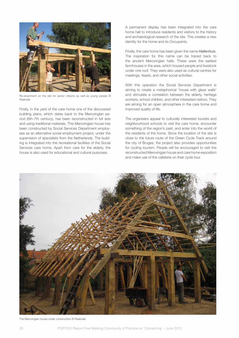
firstly, in the yard of the care home one of the discovered building plans, which dates back to the Merovingian pe-riod (6th-7th century), has been reconstructed in full size and using traditional materials. This Merovingian house has been constructed by Social Services Department employ-ees as an alternative social employment project, under the supervision of specialists from the netherlands. The build-ing is integrated into the recreational facilities of the Social Services care home. apart from care for the elderly, the house is also used for educational and cultural purposes.
a permanent display has been integrated into the care home hall to introduce residents and visitors to the history and archaeological research of the site. This creates a new identity for the home and its Occupants.
finally, the care home has been given the name Hallenhuis. The inspiration for this name can be traced back to the ancient Merovingian halls. These were the earliest farmhouses in the area, which housed people and livestock under one roof. They were also used as cultural centres for meetings, feasts, and other social activities.
With this operation the Social Services Department is aiming to create a metaphorical ‘house with glass walls’ and stimulate a correlation between the elderly, heritage workers, school children, and other interested visitors. They are aiming for an open atmosphere in the care home and improved quality of life. The organisers appeal to culturally interested tourists and neighbourhood schools to visit the care home, encounter something of the region’s past, and enter into the world of the residents of the home. Since the location of the site is close to the future route of the Green Cycle Track around the city of Bruges, the project also provides opportunities for cycling tourism. People will be encouraged to visit the reconstructed Merovingian house and care home exposition and make use of the cafeteria on their cycle tour.
Re-enactment on the site for senior citizens as well as young people © Raakvlak
The Merovingian house under construction © Raakvlak

PORTICO Report Final Meeting Community of Practice on ‘Connecting’ – June 2012 21
Integration
The presentation of archaeological research results to the public is one of the tasks of every community. Examples of this presentation include expositions, open
days on excavations, and open-air sites. The integration of an archaeological presentation into the development of a social project like a care home is exceptional. It is even more special when an all-round approach is created whereby
The Merovingian house reconstructed © Raakvlak
archaeology, elderly care, social employment, education, and cultural tourism converge to improve the care home residents’ quality of life. a heritage-care project like this serves as a unique example and can definitely contribute to the integration of different aspects in our society.
Hillewaert, B. (2000), ‘Een vroegmiddeleeuwse nederzet-ting aan de Kosterijstraat (Korte-Molenstraat, Zandstraat, Pastoriestraat’, in: De Witte, H. and Hillewaert, B., Jaar-boek 1997-1999 Brugse Stedelijke Musea, Brugge: Ste-delijke Musea, 167-174.
Hillewaert, B. and Hollevoet, y. (1998), ‘Een vroegmiddeleeuwse feesthal te Sint-andries Brugge?’, in: In de steigers, v (2): 47-48.
Hillewaert, B. and Hollevoet, y. (2006), ‘andermaal Romeins en vroegmiddeleeuws langs de Zandstraat te Sint-andries/Brugge (prov. West-vlaanderen)’, in: Relicta. Archeologie, Monumenten- & Landschapsonderzoek in Vlaanderen, I: 121-140.
Hollevoet y. (1999-2000), ‘Romeinse off site-fenomenen en vroegmiddeleeuwse nederzettingssporen in de verkaveling Molendorp te Sint-andries/Brugge (prov. W-vl.)’, in: Archeologie in Vlaanderen, vIII: 65-82.
References

The eastern moat and wing of the former palace, as drawn in 1778 by Jacques Trachez. The gate house, on the left, has already lost its western tower. © Ghent City archives

Pars pro toto. The heavy symbolic weight of an archaeological deposit. What if you are saddled with the pars?Gunter Stoops and Guy Dupont
The historical Prince’s Court in Ghent
When the mighty castle of the counts of flanders, built in the heart of Ghent between the 11th and 13th centuries, became old-fashioned and uncomfortable by the mid-14th century, Count louis of Male (who reigned from 1346 to 1384) decided to move his urban residence to his other propriety Hof ten Walle, located only a few hundred metres away. The former noble mansion was reconstructed and enlarged during a long-term building campaign, which was continued by the dukes of Burgundy (heirs of the counts of flanders) and which resulted in a three-winged palace centred around a courtyard and surrounded by a moat. This palace and moat formed the core of a six hectare large domain. Hof ten Walle, also known as the Prinsenhof (Prince’s Court), became one of the four principal urban residences of the Burgundian dukes and their successors, the Habsburg sovereigns in the southern part of the low Countries, along with the Coudenbergh Palace in Brussels, Rihour Palace in lille and the other Prince’s Court in Bruges. It was here on 24 february 1500 that Joanna of Castile, nicknamed Joanna the Mad, gave birth to Charles v, the future emperor of the Holy Roman Empire.
from the late 16th century onwards, the Prince’s Court was no longer used by the Spanish Habsburg sovereigns or their governors, who resided by now permanently in Brussels. In 1649, all the land outside the moat was parcelled out and sold. finally, in 1777, the buildings and the courtyard inside the moat underwent the same fate. Most buildings were revived and integrated into new constructions.
Excavating the gate house and the moat
In 2011, a private owner obtained a building permit to demolish a 20th century workshop and to replace it with a private house on the very same spot which was once adorned by the gate house and main entrance to the Prince’s Court (currently located at Simon de Mirabellostraat). However, this permit was issued with the obligation of a full archaeological research, as advised by the City’s Departments for urban archaeology and Heritage. Due to the small scale of the development project and the archaeological value of the site, the city agreed to share the research costs: the city’s archaeologists carried out the excavations, whilst the owner paid for the logistic support. furthermore, the permit also
stated that the new foundations had to be constructed with respect for the archaeological remains.
The results of the excavations turned out to be even more impressive than expected. The remains of the gate house proved to be monumental and well preserved. The archaeological intervention revealed that the whole construction of the gatehouse was designed at the same time. The arch in the western common wall gives an idea of the height of the gate. under the gateway there was space provided for the mechanism of the draw-bridge. The outside of the brick building (at least the lower part) was covered with stone: a layer of grey limestone from Tournai alternated with layers of white sandy limestone. at some point, all the outside walls were plastered with lime (as can be seen on the 17th century painting, figure 3). later, in the 17th or 18th century, there appears to have been a problem with the southern wall: it may have partly collapsed, necessitating the reconstruction of the walls and on that occasion a different type of brick was used. The western tower, however, was not rebuilt. also in the 17th century, the wooden bridge, supported by stone pillars, was replaced by a brick construction supported by five vaults. The base of one of the 15th century stone pillars (the one the closest to the gate house, i.e. the only one located on the building lot) was excavated. Integrating and visualising the archaeological remains
Many people living in the neighbourhood cherish the historical character of the Prince’s Court quarter. They are aware of its archaeological value and would love to see the remains of the gate house integrated in some way into the new construction. furthermore, the vice Mayor for Culture has expressed his interest in safeguarding this unique monument. The owner himself is also aware of the important historic and symbolic value of the site and its contribution to the sense of place. That is why he asked the architect to change the plans in order to integrate the foundations of the gate house into the basement of the new construction and to make them visible, even from the outside. as for the City’s Department of urban archaeology, its main concern is for the optimal conservation of the archaeological remains in situ, if this is possible, and less about enhancing their

PORTICO Report Final Meeting Community of Practice on ‘Connecting’ – June 201224
experiential value. However, the integration and visualisation of the monumental archaeological remains, located below the surface, raised some practical, privacy, and financial issues, that need to be dealt with, too.
The first challenge was to conceive of a suitable method of (semi-public) presentation that takes into account the diverse and, indeed, sometimes conflicting requirements from conservational, interpretational, practical, and privacy perspectives. an architectural solution to make the monument visually accessible from the street at basement level would include covering the former moat and the bridge pillar’s base in front of the gate house with a glass slab supported by a steel framework. This would make it possible to keep a free view on the eastern façade of the gate house, including its two towers on both sides of the gate way. The massive structure of the gate house itself would be covered with a concrete floor, on top of which the footprint of the towers and gate way would be marked by the use of floor tiles in a different colour. The whole space at ground level, on top of the remains and the glass slab,
would be designed as a garage, enclosed from the street by a fence with vertical bars. This would allow passers-by to peep inside, but, of course, they would only actually see something if the garage were practically empty! as for the owners and residents, they would need to agree that both their privacy and the usability of the space at ground level would be limited. after all, they started their building project merely with the idea of constructing a new house for themselves, not a public attraction facility!
from a heritage interpretation point of view, this ‘archaeological window’ would certainly be an interesting tool for bringing residents and visitors somehow visually in touch with one of the few monumental remains of the illustrious Prince’s Court. Of course, this would only allow a distant glance. furthermore, the sight on the façade and towers would be spoilt by the heavy steel beams that would eventually need to be constructed in front of the gate house in order to support the new building, and also by all kinds of stuff people usually store in their garage. In addition, the
The Prince’s Court in Ghent, with a detail view of the gate house. Etch in antonius Sanderus’ Flandria Illustrata, 1641.
gate house façade would need appropriate lighting.

PORTICO Report Final Meeting Community of Practice on ‘Connecting’ – June 2012 25
However, as an interpretation tool, this viewing window would hardly be sufficient in itself to tell the story of the site. additional information panels or digital tools would be needed as well. This is especially the case since the bronze architectural model of the historical palace, displayed in public at a nearby square and helping onlookers to visualise the now absent buildings, has recently been stolen! In fact, a global interpretation plan for the Prince’s Court neighbourhood as a whole is what is needed.
from an archaeologist’s point of view, the best way of conserving the monumental remains, once they had been investigated, would be to cover them up again with a sufficiently protective layer of sand and to construct the new building on top of it, while taking care that the foundations do not disturb the monument. Of course, if we had done this, the experiential value of the archaeological remains would have been reduced to zero. This was obviously not the intention. However, a glass slab covering the remains, as proposed by the architect, may cause some problems related to the specific climate (the humidity of the soil) and
light (day light coming through the glass) conditions. These may generate the formation of salts and the growth of algae and plants, something which would make the glass filthy and render the monument itself subject to degradation. In order to prevent this, the climate and light conditions under the glass ceiling need to be controlled, the subsurface room needs to be accessible, and a maintenance plan is required.
The second and most important challenge, however, is to conclude a sound financial agreement between the two main parties involved, namely the owner and the City Council. The proposed architectural solution for integrating the archaeological remains below the surface in the new building in such a way that they would remain visible from the street would involve considerable extra costs. This raises the obvious question: who is going to pay the bill? as for the owner, he has already paid for the archaeological research (which is now a legal obligation in flanders, where a disturber-pays principle applies), albeit for the logistic support only, the work itself being done by the City’s Department of urban archaeology, as we have already said.
Even if the conservation of the archaeological remains in situ can be enforced legally, their (permanent) presentation or visualisation cannot. To achieve all this, you have to rely on the interest, good will, and financial contribution of the owner. On the other hand, the owner has budgeted for a building project for a private house, not for a public heritage attraction. If the City Council does indeed value this and similar projects, aiming at valorising the city’s archaeological heritage, at visualising important pages of the city’s history,
The gate house as depicted in a historicizing, 17th century painting representing the departure of the baptismal procession of Charles v in 1500. © STaM Ghent City Museum.

PORTICO Report Final Meeting Community of Practice on ‘Connecting’ – June 201226
and at connecting the local community with both the material remains and the stories of the past, it would be fair to expect the Council to make a commitment, including a financial commitment, possibly supported by the higher governments at provincial and regional level.
architect’s impression of the integration of the archaeological remains into the new house, 2011 © aRPa architecten Gijsemans & Duiverman
The excavation of the gate house. Composite photo, 2011. © Ghent Department of urban archaeology

PORTICO Report Final Meeting Community of Practice on ‘Connecting’ – June 2012 27
De Jonge, K. (1996), ‘Hofordnungen als Quelle der Residenzenforschung? adlige und herzogliche Residenzen in den südlichen niederlanden in der Burgunderzeit”, in: W. Paravicini, H. Kruse, eds., Höfe und Hofordnungen/Ordonnances de l’Hôtel (1200-1600). 5. Symposium der Residenzenkommission der Göttinger Akademie in Zusammenarbeit mit dem Deutschen Historischen Institut Paris. Sigmaringen, 5.-8. Oktober 1996, Sigmaringen: Thorbecke, 173-218.
De Jonge, K. (2000), ‘Bourgondische residenties in het graafschap vlaanderen. Rijsel, Brugge en Gent ten tijde van filips de Goede’, in: Handelingen der Maatschappij voor Geschiedenis en Oudheidkunde te Gent, 54: 93-134.
laleman, M.C. (dir.) (2000), Het Prinselijk Hof ten Walle in Gent. Jubileumuitgave Stadsarcheologie. Bodem en monument in Gent, Gent: Gentse vereniging voor Stadsarcheologie.
laleman, M.C. (2001), ‘Het prinselijk Hof ten Walle: recent onderzoek en nieuwe inzichten’, in: Handelingen der Maatschappij voor Geschiedenis en Oudheidkunde te Gent, 55: 199-236.
laleman, M.C., and lievois, D. (2005), ‘Historische stap- stenen in het Prinsenhof’, in: ‘t Prinsenhof, een prinsheerlijke buurt, Gent, 96-104.
Stoops, G. (2012a), ‘Een smalle doorgang voor gestelde lichamen’, in: Ex Situ. Tijdschrift voor Vlaamse Archeologie, 1 (april 2012): 16-18.
Stoops, G. (2012b), ‘Prinsenhof 103 in Gent: poortgebouw van een Bourgondisch paleis (O.-vl.)’, in: Archaeologia Mediaevalis, 35: 187-191.
References

PORTICO Report Final Meeting Community of Practice on ‘Connecting’ – June 201228
figure 1: archaeological area and overall dimension of the excavations. © Stadt Köln, archäologische Zone

PORTICO Report Final Meeting Community of Practice on ‘Connecting’ – June 2012 29
Public-Private Partnership models based on examples from the Rhineland, especially the Ubian Monument in Cologne Marianne Gechter and Astrid Bader
Introduction
at the CoP meeting, Marianne Gechter and astrid Bader, both representing the PORTICO Partner City of Cologne, presented the German legal framework and some local/regional cases of public-private partnership (PPP) in the conservation and presentation of archaeological sites. Marianne Gechter spoke about some sites in the Rhineland, whilst astrid Bader also presented the marketing and communication plan for the ubian Monument in Cologne. This archaeological site will be opened in 2013 as part of the archaeological Zone Jewish Museum Cologne, an extensive complex documenting historical finds, including the Jewish Museum. almost every day the excavations bring spectacular evidence of 2000 years of the city’s history to light (figures 1). Monumental archaeological remains such as the ubian Monument, the oldest stone building of Cologne, the remains of the Praetorium, the Roman governor’s palace, or the oldest synagogue north
of the alps tell a story of ancient splendour and long-lasting Jewish presence in Cologne (figures 2, 3, and 4). The important historical significance of this place will be honoured by the construction of a contemporary museum complex to be opened in 2015. In 7,500m2 of exhibition space visitors to the archaeological Zone Jewish Museum Cologne will be able to experience more than 2000 years of history above and below the surface.
The legal framework
In Germany, the protection of monuments is the responsibility of the Bundesländer (federal States) and each state has its own legal framework. In the state of north Rhine Westphalia, to which Cologne belongs, this matter is regulated by the act for the Conservation of ancient Monuments (Denkmalschutzgesetz NRW). The authorities involved in the preservation and protection of archaeological monuments include the Ministerium
figure 2: The praetorium, the Roman governor’s palace, which was the political and administrative centre of the region during the Roman period. © Stadt Köln, archäologische Zone

PORTICO Report Final Meeting Community of Practice on ‘Connecting’ – June 201230
(Ministry for Economy, Energy, Building, Housing, and Traffic), the Bezirksregierungen (District governments, at the intermediate level between state and local governments), and the Fachämter (Departments), in particular the Rheinisches Amt für Bodendenkmalpflege (Department for the Preservation of archaeological Monuments) in Bonn and a similar office for Westphalia in Münster. They are in charge of planning all the necessary archaeological research (excavations, surveys etc.) and also supervise the Untere Denkmalbehörden (the responsible departments in the city and regional administrations).
The City of Cologne, however, is an exception to that rule. The so-called lex colonia guarantees the independence of archaeology in Cologne. This means that the municipal services for archaeology do not depend on the authority of the Rheinisches Amt für Bodendenkmalpflege. at a municipal level there are two departments in charge. The archaeological Zone is responsible for both the area where the new museum is being built and the ubian Monument, while the Römisch-Germanisches Museum (Roman-Germanic Museum) is responsible for all other sections of the city.
The law of north Rhine Westphalia states that the discovery of archaeological findings has to be reported to the authorities immediately. If archaeological remains are discovered, the Department for the Protection and Preservation of Monuments (part of the Ministry for Economy, Energy, Building, Housing, and Traffic) is entitled to suspend the building activities up to six months to organise the necessary excavations. The Department for the Protection and Preservation of Monuments is to be involved in the planning processes and building permit applications. If there is any evidence from surveys or former excavations which indicate that considerable findings are to be expected, these authorities can impose conditions for
figure 3: Small slate with Hebrew letters found in Cologne. © Stadt Köln, archäologische Zone
figure 4: Part of the mikveh, an immersion bath for the ritual cleaning of the body. © Stadt Köln, archäologische Zone
excavations. The regulations even allow for the expropriation of private owners of monuments.
In reality the Department and the private investors sign contracts according to the costs-by-cause principle. The investor pays a certain amount for the excavation or hires a company for archaeological research. The department saves money and can therefore guarantee that the excavation will start when it suits the investor. This is a key agreement to make sure that excavations will not take longer than necessary. If unexpected important findings are made or findings have to be preserved, this agreement can be modified or even rejected by the city authorities. In this very unlikely case, the building plan has to be changed and the investor is charged additional costs.
Examples of Public-Private Partnerships (PPPs) in Cologne and the Rhineland
Cases of PPP regarding the preservation and presentation of archaeological heritages in Cologne and north Rhine Westphalia appear to be very diverse in nature and also in success. In fact, they follow different models.
Cologne: Roman forumThe Roman forum in Cologne provides a good example of the importance of co-operation between private owners and public authorities in order to find suitable solutions. The

PORTICO Report Final Meeting Community of Practice on ‘Connecting’ – June 2012 31
remains of the forum are located in a densely built-up area in the basement of the C&a department store, under the escalator and near the toilets. Information panels display the reconstruction drawings and detailed information (figure 5). However, the look of the panels is now considered old fashioned. The presentation would certainly benefit from a modernisation, including the use of new media.
about fifteen years ago, considerable parts of the forum were discovered at the Herzogstraße. There was great public pressure to preserve the monuments, but the investor had signed a contract with the city council which did not include the preservation of the finds. Besides, the representatives of the Ministry and Römisch-Germanisches Museum expressed support for the investor’s point of view. finaly, some parts of the remains were destroyed, whilst others were preserved in situ and remained hidden underground.
Cologne: Kolumbaan additional example is Kolumba (art Museum of the archdiocese of Cologne). Here, parts of the old church have been integrated into the façade of a new, contemporary building, whilst the archaeological remains of earlier churches are preserved in the ground (figures 6 and 7).
Bonn: a Roman bath in the Collegium AlbertinumThe Collegium albertinum in Bonn belongs to the Roman Catholic Church and houses an institute for students of theology. During restorations in the 1980s, a Roman bath in the cannabae legionis was discovered. It appears sumptuous for a private bath, so it is assumed to be a
figure 6: Cologne: Kolumba (art Museum of the archdiocese of Cologne) © Jose fernando vasquez
figure 5: Cologne: remains of the Roman forum in the basement of a C&a shop. © Stadt Köln, archäologische Zone

PORTICO Report Final Meeting Community of Practice on ‘Connecting’ – June 201232
commander’s bath. after the authorities decided to preserve the finds in the cellar, they also decided to add instructive and expensive, but old-fashioned information panels (figure 8). unfortunately, few visitors show up, and the signs are only visible once you have entered the grounds. In Bonn, as well as in Cologne, there is no real communication plan for private or public monuments.
Bonn: Didinkirica – how PPS does not workan example of what happens when no one really cares for the remains is Didinkirica in Bonn. This was a development project named after Didinkirica or Dietkirche, the earliest parish church founded inside the Roman legionary fortress. It was well known that the church was located here, so the preservation of the finds was undisputed. In 1989, when Bonn celebrated its 2000th anniversary, the installation was officially opened by politicians and by representatives of a bank that had sponsored the creation of a bronze model of the Roman fort, for which a well known artist had been commissioned. figure shows the situation today. The doorway with the information panels is closed, the model is smeared, and the frankish sarcophagi are partly damaged (figure 9).
Bonn: cellar of a Roman house integrated into a public buildinga far better example is the cellar of a Roman house in the vicus, integrated into the basement of the Haus der Geschichte (House of the History of the federal Republic of Germany) in Bonn (figure 10). The presentation is excellent, including models and instructive information. although this public building does not house an archaeological museum, but a museum of contemporary history, the representatives of the federal Republic decided to preserve the finds.
Aachen: ‘archaeological window’ in a DM-storeThe excavated and preserved findings of a Roman Porticus are located in a private building, which houses a DM drugstore. a display with flyers is available and ‘archaeological windows’ on the shop grounds allow a view of the excavations below. DM regards this attractive presentation as an additional attraction increasing the volume of customers. furthermore, the archaeological windows form part of an archaeological tour, virtual and real, through aachen. This tour helps to keep the Porticus in the
figure 8: Bonn: remains of the Roman bath under the Collegium albertinum. © Stadt Köln, archäologische Zone
figure 9: Bonn: Didinkirica. © Jürgen W., Bonn
figure 7: Kolumba: excavations inside the church. © Jose fernando vasquez
visitor’s memory.
The Ubian Monument in Cologne
Historical importanceIn 1965, the south-eastern corner tower of the Roman pre-urban fortification, the so-called ubian Monument, was discovered at the Muhlenbach. It is Cologne’s oldest stone monument and the oldest Roman ashlar building north of the alps. Its wooden pile foundations date back to 4 aD. around the beginning of the Common Era, the Romans founded a city with a rectangular street grid, called Oppidum ubiorum. It functioned as an administrative and cultic centre for the conquered Germanic territories. The city was located within the territory of the ubians, an allied Germanic tribe that had been settled by the Romans. The basement and the first floor of the mighty and perhaps never completed square stone building has survived to this day. after the Battle of the Teutoburg forest in 9 aD, a provisional wood-soil-fortification was added to the monument; it was replaced by a stone wall during the construction of the fortification in the settlement era in the second half of the first century. The joints of the city wall are still visible today - a newly designed cork model by Dieter Cöllen shows the entire Monument with the murus gallicus on the right side (figure 11).
after excavation and consolidation activities, the plot was

PORTICO Report Final Meeting Community of Practice on ‘Connecting’ – June 2012 33
figure 10: Bonn: cellar of a Roman house in the vicus, integrated in the basement of the House of the History of the federal Republic of Germany. © Stadt Köln, archäologische Zone
sold to private owners in 1966, but under the provision that they use the access area and underground space (where the monument is located). The agreement also ensured that the owners could not undertake any activities that would harm the monument or impede access to it. In other words, the interventions needed to enhance the presentation and reshape the entrance and access area can only be done in co-operation with the owner. That is why the ubian monument has became an object of Private Public Partnership (PPP). The current presentation of Roman stone monuments and wooden parts not directly related to the ubian Monument will soon be replaced by an exhibition on
figure 11: Cork-model of the ubian Monument with the murus gallicus on the right side (Model by Dieter Cöllen, concept by Sven Schütte) © Stadt Köln, archäologische Zone
the life of the ubians and the Oppidum ubiorum.Marketing and communication strategiesHowever, a successfully implemented PPP has to involve both investors/owners on the one hand and the residents and people working or living in the area on the other. In this sense the communication agency of the archaeological Zone BSx Bader & Schmölzer ltd. has developed a communication master plan presented by astrid Bader.
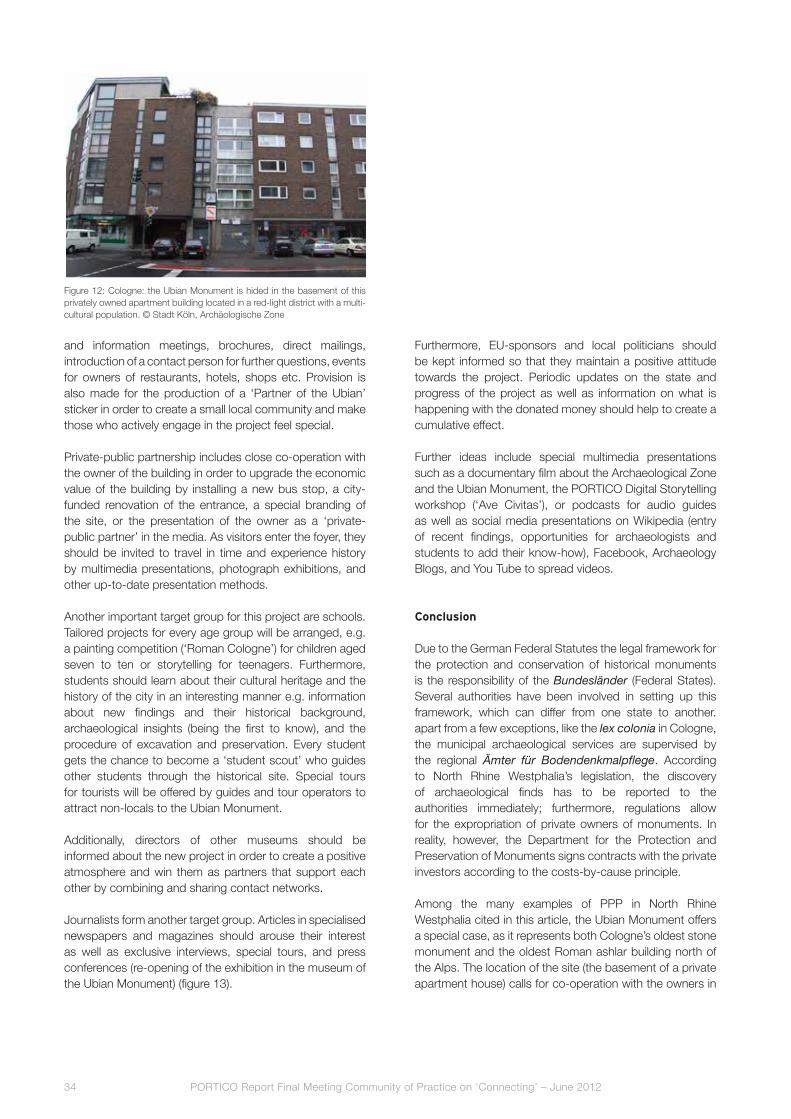
The ubian Monument is located in an unusual environment, namely in the basement of an apartment building (figure 12). Inhabitants living in and near this building are able to exert considerable influence on the success of the project. Therefore a specific communication strategy must be developed to address this group in a special way.
We aim to involve and inspire local residents to identify themselves with the historical site and be proud of it. It is absolutely essential to win the local inhabitants as partners to make them aware of the high importance of this site and to create a cumulative effect. It is crucial that the residents become proud of their history and cultural heritage, so that they can gain an appreciation of the area they live in (from the red light-district to a new tourist attraction) and get in touch with the local community and neighbours. This this could help to create a new district and change the image of the area. for this reason a number of activities will be organised e.g. guided tours with local guides, discussions
PORTICO Report Final Meeting Community of Practice on ‘Connecting’ – June 201234
and information meetings, brochures, direct mailings, introduction of a contact person for further questions, events for owners of restaurants, hotels, shops etc. Provision is also made for the production of a ‘Partner of the ubian’ sticker in order to create a small local community and make those who actively engage in the project feel special.
Private-public partnership includes close co-operation with the owner of the building in order to upgrade the economic value of the building by installing a new bus stop, a city-funded renovation of the entrance, a special branding of the site, or the presentation of the owner as a ‘private-public partner’ in the media. as visitors enter the foyer, they should be invited to travel in time and experience history by multimedia presentations, photograph exhibitions, and other up-to-date presentation methods.
another important target group for this project are schools. Tailored projects for every age group will be arranged, e.g. a painting competition (‘Roman Cologne’) for children aged seven to ten or storytelling for teenagers. furthermore, students should learn about their cultural heritage and the history of the city in an interesting manner e.g. information about new findings and their historical background, archaeological insights (being the first to know), and the procedure of excavation and preservation. Every student gets the chance to become a ‘student scout’ who guides other students through the historical site. Special tours for tourists will be offered by guides and tour operators to attract non-locals to the ubian Monument.
additionally, directors of other museums should be informed about the new project in order to create a positive atmosphere and win them as partners that support each other by combining and sharing contact networks.
Journalists form another target group. articles in specialised newspapers and magazines should arouse their interest as well as exclusive interviews, special tours, and press conferences (re-opening of the exhibition in the museum of the ubian Monument) (figure 13).
furthermore, Eu-sponsors and local politicians should be kept informed so that they maintain a positive attitude towards the project. Periodic updates on the state and progress of the project as well as information on what is happening with the donated money should help to create a cumulative effect.
further ideas include special multimedia presentations such as a documentary film about the archaeological Zone and the ubian Monument, the PORTICO Digital Storytelling workshop (‘ave Civitas’), or podcasts for audio guides as well as social media presentations on Wikipedia (entry of recent findings, opportunities for archaeologists and students to add their know-how), facebook, archaeology Blogs, and you Tube to spread videos.
Conclusion
Due to the German federal Statutes the legal framework for the protection and conservation of historical monuments is the responsibility of the Bundesländer (federal States). Several authorities have been involved in setting up this framework, which can differ from one state to another. apart from a few exceptions, like the lex colonia in Cologne, the municipal archaeological services are supervised by the regional Ämter für Bodendenkmalpflege. according to north Rhine Westphalia’s legislation, the discovery of archaeological finds has to be reported to the authorities immediately; furthermore, regulations allow for the expropriation of private owners of monuments. In reality, however, the Department for the Protection and Preservation of Monuments signs contracts with the private investors according to the costs-by-cause principle.
among the many examples of PPP in north Rhine Westphalia cited in this article, the ubian Monument offers a special case, as it represents both Cologne’s oldest stone monument and the oldest Roman ashlar building north of the alps. The location of the site (the basement of a private apartment house) calls for co-operation with the owners in
figure 12: Cologne: the ubian Monument is hided in the basement of this privately owned apartment building located in a red-light district with a multi-cultural population. © Stadt Köln, archäologische Zone

PORTICO Report Final Meeting Community of Practice on ‘Connecting’ – June 2012 35
figure 13: Remains of the ubian Monument in the museum. © Stadt Köln, archäologische Zone
Grätz, R., lange, H. and Beu, H. (eds.) (1991), Denkmalschutz und Denkmalpflege. 10 Jahre Denkmalschutzgesetz Nordrhein-Westfalen, Köln: Rheinland-verlag.
Gechter, M. et al. (2007), Via Romana am Rhein. Spuren der Römer in der Geschichte, Regensburg.
Gechter, M., and Schütte, S. (2000), ‘ursprung und voraussetzungen des mittelalterlichen Rathauses und
seiner umgebung’, in: u. Krings and W. Geis, Köln. Das gotische Rathaus und seine historische Umgebung, Köln, 78-95 (Stadtspuren, 26).
Pletinckx, D. et al. (2011), The PORTICO master classes. Report on the Cologne case study. The Ubian Monument.
References
order to enhance the presentation of the monument and to reshape the entrance and the access area. The concept of PPP, however, also entails co-operation with local residents and people living in the neighborhood. The communication strategy developed for the ubian Monument aims at creating a stronger identification of this target group with the historical site. Some of the specially tailored projects follow
the idea to upgrade the economic value of the building; others offer special activities for youngsters, students and local residents. In general, this PPP aims at raising public awareness of the high social and economic potential of this unique historical site, resulting among other things in increasing the cultural and integrative value of urban neighbourhoods.
PORTICO Report Final Meeting Community of Practice on ‘Connecting’ – June 201236
Browns of Chester and mast diagram

PORTICO Report Final Meeting Community of Practice on ‘Connecting’ – June 2012 37
Designing with ArchaeologyTony Barton
Tony Barton, an architect who works for Donald Insall associates, explained three projects where private and public sectors co-operated in new construction on archaeologically sensitive sites.
Tony presented three projects:§ an important area of buried archaeology – Browns
of Chester§ a standing scheduled monument – Ince Manor
Grange, Cheshire§ and a unique survivor of industrial archaeology –
Butcher Works in Sheffield.
Significant change was managed, whilst minimising the impact of development on the archaeological significance of each site and partnerships between the public and private sectors were key factors.
Browns of Chester
The Browns of Chester project was in the historic heart of Chester and brought into sharp focus the problems associated with a new building in an ancient, tight-knit city centre.
The site is in the backyards of the buildings fronting the Roman roads, Bridge Street and Eastgate and had been bought for an extension to a department store, itself with a long history in the City.
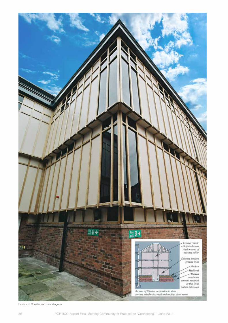
understandably, Browns wanted a trading floor at the same level as their existing shop. However, such were the relative levels and the space needed for conventional piled foundations, that this would have meant losing a rare undisturbed area of buried archaeological deposits. The area is designated as an ‘area Of archaeological Importance’, which means that no excavation can take place without consent.
The City wanted the economic investment, but did not want to lose the archaeological deposits. The City archaeologist was opposed to any development that disturbed the buried archaeology but the final decision would lie with the planning committee. Donald Insall associates (DIa) had addressed concerns about the appearance of the extension; the developer asked if Tony’s team could help with the impasse
over the archaeology and DIa took a fresh look from a historic building architect’s perspective.
DIa analysed the survey drawings and soon noticed that almost in the centre of the site, a large cellar had already been excavated through the whole archaeological profile. DIa proposed a ‘mast’, with its foundations in the cellar, to take all the loads of the new extension. Instead of conventional columns supporting the roof and floors, the structure could be hung off the mast. This meant that the piles and pile caps were needed only within the cellar and the floor slab could be much thinner. With this system in place, DIa advised the developer that if just three steps were introduced between the department store and the extension, the building could be built entirely within the ‘Modern’ deposits and float over the Medieval and Roman archaeology.
In essence, this is what happened, as the planning committee voted for consent; the City lost some, but not all, of its archaeology and gained a much needed, bigger department store in the centre of Chester. The developers agreed a substantial sum to pay for a major excavation of the site. Within the store there was a viewing platform overlooking the dig, which became a great attraction for locals and tourists. The dig opened a door on the City’s history and the finds even included the leg bone of an elephant!
This outcome needed compromise on all sides. The developer had to pay for the archaeological dig to get the planning permission; the City archaeologist had to accept the loss of some buried archaeology; the retailer had to accept the three steps; the construction team had to throw away their designs and calculations for the foundations; and the City Councillors had to strike a balance between commerce and heritage. Ince Manor Grange
Ince Manor Grange overlooks the River Mersey north of Chester and is a Scheduled Monument and Grade I listed Building. The structures are rare survivors of standing manorial buildings and have the highest legal protection for archaeologically important sites in the uK.

PORTICO Report Final Meeting Community of Practice on ‘Connecting’ – June 201238
The monastic grange was attached to St Werburgh’s abbey, now Chester Cathedral and was established in the 12th century. The grange was a farm run by Monks to supply the monastery and was used for hospitality, for instance, both Edward I and Edward II stayed at Ince Manor.
DIa was employed by The Chester Historic Buildings Preservation Trust, which is a charitable, nonprofit making organisation whose purpose is to act as a ‘means of last resort’ to rescue historic buildings. a Building Preservation Trust is able to accept grants that private individuals or other organisations cannot access and its plan for Ince Manor was to save the standing monument and pass it on to an end user.
The Trust did not own the site, which had been left to an elderly lady in the village and she had no money even for basic repairs. an arrangement was being made between the Trust, a private concern with no assets, English Heritage and the local councils to grant funds for a rescue but only if the Trust owned the site. However, the Trust could not negotiate to obtain the site unless grants were guaranteed. Happily on one particular day, the Council acquired the site and immediately passed it on to the Trust who then received grants from the Heritage lottery fund and the authorities.
Crucial to the success of the project though was demonstrating to the English Heritage archaeologists that these were buildings not standing ruins. This was achieved
by DIa showing on their detailed design drawings that every stone would be retained and that all new work would enhance and protect the monument.
all work required Scheduled Monument Consent from English Heritage and listed Building Consent and Planning Permission from the Council. Walls were rebuilt, roofs added, new floors inserted, doors and windows repaired and remade to form successful sound weatherproof envelopes ready for conversion to new uses.
The Trust had taken out a loan from the architectural Heritage fund, which was a risk for its Directors and meant that DIa could not exceed the budget and had no contingency fund. If it had made any profit, this would have had to have been repaid to the Hlf. The Trust negotiated to sell the site to a local property developer for the same amount as the loan. although he then sold it to a local family for a profit, the Trust had the consolation of knowing that it had done its job and rescued Ince Manor Grange.
This was a highly significant archaeological site in danger and through partnership and trust, a creative means was found of channelling public money through private hands for its rescue. Ince Manor Grange is now occupied by a family who love it; it is in very good hands and retains its scheduled monument status.
Ince Manor

PORTICO Report Final Meeting Community of Practice on ‘Connecting’ – June 2012 39
Ince Manor: the repaired building now forms an attractive pair of cottages
Butcher Works (Sheffield)
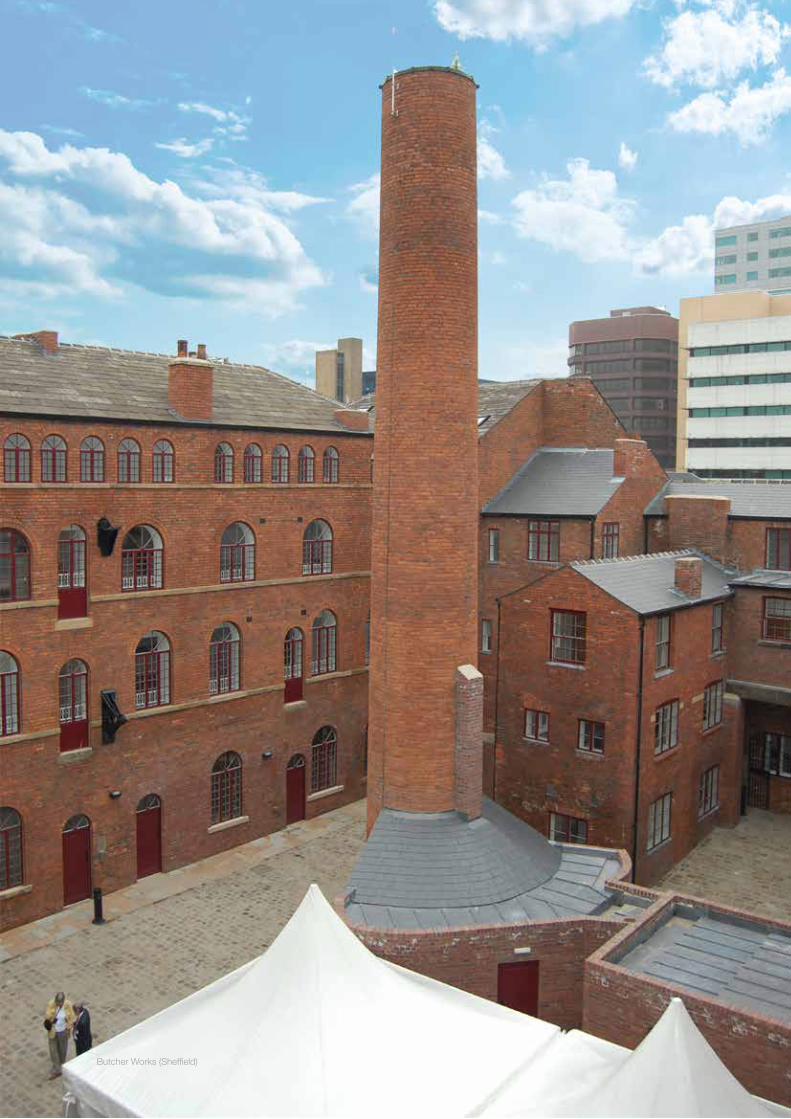
not a scheduled monument, but a Grade II* listed building, Butcher Works in Sheffield tells a vital part of the Steel City’s story and is an important site of industrial archaeology. Built in various phases around a shared courtyard, Butcher Works had grown into a single complex where every phase in the manufacture of the city’s world renowned cutlery took place.
The site was in very poor condition and had been acquired by a property developer, who seemed to have little sympathy for Butcher Work’s archaeological importance. However, Sheffield City Council did appreciate its significance and Tony’s team were employed by the Council to work on the developer’s building.
DIa obtained detailed survey drawings, investigated the history of the site, wrote a Conservation Management Plan, made a condition survey, scheduled and costed the necessary repairs, and set out how the buildings could be brought back to life. all this work was paid for by the Council, out of its regeneration budget, DIa never had a direct relationship with the owner, but their work led to the calculation of the conservation deficit and allowed a grant offer to be made.
The developer then sold the site to a contractor, who had employed another firm of architects specialising in apartments, to gain consents based on the DIa Conservation Management Plan.
Sheffield City Council insisted that Donald Insall associates was retained as conservation advisor and Tony’s team designed and specified proposals for the historic fabric. although the apartments team covered most of the internal area of the flats in plasterboard which hid a lot of the joy of the building, it all remains. One large room has the best preserved grinding wheels in Sheffield and these have been kept as a museum; this was very expensive for the contractor as it had one less flat to sell and a museum to curate and manage.
The Contractor soon learnt to trust Donald Insall associates, because they could see that their specialist advice was adding greatly to the aesthetics of the project, the

Browns: Garner D. et al (2009), Excavations at Chester, 25 Bridge Street 2001: two thousand years of life in microcosm, Chester: Chester City Council (archaeological Service Excavation & Survey Report no 14).
Ince: http://www.donaldinsallassociates.co.uk/app/index.php/projects/show/188
Butchers Works: http://www.donaldinsallassociates.co.uk/app/index.php/projects/show/179
Portland Works Case Study 3: http://www.portlandworks.co.uk/2011/06/13/casestudy3-butcherworks.pdf
References
Butcher Works (Sheffield)


PORTICO Report Final Meeting Community of Practice on ‘Connecting’ – June 2012 43
Partnership in archaeology, conservation and regeneration: a personal viewTony Wilmott
The excavation of the Saxon Church in Pontefract
This paper is very much a personal view based upon personal experience, and I should say at the outset that it does not necessarily reflect any policy or view of my employers, English Heritage, or the other archaeological organisations mentioned below.
Pontefract
My personal first experience of the conflict between development and a desire for the preservation of a monument in situ was in 1984. This was before the advent (in 1992) of Planning Policy Guidance note 16, which made archaeology a material consideration in the planning process, and in this case archaeology was very much conducted under old fashioned ‘rescue’ conditions. at the time, I was working for the West yorkshire archaeology Service, which was maintained by the West yorkshire Metropolitan County Council. a new road scheme was being implemented by the highways division of the WyMCC in one of the most sensitive areas of the historic town of Pontefract, between the Castle and the parish church of all Saints. The political situation was, to say the least, interesting. The road works were to be undertaken in March, at the end of which month the Council was to be wound up as part of the abolition of Metropolitan Councils, including the Greater london Council by the government of Margaret Thatcher. Despite being two parts of the same body, there was barely grudging acknowledgement of the need for archaeology on the part of highways — there was no money for it, and the body had no funds to pay for a major excavation. Highways was able to afford money and time (just!) to squeeze in this last road project before the changes. The archaeology Service managed to get together the money to pay a few staff at weekends to run a team of volunteers every weekend for 4 months, September to December. The site lay between the castle and the historic medieval parish church in an area once at the heart of the royal and ecclesiastical part of the town. Once surrounded by important monastic houses, it was now a little regarded backwater that has still not recovered from the twin catastrophes of the dissolution and the three sieges of the castle during the civil wars. This meant there was little of obvious value to persuade highways of its importance.
The weekend excavations recorded a sequence of medieval and post-medieval structures. In february, works on the
road started, and revealed an extensive Saxon cemetery. as we had the exhumation licence for the site (granted for the main work), I was given three days to get my volunteers together to dig 80 burials. at the end of the last day, the Saxon church building appeared, and I got word to the Council leader. Everything changed. I think the reasons we got time to dig the church, to display the building in the new development with a redesigned road layout were,
firstly, that there was a lot of local pride in the history of the town, which had gone from a major royal seat to a rather depressed mining town. an unknown Saxon church was a visible symbol of the town’s ancient past, the first trace of the pre-norman town of which nothing really was known except references in a couple of charters. local elected

PORTICO Report Final Meeting Community of Practice on ‘Connecting’ – June 201244
politicians enthusiastically recognised the relevance of the cultural heritage to the local community, and valued what had appeared. last, but by no means least, there was a clear political desire to demonstrate to government that the local authority could fulfil all its roles, including the cultural, as a publicity move in the context of the abolition of the authority. In other words, the preservation and display of this modest monument owed a great deal to the political zeitgeist and the needs of politics at the time, but it remains an important and treasured part of the heritage assets that the town boasts.
Archaeological heritage policy in the UK
The way in which the site was excavated would not happen today, since the promulgation of PPG 16 (Planning Policy Guidance note 16) in 1992, now supplanted by PPS 5 (Planning Policy Statement 5: Planning for the Historic Environment), shortly also to be superseded. The document advised that archaeological remains are a finite and irreplaceable resource and that their presence should be a material consideration in applications for new development. It offered two solutions for preserving any significant archaeological deposits found on a development site. The first, and explicitly preferred, method involves preservation in situ whereby the archaeology is left untouched beneath a new development through methods such as adaptation of foundation design and architectural layout of the proposed new development, or by raising the level of the development with made ground so that its foundations do not reach the archaeological horizon. Where nationally important remains are encountered this method of preservation is strongly preferred. If preservation in situ is not feasible then PPG 16 permitted preservation by record. This involved archaeological fieldwork to excavate and record finds and features (thereby destroying them). This may involve a full excavation, further trenching in specific areas or an archaeological watching brief which involves an archaeologist monitoring groundworks for the new development and recording any finds or features revealed as construction continues.
What planning guidance does not do, of course, is to place any requirement on a developer to appreciate, preserve, display, or publicise the archaeology recovered. frequently, the development will fulfil only the letter of the archaeological brief which it is set. The results are then limited to grey literature, but not widely disseminated, and not publicly known. The new policy guideline PPS 5 is interesting in stating that:
Where development will lead to loss of a material part of the significance of a heritage asset, policy HE12.3 requires local planning authorities to ensure that developers take advantage of the opportunity to advance our understanding of the past before the asset or the relevant part is irretrievably lost.
This is an interesting use of words. although the effect of requiring developers to fund archaeological works, the way in which this is phrased clearly invites developers to realise the potential of the archaeology they have funded, many developer funded projects have resulted in excellent popular publications, where developers have seen the advantage in advertising their funding of work that have materially benefitted a community. I have always been puzzled that such products are not more frequent, and I think it is down to us, the archaeologists, to communicate better the advantages that engaging with the archaeological work that they are funding can benefit the public perception of developers.
Birdoswald
That benefit was most certainly appreciated in 1989 when Cumbria County Council acquired the Roman fort at Birdoswald on Hadrian’s Wall. a report on tourism in the Hadrian’s Wall area had expressed the need to take the weight off the central sector. There was also a desire to spread the economic benefits brought by tourism along the line of the Wall to the less advantaged east and west sides. To this end the Council commissioned English Heritage to undertake the work, two public bodies, but the money (£300,000) for excavation, consolidation and display, came from British nuclear fuels, whose Sellafield facility in West Cumbria was, to say the least, not the most popular industrial site in England. Once again, though, this was a political move. It was part of the shift towards transparency in an industry which had a reputation for secrecy, which also resulted in the foundation of the Sellafield visitor centre. Most of the publicity material in the early years bore their logo, and a small display on the excavations went into the visitor centre. There is no doubt that they realised the value of being seen to be partners, philanthropists, or patrons and their enthusiasm and participation was the result of a long-drawn out negotiation on the part of County Council officers.
The excavation and the visitors that came to see the site undoubtedly benefitted the local village community. The village continued to support three pubs, and a number of bed and breakfast establishments were opened. These remain healthy, and got another boost when the Hadrian’s Wall long distance footpath was opened HE12.3 but I believe that without the archaeological work these businesses would not have started for another 10-15 years. I also think that the opportunity existed to go well beyond this in the area of regeneration based upon tourist revenue. However a great deal of this has been realised since, with the initiation of the Hadrian’s Wall bus service and national walking and cycling trails that have put Birdoswald firmly on the ‘must see’ list on the HW World Heritage site.
Maryport
The most recent expression of this has been the initiation of a project at Maryport on the Cumbrian Coast. Maryport is a seriously depressed town. Too far from Sellafield to benefit
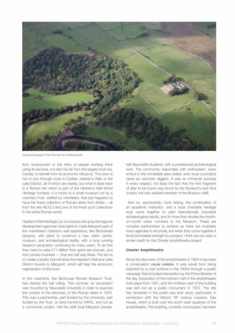
PORTICO Report Final Meeting Community of Practice on ‘Connecting’ – June 2012 45
aerial photograph of the Roman fort at Birdoswald
from employment or the influx of people working there using its services, it is also too far from the largest local city, Carlisle, to benefit from its economic influence. The town is not on any through route to Carlisle, Hadrian’s Wall, or the lake District, all of which are nearby, but what it does have is a Roman fort which is part of the Hadrian’s Wall World Heritage complex. It is home to a small museum run by a voluntary trust, staffed by volunteers, that just happens to have the finest collection of Roman altars from Britain – all from the site HE12.3 and one of the finest such collections in the entire Roman world.
Hadrian’s Wall Heritage ltd, a company set up by the regional development agencies have plans to make Maryport part of the mainstream Hadrian’s wall experience, like Birdoswald became, with plans to construct a new visitor centre, museum, and archaeological facility, with a long running research excavation continuing for many years. To do this they need to raise £11 Million from grant aid sources, and from private business — they are half way there. The aim is to create a facility that will draw the Hadrian’s Wall and lake District tourists to Maryport, which will help the economic regeneration of the town.
In the meantime, the Senhouse Roman Museum Trust, has started the ball rolling. This summer, an excavation was mounted by newcastle university in order to examine the context of the discovery of the Roman altars in 1870. This was a partnership, part funded by the university, part funded by the Trust, on land owned by HWHl, and run as a community project, half the staff local Maryport people,
half newcastle students, with a professional archaeological core. The community responded with enthusiasm, every school in the immediate area visited, even local councillors came as volunteer diggers. It was an immense success in every respect, not least the fact that the first fragment of altar to be found was found by the Museum’s part time curator, the only salaried member of the Museum staff.
and so, sponsorship, fund raising, the combination of an academic institution, and a local charitable heritage trust came together to yield internationally important archaeological results, and to more than double the month-on-month visitor numbers to the Museum. These are complex partnerships to achieve as there are invariably many agendas to reconcile, but when they come together it lends formidable strength to a project. I think we can claim a similar credit for the Chester amphitheatre project.
Chester Amphitheatre
Since the discovery of the amphitheatre in 1929 it has been a conservation cause celebre. It was saved from being bisected by a road scheme in the 1930s through a public campaign that included intervention by the Prime Minister of the day. Excavation of the northern half of the amphitheatre took place from 1957, and the northern part of the building was laid out as a public monument in 1972. The site has remained in the public eye ever since, particularly in connection with the historic 18th century mansion, Dee House, which is built over the south west quadrant of the amphitheatre. This building, currently unoccupied, has been

PORTICO Report Final Meeting Community of Practice on ‘Connecting’ – June 201246
The excavation of the Chester amphitheatre
the focus of a number of development proposals, including proposals to demolish and to excavate and display the southern side of the amphitheatre. The question of Dee House and the amphitheatre is an interesting conservation case study, as the building is protected as a Grade 2* listed building, and the amphitheatre is a Scheduled ancient Monument. Both are under statutory protection and for both the presumption is that they will be retained. In the case of the southern half of the amphitheatre, the presumption is that its surviving archaeology will be preserved in situ.
Several different proposals have been drawn up for the monument, all involving some element of excavation and display, and other works have been carried out on parts of the site, all of which have required various degrees of archaeological evaluation. Proposals including the retention and modification of Dee House were promulgated in 1993, leading to an archaeological evaluation which showed that beneath the core of Dee House cellarage had destroyed much of the archaeology. In 1995 planning consent was granted for a new court building, constructed to the south-west of the site. This building was completed in early 2001, and when this construction was carried out the amphitheatre and its environs became a public concern once more.
In 2000, Chester archaeology undertook an evaluation of the conserved area of the amphitheatre, demonstrating that the monument may not have been as totally excavated as had been believed. also in 2000, Keith Matthews of Ches-ter archaeology drafted a preliminary research framework for the site in which estimates of the surviving quantity of archaeology were attempted. Subsequent discussions on the future of the amphitheatre led ultimately to the devel-opment of the concept of a joint English Heritage/Chester City Council project to investigate and to better display the amphitheatre. Three strands of work were identified: an archaeological research framework, a non-invasive survey of the amphitheatre and its environs, and large scale excavation within the amphitheatre area.
This work was undertaken between 2003 and 2006. The project was a notable success. In terms of partnership, the concept of joint funding, both in cash and kind, between the local authority and English Heritage has been maintained throughout, and remains key to the completion of the final publication of the results, which will take place in the next 2-3 years. In addition, the universities of Chester and liverpool were enabled to use the project as a training ground for their students, and a community aspect was also

PORTICO Report Final Meeting Community of Practice on ‘Connecting’ – June 2012 47
maintained through the participation of local avocational archaeologists. While the excavation was taking place, widespread public support was garnered by a number of measures: the employment of an outreach and education officer for the excavation, the installation of frequently-renewed display panels, a newsletter, an active web site, including a web-cam. To publicise the project more widely, a BBC documentary was made, and the site enjoyed the presence of two artists in residence who exhibited their work. an exhibition in the Grosvenor Museum on gladiators and amphitheatres took place, and an international amphitheatre conference was held, which attracted scholars from three continents to speak. There were also a series of public consultations on the future of the site.
following the archaeological project, the amphitheatre was re-displayed in a new concept including the laying out of the excavated area in new materials, the installation of themed seating, display panels, even a bronze model of the amphitheatre and, the piece de résistance, a wonderful trompe l’oeil mural painted on the wall dividing the excavated from the unexcavated half.
local volunteers and students share training at Maryport
The undoubted success of the amphitheatre project has been all about partnership, between public bodies, the university sector, and above all with the public, whose heritage we, as heritage professionals care for and interpret on their behalf.
The altar pits, Maryport


PORTICO Report Final Meeting Community of Practice on ‘Connecting’ – June 2012 49
Authors’ biographies
Astrid Baderastrid Bader studied History of art. She was assistant lecturer at the Department of German Studies at the university of Klagenfurt, austria. until 2003, she managed aBCom, a PR agency specialising in international press liaison in the field of culture. In 2003, aBCom merged with Schmölzer Marketing to form BSx Bader & Schmölzer GmbH. astrid has many years of experience in press and PR management for German literary publishers, including Deuticke and Residenz, artists, and festivals such as Steirischer Herbst. She was press and communication manager for Graz 2003, Cultural Capital of Europe. for this project, she won the Globe award 2003 for the best marketed tourism [email protected]
Tony BartonTony Barton is an architect, who specialises in the regeneration of historic buildings. He is the Deputy Chairman of Donald Insall associates, which is a multi-award winning practice with an international reputation. Tony is based in Chester where he leads an energetic and creative team of highly skilled [email protected]
Guy DupontGuy Dupont graduated in history at Ghent university and in archival science at the free university of Brussels. He did research and lectured in medieval and early modern history at the academia Belgica in Rome and at the universities of Ghent, antwerp, Rotterdam, and California at Berkeley. He also worked as a curator at the municipal museums in Bruges and as an independent researcher for heritage interpretation projects. Since 2009, he has been working at the City of Ghent as a heritage expert for the Eu-funded PORTICO-project. In 2012 he was appointed as an archivist at the Ghent City [email protected]
PORTICO Report Final Meeting Community of Practice on ‘Connecting’ – June 201250
Marianne GechterDr. Marianne Gechter studied history (specializing in history of the Rhineland), history of art, and archaeology. She has worked with various museums and heritage agencies in the Rhineland. Since 2007, she has been deputy head of archaeological Zone Jewish Museum Cologne. She has published numerous publications dealing with the history of the Rhineland, art history, and [email protected]
Boudewijn GoudswaardBoudewijn Goudswaard graduated at the Institute for Pre- and Protohistory at the university of amsterdam. He worked as a civil servant and archaeological researcher at the national Heritage Service. as a manager in the public sector, he directed many multidisciplinary archaeological research projects. In 1990 he received a national award (‘W.a. van Es prijs’) for archaeology. Since 2000, Boudewijn has been owner and director of The Missing link, a heritage management and consultancy company based in Woerden, where he leads a team of about twenty consultants. He lectures on heritage management at several universities and [email protected]
Bieke HillewaertBieke Hillewaert studied history at Ghent university. In 1989, she became city archaeologist for the city of Bruges. Since 2004, she has been head of Raakvlak, the Regional Service for archaeology in Bruges and surrounding area. She has been in charge of several excavations in Bruges and surroundings and is now mainly engaged in heritage management. Bieke has published many papers in local, flemish, and international publications, dealing with current archaeological research in the area, Bruges archaeology, medieval ceramics, especially imports, and was recently in charge of the publication of three volumes on local archaeology, edited by [email protected]

PORTICO Report Final Meeting Community of Practice on ‘Connecting’ – June 2012 51
Edsard KylstraEdsard Kylstra graduated from the Technical university in Delft in architecture and Restoration. He has taken part in many archaeological and building historical investigations in utrecht and other Dutch cities. He has written articles and published books or participated in Them. He is senior advisor for heritage and urban development at Gemeente utrecht. for the lead-partner in PORTICO he is the project manager. [email protected]
Gunter StoopsGunter Stoops graduated in art history and archaeology at Ghent university. Since 1993 he has worked as an archaeologist for the City of Ghent. Gunter has been in charge of many archaeological excavation campaigns on Ghent territory. He is based at ‘De Zwarte Doos’, the municipal department of urban archaeology and City [email protected]
Tony WilmottTony Wilmott graduated in archaeology at newcastle university in 1977, and did a Masters in medieval archaeology at Birmingham in 1978. He has worked as a field archaeologist ever since, directing and publishing many excavations, and has just completed 25 years at English Heritage, where he has been Senior archaeologist for twelve years. He has a particular interest in the archaeology of the Roman army and of the Roman amphitheatre, as well as late antiquity in the West. In 2012, Tony was voted archaeologist of the year by the readers of Current archaeology [email protected]

Copyright texts by the authors.
Authorship and copyright images as indicated in the captions.
Proof reading by Het Talenhuis.
Pre-press by the City of Ghent, Department of Communication and Promotion.
Printed by Stevens Print nv
Published June 2012
Image cover:
Reconstruction of a Merovingian house at Sint-Andries/Bruges by Social Services Department
employees in an alternative social employment project, under the supervision of specialists from
the Netherlands (see the article by Bieke Hillewaert) © Raakvlak
What is PORTICO?
PORTICO is a cooperative project of the cities of Chester (United Kingdom), Gent (Belgium), Köln
(Germany), Utrecht (the Netherlands) and Initiatief Domplein in Utrecht. The projet’s goal is to
make the partner cities’ archaeological heritage visible by developing new methods, techniques
and ways of thinking about urban development - above and below surface.
PORTICO is sponsored by the European Regional Development Fund through Interreg IVB NWE
programme. The city of Utrecht is lead partner.
More information www.portico.nu
Colophon
Edited and published by the City of Ghent, Department of Strategy and Co-ordination
(contact: Botermarkt 1, 9000 Gent, Belgium, e-mail: [email protected], tel. +32 9 266 82 25).