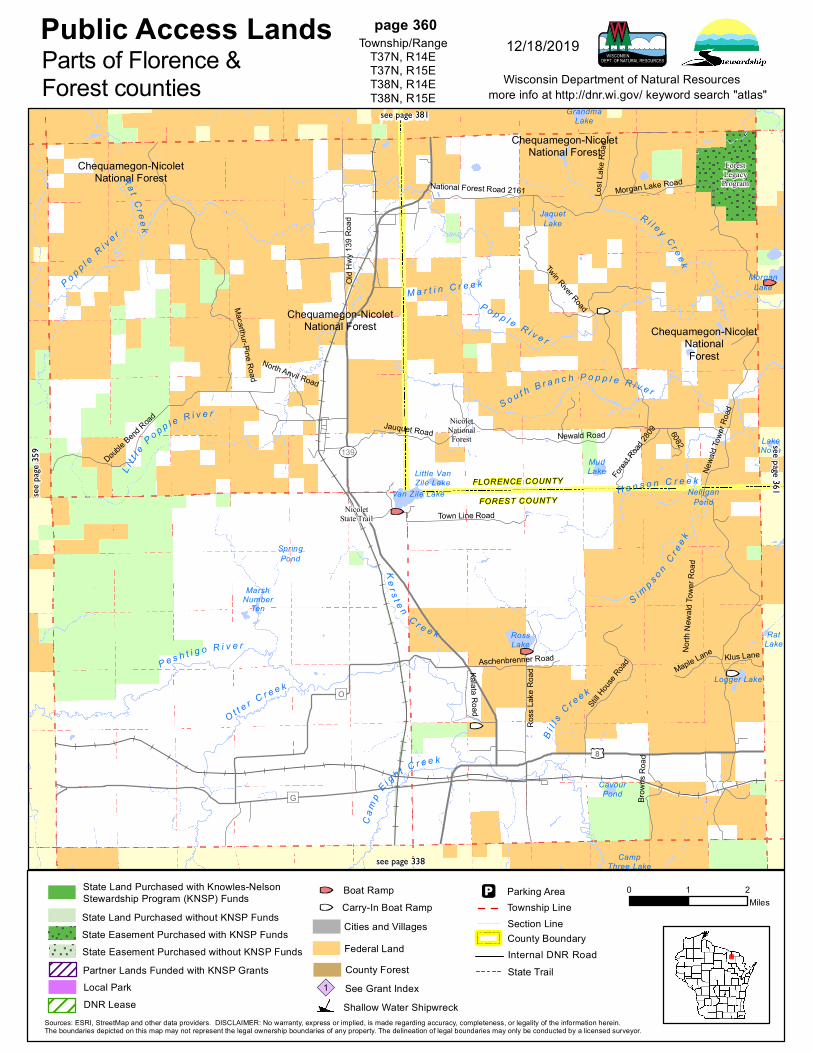
public access lands page 360 parts of florence & forest ... · chequamegon-nicolet national...
TRANSCRIPT
Chequamegon-NicoletNational Forest
Chequamegon-NicoletNationalForest
Chequamegon-NicoletNational Forest
Chequamegon-NicoletNational Forest
MorganLake
S i m
p s o nC r e
e k
K e r s t e n
C r e e k
R i l e y C r e ek
O t t er C r e e k
S o u t h B r a n c h P o p p l e R i v e r
L it t l
e P o p p l e R i v e r
H a n s o n C r e e k
Cam
pE i g h t C r e e k
P o p p l eR i v e r
P o p p l e R i v e r
M a r t i n C r e e k
Ra t C r ee k
B il l s
C r e e k
P e s h t i g o R i v e r
ForestLegacy
Program
NicoletState Trail
NicoletNationalForest
8
139
G
O
Old H
wy 13
9 Roa
dNorth Anvil Road
Twin River RoadMacarthur-Pine Road
Newa
ld Tow
er Ro
ad
Forest
Road 28
09 6082
Klus LaneMaple Lane
Jauquet Road
Lost
Lake
Roa
d
Kalata Road
Newald Road
Aschenbrenner RoadBr
owns
Roa
d
Town Line RoadRo
ss La
ke R
oad
Double B
end Road
Still H
ouse R
oad
National Forest Road 2161 Morgan Lake Road
North
New
ald To
wer R
oad
FLORENCE COUNTY
FOREST COUNTY
MarshNumber
Ten
RossLake
SpringPond
Little VanZile Lake
GrandmaLake
JaquetLake
Van Zile Lake
RatLake
LakeNona
CampThree Lake
NelliganPond
CavourPond
MudLake
Logger Lake
Public Access Landsmore info at http://dnr.wi.gov/ keyword search "atlas"
0 1 2Miles
Wisconsin Department of Natural Resources
Sources: ESRI, StreetMap and other data providers. DISCLAIMER: No warranty, express or implied, is made regarding accuracy, completeness, or legality of the information herein.The boundaries depicted on this map may not represent the legal ownership boundaries of any property. The delineation of legal boundaries may only be conducted by a licensed surveyor.
page 360Township/Range
T37N, R14ET37N, R15ET38N, R14ET38N, R15E
12/18/2019Parts of Florence &Forest counties
see pa
ge 35
9
see page 381
see page 361
see page 338
State Land Purchased without KNSP Funds
State Land Purchased with Knowles-NelsonStewardship Program (KNSP) Funds
State Easement Purchased with KNSP FundsState Easement Purchased without KNSP Funds
State Trail
Section LineTownship LineParking Area
Cities and Villages
County ForestSee Grant Index1Shallow Water Shipwreck
County BoundaryInternal DNR Road
Carry-In Boat RampBoat Ramp
Federal LandPartner Lands Funded with KNSP GrantsLocal ParkDNR Lease
Chequamegon-NicoletNational Forest
Chequamegon-NicoletNational Forest
Chequamegon-NicoletNational Forest
LoggerLake
Sprin
gdal
eB r
a nc h
L a m o n Ta n g u eC r e
e k
R o c k C r e e k
H e n d r i c k s C r e e k
MudCreek
A r m s t r o n g C r e e k
H a l l s C
r ee k
Mo r ga nCr e ek
P o p p l e R i v e r
S y d n e y C r e e k
L un d
C r ee k
Forest LegacyProgram
StateOwnedIslands
Pine-PoppleWild Rivers
8
101
F
C
H
Engle
king R
oad
Wall Road
Morgan Lake Road
Newald Tower Road
Milla
n Roa
d
Old 101 Road
Wozn
iak R
oad
Lunds Road
South Hilbert Drive
Forest Lake Drive
Janc
zews
ki Ro
ad
Ardens Road
Sportsman Road
Dallm
ann R
oad
Nichols Lane
Fatla
Roa
d
Fawn Acres Drive
Sunrise Road
Partridge Road
Chitk
o Roa
dLamontagne Road
Spur Lake Road
Forest Road 606
Camp B
Loop
Road
Fire L
ane R
oad
Memory
Lane
Clark
Lake
Roa
d
Washburn Falls Road
Twin Lake Road
Maple Drive
Rock Cree
k Road Fir
e Tow
er Ro
ad
Shrine Road
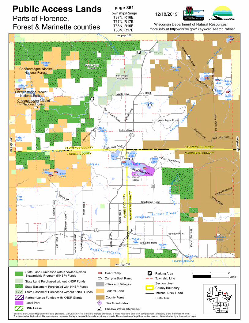
FLORENCE COUNTY
FOREST COUNTY
FLORENCE COUNTY
MARINETTE COUNTY
FORE
ST C
OUNT
Y
MARI
NETT
E CO
UNTY
PetrykLake
Camp B Lake
ForestLake
NadjakLake
Goodman Millpond
LafayeLake
BuckskinLake
BassLake
Clark Lake
MorganLake
LakeGordon
Lost Lake
RatLake
LakeNona
WheelerLake
HobacheeLake
HallsLake
MudLake
WestBassLake
OneontaLake
ScoutLake
LakeLaura
Lund Lake
MirrorLake
BushLake
Hilbert Lake
Public Access Landsmore info at http://dnr.wi.gov/ keyword search "atlas"
0 1 2Miles
Wisconsin Department of Natural Resources
Sources: ESRI, StreetMap and other data providers. DISCLAIMER: No warranty, express or implied, is made regarding accuracy, completeness, or legality of the information herein.The boundaries depicted on this map may not represent the legal ownership boundaries of any property. The delineation of legal boundaries may only be conducted by a licensed surveyor.
page 361Township/Range
T37N, R16ET37N, R17ET38N, R16ET38N, R17E
12/18/2019Parts of Florence,Forest & Marinette counties
see pa
ge 36
0
see page 382
see page 362
see page 339
State Land Purchased without KNSP Funds
State Land Purchased with Knowles-NelsonStewardship Program (KNSP) Funds
State Easement Purchased with KNSP FundsState Easement Purchased without KNSP Funds
State Trail
Section LineTownship LineParking Area
Cities and Villages
County ForestSee Grant Index1Shallow Water Shipwreck
County BoundaryInternal DNR Road
Carry-In Boat RampBoat Ramp
Federal LandPartner Lands Funded with KNSP GrantsLocal ParkDNR Lease
BelgianLake
Big QuinnesecFalls Flowage
ScoutLake
B ea v e r B ra n ch
Cro s
s et t
C re e
k
Nor t h B r an c h P ike R i v e r
M a c i n t i r e C r e e k
KC
C r e e k
S pur
Cre
ekS o u
th B r a n c h L i t tl e
Popp
leRiv
erL i t t l e P o p p l e R i v e rS a n d L a k e
B r a n c hS o u t h B r a n c h P e m e b o n w o n R i v e r
C o l e C r e e k
Dunbar BarrensState Natural
Area
Spread Eagle BarrensNatural Area
North BranchPemebonwonFishery Area
ScatteredForest Land
8
95
Michigan
N
C
O
B
U
Sleete
r Roa
d
CCC Camp Road
Pike River Drive
Old B
F R 529
Westman Road
Fr527
Miller Road
River Drive
Forest Road 533
Toby
s Roa
d
Church RoadEmmet Avenue
Main
Road
Sky Line Drive
Walton Road
Secti
on Li
ne R
oad
One Mile Road
Woods Road
Camp 12 Road
Jack
Pine
Driv
e
Forest Road 523
Fr521
Fr519
Forest Road 520
Spur Lake Road
Forest Road 518
JohnsonCamp Road
Osterberg ParkwayBurma Road
3 Mile Road
West
Fisch
er La
ke Pa
rkway
DvorakLake
LostLake
NorthPond
MarmLake
SandLake
Cowboy Lake
HoskinLake
SpurLake
FischerLake
SackersonLake
HallsLake
No BottomLake
Johnson
MoonLake
HordLake
Railroad Pond
PotholeLake
BushLake
Minnie LakeYoungLake
MudLake
Public Access Landsmore info at http://dnr.wi.gov/ keyword search "atlas"
0 1 2Miles
Wisconsin Department of Natural Resources
Sources: ESRI, StreetMap and other data providers. DISCLAIMER: No warranty, express or implied, is made regarding accuracy, completeness, or legality of the information herein.The boundaries depicted on this map may not represent the legal ownership boundaries of any property. The delineation of legal boundaries may only be conducted by a licensed surveyor.
page 362Township/Range
T37N, R18ET37N, R19ET38N, R18ET38N, R19E
12/18/2019Parts of Florence &Marinette counties
see pa
ge 36
1
see page 383
see page 363
see page 340
State Land Purchased without KNSP Funds
State Land Purchased with Knowles-NelsonStewardship Program (KNSP) Funds
State Easement Purchased with KNSP FundsState Easement Purchased without KNSP Funds
State Trail
Section LineTownship LineParking Area
Cities and Villages
County ForestSee Grant Index1Shallow Water Shipwreck
County BoundaryInternal DNR Road
Carry-In Boat RampBoat Ramp
Federal LandPartner Lands Funded with KNSP GrantsLocal ParkDNR Lease
Chequamegon-NicoletNational Forest
Chequamegon-NicoletNationalForest
Chequamegon-NicoletNational Forest
Chequamegon-NicoletNational Forest
Chequamegon-NicoletNational Forest
Chequamegon-NicoletNational Forest
HemlockLake
SpruceLake
A l l en
C re e
k
W o o ds C r e e k
C o l d w a t e r C r e e k
Hal s
e y L
a ke
S lo u
g h
M a i n l i n e C r e e k
L i l y p a d C r e e k
S t evensC
re ek
F ay
L ak e
O u tl e
tP i n e R i v e r
R a t C r e e k
John s o n
C re e
k
P i n e C r e e k
W e s t A l l e n C r e e k
K i n g s t o n e C r e e k
M e a d o w b r o o k C r e e k
Duck
Cre e
k
NicoletStateTrail
Woods CreekCedars StateNatural Area
NicoletNationalForest
139
70
Long Lake Road
Steve
ns La
ke R
oad
Fay La
ke Road
Thras
her R
oad
Lost
Lake
Roa
d
Halsey Lake Road
Dream Lake Road
Schro
eder
Road
Lily P
ad R
oad
Schu
ltz Ro
ad
Borzick
Road
Shannon RoadQuinlan Spur Road
Tie Mill Road
Chipmunk Rapids Road
Daum
itz R
oad
Pento
ga R
oad
Settle
ment
Road
Old H
wy 13
9
Tucker Road
Maca
rthur-
Pine R
oad
Wisconsin Creek Road
FLOR
ENCE
COU
NTY
FORE
ST C
OUNT
Y
LongLake
Johnson Pond
ReisnerLake
Ramsdell LakeWisconsin Slough
Bastile Lake
Beaver Pond
GrandmaLake
LostLake
OnimishLake
CharlieOtto
Spring
MudLake
KillbornLake
DuckLake
ColdSpring
ChuksLake
Fay LakeOutlet
GrubHoeLake
RatLake
MainlineLake
LilypadLake
WapooseLake
Lakeof Dreams
TroutSprings
ZielerSpring
LittleWapoose Lake
WolfPond
Porcupine Lake
LongLake
HalseyLake
StevensLake
Fay Lake
Public Access Landsmore info at http://dnr.wi.gov/ keyword search "atlas"
0 1 2Miles
Wisconsin Department of Natural Resources
Sources: ESRI, StreetMap and other data providers. DISCLAIMER: No warranty, express or implied, is made regarding accuracy, completeness, or legality of the information herein.The boundaries depicted on this map may not represent the legal ownership boundaries of any property. The delineation of legal boundaries may only be conducted by a licensed surveyor.
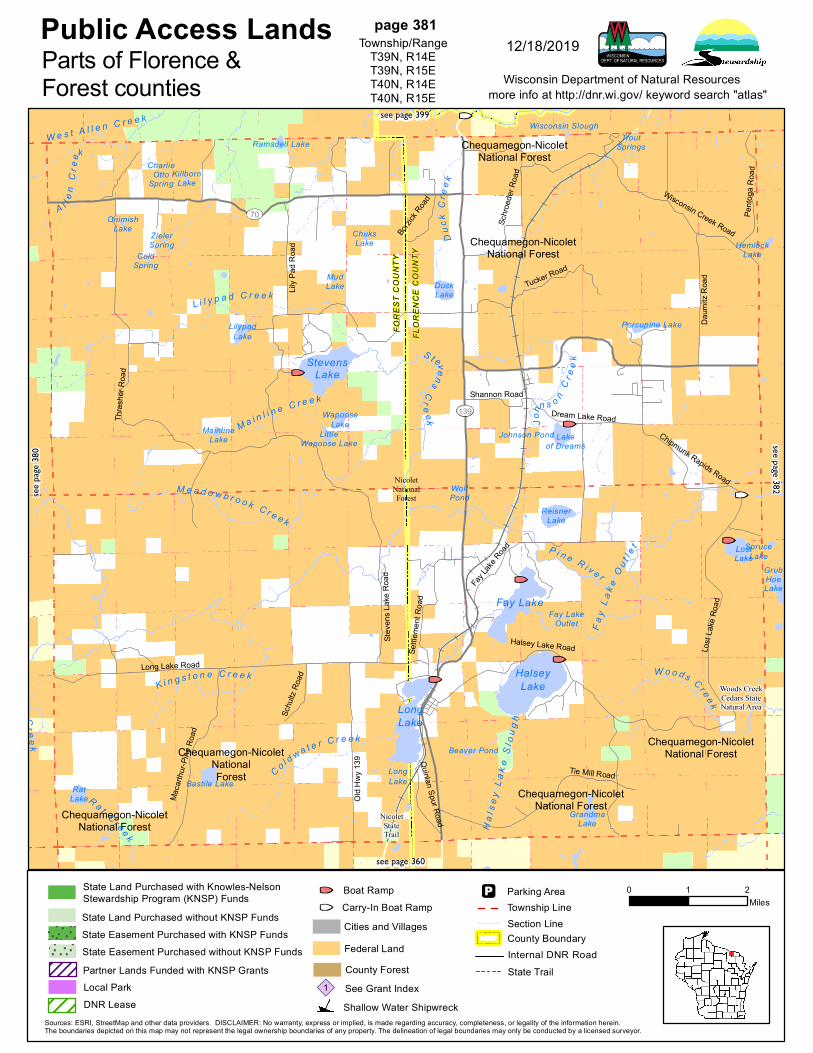
page 381Township/Range
T39N, R14ET39N, R15ET40N, R14ET40N, R15E
12/18/2019Parts of Florence &Forest counties
see pa
ge 38
0
see page 399
see page 382
see page 360
State Land Purchased without KNSP Funds
State Land Purchased with Knowles-NelsonStewardship Program (KNSP) Funds
State Easement Purchased with KNSP FundsState Easement Purchased without KNSP Funds
State Trail
Section LineTownship LineParking Area
Cities and Villages
County ForestSee Grant Index1Shallow Water Shipwreck
County BoundaryInternal DNR Road
Carry-In Boat RampBoat Ramp
Federal LandPartner Lands Funded with KNSP GrantsLocal ParkDNR Lease
Chequamegon-NicoletNational Forest
Chequamegon-NicoletNational Forest
Chequamegon-NicoletNational Forest
R i l ey C r e
e k
B r u l e R i v e r
P i n e R i v e r
M o n t a g n e C r e e k
P i n e R i v e r
StateOwned IslandsForest
LegacyProgram
Forest LegacyProgram
StateNatural Area
Statewide PublicAccess
Haley CreekSwamp StateNatural Area
Pine-PoppleWild Rivers
Pine-PoppleWild Rivers
Statewide Habitat Areas
2
101
70
MichiganMichigan
D
Second Crossing Road
Edith Lake Road
Norway Pine Lane
Harding Road
Carlson RoadWisconsin Creek Road
Ironwood DriveGoodman Grade Drive
National Forest Road 2151
Thompson Road
Duck Lake Road
White Ash Road
Patten Lake Road
1st Crossing Road
National Forest Road 2150HemlockLake
CampThirteen
Lake
BellLake
EdithLake
BootLake
LostLake
SpruceLake
LittlePorcupine
Lake KieperLake
LittleRiley Lake
DuckLake
PickerelLake
LittleBoot Lake
HallsLake
Olson Lake
GrassLake
LoonLake
GrubHoeLake
Silverdollar Lake
SevenmileLake
BassLake
MudLake
Dorothy Lake
RileyLake
Dead MansLake
Lake Seventeen
Birch Lake
Perch Lake
SeidelLake
BessieBabbet
Lake
Sea Lion Lake
LautermanLake
Haley Lake
CruiserLake
Robago Lake
WhiskerLake
JutraLake
KeyesLake
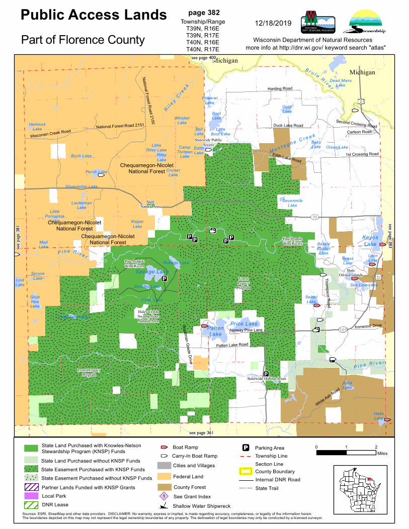
Price Lake
Savage Lake
PattenLake
Public Access Landsmore info at http://dnr.wi.gov/ keyword search "atlas"
0 1 2Miles
Wisconsin Department of Natural Resources
Sources: ESRI, StreetMap and other data providers. DISCLAIMER: No warranty, express or implied, is made regarding accuracy, completeness, or legality of the information herein.The boundaries depicted on this map may not represent the legal ownership boundaries of any property. The delineation of legal boundaries may only be conducted by a licensed surveyor.
page 382Township/Range
T39N, R16ET39N, R17ET40N, R16ET40N, R17E
12/18/2019
Part of Florence Countysee
page
381
see page 400
see page 383
see page 361
State Land Purchased without KNSP Funds
State Land Purchased with Knowles-NelsonStewardship Program (KNSP) Funds
State Easement Purchased with KNSP FundsState Easement Purchased without KNSP Funds
State Trail
Section LineTownship LineParking Area
Cities and Villages
County ForestSee Grant Index1Shallow Water Shipwreck
County BoundaryInternal DNR Road
Carry-In Boat RampBoat Ramp
Federal LandPartner Lands Funded with KNSP GrantsLocal ParkDNR Lease
KeyesLake
FirstC
re e k
L e p ag eCreek
P i n e R i v e r
D e a d m a n C r e e k
H a ll s
C r e e k
P in e
Cr e
e kB a d w a t e r C r e e k
F is h
e rC r
e ek
A n i o i n e Cre e k
B a ir d
Cr e
e k
J o h n s o n C r e e k
B r u l e R i v e rSpre a d
E a g l e O u t l e
t
M e n o m i n e eR i v e r
State OwnedIslands
ForestLegacy
Program
Spread EagleBarrens
Natural Area
Statewide Public Access
Pine-PoppleWild Rivers
2101 Michigan
N
NN
D
4
Woods Road
Johnson Creek RoadLasalle Falls Road
Cook Lane
Olive Avenue
Brule
Land
ing R
oad
Chapin Road
Town
Road
J
River Forest Road
Rometti Drive
Roach Fire Lane Road
Blome-Helgren Road
Lake Emily Drive
Sand
Lake
Roa
d
Lower Dam Road
Brule Dam Road
Finn T
own R
oad
Came
ls Cle
aring
Roa
d
North Lake Road
Pine River Road
Montgomery Lake Road
Old Highway Sixty Nine Road
Montgomery Lake
CowboyLake
LakeAnna
MudLake
EastLake
DyerLake
HausermanLake
CosgroveLake
SpringLake
FrogLake
HallsLake
LoonLake
MudLake
Lost Lake
Lilly Lake
LongLake
CrystalLake
Sand Lake
BairdLake
JuleLake
Folz Pond
BrowningLake
BradfordLakeMarlow
Lake
SouthLake
BarrensLake
Bass Lake
StarLake
FisherLake
LakeMichigamme
ChapinMine
WestLake
NorthLake
Railroad Lake
MiddleLake
MoonLake
Emily Lake
BadwaterLakeTwin Falls
Flowage
Ellwood Lake
Public Access Landsmore info at http://dnr.wi.gov/ keyword search "atlas"
0 1 2Miles
Wisconsin Department of Natural Resources
Sources: ESRI, StreetMap and other data providers. DISCLAIMER: No warranty, express or implied, is made regarding accuracy, completeness, or legality of the information herein.The boundaries depicted on this map may not represent the legal ownership boundaries of any property. The delineation of legal boundaries may only be conducted by a licensed surveyor.
page 383Township/Range
T39N, R18ET39N, R19ET40N, R18ET40N, R19E
12/18/2019
Part of Florence Countysee
page
382
see page 362
State Land Purchased without KNSP Funds
State Land Purchased with Knowles-NelsonStewardship Program (KNSP) Funds
State Easement Purchased with KNSP FundsState Easement Purchased without KNSP Funds
State Trail
Section LineTownship LineParking Area
Cities and Villages
County ForestSee Grant Index1Shallow Water Shipwreck
County BoundaryInternal DNR Road
Carry-In Boat RampBoat Ramp
Federal LandPartner Lands Funded with KNSP GrantsLocal ParkDNR Lease
OttawaNationalForest
OttawaNationalForest
OttawaNationalForest
Chequamegon-NicoletNational Forest
LakeFifteen
ScottLake
Sun s
e tC r
e ekAu
t i oC r
e ek
Wis
con s
i nC r
e ek
B l e a t C r e e k
Stan
l ey C r e e kSo
u th
B ra n
c h I r
o n R
i ve r
N o r t h B r a n c h I r o n R i v e r I r on
L ak e
Cr e
e k
B r u l e R i v e r
Holm
e s C r e e k
A l l en
C r ee k
Wi l s
o nC r e
e k
W e s t A l l e n C r e e k
Nas h
Cr e
e k
I r o n
R i v e r
I r on
R i ve r
G a sp a
r do
C r ee k
O l s o nC r e e k
NicoletStateTrail
OttawaNationalForest
NicoletNationalForest
189
139
73
55
Michigan
Gaspa
rdo Ro
ad
Huff C
reek R
oad
Daum
itz R
oad
Wilson Road
FLOR
ENCE
COU
NTY
FORE
ST C
OUNT
Y
Ramsdell LakeWisconsin Slough
LakeTwentytwo
NelsonLake
BennanLake
HolmesLake
CharlieOtto Spring
WildwoodLake
Killborn Lake
CampLake
LaurelLake
IceLake
LakeSixteen
SnipeLake
WebbLake Lake
Nine
PloverLake
TroutSprings
BatesLake
StanleyLake
IronLake
Sunset Lake
HagermanLake
LakeOttawa
Public Access Landsmore info at http://dnr.wi.gov/ keyword search "atlas"
0 1 2Miles
Wisconsin Department of Natural Resources
Sources: ESRI, StreetMap and other data providers. DISCLAIMER: No warranty, express or implied, is made regarding accuracy, completeness, or legality of the information herein.The boundaries depicted on this map may not represent the legal ownership boundaries of any property. The delineation of legal boundaries may only be conducted by a licensed surveyor.
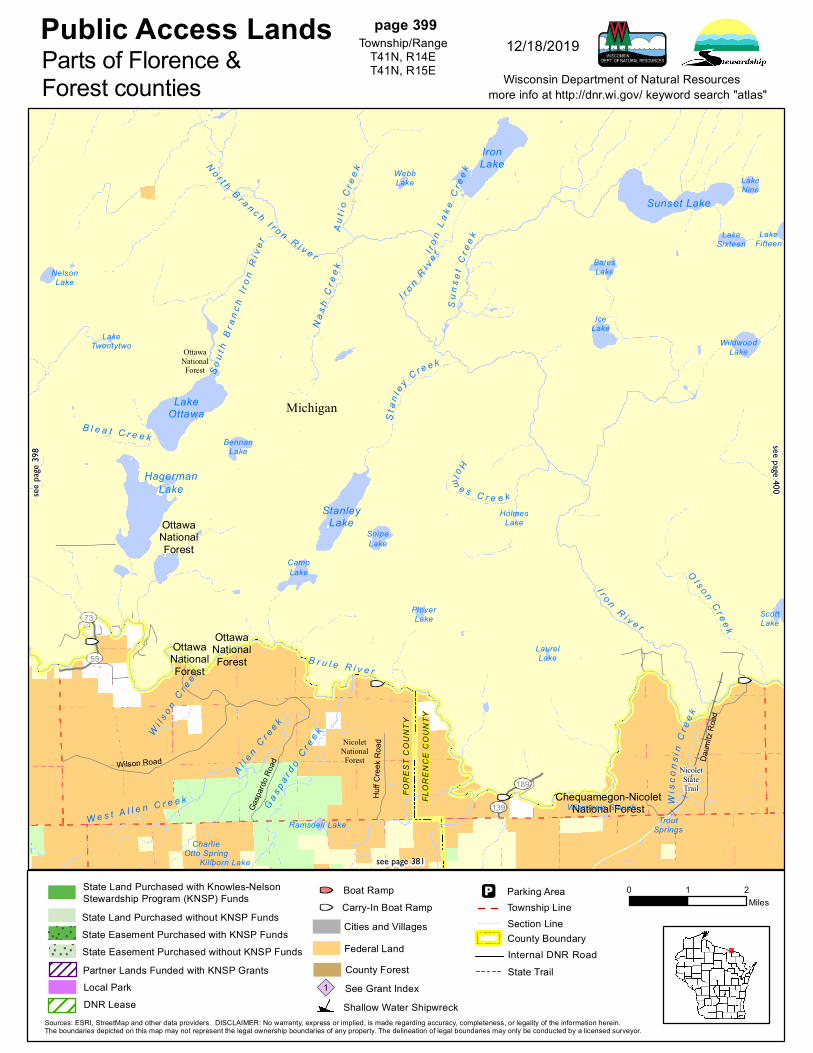
page 399Township/Range
T41N, R14ET41N, R15E
12/18/2019Parts of Florence &Forest counties
see pa
ge 39
8
see page 400
see page 381
State Land Purchased without KNSP Funds
State Land Purchased with Knowles-NelsonStewardship Program (KNSP) Funds
State Easement Purchased with KNSP FundsState Easement Purchased without KNSP Funds
State Trail
Section LineTownship LineParking Area
Cities and Villages
County ForestSee Grant Index1Shallow Water Shipwreck
County BoundaryInternal DNR Road
Carry-In Boat RampBoat Ramp
Federal LandPartner Lands Funded with KNSP GrantsLocal ParkDNR Lease

Chequamegon-NicoletNational Forest
Chequamegon-NicoletNational Forest
Chequamegon-NicoletNational Forest
WildwoodLake
KennedyLake
LakeSixteen
LakeNine
C hi c
a go n
S lo u
g h
R i l ey C r e
e k
F o r t u n e L a k e C r e e kD u n n C r e e k
B r i a r H i l l C r e e kBr
ul e R i v e r
W a g n e r C r e e k
B r u l e R i v e r
M a s t o d o n C r e e k
P a i n t R i v e r
Wa t e rw or k s
CreekO l s o n C r e e k
A l p h a C r e e k
NicoletNationalForest
2
Michigan
Carney Dam Road
Pento
ga Ro
ad
Kalla
Wall
a Trai
l
LakeFifteen
Pickerel Lake
IsaacsonLake
Finn Lake
BeaverLake
MudLakes
WagnerLake
MudLake
LongLake
AndersonLake
ArchiePond
ArmstrongLake
LowerHolmes
Lake
BlueLake
Dead MansLake
Shoe Pac Lake
SevenSprings
Lake
LittleTobinLake
ScottLake
DamLake
IndianLake
BuckLake
LakeEmily
ChicagonLake
Public Access Landsmore info at http://dnr.wi.gov/ keyword search "atlas"
0 1 2Miles
Wisconsin Department of Natural Resources
Sources: ESRI, StreetMap and other data providers. DISCLAIMER: No warranty, express or implied, is made regarding accuracy, completeness, or legality of the information herein.The boundaries depicted on this map may not represent the legal ownership boundaries of any property. The delineation of legal boundaries may only be conducted by a licensed surveyor.
page 400Township/Range
T41N, R16ET41N, R17ET41N, R17E
12/18/2019
Part of Florence Countysee
page
399
see page 382
State Land Purchased without KNSP Funds
State Land Purchased with Knowles-NelsonStewardship Program (KNSP) Funds
State Easement Purchased with KNSP FundsState Easement Purchased without KNSP Funds
State Trail
Section LineTownship LineParking Area
Cities and Villages
County ForestSee Grant Index1Shallow Water Shipwreck
County BoundaryInternal DNR Road
Carry-In Boat RampBoat Ramp
Federal LandPartner Lands Funded with KNSP GrantsLocal ParkDNR Lease