provision(of(atmospheric(mo1on(vectors((amvs)(for...
TRANSCRIPT

Provision of atmospheric mo1on vectors (AMVs) for the use in Numerical Weather Predic1on (NWP)
model-‐based reanalysis in the framework of SCOPE-‐CM (Sustained and coordinated processing of
Environmental Satellite data for Climate Monitoring)
Toshiyuki KURINO (presented by Kazuki Shmoji)
Data Processing Department Meteorological Satellite Center (MSC) Japan Meteorological Agency (JMA)

Objec1ve
• The major objec,ve of this project is to provide Atmospheric Mo,on Vectors (AMV), Clear Sky Radiances (CSR) and All Sky Radiances (ASR) for the use in global and poten,ally regional Numerical Weather Predic,on (NWP) model-‐based reanalysis.
• Furthermore, AMV data provided on regular grids may also be u,lised in the analysis of dynamical systems in rela,on to water vapour transport or monsoon studies.
(e.g. SCM-‐04: U,lity of Satellite derived winds for Monsoon and Cyclone studies over Indian region)

Satellite Sensor Record for geosta1onary imagers
S a t e l l i t e System
Posi1on Longitude
Period Image rate for AMV deriva1on
Comments
GOES-‐E 75° W 1980 – today Variable GOES-‐W 135° W 1980 – today Variable Meteosat (2 -‐ 10)
0° 1982 – 2004 2004 -‐ today
30 min 15 min
Meteosat (5 and 7)
63° E 57° E
1997 – 2005 2005 -‐ today
30 min
30 min Called Indian Ocean Data Coverage (IODC)
Meteosat 3 70° W
75° W 1991 – 1993 1993 – 1995
30 min
30 min Called Atlan,c Data Coverage (ADC) Called eXtended ADC (XADC)
GMS (GOES-‐9)
140° E 155° E
1978 – 2003 2003 – 2005
30 min
30 min GOES-‐9 was put at the Western Pacific Region
MTSAT 140° E 145° E
2005 – 2010 2010 – today
15 min, 30 min, 60 min

Satellite Sensor Record for polar orbi1ng imagers
• AMVs can also be derived from instruments on board polar orbi,ng satellites providing measurements in infrared window and water vapour absorp,on channels. Instruments u,lised by NOAA, CIMSS and EUMETSAT are AVHHR (IR-‐window) and MODIS (IR window and water vapour). AVHRR data coverage reaches back to 1979 and MODIS data coverage starts in 2000.
h`p://noaasis.noaa.gov/NOAASIS/ml/avhrr.html (NOAA/NESDIS) h`p://www.eumetsat.int/Home/Main/Satellites/Metop/Instruments/SP_2010053153142514 (EUMETSAT) h`p://modis.gsfc.nasa.gov/ (NASA)
Algorithms and Processing chains (1/3)
• The overarching objec,ve would be an AMV processing system that could be applicable to all historical geosta,onary satellites.
• The exis,ng processing systems at EUMETSAT and JMA do not have this capability, but could be extended.
• The CIMSS AMV deriva,on algorithm is capable of reprocessing all historical MODIS, AVHRR, GOES, Meteosat and GMS/MTSAT images.
• The exis,ng algorithms differ between AMV processing agencies, and a first step towards a more unified algorithm would be the analysis of the differences.

Algorithms and Processing chains (2/3) • The project would seek close interac1on with the CGMS
Interna1onal Winds Working Group (IWWG) to benefit from ongoing comparison ac,vi,es that might need to be enhanced to cover the temporal dimension of the AMVs long term records.
• The project would also seek close interac1on with SCOPE-‐CM sub-‐project, SCM-‐06: Inter-‐calibra1on of imager observa1ons from 1me-‐series of geosta1onary satellites (IOGEO) through the experience from Global Space-‐based Inter-‐calibra1on System (GSICS) for reprocessing AMVs and CSRs/ASRs long term records.
• GSICS provides bias correc,ons through the inter-‐calibra,on of satellite sensors with respect to selected references that can be applied to generate reprocessed CSR and ASR products as Fundamental Climate Data Records (FCDRs) and related Thema,c Climate Data Records (TCDRs).

Algorithms and Processing chains (3/3) • The reprocessing of AMV requires the background fields of
NWP, which are crucial for its height assignment. The periods of the exsis,ng reanalyses fully cover the opera,on periods of historical meteorological satellites. Thus, the updated reanalysis fields are expected to be used in the AMV reprocessing with the quality informa,on of the reanalysis fields.
• The project would exchange informa1on with reanalysis communi1es on their calcula,on plans and the quality. The best forum iden,fied for discussion of data issues is the WCRP Data Advisory Council that has representa,on from reanalysis centres.
• The project will encourage reanalysis centres to give feedback and support AMV, CSR and ASR valida,on exercises by involving observa,on feedback archives and associated tools such as developed at ECMWF.
Historical overview of related reanalysis ac1vi1es (1/2)
• The first reanalysis was the 15-‐year ECMWF Reanalysis (ERA-‐15). ERA-‐15 collected and used historical AMV data generated opera,onally. Such reanalysis ac,vity was extended to other NWP centres such as NCEP/NWS/NOAA, JMA and NASA, and some of them performed reanalysis calcula,on repeatedly extending period and upgrading NWP and data assimila,on system.
• As the extension of reanalysis, accurate observa,on data were requested. To meet the requirement, EUMETSAT reprocessed AMVs for past Meteosat satellites. It reprocessed Meteosat-‐2 to 7 AMVs and provided them to ECMWF for ERA-‐40 and ERA-‐Interim.
• The first reprocessing by JMA was performed to provide reprocessed GMS-‐3 to -‐5 AMVs to the Japanese 25-‐year Reanalysis (JRA-‐25).
Historical overview of related reanalysis ac1vi1es (2/2)
• Currently, EUMETSAT is performing the reprocessing of AMVs, CSRs and ASRs for Meteosat-‐8 and 9 data within the ERA-‐CLIM project. This ac,vity will con,nue in ERA-‐CLIM2 and also include METEOSAT-‐2 to 7.
• JMA/MSC has completed the reprocessing of AMVs for GMS-‐1,3,4,5, GOES-‐9 and MTSAT-‐1R data within the JRA-‐55 project. JMA/MSC also has completed CSRs reprocessing for GMS-‐5, GOES-‐9 and MTSAT-‐1R .
• University of Wisconsin/CIMSS has completed the re-‐processing of 18-‐19 years of GOES AMVs.

ERA-‐CLIM
• ERA-‐CLIM: 2011 – 2013 – CSR and ASR from MSG for 2004 – 2011 (ongoing) – AMV from MSG for 2004 – 2011 (ongoing) – AMV from METOP-‐A for 2007 – 2012 (completed for two algorithms (EUMETSAT & CIMSS))
• ERA-‐CLIM2: 2014 – 2016 – AVHRR AMVs from 1982 to present – AMV from MFG and MSG 1982 to present

Atmospheric Mo,on Vectors (AMVs) from GEO
MSG 2004 – 2011 • 3-hourly winds • IR 10.8 µm • VIS 0.8 µm • WV 7.3 µm & 6.2 µm
Speed AMV IR, all, high, mid, low al,tudes

Summary of proposed project
The major points to work on to reach the goal of this project are: -‐ Analysis of differences in AMV, CSR and ASR product defini,on, algorithms and processing chains for instruments in geosta,onary and polar orbit; -‐ Development of a plan for a more coherent product suite for all instruments; -‐ Enhancement of AMV algorithms with a quan,ta,ve uncertainty es,mate; -‐ Establishment of a valida,on framework for AMVs by agreeing on a metric, certain quality analysed non-‐satellite observa,ons and by u,lising means from reanalysis centres; -‐ Enhancement of the documenta,on towards a coherent descrip,on of the products
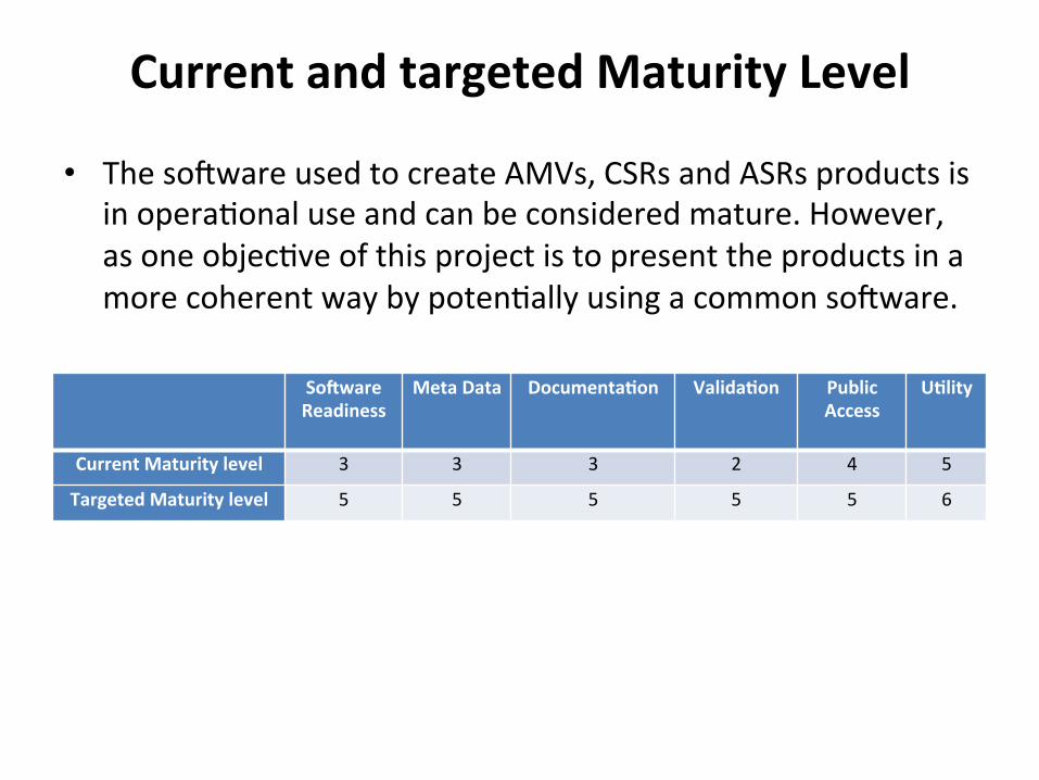
Current and targeted Maturity Level
• The sojware used to create AMVs, CSRs and ASRs products is in opera,onal use and can be considered mature. However, as one objec,ve of this project is to present the products in a more coherent way by poten,ally using a common sojware.
So^ware Readiness
Meta Data Documenta1on Valida1on Public Access
U1lity
Current Maturity level 3 3 3 2 4 5
Targeted Maturity level 5 5 5 5 5 6

Dura1on of the project and schedule (5 years from 1 Jan 2014)
− Review on the use of AMV and CSR in past reanalysis; − Analyze requirement for future reanalysis; − Analyze the differences in AMV product defini1on, algorithms and
processing chains and develop a plan for a globally coherent product;
− Perform feasibility analysis of GOES AMV processing with respect to satellite observa1on schedule and forward analysis result to reanalysis centres
− Encourage other space agencies opera1ng geosta1onary /polar orbital instruments to join the project;
− Open a project portal site
2014 All All JMA, EUM, NOAA,
NOAA
JMA, EUM
JMA − Build common valida1on framework following agreed metric involving
radiosonde observa1ons and tools provided by reanalysis centres; − Perform processing of geosta1onary products;
2015 EUM, JMA, NOAA
EUM, JMA, NOAA
− Perform processing of polar orbit data; − Perform processing of geosta1onary products (con1nue); − Validate products from geosta1onary satellites; − Analyze feedback on early phase products from reanalysis centers
2016 EUM
EUM, JMA, NOAA
All
− Update the documenta1on of all products in coherent style; − Validate products from polar orbi1ng satellites;
2017 EUM , JMA, NOAA
− Analyze feedback on products from reanalysis centres and other applica1ons and develop a plan for SCOPE-‐CM phase 3
2018 All

Status and Progress
-‐ GOES AMV Reprocessing (Point 4) -‐ AMV workshop at ECMWF (Point 3) -‐ Project Portal Site (Point 6)

Status of GOES AMV Reprocessing
C. Velden, D. Santek, D. Stegner, S. Wanzong
Coopera1ve Ins1tute for Meteorological Satellite Studies (CIMSS)
University of Wisconsin-‐Madison U.S.A
20 February 2014
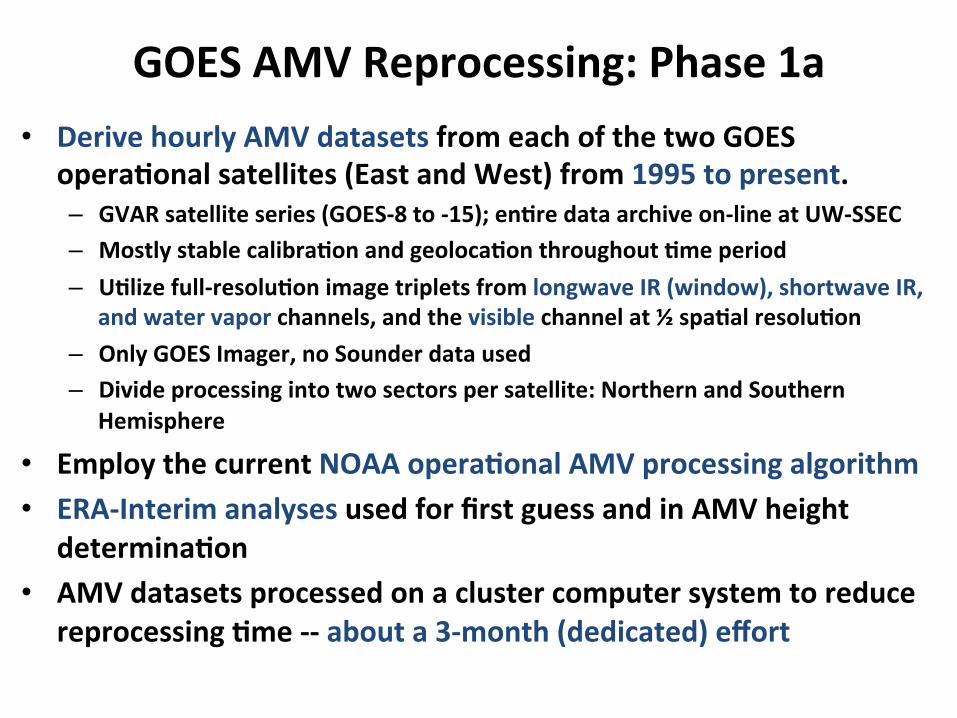
GOES AMV Reprocessing: Phase 1a • Derive hourly AMV datasets from each of the two GOES
opera1onal satellites (East and West) from 1995 to present. – GVAR satellite series (GOES-‐8 to -‐15); en1re data archive on-‐line at UW-‐SSEC – Mostly stable calibra1on and geoloca1on throughout 1me period – U1lize full-‐resolu1on image triplets from longwave IR (window), shortwave IR,
and water vapor channels, and the visible channel at ½ spa1al resolu1on – Only GOES Imager, no Sounder data used – Divide processing into two sectors per satellite: Northern and Southern
Hemisphere
• Employ the current NOAA opera1onal AMV processing algorithm • ERA-‐Interim analyses used for first guess and in AMV height
determina1on • AMV datasets processed on a cluster computer system to reduce
reprocessing 1me -‐-‐ about a 3-‐month (dedicated) effort

GOES AMV Reprocessing: Coverage
GOES-‐West 07 May 2005 1500 UTC
GOES-‐East 07 May 2005 1500 UTC
Blue: Northern Hemisphere coverage Yellow: Southern Hemishpere coverage

GOES AMV Reprocessing: Status • Con1nuous, hourly AMV datasets have been re-‐processed for
the two GOES opera1onal satellites from 1995 to mid-‐2013. – ~600,000 AMV datasets generated – Quality control of the AMVs is underway, both automated and visual – Output text files will be prepared for community access (April release expected)
• This will complete Phase 1a of the reprocessing effort
• Future GOES AMV reprocessing plans (currently unfunded): – Phase 1b: Reprocess the same dataset, but using the GOES-‐R cluster tracking
algorithm (J. Daniels, NOAA/NESDIS) and cloud height algorithm (A. Heidinger, NOAA/NESDIS), both under development
– Phase 2: Extend the reprocessing to earlier U.S. satellites (from 1978 onward), which will require a more substan1al effort to:
• Correct sensor calibra1on and geoloca1on • Produce cloud products (heights) for the pre-‐GVAR satellites
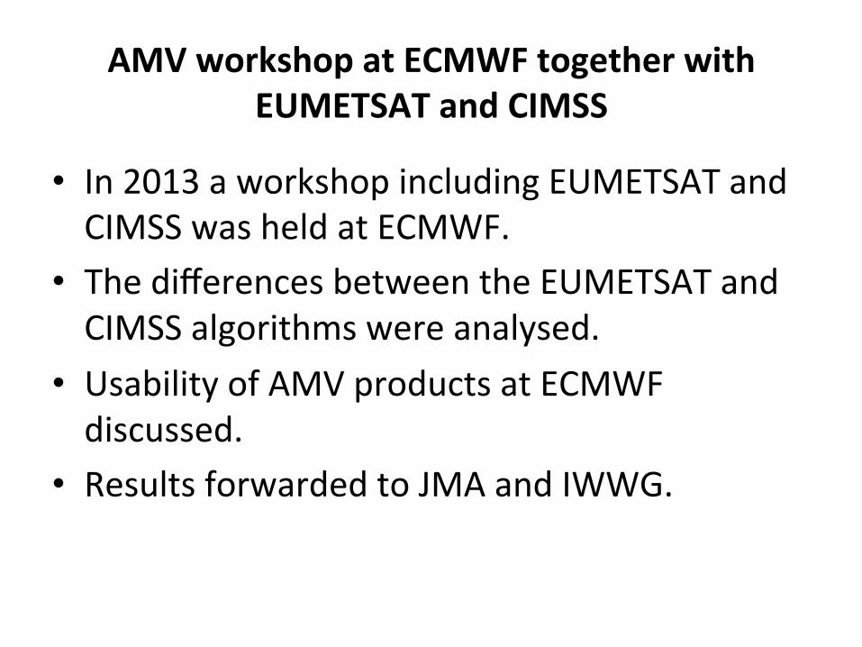
AMV workshop at ECMWF together with EUMETSAT and CIMSS
• In 2013 a workshop including EUMETSAT and CIMSS was held at ECMWF.
• The differences between the EUMETSAT and CIMSS algorithms were analysed.
• Usability of AMV products at ECMWF discussed.
• Results forwarded to JMA and IWWG.

Contents for Project Portal Site Reprocessing Projects • JMA’s website for reprocessing of Satellite Products for
Climate h`p://mscweb.kishou.go.jp/product/reprocess/ • EUMETSAT’s website on Climate Data Records: h`p://www.eumetsat.int/website/home/Data/Products/
Climate/index.html Reanalysis Projects • JRA-‐55 website: h`p://jra.kishou.go.jp/JRA-‐55/index_en.html • ERA-‐CLIM website: h`p://era-‐clim.eu/

Observational Data available for JRA-55
GNSS: Global Naviga,on Satellite System 22

Appendix
Summary of reprocessing efforts for GOES, METEOSAT, Himawari, and AVHRR, mostly AMVs (report from AMV workshop at ECMWF with the addi1on of JMA’s status for Himawari)
as of Sep, 2013 (need to be updated)

Summary of reprocessing efforts for GOES, METEOSAT, Himawari, and AVHRR, mostly AMVs as of Sep, 2013 (1/10)
CIMSS EUMETSAT JMA/MSC
Current data holdings
GOES, SMS-‐1, -‐2, MODIS, KALPANA, POES AVHRR, COMS, GMS, METEOSAT-‐3 onwards, MTSAT, FY-‐ 2C/D/E
METEOSAT, METOP and POES AVHRR (star,ng with NOAA-‐18)
GMS, (GOES-‐9), MTSAT
Already reprocessed
AMV from POES AVHRR (NOAA-‐7 to – 18)
1) AMV and CSR from METEOSAT-‐2 to -‐7 up to end of 2000 2) AMV from AVHRR METOP-‐A up to end of 2012 (using two algorithms, EUMETSAT opera,onal and CIMSS)
AMVs from GMS-‐1 to MTSAT, CSRs from GMS-‐5 to MTSAT
Current produc,on
GOES GVAR -‐8 to -‐15 (1995-‐present): AMV. Expected to be available by 2014. Includes processing of 30-‐ minute images, 15-‐minute images, and 7-‐minute rapid scan images (producing possibly 1 wind product every 7 minutes, though limited to extreme weather situa,ons)
AMV, CSR, ASR, THU, CTH, NDVI, CLM, Cloud type, cloud top pressure, cloud top temperature, from METEOSAT-‐8 and -‐9. Expected to be available by 2014
AMVs and CSRs
(1) Programma1c

Summary of reprocessing efforts for GOES, METEOSAT, Himawari, and AVHRR, mostly AMVs as of Sep, 2013 (2/10)
CIMSS EUMETSAT JMA/MSC
Funding for current produc,on
SSEC grant EU FP7 ERA-‐CLIM and EUMETSAT own resources JMA/MSC own resources
Commi`ed reprocessing
1) AMV, CSR, ASR from Meteosat-‐7 for years 2001-‐2004 for zero degree, and for years from 2001 and up to real ,me for Indian Ocean Data Coverage. Expected to be available by 2014. 2) AMV from AVHRR POES and AVHRR METOP-‐A and -‐B reprocessed by 2015. 3) AMV, CSR, ASR from METEOSAT-‐2 to -‐9 based on inter-‐satellite calibrated IR radiances and updated algorithm. Expected to be available by 2016.
Funding for commi`ed reprocessing
EU FP7 ERA-‐CLIM2 and EUMETSAT own resources

Summary of reprocessing efforts for GOES, METEOSAT, Himawari, and AVHRR, mostly AMVs as of Sep, 2013 (3/10)
CIMSS EUMETSAT JMA/MSC
Considered reprocessing
POES AVHRR using updated code and input and more metadata in output MODIS from EOS-‐Aqua and Terra Repeat current GVAR reprocessing but with latest algorithm (NESDIS GOES-‐R tracking), and extend reprocessing to older GOES satellites, pre-‐GVAR.
Ajer ERA-‐CLIM2 updated codes may arrive from SCOPE-‐CM and can be used for increasing the consistency of geosta,onary AMV products. Also planned Meteosat First Genera,on image reprocessing and inter-‐satellite calibra,on lead to new reprocessing of the same data
Of value, but unfunded
-‐ KALPANA -‐ GOES-‐1 to -‐7 (1978-‐1995) -‐ SMS-‐1 and SMS-‐2 (1979-‐1981) -‐ ATS (1974)
-‐ Rou,ne METEOSAT-‐8 and -‐9 rapid scan images (since May 2008) at 5-‐minute intervals, producing possibly 1 wind product every 20 minutes, limited to 15N-‐70N -‐ METEOSAT-‐8 and -‐9 high resolu,on visible channel images
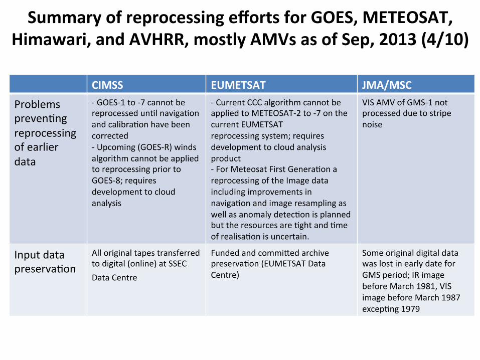
Summary of reprocessing efforts for GOES, METEOSAT, Himawari, and AVHRR, mostly AMVs as of Sep, 2013 (4/10)
CIMSS EUMETSAT JMA/MSC
Problems preven,ng reprocessing of earlier data
-‐ GOES-‐1 to -‐7 cannot be reprocessed un,l naviga,on and calibra,on have been corrected -‐ Upcoming (GOES-‐R) winds algorithm cannot be applied to reprocessing prior to GOES-‐8; requires development to cloud analysis
-‐ Current CCC algorithm cannot be applied to METEOSAT-‐2 to -‐7 on the current EUMETSAT reprocessing system; requires development to cloud analysis product -‐ For Meteosat First Genera,on a reprocessing of the Image data including improvements in naviga,on and image resampling as well as anomaly detec,on is planned but the resources are ,ght and ,me of realisa,on is uncertain.
VIS AMV of GMS-‐1 not processed due to stripe noise
Input data preserva,on
All original tapes transferred to digital (online) at SSEC Data Centre
Funded and commi`ed archive preserva,on (EUMETSAT Data Centre)
Some original digital data was lost in early date for GMS period; IR image before March 1981, VIS image before March 1987 excep,ng 1979

Summary of reprocessing efforts for GOES, METEOSAT, Himawari, and AVHRR, mostly AMVs as of Sep, 2013 (5/10)
CIMSS EUMETSAT JMA/MSC
Input data backup (disaster recovery)
-‐ NOAA NCDC holds the official GOES archive -‐ SSEC has addi,onally processed the original GOES archive and has rescued more data and produced data of higher quality than current NCDC holdings.
-‐ EUMETSAT Data Centre -‐ Third copy back-‐up off-‐site
-‐ JMA/MSC Data Archives -‐ Third copy back-‐up in distributed universi,es and research ins,tutes (no systema,c preserva,on)
(2) Reprocessing methods, including input and output interfaces
CIMSS EUMETSAT JMA/MSC
Input sensor data
GVAR level 1b AVHRR POES level 1b and regridded
METEOSAT level 1.5 MVIRI and SEVIRI AVHRR METOP level 1b (and IASI METOP level 1c)
VISSR, SVISSR for GMS HIRID and HRIT for MTSAT
Summary of reprocessing efforts for GOES, METEOSAT, Himawari, and AVHRR, mostly AMVs as of Sep, 2013 (6/10)
CIMSS EUMETSAT JMA/MSC
Input channels
-‐ AVHRR: IR 10.8 micron -‐ GOES: WV 6.7 micron, IR 10.7 micron, SWIR 3.9 micron, and VIS
0.63 micron
-‐ AVHRR: IR 10.8 micron -‐ METEOSAT-‐8 and -‐9: IR 10.8 micron, WV 6.2 and 7.3 micron, VIS 0.8 micron Note: VIS 0.6 micron not used for AMV METEOSAT-‐2 to -‐7: IR [10.5-‐12.5 micron], WV [5.7-‐7.1 micron], VIS [0.5-‐0.9 micron]
GMS-‐5,GOES-‐9 and MTSAT (IR,WV,VIS) GMS-‐(1-‐5) (IR, VIS)
Input background
-‐ GOES: ERA-‐Interim reanalysis analyses Pressure levels 1x1 degree2 grid 6-‐hourly -‐ AVHRR: NCEP/NCAR reanalysis analyses Pressure levels 1x1 degree2 grid 6-‐hourly
ERA-‐Interim 6-‐hourly forecasts (+6h and +12h steps) 60 model levels for AVHRR, 31 model levels for METEOSAT-‐8 and -‐9, 16 model levels for METEOSAT-‐2 to -‐ 7 0.5x0.5 degree2 grid for AVHRR, 1x1 degree2 grid for METEOSAT-‐8 and -‐9, 1.5x1.5 degree2 grid for METEOSAT-‐2 to -‐7 6-‐hourly
JRA-‐25 reanalysis data (Grid:1.25 degree 23 Layers)
Background ,me interpola,on
Linear in ,me Linear in ,me
Linear in ,me
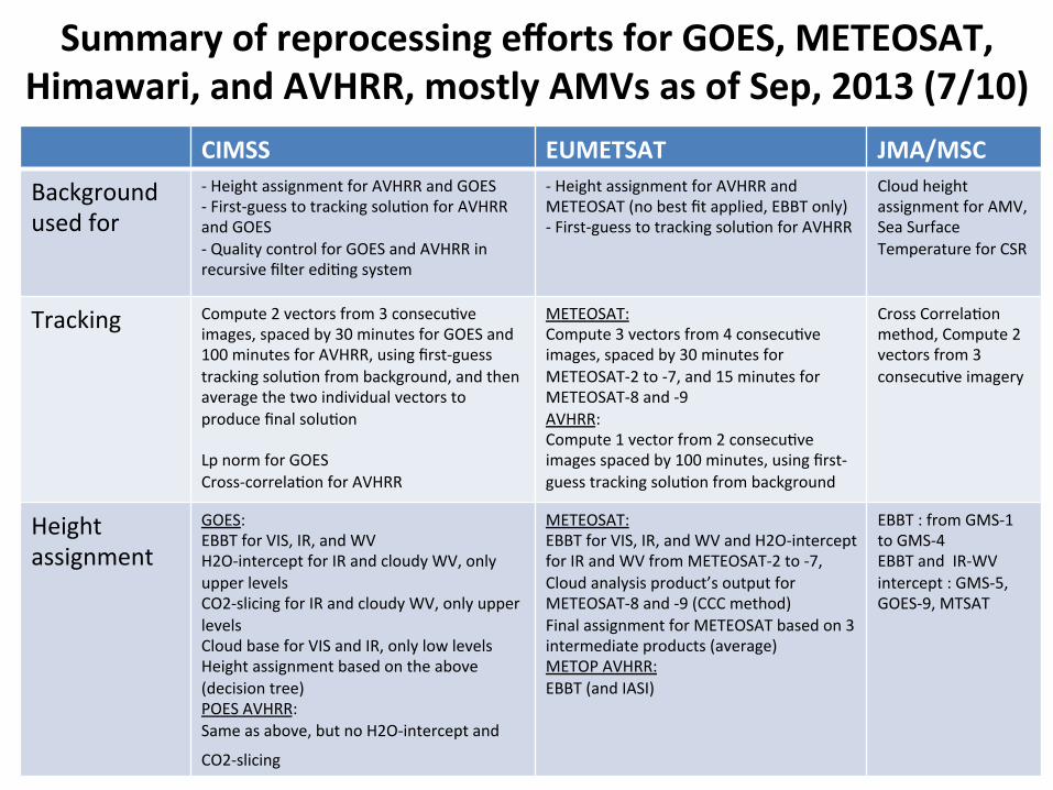
Summary of reprocessing efforts for GOES, METEOSAT, Himawari, and AVHRR, mostly AMVs as of Sep, 2013 (7/10)
CIMSS EUMETSAT JMA/MSC
Background used for
-‐ Height assignment for AVHRR and GOES -‐ First-‐guess to tracking solu,on for AVHRR and GOES -‐ Quality control for GOES and AVHRR in recursive filter edi,ng system
-‐ Height assignment for AVHRR and METEOSAT (no best fit applied, EBBT only) -‐ First-‐guess to tracking solu,on for AVHRR
Cloud height assignment for AMV, Sea Surface Temperature for CSR
Tracking Compute 2 vectors from 3 consecu,ve images, spaced by 30 minutes for GOES and 100 minutes for AVHRR, using first-‐guess tracking solu,on from background, and then average the two individual vectors to produce final solu,on Lp norm for GOES Cross-‐correla,on for AVHRR
METEOSAT: Compute 3 vectors from 4 consecu,ve images, spaced by 30 minutes for METEOSAT-‐2 to -‐7, and 15 minutes for METEOSAT-‐8 and -‐9 AVHRR: Compute 1 vector from 2 consecu,ve images spaced by 100 minutes, using first-‐guess tracking solu,on from background
Cross Correla,on method, Compute 2 vectors from 3 consecu,ve imagery
Height assignment
GOES: EBBT for VIS, IR, and WV H2O-‐intercept for IR and cloudy WV, only upper levels CO2-‐slicing for IR and cloudy WV, only upper levels Cloud base for VIS and IR, only low levels Height assignment based on the above (decision tree) POES AVHRR: Same as above, but no H2O-‐intercept and
CO2-‐slicing
METEOSAT: EBBT for VIS, IR, and WV and H2O-‐intercept for IR and WV from METEOSAT-‐2 to -‐7, Cloud analysis product’s output for METEOSAT-‐8 and -‐9 (CCC method) Final assignment for METEOSAT based on 3 intermediate products (average) METOP AVHRR: EBBT (and IASI)
EBBT : from GMS-‐1 to GMS-‐4 EBBT and IR-‐WV intercept : GMS-‐5, GOES-‐9, MTSAT

Summary of reprocessing efforts for GOES, METEOSAT, Himawari, and AVHRR, mostly AMVs as of Sep, 2013 (8/10)
CIMSS EUMETSAT JMA/MSC
Height assignment future method
1DVAR for GOES and AVHRR Op,mal es,ma,on using the OCA output for METEOSAT-‐8 and -‐9
Quality indicator
EUMETSAT quality indicators (QIs), with and without background (forecast) check RFF quality indicator using height reassignment and poten,al speed bias adjustment
EUMETSAT quality indicators (QIs), with and without background (forecast) check
EUMETSAT QI
Quality control (yes/no)
QI has to exceed 60 Visual inspec,on of ,me-‐series of valida,on metrics w.r.t RAOB
QI has to exceed 30 QI has to exceed 60
Na,ve output format
McIDAS MD format (binary)
METEOSAT-‐na,ve EPS format for AVHRR
"JMA Vector File"
Delivery format
Text (space-‐separated) BUFR BUFR

Summary of reprocessing efforts for GOES, METEOSAT, Himawari, and AVHRR, mostly AMVs as of Sep, 2013 (9/10)
CIMSS EUMETSAT JMA/MSC
Processing system: input data acquisi,on
Satellite data online Satellite data retrieved from EUMETSAT Data Centre
Satellite data retrieved from JMA/MSC Data Centre
Processing system: hardware
Linux cluster, can run ~50 simultaneous streams
Legacy RMPEF (32-‐bit SUN environment) for METEOSAT R-‐EPS (IBM AIX Power6) for AVHRR Can run 3 simultaneous streams for METEOSAT, and 24 for AVHRR
Linux
Hardware resource
In-‐kind contribu,on from SSEC Funded by EUMETSAT Funded by JMA/MSC
Processing system: main sojware
For GOES, NOAA/NESDIS opera,onal For AVHRR, CIMSS code
EUMETSAT opera,onal ground segment sojware, adapted for reprocessing purposes
JMA AMV deriva,on sojware
Reprocessing speed
3900 days/day for AVHRR (using regridded input) Es,mated 440 days/day for GOES
50 days/day for AVHRR (including radiance mapping) 9 days/day for METEOSAT
MTSAT : 10days/1day OTHERS : 45days/1day

Thank you for your a`en,on