operational use of nwc saf amv package in the met office...
TRANSCRIPT

Operational use of NWC SAF AMV package in the Met Office mesoscale forecasting system
© Crown copyright Met Office
Graeme Kelly, Peter Lean, Crispian Batstone, and James Cotton.

OVERVIEW • Satellite derived Atmospheric Motion Vectors
(AMVs) have given positive benefit to the Global and Regional NWP forecasts for many years, however their use in Nowcasting and mesoscale forecasting systems has been limited due large AMV tracking boxes and timeliness.
• This NWCSAF package allows AMVs to be produced with smaller tracking boxes producing AMVs that are more suitable. In addition the NWCSAF package can be run locally over a small region to provide AMVs within a few minutes of the satellite image reception.

© Crown copyright Met Office © Crown copyright Met Office
UKV,UK4 & Nowcasting Model Domains
Model Resolution VAR Time Window Cycling Forecast
Length
UKV 4 km / 1.5km 3D-Var /3km 3 hr 3 hr T+36
South UK Fixed 1.5 km 4D-Var 1.5/3km 1 hr 1 hr T+6 or T+12

© Crown copyright Met Office
UKV 1.5km DA cycling
q 8 three-hour cycles per day
q Data times for long (t+36) forecasts 03, 09, 15, 21 UTC
§ Observation cut-off hh+ 30min
§ Lateral boundaries from Global model
q Intermediate cycles at 00, 06, 12, 18 UTC
§ Observation cut-off hh+ 2hr 40min
§ Lateral boundaries from hh Global run

New web monitoring

NWCSAF CLOUD PRODUCT St Jude day storm
© Crown copyright Met Office
Meteosat 8 cloud type 06z 28 OCT Meteosat 8 channel 9 06z 28 OCT

RAPID SCAN M8 5 MINUTE UKAMVs During the passage of the St JUDE day storm 2013 OCT 2013 0305-0855
All UKAMVs Blue 0-30kts Yellow 31-60kts Green 61-90kts Red 91-120kts Navy 121-150kts

RAPID SCAN M8 5 MINUTE UKAMVs During the passage of the St JUDE day storm 2013 OCT 2013 0305-0855 All UKAMVs
Blue 0-30kts Yellow 31-60kts Green 61-90kts Red 91-120kts Navy 121-150kts

RAPID SCAN M8 5 MINUTE UKAMVs During the passage of the St JUDE day storm 2013 OCT 2013 0305-0855
All UKAMVs increasing speed Blue 0-30kts Yellow 31-60kts Green 61-90kts Red 91-120kts Navy 121-150kts

Forecast impact
• The NWCSAF AMV package (v2011) was iniBally setup in research mode and some NWP trials were run 28 days.
• The results were essenBally neutral using the current AMV setup for EUMETSAT AMVs. A number of 7 day trials were run with various seNngs of the Bme and space thinning parameters.
• The results appeared to degrade if the thinning was reduced below 20km and the Bme window was larger than one hour. In addiBon the sensiBvity to various seNng of AMV QI were tested.

Forecast impact
• A 28day NDP 4DVAR was run with the rapid scan MSG imagery producing AMVs from every second image. AMVs were sent to Met Office data base and available for all Bmes slots for 4DVAR with 45min data cut-‐off.
• Given the small region of the NDP over southern England it was not surprising that there was no significant impact of AMVs but this experiment useful to check feasibility of the setup and check AMV could be processed quickly enough to meet the data cut off Bme.
• The UKV data assimilaBon is in the of process of being upgraded to 4DVAR.

UK Index Metric for forecast verification
• ETS Equitable Threat Score
• RMS root mean square
• Weighted Basket of Indices
• 6 elements
• Combo of ETS & RMS scores
• UK4 Impact trials verified to T+24 at 00, 06, 12, 18 UTC
Element ETS Threshold 1.5m Visibility 200m, 1000m,
5000m 6 hour ppn accumulation
0.5mm, 1.0mm, 4.0mm
Cloud Cover 0.3, 0.6, 0.8
Cloud Base Height
100m, 500m, 1000m
1.5m Temperature
1-RMS2
RMS2(pst)
10m wind 1-RMS2
RMS2(pst)

UKV 15 Nov 2012 to 31 Dec 2012
© Crown copyright Met Office

Forecast impact
• Following the installaBon of the NWCSAF package (v2012) AMVs could now be calculated from addiBon MSG channels including water vapour.
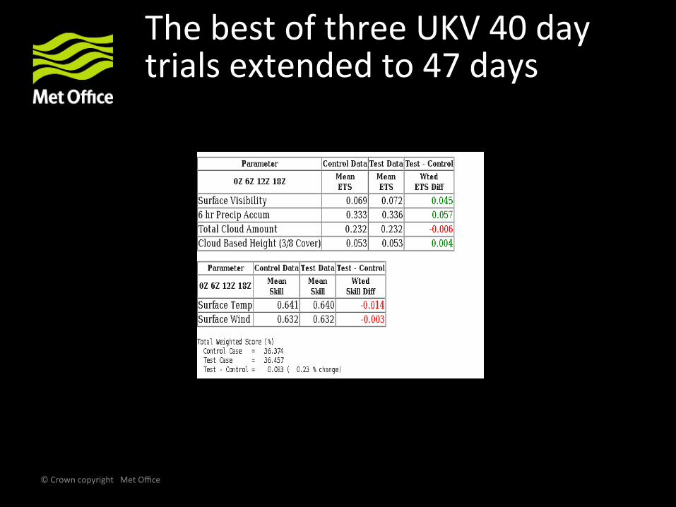
• A series of three 40day trials were run with the new package to tesBng thinning (20km and 10km) and temporal thinning (30min and 60min) with the UKV suite.
• The best UKV trial ( 20km and 30min thinning) it trial was then extended to 47 days.
• A further 30 day trial run with an updated version of NWCSAF package.
© Crown copyright Met Office
The best of three UKV 40 day trials extended to 47 days

• Results demonstrated that lowering assigned height by around 40hPa gives an improved fit to the model background.
• Easy-win : no changes required to observation operator
• NWP assimilation trial setup:
• 2 weeks Nov 2013.
• UKV 3d VAR, 3 hour cycling.
• Lowered all assigned heights by 40hPa
• +ve impact on tropospheric winds during t+0 – t+12h
• broadly neutral for other variables.
NWP assimilation trials using a lower assigned height

Table of monthly stats in UKV region. Height bias (40 hPa) lower was introduced to UK AMVs after March 2014
© Crown copyright Met Office
2013 DEC
2014 JAN
2014 FEB
2014 MAR
2014 APR
2014 MAY
UK BIAS -3.38 -2.99 -2.68 -1.31 -1.31 -0.42 EUM BIAS -3.93 -3.61 -3.23 -3.04 -2 -2.33
UK STD 5.34 5.39 5.1 4.36 4.37 4.08 EUM STD 6.86 6.59 6.13 6.97 4.70 5.01
UK NUM 807017 64456 553310 533615 728237 574661 EUM NUM 19323 12030 12546 14059 15502 14932
Note: from March clear improvement in BIAS and STD for UK AMVs after the reduction of 40 hPa

Adjusted AMV lowering AMV heights by 40 hPa 28 Sept 2013 to 28 Oct 2013 AMV’s usage above 400hPa

Forecast impact of adding extra AMV’s (900-401) hPa over sea. (28 Sept 2013 to 28 Oct 2013) AMV’s usage above 400hPa (forecast control use amv’s > 400hpa adjusted heights by 40 hPa)
© Crown copyright Met Office

Forecast impact of adding extra AMV’s (900-401) hPa over sea and adjusted AMV’s above 400 hPa (28 Sept 2013 to 28 Oct 2013) AMV’s usage above 400hPa (forecast control use amv’s > 400hpa adjusted heights by 40 hPa)

Final comments
© Crown copyright Met Office
1. In January 2014 the locally produced AMVs, using the NWCSAF package, replaced the EUMETSAT AMVs in the operational UKV data assimilation.
2. In March 2014 the UK AMVs > 400 hPa assigned heights were reduced by 40 hPa .
3. The use of UK AMVs over sea >900 hPa has been successfully tested and has been introduced to the operational UKV data assimilation.
4. Testing of UK AMVs will begin in the near future using 4DVAR.