prosp traverse nagagami rivier porcupine mng div
TRANSCRIPT

-- --. .. ——. ....... .... INI ••III ••III Hill
42F15SE0002 OP92-859 MCMILLAN010
PROSPECTING TRAVERSE
NAGAGAMI RIVER
PORCUPINE MINING DIVISION, ONTARIO
NTS: 4EF/10 and 42F/15
49031'3O" N lat784047'3O" W long
to
4904G'aD" N lat784032'1O" W long
by
Robert M. Kuehnbaum31O1 O'Hagan Drive
Mississauga, OntarioL5C 2C4

42F15SE0002 OP92-859 MCMILLAN
TABLE OF CONTENTS
010C
INTRODUCTION 1
LOGISTICS 1
PHYSIOGRAPHY AND QUATERNARY SEDIMENTS 3
PREVIOUS EXPLORATION WORK 3
GEOLOGY 4
STREAM SEDIMENT GEOCHEMISTRY G
DISCUSSION G
REFERENCES 7
APPENDIX I, ANALYTICAL CERTIFICATES, STREAM SEDIMENT SAMPLES . . B
LIST OF FIGURES
Figure 1. Part of 1:1,000,000 scale Bedrock Geology, showing location of Nagagami River traverse, and locations of nearby towns 2
2. Frost Township, Geology and Stream Sediment Samples packet scale 1 inch = \ mile
3. Cross Township, Geology and Stream Sediment Samples pocket scale 1 inch ;^ \ mile
4. Arnott Township, Geology and Stream Sediment Samples pocket scale 1 inch = \ mile
5. McMillan Township, Geology and Stream Sediment Samples pocket scale 1 inch - \ mile

PROSPECTING TRAVERSENAGAGAMI RIVER
PORCUPINE MINING DIVISIONONTARIO
NTS: 42F/1O and 42F/15
INTRODUCTION:
This report summarizes the results of a reconnaissance prospecting traverse of a section of highly metamorphosed Archean rocks along the Nagagami River in northwestern Ontario. The study was part of the author's 1992 O.P.A.P. grant, and was carried out between August 17 and 20, 1992.
The 45-kilometer interval of the Nagagami River which was examined lies south of Highway 11, and west of Highway 631. The Nagagami River crosses Highway 11 about E1 km west of Hearst; the town of Hornpayne, located on the Canadian National Railways line, is situated about 73 km south of the junction of Highway 11 and Highway 631. Locations are given on Figure 1.
The objective of the program was to test for the possibility of greenstone assemblages and sulphide mineralization similar to that at the "McGale Prospect" on the Nagagami River north of Highway 11.
LOGISTICS:
The Nagagami River flows generally northward from Nagagami Lake,northwest of Hornpayne, to its confluence with the Kenogami River which in turn flows into the Albany River. South of Highway 11, there are three possible access points along the river: at Nagagami Lake and Melody Lake which are accessible by float aircraft, and; Couchiching Rapids which is accessible by vehicle via a new road from the Hornpayne area. According to personnel at Forde Lake Air Services, who operate a fishing camp on Nagagami Lake, and who occasionally run canoe excursions into the upper part of the river, the terrane above Melody Lake is very low-lying, and the river current sluggish. Since it was apparent that there was little likelihood of good bedrock exposure there, it was decided to fly into Melody Lake (from Forde Lake] which is the northernmost access point south of Highway 11.
Below Melody Lake, there are six portages varying in length from 50 m to 1,700 m, representing a total of 4,950 m. The portage trails are narrow but not difficult; a lack of maintenance in the last two years, however, has resulted in occasional deadfall and windfall zones across the trails.
Most sections of the Nagagami River are meandering, deep (about 3 m) and slow-flowing, but there are occasional intervals (see below) with shallow riffles and pocketwater with increased current where passage is somewhat hazardous. It is suspected that, in a normal summer, water levels would be sufficiently low for spotting channels and lining a canoe by wading; in the unusually high-water conditions (at least 0.6 m above normal) of 1992, however, the riffle water was very difficult to wade, and submerged (normally exposed) boulders presented hidden hazards. Nonetheless, the river is quite passable if sufficient care is taken. No attempt should be made to shoot or line any sections of the river

,—-^ -vi l /' /"- XRCER CFKX-J ARNOTT 5TOBEY NASSAU ; ,1ISH fjf WAY
S f . / X i .vft : i
(\J
Figure 1. Part of 1:1,000,000 scale Bedrock Geology, Geology of Ontario Series, showing location of Nagagami River traverse, and locations of nearby towns. Unit 7a is paragneiss and migmatite; unit 13 is muscovite- bearing granitic rocks.

where portages bypass rapids.
The author was assisted by Donald R. Hawke of Mississauga, Ontario.
PHYSIOGRAPHY AND QUATERNARY SEDIMENTS:
The terrane of the upper (southern] half of the area traversed - from Melody Lake to Dirty Bush Rapids - is largely very flat, and rises very little (less than 1 m to 2 m] above the Nagagami River. Forest cover is predominantly black spruce, with occasional poplar on higher ground (eskers?]. The banks of the river consist of clay and silt, with minor gravelly layers. Outcrop is scarce. Minor drainages are swampy, and have no noticeacle water flow; the mouths of many of them are blocked by beaver dams. The elevation drop from Melody Lake to the top of White Owl Rapids is in the order of 15-18 m over approximately 20 km; much of this drop is at Trout Rapids and Gull Rock Rapids. The river in this upper section is deep and relatively sluggish, flowing at a steady rate of about 1 km/hour; there are no riffle intervals, the only fast water being at the rapids. Outcrop is also scarce (Figs. 2 and 3].
Below White Owl Rapids, the character of the river is dramatically different. Although there is outcrop at Dirty Bush Rapids (Fig. 3), the rapids flow primarily over a base of boulders. Rough Rock Rapids and Jackpine Rapids ('the Canyon') similarly consist of boulders with intermittent bedrock exposure. Between Dirty Bush Rapids and Rough Rock Rapids, the river alternates between sections of steady current with occasional large boulders, and riffle/pocketwater sections - some up to \ km in length - over a bed of boulders. The banks of the river consist of gravelly silt-sand-clay. Between Dirty Bush Rapids and Rough Rock Rapids, the river drops about 20 m. The total descent of the river through Rough Rock Rapids and Jackpine Rapids is about 20-25 m over 2 km. The final interval traversed, between Jackpine Rapids and Hwy 11, is similar to that above Rough Rock Rapids, although riffles are relatively minor; the river descends about 5-7 m along 8 km in this section.
The observations of riverbank Quaternary sediments in this study corresponds to the distribution of glacial and glaciolacustrine deposits shown by Prest and others, 1968. According to them, the lower part of the river traverses ground morain of the Wisonsin (last] glacial episode. The upper part of the river crosses a narrow belt of glacial lake deposits, although east of the river are outwash and end morain deposits. In addition to typical granitoid material in the till, occasional cobbles of limestone from Paleozoic strata in the Hudson Bay Lowlands were also observed in this study, indicating glacial transport generally from the north. The limit of post-Wisconsin marine overlapis shown by Prest and others (1968) to be about 10-15 km north of Hwy 11, and no evidence of marine sediments were found during the present survey.
PREVIOUS EXPLORATION WORK
There are no mineral claims in the area of the present study, and there is no recorded mineral exploration work in any of the townships from Nagagami Lake to Hwy 11. The author is aware that, in the mid-1970s, Shell Minerals conducted helicopter-mounted, regional reconnaissance investigations, including geochemical surveys and geological mapping, in the region, including

- 4 -
the area around the Three Portages Rapids (McGale) sulphide prospect. The area of present interest may have been at least partially covered, but results are unknown.
A moderate amount of work has been done north of Hwy 11 in Auden and Fintry Townships, north of the area of interest. The "McGale prospect" on the Nagagami River, about 20 km north of Hwy 11, in the northeast corner of Auden Township, consists of a 3.5 to 7.5 m wide sulphide band composed of pyrite and pyrrhotite (about 20?0 with local chalcopyrite. As early as 1965-1366, Colleen Copper carried out geophysical surveys over the zone, and drilled four holes (Toronto Assessment Report #63.1884). In 1971, North D'Arcy Exploration Ltd., following a magnetic survey, drilled G holes totalling 1,511 ft (460.7 m}. The holes intersected greenstone, locally conglomeratic quartzite, and pegmatite. One hole is reported to have cut 47 ft (14.3 m) of massive pyrite and pyrrhotite with minor chalcopyrite and bornite. Another hole cut 24.5 ft (7.5 m] containing +50% sulphides (pyrrhotite) (Toronto Assessment Reports #10, 2.299). In 1985, Noranda Exploration covered an area to the east with MaxMin and magnetic surveys, and found six conductors on strike with the McGale prospect (Assessment Report#2.7779); there is no resord of drilling.
A G.S.C. aeromagnetic anomaly to the southwest, in the southwest part of Fintry Township, was followed up by ground magnetic and electromagnetic surveys in 1967 by Birch Point Mines. Anomalies were outlined (Assessment Report#63.2228), but there is no record of drilling. In 1974, the anomaly was covered with an airborne electromagnetic survey by Scintrex 5urveys Limited for Cedam Limited. The anomaly was discounted as being due to mafic intrusive rocks (Assessment Report #2.1409).
In 1988, a block of 100 claims owned by McKinnon Prospecting Syndicate in the Three Portages Rapids area was covered by an airborne geophysical survey (Ferderber Geophysics, Assessment Report #2.11207). The block has subsequently been expanded. In 1991, an airborne geophysical survey was flown by Aerodat for the McKinnon Prospecting Syndicate; the survey covered about 80 km of strike length, including the northern parts of Fintry and Auden Townships. The target is reported to be gold mineralization related to possible structures and iron formation (Assessment Report #2.1424). In the winter of 1991-1992, ground surveys were carried out by the syndicate.
GEOLOGY:
The only published geological map of the area of interest is a compilation (in part of unpublished data) by the Ontario Department of Mines (Innes, 1969) at a scale of 1 inch to 2 miles (1:126,720). Outcrop in the area is very sparse, and much of the geology - in particular mafic rocks - has been interpreted on the basis of G.S.C. aeromagnetic evidence. Between Melody Lake and Hwy 11, Innes (1969) shows lithologies at only five locations at rapids or riffles, where outcrops may have been examined by helicopter reconnaissance of the river. The rock types are: undifferentiated metasedimentary and metavolcanic migmatites of Archean age at Trout Rapids, Dirty Bush Rapids, Rough Rock Rapids, and at the Hwy 11 bridge, and; granitic rocks in an east-west riffle section between Dirty Bush Rapids and Rough Rock Rapids. Undifferentiated migmatites predominate in the general region south of Hwy 11. Interpreted northeast trending diabase dykes of Protero zoic age are readily apparent on aeromagnetic maps. Other aeromagnetic anomalies

trend east-west, and it was felt that these subtle anomalies could represent mafic metavolcanic rocks, iron formation or sulphide mineralization in the otherwise monotonous sequence of gneissic strata.
In this river traverse, the primary objective was to identify the presence or absence of such greenstone belt remnants and/or mineralization. Mapping in detail the gneissic rocks and granitoid intrusions was therefore of secondary importance. Nonetheless, because this area had never been syste matically mapped Cto the author's knowledge), most river exposures were examined. Exceptions are the central parts of Rough Rock Rapids and Jackpine Rapids where access is difficult. A few exposures of gneissic rocks could only be generally classified since they occur in riffle sections of the river where stopping was either hazardous or impassible. Observations of the geology are given on the accompanying \ mile to 1 inch (1:31,680) scale claim sheets [Figs 2 to 5).
The Archean layered and intrusive rocks comprise a migmatitic complex over the entire area of this study. Rocks of probably metasedimentary origin are represented by medium-grained, poorly compositionally banded biotite-quartz- feldspar (mostly plagioclase) paragneiss; the only other constituent minerals found are almandine garnet and cordierite at Dirty Bush Rapids. Where mobilizate or injection phases are minor, the rock is classified as a schist (unit pgne ). More commonly, however, veins of pegmatite and/or quartz monzonite and granodiorite are present in significant quantities (up to 40-50%), and the rock is classified as a migmatite (unit pgn ). The veins are usually narrow (10-20 cm), discordant to concordant to the foliation, and anastomosing. Schistosity is undulating, and trends from 090 to 130 ; dips are mostly moderately to steeply north. Coarse-grained, massive amphibolite (unit amph) occurs only at Island Rapids, as a small pod within typical migmatite; it contains traces of disseminated pyrrhotite, and may represent a remnant of a mafic intrusive or volcanic phase.
In a few outcrops, intrusive rocks predominate. They include: white to grey, massive to foliated, medium-grained hornblende-granodiorite (unit gd); pinkish, medium-grained massive to foliated biotite-quartz monzonite (qmz ) and hornblende-quartz monzonite (qmz ), and; biotite-diorite (di). The pink, massive pegmatite locally contains coarse muscovite, and appears to post date all other intrusive phases. The granodiorite and quartz monzonite in large outcrops are essentially identical to those lithologies in the migmatitic zones. The ubiquitous pegmatite is probably a partial melting (mobilizate) phase post dating formation of the migmatite complex.
Massive Proterozoic diabase (db) dykes occur at Trout Rapids, 1.5 km of Island Rapids, Island Rapids, and at the head of Jackpine Rapids. They vary from 20 cm to 5 m in width, and trend at 030 , 055 , and 155 ; all are vertical. The northeast trending dykes appear to follow a late fracture pattern observed in a few localities (e.g. Dirty Bush Rapids), while others fit the regional northwest trend. Interestingly, Innes (1969) interpreted a northwest trending dyke in the vicinity of Rough Rock and Jackpine Rapids, although the magnetic anomaly cannot be due to the 20 cm dyke observed there.
A 5-km long, east-west, positive aeromagnetic anomaly just west of Trout Rapids led Innes (1969) to postulate an east-west diabase dyke. Diabase was found at Trout Rapids, but the dyke trends at 030 , and the anomaly is therefore unexplained. No explanation could be found for a weakly negative east-west anomaly just east of Dirty Bush Rapids, nor a weakly positive anomaly about 3 km south of Dirty Bush Rapids, and 1-2 km west of the Nagagami River. It is intersting,

- B -
however, that there is no ground evidence for east-west diabase dykes; pyrrhotite- bearing mafic rocks (amphibolites) such as those at Island Rapids, are a possible cause.
STREAM SEDIMENT GEDQEMISTRY:
Because of the nature of the tributary streams in the upper part of the Nagagami River traverse (see section "Physiography and Quaternary Sediments"], and since there is no evidence of sediment redistribution by the stream flow, no sampling was done .
In the lower part of the river, particularly below Jackpine Rapids, the minor drainages are often swift due to their descent into the river valley. Transported silt and minor sand and clay is abundant, and the streams often have mini-deltas at their mouths. This accumulation of sediment probably occurs annually, since the spring ice breakup would likely sweep away previous accumu lations.
The results of geochemical analysis of 18 stream sediment samples from the lower part of the traverse are given in Appendix I, and sample locations are shown on the accompanying claim sheets. Gold was analyzed by fire assay - atomic absorption methods, and other metals by ICP analysis in the -80 mesh fraction. Analyses were performed by Chemex Labs Ltd., Mississauga, Ontario.
Little can be said of the stream sediment geochemistry. Results are uniformly low: less than 5 ppb Au, less than 0.5 ppm Ag, 4-9 ppm Co, 1-9 ppm Cu, less than 1 ppm Mo, 6-51 ppm Ni, less than 2-8 ppm Pb, 10-52 ppm Zn, D.70-1.80% Fe, and 145-830 ppm Mn. There are no clearly anomalous values. It is interesting, however, that the highest levels of Zn, Co, Cu, Fe, Mn, Ni, and Pb are from the same sample (92-NG-13-S); the distinctly higher than normal Mn content [830 ppm vs. 145-390 ppm in other samples] may indicate metal scavenging by hydromorphous manganese minerals (e.g. wad).
DISCUSSION:
The interval of the Nagagami River between Melody Lake and Highway 11 is underlain by a migmatite complex consisting of metasedimentary paragneiss, injection phases of granodiorite and quartz monzonite, and pegmatite mobilizate. No evidence of metavolcanic rocks, iron formation nor significant sulphide mineralization was found. Extensive glacial and glaciolacustrune deposits, however, blanket bedrock; outcrop along the river is nowhere very abundant, and other unexposed rock types could explain weak aeromagnetic anomalies in the vicinity of the river. Because of the nature of the terrane, outcrop is probably virtually non-existent away from the river's margins, and ground traverses would likely be fruitless.
It was hoped that sediment geochemistry of tributary drainages could define areas of potential mineralization. Unfortunately, the drainages from the southern part of the traverse did not provide adequate sampling sites. Samples from the northern part did not provide results of interest.
The author plans no further prospecting or geological work in the area.

- 7 -
Respectfully submitted,
Robert M. Kuehnbaum, M.Se., FGAC Geologist
November 4, 1992
Innes, D.G., 1969, Pagwa River - Calstock sheet, Ont. Dept. Mines Geological Compilation Series, Preliminary Map P.552, scale 1 inch to E miles.
Prest, V.K., Grant, D.R., and Rampton, V., 19S8, Glacial Map of Canada, Geological Survey of Canada Map 1253A. Canadian Dept. of Energy, Mines and Resources, Ottawa.

- 8 -
APPENDIX I
ANALYTICAL CERTIFICATES
STREAM SEDIMENT SAMPLES

Chemex Labs Ltd,Analytical Chemists ' Geochemists " Registered Assayers
5175 Timberlea Blvd., Mississauga, Ontario, Canada L4W 2S3 PHONE: 416-624-2806
To: KUEHNBAUM, MR. ROBERT
3101 O'HAGAN DR. MISSISSAUGA, ON L5C 2C4
Comments:
A9221827
CERTIFICATE A9221827
KUEHNBAUM, MR.ROBERT
Project: NAGAGAMI R. P.O. # :
Samples submitted to our lab in Mississauga, ON. This report was printed on 30-SEP-92.
SAMPLE PREPARATION
CHEMEXCODE
201229
NUMBERSAMPLES
1818
DESCRIPTION
Dry, sieve to -80 meshICP - AQ Digestion charge
ANALYTICAL PROCEDURES
CHEMEXCODE
100100519291931193219371938194010011950
NUMBERSAMPLES
18181818181818181818
DESCRIPTION METHOD
Au ppb: Fuse 10 g sample FA-AASAg ppm: 9 element, soil and rock ICP-AESCo ppm: 9 element, soil fc rock ICP-AESCu ppm: 9 element, soil t rock ICP-AESFe *: 9 element, soil 6 rock ICP-AESMn ppm: 9 element, soil t rock ICP-AESMo ppm: 9 element, soil t rock ICP-AESNi ppm: 9 element, soil t rock ICP-AESPb ppm: 9 element, soil and rock ICP-AESZn ppm: 9 element, soil k rock ICP-AES
DETECTION UPPERLIMIT LIMIT
5 100000.5 200
1 100001 10000
0.01 15.005 100001 100001 100005 100002 10000
CD
l

Chemex Labs Ltd.Analytical Chemists * Geochemists * Registered Assayers
5175 Timbertea Blvd., Mississauga, Ontario, Canada L4W 2S3 PHONE: 416-624-2806
To: KUEHNBAUM, MR. ROBERT
3101 O'HAGANDR. MISSISSAUGA, ON L5C 2C4
Project: Comments:
NAGAGAMI R.
Page Number : 1 Total Pages : 1 Certificate Date: 30-SEP-92 Invoice No. : 19221827 P.O. Number : Account : EDL
CERTIFICATE OF ANALYSIS A9221 827
SAMPLE
92NG-01-292NG-02-292NG-O3-292NG-04-292NG-O5-2
92NG-O6-292NG-O7-292NG-O8-292NG-09-292NG-10-2
92NG-11-292NG-12-292NG-13-292NG-14-292NG-15-2
92NG-16-292NG-17-292NG-18-2
PREPCODE
2O12012012O1201
2O12O1201201201
2012O12O12O12O1
2012O1201
229229229229229
229229229229229
229229229229229
229229229
Au ppbFA+AA
< 5< 5< 5< 5< 5
< 5< 5< 5< 5< 5
< 5< 5< 5< 5< 5
< 5< S< 5
Agppm
< 0.5< 0.5< O. 5< 0.5< 0.5
< 0.5< 0.5< 0. 5< O. 5< 0.5
< 0.5< 0.5< 0.5< 0.5< 0.5
< 0.5< 0.5< 0.5
Coppm
e54e5
e4445
669
Cuppm
43233
21113
25911
212
Fe*
1.751.66O. 811.701.42
1.441.231.04O.9O1.62
1.14l.OO1.8O1.1O1.02
0.88O. 97O.7O
Mnppm
2202O5390265205
22517522O230295
265240830145155
19528O175
MoPPm
< 1< 1< 1< 1< 1
< 1< 1< 1< 1< 1
< 1< 1< 1< 1< 1
< 1< 1< 1
Nippm
14106
1210
111097
12
10102166
797
Pbppm
44264
42424
248
< 22
2< 2
4
Znppm
2020182022
222O2O1628
2O2O521412
162410
CERTIFICATION^

. ,- ...,, ..., n .. ,.ll MM ••III HIM Hill l
42F 1 5SE0002 OP92-859 MCMILLAN
020
ON
1992
MAGNETIC AND VLF-EM SURVEYS
B HORIZON SOIL SAMPLING
AND
GEOLOGICAL MAPPING
BEAR BAY CLAIMS
Lsfce of The Hoods
Kenora Mining Division, Ontario
NTS: 52E/9SW
by
Robert: M. KuehnbaLm
31O1 O'Hagan Drive
Mississauga, Ontario
L5C 2C4

42F15SE0002 OP92-859 MCMILLAN
TABLE OF CONTENTS020C
1. SUMMARY 1
2. LOCATION AND ACCESS 4
3. THE PROPERTY 4
4. PREVIOUS WORK 4
5. OTHER WORK IN THE AREA 8
6. THE PRESENT SURVEY 9
7. REGIONAL GEOLOGY . 10
8. PROPERTY GEOLOGY AND MINERALIZATION
8.1 Description and Geochemistry of Lithologic Units 12
8.2 Metamorphism, Alteration and Structure 17
8.3 Mineralization 13
9. MAGNETIC AND VLF-EM SURVEYS . . . . . . . . . . 20
10. B HORIZON SOIL GEOCHEMISTRY
10.1 Soil Types and Vegetation . 22
10.2 Statistical Treatment of Results 23
10.3 Description of Soil Anomalies . 24
REFERENCES . 27
CERTIFICATE OF QUALIFICATIONS . 28
LIST OF APPENDICES
APPENDIX I.
II.
III.
IV.
V.
VI.
VII.
ROCK DESCRIPTIONS . 29
ANALYTICAL CERTIFICATES - ROCK SAMPLES . 33
ANALYTICAL CERTIFICATES - B HORIZON SOIL SAMPLES . . 38
B HORIZON SOIL GEOCHEMISTRY - STATISTICAL DATA
AND FREQUENCY DISTRIBUTION DIAGRAMS . 42
ANALYTICAL PROCEDURES . . . . . . . .51
LOG OF DRILLHOLE 0-5, HUDSON BAY EXPLORATION AND
DEVELOPMENT COMPANY LIMITED . 53
WHOLE ROCK AND TRACE ELEMENT GEOCHEMISTRY OF ROCK
SAMPLES BY LITHOLOGIC UNIT . 55

LIST DF TABLES
Table 1 . Table of Formations 13
2. B Horizon Soil Geochemistry, Statistical Pararmeters,
1991 and 1992 Samples 24
3. Copper in B Horizon Soils. Frequency Distribution
and Cumulative Percent Frequency . 43
4. Zinc in B Horizon Soils. Frequency Distribution and
Precent Cumulative Frequency 43
5. Cobalt in B Horizon Soils. Frequency Distribution
and Percent Cumulative Frequency . 45
6. Nickel in B Horizon Soils. Frequency Distribution
and Percent Cumulative Frequency . 45
7. Lead in B Horizon Soils. Frequency Distribution
and Percent Cumulative Frequency 47
S. Iron in B Horizon Soils. Frequency Distribution
and Percent Cumulative Frequency . 47
9. Manganese in B Horizon Soils. Frequency Distribution
and Percent Cumulative Frequency . 49
10. Whole Rock and Trace Element Geochemistry of Mafic
Metavolcanic Flow Rocks . 56
11. Whole Rock and Trace Element Geochemistry, Samples
of the Tuffaceous - Sedimentary Unit 57
12. Whole Rock and Trace Element Geochemistry, Samples
of the Intermediate Tuff and Tuff-Breccia . 58
13. Whole Rock and Trace Element Geochemistry, Samples
of Shear Zones. 59
LIST OF FIGURES
Figure 1 . Regional Geology and Location of the Bear Bay Claims . 5
2. Geology of the Area Around the Bear Bay Property . . B
3. Capper in B Horizon Soils. Frequency Distribution
and Cumulative Percent Frequency . 44
4. Zinc in B Horizon Soils. Frequency Distribution
and Cumulative Percent Frequency . 44

LIST DF FIGURES (cont'd)
Figure 5. Cobalt in B Horizon Soils. Frequency Distribution
and Cumulative Percent Frequency 46
B. Nickel in B Horizon Soils. Frequency Distribution
and Cumulative Percent Frequency 46
7. Lead in B Horizon Soils. Frequency Distribution
and Cumulative Percent Frequency 48
8. Iron in B Horizon Soils. Frequency Distribution
and Cumulative Percent Frequency 48
3. Manganese in B Horizon Soils. Frequency Distribution
and Cumulative Percent Frequency 50
LIST OF PLANS
Plan 1. Geology S Rock Sample Locations . pocket
2. Magnetic Survey, Contoured Values . "
3. VLF-EM Survey, NAA, In-Phase S Quadrature Profiles . . "
4. VLF-EM Survey, NAA, Fraser Filtered Contours "
5. B Horizon Soil Geochemistry. Sample Locations and
Soil Description "
6. B Horizon Soil Geochemistry, Cu, Zn, Ag. Contoured
Values - Cu, Zn . . . . . . . . . .
7. B Horizon Soil Geochemistry, Co, Ni, Mo. Contoured
Values - Co, Ni . . . . . . . . . .
S. B Horizon Soil Geochemistry, Pb, Fe, Mn. Contoured
Values - Pb, Fe . . . . . . . . . .
9. Compilation. Simplified Geology, Geophysical Interpre
tation S B Horizon Soil Geochemical Anomalies . . "
- 111 -

REPORT ON
MAGNETIC AND VLF-EM SURVEYS
B HORIZON SOIL SAMPLING
AND
GEOLOGICAL HAPPING
BEAR BAY CLAIMS
Lake of the Woods
Kenora Mining Division, Ontario
NTS: 52E/3SH
1. SUMMARY AND RECOMMENDATIONS
The Bear Bay property was examined in 1991 and 1992 by geological,
VLF-EM, magnetic, B horizon soil sampling and rock sampling surveys.
The property is underlain by supracrustal rocks of the Monument Bay
group, part of the Upper Keewatin supergroup. The steeply north-dipping
sequence consists of - from bottom to top - massive mafic (high-Mg tholeiitic
basalt to andesite) flows, an assemblage of very fine-grained clastic metasedi-
mentary and distal aquagene felsic to intermediate tuffaceous rocks, and a unit
of lapilli tuff and tuff breccia of mostly magnesian tholeiitic basalt composition.
The sequence was subjected to regional metamorphism, probably accompanied by
east-west shearing, and intruded by irregular dykes of gabbro, and later by
granodiorite of the Viola Lake Stock.
Extensive sulphide mineralization was reported in a 1976 Hudson Bay
drillhole, located in the approximate centre of the grid. The sulphides,
consisting of weakly disseminated to semi-massive pyrrhotite with minor pyrite,
and up to V/e chalcopyrite and 1/S sphalerite, occur in two zones totalling 27.6 m.
Neither the drillhole location nor evidence of such extensive mineralization
was found at surface during the present survey. The hole was drilled on a broad
EM-17 conductor.
An east-west VLF-EM conductor traverses the entire 900-m long grid.
Iron oxide stained, locally possibly graphitic shears were found at several
localities along it. Overlying the conductor, soils are locally anomalous in

- 2 -
zinc (up to 785 ppm), copper, cobalt, nickel and iron; the zinc anomaly is
about 500 m long. The zone has no corresponding magnetic response.
A second conductor, at least 200 long and open to the west, lies to
the south. It is marked by a strong magnetic anomaly which continues to the
east. An exposure of pyrrhotite mineralization (about 2m wide], believed to
be shear-hosted, lies on the geophysical anomalies, but neither the rocks nor
soils in the area contain appreciable base or precious metals. Other weak soil
anomalies, however, lie on trend over magnetic highs.
Weak gold mineralization (760 ppb Au) was found in only one locality
where very minor quartz veinlets occur in tuff. There is no response of gold
in soils in the western part of the grid area.
Although no significant mineralization has been found in the 1991 and
1992 surveys, the problem of the extensive sulphides in the Hudson Bay drillhole
remains. It was originally thought that the mineralization was volcanogenic in
origin, but the geological environment - lacking proximal subaqueous tuffs and
breccias, chemical sediments and evidence of extensive magnesian or potassic
alteration - is not favourable for exhalative massive sulphides. The reported
sulphides may, however, be related to a shear which could potentially host gold
mineralization. A number of gold occurrences in the general area are related
to splays of the Pipestone - Cameron deformation zone, about 3 km south of the
Bear Bay property.
The most Favourable location for the Hudson Bay drillhole mineralization
is the southern conductor. It has associated sulphides at surface, has a corres
ponding magnetic anomaly suggesting buried sulphides (pyrrhotite), and is open
to the west. Lines which stopped short of the conductor in the western part
of the grid should be extended to the southern claim boundary, and be covered
with geological, geophysical and soil sampling surveys. Trenching of the known
mineralization and any other favourable areas, with detailed rock and soil
sampling, should be done. A few reconnaissance geophysical lines should also be
run south of the property to test for additional conductors. Because VLF-EM
cannot detect disseminated sulphide mineralization not associated with shears,

- 3 -
some lines in the vicinity of both conductors should be tested with HLEM, such
as MaxMin.
It is also recommended that trenching, with detailed rock and soil
sampling, be done over the main property-wide conductor. Although it is non
magnetic, limonite and reddish soils suggest some sulphides (pyrite?). in parti
cular, the broad zinc and minor copper, cobalt and nickel soil anomalies should
be examined. All further soil and rock samples should be analyzed for gold.

- 4 -
2 - LOCATION AND ACCESS
The property is located approximately 32 km (20 mi) southeast of
Kenora, and 18 km (11 mi) northwest of Sioux Narrows, between Bear Bay and
Adams River Bay of Lake of the Woods, and within the Eastern Peninsula (Figs.
152). Yellow Girl Bay, a main body of Lake of the Woods, lies about 0.6 km
(0.4 mi) to the south. Geographic coordinates of the centre of the property
are: 49O30'54" N lat; 94O 16'23" W long. The property is on the Yellow Girl
Bay claim sheet: G-2656.
Access is most easy by boat from Sioux Narrows or Kenora. Fixed
wing float aircraft are also available in Kenora, and barges travel Lake of
the Woods. Road access is not currently available, but logging haulage roads
have been recently built into the Jadikin Lake area about 6-7 km to the north,
and access waE planned into the vicinity of the Viola Lake stock towards the
property; it is not known, however, if the road has been constructed.
3. THE PROPERTY
The 4-unit property consists of two 2-unit claims. Claim K1161055
was staked on June 9 and 1O, 1991, and recorded on June 11, 1991. Claim K1191242
was staked on August 24, 1992, and recorded on August 25, 1992. Both claims
are held by Robert M. Kuehnbaum, 3101 O'Hagan Drive, Mississauga, Ontario,
L5C 2C4.
4 PREVIOUS WORK
Except for a small excavation on Bear Bay in the northwest corner
(discussed by Kuehnbaum, 1991), the only work known to have been done on the
property was by Hudson Bay Exploration and Development Company Limited. In 1372,
they carried out an airborne geophysical survey; the results of the survey are
not available in the assessment files, but are mentioned by MacTavish (1975).
In 1975, a ground followup survey was done, encompassing 165 claims (known as
"Group D") in the area. North-south lines were cut at 91.5 m (300 ft) spacings
with readings taken at 30.5 m (1OO ft) intervals. The instrumentation was a
Geonics EM-17 unit operating at a transmitting frequency of 1,SOO Hz; 3OO ft

LEGEND
PHANEROZOICCENOZOIC
QUATERNARY
PLEISTOCENE AND RECENT
Sand, gravel, clay.
UNCONfORMITY
PRECAMBRIANMIDDLE TO LATE PRECAMBRIAN
MAFIC INTRUSIVE ROCKS
W Diabase dikes
FELSIC AND INTERMEDIATE INTRUSIVE
9 Unsubdivided9a Massive lo foliated, equigranular
and porphyritic quartz monzonite.granodiorite, trondhjemite, quartzdiorite, and granite
96 Gneissic (o foliated Irondniemite.quartz monzonite, granodiorite.quartz diorite
9c Quartz and leldspar porphyries
B unsubdivided equigranular and por phyritic rrtonzonite. syenodiorite, syenite, diorite and quartz diorite
8a Monzonite, syenodiorite, syenite86 Diorite, quartz diorite.
METAMORPHOSED MAFIC AND ULTRAMAFIC INTRUSIVE ROCKS
7 Unsubdivided malic intrusive rocks7a Gabbro, norite, diorite.7b Anorthosite, anorthosite gabbro.
6 Peridotite, pyroxenite.
INTRUSIVE CONTACTS'
METASEDIMENTS CHEMICAL METASEDIMENTS
5 Unsubdivided ironstone 5a Magnetite ironstone. So Pyrite Ironstone. Se Chert.
CLASTIC METASEDIMENTS
4 Unsubdivided4a Pebble and boulder conglomerite. 4b Sandstone, siltstone, argillite, and
derived schists. 4c Migmatite, metatexite.
METAVOLCANICSALKALIC MAFIC METAVOLCANICS
3 Unsubdivided. 3a Flows?
FELSIC TO INTERMEDIATE METAVOLCANICS
2 Unsubdivided.la Flows'2b Tutl, agglomerate, and breccia*2c Migmatite.
MAFIC METAVOLCANICS
1 UnsubdMded 1 a Massive and pillowed Hows, tb Tuft, agglomerate, and breccia le Amphibolite, amphibolite gneiss,
and migmatite.
Legend for Figure 1
Ont. Geol. Survey Map

Figure 1Regional Geologyand Location of
THE BEAR BAY CLAIMSYellow Girl Bay
Kenora Mining Division
Scale: 1 inch to 4 miles Ont. Geol. Survey Map 2443
DEVONSHIRE f

LEGEND*PMAMBUZOIC
CtNOICC MMTBMMT
LEBTOCiNi AND moon
ircatemm
i Hta. M Mratm ro wmisnc CONTACTUTTAUOKPHCttO K.THAUAFC KTHUSIVI ROCKS
FBtCMIjRIlM PNOTCHO20IC
MAFIC INTHUtWl ROCK*
neut amtlie (jrier*!! layering l M
16 leM DrMeremlallon layering
nment CONTACTAMCMEAN
FELSIC afTRUSVf RCCKt
10 ice———' ir*
lOc MonnHie10d Oueru Monzcdkxae10. bon*
lOg AlkaM tetdspv megaorystt ion Plagioclase phenocryst! 10| Quartz phenocryns 10k FeMs: epMe 10m Intrusion breeds 10n Igneous layering
KTSUSnt CONTACT
UAFC INTRUSIVE ROCKS
M QaMre.dk>*>
•d Hornblende phanocryitsM Plagioclase phenocryst!If Inna phenccrynslg Rounded mdutrawen Highly mined
•/TRuSf* CONTACT
METAMOWHOSED MTERMEOIATE TO FELSIC INTRUSIVE
If Carbonatued
ffmuent CONTACTMtTAIEOMOrTAItV ROCKP
4a wacke (Hne-grarnad)
4C4d
mnnneChert: sWcaoua sMalone
4a Uudsione41 Conglomerate, tuff breccia4g Tulleceous wacke4h4| SmpNds Ironatone4k Cross-bedding
4P 40.
SIHFOM* pofphyroblftsuMonoMNc granAoltf-etatl
ra
AIUH MOW* m^Kfym
M QnrexMrlMIb ToiUMtle Omni monzodiarfk*td Ouwu ana*, aant
lgin
Im Strongly foHM*d. gnalsslc
HTBUSnf CONTACT
METAMOVHOSED WTEHMEOIATE TO FELSC POKPHVtlY fmoavt ROCKS"
4s Highly named
FUSIC METAVOLOMC ROCKS1 (rfiyoHuc lo decrlrc)
3a Tuff3b LapHVUff3c Tuff breccia3d Pyroclastic breccia30 Bedded tuft, tuffaceous wacke3f Vofcanrc-clesl congkxnarite3g Maislve flow3h Laminated flow31 Flow breccia3k Plagioclase phanooysts3m Ouam phenocrystsIn Highly strained3p Carbonatized3r Sencrnted
MAFIC TO HTERMEDIATE UETAVOLCAKIC ROCKS1 (andelltIC
Quartz phmocrysa
ra 71 Ouaru phanocrystt7b Plagloclaia phanocf ytit
7d Anpnaota pharncrysB7a FarsMa: apMM71 HioMy mmad7g Otxnanndm Sanaiiiao
rfmusnf CONTACT
METAMOflPHOSEO MAFIC INTRUSIVE ROCKS
ra U MXiragiMraMi Ometmtc LKCogutraId Oumz gabbro: quartz dkxHala PtagnctM* phanoaytn (laopard rock)
lg Olffcrmliallon MyanngIn Mghly mlnadIt Cwtonaiaad
2l TuK2b Lapmiuff2c Tuff breccle2d Pyroclastic breccle2a Bedded luff: tuffaceous weeks
2g Missive flow2h PWow breccia: How breccia21 Amygdaloidal2k Plagioclase phenocrysts2m Pyroxene phenocrysts2n Highly strained2p CarbonatizedM AmphiboMlzed: MMized
2s Garnet porphyroblast*MAFIC METAVOLCANIC BOCKS* (besarnc to basalKc komeimlc)
li Fine-grained, mesilve flowit medtum-grained. messtve flow41C PWowedflowId AmygdaloldilII VerrolllK11 Plegjodase phenocrysts (leopiril rock)1g Pillow breccia, flow breccia hyaloclastite1h Tuff11 LaprlliluffIk Tuft breccia1m MagneticIn Garnet porphyroblast.tp Highly mmed1q CarbonatizedIr Eprdolized
Legend for Figure
From OGS Preliminary Map P.3121 (Ayer and others, 1988)

lmi
Figure 2. Geology of the area around the Bear Bay property, with locations of previous drillholes and property boundary. From Ayer and others [1988), O.G.S. Map P. 3121. Scale 1 inch to \ mile (1:15,840).

7
cable separation was used. Numerous conductors, with strike lengths varying
from 91.5 m (3OO ft) to 4.8 km (3 mi), and with characteristics indicative of
sulphide or graphite mineralization, were located. A few anomalies were explained
by conductive overburden and lake bottom effects (MacTavish, 1975).
In 1976, several holes were drilled by Hudson Bay to test conductors.
One of these, drillhole D-5 (-50 , north-facing), tested a 549 m (1,800 ft)
long conductor which is broad and strong on its west end, and narrow and of
moderate strength on its east end. The approximate location of the drillhole
is shown on Figure 2. The 31.7 m (104 ft) drillhole intersected a 7.47 m (24.5 ft)
zone of sulphide mineralization from 7.47 m (24.5 ft) to 14.9 m (49.0 ft) con
taining S-10% to semi-massive pyrrhotite with minor pyrite and trace chalco
pyrite and sphalerite. From 16.3 m (53.5 ft) to 26.5 m (87.0 ft), continuous
sulphide (mostly pyrrhotite) mineralization was reported, varying from "slight"
to ID-15%, including minor zones (0.3 m or less) with semi-massive pyrrhotite,
and up to '\ a/,, sphalerite and W, chalcopyrite. The host rock was reported to be
andesite with "occasional quartz-carbonate". The log of drillhole D-5 (Lambert,
1976) is given in Appendix VI. The precise location of the drillhole with res
pect to the present grid is unknown, but is likely around line 4E.
Other Hudson Bay drillholes in the area, but not on the current
property, are shown on Figure 2. Drillhole D-3, on an island in Yellow Girl
Bay, intersected two narrow (0.3 m and 0.6 m) graphite-pyrite zones. Southwest
of the property, drillhole D-1 intersected S-10% pyrite and pyrrhotite in a 0.6 m
zone in andesite, and drillhole D-2 cut an 8.5 m (28 ft) zone of banded graphite
and andesite (Lambert, 1976). According to A. Lambert (pers. comm., 1992), the
core from all drillholes in the area was stored on a small island in Yellow
Girl Bay.
In 1991, a small amount of exploration work was done by the author on
the original 2-unit claim (K1161055). This included VLF-EM and magnetic surveys
on four 100-m spaced chain-and-compass lines just east of Bear Bay. Geological
mapping, rock sampling and B horizon soil sampling were also done on the grid.
The work outlined two VLF-EM conductors reflecting the western end on the
Hudson Bay EM-17 conductor. Magnetic anomalies not directly associated with the
conductors were also delineated, but could net be explained. The limited soil

- 8 -
sampling defined possible anomalies in Cu, Zn, Co, Ni and Fe over and around the
conductors, and less directly around the magnetic anomalies. The results of the
survey were thoroughly discussed by Kuehnbaum f 1991), and all of the data are
inccrporated into that collected during the present study.
Government geological studies in the area include mapping by the
Ontario Department of Mines at a scale of 1 mile to 1 inch (Fraser, 1945),
and more recently by the Ontario Geological Survey at a scale cf \ mile to
1 inch (Ayer and others, 1988).
5. OTHER WORK IN THE AREA
Other work in the region surrounding the Bear Bay property has
focussed on gold and base metals potential. Approximately 2.4 km northwest,
in the northwest erd of Bear Bay, there are two sites of old (pre-1900?) shafts
and pits on quartz veins (Ayer and others, 1988); these were staked by W. Why-
mark around 1987, but ne significant work was done. About 7 km to the northwest
of the property, in the P.O.W. Bay area, Cominco Limited in 1968, and Kerr
Addison Mines Limited in 1973 carried out unsuccessful base metals exploration,
including diamond drilling on geophysical targets (see Ayer and others, 1988).
The Pipestone-Cameron deformation zone (PCDZ) traverses Yellow Girl
Bay about 2.8 km south of the property. The PCDZ is a major high strain system
traceable for at least 75 km from the Cameron Lake area to the central part of
Lake of the Woods. A number of gold occurrences related to the PCDZ include
the Cameron Lake deposit, occurrences at Sioux Narrcws (e.g. Regina Bay mine)
and around Flint and Caviar Lakes. The Yellow Girl Bay prospect, about 2.4 km
south of the Bear Bay property, has been drilled, but no work has been done in
recent years. The Chisholm Island prospect, about 8.8 km west of Bear Bay, was
intensively explored by a Noranda-Ncrcnt joint venture in 1989. At least 10
drillholes were put down, but the results of only the discovery hole were
reported: D.65% Cu, 0.42 cz/t Au and 1.42 oz/t Ag across 7.9 ft (the Northern
Miner, May 22,1989).

- 9 -
6. THE PRESENT SURVEY
The 1992 geophysical, geological and geochemical surveys were done
on August 25-28 and 30, 1992. The work was supervised by Robert M. Kuehnbaum
who did the VLF-EM and geological surveys. Donald R. Hawke, #302-1800 Bloor
Street East, Mississauga, Ontario, L4X 2S1, carried out the magnetic survey and
assisted in the soil sampling. A minor amount of prospecting was also done
previously [August 24, 1992] to the east oF the present property boundary; the
data are included in this report.
The flagged chain-and-compass grid started in 1991 was extended a
further BOO m with six 10O-m spaced crosslines tied to the northern east-west
claim boundary. Two fill-in lines were established from the southern claim line
to detail the area of magnetic and VLF-EM anomalies and a sulphide occurrence.
The grid certainly encompasses the location of Hudson Bay drillhole 0-5, but no
evidence was found; 0-5 was a Winkie drillhole, which would have caused minimal
ground disturbance. The 1992 crosslines total 2,690 m, and were flagged at 10-
or 20-m intervals.
VLF-EM and magnetic readings were taken at 20-m intervals in the nor
thern part of the grid, and at 10-m intervals in the south over geophysical
anomalies. Magnetic readings, taken with a Geometrics G816 proton magnetometer,
were corrected for diurnal variation along the baseline, and separately along
each crossline; drift was minimal. VLF-EM readings were taken with a Geonics
EM-1G unit. A total of 20G VLF-EM readings and 207 magnetic readings were taken
in 1992 along 2,G90 m of crossline. Contoured magnetic data are presented on
Plan 2, and VLF-EM profiles and Fraser filtered data are given on Plans 3 and
4, respectively.
Geological mapping included grab and composite grab sampling of expo
sures and in situ material on the grid. A total of 20 rock samples from the
grid area, and 3 samples from east of the property were submitted for various
combinations of trace metal and wholerock analysis to Chemex Labs Ltd.,
Mississauga, Ontario. Rock descriptions are given in Appendix I; analytical
certificates in Appendix II, and; analytical procedures in Appendix V.

- 10 -
Locations of rock samples are shown on Plan 1.
B horizon soil samples were taken on all 8 lines, mostly in areas of
geophysical anomalies; swamps, which were unusually wet in 1992, did not permit
sampling in some key areas around geophysical anomalies in the southern parts
of lines 3+50E to 4+50E. The southern limit of sampling on lines 5E to SE was
determined by a deep swamp. At least 500 gm of material were taken at each
site, at a depth of 20-30 cm, using a pick and trowel. A total of 92 samples
were taken along 960 m of line, and submitted to Chemex Labs Ltd., Mississauga,
Ontario, for multi-element analysis. Results are presented in Appendix III,
and analytical procedures are given in Appendix V. In 1991, 40 soil samples
were taken in the western part of the grid; data from these samples have been
incorporated into the statistical treatment of geochemical results (Appendix IV)
and on accompanying geochemical plots (Plans 5 to 9 ) .
7. REGIONAL GEOLOGY
The Bear Bay property lies within the Lake of the Woods greenstone
belt (LWGB) in the northwestern part of the Wabigoon subprovince. It consists
of a metamorphosed assemblage of volcanic and sedimentary rocks, intruded by
granitoid rocks, many of batholithic size.
The Ontario Geological Survey, through systematic remapping in the
1980's and synoptic studies, has recently established stratigraphic subdivisions
in the LWGB (Ayer and others, 1991]. The supracrustal rocks are divided into
three supergroups. The Lower Keewatin supergroup (LKS) consists of magnesian
and iron-rich tholeiites, suggestive of sea-floor and island-arc assemblages,
respectively.
The Upper Keewatin supergroup (UKS), unconformably overlying the LKS,
consists of three main assemblages: (1) calc-alkaline volcanic rocks, volcani
clastic and chemical sediments; (2] turbiditic sedimentary rocks, and; (3)
mafic to ultramafic tholeiitic and komatiitic flows. The UKS is interpreted
to represent an island-arc assemblage. From the stratigraphic compilation of
Ayer and others (1991), the Bear Bay property lies within the Monument Bay group,

- 11 -
which consists principally of calc-alkalic to shoshonitic mafic to felsic volcanic
rocks, with subordinate tholeiitic to komatiitic mafic flows, conglomerates,
turbidites and chemical sedimentary rocks.
The overlying Electrum Lake supergoup, consisting of predominantly
clastic sedimentary rocks, lies further to the north from the Bear Bay area.
The LWGB has undergone two major periods of deformation. The first,
a north-south compressive event, resulted in subhorizontal, tight folds with
steeply dipping foliation, and dip-slip movement of narrow thrust faults. The
second event produced east-west trending subvertical folds with a steeply
dipping fabric. Broad deformation zones, such as the Pipestone - Cameron
deformation zone south of the Bear Bay property, developed during this period.
A third event, producing subhorizontal open folds, is of significance only
around post-tectonic intrusions such as the Viola Lake Stock (Ayer and others,
1991].
The area encompassing the Bear Bay property - the Chisholm Island
sheet - was most recently mapped by Ayer and others (1988]. The subsequent
regional synthesis and stratigraphic subdivisions of Ayer and others [1991]
has replaced the stratigraphy of Ayer and others (1988] . South of the Viola
Lake Stock (unit 1O, Fig. 2], two main sequences are present: (1] mafic to
felsic volcanic rocks, including flows and fragmentals, and intercalated wacke
and siltstone (units 2 and 4, Fig. 2], and; (2] tholeiitic to komatiitic basaltic
rocks intercalated with (1] (unit 1, Fig. 2]. Further south, sedimentary rocks
of the Warclub group, also part of the Upper Keewatin supergroup, are exposed
on islands in Yellow Girl Bay (unit 4, Pewabic Island, Fig. 2]; they appear to
be similar to some sediments on the Bear Bay property, but no examination was
made during the present study. Metamorphosed synvolcanic dykes and sills cut
the layered rocks in the region surrounding the Bear Bay property. Mafic bodies
are differentiated from peridotite/pyroxenite to gabbro. Granitoid rocks include
early, weakly to strongly foliated bodies such as the Aulneau Batholith, lying
about 8 km south of the property, and late, massive granodiorite such as the
1. The "upper diverse group" and "upper mafic group" of Ayer and others (1988]
are now included in the Monument Bay group.

- 12 -
Viola Lake Stock. Volcanic and sedimentary rocks are metamorphosed to the
greenschist facies; adjacent to intrusive bodies, such as the Viola Lake
Stock, the metamorphic grade is amphibolite facies. The highly schistose and
carbonatized Pipestone - Cameron deformation zone, about 3 km south of the
property, is up to 1.5 wide, and there are numerous smaller shears splaying
from it (Ayer and others, 1988).
8. PROPERTY GEOLOGY AND MINERALIZATION
8.1 Description and Geochemistry of Lithologic Units
Geology and rock sample locations are presented on Plan 1. A table
of formations is given on Table 1. No stratigraphic indicators, such as graded
bedding-or pillow tops, were found during the present survey, but Ayer and others
[1988) indicated bedding tops to the north, just east of the property and in the
same units which underlie the property; they also indicated an anticlinal axis
just south of the claims [Fig. 2). In lack of geological evidence to the
contrary, and an apparent lack of geophysical evidence for structural contact
between the units [i.e. shears and conductors transgress rock boundaries, see
sections B.2 and 9), the sequence on the property is assumed to be homoclinal,
upright [steeply inclined) of northward decreasing age.
Descriptions of rock samples analyzed from the various units are
given in Appendix I. For clarity, whole rock and trace metal geochemical analyses
given in Appendix II are presented in tabular form, rearranged according to
rock type, in Appendix VII. Rock classification discussed below is based on
standard Na O * K O vs SiO FeO + TiO - MgO - Al O , Nb/Y vs Zr/TiO plots ^ ^ c "C ^ c J t.
and FM ratios C10OxFeO/FeQ 4- MgO); diagrams are not presented for these
calculations.
Mafic Metavolcanic Rocks [mmv)
Mafic metavolcanic flow rocks [mmv) are exposed in the southern part of
the property and in small areas within the intermediate tuff/tuff breccia unit
south of the Viola Lake Stock [Plan 1). They are uniform massive flows, and

- 13 -
TABLE 1
TABLE DF FORMATIONS
PHANEROZOIC
CENOZOIC
QUATERNARY
Pleistocene
Glacial deposits, till of variable composition
PRECAMBRIAN
ARCHEAN
FELSIC INTRUSIVE ROCKS, VIOLA LAKE STOCK
gd Biatite-granodiorite
MAFIC INTRUSIVE ROCKS
gb Gabbro
di Biotite-diorite
METASEDIMENTARY AND METAVOLCANIC ROCKS
UPPER KEEEWATIN SUPERGROUP
MONUMENT BAY GROUP
itv Intermediate tuff and tuff-breccia
ts Sedimentary rocks and tuffaceous sedimentary rocks:
wacke, siltstone, distal aquagene intermediate to
felsic tuffs
mmv Mafic metavolcanic flows

- 14 -
display no primary features [vesicles, pillows etc.). At L9E/2+80S, the unit
has a somewhat tuffaceous appearance, but it may be brecciated since it is
adjacent to a shear. The rocks are greyish-green, and very fine- to fine
grained. Amphibole is the dominant mafic mineral. They are locally slightly
schistose, chloritic, and contain minute seams or streaks of calcite, particu
larly near known or interpreted shears. Rare biotite alteration occurs near
one sulphide-mineralized zone. Samples typical of this unit are: 92-BB-1008,
-1013, 1O14 and 1018.
Whole rock analyses (Table 10, Appendix VII) show the rocks to be
high-Mg tholeiitic basalt to andesite. Sample 92-BB-1008 falls in the range
of high-Mg basaltic komatiite. All samples have FM ratios of 49.4 to 59.7
(average 56.8/0. Although two of the samples (92-BB-1013 and -1018) lie near
shears or sulphide mineralization, they do not appear to be significantly altered
on the basis of their low LOI contents.
Tuffaceous - Sedimentary Unit (ts)
This enigmatic assemblage of rocks traverses the property; it is of
fairly uniform thickness in the central and eastern areas of the grid, but widens
considerably to the west. Ayer and others (1988) mapped the rocks as siltstone,
mudstone and wacke. This study has also shown the rocks to be clastic, including
siltstone and probable wacke; it is also believed that there is, in part, a
tuffaceous volcanic component. Ayer and others (1988) may have benefitted by
petrographic studies, since mapping is made difficult by generally poor, lichen
and grass covered, broken outcrops consisting of heaved blocks.
Rock descriptions of analyzed samples (Appendix I) and whole rock
and trace geochemical analyses (Table 11, Appendix VII) include samples
92-BB-1OOO, -1OO1, -1O03, -1OO4, -1OO6, -1O1O and -1O15).
The rocks are poorly to moderately bedded (cm-scale), and faintly
schistose. Weathering surfaces are generally buff to pale reddish-brown due to
the oxidation of trace sulphides (pyrrhotite); fresh surfaces are tan to dark
greenish-brown. Very fine grain size precludes positive hand specimen identifi
cation of most of the constituent minerals, although quartz, and to a lesser

-15 -
extent, whitish feldspar predominate. Biotite (about 5X) is reasonably wide
spread; white mica (sericite or muscovite) is rare.
A few outcrops were mapped as siltstone (ts ) or wacke (ts ), butst w
most rocks are of uncertain origin, and could be classified as either clastic
sedimentary of distal aquagene tuffaceous in nature. These are noted on Plan
1 as ts or ts . Scattered outcrops on the 1991 grid (LO to L3E) were st t w t
originally mapped as felsic tuffs; these areas were not remapped in 1992, and
are shown as uncertain tuff (ts ?) on Plan 1. Whole rock analyses (Table 11)
are not diagnostic. Samples 92-BB-1000 and -1003 could be classified as calc-
alkaline dacitic or rhyolitic tuff, but they could equally be - from high Al O
feldspathic siltstone. Sample 92-BB-1006 does not consistently fall within
any volcanic field, and it is probably a wacke. The analysis for sample
92-BB-1015 is suspect (see footnote, Table 11).
Intermediate Tuff/Tuff Breccia (itv)
This unit lies immediately south of the Viola Lake Stock. It is
exposed across about 140 m on L8E and L9E, and is cut off by the Viola Lake
Stock on its west end. It is also exposed on excellent shoreline outcrops
on Adams River Bay just east of the property, and was observed (but not mapped)
around the NE (#1) claim post of K1191242. Two small zones are intercalated in
the tuffaceous - sedimentary unit.
The main unit is readily distinguishable. Although grossly fairly
uniform, the unit is comprised of a very fine-grained, (grey-) green groundmass
with fragments of more mafic (dark green) and less mafic (greenish-cream)
composition. Dark green amphibole and quartzo-feldspathic material predominate.
The clasts vary in size up to 20 cm long, and are moderately flattened; where
outcrop is obscured by vegetation, a crude bending is probably due to flattened
fragments. The main unit can in many areas be considered a tuff-breccia
because of fragment size (samples 92-BB-1005, -1007, 92-BBP-001, -002, -003).
The intercalations within the tuffaceous - sedimentary unit have much smaller,
lapilli-sized fragments (sample 92-BB-1002). The unit is everywhere slightly
to moderately schistose.

- 16 -
A typical, but not exclusive Feature oF the tuFF unit is the presence
oF dark green/black pyroxene (possibly local hornblende?] porphyroblasts
about 2-4 mm in length. Ayer and others f 1988) mapped this unit as amphibolitized
lapilli tuFF, tuFF breccia and/or bedded tuFF/tuFFaceous wacke with pyroxene
phenocrysts and local garnet porphyroblasts. The pyroxene is Felt to actually
be porphyroblastic because the grains are mostly randomly oriented despite
stretching oF the tuFF Fragments, and because they also occur in massive maFic
volcanic rocks adjacent to the Viola Lake Stock.
Despite the apparent heterogeneity oF the main unit, whole rock analyses
oF hand specimens returned quite uniForm compositions [Table 12, Appendix VII].
The sample oF lapilli tuFF (92-BB-1002] i s distinctive because oF its relatively
high Al O and Na O contents, and low CaO and K O contents; in this respect, it
is chemically more similar to the maFic metavolcanic (mmv] unit. All rocks,
however, Fall within the range oF tholeiitic basalt; despite their appearance in
the Field oF being more intermediate in composition than the maFic Flow rocks
(mmv], they are actually somewhat more basic, based in SiO contents. The FM
ratios vary From S3.4/6 (high Mg tholeiite] to 7B.B'/, (high Fe tholeiite]; the
highest ratio occurs in a sample (92-BBP-002] with about 3/S pyrrhotite, and
is Felt to be biased. The Zr/TiO and Nb/Y ratios are typical oF tholeiites,
except For sample 92-BBP-003 which has a very high Zr/TiO ratio oF O.11, typical
oF much more Felsic rocks; the Zr content oF 80O ppm cannot be explained.
Metagabbro and Diorite (gb, di]
Metagabbro (gb] is exposed in several localities in the eastern part oF
the property, cutting both the tuffaceous - sedimentary unit and the intermediate
tuFF unit. The bodies appear to be lensoidal. It is massive, medium-grained,
typically gabbroic-textured, and is composed oF dark green hornblende and
saussuritized(?] plagioclase. There is no Fabric, and the rock was probably
intruded subsequent to regional metamorphism. A magnetically interpreted gabbro
body, overlying gabbro outcrop, traverses stratigraphy between L5E/2+15S and
L1E/2+80S (see Plan 9, and section 9] is apparently oFFset by conjugate Faulting
thought to be related to intrusion oF the Viola Lake Stock; the gabbro thereFore
predates the granodiorite.

- 17 -
A small body of massive, medium-grained biotite-diorite is poorly
exposed near L7E/2+15S. It occurs nowhere else in the general area (Fig. 2),
and may be a contaminated(?) phase of the gabbroic rocks.
Biotite-Granodiorite
On the property, the rocks of the Viola Lake Stock are quite uniform.
The granodiorite is typically white, greyish, buff, or pink weathering, massive
and medium-grained (3-5 mm). The pinkish varieties are due to irregularly distri
buted zones of concentration of Kfeldspar megacrysts up to several cm in size.
The rock is composed of plagioclase, quartz, minor Kfeldspar and less than 5/S
biotite. Poorly developed 'dry' fracture/joint surfaces locally contain patches
of black tourmaline.
The contact of the Viola Lake Stock is intrusive and does not appear
to have been structurally modified. On L3E, the contact irregularly cuts mafic
flow rock; an apophysis is suggested on L5E. A few smaller bodies of granodiorite
south of the contact are much finer-grained (1-2 mm), and have an aplitic
appearance.
8.2 Metamorphism, Alteration and Structure
As noted above, metamorphism of the supracrustal rocks throughout
the property appears to have attained amphibolite facies metamorphic grade;
dark amphibole in the mafic to intermediate volcanic rocks is ubiquitous. The
presence of pyroxene in some of the tuff/tuff breccia and mafic flow units near
the Viola Lake Stock implies local pyroxene-hornfels metamorphism, although this
is unlikely in the aureole of a granitoid body. Chlorite is present only as a
retrograde mineral associated with suspected or confirmed shears.
Penetrative deformational fabric is inconsistent. Much of the mafic
metavolcanic (mmv) unit is massive, but is locally to weakly schistose. Fabric
in the tuff/tuff breccia (itv) unit is expressed by flattened fragments and weak
schistosity. Fabric in these two volcanic units is probably subdued because of
the scarcity of micaceous minerals. Schistosity in the tuffaceous - sedimentary

- 18 -
unit (ts], due to the presence of biotite, is modest, and appears to be parallel
to bedding where evident. Schistosity dips 75 to 85 north, mostly 80 .
Shearing occurs at a number of localities. All but one of these are
associated with VLF-EM conductor axes (see section 9). At L1E/2+60S, the
felsic metavolcanic rock(?) of unit ts is sericitic, schistose and limonite-
stained (Kuehnbaum, 1991). On L7E/2+80S, along the same conductor, sheared
rock was exposed in broken bedrock in a soil pit; the rock is rotted, limo-
nitic, and slightly schistose, and contains sericite and quartz 'eyes' (sample
92-BB-1009]. Further east (L9E/E+80S], rubble on a hillslope, surrounded by
mafic metavolcanic rock, is highly siliceous, dark grey (probably graphitic],
and contains white and limonitic laminae (to H-5 mm]; the unit, probably 1-3 m
wide, resembles an argillaceous siltstone but is interpreted as a shear [samples
92-BB-1011 and -1012].
On L3+50E/3+30S, another rubbly zone (approximately 2 m wide] exposes
a probable shear. The siliceous, chlorite-sericite-bearing material is highly
oxidized, but still contains AaA pyrrhotite and minor pyrite and chalcopyrite(?]
(sample 92-BB-1019]. This zone is located on a geophysically interpreted shear
(section 9]. The enveloping mafic metavolcanic rocks are slightly biotite- and
pyrrhotite-enriched (samples 92-BB-1017 and -1O18].
Another interpreted shear of unknown dimensions at L4+50E/2+50S is
exposed as rubble in a soil pit. It is heavily limonite-stained, friable and
chloritic (sample 92-BB-1016].
Whole rock analyses of samples of shears are given in Table 13. When
compared with other whole rock data of the rocks in which they occur, they are
characterized by high LOI contents reflecting hydrated Fe oxides (limonite]
and mica, spotty enrichment in Fe O and CaO (calcite alteration?], and spotty
depletion in Al O .
Faulting was nowhere observed on the grid. Faint northeast trending
lineaments on airphotos, visible on the ground as as valleys between outcrop
ridges at the southern ends of L1E to L3E, are interpreted to be faults which
sinistrally offset stratigraphy. Although conductor axes have not been interpreted
to" be offset, they could easily do so. Other magnetically interpreted northeast

- 19 -
and northwest trending faults further east offset gabbro bodies and magnetic
trends (section 9, Plan 9}. These faults are believed to have developed during
emplacement of the Viola Lake Stock.
An old pit on Bear Bay (Plan 1] exposes yellow-weathering, intensely
argillized granodiorite and/or felsite cut by a stockwork (550 of 1-30 cm
white, vuggy quartz veinlets. Minor limonite pseudomorphs after marcasite (?)
occur in the quartz, and many fractures are coated with Mn-oxides (Kuehnbaum,
1991). The cause of this alteration is unexplained, but the pit lies on trend
with a weak conductor (shear?) crossing LO and L1E to the east.
8.3 Mineralization
The set-up of 1976 Hudson Bay diamond drillhole D-5 was not located
despite careful examination of the most probable area around L4E. The drillhole
penetrated 2.4 m of overburden (Appendix VI), so it could have been located
anywhere not on outcrop. From the geophysical plans of MacTavish (1975),
L39+OOE on the Hudson Bay grid lies about 7BO m west of the tip of the inlet
on Adams River Bay, or around L4E on the present grid; the location of 4+05N
given on the drill log, however, is obviously in error with respect to the
Hudson Bay grid (should be more than 50+OON). Since the drillhole cut only
'andesite', it could be assumed that it was put down in the area of the minera
lization found at conductor V2 (Plan 9) since the main property-wide conductor
V1 lies within the tuffaceous - sedimentary unit around L4E.
Regardless, no mineralization was found at surface comparable to that
described in drillhole D-5. The best mineralization (L3+50E/3+30S, sample
92-BB-1019, Appendix I) consists of a roughly 'S. m wide zone, interpreted as s
shear (see section 8.2, above) containing pyrrhotite, and possible pyrite and
chalcopyrite. The sample contained only 52 ppm Cu, 92 ppm Zn, ^5 ppb Au, and
no significant amounts of other metals.
Very low base and precious metals values were returned for grab samples
from the property-wide shear (V1 on Plan 9), reflected by samples 92-BB-1001,
-1009, -1011, and -1012 (Table 13, Appendix VII). They contain maxima of
C.0.5 ppm Ag, 95 ppm Cu, 14 ppm Pb, 50 ppm Zn and <5 ppb Au. The limonitic

- 20 -
shear at L4+50E/2+50S is also unmineralized, but contains slightly higher
Cu: 215 ppm.
Pyrrhotite is very widely distributed in minor amounts fl-2%). Rock
samples were routinely analyzed for base and precious metals (Tables 10 to 12,
Appendix VII). Results are low: ^.5 ppm Ag, 16-198 ppm Cu, 20-108 ppm Zn,
as well as very low contents of Pb, Co and Ni. Au contents are low (-45 to 15
ppb), except sample 92-BB-1002, with 760 ppb Au; this sample of intermediate
tuff contains minor 1-2 mm quartz-carbonate veinlets which are probably gold-
enriched.
Kuehnbaum C1991) channel- and grab-sampled the old pit on Bear Bay.
Samples contained *5-20 ppb Au, 168-391 ppm Cu, 2-16 ppm Pb, 14-82 ppm Zn, and
*0.5 ppm Ag.
9. MAGNETIC AND VLF-EM SURVEYS
Contoured magnetic readings (Plan g] and VLF-EM profiles (Plan 3)
incorporate data from 1991 (LO to L3E) and 1992 (L3+50E to L9E). Fraser
filtered data (Plan 4) were calculated to assist in conductor interpretation.
Plan 9 is a compilation map of simplified geology, soil geochemistry and geophy
sical interpretation. The locations of VLF-EM conductors, magnetic bodies,
magnetic domains and structures shown on Plan 9 were interpreted by F.L.
Jagodits, P. Eng., Consulting Geophysicist, Toronto, Ontario. The ensuing
description of the results was, however, prepared by the author following
discussions with F.L. Jagodits regarding his interpretation.
Only two magnetic domains are evident. The northern domain (Gr) is
of magnetically low relief, with readings - excluding weak anomalies - in the
range of about 59,200 nT to 59,400 nT. Domain Gr actually incorporates several
lithologic units. Readings over the intermediate tuff/tuff breccia (itv) unit
are actually somewhat lower (by 50 -75 nT) than over the Viola Lake Stock.
Domain Gr incorporates part of the tuffaceous - sedimentary unit (ts) in the
west, and mafic metavolcanic rocks (mmv) in the east, where background response
does not differ significantly from that in the northern part of the property.

- 21 -
The southern domain (V) is interpreted to represent a volcanic regime,
and shows considerable magnetic relief. The prominent anomaly M1, evident
From L1E to L5E (possibly to LBE, Plan 9) is interpreted to be due to gabbro;
it overlies at one location a gabbro outcrop at least 15 m wide. Response is
up to +61.400 nT, or about 1,900 to 2,000 nT above background. A small anomaly
at the north end of L4+50E is thought to be a fault-offset portion of this body.
The gabbro is clearly a pinch-and-swell dyke which transgresses supracrustal
boundaries; it is younger than the mafic metavolcanic (mmv) and tuffaceous -
sedimentary (ts) units.
M2 is a second anomaly trend extending from L3E to LBE. At line 5E,
it is strongest ( about +600 nT) where it overlies gabbro outcrop. At its
western end, it is also interpreted to be due to gabbro; other areas may be
due to magnetic flows within the mafic metavolcanic unit or thinner, less magnetic
gabbro bodies. It lies oblique to the boundary of units mmv and itv. Other
gabbro and diorite in outcrop is not magnetic.
M3 is a cluster of magnetic bodies interpreted by F.L. Jagodits to be
due to magnetic zones within mmv. On L4+50E, however, the strongest part of the
anomaly C+2,400 nT) directly overlies shear-related pyrrhotite mineralization.
On LBE, the anomaly (up to +1,100 nT) is very broad, and partly overlies outcrop
of mmv with trace pyrrhotite; it is interpreted to be the result of two separate
magnetic bodies: one extending east from the zone of pyrrhotite mineralization;
the other of volcanic origin, to the south.
Anomaly M4 (about +400 nT, LO) is also interpreted to be of volcanic
origin, but its orientation and presence within the tuffaceous - sedimentary
unit (ts) also suggests possible gabbro, or even pyrrhotite mineralization.
The most prominent VLF-EM conductor (V1) is of fair strength, and
traverses the property. It is interpreted to be continuous, but geological
evidence suggests that it could be slightly offset on the west end (see section
8.2). It is directly related to three exposures of interpreted shearing (L1E,
L7E, L9E). These zones, described in sections 8.2 and 8.3, are of unknown width,
although that on L9E is in the order of 1-3 m wide. They are limonitic, possibly
due to oxidized sulphides, and are possibly graphitic. Significantly, there

- 22 -
is no magnetic responsed corresponding with conductor V1, suggesting that any
sulphide mineralization would not include pyrrhotite. The conductor/shear
transgresses major litholgic boundaries.
Conductor V2, approximately 200 m in length and open to the west, is
related to the shear-related pyrrhotite mineralization at surface which is
reflected by magnetic anomaly M3. The conductor axis lies slightly to the north
of the exposure, suggesting that additional shearing and/or sulphide mineralization
may lie under low ground at the base of the slope.
Conductor V3 is weak, and lies within the tuffaceous - sedimentary unit
(ts). Its significance is due to a roughly related magnetic anomaly (M4) and
soil geochemical anomalies. Conductor V4, also weak, is underlain by a swampy
area and is entirely within the Viola Lake Stock; it may reflect a large joint
or fracture. Other weak conductors underlie the swamp in the southeast part of
the property; they may be due to conductive material [clay].
The interpreted northeast and northwest trending faults have been dis
cussed above (section 8.2). It is noteworthy that a zone of shearing found at
L4+50E/2+50S is not reflected by a conductor, but it does lie very close to an
interpreted fault.
10. B HORIZON SOIL GEOCHEMISTRY
1O. 1 Soil Types and Vegetation
B horizon soils were chosen as the medium for sampling in 1991 and
1992 because of its success, in the author's experience, in generally sharply
defined anomalies over bedrock mineralization in the Lake of the Woods area.
In the region, there is generally a very thin till mantle, in the order of less
than 1 m to around 2 m deep, lying on bedrock which is often deeply decomposed
when sulphides or shears are present. Thus, buried mineralization can be
detected by either primary (glacial) or secondary (hydromorphic) dispersion of
metals.

- 23 -
The Bear Bay area is ideal for B horizon soil sampling. With the
exception of swamps, it is completely underlain by till. The matrix composition -
with respect to proportions of clay-, silt- and sand-sized components - is highly
variable, from predominantly clay with minor sand and silt fractions, to
predominantly sandy. Colour is equally highly variable, including greyish-
brown, beige, and medium to dark brown. Yellowish, orangey and reddish-brown
matrices are common over and around conductors, reflecting dispersion of iron
as reflected by limonite (after sulphides?) in the oxidized bedrock. Cobbles
and boulders of granitic rocks abound in the till, but many areas contain
mixed, angular, locally derived bedrock fragments; broken subcrop was found
in a number of soil pits at depths of less than 20 cm. Matrix descriptions
are presented on Plan 5.
Over the property, vegetation is consistently mixed bush consisting of
spruce, balsam, poplar, birch and jackpine, with a mostly dense understory of
hazel, alder, young trees and various shrubs - typical of Lake of the Woods.
Over the Viola Lake Stock, the bush is somewhat more open because of large out
crops, and jackpine and black spruce predominate. The large swamp on the
southern property boundary contains mature black ash, and the swamp on L3E to
L4+50E is open and grassy, or alder-covered.
10.2 Statistical Treatment of Results
Frequency distribution diagrams were constructed for copper, lead, zinc,
cobalt, nickel, iron and manganese, using 1991 and 1992 results (Tables 3 to 9,
Figs. 3a to 9a]. Diagrams were not done for silver or molybdenum since very few
values exceed the detection limits (O.5 ppm Ag, 1 ppm Mo], and any value in
excess of the detection limit could be considered anomalous. Best-Fit, Freehand
curves were drawn through Frequency distribution populations in order to divide
anomalous From background levels. For the most part, data do not display normal
distribution. In Fact, several background populations are apparent: three For
copper, zinc and nickel; two For lead and iron. This type oF distribution makes
the selection oF anomalous levels diFFicult. Only manganese and cobalt display
normal, single background populations. The multiple background populations are
likely due to varying bedrock types.

- 24 -
The non-anomalous values were then replotted into cumulative frequency
diagrams (Figs. 3b to 9b), STTi arbitrarily chosen as the lower limit of ther~
'probably anomalous' level, and 50^ as the median (background) value; median
values are probably somewhat meaningless due to multiple background populations.
Statistical data are presented in Table 2.
TABLE 2
B Horizon Soil Geochemistry
Statistical Parameters
1991 and 1992 Samples
Probably Metal Median* Anomalous Anomalous Range
CuPbZnCoNiFeMnAg**Mo**
197
1101220
2 . 37,400
5017?
2503345
4 . 27o1,600
55-
2804055
S.0%1,800
1-442-228-7581-741-120
0.21-+15.0%25-4680
-0.5-1.0*1-2
ppm, unless otherwise indicated not calculated
In 1991, gold contents were determined For B horizon soils on LO to
L3E (Kuehnbaum, 1991); all values were 5 ppb Au, and 1992 samples were not
analyzed.
10.3 Description oF Soil Anomalies
Contoured data For copper and zinc, cobalt and nickel, and lead and
iron are shown on Plans 6,7 and 8, respectively. Except For copper, lowermost
contours were chosen at or close to the 'probably anomalous' levels. Attempts
to contour at lower levels did not result in clearer patterns. Probably anomalous
level contours are shown on the compilation plan (Plan 9). Anomalies discussed
below thereFore incorporate 'probably anomalous' values and above.

- 25 -
Anomaly 1 (Plan 9) is a weak, coincident Pb C18 ppm) - Zn (250 ppm)
zone where conductor V3 crosses LO. To the south is a weak Co (44 ppm) anomaly.
The anomalous Cu-Zn zone overlies an outcrop of the tuffaceous - sedimentary
unit (ts) with minor pyrrhotite; no explanation for Anomaly 1 can be given.
Anomaly 'S. overlies the western end of VLF-EM conductor V1 between LO
and L3E. It consists of partly overlapping and isolated anomalous values of
Cu (up to 80 ppm), Zn (up to 324 ppm), Ni (up to 49 ppm) and Pb (up to 20 ppm).
The soils are also locally Fe-enriched (up to B.47%). The 40 ppm Cu contour shows
the anomaly to be somewhat more continuous (Plan B). The anomaly is probably
related to metal enrichment in the shear expressed by conductor V1.
Anomaly 3 is defined by a broad Zn anomaly (252-785 ppm Zn) between
L4E and L9E. It incorporates smaller zones of enrichment in Cu (51-141 ppm),
Co (up to 32 ppm), Ni (up to 120 ppm), Pb (up to 22 ppm) and Fe. It is interes
ting that the two areas of shearing mapped on L7E and L9E are not associated with
anomalous soils. The anomaly is also interpreted to be due to metal enrichment
in a shear expressed by conductor V1, with zinc showing the broadest dispersion.
The broad Cu-Ni anomaly along the south end could be due to glacial dispersion.
Anomaly 4 is a 2-station Ni anomaly (47 S 88 ppm) overlying and likely
due to a gabbro body (outcrop and magnetic evidence).
Anomaly 5 is a 1-station Cu (50 ppm) and 2-station Zn (272 S 342 ppm)
anomaly situated just south of the pyrrhotite-bearing, oxidized shear(?) on
L3+50E. It may represent glacial dispersion from the zone (anywhere on conductor
V2), although both soil and rock samples from the mineralized zone were not
significantly metal-enriched.
Anomaly B consists of two single-station anomalies with 99 and 144 ppm
Cu, 44 and 74 ppm Co, 57 and 53 ppm Ni, and significant Fe enrichment (up to S.8%),
The samples directly overlie interpreted magnetic bodies, possibly indicating
buried sulphide (pyrrhotite) mineralization similar to the zone at L3+50E.

- 26 -
Respectfully submitted,
Robert M. Kuehnbaum
M.Se., F.G.A.C., Consulting Geologist
November 27, 1992

- 27 -
REFERENCES
Ayer, J.A., Johns, G.W., and Blackburn, C.E., 1991, Archean volcanology andsedimentology of Lake of the Woods - the classic Keewatin greenstone belt: Geological Association of Canada, Mineralogical Association of Canada, Society of Economic Geologists, Joint Annual Meeting, Toronto '91, Field trip BE, Guidebook, 59 p.
Ayer, J.A., MacFie, R.I., and Buck, S., 1988, Precambrian geology of the Chisholm Island area, Lake of the Woods, District of Kenora; Ontario Geological Survey, Map P.3121, Geological Series - Prelim- nary Map, scale 1:15,840, or 1 inch to \ mile.
Fraser, N.H.C., 1945, Geology of the Whitefish Bay area, Lake of the Woods;p. 1-19 in Annual Report for 1943, Vol. 52, pt 4, Ontario Department of Mines. Accompanied by Map 52C, scale 1:53,360, or 1 inch to 1 mile.
Kuehnbaum, R.M., 1990, Report on soil sampling survey and rock geochemistry, Passage gold property, Lake of the Woods, Kenora Mining Division, Ontario, 37 p., in Toronto and Kenora assessment files.
____________, 1991, Report on magnetic and VLF-EM surveys, B horizon soilsampling and geological mapping, Bear Bay claims, Lake of the Woods, Kenora Mining Division, Ontario, NTS: 52E/9SW, in Toronto and Kenora assessment files.
Lambert, A., 1976, Diamond drill logs for drillholes D-1 to D-5, for Hudson Bay Exploration and Development Company Limited, in Toronto and Kenora assessment files.
MacTavish, R.O., 1975, Electromagnetic survey of Group "D", Eagle Project,Kakagi block, Kenora Mining Division, Ontario, for Hudson Bay Explo ration and Development Company Limited, 3 p., with 3 maps, scale 1:4,800 (1 inch to 400 ft), in Toronto and Kenora assessment files.

- 28 -
CERTIFICATE OF QUALIFICATIONS
I, Robert Martin Kuehnbeum, of 3101 O'Hagan Drive, Mississauga, Ontario, hereby certify that:
1. I am a graduate of the University of Toronto with B.Se. (1971) and M.Se. C1973) degrees in Geology.
2. I have been continuously practicing my profession since 1974 as an employee of mining firms and, since 1986, as a Consulting Geologist.
3. I am a Fellow of the Geological Association of Canada.
4. I am the sole registered holder of the claims discussed in this report.
5. This report outlines work carried out by myself and Donald R. Hawke,residing in Mississauga, Ontario, and I was present on the property during all phases of work.
B. This report reviews all available government and company assessment data in the immediate vicinity of the property.
Signed and sealed
This - day of WA , 1992.
at Mississauga, Ontario
i
Robert M. Kuehnbaum, M.Se., F.G.A.C.

- 29 -
APPEJSDIX I
ROCK DESCRIPTIONS

- 30 -
APPENDIX I
Sample No. Type
92-BB-1000R grab,outcrop
10O1R chips of subcrop, soil pit
1002R grab,outcrop
1003R grab,outcrop
-1004R grab,outcrop
-10O5R grab,outcrop
1006R grab,outcrop
-10O7R grab,outcrop
ROCK DESCRIPTIONS
Description
BufF-weathering, grey, very fine-grained. Composed principally of saccharoidal quartz and feldspar. Rock is either siltstone or cherty felsic tuff. Minor Fe oxide pits suggest former sulphides. Fracture surfaces slightly limonite-stained.
Same as 1000R. About 156 very fine-grained, roughly disseminated pyrrhotite.
Massive (not well-laminated] intermediate lapilli tuff. Composed of fine-grained feldspathic material and quartz, amphibole and 5/6 biotite. Vague schistosity. Minor quartz-carbonate veinlets (1-2 mm]. Fracture surfaces reddish-brown, but no sulphides apparent.
Grey (buff-weathering], moderately laminated (cm scale], very fine-grained intermediate to felsic tuff or silt stone. Composed principally of quartz.
Grey, very fine-grained, moderately laminated clastic rock. Composed princippaly of fine, silt-sized quartz and larger (0.2 mm] white feldspar grains. Minor (less than 5/6] biotite imparts slight schistosity. Minor secondary quartz seams (less than 1 mm]. Cleavage and fracture planes limonite-stained. Greywacke or tuff?
Intermediate-composition tuff. Greyish-green, fairly uniform, consisting of dark green amphibole and quartzo- feldspathic material. Faint schistosity. On outcrop, very irregular banding due to mafic content. Some stretched fragments up to 20 cm long. Local randomly oriented pyroxene (or hornblende] porphyroblasts, 3-4 mm in length.
Uniform, poorly laminated, grey clastic rock. Composed of quartz, white feldspar, biotite (5/0 , and minor epidote. Biotite in aggregates, similar to 1OO2R, but somewhat coarser-grained. Wacke? Minor Fe oxides (surface oxidation] throughout.
Green, medium- to coarse-grained. Composed of 4056 dark green amphibole, 60/6 feldspar 4- quartz, minor epidote and calcite. Amphibole/pyroxene in 1-2 mm subidiomorphic, porphyroblastic grains. On outcrop, irregular banding displays some minor folding. Stretched and boudinaged layers and fragments (clasts] of lighter and darker material. Intermediate tuff - tuff breccia.
- 31 -
92-BB-1008R
-1009R
grabs, Massive mafic metavolcanie rock. Grey-green, very fine- subcrop in grained. Amphibole dominant mafic mineral. 1-2X soil pit irregularly distributed aggregates (1-2 mm) very fine-
grained pyrrhotite. No schistosity. Overall weakly magnetic. Weathering surface slightly limonite-stained.
grabs, Highly limonitic, rotted, crumbly material. Well-lamina- subcrop in ted, slightly schistose. Composed principally of buff soil pits quartz and minor sericitef?) with limonitic partings.
Rare clear quartz 'eyes' to + 1 mm. Probable shear.
1010R grab,outcrop
1011R composite grab, rubble
1012R composite grab, rubble
Greywacke or intermediate to felsic tuff? Grey clastic rock. Composed principally of very fine-grained (silt- sized) quartz and minor feldspar with less than 5/6 evenly dispersed biotite (0.1 mm). Minor white mica (sericite?) defines weak schistosity. Moderately laminated.Probable shear, resembles argillaceous siltstone. Rubbly hillslope exposing blocks and fragments of extremely fine-grained, highly siliceous rock. Dark grey, probably graphitic. White laminae, and earthy limonitic laminae to *5mm. Very friable along micaceous? partings. Zone of unknown width, probably 1-3 m.
Same as 1011R, but 5 m to west, graphite?
Dark grey due to
1013R grab, rubble
Same as 10O8R, but appears somewhat tuffaceous, probably due to brecciation(?)7alteration(?) adjacent to shear at 1011 ans 1012R. About 1-256 very fine-grained dissemi nated pyrrhotite. Slightly limonite-stained weathering surface.
1014R grab,outcrop
-1015R grab,outcrop
-1016R chips of subcrop, soil pit
Massive to very slightly schistose, fine-grained mafic metavolcanie flow rock, similar to 1O08R. Trace very Fine-grained disseminated pyrrhotite. Limonite-stained. Non-magnetic.
Intermediate tuffaceous sediment or wacke? Grey, fine grained, predominantly quartzose clastic rock. Minor feldspar and 5/6 biotite. Mica defines moderate schisto sity. Poorly laminated. Rare very fine-grained pyrrho tite. Similar to 1002R.
Sheared tuuaceous/sedimentary unit. Friable fragments of grey, siliceous rock similar to adjacent clastic rocks. Chloritic. No evidence of sulphides, but rock is heavily and pervasively limonitic stained.

- 32 -
grab, sub- Massive Fine-grained mafic metavolcanic Flow rock, crop rubble similar to 1008R. 1X very Fine-grained disseminated on slope pyrrhotite. Moderately magnetic
92-BB-1017R
-1018R " " Same as 1017R, but contains minor (2X) very Fine-grainedbiotite. 1X very Fine-grained disseminated pyrrhotite and pyrite. Locally more abundant and coarser-grained pyyrhotite (0.2 mm) in epidote segregations. Very weakly magnetic.
mineralized zone, probable shear. Not well exposed zone, approximately 2 m wide. Loose, slumped, intensely limo- nite-stained and Friable. Grey to greenish-grey, siliceous (cherty), with minor micaceous (chlorite and sericite?) laminae; white mica locally coarse (several mm). Minor reddish seamsXlaminae. Rock is either sheared and silici- Fied maFic metavolcanic rock or sedimentary/exhalative unit. 4% very Fine-grained pyrrhotite irregularly distri buted throughout, especially coarse-grained on micaceous partings. Possible minor pyrite and chalcopyrite (not conFirmable). Note: diFFicult to observe Fresh surFaces due to Friability and oxidation.
Samples 92-BB-001R to -003R are located just east oF the eastern property boundary on the shore oF Adams River Bay.
1019R large com posite grab, sub crop rubble on slope
32-BBP-001R grab, Intermediate tuFF. UniForm, poorly laminated. Medium outcrop to pale greyish-green. Very Fine-grained. Abundant
epidote. Greyish streaks due to stretched Fragments about 20 cm long. Smaller, more Felsic Fragments evident on weathered surFace. About 2/S pyroxene (or hornblende) porphyroblasts evenly distributed throughout. Very weak Fabric.
-DOER grab,outcrop
-OO3R grab,outcrop
Similar to -001R, but medium-green, and black porphyroblasts much smaller (1 mm), less common and appear to be incor porated into Fabric. TuFFaceous texture not clear. 3/6 very Fine- to Fine-grained evenly distributed aggregates oF pyrrhotite.
Same zone as -OO2R. Limonite stained intermediate tuFF as -OO1R. TuFFaceous texture (2-3 cm long dark fragments)
highly evident, and well-developed schistosity. No sulphides, non-magnetic.

- 33 -
APPENDIX II
ANALYTICAL CERTIFICATES
HOCK SAfFLES

Chemex Labs Ltd,Analytical Chemists' Geochemlsts' Registered Assayers5175 Timbertea Blvd., Mississauga, Ontario, Canada L4W 2S3 PHONE: 416-624-2806
10: KUtHNBAUM, MR. ROBERT
3101 O'HAGANDR. MISSISSAUGA, ON L5C2C4
Project: Comments:
BEAR BAY
PageNumber :1 Total Pages :1 CwtMcate Date: 06-OCT-92 InvoteeNo. .19221831 P.O. Number : Account :EDL
SAMPLE
92BB 1000RJ2BB 1002RJ2BB 1003R)2BB 1005R92BB 1006R
92BB 1007R92BB 1008R)2BB 1009RJ2BB 1011R92BB 1013R
HBB 1014R)2BB 1015R)2BB 1018R92BB 1019R
i
PRCO
299299299299299
299299299299299
299299299299
EPm
200200200200200
200200200200200
200200200200
CERTIFICATE OF ANALYSIS A9221 831
A1203 CaO Cr203 F*203 K20 NgO MnO Na20 P205 8i02 Ti02 LOI TOTAL Ba Mb Ib 8r T Ir****SS*****\\* ppi PPI ppi PPI PPI ppi
14.51 3.54 0.03 3.78 2.22 1.31 0.05 2.82 0.16 69.32 0.42 1.90 100.05 320 < 10 55 2*0 10 10016.85 7.58 0.04 11.95 0.47 3.69 0.13 3.56 0.21 51.84 1.44 2.21 99.97 120 K 10 < 5 430 30 9013.28 1.76 0.07 2.14 2.20 0.84 0.03 4.14 0.15 75.34 0.31 0.87 101.15 480 < 10 2* 300 10 11015.91 13.81 0.07 9.20 2.63 4.56 0.20 1.03 0.23 52.00 0.88 1.38 101.90 370 < 10 65 590 20 7015.77 5.51 0.06 6.52 2.52 4.79 0.10 5.15 0.48 56.20 0.86 1.36 99.32 1580 < 10 44 1500 20 ICO
13.73 16.26 0.09 11.89 1.17 5.75 0.27 1.42 0.16 47.22 0.77 1.91 100.65 290 < 10 11 450 20 7013.59 10.13 0.06 9.64 0.62 8.86 0.20 2.78 0.58 48.22 1.00 1.66 97.34 904-\ < 10 < 5 950 30 ICO15.57 1.88 0.03 9.01 2.83 4.20 0.06 1.30 0.32 58.76 0.62 6.80 101.40 760 < 10 65 350 10 11015.19 3.20 0.04 5.59 1.51 1.25 0.06 4.01 0.25 65.79 0.45 3.93 101.25 330 < 10 32 450 10 11015.20 6.83 0.04 7.60 0.22 4.64 0.18 4.36 0.17 56.00 1.24 1.55 98.03 120- -t 10 < 5 190 30 90
15.03 10.87 0.04 9.47 0.09 5.76 0.25 1.37 0.15 53.25 1.20 1.10 98.58 70 ~ 4 10 < 5 110 SO 9018.15 6.71 0.01 14.48 0.50 4.59 0.22 3.60 0.21 49.36 1.50 0.14 99.47 190 * 10 < 3 SCO SO 9017.52 7.93 0.05 6.26 0.85 3.97 0.17 3.69 0.17 56.72 1.16 1.55 100.05 350- * 10 17 150 20 109.45 8.08 < 0.01 13.80 < 0.01 7.69 0.53 1.13 0.14 51.11 0.45 6.20 98.60 30 < 10 < 5 70 30 70
CERTIFICATION:.

Chemex Labs Ltd,Analytical Chemists ' Qeochemlsts ' Registered Assayers
5175 Timberlea Blvd., Mississauga, Ontario, Canada L4W 2S3 PHONE: 416-624-2806
To:
3101 O'HAGANDR. MISSISSAUQA, ON L5C2C4
Project: Comments:
BEAR BAY
Total Pages :1 Certificate Date: 3O-SEP-92 Invoice No. : 19221830 P.O. Number : Account :EDL
CERTIFICATE OF ANALYSIS A9221830
SAMPLE
92BB 1OOOR 93mm 1001R 92BB 1OO2R 92BB 1003R 92BB 1O04R
92BB 1O05R 92BB 1OO6R 92BB 1007R 92BB 1OO8R 92BB 1O09R
92BB 1O1OR 92BB 1011R 92BB 1012R 92BB 1O13R 92BB 1014R
92BB 1015R 92BB 1016R 92BB 1017R 92BB 1018R 92BB 1019R
PREP CODE
205 2O5 205 205 205
205 2O5 2O5 2O5 205
205 205 205 205 2O5
205 205 205 205 2O5
226 226 226 226 226
226 226 226 226226
226 226 226 226 226
226 226 226 226 226
Au ppb PA+AA
4 5 c 5760< S < S
< 5 < 5< 5 < 5 < 5
< 5 < 5 < 5 < 5 < 5
< 5 < 5 15
< 5 < 5
Ag ppm
< 0.5 < 0.5 c 0.5 < 0.5 < 0.5
< 0.5 < 0.5 < 0.5 c 0.5 < O. S
< 0.5 < 0.5 < O. 5 < 0.5 * 0.5
* 0.5 * 0.5 < 0.5 < 0.5 < 0.5
Co ppm
8107 3
1O
8 199
304
93 1
18 1O
16 2
19 30 8
Cu ppa
65 90 58 20 60
115 46 63 76 40
36 95 29
103 16
16 116 33 77 52
F*
2.13 2.69 4.63 1.46 3.08
1.20 2.45 1.69 2.76 5.58
1.69 3.78 1.97 2.02 1.18
3.41 13.50 6.52 2.29 6.35
Mn ppa
270 275 290 265 230
275 3O5 455 2O5 275
180 315 85
150 225
375 265 865 380 445
Moppa
i3
< 1< 1 t 1 < 1< 1
< 1 < 1* 1
* 1
< 1 < i< 1
C 1
Mi PP*
55 149 8 9
17 79 26
1OO9
338 7
27 15
1O 7
36 50 25
PbPP*
2a2 2
< 2
< 2 1O
< 2a
14
< 28 6
< 2 < 2
4 144
< 22
Zn PP*
86no54 74 6O
2O 52 26 72 SO
26 5O 18 30 32
56 96
108 54 92
CERTIFICATION: \T^-^ C? l WN...
ill

Chemex Labs Ltd,Analytical Chemists * Geochetnists * Registered Assayers 212 Brooksbank Ave., North Vancouver British Columbia, Canada V7J 2C1 PHONE: 604-984-0221
To: r\ucHNBauM. MR. hUBtRT
3101 O'HAGANDR. MISSISSAUGA, ON L5C2C4
Project: Comments:
BEAR BAY REGIONAL
Page Number :1 Total Pages : 1 Certificate Date: 30-SEP-92 Invoice No. : 19221829 P.O. Number : Account :EDL
CERTIFICATE OF ANALYSIS A9221 829
SAMPLJPWQPcom
A1203 CaO Cr203 Fe203 * \ * V
X20 MffO MnO Na20 P205 Si02 Ti02 \ X
LOI TOTAL 0 X
Kbpp. pp.
Sr pp.
92BBF.002 92BBF.003
299299299
200200200
13.63 13.9913.44 17.2713.93 12.82
0.090.050.09
9.0114.468.64
1.551.031.41
3.383.494.49
0.1S 0.21 0.15
2.221.252.29
0.160.120.18
52.8345.2350.68
0.700.670.71
1.871.642.78
99.CI 98.8698.17
530 10190 < 10330 < 10
38 39027 43027 540
101010
7070
800
LJ 01
CERTIFICATION:

Chemex Labs Ltd.Analytical Chemists * Geochemists * Registered Assayers
5175 Timberiea Blvd., Mississauga, Ontario, Canada L4W 2S3 PHONE: 416-624-2806
To: .._HNB/.-..., .^R. R ^.t
3101 O'HAGAN DR. MISSISSAUGA, ON L5C2C4
Project: Comments:
BEAR BAY REGIONAL
' C*9O Ml* l tUOI I 1
Total Pages :1 Certificate Date: 30-SEP-92 Invoice No. : 19221828 P.O. Number : Account : EDL
CERTIFICATE OF ANALYSIS A9221 828
SAMPLE
92BBP.OO192BBP.OO293BBP.OO3
\
PREP CODE
2O52OS205
226226226
Au ppb FA+AA
< 5< 5< 5
Ag ppm
< O. 5< O. 5< O. 5
Co ppm
93516
Cu ppm
41198
SO
Fa*
1.582.372.25
MaPPB
43O170320
MoPPB
< 11
< 1
Hi PP*
39128
82
PbPPB
642
Zn PP*
42224O
uiNl
CERTIFICATION:

- 38 -
APPENDIX III
ANALYTICAL CERTIFICATES
B HORIZON SOIL SAMPLES

Chemex Labs Ltd,Analytical Chemists ' Geochemlsta ' Registered Assayers
5175 Timbertea Blvd., Mississauga, Ontario, Canada L4W 2S3 PHONE: 416-624-2806
To: KUEHNBAUM, MR. ROBERT
3101 O'HAGAN DR MISSISSAUGA, ON L5C 2C4
Project: Comments:
BEAR BAY
Page Number : 1 Total Pages :3 Certificate Date: 28-SEP-02 Invoice No. : 19221826 P.O. Number : Account : EDL
CERTIFICATE OF ANALYSIS A9221826
SAMPLE
02-BB-Ol92-BB-0292-BB-0392-BB-0492-BB-05
92-BB-0692-BB-0792-BB-0892-BB-0992-BB-10
92-BB-ll92-BB-12i92-BB-13'92-BB-1492-BB-15
92-BB-1692-BB-1792-BB-1892-BB-1992-BB-20
92-BB-2192-BB-2292-BB-2392-BB-2492-BB-25
92-BB-2692-BB-2792-BB-2892-BB-2992-BB-30
92-BB-3192-BB-3292-BB-3392-BB-3492-BB-35
92-BB-3692-BB-3792-BB-3892-BB-3992-BB-40
PREPCODE
201201201201201
201201201201201
201201201201201
201201201201201
201201201201201
201201201201201
201201201201201
201201201201201
229229229229229
229229229229229
229229229229229
229229229229229
229229229229229
229229229229229
229229229229229
229229229229229
*gppm
< O . 5< O . 3< 0.5< 0 . 5< O .5
< 0 .5< O . 5< 0 . 5< 0 .5< 0 .5
< 0 .5< 0 .5 C O .5< 0 .5< 0 .5
< 0 .5< 0 .5< 0 .5< 0.5< 0.5
< O .5< O .5< 0.5< 0 .5< 0 .5
< 0.5< 0 .5< O . 5< 0.5< O .5
< 0.5< 0.5
0.51 . 0
< 0 .5
< 0 .5< 0.5< 0.5< 0.5< 0 .5
Coppm
109
131213
189
14126
241627449
79
182717
2619172214
101515114
109
192522
1924201915
Cuppm
1111192522
302623119
1417499912
610322721
3077674926
28361994
2720
14112416
1517192332
Fe*
1 . Bl2 . 082.222.272 .37
2.712. 743 . 532 . 801.31
3. 012.023.724. 961.33
1. 871 .763 . 162.502.29
3.003.223. 652 .222 . 95
3. 953 . 572.441. 650. 93
2.001.132.192.342 .29
2 .072 . 402 .342.442. 98
Mnppm
20513549O23093O
249020O475475290
265500875590500
285215765595630
226O460
11651665475
19035579O52O115
3252701215685
3170
141025101245495320
MOppm
< l< 1< 1< 1< 1
< 1< 1< 1< 1< 1
< 1< 1< 1< i< 1
< 1< 1< 1< 1< 1
< 1111
< 1
1< 1< 1< 1< 1
< 1< 1< 1
1< 1
< 1< 1< 1< 1< 1
Nippm
1216202419
2918151410
3117295713
1114304530
3933332530
124742199
2627
1208729
2128243039
Pbppm
c6848
104666
106
1246
68
128a
121618166
66644
1068
148
814886
ZnPP*
549*
138158146
3281522389432
13090
19619854
58IK222228196
328356402182156
1721241146216
4452
32245O758
440512482320104
\r^uAryiCERTIFICATION: Vr^"* O/ l'f Av
U)tfl

Chernex Labs Ltd,Analytical Chemists ' Geochemisis ' Registered Assayers 5175 Timberlea Blvd.. Mississauga, Ontario, Canada L4W 2S3 PHONE: 416-624-2806
To: KUEHNBAUM, MR ROBERT
3101 O'HAGAN DR MISSISSAUGA, ON L5C2C4
Project: Comments:
BEAR BAY
Page Number :2 Total Pages :3 Certificate Dale: 2frSEP-92 Invoice No. : 19221826 P.O. Number : Account : EDL
CERTIFICATE OF ANALYSIS A9221 826
SAMPLE
92-BB-4192-BB-4292-BB-4392-BB-4492-BB-45
92-BB-4692-BB-4792-BB-4892-BB-4992-BB-50
92-BB-5192-BB-5292-BB-5392-BB-5492-BB-55
92-BB-5692-BB-5792-BB-5892-BB-5992-BB-60
92-BB-6192-BB-6292-BB-6392-BB-6492-BB-65
92-BB-6692-BB-6792-BB-6B92-BB-6992-BB-70
92-BB-7192-BB-7292-BB-7392-BB-7492-BB-75
92-BB-7692-BB-7792-BB-7892-BB-7992-BB-80
PREPCODE
201201201201201
201201201201201
201201201201201
201201201201201
201201201201201
201201201201201
201201201201201
201201201201201
229229229229229
229229229229229
229229229229229
229229229229229
229229229229229
229229229229229
229229229229229
229229229229229
Agppm
< 0 .5< O .5< 0 .5< 0.5 C 0 .5
< 0.5< 0.5< 0 .5< 0 .5< 0.5
< 0.5< 0 .5< 0.5< O .5< O .5
< 0 .5< 0.5< 0.5< 0 .5K 0.5
< 0 .5< 0.5* 0 .5< 0.5K 0.5
< 0 . 5< 0. 5< 0.5< 0.5< 0.5
< 0.5< 0.5< 0.5 C 0.5< 0.5
< 0.5< 0.5< 0.5< 0.5< 0.5
COppm
201944
22
1411301415
177
161432
2O1922222
33533173
131526139
1332171428
97
103274
Cuppm
1651293
22
2836482946
324
161440
463137442
452493451
5462702835
2272251830
198
2548
144
Fe%
3.072.950. 981.002.58
3.456.763. 933.312.75
3.561.542.262.122.71
3. 473. 984. 102.890.69
0.773.713.545.486.13
5.O53.182.101.372.35
2.933.403.192.333.15
1.781.672.155. 8O4.48
Mnppm
59520565
2402840
325390
3450495815
1315110890670
4550
119511OO106078090
10046803330740275
85O660
160573O205
5451935880305
1165
240175155330415
Moppm
< i< i< i< l< l
< i< l< i< i< l
< l< i< l< l< i
< i< i< i< i< l
< l< l< l
21
< 1< 1< 1< 1< 1
< 1< 1< 1< 1< 1
< 1< 1< 1< 1< 1
Mippm
3088137
33
3128212426
2712242325
453351773
64150219
1832442112
2239272034
1612173559
Pbppm
8286
12
121412106
86
126
14
6121082
6868
14
2210148
10
8141268
8S
12128
Znppm
128682224316
222140324234330
17264
36036235O
24O242148828
18166298182110
3382625662
114
178302190206256
1045464
122170
i r.PRTIFICATION fl^^^ CL/ /l
-r.
1*K

Chemex Labs Ltd.Analytical Chemists * Geocbemists ' Registered Assayers
5175 Timbertea Blvd., Mississauga, Ontario, Canada L4W 2S3 PHONE: 416-624-2806
To: KUEHNBAUM, MR. ROBERT
3101 O'HAGAN DR. MISSISSAUGA, ON L5C2C4
Project: Comments:
BEAR BAY
Page Number :3 Total Pages :3 Certificate Date: 28-SEP-92 Invoice Ho. : 19221826 P.O. Number : Account :EDL
CERTIFICATE OF ANALYSIS A9221826
SAMPLE
92-BB-8192-BB-8292-BB-8392-BB-8492-BB-85
92-BB-8692-BB-8792-BB-8892-BB-8992-BB-90
02-BB-9102-BB-B2
PREPCODE
2012O12O1201201
201201201201201
2O1201
229229229229229
229229229229229
229229
Agppm
^ 0 5< 0 5< 0 5 * 0 5 COS
< 0 5< 0 5< 0 B< 0 5< 0 S
< 0 5< 0 S
Coppm
91114127
142
1O< 113
2528
Cuppm
292111176
293
384210
5038
Feft
1 912 672 282 281 62
1 620 602 93
:*15 002 48
4 203 33
Mnppm
215295835505295
33540
140115460
14753940
MOppm
< 1< 1< 1< 1< 1
< 1< 1< 1< 1< 1
< 11
Hippm
202216181O
193
141
17
2224
Pbppm
4a
10126
626
166
1016
ZnPT*
4817412816456
646
3648
158
342272
^*
CERTIFICATION:.

- 42 -
APPENDIX IV
B HORIZON SOIL GEOCHEMISTRY
STATISTICAL DATA
AND
FREQUENCY DISTRIBUTION DIAGRAMS

- 43 -
Table 3. Copper in B horizon soils, percent Frequency.
Frequency distribution and cumulative
Interval (ppm)Frequency
1991 1992 TotalBackground Fopulation(s)
Cum. Frog. Cum. X
0-56-1011-1516-2021-25
26-3031-3536-4041-4546-5051-55
56-6061-6566-7071-7576-8081-85+S5
Total Cn)
118614
225--
-1-1--
41
69101210
1256274
-.
1211-4
92
1717161314
1278774
1312-4
133
1734506377
8996104111118122
13.927.941.051.663.1
73.078.785.291.096.7100.0
Table 4. Zinc in B horizon soils, percent frequency.
Frequency distribution and cumulative
Interval (ppm)
0-2021-4041-6061-8O81-100101-120
121-140 141-160 161-180 181-200 201-220
221-24O 241-260 261-280 281-300 301-320 321-340 +340
Total (n)
Frequency 1991 1992 Total
3258
52
52111
22-
1-
1~
459B4B
76761
B221
36
11
77
1414
98
128a72
842237
11
Background Population(s) Cum. Freq. Cum. '/o
71428425159
7179879496
104108110
6.412.725.538. Z46.453.6
64.571.879.185.587.3
94.598.2100.0
41 133

- 44 -
20
16
L U.
*^,
F
\
•lg
\p
iur
r
s Z3a
l\/ ,\l \
S*
anomi55 f
v^
\\
100 -j
alous rfi 8O -
Dpm -j- UCopper L. yja**xst t 60 -n ^ 133 u
"H 4Q .p ^U
(Di-H
f 520 "u
1 — — *?
Figure
sny./
f7f/'
/
3bCT70/ ,M.,,,,.J/A ^^
jSx'
,/prob.
50 Ranompm
10 20 30 40 50 60 70 80 +8S
Interval Cppm)
Figure 4a Zinc
anomalous 28O ppm
40 80 120 160 200 240 28O 320
Interval (ppm)
340
10 20 30 40 50
Cumulative interval Cppm)
Figure 4b
^lULJ, 0C0)Er 80Q)L
U-v SO
• i-H
ID 4Qt—H
| 2O-u
n~7o'J / /o ^
/^
X'x'.X
7507o /'
.1.x'
xX vx'
x
-t—"'
prob anom25O ppm
0
40 80 120 1BO 20O 240
Cumulative interval (ppm)
Figure 3. Copper in B horizon soils. Frequency distribution (a) and cumulative percent frequency (b).
Figure 4. Zinc in B horizon soils. Frequency distribution (a) and cumulative percent frequency

- 45 -
Table 5. Cobalt in B horizon soils. Frequency distribution and percent cumulative Frequency.
Interval CppnQ
Frequency Background Populations)
1991 1992 Total Cum. Freq. Cum. %
0-5S- 1011-1516-2021 -35
26-3031-3536-4041-4546-50+50
Total (n)
Table G. Nickel incumulative
914543
3-111-
41
B horizonfrequency
81825189
75-1-1
92
soils.-
1732302212
1051211
133
Frequency
Frequency
Interval Cppm)
0-56-1011-1516-2021-25
26-3031-3536-4041-4546-5O51-55
56-60+7S
1991
513285
22211-
_
1992
36121515
14103521
24
Total
819142320
1G125631
24
174979101113
123128129
13.238.061.278.387.6
95.399.2100.0
distribution and percent
Background
Cum . Freq
827416484
100112117123126127
Population(s)
Cum. 0/,
6.321.332.350.466.1
78.788.292.196.999.2100.0
Total (n) 41 92 133

- 47 -
Table 7. Lead in B horizon soils, cumulative frequency.
Frequency distribution and percent
Frequency
Interval Cppm)
0-23-45-67-89-1011-12
13-1415-1617-1819-2021-22
Total (n)
Table 8. Iron in Bcumulative
Interval W
0-0.500.51-1.001.01-1 .501.51-2.002.01-2.5O2.51-3.OO
3.01-3.503. 51-4. OD4.O1-4.5O4.51-5.005.O1-5.5O5.51-6.00+6.00
1991
33
11256
4322-
41
1992
36
2623912
741 1
92
Total
69
37251418
117321
133
horizon soils. FrequencyFrequency
1931
349744
.44-2-
-
Frequency
1992
54
112514
121031^13
Total
31O13182918
121471413
Background Population(s)
Cum. Freq. Cum. V,
615527791109
120127130132133
distribution
Background
Cum. Freq
31326447391
103117124125
4.511.339.157.968.482.0
90.295.597.799.2100.0
and percent
Population(s)
Cum. '/o
2.410.420.835.258.472.8
82.493.699.21OO.O
Total [n] 41 92 133

- 48 -
40 T
30-
0)
10 -
30-
20-
u03Lu.
Figure 7a
Lead
n=133
no anomalous values
4 8 12 16 20
Interval (ppm)
figure 8a
Iron
1.0 ?.0 3.0 4.0 5.0 6.0 +6.0
Interval (7o)
Figure To
100-1
l 80 -0) it 60-fl)
p 40-(Ci-H
i 20-
97* . . -/^
5O%X
js"'
/'17
7
anom.ppm
100 -iu ucr m j. u.
E CJ
80 '
60 -
40 -
4 8 12 16 20
Cumulative Interval (ppm)
Figure 8b
977o______
prob. anom.
1.O 2.0 3.0 4.0 5.0
Cumulative Interval
Figure 7. Lead in B horizon soils. Frequency distribution (a) and percent cumulative Frequency Cb).
Figure 8. Iron in B horizon soils. Frequency distribution fa) and percent cumulative Frequency (b).

- 49 -
Table g. Manganese in B horizon soils. Frequency distribution and percent cumulative frequency.
Frequency Background PopulationCe) Interval (ppm) 1991 1995 Total Cum. Freq. Cum. X
0-200.201-4004O1-60O601-800801-10OO
1112 G22
13231797
243523119
24538293102
20.049.268.377.585.0
1001-1200 1201-1400 1401-160O 1601-1800 1801-2OOO +2000
1121
5323
10
6444
13
108112116120
90.093.396.7100.0
Total (n) 41 92 133

- 50 -
Figure 9a
anomalous 1800 ppm
400 800 1SOO 16OO
Interval (ppm).
+5000
Figure 9b
od)
0)
IJ-B)>
•Hjp(0p— t
1
100, 97X ^..
80-
60-
40-
^o-
^•-^ "X
X
/ prob . anom 1600 ppm
/l1
400
400 800 12OO 1SOO
Cumulative interval (ppm)
Figure 9. Manganese in B horizon soils. Frequency distribution (a) and percent cumulative Frequency (b).

- 51 -
APPENDIX V
ANALYTICAL PROCEDURES

- 52 -
APPENDIX V
ANALYTICAL PROCEDURES
All samples were submitted to Chemex Lsbs Ltd., Mississauga, Ontario and Vancouver, B.C., for geochemical analysis (rocks and soils] and whole- rock geochemical analysis (rocks) using the following procedures.
SOIL SAMPLE PREPARATION
Drying and sieving to -80 mesh
ROCK SAMPLE PREPARATION
Sample crushed, split and RING ground to approximately -15O mesh.
ANALYTICAL
1. GOld (Rocks], 10 grams of sample fused in litharge, carbonate and siliceous flux to produce a button containing precious metals. Button cupelled in muffle furnace to produce a precious metals bead which is dissolved in nitric acid - aqua regia. Measurement by atomic absorption analysis. Detection limit 5 ppb.
2. Silver, Cobalt, Copper, Iron, Manganese, Molybdenum, Nickel, Lead and Zinc. \ gram sample dissolved in nitric acid - aqua regia, and analyzed by induced coupled plasma (ICP] methods. Detection limits: 0.5 ppm Ag; 1 ppm Co, Cu, Mo, and Ni; 5 ppm Mn and Pb; D.01% Fe.
3. Whole Rock Oxides, Loss on Ignition (LOI), and Barium, Niobium,Strontium, Yttrium and Zirconium (Rocks). 0.10 gm sample added to lithium metaborate flux, and fused to 1050 C. Resultant bead cooled and dissolved in 100 mL of 4/i nitric acid. Major rock components [oxides], Ba, Mb, Sr, Y and Zr determined by ICP analysis, corrected for inter-element interference. Detection limits: D.01% for whole rock oxides; 1O ppm Ba, Nb, Sr, Y and Zr .
Rb determined by atomic absorption analysis using same solution as For whole rock analysis. Detection limit 5 ppm.
LOI determined by adding 1 gm sample to previously heated (660 C), cooled and weighed porcellain crucible. Sample and crucible heated to 660 C for 1 hr, cooled and weighed. LOI determined by weight loss, detection limit D.01%.

- 53 -
APPENDIX VI
LOG OF DRILLHOLE D-5
HUDSON BAY EXPLORATION AND DEVELOPMENT COMPANY LIMITED
(LAMBERT, 1376)

- "5-3 -
HUDSON BAY EXPLORATION AND DEVELOPMENT COMPANY LIMITED
DIAMOND DRILL LOG
PROPERTY: EAGLE
CLAIM NO. K-^46/
HOLE NO. D-5 ANGLE: -50"
DEPTH: 104' GRID NO. D
DATE STARTED: July 13, 1976
DRILLED BY: Northwest Geophysics
LOCATION: Kakagi Uloch (
DIRECTION: 360" (north)
CO-ORDINATES: 39 * 00 E4.-J05 n
DATE FINISHED: July 14, 1976
LOGGED BY: - A. Lambert
DEPTH
From
0.0
8.0
104.0
To
8.0
104.0
DESCRIPTION OF CORE
Overburden
Andesite - fine grained, dark green, occasional quartz:carbonates. Mineralized sections throughout.
9.0' 1/2" near solid pyrrhotite and pyrite:11.0-12.5 narrow bands pyrrhotite and pyrite22.5' 2" band pyrrhotite find pyrite
(0463) 24.5-29.5 25-30i pyrrhotite, minor pyrite(8-164) 29.5-33.5 5-101; pyrrhotite, minor pyrite, tr sphaleri t e(0455) 35.5-36.0 semi-massive pyrrhotite, trace chalcopyrite(8466) 36.0-41.0 15-20"i pyrrhotite, minor pyrite, tr chalcopyrite(8457) Ml. 0-46.0 15-20"* pyrrhotite, minor pyrite(0468) 46.0-47.5 5-103 pyrrhotite, minor pyrite(8'1G9) 47.5-49.0 5-10^ pyrrhotite, ninor pyrite, trace chalcopyrite(0470) 53. 5-5-*-. 5 3-5^ pyrrhotite, minor pyrite, trace chalcopyrite(3471) 51.5-56.5 3-5^ pyrrhotite, minor pyrite, trace chalcopyrite
(4" quartz vein at 54.5)(8472) 56.5-53.0 10-15; pyrrhotite, minor pyrite, trace chalcopyrite
59.0-6U.O very slight mineralization (60. 5' 2" massivepyrrhotite -and pyrite)
(8473) 68.0-69.0 Slight pyrrhotite and pyrite 1^. iiphalerite(0474) 69.0-70.0 Seni nassivo pyrrhotite
70.0-72.0 Slic/ht minernlization(3475) 72.0-73.0 Well mineralised pyrrliotite, 1^ chalcopyrite(8476) 73.0-75.5 10-15^ pyrrhotite, trace clialcopyrite and sph.^.lerit
75. 5-01. f. barren (biotitic)(8477) 81.5-Hb.O -.-/oil mineralised pyrrhotite, trace chalcopyrite,
and sphalerite(047fl) 85.0-8-J.5 Slightly mineralised pyrrhotite, 1"^ chalcopyrite
(1/G" r. triiigsrP-5.5-8G.5 Ikirren
(8479) 85.5-87.0 v;sll mineralised pyrrhotite103.5 1/2" mas:;ive jiyrrhotite
END OF IlOLi: (core anql^40-45" )

- 55 -
APPENDIX VII
WHOLE ROCK AND TRACE ELEMENT GEOCHEMISTRY
OF ROCK SAMPLES BY LITHOLOGIC UNIT

- 56 -
TABLE 10
Whole Rock and Trace Element Geochemistry of
MAFIC METVOLCANIC FLOW FKDCKS
Sample No.*
SiO^SOTiOjA1 2O3Cr^O-gFe203MnOMgOCaONa^OKpOP205LOITotal
BaCppm)NbRbSrYZr
AgCoCuMnMoNiPbZnFe(7o]Au(opb)
1006
48.221.00
13.590.069.640.208.86
10.132.780.620.581.66
97.34
90*10< 595O
30160
•eO.53076
205*1
1008
722.76
*5
1013
56.001.24
15.200.047.600.184.646.834.360.220. 171.55
98.03
120•CIO•*51903090
40.518
1O3150
•ci27^30
2.024. 5
1014
53.251.20
15.030.049.470.255.76
10.871.37O.O90.151.10
98.58
70*MO< 51103090
*0.51016
225•el15*232
1 . 18-C5
1018
56.721.16
17.52O.O56.260.173.977.933.690.850.171.55
100.05
350•c10
1715O20SO
*0.53077
380•ftl50^54
2.29^
101;
*0.51933
865.d36
4108
6.5215
All samples are 92-BB series, 1992

TABLE 11
Whole Rock and Trace Element Geochemistry, Samples of the
TUFFACEOUS - SEDIMENTARY UNIT
Samp le No .
siOpfx)TiOpAl-jO-,Cr-,0-0Fe203 MnOMgOCaONa20
Pi05 LOITotal
Ba(ppm)NbRbSrYZr
AgCoCuMnMoNiPbZnFeC/S)
1000
69.320.4214.510.033.78 0.051.313.542.82 2.220.16 1.90
100.05
320*-1Q5528010
100
*0.5a
65270•C1552
862.13
1003
75.340.3113.280.072.14 0.030.841.764.14 2.200.15 0.87
101.15
480*.102830010
110
*0.53
20265
1a2
741 .46
pp10O6
56.200.8615.770.066.52 0.104.795.515.15 2.520.48 1.36
99.32
1580•CIO44
150020160
< 0.51946
305^1791052
2.45
-BB samples ———— —————— ————— ——— — 1015 * 1001 1004 1010 10OO
49.361.50
18.150.0114.48 0.224.596.713.60 0.500.21 0. 14
99.47
190*-10
53603090
.CO. 5 ^.5 -f-O.S -cO.5 *:0.516 10 10 9 916 50 60 36 79
375 275 230 180 665< /\ O 3 ^1 ^110 14 9 33 114 2 ^2 *-2 4
56 110 60 26 783.41 2 . 69 3 . 08 1 . 69 4 . 78
— 91-88 samples —————1012 1013 1014
^0.5 ^.5 *;0.517 31 1270 139 63180 46O 340-ci *:1 -O7 34 45846
56 34 1063.96 4.88 2.40
01Nj
Au(ppb)
Whole rock analysis of 92-BB-1015 is suspect. Nothing in the sample indicatesa high Fe content (Appendix I). Sample 92-BB-1016 has abundant limoniteand high Fe'/o (digestion - ICP analysis). Thus, analysis above possibly oF 1O16.

- 58 -
TAELE 12
Whole Rock and Trace Element Geochemistry, Samples of
INTERMEDIATE TUFF AND TUFF-BRECCIA
Sample No.—— 92-BB samples — 1002 1005 1007
— 92-BBP samples— 001 002 003
siqgCx)TiO^A1203Cr203Fe203 MnOMgOCaONaEOK20PjOc;LOI
BaCpprn)NbRbSrYZr
AgCoCuMnMoNiPbZnFe(?0Au(ppb)
51.841.44
16.850.0411.95 0.133.697.583.560.470.212.21
99.97
12O<^0< 54303090
-CO. 57
58290< /\
92
544.63760
52.000.8815.910.079.20 0.204.5613.811.032.630.231.38
101.90
370<^065
5902070
•eO.B8
115275<^17•^220
1.20•*:5
47.220.7713.730.0911.89 0.275.7516.261.421.170.161.91
100.65
290<^011
450207O
•eO.59
63455•ci26*;226
1.69*5
52.830.7013.630.099.01 0.183.3813.992.221.550.161.87
99.61
5301038
3901070
^0.59
41430•^1396
421.58^5
45.230.6713.440.0514.46 0.213.4917.271.251.030.121.64
98.86
19O•C1027
430107O
-iO.535198170
11284
222.37< 5
50.680.7113.930.098.64 0.154.4912.822.291.410.182.78
98. 17
33O•MO27
54010
8OO
^.51550
320-ci822
402.25*5
92-BBP- samples are from Adams River Bay immediately east of the property.

- 59 -
TABLE 13
Whole Rock and Trace Element Geochemistry, Samples of
SHEAR ZONES
Sample No.
SiOgCX)Tio2Al^O-g
Cr^OgFSpO-g
MnOMgOCaONa20K20P205LOITotal
Ba(ppm)MbRbSrYZr
AgCoCuMnMoNiPbZnFeC50AuCppb)
1009
58.760.6215.570.039.010.064.201.881.302.830.326.80
101.40
760•^065
35010
11O
*0.54
40275•*19
1450
5.58<'5
— — — Se-
1011
65.790.4515.190.045.590.061.253.204.011.510.253.93
101.25
330•c1032
45010
110
*0.53
95315
•*188
503.78^
- BS" samp 11019
51.110.459.45
^.0113.800.537.698.081.13
•*:0.010.146.20
98.60
30•*10* 5703070
*0.58
52445<^252
926.35*5
91-BBsample
1012 1016 1001
*Q.Ei -*:0.5 <0.51 2 4
29 116 4685 265 220•li -*1 17 7 206 14 a18 96 44
1.97 13.50 2.98*5 *5 <5

(
Wiie
y Ba
y (G
X -
*
"-N
*—
——
?^~
i .-.
.J f
-*
p. —
.-i
i'ULr
t '
— —
— -
JV-T
-I+
-
-t-
—i—
—
-
l g
^ I
s -^ r
~, - ---
T -^ -
"
/-. j
j
^ i
i —
.
4 -
* * i
. x
INDI
AN R
ESER
VE
K V
J4
lo.-
32
8
C
MAC
QUA
RRIE
TW
RFO
R S
TATU
S
RE
FER
TO
r
AN M
2074
VR
STA
TUS
R
EFER
TO
TW
P JL
AN
M
r fc :
V
1
J
-D S
?L
ro*
' S
2V
* "
s*
05 L
i*
JB
J
en r
-
"
3D .0. - *:MKG RIGHTS ONLY O. - SURFACE RIGHTS C'i.. Y
S. - Mfc.feJ . NO
SLRFACt
RICHJMV
h*.
DM*
C
•MMM*
:
MAY
31/65
SbMR
MRO
REVEST TO
CROWN
STAl
JUNE
M55
6*)O
LOGAtr-TtME
y ^ s
d*
*l
> .1
r. i 5 WITHDRAWN
FROT/.
0
SPO*
O 3 t/)
3-
O Z— u D
O. I ': 0-
* t c 1 ( i ' t ( i ( t t . 'P r
l> : j i n i n ( n •4 j ,r f i i
O 3i
t/. Q iLj
'
m M
"t
1 J*
'
1 l
^
1
*
1
1 '
1
0
i5 1CD oundor
y
3 "D H
T t X
l * r i. k
0
^
o f s -•l ^
— o
^*-
**
0
0"*
w
C
Q
S
H
r^
y
l w
S.
^M
^ O
H
,f.
r i
^
*; /ithdrown
-n
o 3 in
K UJ
^
i)
W
; i '
't '
' '''
'
1
TJ T3
(t i
O i
r- i
ajO
(C
(D
5*
" O
(0
"
3
5
~ S
S"D
li
— 1
-n
rovincic -zr- Shown
Thjs
f 3-
l~
J
*
?
0
^
*
Q.
g
0 J'
ja 3
71 5-1
4V
O
^o
CD
o^
r- r,
- o
f 0
0
-*1""
C/i
0)
c-U
l -,
cjo c
T oX
) 'T
1
'D 1
'C 1
in
t (fi
J ?
si,
.0
1 ^
TD m ~n
m m "Z. o rn
c,
j V
/,-
^ ID
^^
^^
i^
^3
^^
™**
""^ ^
^ ™
^^ ™
^ ^^
r^
*D
^^ ^
5f^
*^
^^
^*
JQ
^^
^^
^^
"p
^
^!i
^~
^^
*^^
^^
^^
^n
10
W r
^
2J ft
mto
C)t')
fT1
CO
HH
0
r~
i
rn33
rnc'(-rno
i ctr
i>
>
lw0
*
co
>t/'
- t"
,"*
O
-j
O
i.)
-^
. —
i :?
! i-"
si 5
^ CD
n
m^2
Z O
~
il J.
cr
, p
J S
g :-
r.
V O
'os^^-iJzIi^^
711
*'^
**"*
"' l
*
-'
,'
^
^ " Z
5
>
rn
^ Z
'•; -;
-" "'
" '
^ O
m 5
O z
9 i
"i - '
- -I
- -"
m
> C
z S
I .
: ,;
5 1
S ^
55 c
1 K
z
r* ji^
lSo^S
ll
0
.**
1""
^ r n
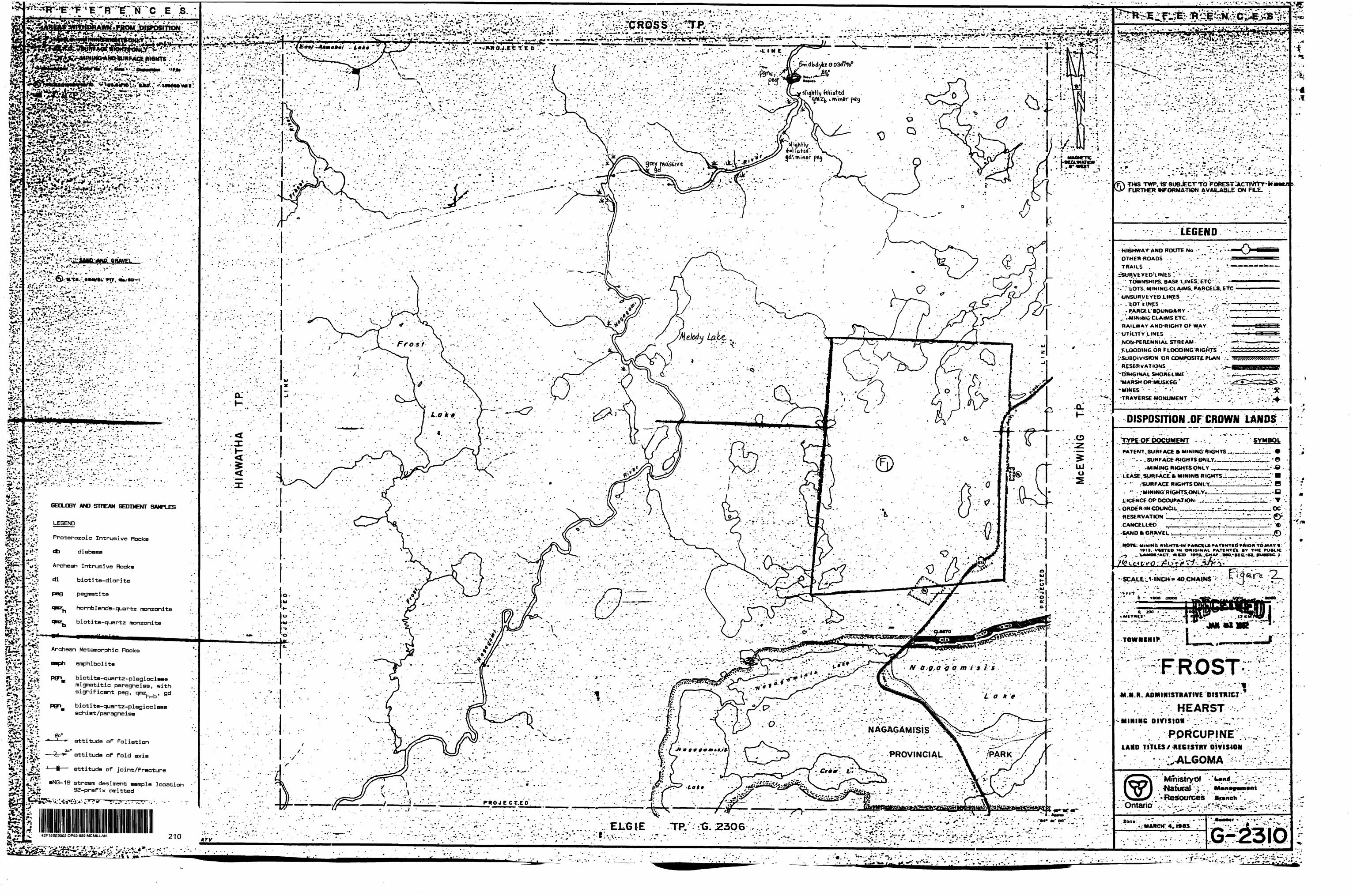
*^ii
^^l
L-V
-v;?
f:P
P(^^^^
a H.
t ; *
•. •"•
- v
- - :-
.'••-
..-
. '
- -'
v. •'
••- -'
- ••-
; '
' '•
••' .--
..-y-
.--.'
•:^.;T
;.?;:JX
-
- - ':
* -
-: .
•'••'•;.
- '' -
. -. "f
- v r"
-1 ''
- -.
- .-''
' •'•.'.
. '
.'."' -
.''. '
- ;..-
'"' '•'•
i;--'; A
iV '*
.'-•••-
V; -
. - '..
' .
.. .,
. .'
' v
:
-: -
;-.:
-.'
. ;..
. :".
:..-.
"r*'
-
1. .'.
.- •••'•
rf.vr
.sv.
•. '-
' -
- -~
t: .'
- '
' -
' '
- .
.•"•y
1 .
. .
' '
. '.
- -
j-
'v
. .4-
"t
"-
'
- '-
- .'.
. '
.' .'
: .
'. .
-. -
- -
- '
i; '.
i ?
."
' ,H
- "
'' '
'. '
'- " -
''-
' 'i
*l
' .-'
'';T
R :,
' . "-
: ' ••f
'-'.-,-
. -' '
:. :
.-' .;-
- -v
' . ;:
- •::-
-.--.-.,
t ,;-
,-;
- -..-
-;, •-.
..•••.
..,vv
:t ?v
. i''.
•*t*
* *
. '
*,-
*
,,
. *
. ,,
^ . \
* .
. .
. -*'
, *
i*
\ *
^ f
i ..
' - '
- ,
-.'
- -
' . .
' ,-
' '
. '
.. •••
- '
v - :
. .
'. '
' .
" . '
l.'
' - - -
-.-.
. "
v*:
- ,-t
tlv
' - '
. '
;---
-'
- -
. -
. ,-
" '.
- -
" .
.--
-. -
- '.
.-•••
' '.V
.-.
.' -.
--...-
.;'..
.;
.'•'I
:..:-
..- -.
..yf-
:..'
*.;.-
. •-•-.•
-,- •••:
- -:- •
••-'
-.5; -
:" .-'.
-.
- - 'f-
r---.-
. . •••\-
-.'-i:v
*: ' v\
v^-:-
::v.'^.-
.,*r*\
r;-..
... ••
..'.
-- '
' .
.-"-
.V'
. '
. v
- :
- -.'
.:---
. .-
. •-•
•- 'W
'J
','i.
'.•..:
.:- •
•.••;-
".i;l
.V'y
1,:/•
...-
.. '
-. -
- -
-- -
' . .
-.. -
::*
.- -.-
. -:,
- ;-
*.:..,
v- :
!,'-*'-
.;.s..;
'.-j.i
v.v-
-'
.'v
-,.,1 -
. ..
:':.
'.
.'-.
- v.
-..;
.v:
. -
-:.
.•.-
,y
-; ;v
' •-.-:
V ..
," ' i
: ::;
-.J
/ o:-;
^A
l.. ,-
:y ,.
^ '
,- -.-
-. —
. :__
'_
-. __ -
•"•••-
•^.--
•^.
••-•' .•
'••-.
:^^k
-v-..
::,v^
:*v-. ;
:-;v'J
ur.vi
vi
. :
r,i:"
HIA
WA
THA
. - t-
. -*.
*. -- -
..I..
5 ^'
^.-
- t
K -i'
''.r
•t:
--.v/-
'-•"
•V/
'. '
: -
*' '
!-':
'. l
1 ^-
;".v
'i''
" V
V.^
?"'.V
- ^•
•.iP'
:-/:
. ^-
'••-'.
. .-.•.
' - .
:*'
'f .V
W '
.
' ''.
- '
' ' .
'
McE
WJN
G'
'
i;..'
. l
\'M ••.t w
- ]-
- -v
v .,-
i '
,
1^.-
.'';v^
-1 -
'..
i '
s1 l-
- -H
n
^
. 15
" '
0 :
-S;'
',; B
^ |
r;,
1 :;.
ri*
. S
V\
o —
, -
' .
s: v^ i
-M
v : i
^* .
B
.** 5
-25,
,--..r
i-d--
i ^
.'.i-
!2 m
T
S --
..1
;
' *
v -
i
•'••'•'^
..cs.
5 *
l'
30Q
.??^
C[l
Ht)
3
- .-':
•'
. --
2 P
" r
1^'!.
- :--'
1iV.
'; .'
'.
.-.-.i v.
:--".:/-,
'.-.••:
^7..!.
:,.1
' ^.
^ :*
'' ..v
. '.:
"' '
-.^.
v-
.
:. 7.
-. -;
" "'
' -''
' -
- --
-"
' ~
'-
\'•i
-
v.
^^
J^-
:--
J"*k

REFERENCES
AKEAS WITHDRAWN fROM DISPOSITION
M.R.O. - MINING RIGHTS ONLYS.R.O. - SURFACE RIGHTS ONLYM.+ S. - MINING AND SURFACE RIGHTS
OntorNo. DM* Dtowritton Fito
peg
GEGLQOGY AND STREAM SEDIMENT SAMPLES
LEGEND
Proterazoio Intrusive Rooks
ob diabase
Archean Intrusive Rooks
di biotite-diorite
pegmatite
hornblende-quartz monzonite
biotite-quartz monzonite
gd granodiorite
Archean Metamorphic Rocks
amphibolite
biotite-quartz-plagioclase migmatitic paragneiss, with significant peg, qmz gd
biotite-quartz-plagioclase schist/paragneiss
KEY
attitude of foliationoo"
—2r*- attitude of fold axis
—*— attitude of joint/fracture
—NB-1S stream sediment sample location 92-prefix omitted
MCCOIG - TP,
(L h-
LtUJo irUJ
CD
c
l(T
FROST TP. G.23IO
REFERENC S
LEGEND
4 rv.
HIGHWAY AND ROUTE No OTHER ROADS TRAILSSURVEYED LINES:
TOWNSHIPS. BASE LINES. ETC.LOTS. MINING CLAIMS. PARCELS. ETC
UNSURVEYED LINES:LOT LINESPARCEL BOUNDARYMINING CLAIMS ETC
RAILWAY AND RIGHT OF WAY -* UTILITY LINES " NON-PERENNIAL STREAM FLOODING OR FLOODING RIGHTS i SUBDIVISION OR COMPOSITE PLAN RESERVATIONS ORIGINAL SHORELINE MARSH OR MUSKEG MINES TRAVERSE MONUMENT
DISPOSITION OF CROWN LANDS
TYPE OF DOCUMENT
PATENT. SURFACE ft MINING RIGHTS. " . SURFACE RIGHTS ONLY......" . MINING RIGHTS ONLY ,.....
LEASE, SURFACE 81 MINING RIGHTS.." .SURF ACE RIGHTS ONLY._...." . MINING RIGHTS ONLY.........
LICENCE OF OCCUPATION .——...™. ORDER-IN COUNCIL _________... RESERVATION ____________....CANCELLED ___.______.......SAND ft GRAVEL ____.___........
MOTE: MINING MIGHTS IN PARCELS fATENTEO PMION TO MAH 1913. VESTED IN ORIGINAL PATENTEE W THE LANDS ACT. NX.O 1*7O. CHAP. MO. SEC. S3. SUVSCCj
SCALE: 1 INCH ^ 40 CHAINS
FEETO 1OOO 2OOO 6000
O 200 METRES
1OOO11 KM)
200013 KM|
TOWNSHIP future
CROSSM.N.R ADMINISTRATIVE DISTRICT
HEARSTMINING DIVISION
PORCUPINELAND TITLES/ REGISTRY DIVISION
ALGOMAMinistryof LandNatUIBl ManagemvntResources Branch
Ontario
DataMARCH 4,1983
•••••r
G-229942F1SSE0002 OP92-859 MCMILLAN 220

REFERENCES
AREAS WITHDRAWN PROM
M.K.O. - MINING MIGHTS ONLY
t.R.0. - SURFACE RIGHTS ONLYM.* S. - MINING AND SURFACE RIGHTS
FI*
(5) 43(RSaW7D) W 54/72 AUG.3/72 SRQ.
®43{RSjO.I97O) W. 66/77 28/6/77 SJUX
(SUsdt&aiVTO) W. 78/80 15/2/80 SJtCL® P.L.A. 1953
164585 MS 541 165541 77094 *S
SAND and ORAVEL
QUARRY PERMIT M.T.C. Qrawl Pit M.T.C. Gravtl Pit No. 3D-7
GEOLOGY AND STREAM SEDIMENT SAMPLES
LEGEND
Proterozoic Intrusive Bocks
* diabase
Archean Intrusive Rocks
di biotite-diorite
pegmatite
hornblende-quartz monzonite
biotite-quertz monzonite
granodiorite
pog
pgn
se*
2**
MCMILLAN TP. G-2324
:)..-.M
amphibolite
biotite-quartz-plagioclase migmatitic paragneiss, withsignificant peg, qmz. ,. gdh—b
biotite-quartz-plagioclase sch i st/paragne i ss
attitude of foliation
attitude of fold axis
attitude of joint/fracture
•NG-1S stream desiment sample location 92-prefix omitted
42F15SE0002 OP92-B59 MCMILLAN 230
O) CVJ CVJo
en eno tr o
19 l 18 l 17 l l! l . 15
MCEWING TP. G-2332
REFERENCES
i
LEGEND ;HIGHWAY AND ROUTE Mo OTHER ROADS TRAILS SURVEYED LINES
TOWNSHIPS. BASE LINES. ETC -LOTS. MINING CLAIMS. PARCELS. ETC
UNSURVEYED LINESLOT LINESPARCEL BOUNDARYMINING CLAIMS ETC
RAlLWAY AND RIGHT OF WAY UTILITY LINES NON-PERENNIAL STREAM FLOODING OR FLOODING RIGHTS SUBDIVISION OR COMPOSITE PLAN RESERVATIONS ORIGINAL SHORELINE MARSH OR MUSKEG MINES TRAVERSE MONUMENT
mcDncmnu ne mn wu i
TYPE OF DOCUMENT
PATENT. SURFACE ft MINING RIGHTS. " . SURFACE RIGHTS ONLY___" . MINING RIGHTS ONLY ^.^.
LEASE, SURFACE ft MINING RIGHTS-. " .SURF ACE RIGHTS ONLY____ " . MINING RIGHTS ONLY——————
LICENCE OF OCCUPATION ™—-,.^.ORDER-IN-COUNCIL ————————.RESERVATION _____________....CANCELLED ______________SAND ft GRAVEL ______________.
MOTE: MINING RIGHTS IN PARCELS PATENTED * Rimum 1*13. VESTED IN ORIGINAL PATENTEE E™ 1*ME LANDS ACT. RS.O f*7*. CHAP. *M
SCALE: 1 INCH - 40 CHAINS
FtETO 1OOO MOO
O 200 METRES
1000M KM 1
TOWNSHIP
ARNOTT
\trv
M.N.R. A DM l PI l STRATI VE DISTRICT
HEARSTMINING DIVISION
PORCUPINELAND TITLES/ RE6ISTRY DIVISION
ALGOMA
•
1li
Ministryof LandNatural ManaResources Branch
Ontario
••uM A R. C H 4J9S3 G-247

R E F E R E N C E S LEGENDFRO*DISPOSITION HIGHWAY AND ROUTE N*.
OTHER ROADS TRAILS SURVEVfO
FINTRY TWP.MJUX-MINING RIGHTSONLY
SURFACE RIGHTS TOWNSHIPS. BASE LMES. LOTS. MINING
UNSURVEYED LINES:LOT LINESPARCEL BOUNDARY *MINING CLAIMS ETC.
RAILWAY AND RIGHT OF WAV * UTILITY LINES NON-PERENNIAL STREAM FLOODING OR FLOODING RIGHTS SUBDIVISION RESERVATIONS ORIGINAL SHOREUNE MARSH OR MUSKEG MINES TRAVERSE MONUMENT
imfnmmL':DISPOSITION
INTERMEDIATE
PATENT. SURFACE ft MUMNC ~ .SURFACE RIGHTS " . MINING RIGHTSOMLT
LEASE. SURFACE ft MINXJ " . SURFACE RIGHTSONLV " . MINING RIGHTSONLY '
LICENCE OF OCCUPATKNIORDER-IN-COUNaLRESERVATIONCANCELLEDSAND ft GRAVEL
SCALE: 1 INCH-40CHAMt
GEOLOOGY Aid STREAM SEDIMENT SAMPLES
Proterozoic Intrusive Rocks
db diabase
Archean Intrusive Rocks
di biotite-diorite
pegmatite
hornblende-quartz monzonite
biotite-quartz monzonite
granodiorite
Archean Metamorphic Rocks
amphibolite
biotite-quartz-plagioclase migmatitic paragneiss, with TOWNSHIPsignificant peg, qmz gdh—b
biotite-quartz-plagioclase sch i st/paragne i ea M.N.R
HMIHIH6 OIVISIOIattitude of foliation
attitude of fold axis
attitude of joint/fracture LAID TITLES/ •EtlSHY
•NG-1S stream sediment sample location 92-prefix omitted
MmistiyuC Natural25 24 23 22 21 20 19 10 9
••U KMUARY JM42F15SE0002 OP92-859 MCMILLAN

r,4-K1161055
L
LO LIE L2E L3E L4E L5E L6E L7E L8E L9E
LP
IS
f 9" . 1
gds*})9
- — ——— — — — — — ^tst? 7Sr ^o
— — — - — —— . _ M*O*~~ ~~~ovnmv
-r^'
mrw ffp^^ ^
^
ci-^
2
ts-t -^
C?t5 t 7
, ehwe^ ts ^Wrieitie Sth'.it 11-88- room.— r
~^~~ —— -V" '*mmV ^
.c X 3S f-yjVJ. 9i.BS-roi
,^ —— -*^^ ~^*** *~)
m
n
x-"" —— "•"" "S" y \ - 1 \ .-—-s , 1
*t
Q
^^ ^~**
K. Cad ^
fci- J^-^
C^-- — -
l**? "^^
-rs 0,-i- tst ?0tst ?
qi-BB-loilR
J"00 J"
tst? ^^r r.--"'"";if/, po r-r.--
JR 1 ^^. — ^J ..-
y ;-. "^ y •••-..
— - — - r .........^mv ' Kmv *— -
^
\ — 1 '
^
1" """
^itVp
xtsH ,bi
* "* -..
T-vi
Ohim\/
CmnivW9-
3dC
C
IS -
'7^t"51. f"
85 N,
--•x. 3S -. * - ** * ™
•-. ^ii-, 10' 1.7 R
, PO
\ 4S ,~
) * l
Sfi.-'' --Ar -
yo
C
wwv -t.., O ' jl.seJi'Aw,eU. ' C f
"***^ T "^ x -^
ci. * 7l5t-l ^^.^ilpO2R
C-!OO*p S w-'
dIZ
tsn-t ^'
JL.
^trj)o,HWR
iwmv, '^ mftS5W' mm,
mas \
fto —
("•\ ^J iCrs:
iz^r^^'ol6R t5 /0,"*?
*r — ~
Qmmv
C3; WVWiV,
;
\ \
\ c^-••r- \
We \..-- V)
111
5K)
),
3 gd
::.:-l-^
t1-- 5r:5*itvp 1
r #4 jmnh~",^:9
F———- '
1 ^s-tj ,PO i 00^^ I006R
^S ———
cc, sl.f Jixtoti
j"
A mw\/ ^sl.s.K'.stos,
' ,]
rive
i-
^r ,*)5 C '
s'r&iS '*VP /ft
x/ 5^4d XV, poorly |am. *~-^
~-s— — — — — '.fVp
O~x-f-T — "7 .-'"" ^.?0 )/I'.rS.--'''' itvp/^ cUi+vp f rnv5d ,. — x ^xL,-i ——c•^^"w
c-^.
1 5 —— 80 "~""w ^- *— i-*T~VC'
--" (Jit
CIOWR ///^ J
i coe R ^
^u.
^ — J ^- —— ' d^ : mm
, i . j^~
" — v^^
Of} ....-.---Ui.
^li
sv? ~^(y eo JC/ ^
C^.——
/CfC—-—Zt-^
sitvp 3b '^\
^.b 1
^Ji ^r^r — — — — CDX ^,IOIOR — — -^^2"yst. w ^—— ' JL Q
"^p massive mmv
: shear, ser. ichijt quartz tytS
C wipW. Subcrop 1-7-A po
-iL.
^ "~ 9^
" 5^ c^ — .mmv
^•tii— ——— — : jtj.
rp ^~-^ ygdc?^ .^/f5 ^ - ^liVp -^ (C-
—— Co??
O'*'rrD5"""""^tSvo-t
mmv, mo**ivt
mmv, 4B ff.? x^l-Z'/o po 5 lOllC.
'1-
^
/^fr\Tt\\i
'X?!. ich.itoi*, band*J
IS
M+Vp
'itVp
Hv,•f ^2S
1 1 m o n\ -h c. \o\\f. ,
3S
^*Tnw\v, si- scVi'.i+txt j cc
L3+50E L4+50E
K1191242
Adams River Bay (Lake of the Woods)
LEGEND
D
KEY
streamswampclaim post, tied to gridclaim post, not tied to grid
FELSIC INTRUSIVE ROCKS
VIOLA LAKE STOCK
Biotite-granodiorite
MAFIC INTRUSIVE ROCKS
Gabbro
Biotite-diorite
l itv
ts
42F15SE0002 OP92-859 MCMILLAN 250
To accompany report by Robert M, Kuehnbaum
mmv
META5EDIMENTARY AND METAVOLCANIC ROCKS
UPPER KEEWATIN SUPERGROUP
MONUMENT BAY GROUP
Intermediate tuff and tuff breccia
Tuffaceous sedimentary rocks and sedimentary rocks
ts - wacke w
ts - siltstonest
ts - felsic to intermediate tuffaceous sedimentary rocks * (aquagene tuffs)
ts ., ts indicates uncertain origin st-t w-t
mafic metavolcanic Flow, massive
KEY
bipcc
cblpo
ser
outcrop
bedrock subcrop fragments in soil pit
geological contact: defined, approximate
attitude of inclined schistosity
biotitepyroxene porphyroblastscalcitechloritepyrrhotitesericite
shear or mineralized zone fault
Abbreviations
si - slightly lam - laminated
(92-BB]1013R rock sample location, prefix omitted
BEAR BAY CLAIMSKenora Mining Division, N.T.S. :52E79
GEOLOGY 8c ROCK SAMPLE LOCATIONS
50l —— l l
Metres
50 100 150
Sept. 92 Scale 1:2,000 PLAN^ 1

LO L5E L6E L7E L8E
K1161055
L3+50E L4+50E
L9E
LP
K1191242
Adams River Bay (Lake of the Woods)
KEY
streamswampclaim post, tied to gridclaim post, not tied to grid
Contour Intervals
61OOO nTBOOOO598005970O59SOO595OO594OO593OO592OO59OOO58OOO
42F1SSE0002 OP92-859 MCMILLAN 260
Instrument:: Geometrics G-816 Proton Magnetometer Total Field Measurements
Base Station
To accompany report by Robert M. Kuehnbaum
BEAR BAY CLAIMSKenora Mining Division, N.T.S. :52EX9
MAGNETIC SURVEY CONTOURED VALUES
50Metres
50 100 150
Sept. 92 Scale 1:2,000 PLAN* 2

LO LIE L2E L3E L4E L5E L6E L7E L8E L9E
K1161055
L3+50E L4+50E
K1191242
Adams River Bay (Lake of the Woods)
1 cm ^
D
KEY
streamswampclaim post, tied to gridclaim post, not tied to grid
Quadrature (Q)
/l
l
In-Phase (I)
42F15SE0002 OP92-BS9 MCMILLAN 270
To accompany report by Robert M. Kuehnbaum
-f- !
Transmitter: NAA Instrument: Geonics EM-16 Readings taken facing south
BEAR BAY CLAIMSKenora Mining Division, N.T.S. :52EX9
VLF-EM SURVEYNAA
IN-PHASE S QUADRATUREPROFILES
50________O i—i i—i i—i
Metres 50 100 150
Sept. 92 Scale 1:2,000 PLAN* 3

LO LIE L5E L6E L7E L8E
K1161055
L3+50E L4+50E
L9E
LP
K1191242
Adams River Bay (Lake of the Woods)
KEY
streamswampclaim post, tied to gridclaim post, not tied to grid
Contour Intervals
14O120100SO6O4020O
42F15SE0002 OP92-859 MCMILLAN 280
To accompany report by Robert M. Kuehnbaum
BEAR BAY CLAIMSKenora Mining Division, N.T.S. :52EX9
VLF-EM SURVEYNAA
FRASER FILTERED CONTOURS
50i i
Metres 50 100 150
Sept. 92 Scale 1:2,000 PLAN* 4

K1161055
L
LO
is
2S
LIE L2E L3E
LP
L4E
BASELINE
L5E L6E L7E L8E L9E
LP
ir-br o bedrtcK cHipt
(bufffcU'y 9180 621 (
)rotdi*"" br -Till fcj.1 (
1 9 fij - br sandy f.|l frw(
Fbwgf ttlt 61-H
) in .g t -VD oranjt t '.II 6|6 (
)roed. br. -K.O bi7(
).kbrcl-*t 6|j (
) b* 151*1 6|5 (
)orqr*je br (d, 6M C
613 (
6l2(
611 (
———————————————————— g, —————————————————————————
)r-brcl-tt
)y-br Vi H
) br fill
Mt^rty HU
) bcijt id -it
, ,
* - " 91 88 6^*1 (
Htbr sd-it-tl 640(
)med br-jrey till jj}(
)r-br cl-st jj5(
(meJ. br et-fl 6}7(
)ik br el-*t f Wl) 636C
L 6K(
3S 63-H
633 (
631 (
MM
9) 00-630 () Ltbr graoilly t'.Lt ^1K
) [t br sd-Jfft-v*! 6tB(
} br jd-jro^l 627 (
) It br Sd-Jt, graW.^t P'bblw 6M(
) It br si 6U(
(r-br fill t mfceKVfj ^2i|(
)r d- rick fill t r"* e^'-P 1 ..fellj
h r~b*- ^''^ fr rfl ^^^'-p* .-*'' -
) r f-iulij p*bMj 111 :-' fl ^
) br jd-st^-br el-rid. +-.II * •...........
(••tt f ra*t .
is -
*bfcl-r-KJ,f.ll
(brsd-it-cL
) f-bffl-ld .flj ( Crack fraji(b;^u. 8S(
(brxi .r.-i.U 85 C (WUfclts
)m*diumb' td- 46 (
).|t br-jnj ci. 87 C
..-••*fl(
••••" fl?(
90 C
91 (
1=1
~2S IH92-88- 10(
9 C
8()m*d.kr. 5t-cl 7(
) i. i. ,. 6(
) b^yt *d-H-il 4 (
) i- " Sd-*t 3 (
j ,. ,. ,, j,
- , 3S -
J It .r-br *d-j*-cl
)red ririidual so'il ^"th-fn^t.
)br sd-jl-cl.
)r.-br *^-el i (
7(J(
4S
rr-brel-jt -,(f-bfidl-J-t
) ii ii
l li M 72(
Inifd birsdrKl 7^(
)Ubr Jt-Si 76( 77-*
-li.
lbrcl-*t 79 C
)dtcbrsd.-it4 ft) C
flic
92-882^
20(
27 (
26 (
)m(dbrfV-c 2J(
)dklr Jt-c * 14 ( kcdretk fmji
)4lcr-brei-sv 21(
)rn*dbi-**-cl 22 (
)d.fc br - " 21 (
)mtdbrfd-st-cl 20 (
r" " " |J-(
) - - Sd-st- |8(
\ \H
i 16 (
\ IJ ' \ H(
(r-br-#*-*l |3 (
)m*d br-.jt-el ;j(
) It br Sd -jV.-d
#lT#4
.
* u - St-Cl
d —
( " *- "1 92-00-^2 (
) ii H n
)med r-br *1
) dk br st-a
, -. - -
)M(d.br 5t-
hJk br "
) mid. br 5cl-; '.' ".:) br ft -el -*
41 (
* bedrock fregj 39 (
38 (
31(
36 (
a31^
33 (
3l(
30 C
txdrock frqgt
s
)f-br jt-cl
) i- i.
)dltbr ik-cl^n b*drock W BB-tf '
) " - i- So (
)r-br cl-*l A1(
)ttk br cl-Jt c rock Irajj 4g (
) mod br cL-st -S|7(
)dkbr Cl-It-Sd 4( (
)-mtd br - - JjJ-j
)Ltbr*t-tL 44 (
) b*'ye id-jt-tt. 43(
) " - Ci .--•""
| t- t* Ccl - SI -*l
r Io0-y *t-c[ ..-
)brid-*t-cl .--'[...-•-•r-*2lf3
. i. ^
.......-•-•••••^
...--••••••"""
*
)dUbrjt-cl S18(
) - n sic) " " Sil
, ,. i., l**"^ Sf( ) r. id-j-t-il 4 ted'o^tf rm^s Sic
K-br jd-ii-cl 53 (
M* k ir " " S2-(
)Ubr - - .......••••••••
) br .';.-- -"
j it br sl- 4 l,(eaw.y
(dky-br it-St| 92-88-6K
)dU br cl-*(- , loamy ^j(
) i. ,. .- ,on b^drack 67 (
) - - - . l"0wvy 66(
)im**l br id-jt-cl 65 (
)dk.br - - 64(
hb^Ki^ ** *- 63-i
61 (
6o(^U-
B
IS
t*
(ile. br st-tl * bedrock fra^f
| li l* .' M
• r-br "
) y-br st-tl
jikbr st-cl
) It br id-it
)bei^t - -
f — 1LI
K1191242
L3-r50E L4+50E
Adams River Bay (Lake of the Woods)
KEY
••'v ...^, stream'111 - swampm claim post, tied to grid D claim post, not tied to grid
91-BB-61O — 1991 soil sample92-BB-1 1992 soil sample
Abbreviations of soil colour and components:
It - light dk - dark med - medium r - red br - brown y - yellow
sd - sand st - silt ci - clay frags - fpagments
42F15SE0002 OP92-B59 MCMILLAN 290
To accompany report by Robert M. Kuehnbaum
BEAR BAY CLAIMSKenora Mining Division, N.T.S. :52E79
B HORIZON SOIL GEOCHEMISTRY
SAMPLE LOCATIONS SOIL DESCRIPTION
50 O i—i i—i i—r~
Metres
50 TOO—l
150
Sept. 92 Scale 1:2,000 PLAN* 5

K1161055
L
LO
IS
40
I1()
21 ( ) 119
LIE L2E L3E
LP
L4E
BASELINE
L5E L6E L7E L8E L9E
LP
m () i BO
IS --
2S
ii(Z3()1J8
U()M
fi
is
*5( )U8 H()UB
3S --
4S
35OH1*
\
A)*x-.-40
'3lf"KC7550 '~~ lrtl'"40
\.-^'12^13
L3+50E L4+50E
K1191242
Adams River Bay (Lake of the Woods)
o
KEY
streamswampclaim post, tied to gridclaim post, not tied to grid
CuQZn (Ag) values in ppm. Only detectable values ofAg are shown; all others are O.5 ppm
50-54®25O-273 probably anomalous values, ppm (Cu S Zn only)
anomalous values, ppm (Cu S Zn only)
* Contour intervals (ppm)
Cu ———40 ————— -50- ———— -75-— —
42F15SE0002 OP92-859 MCMILLAN 300Zn •250-
• 4OO -•55O-
jlk^accompany report by Robert M. Kuehnbaum
BEAR BAY CLAIMSKenora Mining Division, N.T.S. :52E79
B HORIZON SOIL GEOCHEMISTRY
Cu, Zn, AgCONTOURED VALUES
Cu, Zn
50________OF——l l——l l——[~
Metres 50 TOO 150
Sept. 92 Scale 1:2,000 PLAN* 6

LO LIE L2E L3E
K1161055
L3+50E L4+50E
K1191242
Adams River Bay (Lake of the Woods)
KEY
streamswampclaim post, tied to gridclaim post, not tied to grid
CoCDNi (Mo) values in ppm. Only detectable values ofMo are shown; all others are <l ppm
33-40 45-54 probably anomalous values, ppm (Co E Ni only)
anomalous values, ppm (Co S Ni only)
Contour intervals (ppm)
Co ———30 ——— ——— 50- ——
NiTfC
42F15SE0002 OP92-859 MCMILLAN 310
To accompany report by Robert M. Kuehnbaum
BEAR BAY CLAIMSKenora Mining Division, N.T.S. :52E79
B HORIZON SOIL GEOCHEMISTRY
Co, Ni, MoCONTOURED VALUES
CO, Ni
50 t
Metres
50 100 150
Sept. 92 Scale 1:2,000 PLAN* 7

LO LIE L2E L3E L5E L6E L7E L8E
K1161055
L3+50E L4+50E
L9E
K1191242
Adams River Bay (Lake of the Woods)
KEY
-'v...^w stream III - swampm claim post, tied to grid D claim post, not tied to grid
values For Pb and Mn in ppm; Fe in X
.1-1 l^oo probably anomalous values, Fe X, Fb S Mn ppm 1 oUU 1 r\ys . v
anomalous values, Fe X, Mn ppm
Contour intervals (ppm)
42F15SE0002 OP92-859 MCMILLAN 320
Pb
Fe -
- 17(ppm)-
—— 4.2U) -
To accompany report by Robert M. Kuehnbaum
BEAR BAY CLAIMSKenora Mining Division, N.T.S. :52EX9
B HORIZON SOIL GEOCHEMISTRY
Pb, Fe, MnCONTOURED VALUES
Pb, Fe
50________O t—i i—i i—i-
Metres
50 100=^- 150
Sept. 92 Scale 1:2,000 PLAN* 8

LO LIE L2E L5E L6E L7E L8E L9E
LP
K1161Q55
r^'-'-'-^^s
L3+50E L4+50E
K1191242
Adams River Bay (Lake of the Woods)
D
KEY
streamswampclaim post, tied to gridclaim post, not tied to grid
B Horizon Soil Geochemical Anomalies
1 Sdil anomaly described in text
— Cu5O ——— 5O ppm Cu contour
— Zn25O ——— 25O ppm Zn contour
— Co3O ——— 30 ppm Co contour
— Ni45 ——— 45 ppm Ni contour
— Pb17 ——— 17 ppm Pb contour
Simplified Geological Legend
gd granodiorite, Viola Lake Stock
gb gabbro, diorite
itv intermediate tuff and tuff breccia
tS tuffaceous volcanic - sedimentary unit
mmv massive mafic metavolcanic rocks
— ——— geological contact, approximate and observed
geologically i nterpreted f au 11
observed shear or mineralized zone
Geophysical Interpretation
by: F. L. Jagodits, P.Eng., Consulting Geophysicist
2#"xv.:3? approximate outline of magnetic body, with anomaly code (M1) and ^iiii^ probable cause of anomaly: g - gabbro, m - mafic volcanics
(3l^- approximate limit of magnetic domain, granitic {GR] and volcanic V domains indicated
.^- — — *- poor-^..^--^. mediocre axis of VLF-EM conductor, with anomaly code
magnetically interpreted fault or shear
interpretation uncertain42F15SE0002 OP92-859 MCMILLAN 330
To accompany report by Robert M. Kuehnbaum
BEAR BAY CLAIMSKenora Mining Division, N.T.S. :52E79
COMPILATIONSIMPLIFIED GEOLOGY,
GEOPHYSICAL INTERPRETATION8t B HORIZON
SOIL GEOCHEMICAL ANOMALIES
50 O r~
Metres 50 100 150
Sept. 92 Scale 1:2,000 PLAN* 9