proposed route tour schedule and protocol
TRANSCRIPT
Proposed Route Tour Schedule and Protocol
Tour Background and Protocol
The Chairman of the Arizona Power Plant and Transmission Line Siting Committee (“Siting
Committee”) has requested a tour of the Ten West Link 500 kV transmission line project
(“Project”). Given the length of the line and complexity of the terrain, the most efficient and cost-
effective way for the Committee to take the tour is by helicopter.
During the tour, members of the Siting Committee will travel the 103.4 mile Arizona portion of
the Project in two helicopters, accompanied by Mr. Ali Amirali and Mr. Lowell Rogers
respectively, as well as other members of the DCR Transmission L.L.C, (“DCRT”) team as space
limitations permit. Included in this exhibit is a script that Mr. Amirali and Mr. Rogers will narrate
verbatim during the flight. The script identifies the hover points at which portions of the narrative
will be read, which hover points are identical to those specified in the virtual tour that has been
filed in this docket as Exhibit 8 and will be presented during the public hearing in this matter. The
route tour map included in this exhibit identifies the various hover points. The tour path will start
at hover point #1 at the Delaney Substation and end at hover point #10 (Colorado River/AZ
Boarder), visiting each hover point in sequential order, generally flying along the proposed Project
route. To comply with Arizona open meeting laws, no discussion of the tour or Project other than
a reading of this script at the identified hover points will be permitted on route to, from and during
the flight. To ensure compliance with this requirement, in-flight conversations will be recorded
for future transcription and public inspection. Once the tour is complete, the Committee members
will be transported to the hearing location, at which time a public hearing recorded by a court
reporter will commence to entertain questions and discussion about the tour and Project.
Tour Summary (January 27, 2019)
DCRT has arranged for Siting Committee members to be picked up at the Riggles RV and Event
Center located at 240 North Riggles Avenue, Quartzite, Arizona 85346. Before proceeding to the
helicopters, there will be a brief review of the tour protocol. Committee members will then be
transported to the Quartzite airport by automobile, where they will board the helicopters. After
taking off, the Siting Committee members will fly east-bound from the Quartzite airport until they
reach the Project route near I-10, then fly east to the Delaney substation. From the Delaney
substation, the tour will follow the Proposed Route as described in the script for 103.4 miles until
the California-Arizona border. During the aerial tour, the helicopters will hover for one to three
minutes over the points identified in the script, during which time Mr. Amirali and Mr. Rogers
will read from the script an explanation of the key points and features at each location. After
reaching the Colorado River, the helicopters will turn back and follow the Proposed Route until
they reach I-95, at which point they will divert from the Proposed Route and return to the Quartzite

airport. From there, the Committee members will be transported by vehicle back to the Riggles
RV and Event Center for the public hearing.
Deviations from this flight path may occur if the pilot deems necessary for safety or is directed to
by air traffic control.
Tour Itinerary- January 27, 2020:
MEET AT RIGGLES RV AND EVENT CENTER 11:00 am
REVIEW TOUR PROTOCOL 11:05 am
DEPART FOR HELICOPTERS 11:10 am
ARRIVE AT HELICOPTERS 11:25 am
SAFETY BRIEFING 11:30 am
HELICOPTERS DEPART 11:45 am
HELICOPTERS RETURN 3:25 pm
DEPART FOR RIGGLES RV AND EVENT CENTER 3:30 pm
DISCUSSION OF TOUR 4:00 pm

kj
")
")
!Ä
!!A
!!A!!A!!A
!!A
!!A
!!A
!!A
!!A!!A
Kofa National Wildlife RefugeYuma Proving Ground
Colorado RiverIndian Tribe
Land
kj
DelaneySubstation
ColoradoRiver
Substation
§̈¦10§̈¦10
§̈¦10
§̈¦10
Salome
Quartzsite
Blythe
La Paz
County, AZ
Maricopa
County, AZ
Yuma
County, AZ
Imperial
County, CA
Riverside
County, CA
Colora doRiver
N Love
kin Bl
vd
WSalome Hwy
W Hobsonway
28th Ave
Buckeye-Salome Rd
N AguilaRd
S Love
kin Bl
vd
W Courthouse Rd
Vicksb
urg Rd
Alamo
DamR
d
Mohav
e Rd
Aguila Rd
Ehrenb
ergPos
tonHw
y
Midland Rd
Eagle
EyeR
d
£¤95
£¤78
£¤95
£¤95
£¤60
£¤60
£¤60
¬«72
¬«78
¬«95
QuartzsiteAirport
1
23
4
56
7
8
9
10
Sources: Esri, USGS, NOAA
ArizonaCalifornia
W:\1
5432
0_Te
nWes
t\Ap
ps\R
FI\RF
I_ECS
_186
_Pro
jectLo
catio
n\Pr
oject
Loca
tion.m
xd
Rev
ised:
2020
-01-1
0 By:
ksev
erud
ProjectLocation
Ten West Link 500kV Project
¯
0 5 10 15 20Miles
Land StatusBureau of Land ManagementBureau of ReclamationColorado River Indian Tribe LandsCountyDepartment of DefensePrivateStateUSFWS
Base FeaturesInterstate HighwayMajor RoadCAP CanalState BoundaryCounty Boundary
Project Components") Substationkj Series Compensation Station
Project Route
DCR Transmission, LLC
Helicopter Tour
!Ä Airport
!!A Hover Point
ACC Line SitingCommittee Site Tour
1
Ten West Link
Helicopter Tour Narrative
Introduction: Ten West Link
You are about to take an aerial tour of the Ten West Link transmission project, a proposed 125-mile-long, 500 kV transmission line connecting the APS-owned Delaney substation, located in Tonopah Arizona, to the SCE-owned Colorado River substation - located just west of City of Blythe in Riverside, California. The tour will start at the Delaney substation and will follow the 103-mile long, Arizona section of the proposed transmission line route, concluding at the Colorado River on the Arizona-California border.
HOVER POINT: 1 (Delaney Substation)
The Ten West Link project interconnects to the Delaney Substation, which is directly in front of us. As part of the project, the Delaney Substation will be converted to a split bus arrangement by APS to facilitate the interconnection of the line. The line will exit the substation to a new steel monopole towards the west. This structure can be seen in CEC exhibit G6. From that point, the line will span north along the outer perimeter of the substation using self-supporting lattice structures, which can be seen in CEC exhibits G1 and G4. As the line wraps around the perimeter of the substation, its corridor will converge with the existing transmission lines that have a north-south alignment. Ten West Link will continue north, crossing Interstate-10. The majority of access to this area will use existing access roads. The land under this hover point is privately owned. Arizona State Land Department property, or ASLD for short, is located east and south of the substation. The Ten West Link alignment is proposed to be on private land between the substation and I-10. Transitional We will now travel to the next hover point, which is about 12 miles away. We’ll travel about 600 feet to the left, of the Ten West Link alignment and see how the line will parallel the existing Devers-Palo Verde 500 kV line. We’ll also cross over I-10 and the Central Arizona Project canal. Hover Point (1 mile from substation) Lat: 33.480868° Long: -113.054107°

2
HOVER POINT: 2 (Corridor Adjacent to Existing Devers-Palo Verde Line)
As we look west, we see the existing Devers-Palo Verde line, or DPV for short, and the Central Arizona Project, or CAP, canal to our right. Ten West Link will parallel the DPV line from the Delaney substation past this point to the I-10Freeway, which you can see in the distance. At this location, Ten West Link will use self-supporting lattice structures, similar in shape and height to the DPV line. Please see CEC exhibits G1 and G4 for examples of these structures. Each Ten West Link structure will generally be about 250 feet to the south of the corresponding DPV line structure. The type of structures in this area were chosen to reduce the visual contrast of the Ten West Link line by mimicking the structure placement, height, and spans of the DPV line. The majority of the access in this area will use existing access roads that were built for the construction of DPV. Short spur roads will continue these existing access roads to the locations of the new Ten West Link structures. The land under and around this hover point is owned by the Bureau of Land Management or BLM. The Big Horn Mountain Wilderness Area is located to the north. Transitional We’ll now travel to the next hover point, which is about 14 miles away. We’ll travel about 600 feet to the left, or south, of the Ten West Link alignment. We will see how the Ten West Link line will parallel the existing DPV line. Hover Point Lat: 33.575432° Long: -113.147335°

3
HOVER POINT: 3 (I-10 Crossing)
At this location, Ten West Link will still be to the left or south of the existing DPV line that you can see to the right of us. Ten West Link will cross over the I-10 Freeway here, in a similar fashion as the DPV line. DCRT has met with the Arizona Department of Transportation several times to understand their requirements for crossing I-10 and will comply with these requirements. Three spans ahead, just past where you can see the canal, the Ten West Link alignment diverges from the DPV line, crossing under the DPV line and continuing to the west parallel to the I-10 Freeway. The land under this hover point is owned by the Arizona Department of Transportation. Arizona State Lands and BLM lands are to the north. Privately owned desert land is to the east and west, adjacent to I-10. Transitional We’ll now travel to the next hover point, which is about half a mile away. We’ll continue to travel about 600 feet to the left, or south, of the Ten West Link alignment. Hover Point: Lat: 33.578049° Long: -113.391675°
4
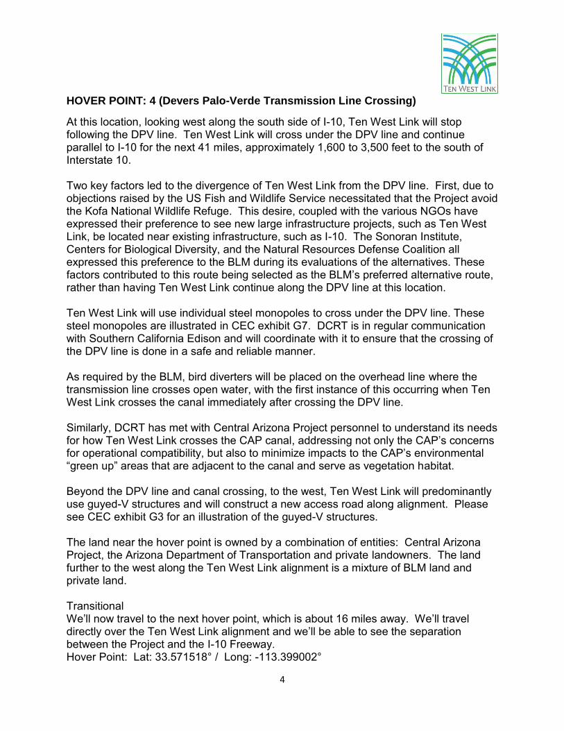
HOVER POINT: 4 (Devers Palo-Verde Transmission Line Crossing)
At this location, looking west along the south side of I-10, Ten West Link will stop following the DPV line. Ten West Link will cross under the DPV line and continue parallel to I-10 for the next 41 miles, approximately 1,600 to 3,500 feet to the south of Interstate 10. Two key factors led to the divergence of Ten West Link from the DPV line. First, due to objections raised by the US Fish and Wildlife Service necessitated that the Project avoid the Kofa National Wildlife Refuge. This desire, coupled with the various NGOs have expressed their preference to see new large infrastructure projects, such as Ten West Link, be located near existing infrastructure, such as I-10. The Sonoran Institute, Centers for Biological Diversity, and the Natural Resources Defense Coalition all expressed this preference to the BLM during its evaluations of the alternatives. These factors contributed to this route being selected as the BLM’s preferred alternative route, rather than having Ten West Link continue along the DPV line at this location. Ten West Link will use individual steel monopoles to cross under the DPV line. These steel monopoles are illustrated in CEC exhibit G7. DCRT is in regular communication with Southern California Edison and will coordinate with it to ensure that the crossing of the DPV line is done in a safe and reliable manner. As required by the BLM, bird diverters will be placed on the overhead line where the transmission line crosses open water, with the first instance of this occurring when Ten West Link crosses the canal immediately after crossing the DPV line. Similarly, DCRT has met with Central Arizona Project personnel to understand its needs for how Ten West Link crosses the CAP canal, addressing not only the CAP’s concerns for operational compatibility, but also to minimize impacts to the CAP’s environmental “green up” areas that are adjacent to the canal and serve as vegetation habitat. Beyond the DPV line and canal crossing, to the west, Ten West Link will predominantly use guyed-V structures and will construct a new access road along alignment. Please see CEC exhibit G3 for an illustration of the guyed-V structures. The land near the hover point is owned by a combination of entities: Central Arizona Project, the Arizona Department of Transportation and private landowners. The land further to the west along the Ten West Link alignment is a mixture of BLM land and private land. Transitional We’ll now travel to the next hover point, which is about 16 miles away. We’ll travel directly over the Ten West Link alignment and we’ll be able to see the separation between the Project and the I-10 Freeway. Hover Point: Lat: 33.571518° / Long: -113.399002°
5
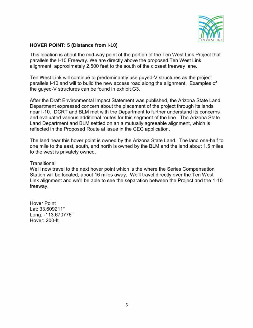
HOVER POINT: 5 (Distance from I-10)
This location is about the mid-way point of the portion of the Ten West Link Project that parallels the I-10 Freeway. We are directly above the proposed Ten West Link alignment, approximately 2,500 feet to the south of the closest freeway lane. Ten West Link will continue to predominantly use guyed-V structures as the project parallels I-10 and will to build the new access road along the alignment. Examples of the guyed-V structures can be found in exhibit G3. After the Draft Environmental Impact Statement was published, the Arizona State Land Department expressed concern about the placement of the project through its lands near I-10. DCRT and BLM met with the Department to further understand its concerns and evaluated various additional routes for this segment of the line. The Arizona State Land Department and BLM settled on an a mutually agreeable alignment, which is reflected in the Proposed Route at issue in the CEC application. The land near this hover point is owned by the Arizona State Land. The land one-half to one mile to the east, south, and north is owned by the BLM and the land about 1.5 miles to the west is privately owned. Transitional We’ll now travel to the next hover point which is the where the Series Compensation Station will be located, about 16 miles away. We’ll travel directly over the Ten West Link alignment and we’ll be able to see the separation between the Project and the 1-10 freeway. Hover Point Lat: 33.609211° Long: -113.670776° Hover: 200-ft

6
HOVER POINT: 6 (Series Compensation Station)
This hover point is approximately 1,000 feet south of the proposed series compensation station. The station is located in an approximately 187-feet by 281-feet or 1.2 acres fenced area. A drawing of the station layout can be found in CEC exhibit G16. As Ten West Link approaches the series compensation station from the east, it uses a combination of self-supporting lattice structures, as seen in CED exhibits G1 and G4, and guyed-V structures, as seen in CEC exhibit G3. The selection of structure types is a result of alignment turns and topography. As Ten West Link departs the series compensation station and continues west, it will use self-supporting lattice structures. The selection of structure types is based on alignment turns, or angles, as well as topography. Please refer to CEC exhibits G1 and G4 for examples of these structures. The land in this area is owned by the BLM. The New Water Mountain Wilderness Area is located approximately 3-miles due south and the Kofa National Wildlife Refuge is approximately 6.5 miles to the south. Transitional We’ll now travel to the next hover point, about 16 miles away, which is where the Ten West Link line turns south away from I-10. We will travel directly above the Ten West Link alignment and we will be able to see the separation between the Project and the 1-10 Freeway. Note how the topography changes and becomes more mountainous. Hover Point Lat: 33.645983° Long: -113.940609°

7
HOVER POINT: 7 (Diverge from I-10)
At this location, the alignment turns to the southwest and no longer parallels I-10. This alignment avoids the Town of Quartzite as well as the BLM’s Long-Term Visitor Area. This alignment to the southwest places the structures along the valley floor, below the mountains to the south. The Town of Quartzsite can be seen to the west from here. Avoiding the Town of Quartzite was a high priority to the local community and another result of the extensive stakeholder outreach conducted on this project. As Ten West Link continues to the south from this point it uses self-supporting lattice structures. Because this area is used by the Off-Highway Vehicle recreational community, the BLM perceived the guy wire associated with guyed-V structures-to be potential safety risk to this community. As a result, the BLM selected self-supporting structures in this area as a safety precaution. Examples of these structures can be found in CEC exhibits G1 and G4. Though some existing roads are available and will be used to gain access to the Project area, new access roads will be required to be constructed in this area. The area in all directions around this hover point is owned by the BLM. The Kofa National Wildlife Refuge is 8.5 miles to the southeast from here. Various alternatives through this valley were considered by the BLM, including alignments that were closer to the Town of Quartzite and the BLM Long-Term Visitor Area. On several occasions, DCRT met with the leadership of the Town of Quartzite, La Paz County and the Off-Highway Vehicle community to understand concerns raised about having the Ten West Link alignment near their population centers and recreational areas that are important to the area economy. DCRT articulated these local concerns to BLM and the Proposed Route avoids impacting these areas. Transitional We’ll now travel to the next hover point, about 10 miles away, which is where the Ten West Link line again converges with the existing DPV line corridor. We’ll travel directly above the Ten West Link alignment. Note how the project is at the base of the mountains to the left and the presence of existing access roads along the way, many of which will be used by the project where practicable. Hover Point Lat: 33.672620° Long: -114.115994° Hover elevation: 200 feet

8
HOVER POINT: 8 (Rejoin DPV)
At this point, the Ten West Link alignment rejoins the existing DPV corridor. Ten West Link will cross under the DPV line at this location, then turn west, and parallel DPV approximately 250 feet to the south of the existing line. To the west, while adjacent to the DPV line, the Ten West Link structures will be similar in shape and height to the DPV line-- using self-supporting lattice structures as depicted in CEC exhibits G1 and G4. The type of structures in this area were chosen to reduce the visual contrast of the Ten West Link line by mimicking the structure placement, height, and spans of the DPV line to the extent feasible. The majority of access in this area will use existing access roads that were built for the construction of the DPV line. Short spur roads will continue these existing access roads to the locations of the new Ten West Link structures. The Department of Defense and Yuma Proving Ground voiced concerns with the project being located on Yuma Proving Ground property, citing operational impacts. Given the presence of the DPV line and pipelines to the north, completely avoiding Yuma Proving Ground lands was challenging. By working closely with DOD staff and evaluating a multitude of engineering options, we identified a solution of spanning Yuma Proving Ground lands by way of an aerial-only crossing. This solution was acceptable to the DOD and allowed the project to stay on the south side of the DPV line, thereby avoiding impacts to other infrastructure and resources -- including a large desert wash area running through the northeast corner of Yuma Proving Ground lands. The area in all directions around this hover point is owned by the BLM. The Kofa National Wildlife Refuge boundary is 0.6 miles to the east. The DOD and Yuma Proving Ground boundary is 4.4 miles to the west. We are now close to the northwest corner of the Kofa National Wildlife Refuge, where DCRT will implement additional mitigation requirements developed as part of the Biological Assessment process with the US Fish and Wildlife Services. The Project will avoid construction activities in this area during the Sonoran pronghorn breeding season and will stop work in this area anytime that pronghorns are present in the Kofa National Wildlife Refuge within one mile of the Project centerline. Transitional We’ll now travel to the next hover point, about 8 miles away, which is where the Ten West Link line traverses through the Copper Bottom Pass. We’ll travel about 600 feet to the left of the Ten West Link alignment and will see how the Ten West Link line parallels the existing DPV line. About half-way to the next hover point, the Yuma Proving Ground will be to our left. Please note the existing access roads along the way and the existence of spur roads to the current DPV structures. These spur roads will be extended to the new Ten West Link structures. Hover Point: Lat: 33.529831° / Long: -114.176381°
9
HOVER POINT: 9 (Enter Copper Bottom Pass)
At this point, the Ten West Link alignment enters Copper Bottom Pass. The Copper Bottom Pass is a utility corridor in which existing gas pipelines, roads, and the DPV line are located. The Ten West Link line will be located a minimum of 200 feet to the south of the DPV line with the structures located on ridgelines similar to DPV. To ensure transmission line reliability, it is critical to maintain adequate separation between the DPV line and the Ten West Link line. The physical separation between the two vital 500 kV lines will minimize the probability that the same event would create an outage on both the lines. In this area, the Project will use a combination of road and roadless construction methods. Roadless construction will use helicopter access to avoid the need to construct new access roads, minimizing the amount of visual and physical impact in the area. The use of roadless construction is used where feasible in this section of the project, taking into account the safety of helicopter operations. In this section Ten West Link uses self-supporting lattice structures. The types of structures in this area were chosen due to engineering requirements due to the rough topography. Examples of these structures can be found in CEC exhibits G1 and G4. The area in all directions around this hover point is owned by the BLM. The DOD/Yuma Proving Ground boundary is 0.6 miles to the south. The Colorado River Indian Tribes reservation is approximately 4 miles to the northwest. No component of the Project is located on tribal land. Transitional We’ll now travel to the final hover point, the Colorado River and border between Arizona and California, about 17 miles away. While still in the Copper Bottom Pass, portions of the Ten West Link route in this area is approximately 500 to 1000 feet south of the Colorado River Indian Tribes reservation. The Copper Bottom Pass area has been identified by the BLM as an area of high use by Off-highway Vehicle riders and as an area of high visual value. DCRT will be implementing a number of measures to avoid impacting this area, including the use of helicopter access at select structure locations so as to avoid building access roads with large cuts and color matching with the existing DPV line structures and rock painting in select areas to further reduce visual impacts from road construction. About mid-way to the final hover point we’ll exit the Copper Bottom Pass and you will be able to see the topography change from mountainous to the historical Colorado River floodplain. In this area we’ll travel about 600 feet to the left or south of the Ten West Link alignment.

10
When we exit Copper Bottom Pass we’ll see that Ten West Link continues to parallel the existing DPV line. Note how the topography in the section is comprised of a number of ravines and ridgelines, limiting the available locations to site the structures. Similar to the past section, please note the existing access roads along the way and the existence of spur roads to the current DPV structures. As earlier, these spur roads will be extended to the new Ten West Link structures. Hover Point Lat: 33.561144° Long: -114.311409° Hover Point: Above topography and in smooth air.
11
HOVER POINT: 10 (Colorado River)
This is the location where Ten West Link crosses the Colorado River and exits Arizona. The area in all directions around the hover point is owned by the Arizona State Land Department. The BLM owns the land 1 mile to the east and south. Notably, the Project will not directly impact any wetlands associated with the Colorado River nor will it impact any protected fish species in the river. Bird diverters will also be placed on the overhead wire at the Colorado River crossing since the Project crosses open water. Transitional We’ll now travel back to the airport in Quartzsite, a flight distance of about 23 miles. We’ll retrace the route we’ve taken along the Ten West Link alignment, through the Copper Bottom Pass. When we’ve exited the pass, we’ll go directly to the airport and from there take you back to the Riggles RV Resort where the public hearing will continue in order to entertain any questions or discussion about this tour. Hover Point Lat: 33.534713° Long: -114.548117°

Ten West Link Application for CEC - Exhibit G-1 Proposed Tangent Lattice Structure
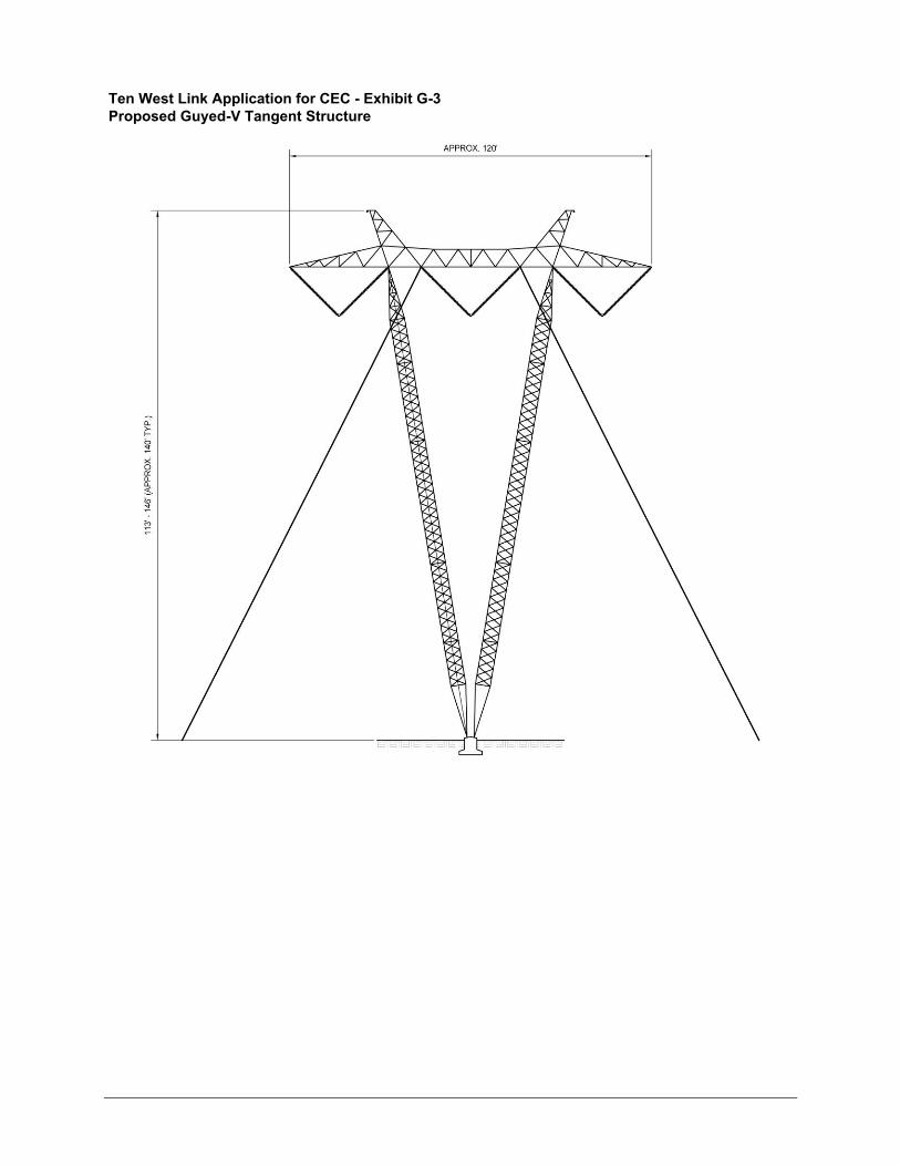
Ten West Link Application for CEC - Exhibit G-3 Proposed Guyed-V Tangent Structure

Ten West Link Application for CEC - Exhibit G-4 Proposed Self-Supporting Angle Dead-End Structure

120' -
180
' (AP
PRO
XIM
ATE)
Ten West Link Application for CEC - Exhibit G-6 Proposed Steel Monopole Structures by Substations

Ten West Link Application for CEC - Exhibit G-7 Proposed Three Pole Crossing Structure

Ten West Link Application for CEC - Exhibit G-16Series Compensation Station General Layout