proposed housing project on portion 1 (169 ha) and …
TRANSCRIPT

PROPOSED HOUSING PROJECT ON PORTION 1 AND THE REMAINDER OF THE FARM SIMS 462 (169 Ha) AND PORTION 1 OF THE FARM UITKOMS 463 (112 Ha), KATHU: FEASIBILITY-STAGE GEOTECHNICAL INVESTIGATIONS
VGI3944
Compiled by: VGIconsult Projects P.O. BOX 604 FOURWAYS 2055
TEL : (011) 469 0854 FAX : (011) 469 0961 FAX : 0866892847 e-mail: [email protected]

D.B. Buttrick Ph. D. (Eng. Geol.), MSAIEG, Pr. Sci. Nat. ; A.A. Gerber B. Eng., Pr. Eng. ASB: N.Y.G. Trollip M. Sc. (Eng. & Env.), Pr. Sci. Nat., AMSAIEG ; I. Kleinhans M. Sc. (Eng. & Env.), Pr. Sci. Nat.
Consulting Engineering Geologists & Engineers VGIconsultVGIconsult Projects (Pty.) Ltd.
Registration number 2003/015042/07
MACROPLAN TOWN AND REGIONAL PLANNERS P.O. Box 604
4A MURRAY AVENUE Fourways
PO BOX 987 2055
UPINGTON Gauteng
NORTHERN CAPE Telephone
Direct : (011) 469 0854
ATTENTION: MR. JACOBUS TREURNICH Fax : (011) 469 0961
CC ENVIRO AFRICA Fax : 0866892847
MR CLINTON GEYSER E-mail [email protected]
Your reference Our reference Date
- VGI3944 19 NOVEMBER 2015
PROPOSED HOUSING PROJECT ON PORTION 1 AND THE REMAINDER OF THE FARM SIMS 462 (169 Ha) AND PORTION 1 OF THE FARM UITKOMS 463 (112 Ha), KATHU: FEASIBILITY-STAGE GEOTECHNICAL INVESTIGATIONS
SUMMARY
This report presents the results of a Feasibility Stage geotechnical investigation commissioned on Portion 1 of the Remainder of Sims 462 and Portion 1 of Uitkoms 463 on the outskirts of the town of Kathu, in the Northern Cape.
This investigation comprised the excavation, profiling and sampling of 38 test pits, and the review of existing mine data in terms of the potential for dolomite related instability.
Existing information indicates that the Sims site is underlain by very thick (57-117m) Kalahari Group material (calcrete, clay, pebble layers), overlying Gamagara Formation shale to 121->234m). No known/confirmed faults are indicated to transect the site. Most of the Sims site is located within the area significantly impacted by groundwater abstraction. The current groundwater elevation range is 1080m AMSL to 1120m AMSL, i.e. 80m to 120m below the OWL. The site is not judged to be on dolomite land.
Existing information indicates that the Uitkoms site is underlain by Banded Iron Formation at shallow (10m or less) and to great depth (in excess of 142m). The site is located in the area not impacted by large scale groundwater abstraction. The site is not judged to be on dolomite land.
The proposed development can be described in terms of two (provisional) primary soil zones of similar foundation conditions, namely:
Soil Zones Designation Description
12[(H/C-C1/S-
S1)R3]
All the soil layers (i.e. the colluvium, ferruginous pebble marker, pedogenic are of low expansiveness) (H).
The colluvium and pedogenic layers comprise low density, collapsible and compressible material (C1/S1), to depths less than 0.5m. Minor to moderate settlement may be anticipated if these materials are placed under load and/or if the moisture content increases.
Refusal occurred with a TLB at depths less than 1.5m (R3).
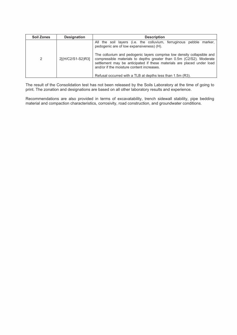
Soil Zones Designation Description
2 2[(H/C2/S1-S2)R3]
All the soil layers (i.e. the colluvium, ferruginous pebble marker, pedogenic are of low expansiveness) (H).
The colluvium and pedogenic layers comprise low density collapsible and compressible materials to depths greater than 0.5m (C2/S2). Moderate settlement may be anticipated if these materials are placed under load and/or if the moisture content increases.
Refusal occurred with a TLB at depths less than 1.5m (R3).
The result of the Consolidation test has not been released by the Soils Laboratory at the time of going to print. The zonation and designations are based on all other laboratory results and experience.
Recommendations are also provided in terms of excavatability, trench sidewall stability, pipe bedding material and compaction characteristics, corrosivity, road construction, and groundwater conditions.

PROPOSED HOUSING PROJECT ON PORTION 1 AND THE REMAINDER OF THE FARM SIMS 462 (169 Ha) AND PORTION 1 OF THE FARM UITKOMS 463 (112 Ha), KATHU: FEASIBILITY-STAGE GEOTECHNICAL INVESTIGATIONS
TABLE OF CONTENTS PAGE NUMBER
1. INTRODUCTION .................................................................................................................................... 1
2. TERMS OF REFERENCE ...................................................................................................................... 1
3. SCOPE OF WORK ................................................................................................................................ 1
4. AVAILABLE INFORMATION ................................................................................................................ 2
4.1. Topographic Data.......................................................................................................................... 24.2. Geological Information .................................................................................................................. 24.3. Industry Standards and Publications ............................................................................................. 24.4. Geohydrological Data and Reports ............................................................................................... 34.5. Existing Data and Reports ............................................................................................................ 3
5. DESCRIPTION OF THE STUDY AREA ................................................................................................ 3
5.1. Locality .......................................................................................................................................... 35.2. Site Description ............................................................................................................................. 3
6. PROCEDURES USED IN THIS STUDY ................................................................................................ 3
6.1. Assimilation of Available Data ....................................................................................................... 36.2. Map Production (Projection, Co-ordinate System and Datum) ..................................................... 36.3. Test Pits ........................................................................................................................................ 46.4. Boreholes ...................................................................................................................................... 46.5. Soil Sampling and Testing ............................................................................................................ 46.6. Geotechnical Near-surface Soils Classification ............................................................................ 56.7. Potential Erosion and Piping (Dispersive Soils) ............................................................................ 66.8. Potential Aggressiveness of Interparticulated Groundwater ......................................................... 66.9. Earthworks Classifications for Service Trenches .......................................................................... 66.10. Re-usability of Spoil ...................................................................................................................... 66.11. Seismic Hazard ............................................................................................................................. 76.12. Dolomite Land ............................................................................................................................... 7
7. GEOLOGY ............................................................................................................................................. 8
7.1. Regional Geological Setting .......................................................................................................... 87.4. Site Specific Geology .................................................................................................................. 107.5. Past Sinkholes and Subsidences ................................................................................................ 117.6. Near-surface Soils....................................................................................................................... 11
8. GEOHYDROLOGY .............................................................................................................................. 12
8.1. Regional and Site-specific Geohydrology ................................................................................... 128.2. Original Groundwater Level vs. Current Groundwater Level ...................................................... 13
9. NEAR SURFACE GEOTECHNICAL EVALUATION ........................................................................... 14
9.1. Engineering Properties and Material Characteristics .................................................................. 149.2. Natural Slope Stability and Erosion ............................................................................................. 159.3. Sidewall Stability in Excavations ................................................................................................. 159.4. Earthworks Classifications for Service Trenches (R) .................................................................. 159.5. Seismic Activity ........................................................................................................................... 169.6. Materials for Road Construction Purposes (TRH14) ................................................................... 169.7. Re-Usability of Spoil: Bedding Material and Earthworks ............................................................. 169.8. Drainage ..................................................................................................................................... 16
10. CONCLUSIONS ................................................................................................................................... 16
10.1. General ....................................................................................................................................... 1610.2. Near Surface Soils Assessment .................................................................................................. 17
11. RECOMMENDATIONS ........................................................................................................................ 17
11.1. Foundation Design Requirements ............................................................................................... 1711.2. Excavatability .............................................................................................................................. 2011.3. Trench Sidewall Stability ............................................................................................................. 2011.4. Pipe Bedding Material and Backfill and Compaction Characteristics .......................................... 20

11.5. Corrosivity ................................................................................................................................... 2111.6. Road Construction ...................................................................................................................... 2111.7. Groundwater Conditions ............................................................................................................. 21
12. GENERAL ............................................................................................................................................ 21
12.1. Verification Process .................................................................................................................... 2112.2. Third Party Reviews .................................................................................................................... 22

PROPOSED HOUSING PROJECT ON PORTION 1 AND THE REMAINDER OF THE FARM SIMS 462 (169 Ha) AND PORTION 1 OF THE FARM UITKOMS 463 (112 Ha), KATHU: FEASIBILITY-STAGE GEOTECHNICAL INVESTIGATIONS
TABLE OF CONTENTS CONTINUED
TABLES
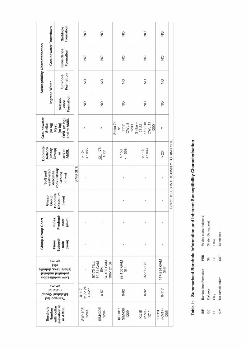
SUMMARISED BOREHOLE INFORMATION AND INHERENT SUSCEPTIBILITY CHARACTERISATION
TABLE 1
SUMMARISED TEST PIT POROFILES TABLE 2
SUMMARISED LABORATORY TEST RESULTS TABLE 3
FIGURES
LOCALITY WITH TOPOGRAPHIC SHEET LEGEND (1A) FIGURE 1
SITE LAYOUT FIGURE 2
REGIONAL GEOLOGY WITH GEOLOGY LEGEND (3A) FIGURE 3
REGIONAL GEOHYDROLOGY FIGURE 4
DRAWINGS
BOREHOLE -, TEST PIT POSITIONS AND SOILS ZONATION VGI3944/1
SCHEMATIC GEOLOGICAL CROSS SECTIONS VGI3944/2
APPENDICES
BOREHOLE PROFILES APPENDIX 1
TEST PIT PROFILES APPENDIX 2
LABORATORY TEST RESULTS APPENDIX 3

1
1. INTRODUCTION
This report presents the results of a Feasibility Stage geotechnical investigation commissioned on Portion 1 of the Remainder of Sims 462 and Portion 1 of Uitkoms 463 on the outskirts of the town of Kathu, in the Northern Cape.
This investigation comprised the excavation, profiling and sampling of test pits, and the review of existing mine data in terms of the potential for dolomite related instability.
This report documents, the terms of reference, location and description of the site, data used, geotechnical conditions and recommendations on the way forward.
2. TERMS OF REFERENCE
VGIconsult is appointed by MacroPlan to undertake a Feasibility Stage Geotechnical Investigation, as set out in proposal number VGI3944P, dated 2 August 2015.
3. SCOPE OF WORK
It was indicated that an Environmental Assessment is underway and that the relevant Department has requested the following: “A geo-technical assessment must be included as a specialist assessment. The assessment will provide information related to the soil types, soil potential, soil stability, subsoil structure, suitability of the area to support the proposed structures and recommendation for foundations”.
For housing projects compliance must ultimately be achieved with NHBRC Home Building Manual (1999). Township development is to comply with SANS 634 (2012) and if located on dolomite land, compliance is also to be achieved with SANS 1936 (2012).
The proposed land use is indicated as follows:
PORTION 1 OF THE FARM UITKOMS 463
Zoning Description Land Units Total Area (m2) Avg. %
RES I Single Home 163 152261.3 934.1 14
RES II Group Housing 1 21413.7 21413.7 2
OPEN I Park 2 14029.8 7014.9 1
OPEN II Recreation 1 738018.7 738018.7 66
OPEN III Conservation 3 119976.1 39992.0 11
INST II Worship 1 8213.2 8213.2 1
TRANS I Public Street 1 65746.6 65746.6 6
Total 1119659.4
PORTION 1 AND THE REMAINDER OF THE FARM SIMS 462
Zoning Description Land Units Total Area (m2) Avg. %
RES I Single Home 538 351362.0 653.1 20.8
RES II Group Housing 851 389334.0 457.5 23.1
RES III Flats 4 40376.6 10094.2 2.4
BUS I Commercial 6 62141.0 10356.8 3.7
OPEN I Park 29 258905.0 8927.8 15.3
INST II Worship 6 25103.9 4184.0 1.5
INST I Education 2 69843.8 34921.9 4.1

2
PORTION 1 AND THE REMAINDER OF THE FARM SIMS 462
Zoning Description Land Units Total Area (m2) Avg. %
AUTH Municipal Use 2 3940.2 1970.1 0.2
TRANS II Public Street 1 488011.5 488011.5 28.9
Total 1689018.0
4. AVAILABLE INFORMATION
Information sources include:
4.1. Topographic Data
o Topographic Map, 1: 50 000 Scale Series: issued by the Chief Directorate: Surveys and Mapping, Department of Land Affairs:
4.2. Geological Information
o Geological Map, 1: 250 000 Scale Series: issued by the Geological Survey of South Africa (Council for Geoscience):
Sheet Name Reference Kuruman 2722
o The Geology of South Africa: by MR Johnson, CR Anhaeusser, RJ Thomas, 2006.
4.3. Industry Standards and Publications
o South African National Standard SANS 1936-1/2/3/4: 2012, Edition 1 (ISBN 978-0-626-27840-3).
o South African National Standard SANS 633: 2012, Soil profiling and rotary percussion borehole logging on dolomite land in Southern Africa for engineering purposes.
o South African National Standard SANS 634: 2012, Geotechnical investigations for township development.
o Environmental Earth Sciences, Springer-Verlag: “A Performance Based Approach to Dolomite Risk Management” by D Buttrick, N Trollip, R Watermeyer, N Pieterse, A Gerber, Volume 64, Issue 4, p1127 to p1138, dated 2011.
o Journal of the South African Institution of Civil Engineering: "Proposed Method for Dolomite Land Hazard and Risk Assessment in South Africa" by Buttrick, Van Schalkwyk, Kleywegt and Watermeyer, Volume 43, Number 2, dated 2001.
o Annals of the Geological Survey of South Africa: “Subsurface subsidences and sinkholes caused by lowering of the dolomitic water-table on the Far West Rand Gold Field of South Africa” by RJ Kleywegt and DR Pike, Volume 16, p77 to p105, dated 1982.
o Site Investigation Code of Practice SAICE Geotechnical Division, January 2010.
o TRH14, Guidelines for Road Construction Material. Committee of State Road Authorities, Pretoria South Africa, dated 1985.
Sheet Name ReferenceKathu 2723 CA

3
o South African National Standard SANS 10160-4: 2011, Seismic Actions and General Requirements for Buildings, Edition 1.1 (ISBN 978-0-626-26421-4).
o NHBRC Home Building Manual, dated 1999.
4.4. Geohydrological Data and Reports
o Groundwater information is made available by the Department of Water Affairs through the National Groundwater Information System (NGIS) which offers read-only access to data from:
National Groundwater Archive (NGA);
Water Management System (WMS); and
Hydstra [http://www.dwa.gov.za/chart/]).
o Report “Geohydrology Guideline Development: Implementation of Dolomite Guideline – Phase 1, Activities 19 & 28: Desktop development of a Dolomite Hydrogeological Compartment Map and explanation booklet”, by Martin Holland of Water Geosciences Consulting & Frans Wiegmans of Golder Associates, Project Number 14/14/5/2, dated November 2009.
4.5. Existing Data and Reports
o VGIconsult report “Sishen Iron Ore Company: Regional Dolomite Stability Investigation for Risk Management Purposes”, Report Number VGI3193.3, dated 31 July 2012
o Kumba Iron Ore (Sishen Mine) Exploration Borehole Database.
5. DESCRIPTION OF THE STUDY AREA
5.1. Locality
The locality of the sites within the region is displayed in the attached Figure 1. The Sims site flanks the western edge of Kathu town and comprises 169ha. The Uitkoms site flanks the eastern edge of the town and comprises 112ha.
5.2. Site Description
The sites, as seen in aerial photographic coverage, are presented in the attached Figure 2. The Sims site falls gently from west to east from 1210m AMSL to 1205m AMSL at 0.2º. The Uitkoms site is relatively flat and at an elevation of 1230m AMSL.
6. PROCEDURES USED IN THIS STUDY
6.1. Assimilation of Available Data
Data collected from Kumba, the VGIconsult database together with available geological and geohydrological data are first assimilated.
6.2. Map Production (Projection, Co-ordinate System and Datum)
All the drawings in this report are produced using a Geographic Information System (GIS). The projection information of the figures and drawings in this report listed below:
Projection surface: Mercator (cylinder)Projection orientation: Transverse aspectDatum or reference ellipsoid: World Geodetic System 84
4
Central Meridian: In degrees (23 for this study)False easting and northing: Zero degreesScale factor: 1
The drawings and figures are co-ordinated in metres latitude (7 digit value) and longitude (5 or 6 digit value).
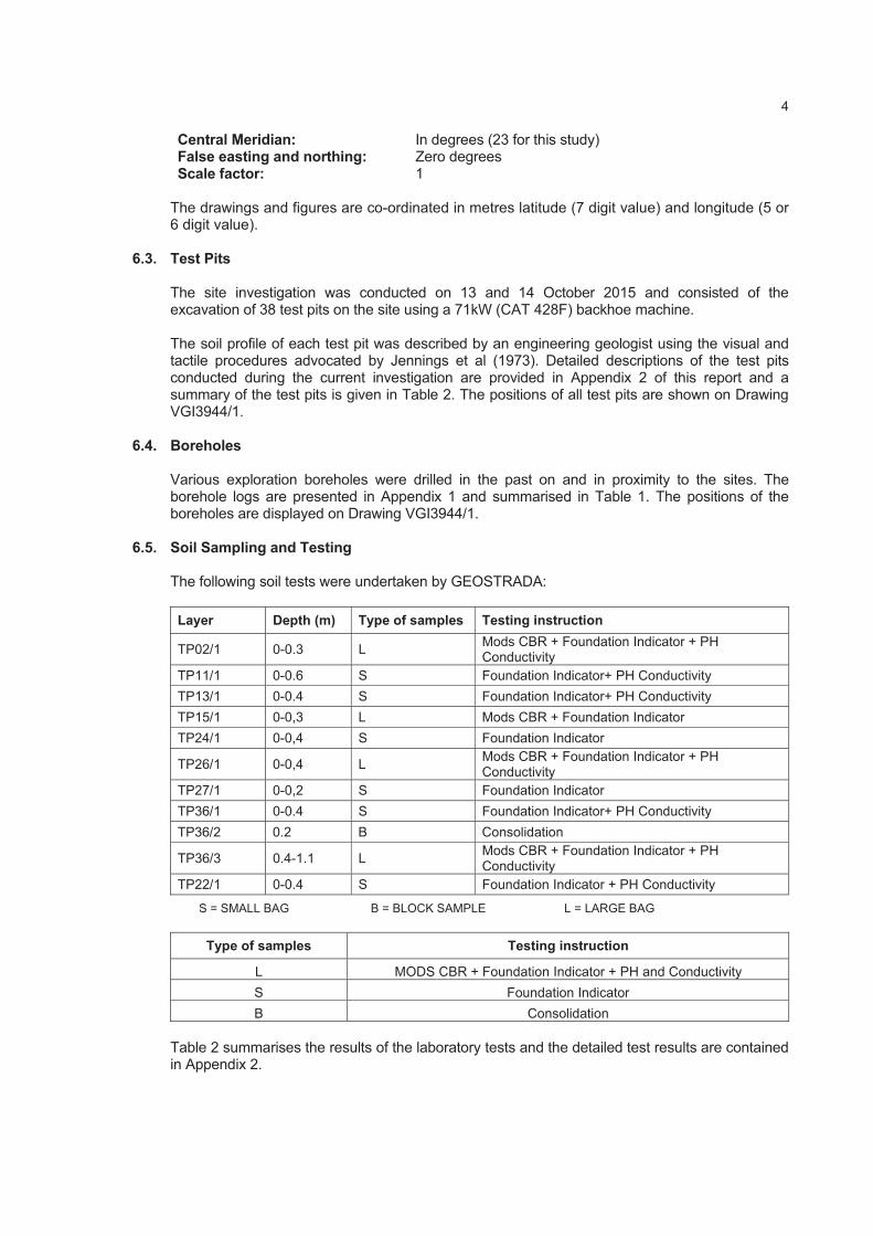
6.3. Test Pits
The site investigation was conducted on 13 and 14 October 2015 and consisted of the excavation of 38 test pits on the site using a 71kW (CAT 428F) backhoe machine.
The soil profile of each test pit was described by an engineering geologist using the visual and tactile procedures advocated by Jennings et al (1973). Detailed descriptions of the test pits conducted during the current investigation are provided in Appendix 2 of this report and a summary of the test pits is given in Table 2. The positions of all test pits are shown on Drawing VGI3944/1.
6.4. Boreholes
Various exploration boreholes were drilled in the past on and in proximity to the sites. The borehole logs are presented in Appendix 1 and summarised in Table 1. The positions of the boreholes are displayed on Drawing VGI3944/1.
6.5. Soil Sampling and Testing
The following soil tests were undertaken by GEOSTRADA:
Layer Depth (m) Type of samples Testing instruction
TP02/1 0-0.3 L Mods CBR + Foundation Indicator + PH Conductivity
TP11/1 0-0.6 S Foundation Indicator+ PH Conductivity
TP13/1 0-0.4 S Foundation Indicator+ PH Conductivity
TP15/1 0-0,3 L Mods CBR + Foundation Indicator
TP24/1 0-0,4 S Foundation Indicator
TP26/1 0-0,4 L Mods CBR + Foundation Indicator + PH Conductivity
TP27/1 0-0,2 S Foundation Indicator
TP36/1 0-0.4 S Foundation Indicator+ PH Conductivity
TP36/2 0.2 B Consolidation
TP36/3 0.4-1.1 L Mods CBR + Foundation Indicator + PH Conductivity
TP22/1 0-0.4 S Foundation Indicator + PH Conductivity
S = SMALL BAG B = BLOCK SAMPLE L = LARGE BAG
Type of samples Testing instruction
L MODS CBR + Foundation Indicator + PH and Conductivity
S Foundation Indicator
B Consolidation
Table 2 summarises the results of the laboratory tests and the detailed test results are contained in Appendix 2.
5
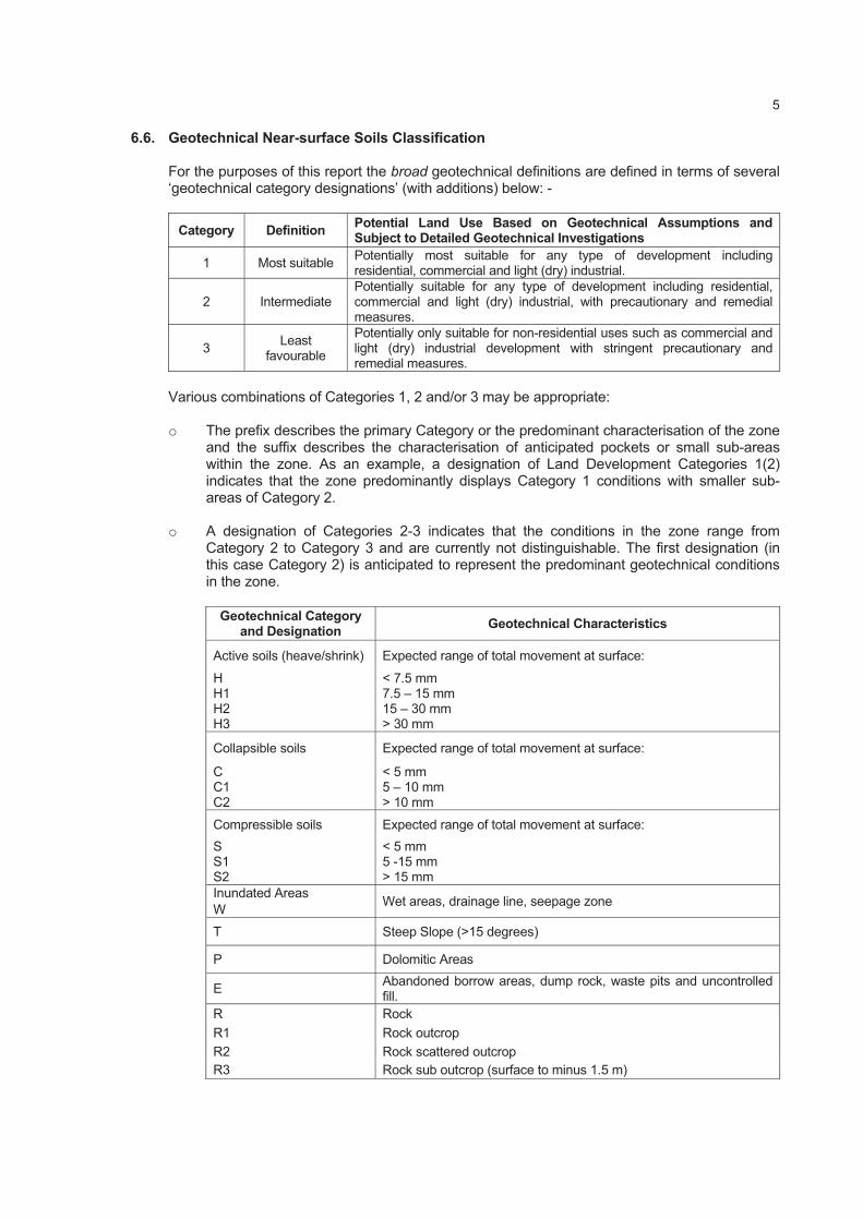
6.6. Geotechnical Near-surface Soils Classification
For the purposes of this report the broad geotechnical definitions are defined in terms of several ‘geotechnical category designations’ (with additions) below: -
Category Definition Potential Land Use Based on Geotechnical Assumptions and Subject to Detailed Geotechnical Investigations
1 Most suitable Potentially most suitable for any type of development including residential, commercial and light (dry) industrial.
2 Intermediate Potentially suitable for any type of development including residential, commercial and light (dry) industrial, with precautionary and remedial measures.
3Least
favourable
Potentially only suitable for non-residential uses such as commercial and light (dry) industrial development with stringent precautionary and remedial measures.
Various combinations of Categories 1, 2 and/or 3 may be appropriate:
o The prefix describes the primary Category or the predominant characterisation of the zone and the suffix describes the characterisation of anticipated pockets or small sub-areas within the zone. As an example, a designation of Land Development Categories 1(2) indicates that the zone predominantly displays Category 1 conditions with smaller sub-areas of Category 2.
o A designation of Categories 2-3 indicates that the conditions in the zone range from Category 2 to Category 3 and are currently not distinguishable. The first designation (in this case Category 2) is anticipated to represent the predominant geotechnical conditions in the zone.
Geotechnical Category and Designation
Geotechnical Characteristics
Active soils (heave/shrink) Expected range of total movement at surface:
H < 7.5 mm H1 7.5 – 15 mm H2 15 – 30 mm H3 > 30 mm
Collapsible soils Expected range of total movement at surface:
C < 5 mm C1 5 – 10 mm C2 > 10 mm
Compressible soils Expected range of total movement at surface:
S < 5 mm S1 5 -15 mm S2 > 15 mm
Inundated Areas Wet areas, drainage line, seepage zone
W
T Steep Slope (>15 degrees)
P Dolomitic Areas
EAbandoned borrow areas, dump rock, waste pits and uncontrolled fill.
R Rock
R1 Rock outcrop
R2 Rock scattered outcrop
R3 Rock sub outcrop (surface to minus 1.5 m)

6
6.7. Potential Erosion and Piping (Dispersive Soils)
Sodium-based clay minerals are susceptible to erosion or piping in the in situ soil profile. The electrical conductivity (EC) of the soil paste provides an indicator of the salinity and potential dispersive behaviour.
6.8. Potential Aggressiveness of Interparticulated Groundwater
According to industry guidelines pH and electrical conductivity (EC) should be measured in selected samples. pH is a measure of the acidity of the soil based on its hydrogen ion concentration and is mathematically defined as the negative logarithm of the hydrogen ion concentration, or pH = -log[H+].
The pH of a material ranges on a logarithmic scale from 1-14, where pH 1-6 are acidic, pH 7 is neutral, and pH 8-14 are basic. Lower pH corresponds with higher [H+], while higher pH is associated with lower [H+].
Electrical conductivity (EC) is the ability of the material to conduct electrical current through it. EC is measured in Siemens per unit area (e.g. Siemens per metre). The higher the dissolved material in soil sample, the higher the EC of the soil. The electrical conductivity of soils varies depending on the amount of moisture held by soil particles. Sands have a low conductivity, silts have a medium conductivity, and clays have a high conductivity. Consequently, EC correlates strongly to soil particle size and texture.
Soil resistivity is a function of soil moisture and the concentrations of ionic soluble salts and is considered to be most comprehensive indicator of a soil’s corrosivity. Typically, the lower the resistivity, the higher will be the corrosivity as indicated in the following Table:
Soil Resistivity (Ohm/m) Corrosivity Rating
> 200 Essentially non-corrosive
100 to 200 Mildly corrosive
50 to 100 Moderately corrosive
30 to 50 Corrosive
10 to 30 Highly corrosive
< 10 Extremely corrosive
6.9. Earthworks Classifications for Service Trenches
The ease of excavation is a critical financial factor when installing underground services and placement of foundations. The excavatability of material can be grouped into the following three categories according to SABS 1200D:
o Soft excavation (Class A) requires mechanical equipment o Intermediate excavation (Class B) requires ripping equipment o Hard rock excavation (Class C) requires blasting or pneumatic rock breaking equipment
6.10. Re-usability of Spoil
Material excavated from the pipe trench may be re-used as fill material if it meets the requirements of SABS 1200LB, as follows:
Selected Granular Fill Selected Fill Backfill
Granular
Non-cohesive
0,6mm to 19mm particle size
Free-draining
Compactibility factor <0,4
Plasticity Index (PI) < 6
No lumps or stones >30mm diameter
No vegetation
Little or no organic material
Stones >150mm in diameter
Less than 10% of rocks >50mm in diameter
No large clay lumps

7
6.11. Seismic Hazard
The seismicity of Southern Africa is typically that of an intra-plate region. The natural seismic regime of a region of this type is characterized by a low-level activity by world standards, with earthquakes randomly distributed in space and time. In South Africa the only part which does not display the characteristics of an intra-plate region is the possible continuation of the East African rift system in the north-eastern region of the country.
The boundaries of the African Plate are conspicuously outlined by a narrow earthquake belt following the Mid-Atlantic and Mid-Indian oceanic ridges. Most of the natural activity around Southern Africa occurs along these features. Tremors resulting from the deep-mining operations in the gold fields of Gauteng, North West and Free State Provinces, form the bulk of the seismic events recorded by the regional network of seismological stations. The depth of these tremors has been fixed at 2 km below the surface.
The level of amplification induced in structures by seismic events is primarily influenced by the nature and magnitude of the seismic impulse, e.g. magnitude and epicentre of an earthquake, but also by the dynamic stiffness properties of the rock mass and regolith and of the particular structures.
In accordance with SANS 10160 (2012) structures in seismic zones shall, as a minimum, be designed and constructed to resist the effects of seismic ground motions. This standard provides strategies and rules for the design of buildings subject to earthquake actions primarily to safeguard against major catastrophic structural failures and loss of life, not to prevent damage or to maintain function. Figure 1 of SANS 10160-4 presents the seismic zones of South Africa. Two zones are identified, namely: a) Zone I: Natural seismic activity and b) Zone II: Regions of mining-induced and natural seismic activity.
SANS 10160-4, Table 3 presents classes of buildings relevant to seismic hazard:
ImportanceClass
Buildings Importance Factor ( i)
I Buildings of minor importance for public safety, e.g. agricultural buildings etc.
0.8
II Ordinary buildings, not belonging to the other categories 1.0
III Buildings for which seismic resistance is of importance in view of the consequences associated with collapse, e.g. schools, assembly halls, cultural institutions etc.
1.2
IV Buildings for which integrity during earthquakes is of vital importance for protection e.g. hospitals, fire stations, power plants etc.
1.4
Note:
The numbering of importance classes differ from those in the Eurocode where from the definitions were taken.
Buildings of Importance Class I, II and III in Zone II need only comply with clause 5 and with the minimum requirements for structural and non-structural components and with the requirements for ties, continuity and anchorage, all as detailed in clause 9.
Buildings of Importance Class IV in Zone II shall be treated as buildings located in Zone 1.
6.12. Dolomite Land
Land underlain by dolomite or limestone residuum or bedrock (or both), within the Malmani Subgroup and Campbell Rand Subgroup, typically at depths of no more than:
a) 60m in areas where no de-watering has taken place and the local authority has jurisdiction, is monitoring and has control over the groundwater levels in the areas under consideration; or
b) 100m in areas where de-watering has taken place or where the local authority has no jurisdiction or control over groundwater levels.

8
Where dolomite land occurs a Dolomite Area Designation is to be assigned in accordance with SANS 1936 Part 2 (2012).
The definitions of the Dolomite Area Designations, as defined in SANS 1936 Part 1 (2012), are as follows:
DDesignation
Description
D1 No precautionary measures are required.
D2General precautionary measures, in accordance with the requirements of SANS 1936-3, that are intended to prevent the concentrated ingress of water into the ground, are required.
D3Precautionary measures in addition to those pertaining to the prevention of concentrated ingress of water into the ground, in accordance with the relevant requirements of SANS 1936-3, are required.
D4 Additional site-specific precautionary measures are required.*
*Section 4.3.4 states the following specific measures for D4 areas: a) site characterization, analysis and design, specification of precautionary measures, supervision
of implementation and formulation of dolomite risk management plan shall be undertaken by a Competence Level 4 geo-professional;
b) the foundation design and design of the structure, precautionary measures and dolomite risk management plan shall specifically address and effectively mitigate the dolomite risks (should read hazard) present on the site;
c) the site characterization, foundation design and design of the structure, precautionary measures and dolomite risk management requirements shall be reviewed and approved by an independent Competence Level 4 geo-professional and, where relevant, by a structural engineer with a similar level of competence; and
d) all aspects of the development proposal shall be reviewed and approved by the local authority who may request a further review by an authority-designated Competence Level 4 peer if required.
The new NHBRC Home Building Manual has been gazetted and is to be published in October 2015. The definition is as follows:
Table 11: Dolomite area designations
D Designation Description
D1 No precautionary measures are required.
D2Precautionary measures and dolomite risk management are required to maintain a tolerable hazard rating.
D3Precautionary measures and dolomite risk management in addition to that described for dolomite area designation D2 are required to achieve a tolerable hazard rating.
D4Precautionary measures and dolomite risk management in addition to that described for D3 rarely enables a tolerable hazard rating to be achieved.
7. GEOLOGY
7.1. Regional Geological Setting
According to the 1:250 000 scale geological map (refer to Figure 3) the Sims site is located on Tertiary age surface limestone (Tl) and Uitkoms is located on Quaternary age sand (Qs).
The Sishen Iron Ore Mine (including the town of Kathu) is situated on the Maremane Dome. The Dome consists of carbonate rocks (predominantly stromatolitic and crinkle laminated dolomite and limestone) of the Campbell Rand Subgroup, Ghaap Group, Transvaal Supergroup.

9
Only the eastern half of the dome is exposed with dolomite outcropping to the south-east of Sishen. Chert breccia of the Ghaap Group, as well as ferruginised brecciated banded ironstone (BIF) of the Asbestos Hills Subgroup, Ghaap Group overlie the Campbell Rand Subgroup.
To the west of the Sishen Mine the Campbell Rand Subgroup is overlain along an angular unconformity by conglomerate, shale and quartzite of the Gamagara Formation,Olifantshoek Supergroup. Further to the west Makganyene Formation diamictite and Ongeluk Formation andesitic lava of the Postmasburg Group of the Transvaal Supergroup are thrust over the Gamagara Formation along a north-south striking, westerly dipping, low-angle thrust fault.
Thin, diabase dykes with north-south and northeast orientations, have intruded the stratigraphic sequence. Some of the dykes are postulated to form impervious barriers and compartmentalise the groundwater.
A buried glacial valley, filled with Dwyka tillite and mudstones has been identified during past reconnaissance drilling. The valley is located between the mine area and Kathu. It has a typical north-south orientation, with a north-west orientation between Dibeng and the mine pit.
Kalahari Group material lie unconformably on lavas, shales and quartzites of the Olifantshoek Supergroup and dolomite/Banded Iron Formation of the Ghaap Group. Two main lithologies can be distinguished, namely basal gravels, assigned to the Wessels Formation, and overlying calcareous clays of the Budin Formation.
The various lithological units anticipated in the project area are as follows:
Lithostratigraphic Unit Lithology
Kalahari Group -Cenozoic Era (i.e. including Tertiary and Quaternary deposits):
Gordonia Formation (Quaternary) Windblown sand
Lonely Formation (Quaternary) Surface limestone (loosely consolidated low density diatomaceous limestone) formed in shallow freshwater lakes)
Obobogorop Formation (Quaternary) Gravel (derived from Dwyka Formation)
Mokalanen Formation (at boundary between Quaternary/Tertiary)
Calcrete (forming a sandy limestone or conglomerate with calcareous matrix)
Eden Formation (Tertiary) Sandstone, siltstone poorly sorted gravel
Budin Formation (Tertiary) Clays and pebbles
Wessels Formation (Tertiary) Coarse angular poorly sorted gravel
Unconformity
Dolerite dykes and sills (Drakensburg Group age/150 Ma)
Dwyka Formation, Karoo Supergroup Tillite, mudstone and weathered derivatives
Unconformity
Gamagara Formation, Olifantshoek Supergroup Shale, conglomerate and quartzite
Diabase dykes and sills (possibly of Bushveld Complex age/2061 Ma)
Thrust
Ongeluk Formation, Postmasburg Group, Transvaal Supergroup
Andesitic lava
Makganyene Formation, Postmasburg Group, Transvaal Supergroup
Diamictite and weathered derivates
Unconformity
Asbestos Hill Subgroup, Ghaap Group Koegas Subgroup, Ghaap Group
Ferruginised brecciated banded ironstone Manganore ironore, chert breccia: Massive ore Laminated ore Intrusive Banded Iron Formation
10
Lithostratigraphic Unit Lithology
Laminated Ore Banded Iron Formation
Unconformity
(Wolhaarkop Formation) Campbell Rand Subgroup, Ghaap Group, Transvaal Supergroup
Chert breccia
Unconformity
Gamohaan-, Kogelbeen-, Papkuil-, Fairfield-, Reivilo-, Monteville Formation, Campbell Rand Subgroup, Ghaap Group, Transvaal Supergroup
Limestone, dolomite, chert, subordinate shale, ooilite and weathering soil derivatives
7.2. Structural Geology
o Sishen Iron Ore Mine is situated in the northern extent of the Maremane Dome area.
o The N-S and E-W trending interference folding that formed the dome dictates a shallow northwards plunge of major fold axes.
o A large number of north/south-trending normal faults are present with variable (<100m) displacements related mainly to the first passive margin-rifting event, and were subsequently reactivated.
o Numerous normal faults displacing stratigraphic units in fault-bounded shale filled basins are also present.
7.3. Local Geology: Kathu area
o A general overview of the geology indicates that the Kalahari Group deposits are relatively extensive in plan and in depth.
o A Karoo age valley (in-filled with shale-rich deposits) has been reported by various authors.
o Dolomite rock is confirmed in 32 of the 76 boreholes drilled in and near to Kathu. Of this set 13 intercept dolomite within 100m of ground surface. Of this set only 3 intercept dolomite bedrock at 60m or shallower.
o Dolomite rock is overlain by chert/chert breccia of the Wolhaarkop Formation in sub-areas. The Formation is relatively thin. In sub-areas the dolomite is overlain by Banded Iron Formation and/or shale of the Gamagara Formation.
Although various boreholes indicate that Kathu is largely not located on dolomite land, attention is drawn to the presence of faults and other structures which transect the subsurface profile. Sinkholes have been observed on such features south-east of the mine pit. In 2012 it was therefore determined that dolomite risk management be applied to the formalised portion of Kathu Town.
7.4. Site Specific Geology
7.4.1. Sims Site
According to Sishen Iron Ore Mine data five boreholes were drilled on the site and an additional two boreholes on/near to the site boundary.
This site is blanketed by 57m to 117m thick Kalahari Group material comprising calcrete, clay and pebbles. The calcrete is 19m to 64m in thickness. The Kalahari deposits are underlain by shale and siltstone of the Gamagara Formation to very great depth (121m to in excess of 234m.
11
Borehole KM17 is described to intercept Karoo age shale, but considering the borehole logs of the Mine database in the area, this material may in fact be of the Gamagara Formation. Locally the Gamagara shales are underlain by chert breccia of the Wolhaarkop Formation. In Borehole KU1E the chert breccia is overlain by Banded Iron Formation. Exploration Borehole SW410E intercepts a cavity at very great depth below the Kalahari Group. The anticipated Formation is Gamagara Group shale or BIF/Wolhaarkop breccia. The reason for cavity formation during the drilling process is unknown. Only one of the seven boreholes (Borehole SIM430E) intercepted dolomite rock. The depth to dolomite is 121m.
According to the Sishen Mine structural data set no faults transect the site.
As this site is predominantly located in the area of significant impact of groundwater drawdown (refer to Section 8.2) the 100m depth to dolomite rock cut off applies. Notwithstanding this, dolomite rock is greater than 121m, and as no major faults of significance are indicated to transect the site, the site is not judged to be on dolomite land.
7.4.2. Uitkoms Site
According to Sishen Iron Ore Mine data a single borehole was drilled on the site but the mine database has no log for this exploration hole. Six boreholes were drilled in proximity to site. A gravity survey was commissioned for the already formalised portion of Kathu town which indicates a major gravity high flanking the western side of the site. Drilling data indicates that this gravity high probably extends over, onto the Uitkoms site, in particular in the area of proposed housing. The entire northern portion of the development is to remain as open parkland. Boreholes immediately west and south of the site indicate Banded Iron Formation at shallow depth (0m to 10m) to depths in excess of 142m. The BIF is overlain by Kalahari Group deposits. Borehole KBH04 intercepts 36m of Kalahari deposits mantling BIF to at least 90m depth.
According to the Sishen Mine structural data set no faults transect the site.
As this site is predominantly located in the area not impacted by groundwater drawdown (refer to Section 8.2) the 60m depth to dolomite rock cut off could apply. In the interest of dolomite risk management, and as it cannot be stated with certainty that this situation would prevail in perpetuity the 100m cut off is considered. Notwithstanding this, dolomite rock is anticipated at depths in excess of 142m, and as no major faults of significance are indicated to transect the site, the site is not judged to be on dolomite land.
7.5. Past Sinkholes and Subsidences
The CGS sinkhole database indicates no record of sinkholes on or in close proximity to the Sims or Uitkoms sites.
7.6. Near-surface Soils
An 8.45 Ton, 71Kw Backhoe Machine (CAT 428F) capable of excavating to 3.2m depth was hired to study the near-surface conditions.
The materials studied vary in thickness and geotechnical properties. The typical soil profile encountered in test pits excavated in this study can be summarized as follows (Refer to Table 2 and Drawing VGI3944/1):
A layer of colluvium comprising loose silty sand (with exception of TP 36 which has a medium dense consistency), encountered in all the test pits from ground surface to a depth of 0.8m.
An isolated fill layer comprising of mixed gravels, loosely packed in a silty sand matrix, with overall medium dense consistency.

12
This layer is situated at TP 11 from ground surface to a depth of 0.6m.
Nodular calcrete (pedogenic) layers were encountered below the colluvium as follows:
A layer comprising 20% to 30% nodular calcrete loosely packed in a silty sand matrix with an overall medium dense consistency. This layer is observed in test pits TP22 and TP32 between depths of 0.2m to 0.5m.
A layer comprising 40% to 50% nodular calcrete loosely packed in a silty sand matrix with an overall medium dense consistency. This layer is observed in majority of test pits between depths of 0m to 1,0m.
A layer comprising 60% to 80% nodular calcrete densely packed in a silty sand matrix with an overall dense consistency. This layer is observed in test pits TP30 and TP36 between depths of 0,2m to 1,2m.
The nodular calcrete is underlain by very dense honeycomb calcrete tending to hardpan calcrete from a minimum depth of 0,1m and a maximum depth of 1,2m.
Refusal of the TLB occurred at a depth of 0.1m to 1.2m on very dense honeycomb calcrete tending to hardpan calcrete in all the test pits.
No seepage or groundwater was observed.
8. GEOHYDROLOGY
8.1. Regional and Site-specific Geohydrology
Refer to Figure 4 for pertinent groundwater information.
8.1.1. Quaternary Catchment Area
According to the country wide Quaternary Catchment data the stand is located in Catchment D73A.
8.1.2. Groundwater Management Area (WMA)
According to the country wide Water Management Areas data the sites are located in WMA 10: Lower Vaal.
8.1.3. Dolomite Groundwater Management Area (GMA)
According to the Water Geosciences Consulting Dolomite Hydrogeological Compartment Map1 (2009) the stand is located in the Prieska Sub-Basin Dolomite GMA.
8.1.4. Dolomite Groundwater Management/Resource Units
According to the Water Geosciences Consulting Dolomite Hydrogeological Compartment Map (2009) the sites are not located within designated Dolomite Groundwater Management- or Resource Units.
1 The map represents the subdivision of the dolomitic surface outcrop of the Ghaap Plateau and the Gauteng/North
West dolomites. The major delineation is represented by the dolomitic Groundwater Management Areas (GMA). The names of these GMA’s typically correspond closely to the common known dolomitic compartments as established in the late 1980’s by the DWA. However, the delineation does not necessarily represent a dolomite compartment or unit.

13
8.2. Original Groundwater Level vs. Current Groundwater Level
Several geohydrological investigations have been conducted in the region since the early 1970s. The information was analysed in 2009 by the SIOM appointed geohydrologist Mr. R Meyer in order to formulate a conceptual geohydrological model of the mining area and the immediate surrounding areas.
During 2008 a total of 10 874 005 m3 of groundwater was abstracted from the SIOM. This was accomplished from three well fields located in the southern mining pit, the northern pit and the so-called western boreholes from which 8 386 600 m3, 1 602 085 m3 and 885 320 m3 were abstracted respectively during 2008. From the two other well fields, referred to as the Kathu and Khai-Appel well fields, supplying the town, country club, game farm adjoining Kathu and the farming requirements of Ferroland, 1 699 366 m3 and 873 680 m3 were abstracted respectively. The total volume of ground water abstraction during 2008 from these sources amounts to 13 447 051 m3.
In 2012 the changes in the groundwater levels experienced in the greater Kathu region was studied by Meyer in order to prepare an OWL (original groundwater level) contour map as well as CWL (current water level) contour map. Although regular water level monitoring was concentrated in the area immediately surrounding the mining areas, regional hydro-censuses were conducted in 1970-1972 and again in 1994. Sporadic water level measurements were also taken in selected areas since 1970, with the focus being close to the mining area, the alluvial aquifer associated with the non-perennial Gamagara River and the farms around the larger areas around the mine development. The exceptional recharge period between 1973/74 and 1975/76 warrants the choice of pre-1974 water levels as baseline groundwater level. The hydro-census data of the early 1970’s is therefore viewed as the groundwater level baseline (OWL) for the regional area around Sishen/Kathu and most of the information used to construct the pre-1974 water level maps are derived from this census, although a few older water levels records were also used.
Very little pre-1974 water level information could be found for the town of Kathu. In addition, many of the older boreholes in the area were drilled as water supply boreholes, and did not necessarily penetrate the Kalahari Group formation with associated groundwater levels presenting conditions in the primary aquifer.
Across the town of Kathu the OWL (original groundwater level elevation) varies by about 10m, from 1200m to 1210m AMSL. Based on current piezometric and groundwater level information, three water level conditions have been identified by Meyer:
1. Areas where the groundwater conditions have not yet been impacted by the large scale groundwater abstraction.
2. A triangular shaped area between the Kathu and Sekgame dykes where groundwater conditions have been partially impacted by groundwater abstraction activities.
This condition is present below the north eastern part of the original town development and to the south of the golf course.
3. An area in the southern and south-western portion where groundwater conditions have been significantly impacted by the groundwater abstraction.
The Uitkoms site is located in the area not impacted by large scale groundwater abstraction.
Most of the Sims site is located within the area significantly impacted by groundwater abstraction. The current groundwater elevation range is 1080m AMSL to 1120m AMSL, i.e. 80m to 120m below the OWL.

14
9. NEAR SURFACE GEOTECHNICAL EVALUATION
The geotechnical evaluation of the near surface soil horizons and their properties on the site are based on the interpretation of the geology, the soil profiles and the laboratory test results:
9.1. Engineering Properties and Material Characteristics
9.1.1. Activity (swelling/shrinking) or Expansive Potential of soils within 1.2m from natural ground level
The foundation indicator test results indicate that all the soil layers have a low potential expansiveness (<7.5mm).
9.1.2. Potentially Collapsible Soils within 1.2m from natural ground level
The colluvium, comprising loose silty sand and extending to an anticipated maximum depth of 0.9m, is potentially highly collapsible. The medium dense nodular calcrete, as well as the fill, has a moderate collapse potential. The colluvial/pedogenic horizon is of greater thickness (> 0.5m) in Soils Zone 2 necessitating a C2 designation.
9.1.3. Potentially Compressible Soils within 1.2m from natural ground level
The colluvium is highly compressible and extends to an anticipated maximum depth of 0.9m. The medium dense nodular calcrete and fill is potentially moderately compressible. The colluvial/pedogenic horizon is of greater thickness (> 0.5m) in Soils Zone 2 necessitating a S2 designation.
9.1.4. Potential Aggressiveness of Interparticulated Groundwater
Our assessment of the pH- and resistivity values is as follows:
Test Pit No.
Sample Depth Material origin pH: natural soil Descriptor:natural soil
TP02/1 0-0.3 Calcrete 7.30 Pedogenic
TP11/1 0-0.6 Fill 7.89 Fill
TP13/1 0-0.4 Transported 7.80 Colluvium
TP26/1 0-0,4 Calcrete 7.92 Pedogenic
TP36/1 0-0.4 Transported 8.03 Colluvium
TP36/3 0.4-1.1 Calcrete 8.35 Pedogenic
TP22/1 0-0.4 Transported 7.44 Colluvium
The samples submitted for pH testing revealed that all the soil layers (fill, colluvium and calcrete) are neutral to alkaline, with a pH value of 7.30 to 8.35.
It is therefore foreseen that no real potential exists for an aggressive environment towards steel within the subsurface profile.
9.1.5. Potential Erosion and Piping (Dispersive Soils)2
Sodium-based clay minerals are susceptible to erosion or piping in the in situ soil profile. The electrical conductivity of the soil paste provides an indicator of the salinity and potential dispersive behaviour.
2 when soil types are subjected to a hydraulic gradient
15
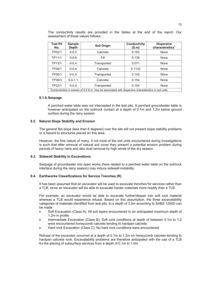
The conductivity results are provided in the tables at the end of the report. Our assessment of these values follows:
Test Pit No.
Sample Depth
Soil Origin Conductivity
(S.m) Dispersive
charactersitics1
TP02/1 0-0.3 Calcrete 0.163 None
TP11/1 0-0.6 Fill 0.139 None
TP13/1 0-0.4 Transported 0.071 None
TP26/1 0-0,4 Calcrete 0.1133 None
TP36/1 0-0.4 Transported 0.142 None
TP36/3 0.4-1.1 Calcrete 0.154 None
TP22/1 0-0.4 Transported 0.154 None 1Conductivities in excess of 0.5 S.m. may be associated with dispersive characteristics in soil units
9.1.6. Seepage
A perched water table was not intercepted in the test pits. A perched groundwater table is however anticipated on the soil/rock contact at a depth of 0.1m and 1.2m below ground surface during the rainy season.
9.2. Natural Slope Stability and Erosion
The general flat slope (less than 6 degrees) over the site will not present slope stability problems or a hazard to structures placed on this area.
However, the fine nature of many, if not most of the soil units encountered during investigations is such that after removal of natural soil cover they present a potential erosion problem during periods of heavy rains and also dust removal by high winds of the dry season.
9.3. Sidewall Stability in Excavations
Seepage of groundwater into open works (here related to a perched water table on the soil/rock interface during the rainy season) may induce sidewall instability.
9.4. Earthworks Classifications for Service Trenches (R)
It has been assumed that an excavator will be used to excavate trenches for services rather than a TLB, since an excavator will be able to excavate harder materials more readily than a TLB.
For example, an excavator would be able to excavate further/deeper into soft rock material whereas a TLB would experience refusal. Based on this assumption, the three excavatability categories of materials identified from test pits, to a depth of 3,0m according to SABS 1200D can be made:
Soft Excavation (Class A): All soil layers encountered to an anticipated maximum depth of 1.2m in profile.
Intermediate Excavation (Class B): Soft rock conditions at depth of between 0.1m to 1.2 were encountered honeycomb calcrete tending to hardpan calcrete.
Hard rock Excavation (Class C): No hard rock conditions were encountered.
Refusal of the excavator occurred at a depth of 0.1m to 1.2m on honeycomb calcrete tending to hardpan calcrete rock. Excavatability problems are therefore anticipated with the use of a TLB for the placing of subsurface services from a depth of 0.1m to 1.0m.

16
9.5. Seismic Activity
In terms of SANS 10160 (2012) and the seismic hazard map contained therein the site is not located in a Seismic Hazard Zone.
9.6. Materials for Road Construction Purposes (TRH14)
Test Pit No.
Sample Depth Soil Origin MDD OMC COLTO
Classification
TP02/1 0-0.3 Calcrete 2016 7.6 G5
TP15/1 0-0,3 Calcrete 1824 10.8 G5
TP26/1 0-0,4 Calcrete 1880 7.4 G5
TP36/3 0.4-1.1 Calcrete 1880 9.7 G6
o G5 quality materials are suitable for the use for base layer, and G6 quality material are suitable for sub base in road construction. However G6 quality material can be improved to G5 quality by adding 20% to 30% gravels.
9.7. Re-Usability of Spoil: Bedding Material and Earthworks3
o Selected Granular Bedding – i.e. naturally occurring non-cohesive, free draining, singularly graded gravel-soils between 0.6mm and 19.0mm particle size are not available on this site and will need to be imported.
o Selected Fill – the laboratory tests results confirm that natural soils with a PI less than 6% and/or a stones content of <30mm are not available on this site.
o General Backfill – materials recovered from trench excavation works may be considered for general backfill purposes after removal or reduction of all the larger cobble and boulder size fractions.
o The selected calcrete materials, G5 and G6 quality materials are suitable for the construction of earth mattresses.
9.8. Drainage
A complete stormwater system that provides for drainage as well as the provision of drainage to control runoff from major stormwater events will need to be constructed on the site, according to Municipal specifications.
10. CONCLUSIONS
10.1. General
This investigation comprised the excavation, profiling and sampling of 38 test pits across the two proposed sites and the studying of existing, relevant Sishen Iron Ore Mine data.
Existing information indicates that the Sims site is underlain by very thick (57-117m) Kalahari Group material (calcrete, clay, pebble layers), overlying Gamagara Formation shale to 121->234m). No known/confirmed faults are indicated to transect the site. Most of the Sims site is located within the area significantly impacted by groundwater abstraction. The current groundwater elevation range is 1080m AMSL to 1120m AMSL, i.e. 80m to 120m below the OWL. The site is not judged to be on dolomite land.
3 SANS 1200 DB: 1983 & LB: 1989

TABLES
SUMMARISED BOREHOLE INFORMATION AND INHERENT SUSCEPTIBILITY CHARACTERISATION
TABLE 1
17
Existing information indicates that the Uitkoms site is underlain by Banded Iron Formation at shallow (10m or less) and to great depth (in excess of 142m). The site is located in the area not impacted by large scale groundwater abstraction. The site is not judged to be on dolomite land.
10.2. Near Surface Soils Assessment
It follows from the test pits and laboratory test results that the sites can be described in terms of two soil zones of similar foundation conditions, namely:
Soil Zones Designation
1 2[(H/C-C1/S-S1)R3]
2 2[(H/C2/S1-S2)R3]
10.2.1. Soil Zone 1: 2([H/C-C1/S-S1)R3]
All the soil layers (i.e. the colluvium, ferruginous pebble marker, pedogenic are of low expansiveness (H). The colluvium and pedogenic layers comprise low density, collapsible and compressible material (C-C1/S-S1), to depths less than 0.5m. Settlement of up to 15mm may be anticipated if these materials are placed under load and/or if the moisture content increases. Refusal occurred with a TLB at depths less than 1.5m (R3).
10.2.2. Soil Zone 2: 2[(H/C2/S1-S2)R3] All the soil layers (i.e. the colluvium, ferruginous pebble marker, pedogenic are of low expansiveness (H). The colluvium and pedogenic layers comprise low density collapsible and compressible materials to depths greater than 0.5m (C2/S1-S2). Major settlement (>15mm) may be anticipated if these materials are placed under load and/or if the moisture content increases. Refusal occurred with a TLB at depths less than 1.5m (R3).
11. RECOMMENDATIONS
11.1. Foundation Design Requirements
The loose colluvial layer and medium dense nodular calcrete encountered in majority of the Test Pits from natural ground level to an anticipated maximum depth of 0.9m are not suitable for the founding. Refusal of the TLB was encountered at a depth of 0.1m and 1.2m on honeycomb tending to hardpan calcrete (pedogenic) in all the test pits.
18
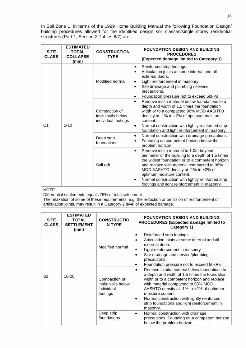
In Soil Zone 1, in terms of the 1999 Home Building Manual the following Foundation Design/ building procedures allowed for the identified design soil classes/single storey residential structures (Part 1, Section 2 Tables 6/7) are:
SITE CLASS
ESTIMATED TOTAL
COLLAPSE (mm)
CONSTRUCTION TYPE
FOUNDATION DESIGN AND BUILDING PROCEDURES
(Expected damage limited to Category 1)
C1 5-10
Modified normal
Reinforced strip footings.
Articulation joints at some internal and all external doors.
Light reinforcement in masonry.
Site drainage and plumbing / service precautions.
Foundation pressure not to exceed 50kPa.
Compaction of insitu soils below individual footings
Remove insitu material below foundations to a depth and width of 1.5 times the foundation width or to a compacted 98% MOD AASHTO density at -1% to +2% of optimum moisture content.
Normal construction with lightly reinforced strip foundation and light reinforcement in masonry.
Deep strip foundations
Normal construction with drainage precautions.
Founding on competent horizon below the problem horizon.
Soil raft
Remove insitu material to 1.0m beyond perimeter of the building to a depth of 1.5 times the widest foundation or to a competent horizon and replace with material compacted to 98% MOD AASHTO density at -1% to +2% of optimum moisture content.
Normal construction with lightly reinforced strip footings and light reinforcement in masonry.
NOTE Differential settlements equals 75% of total settlement. The relaxation of some of these requirements, e.g. the reduction or omission of reinforcement or articulation joints, may result in a Category 2 level of expected damage.
SITE CLASS
ESTIMATED TOTAL
SETTLEMENT (mm)
CONSTRUCTION TYPE
FOUNDATION DESIGN AND BUILDING PROCEDURES (Expected damage limited to
Category 1)
S1
10-20
Modified normal
Reinforced strip footings.
Articulation joints at some internal and all external doors
Light reinforcement in masonry
Site drainage and service/plumbing precautions
Foundation pressure not to exceed 50kPa
Compaction of insitu soils below individual footings
Remove in situ material below foundations to a depth and width of 1,5 times the foundation width or to a competent horizon and replace with material compacted to 93% MOD AASHTO density at -1% to +2% of optimum moisture content.
Normal construction with lightly reinforced strip foundations and light reinforcement in masonry.
Deep strip foundations
Normal construction with drainage precautions. Founding on a competent horizon below the problem horizon.

19
SITE CLASS
ESTIMATED TOTAL
SETTLEMENT (mm)
CONSTRUCTION TYPE
FOUNDATION DESIGN AND BUILDING PROCEDURES (Expected damage limited to
Category 1)
Soil Raft
Remove insitu material to 1,0m beyond perimeter of building to a depth of 1,5m times the widest foundation or to a competent horizon and replace with material compacted to 93% MOD AASHTO density at -1% to + 2% of optimum moisture content.
Normal construction with lightly reinforced strip footings and light reinforcement in masonry.
NOTE 1) Differential settlement equals 50% of total settlement. 2) The relaxation of some of these requirements, e.g. the reduction or omission of reinforcement or
articulation joints, may result in a Category 2 level of expected damage. 3) Account must be taken of sloping sites when differential fill heights may lead to greater differential
settlements. 4) Settlements induced by loads imposed by deep filling beneath surface beds may necessitate the
adoption of a construction type appropriate to a more severe site class.
In Soil Zone 2, in terms of the 1999 Home Building Manual the following Foundation Design/ building procedures allowed for the identified design soil classes/single storey residential structures (Part 1, Section 2 Tables 6/7) are:
SITE CLASS
ESTIMATED TOTAL
COLLAPSE (mm)
CONSTRUCTION TYPE
FOUNDATION DESIGN AND BUILDING PROCEDURES
(Expected damage limited to Category 1)
C2 >10
Stiffened strip footings, stiffened or cellular raft
Stiffened strip footings or stiffened or cellular raft with lightly reinforced or articulated masonry. Bearing pressure not to exceed to 50kPa. Fabric reinforcement in floor slabs. Site drainage and plumbing / service precautions.
Deep strip foundations
Normal construction with drainage precautions. Founding on competent horizon below the problem horizon. With fabric reinforcement in floor slabs.
Compaction of insitu soils below individual footings
Remove insitu material below foundations to a depth and width of 1.5 times the foundation width or to a compacted 98% MOD AASHTO density at -1% to +2% of optimum moisture content. Normal construction with lightly reinforced strip foundation and light reinforcement in masonry.
Piled or pier foundations
Reinforced concrete ground beams or solid slabs on piled or pier foundations. Ground slabs with fabric reinforcement. Good site drainage.
Soft raft
Remove insitu material to 1.0m beyond perimeter of the building to a depth of 1.5 times the widest foundation or to a competent horizon and replace with material compacted to 98% MOD AASHTO density at -1% to +2% of optimum moisture content. Normal construction with lightly reinforced strip footings and light reinforcement in masonry.
NOTE Differential settlements equals 75% of total settlement. The relaxation of some of these requirements, e.g. the reduction or omission of reinforcement or articulation joints, may result in a Category 2 level of expected damage.

20
SITE CLASS
ESTIMATED TOTAL
SETTLEMENT (mm)
CONSTRUCTION TYPE
FOUNDATION DESIGN AND BUILDING PROCEDURES
(Expected damage limited to Category 1)
S2 >20
Stiffened strip footings, stiffened
Stiffened strip footings or stiffened or cellular raft with lightly reinforced or articulated masonry. Bearing pressure not to exceed to 50kPa. Mesh reinforcement in floor slabs. Site drainage and service/plumbing precautions.
Deep strip foundations
As for S1 but with mesh reinforcement in floor slabs
Compaction of in situ soils below individual footings
Remove in situ material below foundations to a depth and width of 1,5 times the foundation width or to a competent horizon and replace with material compacted to 93% MOD AASHTO density at -1% to +2% of optimum moisture content. Normal construction with lightly reinforced strip foundations and light reinforcement in masonry.
Piled or pier foundation
Reinforced concrete ground beams or solid slabs on piled or pier foundations. Ground slabs with fabric reinforcement. Ground site drainage.
Soil raft
Remove insitu material to 1,0m beyond perimeter of building to a depth of 1,5m times the widest foundation or to a competent horizon and replace with material compacted to 93% MOD AASHTO density at -1% to + 2% of optimum moisture content. Normal construction with lightly reinforced strip footings and light reinforcement in masonry.
NOTE 1) Differential settlement equals 50% of total settlement. 2) The relaxation of some of these requirements, e.g. the reduction or omission of reinforcement or
articulation joints, may result in a Category 2 level of expected damage. 3) Account must be taken of sloping sites when differential fill heights may lead to greater differential
settlements. 4) Settlements induced by loads imposed by deep filling beneath surface beds may necessitate the
adoption of a construction type appropriate to a more severe site class.
Where very dense honeycomb tending to hardpan calcrete is encountered within the standard footing depth, the structure can be placed directly on this material. Where such material is not encountered within the standard footing depth, an engineered soil mattress should be constructed (on the very dense honeycomb tending to hardpan calcrete) to the required founding level as follows:
1) Remove all excavatable material (with an excavator) to a maximum depth of between 0.1m to 1.0m in the footprint area of the structure and up to 1m beyond the edge of the proposed foundation area.
2) Rip and compact the excavated floor area to 95% of Modified AASHTO maximum dry density at optimum moisture content.
3) Backfill in maximum 150mm thick layers with imported G5-quality material; each layer is to be compacted to at least 98% of Modified AASHTO maximum dry density at optimum moisture content.
4) This should also include the (minimum) 150mm freeboard, i.e. top of floor slab to top of natural ground level, as required by the NHBRC Guidelines.
11.2. Excavatability
It should be noted that if a backactor will be used for the excavation of services, excavatability problems may be experienced in both Soil Zones 1 and 2 from 0.1m depth (which is within the general excavation depth for services [1.5m]) due to the presence of shallow calcrete.
21
11.3. Trench Sidewall Stability
In the event that there is uncertainly with respect to shoring requirements in trenches deeper than 1m, a competent person should be consulted. All excavation slopes must be inspected by a competent person during construction to assess stability and recommended stabilizing measures, where required.
11.4. Pipe Bedding Material and Backfill and Compaction Characteristics
o The materials tested in this investigation do not comply with the SABS 1200LB criteria for selected granular fill or selected fill. Selected granular fill and/or selected fill is not available on this site and will need to be imported.
o Selected Granular Bedding – i.e. naturally occurring non-cohesive, free draining, singularly
graded gravel-soils between 0.6mm and 19.0mm particle size are not available on this site and will need to be imported.
o Selected Fill – the laboratory tests results confirm that natural soils with a PI less than 6%
and/or a stones content of <30mm are not available on this site and will need to be imported.
o General Backfill – materials recovered from trench excavation works may be considered
for general backfill purposes after removal or reduction of all the larger cobble and boulder size fractions.
o The selected calcrete materials, G5 and G6 quality materials are suitable for the
construction of earth mattresses 11.5. Corrosivity
The selection of materials to be used for wet services placed below ground surface should take cognisance of a possible corrosive nature of the environment.
11.6. Road Construction
Calcrete classifying as G5 quality materials is suitable for the use for base layer. G6 quality material is suitable for sub base in road construction. However G6 quality material can be improved to G5 quality by adding 20% to 30% gravels.
11.7. Groundwater Conditions
No seepage was indicated in the test pits excavated. However the soil/rock interface may give rise to water seepage during wet season. Water runoff into open works may also occur during excavation and construction work, particularly in the wet season due natural slope. A pump should therefore be available during such work. Structures could be impacted on by „rising damp‟. Special attention to membrane/dampcourse measures is required (for example, the use of „waterproof‟ concretes in slab/raft foundation designs).

22
12. GENERAL
12.1. Verification Process
The findings in this report are based upon our interpretation of the data recovered during these investigations.
While every effort has been made, within the limits of the project budget, time and present-day insight, to determine overall ground conditions on this site, poorer sub-areas may have been missed. For this reason, it is recommended that a competent specialist is always invited to inspect open works on this site in order to further confirm the findings described in this report.
12.2. Third Party Reviews
If this report is reviewed by third parties, it should be noted that dolomite hazard assessment and management is an empirical science and consequently such parties may formulate opinions concerning the findings, conclusions and recommendations of this investigation at variance with those contained in this report. This fact should be borne in mind when costs are incurred on this project prior to receipt of the comments of these parties. VGIconsult Projects Pty Ltd, its members
and personnel cannot be held responsible for these divergent views or consequential damages.1
VGIconsult Projects (Pty.) Ltd. P.O. BOX 604 FOURWAYS 2055 TEL : (011) 469 0854 FAX : (011) 469 0961 FAX : 0866892847 e-mail: [email protected]
Ta
ble
1:
S
um
mari
sed
Bo
reh
ole
In
form
ati
on
an
d I
nh
ere
nt
Su
scep
tib
ilit
y C
hara
cte
risati
on
BIF
B
an
de
d Iro
n F
orm
ation
P
EB
P
eb
ble
sto
ne
(ro
lste
ne
)
CC
C
alc
rete
S
H
Sha
le (
Ga
ma
ga
ra)
CL
C
lay
TIL
T
illite
GM
N
o s
am
ple
re
turn
S
ST
S
an
dsto
ne
Bo
reh
ole
N
um
be
r w
ith
co
lla
r ele
vati
on
in
m
AM
SL
Transported
&Kalahari Group
material
(m-m)
Low mobilisation
potential material
(shale, lava, dolerite
etc)
(m-m)
Gh
aap
Gro
up
Ch
ert
Gh
aap
G
rou
p
Do
lom
ite
Resid
uu
m
(m-m
)
So
ft a
nd
w
eath
ere
d
do
lom
ite
roc
k (
Gh
aa
p
Gro
up
)
(m-m
)
Do
lom
ite
Bed
rock
(G
haap
G
rou
p)
m
an
d m
A
MS
L
Gro
un
dw
ate
r S
trik
e
(m b
g)
Res
t
(m b
g)
OW
L (
m b
g)
an
d m
AM
SL
Su
sce
pti
bil
ity
Ch
ara
cte
ris
ati
on
Fin
es
Su
bo
rdi-
nate
(m-m
)
Fin
es
Pre
do
mi-
na
nt
(m-m
)
Ing
res
s W
ate
r G
rou
nd
wate
r D
raw
do
wn
Su
bsid
-en
ce
Fo
rmati
on
Sin
kh
ole
Fo
rmati
on
Su
bsid
en
ce
Fo
rmati
on
Sin
kh
ole
F
orm
ati
on
SIM
S S
ITE
SW
41
0E
12
09
0-1
17
117-1
24
C
AV
?
- -
-
- >
12
4
< 1
085
?
NO
N
O
NO
N
O
SIM
430E
12
04
0-5
7
57-7
0 T
ILL
70-8
4 G
AM
S
H
84
-100
GA
M
100-1
21
SH
- -
- -
121-1
78
10
83
?
NO
N
O
NO
N
O
KB
H01/
SIM
436
12
09
0-9
2
92
-150
GA
M
SH
- -
- -
> 1
50
< 1
058
Str
ike
74
91
111
7
OW
L 8
120
0
NO
N
O
NO
N
O
KU
1E
(KM
7)
12
11
0-9
2
92-1
12
BIF
-
- -
- >
11
2
< 1
099
Str
ike –
27
.82
118
3.1
8
OW
L 1
1
120
0
NO
N
O
NO
N
O
KU
11E
(KM
17)
12
05
0-1
17
117-2
34
GA
M
SH
?-
- -
- >
234
?
NO
N
O
NO
N
O
BO
RO
HO
LE
S I
N P
RO
XIM
ITY
TO
SIM
S S
ITE

Ta
ble
1:
S
um
mari
sed
Bo
reh
ole
In
form
ati
on
an
d I
nh
ere
nt
Su
scep
tib
ilit
y C
hara
cte
risati
on
BIF
B
an
de
d Iro
n F
orm
ation
P
EB
P
eb
ble
sto
ne
(ro
lste
ne
)
CC
C
alc
rete
S
H
Sha
le (
Ga
ma
ga
ra)
CL
C
lay
TIL
T
illite
GM
N
o s
am
ple
re
turn
S
ST
S
an
dsto
ne
Bo
reh
ole
N
um
be
r w
ith
co
lla
r ele
vati
on
in
m
AM
SL
Transported
&Kalahari Group
material
(m-m)
Low mobilisation
potential material
(shale, lava, dolerite
etc)
(m-m)
Gh
aap
Gro
up
Ch
ert
Gh
aap
G
rou
p
Do
lom
ite
Resid
uu
m
(m-m
)
So
ft a
nd
w
eath
ere
d
do
lom
ite
roc
k (
Gh
aa
p
Gro
up
)
(m-m
)
Do
lom
ite
Bed
rock
(G
haap
G
rou
p)
m
an
d m
A
MS
L
Gro
un
dw
ate
r S
trik
e
(m b
g)
Res
t
(m b
g)
OW
L (
m b
g)
an
d m
AM
SL
Su
sce
pti
bil
ity
Ch
ara
cte
ris
ati
on
Fin
es
Su
bo
rdi-
nate
(m-m
)
Fin
es
Pre
do
mi-
na
nt
(m-m
)
Ing
res
s W
ate
r G
rou
nd
wate
r D
raw
do
wn
Su
bsid
-en
ce
Fo
rmati
on
Sin
kh
ole
Fo
rmati
on
Su
bsid
en
ce
Fo
rmati
on
Sin
kh
ole
F
orm
ati
on
238
2/
SIM
435
12
13
0-1
02
102-1
50
GA
M
SH
- -
- -
> 1
50
< 1
062
Str
ike –
135
107
7
OW
L 1
2
120
0
NO
N
O
NO
N
O
133
16
S
IM4
34E
12
04
0-7
0
70-8
4 G
AM
S
H-
- -
- >
84
<
11
20
Str
ike
19
D
ry (
rest)
O
WL 2
1
122
5
NO
N
O
NO
N
O
UIT
KO
MS
SIT
E
SW
377E
N
O L
OG
IN
KU
MB
A M
INE
EX
PL
OR
AT
ION
DA
TA
BA
SE
BO
RO
HO
LE
S IN
PR
OX
IMIT
Y T
O U
ITK
OM
S S
ITE
415
5/
UK
9
12
23
0-1
0
10-1
42
BIF
-
- -
- >
14
2
< 1
081
Str
ike
53
119
9
23
.5
OW
L 2
3
120
0
NO
N
O
NO
N
O
527
6/
UK
13
12
24
- 0-1
50 B
IF
- -
- -
> 1
50
< 1
073
Str
ike
72
26
119
7
OW
L
23
120
0
NO
N
O
NO
N
O
KB
H04/
BE
1
12
28
0-3
6
36-9
0 B
IF
- -
- -
> 9
0
< 1
138
Str
ike
83
22
120
6
OW
L 2
8
120
0
NO
N
O
NO
N
O
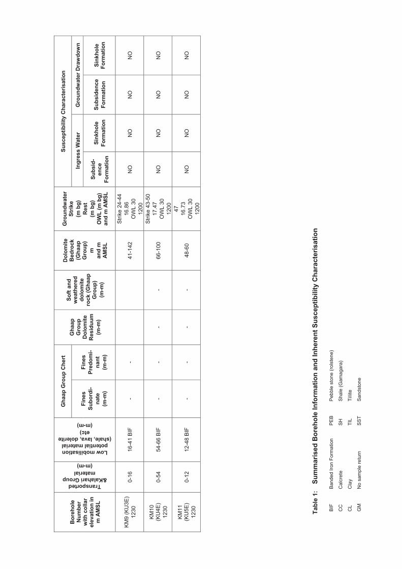
Ta
ble
1:
S
um
mari
sed
Bo
reh
ole
In
form
ati
on
an
d I
nh
ere
nt
Su
scep
tib
ilit
y C
hara
cte
risati
on
BIF
B
an
de
d Iro
n F
orm
ation
P
EB
P
eb
ble
sto
ne
(ro
lste
ne
)
CC
C
alc
rete
S
H
Sha
le (
Ga
ma
ga
ra)
CL
C
lay
TIL
T
illite
GM
N
o s
am
ple
re
turn
S
ST
S
an
dsto
ne
Bo
reh
ole
N
um
be
r w
ith
co
lla
r ele
vati
on
in
m
AM
SL
Transported
&Kalahari Group
material
(m-m)
Low mobilisation
potential material
(shale, lava, dolerite
etc)
(m-m)
Gh
aap
Gro
up
Ch
ert
Gh
aap
G
rou
p
Do
lom
ite
Resid
uu
m
(m-m
)
So
ft a
nd
w
eath
ere
d
do
lom
ite
roc
k (
Gh
aa
p
Gro
up
)
(m-m
)
Do
lom
ite
Bed
rock
(G
haap
G
rou
p)
m
an
d m
A
MS
L
Gro
un
dw
ate
r S
trik
e
(m b
g)
Res
t
(m b
g)
OW
L (
m b
g)
an
d m
AM
SL
Su
sce
pti
bil
ity
Ch
ara
cte
ris
ati
on
Fin
es
Su
bo
rdi-
nate
(m-m
)
Fin
es
Pre
do
mi-
na
nt
(m-m
)
Ing
res
s W
ate
r G
rou
nd
wate
r D
raw
do
wn
Su
bsid
-en
ce
Fo
rmati
on
Sin
kh
ole
Fo
rmati
on
Su
bsid
en
ce
Fo
rmati
on
Sin
kh
ole
F
orm
ati
on
KM
9 (
KU
3E
)
12
30
0-1
6
16-4
1 B
IF
- -
41
-142
Str
ike
24-4
4
16
.86
OW
L 3
0
120
0
NO
N
O
NO
N
O
KM
10
(K
U4E
)
12
30
0-5
4
54-6
6 B
IF
- -
- -
66-1
00
Str
ike
43-5
0
17
.47
OW
L 3
0
120
0
NO
N
O
NO
N
O
KM
11
(K
U5E
)
12
30
0-1
2
12-4
8 B
IF
- -
- -
48-6
0
47
16
.73
OW
L 3
0
120
0
NO
N
O
NO
N
O

Tab
le 2
:
Su
mm
ari
sed
Test
Pit
Pro
file
s
No
te:
MR
– M
axim
um
Re
ach
R –
Re
fusa
l
NR
– N
o R
efu
sa
l (W
eb
b &
Part
ne
rs,
19
86)
P
R –
Pa
rtia
l R
efu
sa
l (W
eb
b &
Pa
rtne
rs,
19
86)
TE
ST
PIT
N
UM
BE
R
DE
PT
H O
F S
OIL
HO
RIZ
ON
S (
m)
–(m
)
SO
FT
RO
CK
M
AT
ER
IAL
AT
TH
E B
AS
E O
F
TE
ST
PIT
S
OIL
FIL
L
CO
LL
UV
IUM
N
OD
UL
AR
CA
LC
RE
TE
TP
01
–
0 –
0.3
–
+0.3
H
one
ycom
b C
alc
rete
+R
TP
02
–
–
0 –
0.3
+
0.3
H
one
ycom
b C
alc
rete
+R
TP
03
–
–
0 –
0.3
+
0.3
H
one
ycom
b C
alc
rete
+R
TP
04
–
–
0 –
0.2
+
0.2
H
one
ycom
b C
alc
rete
+R
TP
05
–
–
0 –
0.4
+
0.4
H
one
ycom
b C
alc
rete
+R
TP
06
–
–
0 –
0.2
+
0.2
H
one
ycom
b C
alc
rete
+R
TP
07
–
0 –
0.3
–
+0.3
H
one
ycom
b C
alc
rete
+R
TP
08
–
0 –
0.3
–
+0.3
H
one
ycom
b C
alc
rete
+R
TP
09
–
0 –
0.2
–
+0.2
H
one
ycom
b C
alc
rete
+R
TP
10
–
–
0 –
0.2
+
0.2
H
one
ycom
b C
alc
rete
+R
TP
11
0 –
0.6
–
0.6
– 1
.0
+1.0
H
one
ycom
b C
alc
rete
+R
TP
12
–
0 –
0.8
–
+0.8
H
one
ycom
b C
alc
rete
+R
TP
13
–
0 –
0.4
–
+0.4
H
one
ycom
b C
alc
rete
+R
TP
14
–
–
0 –
0.4
+
0.4
H
one
ycom
b C
alc
rete
+R
TP
15
–
–
0 –
0.3
+
0.3
H
one
ycom
b C
alc
rete
+R
TP
16
–
–
0 –
0.3
+
0.3
H
one
ycom
b C
alc
rete
+R
TP
17
–
–
0 –
0.3
+
0.3
H
one
ycom
b C
alc
rete
+R
TP
18
–
–
0 –
0.4
+
0.4
H
one
ycom
b C
alc
rete
+R
TP
19
–
–
0 –
0.1
+
0.1
H
one
ycom
b C
alc
rete
+R
TP
20
–
–
0 –
0.2
+
0.2
H
one
ycom
b C
alc
rete
+R
TP
21
–
–
0 –
0.3
+
0.3
H
one
ycom
b C
alc
rete
+R
TP
22
–
0 –
0.4
0.4
– 0
.5
+0.5
H
one
ycom
b C
alc
rete
+R
TP
23
–
–
0 –
0.3
+
0.3
H
one
ycom
b C
alc
rete
+R
TP
24
–
0 –
0.4
–
+0.4
H
one
ycom
b C
alc
rete
+R
TP
25
–
–
0 –
0.2
+
0.2
H
one
ycom
b C
alc
rete
+R
TP
26
–
–
0 –
0.4
+
0.4
H
one
ycom
b C
alc
rete
+R
TP
27
–
–
0 –
0.2
+
0.2
H
one
ycom
b C
alc
rete
+R
TP
28
–
0 –
0.6
–
+0.6
H
one
ycom
b C
alc
rete
+R
TP
29
–
0 –
0.5
–
+0.5
H
one
ycom
b C
alc
rete
+R
TP
30
–
0 –
0.2
0.2
-1.2
+
1.2
H
one
ycom
b C
alc
rete
+R

Tab
le 2
:
Su
mm
ari
sed
Test
Pit
Pro
file
s
No
te:
MR
– M
axim
um
Re
ach
R –
Re
fusa
l
NR
– N
o R
efu
sa
l (W
eb
b &
Part
ne
rs,
19
86)
P
R –
Pa
rtia
l R
efu
sa
l (W
eb
b &
Pa
rtne
rs,
19
86)
TE
ST
PIT
N
UM
BE
R
DE
PT
H O
F S
OIL
HO
RIZ
ON
S (
m)
–(m
)
SO
FT
RO
CK
M
AT
ER
IAL
AT
TH
E B
AS
E O
F
TE
ST
PIT
S
OIL
FIL
L
CO
LL
UV
IUM
N
OD
UL
AR
CA
LC
RE
TE
TP
31
–
0 –
0.3
–
+0.3
H
one
ycom
b C
alc
rete
+R
TP
32
–
0 –
0.2
0.2
-0.4
+
0.4
H
one
ycom
b C
alc
rete
+R
TP
33
–
0 –
0.5
–
+0.5
H
one
ycom
b C
alc
rete
+R
TP
34
–
0 –
0.5
–
+0.5
H
one
ycom
b C
alc
rete
+R
TP
35
–
0 –
0.4
–
+0.4
H
one
ycom
b C
alc
rete
+R
TP
36
–
0 –
0.4
0.4
– 1
.1
+1.1
H
one
ycom
b C
alc
rete
+R
TP
37
–
0 –
0.9
–
+0.9
H
one
ycom
b C
alc
rete
+R
TP
38
–
0 –
0.4
–
+0.4
H
one
ycom
b C
alc
rete
+R

Tab
le 3
:
Su
mm
ari
sed
Lab
ora
tory
Test
Resu
lts
LL
:
Liq
uid
Lim
it
OM
C
: O
ptim
um
Mo
istu
re C
onte
nt
PI
: P
lasticity I
ndex
CB
R
: C
alif
orn
ia B
eari
ng R
atio
LS
:
Lin
ear
Shri
nka
ge
G
C
: C
laye
y G
ravels
G
M
: G
radin
g M
odu
lus
SC
:
Cla
ye
y S
ands
US
C
: U
nifie
d S
oil
Cla
ssific
ation
CL
: S
and
y C
lays
MD
D
: M
axim
um
Dry
Density
ML
:
Cla
ye
y S
ilts
Test
Pit
N
o.
SA
MP
LE
D
EP
TH
(m)
GR
AD
ING
(%
PA
SS
ING
) S
IEV
E S
IZE
(m
m)
AT
TE
RB
ER
G L
IMIT
S
(%)
PO
TE
NT
IAL
E
XP
AN
SIV
E-
NE
SS
US
C
GM
CB
R A
T %
C
OM
PA
CT
ION
M
OD
IFIE
D A
AS
HT
O
CO
MP
AC
TIO
N
OR
IGIN
2,0
0,4
25
0
,075
0,0
02
L
L(%
) P
I(%
) L
S
(%)
95
97
98
M
DD
(k
g/m
³)
OM
C
(%)
TP
02/1
0-0
.3
48
44
7
1
0
NP
0
Lo
w
GP
-G
M2.0
1
39
59
69
201
6
7.6
P
ED
OG
EN
IC
TP
11/1
0-0
.6
53
44
11
2
0
NP
0
Lo
w
SP
-S
M1.9
2
F
ILL
TP
13/1
0-0
.4
99
89
11
3
0
NP
0
Lo
w
SP
-S
M1.0
1
C
OLLU
VIU
M
TP
15/1
0-0
,3
43
40
12
5
0
NP
0
Lo
w
GP
-G
M2.0
1
36
53
64
182
4
10
.8
PE
DO
GE
NIC
TP
22/1
0-0
.4
99
95
16
3
0
NP
0
Lo
w
SM
0.9
0
C
OLLU
VIU
M
TP
24/1
0-0
,4
100
96
11
1
0
NP
0
Lo
w
SP
-S
M0.9
3
C
OLLU
VIU
M
TP
26/1
0-0
,4
56
53
13
1
0
NP
0
Lo
w
SC
1.7
8
33
48
57
188
0
7.4
P
ED
OG
EN
IC
TP
27/1
0-0
,2
51
47
11
6
0
NP
0
Lo
w
GP
-G
M1.9
1
P
ED
OG
EN
IC
TP
36/1
0-0
.4
95
90
17
3
0
NP
0
Lo
w
SM
0.9
8
C
OLLU
VIU
M
TP
36/3
0.4
-1.1
73
70
26
9
22
6
2.5
Lo
w
SC
1.3
1
38
53
64
188
0
9.7
P
ED
OG
EN
IC

FIGURES
LOCALITY WITH TOPOGRAPHIC SHEET LEGEND (1A) FIGURE 1
SITE LAYOUT FIGURE 2
REGIONAL GEOLOGY WITH GEOLOGY LEGEND (3A) FIGURE 3
REGIONAL GEOHYDROLOGY FIGURE 4

-4000
-4000
-1500
-1500
1000
1000
3500
3500
6000
6000
8500
8500
11000
11000
-3068500
-3068500
-3066000
-3066000
-3063500
-3063500
-3061000
-3061000
-3058500
-3058500
No
.D
AT
EA
ME
ND
ME
NT
D.P
.W.
ce
rtifie
das-b
uilt
dra
win
gs
as
pe
rC
en
tra
lised
Dra
win
gA
rch
ive
AS
-BU
ILT
DR
AW
ING
RE
QU
IRE
ME
NT
S
na
me:
da
te:
pro
fessio
nalre
gis
tratio
nn
o.:
ca
dfile
na
me
pa
ge
typ
e
co
nsulta
nt
2M
ULB
ER
RY
HIL
LO
FF
ICE
PA
RK
BR
OA
DA
CE
RS
DR
IVE
DA
INF
ER
NF
OU
RW
AY
S205
5T
el:
(011
)46
9-0
854
Fax:
(011
)46
9-0
961
em
ail:
jhb
@vgic
on
sult.c
o.z
a
dis
cip
line
GE
OT
EC
HN
ICA
L
se
rvic
e
VG
Ico
nsu
ltP
roje
cts
(Pty
)L
td.
Pro
jectN
um
be
r
scale
da
te
Dra
win
gnu
mb
er
de
sig
ned
ref.
no
.
dra
wn
ch
ecke
d
dra
win
gtitle
LO
CA
LIT
YP
LA
N(R
EF
.:M
AP
27
23
CA
KA
TH
U1
:25
000
)
N.T
.O
CT
OB
ER
20
15
AR
.G.
FIG
UR
E1
VG
I39
44
VG
I39
44
:N
OR
TH
ER
NC
AP
E:K
AT
HU
:P
RO
PO
SE
DH
OU
SIN
GP
RO
JE
CT
ON
RE
MA
IND
ER
SO
FF
AR
MS
SIM
SA
ND
UIT
KO
MS
1:5
0 0
00
Tra
nsvers
eM
erc
ato
rC
entr
alM
eri
dia
n=
23
°F
als
eE
astin
g=
0°
co
-ord
ina
tesyste
m
Fals
eN
ort
hin
g=
0°
Sca
leF
acto
r=
1D
atu
m=
WG
S8
4
0500
1 0
00
1 5
00
2 0
00
2 5
00 metr
es
LE
GE
ND
PO
RT
ION
1O
FT
HE
FA
RM
UIT
KO
MS
PO
RT
ION
1R
EM
AIN
DE
RO
FT
HE
FA
RM
SIM
S4
62
A1
N.T
.V
GI3
944

SIM
S4
62
ID:C
04
10
00
00
00
00
46
20
00
00
KA
LA
HA
RI
GH
OL
FE
NJ
AG
LA
ND
GO
ED
77
5ID
:C0
41
00
00
00
00
07
75
00
00
0
KA
LA
HA
RI
GH
OL
FE
NJ
AG
LA
ND
GO
ED
77
5ID
:C0
41
00
00
00
00
07
75
00
00
2
SIM
S4
62
ID:C
04
10
00
00
00
00
46
20
00
01
ID:C
04
10
00
00
00
00
73
60
00
00
UIT
KO
MS
46
3ID
:C0
41
00
00
00
00
04
63
00
00
1
BE
ST
WO
OD
45
9ID
:C0
41
00
00
00
00
04
59
00
00
4
SIM
S4
62
ID:C
04
10
00
00
00
00
46
20
00
06
SE
KG
AM
E4
61
ID:C
04
10
00
00
00
00
46
10
00
00
KA
LA
HA
RI
GH
OL
FE
NJ
AG
LA
ND
GO
ED
77
5ID
:C0
41
00
00
00
00
07
75
00
00
1
KA
LA
HA
RI
GH
OL
FE
NJ
AG
LA
ND
GO
ED
77
5ID
:C0
41
00
00
00
00
07
75
00
00
0
UIT
KO
MS
46
3ID
:C0
41
00
00
00
00
04
63
00
00
5
SIM
S4
62
ID:C
04
10
00
00
00
00
46
20
00
15
BE
ST
WO
OD
45
9ID
:C0
41
00
00
00
00
04
59
00
04
8BE
ST
WO
OD
45
9ID
:C0
41
00
00
00
00
04
59
00
04
9
SIM
S4
62
ID:C
04
10
00
00
00
00
46
20
00
11
BE
ST
WO
OD
45
9ID
:C0
41
00
00
00
00
04
59
00
05
1
SIM
S4
62
ID:C
04
10
00
00
00
00
46
20
00
23
SIM
S4
62
ID:C
04
10
00
00
00
00
46
20
00
30
BE
ST
WO
OD
45
9ID
:C0
41
00
00
00
00
04
59
00
05
0
UIT
KO
MS
46
3ID
:C0
41
00
00
00
00
04
63
00
00
7
UIT
KO
MS
46
3ID
:C0
41
00
00
00
00
04
63
00
01
0
BE
ST
WO
OD
45
9ID
:C0
41
00
00
00
00
04
59
00
00
4
BE
ST
WO
OD
45
9ID
:C0
41
00
00
00
00
04
59
00
00
0
UIT
KO
MS
46
3ID
:C0
41
00
00
00
00
04
63
00
00
2
SIM
S4
62
ID:C
04
10
00
00
00
00
46
20
00
19
UIT
KO
MS
46
3ID
:C0
41
00
00
00
00
04
63
00
00
0
BE
ST
WO
OD
45
9ID
:C0
41
00
00
00
00
04
59
00
05
3
AF
AR
M7
34
ID:C
04
10
00
00
00
00
73
40
00
04
SE
KG
AM
E4
61
ID:C
04
10
00
00
00
00
46
10
00
10
SIM
S4
62
ID:C
04
10
00
00
00
00
46
20
00
16
1225
1205
1220
1215
1210
1200
1235
1230
1205
1205
1230
PO
RT
ION
1R
EM
AIN
DE
RO
FT
HE
FA
RM
SIM
S4
62
PA
RT
1A
RE
A:
16
9.1
4h
a
PO
RT
ION
1O
FT
HE
FA
RM
UIT
KO
MS
AR
EA
:9
3.3
4h
a
2000
2000
3000
3000
4000
4000
5000
5000
6000
6000
7000
7000
-3066000
-3066000
-3065000
-3065000
-3064000
-3064000
-3063000
-3063000
No.
DA
TE
AM
EN
DM
EN
TD
.P.W
.
ce
rtifie
da
s-b
uilt
dra
win
gs
as
pe
rC
en
tra
lised
Dra
win
gA
rch
ive
AS
-BU
ILT
DR
AW
ING
RE
QU
IRE
ME
NT
S
na
me
:
da
te:
pro
fessio
nalre
gis
tra
tion
no.:
ca
dfile
na
me
pa
ge
type
co
nsu
lta
nt
2M
ULB
ER
RY
HIL
LO
FF
ICE
PA
RK
BR
OA
DA
CE
RS
DR
IVE
DA
INF
ER
NF
OU
RW
AY
S20
55
Tel:
(01
1)
46
9-0
85
4F
ax:
(01
1)
46
9-0
96
1em
ail:
jhb
@vg
ico
nsu
lt.c
o.z
a
dis
cip
line
GE
OT
EC
HN
ICA
L
se
rvic
e
VG
Ico
ns
ult
Pro
jec
ts(P
ty)
Ltd
.
Pro
ject
Nu
mb
er
scale
da
te
Dra
win
gnu
mbe
r
de
sig
ned
ref.
no
.
dra
wn
ch
ecke
d
dra
win
gtitle
SIT
ELA
YO
UT
WIT
HG
RO
UN
DE
LE
VA
TIO
NC
ON
TO
UR
S
N.T
.O
CT
OB
ER
20
15
AR
.G.
FIG
UR
E2
VG
I394
4
VG
I394
4:
NO
RT
HE
RN
CA
PE
:K
AT
HU
:P
RO
PO
SE
DH
OU
SIN
GP
RO
JE
CT
ON
RE
MA
IND
ER
SO
FF
AR
MS
SIM
SA
ND
UIT
KO
MS
1:8
000
Tra
nsve
rse
Me
rca
tor
Cen
tra
lM
eri
dia
n=
23
°F
als
eE
astin
g=
0°
co
-ord
inate
syste
m
Fals
eN
ort
hin
g=
0°
Sca
leF
acto
r=
1D
atu
m=
WG
S8
4
020
040
060
080
01 0
00 me
tre
s
LE
GE
ND
GR
OU
ND
EL
EV
AT
ION
CO
NT
OU
RS
(mA
MS
L)
SE
NS
ITIV
EA
RE
A
AR
CH
EO
LO
GIC
AL
LY
SE
NS
ITIV
EA
RE
A
KA
TH
UF
OR
ES
TP
RO
TE
CT
ED
AR
EA
ES
KO
MS
ER
VIT
UD
ES
PO
RT
ION
1O
FT
HE
FA
RM
UIT
KO
MS
PO
RT
ION
1R
EM
AIN
DE
RO
FT
HE
FA
RM
SIM
S4
62
FA
RM
BO
UN
DA
RIE
S
SIT
ELA
YO
UT
A1
N.T
.V
GI3
94
4

-9000
-9000
-4000
-4000
1000
1000
6000
6000
11000
11000
16000
16000
21000
21000
-3076000
-3076000
-3071000
-3071000
-3066000
-3066000
-3061000
-3061000
-3056000
-3056000
-3051000
-3051000
No
.D
AT
EA
ME
ND
ME
NT
D.P
.W.
ce
rtifie
das-b
uilt
dra
win
gs
as
pe
rC
en
tra
lised
Dra
win
gA
rch
ive
AS
-BU
ILT
DR
AW
ING
RE
QU
IRE
ME
NT
S
na
me:
da
te:
pro
fessio
nalre
gis
tratio
nn
o.:
ca
dfile
na
me
pa
ge
typ
e
co
nsulta
nt
2M
ULB
ER
RY
HIL
LO
FF
ICE
PA
RK
BR
OA
DA
CE
RS
DR
IVE
DA
INF
ER
NF
OU
RW
AY
S205
5T
el:
(011
)46
9-0
854
Fax:
(011
)46
9-0
961
em
ail:
jhb
@vgic
on
sult.c
o.z
a
dis
cip
line
GE
OT
EC
HN
ICA
L
se
rvic
e
VG
Ico
nsu
ltP
roje
cts
(Pty
)L
td.
Pro
jectN
um
be
r
scale
da
te
Dra
win
gnu
mb
er
de
sig
ned
ref.
no
.
dra
wn
ch
ecke
d
dra
win
gtitle
RE
GIO
NA
LG
EO
LO
GY
(RE
F.:
MA
P27
22
KU
RU
MA
N1
:25
000
0G
EO
LO
GIC
AL
SE
RIE
S)
N.T
.O
CT
OB
ER
20
15
AR
.G.
FIG
UR
E3
VG
I39
44
VG
I39
44
:N
OR
TH
ER
NC
AP
E:K
AT
HU
:P
RO
PO
SE
DH
OU
SIN
GP
RO
JE
CT
ON
RE
MA
IND
ER
SO
FF
AR
MS
SIM
SA
ND
UIT
KO
MS
1:1
00 0
00
Tra
nsvers
eM
erc
ato
rC
entr
alM
eri
dia
n=
23
°F
als
eE
astin
g=
0°
co
-ord
ina
tesyste
m
Fals
eN
ort
hin
g=
0°
Sca
leF
acto
r=
1D
atu
m=
WG
S8
4
01 0
00
2 0
00
3 0
00
4 0
00
5 0
00 metr
es
LE
GE
ND
PO
RT
ION
1O
FT
HE
FA
RM
UIT
KO
MS
PO
RT
ION
1R
EM
AIN
DE
RO
FT
HE
FA
RM
SIM
S4
62
A1
N.T
.V
GI3
944

No
.D
AT
EA
ME
ND
ME
NT
D.P
.W.
ce
rtifie
das-b
uilt
dra
win
gs
as
pe
rC
en
tra
lised
Dra
win
gA
rch
ive
AS
-BU
ILT
DR
AW
ING
RE
QU
IRE
ME
NT
S
na
me:
da
te:
pro
fessio
nalre
gis
tratio
nn
o.:
ca
dfile
na
me
pa
ge
typ
e
co
nsulta
nt
2M
ULB
ER
RY
HIL
LO
FF
ICE
PA
RK
BR
OA
DA
CE
RS
DR
IVE
DA
INF
ER
NF
OU
RW
AY
S205
5T
el:
(011
)46
9-0
854
Fax:
(011
)46
9-0
961
em
ail:
jhb
@vgic
on
sult.c
o.z
a
dis
cip
line
GE
OT
EC
HN
ICA
L
se
rvic
e
VG
Ico
nsu
ltP
roje
cts
(Pty
)L
td.
Pro
jectN
um
be
r
scale
da
te
Dra
win
gnu
mb
er
de
sig
ned
ref.
no
.
dra
wn
ch
ecke
d
dra
win
gtitle
GE
OL
OG
YL
EG
EN
D(R
EF
.:M
AP
27
22
KU
RU
MA
N1
:25
000
0G
EO
LO
GIC
AL
SE
RIE
S)
N.T
.O
CT
OB
ER
20
15
AR
.G.
FIG
UR
E3
A
VG
I39
44
VG
I39
44
:N
OR
TH
ER
NC
AP
E:K
AT
HU
:P
RO
PO
SE
DH
OU
SIN
GP
RO
JE
CT
ON
RE
MA
IND
ER
SO
FF
AR
MS
SIM
SA
ND
UIT
KO
MS
co
-ord
ina
tesyste
m
A1
N.T
.V
GI3
944
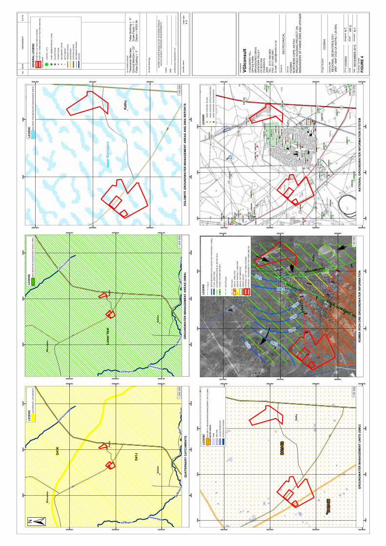
380
Kath
u
Sis
hen
Win
can
ton
Dro
es
pru
it
Ga-Mogara
Vle
rmui
slee
gte
Olifantsloop
Ga-M
og
ara
Ga-M
ogara
Ga-M
og
ara
D41JD
41K
-40
00
-40
00
600
0
600
0
160
00
160
00
-3076000
-3076000
-3066000
-3066000
-3056000
-3056000
No
.D
AT
EA
ME
ND
ME
NT
D.P
.W.
as-b
uilt
dra
win
gs
ce
rtifie
da
s-b
uilt
dra
win
gs
as
pe
rC
en
tra
lise
dD
raw
ing
Arc
hiv
eA
S-B
UIL
TD
RA
WIN
GR
EQ
UIR
EM
EN
TS
na
me
:
da
te:
pro
fessio
na
lre
gis
tra
tio
nn
o.:
ca
dfile
na
me
pa
ge
typ
e
co
nsu
lta
nt
2M
UL
BE
RR
YH
ILL
OF
FIC
EP
AR
K
BR
OA
DA
CR
ES
DR
IVE
DA
INF
ER
NV
ALL
EY
PO
BO
X6
04
FO
UR
WA
YS
20
55
TE
L:
(011
)46
908
54
FA
X:(0
11
)46
90
96
1
E-m
ail:
vg
ijhb@
mw
eb.c
o.z
a
dis
cip
line
GE
OT
EC
HN
ICA
L
se
rvic
e
VG
Ico
nsu
lt
sca
le
da
te
Dra
win
gn
um
be
r
de
sig
ne
dre
f.n
o.
dra
wn
ch
ecke
d
dra
win
gtitle
RE
GIO
NA
LG
EO
HY
DR
OLO
GY
(RE
F.:
MA
P27
23
CA
KA
TH
U1:2
50
00
)
N.T
.N
OV
EM
BE
R20
15
AR
.G.
N.T
.
FIG
UR
E4
VG
I39
44:
NO
RT
HE
RN
CA
PE
:K
AT
HU
:P
RO
PO
SE
DH
OU
SIN
GP
RO
JE
CT
ON
RE
MA
IND
ER
SO
FF
AR
MS
SIM
SA
ND
UIT
KO
MS
Tra
nsve
rse
Me
rcato
rC
en
tra
lM
erid
ian
=2
3°
Fals
eE
astin
g=
0°
co
-ord
ina
tesyste
m
Fals
eN
ort
hin
g=
0°
Sca
leF
acto
r=
1D
atu
m=
WG
S84
VG
I39
44
Pro
ject
Nu
mbe
rV
GI3
94
4
380
Kath
u
Sis
hen
Win
can
ton
Dro
es
pru
it
Ga-Mogara
Vle
rmui
slee
gte
Olifantsloop
Ga-M
og
ara
Ga-M
ogara
Ga-M
og
ara
Lo
wer
Vaa
l
-40
00
-40
00
600
0
600
0
160
00
160
00
-3076000
-3076000
-3066000
-3066000
-3056000
-3056000
380
Ka
thu
Up
pe
rG
am
og
ara
350
0
350
0
600
0
600
0
-3066000
-3066000
-3063500
-3063500
-3061000
-3061000
380
Kath
u
D41J
-G3
D41J
-G6
100
0
100
0
350
0
350
0
600
0
600
0
-3068500
-3068500
-3066000
-3066000
-3063500
-3063500
-3061000
-3061000
380
Kath
u
KATHUDYKE
SEKGAME DYKE
KATHU_DOLERITE_DYKE
DY
KE
(?)
1180
1200
1195
1185
1190
1175
1205
350
0
350
0
600
0
600
0
-3066000
-3066000
-3063500
-3063500
-3061000
-3061000
D4N
245
9
D4N
238
6
D4N
238
5
D4N
238
3
D4N
238
2
D4N
202
7D
4N
188
7
D4N
186
1
D4N
163
4
D4N
161
4
D4N
157
1
D4N
156
4
D4N
153
2
D4N
152
5
D4N
152
4
D4N
126
2
D4N
126
1
D4N
124
5
D4N
124
3
D4N
124
0
D4N
123
9
D4N
121
6
D4N
121
6
D4N
121
5
D4N
121
4
D4N
11
98
D4N
11
97
D4N
11
96
D4N
11
87
D4N
11
85
D4N
11
84
D4N
073
0
D4N
071
7
D4N
071
5
D4N
071
3
D4N
0711
D4N
071
0
D4N
070
9
D4N
070
8
D4N
070
7
D4N
070
6
D4N
067
3
D4N
063
0
D4N
062
9
D4N
056
6
D4N
056
5D
4N
056
4
D4N
056
3
D4N
056
1
D4N
055
4
D4N
055
2
D4N
055
1
D4N
054
9D
4N
054
8
D4N
054
7
D4N
051
8
D4N
051
3
D4N
018
3
D4N
018
0
D4N
017
2
100
0
100
0
350
0
350
0
600
0
600
0
-3068500
-3068500
-3066000
-3066000
-3063500
-3063500
-3061000
-3061000
QU
AT
ER
NA
RY
CA
TC
HM
EN
TS
GR
OU
ND
WA
TE
RM
AN
AG
EM
EN
TA
RE
AS
(WM
A)
DO
LO
MIT
EG
RO
UN
DW
AT
ER
MA
NA
GE
ME
NT
AR
EA
SA
ND
DW
AR
EP
OR
TS
GR
OU
ND
WA
TE
RM
AN
AG
EM
EN
TU
NIT
S(G
MU
)K
UM
BA
IRO
NO
RE
GR
OU
ND
WA
TE
RIN
FO
RM
AT
ION
NA
TIO
NA
LG
RO
UN
DW
AT
ER
INF
OR
MA
TIO
NS
YS
TE
M
A2
LE
GE
ND
DO
LO
MIT
EG
RO
UN
DW
AT
ER
MA
NA
GE
ME
NT
AR
EA
SG
EN
ER
AL
LE
GE
ND
PO
RT
ION
1O
FT
HE
FA
RM
UIT
KO
MS
PO
RT
ION
1R
EM
AIN
DE
RO
FT
HE
FA
RM
SIM
S46
2
RS
AT
OW
NS
CA
PIT
AL
/C
ITY
CH
IEF
AD
MIN
IST
RA
TIV
ET
OW
N
MA
JO
RT
OW
N
OT
HE
RT
OW
N
SE
CO
ND
AR
YT
OW
N
SE
TT
LE
ME
NT
FR
EE
WA
YR
OA
DS
MA
INR
OA
DS
NA
TIO
NA
LR
OA
DS
SE
CO
ND
AR
YR
OA
DS
RIV
ER
S
LE
GE
ND
DO
LO
MIT
EG
RO
UN
DW
AT
ER
MA
NA
GE
ME
NT
UN
ITS
(GM
U)
INL
AN
DW
AT
ER
AR
EA
S
DA
M
DR
YP
AN
LA
RG
ER
ES
ER
VO
IR
SE
WE
RA
GE
WO
RK
S
LE
GE
ND
FA
ULT
GR
OU
ND
WA
TE
RL
EV
EL
ELE
VA
TIO
NC
ON
TO
UR
S(m
AM
SL
)
FL
OW
_D
IRE
CT
ION
EX
TR
AP
OLA
TE
DD
YK
E(R
.M
EY
ER
20
12
)
DY
KE
S(G
OL
DE
RR
EP
OR
T)
NW
-SE
fau
lts
N-S
fau
lts
AR
EA
C:IM
PA
CT
ED
AR
EA
B:
PA
RT
IALLY
IMP
AC
TE
D
AR
EA
A:N
OT
IMP
AC
TE
D
KA
RO
OV
ALLE
Y
PO
RT
ION
1O
FT
HE
FA
RM
UIT
KO
MS
PO
RT
ION
1R
EM
AIN
DE
RO
FT
HE
FA
RM
SIM
S46
2
LE
GE
ND
QU
AT
ER
NA
RY
CA
TC
HM
EN
TS
LE
GE
ND
GR
OU
ND
WA
TE
RM
AN
AG
EM
EN
TA
RE
AS
(WM
A)
LE
GE
ND
NG
ISH
YD
ST
RA
:IN
US
E
NG
ISH
YD
ST
RA
:S
TA
TU
SU
NK
NO
WN
NG
ISH
YD
ST
RA
:D
ISC
ON
TIN
UE
D
1:2
00
00
01
:20
0 0
00
1:4
0 0
00
1:5
0 0
00
1:4
0 0
00
1:5
0 0
00

DRAWINGS
BOREHOLE -, TEST PIT POSITIONS AND SOILS ZONATION VGI3944/1SCHEMATIC GEOLOGICAL CROSS SECTIONS VGI3944/2

ZO
NE
1
ZO
NE
2
A
B
A'
B'
VG
I39
44
TP
27
VG
I39
44
TP
26
VG
I39
44
TP
25
VG
I39
44
TP
24
VG
I39
44
TP
23
VG
I39
44
TP
21
VG
I39
44
TP
20
VG
I39
44
TP
19
VG
I39
44
TP
18
VG
I39
44
TP
17
VG
I39
44
TP
16
VG
I39
44
TP
15
VG
I39
44
TP
14
VG
I39
44
TP
13
VG
I39
44
TP
12
VG
I39
44
TP
11
VG
I39
44
TP
10
VG
I39
44
TP
09
VG
I39
44
TP
08
VG
I39
44
TP
07
VG
I39
44
TP
06
VG
I39
44
TP
05
VG
I39
44
TP
04
VG
I39
44
TP
03
VG
I39
44
TP
02
VG
I39
44
TP
01
SIM
S4
62
ID:C
04
10
00
00
00
00
46
20
00
00
SIM
S4
62
ID:C
04
10
00
00
00
00
46
20
00
01
ID:C
04
10
00
00
00
00
73
60
00
00
SIM
S4
62
ID:C
04
10
00
00
00
00
46
20
00
06
SIM
S4
62
ID:C
04
10
00
00
00
00
46
20
00
15
KA
LA
HA
RI
GH
OL
FE
NJ
AG
LA
ND
GO
ED
77
5ID
:C0
41
00
00
00
00
07
75
00
00
1
SIM
S4
62
ID:C
04
10
00
00
00
00
46
20
00
11
SIM
S4
62
ID:C
04
10
00
00
00
00
46
20
00
30
SIM
S4
62
ID:C
04
10
00
00
00
00
46
20
00
19
SIM
S4
62
ID:C
04
10
00
00
00
00
46
20
00
18
KA
LA
HA
RI
GH
OL
FE
NJ
AG
LA
ND
GO
ED
77
5ID
:C0
41
00
00
00
00
07
75
00
00
2
SE
KG
AM
E4
61
ID:C
04
10
00
00
00
00
46
10
00
00
SW
41
0E
SIM
04
30
E
KB
H1
SIM
04
36
23
82
SIM
04
35
13
31
6S
IM0
43
4E
KM
7(K
U1
)K
um
ba
KU
00
01
E
KM
17
(KU
11
)K
um
ba
KU
00
11
E
2000
2000
2500
2500
3000
3000
3500
3500
-3066500
-3066500
-3066000
-3066000
-3065500
-3065500
-3065000
-3065000
-3064500
-3064500
-3064000
-3064000
No
.D
AT
EA
ME
ND
ME
NT
D.P
.W.
ce
rtifie
da
s-b
uilt
dra
win
gs
as
pe
rC
entr
alis
ed
Dra
win
gA
rch
ive
AS
-BU
ILT
DR
AW
ING
RE
QU
IRE
ME
NT
S
na
me:
da
te:
pro
fessio
na
lre
gis
tra
tion
no
.:
ca
dfile
na
me
pa
ge
typ
e
co
nsu
ltan
t
2M
UL
BE
RR
YH
ILL
OF
FIC
EP
AR
KB
RO
AD
AC
ER
SD
RIV
ED
AIN
FE
RN
FO
UR
WA
YS
20
55
Tel:
(011
)4
69-0
85
4F
ax:
(011
)4
69-0
96
1em
ail:
jhb
@vgic
onsu
lt.c
o.z
a
dis
cip
line
GE
OT
EC
HN
ICA
L
se
rvic
e
VG
Ico
nsu
ltP
roje
cts
(Pty
)L
td.
Pro
ject
Nu
mb
er
scale
da
te
Dra
win
gn
um
be
r
de
sig
ne
dre
f.n
o.
dra
wn
ch
ecke
d
dra
win
gtitle
BO
RE
HO
LE
-,T
ES
TP
ITP
OS
ITIO
NS
AN
DS
OIL
ZO
NA
TIO
N
N.T
.O
CT
OB
ER
20
15
AR
.G.
DR
AW
ING
VG
I39
44
/01
VG
I394
4
VG
I394
4:
NO
RT
HE
RN
CA
PE
:K
AT
HU
:P
RO
PO
SE
DH
OU
SIN
GP
RO
JE
CT
ON
RE
MA
IND
ER
SO
FF
AR
MS
SIM
SA
ND
UIT
KO
MS
1:5
50
0
Tra
nsvers
eM
erc
ato
rC
entr
alM
eri
dia
n=
23
°F
als
eE
astin
g=
0°
co
-ord
ina
tesyste
m
Fals
eN
ort
hin
g=
0°
Sca
leF
acto
r=
1D
atu
m=
WG
S84
LE
GE
ND
BO
RE
HO
LE
S
TE
ST
PIT
S
VG
I39
44
CR
OS
SS
EC
TIO
N
RE
SID
UA
LG
RA
VIT
Y(m
Ga
ls)
SO
ILZ
ON
AT
ION
PO
RT
ION
1O
FT
HE
FA
RM
UIT
KO
MS
PO
RT
ION
1R
EM
AIN
DE
RO
FT
HE
FA
RM
SIM
S4
62
FA
RM
BO
UN
DA
RIE
S
SIT
ELA
YO
UT
A1
N.T
.V
GI3
94
4
ZO
NE
1
ZO
NE
2
VG
I39
44
TP
38
VG
I39
44
TP
36
VG
I39
44
TP
35
VG
I39
44
TP
34
VG
I39
44
TP
33
VG
I39
44
TP
32
VG
I39
44
TP
31
VG
I39
44
TP
30
VG
I39
44
TP
29
VG
I39
44
TP
28V
GI3
94
4T
P2
2
UIT
KO
MS
46
3ID
:C0
41
00
00
00
00
04
63
00
00
1
SIM
S4
62
ID:C
04
10
00
00
00
00
46
20
00
00
KA
LA
HA
RI
GH
OL
FE
NJ
AG
LA
ND
GO
ED
77
5ID
:C0
41
00
00
00
00
07
75
00
00
0
KA
LA
HA
RI
GH
OL
FE
NJ
AG
LA
ND
GO
ED
77
5ID
:C0
41
00
00
00
00
07
75
00
00
0
UIT
KO
MS
46
3ID
:C0
41
00
00
00
00
04
63
00
00
0
BE
ST
WO
OD
45
9ID
:C0
41
00
00
00
00
04
59
00
00
0
UIT
KO
MS
46
3ID
:C0
41
00
00
00
00
04
63
00
00
5
BE
ST
WO
OD
45
9ID
:C0
41
00
00
00
00
04
59
00
04
8
BE
ST
WO
OD
45
9ID
:C0
41
00
00
00
00
04
59
00
04
9
BE
ST
WO
OD
45
9ID
:C0
41
00
00
00
00
04
59
00
00
4
UIT
KO
MS
46
3ID
:C0
41
00
00
00
00
04
63
00
00
6
UIT
KO
MS
46
3ID
:C0
41
00
00
00
00
04
63
00
00
8
UIT
KO
MS
46
3ID
:C0
41
00
00
00
00
04
63
00
01
0
BE
ST
WO
OD
45
9ID
:C0
41
00
00
00
00
04
59
00
05
1
UIT
KO
MS
46
3ID
:C0
41
00
00
00
00
04
63
00
00
7
BE
ST
WO
OD
45
9ID
:C0
41
00
00
00
00
04
59
00
00
4
BE
ST
WO
OD
45
9ID
:C0
41
00
00
00
00
04
59
00
05
4
BE
ST
WO
OD
45
9ID
:C0
41
00
00
00
00
04
59
00
05
3
BE
ST
WO
OD
45
9ID
:C0
41
00
00
00
00
04
59
00
05
2
VG
I39
44
TP
37
6000
6000
6500
6500
7000
7000
7500
7500
-3064500
-3064500
-3064000
-3064000
-3063500
-3063500
-3063000
-3063000
-3062500
-3062500
-3062000
-3062000
010
020
030
040
050
0 me
tre
s

NG
L
10
m
20
m
30
m
40
m
50
m
60
m
70
m
80
m
90
m
11
0m
100
m
120
m
130
m
140
m
150
m
160
m
170
m
180
m
SW410E
SIM430E
KBH1(SIM436)
160
m
50
m
NG
L
KBH1(SIM436)
100
m
130
m
120
m
80
m
30
m
60
m
170
m
70
m
20
m
140
m
90
m
11
0m
10
m
40
m
150
m
180
m
A'KM7(KU1)
BKM17(KU11)
B'2382(SIM435)
A13316(SIM434E)
84
mE
OH
11
2m
EO
H
150
mE
OH
234
mE
OH
124
mE
OH
178
mE
OH
150
mE
OH
150
mE
OH
No
.D
AT
EA
ME
ND
ME
NT
D.P
.W.
ce
rtifie
da
s-b
uilt
dra
win
gs
as
pe
rC
en
tra
lise
dD
raw
ing
Arc
hiv
eA
S-B
UIL
TD
RA
WIN
GR
EQ
UIR
EM
EN
TS
na
me
:
da
te:
pro
fessio
na
lre
gis
tra
tio
nn
o.:
ca
dfile
na
me
pa
ge
typ
e
co
nsu
lta
nt
2M
UL
BE
RR
YH
ILL
OF
FIC
EP
AR
KB
RO
AD
AC
ER
SD
RIV
ED
AIN
FE
RN
FO
UR
WA
YS
20
55
Te
l:(0
11
)4
69
-08
54
Fa
x:
(01
1)
46
9-0
96
1e
ma
il:jh
b@
vg
ico
nsu
lt.c
o.z
a
dis
cip
line
GE
OT
EC
HN
ICA
L
se
rvic
e
VG
Ico
ns
ult
Pro
jec
ts(P
ty)
Ltd
.
Pro
ject
Nu
mb
er
sca
le
da
te
Dra
win
gn
um
be
r
de
sig
ne
dre
f.n
o.
dra
wn
ch
ecke
d
dra
win
gtitle
CR
OS
S-S
EC
TIO
NS
N.T
.O
CT
OB
ER
20
15
AR
.G.
DR
AW
ING
VG
I39
44
/02
VG
I39
44
VG
I39
44
:N
OR
TH
ER
NC
AP
E:
KA
TH
U:
PR
OP
OS
ED
HO
US
ING
PR
OJE
CT
ON
RE
MA
IND
ER
SO
FF
AR
MS
SIM
SA
ND
UIT
KO
MS
Tra
nsve
rse
Me
rca
tor
Ce
ntr
alM
eri
dia
n=
23
°F
als
eE
astin
g=
0°
co
-ord
ina
tesyste
m
Fa
lse
No
rth
ing
=0
°S
ca
leF
acto
r=
1D
atu
m=
WG
S8
4
A2
N.T
.V
GI3
94
4
LE
GE
ND
BO
RE
HO
LE
S
GO
RD
ON
IAF
OR
MA
TIO
N,K
AL
AH
AR
IG
RO
UP
(SA
ND
)
MO
KA
LA
NL
EN
FO
RM
AT
ION
,K
AL
AH
AR
IG
RO
UP
(CA
LC
RE
TE
)
WE
SS
EL
SF
OR
MA
TIO
N,
KA
LA
HA
RI
GR
OU
P(G
RA
VE
LY
CL
AY
)
GA
MA
GA
RA
FR
OM
AT
ION
,O
LIF
AN
TS
HO
EK
SU
PE
RG
RO
UP
(SH
AL
E,
SIL
TS
TO
NE
)
BA
ND
ED
IRO
NF
OR
MA
TIO
NA
SB
ES
TO
SH
ILL
SS
UB
GR
OU
P
WO
LH
AA
RS
KO
P,A
SB
ES
TO
SH
ILL
SS
UB
GR
OU
P(B
RE
CC
IA)
GH
AA
PG
RO
UP,
CA
MP
BE
LL
RA
ND
SU
BG
RO
UP
(DO
LO
MIT
E)
CA
VIT
Y?

APPENDICES
BOREHOLE PROFILES APPENDIX 1
TEST PIT PROFILES APPENDIX 2
LABORATORY TEST RESULTS APPENDIX 3

APPENDIX 1
BOREHOLE PROFILES

SIMS SITE

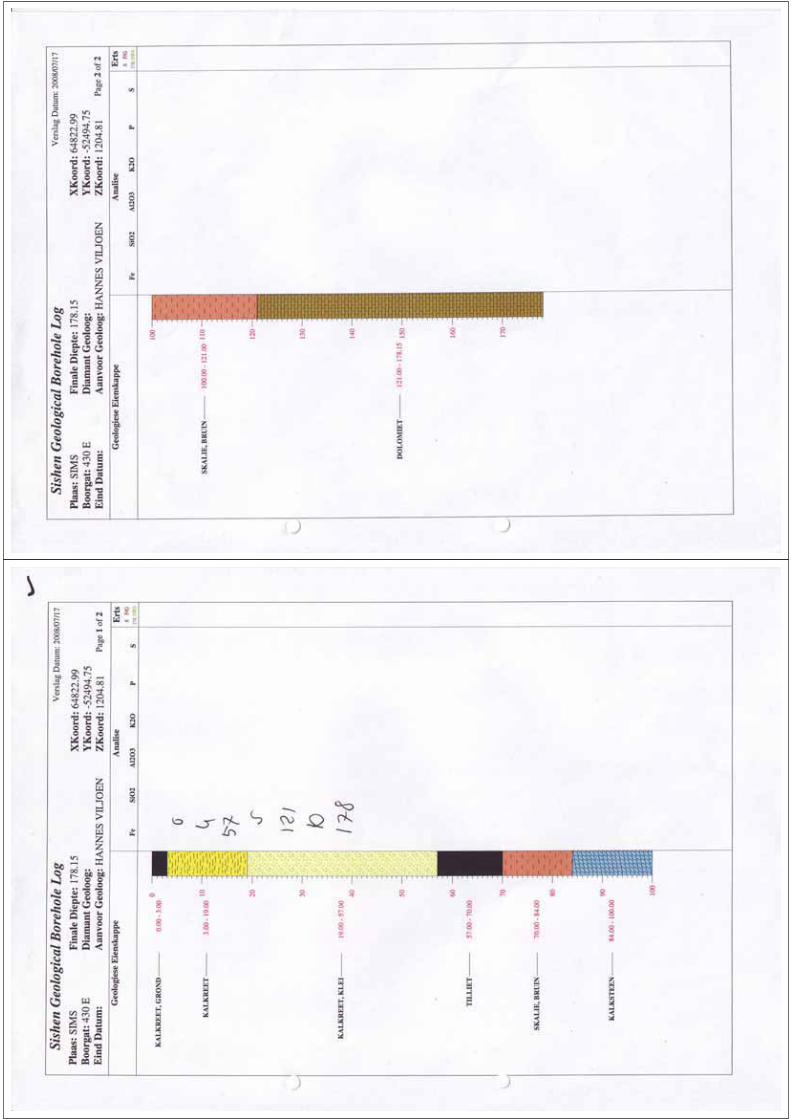

KU
MB
AS
ISH
EN
GR
OU
ND
WA
TER
STU
DY
HO
LE N
o: K
BH
1S
heet
1 o
f 5
HO
LE N
o: K
BH
1S
heet
1 o
f 5
JOB
NU
MB
ER
: VG
I319
3.3
JOB
NU
MB
ER
: VG
I319
3.3
29.
00
0.0
0
32.
00
Ang
ular
whi
te h
ardp
an C
ALC
RE
TE
with
min
orsa
ndy
cla
yey
silt
;
M
OK
ALA
NLE
NFO
RM
ATI
ON
, KA
LAH
AR
I GR
OU
P
Offw
hite
cla
yey
SIL
T w
ith t
race
s of
cal
cret
e;K
ALA
HA
RI G
RO
UP
Sca
le1:
150
120
5
120
0
119
5
119
0
118
5
118
0
5 10 15 20 25 30
12
3
0.58
2.34
1.29
4.19
5.09
3.09
2.36
4.05
2.10
1.20
2.24
2.57
5.27
3.33
4.01
5.40
4.23
4.21
4.04
3.42
4.45
4.39
3.21
3.02
3.07
3.34
2.43
3.02
3.06
3.07
2.46
2.39
2.34
3.17
Pen
etr
time
min
:s/m
Air
retu
rnS
ampl
ere
cov
Ham
mer
rate
RE
DU
CE
DLE
VE
L
KU
MB
AS
ISH
EN
GR
OU
ND
WA
TER
STU
DY
HO
LE N
o: K
BH
1S
heet
2 o
f 5
HO
LE N
o: K
BH
1S
heet
2 o
f 5
JOB
NU
MB
ER
: VG
I319
3.3
JOB
NU
MB
ER
: VG
I319
3.3
33.
00
36.
00
46.
00
48.
00
55.
00
64.
00
Ang
ular
whi
te
ha
rdpa
n
CA
LCR
ET
E;
MO
KA
LAN
LEN
F
OR
MA
TIO
N,
KA
LAH
AR
IG
RO
UP
Whi
te
clay
ey
SIL
T w
ith t
race
s o
f ca
lcre
te;
KA
LAH
AR
I GR
OU
P
Ang
ular
whi
te
ha
rdpa
n
CA
LCR
ET
E;
MO
KA
LAN
LEN
F
OR
MA
TIO
N,
KA
LAH
AR
IG
RO
UP
Whi
te a
nd li
ght b
row
n cl
ayey
SIL
T w
ith tr
aces
of c
alcr
ete;
KA
LAH
AR
I GR
OU
P
Ang
ular
lig
ht b
row
n b
lotc
hed
whi
te h
ardp
anC
ALC
RE
TE
with
min
or li
ght b
row
n cl
ayey
silt
ysa
nd;
MO
KA
LAN
LEN
F
OR
MA
TIO
N,
KA
LAH
AR
I GR
OU
P
Ligh
t ye
llow
bro
wn
clay
ey S
ILT
with
trac
es o
fca
lcre
te; K
ALA
HA
RI G
RO
UP
Ang
ular
sub
angu
lar
and
subr
ound
GR
AV
EL
ofm
ixed
orig
in w
ith tr
aces
of y
ello
w b
row
n cl
ayey
silty
s
and;
T
RA
NS
PO
RT
ED
(
KA
LAH
AR
IG
RO
UP
WE
SS
ELS
FO
RM
ATI
ON
?)
117
5
117
0
116
5
116
0
115
5
115
0
114
5
35 40 45 50 55 60 65
12
3
3.17
3.08
4.10
3.15
4.35
4.30
4.07
3.57
3.33
3.53
3.03
3.21
3.24
2.46
3.13
2.17
3.20
3.41
3.09
2.41
3.06
3.01
2.04
2.22
2.42
2.31
1.46
2.10
1.51
1.16
1.37
2.34
2.40
1.17
Pen
etr
time
min
:s/m
Air
retu
rnS
ampl
ere
cov
Ham
mer
rate
RE
DU
CE
DLE
VE
L
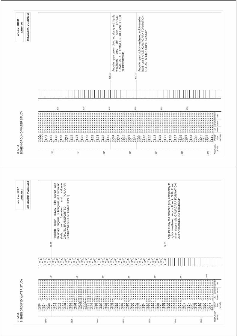
KU
MB
AS
ISH
EN
GR
OU
ND
WA
TER
STU
DY
HO
LE N
o: K
BH
1S
heet
3 o
f 5
HO
LE N
o: K
BH
1S
heet
3 o
f 5
JOB
NU
MB
ER
: VG
I319
3.3
JOB
NU
MB
ER
: VG
I319
3.3
70.
00
92.
00
Red
dish
b
row
n
clay
ey
silt
y S
AN
D
with
abun
dant
ang
ular
, su
bang
ular
and
sub
roun
dsh
ale,
iron
f
orm
atio
n
and
calc
rete
GR
AV
EL;
TR
AN
SP
OR
TE
D
(K
ALA
HA
RI
GR
OU
P W
ES
SE
LS F
OR
MA
TIO
N ?
)
Ang
ular
dus
ky r
ed b
lotc
hed
grey
com
plet
ely
tohi
ghly
wea
ther
ed v
ery
sof
t ro
ck S
HA
LE a
ndm
inor
cla
yey
silt
; GA
MA
GA
RA
FO
RM
AT
ION
,O
LIFA
NTS
HO
EK
SU
PE
RG
RO
UP
114
0
113
5
113
0
112
5
112
0
111
5
111
0
70 75 80 85 90 95 100
12
3
3.00
3.13
3.04
4.13
4.17
4.41
4.57
9.41
10.4
8
12.3
7
7.17
7.04
6.06
5.35
5.41
3.58
4.07
5.06
3.50
3.41
3.20
5.59
4.55
3.37
6.51
9.32
7.15
5.10
3.12
3.15
3.49
4.02
4.22
3.11
Pen
etr
time
min
:s/m
Air
retu
rnS
ampl
ere
cov
Ham
mer
rate
RE
DU
CE
DLE
VE
L
KU
MB
AS
ISH
EN
GR
OU
ND
WA
TER
STU
DY
HO
LE N
o: K
BH
1S
heet
4 o
f 5
HO
LE N
o: K
BH
1S
heet
4 o
f 5
JOB
NU
MB
ER
: VG
I319
3.3
JOB
NU
MB
ER
: VG
I319
3.3
115
.00
120
.00
Ang
ular
gre
y br
own
blot
ched
dus
ky r
ed h
ighl
yw
eath
ered
very
soft
r
ock
S
HA
LE;
GA
MA
GA
RA
FO
RM
AT
ION
, OLI
FA
NT
SH
OE
KS
UP
ER
GR
OU
P
Ang
ular
gre
y hi
ghly
wea
ther
ed s
oft t
o m
ediu
mha
rd r
ock
SH
ALE
; GA
MA
GA
RA
FO
RM
AT
ION
,O
LIFA
NTS
HO
EK
SU
PE
RG
RO
UP
110
5
110
0
109
5
109
0
108
5
108
0
107
5
105
110
115
120
125
130
12
3
4.03
1.48
1.43
1.49
1.33
2.56
1.32
1.36
1.29
1.33
1.21
1.33
1.14
1.59
2.04
2.14
2.10
2.05
2.15
3.03
2.00
1.20
1.18
1.31
1.29
1.32
1.27
2.06
2.08
1.54
2.02
2.15
2.15
1.50
Pen
etr
time
min
:s/m
Air
retu
rnS
ampl
ere
cov
Ham
mer
rate
RE
DU
CE
DLE
VE
L

KU
MB
AS
ISH
EN
GR
OU
ND
WA
TER
STU
DY
HO
LE N
o: K
BH
1S
heet
5 o
f 5
HO
LE N
o: K
BH
1S
heet
5 o
f 5
JOB
NU
MB
ER
: VG
I319
3.3
JOB
NU
MB
ER
: VG
I319
3.3
150
.00
NO
TES
1) D
rille
d on
gra
vity
trav
erse
: Lin
e K
ATH
U
2) K
umba
Ass
igne
d B
oreh
ole
num
ber:
UK
0015
3) D
rille
r re
port
s so
lid c
ondi
tions
94
m to
134
m ,
138
m to
150
m
4) G
roun
dwat
er in
terc
epte
d fro
m 7
4 m
5) D
rille
r cas
ing
used
from
91
m to
150
m
6) G
roun
dwat
er r
est
leve
l re
cord
ed a
s 91
m o
nth
e 20
11/0
3/09
7) O
rigin
al D
olom
ite A
quife
r G
roun
dwat
er L
evel
(OW
L)12
00 m
AM
SL
8) W
ater
add
ed f
rom
0 m
to
150
m a
nd fo
amad
ded
0 m
to 1
50 m
9) P
roje
ctio
n I
nfor
mat
ion:
C
M 2
3 d
egre
es E
,Tr
ansv
erse
Mer
cato
r, W
GS
84
CO
NTR
AC
TOR
:M
AC
HIN
E :
DR
ILLE
D B
Y :
PR
OFI
LED
BY
:
TYP
E S
ET
BY
:S
ETU
P F
ILE
:
BO
OY
SE
N B
OR
EH
JB01
SC
HR
AM
M (2
100
kPa)
FRA
NS
/HE
RM
AN
/AP
RIL
B B
OLI
THO
GA
RTH
JO
RD
AA
NS
ETU
P.S
ET
INC
LIN
ATI
ON
:D
IAM
:D
ATE
:D
ATE
:
DA
TE :
TEX
T :90
DE
GR
EE
S16
5 m
m20
11/0
3/03
2011
/05/
0526
/10/
15 0
9:33
..C:\D
OTF
ILE
S\2
0110
9~1.
TXT
ELE
VA
TIO
N :
X-C
OO
RD
:Y
-CO
OR
D :
1209
m A
MS
L30
6465
928
40
dot.P
LOT
5006
J&
WD
055
DB
B
HO
LE N
o: K
BH
1H
OLE
No:
KB
H1
107
0
106
5
106
0
135
140
145
150
12
3
1.48
1.55
1.40
1.47
1.51
1.59
1.46
1.50
1.59
2.20
2.01
1.49
1.50
1.51
2.01
Pen
etr
time
min
:s/m
Air
retu
rnS
ampl
ere
cov
Ham
mer
rate
RE
DU
CE
DLE
VE
L


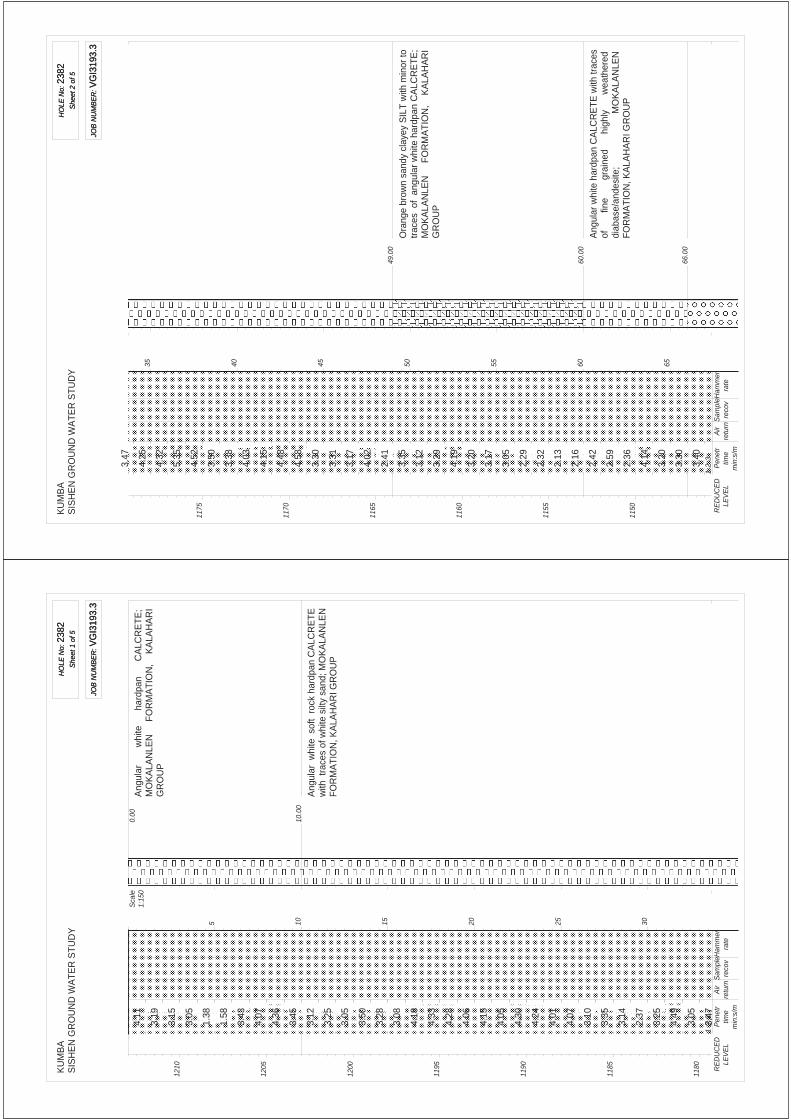
KU
MB
AS
ISH
EN
GR
OU
ND
WA
TER
STU
DY
HO
LE N
o: 2
382
She
et 1
of 5
HO
LE N
o: 2
382
She
et 1
of 5
JOB
NU
MB
ER
: VG
I319
3.3
JOB
NU
MB
ER
: VG
I319
3.3
10.
00
0.0
0A
ngul
ar
w
hite
hard
pan
C
ALC
RE
TE
;M
OK
ALA
NLE
N
FO
RM
AT
ION
, K
ALA
HA
RI
GR
OU
P
Ang
ular
whi
te s
oft
rock
har
dpan
CA
LCR
ET
Ew
ith t
race
s of
whi
te s
ilty
sand
; MO
KA
LAN
LEN
FOR
MA
TIO
N, K
ALA
HA
RI G
RO
UP
Sca
le1:
150
121
0
120
5
120
0
119
5
119
0
118
5
118
0
5 10 15 20 25 30
12
3
4.11
3.19
3.15
3.05
1.38
1.58
3.43
4.07
4.36
3.45
3.12
3.25
3.05
3.50
3.28
3.08
4.18
4.33
4.28
4.06
4.15
4.05
4.30
4.24
4.01
4.07
3.10
3.35
3.14
2.37
3.25
4.49
3.05
3.47
Pen
etr
time
min
:s/m
Air
retu
rnS
ampl
ere
cov
Ham
mer
rate
RE
DU
CE
DLE
VE
L
KU
MB
AS
ISH
EN
GR
OU
ND
WA
TER
STU
DY
HO
LE N
o: 2
382
She
et 2
of 5
HO
LE N
o: 2
382
She
et 2
of 5
JOB
NU
MB
ER
: VG
I319
3.3
JOB
NU
MB
ER
: VG
I319
3.3
49.
00
60.
00
66.
00
Ora
nge
brow
n sa
ndy
clay
ey S
ILT
with
min
or to
trac
es o
f an
gula
r w
hite
har
dpan
CA
LCR
ET
E;
MO
KA
LAN
LEN
F
OR
MA
TIO
N,
KA
LAH
AR
IG
RO
UP
Ang
ular
whi
te h
ardp
an C
ALC
RE
TE
with
trac
esof
fine
gra
ined
high
ly
w
eath
ered
diab
ase/
ande
site
;
M
OK
ALA
NLE
NFO
RM
ATI
ON
, KA
LAH
AR
I GR
OU
P
117
5
117
0
116
5
116
0
115
5
115
0
35 40 45 50 55 60 65
12
3
3.47
4.25
4.32
5.35
4.52
3.50
3.38
4.03
4.15
4.48
4.58
3.30
3.31
3.17
4.02
2.41
3.35
3.12
3.29
4.19
3.20
3.17
3.05
2.29
2.32
2.13
2.16
2.42
2.59
2.36
4.14
3.20
3.30
3.40
Pen
etr
time
min
:s/m
Air
retu
rnS
ampl
ere
cov
Ham
mer
rate
RE
DU
CE
DLE
VE
L

KU
MB
AS
ISH
EN
GR
OU
ND
WA
TER
STU
DY
HO
LE N
o: 2
382
She
et 3
of 5
HO
LE N
o: 2
382
She
et 3
of 5
JOB
NU
MB
ER
: VG
I319
3.3
JOB
NU
MB
ER
: VG
I319
3.3
Sub
roun
d,
suba
ngul
ar
and
ang
ular
hi
ghly
wea
ther
ed
GR
AV
EL
o
f
mix
ed
orig
in;
WE
SS
ELS
FO
RM
ATI
ON
, KA
LAH
AR
I GR
OU
P
114
5
114
0
113
5
113
0
112
5
112
0
111
5
70 75 80 85 90 95 100
12
3
3.27
3.05
2.30
3.55
2.35
2.33
2.47
2.72
2.43
2.30
2.39
2.25
3.59
3.42
4.05
3.28
3.30
2.58
2.11
3.49
2.59
2.28
2.33
2.27
1.40
1.33
1.36
1.51
1.58
1.50
1.47
3.00
2.05
2.15
Pen
etr
time
min
:s/m
Air
retu
rnS
ampl
ere
cov
Ham
mer
rate
RE
DU
CE
DLE
VE
L
KU
MB
AS
ISH
EN
GR
OU
ND
WA
TER
STU
DY
HO
LE N
o: 2
382
She
et 4
of 5
HO
LE N
o: 2
382
She
et 4
of 5
JOB
NU
MB
ER
: VG
I319
3.3
JOB
NU
MB
ER
: VG
I319
3.3
102
.00
120
.00
Ang
ular
dus
ky b
row
n c
ompl
etel
y w
eath
ered
and
sh
atte
red
cla
yey
SIL
T;
GA
MA
GA
RA
FO
RM
AT
ION
,
OLI
FA
NT
SH
OE
KS
UP
ER
GR
OU
P
Ang
ular
lig
ht g
rey
hig
hly
wea
ther
ed v
ery
soft
rock
MU
DR
OC
K w
ith a
bund
ant
grey
cla
yey
SIL
T;
G
AM
AG
AR
A
FO
RM
AT
ION
,O
LIFA
NTS
HO
EK
SU
PE
RG
RO
UP
111
0
110
5
110
0
109
5
109
0
108
5
108
0
105
110
115
120
125
130
12
3
2.01
2.08
2.47
1.29
1.50
1.54
2.10
4.21
3.25
1.56
2.04
2.06
1.51
2.58
2.51
1.46
1.55
1.26
1.54
1.07
1.36
1.30
1.16
1.21
1.50
1.47
2.00
1.35
1.23
1.22
1.46
2.16
1.28
1.12
Pen
etr
time
min
:s/m
Air
retu
rnS
ampl
ere
cov
Ham
mer
rate
RE
DU
CE
DLE
VE
L
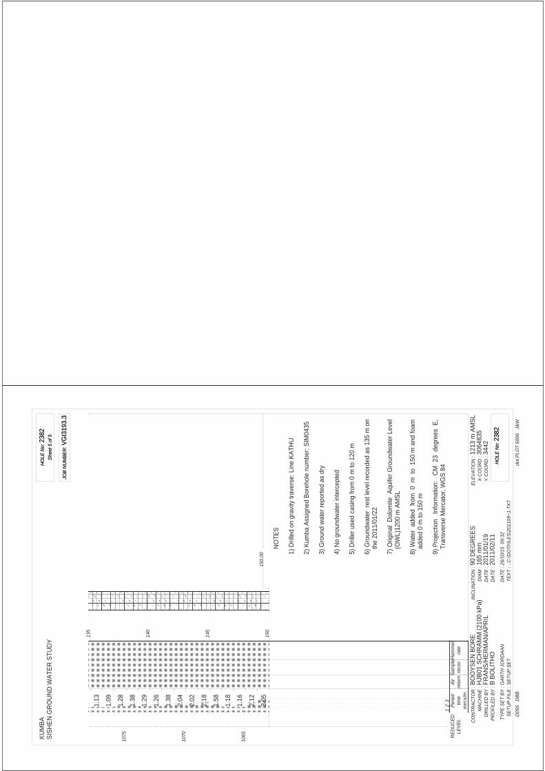
KU
MB
AS
ISH
EN
GR
OU
ND
WA
TER
STU
DY
HO
LE N
o: 2
382
She
et 5
of 5
HO
LE N
o: 2
382
She
et 5
of 5
JOB
NU
MB
ER
: VG
I319
3.3
JOB
NU
MB
ER
: VG
I319
3.3
150
.00
NO
TES
1) D
rille
d on
gra
vity
trav
erse
: Lin
e K
ATH
U
2) K
umba
Ass
igne
d B
oreh
ole
num
ber:
SIM
0435
3) G
roun
d w
ater
repo
rted
as d
ry
4) N
o gr
ound
wat
er in
terc
epte
d
5) D
rille
r use
d ca
sing
from
0 m
to 1
20 m
6) G
roun
dwat
er r
est l
evel
rec
orde
d as
135
m o
nth
e 20
11/0
1/22
7) O
rigin
al D
olom
ite A
quife
r G
roun
dwat
er L
evel
(OW
L)12
00 m
AM
SL
8) W
ater
add
ed f
rom
0 m
to
150
m a
nd fo
amad
ded
0 m
to 1
50 m
9) P
roje
ctio
n I
nfor
mat
ion:
C
M 2
3 d
egre
es E
,Tr
ansv
erse
Mer
cato
r, W
GS
84
CO
NTR
AC
TOR
:M
AC
HIN
E :
DR
ILLE
D B
Y :
PR
OFI
LED
BY
:
TYP
E S
ET
BY
:S
ETU
P F
ILE
:
BO
OY
SE
N B
OR
EH
JB01
SC
HR
AM
M (2
100
kPa)
FRA
NS
/HE
RM
AN
/AP
RIL
B B
OLI
THO
GA
RTH
JO
RD
AA
NS
ETU
P.S
ET
INC
LIN
ATI
ON
:D
IAM
:D
ATE
:D
ATE
:
DA
TE :
TEX
T :90
DE
GR
EE
S16
5 m
m20
11/0
1/19
2011
/02/
1126
/10/
15 0
9:32
..C:\D
OTF
ILE
S\2
0110
9~1.
TXT
ELE
VA
TIO
N :
X-C
OO
RD
:Y
-CO
OR
D :
1213
m A
MS
L30
6483
534
42
dot.P
LOT
5006
J&
WD
055
DB
B
HO
LE N
o: 2
382
HO
LE N
o: 2
382
107
5
107
0
106
5
135
140
145
150
12
3
1.13
1.09
1.28
1.38
1.29
1.26
1.38
2.04
2.02
2.18
1.58
1.18
1.16
2.12
3.05
Pen
etr
time
min
:s/m
Air
retu
rnS
ampl
ere
cov
Ham
mer
rate
RE
DU
CE
DLE
VE
L
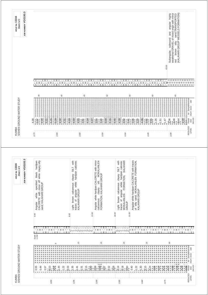
KU
MB
AS
ISH
EN
GR
OU
ND
WA
TER
STU
DY
HO
LE N
o: 1
3316
She
et 1
of 3
HO
LE N
o: 1
3316
She
et 1
of 3
JOB
NU
MB
ER
: VG
I319
3.3
JOB
NU
MB
ER
: VG
I319
3.3
8.0
0
0.0
0
13.
00
18.
00
21.
00
Ang
ular
w
hite
s
peck
led
bl
ack
ha
rdpa
nC
ALC
RE
TE
with
min
or o
ff w
hite
cla
yey
silty
sand
; KA
LAH
AR
I GR
OU
P
Ligh
t b
row
n c
alca
reou
s c
laye
y S
ILT
with
trac
es
of
angu
lar
whi
te
hard
pan
cal
cret
e;K
ALA
HA
RI G
RO
UP
Ang
ular
whi
te h
ardp
an C
ALC
RE
TE
with
min
orca
lcar
eous
clay
ey
silt
;
MO
KA
LAN
LEN
FOR
MA
TIO
N, K
ALA
HA
RI G
RO
UP
Ligh
t b
row
n c
alca
reou
s c
laye
y S
ILT
with
trac
es
of
angu
lar
whi
te
hard
pan
cal
cret
e;M
OK
ALA
NLE
N
FO
RM
AT
ION
, K
ALA
HA
RI
GR
OU
P
Ang
ular
whi
te h
ardp
an C
ALC
RE
TE
with
trac
esof
si
lty s
and;
MO
KA
LAN
LEN
FO
RM
AT
ION
,K
ALA
HA
RI G
RO
UP
Sca
le1:
150
120
0
119
5
119
0
118
5
118
0
117
5
5 10 15 20 25 30
12
3
0.55
0.44
0.57
2.23
4.07
1.44
1.22
2.03
1.35
1.41
1.51
2.15
3.43
2.59
5.60
3.27
2.02
3.18
2.14
2.18
2.50
0.40
1.22
1.30
2.15
2.24
3.56
4.27
4.11
4.27
4.40
5.29
4.29
4.39
Pen
etr
time
min
:s/m
Air
retu
rnS
ampl
ere
cov
Ham
mer
rate
RE
DU
CE
DLE
VE
L
KU
MB
AS
ISH
EN
GR
OU
ND
WA
TER
STU
DY
HO
LE N
o: 1
3316
She
et 2
of 3
HO
LE N
o: 1
3316
She
et 2
of 3
JOB
NU
MB
ER
: VG
I319
3.3
JOB
NU
MB
ER
: VG
I319
3.3
63.
00
Sub
angu
lar,
su
brou
nd
and
ang
ular
hi
ghly
wea
ther
ed G
RA
VE
L of
mix
ed o
rigin
with
min
orre
d
bro
wn
s
ilty
s
and;
TR
AN
SP
OR
TE
D(K
ALA
HA
RI G
RO
UP
WE
SS
ELS
FO
RM
ATI
ON
)
117
0
116
5
116
0
115
5
115
0
114
5
114
0
35 40 45 50 55 60 65
12
3
4.39
3.37
4.16
5.21
5.15
5.29
4.34
4.31
4.23
4.33
4.03
3.51
4.14
4.27
3.54
3.40
5.09
5.15
4.46
4.39
3.54
3.41
3.28
3.20
4.28
3.52
3.33
1.26
1.51
1.47
2.36
2.46
2.44
4.20
Pen
etr
time
min
:s/m
Air
retu
rnS
ampl
ere
cov
Ham
mer
rate
RE
DU
CE
DLE
VE
L

KU
MB
AS
ISH
EN
GR
OU
ND
WA
TER
STU
DY
HO
LE N
o: 1
3316
She
et 3
of 3
HO
LE N
o: 1
3316
She
et 3
of 3
JOB
NU
MB
ER
: VG
I319
3.3
JOB
NU
MB
ER
: VG
I319
3.3
70.
00
84.
00
Red
dish
br
own
cla
yey
SIL
T w
ith t
race
s o
fan
gula
r c
ompl
etel
y w
eath
ered
stif
f cla
yey
silt
frag
men
ts;
G
AM
AG
AR
A
F
OR
MA
TIO
N,
OLI
FAN
TSH
OE
K S
UP
ER
GR
OU
P
NO
TES
1) D
rille
d on
gra
vity
trav
erse
: Lin
e A
2) K
umba
Ass
igne
d B
oreh
ole
num
ber:
SIM
0434
E
3) D
rille
r rep
orts
no
solid
con
ditio
ns
4) G
roun
dwat
er in
terc
epte
d fro
m a
t 19
m
5) N
o dr
iller
cas
ing
used
6) G
roun
dwat
er r
est l
evel
rec
orde
d as
dry
on
the
2011
/06/
01
7) O
rigin
al D
olom
ite A
quife
r G
roun
dwat
er L
evel
appr
oxim
atly
122
5 m
AM
SL
(Pre
1972
)
8) W
ater
add
ed f
rom
0 m
to
84
m a
nd fo
amad
ded
0 m
to 8
4 m
9) P
roje
ctio
n I
nfor
mat
ion:
C
M 2
3 d
egre
es E
,Tr
ansv
erse
Mer
cato
r, W
GS
84
CO
NTR
AC
TOR
:M
AC
HIN
E :
DR
ILLE
D B
Y :
PR
OFI
LED
BY
:
TYP
E S
ET
BY
:S
ETU
P F
ILE
:
BO
OY
SE
N B
OR
EH
JB01
SC
HR
AM
M (2
100
kPa)
Fran
s/H
erm
an/A
pril
B B
OLI
THO
GA
RTH
JO
RD
AA
NS
ETU
P.S
ET
INC
LIN
ATI
ON
:D
IAM
:D
ATE
:D
ATE
:
DA
TE :
TEX
T :90
DE
GR
EE
S16
5 m
m20
11/0
5/30
2011
/07/
0126
/10/
15 0
9:50
..C:\D
OTF
ILE
S\2
0110
8~1.
TXT
ELE
VA
TIO
N :
X-C
OO
RD
:Y
-CO
OR
D :
1204
m A
MS
L30
6590
217
70
dot.P
LOT
5006
J&
WD
055
DB
B
HO
LE N
o: 1
3316
HO
LE N
o: 1
3316
113
5
113
0
112
5
112
0
70 75 80
12
3
5.40
6.27
5.48
3.59
4.24
3.46
5.43
5.51
6.15
4.59
4.43
4.25
2.51
2.54
2.42
2.26
2.11
Pen
etr
time
min
:s/m
Air
retu
rnS
ampl
ere
cov
Ham
mer
rate
RE
DU
CE
DLE
VE
L

UITKOMS SITE

KU
MB
AS
ISH
EN
GR
OU
ND
WA
TER
STU
DY
HO
LE N
o: 4
155
She
et 1
of 5
HO
LE N
o: 4
155
She
et 1
of 5
JOB
NU
MB
ER
: VG
I319
3.3
JOB
NU
MB
ER
: VG
I319
3.3
1.0
0
0.0
0
4.0
0
10.
00
Ora
nge
bro
wn
silt
y S
AN
D;
QU
AT
ER
NA
RY
WIN
D
B
LOW
N
S
AN
D
(G
OR
DO
NIA
FOR
MA
TIO
N)
Ang
ular
whi
te h
ardp
an C
ALC
RE
TE
with
trac
esof
m
ater
ial
as
a
bove
; M
OK
ALA
NLE
NFO
RM
ATI
ON
, KA
LAH
AR
I GR
OU
P
Ang
ular
whi
te
ha
rdpa
n
CA
LCR
ET
E;
MO
KA
LAN
LEN
F
OR
MA
TIO
N,
KA
LAH
AR
IG
RO
UP
Ang
ular
yel
low
bro
wn
band
ed d
ark
grey
hig
hly
wea
ther
ed
med
ium
h
ard
ro
ck
SH
ALE
;B
AN
DE
D IR
ON
FO
RM
AT
ION
/PY
RO
PH
ILLI
TE
SH
ALE
WIT
H I
RO
N B
AN
DS
OF
AS
BE
ST
OS
HIL
LS S
UB
GR
OU
P, G
HA
AP
GR
OU
P
Sca
le1:
150
122
0
121
5
121
0
120
5
120
0
119
5
119
0
5 10 15 20 25 30
12
3
0.49
0.58
1.14
5.57
7.04
9.44
4.46
2.32
2.49
2.09
1.50
1.51
1.27
2.05
1.58
3.00
2.45
7.28
2.41
2.43
9.11
4.05
1.54
3.47
2.13
2.43
3.01
3.45
4.45
1.46
5.58
1.55
2.15
2.48
Pen
etr
time
min
:s/m
Air
retu
rnS
ampl
ere
cov
Ham
mer
rate
RE
DU
CE
DLE
VE
L
KU
MB
AS
ISH
EN
GR
OU
ND
WA
TER
STU
DY
HO
LE N
o: 4
155
She
et 2
of 5
HO
LE N
o: 4
155
She
et 2
of 5
JOB
NU
MB
ER
: VG
I319
3.3
JOB
NU
MB
ER
: VG
I319
3.3
50.
00
59.
00
Ang
ular
da
rk
grey
bl
otch
ed
yello
w b
row
nhi
ghly
wea
ther
ed h
ard
rock
SLA
TE; B
AN
DE
DIR
ON
F
OR
MA
TIO
N,
AS
BE
ST
OS
H
ILLS
SU
BG
RO
UP
, GH
AA
P G
RO
UP
Ang
ular
bla
ck b
ande
d d
ark
grey
occ
asio
nally
red
bro
wn
unw
eath
ered
har
d r
ock
SLA
TE
;B
AN
DE
D
IRO
N
FO
RM
AT
ION
, A
SB
ES
TO
SH
ILLS
SU
BG
RO
UP
, GH
AA
P G
RO
UP
118
5
118
0
117
5
117
0
116
5
116
0
35 40 45 50 55 60 65
12
3
2.48
2.23
2.30
2.34
3.44
5.47
4.35
4.29
4.30
3.22
2.17
3.13
2.17
1.27
1.49
2.15
2.01
2.40
2.57
2.06
2.42
3.36
3.17
2.21
4.09
2.41
5.01
4.24
4.06
4.56
4.37
7.39
7.24
6.17
Pen
etr
time
min
:s/m
Air
retu
rnS
ampl
ere
cov
Ham
mer
rate
RE
DU
CE
DLE
VE
L

KU
MB
AS
ISH
EN
GR
OU
ND
WA
TER
STU
DY
HO
LE N
o: 4
155
She
et 3
of 5
HO
LE N
o: 4
155
She
et 3
of 5
JOB
NU
MB
ER
: VG
I319
3.3
JOB
NU
MB
ER
: VG
I319
3.3
85.
00
Ang
ular
da
rk
grey
un
wea
ther
ed h
ard
roc
kdo
lom
ite
with
ba
nds
of
SLA
TE
as
abo
ve;
BA
ND
ED
IR
ON
F
OR
MA
TIO
N,
AS
BE
ST
OS
HIL
LS S
UB
GR
OU
P, G
HA
AP
GR
OU
P
115
5
115
0
114
5
114
0
113
5
113
0
112
5
70 75 80 85 90 95 100
12
3
5.30
5.23
8.35
6.13
5.04
5.53
4.57
5.56
4.58
4.59
9.02
5.34
5.46
5.38
5.48
6.03
7.50
6.44
8.08
8.34
5.13
5.52
7.43
8.42
6.32
6.41
5.24
4.14
4.12
5.53
5.59
8.19
11.0
7
12.5
1
Pen
etr
time
min
:s/m
Air
retu
rnS
ampl
ere
cov
Ham
mer
rate
RE
DU
CE
DLE
VE
L
KU
MB
AS
ISH
EN
GR
OU
ND
WA
TER
STU
DY
HO
LE N
o: 4
155
She
et 4
of 5
HO
LE N
o: 4
155
She
et 4
of 5
JOB
NU
MB
ER
: VG
I319
3.3
JOB
NU
MB
ER
: VG
I319
3.3
112
0
111
5
111
0
110
5
110
0
109
5
109
0
105
110
115
120
125
130
12
3
7.01
7.10
5.10
4.40
5.05
6.56
6.42
5.30
5.10
4.01
4.31
3.52
4.24
4.53
3.18
3.12
5.02
3.49
3.20
4.02
4.20
4.15
4.21
3.05
3.11
4.13
3.21
3.05
3.01
3.28
3.26
4.27
3.36
2.40
Pen
etr
time
min
:s/m
Air
retu
rnS
ampl
ere
cov
Ham
mer
rate
RE
DU
CE
DLE
VE
L

KU
MB
AS
ISH
EN
GR
OU
ND
WA
TER
STU
DY
HO
LE N
o: 4
155
She
et 5
of 5
HO
LE N
o: 4
155
She
et 5
of 5
JOB
NU
MB
ER
: VG
I319
3.3
JOB
NU
MB
ER
: VG
I319
3.3
142
.00
NO
TES
1) D
rille
d on
gra
vity
trav
erse
: Lin
e K
ATH
U
2) S
late
/sha
le c
ould
pos
sibl
y b
e ch
ert o
r jas
per
in th
e ba
nded
iron
form
atio
n
3) D
rille
r re
port
s so
lid c
ondi
tions
from
39
m to
40
m ,
56
m to
58
m ,
59 m
to 1
03 m
and
dril
ling
was
sto
pped
at 1
42 m
due
to s
afet
y pr
ecau
tions
4) G
roun
dwat
er in
terc
epte
d at
53
m
5) K
umba
Ass
igne
d B
oreh
ole
num
ber:
UK
0009
6) D
rille
r use
d ca
sing
from
1 m
to 4
2.4
m
7) G
roun
dwat
er r
est l
evel
rec
orde
d at
23.
5 m
on
the
2010
/10/
28
8) O
rigin
al D
olom
ite A
quife
r G
roun
dwat
er L
evel
(OW
L)12
00 m
AM
SL
9) W
ater
add
ed f
rom
0 m
to 5
3 m
, 86
m to
142
m ,
foa
m a
dded
fro
m 0
m to
54
m ,
86 m
to14
2 m
10)P
roje
ctio
n I
nfor
mat
ion:
CM
23
deg
rees
E,
Tran
sver
se M
erca
tor,
WG
S 8
4
CO
NTR
AC
TOR
:M
AC
HIN
E :
DR
ILLE
D B
Y :
PR
OFI
LED
BY
:
TYP
E S
ET
BY
:S
ETU
P F
ILE
:
BO
OY
SE
N B
OR
EH
JB01
SC
HR
AM
M (2
100
kPa)
FRA
NS
/HE
RM
AN
/AP
RIL
B B
OLI
THO
GA
RTH
JO
RD
AA
NS
ETU
P.S
ET
INC
LIN
ATI
ON
:D
IAM
:D
ATE
:D
ATE
:
DA
TE :
TEX
T :90
DE
GR
EE
S16
5 m
m20
10/1
0/26
2010
/11/
1826
/10/
15 0
9:31
..C:\D
OTF
ILE
S\2
0110
9~1.
TXT
ELE
VA
TIO
N :
X-C
OO
RD
:Y
-CO
OR
D :
1223
m A
MS
L30
6339
563
83
dot.P
LOT
5006
J&
WD
055
DB
B
HO
LE N
o: 4
155
HO
LE N
o: 4
155
108
5
135
140
12
3
4.30
5.51
8.25
9.32
4.21
4.49
5.08
Pen
etr
time
min
:s/m
Air
retu
rnS
ampl
ere
cov
Ham
mer
rate
RE
DU
CE
DLE
VE
L

KU
MB
AS
ISH
EN
GR
OU
ND
WA
TER
STU
DY
HO
LE N
o: 5
276
She
et 1
of 5
HO
LE N
o: 5
276
She
et 1
of 5
JOB
NU
MB
ER
: VG
I319
3.3
JOB
NU
MB
ER
: VG
I319
3.3
1.0
0
0.0
0A
ngul
ar
yello
w
brow
n b
ande
d d
ark
bro
wn
high
ly w
eath
ered
sof
t to
med
ium
har
d ro
ck;
BA
ND
ED
IR
ON
F
OR
MA
TIO
N,
AS
BE
ST
OS
HIL
LS S
UB
GR
OU
P, G
HA
AP
GR
OU
P
Ang
ular
ye
llow
bro
wn
ban
ded
dar
k g
rey
tobl
ack
med
ium
wea
ther
ed h
ard
rock
; BA
ND
ED
IRO
N
FO
RM
AT
ION
, A
SB
ES
TO
S
HIL
LSS
UB
GR
OU
P, G
HA
AP
GR
OU
P
Sca
le1:
150
122
0
121
5
121
0
120
5
120
0
119
5
5 10 15 20 25 30
12
3
0.56
1.05
1.47
1.54
2.15
2.32
2.18
2.13
2.03
2.31
2.13
2.02
2.12
2.15
2.23
2.13
2.16
3.08
2.41
2.55
2.29
2.11
3.02
3.32
4.05
2.51
2.33
2.48
1.38
2.01
2.20
2.15
2.20
2.16
Pen
etr
time
min
:s/m
Air
retu
rnS
ampl
ere
cov
Ham
mer
rate
RE
DU
CE
DLE
VE
L
KU
MB
AS
ISH
EN
GR
OU
ND
WA
TER
STU
DY
HO
LE N
o: 5
276
She
et 2
of 5
HO
LE N
o: 5
276
She
et 2
of 5
JOB
NU
MB
ER
: VG
I319
3.3
JOB
NU
MB
ER
: VG
I319
3.3
61.
00
Ang
ular
gr
ey
band
ed
dark
gr
ey
to b
lack
slig
htly
wea
ther
ed h
ard
rock
SLA
TE
/ SH
ALE
;B
AN
DE
D
IRO
N
FO
RM
AT
ION
, A
SB
ES
TO
SH
ILLS
SU
BG
RO
UP
, GH
AA
P G
RO
UP
119
0
118
5
118
0
117
5
117
0
116
5
116
0
35 40 45 50 55 60 65
12
3
2.16
2.09
2.24
2.33
1.58
1.42
2.27
1.27
2.36
2.31
1.44
1.58
1.22
1.48
2.30
3.17
4.29
5.12
2.29
2.15
2.07
3.16
3.58
2.59
2.57
2.38
2.31
4.53
6.07
6.04
7.32
11.3
9
13.4
0
8.11
Pen
etr
time
min
:s/m
Air
retu
rnS
ampl
ere
cov
Ham
mer
rate
RE
DU
CE
DLE
VE
L

KU
MB
AS
ISH
EN
GR
OU
ND
WA
TER
STU
DY
HO
LE N
o: 5
276
She
et 3
of 5
HO
LE N
o: 5
276
She
et 3
of 5
JOB
NU
MB
ER
: VG
I319
3.3
JOB
NU
MB
ER
: VG
I319
3.3
115
5
115
0
114
5
114
0
113
5
113
0
112
5
70 75 80 85 90 95 100
12
3
5.43
6.37
7.13
4.32
5.10
5.05
6.02
5.15
5.07
4.48
6.18
6.25
6.12
8.56
4.33
4.46
5.31
8.10
7.51
6.53
12.0
2
14.1
3
8.18
6.34
7.57
9.14
6.39
9.13
6.22
7.38
5.54
7.09
19.0
5
11.3
3
Pen
etr
time
min
:s/m
Air
retu
rnS
ampl
ere
cov
Ham
mer
rate
RE
DU
CE
DLE
VE
L
KU
MB
AS
ISH
EN
GR
OU
ND
WA
TER
STU
DY
HO
LE N
o: 5
276
She
et 4
of 5
HO
LE N
o: 5
276
She
et 4
of 5
JOB
NU
MB
ER
: VG
I319
3.3
JOB
NU
MB
ER
: VG
I319
3.3
112
0
111
5
111
0
110
5
110
0
109
5
109
0
105
110
115
120
125
130
12
3
5.27
24.4
8
19.4
7
25.3
8
9.07
9.00
6.50
7.01
7.02
7.09
6.01
5.06
5.03
6.22
6.22
14.3
2
12.1
7
16.0
1
15.4
1
19.1
7
10.2
6
6.51
7.22
5.27
7.05
6.33
4.41
5.36
5.37
5.27
6.57
7.56
5.41
6.46
Pen
etr
time
min
:s/m
Air
retu
rnS
ampl
ere
cov
Ham
mer
rate
RE
DU
CE
DLE
VE
L

KU
MB
AS
ISH
EN
GR
OU
ND
WA
TER
STU
DY
HO
LE N
o: 5
276
She
et 5
of 5
HO
LE N
o: 5
276
She
et 5
of 5
JOB
NU
MB
ER
: VG
I319
3.3
JOB
NU
MB
ER
: VG
I319
3.3
150
.00
NO
TES
1) D
rille
d on
gra
vity
trav
erse
: Lin
e K
ATH
U
2) K
umba
Ass
igne
d B
oreh
ole
num
ber:
UK
0013
3) D
rille
r rep
orts
sol
id c
ondi
tions
61
m to
150
m
4) G
roun
dwat
er in
terc
epte
d at
72
m
5) D
rille
r cas
ing
used
from
63
m to
150
m
6) G
roun
dwat
er r
est
leve
l re
cord
ed a
s 26
m o
nth
e 20
11/0
2/10
7) O
rigin
al D
olom
ite A
quife
r G
roun
dwat
er L
evel
(OW
L)12
00 m
AM
SL
8) W
ater
add
ed f
rom
0 m
to
150
m a
nd fo
amad
ded
0 m
to 1
50 m
9) P
roje
ctio
n I
nfor
mat
ion:
C
M 2
3 d
egre
es E
,Tr
ansv
erse
Mer
cato
r, W
GS
84
CO
NTR
AC
TOR
:M
AC
HIN
E :
DR
ILLE
D B
Y :
PR
OFI
LED
BY
:
TYP
E S
ET
BY
:S
ETU
P F
ILE
:
BO
OY
SE
N B
OR
EH
JB01
SC
HR
AM
M (2
100
kPa)
FRA
NS
/HE
RM
AN
/AP
RIL
B B
OLI
THO
GA
RTH
JO
RD
AA
NS
ETU
P.S
ET
INC
LIN
ATI
ON
:D
IAM
:D
ATE
:D
ATE
:
DA
TE :
TEX
T :90
DE
GR
EE
S16
5 m
m20
11/0
2/03
2011
/05/
0526
/10/
15 0
9:32
..C:\D
OTF
ILE
S\2
0110
9~1.
TXT
ELE
VA
TIO
N :
X-C
OO
RD
:Y
-CO
OR
D :
1224
m A
MS
L30
6426
465
03
dot.P
LOT
5006
J&
WD
055
DB
B
HO
LE N
o: 5
276
HO
LE N
o: 5
276
108
5
108
0
107
5
135
140
145
150
12
3
6.25
8.48
7.03
12.1
0
10.6
8
9.30
7.01
9.09
6.31
7.07
8.04
5.43
10.1
3
16.1
6
8.04
Pen
etr
time
min
:s/m
Air
retu
rnS
ampl
ere
cov
Ham
mer
rate
RE
DU
CE
DLE
VE
L
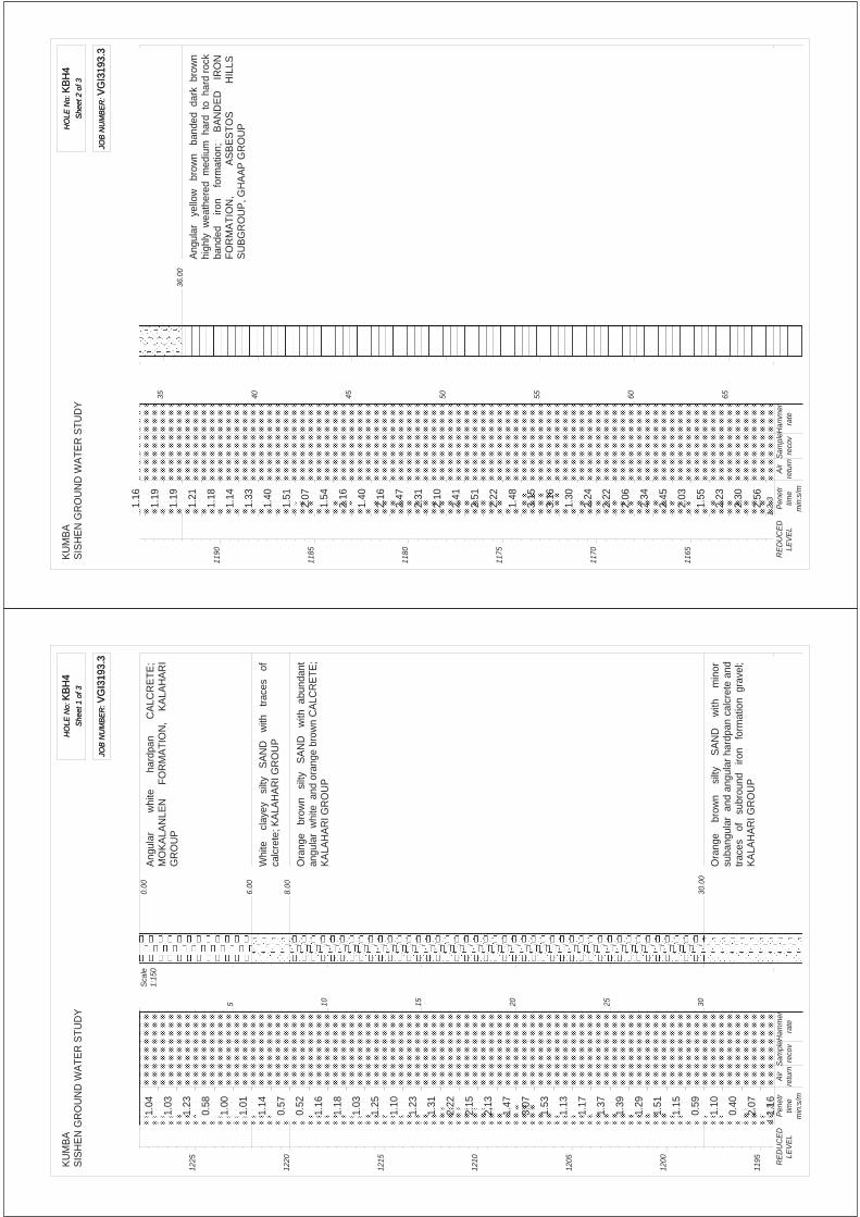
KU
MB
AS
ISH
EN
GR
OU
ND
WA
TER
STU
DY
HO
LE N
o: K
BH
4S
heet
1 o
f 3
HO
LE N
o: K
BH
4S
heet
1 o
f 3
JOB
NU
MB
ER
: VG
I319
3.3
JOB
NU
MB
ER
: VG
I319
3.3
6.0
0
0.0
0
8.0
0
30.
00
Ang
ular
whi
te
ha
rdpa
n
CA
LCR
ET
E;
MO
KA
LAN
LEN
F
OR
MA
TIO
N,
KA
LAH
AR
IG
RO
UP
Whi
te
cla
yey
silt
y S
AN
D
with
tr
aces
of
calc
rete
; KA
LAH
AR
I GR
OU
P
Ora
nge
bro
wn
silt
y S
AN
D
with
abu
ndan
tan
gula
r w
hite
and
ora
nge
brow
n C
ALC
RE
TE;
KA
LAH
AR
I GR
OU
P
Ora
nge
br
own
si
lty
SA
ND
w
ith
min
orsu
bang
ular
and
ang
ular
har
dpan
cal
cret
e an
dtr
aces
of
su
brou
nd
iron
for
mat
ion
gra
vel;
KA
LAH
AR
I GR
OU
P
Sca
le1:
150
122
5
122
0
121
5
121
0
120
5
120
0
119
5
5 10 15 20 25 30
12
3
1.04
1.03
1.23
0.58
1.00
1.01
1.14
0.57
0.52
1.16
1.18
1.03
1.25
1.10
1.23
1.31
2.22
2.15
2.13
1.47
3.07
1.53
1.13
1.17
1.37
1.39
1.29
1.51
1.15
0.59
1.10
0.40
2.07
1.16
Pen
etr
time
min
:s/m
Air
retu
rnS
ampl
ere
cov
Ham
mer
rate
RE
DU
CE
DLE
VE
L
KU
MB
AS
ISH
EN
GR
OU
ND
WA
TER
STU
DY
HO
LE N
o: K
BH
4S
heet
2 o
f 3
HO
LE N
o: K
BH
4S
heet
2 o
f 3
JOB
NU
MB
ER
: VG
I319
3.3
JOB
NU
MB
ER
: VG
I319
3.3
36.
00
Ang
ular
ye
llow
br
own
ban
ded
dar
k b
row
nhi
ghly
wea
ther
ed m
ediu
m h
ard
to h
ard
rock
band
ed
iron
fo
rmat
ion;
B
AN
DE
D
IRO
NF
OR
MA
TIO
N,
A
SB
ES
TO
S
HIL
LSS
UB
GR
OU
P, G
HA
AP
GR
OU
P
119
0
118
5
118
0
117
5
117
0
116
5
35 40 45 50 55 60 65
12
3
1.16
1.19
1.19
1.21
1.18
1.14
1.33
1.40
1.51
2.07
1.54
2.16
1.40
2.16
2.47
2.31
2.10
2.41
2.51
2.22
1.48
3.15
3.16
1.30
2.24
2.22
2.06
2.34
2.45
2.03
1.55
2.23
2.30
2.56
Pen
etr
time
min
:s/m
Air
retu
rnS
ampl
ere
cov
Ham
mer
rate
RE
DU
CE
DLE
VE
L
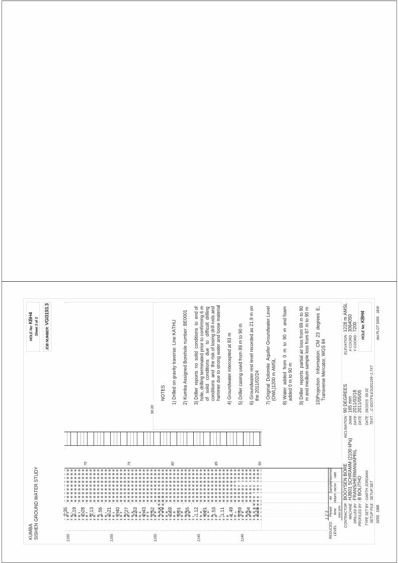
KU
MB
AS
ISH
EN
GR
OU
ND
WA
TER
STU
DY
HO
LE N
o: K
BH
4S
heet
3 o
f 3
HO
LE N
o: K
BH
4S
heet
3 o
f 3
JOB
NU
MB
ER
: VG
I319
3.3
JOB
NU
MB
ER
: VG
I319
3.3
90.
00
NO
TES
1) D
rille
d on
gra
vity
trav
erse
: Lin
e K
ATH
U
2) K
umba
Ass
igne
d B
oreh
ole
num
ber:
BE
0001
3) D
rille
r r
epor
ts n
o s
olid
con
ditio
ns t
o e
nd o
fho
le, d
rillin
g te
rmin
ated
prio
r to
con
firm
ing
6 m
of
solid
co
nditi
ons
due
to
di
fficu
lt d
rillin
gco
nditi
ons
and
the
ris
k of
losi
ng d
rill r
ods
and
ham
mer
due
to s
trong
wat
er a
nd lo
ose
mat
eria
l
4) G
roun
dwat
er in
terc
epte
d at
83
m
5) D
rille
r cas
ing
used
from
89
m to
90
m
6) G
roun
dwat
er r
est l
evel
rec
orde
d as
21.
9 m
on
the
2011
/02/
24
7) O
rigin
al D
olom
ite A
quife
r G
roun
dwat
er L
evel
(OW
L)12
00 m
AM
SL
8) W
ater
add
ed f
rom
0 m
to
90
m a
nd fo
amad
ded
0 m
to 9
0 m
9) D
rille
r r
epor
ts p
artia
l air
loss
from
89
m to
90
m a
nd m
ediu
m s
ampl
e lo
ss fr
om 8
7 m
to 9
0 m
10)P
roje
ctio
n I
nfor
mat
ion:
CM
23
deg
rees
E,
Tran
sver
se M
erca
tor,
WG
S 8
4
CO
NTR
AC
TOR
:M
AC
HIN
E :
DR
ILLE
D B
Y :
PR
OFI
LED
BY
:
TYP
E S
ET
BY
:S
ETU
P F
ILE
:
BO
OY
SE
N B
OR
EH
JB01
SC
HR
AM
M (2
100
kPa)
FRA
NS
/HE
RM
AN
/AP
RIL
B B
OLI
THO
GA
RTH
JO
RD
AA
NS
ETU
P.S
ET
INC
LIN
ATI
ON
:D
IAM
:D
ATE
:D
ATE
:
DA
TE :
TEX
T :90
DE
GR
EE
S16
5 m
m20
11/0
2/18
2011
/05/
0526
/10/
15 0
9:33
..C:\D
OTF
ILE
S\2
0110
9~1.
TXT
ELE
VA
TIO
N :
X-C
OO
RD
:Y
-CO
OR
D :
1228
m A
MS
L30
6405
072
00
dot.P
LOT
5006
J&
WD
055
DB
B
HO
LE N
o: K
BH
4H
OLE
No:
KB
H4
116
0
115
5
115
0
114
5
114
0
70 75 80 85 90
12
3
2.35
2.19
2.28
2.13
1.56
2.21
2.40
2.27
2.53
2.43
2.52
7.20
2.59
3.01
2.55
1.12
3.21
1.53
1.11
1.49
2.59
3.04
5.16
Pen
etr
time
min
:s/m
Air
retu
rnS
ampl
ere
cov
Ham
mer
rate
RE
DU
CE
DLE
VE
L


APPENDIX 2TEST PIT PROFILES
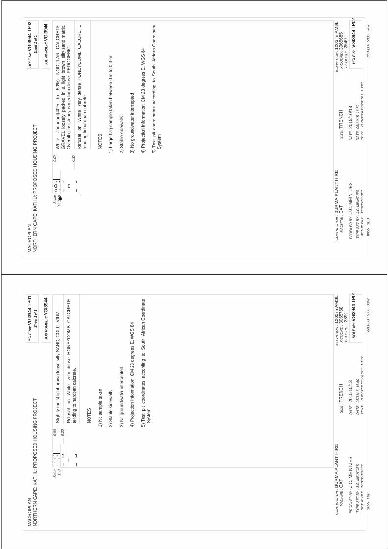
MA
CR
OP
LAN
NO
RTH
ER
N C
AP
E: K
ATH
U: P
RO
PO
SE
D H
OU
SIN
G P
RO
JEC
TH
OLE
No:
VG
I394
4 TP
01S
heet
1 o
f 1
HO
LE N
o: V
GI3
944
TP01
She
et 1
of 1
JOB
NU
MB
ER
: VG
I394
4JO
B N
UM
BE
R: V
GI3
944
0.3
0
0.0
0S
light
ly m
oist
ligh
t bro
wn
loos
e si
lty S
AN
D; C
OLL
UV
IUM
Ref
usal
on
W
hite
ve
ry d
ense
HO
NE
YC
OM
B C
ALC
RE
TE
tend
ing
to h
ardp
an c
alcr
ete.
Sca
le1:
50
NO
TES
1) N
o sa
mpl
e ta
ken
2) S
tabl
e si
dew
alls
3) N
o gr
ound
wat
er in
terc
epte
d
4) P
roje
ctio
n In
form
atio
n: C
M 2
3 de
gree
s E
, WG
S 8
4
5) T
est
pit
coor
dina
tes
acc
ordi
ng t
o S
outh
Afri
can
Coo
rdin
ate
Sys
tem
CO
NTR
AC
TOR
:M
AC
HIN
E :
PR
OFI
LED
BY
:
TYP
E S
ET
BY
:S
ETU
P F
ILE
:
BU
RM
A P
LAN
T H
IRE
CA
T
J.C
. ME
INTJ
ES
J.C
. ME
INTJ
ES
TES
TPIT
S.S
ET
SIZ
E :
DA
TE :
DA
TE :
TEX
T :TR
EN
CH
2015
/10/
1305
/11/
15 1
6:50
..C:\D
OTF
ILE
S\2
0151
1~1.
TXT
ELE
VA
TIO
N :
X-C
OO
RD
:Y
-CO
OR
D :
1205
m A
MS
L30
6576
8-2
390
dot.P
LOT
5006
J&
WD
055
DB
B
HO
LE N
o: V
GI3
944
TP01
HO
LE N
o: V
GI3
944
TP01
0.3
MA
CR
OP
LAN
NO
RTH
ER
N C
AP
E: K
ATH
U: P
RO
PO
SE
D H
OU
SIN
G P
RO
JEC
TH
OLE
No:
VG
I394
4 TP
02S
heet
1 o
f 1
HO
LE N
o: V
GI3
944
TP02
She
et 1
of 1
JOB
NU
MB
ER
: VG
I394
4JO
B N
UM
BE
R: V
GI3
944
0.3
0
0.0
0W
hite
a
bund
ant(
40%
to
5
0%)
N
OD
ULA
R
CA
LCR
ET
EG
RA
VE
L lo
osel
y p
acke
d in
a l
ight
bro
wn
silt
y sa
nd m
atrix
,O
vera
ll co
nsis
tenc
y is
med
ium
den
se; P
ED
OG
EN
IC
Ref
usal
on
W
hite
ve
ry d
ense
HO
NE
YC
OM
B C
ALC
RE
TE
tend
ing
to h
ardp
an c
alcr
ete.
Sca
le1:
50
NO
TES
1) L
arge
bag
sam
ple
take
n be
twee
n 0
m to
0,3
m.
2) S
tabl
e si
dew
alls
3) N
o gr
ound
wat
er in
terc
epte
d
4) P
roje
ctio
n In
form
atio
n: C
M 2
3 de
gree
s E
, WG
S 8
4
5) T
est
pit
coor
dina
tes
acc
ordi
ng t
o S
outh
Afri
can
Coo
rdin
ate
Sys
tem
CO
NTR
AC
TOR
:M
AC
HIN
E :
PR
OFI
LED
BY
:
TYP
E S
ET
BY
:S
ETU
P F
ILE
:
BU
RM
A P
LAN
T H
IRE
CA
T
J.C
. ME
INTJ
ES
J.C
. ME
INTJ
ES
TES
TPIT
S.S
ET
SIZ
E :
DA
TE :
DA
TE :
TEX
T :TR
EN
CH
2015
/10/
1305
/11/
15 1
6:50
..C:\D
OTF
ILE
S\2
0151
1~1.
TXT
ELE
VA
TIO
N :
X-C
OO
RD
:Y
-CO
OR
D :
1205
m A
MS
L30
6568
5-2
549
dot.P
LOT
5006
J&
WD
055
DB
B
HO
LE N
o: V
GI3
944
TP02
HO
LE N
o: V
GI3
944
TP02

MA
CR
OP
LAN
NO
RTH
ER
N C
AP
E: K
ATH
U: P
RO
PO
SE
D H
OU
SIN
G P
RO
JEC
TH
OLE
No:
VG
I394
4 TP
03S
heet
1 o
f 1
HO
LE N
o: V
GI3
944
TP03
She
et 1
of 1
JOB
NU
MB
ER
: VG
I394
4JO
B N
UM
BE
R: V
GI3
944
0.3
0
0.0
0W
hite
a
bund
ant(
40%
to
5
0%)
N
OD
ULA
R
CA
LCR
ET
EG
RA
VE
L lo
osel
y p
acke
d in
a l
ight
bro
wn
silt
y sa
nd m
atrix
,O
vera
ll co
nsis
tenc
y is
med
ium
den
se; P
ED
OG
EN
IC
Ref
usal
on
W
hite
ve
ry d
ense
HO
NE
YC
OM
B C
ALC
RE
TE
tend
ing
to h
ardp
an c
alcr
ete.
Sca
le1:
50
NO
TES
1) N
o sa
mpl
e ta
ken
2) S
tabl
e si
dew
alls
3) N
o gr
ound
wat
er in
terc
epte
d
4) P
roje
ctio
n In
form
atio
n: C
M 2
3 de
gree
s E
, WG
S 8
4
5) T
est
pit
coor
dina
tes
acc
ordi
ng t
o S
outh
Afri
can
Coo
rdin
ate
Sys
tem
CO
NTR
AC
TOR
:M
AC
HIN
E :
PR
OFI
LED
BY
:
TYP
E S
ET
BY
:S
ETU
P F
ILE
:
BU
RM
A P
LAN
T H
IRE
CA
T
J.C
. ME
INTJ
ES
J.C
. ME
INTJ
ES
TES
TPIT
S.S
ET
SIZ
E :
DA
TE :
DA
TE :
TEX
T :TR
EN
CH
2015
/10/
1305
/11/
15 1
6:50
..C:\D
OTF
ILE
S\2
0151
1~1.
TXT
ELE
VA
TIO
N :
X-C
OO
RD
:Y
-CO
OR
D :
1205
m A
MS
L30
6559
6-2
785
dot.P
LOT
5006
J&
WD
055
DB
B
HO
LE N
o: V
GI3
944
TP03
HO
LE N
o: V
GI3
944
TP03
MA
CR
OP
LAN
NO
RTH
ER
N C
AP
E: K
ATH
U: P
RO
PO
SE
D H
OU
SIN
G P
RO
JEC
TH
OLE
No:
VG
I394
4 TP
04S
heet
1 o
f 1
HO
LE N
o: V
GI3
944
TP04
She
et 1
of 1
JOB
NU
MB
ER
: VG
I394
4JO
B N
UM
BE
R: V
GI3
944
0.2
0
0.0
0W
hite
a
bund
ant(
40%
to
5
0%)
N
OD
ULA
R
CA
LCR
ET
EG
RA
VE
L lo
osel
y p
acke
d in
a l
ight
bro
wn
silt
y sa
nd m
atrix
,O
vera
ll co
nsis
tenc
y is
med
ium
den
se; P
ED
OG
EN
IC
Ref
usal
on
W
hite
ve
ry d
ense
HO
NE
YC
OM
B C
ALC
RE
TE
tend
ing
to h
ardp
an c
alcr
ete.
Sca
le1:
50
NO
TES
1) N
o sa
mpl
e ta
ken
2) S
tabl
e si
dew
alls
3) N
o gr
ound
wat
er in
terc
epte
d
4) P
roje
ctio
n In
form
atio
n: C
M 2
3 de
gree
s E
, WG
S 8
4
5) T
est
pit
coor
dina
tes
acc
ordi
ng t
o S
outh
Afri
can
Coo
rdin
ate
Sys
tem
CO
NTR
AC
TOR
:M
AC
HIN
E :
PR
OFI
LED
BY
:
TYP
E S
ET
BY
:S
ETU
P F
ILE
:
BU
RM
A P
LAN
T H
IRE
CA
T
J.C
. ME
INTJ
ES
J.C
. ME
INTJ
ES
TES
TPIT
S.S
ET
SIZ
E :
DA
TE :
DA
TE :
TEX
T :TR
EN
CH
2015
/10/
1305
/11/
15 1
6:50
..C:\D
OTF
ILE
S\2
0151
1~1.
TXT
ELE
VA
TIO
N :
X-C
OO
RD
:Y
-CO
OR
D :
1210
m A
MS
L30
6549
3-3
025
dot.P
LOT
5006
J&
WD
055
DB
B
HO
LE N
o: V
GI3
944
TP04
HO
LE N
o: V
GI3
944
TP04

MA
CR
OP
LAN
NO
RTH
ER
N C
AP
E: K
ATH
U: P
RO
PO
SE
D H
OU
SIN
G P
RO
JEC
TH
OLE
No:
VG
I394
4 TP
05S
heet
1 o
f 1
HO
LE N
o: V
GI3
944
TP05
She
et 1
of 1
JOB
NU
MB
ER
: VG
I394
4JO
B N
UM
BE
R: V
GI3
944
0.4
0
0.0
0W
hite
a
bund
ant(
40%
to
5
0%)
N
OD
ULA
R
CA
LCR
ET
EG
RA
VE
L lo
osel
y p
acke
d in
a l
ight
bro
wn
silt
y sa
nd m
atrix
,O
vera
ll co
nsis
tenc
y is
med
ium
den
se; P
ED
OG
EN
IC
Ref
usal
on
W
hite
ve
ry d
ense
HO
NE
YC
OM
B C
ALC
RE
TE
tend
ing
to h
ardp
an c
alcr
ete.
Sca
le1:
50
NO
TES
1) N
o sa
mpl
e ta
ken
2) S
tabl
e si
dew
alls
3) N
o gr
ound
wat
er in
terc
epte
d
4) P
roje
ctio
n In
form
atio
n: C
M 2
3 de
gree
s E
, WG
S 8
4
5) T
est
pit
coor
dina
tes
acc
ordi
ng t
o S
outh
Afri
can
Coo
rdin
ate
Sys
tem
CO
NTR
AC
TOR
:M
AC
HIN
E :
PR
OFI
LED
BY
:
TYP
E S
ET
BY
:S
ETU
P F
ILE
:
BU
RM
A P
LAN
T H
IRE
CA
T
J.C
. ME
INTJ
ES
J.C
. ME
INTJ
ES
TES
TPIT
S.S
ET
SIZ
E :
DA
TE :
DA
TE :
TEX
T :TR
EN
CH
2015
/10/
1305
/11/
15 1
6:50
..C:\D
OTF
ILE
S\2
0151
1~1.
TXT
ELE
VA
TIO
N :
X-C
OO
RD
:Y
-CO
OR
D :
1205
m A
MS
L30
6552
4-2
329
dot.P
LOT
5006
J&
WD
055
DB
B
HO
LE N
o: V
GI3
944
TP05
HO
LE N
o: V
GI3
944
TP05
MA
CR
OP
LAN
NO
RTH
ER
N C
AP
E: K
ATH
U: P
RO
PO
SE
D H
OU
SIN
G P
RO
JEC
TH
OLE
No:
VG
I394
4 TP
06S
heet
1 o
f 1
HO
LE N
o: V
GI3
944
TP06
She
et 1
of 1
JOB
NU
MB
ER
: VG
I394
4JO
B N
UM
BE
R: V
GI3
944
0.2
0
0.0
0W
hite
a
bund
ant(
40%
to
5
0%)
N
OD
ULA
R
CA
LCR
ET
EG
RA
VE
L lo
osel
y p
acke
d in
a l
ight
bro
wn
silt
y sa
nd m
atrix
,O
vera
ll co
nsis
tenc
y is
med
ium
den
se; P
ED
OG
EN
IC
Ref
usal
on
W
hite
ve
ry d
ense
HO
NE
YC
OM
B C
ALC
RE
TE
tend
ing
to h
ardp
an c
alcr
ete.
Sca
le1:
50
NO
TES
1) N
o sa
mpl
e ta
ken
2) S
tabl
e si
dew
alls
3) N
o gr
ound
wat
er in
terc
epte
d
4) P
roje
ctio
n In
form
atio
n: C
M 2
3 de
gree
s E
, WG
S 8
4
5) T
est
pit
coor
dina
tes
acc
ordi
ng t
o S
outh
Afri
can
Coo
rdin
ate
Sys
tem
CO
NTR
AC
TOR
:M
AC
HIN
E :
PR
OFI
LED
BY
:
TYP
E S
ET
BY
:S
ETU
P F
ILE
:
BU
RM
A P
LAN
T H
IRE
CA
T
J.C
. ME
INTJ
ES
J.C
. ME
INTJ
ES
TES
TPIT
S.S
ET
SIZ
E :
DA
TE :
DA
TE :
TEX
T :TR
EN
CH
2015
/10/
1305
/11/
15 1
6:50
..C:\D
OTF
ILE
S\2
0151
1~1.
TXT
ELE
VA
TIO
N :
X-C
OO
RD
:Y
-CO
OR
D :
1205
m A
MS
L30
6542
1-2
567
dot.P
LOT
5006
J&
WD
055
DB
B
HO
LE N
o: V
GI3
944
TP06
HO
LE N
o: V
GI3
944
TP06

MA
CR
OP
LAN
NO
RTH
ER
N C
AP
E: K
ATH
U: P
RO
PO
SE
D H
OU
SIN
G P
RO
JEC
TH
OLE
No:
VG
I394
4 TP
07S
heet
1 o
f 1
HO
LE N
o: V
GI3
944
TP07
She
et 1
of 1
JOB
NU
MB
ER
: VG
I394
4JO
B N
UM
BE
R: V
GI3
944
0.3
0
0.0
0S
light
ly m
oist
ligh
t bro
wn
loos
e si
lty S
AN
D; C
OLL
UV
IUM
Ref
usal
on
W
hite
ve
ry d
ense
HO
NE
YC
OM
B C
ALC
RE
TE
tend
ing
to h
ardp
an c
alcr
ete.
Sca
le1:
50
NO
TES
1) N
o sa
mpl
e ta
ken
2) S
tabl
e si
dew
alls
3) N
o gr
ound
wat
er in
terc
epte
d
4) P
roje
ctio
n In
form
atio
n: C
M 2
3 de
gree
s E
, WG
S 8
4
5) T
est
pit
coor
dina
tes
acc
ordi
ng t
o S
outh
Afri
can
Coo
rdin
ate
Sys
tem
CO
NTR
AC
TOR
:M
AC
HIN
E :
PR
OFI
LED
BY
:
TYP
E S
ET
BY
:S
ETU
P F
ILE
:
BU
RM
A P
LAN
T H
IRE
CA
T
J.C
. ME
INTJ
ES
J.C
. ME
INTJ
ES
TES
TPIT
S.S
ET
SIZ
E :
DA
TE :
DA
TE :
TEX
T :TR
EN
CH
2015
/10/
1305
/11/
15 1
6:50
..C:\D
OTF
ILE
S\2
0151
1~1.
TXT
ELE
VA
TIO
N :
X-C
OO
RD
:Y
-CO
OR
D :
1205
m A
MS
L30
6531
0-2
814
dot.P
LOT
5006
J&
WD
055
DB
B
HO
LE N
o: V
GI3
944
TP07
HO
LE N
o: V
GI3
944
TP07
MA
CR
OP
LAN
NO
RTH
ER
N C
AP
E: K
ATH
U: P
RO
PO
SE
D H
OU
SIN
G P
RO
JEC
TH
OLE
No:
VG
I394
4 TP
08S
heet
1 o
f 1
HO
LE N
o: V
GI3
944
TP08
She
et 1
of 1
JOB
NU
MB
ER
: VG
I394
4JO
B N
UM
BE
R: V
GI3
944
0.3
0
0.0
0S
light
ly m
oist
ligh
t bro
wn
loos
e si
lty S
AN
D; C
OLL
UV
IUM
Ref
usal
on
W
hite
ve
ry d
ense
HO
NE
YC
OM
B C
ALC
RE
TE
tend
ing
to h
ardp
an c
alcr
ete.
Sca
le1:
50
NO
TES
1) N
o sa
mpl
e ta
ken
2) S
tabl
e si
dew
alls
3) N
o gr
ound
wat
er in
terc
epte
d
4) P
roje
ctio
n In
form
atio
n: C
M 2
3 de
gree
s E
, WG
S 8
4
5) T
est
pit
coor
dina
tes
acc
ordi
ng t
o S
outh
Afri
can
Coo
rdin
ate
Sys
tem
CO
NTR
AC
TOR
:M
AC
HIN
E :
PR
OFI
LED
BY
:
TYP
E S
ET
BY
:S
ETU
P F
ILE
:
BU
RM
A P
LAN
T H
IRE
CA
T
J.C
. ME
INTJ
ES
J.C
. ME
INTJ
ES
TES
TPIT
S.S
ET
SIZ
E :
DA
TE :
DA
TE :
TEX
T :TR
EN
CH
2015
/10/
1305
/11/
15 1
6:50
..C:\D
OTF
ILE
S\2
0151
1~1.
TXT
ELE
VA
TIO
N :
X-C
OO
RD
:Y
-CO
OR
D :
1205
m A
MS
L30
6514
5-2
592
dot.P
LOT
5006
J&
WD
055
DB
B
HO
LE N
o: V
GI3
944
TP08
HO
LE N
o: V
GI3
944
TP08

MA
CR
OP
LAN
NO
RTH
ER
N C
AP
E: K
ATH
U: P
RO
PO
SE
D H
OU
SIN
G P
RO
JEC
TH
OLE
No:
VG
I394
4 TP
09S
heet
1 o
f 1
HO
LE N
o: V
GI3
944
TP09
She
et 1
of 1
JOB
NU
MB
ER
: VG
I394
4JO
B N
UM
BE
R: V
GI3
944
0.2
0
0.0
0S
light
ly m
oist
ligh
t bro
wn
loos
e si
lty S
AN
D; C
OLL
UV
IUM
Ref
usal
on
W
hite
ve
ry d
ense
HO
NE
YC
OM
B C
ALC
RE
TE
tend
ing
to h
ardp
an c
alcr
ete.
Sca
le1:
50
NO
TES
1) N
o sa
mpl
e ta
ken
2) S
tabl
e si
dew
alls
3) N
o gr
ound
wat
er in
terc
epte
d
4) P
roje
ctio
n In
form
atio
n: C
M 2
3 de
gree
s E
, WG
S 8
4
5) T
est
pit
coor
dina
tes
acc
ordi
ng t
o S
outh
Afri
can
Coo
rdin
ate
Sys
tem
CO
NTR
AC
TOR
:M
AC
HIN
E :
PR
OFI
LED
BY
:
TYP
E S
ET
BY
:S
ETU
P F
ILE
:
BU
RM
A P
LAN
T H
IRE
CA
T
J.C
. ME
INTJ
ES
J.C
. ME
INTJ
ES
TES
TPIT
S.S
ET
SIZ
E :
DA
TE :
DA
TE :
TEX
T :TR
EN
CH
2015
/10/
1405
/11/
15 1
6:50
..C:\D
OTF
ILE
S\2
0151
1~1.
TXT
ELE
VA
TIO
N :
X-C
OO
RD
:Y
-CO
OR
D :
1205
m A
MS
L30
6525
1-2
353
dot.P
LOT
5006
J&
WD
055
DB
B
HO
LE N
o: V
GI3
944
TP09
HO
LE N
o: V
GI3
944
TP09
MA
CR
OP
LAN
NO
RTH
ER
N C
AP
E: K
ATH
U: P
RO
PO
SE
D H
OU
SIN
G P
RO
JEC
TH
OLE
No:
VG
I394
4 TP
10S
heet
1 o
f 1
HO
LE N
o: V
GI3
944
TP10
She
et 1
of 1
JOB
NU
MB
ER
: VG
I394
4JO
B N
UM
BE
R: V
GI3
944
0.2
0
0.0
0W
hite
a
bund
ant(
40%
to
5
0%)
N
OD
ULA
R
CA
LCR
ET
EG
RA
VE
L lo
osel
y p
acke
d in
a l
ight
bro
wn
silt
y sa
nd m
atrix
,O
vera
ll co
nsis
tenc
y is
med
ium
den
se; P
ED
OG
EN
IC
Ref
usal
on
W
hite
ve
ry d
ense
HO
NE
YC
OM
B C
ALC
RE
TE
tend
ing
to h
ardp
an c
alcr
ete.
Sca
le1:
50
NO
TES
1) N
o sa
mpl
e ta
ken
2) S
tabl
e si
dew
alls
3) N
o gr
ound
wat
er in
terc
epte
d
4) P
roje
ctio
n In
form
atio
n: C
M 2
3 de
gree
s E
, WG
S 8
4
5) T
est
pit
coor
dina
tes
acc
ordi
ng t
o S
outh
Afri
can
Coo
rdin
ate
Sys
tem
CO
NTR
AC
TOR
:M
AC
HIN
E :
PR
OFI
LED
BY
:
TYP
E S
ET
BY
:S
ETU
P F
ILE
:
BU
RM
A P
LAN
T H
IRE
CA
T
J.C
. ME
INTJ
ES
J.C
. ME
INTJ
ES
TES
TPIT
S.S
ET
SIZ
E :
DA
TE :
DA
TE :
TEX
T :TR
EN
CH
2015
/10/
1405
/11/
15 1
6:50
..C:\D
OTF
ILE
S\2
0151
1~1.
TXT
ELE
VA
TIO
N :
X-C
OO
RD
:Y
-CO
OR
D :
1205
m A
MS
L30
6536
0-2
098
dot.P
LOT
5006
J&
WD
055
DB
B
HO
LE N
o: V
GI3
944
TP10
HO
LE N
o: V
GI3
944
TP10

0.6
MA
CR
OP
LAN
NO
RTH
ER
N C
AP
E: K
ATH
U: P
RO
PO
SE
D H
OU
SIN
G P
RO
JEC
TH
OLE
No:
VG
I394
4 TP
11S
heet
1 o
f 1
HO
LE N
o: V
GI3
944
TP11
She
et 1
of 1
JOB
NU
MB
ER
: VG
I394
4JO
B N
UM
BE
R: V
GI3
944
0.6
0
0.0
0
1.0
0
Red
dish
br
own
abu
ndan
t(60
%
to
70%
) M
IXE
D G
RA
VE
Llo
osel
y
pack
ed
in
a b
row
n s
ilty
san
d m
atrix
, O
vera
llco
nsis
tenc
y is
med
ium
den
se; F
ILL
Whi
te
abu
ndan
t(40
%
to
50%
)
NO
DU
LAR
C
ALC
RE
TE
GR
AV
EL
loos
ely
pac
ked
in a
lig
ht b
row
n s
ilty
sand
mat
rix,
Ove
rall
cons
iste
ncy
is m
ediu
m d
ense
; PE
DO
GE
NIC
Ref
usal
on
W
hite
ve
ry d
ense
HO
NE
YC
OM
B C
ALC
RE
TE
tend
ing
to h
ardp
an c
alcr
ete.
Sca
le1:
50
NO
TES
1) S
mal
l bag
sam
ple
take
n be
twee
n 0
m to
0,6
m.
2) S
tabl
e si
dew
alls
3) N
o gr
ound
wat
er in
terc
epte
d
4) P
roje
ctio
n In
form
atio
n: C
M 2
3 de
gree
s E
, WG
S 8
4
5) T
est
pit
coor
dina
tes
acc
ordi
ng t
o S
outh
Afri
can
Coo
rdin
ate
Sys
tem
CO
NTR
AC
TOR
:M
AC
HIN
E :
PR
OFI
LED
BY
:
TYP
E S
ET
BY
:S
ETU
P F
ILE
:
BU
RM
A P
LAN
T H
IRE
CA
T
J.C
. ME
INTJ
ES
J.C
. ME
INTJ
ES
TES
TPIT
S.S
ET
SIZ
E :
DA
TE :
DA
TE :
TEX
T :TR
EN
CH
2015
/10/
1405
/11/
15 1
6:50
..C:\D
OTF
ILE
S\2
0151
1~1.
TXT
ELE
VA
TIO
N :
X-C
OO
RD
:Y
-CO
OR
D :
1205
m A
MS
L30
6510
4-2
103
dot.P
LOT
5006
J&
WD
055
DB
B
HO
LE N
o: V
GI3
944
TP11
HO
LE N
o: V
GI3
944
TP11
MA
CR
OP
LAN
NO
RTH
ER
N C
AP
E: K
ATH
U: P
RO
PO
SE
D H
OU
SIN
G P
RO
JEC
TH
OLE
No:
VG
I394
4 TP
12S
heet
1 o
f 1
HO
LE N
o: V
GI3
944
TP12
She
et 1
of 1
JOB
NU
MB
ER
: VG
I394
4JO
B N
UM
BE
R: V
GI3
944
0.8
0
0.0
0S
light
ly m
oist
ligh
t bro
wn
loos
e si
lty S
AN
D; C
OLL
UV
IUM
Ref
usal
on
W
hite
ve
ry d
ense
HO
NE
YC
OM
B C
ALC
RE
TE
tend
ing
to h
ardp
an c
alcr
ete.
Sca
le1:
50
NO
TES
1) N
o sa
mpl
e ta
ken
2) S
tabl
e si
dew
alls
3) N
o gr
ound
wat
er in
terc
epte
d
4) P
roje
ctio
n In
form
atio
n: C
M 2
3 de
gree
s E
, WG
S 8
4
5) T
est
pit
coor
dina
tes
acc
ordi
ng t
o S
outh
Afri
can
Coo
rdin
ate
Sys
tem
CO
NTR
AC
TOR
:M
AC
HIN
E :
PR
OFI
LED
BY
:
TYP
E S
ET
BY
:S
ETU
P F
ILE
:
BU
RM
A P
LAN
T H
IRE
CA
T
J.C
. ME
INTJ
ES
J.C
. ME
INTJ
ES
TES
TPIT
S.S
ET
SIZ
E :
DA
TE :
DA
TE :
TEX
T :TR
EN
CH
2015
/10/
1405
/11/
15 1
6:50
..C:\D
OTF
ILE
S\2
0151
1~1.
TXT
ELE
VA
TIO
N :
X-C
OO
RD
:Y
-CO
OR
D :
1205
m A
MS
L30
6498
5-2
374
dot.P
LOT
5006
J&
WD
055
DB
B
HO
LE N
o: V
GI3
944
TP12
HO
LE N
o: V
GI3
944
TP12
0.4
MA
CR
OP
LAN
NO
RTH
ER
N C
AP
E: K
ATH
U: P
RO
PO
SE
D H
OU
SIN
G P
RO
JEC
TH
OLE
No:
VG
I394
4 TP
13S
heet
1 o
f 1
HO
LE N
o: V
GI3
944
TP13
She
et 1
of 1
JOB
NU
MB
ER
: VG
I394
4JO
B N
UM
BE
R: V
GI3
944
0.4
0
0.0
0S
light
ly m
oist
ligh
t bro
wn
loos
e si
lty S
AN
D; C
OLL
UV
IUM
Ref
usal
on
W
hite
ve
ry d
ense
HO
NE
YC
OM
B C
ALC
RE
TE
tend
ing
to h
ardp
an c
alcr
ete.
Sca
le1:
50
NO
TES
1) S
mal
l bag
sam
ple
take
n be
twee
n 0
m to
0,4
m.
2) S
tabl
e si
dew
alls
3) N
o gr
ound
wat
er in
terc
epte
d
4) P
roje
ctio
n In
form
atio
n: C
M 2
3 de
gree
s E
, WG
S 8
4
5) T
est
pit
coor
dina
tes
acc
ordi
ng t
o S
outh
Afri
can
Coo
rdin
ate
Sys
tem
CO
NTR
AC
TOR
:M
AC
HIN
E :
PR
OFI
LED
BY
:
TYP
E S
ET
BY
:S
ETU
P F
ILE
:
BU
RM
A P
LAN
T H
IRE
CA
T
J.C
. ME
INTJ
ES
J.C
. ME
INTJ
ES
TES
TPIT
S.S
ET
SIZ
E :
DA
TE :
DA
TE :
TEX
T :TR
EN
CH
2015
/10/
1405
/11/
15 1
6:50
..C:\D
OTF
ILE
S\2
0151
1~1.
TXT
ELE
VA
TIO
N :
X-C
OO
RD
:Y
-CO
OR
D :
1205
m A
MS
L30
6481
5-2
160
dot.P
LOT
5006
J&
WD
055
DB
B
HO
LE N
o: V
GI3
944
TP13
HO
LE N
o: V
GI3
944
TP13
MA
CR
OP
LAN
NO
RTH
ER
N C
AP
E: K
ATH
U: P
RO
PO
SE
D H
OU
SIN
G P
RO
JEC
TH
OLE
No:
VG
I394
4 TP
14S
heet
1 o
f 1
HO
LE N
o: V
GI3
944
TP14
She
et 1
of 1
JOB
NU
MB
ER
: VG
I394
4JO
B N
UM
BE
R: V
GI3
944
0.4
0
0.0
0W
hite
a
bund
ant(
40%
to
5
0%)
N
OD
ULA
R
CA
LCR
ET
EG
RA
VE
L lo
osel
y p
acke
d in
a l
ight
bro
wn
silt
y sa
nd m
atrix
,O
vera
ll co
nsis
tenc
y is
med
ium
den
se; P
ED
OG
EN
IC
Ref
usal
on
W
hite
ve
ry d
ense
HO
NE
YC
OM
B C
ALC
RE
TE
tend
ing
to h
ardp
an c
alcr
ete.
Sca
le1:
50
NO
TES
1) N
o sa
mpl
e ta
ken
2) S
tabl
e si
dew
alls
3) N
o gr
ound
wat
er in
terc
epte
d
4) P
roje
ctio
n In
form
atio
n: C
M 2
3 de
gree
s E
, WG
S 8
4
5) T
est
pit
coor
dina
tes
acc
ordi
ng t
o S
outh
Afri
can
Coo
rdin
ate
Sys
tem
CO
NTR
AC
TOR
:M
AC
HIN
E :
PR
OFI
LED
BY
:
TYP
E S
ET
BY
:S
ETU
P F
ILE
:
BU
RM
A P
LAN
T H
IRE
CA
T
J.C
. ME
INTJ
ES
J.C
. ME
INTJ
ES
TES
TPIT
S.S
ET
SIZ
E :
DA
TE :
DA
TE :
TEX
T :TR
EN
CH
2015
/10/
1405
/11/
15 1
6:50
..C:\D
OTF
ILE
S\2
0151
1~1.
TXT
ELE
VA
TIO
N :
X-C
OO
RD
:Y
-CO
OR
D :
1204
m A
MS
L30
6457
4-2
115
dot.P
LOT
5006
J&
WD
055
DB
B
HO
LE N
o: V
GI3
944
TP14
HO
LE N
o: V
GI3
944
TP14

0.3
MA
CR
OP
LAN
NO
RTH
ER
N C
AP
E: K
ATH
U: P
RO
PO
SE
D H
OU
SIN
G P
RO
JEC
TH
OLE
No:
VG
I394
4 TP
15S
heet
1 o
f 1
HO
LE N
o: V
GI3
944
TP15
She
et 1
of 1
JOB
NU
MB
ER
: VG
I394
4JO
B N
UM
BE
R: V
GI3
944
0.3
0
0.0
0W
hite
a
bund
ant(
40%
to
5
0%)
N
OD
ULA
R
CA
LCR
ET
EG
RA
VE
L lo
osel
y p
acke
d in
a l
ight
bro
wn
silt
y sa
nd m
atrix
,O
vera
ll co
nsis
tenc
y is
med
ium
den
se; P
ED
OG
EN
IC
Ref
usal
on
W
hite
ve
ry d
ense
HO
NE
YC
OM
B C
ALC
RE
TE
tend
ing
to h
ardp
an c
alcr
ete.
Sca
le1:
50
NO
TES
1) L
arge
bag
sam
ple
take
n be
twee
n 0
m to
0,3
m.
2) S
tabl
e si
dew
alls
3) N
o gr
ound
wat
er in
terc
epte
d
4) P
roje
ctio
n In
form
atio
n: C
M 2
3 de
gree
s E
, WG
S 8
4
5) T
est
pit
coor
dina
tes
acc
ordi
ng t
o S
outh
Afri
can
Coo
rdin
ate
Sys
tem
CO
NTR
AC
TOR
:M
AC
HIN
E :
PR
OFI
LED
BY
:
TYP
E S
ET
BY
:S
ETU
P F
ILE
:
BU
RM
A P
LAN
T H
IRE
CA
T
J.C
. ME
INTJ
ES
J.C
. ME
INTJ
ES
TES
TPIT
S.S
ET
SIZ
E :
DA
TE :
DA
TE :
TEX
T :TR
EN
CH
2015
/10/
1405
/11/
15 1
6:50
..C:\D
OTF
ILE
S\2
0151
1~1.
TXT
ELE
VA
TIO
N :
X-C
OO
RD
:Y
-CO
OR
D :
1205
m A
MS
L30
6418
4-2
417
dot.P
LOT
5006
J&
WD
055
DB
B
HO
LE N
o: V
GI3
944
TP15
HO
LE N
o: V
GI3
944
TP15
MA
CR
OP
LAN
NO
RTH
ER
N C
AP
E: K
ATH
U: P
RO
PO
SE
D H
OU
SIN
G P
RO
JEC
TH
OLE
No:
VG
I394
4 TP
16S
heet
1 o
f 1
HO
LE N
o: V
GI3
944
TP16
She
et 1
of 1
JOB
NU
MB
ER
: VG
I394
4JO
B N
UM
BE
R: V
GI3
944
0.3
0
0.0
0W
hite
a
bund
ant(
40%
to
5
0%)
N
OD
ULA
R
CA
LCR
ET
EG
RA
VE
L lo
osel
y p
acke
d in
a l
ight
bro
wn
silt
y sa
nd m
atrix
,O
vera
ll co
nsis
tenc
y is
med
ium
den
se; P
ED
OG
EN
IC
Ref
usal
on
W
hite
ve
ry d
ense
HO
NE
YC
OM
B C
ALC
RE
TE
tend
ing
to h
ardp
an c
alcr
ete.
Sca
le1:
50
NO
TES
1) N
o sa
mpl
e ta
ken
2) S
tabl
e si
dew
alls
3) N
o gr
ound
wat
er in
terc
epte
d
4) P
roje
ctio
n In
form
atio
n: C
M 2
3 de
gree
s E
, WG
S 8
4
5) T
est
pit
coor
dina
tes
acc
ordi
ng t
o S
outh
Afri
can
Coo
rdin
ate
Sys
tem
CO
NTR
AC
TOR
:M
AC
HIN
E :
PR
OFI
LED
BY
:
TYP
E S
ET
BY
:S
ETU
P F
ILE
:
BU
RM
A P
LAN
T H
IRE
CA
T
J.C
. ME
INTJ
ES
J.C
. ME
INTJ
ES
TES
TPIT
S.S
ET
SIZ
E :
DA
TE :
DA
TE :
TEX
T :TR
EN
CH
2015
/10/
1405
/11/
15 1
6:50
..C:\D
OTF
ILE
S\2
0151
1~1.
TXT
ELE
VA
TIO
N :
X-C
OO
RD
:Y
-CO
OR
D :
1205
m A
MS
L30
6399
9-2
585
dot.P
LOT
5006
J&
WD
055
DB
B
HO
LE N
o: V
GI3
944
TP16
HO
LE N
o: V
GI3
944
TP16

MA
CR
OP
LAN
NO
RTH
ER
N C
AP
E: K
ATH
U: P
RO
PO
SE
D H
OU
SIN
G P
RO
JEC
TH
OLE
No:
VG
I394
4 TP
17S
heet
1 o
f 1
HO
LE N
o: V
GI3
944
TP17
She
et 1
of 1
JOB
NU
MB
ER
: VG
I394
4JO
B N
UM
BE
R: V
GI3
944
0.3
0
0.0
0W
hite
a
bund
ant(
40%
to
5
0%)
N
OD
ULA
R
CA
LCR
ET
EG
RA
VE
L lo
osel
y p
acke
d in
a l
ight
bro
wn
silt
y sa
nd m
atrix
,O
vera
ll co
nsis
tenc
y is
med
ium
den
se; P
ED
OG
EN
IC
Ref
usal
on
W
hite
ve
ry d
ense
HO
NE
YC
OM
B C
ALC
RE
TE
tend
ing
to h
ardp
an c
alcr
ete.
Sca
le1:
50
NO
TES
1) N
o sa
mpl
e ta
ken
2) S
tabl
e si
dew
alls
3) N
o gr
ound
wat
er in
terc
epte
d
4) P
roje
ctio
n In
form
atio
n: C
M 2
3 de
gree
s E
, WG
S 8
4
5) T
est
pit
coor
dina
tes
acc
ordi
ng t
o S
outh
Afri
can
Coo
rdin
ate
Sys
tem
CO
NTR
AC
TOR
:M
AC
HIN
E :
PR
OFI
LED
BY
:
TYP
E S
ET
BY
:S
ETU
P F
ILE
:
BU
RM
A P
LAN
T H
IRE
CA
T
J.C
. ME
INTJ
ES
J.C
. ME
INTJ
ES
TES
TPIT
S.S
ET
SIZ
E :
DA
TE :
DA
TE :
TEX
T :TR
EN
CH
2015
/10/
1405
/11/
15 1
6:51
..C:\D
OTF
ILE
S\2
0151
1~1.
TXT
ELE
VA
TIO
N :
X-C
OO
RD
:Y
-CO
OR
D :
1205
m A
MS
L30
6419
2-2
746
dot.P
LOT
5006
J&
WD
055
DB
B
HO
LE N
o: V
GI3
944
TP17
HO
LE N
o: V
GI3
944
TP17
MA
CR
OP
LAN
NO
RTH
ER
N C
AP
E: K
ATH
U: P
RO
PO
SE
D H
OU
SIN
G P
RO
JEC
TH
OLE
No:
VG
I394
4 TP
18S
heet
1 o
f 1
HO
LE N
o: V
GI3
944
TP18
She
et 1
of 1
JOB
NU
MB
ER
: VG
I394
4JO
B N
UM
BE
R: V
GI3
944
0.4
0
0.0
0W
hite
a
bund
ant(
40%
to
5
0%)
N
OD
ULA
R
CA
LCR
ET
EG
RA
VE
L lo
osel
y p
acke
d in
a l
ight
bro
wn
silt
y sa
nd m
atrix
,O
vera
ll co
nsis
tenc
y is
med
ium
den
se; P
ED
OG
EN
IC
Ref
usal
on
W
hite
ve
ry d
ense
HO
NE
YC
OM
B C
ALC
RE
TE
tend
ing
to h
ardp
an c
alcr
ete.
Sca
le1:
50
NO
TES
1) N
o sa
mpl
e ta
ken
2) S
tabl
e si
dew
alls
3) N
o gr
ound
wat
er in
terc
epte
d
4) P
roje
ctio
n In
form
atio
n: C
M 2
3 de
gree
s E
, WG
S 8
4
5) T
est
pit
coor
dina
tes
acc
ordi
ng t
o S
outh
Afri
can
Coo
rdin
ate
Sys
tem
CO
NTR
AC
TOR
:M
AC
HIN
E :
PR
OFI
LED
BY
:
TYP
E S
ET
BY
:S
ETU
P F
ILE
:
BU
RM
A P
LAN
T H
IRE
CA
T
J.C
. ME
INTJ
ES
J.C
. ME
INTJ
ES
TES
TPIT
S.S
ET
SIZ
E :
DA
TE :
DA
TE :
TEX
T :TR
EN
CH
2015
/10/
1405
/11/
15 1
6:51
..C:\D
OTF
ILE
S\2
0151
1~1.
TXT
ELE
VA
TIO
N :
X-C
OO
RD
:Y
-CO
OR
D :
1205
m A
MS
L30
6436
1-2
558
dot.P
LOT
5006
J&
WD
055
DB
B
HO
LE N
o: V
GI3
944
TP18
HO
LE N
o: V
GI3
944
TP18

MA
CR
OP
LAN
NO
RTH
ER
N C
AP
E: K
ATH
U: P
RO
PO
SE
D H
OU
SIN
G P
RO
JEC
TH
OLE
No:
VG
I394
4 TP
19S
heet
1 o
f 1
HO
LE N
o: V
GI3
944
TP19
She
et 1
of 1
JOB
NU
MB
ER
: VG
I394
4JO
B N
UM
BE
R: V
GI3
944
0.1
0
0.0
0W
hite
a
bund
ant(
40%
to
5
0%)
N
OD
ULA
R
CA
LCR
ET
EG
RA
VE
L lo
osel
y p
acke
d in
a l
ight
bro
wn
silt
y sa
nd m
atrix
,O
vera
ll co
nsis
tenc
y is
med
ium
den
se; P
ED
OG
EN
IC
Ref
usal
on
W
hite
ve
ry d
ense
HO
NE
YC
OM
B C
ALC
RE
TE
tend
ing
to h
ardp
an c
alcr
ete.
Sca
le1:
50
NO
TES
1) N
o sa
mpl
e ta
ken
2) S
tabl
e si
dew
alls
3) N
o gr
ound
wat
er in
terc
epte
d
4) P
roje
ctio
n In
form
atio
n: C
M 2
3 de
gree
s E
, WG
S 8
4
5) T
est
pit
coor
dina
tes
acc
ordi
ng t
o S
outh
Afri
can
Coo
rdin
ate
Sys
tem
CO
NTR
AC
TOR
:M
AC
HIN
E :
PR
OFI
LED
BY
:
TYP
E S
ET
BY
:S
ETU
P F
ILE
:
BU
RM
A P
LAN
T H
IRE
CA
T
J.C
. ME
INTJ
ES
J.C
. ME
INTJ
ES
TES
TPIT
S.S
ET
SIZ
E :
DA
TE :
DA
TE :
TEX
T :TR
EN
CH
2015
/10/
1405
/11/
15 1
6:51
..C:\D
OTF
ILE
S\2
0151
1~1.
TXT
ELE
VA
TIO
N :
X-C
OO
RD
:Y
-CO
OR
D :
1208
m A
MS
L30
6428
8-2
970
dot.P
LOT
5006
J&
WD
055
DB
B
HO
LE N
o: V
GI3
944
TP19
HO
LE N
o: V
GI3
944
TP19
MA
CR
OP
LAN
NO
RTH
ER
N C
AP
E: K
ATH
U: P
RO
PO
SE
D H
OU
SIN
G P
RO
JEC
TH
OLE
No:
VG
I394
4 TP
20S
heet
1 o
f 1
HO
LE N
o: V
GI3
944
TP20
She
et 1
of 1
JOB
NU
MB
ER
: VG
I394
4JO
B N
UM
BE
R: V
GI3
944
0.2
0
0.0
0W
hite
a
bund
ant(
40%
to
5
0%)
N
OD
ULA
R
CA
LCR
ET
EG
RA
VE
L lo
osel
y p
acke
d in
a l
ight
bro
wn
silt
y sa
nd m
atrix
,O
vera
ll co
nsis
tenc
y is
med
ium
den
se; P
ED
OG
EN
IC
Ref
usal
on
W
hite
ve
ry d
ense
HO
NE
YC
OM
B C
ALC
RE
TE
tend
ing
to h
ardp
an c
alcr
ete.
Sca
le1:
50
NO
TES
1) N
o sa
mpl
e ta
ken
2) S
tabl
e si
dew
alls
3) N
o gr
ound
wat
er in
terc
epte
d
4) P
roje
ctio
n In
form
atio
n: C
M 2
3 de
gree
s E
, WG
S 8
4
5) T
est
pit
coor
dina
tes
acc
ordi
ng t
o S
outh
Afri
can
Coo
rdin
ate
Sys
tem
CO
NTR
AC
TOR
:M
AC
HIN
E :
PR
OFI
LED
BY
:
TYP
E S
ET
BY
:S
ETU
P F
ILE
:
BU
RM
A P
LAN
T H
IRE
CA
T
J.C
. ME
INTJ
ES
J.C
. ME
INTJ
ES
TES
TPIT
S.S
ET
SIZ
E :
DA
TE :
DA
TE :
TEX
T :TR
EN
CH
2015
/10/
1405
/11/
15 1
6:51
..C:\D
OTF
ILE
S\2
0151
1~1.
TXT
ELE
VA
TIO
N :
X-C
OO
RD
:Y
-CO
OR
D :
1205
m A
MS
L30
6446
2-2
791
dot.P
LOT
5006
J&
WD
055
DB
B
HO
LE N
o: V
GI3
944
TP20
HO
LE N
o: V
GI3
944
TP20

MA
CR
OP
LAN
NO
RTH
ER
N C
AP
E: K
ATH
U: P
RO
PO
SE
D H
OU
SIN
G P
RO
JEC
TH
OLE
No:
VG
I394
4 TP
21S
heet
1 o
f 1
HO
LE N
o: V
GI3
944
TP21
She
et 1
of 1
JOB
NU
MB
ER
: VG
I394
4JO
B N
UM
BE
R: V
GI3
944
0.3
0
0.0
0W
hite
a
bund
ant(
40%
to
5
0%)
N
OD
ULA
R
CA
LCR
ET
EG
RA
VE
L lo
osel
y p
acke
d in
a l
ight
bro
wn
silt
y sa
nd m
atrix
,O
vera
ll co
nsis
tenc
y is
med
ium
den
se; P
ED
OG
EN
IC
Ref
usal
on
W
hite
ve
ry d
ense
HO
NE
YC
OM
B C
ALC
RE
TE
tend
ing
to h
ardp
an c
alcr
ete.
Sca
le1:
50
NO
TES
1) N
o sa
mpl
e ta
ken
2) S
tabl
e si
dew
alls
3) N
o gr
ound
wat
er in
terc
epte
d
4) P
roje
ctio
n In
form
atio
n: C
M 2
3 de
gree
s E
, WG
S 8
4
5) T
est
pit
coor
dina
tes
acc
ordi
ng t
o S
outh
Afri
can
Coo
rdin
ate
Sys
tem
CO
NTR
AC
TOR
:M
AC
HIN
E :
PR
OFI
LED
BY
:
TYP
E S
ET
BY
:S
ETU
P F
ILE
:
BU
RM
A P
LAN
T H
IRE
CA
T
J.C
. ME
INTJ
ES
J.C
. ME
INTJ
ES
TES
TPIT
S.S
ET
SIZ
E :
DA
TE :
DA
TE :
TEX
T :TR
EN
CH
2015
/10/
1405
/11/
15 1
6:51
..C:\D
OTF
ILE
S\2
0151
1~1.
TXT
ELE
VA
TIO
N :
X-C
OO
RD
:Y
-CO
OR
D :
1205
m A
MS
L30
6464
3-2
603
dot.P
LOT
5006
J&
WD
055
DB
B
HO
LE N
o: V
GI3
944
TP21
HO
LE N
o: V
GI3
944
TP21
0.4
MA
CR
OP
LAN
NO
RTH
ER
N C
AP
E: K
ATH
U: P
RO
PO
SE
D H
OU
SIN
G P
RO
JEC
TH
OLE
No:
VG
I394
4 TP
22S
heet
1 o
f 1
HO
LE N
o: V
GI3
944
TP22
She
et 1
of 1
JOB
NU
MB
ER
: VG
I394
4JO
B N
UM
BE
R: V
GI3
944
0.4
0
0.0
0
0.5
0
Slig
htly
moi
st li
ght b
row
n lo
ose
silty
SA
ND
; CO
LLU
VIU
M
Slig
htly
moi
st li
ght b
row
n m
ediu
m d
ense
silt
y S
AN
D w
ith m
inor
(20%
-30%
) NO
DU
LAR
CA
LCR
ETE
; PE
DO
GE
NIC
Ref
usal
on
W
hite
ve
ry d
ense
HO
NE
YC
OM
B C
ALC
RE
TE
tend
ing
to h
ardp
an c
alcr
ete.
Sca
le1:
50
NO
TES
1) S
mal
l bag
sam
ple
take
n be
twee
n 0
m to
0,4
m.
2) S
tabl
e si
dew
alls
3) N
o gr
ound
wat
er in
terc
epte
d
4) P
roje
ctio
n In
form
atio
n: C
M 2
3 de
gree
s E
, WG
S 8
4
5) T
est
pit
coor
dina
tes
acc
ordi
ng t
o S
outh
Afri
can
Coo
rdin
ate
Sys
tem
CO
NTR
AC
TOR
:M
AC
HIN
E :
PR
OFI
LED
BY
:
TYP
E S
ET
BY
:S
ETU
P F
ILE
:
BU
RM
A P
LAN
T H
IRE
CA
T
J.C
. ME
INTJ
ES
J.C
. ME
INTJ
ES
TES
TPIT
S.S
ET
SIZ
E :
DA
TE :
DA
TE :
TEX
T :TR
EN
CH
2015
/10/
1305
/11/
15 1
6:51
..C:\D
OTF
ILE
S\2
0151
1~1.
TXT
ELE
VA
TIO
N :
X-C
OO
RD
:Y
-CO
OR
D :
1230
m A
MS
L30
6370
1-6
866
dot.P
LOT
5006
J&
WD
055
DB
B
HO
LE N
o: V
GI3
944
TP22
HO
LE N
o: V
GI3
944
TP22
MA
CR
OP
LAN
NO
RTH
ER
N C
AP
E: K
ATH
U: P
RO
PO
SE
D H
OU
SIN
G P
RO
JEC
TH
OLE
No:
VG
I394
4 TP
23S
heet
1 o
f 1
HO
LE N
o: V
GI3
944
TP23
She
et 1
of 1
JOB
NU
MB
ER
: VG
I394
4JO
B N
UM
BE
R: V
GI3
944
0.3
0
0.0
0W
hite
a
bund
ant(
40%
to
5
0%)
N
OD
ULA
R
CA
LCR
ET
EG
RA
VE
L lo
osel
y p
acke
d in
a l
ight
bro
wn
silt
y sa
nd m
atrix
,O
vera
ll co
nsis
tenc
y is
med
ium
den
se; P
ED
OG
EN
IC
Ref
usal
on
W
hite
ve
ry d
ense
HO
NE
YC
OM
B C
ALC
RE
TE
tend
ing
to h
ardp
an c
alcr
ete.
Sca
le1:
50
NO
TES
1) N
o sa
mpl
e ta
ken
2) S
tabl
e si
dew
alls
3) N
o gr
ound
wat
er in
terc
epte
d
4) P
roje
ctio
n In
form
atio
n: C
M 2
3 de
gree
s E
, WG
S 8
4
5) T
est
pit
coor
dina
tes
acc
ordi
ng t
o S
outh
Afri
can
Coo
rdin
ate
Sys
tem
CO
NTR
AC
TOR
:M
AC
HIN
E :
PR
OFI
LED
BY
:
TYP
E S
ET
BY
:S
ETU
P F
ILE
:
BU
RM
A P
LAN
T H
IRE
CA
T
J.C
. ME
INTJ
ES
J.C
. ME
INTJ
ES
TES
TPIT
S.S
ET
SIZ
E :
DA
TE :
DA
TE :
TEX
T :TR
EN
CH
2015
/10/
1405
/11/
15 1
6:51
..C:\D
OTF
ILE
S\2
0151
1~1.
TXT
ELE
VA
TIO
N :
X-C
OO
RD
:Y
-CO
OR
D :
1205
m A
MS
L30
6488
6-2
673
dot.P
LOT
5006
J&
WD
055
DB
B
HO
LE N
o: V
GI3
944
TP23
HO
LE N
o: V
GI3
944
TP23
MA
CR
OP
LAN
NO
RTH
ER
N C
AP
E: K
ATH
U: P
RO
PO
SE
D H
OU
SIN
G P
RO
JEC
TH
OLE
No:
VG
I394
4 TP
25S
heet
1 o
f 1
HO
LE N
o: V
GI3
944
TP25
She
et 1
of 1
JOB
NU
MB
ER
: VG
I394
4JO
B N
UM
BE
R: V
GI3
944
0.2
0
0.0
0W
hite
a
bund
ant(
40%
to
5
0%)
N
OD
ULA
R
CA
LCR
ET
EG
RA
VE
L lo
osel
y p
acke
d in
a l
ight
bro
wn
silt
y sa
nd m
atrix
,O
vera
ll co
nsis
tenc
y is
med
ium
den
se; P
ED
OG
EN
IC
Ref
usal
on
W
hite
ve
ry d
ense
HO
NE
YC
OM
B C
ALC
RE
TE
tend
ing
to h
ardp
an c
alcr
ete.
Sca
le1:
50
NO
TES
1) N
o sa
mpl
e ta
ken
2) S
tabl
e si
dew
alls
3) N
o gr
ound
wat
er in
terc
epte
d
4) P
roje
ctio
n In
form
atio
n: C
M 2
3 de
gree
s E
, WG
S 8
4
5) T
est
pit
coor
dina
tes
acc
ordi
ng t
o S
outh
Afri
can
Coo
rdin
ate
Sys
tem
CO
NTR
AC
TOR
:M
AC
HIN
E :
PR
OFI
LED
BY
:
TYP
E S
ET
BY
:S
ETU
P F
ILE
:
BU
RM
A P
LAN
T H
IRE
CA
T
J.C
. ME
INTJ
ES
J.C
. ME
INTJ
ES
TES
TPIT
S.S
ET
SIZ
E :
DA
TE :
DA
TE :
TEX
T :TR
EN
CH
2015
/10/
1405
/11/
15 1
6:51
..C:\D
OTF
ILE
S\2
0151
1~1.
TXT
ELE
VA
TIO
N :
X-C
OO
RD
:Y
-CO
OR
D :
1210
m A
MS
L30
6453
4-3
059
dot.P
LOT
5006
J&
WD
055
DB
B
HO
LE N
o: V
GI3
944
TP25
HO
LE N
o: V
GI3
944
TP25

0.4
MA
CR
OP
LAN
NO
RTH
ER
N C
AP
E: K
ATH
U: P
RO
PO
SE
D H
OU
SIN
G P
RO
JEC
TH
OLE
No:
VG
I394
4 TP
24S
heet
1 o
f 1
HO
LE N
o: V
GI3
944
TP24
She
et 1
of 1
JOB
NU
MB
ER
: VG
I394
4JO
B N
UM
BE
R: V
GI3
944
0.4
0
0.0
0S
light
ly m
oist
ligh
t bro
wn
loos
e si
lty S
AN
D; C
OLL
UV
IUM
Ref
usal
on
W
hite
ve
ry d
ense
HO
NE
YC
OM
B C
ALC
RE
TE
tend
ing
to h
ardp
an c
alcr
ete.
Sca
le1:
50
NO
TES
1) S
mal
l sam
ple
take
n be
twee
n 0
m to
0,4
m.
2) S
tabl
e si
dew
alls
3) N
o gr
ound
wat
er in
terc
epte
d
4) P
roje
ctio
n In
form
atio
n: C
M 2
3 de
gree
s E
, WG
S 8
4
5) T
est
pit
coor
dina
tes
acc
ordi
ng t
o S
outh
Afri
can
Coo
rdin
ate
Sys
tem
CO
NTR
AC
TOR
:M
AC
HIN
E :
PR
OFI
LED
BY
:
TYP
E S
ET
BY
:S
ETU
P F
ILE
:
BU
RM
A P
LAN
T H
IRE
CA
T
J.C
. ME
INTJ
ES
J.C
. ME
INTJ
ES
TES
TPIT
S.S
ET
SIZ
E :
DA
TE :
DA
TE :
TEX
T :TR
EN
CH
2015
/10/
1405
/11/
15 1
6:51
..C:\D
OTF
ILE
S\2
0151
1~1.
TXT
ELE
VA
TIO
N :
X-C
OO
RD
:Y
-CO
OR
D :
1205
m A
MS
L30
6471
8-2
871
dot.P
LOT
5006
J&
WD
055
DB
B
HO
LE N
o: V
GI3
944
TP24
HO
LE N
o: V
GI3
944
TP24
0.8
MA
CR
OP
LAN
NO
RTH
ER
N C
AP
E: K
ATH
U: P
RO
PO
SE
D H
OU
SIN
G P
RO
JEC
TH
OLE
No:
VG
I394
4 TP
26S
heet
1 o
f 1
HO
LE N
o: V
GI3
944
TP26
She
et 1
of 1
JOB
NU
MB
ER
: VG
I394
4JO
B N
UM
BE
R: V
GI3
944
0.4
0
0.0
0W
hite
a
bund
ant(
40%
to
5
0%)
N
OD
ULA
R
CA
LCR
ET
EG
RA
VE
L lo
osel
y p
acke
d in
a l
ight
bro
wn
silt
y sa
nd m
atrix
,O
vera
ll co
nsis
tenc
y is
med
ium
den
se; P
ED
OG
EN
IC
Ref
usal
on
W
hite
ve
ry d
ense
HO
NE
YC
OM
B C
ALC
RE
TE
tend
ing
to h
ardp
an c
alcr
ete.
Sca
le1:
50
NO
TES
1) L
arge
bag
sam
ple
take
n be
twee
n 0
m to
0,8
m.
2) S
tabl
e si
dew
alls
3) N
o gr
ound
wat
er in
terc
epte
d
4) P
roje
ctio
n In
form
atio
n: C
M 2
3 de
gree
s E
, WG
S 8
4
5) T
est
pit
coor
dina
tes
acc
ordi
ng t
o S
outh
Afri
can
Coo
rdin
ate
Sys
tem
CO
NTR
AC
TOR
:M
AC
HIN
E :
PR
OFI
LED
BY
:
TYP
E S
ET
BY
:S
ETU
P F
ILE
:
BU
RM
A P
LAN
T H
IRE
CA
T
J.C
. ME
INTJ
ES
J.C
. ME
INTJ
ES
TES
TPIT
S.S
ET
SIZ
E :
DA
TE :
DA
TE :
TEX
T :TR
EN
CH
2015
/10/
1405
/11/
15 1
6:51
..C:\D
OTF
ILE
S\2
0151
1~1.
TXT
ELE
VA
TIO
N :
X-C
OO
RD
:Y
-CO
OR
D :
1205
m A
MS
L30
6487
7-2
866
dot.P
LOT
5006
J&
WD
055
DB
B
HO
LE N
o: V
GI3
944
TP26
HO
LE N
o: V
GI3
944
TP26

0.2
MA
CR
OP
LAN
NO
RTH
ER
N C
AP
E: K
ATH
U: P
RO
PO
SE
D H
OU
SIN
G P
RO
JEC
TH
OLE
No:
VG
I394
4 TP
27S
heet
1 o
f 1
HO
LE N
o: V
GI3
944
TP27
She
et 1
of 1
JOB
NU
MB
ER
: VG
I394
4JO
B N
UM
BE
R: V
GI3
944
0.2
0
0.0
0W
hite
a
bund
ant(
40%
to
5
0%)
N
OD
ULA
R
CA
LCR
ET
EG
RA
VE
L lo
osel
y p
acke
d in
a l
ight
bro
wn
silt
y sa
nd m
atrix
,O
vera
ll co
nsis
tenc
y is
med
ium
den
se; P
ED
OG
EN
IC
Ref
usal
on
W
hite
ve
ry d
ense
HO
NE
YC
OM
B C
ALC
RE
TE
tend
ing
to h
ardp
an c
alcr
ete.
Sca
le1:
50
NO
TES
1) S
mal
l bag
sam
ple
take
n be
twee
n 0
m to
0,2
m.
2) S
tabl
e si
dew
alls
3) N
o gr
ound
wat
er in
terc
epte
d
4) P
roje
ctio
n In
form
atio
n: C
M 2
3 de
gree
s E
, WG
S 8
4
5) T
est
pit
coor
dina
tes
acc
ordi
ng t
o S
outh
Afri
can
Coo
rdin
ate
Sys
tem
CO
NTR
AC
TOR
:M
AC
HIN
E :
PR
OFI
LED
BY
:
TYP
E S
ET
BY
:S
ETU
P F
ILE
:
BU
RM
A P
LAN
T H
IRE
CA
T
J.C
. ME
INTJ
ES
J.C
. ME
INTJ
ES
TES
TPIT
S.S
ET
SIZ
E :
DA
TE :
DA
TE :
TEX
T :TR
EN
CH
2015
/10/
1405
/11/
15 1
6:51
..C:\D
OTF
ILE
S\2
0151
1~1.
TXT
ELE
VA
TIO
N :
X-C
OO
RD
:Y
-CO
OR
D :
1210
m A
MS
L30
6476
4-3
075
dot.P
LOT
5006
J&
WD
055
DB
B
HO
LE N
o: V
GI3
944
TP27
HO
LE N
o: V
GI3
944
TP27
MA
CR
OP
LAN
NO
RTH
ER
N C
AP
E: K
ATH
U: P
RO
PO
SE
D H
OU
SIN
G P
RO
JEC
TH
OLE
No:
VG
I394
4 TP
28S
heet
1 o
f 1
HO
LE N
o: V
GI3
944
TP28
She
et 1
of 1
JOB
NU
MB
ER
: VG
I394
4JO
B N
UM
BE
R: V
GI3
944
0.6
0
0.0
0S
light
ly m
oist
ligh
t bro
wn
loos
e si
lty S
AN
D; C
OLL
UV
IUM
Ref
usal
on
W
hite
ve
ry d
ense
HO
NE
YC
OM
B C
ALC
RE
TE
tend
ing
to h
ardp
an c
alcr
ete.
Sca
le1:
50
NO
TES
1) N
o sa
mpl
e ta
ken
2) S
tabl
e si
dew
alls
3) N
o gr
ound
wat
er in
terc
epte
d
4) P
roje
ctio
n In
form
atio
n: C
M 2
3 de
gree
s E
, WG
S 8
4
5) T
est
pit
coor
dina
tes
acc
ordi
ng t
o S
outh
Afri
can
Coo
rdin
ate
Sys
tem
CO
NTR
AC
TOR
:M
AC
HIN
E :
PR
OFI
LED
BY
:
TYP
E S
ET
BY
:S
ETU
P F
ILE
:
BU
RM
A P
LAN
T H
IRE
CA
T
J.C
. ME
INTJ
ES
J.C
. ME
INTJ
ES
TES
TPIT
S.S
ET
SIZ
E :
DA
TE :
DA
TE :
TEX
T :TR
EN
CH
2015
/10/
1305
/11/
15 1
6:51
..C:\D
OTF
ILE
S\2
0151
1~1.
TXT
ELE
VA
TIO
N :
X-C
OO
RD
:Y
-CO
OR
D :
1230
m A
MS
L30
6391
1-6
767
dot.P
LOT
5006
J&
WD
055
DB
B
HO
LE N
o: V
GI3
944
TP28
HO
LE N
o: V
GI3
944
TP28

MA
CR
OP
LAN
NO
RTH
ER
N C
AP
E: K
ATH
U: P
RO
PO
SE
D H
OU
SIN
G P
RO
JEC
TH
OLE
No:
VG
I394
4 TP
29S
heet
1 o
f 1
HO
LE N
o: V
GI3
944
TP29
She
et 1
of 1
JOB
NU
MB
ER
: VG
I394
4JO
B N
UM
BE
R: V
GI3
944
0.5
0
0.0
0S
light
ly m
oist
ligh
t bro
wn
loos
e si
lty S
AN
D; C
OLL
UV
IUM
Ref
usal
on
W
hite
ve
ry d
ense
HO
NE
YC
OM
B C
ALC
RE
TE
tend
ing
to h
ardp
an c
alcr
ete.
Sca
le1:
50
NO
TES
1) N
o sa
mpl
e ta
ken
2) S
tabl
e si
dew
alls
3) N
o gr
ound
wat
er in
terc
epte
d
4) P
roje
ctio
n In
form
atio
n: C
M 2
3 de
gree
s E
, WG
S 8
4
5) T
est
pit
coor
dina
tes
acc
ordi
ng t
o S
outh
Afri
can
Coo
rdin
ate
Sys
tem
CO
NTR
AC
TOR
:M
AC
HIN
E :
PR
OFI
LED
BY
:
TYP
E S
ET
BY
:S
ETU
P F
ILE
:
BU
RM
A P
LAN
T H
IRE
CA
T
J.C
. ME
INTJ
ES
J.C
. ME
INTJ
ES
TES
TPIT
S.S
ET
SIZ
E :
DA
TE :
DA
TE :
TEX
T :TR
EN
CH
2015
/10/
1305
/11/
15 1
6:51
..C:\D
OTF
ILE
S\2
0151
1~1.
TXT
ELE
VA
TIO
N :
X-C
OO
RD
:Y
-CO
OR
D :
1230
m A
MS
L30
6360
7-7
078
dot.P
LOT
5006
J&
WD
055
DB
B
HO
LE N
o: V
GI3
944
TP29
HO
LE N
o: V
GI3
944
TP29
MA
CR
OP
LAN
NO
RTH
ER
N C
AP
E: K
ATH
U: P
RO
PO
SE
D H
OU
SIN
G P
RO
JEC
TH
OLE
No:
VG
I394
4 TP
30S
heet
1 o
f 1
HO
LE N
o: V
GI3
944
TP30
She
et 1
of 1
JOB
NU
MB
ER
: VG
I394
4JO
B N
UM
BE
R: V
GI3
944
0.2
0
0.0
0
1.2
0
Slig
htly
moi
st li
ght b
row
n lo
ose
silty
SA
ND
; CO
LLU
VIU
M
Whi
te
abu
ndan
t(60
%
to
80%
)
NO
DU
LAR
C
ALC
RE
TE
GR
AV
EL
den
sly
pac
ked
in a
whi
te t
o li
ght b
row
n si
lty s
and
mat
rix, O
vera
ll co
nsis
tenc
y is
den
se; P
ED
OG
EN
IC
Ref
usal
on
W
hite
ve
ry d
ense
HO
NE
YC
OM
B C
ALC
RE
TE
tend
ing
to h
ardp
an c
alcr
ete.
Sca
le1:
50
NO
TES
1) N
o sa
mpl
e ta
ken
2) S
tabl
e si
dew
alls
3) N
o gr
ound
wat
er in
terc
epte
d
4) P
roje
ctio
n In
form
atio
n: C
M 2
3 de
gree
s E
, WG
S 8
4
5) T
est
pit
coor
dina
tes
acc
ordi
ng t
o S
outh
Afri
can
Coo
rdin
ate
Sys
tem
CO
NTR
AC
TOR
:M
AC
HIN
E :
PR
OFI
LED
BY
:
TYP
E S
ET
BY
:S
ETU
P F
ILE
:
BU
RM
A P
LAN
T H
IRE
CA
T
J.C
. ME
INTJ
ES
J.C
. ME
INTJ
ES
TES
TPIT
S.S
ET
SIZ
E :
DA
TE :
DA
TE :
TEX
T :TR
EN
CH
2015
/10/
1305
/11/
15 1
6:51
..C:\D
OTF
ILE
S\2
0151
1~1.
TXT
ELE
VA
TIO
N :
X-C
OO
RD
:Y
-CO
OR
D :
1230
m A
MS
L30
6273
9-6
323
dot.P
LOT
5006
J&
WD
055
DB
B
HO
LE N
o: V
GI3
944
TP30
HO
LE N
o: V
GI3
944
TP30
MA
CR
OP
LAN
NO
RTH
ER
N C
AP
E: K
ATH
U: P
RO
PO
SE
D H
OU
SIN
G P
RO
JEC
TH
OLE
No:
VG
I394
4 TP
31S
heet
1 o
f 1
HO
LE N
o: V
GI3
944
TP31
She
et 1
of 1
JOB
NU
MB
ER
: VG
I394
4JO
B N
UM
BE
R: V
GI3
944
0.3
0
0.0
0S
light
ly m
oist
ligh
t bro
wn
loos
e si
lty S
AN
D; C
OLL
UV
IUM
Ref
usal
on
W
hite
ve
ry d
ense
HO
NE
YC
OM
B C
ALC
RE
TE
tend
ing
to h
ardp
an c
alcr
ete.
Sca
le1:
50
NO
TES
1) N
o sa
mpl
e ta
ken
2) S
tabl
e si
dew
alls
3) N
o gr
ound
wat
er in
terc
epte
d
4) P
roje
ctio
n In
form
atio
n: C
M 2
3 de
gree
s E
, WG
S 8
4
5) T
est
pit
coor
dina
tes
acc
ordi
ng t
o S
outh
Afri
can
Coo
rdin
ate
Sys
tem
CO
NTR
AC
TOR
:M
AC
HIN
E :
PR
OFI
LED
BY
:
TYP
E S
ET
BY
:S
ETU
P F
ILE
:
BU
RM
A P
LAN
T H
IRE
CA
T
J.C
. ME
INTJ
ES
J.C
. ME
INTJ
ES
TES
TPIT
S.S
ET
SIZ
E :
DA
TE :
DA
TE :
TEX
T :TR
EN
CH
2015
/10/
1305
/11/
15 1
6:51
..C:\D
OTF
ILE
S\2
0151
1~1.
TXT
ELE
VA
TIO
N :
X-C
OO
RD
:Y
-CO
OR
D :
1230
m A
MS
L30
6299
1-6
325
dot.P
LOT
5006
J&
WD
055
DB
B
HO
LE N
o: V
GI3
944
TP31
HO
LE N
o: V
GI3
944
TP31
MA
CR
OP
LAN
NO
RTH
ER
N C
AP
E: K
ATH
U: P
RO
PO
SE
D H
OU
SIN
G P
RO
JEC
TH
OLE
No:
VG
I394
4 TP
32S
heet
1 o
f 1
HO
LE N
o: V
GI3
944
TP32
She
et 1
of 1
JOB
NU
MB
ER
: VG
I394
4JO
B N
UM
BE
R: V
GI3
944
0.2
0
0.0
0
0.4
0
Slig
htly
moi
st li
ght b
row
n lo
ose
silty
SA
ND
; CO
LLU
VIU
M
Slig
htly
moi
st li
ght b
row
n m
ediu
m d
ense
silt
y S
AN
D w
ith m
inor
(20%
-30%
) N
OD
ULA
R C
ALC
RE
TE
GR
AV
EL
and
CO
BB
LES
;P
ED
OG
EN
IC
Ref
usal
on
W
hite
ve
ry d
ense
HO
NE
YC
OM
B C
ALC
RE
TE
tend
ing
to h
ardp
an c
alcr
ete.
Sca
le1:
50
NO
TES
1) N
o sa
mpl
e ta
ken
2) S
tabl
e si
dew
alls
3) N
o gr
ound
wat
er in
terc
epte
d
4) P
roje
ctio
n In
form
atio
n: C
M 2
3 de
gree
s E
, WG
S 8
4
5) T
est
pit
coor
dina
tes
acc
ordi
ng t
o S
outh
Afri
can
Coo
rdin
ate
Sys
tem
CO
NTR
AC
TOR
:M
AC
HIN
E :
PR
OFI
LED
BY
:
TYP
E S
ET
BY
:S
ETU
P F
ILE
:
BU
RM
A P
LAN
T H
IRE
CA
T
J.C
. ME
INTJ
ES
J.C
. ME
INTJ
ES
TES
TPIT
S.S
ET
SIZ
E :
DA
TE :
DA
TE :
TEX
T :TR
EN
CH
2015
/10/
1305
/11/
15 1
6:51
..C:\D
OTF
ILE
S\2
0151
1~1.
TXT
ELE
VA
TIO
N :
X-C
OO
RD
:Y
-CO
OR
D :
1230
m A
MS
L30
6292
3-6
511
dot.P
LOT
5006
J&
WD
055
DB
B
HO
LE N
o: V
GI3
944
TP32
HO
LE N
o: V
GI3
944
TP32

MA
CR
OP
LAN
NO
RTH
ER
N C
AP
E: K
ATH
U: P
RO
PO
SE
D H
OU
SIN
G P
RO
JEC
TH
OLE
No:
VG
I394
4 TP
33S
heet
1 o
f 1
HO
LE N
o: V
GI3
944
TP33
She
et 1
of 1
JOB
NU
MB
ER
: VG
I394
4JO
B N
UM
BE
R: V
GI3
944
0.5
0
0.0
0S
light
ly m
oist
ligh
t bro
wn
loos
e si
lty S
AN
D; C
OLL
UV
IUM
Ref
usal
on
W
hite
ve
ry d
ense
HO
NE
YC
OM
B C
ALC
RE
TE
tend
ing
to h
ardp
an c
alcr
ete.
Sca
le1:
50
NO
TES
1) N
o sa
mpl
e ta
ken
2) S
tabl
e si
dew
alls
3) N
o gr
ound
wat
er in
terc
epte
d
4) P
roje
ctio
n In
form
atio
n: C
M 2
3 de
gree
s E
, WG
S 8
4
5) T
est
pit
coor
dina
tes
acc
ordi
ng t
o S
outh
Afri
can
Coo
rdin
ate
Sys
tem
CO
NTR
AC
TOR
:M
AC
HIN
E :
PR
OFI
LED
BY
:
TYP
E S
ET
BY
:S
ETU
P F
ILE
:
BU
RM
A P
LAN
T H
IRE
CA
T
J.C
. ME
INTJ
ES
J.C
. ME
INTJ
ES
TES
TPIT
S.S
ET
SIZ
E :
DA
TE :
DA
TE :
TEX
T :TR
EN
CH
2015
/10/
1305
/11/
15 1
6:51
..C:\D
OTF
ILE
S\2
0151
1~1.
TXT
ELE
VA
TIO
N :
X-C
OO
RD
:Y
-CO
OR
D :
1230
m A
MS
L30
6317
5-6
530
dot.P
LOT
5006
J&
WD
055
DB
B
HO
LE N
o: V
GI3
944
TP33
HO
LE N
o: V
GI3
944
TP33
MA
CR
OP
LAN
NO
RTH
ER
N C
AP
E: K
ATH
U: P
RO
PO
SE
D H
OU
SIN
G P
RO
JEC
TH
OLE
No:
VG
I394
4 TP
34S
heet
1 o
f 1
HO
LE N
o: V
GI3
944
TP34
She
et 1
of 1
JOB
NU
MB
ER
: VG
I394
4JO
B N
UM
BE
R: V
GI3
944
0.5
0
0.0
0S
light
ly m
oist
ligh
t bro
wn
loos
e si
lty S
AN
D; C
OLL
UV
IUM
Ref
usal
on
W
hite
ve
ry d
ense
HO
NE
YC
OM
B C
ALC
RE
TE
tend
ing
to h
ardp
an c
alcr
ete.
Sca
le1:
50
NO
TES
1) N
o sa
mpl
e ta
ken
2) S
tabl
e si
dew
alls
3) N
o gr
ound
wat
er in
terc
epte
d
4) P
roje
ctio
n In
form
atio
n: C
M 2
3 de
gree
s E
, WG
S 8
4
5) T
est
pit
coor
dina
tes
acc
ordi
ng t
o S
outh
Afri
can
Coo
rdin
ate
Sys
tem
CO
NTR
AC
TOR
:M
AC
HIN
E :
PR
OFI
LED
BY
:
TYP
E S
ET
BY
:S
ETU
P F
ILE
:
BU
RM
A P
LAN
T H
IRE
CA
T
J.C
. ME
INTJ
ES
J.C
. ME
INTJ
ES
TES
TPIT
S.S
ET
SIZ
E :
DA
TE :
DA
TE :
TEX
T :TR
EN
CH
2015
/10/
1305
/11/
15 1
6:51
..C:\D
OTF
ILE
S\2
0151
1~1.
TXT
ELE
VA
TIO
N :
X-C
OO
RD
:Y
-CO
OR
D :
1230
m A
MS
L30
6339
8-6
480
dot.P
LOT
5006
J&
WD
055
DB
B
HO
LE N
o: V
GI3
944
TP34
HO
LE N
o: V
GI3
944
TP34

MA
CR
OP
LAN
NO
RTH
ER
N C
AP
E: K
ATH
U: P
RO
PO
SE
D H
OU
SIN
G P
RO
JEC
TH
OLE
No:
VG
I394
4 TP
35S
heet
1 o
f 1
HO
LE N
o: V
GI3
944
TP35
She
et 1
of 1
JOB
NU
MB
ER
: VG
I394
4JO
B N
UM
BE
R: V
GI3
944
0.4
0
0.0
0S
light
ly m
oist
ligh
t bro
wn
loos
e si
lty S
AN
D; C
OLL
UV
IUM
Ref
usal
on
W
hite
ve
ry d
ense
HO
NE
YC
OM
B C
ALC
RE
TE
tend
ing
to h
ardp
an c
alcr
ete.
Sca
le1:
50
NO
TES
1) N
o sa
mpl
e ta
ken
2) S
tabl
e si
dew
alls
3) N
o gr
ound
wat
er in
terc
epte
d
4) P
roje
ctio
n In
form
atio
n: C
M 2
3 de
gree
s E
, WG
S 8
4
5) T
est
pit
coor
dina
tes
acc
ordi
ng t
o S
outh
Afri
can
Coo
rdin
ate
Sys
tem
CO
NTR
AC
TOR
:M
AC
HIN
E :
PR
OFI
LED
BY
:
TYP
E S
ET
BY
:S
ETU
P F
ILE
:
BU
RM
A P
LAN
T H
IRE
CA
T
J.C
. ME
INTJ
ES
J.C
. ME
INTJ
ES
TES
TPIT
S.S
ET
SIZ
E :
DA
TE :
DA
TE :
TEX
T :TR
EN
CH
2015
/10/
1305
/11/
15 1
6:51
..C:\D
OTF
ILE
S\2
0151
1~1.
TXT
ELE
VA
TIO
N :
X-C
OO
RD
:Y
-CO
OR
D :
1230
m A
MS
L30
6330
5-6
720
dot.P
LOT
5006
J&
WD
055
DB
B
HO
LE N
o: V
GI3
944
TP35
HO
LE N
o: V
GI3
944
TP35
0.4
0.2
0.4
1.1
MA
CR
OP
LAN
NO
RTH
ER
N C
AP
E: K
ATH
U: P
RO
PO
SE
D H
OU
SIN
G P
RO
JEC
TH
OLE
No:
VG
I394
4 TP
36S
heet
1 o
f 1
HO
LE N
o: V
GI3
944
TP36
She
et 1
of 1
JOB
NU
MB
ER
: VG
I394
4JO
B N
UM
BE
R: V
GI3
944
0.4
0
0.0
0
1.1
0
Slig
htly
m
oist
li
ght
bro
wn
med
ium
de
nse
silt
y S
AN
D;
CO
LLU
VIU
M
Whi
te
abu
ndan
t(60
%
to
80%
)
NO
DU
LAR
C
ALC
RE
TE
GR
AV
EL
den
sly
pac
ked
in a
whi
te t
o li
ght b
row
n si
lty s
and
mat
rix, O
vera
ll co
nsis
tenc
y is
den
se; P
ED
OG
EN
IC
Ref
usal
on
W
hite
ve
ry d
ense
HO
NE
YC
OM
B C
ALC
RE
TE
tend
ing
to h
ardp
an c
alcr
ete.
Sca
le1:
50
NO
TES
1) S
mal
l ba
g s
ampl
e ta
ken
bew
teen
0 m
to 0
,4 m
, und
istu
rbed
sam
ple
take
n a
t 0.
2 m
and
larg
e ba
g sa
mpl
e ta
ken
betw
een
0,4
m to
1,1
m.
2) S
tabl
e si
dew
alls
3) N
o gr
ound
wat
er in
terc
epte
d
4) P
roje
ctio
n In
form
atio
n: C
M 2
3 de
gree
s E
, WG
S 8
4
5) T
est
pit
coor
dina
tes
acc
ordi
ng t
o S
outh
Afri
can
Coo
rdin
ate
Sys
tem
CO
NTR
AC
TOR
:M
AC
HIN
E :
PR
OFI
LED
BY
:
TYP
E S
ET
BY
:S
ETU
P F
ILE
:
BU
RM
A P
LAN
T H
IRE
CA
T
J.C
. ME
INTJ
ES
J.C
. ME
INTJ
ES
TES
TPIT
S.S
ET
SIZ
E :
DA
TE :
DA
TE :
TEX
T :TR
EN
CH
2015
/10/
1305
/11/
15 1
6:51
..C:\D
OTF
ILE
S\2
0151
1~1.
TXT
ELE
VA
TIO
N :
X-C
OO
RD
:Y
-CO
OR
D :
1230
m A
MS
L30
6348
6-6
968
dot.P
LOT
5006
J&
WD
055
DB
B
HO
LE N
o: V
GI3
944
TP36
HO
LE N
o: V
GI3
944
TP36

MA
CR
OP
LAN
NO
RTH
ER
N C
AP
E: K
ATH
U: P
RO
PO
SE
D H
OU
SIN
G P
RO
JEC
TH
OLE
No:
VG
I394
4 TP
37S
heet
1 o
f 1
HO
LE N
o: V
GI3
944
TP37
She
et 1
of 1
JOB
NU
MB
ER
: VG
I394
4JO
B N
UM
BE
R: V
GI3
944
0.9
0
0.0
0S
light
ly m
oist
ligh
t bro
wn
loos
e si
lty S
AN
D; C
OLL
UV
IUM
Ref
usal
on
W
hite
ve
ry d
ense
HO
NE
YC
OM
B C
ALC
RE
TE
tend
ing
to h
ardp
an c
alcr
ete.
Sca
le1:
50
NO
TES
1) N
o sa
mpl
e ta
ken
2) S
tabl
e si
dew
alls
3) N
o gr
ound
wat
er in
terc
epte
d
4) P
roje
ctio
n In
form
atio
n: C
M 2
3 de
gree
s E
, WG
S 8
4
5) T
est
pit
coor
dina
tes
acc
ordi
ng t
o S
outh
Afri
can
Coo
rdin
ate
Sys
tem
CO
NTR
AC
TOR
:M
AC
HIN
E :
PR
OFI
LED
BY
:
TYP
E S
ET
BY
:S
ETU
P F
ILE
:
BU
RM
A P
LAN
T H
IRE
CA
T
J.C
. ME
INTJ
ES
J.C
. ME
INTJ
ES
TES
TPIT
S.S
ET
SIZ
E :
DA
TE :
DA
TE :
TEX
T :TR
EN
CH
2015
/10/
1305
/11/
15 1
6:51
..C:\D
OTF
ILE
S\2
0151
1~1.
TXT
ELE
VA
TIO
N :
X-C
OO
RD
:Y
-CO
OR
D :
1230
m A
MS
L30
6353
3-6
708
dot.P
LOT
5006
J&
WD
055
DB
B
HO
LE N
o: V
GI3
944
TP37
HO
LE N
o: V
GI3
944
TP37
MA
CR
OP
LAN
NO
RTH
ER
N C
AP
E: K
ATH
U: P
RO
PO
SE
D H
OU
SIN
G P
RO
JEC
TH
OLE
No:
VG
I394
4 TP
38S
heet
1 o
f 1
HO
LE N
o: V
GI3
944
TP38
She
et 1
of 1
JOB
NU
MB
ER
: VG
I394
4JO
B N
UM
BE
R: V
GI3
944
0.4
0
0.0
0S
light
ly m
oist
ligh
t bro
wn
loos
e si
lty S
AN
D; C
OLL
UV
IUM
Ref
usal
on
W
hite
ve
ry d
ense
HO
NE
YC
OM
B C
ALC
RE
TE
tend
ing
to h
ardp
an c
alcr
ete.
Sca
le1:
50
NO
TES
1) N
o sa
mpl
e ta
ken
2) S
tabl
e si
dew
alls
3) N
o gr
ound
wat
er in
terc
epte
d
4) P
roje
ctio
n In
form
atio
n: C
M 2
3 de
gree
s E
, WG
S 8
4
5) T
est
pit
coor
dina
tes
acc
ordi
ng t
o S
outh
Afri
can
Coo
rdin
ate
Sys
tem
CO
NTR
AC
TOR
:M
AC
HIN
E :
PR
OFI
LED
BY
:
TYP
E S
ET
BY
:S
ETU
P F
ILE
:
BU
RM
A P
LAN
T H
IRE
CA
T
J.C
. ME
INTJ
ES
J.C
. ME
INTJ
ES
TES
TPIT
S.S
ET
SIZ
E :
DA
TE :
DA
TE :
TEX
T :TR
EN
CH
2015
/10/
1305
/11/
15 1
6:51
..C:\D
OTF
ILE
S\2
0151
1~1.
TXT
ELE
VA
TIO
N :
X-C
OO
RD
:Y
-CO
OR
D :
1230
m A
MS
L30
6372
4-6
634
dot.P
LOT
5006
J&
WD
055
DB
B
HO
LE N
o: V
GI3
944
TP38
HO
LE N
o: V
GI3
944
TP38

Nam
e
Nam
e
MA
CR
OP
LAN
NO
RTH
ER
N C
AP
E: K
ATH
U: P
RO
PO
SE
D H
OU
SIN
G P
RO
JEC
TLE
GE
ND
She
et 1
of 1
LEG
EN
DS
heet
1 o
f 1
JOB
NU
MB
ER
: VG
I394
4JO
B N
UM
BE
R: V
GI3
944
GR
AV
EL
{
SA
02}
SA
ND
{S
A04
}
SIL
TY
{S
A07
}
HO
NE
YC
OM
B C
ALC
RE
TE
{S
A27
}
NO
DU
LAR
CA
LCR
ET
E
{S
A27
}
UN
DIS
TU
RB
ED
SA
MP
LE
{SA
37}
DIS
TU
RB
ED
SA
MP
LE
{
SA
38}
CO
NTR
AC
TOR
:M
AC
HIN
E :
PR
OFI
LED
BY
:
TYP
E S
ET
BY
:S
ETU
P F
ILE
:J.
C. M
EIN
TJE
STE
STP
ITS
.SE
T
SIZ
E :
DA
TE :
DA
TE :
TEX
T :05
/11/
15 1
6:51
..C:\D
OTF
ILE
S\2
0151
1~1.
TXT
ELE
VA
TIO
N :
X-C
OO
RD
:Y
-CO
OR
D :
dot.P
LOT
5006
J&
WD
055
DB
B
LEG
EN
DS
UM
MA
RY
OF
SY
MB
OLS
LEG
EN
DS
UM
MA
RY
OF
SY
MB
OLS

APPENDIX 3
LABORATORY TEST RESULTS

Pro
pose
d H
ousi
ng P
roje
ct -
Kat
huJo
b N
o:
2015
-C-1
332
53.0
37.5
26.5
19.0
13.2
9.5
4.75
2.00
0.42
50.
250
0.15
00.
075
0.06
00.
050
0.02
00.
005
0.00
2G
MLL
PI
LSpH
S
/m
5/88
34T
P 2
/10
- 0.
310
078
5855
5250
4948
4433
227
54
31
12.
01N
P0.
020
167.
60.
012
2439
5969
927.
300.
163
5/88
35T
P 1
1/1
0 -
0.6
100
8679
7468
6357
5344
3626
116
65
22
1.92
NP
0.0
7.89
0.13
9
5/88
36T
P 1
3/1
0 -
0.4
100
9999
9999
8962
4111
76
53
31.
01N
P0.
07.
800.
0701
5/88
37T
P 1
5/1
0 -
0.3
100
7162
5853
5145
4340
3527
1210
97
65
2.05
NP
0.0
1824
10.8
0.0
1324
3653
6494
5/88
38T
P 2
4/1
0 -
0.4
100
9679
4711
76
43
10.
93N
P0.
0
5/88
39T
P 2
6/1
0 -
0.4
100
8165
6360
5957
5653
4635
138
74
21
1.78
NP
0.0
1880
7.4
0.0
1021
3348
5780
7.92
0.11
33
5/88
40T
P 2
7/1
0 -
0.2
100
8874
6660
5752
5147
4131
118
87
66
1.91
NP
0.0
5/88
41T
P 3
6/1
0 -
0.4
100
9796
9595
9590
7453
1710
97
53
0.98
NP
0.0
8.03
0.14
2
5/88
43T
P 3
6/3
0.4
- 1.
110
087
8783
8179
7673
7062
4926
2120
1714
91.
3122
62.
518
809.
70.
414
2638
5364
908.
350.
154
5/88
44T
P 2
2/1
0 -
0.4
100
9999
9999
9581
5716
77
75
30.
90N
P0.
07.
440.
154
Sam
ple
No
pH +
Con
duct
ivity
(T
MH
A20
& A
21T
)
CB
R (
Mod
ified
AA
SH
TO
) T
MH
1 A
8
Des
crip
tion
Dep
th (
m)
Hol
e N
o / T
P N
o90
%%
S
wel
l
Max
imum
Dry
D
ensi
ty (
kg/m
³)
& O
MC
(%
)
(T
MH
1 A
7)
Atte
rber
g Li
mits
(T
MH
1 A
2-A
4)
< 0
.425
mm
Per
cent
age
Pas
sing
Sie
ve (
mm
) -
TM
H1
A1,
A5,
MT
1
Sie
ve A
naly
sis
100%
98%
97%
95%
93%
Dat
e:16
/11/
2015
SU
MM
AR
Y O
F T
ES
T R
ES
UL
TS O
N S
OIL
S -
RE
P C
OM
2
Clie
nt:
VG
I Con
sult
Pro
ject
s V
GI 3
944
Pro
ject
:P
roje
ct N
o:
Eve
ryth
ing
poss
ible
is d
one
to e
nsur
e th
at t
ests
are
rep
rese
ntat
ive
and
are
perf
orm
ed a
ccur
atel
y, a
nd t
hat
repo
rts
and
conc
lusi
ons
are
quot
ed c
orre
ctly
. G
eost
rada
or
its o
ffici
als
can
in n
o w
ay b
e he
ld li
able
for
cons
eque
ntia
l dam
age
or lo
ss d
ue t
o an
y er
ror
in c
arry
ing
out
the
test
s, n
or fo
r an
y er
rone
ous
stat
emen
t or
opi
nion
con
tain
ed in
a r
epor
t ba
sed
on s
uch
test
s. I
f a t
est
repo
rt is
pub
lishe
d or
rep
rodu
ced
by t
he c
lient
, it
will
be
done
in fu
ll, w
ithou
t an
y om
ittan
ce.
Rem
arks
:

Client: Source/Location: Job No: 2015-C-1332
Project Name: Layer: Sample No: 5/8834
Project No: Lane: Date: 16/11/2015
Hole/TP No: Stabilizing Agent: Test Method: TMH1 A1, A5 & MT1
Depth (m): Section: Client Ref No:
Description: Chainage: GPS X:
Additional Info: Offset: GPS Y:
Sieve (mm) % Passing Sieve (mm) % Passing
75.0 100 0.425 44 Liquid Limit (%) 0 % Gravel 52
63.0 100 0.250 33 Plastic Limit (%) 0 % Sand 43
53.0 100 0.150 22 Plasticity Index (%) NP % Silt 4
37.5 78 0.075 7 Weighted PI (%) 0 % Clay 1
26.5 58 0.060 5 Linear Shrinkage (%) 0.0 Activity 0.0
19.0 55 0.050 4 Grading Modulus 2.01 Unified Classification GP-GM
13.2 52 0.020 3 Uniformity coefficient 300 TRB Classification A - 1 - b
9.5 50 0.005 1 Coefficient of curvature 0.0
4.75 49 0.002 1
2.00 48
6.0
Everything possible is done to ensure that tests are representative and are performed accurately, and that reports and conclusions are quoted correctly. Geostrada or its officials can in no way be held liable for consequential damage or loss due to any error made in carrying out the tests, nor for any erroneous statement or opinion contained in a report based on such tests. If a test report is published or reproduced by the client, it will be done in full, without any omittance.
Remarks:
SIEVE ANALYSISATTERBERG LIMITS SOIL CLASSIFICATION
TP 2/1
0 - 0.3
Proposed Housing Project - Kathu
VGI 3944
VGI Consult Projects
FOUNDATION INDICATOR TEST RESULTS - REP COM 7
CLAYSILT SAND
COARSEFINE MEDIUM COARSE FINE MEDIUM COARSE FINE MEDIUM
GRAVEL
0
20
40
60
80
100
120
0.001 0.01 0.1 1 10 100
PE
RC
EN
TA
GE
FIN
ER
BY
MA
SS
PARTICLE SIZE ( mm )
PARTICLE SIZE DISTRIBUTION
ME
DIU
M
HIG
H
VE
RY
HIG
H
LOW
0
10
20
30
40
50
60
0 10 20 30 40 50 60 70 80 90 100
PI O
F W
HO
LE
SA
MP
LE
CLAY FRACTION OF WHOLE SAMPLE (< 2 um)
POTENTIAL EXPANSIVENESSVan der Merwe's Activity Chart
CH or OH
CL or OL
CL or ML ML or OL
Ml or OH
0
10
20
30
40
50
60
0 10 20 30 40 50 60 70 80 90 100
PL
AS
TIC
ITY
IND
EX
(P
I)
LIQUID LIMIT ( LL)
CASAGRANDE 'A' LINE

Client: Source/Location: Job No: 2015-C-1332
Project Name: Layer: Sample No: 5/8835
Project No: Lane: Date: 16/11/2015
Hole/TP No: Stabilizing Agent: Test Method: TMH1 A1, A5 & MT1
Depth (m): Section: Client Ref No:
Description: Chainage: GPS X:
Additional Info: Offset: GPS Y:
Sieve (mm) % Passing Sieve (mm) % Passing
75.0 100 0.425 44 Liquid Limit (%) 0 % Gravel 47
63.0 100 0.250 36 Plastic Limit (%) 0 % Sand 47
53.0 100 0.150 26 Plasticity Index (%) NP % Silt 4
37.5 86 0.075 11 Weighted PI (%) 0 % Clay 2
26.5 79 0.060 6 Linear Shrinkage (%) 0.0 Activity 0.0
19.0 74 0.050 6 Grading Modulus 1.92 Unified Classification SP-SM
13.2 68 0.020 5 Uniformity coefficient 96 TRB Classification A - 1 - b
9.5 63 0.005 2 Coefficient of curvature 0.1
4.75 57 0.002 2
2.00 53
6.0
FOUNDATION INDICATOR TEST RESULTS - REP COM 7
VGI Consult Projects
Proposed Housing Project - Kathu
VGI 3944
TP 11/1
0 - 0.6
SIEVE ANALYSISATTERBERG LIMITS SOIL CLASSIFICATION
Everything possible is done to ensure that tests are representative and are performed accurately, and that reports and conclusions are quoted correctly. Geostrada or its officials can in no way be held liable for consequential damage or loss due to any error made in carrying out the tests, nor for any erroneous statement or opinion contained in a report based on such tests. If a test report is published or reproduced by the client, it will be done in full, without any omittance.
Remarks:
CLAYSILT SAND
COARSEFINE MEDIUM COARSE FINE MEDIUM COARSE FINE MEDIUM
GRAVEL
0
20
40
60
80
100
120
0.001 0.01 0.1 1 10 100
PE
RC
EN
TA
GE
FIN
ER
BY
MA
SS
PARTICLE SIZE ( mm )
PARTICLE SIZE DISTRIBUTION
ME
DIU
M
HIG
H
VE
RY
HIG
H
LOW
0
10
20
30
40
50
60
0 10 20 30 40 50 60 70 80 90 100
PI O
F W
HO
LE
SA
MP
LE
CLAY FRACTION OF WHOLE SAMPLE (< 2 um)
POTENTIAL EXPANSIVENESSVan der Merwe's Activity Chart
CH or OH
CL or OL
CL or ML ML or OL
Ml or OH
0
10
20
30
40
50
60
0 10 20 30 40 50 60 70 80 90 100
PL
AS
TIC
ITY
IND
EX
(P
I)
LIQUID LIMIT ( LL)
CASAGRANDE 'A' LINE

Client: Source/Location: Job No: 2015-C-1332
Project Name: Layer: Sample No: 5/8836
Project No: Lane: Date: 16/11/2015
Hole/TP No: Stabilizing Agent: Test Method: TMH1 A1, A5 & MT1
Depth (m): Section: Client Ref No:
Description: Chainage: GPS X:
Additional Info: Offset: GPS Y:
Sieve (mm) % Passing Sieve (mm) % Passing
75.0 100 0.425 89 Liquid Limit (%) 0 % Gravel 1
63.0 100 0.250 62 Plastic Limit (%) 0 % Sand 92
53.0 100 0.150 41 Plasticity Index (%) NP % Silt 4
37.5 100 0.075 11 Weighted PI (%) 0 % Clay 3
26.5 100 0.060 7 Linear Shrinkage (%) 0.0 Activity 0.0
19.0 100 0.050 6 Grading Modulus 1.01 Unified Classification SP-SM
13.2 99 0.020 5 Uniformity coefficient 3 TRB Classification A - 2 - 4
9.5 99 0.005 3 Coefficient of curvature 0.9
4.75 99 0.002 3
2.00 99
6.0
Everything possible is done to ensure that tests are representative and are performed accurately, and that reports and conclusions are quoted correctly. Geostrada or its officials can in no way be held liable for consequential damage or loss due to any error made in carrying out the tests, nor for any erroneous statement or opinion contained in a report based on such tests. If a test report is published or reproduced by the client, it will be done in full, without any omittance.
Remarks:
SIEVE ANALYSISATTERBERG LIMITS SOIL CLASSIFICATION
TP 13/1
0 - 0.4
Proposed Housing Project - Kathu
VGI 3944
VGI Consult Projects
FOUNDATION INDICATOR TEST RESULTS - REP COM 7
CLAYSILT SAND
COARSEFINE MEDIUM COARSE FINE MEDIUM COARSE FINE MEDIUM
GRAVEL
0
20
40
60
80
100
120
0.001 0.01 0.1 1 10 100
PE
RC
EN
TA
GE
FIN
ER
BY
MA
SS
PARTICLE SIZE ( mm )
PARTICLE SIZE DISTRIBUTION
ME
DIU
M
HIG
H
VE
RY
HIG
H
LOW
0
10
20
30
40
50
60
0 10 20 30 40 50 60 70 80 90 100
PI O
F W
HO
LE
SA
MP
LE
CLAY FRACTION OF WHOLE SAMPLE (< 2 um)
POTENTIAL EXPANSIVENESSVan der Merwe's Activity Chart
CH or OH
CL or OL
CL or ML ML or OL
Ml or OH
0
10
20
30
40
50
60
0 10 20 30 40 50 60 70 80 90 100
PL
AS
TIC
ITY
IND
EX
(P
I)
LIQUID LIMIT ( LL)
CASAGRANDE 'A' LINE

Client: Source/Location: Job No: 2015-C-1332
Project Name: Layer: Sample No: 5/8837
Project No: Lane: Date: 16/11/2015
Hole/TP No: Stabilizing Agent: Test Method: TMH1 A1, A5 & MT1
Depth (m): Section: Client Ref No:
Description: Chainage: GPS X:
Additional Info: Offset: GPS Y:
Sieve (mm) % Passing Sieve (mm) % Passing
75.0 100 0.425 40 Liquid Limit (%) 0 % Gravel 57
63.0 100 0.250 35 Plastic Limit (%) 0 % Sand 33
53.0 100 0.150 27 Plasticity Index (%) NP % Silt 5
37.5 71 0.075 12 Weighted PI (%) 0 % Clay 5
26.5 62 0.060 10 Linear Shrinkage (%) 0.0 Activity 0.0
19.0 58 0.050 9 Grading Modulus 2.05 Unified Classification GP-GM
13.2 53 0.020 7 Uniformity coefficient 367 TRB Classification A - 1 - b
9.5 51 0.005 6 Coefficient of curvature 0.0
4.75 45 0.002 5
2.00 43
6.0
FOUNDATION INDICATOR TEST RESULTS - REP COM 7
VGI Consult Projects
Proposed Housing Project - Kathu
VGI 3944
TP 15/1
0 - 0.3
SIEVE ANALYSISATTERBERG LIMITS SOIL CLASSIFICATION
Everything possible is done to ensure that tests are representative and are performed accurately, and that reports and conclusions are quoted correctly. Geostrada or its officials can in no way be held liable for consequential damage or loss due to any error made in carrying out the tests, nor for any erroneous statement or opinion contained in a report based on such tests. If a test report is published or reproduced by the client, it will be done in full, without any omittance.
Remarks:
CLAYSILT SAND
COARSEFINE MEDIUM COARSE FINE MEDIUM COARSE FINE MEDIUM
GRAVEL
0
20
40
60
80
100
120
0.001 0.01 0.1 1 10 100
PE
RC
EN
TA
GE
FIN
ER
BY
MA
SS
PARTICLE SIZE ( mm )
PARTICLE SIZE DISTRIBUTION
ME
DIU
M
HIG
H
VE
RY
HIG
H
LOW
0
10
20
30
40
50
60
0 10 20 30 40 50 60 70 80 90 100
PI O
F W
HO
LE
SA
MP
LE
CLAY FRACTION OF WHOLE SAMPLE (< 2 um)
POTENTIAL EXPANSIVENESSVan der Merwe's Activity Chart
CH or OH
CL or OL
CL or ML ML or OL
Ml or OH
0
10
20
30
40
50
60
0 10 20 30 40 50 60 70 80 90 100
PL
AS
TIC
ITY
IND
EX
(P
I)
LIQUID LIMIT ( LL)
CASAGRANDE 'A' LINE

Client: Source/Location: Job No: 2015-C-1332
Project Name: Layer: Sample No: 5/8838
Project No: Lane: Date: 16/11/2015
Hole/TP No: Stabilizing Agent: Test Method: TMH1 A1, A5 & MT1
Depth (m): Section: Client Ref No:
Description: Chainage: GPS X:
Additional Info: Offset: GPS Y:
Sieve (mm) % Passing Sieve (mm) % Passing
75.0 100 0.425 96 Liquid Limit (%) 0 % Gravel 0
63.0 100 0.250 79 Plastic Limit (%) 0 % Sand 93
53.0 100 0.150 47 Plasticity Index (%) NP % Silt 6
37.5 100 0.075 11 Weighted PI (%) 0 % Clay 1
26.5 100 0.060 7 Linear Shrinkage (%) 0.0 Activity 0.0
19.0 100 0.050 6 Grading Modulus 0.93 Unified Classification SP-SM
13.2 100 0.020 4 Uniformity coefficient 3 TRB Classification A - 2 - 4
9.5 100 0.005 3 Coefficient of curvature 1.0
4.75 100 0.002 1
2.00 100
6.0
Everything possible is done to ensure that tests are representative and are performed accurately, and that reports and conclusions are quoted correctly. Geostrada or its officials can in no way be held liable for consequential damage or loss due to any error made in carrying out the tests, nor for any erroneous statement or opinion contained in a report based on such tests. If a test report is published or reproduced by the client, it will be done in full, without any omittance.
Remarks:
SIEVE ANALYSISATTERBERG LIMITS SOIL CLASSIFICATION
TP 24/1
0 - 0.4
Proposed Housing Project - Kathu
VGI 3944
VGI Consult Projects
FOUNDATION INDICATOR TEST RESULTS - REP COM 7
CLAYSILT SAND
COARSEFINE MEDIUM COARSE FINE MEDIUM COARSE FINE MEDIUM
GRAVEL
0
20
40
60
80
100
120
0.001 0.01 0.1 1 10 100
PE
RC
EN
TA
GE
FIN
ER
BY
MA
SS
PARTICLE SIZE ( mm )
PARTICLE SIZE DISTRIBUTION
ME
DIU
M
HIG
H
VE
RY
HIG
H
LOW
0
10
20
30
40
50
60
0 10 20 30 40 50 60 70 80 90 100
PI O
F W
HO
LE
SA
MP
LE
CLAY FRACTION OF WHOLE SAMPLE (< 2 um)
POTENTIAL EXPANSIVENESSVan der Merwe's Activity Chart
CH or OH
CL or OL
CL or ML ML or OL
Ml or OH
0
10
20
30
40
50
60
0 10 20 30 40 50 60 70 80 90 100
PL
AS
TIC
ITY
IND
EX
(P
I)
LIQUID LIMIT ( LL)
CASAGRANDE 'A' LINE
Client: Source/Location: Job No: 2015-C-1332
Project Name: Layer: Sample No: 5/8840
Project No: Lane: Date: 16/11/2015
Hole/TP No: Stabilizing Agent: Test Method: TMH1 A1, A5 & MT1
Depth (m): Section: Client Ref No:
Description: Chainage: GPS X:
Additional Info: Offset: GPS Y:
Sieve (mm) % Passing Sieve (mm) % Passing
75.0 100 0.425 47 Liquid Limit (%) 0 % Gravel 49
63.0 100 0.250 41 Plastic Limit (%) 0 % Sand 43
53.0 100 0.150 31 Plasticity Index (%) NP % Silt 2
37.5 88 0.075 11 Weighted PI (%) 0 % Clay 6
26.5 74 0.060 8 Linear Shrinkage (%) 0.0 Activity 0.0
19.0 66 0.050 8 Grading Modulus 1.91 Unified Classification GP-GM
13.2 60 0.020 7 Uniformity coefficient 183 TRB Classification A - 1 - b
9.5 57 0.005 6 Coefficient of curvature 0.0
4.75 52 0.002 6
2.00 51
6.0
FOUNDATION INDICATOR TEST RESULTS - REP COM 7
VGI Consult Projects
Proposed Housing Project - Kathu
VGI 3944
TP 27/1
0 - 0.2
SIEVE ANALYSISATTERBERG LIMITS SOIL CLASSIFICATION
Everything possible is done to ensure that tests are representative and are performed accurately, and that reports and conclusions are quoted correctly. Geostrada or its officials can in no way be held liable for consequential damage or loss due to any error made in carrying out the tests, nor for any erroneous statement or opinion contained in a report based on such tests. If a test report is published or reproduced by the client, it will be done in full, without any omittance.
Remarks:
CLAYSILT SAND
COARSEFINE MEDIUM COARSE FINE MEDIUM COARSE FINE MEDIUM
GRAVEL
0
20
40
60
80
100
120
0.001 0.01 0.1 1 10 100
PE
RC
EN
TA
GE
FIN
ER
BY
MA
SS
PARTICLE SIZE ( mm )
PARTICLE SIZE DISTRIBUTION
ME
DIU
M
HIG
H
VE
RY
HIG
H
LOW
0
10
20
30
40
50
60
0 10 20 30 40 50 60 70 80 90 100
PI O
F W
HO
LE
SA
MP
LE
CLAY FRACTION OF WHOLE SAMPLE (< 2 um)
POTENTIAL EXPANSIVENESSVan der Merwe's Activity Chart
CH or OH
CL or OL
CL or ML ML or OL
Ml or OH
0
10
20
30
40
50
60
0 10 20 30 40 50 60 70 80 90 100
PL
AS
TIC
ITY
IND
EX
(P
I)
LIQUID LIMIT ( LL)
CASAGRANDE 'A' LINE
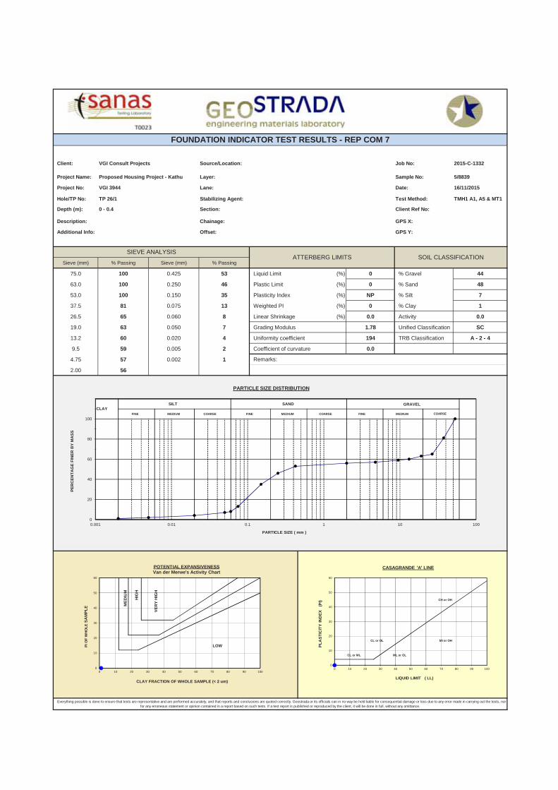
Client: Source/Location: Job No: 2015-C-1332
Project Name: Layer: Sample No: 5/8839
Project No: Lane: Date: 16/11/2015
Hole/TP No: Stabilizing Agent: Test Method: TMH1 A1, A5 & MT1
Depth (m): Section: Client Ref No:
Description: Chainage: GPS X:
Additional Info: Offset: GPS Y:
Sieve (mm) % Passing Sieve (mm) % Passing
75.0 100 0.425 53 Liquid Limit (%) 0 % Gravel 44
63.0 100 0.250 46 Plastic Limit (%) 0 % Sand 48
53.0 100 0.150 35 Plasticity Index (%) NP % Silt 7
37.5 81 0.075 13 Weighted PI (%) 0 % Clay 1
26.5 65 0.060 8 Linear Shrinkage (%) 0.0 Activity 0.0
19.0 63 0.050 7 Grading Modulus 1.78 Unified Classification SC
13.2 60 0.020 4 Uniformity coefficient 194 TRB Classification A - 2 - 4
9.5 59 0.005 2 Coefficient of curvature 0.0
4.75 57 0.002 1
2.00 56
6.0
FOUNDATION INDICATOR TEST RESULTS - REP COM 7
VGI Consult Projects
Proposed Housing Project - Kathu
VGI 3944
TP 26/1
0 - 0.4
SIEVE ANALYSISATTERBERG LIMITS SOIL CLASSIFICATION
Everything possible is done to ensure that tests are representative and are performed accurately, and that reports and conclusions are quoted correctly. Geostrada or its officials can in no way be held liable for consequential damage or loss due to any error made in carrying out the tests, nor for any erroneous statement or opinion contained in a report based on such tests. If a test report is published or reproduced by the client, it will be done in full, without any omittance.
Remarks:
CLAYSILT SAND
COARSEFINE MEDIUM COARSE FINE MEDIUM COARSE FINE MEDIUM
GRAVEL
0
20
40
60
80
100
120
0.001 0.01 0.1 1 10 100
PE
RC
EN
TA
GE
FIN
ER
BY
MA
SS
PARTICLE SIZE ( mm )
PARTICLE SIZE DISTRIBUTION
ME
DIU
M
HIG
H
VE
RY
HIG
H
LOW
0
10
20
30
40
50
60
0 10 20 30 40 50 60 70 80 90 100
PI O
F W
HO
LE
SA
MP
LE
CLAY FRACTION OF WHOLE SAMPLE (< 2 um)
POTENTIAL EXPANSIVENESSVan der Merwe's Activity Chart
CH or OH
CL or OL
CL or ML ML or OL
Ml or OH
0
10
20
30
40
50
60
0 10 20 30 40 50 60 70 80 90 100
PL
AS
TIC
ITY
IND
EX
(P
I)
LIQUID LIMIT ( LL)
CASAGRANDE 'A' LINE

Client: Source/Location: Job No: 2015-C-1332
Project Name: Layer: Sample No: 5/8841
Project No: Lane: Date: 16/11/2015
Hole/TP No: Stabilizing Agent: Test Method: TMH1 A1, A5 & MT1
Depth (m): Section: Client Ref No:
Description: Chainage: GPS X:
Additional Info: Offset: GPS Y:
Sieve (mm) % Passing Sieve (mm) % Passing
75.0 100 0.425 90 Liquid Limit (%) 0 % Gravel 5
63.0 100 0.250 74 Plastic Limit (%) 0 % Sand 85
53.0 100 0.150 53 Plasticity Index (%) NP % Silt 7
37.5 100 0.075 17 Weighted PI (%) 0 % Clay 3
26.5 100 0.060 10 Linear Shrinkage (%) 0.0 Activity 0.0
19.0 97 0.050 9 Grading Modulus 0.98 Unified Classification SM
13.2 96 0.020 7 Uniformity coefficient 3 TRB Classification A - 2 - 4
9.5 95 0.005 5 Coefficient of curvature 1.0
4.75 95 0.002 3
2.00 95
6.0
Everything possible is done to ensure that tests are representative and are performed accurately, and that reports and conclusions are quoted correctly. Geostrada or its officials can in no way be held liable for consequential damage or loss due to any error made in carrying out the tests, nor for any erroneous statement or opinion contained in a report based on such tests. If a test report is published or reproduced by the client, it will be done in full, without any omittance.
Remarks:
SIEVE ANALYSISATTERBERG LIMITS SOIL CLASSIFICATION
TP 36/1
0 - 0.4
Proposed Housing Project - Kathu
VGI 3944
VGI Consult Projects
FOUNDATION INDICATOR TEST RESULTS - REP COM 7
CLAYSILT SAND
COARSEFINE MEDIUM COARSE FINE MEDIUM COARSE FINE MEDIUM
GRAVEL
0
20
40
60
80
100
120
0.001 0.01 0.1 1 10 100
PE
RC
EN
TA
GE
FIN
ER
BY
MA
SS
PARTICLE SIZE ( mm )
PARTICLE SIZE DISTRIBUTION
ME
DIU
M
HIG
H
VE
RY
HIG
H
LOW
0
10
20
30
40
50
60
0 10 20 30 40 50 60 70 80 90 100
PI O
F W
HO
LE
SA
MP
LE
CLAY FRACTION OF WHOLE SAMPLE (< 2 um)
POTENTIAL EXPANSIVENESSVan der Merwe's Activity Chart
CH or OH
CL or OL
CL or ML ML or OL
Ml or OH
0
10
20
30
40
50
60
0 10 20 30 40 50 60 70 80 90 100
PL
AS
TIC
ITY
IND
EX
(P
I)
LIQUID LIMIT ( LL)
CASAGRANDE 'A' LINE
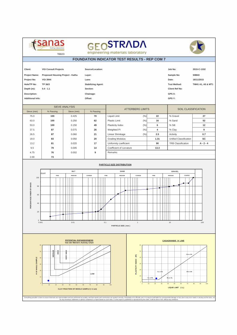
Client: Source/Location: Job No: 2015-C-1332
Project Name: Layer: Sample No: 5/8843
Project No: Lane: Date: 16/11/2015
Hole/TP No: Stabilizing Agent: Test Method: TMH1 A1, A5 & MT1
Depth (m): Section: Client Ref No:
Description: Chainage: GPS X:
Additional Info: Offset: GPS Y:
Sieve (mm) % Passing Sieve (mm) % Passing
75.0 100 0.425 70 Liquid Limit (%) 22 % Gravel 27
63.0 100 0.250 62 Plastic Limit (%) 16 % Sand 52
53.0 100 0.150 49 Plasticity Index (%) 6 % Silt 12
37.5 87 0.075 26 Weighted PI (%) 4 % Clay 9
26.5 87 0.060 21 Linear Shrinkage (%) 2.5 Activity 0.7
19.0 83 0.050 20 Grading Modulus 1.31 Unified Classification SC
13.2 81 0.020 17 Uniformity coefficient 90 TRB Classification A - 2 - 4
9.5 79 0.005 14 Coefficient of curvature 13.3
4.75 76 0.002 9
2.00 73
6.0
Everything possible is done to ensure that tests are representative and are performed accurately, and that reports and conclusions are quoted correctly. Geostrada or its officials can in no way be held liable for consequential damage or loss due to any error made in carrying out the tests, nor for any erroneous statement or opinion contained in a report based on such tests. If a test report is published or reproduced by the client, it will be done in full, without any omittance.
Remarks:
SIEVE ANALYSISATTERBERG LIMITS SOIL CLASSIFICATION
TP 36/3
0.4 - 1.1
Proposed Housing Project - Kathu
VGI 3944
VGI Consult Projects
FOUNDATION INDICATOR TEST RESULTS - REP COM 7
CLAYSILT SAND
COARSEFINE MEDIUM COARSE FINE MEDIUM COARSE FINE MEDIUM
GRAVEL
0
20
40
60
80
100
120
0.001 0.01 0.1 1 10 100
PE
RC
EN
TA
GE
FIN
ER
BY
MA
SS
PARTICLE SIZE ( mm )
PARTICLE SIZE DISTRIBUTION
ME
DIU
M
HIG
H
VE
RY
HIG
H
LOW
0
10
20
30
40
50
60
0 10 20 30 40 50 60 70 80 90 100
PI O
F W
HO
LE
SA
MP
LE
CLAY FRACTION OF WHOLE SAMPLE (< 2 um)
POTENTIAL EXPANSIVENESSVan der Merwe's Activity Chart
CH or OH
CL or OL
CL or ML ML or OL
Ml or OH
0
10
20
30
40
50
60
0 10 20 30 40 50 60 70 80 90 100
PL
AS
TIC
ITY
IND
EX
(P
I)
LIQUID LIMIT ( LL)
CASAGRANDE 'A' LINE

Client: Source/Location: Job No: 2015-C-1332
Project Name: Layer: Sample No: 5/8844
Project No: Lane: Date: 16/11/2015
Hole/TP No: Stabilizing Agent: Test Method: TMH1 A1, A5 & MT1
Depth (m): Section: Client Ref No:
Description: Chainage: GPS X:
Additional Info: Offset: GPS Y:
Sieve (mm) % Passing Sieve (mm) % Passing
75.0 100 0.425 95 Liquid Limit (%) 0 % Gravel 1
63.0 100 0.250 81 Plastic Limit (%) 0 % Sand 92
53.0 100 0.150 57 Plasticity Index (%) NP % Silt 4
37.5 100 0.075 16 Weighted PI (%) 0 % Clay 3
26.5 100 0.060 7 Linear Shrinkage (%) 0.0 Activity 0.0
19.0 100 0.050 7 Grading Modulus 0.90 Unified Classification SM
13.2 99 0.020 7 Uniformity coefficient 2 TRB Classification A - 2 - 4
9.5 99 0.005 5 Coefficient of curvature 1.0
4.75 99 0.002 3
2.00 99
6.0
FOUNDATION INDICATOR TEST RESULTS - REP COM 7
VGI Consult Projects
Proposed Housing Project - Kathu
VGI 3944
TP 22/1
0 - 0.4
SIEVE ANALYSISATTERBERG LIMITS SOIL CLASSIFICATION
Everything possible is done to ensure that tests are representative and are performed accurately, and that reports and conclusions are quoted correctly. Geostrada or its officials can in no way be held liable for consequential damage or loss due to any error made in carrying out the tests, nor for any erroneous statement or opinion contained in a report based on such tests. If a test report is published or reproduced by the client, it will be done in full, without any omittance.
Remarks:
CLAYSILT SAND
COARSEFINE MEDIUM COARSE FINE MEDIUM COARSE FINE MEDIUM
GRAVEL
0
20
40
60
80
100
120
0.001 0.01 0.1 1 10 100
PE
RC
EN
TA
GE
FIN
ER
BY
MA
SS
PARTICLE SIZE ( mm )
PARTICLE SIZE DISTRIBUTION
ME
DIU
M
HIG
H
VE
RY
HIG
H
LOW
0
10
20
30
40
50
60
0 10 20 30 40 50 60 70 80 90 100
PI O
F W
HO
LE
SA
MP
LE
CLAY FRACTION OF WHOLE SAMPLE (< 2 um)
POTENTIAL EXPANSIVENESSVan der Merwe's Activity Chart
CH or OH
CL or OL
CL or ML ML or OL
Ml or OH
0
10
20
30
40
50
60
0 10 20 30 40 50 60 70 80 90 100
PL
AS
TIC
ITY
IND
EX
(P
I)
LIQUID LIMIT ( LL)
CASAGRANDE 'A' LINE