proposal for the e redistricting s · proposal for strategic telemetry esri redistricting solution...
TRANSCRIPT

Prepared by:
Environmental Systems Research Institute, Inc. (Esri) 380 New York Street Redlands, California 92373-8100 Phone: (909) 793-2853
This document contains commercial or financial information or trade secrets of Esri, which are confidential and exempt from disclosure to the public under the Freedom of Information Act 5 USC 522(b)(4), and unlawful disclosure thereof is a violation of the Trade Secret Act 18 USC 1905.
PROPOSAL FOR THE ESRI REDISTRICTING
SOLUTION
Prepared for: Ken Strasma Strategic Telemetry 236 Massachusetts Ave NE #205 Washington, DC 20002 202-546-4764 July 27, 2011
Copyright © 2011 Esri All rights reserved. Printed in the United States of America. The information contained in this document is the exclusive property of Esri. This work is protected under United States copyright law and other international copyright treaties and conventions. Esri grants proposal recipient the right to internally redistribute this document to proposal recipient's management and staff on a need-to-know basis, so long as proposal recipient does not remove or obscure any Esri or its licensors' patent, copyright, trademark, or proprietary rights notices contained in or affixed to this document. No part of this work may be reproduced or transmitted to third parties (except for consultants under a confidentiality obligation who are involved in the proposal evaluation process) in any form or by any means, electronic or mechanical, including photocopying and recording, or by any information storage or retrieval system, except as expressly permitted in writing by Esri. All requests should be sent to Attention: Contracts and Legal Services Manager, Esri, 380 New York Street, Redlands, CA 92373-8100 USA. The information contained in this document is subject to change without notice.
U.S. GOVERNMENT RESTRICTED/LIMITED RIGHTS (APPLIES TO FEDERAL PROCUREMENT ONLY)
Any software, documentation, and/or data delivered hereunder is subject to the terms of the License Agreement. In no event shall the U.S. Government acquire greater than RESTRICTED/LIMITED RIGHTS. At a minimum, use, duplication, or disclosure by the U.S. Government is subject to restrictions as set forth in FAR §52.227-14 Alternates I, II, and III (DEC 2007); FAR §52.227-19 (DEC 2007) and/or FAR §12.211/12.212 (Commercial Technical Data/Computer Software); and DFARS §252.227-7015 (NOV 1995) (Technical Data) and/or DFARS §227.7202 (Computer Software), as applicable. Contractor/Manufacturer is Esri, 380 New York Street, Redlands, CA 92373-8100 USA.
TRADEMARKS AND SERVICE MARKS @esri.com, 3D Analyst, ACORN, Address Coder, ADF, AML, ArcAtlas, ArcCAD, ArcCatalog, ArcCOGO, ArcData, ArcDoc, ArcEdit, ArcEditor, ArcEurope, ArcExplorer, ArcExpress, ArcGIS, ArcGlobe, ArcGrid, ArcIMS, ARC/INFO, ArcInfo, ArcInfo Librarian, ArcLessons, ArcLocation, ArcLogistics, ArcMap, ArcNetwork, ArcNews, ArcObjects, ArcOpen, ArcPad, ArcPlot, ArcPress, ArcPy, ArcReader, ArcScan, ArcScene, ArcSchool, ArcScripts, ArcSDE, ArcSdl, ArcSketch, ArcStorm, ArcSurvey, ArcTIN, ArcToolbox, ArcTools, ArcUSA, ArcUser, ArcView, ArcVoyager, ArcWatch, ArcWeb, ArcWorld, ArcXML, Atlas GIS, AtlasWare, Avenue, BAO, Business Analyst, Business Analyst Online, BusinessMAP, CommunityInfo, Database Integrator, DBI Kit, EDN, Esri, Esri—Team GIS, Esri—The GIS Company, Esri—The GIS People, Esri—The GIS Software Leader, FormEdit, GeoCollector, Geographic Design System, Geography Matters, Geography Network, GIS by Esri, GIS Day, GIS for Everyone, GISData Server, JTX, MapIt, Maplex, MapObjects, MapStudio, ModelBuilder, MOLE, MPS—Atlas, PLTS, Rent-a-Tech, SDE, SML, Sourcebook·America, Spatial Database Engine, StreetMap, Tapestry, the ARC/INFO logo, the ArcGIS logo, the ArcGIS Explorer logo, the ArcPad logo,the Esri globe logo, the Esri Press logo, the GIS Day logo, the MapIt logo, The Geographic Advantage, The Geographic Approach, The World's Leading Desktop GIS, Water Writes, www.esri.com, www.geographynetwork.com, www.gis.com, www.gisday.com, and Your Personal Geographic Information System are trademarks, registered trademarks, or service marks of Esri in the United States, the European Community, or certain other jurisdictions. Other companies and products mentioned herein may be trademarks or registered trademarks of their respective trademark owners.
Proposal for Strategic Telemetry Esri Redistricting Solution
P11-6041 i July 27, 2011
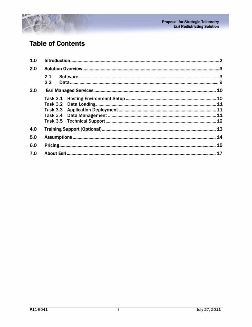
Table of Contents
1.0 Introduction ........................................................................................................................... 2
2.0 Solution Overview ................................................................................................................. 3
2.1 Software ...................................................................................................................... 3 2.2 Data ............................................................................................................................. 9
3.0 Esri Managed Services .................................................................................................... 10
Task 3.1 Hosting Environment Setup ............................................................................ 10 Task 3.2 Data Loading ..................................................................................................... 11 Task 3.3 Application Deployment .................................................................................. 11 Task 3.4 Data Management ........................................................................................... 11 Task 3.5 Technical Support ............................................................................................. 12
4.0 Training Support (Optional) .............................................................................................. 13
5.0 Assumptions ...................................................................................................................... 14
6.0 Pricing ................................................................................................................................. 15
7.0 About Esri ........................................................................................................................... 17

Proposal for Strategic Telemetry Esri Redistricting Solution
P11-6041 2 July 27, 2011
1.0 Introduction The Esri Redistricting solution allows users to rapidly and effectively create, edit, publish, review, and collaborate on redistricting plans that comply with federal law through a robust, easy‐to‐use web browser. The solution was designed to help state and local governments develop redistricting plans in response to the 2010 Census. In addition, advocacy groups, educators and the general public can use the Esri Redistricting solution to evaluate proposed plans, provide input to decision makers, and collaborate with others to develop alternative plans for consideration.
The solution can be used to develop district boundaries that are substantially equal in population as practicable based on race, existing communities, voting age population, and other data variables collected by the U.S. Census Bureau and local jurisdictions. In addition to offering powerful analytical tools, the solution has a number of features that distinguish it from other products on the market: Collaboration and Efficiency
Esri Redistricting allows organizations to interact with each other and with the public throughout the redistricting process. The ability to share plans by publishing to smaller private working groups or larger audiences is unique because it leverages the power of ArcGIS Online to support community collaboration. End-users are able to easily create and submit plans to redistricting committees for consideration. This facilitates effective communication, improved efficiency across organizations and transparency in government decision making. Comprehensive Resources
The solution not only provides powerful analytical tools for redistricting, but also offers a number of resources such as software training sessions, extensive online help documentation, and a Redistricting

Proposal for Strategic Telemetry Esri Redistricting Solution
P11-6041 3 July 27, 2011
Resource Center which provides access to video tutorials, forums, blogs, and other tools that allows users to successfully achieve their desired results throughout the redistricting process. Centralized Management
In addition to offering a powerful, easy-to-use analytical tool for drawing and evaluating district plans, Esri fully supports the operation of the application, data and associated resources. This includes managing the hardware, software, infrastructure and technical staff required to support a sophisticated enterprise GIS system on a 24/7 basis. Through Esri Managed Services, Strategic Telemetry has the ability to leverage experienced professionals qualified to maintain the operation of the tools and data. As the world leader in GIS software, Esri has 40 years of experience in creating solutions designed to manage, visualize, and analyze geospatial data. These are key components required to implement a robust redistricting solution and deliver the comprehensive maps Strategic Telemetry needs as a foundation for the State of Arizona’s redistricting legislation.
2.0 Solution Overview Esri Redistricting addresses common needs and challenges related to redistricting at the state and local level. The foundation of the solution is Esri’s proven ArcGIS software platform and pertinent data set components. ArcGIS provides comprehensive features and functionality that allow for plan creation, management, visualization, editing and community collaboration. Esri Redistricting components can be paired with multiple deployment options; software-as-a-service (SaaS), on-premises at the organization’s data center, or completely hosted and managed through Esri Managed Services. Esri is proposing the Managed Services deployment option to Strategic Telemetry to support their need for public participation and collaboration during the State of Arizona’s redistricting process.
2.1 Software
The Esri Redistricting solution provides an interactive Web-based application called Esri Redistricting that focuses on creating and maintaining redistricting plans. Esri Redistricting is based on ArcGIS Server and the ArcGIS API for Flex to provide a rich Internet application user experience. With the Esri Redistricting application, these are just some of the functions you can perform: Plan Creation and Editing Esri Redistricting is an Internet Web application with a straightforward mapcentric interface that provides easy-to-use tools for creating, editing, and viewing district plans.

Proposal for Strategic Telemetry Esri Redistricting Solution
P11-6041 4 July 27, 2011
Plan creation and editing is simple with the Esri Redistricting solution. The Web-based
application allows you to: Delineate district boundaries using census geographies (blocks, block groups, tracts, counties or blocks, VTDs, counties)
Monitor demographics of critical geography selections and visualize their impact to a district profile
Direct or two-step district assignment of user-selected geographies Lock or unlock district assignments to a selected geography Undo / redo district assignment history to a plan’s last save point Prevent geographies from being assigned to more than one district, as well as identifying areas
that have yet to be assigned to a district Support contiguous and non-contiguous district definitions
Census and Custom Geography Data Esri Redistricting is complete with preprocessed census data—2000, 2010 TIGER, and Public Law (P.L.) 94-171. Esri offers an optional data service package to support clients with integration of custom data sets supplied by Strategic Telemetry. The add-on data is integrated into the Esri Redistricting solution data store by Esri, before the solution is brought online for your organization. The following is supported: Pre-deployed, customer-provided data in ArcGIS-supported formats (TIGER/Line shapefile,
shapefile, file geodatabase) Census TIGER data (geography files) for 2000 and 2010 (when available) Census geography definitions (blocks, block groups, tracts, counties or blocks, VTDs, counties) Census P.L. 94-171 population attribute data (race, ethnicity, etc.) related to census geographies
Map Navigation The following map viewer navigation features are supported by Esri Redistricting: Zoom in / zoom out by bounding
box Zoom in / zoom out by scale slider Zoom in / zoom out by mouse wheel Zoom to address Zoom to selection Zoom to ZIP Code Zoom to place name Zoom to latitude / longitude Zoom to district by name Zoom to unassigned geographies Zoom to selected geographies Overview map navigation
Mashups Esri Redistricting supports the following map viewer mashup capabilities and augments the online district plan map with easy–to-use overlays of auxiliary data: Add maps from ArcGIS.com (street maps, satellite imagery, terrain, topographic, etc.) Add map resources hosted by your organization or other organizations through ArcGIS Server Plot uploaded addresses (such as incumbents’ residences) or coordinate-based data (CSV, Excel,
shapefile)

Proposal for Strategic Telemetry Esri Redistricting Solution
P11-6041 5 July 27, 2011
Redlining Esri Redistricting supports the following redlining or mark-up capabilities to district maps: Add user-defined notes Add user-defined shapes (points, lines, polygons, circles, and arrows) Add graphic image files (for example GIF, JPEG, PNG)
Feature Selection The solution also supports geographic feature selection capabilities for assignment of features to a district: Select by attribute (Query Builder) Select by point Select by user drawn box, polygon, line, polyline, circle Select by district name Select unassigned districts Select by proximity (feet, yards, miles, meters, kilometers) Select by spatial overlay (for example, select by another layer’s spatial geography) with an
optional attribute filter Plan Publication, Submission and Sharing The Esri Redistricting solution seamlessly integrates with ArcGIS Online to support accessibility restrictions for public group or private access. This solution provides access to a plan online, reducing the need for paper map production. The supported capabilities include: Sharing district plans between users and groups with the Esri Redistricting. Users can be
legislators, advocacy groups, and team members of the Independent Redistricting Commission. Publishing plans to ArcGIS.com, with the capability to leverage all capabilities provided by
ArcGIS.com on the plan, including secure access to groups. Data Export Esri Redistricting provides the ability to export plans to a variety of formats for sharing with other systems and applications. The following are supported: Export district plans (PDF, text / ASCII, file geodatabase, etc.) Export reports (text / ASCII, CSV, Excel) Export image of the current extent Export plans to DOJ/OMB format (block assignments) Export to KML
Printing To support workflows that require paper and PDF reports and maps, the following printing options are supported by the solution: Print tabular reports based on census geographies and census data Print maps to predefined templates with basic map information Production of multipage district plan map books Print to all standard paper sizes: E-size, B-size, letter size, plotter size, 8 ½” x 11”
Proposal for Strategic Telemetry Esri Redistricting Solution
P11-6041 6 July 27, 2011
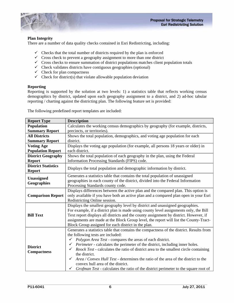
Plan Integrity There are a number of data quality checks contained in Esri Redistricting, including: Checks that the total number of districts required by the plan is enforced Cross check to prevent a geography assignment to more than one district Cross checks to ensure summation of district populations matches client population totals Check validates districts have contiguous geographies (optional) Check for plan compactness Check for district(s) that violate allowable population deviation
Reporting Reporting is supported by the solution at two levels: 1) a statistics table that reflects working census demographics by district, updated upon each geography assignment to a district, and 2) ad-hoc tabular reporting / charting against the districting plan. The following feature set is provided: The following predefined report templates are included: Report Type Description Population Summary Report
Calculates the working census demographics by geography (for example, districts, precincts, or territories).
All Districts Summary Report
Shows the total population, demographics, and voting age population for each district.
Voting Age Population Report
Displays the voting age population (for example, all persons 18 years or older) in each district.
District Geography Report
Shows the total population of each geography in the plan, using the Federal Information Processing Standards (FIPS) code.
District Statistics Report
Displays the total population and demographic information by district.
Unassigned Geographies
Generates a statistics table that contains the total population of unassigned geographies in each county of the district, divided into the Federal Information Processing Standards county code.
Comparison Report Displays differences between the active plan and the compared plan. This option is only available if you have both an active plan and a compared plan open in your Esri Redistricting Online session.
Bill Text
Displays the smallest geography level by district and unassigned geographies. For example, if a district plan is made using county level assignments only, the Bill Text report displays all districts and the county assignment by district. However, if assignments are made at the Block Group level, the report will list the County-Tract-Block Group assigned for each district in the plan.
District Compactness
Generates a statistics table that contains the compactness of the district. Results from the following tests are included: Polygon Area Test - compares the areas of each district. Perimeter - calculates the perimeter of the district, including inner holes. Reock Test - calculates the ratio of district area to the smallest circle containing
the district. Area / Convex Hull Test - determines the ratio of the area of the district to the
convex hull area of the district. Grofman Test - calculates the ratio of the district perimeter to the square root of

Proposal for Strategic Telemetry Esri Redistricting Solution
P11-6041 7 July 27, 2011
Report Type Description the area.
Schwartzberg Test - is the ratio of the perimeter of the district to the perimeter of a circle of an equal area to that of the district.
Polsby Popper Test - calculates the ratio of the same area of the district to the area of a circle with the same perimeter.
Holes Test - determines the number of holes (geography clusters that are fully enclosed) within each district.
Assigned District Splits
Lists each county that is included in a district. Counties that are split (overlap) multiple districts, are denoted with an asterisk (*).
Users may create report templates against: Census P.L. 94-171 population demographic data at the following levels: district, block, block
group, tract Customer-specific data integrated via the data add-on pack (for example, historical voting data)
Reporting functionality will support the following capabilities: Save report templates and use them across districting plans Create formula fields to report against Generate charts and graphs in reports Embed graphics into a report Export statistics table and reports (CSV, PDF, Excel) Display demographic changes between districts caused by geography assignment(s) Display ideal versus actual district population Share reports with other users and groups
Plan Management The Esri Redistricting solution has a districting plan explorer that provides the following features: Centralized plan management Save a copy of a plan (“Save As”) or save a copy of portions of a plan (select plan features) Lock plans as “Read-only” Maintain a log of access and modifications to a plan (for example, created, opened, or saved) Maintain plan metadata Ability to merge plans for consolidated district plan assignments Overlay plan comparison / visualization Ability to compare plans created with 2010 Census data to 2000 Census plans “Folder-like” districting plan explorer to manage and categorize plans by keyword
Plan Management Administration and Access Control The Esri Redistricting solution supports the creation, storage, and retrieval of district plans from the Redistricting Database. As such, this module of the solution also regulates plan access and user / group management. The Esri Redistricting solution supports user entities with the following rights:
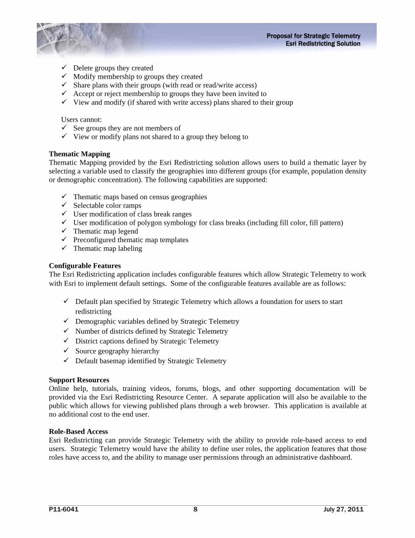
Users can: Create groups Invite other users of the system to join groups they create
Proposal for Strategic Telemetry Esri Redistricting Solution
P11-6041 8 July 27, 2011
Delete groups they created Modify membership to groups they created Share plans with their groups (with read or read/write access) Accept or reject membership to groups they have been invited to View and modify (if shared with write access) plans shared to their group
Users cannot: See groups they are not members of View or modify plans not shared to a group they belong to
Thematic Mapping Thematic Mapping provided by the Esri Redistricting solution allows users to build a thematic layer by selecting a variable used to classify the geographies into different groups (for example, population density or demographic concentration). The following capabilities are supported: Thematic maps based on census geographies Selectable color ramps User modification of class break ranges User modification of polygon symbology for class breaks (including fill color, fill pattern) Thematic map legend Preconfigured thematic map templates Thematic map labeling
Configurable Features The Esri Redistricting application includes configurable features which allow Strategic Telemetry to work with Esri to implement default settings. Some of the configurable features available are as follows:
Default plan specified by Strategic Telemetry which allows a foundation for users to start redistricting
Demographic variables defined by Strategic Telemetry Number of districts defined by Strategic Telemetry District captions defined by Strategic Telemetry Source geography hierarchy Default basemap identified by Strategic Telemetry
Support Resources Online help, tutorials, training videos, forums, blogs, and other supporting documentation will be provided via the Esri Redistricting Resource Center. A separate application will also be available to the public which allows for viewing published plans through a web browser. This application is available at no additional cost to the end user. Role-Based Access Esri Redistricting can provide Strategic Telemetry with the ability to provide role-based access to end users. Strategic Telemetry would have the ability to define user roles, the application features that those roles have access to, and the ability to manage user permissions through an administrative dashboard.

Proposal for Strategic Telemetry Esri Redistricting Solution
P11-6041 9 July 27, 2011
2.2 Data
Data is an essential component of a GIS implementation. The Esri Redistricting solution includes important data resources to use with ArcGIS software to support application requirements. These data resources—ArcGIS Online, U.S. Census data, and optional data sets—are outlined below and can be used to complement Strategic Telemetry and the State of Arizona’s existing GIS data resources. ArcGIS Online ArcGIS Online is intended to support the geocoding and basemap requirements for Esri Redistricting, providing nationwide imagery, street maps, topographic and hybrid maps. ArcGIS.com With ArcGIS.com users can publicly share your redistricting maps with the community. Maps can be shared on a completely public basis or can be kept private or semi-private by sharing it with one or more groups you belong to or create. Alternatively, users can share an item with a larger group or the public at-large when they want more people to have access to their plan but also want to highlight the content within a group setting. This is especially appropriate for the focused work in redistricting where all members benefit from seeing a list of specific content they can use for collaboration and exchange. U.S. Census Data The Esri Redistricting Solution includes the data required for redistricting from the 2000 Census and the 2010 Census. The Public Law 94-171 population data contains a count of all persons by total population and total population by voting age population (18 and over). Esri Redistricting allows users to effortlessly track the desired variables for their jurisdiction. Optional Data Content Esri also offers several options for customers that do not currently own or license the geospatial data they need to effectively visualize and analyze their geographic area-of-interest. These options are listed below. Pricing for these options are available from Esri upon request.
Esri StreetMap Premium Esri Business and Demographic data (nationwide coverage) ArcGIS Online Premium Services
In addition, the Redistricting Solution supports Esri-compatible geographic data provided by the organization which can be integrated into the solution and used for sophisticated analysis. Details regarding data management activities associated with Strategic Telemetry or the State of Arizona’s custom content can be found below in Section 3.0.

Proposal for Strategic Telemetry Esri Redistricting Solution
P11-6041 10 July 27, 2011
3.0 Esri Managed Services Esri will provide Managed Services for Esri Redistricting, which includes providing external HTTP access to the web application, operational hosting and monitoring, and troubleshooting technical support incidents through Tier 2 Hosted Environment Support. Esri's Redistricting solution will target the following service levels to the support Strategic Telemetry and the State of Arizona’s operational requirements:
24/7 System Access 95% System Availability Hosting Environment to support up to 100 active users 20 GB of Custom Data Storage Data Backup and Archive Annual Update of Strategic Telemetry / State of Arizona’s Custom Data 24/7 Tier 2 Hosted Environment Support and Monitoring
The proposed Managed Services described below includes setting up the Hosting Environment, loading and managing the data content, deploying the Esri Redistricting application and providing 24/7 operational support.
Task 3.1 Hosting Environment Setup
Esri will set up the base components comprising the underlying Hosting Environment infrastructure including the relevant hardware, power, facilities and network infrastructure to enable Strategic Telemetry’s external HTTP access to the Esri Redistricting application. The Hosting Environment will include the following software technology components:
Windows Server 2008
ArcGIS Server Enterprise Standard 10 SP1
ArcGIS API for Flex
PostgreSQL 8.4.2
Esri Redistricting application
Esri Responsibilities
Set up the Hosting Environment required to support up to 100 active users.
Install and maintain the software technology components outlined above.
Strategic Telemetry Responsibilities
None.

Proposal for Strategic Telemetry Esri Redistricting Solution
P11-6041 11 July 27, 2011
Task 3.2 Data Loading
Esri will load and update up to 20 GB of Strategic Telemetry or State of Arizona data content (hereinafter referred to as "Data Content") annually to the Hosting Environment prior to Task 3.3 when received in the agreed upon format and delivery method.
Esri Responsibilities
Load Strategic Telemetry / State of Arizona Data Content described above to the Hosting Environment.
Test and verify the Data Content after it is loaded into the Hosting Environment.
Strategic Telemetry Responsibilities
Provide Strategic Telemetry / State of Arizona Data Content in the agreed upon format and delivery method.
Procure and maintain (if necessary) the appropriate data licensing for the Data Content.
Task 3.3 Application Deployment
After setup of the infrastructure components listed in Task 3.1 and loading the Data Content described in Task 3.2, Esri will deploy and test the Esri Redistricting application and will work remotely with Strategic Telemetry to verify access through a URL provided by Esri. Strategic Telemetry will provide Esri with written confirmation that the application is accessible within five (5) days of receiving notification from Esri that deployment is ready for verification.
Esri Responsibilities:
Deploy the Esri Redistricting application to the Hosting Environment. Notify Strategic Telemetry when the Esri Redistricting application has been deployed by sending
a URL, and allow up to five (5) days for testing accessibility. Troubleshoot issues that may occur while Strategic Telemetry is testing accessibility to the Esri
Redistricting application.
Strategic Telemetry Responsibilities:
Test the availability of the Esri Redistricting application once Esri has provided notification that it is available in the Hosting Environment.
Provide Esri with written (email) confirmation that the Esri Redistricting application is accessible within five (5) business days.
Task 3.4 Data Management
Esri will load the updated Data Content provided by Strategic Telemetry to the staging environment. Esri will notify Strategic Telemetry when the Esri Redistricting application is available with the updated Data Content deployed to the staging environment by sending a URL, and will work remotely with Strategic Telemetry to verify access to the updated Data Content. Strategic Telemetry will provide Esri with written confirmation that the Data Content in the application is accessible and represents the appropriate changes
Proposal for Strategic Telemetry Esri Redistricting Solution
P11-6041 12 July 27, 2011
within five (5) days of receiving notification from Esri that data updates are ready for verification. Once confirmation has been received, Esri will deploy the updated Esri Redistricting application to the production hosting environment and notify Strategic Telemetry when it is available. Strategic Telemetry will verify accessibility and provide written confirmation to Esri.
Esri Responsibilities:
Deploy Esri Redistricting with updated Data Content provided by Strategic Telemetry to the staging environment.
Notify Strategic Telemetry when the updated application is available in staging by sending a URL, and allow up to five (5) days for testing accessibility.
Upon receipt of written (email) confirmation from Strategic Telemetry that the application is accessible, deploy the updated application to the production environment.
Notify Strategic Telemetry when deployment to the production environment is complete
Strategic Telemetry Responsibilities:
Test the updated Data Content in the Esri Redistricting application once Esri has provided notification that it is available in the staging environment.
Provide Esri with written (email) confirmation that the Data Content is available in staging and reflects the appropriate changes within five (5) business days.
Verify that the updated version of the application is accessible in the production environment and provide Esri with written (email) confirmation within five (5) business days.
Task 3.5 Technical Support
3.5.1 Tier 1 Helpdesk Support
Strategic Telemetry will provide the first point of contact (Tier 1 Helpdesk Support) for Esri Redistricting end users to address any operational use or technical issues. This support consists of answering user questions, replicating and reviewing reported issues, addressing application use or training requirements (if appropriate), and documenting and communicating validated technical issues to Tier 2 Hosted Environment Support staff.
Esri Responsibilities
None.
Strategic Telemetry Responsibilities
Designate up to two (2) primary points of contact (POC) and send the names and contact information to Esri's Tier 2 Hosted Environment Support staff.
Support end users in the daily operation of the Esri Redistricting solution and resolve technical issues, if possible.
Document procedures and the results of such procedures which Strategic Telemetry followed to troubleshoot the technical issues.
Proposal for Strategic Telemetry Esri Redistricting Solution
P11-6041 13 July 27, 2011
Escalate documented, unresolved, validated technical issues (Technical Support Incidents) to Esri Tier 2 Hosted Environment Support staff. Upon escalating the Technical Support Incident to Esri, Strategic Telemetry will provide Esri with the supporting documentation describing what steps they undertook to troubleshoot the technical issue prior to escalation.
3.5.2 Tier 2 Hosted Environment Support
Tier 2 Hosted Environment Support includes 24/7 monitoring of the operation of the Hosting Environment, troubleshooting and resolving infrastructure issues, and responding to Technical Support Incidents escalated by Strategic Telemetry 's Tier 1 Helpdesk Support staff. It is anticipated that a Technical Support Incident would be escalated to Esri’s Tier 2 Hosted Environment Support POC only after Strategic Telemetry's Tier 1 Helpdesk Support staff have exhausted all potential resolution approaches and considerations, and could not successfully resolve it.
Esri Responsibilities
Investigate, assess and track Technical Support Incident(s) escalated by Strategic Telemetry's Tier 1 Helpdesk Support staff on a 24/7 basis.
Undertake commercially reasonable efforts in the identification of potential resolution(s) or suggested workaround(s).
Provide details of potential resolution(s) or suggested workaround(s) to Tier 1 Helpdesk Support staff, as appropriate.
Strategic Telemetry Responsibilities
Communicate Technical Support Incidents to Esri via agreed upon process.
Provide Esri with the supporting documentation describing the steps Strategic Telemetry undertook to troubleshoot the technical issue prior to escalation.
Promptly respond to questions Esri poses during Tier 2 Hosted Environment Support activities.
Support interaction with end users, including following up after a Technical Support Incident has been resolved.
Implement the Esri-suggested workaround or resolution, as appropriate.
4.0 Training Support (Optional) Esri will provide optional training support for up to 8 training sessions for the Redistricting Solution. Training sessions will be limited to two hours each and will be divided into two training groups.
Internal Staff Sessions Esri will conduct four training sessions for internal Strategic Telemetry or State of Arizona staff either onsite or remotely via the web. This training session is expected to cover a general overview of the Esri Redistricting solution as well as allow for time to answer questions related to specific areas of the solution. Esri will coordinate with Strategic Telemetry prior to the training sessions in order to elicit specific questions from the expected audience.

Proposal for Strategic Telemetry Esri Redistricting Solution
P11-6041 14 July 27, 2011
General Public Sessions Esri will conduct four training sessions for the general public remotely via the web. This training session is expected to cover a general overview of the Esri Redistricting solution as well as allow for time to answer questions from the audience. Remote Tier 1 Helpdesk Sessions Esri will provide up to twenty (20) hours of remote training support to answer any application questions Strategic Telemetry has after the training sessions have been completed. Training support questions will be sent to Esri through Strategic Telemetry Tier 1 Helpdesk. Remote training support can be conducted via phone and/or webcast.
Esri Responsibilities
Provide training support as described above.
Strategic Telemetry Responsibilities
Designate up to 2 primary points of contact (POC) for training support and send the names and contact information to Esri.
Provide the Esri consultant with access to data and computer system environment, as required.
Provide adequate office space for the Esri consultant to work while on-site
Provide a conference room equipped with an LCD projector and workstation for onsite training.
5.0 Assumptions This proposal assumes a twelve (12) month hosting commitment commencing upon execution of
the appropriate contract documents signed by both parties. Managed Services provided beyond this 12 month term are subject to a price escalation for which Esri can provide a proposal.
The targeted system availability for the Hosting Environment excludes scheduled downtime or interruption due to causes beyond the direct control of Esri.
There will be up to 100 active users of the solution, which equates to about 20 concurrent users making requests to the server through the application at the same second.
Esri will undertake commercially reasonable efforts in the identification of potential resolution(s) or suggested workaround(s) associated with Tier 2 Hosted Environment Support.
Tier 2 Hosted Environment Support as defined in Task 3.5.2 will be provided based on mutually agreed specifications and versions of the application technology outlined in Task 3.1 above.
Esri will use Strategic Telemetry or State of Arizona Data Content described in Task 3.2 as-is and is not responsible for cleansing any erroneous data received from Strategic Telemetry.
The Data Content described Task 3.2 will not exceed 20 GB.

Proposal for Strategic Telemetry Esri Redistricting Solution
P11-6041 15 July 27, 2011
6.0 Pricing Esri is pleased to submit the following price proposal to Strategic Telemetry. The components that comprise the Esri Redistricting solution include ArcGIS software, pertinent data sets, Managed Services and training. Optional items, such as additional data content or consulting support, are also available upon request and subject to Esri reevaluating the pricing in this proposal. This section provides a summary of pricing for the Esri Redistricting solution components described in Section 2.0, Managed Services described in Section 3.0 and optional Training Support described in Section 4.0. The price for implementing and managing the Esri Redistricting solution as described in Table 1 below is based upon an anticipated award of a firm-fixed-price (FFP) Purchase Order subject to the terms and conditions of Esri's standard Implementation Services Agreement, (G363FP dated 06/14/2010) included as Attachment A, including the Managed Services Addendum,(G-595) which is attached hereto as Attachment B. Esri proposes a grand total firm-fixed-price of $110,500 to deliver the solution as defined in this proposal. This includes Esri Redistricting License fees in the amount of $78,000 (reference Section 2.0), a one-time fee of $16,900 to for setup and deployment and a monthly fee in the amount of $1,300 per month for 12 months for ongoing operational support for the Esri Redistricting solution (reference Section 3.0).
Table 1: Esri Redistricting Solution (Firm Fixed Price)
Description Year 1 Upfront
Year 1 Monthly
Esri Redistricting License Fees $78,000 n/a
Setup and Deployment Fees $16,900(one-time fee) n/a
Esri Managed Services Operations Fees n/a $1,300 (per month for 12 months)
Grand Total Firm Fixed Price $110,500
Pricing for the optional training support is described in Table 2 below.
Table 2: Esri Training Support (Firm Fixed Price - Optional)
Description FFP
Option 1 – Onsite Internal Staff Training and Remote General Public Sessions
$5,600
Option 2 – Remote Internal Staff Training and Remote General Public Sessions
$4,700
Option 3 – Remote Tier 1 Helpdesk Sessions $3,600
This proposal is valid for thirty (30) days from the proposal submittal date above. Price is exclusive of

Proposal for Strategic Telemetry Esri Redistricting Solution
P11-6041 16 July 27, 2011
applicable state and local taxes for which Strategic Telemetry shall remain responsible. Payment will be due thirty (30) days following receipt of Esri's invoice.
To order the services under this proposal please provide the following:
1. Executed Copy of the G-363FP Implementation Services Agreement and 2. Executed Copy of the G-595 Managed Services Addendum 3. Purchase Order referencing this Proposal P11-6041 that includes $110,500 plus any fees
associated with the optional Training Support items selected by Strategic Telemetry described in Section 4.0 and listed in Table 2
4. A copy of this Proposal You may fax these documents to 909-307-3034. Once these documents have been received we will be in touch with you to discuss schedule and finalize staffing arrangements. We look forward to supporting you. Erin Ross, Program Manager Esri Professional Services 380 New York Street Redlands, CA 92373 (909) 793-2853 Ext 2073 [email protected]

Proposal for Strategic Telemetry Esri Redistricting Solution
P11-6041 17 July 27, 2011
7.0 About Esri Esri is a privately owned software company based in Redlands California that was founded in 1969 with the belief that GIS technology can help both citizens and governments better manage and invest in society. Through thousands of projects around the world, we have shown how GIS can make a difference in society’s ability to measure, understand, and plan for change. As Jack Dangermond, president of Esri, explains, “We at Esri believe that better information makes for better decisions. Our reputation is built on contributing our technical knowledge, special people, and valuable experience to the collection, analysis, and communication of geographic information.” Part of this commitment is Esri’s support for better government. Governments at all levels—from the 200 largest cities in the United States to more than 24,000 state and local governments worldwide—use our software to better analyze data, plan activities, and make decisions. Esri's technology benefits departments as diverse as public works, elections, emergency management, law enforcement, assessment, inspections, and other departments throughout local, state, and national governments. We also provide support at a global level through disaster response and support, conservation programs, and grant and sustainable development programs. We consistently receive rewards and recognition for our efforts to promote effective government and responsible social and environmental investment. In addition, Esri is a leading provider of GIS-based solutions to telecom, cable, and utility companies. These companies have found that ArcGIS software provides a comprehensive IT platform that enables support for market/competitive analysis, network planning, engineering and construction, sales and service delivery, and customer care applications. We believe that by contributing our expertise and technology to government and other organizations in over 20 other industries, we can help invest in our future and improve society. The Esri Redistricting Solution is part of this investment.
ATTACHMENT A IMPLEMENTATION SERVICES
FIRM FIXED PRICE AGREEMENT
Esri, 380 New York St., Redlands, CA 92373-8100 USA • TEL 909-793-2853 • FAX 909-793-5953
G363FP
Page 1 of 4 06/14/2010
Environmental Systems Research Institute, Inc. ("Esri"), will provide the Deliverables set forth in the Scope of Work in the Esri proposal dated ________________, which is hereby incorporated by this reference into the terms of this Agreement. 1. DEFINITIONS "Commercial off the Shelf Software" or "COTS Software" means all or any portion of Esri's proprietary software technology accessed or downloaded from an authorized Esri Web site or delivered on any media in any format, including backups, updates, service packs, patches, hot fixes, or permitted merged copies, available under license to the general public. "Custom Software" means all or any portion of the computer software code, components, dynamic link libraries (DLLs), and programs delivered on any media provided in source, object, or executable code format(s), inclusive of backups, updates, or merged copies permitted hereunder or subsequently supplied under this Agreement, exclusive of COTS Software. "Deliverables" means Custom Software, Technical Data, or Map Data specified for delivery to or use by Licensee in the Scope of Work for this Agreement. "Map Data" means any digital dataset(s) including geographic, vector data, coordinates, raster, or associated tabular attributes supplied by either party for use in the performance of this Agreement. "Technical Data" means, without limitation, all technical materials including formulas, compilations, software code or programs, methods, techniques, know-how, technical assistance, processes, algorithms, designs, data dictionaries and models, schematics, user documentation, training documentation, specifications, drawings, flowcharts, briefings, test or quality control procedures, or other similar information supplied or disclosed by Esri under this Agreement. 2. RESERVATION OF OWNERSHIP AND GRANT OF LICENSE Except as specifically granted in this Agreement, Esri or its licensors own and retain all right, title, and interest in Custom Software. Subject to the terms and conditions set forth in this Agreement, Esri hereby grants to Licensee a nonexclusive, royalty-free, worldwide license to use, modify, and/or reproduce the Custom Software in connection with Licensee's authorized use of the COTS Software. Licensee must separately and directly license Map Data from the vendor. 3. PATENTS AND INVENTIONS Each party shall retain title to any inventions, innovations, and improvements ("Inventions") made or conceived solely by its principals, employees, consultants, or independent contractors (hereinafter called "Inventors") during the term of this Agreement. The parties shall jointly own any Inventions made or conceived jointly by Inventors from both parties. Except as provided in the next paragraph, where Inventions are jointly owned, each party shall share equally the costs of acquiring protection for the Inventions and furnish the other joint owner with assistance reasonably required for acquiring protection. A joint owner ("Assigning Owner") electing not to acquire or maintain protection of any Inventions in any country or countries shall assign its rights in such Inventions to the other joint owner ("Beneficial Owner") as is necessary to enable the Beneficial Owner to protect such Inventions in such country or countries at its expense and for its exclusive benefit. In such event, the Assigning Owner shall make available to the Beneficial Owner the name(s) of Assigning Owner's Inventors and shall otherwise cooperate with the Beneficial Owner in order to assist the Beneficial Owner in protecting such Inventions. The Beneficial Owner shall reimburse the Assigning Owner for all reasonable out-of-pocket expenses incurred in rendering such assistance. If any such Inventions are so protected by the Beneficial Owner, then the Assigning Owner shall have a license with respect to the subject matter of such protected Inventions in such country or countries. Neither party may license, transfer, sell, or otherwise alienate or encumber its interest in jointly owned Inventions without the written consent of the other party, which shall not be unreasonably withheld by either party.

G363FP
Page 2 of 4 06/14/2010
4. COMPENSATION Esri shall invoice on a percent-complete or milestone basis as described in the Scope of Work. If the Scope of Work specifies percent-complete invoicing, Esri shall prepare and submit monthly invoices based on the percent complete for each Deliverable as of the end of the preceding month. If the Scope of Work specifies milestone invoicing, Esri shall prepare and submit an invoice after the completion of each milestone. Upon acceptance of all Deliverables under this Agreement, the unpaid balance of the total Agreement value is due. Payment shall be made to the Esri address identified on original Esri invoices. Licensee shall pay each invoice no later than thirty (30) days after receipt. If the Esri credit history established by the Licensee does not support this provision, Esri reserves the right to require full or partial prepayment. 5. ACCEPTANCE Licensee shall complete its acceptance review within ten (10) working days of receiving each Deliverable. Acceptance for Deliverables will be categorized by Licensee as follows: A. "Deliverable Accepted" means a Deliverable conforming to the Scope of Work with no more than minor
nonconformities. B. "Deliverable Accepted with Rework" means a Deliverable substantially conforming to the Scope of Work but having a
significant number of identified nonconformities and accepted subject to rework by Esri. Esri shall rework the Deliverable for the identified nonconformities and resubmit it within thirty (30) days. Licensee will rerun its acceptance review for the nonconformities detected in the initial review within ten (10) working days of such resubmission and will reclassify the deliverable as either Deliverable Accepted or Deliverable Rejected.
C. "Deliverable Rejected" means a Deliverable that fails to substantially conform to the applicable Scope of Work. Esri shall rework the Deliverable and resubmit it to Licensee within thirty (30) days, at which time Licensee shall have ten (10) working days to rerun its acceptance review and reclassify the deliverable as either Deliverable Accepted or Deliverable Rejected.
Licensee agrees it shall not use any Deliverable in its business operations before acceptance as described in A or B above. If Esri does not receive, within ten (10) working days after delivery, written notice that the Deliverable is Accepted with Rework or Rejected in accordance with A or B, or if Licensee uses the Deliverable in its business operations, the Deliverable shall be deemed, as of the first occurrence of either of these events, to have been accepted. 6. LIMITED WARRANTY AND DISCLAIMER OF WARRANTIES Esri warrants for a period of thirty (30) days after acceptance of a Deliverable that the Deliverable will conform, in a manner consistent with the professional and technical standards in the software industry, to the applicable written specifications that are included in or delivered by Esri pursuant to the Scope of Work. Disclaimer of Warranties A. WITH THE EXCEPTION OF THE LIMITED WARRANTY SET FORTH IN THIS ARTICLE, ESRI DISCLAIMS,
AND THIS AGREEMENT EXPRESSLY EXCLUDES, ALL OTHER WARRANTIES, EXPRESS OR IMPLIED, ORAL OR WRITTEN, INCLUDING, WITHOUT LIMITATION, ANY AND ALL WARRANTIES OF MERCHANTABILITY, FITNESS FOR A PARTICULAR PURPOSE, NONINTERFERENCE, AND NONINFRINGEMENT, AS WELL AS ANY WARRANTIES THAT
1. THE DELIVERABLES ARE ERROR FREE, FAULT TOLERANT, OR FAIL SAFE; WILL OPERATE
WITHOUT INTERRUPTION; OR ARE COMPATIBLE WITH ALL EQUIPMENT AND SOFTWARE CONFIGURATIONS;
2. ALL NONCONFORMITIES CAN OR WILL BE CORRECTED; OR 3. THE DELIVERABLES ARE DESIGNED, MANUFACTURED, OR INTENDED FOR USE IN
ENVIRONMENTS OR APPLICATIONS THAT MAY LEAD TO DEATH, PERSONAL INJURY, OR PHYSICAL PROPERTY DAMAGE OR ENVIRONMENTAL DAMAGE (ANY SUCH USE BY LICENSEE SHALL BE AT LICENSEE'S OWN RISK AND COST.)
B. IN ADDITION TO AND WITHOUT LIMITING THE PRECEDING PARAGRAPH, ESRI DOES NOT WARRANT, IN ANY WAY, MAP DATA. MAP DATA MAY NOT BE FREE OF NONCONFORMITIES, DEFECTS, ERRORS, OR OMISSIONS; BE AVAILABLE WITHOUT INTERRUPTION; BE CORRECTED IF ERRORS ARE DISCOVERED; OR MEET LICENSEE'S NEEDS OR EXPECTATIONS. LICENSEE SHOULD NOT RELY ON ANY MAP DATA UNLESS LICENSEE HAS VERIFIED THE MAP DATA AGAINST ACTUAL DATA FROM DOCUMENTS OF RECORD, FIELD MEASUREMENT, OR OBSERVATION.

G363FP
Page 3 of 4 06/14/2010
7. LIMITATION OF LIABILITY AND EXCLUSIVE REMEDY IN NO EVENT SHALL ESRI BE LIABLE TO LICENSEE FOR COSTS OF PROCUREMENT OF SUBSTITUTE GOODS OR SERVICES; LOST PROFITS; LOST SALES; OR BUSINESS EXPENDITURES; INVESTMENTS; BUSINESS COMMITMENTS; LOSS OF ANY GOODWILL; OR FOR ANY INDIRECT, SPECIAL, EXEMPLARY, CONSEQUENTIAL, OR INCIDENTAL DAMAGES ARISING OUT OF, OR RELATED TO, THIS AGREEMENT, HOWEVER CAUSED OR UNDER ANY THEORY OF LIABILITY, EVEN IF ESRI HAS BEEN ADVISED OF THE POSSIBILITY OF SUCH DAMAGES. ESRI'S TOTAL CUMULATIVE LIABILITY HEREUNDER, FROM ALL CAUSES OF ACTION OF ANY KIND, SHALL IN NO EVENT EXCEED THE AMOUNT ACTUALLY PAID BY THE LICENSEE FOR THE PORTION OF THE SERVICES UNDER THIS AGREEMENT. THESE LIMITATIONS SHALL APPLY NOTWITHSTANDING ANY FAILURE OF ESSENTIAL PURPOSE OF ANY LIMITED REMEDY. 8. CONFIDENTIALITY The Deliverables are Esri confidential information, and Licensee shall preserve and protect the confidentiality of said Deliverables. Insofar as its rights may be legally restricted, Licensee agrees not to reverse engineer or decompile Custom Software delivered only in object code, executable code, or similar formats (collectively, "Secure Formats"). For Custom Software delivered in source code or other human-readable formats, Licensee shall have met its obligations under this Agreement if its disclosure of Custom Software is limited to Custom Software in Secure Formats, provided that the means for reverse engineering, decompiling, or disassembling such Custom Software is withheld from such disclosure, and the person or entity in receipt of such Custom Software similarly agrees not to perform such acts or allow others to do so. Except as provided in the preceding paragraph, Licensee shall not disclose the Deliverables to employees or third parties without the advance written consent of Esri. However, Licensee may, without such consent, make such disclosures to employees to the extent reasonably required to allow Licensee to use the Deliverables in a manner authorized under applicable licenses. Before disclosing all or any portion of the Deliverables to employees or third parties as permitted in the preceding sentence, Licensee shall inform such employees or third parties of the obligations in this Agreement and obtain their agreement to be bound by them. 9. EXPORT CONTROLS The disclosures permitted under Article 8, Confidentiality, shall not relieve Licensee of its obligation to maintain the Deliverables in confidence and comply with all applicable laws and regulations of the United States including, without limitation, its export control laws. Licensee expressly acknowledges and agrees that Licensee shall not export, reexport, transfer, or release Deliverables in whole or in part, to (i) any U.S. embargoed country (or to a national or resident of any U.S. embargoed country); (ii) any person on the U.S. Treasury Department's list of Specially Designated Nationals; (iii) any person or entity on the U.S. Commerce Department's Table of Denial Orders; or (iv) any person or entity where such export, reexport, or provision violates any U.S. export control laws or regulations including, but not limited to, the terms of any export license or licensing provision and any amendments and supplemental additions to U.S. export laws as they may occur from time to time. 10. GENERAL PROVISIONS 10.1 Nonhire of Esri Personnel. Licensee will not directly solicit for hire any employee(s) of Esri's technical staff, who is (are) associated with services called for under this project, for a period of one (1) year after completion of the project. In the event the foregoing provision is breached, liquidated damages equal to twelve (12) months of the Esri employee's compensation plus any legal expenses associated with the enforcement of this provision shall be paid by the Licensee to Esri. The foregoing shall in no way restrict Licensee from publicly advertising positions for hire in newspapers, professional magazines, or Internet postings. 10.2 Taxes. Services provided are quoted exclusive of all state, local, value-added, or other taxes, customs, or duties or other charges (other than income taxes payable by Esri). In the event such taxes and/or charges become applicable to Esri's services or Deliverables, Licensee shall pay any such applicable tax upon receipt of written notice that such tax(es) is/are due. 10.3 UCC Inapplicability. Services provided under this Agreement will not be governed by the Uniform Commercial Code (UCC) and will not be deemed "goods" within the definition of the UCC. 10.4 Order of Precedence. These terms and conditions supersede those outlined in any Licensee ordering or authorizing documents such as purchase orders. Any additional terms or conditions in Licensee ordering or authorizing documents are void and may be incorporated into this Agreement only via written amendment signed by both parties to be binding.

G363FP
Page 4 of 4 06/14/2010
10.5 Assignment and Delegation. Esri may, in whole or in part, assign any of its rights or delegate any performance under this Agreement, provided that Esri shall remain responsible for the performance it delegates. This Agreement binds and benefits successors or assigns permitted under this clause. 10.6 Equitable Relief. Licensee agrees that any breach of this Agreement by Licensee may cause Esri irreparable damage and that, in the event of such breach, in addition to any and all remedies at law, Esri shall have the right to seek an injunction, specific performance, or other equitable relief in any court of competent jurisdiction to prevent violation of these terms and without the requirement of posting a bond or undertaking or proving injury as a condition of relief. 10.7 Claim Must Be Filed Within One (1) Year. Any claim related to this Agreement or the services or Deliverables may not be brought unless brought within one (1) year. The one (1)-year period begins on the date when the party knew or should have known of the claim. If it is not filed during the one (1)-year period, that claim is permanently barred. This applies to Licensee and Licensee's successors and/or assigns. It also applies to Esri and/or Esri's successors and assigns. 10.8 Governing Law. This Agreement shall be governed by and construed in accordance with the laws of the State of California without reference to its conflict of laws principles. 10.9 Entire Agreement. This Agreement constitutes the sole and entire agreement of the parties as to the subject matter set forth herein and supersedes any previous agreements, understandings, and arrangements (including any attached purchase order terms and conditions) between the parties relating to such subject matter. The undersigned hereby acknowledges and represents that he/she has read and understands this Agreement and has the authority to bind his/her organization to these terms and conditions. An executed Agreement shall constitute a duplicate if it is transmitted through electronic means, such as fax or e-mail, and reflects the signing of the document by Licensee. Duplicates are valid and binding even if an original paper document bearing Licensee's original signature is not delivered. By: Date: Print Name: Phone: ( ) Organization ("Licensee"): Address: City: State: ZIP Code:
ATTACHMENT B MANAGED SERVICES ADDENDUM
Esri, 380 New York St., Redlands, CA 92373-8100 USA • TEL 909-793-2853 • FAX 909-793-5953
G595
Page 1 of 4 03/05/2010
This Managed Services Addendum ("Addendum") is appended to and made part of the Master Services Agreement No. <#> (hereinafter referred to as "Agreement") made between Environmental Systems Research Institute, Inc. (hereinafter referred to as "Esri"), and <Customer Name> (hereinafter referred to as "Customer"). WITNESSETH: WHEREAS, Esri is a developer and marketer of proprietary geographic information system (GIS) COTS Software, Esri Data, Web Services, and other services, including associated Managed Services as defined below; and WHEREAS, Customer is desirous of engaging Esri to provide Managed Services for Customer Content; NOW THEREFORE, in consideration of the foregoing and mutual promises herein set forth, the parties hereby agree as follows: SECTION 1—DEFINITIONS (a) "Base Components" shall mean the hardware, COTS Software, Esri Data, and network that Esri, or its third-party
suppliers/partners make available as the underlying environment for Hosting Customer Content. (b) "Base Services" shall mean the provision of operational support associated with managing Base Components and
Customer Content within the specified service levels. (c) "Customer Content" shall mean items including, but not limited to, custom software applications owned or licensed by
Customer, photos, journal text, geospatial data, nongeospatial data, user interfaces, graphics components, and icons, plus any personally identifiable information, supplied by or on behalf of Customer.
(d) "Customer Web Site" shall mean Customer Content viewed through a user interface and made available via the Internet under the Domain Name reserved for the Web site.
(e) "Data Center" shall mean a facility, either at Esri's headquarters in Redlands, California, or a partner's hosted facility, which houses Base Components and Customer Content including Web servers and other related equipment and supports the provision of Managed Service(s).
(f) "Domain Name(s)" shall mean a series of alphanumeric strings separated by periods that is an address of a computer network connection, which Customer has specified for Customer Web Site.
(g) "End User" shall mean any third party or entity who accesses or uses any Customer Content via Customer Web Site. (h) "Esri Data" means any Esri or third-party digital dataset(s) including, but not limited to, geographic vector data
coordinates, raster, reports, or associated tabular attributes. (i) "Hosting" means the business of housing, servicing, and maintaining files for one or more Web sites. (j) "Intellectual Property Rights" shall mean any and all now known or hereafter known tangible and intangible (i) rights
associated with works of authorship throughout the universe, including but not limited to copyrights, moral rights, and mask-works; (ii) trademark and trade name rights and similar rights; (iii) trade secret rights; (iv) patents, designs, algorithms, and other industrial property rights; (v) all other intellectual and industrial property rights of every kind and nature throughout the universe and however designated (including logos, "rental" rights, and rights to remuneration), whether arising by operation of law, contract, license, or otherwise; and (vi) all registrations, initial applications, renewals, extensions, continuations, divisions, or reissues hereof now or hereafter in force (including any rights in any of the foregoing).
(k) "Managed Service(s)" shall mean Hosting and provision of access to Base Components and related Base Services required to make Customer Content available to Customer or Customer's End Users.
(l) "Public Software" shall mean any software, documentation, or other material that contains or is derived (in whole or in part) from any software, documentation, or other material that is distributed as free software, open source software (e.g., Linux), or other similar licensing or distribution models, including, but not limited to, software, documentation or other material licensed or distributed under any other of the following licenses or distribution models, or license or distribution models similar to any of the following: (i) the GNU General Public License (GPL), Lesser/Library GPL (LGPL), or Free Documentation License; (ii) the Artistic License (e.g., Perl); (iii) the Mozilla Public License; (iv) the Netscape Public License; (v) the Sun Community Source License (SCSL); (vi) the Sun Industry Standards License (SISL); (vii) the Berkeley Software Distribution (BSD) License; and (viii) the Apache License.

G595
Page 2 of 4 03/05/2010
SECTION 2—MANAGED SERVICES 2.1 Managed Services. It is the responsibility of Customer to determine whether Base Components, Base Services, Customer Content, or the combination of the three meets Customer's needs and service levels, if applicable, as set forth in the applicable Task Order. It is Customer's responsibility to plan for and request additional capacity to support anticipated growth, utilization, and peaks in demand. 2.2 License to Customer Content. During the term of the related applicable Task Order, Customer hereby grants to Esri and its affiliates permission to use Customer Content to support the provision of Managed Services. Such permission shall include, but not be limited to, the grant of rights and license to manipulate, publish, distribute, and implement Customer Content within the environment in any reasonable manner needed to support the provision of Managed Services. 2.3 Expenses. Customer is responsible for any shipping or temporary storage costs incurred during the delivery of Customer Content to Esri, or removal of Customer Content from Data Center, unless otherwise set forth in a separate agreement. 2.4 Risk of Loss. Risk of loss for all Customer Content shall at all times remain with Customer. Risk of loss for all Base Components shall at all times remain with Esri. 2.5 Personally Identifiable Information. Prior to Esri providing Managed Services utilizing any Customer Content under this Agreement, Customer shall notify Esri if Customer Content includes personally identifiable information (as defined in regulations such as HIPAA, GLB, or SSI).
2.6 Public Software. Customer may not use, and may not authorize End Users to use, any Public Software in connection with Base Services in any manner that requires, pursuant to the license applicable to such Public Software, that any Base Services be (i) disclosed or distributed in source code form, (ii) made available free of charge to recipients, or (iii) modifiable without restriction by recipients.
2.7 Monitoring. Customer will provide information and/or other materials related to its Customer Content as reasonably requested by Esri or its Hosting partner to verify Esri's and/or Customer's compliance with this Agreement. Esri or its Hosting partner, as applicable, may crawl or otherwise monitor the external interfaces of any Customer Content solely for the purpose of verifying compliance with this Agreement.
2.8 Prohibited Content. In the event that Esri reasonably believes that any Customer Content violates the law, infringes or misappropriates the rights of any third party, or otherwise violates a material term of this Agreement ("Prohibited Content"), Esri will notify Customer of Prohibited Content in accordance with Esri's standard Digital Millennium Copyright Act ("DMCA") "take down" notice processing procedures and may request that such content be removed from Base Services or access to it be disabled. Notwithstanding, Esri may remove or disable access to any Prohibited Content without prior notice pursuant to the DMCA or as required to comply with any judicial, regulatory, or other governmental order. In the event that Esri removes content without prior notice, Esri will provide prompt written notice to Customer in accordance with Esri's standard DMCA take down notice processing procedures unless prohibited by law. SECTION 3—OWNERSHIP 3.1 Customer's Property. All Customer Content that Customer gives to Esri under this Addendum shall at all times remain the Intellectual Property Rights of Customer or its licensor(s). Esri shall have no rights to such Customer Content other than the limited right to use such content for the purposes expressly set forth in subsections 2.2 and 2.8 of this Addendum. 3.2 Esri's Property. Esri or its affiliates shall retain at all times the right, title, and interest in and to all Base Components. SECTION 4—TERMINATION In the event of expiration, termination, or take down of Prohibited Content as set forth in subsection 2.8 of the Agreement or an applicable Task Order while Esri is providing Managed Services, Esri will download all Customer Content in Esri's possession to a medium of Customer's choosing and deliver such Customer Content to Customer. Customer will be responsible for any unpaid fees due through the date of Termination.
G595
Page 3 of 4 03/05/2010
SECTION 5—LIMITED WARRANTIES 5.1 Esri warrants that there is no outstanding contract, commitment, or agreement to which Esri is a party or legal impediment of any kind known to Esri that conflicts with this Addendum or might limit, restrict, or impair the rights granted to Customer hereunder. 5.2 Customer warrants and represents that Customer has the full authority and right from the owner or any third party to grant permission(s) to use Customer Content offered and submitted herein to Esri. 5.3 Customer warrants and represents that Customer Content does not
(a) Infringe on any proprietary rights of third persons or contain any information that is deemed unlawful, libelous, violative of any person's right to privacy and/or publicity, obscene, pornographic, or indecent;
(b) Violate any law, statute, ordinance, or regulation, including, without limitation, the laws and regulations governing export control, personally identifiable information, unfair competition, antidiscrimination, or false advertising; or
(c) Contain any viruses, Trojan horses, trap doors, back doors, worms, time bombs, cancel bots, or other computer programming routines that are intended to damage, detrimentally interfere with, surreptitiously intercept, corrupt, or expropriate any system, data, or personal information.
SECTION 6—DISCLAIMER OF WARRANTIES 6.1 WITH THE EXCEPTION OF THE LIMITED WARRANTY SET FORTH IN SUBSECTION 5.1 ABOVE, ESRI DISCLAIMS, AND THIS AGREEMENT EXPRESSLY EXCLUDES, ALL OTHER WARRANTIES, EXPRESS OR IMPLIED, ORAL OR WRITTEN, INCLUDING, WITHOUT LIMITATION (i) THAT THE MANAGED SERVICES WILL OPERATE WITHOUT INTERRUPTION AND ARE COMPATIBLE WITH ALL EQUIPMENT AND SOFTWARE CONFIGURATIONS, OR (ii) ANY AND ALL WARRANTIES OF MERCHANTABILITY, FITNESS FOR A PARTICULAR PURPOSE, NONINTERFERENCE, SYSTEM INTEGRATION, AND NONINFRINGEMENT OF INTELLECTUAL PROPERTY RIGHTS. 6.2 Data Disclaimer. IN THE EVENT THAT ANY ESRI DATA IS PROVIDED UNDER THIS ADDENDUM, THE ESRI DATA HAS BEEN OBTAINED FROM SOURCES BELIEVED TO BE RELIABLE, BUT ITS ACCURACY AND COMPLETENESS ARE NOT GUARANTEED. THE ESRI DATA MAY CONTAIN SOME NONCONFORMITIES, DEFECTS, ERRORS, OR OMISSIONS. ESRI DOES NOT WARRANT THAT THE ESRI DATA WILL MEET CUSTOMER'S NEEDS OR EXPECTATIONS, THAT THE USE OF THE ESRI DATA WILL BE UNINTERRUPTED, OR THAT ALL NONCONFORMITIES CAN OR WILL BE CORRECTED. ESRI IS NOT INVITING RELIANCE ON THIS ESRI DATA, AND CUSTOMER SHOULD ALWAYS VERIFY ACTUAL ESRI DATA INCLUDING, BUT NOT LIMITED TO, MAP, SPATIAL, RASTER, AND TABULAR INFORMATION. 6.3 Internet Disclaimer. CUSTOMER EXPRESSLY ACKNOWLEDGES AND AGREES THAT THE INTERNET (INCLUDING, WITHOUT LIMITATION, THE WEB) IS A NETWORK OF PRIVATE AND PUBLIC NETWORKS, AND THAT (i) THE INTERNET IS NOT A SECURE INFRASTRUCTURE, (ii) ESRI HAS NO CONTROL OVER THE INTERNET, AND (iii) ESRI IS NOT LIABLE FOR DAMAGES UNDER ANY THEORY OF LAW RELATED TO THE DISCONTINUANCE OF OPERATION OF ANY PORTION OF THE INTERNET OR POSSIBLE REGULATION OF THE INTERNET THAT MIGHT RESTRICT OR PROHIBIT THE OPERATION OF THE WEB SITE.
6.4 Esri does not warrant that all Managed Services will be available outside the United States. SECTION 7—EXCLUSIVE REMEDY AND LIMITATION OF LIABILITY 7.1 General Limitation of Liability. IN NO EVENT WILL ESRI'S TOTAL CUMULATIVE LIABILITY UNDER THIS ADDENDUM, FROM ALL CAUSES OF ACTION OF ANY KIND, INCLUDING, BUT NOT LIMITED TO, CONTRACT, TORT (INCLUDING NEGLIGENCE), STRICT LIABILITY, BREACH OF WARRANTY, MISREPRESENTATION, OR OTHERWISE, EXCEED THE AMOUNTS PAID OR PAYABLE TO ESRI BY CUSTOMER FOR GOODS OR SERVICES RENDERED DURING THE PERIOD OF FOUR (4) MONTHS IMMEDIATELY PRECEDING THE BREACH. 7.2 Disclaimer of Certain Types of Liability. IN NO EVENT SHALL ESRI BE LIABLE TO CUSTOMER FOR ANY INDIRECT, SPECIAL, INCIDENTAL, OR CONSEQUENTIAL DAMAGES, INCLUDING, BUT NOT LIMITED TO, LOST PROFITS, LOST SALES, OR LOSS OF ANY GOODWILL, ARISING OUT OF OR RELATED TO THIS

G595
Page 4 of 4 03/05/2010
ADDENDUM OR USE OF THE BASE SERVICES OR HOSTING OF PERSONALLY IDENTIFIABLE INFORMATION PROVIDED BY CUSTOMER IN THE CUSTOMER CONTENT, HOWEVER CAUSED, ON ANY THEORY OF LIABILITY, AND WHETHER OR NOT SUCH PARTY HAS BEEN ADVISED OF THE POSSIBILITY OF SUCH DAMAGE. THESE LIMITATIONS SHALL APPLY NOTWITHSTANDING ANY FAILURE OF ESSENTIAL PURPOSE OF ANY LIMITED REMEDY. 7.3 Applicability of Disclaimers and Limitations. Customer agrees that the limitations of liability and disclaimers set forth in this Addendum will apply regardless of whether Customer has accepted the goods or services delivered by Esri. The parties agree that Esri has set its prices and entered into this Addendum in reliance on the disclaimers and limitations set forth herein, that the same reflect an allocation of risk between the parties (including the risk that a contract remedy may fail in its essential purpose and cause consequential loss), and that the same form an essential basis of the bargain between the parties. SECTION 8—INFRINGEMENT INDEMNITY Customer shall defend, indemnify, and hold harmless Esri from and against any loss, liability, cost, or expense, including reasonable attorneys' fees, that may be incurred by Esri against any claims, actions, or demands by a third party alleging that Customer Content infringes a patent, copyright, trademark, or other proprietary right. SECTION 9—GENERAL PROVISIONS 9.1 Relationship of the Parties. The parties hereto agree that each is an independent contractor with respect to this Addendum; that this Addendum does not constitute an agency, partnership, franchise, or joint venture; and that nothing herein contained is intended to constitute, nor shall it be construed to constitute, the parties as agents, partners, franchisor/franchisee, or coventurers of each other. Except as expressly provided in this Addendum, neither party shall have any power or authority to act in the name or on behalf of the other party except with the prior, express written consent of the other party. 9.2 Export Regulations. The parties acknowledge that this Addendum and the performance thereof may be subject to compliance with any and all applicable United States laws, regulations, or orders relating to the export of Customer Content. Customer must have appropriate EAR 99 certification for Customer Content hosted in the Managed Services environment. 9.3 Insurance. Each party shall, throughout the term of this Addendum, obtain and maintain at its own cost and expense from a qualified insurance company an appropriate Commercial General Liability (CGL) insurance policy, including coverage for products liability, naming the other party as an additional named insured. Such policy shall provide protection against any and all claims, demands, and causes of action arising out of any error, omission, failure to perform, or defect, alleged or otherwise, of goods and services used in connection therewith or any use thereof. The amount of coverage shall be in the minimum amount of one million U.S. dollars (US$1,000,000). The policy shall provide for thirty (30) days' notice, delivered on a reasonable-efforts basis, to the other party from the insurer by registered or certified mail, with return receipt requested, in the event of any modification, cancellation, or termination thereof. Both parties agree to furnish the other party a Certificate of Insurance evidencing the same within thirty (30) days after the effective date of this Addendum. 9.4 Sales and Use Taxes. All fees payable by Customer are exclusive of state, local, and other taxes or charges (including, without limitation, custom duties, tariffs, and value-added taxes, but excluding income taxes payable by Esri). In the event such taxes or charges become applicable to Managed Services, Customer will pay any such taxes upon receipt of written notice that they are due. 9.5 Consents. Any consent required under this Addendum shall not be unreasonably withheld or delayed by the respective party. 9.6 Survival of Terms. The provisions of Sections and subsections 1, 2.3, 2.4, 3, 5, 6, 7, 8, and 9 of this Addendum shall survive the expiration or termination of this Addendum for any reason. 9.7 Amendments. Except as otherwise expressly provided herein, any Amendment(s) to or Task Orders issued under this Addendum must be in writing and signed by an authorized representative of each party. 9.8 Order of Precedence. In the event of a conflict between the terms and conditions of this Addendum and those of the Agreement, the terms and conditions of this Addendum supersede those of the Agreement.