project concept note · web viewcurrency unit = = us$1 us$ = sdr 1 fiscal year january 1 –...
TRANSCRIPT

Document ofThe World Bank
Report No:
PROJECT BRIEF
ON A
PROPOSED GRANT FROM THEGLOBAL ENVIRONMENT FACILITY TRUST FUND
IN THE AMOUNT OF USD 7.66 MILLION
TO THE
ROYAL GOVERNMENT OF BHUTAN
FOR A
BHUTAN - LAND MANAGEMENT PROJECTBHUTAN - SUSTAINABLE LAND MANAGEMENTPROJECT
{June 14, 2005}
CURRENCY EQUIVALENTS
(Exchange Rate Effective {Date})
Currency Unit == US$1
US$ = SDR 1
FISCAL YEARJanuary 1 – December 31
ABBREVIATIONS AND ACRONYMSADB Asian Development BankBAS Budget and Administration SystemCASCBDChiogCTEMDADM
Country Assistance StrategyConvention on Biological DiversityVillage or lowest administrative unit, with elected representative of TshogpaCleaner Technology and Environmental ManagementDepartment of Aid and Debt Management, Ministry of Finance
DANIDA Danish International Development AssistanceDasho …DzongdaDBADECDOADOFDOLDPSIRDYT
Administrative Head of a district of Dzongkhag
Department of Budget and Accounts, Ministry of FinanceDzonkhag Environment CommitteeDepartment of AgricultureDepartment of ForestDepartment of LivestockDriver, Pressure, State, Impact and ResponseDzongkhag Yargye Tshogdu (District Development Committee)
EIMSEUSPSFYP
Environmental Information Management SystemEnvironment and Urban Sector Program Support (Danida)Five-Year Plan
GeogGFCGPTGTZ
GupGYT
Local Government Administrative areaGeog Field CoordinatorGeog SLM Planning TeamDeutsche Gesellschaft fur Technische Zusammenarbeit GmbH (German Technical Cooperation)Head of a geog and of the GYTGeog Yargye Tshogchung (Block Development Committee)
ICDPICIMODIFADLODLUPSLWCmaslM&E
Integrated Conservation and Development ProgrammeInternational Center for Integrated Mountain DevelopmentInternational Fund for Agricultural DevelopmentLiaison Office of DenmarkLand Use Planning Section, Ministry of AgricultureLocal Working Committeesmeters above sea levelMonitoring and Evaluation
MEAPMoA
Micro Environmental Action PlanMinistry of Agriculture
MoF Ministry of Finance
MoHCAMoUMTACMTIMoWHSNECSNSSC
Ministry of Home and Cultural AffairsMemorandum of UnderstandingMulti-sectoral Technical Advisory CommitteeMinistry of Trade and IndustryMinistry of Works and Human SettlementNational Environment Commission SecretariatNational Soil Service Center
OPPDOPIPPMU
Operational ProgramProject Development ObjectiveProject Implementation PlanProject Management Unit
PSC Project Steering CommitteeRAARGoB
Royal Audit AuthorityRoyal Government of Bhutan
RNR Renewable Natural ResourcesRNR-RCSALTSDCSDSSLMSLMPSNV
Renewable Natural Resources – Research CenterSlope Agricultural Land TechnologySwiss Agency for Development and CooperationSustainable Development SecretariatSustainable Land ManagementSustainable Land Management ProjectNetherlands Development Organization
TA Technical AssistanceTORTseriTshogpa
Terms of ReferenceShifting CultivationElected head of a village (chiog)
UNCCDUNDPUNEPUNFCCC
United Nations Convention to Combat DesertificationUnited Nations Development ProgramUnited Nations Environmental ProgramUnited Nations Framework Convention on Climate Change
Vice President: Praful PatelCountry Manager/Director: Alastair McKechnie
Sector Manager: Jeffrey S. RackiTask Team Leader: Malcolm A. Jansen

BHUTANBhutan - Land Management Project
CONTENTS
Page
A. STRATEGIC CONTEXT AND RATIONALE....................................................................................1
1. Country and sector issues....................................................................................................1
2. Rationale for Bank involvement..........................................................................................5
3. Higher level objectives to which the project contributes.....................................................6
B. PROJECT DESCRIPTION...............................................................................................................7
1. Lending instrument..............................................................................................................7
2. Project development objective and key indicators..............................................................7
3. Project global objective and key indicators.........................................................................8
4. Project components..............................................................................................................8
5. Lessons learned and reflected in the project design..........................................................12
6. Alternatives considered and reasons for rejection.............................................................13
C. IMPLEMENTATION.......................................................................................................................13
1. Partnership arrangements (if applicable)...........................................................................13
2. Institutional and implementation arrangements.................................................................14
3. Monitoring and evaluation of outcomes/results................................................................17
4. Sustainability and Replicability.........................................................................................18
5. Critical risks and possible controversial aspects...............................................................19
6. Loan/credit conditions and covenants...............................................................................21
D. APPRAISAL SUMMARY................................................................................................................21
1. Economic and financial analyses.......................................................................................21
2. Technical............................................................................................................................22
3. Fiduciary............................................................................................................................23
4. Social.................................................................................................................................24
5. Environment......................................................................................................................26
6. Safeguard policies..............................................................................................................26
7. Policy Exceptions and Readiness......................................................................................27
Annex 1: Country and Sector or Program Background........................................................................28

Annex 2: Major Related Projects Financed by the Bank and/or other Agencies................................36
Annex 3: Results Framework and Monitoring.......................................................................................39
Annex 4: Detailed Project Description.....................................................................................................58
Annex 5: Project Costs..............................................................................................................................73
Annex 6: Implementation Arrangements................................................................................................74
Annex 8: Procurement..............................................................................................................................98
Annex 9: Economic and Financial Analysis..........................................................................................103
Annex 10: Safeguard Policy Issues.........................................................................................................108
Annex 11: Project Preparation and Supervision..................................................................................116
Annex 12: Documents in the Project File..............................................................................................117
Annex 13: Statement of Loans and Credits...........................................................................................118
Annex 14: Country at a Glance..............................................................................................................119
Annex 15: Incremental Cost Analysis....................................................................................................121
Annex 16: STAP Roster Review...............................................................................................................137

A. STRATEGIC CONTEXT AND RATIONALE1. Country and sector issues
The Kingdom of Bhutan is a small landlocked country in the Eastern Himalayas with an area of 40,076 km2 and a population of 734,340 averaging a little more than 19 people per km2. Located in the young and rugged Himalayan range, the population of Bhutan must make its living within fragile and inherently unstable ecosystems. Bhutan’s usable land resource is limited due to difficult and high mountain terrain, vast areas of snow and barren rocks, and large forest coverage – which is currently 72.5% (including scrub forest) and is mandated to be maintained at least at 60 percent in perpetuity. Arable agriculture land is less than 8 per cent, mostly located in the central valleys and southern foothills. On average each rural household owns 3.48 acres of land spread over different agro-ecological zones and altitudes. The limited flat areas must support agriculture, on which the majority of the population subsists, and other development activities of a population, which is currently growing at 2.5 per cent each year. Population growth has led to split inheritance among families, and consequently farmlands are becoming fragmented resulting is lesser investments in land management by the farmers.
Being a predominantly agrarian society, 79% of Bhutan’s population live in rural areas and subsist on an integrated livelihood system of crop agriculture, livestock rearing and use of a wide variety of forest products. A large majority of Bhutan’s poor (around 98%) live in rural areas, where poverty is nine times greater than urban areas. In general, poverty tends to be high in remote areas, where difficult terrain and climatic conditions constrain productivity as well as access to roads, markets and basic services. One of the factors affecting poverty is ownership and access to productive assets, including land. More than half the rural families have less than two hectares of land. Land degradation and loss of fertility are among the causes of poverty in Bhutan, where 32% of the population is classified as poor by standards that include a food poverty line. The promotion of sound and sustainable management of natural resources is an important strategy for reduction of poverty.
The rural landscape is very susceptible to landslides, soil run-off, and seasonal floods because of natural factors such as steep terrain, fragile geologic conditions, and heavy rains, which annually average above 3,500mm in the southern region and 1,000mm in the central region, and intensify during the period from June to September. In areas of intensive land use, soil erosion, landslides and forest degradation, and depletion of soil fertility in agricultural land are becoming increasingly visible and accelerating the degradation of the land. Anthropogenic factors associated with land degradation are overgrazing, deforestation, reduced fallow periods under tseri (shifting cultivation), poor soil and irrigation water management, and development of infrastructure such as roads. In areas with high population density and intensive livelihood practices, rural land degradation is most severe causing loss of life and property (mainly from landslides), reduced productivity from public and private investments in infrastructure and farmlands and a cumulative undermining of environmental stability. Such land degradation can result in potential damage to hydro-power installation on which half of the country’s revenue that is spent on services to the population is based on. Most of this hydro-power is sold to India. The degradation of the watersheds could have significant impact on the economy of Bhutan and the livelihood and well being of the majority of the rural population in Bhutan.
The consequent of land degradation is the significant reduction of ecosystem functions and services that otherwise have potential to provide substantial global and local benefits. In addition to direct impacts of land degradation on productivity and livelihoods, it can also impact on other GEF focal areas, such as biodiversity conservation, climate change and international waters. Bhutan is an internationally important country with an outstanding range of biodiversity and ecosystems. Wild flora and fauna includes over 5,500 species of vascular plants, 770 species of birds, and 165 species of mammals. Many of these are globally threatened species such as the tiger, snow leopard, clouded leopard, Asian elephant, takin,
1
Himalayan musk deer, red panda, golden langur, black-necked crane, and white-bellied heron. The Kingdom is the conservation centerpiece of the Eastern Himalayas, a region recognized as one of the 10 biodiversity hotspots in the world and thereby of immense global ecological significance. However, overgrazing in forest lands, shifting cultivation and exploitation of forest products without replenishment or sustainable practices are real threats to forest cover and biodiversity.
Nearly 30 percent of the cultivated area in the country is under tseri or other forms of shifting cultivation, which in many places may be the only feasible low-input system of crop production. However, the unsustainable practice of shifting cultivation can result in severe soil erosion, run-off and degradation of the productive potential of the land. The continuation and possible expansion of shifting cultivation and burning can also be a significant contributor to Green House Gas (GHG) emissions. Livestock is owned by 90 percent of the rural families, but titled pasture land comprises only about 3.8 percent of the land area. Consequently, the limited availability of grazing lands, means that overgrazing can result in loss of forest cover, increased erosion and soil losses and increase the risk of pollution of water sources. In terms of the urban areas, the population of 21 per cent shows an annual growth rate of 6 - 7 percent, which is a concern as the country’s urban population is thought to quadruple during the next two decades. Urban expansion vies with agriculture for the relatively flat and fertile valley bottoms and has triggered natural habitat fragmentation and destruction, and inadvertently contributed to slope instability and land slips. There is also a proliferation of industrial activities in and around urban areas causing landslides from roads and water pollution from industries. Nationally, economic activities can only intensify or expand onto steeper and less suitable terrain, where the inherently unstable geologic conditions and climatic factors increase the land’s susceptibility to degradation. As a consequence the mainly trans-boundary watersheds and rivers that originate in Bhutan carry a considerable amount of sediment that could affect the sustainability of the country’s hydro-power generation potential and has considerable ecological and economic impact on many downstream communities living in the alluvial plains of neighboring India and Bangladesh. The reversal of land degradation is at present constrained by a number of institutional barriers among line agencies to integrated natural resources planning as well as imperfect policy and legislation that prevent sustainable land management planning with an ecosystem approach. Current planning is done on a sectoral basis that spreads investments rather than integrates them holistically for sustainable land management. There is a lack of empowerment and capacity with stakeholders at lowest appropriate level to prepare natural resources management plans and conflicting national policies and regulations regarding land use and tenure. Weakening of traditional indigenous NRM systems due to overlay of central level laws and rules has destabilized local level initiatives and local resource mobilization. The lack of credible baseline information on natural resources constraints the introduction of integrated land management approaches. These are discussed in more detail in the table below.
Issues and Causes of Land Degradation in BhutanIssue Underlying Causes Barriers to be addressed
Lack of policy processes and understanding to solve land degradation problems on-the-ground
Policy failures, contradictory regulatory frameworks
Lengthy process involving many government bodies and stakeholders; limited concise structured lessons emanating from the field
Investments under annual development plan budget without direct concern for sustainable land management
Sectoral planning that spreads investments rather than integrates them holistically for sustainable land management
Limited fora and mechanisms to institute multi-sectoral area based planning for sustainable land management
Deforestation Increased demand for fuel Forest resources management
2

wood, timber, and continued traditional practice of unsustainable shifting cultivation
plans/guidelines are only available for commercial harvesting (not for local users); livelihood options for changing shifting cultivation are not provided.
Over-grazing high local cattle population; poor rangeland management practices, access to pasture land restricted; open access situations in many cases
Land Act, Forest and Nature Conservation rules and regulations do not permit scientific management of rangeland; culling of animals discouraged by religious groups; lack of crops with high aggregate value..
Unsustainable agricultural practices
Frequency of tillage practice increased with intensification; crop rotation is limited and recycling of farm residues is on decline;
Incentives to adopt improved technology options not available; farmers have no viable options beyond sustenance practices
Improper water management
Growing irrigated rice on slopes with recently formed soils of unstable parent materials; irrigation channels not well made or established; natural resources not appropriately valued
Development of sites for irrigated rice not studied adequately. Infrastructure provided but not management technology. Poor coordination among sectors. Poor water management practices; lack of water pricing.
Urban – rural land use conflicts
Increased population pressure; rural to urban migration; institutional overlap in interface areas; sectoral approach to land use planning
Land capability information to guideline planners is not available; land for urban or for other uses is decided by politicians without adequate scientific data.
Uncertainty at village level on land and water management legal framework
Traditional management systems overlaid by central legislation
Adoption of characteristics of local management systems not reflected in central level prescriptions
Uncertain understanding of natural resource capabilities and constraints
Inappropriate decision making on sustainable options for natural resource management
Baseline information to guide planning and measure impacts of various land management options is not available
The project seeks to address the underlying constraints to sustainable land management in an integrated manner, so that environmental management to combat land degradation will be integrated into poverty reduction and sustainable development efforts in order to achieve significant and lasting results. Improving land management in ways that benefit the poor requires policy and institutional changes that cut across sectors.
The RGoB commitment The RGoB is keen and commitment to addressing land degradation concerns. The 82nd session of the National Assembly in July 2004 recommended a review of the Land Act, 1979, and a high level technical meeting chaired by the Minister of Agriculture, October 2004, called for urgent attention to land degradation. During May 2005 a land conservation campaign takes place all over eastern Bhutan spearheaded by the MOA minister. The Draft Constitution of Bhutan (Tsa Thrim Chhenmo) published 26th March 2005 reiterates the RGoB’s intention to conserve biodiversity and prevent ecological degradation. For the ongoing 9th FYP (2002-2007), the country has five overall goals: improving quality of life and income, especially of the poor; ensuring good governance; promoting
3

private sector growth and employment generation; preserving and promoting cultural heritage and environment conservation; and achieving rapid economic growth and transformation. The planning and implementation of the FYPs is guided by the RGOB’s vision, Bhutan 2020, around the tenet of “Gross National Happiness” – a distinctively Bhutanese development philosophy first propounded by His Majesty King Jigme Singye Wangchuck in the 1970s.
For the preparation of the SLMP the RGoB established at an early stage a multi-sectoral Working Group whose composition (MOA, MOWHS, MTI, NECS, MOF, MOHCA and Danida EUSPS) reflects that of the already established PSC where the Ministry of Finance (MOF) takes the lead role. The PSC is shared with the Danida EUSPS program that started in 2004. Danida will provide parallel financing to the SLMP and at RGoB initiative the PSC is shared. A representative of the Danida EUSPS program also takes part in the inter-sectoral Working Group that prepares the SLMP. The incremental funding channeled through SLMP will therefore have a solid basis to assist in developing a coherent strategy and strengthened institutional arrangements to arrest degradation patterns and maintain the ecosystem services of Bhutan’s watersheds.
Present initiatives at the policy level to combat land degradation and mainstream an SLM approach encompass the EUSPS initiative to support development of a grazing policy and a new grazing act as well as other policy endeavors and information management systems at central and dzongkhag level. The ministries, in particular the MOA, are in 2005 preparing guidelines for preparing the 10 th 5-Year Plan (2008 onwards) so that planning becomes area-based rather than sector-based. The Department of Roads (DOR), Ministry of Works and Human Settlements (MoWHS), is applying an environment-friendly road construction concept, while the Ministry of Trade and Industry (MTI)’s Environmental Unit sets and monitors environmental standards of industrial and mining operations and promotes cleaner technology and environmental management (CTEM) in industries. It’s Department of Geology and Mines conducts geologic hazard and risk assessments, monitors natural hazards, advises on mitigation measures for natural disasters, provides geologic engineering services, and ensures environment-friendly exploitation of economic mineral resources. The National Environment Commission (NEC) serves as an overall environmental advisor to the RGoB, prepares through its secretariat, NECS, environmental legislation, oversees compliance monitoring of the Environmental Assessment Act, 2000, and associated regulations and guidelines, and coordinates the implementation of the National Environment Strategy and national obligations to international environmental conventions. The NECS implements environmental advocacy and awareness programs for local authorities and communities.
Gradually more empowerment reaches the dzongkhag and in particular geog levels, where the Dzongkhag Yargye Tshogdus (DYTs) and below them the Block or Geog Yargye Tshogchungs (GYTs) are elected bodies that have regulatory and administrative powers and support from seconded line agency staff. The current 9th FYP (2002-2007) is sector-based derived from annual plans and wish-lists prepared by dzongkhag and geog, however, guided by a menu of technical programs offered by the central line agencies. The Ministry of Home & Cultural Affairs (MOHCA) is the nodal agency for local level administration organization at dzongkhag level.
Eligibility for GEF Support RGoB has requested the GEF and Danida to help it develop an integrated and cross-sectoral approach to SLM at both policy and project level in order that the approach can be mainstreamed in RGoB development planning. In 2003, Bhutan ratified the UN Convention to Combat Desertification (UNCCD) and was eligible to receive GEF support under the new Operational Program 15 on Sustainable Land Management. Other important international environmental conventions that Bhutan is Party to include the Convention on Biological Diversity (CBD) and UN Framework Convention on Climate Change (UNFCCC), both ratified in 1995. The SLMP is in line with RGoB policy for next five-year plan, with its reports to the Conventions, and with regional agreements between India and Bhutan.
4

The National Environment Commission has received funds for preparation of National Action Plan to combat desertification that would be linked to, and complement the design of this project.
The proposed project is consistent with the recommendations of the Biodiversity Action Plan for Bhutan in that it places great emphasis on integration of conservation of biodiversity in all aspects of land management. In terms of the UNFCCC obligations, Bhutan recognizes the need to ensure careful stewardship and sustained use of its natural resources. The strategy advocates a “middle path” of development and recognizes three key issues, namely effective natural resources management, integrated urban-rural planning, and development planning that is sensitive to Bhutanese values and identifies three avenues for sustainable development, viz hydro-power development, food production and industrial development. The proposed project in very supportive of the UNFCCC responsibilities in that its aim is to ensure effective natural resources management in a manner that supports effective and sustainable development. The protection of the catchment of critical trans-boundary rivers from sediment transport and erosion will greatly facilitate sustainable hydro-power development, which is a major revenue source for the RGoB, and the project promote sustainable agriculture, forestry and livestock development in the mountains of Bhutan that will eventually support food production and rural incomes. In terms of Agenda 21, the project supports directly at least four of the six principles articulated by Bhutan, namely sustainability, people’s participation and decentralization, human resource development, and regional balanced development. Agenda 21 calls for the development of an integrated and more balanced land use planning capability, which is a core element of the proposed project through its support for introducing of a multi-sectoral approach to sustainable land management.
2. Rationale for Bank involvement
The Bank has been involved in many sectors in Bhutan and has witnessed the changes in the physical landscape over the last 20 years as sectoral development plans are implemented. It shares RGoB and donors’ concerns about the need to rationalize the use and management of Bhutan’s extremely limited available land resource for development to avoid the cumulative deterioration, which is becoming increasingly evident, and ensure long-term environmental sustainability. Donors, including the Bank, have tended to work with particular sectoral agencies, helping to strengthen their development agenda. With limited land resource and intensifying demand leading to overuse and degradation, there is a need to rationalize usage and enhance management of land using inter-disciplinary and participatory approaches. The RGoB asked for support from GEF under its Operational Program 15 through the World Bank to address its critical land degradation situation. The Bank shares the RGoB’s concerns to protect Bhutan’s land resources and the Bank is actively working with GEF and other donors in other countries to develop similar initiatives in sustainable land management. The Bank’s comparative advantage is that it has Bhutan experience, it is a GEF Implementing Agency, it has undertaken consultations with Danida for parallel financing and has an active agenda to promote community participatory approaches. The Bank is able to guide Bhutan on the appropriation of GEF funding in a way that creates synergies with existing programs of other agencies. The SLMP corroborates the goals of the CAS (2000) that identifies six major environmental priorities: (i) Forest regeneration and biodiversity; (ii) Conservation and development; (iii) Greening of the National Accounts; (iv) Institutionalized capacity for Environment Impact Assessment; (v) Watershed management; and (vi) Environmental legislation.
The draft new CAS (FY06-FY09) recognizes that Bhutan has followed a unique development process that strives to balance spiritual and material advancement through four pillars: sustainable and equitable economic growth and development, preservation and sustainable use of the environment, preservation and promotion of cultural heritage, and good governance. Accordingly, the Bank will support Bhutan in (i) expanding access to better infrastructure, improving access and quality of social services, and connecting communities to markets; (ii) promoting private sector development and employment; and (iii) improving
5

public finance management and monitoring and evaluation of development outcomes. Pursuing these inter-related strategic objectives will be facilitated through across-the-board support to decentralization, good governance, and environmental management. The proposed Bank investments in new CAS period for Urban Development, Rural Road Access and Decentralized Rural Development would contribute to CAS objectives of expanding access and social services to rural areas in a manner that is environmentally sound and safeguards the fragility of the land. Maintenance of the ecological integrity of the land is of critical significance since the country’s macroeconomic growth prospects are highly dependent on ensuring a reliable supply of water for the hydropower sector and agricultural development, the latter in particular being significant to ensuring alleviating rural poverty, improving local productivity and livelihoods. The SLM project will complement and support the proposed Bank investments in the new CAS period, its approach to decentralized planning and its multi-sectoral approach to land management would provide important lessons and learning for promoting development that is environmentally sound. Further, the project’s association with Danida will support one of the key draft CAS objectives of catalyzing assistance from other development partners and increasing the impact of available development resources, which is particular relevant in small country like Bhutan which has constraints of limited manpower and institutional capacity and limited financial resources.
3. Higher level objectives to which the project contributes
The project will contribute to RGoB’s national goals of conserving the environment, reducing poverty, and promoting sustainable livelihoods for the sake of ‘Gross National Happiness’, thereby contributing to global environmental benefits. It will foster amended policies, tools and interventions to reverse land degradation due to imprudent irrigation water management, overgrazing, forest degradation and unsustainable agricultural practices and improve livelihood sources and well-being of local communities in Bhutan. It will mainstream SLM into RGoB development planning framework and safeguard the hydrological regime that is the economic mainstay of the Bhutanese government. During 2000-2002, sale of hydropower generated more than Nu 6,600 million – accounting for around 48 per cent of RGoB’s total revenue. It will help to optimize the quantity, quality and timing of water flows from the numerous, mainly trans-boundary watersheds within Bhutan and the ecological services they provide on which the Bhutanese economy is dependent on.
The proposed project is consistent with the expected outcomes of the GEF’s Operational Program 15 by addressing the policy and regulatory framework; by mitigating causes of land degradation and maintaining functional integrity of the ecosystem that ensures people’s livelihood; and by strengthening institutional and human capacity at both local and central level. It supports partnerships with other donors (in particular Danida) working on land and environmental management, local farmers and other stakeholders, including government entities at the local, district and national levels in providing coordinated financial and technical support to address land degradation in a holistic and sustainable manner. The project is fully consistent with SLM Strategic Priorities #1 in that it would support capacity building and adoption of SLM practices by farmers and ensure that SLM principles are integrated into the Country’s five-year planning process. It is fully consistent with SLM Strategic Priority #2 in that it would support the implementation of innovative sustainable land use practices in pilot sites to test approaches to sustainable agriculture, rangeland management and forestry development. The project will contribute to the control of sediments in trans-boundary water bodies and promote cross-sectoral approaches at both policy and operational level and facilitate area-based planning with local level bodies. The SLMP will create synergy with the Danida EUSPS in changing policies and legislative framework by bringing lessons learnt back from local to policy level. The project will address the mitigation of the causes of land degradation on the structure and functional integrity of ecosystems, promote reduction of GHG and improve carbon sequestration, and help stabilize sediment release in targeted trans-boundary rivers systems. The project interfaces with OP 4 (Mountain Ecosystems), OP 9 (Integrated Land and
6

Water), and OP 12 (Integrated Ecosystem Management) and give opportunity for Bhutan to build synergy between national programs and activities associated with CBD, UNCCCF, and UNCCD as land degradation issues are closely linked to those concerning biodiversity and climate change. Under the UNCCD, the project meets some of the global objectives of adopting an integrated approach, addressing the physical, biological and socio-economic aspects of the processes of desertification and drought and catalyses the use of existing and additional financial resources to combat desertification.
B. PROJECT DESCRIPTION1. Lending instrument
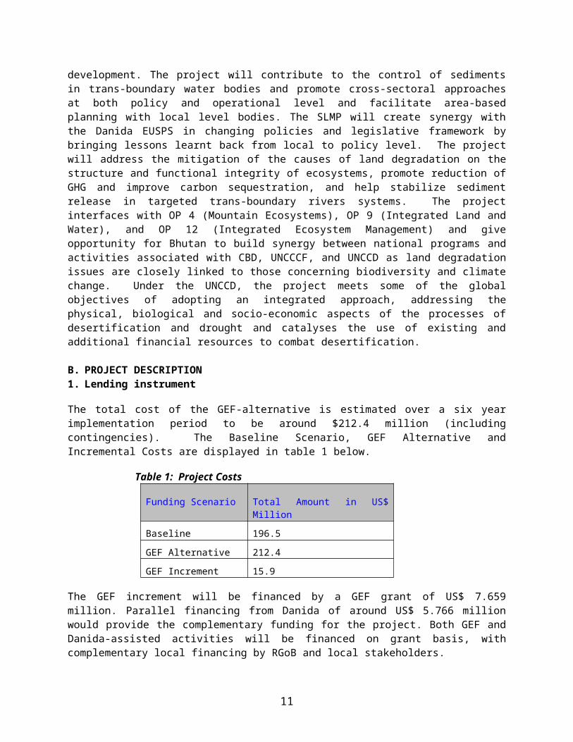
The total cost of the GEF-alternative is estimated over a six year implementation period to be around $212.4 million (including contingencies). The Baseline Scenario, GEF Alternative and Incremental Costs are displayed in table 1 below.
Table 1: Project Costs
Funding Scenario Total Amount in US$ Million
Baseline 196.5
GEF Alternative 212.4
GEF Increment 15.9
The GEF increment will be financed by a GEF grant of US$ 7.659 million. Parallel financing from Danida of around US$ 5.766 million would provide the complementary funding for the project. Both GEF and Danida-assisted activities will be financed on grant basis, with complementary local financing by RGoB and local stakeholders.
Table 2: Project Incremental Co-financing by Component and Percentages Amounts are in USD million
ComponentIndicative
Cost% of Total
Danida EUSPS
% of Danida EUSPS
Counter-part
Financing
% of Counter-
part
GEF Financi
ng% of GEF
1. Policy and regulatory framework for mainstreaming SLM 2.153 13.6 1.101 19.0 0 0 1.052 13.72. SLM Pilot site investment and validation through M&E 2.454 15.4 0.596 10.3 0.484 19.7 1.374 17.93. Upscaling and institutional sustainability ensured for SLM 9.306 58.6 4.069 70.6 0.828 33.6 4.409 57.6d. Project Management + M&E 1.970 12.4 0 0 1.148 46.7 0.814 10.8Contingencies
TOTAL 15.884 100 5.766 100 2.46 100 7.659 100
2. Project development objective and key indicatorsProject Development Objective The Project Development Objective is to ensure that sustainable land management practices are mainstreamed into Bhutan's policy, planning, legal and regulatory framework, and contribute to improving people's livelihoods and economic well being.
7
Key indicators of success Expected outcomes at the end of the project period at the PDO level are as follows:
1. Adoption of a national policy, planning and regulatory framework for SLM in Bhutan to secure land productivity, improved cropping and grazing practices and improved livelihoods;
2. The mainstreaming of SLM approaches in 9 geogs and 3 dzongkhags contributing to ecosystem protection, and improved productivity and hydrological functions;
The progress towards the objectives will be measured through a carefully designed participatory monitoring system that is linked to the Projects’ four components.
3. Project global objective and key indicatorsProject Global Environmental Objective. The Project Global Objective is to combat land degradation and realize local and global benefits of protecting trans-boundary watersheds in a manner that preserves ecosystem integrity in Bhutan.
Key Indicators of Success Expected outcomes at the end of the project period at the PGEO level in target sites are as follows:
1. 30% increase in extent of managed landscapes under sustainable land management, 2. 10% increase in extent of upstream shifting cultivation lands converted to sustainable land cover
and concomitant reduction in GHG emissions, 3. 5% increase in land under community conservation initiatives, and 4. 10% reduction of sediment flow in rivers
The project has been structured into the four mutually reinforcing and complementary components that align themselves with the Danida’s Environment and Urban Sector Program Support (EUSPS) project. The objective of EUSPS is to promote balanced development on a social, economic and environmentally sustainable basis through enforcement of appropriate legislation and policies, decentralized land use and management of natural resources, strengthened capacity to promote and support decentralized urban management and delivery of cost effective urban services with public participation. The GEF funding is requested to provide incremental assistance to assure the safe and environmentally-sustainable management of sloping lands in Bhutan, an internationally important country for biodiversity of mountains and tropical forests and a source of considerable sediment and land degradation that affects adjacent areas and neighbouring countries. The incremental GEF funding for environmental benefits is to be based operationally on cost sharing with Danida.
4. Project componentsOverview The GEF increment would support four mutually reinforcing and complementary components that align themselves with the Danida EUSPS. The GEF funded SLMP encompasses on the ground planning and investment in pilot sites (Component 2) based on a cross-sectoral area-based planning originating from lowest appropriate decentralized level and based on relevant bio-physical and socio-economic information. Through careful monitoring it will generate lessons to feed into the formulation of new policies and revise the regulatory framework (Component1) for inter-sectoral SLM in close cooperation with the EUSPS and it will create the enabling conditions for mainstreaming the SLM approach in the RGoB development planning.
Capacity building through bottom up participatory planning for SLM and institutionalised monitoring will validate and consolidate the SLM approach at all levels (Component 2 and 3). A careful set up for project management (Component 4) will ensure that all stakeholders from chiog to national level have access to participate and take part in decision-making, monitoring and evaluation. The project will adopt a
8
community based approach, through which all chiog residents will be encouraged to prepare a (socially inclusive) chiog SLM plans that will feed into higher level geog SLM Plans that is fundable under the RGoB decentralized budgetary system.
Project Components, Key Outcomes, Outputs and Inputs The project will implement four complementary components in a series of logical, progressive steps designed to reinforce and inform the establishment of the SLM framework in Bhutan and to enable scaling up of processes established through the Project. The Components and their major Outcomes are as follows:
Component One - SLM Planning, Policy, Legislative, and Regulatory Framework established for management of land resources in Bhutan (GEF $1.05M and EUSPS $1.1M)
This component will support activities related to the regulatory arrangements for land management that would comprise of national level sector policies and legislative framework as well as local level by-laws. In synergy with the Danida EUSPS, the GEF project will bring incremental lessons learnt from investments at the pilot sites (Component 2 and 3) to feed back into national level revisions of the policy and legislative frameworks. In this way, the new modes of integrating sector planning for sustainable land management at chiog, geog and dzongkhag level will not only inform the guidelines for preparation of the tenth (2007-2011) and eleventh (2011-2016) five-year plans, but impact on key national level policies and acts, including watershed management, upland agriculture, grazing, forestry, urban planning and infrastructure development.
The three dzongkhags hosting the first three pilot geogs will participate in harnessing and validating the lessons learnt to feed these into an expansion of the SLM approach to other geogs in the same dzongkhags in PY3 and influence and consolidate their Annual and Five-year planning in an integrated multi-sectoral fashion (Component 3). At the lowest appropriate level for SLM, the geogs and chiogs, the formulation of by-laws to guide SLM of private and common lands will be initiated for local community enforcement and testing of different modalities for community-based management of land and water resources.
The monitoring and the application of results indicators from the pilot geogs and new geogs (Component 2 and 3) will be streamlined to capture all the relevant information necessary to influence the ongoing revisions of the planning, policy, legislative and regulatory framework for land management in Bhutan. Close collaboration with Danida EUSPS on a regular basis and the sharing of lessons through the joint Project Steering Committee (PSC) will ensure that results reach the policy level.
The expected outcomes by end of project period are: (i) principles of SLM multi-sectoral planning included in the tenth and eleventh Five-Year Plans of the RGoB/government; (ii) principles of SLM multi-sectoral planning included in the three target dzongkhag and nine geog annual development plans; (iii) SLM multi-sectoral principles integrated into at least three key sector policies and revision and development of relevant legislations; and (iv) a number of local level resource management systems/agreements formulated.
Component Two – SLM Approaches Demonstrated and Validated in Pilot Geogs (GEF $1.4M and EUSPS $0.6M)
The GEF project would support the piloting of integrated multi-sectoral planning and investment in SLM approaches in selected geogs in three dzongkhags as an incremental activity to ongoing government sector investments in these sites. The geog constitutes the lowest government level where planning and investment in land management within agriculture, forestry and livestock takes place. One geog may comprise between 8 – 18 chiogs or villages that are often several hours or days of walking distant from each other. The project would institute an area-based ecosystem approach to SLM multi-sectoral
9

participatory planning at the chiog / village level catering to all land and water resources within the chiog’s area. The pilot geogs were selected on the following criteria, namely severity of land degradation, grazing and tseri impacts, and opportunities for addressing resource use conflicts, biodiversity conservation, and urban-rural interactions.
Central level agencies will assist the geog and chiog in creating the necessary bio-physical and socio-economic information for preparing local level SLM plans. This includes local natural resource inventories, soil capability, forest function and land hazard mapping and the preparation of relevant socio-economic baselines, including the tenure context, in order that a Framework Plan for SLM can be prepared at chiog level. The body of information in the chiog SLM Framework Plan will guide the preparation of a multi-sectoral SLM five-year and one-year Action Plans for each chiog with full participation of all local stakeholders, including women and vulnerable groups. The chiog SLM Framework and action plans will be make up the geog SLM Framework and Action Plan. The chiog five-year SLM action plans would be funded by the GEF project for the first three years and in subsequent years would be mainstreamed into dzongkhag and geog plans for funding by the RGoB through the existing decentralized financial system. A separate grant facility to address specific inter-geog or inter-dzongkhag natural resource management conflicts is included under this component.
The implementation of the pilot activities rests with local level bodies under a community based approach. The geog level RNR staff that normally caters to implementation of sector programs in the chiogs will be supported by a Geog SLM Field Coordinator seconded from MOA and a team of social mobilizers that make up the Geog SLM Planning Team (GPT) to facilitate a multi-sectoral planning approach to SLM. The GPT will move from chiog to chiog to facilitate the preparation of chiog SLM action plans with full public participation and concern for vulnerable groups. After the first three years the GPT and the Coordinator will physically move to other geogs within the dzongkhag concerned to upscale the activities. Both the geog RNR staff and the GPT will receive technical assistance and training during the first project year, to be repeated when new geogs are included.
The monitoring system will take cognizance of the limited or lack of adequate baseline information on natural resources. In the initial year of project implementation the project would support the development and application of new analytical tools for establishing biophysical and socio-economic tools that will inform chiog and geog SLM planning (Component 3). The monitoring system will cater to clearly defined result indicators determined for each investment, including its policy linkages so that lessons learnt for the policy level are easily recognizable. The indicators for monitoring are determined together with village stakeholders as part of the planning process itself to ensure ownership of results. The monitoring will also address the human resource costs and benefits of the new approach of inter-departmental work and bottom-up participatory planning and associated bio-physical and socio-economic information collection. This monitoring will make up the necessary validation that will feed into Component 3 in order to enable the expansion and institutionalization of the approach in other geogs and dzongkhags, as well as the revision of regulatory frameworks that is envisaged under the EUSPS baseline. The economic and financial benefits and impacts on livelihoods of the SLM activities would be assessed as part of the monitoring effort to support the up-scaling and ensure the economic rationality and social acceptability of the investments. The monitoring set-up will use MOA’s existing Manual for Monitoring and Evaluation as well as a separate locally based participatory monitoring system. In order to capture the new approach of GEF funded SLMP, which is non- sectoral in approach, an incremental monitoring system will be institutionalized to compensate weakness in the existing MOA sector based monitoring approach. Thus, separate chiog-based participatory monitoring will be carried out to address technical innovations and their applicability as well as the best institutional framework for SLM under different tenurial conditions.
10

The geog local government body, the GYT, will form a geog level SLM Committee to follow the project planning and monitoring. The dzongkhag will be an active partner in the SLMP through its administrative head, the Dasho Dzongda, and the dzongkhag SMLP Coordination Committee where the dzongkhag RNR staff, the dzongkhag planning officer and engineer participate in discussing field experience and facilitate its application in other geogs and in the dzongkhag itself. The dzongkhag RNR staff will be in regular contact with the pilot geog RNR staff and both will be supported by the regional RNR-Research Centers for specific studies related to SLM. In project year 2-3 the dzongkhag together with the PMU and the geog field coordinator would select additional geogs within the same dzongkhag for upscaling of the SLM approach (Component 3).
The expected outcomes by end of project period are: (i) local inventories, resource assessments and socio-economic profiles established for the pilot geogs and guiding local planning; (ii) an organizational and institutional framework for multi-sectoral planning in place at all levels; (iii) key environmental impacts of slope protection, sustainable agricultural practices, degraded forests regenerated; tseri converted to permanent cropping, grazing lands improved and resource conflicts resolved, forested areas under community management, achieved; and (iv) SLM investments validated and lessons learned on transaction costs and institutional modalities
Component Three Multi-Sectoral SLM approaches institutionalized and scaled up (GEF $4.4M and EUSPS $4.1M)
The objective of this component is to enable the expansion of the SLM approach to other geogs and dzongkhags based on the learning and experience of Component 2. This will be done through expansion of the approach and its consolidation in governmental institutional system. The institutional system for sustaining the SLM approach comprises both the organizational arrangements for inter-sectoral planning in the future, the necessary skills, the tools and the budget supporting the new approach. The organizational arrangement encompasses national level and the local dzongkhag and geog level modalities as they prepare the annual and five-year plans for land use and land management. The call under the GEF increment for inter-sectoral planning will require the RNR staff at geog level to plan in unison focusing on an area-based approach rather than a sector-approach and for the dzongkhag eventually to do likewise and integrate not only the RNR sectors but also infrastructure, roads, irrigation, power and industrial development within the dzongkhag. The dzongkhag is the level where issues related to inter-dzongkhag grazing conflicts would be solved. It is similarly the pivotal juncture where the interfaces with the urban centres are played out, and where the engineers for road construction and irrigation canals are hosted. It is the level where an area-based approach to SLM for the whole dzonkhag can be formulated as a dzongkhag SLM Framework Plan supported by environmental and socio-economic information brought about by national level agencies at a later stage in the project. The enabling conditions for this approach will be brought about by the lessons from Component 2 and the expansion under Component 3, and by the RGoB intention to institute an area-based approach for the next Five-Year Plan and by the central level NECS’ support for setting up Dzongkhag Environment Committees (DEC) corroborating the dzongkhag’s attempts to mainstream environmental objectives in planning. The DEC may make up the SLMP Coordination Committee at dzongkhag level.
The GEF project would provide the analytical tools and learning from the field-based (Component 2 and 3) and complement EUSPS support for the development of dzongkhag administrative and technical MIS systems and capacity building that facilitates local decision-making and monitoring. In addition, the GEF project would support targeted research to better understand policy and institutional failures that drive land degradation and facilitate the adoption and promotion of innovative and indigenous land use practices. RGoB’s commitment to address urgent issues of land degradation and future area-based planning serves as an indication of full government support and budget for the field of SLM.
11
The expected outcomes by the end of project period are: (i) development and adoption of new analytical tools for biophysical and socio-economic baselines that inform chiog and geog SLM Framework and Action Planning. These analytical tools comprise modes of bottom-up planning, as well as preparation of land hazard zoning maps, soil capability analysis, and the preparation of land use typologies. The tools will specify the skills and time required for the application of these tools, too. Analytical tools for generating relevant socio-economic and tenurial baselines would also constitute an outcome to guide the development of a sustainable planning framework for SLM in the future; (ii) SLM lessons adopted at pilot geog levels and up scaled to six other geogs; (iii) capacity build in inter-sectoral planning for SLM planning; (iv) thematic expansion of SLM concept supporting better understanding of ecosystem concerns. The GEF project may undertake a limited expansion to other dzongkhags in pusuit of narrowly earmarked thematic issues arising from lessons learnt in the pilot dzongkhags; and (v) knowledge generation for SLM policy guidance.
Component 4 Project Management established (GEF $0.8M)
This component caters to the establishment of the SLMP implementing bodies. At the national level, a PMU takes overall responsibility for coordination and management of project activities. A Project Steering Committee (PSC) guides the implementation of the project and endorses SLMP workplans. The PSC is chaired by the Secretary, Ministry of Finance, which emphasizes the strong commitment of RGoB to SLM approaches. It includes representatives of a number of relevant ministries and is jointly shared by SLMP and Danida to ensure synergy of the two programs.
The PMU consists of a Project Director and Project Manager. The inter-sectoral committee, which as a Working Group supported the preparation of the SLMP will continue as a Multi-sectoral Technical Advisory Committee (MTAC) representing all the ministries and departments involved in the Project (Ministry of Agriculture, Ministry of Finance, Ministry of Trade and Industry, Ministry of Works and Human Settlements, Ministry of Home and Cultural Affairs, National Environment Commission Secretariat).
At Dzongkhag level a SLM Coordination Committee will be appointed, which may coincide with the recently appointed Dzongkhag Environmental Committees. At geog level the GYT or a smaller unit appointed by the Gup will serve as the geog SLM Committee and Geog M&E Forum to interact with the SLM Field Coordinator, the Geog SLM Planning Team and the Geog RNR staff for project implementation.
The expected outcomes by end of project period are: (i) National Project Steering Committee and Multi-sectoral Technical Advisory Group effectively supporting the mainstreaming of SLM; and (ii) regional and sub-regional decentralized institutions effectively resolving resource use conflicts and wider application of SLM concept.
5. Lessons learned and reflected in the project designThe project design reflects lessons from ongoing and completed projects as follows:
Support from GEF was provided for the Bhutan Trust Fund for Environmental Conservation (April 2, 1998). A lesson at the start was the need for a reliable additional funding source not dependent on income from the trust fund in order to carry out benchmark activities. The National Capacity Self-Assessment for Global Environmental Management (UNDP) involved stakeholder consultations with relevance for future work. The lessons from the Integrated Management of Jigme Dorji National Park (1997-2003)(UNDP-GEF) emphasized the value of maintaining a flexible and adaptive approach to project design and implementation and to ensure that realistic targets were set commensurate with actual staff strength and that adequate remuneration was provided. The Energy and Environment Project, UNDP Bhutan (April
12

2004) highlights that policy impacts are often more sustainable if achieved through demonstration projects with a bottom-up entry point to policy formulation, that environmental goals and results are intricately linked to broader political and governance structures, that integration of organisational functions is necessary relying on incentives for information exchange and joint programming, and that capacity development needs to look beyond project duration for long-term impact rather than focus on short training and study tours.
The review of UNDP/GEF Small Grants Program (SGP) indicates that where stakeholder consultations were cursory projects suffered from lack of community motivation and understanding of project objectives, that visibility of benefits was key to community participation as it is natural for local people to be reluctant to dedicate their time and energy on projects that do not demonstrate immediate benefits. Where benefits were tangible and immediate, community participation and zeal to do their bit was profound. This was most notable in the Biomass Fuel Efficiency Project in Tsirang, Shingneer Watershed Management Project, and Cane and Bamboo Management Project in JSWNP. In Ngatshang Integrated Land Management Project, which had an intense work plan because of the short project duration, the staff and students of the Ngatshang Community School found the project onerous. SGP projects have helped redefine forester-people relationship and promote the concept of Community-Based Organisations (CBO), which is a new concept in Bhutan. SGP can be regarded as a ground-breaking instrument in bringing about this concept in the country.
6. Alternatives considered and reasons for rejection
A number of alternatives were considered such as to continue the existing approach of promoting environmental awareness and improved ecologically sound practice among individual sectoral agencies and / or instituting a project using a “payment for environmental services approach” to help make allocation decisions within particular watersheds, based on values ascribed to the utility of eco-system functions. It was discarded because the detailed data required for attributing specific cause and effect are not available in Bhutan and downstream users are either still willing to live with the environmental damages or are not yet ready to consider compensating upstream inhabitants for what they consider are free eco-system services. This option is therefore before its time. The third option, the one adopted, was that of creating a cross-sectoral approach at all levels bringing the ecological, economic and social dimensions into sustainable land use planning. The SLMP formulation process itself was designed to provide substantial impetus to multi-sectoral teambuilding through forming cross-sectoral Working Group, intensive stakeholder participation at community and local government level, the inter-sectoral technical level and at the level of the national decision-makers. This approach was felt to be the most suitable to enhance the prospects for sustainable implementation and outcome and, through SLM approaches, experiment with and help to foster the gradual dissemination and mainstreaming of locally-driven, integrated SLM planning processes into RGoB’s overall planning and implementation framework.
C. IMPLEMENTATION1. Partnership arrangements (if applicable)Co-financing Arrangements The project will financed by DANIDA through parallel financing arrangements. The DANIDA-assisted EUSPS and GEF-assisted SLMP will both address rural and urban environmental management thorough support to the Ministry of Agriculture, Ministry of Works and Human Settlements, Ministry of Trade and Industry, and the National Environment Commission Secretariat. While EUSPS emphasizes policy and planning at the central level for its program component with MoA and RNR, SLMP works mainly from the ground up, promoting mechanisms for sustainable land management at the chiog and geog level and feeding back into dzongkhag level in order to bring lessons learnt back to policy level for revision of policies and regulatory framework. The alignment will also increase the efficiency in the use of human and financial resources, reducing the risk of overlap and competition for project staff in these sectors and minimizing the cost of implementation and
13

administration of these programs. A Memorandum of Understanding signed between RGoB, DANIDA and the World Bank signed on 26 March 2004 outlines the cooperation between the two programs. SLMP and EUSPS will coordinate their annual work plans and budgets for submission to the joint Project Steering Committee. They will also coordinate their activities at central and local levels, including selection of target areas, capacity building, information management, technical documentation, and impact assessment, as well as use of long- and short-term advisors and consultants and the conduct of joint reviews and evaluation.
The SLMP is hosted by the MOA, but it may also fund activities, which technically are under MTI or MOWHS which both are represented in the MTAC and PSC. This takes place when such activities appear in chiog and geog SLM action plans.
A number of other land management oriented projects are implemented in Bhutan supported by donors. These will share lessons learnt with the SLMP through regular formalized exchange of work experience. Several of these operate as program support and are part of the RGoB’s ongoing development investment.
2. Institutional and implementation arrangements
Institutional and Implementation arrangements are based on existing government structures, but with a cross-sectoral Project Steering Committee, Multi-Sectoral Technical Advisory Committee and local-level cross-sectoral teams to guide the project towards mainstreaming the SLM approach in RGoB development planning. Activities in the pilot geogs would be based on a participatory planning approach involving local communities, local government staff and geog SLM planning teams. The participatory planning approach is discussed in detail in Attachment 1 to Annex 4 of the PAD. This Planning approach outlines the approach for the involvement of communities in planning, decision making, implementation and monitoring of sustainable land management activities supported by the project
The Project Steering Committee (PSC) is an inter-ministerial group, chaired by the MOF, and comprising representatives from the key implementation agencies (MOA, MOW&HS, MOTI, NECS). The PSC will meet semi-annually and monitor SLMP implementation accordingly to agreed work plans and budgets. It will approve proposed budget revisions, job descriptions and deployment of international and national technical advisors and consultants to complement those deployed by EUSPS. It will take decisions on the policy, planning and regulatory aspects of the SLMP, oversee project management arrangements and performance, and ensure smooth coordination with Department of Budget and Accounts (DBA) on matters of funds flow and project accounting, and with Royal Audit Authority (RAA) on project audits.
The Project Management Unit (PMU) is entrusted with the day-to-day management of SLMP and consists of a project director and a project manager as well as secretarial and financial staff. The PMU is under the MOA. It has oversight of the entire work program set out in the Project Plan of Implementation (PIP). The Project Director will be an ex-officio member of the PSC. The Project Director together with the Project Manager is responsible for close coordination with the MTAC, the EUSPS and for constant support to field implementation. International Technical Assistance support to the PMU is envisaged.
The Multi-Sectoral Technical Advisory Committee (MTAC) at central level represents the ministries and departments collaborating cross-sectorally in the project. Members of the MTAC are the same persons that constituted the cross-sectoral Working Group for the SLMP preparation. It provides regular advisory and operational technical support to the PMU and the field and caters to the alignment between the project activities and the respective sectoral plans and programs. The MTAC will meet once a month.
14

Dzongkhag SLMP Coordination Committee will be formed the Dasho Dzongda to constitute a coordination mechanism between geog and dzongkhag. It may be equivalent to the DEC. It will comprise of the dzongkag RNR staff, Planning Officer, Engineer, and Dzongkhag Financial Officer. Its RNR staff will have regular contact with geog RNR and as a committee it will advise on upscaling to other geogs within the dzongkhag in PY3. (TORS)
The DYT is the dzongkhag elected body that as a political body will carry forward all elements of the new approach as well as spearheading with the dasho dzongda possible negotiations with neighbouring dzongkhags on grazing issues.
Geog SLMP Field Coordinator is an incremental staff seconded by the MOA to the geog level in support of the SLMP. The cross-sectoral approach is new and the RNR staff at geog level needs support to align its work with a new approach that addresses SLM rather than only sector work and supports it in developing bottom up SLM planning from chiog level.
Geog SLM Planning Team is a body hired by the project as a collaborative training input to the geog RNR staff. Its main role is as social mobilizers to facilitate the chiog level area-based planning for SLM. There is one team for each of the three pilot geogs recruited among local residents/villagers. The size of the team depends on size of geog ranging from 2-3 men and 2-3 women.
The GYT as the geog level elected body headed by the Gup and consisting of annually elected tshogpas who each represent a chiog. The GYT may perform as the Geog SLMP Coordination Committee or set up a local working committee for regular interaction with the Field Coordinator and the Planning Team. Together with the geog RNR it will help scrutinize the SLM chiog plans and merge them to Geog SLM Action Plan in order to submit this for SLMP funding through the normal channels so that a Letter of Credit can be issued to the geog for SLMP implementation.
15

Table 2 Implementation Arrangements
SLMP Facilitation Rgob & Decentralised Line Agency SLMP Planning
Structure Structure Support Structure Tools
SLMP activities
Chiogs 1, 2, 3, 4, 5, 6, 7, 8, 9, 10, 11, 12, 13, 14, 15, etc.
Project Plan
Dzongkhag Plan &
Dzongkhag SLM Plan
(PY 3-4)
Chiog SLM PlansRgoB Activities (baseline)
Geog Accountant
Geog M&E Forum
RNR staff, advisors
and implementers
GSLMPT
of MT, MWHS
and RNR RC
Geog GYT
Dzongda and
Dzongkhag
DYT
Home Ministry
Danida
Dasho
(hired staff under the
Coordinator
Dzongkhag
SLM Coordinator &
Committee
(selected by Dasho
PSC
MTAC
Geog SLM coordinator
and Gup)
EUPS
(incremental, appointed
by MOA)
Geog SLMP
Planning Team
Dzongda among
existing staff)
Geog SLM Plans
PMU
Project Director &
Project Manager
Geog SLMP
Line Ministries
RNR staff
Planning Officer
Accountant
Regional Offices
16

The selection of the above bodies follow the existing RGOB system and only where on the job training is necessary through deployment of rotational incremental staff and consultants are these added. Capacity constraints are linked to institutionalising bottom-up area-based SLM planning linked to geo-informatics. Normally, RNR staff implements a menu of crop or livestock demonstrations already decided upon in a central level menu. In SLMP RNR staff must facilitate together with the Planning Team decision making at chiog level on how to define SLM activities along with the ordinary development activities at the same time and merge the two at chiog level. Besides capacity constraints there may be time constraints also. Careful monitoring of the new approach will address both environmental as well as institutional impact.
Financial management and procurement will be carried out primarily by the geog that receives a Letter of Credit and the dzongkhag financial officer for consolidating reporting. The capacity of the geog would not be sufficient and training of local level geog staff in financial management, procurement, disbursements and financial progress monitoring is necessary. Training of geog level staff is envisaged also in the World Bank-assisted on Decentralized Rural Development Project, which covers three-quarters of all Geogs in Bhutan. The SLMP will piggy-back on this training.
Flow of Funds and Financial Reporting is based on the RGoB recognised system. Project funds flow through the Department of Budget and Accounts (DBA) of the Ministry of Finance directly to the relevant agencies charged with the implementation of project activities through a Letter of Credit. The Annual Work Plans and Budgets will be integrated at the geog, dzongkhag and line agency level and presented as the overall Project Annual Budget in support of a PIP that clearly designates responsibility for implementation among stakeholders. The SLMP will use activity-based planning, budgeting and financial reporting systems, consistent with RGo/B’s system, as described in the Financial Rules and Regulations (FRR), July 2001, Ministry of Finance (MOF), including the accountability framework described in Annex 1 Financial Rules and Regulations 2002 – Applicable to Dzongkhag Executed Activities, Dzongkhag Yargay Tshogdu Chathrim, 2002; and Annex 1 Financial Rules and Regulations 2002 – Applicable to Geog Executed Activities, Geog Yargay Tshogchhung Chathrim, 2002.
3. Monitoring and evaluation of outcomes/results
The SLMP Monitoring Framework The monitoring system will take cognizance of the limited or lack of adequate baseline information on natural resources. In the initial year of project implementation the project would support the development and application of new analytical tools for establishing biophysical and socio-economic tools that will inform chiog and geog SLM planning (Component 3). The GEF project will feature two monitoring arrangements. One that follows the MOA’s Manual for Monitoring and Evaluation, which is clearly segregated by sector in its reporting format and serves to monitor financial progress; the other is designed particularly for the GEF project and geared towards capturing the new approach of multi-sectoral planning to generate the important lessons learnt from a new SLM approach. Both monitoring systems are described in the Operational Manual and Annex 3 of the Project Appraisal Document (PAD).
The SLM multi-sectoral monitoring will link up to the SLMP’s Results Framework through a system of carefully defined indicators linked to each SLM investment and action plan at chiog level. Thus, as part of the chiog participatory planning process the project together with the local villages establishes the baselines and relevant indicators of success that will guide the project’s own learning. The very planning process and the collaborative definition of indicators at that stage serve to create ownership of the process and the results. The facilitators for this process will be the GPT, the Geog Coordinator and the Geog RNR staff. Each chiog level plan/activity will have a small log-frame attached with time-bound indicators that are determined by the local stakeholders and which identifies both the socio-economic and environmental benefits to arise. The participatory monitoring process will be facilitated by the Geog SLM Coordinator
17

and GPT. The Geog Planning Team with support from the RNR staff will undertake an annual assessment of the monitoring results at each chiog and provide feedback and guidance for adjustment to the farmers. The framework for participation of local communities in the planning, implementation and monitoring of project activities is described in detail in Attachment 1 to Annex 4 of the PAD.
Training of the Geog Coordinator, the SLM GPT and Geog RNR staff in using a new monitoring system will be facilitated by technical assistance from the participatory planning advisor during the first months of the project. The training includes the design of format, logistics of its implementation, resources required and linkages to the MOA’s Manual as well as definition of storage and access to data.
The design and training will include the dzongkhag level RNR and Planning Officers/Dzongkhag SLMP Coordination Committee as field reporting will go through these with copy to the PMU. Consultants will be hired to undertake specific studies with regular intervals to generate lessons that do not lend themselves to the regular monitoring. The physical results of impact on land management will be carried out selectively using indicators based on the DPSIR model adopted for the Environmental Information Management System (EIMS), concurrently being developed at the NECS under EUSPS. The NECS member of MTAC will support this effort.
At PMU level the lessons learnt will be aligned with those of the EUSPS and presented to the PSC to feed into policy makers’ work on revision of the regulatory framework and policies.
4. Sustainability and Replicability
The introduction of the SLM approach been confirmed at a high level technical meeting on in October 2004 by the minister of MOA calling for ‘actions to arrest the land degradation situation immediately’ and for the “formulation of a land management and soil conservation master plan” and by having a multi-sectoral PSC and MTAC overseeing the GEF project. Local level sustainability is fostered by the planning process that requires prior stakeholder ownership to defined SLM activities and cost-sharing of investments. Proposed SLM practices and technologies will be applied closely with existing indigenous practices and knowledge of farmers that are the basis for decision making and survival strategies. This caters in project design to the critical factors outlined in B5. Replicability is linked to scaling up of institutional capacity, as well as technical and financial innovations within the same dzongkhag and at national level for final policy adoption. The ability to scale up relies heavily on a focused and targeted monitoring system. The scaling up is understood as direct replication and/or as identifying new solutions in new surroundings based on what is already tested.
Specifically, in terms of shifting cultivation, the project will tackle this issue by including the tseri lands of each chiog/geog in the chiog/geog SLM framework and action plans and define solutions together with villagers to address the negative impacts on environment. In one geog, Phuentsholing, farmers already have turned some tseri land into orchards that are providing a steady income to the farmers. Others best practices include crop intensification and rotation, and establishing forests and terraced farming systems. The project would facilitate farmers make the transition from tseri to better forms of land use by providing agronomic information and technical extension support, study visits to successful farming sites (e.g. converted tseri lands to orchards in Phuentsholing geog and other appropriate and sustainable land use practices), seeds and other planting materials and targeted capacity development. The solutions to existing unsustainable use of land will be area-specific but all tseri lands would form part of the plans resulting from the participatory planning at chiog level. Solutions would be determined on the basis of land suitability and land capability assessment that would be supported by the project and social acceptability by the farmers.
18

The institutional capacity building is fostered by classroom training and on the job training with careful inbuilt procedures for monitoring of capacity building results. A staggered approach to bring in new RNR staff and GPT for orientation and on the job training in the old geogs prior to launching SLM approaches in new geogs will avoid the risk to start from scratch. Dzongkhag RNR and Planning Officers will be invited and kept abreast of the SLM work in order for them to take ownership of the results of a multi-sectoral approach for further dissemination. The PMU with the PSC are responsible for identifying the entry points for bringing lessons learnt to bear on policy revisions. The scaling up of the technical aspects comprise scaling up multi-sectoral solutions to problems of land degradation and scaling up new techniques which may have occurred as a result of multi-sectoral approaches or through learning from abroad. Technical solutions will constitute thematic issues in all workshops with stakeholders. The scaling up of the financial aspects of SLM approach would require in the long run that sectoral block allocations give way to area-based planning, which may occur with the preparation of the 10 th Five Year Plan. The Secretary, MOF is head of the PSC for the GEF project and will provide an important link and vehicle for the GEF project to bring all budgetary requirements for a new SLM approach for discussion at an early stage and adapt accordingly. The scaling up of the policy and regulatory aspects entails that local by-laws and viable institutional mechanisms are reflected in their intention in the national regulatory frameworks. This will happen through careful dissemination of lessons from the pilot sites in a manner that is conducive to easy incorporation.
5. Critical risks and possible controversial aspects
RISKS RISK MITIGATION MEASURES RISK RATING WITH MITIGATION
To Project Development/Global Environment ObjectiveRGoB sector agencies do not receive sufficient administrative room and financial support to integrate their guidelines for annual plan investments in a way that support area-based planning for SLM
Dzongkhag and geog RNR officers do not have the capacity to undertake inter-sectoral planning and support the preparation of overall Chiog and Geog SLM Framework Plans
Farmers are too poor, and incentives are not adequate to influence adoption of long term SLM approach
The Project Steering Committee (PSC) high-level and chaired by Secretary, Ministry of Finance, provides commitment to mainstreaming of SLM
PSC provides access/conduit to the Central Council of Ministers (CCM) that endorses policies and legislation
SLMP Multi-sectoral Technical Advisory Committee ensures coordination between line agencies for SLMP activities
On the job training of dzongkhag and geog level extension staff and planning agents at project start and careful identification of constraints (time, incentives) to be addressed during scaling-up of approach. Dzongkhag level with support from DEC develops a dzongkhag SLM Framework Plan that aligns investment in other sectors, including infrastructure, to SLM goals
The SLMP participatory bottom-up planning approach ensures poverty issues are internalized in the adoption of the SLM approach
M
L
M
19

To Component ResultsComponent 1: SLM Planning, Policy, Legislative, and Regulatory Framework established for management of land resources in BhutanBureaucratic constraints in feeding field level information into central level legal agencies
Sector agencies reluctant to collaborate cross-sectorally
EUSPS-supported review, revision and drafting of legislation not completed in a timely manner and not able to support SLM approach due to sector-based regulatory framework
SLMP and EUSPS through MOA’s PPD set up communication channels with the legal section of MOA for early information sharing
MTAC provides an institutional channel that ensures sector departments collaborate
Shared PSC between EUSPS and SLMP to ensure synergy and timely implementation
MoU signed between Danida, RGoB and World Bank to ensure collaboration EUSPS and SLMP
SLMP and Danida EUSPS seminars on policy issues
M
L
L
Component 2:Sustainable Land Management Approaches demonstrated and validated in pilot sitesSkills in area-based bottom up planning for SLM lacking among Geog RNR staff and Geog Planning Team
Difficulties in combining results of technical survey with results of tenurial surveys into one plan
Innovative land management technologies not compatible with household manpower
Monitoring arrangements do not capture the necessary documentation of SLM assessment and planning tools and cannot feed into the strategy and policy implications from field experience
On the job training as regular inputs over the first year and subsequent years
Support, guidance and training by technical assistance during initial steps
Technologies will be adapted to capture all thematic information
All technological land management options will include manpower analysis
Limited Logical Framework Analysis will be conducted for all field trials and land management interventions so that they are guided by clearly formulated objectives, anticipated outputs and success indicators to lend themselves to monitoring and up-scaling
L
M
M
M
Component 3: Multi-Sectoral SLM approach institutionalized and scaled-upInadequate priority given to developing analytical tools that help consolidate the SLM planning
Adequate funds set aside in project to build capacity and equip line agencies for developing tools
M
20

approach by line agencies responsible for development
The scaling up may suffer from lack of skilled manpower in new geogs
The dzongkhags and geogs may not wish to abandon sector-based planning
Long term technical assistance provided to support this development
Early identification and training of additional field staff ensures the required manpower is available
The RGoB’s guidelines for the 10th Five Year plan recognizes area-based planning as the foundation for development plans allowing SLM concerns to be included cross-sectorally
L
M
Component 4: Project Management Established and Cost-EffectiveMOA does not second sufficiently high-skilled staff as Geog SLM field coordinators
PMU and MTAC to busy and detached from the field to internalize the lived lessons learnt
The monitoring data do not reach central level in a fashion that lend themselves to easy formulation of policy recommendations
Commitment from RGoB to appoint coordinators with relevant skills prior to project approval. Commitment will be sought
Bank Supervision will monitor effectiveness of PMU and MTAC and seek remedy if necessary
The SLMP adopts two-pronged monitoring approach that ensures relevant data are monitored and lessons learnt are prepared regularly
L
L
M
Overall risk rating M
6. Loan/credit conditions and covenants
D. APPRAISAL SUMMARY1. Economic and financial analyses
Base Analysis The analysis focuses on the value of reducing the rate of forest loss over the next fifty years – on the basis of modest assessments of a few parameters -- to establish a preliminary return to the investment of the proposed project. If this base return justifies or is close to justifying the scale of the proposed investment then the acceptability of Project from the points of view of both the Bhutanese economy and the rest of the world should be more likely than not. The values of avoided losses of agricultural soil and soil fertility due to erosion and of avoided losses in infrastructure from landslides would further improve upon this preliminary assessment. Currently, the rate of loss in forest area is estimated at 0.5 percent per year. The analysis considers a reduction in this rate of area loss to 0.25 percent per annum after ten years of implementing improved land use planning and management.
The value of forest area, in terms of the value of local forest products and downstream environmental services (within and outside Bhutan) should be at least as much as the value of using land generally for dry land agricultural production. This proposition follows as many steep, formerly forested areas are used for cultivation, and, if soil fertility of exiting cultivated areas continues to decline in a future without the Project as now forecast by RNR staff, new cultivation will encroach upon forests to maintain current levels of household income. Certainly not all land is available for cultivation; and many forest areas at specific sites are more valuable for their potential forest products than in alternative uses. The average
21

economic value of dry land cultivation is proposed as a rough proxy valuation for forest areas in all their local and downstream services.
The average production of grains (wheat, barley and maize) on rainfed land in Bhutan is about 1 270 kilograms per hectare. The import parity border value of this production is approximately USD 125 per tonne (this is a conservative estimate – the value might likely be higher), or about USD 158 per hectare. After allocating about 60 percent of this value of production for the value of inputs (mostly local labour) the net value per hectare of land is approximately USD 60. The assertion here is that, in total, forest areas in Bhutan provide services each year having an average value of USD 60 or more per hectare (in 2005 constant values)1.
Forest areas in Bhutan comprise about 29 050 square kilometres, according to the most recently published official statistics. At the current estimated rate of loss in forest area in Bhutan (0.5 percent per annum), forest area fifty years from now would amount to about 22 700 square kilometres.
Under the proposed Project, this rate of forest loss should be reduced significantly in the long run. The analysis considers a reduction to a rate of 0.25 percent a year after ten years from the start of the implementation of the Project. This implies that fifty years from now the forest area would amount to 25 310 square kilometres as a result of the processes and practices introduced under the Project.
Project costs are estimated at USD 15 million or less in economic values. Given the proposed reduction in loss of forest area, the overall base economic rate of return (ERR) is estimated at 11 percent (10.8 percent). The spreadsheet calculation is provided in attached Table 1. The threshold rate of return for Bhutan may be considered to be 10 percent (or less). The preliminary estimation of the Project’s economic rate of return on the basis of these parameters suggests that the scale of the proposed investment in relation to the minimal potential benefits considered here should be acceptable.
Sensitivity Analysis. As formulated, the spreadsheet model of this analysis hinges on five principal parameters: the average border value of grain, the output per hectare of grain, the value of inputs (considered here to consist mostly of labour) per hectare of grain production, the initial forest area, the rate of forest area loss without the project and the rate of forest area loss with the project. The single parameter that most strongly affects the rate of return is the rate of loss of forest area without the project. With all other parameters at their base values, a rate of forest area loss of 0.4 percent per annum (a variation of 20 percent from the base value of 0.5 percent for this parameter) in the future without the project results in an ERR of about 8.3 percent. If the rate of future loss is 0.6 percent a year (a variation of 20 percent over the base value) the ERR becomes about 13 percent. For the other parameters, variations in any one parameter of plus or minus 20 percent, while keeping remaining parameters at their base values causes the ERR to switch between 9.6 and 11.8 percent. These exercises show that the base return is not particularly sensitive to any one value of the key parameters in the calculation. As the values of these key parameters are as likely to be above as below their base values, the valuation of a slowing of the rate of forest area loss (a halving of the current estimated rate of annual area loss), using as a proxy for the value of forest physical and other environmental services the potential economic value of using that land in dryland agriculture, generates an overall stable result.
2. Technical
Sectoral expertise for Land management: MoA has considerable experience in the various sectoral aspects of land management ranging from the management of soil, livestock, forests, and agriculture. The technical inputs concerning these aspects are provided by the RNR staff in the dzongkhags and the RNR
1 Carbon sequestration is at least 100 tonnes per hectare.
22
extension staff in the geogs. The commitment of the Minister to sustainable land management is demonstrated by his plan to start a country-wide campaign on land management from July 2005.
Integrated and sustainable land use planning: Integrated planning of land based on the capacity of the land, the needs of the people and overall dzongkhag/geog plans is still at a very nascent stage in Bhutan. Currently the plans are prepared by the tshogpa (village/chiog leaders) based on a list provided by the villagers; with limited analysis of the impact on the land or surrounding resources. This project will provide technical assistance to integrate land management principles in the geog and dzongkhag plans starting at the level of chiogs (villages). The goal is to feed the planning into the Tenth Five Year Plan planning process. The project will also assist at the national level in the review and formulation of policies that follow the principles of integrated land management; and will also assist in developing thematic maps that include natural resources, human resources and potential hazards.
Environmental Management: RGoB has shown strong commitment to the conservation of biodiversity, environmental conservation and sustainable development. The National Environment Commission Secretariat during the Eight Five Year Plan formulated the National Environment Strategy which was finalized in 1998. In 2000, the environmental Assessment Act was passed which establishes procedures for the assessment of potential effects of strategic plans, programs, policies and projects on environment. The National Environmental Commission also adopted several environmental codes of best practices for hazardous waste management, solid waste management, sewage and sanitation and urban roads and traffic.
Although there is strong commitment in environmental preservation and policies are in place, due to the relatively new legislation, the decentralization of the environmental management responsibilities from the NEC to the line Ministries has only occurred in one Ministry. The Ministry of Agriculture has committed to the establishment of an Environment Unit and the arrangements are currently being discussed.
Furthermore, the implementation and monitoring of the environmental policies at the Dzongkhag levels are weak and public information is limited due to both human and capital capacity constraints. This project will provide assistance in building the capacity of the dzongkhag, RNR staff and Ministry of Agriculture officials to prepare, implement and monitor EIAs and environmental management activities.
3. Fiduciary
Financial management and disbursement arrangements have been streamlined, to the extent possible, to use the existing government system. The MOA, which has experience in implementing Bank financed projects, will be the key implementing agency and have overall responsibility for financial management of the project. The audit reports submitted to IDA for the previous project had very few qualifications which were not material and the reports were received on time during the later part of the project period.
Project’s financial management and disbursement arrangements will support RGoB’s efforts for promoting decentralization and greater ownership by the dzongkhags of project activities undertaken at the dzongkhag level. Accordingly, for all project expenditure to be incurred by dzongkhags, funds will be budgeted, recorded, accounted and reported in the books of the dzongkhags.
All project disbursements will initially follow the transaction based system. Close supervision will be conducted to graduate the project to Report Based disbursement. Project funds will be deposited in to Special Account to be opened in the Royal Monetary Authority and will be operated according to terms and conditions acceptable to IDA. Disbursements from the special accounts will be following the normal government procedure for making payments, as described in the Financial and Accounting Manual of
23

RGOB. Project accounts will be kept on a cash basis of accounting. Annual external auditing of project accounts will be carried out by the Royal Audit Authority, which is the supreme audit institution in Bhutan and the internal audit function will be carried out by the Internal Auditors in the MOA. Separate TORs will be agreed for the external and internal auditors
MOA will submit to IDA the Financial Management Reports (FMRs) on a quarterly basis for reporting the financial progress of the project. The formats for FMR were discussed during pre-appraisal and will be confirmed at negotiations. The FMR formats have been simplified to facilitate easy extraction of necessary information from the existing government system. Capacity strengthening and building in financial management will be carried out during the project period at the dzongkhags and geog levels.
4. Social
The project is expected to yield positive social impacts by providing rural communities opportunities to achieve higher incomes through enhanced agricultural productivity and more productive use of land resources. The project will follow a participatory and inclusive process of direct and systematic participation of beneficiary communities in the selection, implementation and monitoring of the activities supported by the project.
Consultations with the community concerning the objectives of the project indicate that project affected people at the identified pilot sites strongly support the idea of having a project to address land degradation problems. They identified the main positive social impacts of the project as: reduction in incidents of landslides and flash floods, improvement of forest conditions, and improvement in livelihoods and farming practices.
It is highly unlikely that proposed project activities will result in any significant adverse social impacts, including the physical relocation of people or the acquisition of privately owned land. Some adverse impacts may arise from potential restriction on access by local communities to natural resources in the pilot sites. Since the project is community-based where the community using the resources decides to restrict access to natural resources and identifies appropriate measures to mitigate adverse impacts, if any, on affected people including the more vulnerable members of the community, the provisions of the World Bank’s O.P. 4.12 are not applicable to the project. However, to ensure transparency and equity, a Process Framework (PF) for the participation of local communities in the implementation of sustainable land management activities by the project has been developed to detail the principles and processes for assisting communities to manage any negative potential impacts. Since the exact social impacts of access will only be identified during project implementation, the Process Framework will ensure that mitigation of any negative impacts deriving from any potential restriction access by communities to natural resources (e.g. grazing land) will be based on a participatory resource mapping, involving all affected stakeholders, and on their consent regarding the scale of restriction and the type of mitigation measures to compensate any loss of income. Any desired changes by the communities in the ways in which local populations exercise customary tenure rights in the project sites will not be imposed on them, but will emerge for a consultative process satisfactory to the World Bank. Annual project work plans including management arrangements for community access to resources in project sites and associated mitigation measures will require World Bank agreement.
Restrictions by surrounding communities to utilize resources are possible, but such restrictions to resource access are not expected to be introduced by the government or project entities. Rather, they will be based on the consent of the community. In fact, specific forms of resource use may continue on a reduced scale or may be restricted, but these actions would evolve through an internal community decision making process, and alternative income or resource generations measures will be agreed with those who may face the loss of some income as a result of restrictions.
24

Field based consultations also indicated that there were no social groups present in these communities with a social and cultural identity distinct from the dominant society that would make them vulnerable to being disadvantaged in the development process. Since project activities are based on local demands and identified through a highly participative and inclusive process, the policy required of the World Bank’s OD 4.20 on Indigenous Peoples to ensure the participation of indigenous and vulnerable groups in the decision making through out the planning and implementation phase of the project, and that these groups are provided assistance in accordance to their priorities are addressed by the design of the project. To effectively monitor project impacts on the vulnerable, the socio-economic baseline established for the project will include specific data on representative vulnerable households (e.g. women and women headed households, the most poor, farmers with marginal land holdings and the landless).
Stakeholder Consultation
The major stakeholders relevant to Project objectives can be classified in two groups, national and local stakeholders. National stakeholders include policy makers, national and district government agencies, national and district technical and research institutions, civil society organizations (although limited in Bhutan) and academic institutions. Local/beneficiary stakeholders comprise local government agencies, farmers, herders, forest dependants, local municipalities and their populations, and other local citizens.
During project preparation the involvement of these stakeholders occurred through participation in: (i) national consultations and workshops; (ii) meetings of the Multi-Sectoral Technical Advisory Committee and Project Steering Committee; (iii) field surveys and study visits; (iv) geog and chiog level workshops and meetings; and (v) dzongkhag level consultations. During project preparation, a series of workshops were held at all pilot field locations, with technicians at the regional level and with decision-makers at the central level to assess stakeholder interest and DYT and GYT participation so as to ensure that local perspectives were adequately reflected in the final project design. This approach is consistent with RGoB’s efforts to improve the policy framework for community-based natural resource management (CBNRM) where local user groups are given increased responsibility for managing their natural resources in their localities.
Detailed stakeholder assessment and consultations were conducted in each of three pilot sub-project locations during Project preparation. Stakeholders included local resource users and communities, geog and dzongkhag administration officials, field-based staff of line agencies such as agriculture, forestry, livestock development and nature conservation, as well those of other sectors whose operations have impacts on land-use, such as power, roads, and irrigation
During project implementation, stakeholder participation is included in all Project components at varying levels of intervention. At the community level local participation is specifically identified and costed as key inputs to component 2, namely the demonstration and validation of SLM approaches and in component 3 for up-scaling to new geogs and dzongkhags and thematic expansion. In particular, the planning framework outlines the process for community participation in resource mapping, planning and decision making, implementation and monitoring of SLM activities and specific arrangements for resource us conflict resolution. Workshops, exchange visits and study tours will provide for wider dissemination of SLM learning and experiences. At the national level, consultations will be ensured through the existing Project Steering Committee and Multi-Sectoral Technical Advisory Committee as well as workshops and consultations with relevant line ministries, DYT and GYT members, academia and civil society for sector policy and legislation review and revision.
5. Environment
25

Environmental conservation occupies a central place in RGoB’s development policies. The Environment Assessment Act (2000) and the Forest and Nature Conservation Act (1995) provide the framework to ensure that development projects are carried out in an environmentally sound and sustainable manner from design through implementation. This project will collaborate closely with the DANIDA “Environment and Urban Sector Program” which provides support to the Ministry of Agriculture on environmental governance and capacity building..
Since this GEF project is mainly to ensure the sustainable use of land resources and to reverse current pace of land degradation and to ensure the future sustainability of the land, there is very limited adverse environmental impacts that are foreseen. Furthermore, the entire design of the project is based on a highly consultative and participatory process which ensures that all concerns are reflected in the project. The three pilot sites for project intervention focus on various issues causing land degradation: over grazing, landslides and increased urbanization. The project will assist the Geogs and Dzongkags in the integrated management of the land based on the needs of the people to reverse land degradation and reduce the degree of erosion taking place.
Since participatory land use management and environmental assessment system is relatively new in Bhutan and there is limited experience in implementing the environmental assessment process, extensive capacity building activities are included in the EMF for the communities, geog RNR sector staff and dzongkag environment committees (DEC) who will be directly involved in the use planning teams. The entire environmental assessment process will be managed by the dzongkhag environmental committee (DEC) and channeled directly to the relevant competent authority or NEC.
6. Safeguard policies
This project is a category B.
The safeguard policy for environmental assessment (OP/BP/GP 4.01), Forests (OP/BP 4.36), and Pest Management (OP 4.09) are triggered. The Natural Habitats (OP/BP 4.04), and Cultural Property (OPN 11.03) have limited applicability, however, care will be given when scaling up of activities during the course of project implementation to ensure that the impact larger spatial areas is kept to a minimum. The Environmental Management Framework ensures that the environmental assessment and management process is incorporated into the entire land use planning and management process from the chiog, geog, dzongkag and central levels.
Environmental Assessment: This is applicable given the project’s emphasis on land management spanning over large spatial territories. However, potential adverse environmental impacts on human populations or environmentally important areas including wetlands, forests, grasslands, and other natural habitats, are limited. These impacts will be site-specific, with few being irreversible. An Environment Assessment and Environmental Management Framework have been developed to ensure all environmental issues are considered in project planning, implementation and monitoring.
Pest Management: The project might involve, on a limited scale, procurement and use of pesticides to enhance crop production. However, the procurement and distribution of pesticides in Bhutan is well controlled through a centralized system and there will be no procurement of pesticides classified as Class Ia, Ib and II by WHO. IPM training will be given and applied to the extent possible.
Forests: The project envisages community and private forestry, and afforestation/ reforestation of barren/degraded areas and catchment areas to curb land degradation. However, the project will not engage in commercial forestry activity.
26

Safeguard Policies Triggered by the Project Yes NoEnvironmental Assessment (OP/BP/GP 4.01) [x] [ ]Natural Habitats (OP/BP 4.04) [ ] [x]Pest Management (OP 4.09) [x] [ ]Cultural Property (OPN 11.03, being revised as OP 4.11) [ ] [x]Involuntary Resettlement (OP/BP 4.12) [ ] [x]Indigenous Peoples (OD 4.20, being revised as OP 4.10) [ ] [x]Forests (OP/BP 4.36) [x] [ ]Safety of Dams (OP/BP 4.37) [ ] [x]Projects in Disputed Areas (OP/BP/GP 7.60)* [ ] [x]Projects on International Waterways (OP/BP/GP 7.50) [ ] [x]
7. Policy Exceptions and Readiness
To be Completed
* By supporting the proposed project, the Bank does not intend to prejudice the final determination of the parties' claims on the disputed areas
27

Annex 1: Country and Sector or Program Background
General Development Context
Bhutan is a small kingdom covering about 40,076 square kilometers in the eastern Himalayas and a population of 734,340 averaging a little more than 19 people per km2. Nestled between China and India, Bhutan started opening to the world relatively recently, especially through tourism. During this process, the country has experienced rapid social and economic development as a result of prudent macroeconomic management, beneficial exploitation of hydropower resources, and substantial support from development partners. Urbanization has accelerated, and Thimphu, the Kingdom’s capital, is growing fast at around 10 percent per year. Agriculture, the mainstay of subsistence and employment, relies on scattered and scarce arable land that amounts to less than 8 percent of the country’s territory. O n average each rural household owns 3.48 acres of land spread over different agro-ecological zones and altitudes. The limited flat areas must support agriculture, on which the majority of the population subsists, and other development activities of a population, which is currently growing at 2.5 per cent each year. Population growth has led to split inheritance among families, and consequently farmlands are becoming fragmented resulting is lesser investments in land management by the farmers. Dispersion of the population and the formidable topography, with elevations ranging from 100 to 7,500 meters, make it difficult to achieve economies of scale in service delivery and costly to build and maintain roads and other vital infrastructure. This is made even more challenging by monsoon floods and landslides in summer and icy conditions in winter.
Being a predominantly agrarian society, 79% of Bhutan’s population live in rural areas and subsist on an integrated livelihood system of crop agriculture, livestock rearing and use of a wide variety of forest products. A large majority of Bhutan’s poor (around 98%) live in rural areas, where poverty is nine times greater than urban areas. One of the factors affecting poverty is ownership and access to productive assets, including land. More than half the rural families have less than two hectares of land. Land degradation and loss of fertility are among the causes of poverty in Bhutan, where 32% of the population is classified as poor by standards that include a food poverty line. The promotion of sound and sustainable management of natural resources is an important strategy for reduction of poverty.
The country’s overarching development philosophy is that of “Gross National Happiness”, first propounded by His Majesty King Jigme Singye Wangchuck in the 1970s. Around the tenet of Gross National Happiness, the country has designed its vision document Bhutan 2020. To maximize Gross National Happiness, Bhutan 2020 outlines five main development themes: (a) human development; (b) development of culture and heritage; (c) maintain distinctive identity; (d) balanced and equitable development; (e) good governance; and (f) environmental conservation to ensure that development choices are based on environmental sustainability and that the biological productivity and diversity of the natural environment are not impaired. For the 9 th Five Year Plan, Bhutan has adopted five overall goals: improving quality of life and income, especially of the poor; ensuring good governance; promoting private sector growth and employment generation; preserving and promoting cultural heritage and environment conservation; and achieving rapid economic growth and transformation.
Environmental Context and Issues
Environmental conservation has consistently occupied a pivotal place in the national development agenda. Strong conservation ethics, underpinned by the traditional reverence for nature, have influenced the country’s approach to environment long before global concerns for environment were raised. 72.5 per cent of the country is under forest cover and national mandate exists to maintain at least 60 per cent of the country under forest cover in perpetuity.
28

Bhutan’s natural environment is one of the most outstanding in the world. Stable and farsighted political leadership, low population size, traditional reverence for nature, delayed modernization, environmentally sensitive development policies, and rugged topography have all contributed to the nation’s positive state of environment. Diversity in wild flora and fauna, which includes more than 5,500 species of vascular plants, 770 species of birds and 170 mammals, is one of the highest in Asia. These include several globally threatened species such as the tiger, snow leopard, clouded leopard, Asian elephant, takin, Himalayan musk deer, red panda, golden langur, black-necked crane, and white-bellied heron. To protect its wild biodiversity, the country has established a comprehensive protected areas system made up of four national parks, four wildlife sanctuaries and a strict nature reserve, representing all major ecosystems and collectively encompassing more than 26 per cent of its territory. These protected areas are connected by biological corridors, which account for another nine per cent of the country’s area. It is, therefore, not out of place to call the country the “conservation centerpiece” of the Eastern Himalayas – a region recognized as one of the ten global biodiversity hotspots.
Forest Cover Map of Bhutan
Bhutan’s natural environment is also of enormous importance for its watersheds. There are four major watersheds, namely Amo Chhu, Wang Chhu, Puna Tsang Chhu, and Manas Chhu. The protection of these watersheds from adverse land use practices is crucial to sustain hydropower development and agriculture, which are the mainstays of the Bhutanese economy. In Lhuentse, land degradation due to biotic and natural factors has formed an artificial lake along Kuri Chhu, threatening the Kuri Chhu Hydropower Plant downstream. The watersheds are also of immense ecological and economic consequence to the many downstream communities in the alluvial plains of India and Bangladesh.
The rural landscape is very susceptible to landslides, soil run-off, and seasonal floods because of natural factors such as steep terrain, fragile geologic conditions, and heavy rains, which annually average above
29

3,500mm in the southern region and 1,000mm in the central region, and intensify during the period from June to September. In areas of intensive land use, soil erosion, landslides and forest degradation, and depletion of soil fertility in agricultural land are becoming increasingly visible and accelerating the degradation of the land. Anthropogenic factors associated with land degradation are overgrazing, deforestation, reduced fallow periods under tseri (shifting cultivation), poor soil and irrigation water management, and development of infrastructure such as roads. In areas with high population density and intensive livelihood practices, rural land degradation is most severe causing loss of life and property (mainly from landslides), reduced productivity from public and private investments in infrastructure and farmlands and a cumulative undermining of environmental stability. Such land degradation can result in potential damage to hydro-power installations on which half of the country’s revenue that is spent on services to the population is based on. The degradation of the watersheds could have significant impact on the economy of Bhutan and the livelihood and well being of the majority of the rural population in the country.
Nearly 30 percent of the cultivated area in the country is under tseri or other forms of shifting cultivation, which in many places may be the only feasible low-input system of crop production. However, the unsustainable practice of shifting cultivation can result in severe soil erosion, run-off and degradation of the productive potential of the land. The continuation and possible expansion of shifting cultivation and burning can also be a significant contributor to Green House Gas (GHG) emissions. Livestock is owned by 90 percent of the rural families, but titled pasture land comprises only about 3.8 percent of the land area. Consequently, the limited availability of grazing lands, means that overgrazing can result in loss of forest cover, increased erosion and soil losses and increase the risk of pollution of water sources.
The cattle population has increased albeit slightly following a rather erratic trend from 308,273 in 1990 to 320,509 in 2000. Similarly, yak population has increased from about 33,035 to 34,928 during the same period. Livestock is owned by 90 percent of the rural families, but pasture comprises only about 3.8 percent of the land area. The major source of cattle feed comes from grazing and foraging in the forest. Thus the threats of permanent damage to increasing areas of forest cover and risk of pollution of water sources are real. The annual rate of forest degradation in Bhutan is estimated at 0.5 percent and the total area of degraded forests is estimated at 231,600 hectares according to the master plan for forestry development of 1991. Further fuelwood, fodder and other forest products continue to be collected from the catchment forests without replenishment or sustainable practices. As a result, overgrazing persists and exacerbates land degradation in many areas.
30

Pasture Areas of Bhutan
Statistically, Bhutan is among the least urbanized countries with only 21 per cent of the population living in urban areas. That fact notwithstanding, urbanization is emerging as a major problem, more so because it is largely concentrated in two major townships, Thimphu and Phuentsholing. On the whole, urban population is estimated to be growing at 6 to 7 per cent annually. If this trend continues, urban population would quadruple during the next two decades. Urban expansion vies with agriculture for the most productive areas, which are usually on the relatively flat and fertile valley bottoms. Infrastructure development in urban and peri-urban areas has led to increased land use conversion, triggered natural habitat fragmentation and destruction, and inadvertently contributed to slope instability and land slips. Industrial activities are also proliferating particularly in and around urban centers, causing much of the land and water pollution. Devastating floods on the more densely-populated southern belt bordering India have been attributed to natural and anthropogenic factors such as fragile geologic conditions, infrastructural development, burgeoning population and intensive use of upstream forests for fuel wood, grazing and non-wood forest products. As a consequence the mainly trans-boundary watersheds and rivers that originate in Bhutan carry a considerable amount of sediment that could affect the sustainability of the country’s hydro-power generation potential and has considerable ecological and economic impact on many downstream communities living in the alluvial plains of neighboring India and Bangladesh.
The reversal of land degradation is at present constrained by a number of institutional barriers among line agencies to integrated natural resources planning as well as imperfect policy and legislation that prevent sustainable land management planning with an ecosystem approach. Current planning is done on a sectoral basis that spreads investments rather than integrates them holistically for sustainable land management. There is a lack of empowerment and capacity with stakeholders at lowest appropriate level to prepare natural resources management plans and conflicting national policies and regulations regarding land use and tenure. Weakening of traditional indigenous NRM systems due to overlay of central level
31

laws and rules has destabilized local level initiatives and local resource mobilization. The lack of credible baseline information on natural resources constraints the introduction of integrated land management approaches. These are discussed in more detail in the table below.
Issues and Causes of Land Degradation in BhutanIssue Underlying Causes Barriers to be addressed
Lack of policy processes and understanding to solve land degradation problems on-the-ground
Policy failures, contradictory regulatory frameworks
Lengthy process involving many government bodies and stakeholders; limited concise structured lessons emanating from the field
Investments under annual development plan budget without direct concern for sustainable land management
Sectoral planning that spreads investments rather than integrates them holistically for sustainable land management
Limited fora and mechanisms to institute multi-sectoral area based planning for sustainable land management
Deforestation Increased demand for fuel wood, timber, and continued traditional practice of unsustainable shifting cultivation
Forest resources management plans/guidelines are only available for commercial harvesting (not for local users); livelihood options for changing shifting cultivation are not provided.
Over-grazing high local cattle population; poor rangeland management practices, access to pasture land restricted; open access situations in many cases
Land Act, Forest and Nature Conservation rules and regulations do not permit scientific management of rangeland; culling of animals discouraged by religious groups; lack of crops with high aggregate value..
Unsustainable agricultural practices
Frequency of tillage practice increased with intensification; crop rotation is limited and recycling of farm residues is on decline;
Incentives to adopt improved technology options not available; farmers have no viable options beyond sustenance practices
Improper water management
Growing irrigated rice on slopes with recently formed soils of unstable parent materials; irrigation channels not well made or established; natural resources not appropriately valued
Development of sites for irrigated rice not studied adequately. Infrastructure provided but not management technology. Poor coordination among sectors. Poor water management practices; lack of water pricing.
Urban – rural land use conflicts
Increased population pressure; rural to urban migration; institutional overlap in interface areas; sectoral approach to land use planning
Land capability information to guideline planners is not available; land for urban or for other uses is decided by politicians without adequate scientific data.
Uncertainty at village level on land and water management legal framework
Traditional management systems overlaid by central legislation
Adoption of characteristics of local management systems not reflected in central level prescriptions
Uncertain understanding of natural resource
Inappropriate decision making on sustainable options for natural resource
Baseline information to guide planning and measure impacts of various land management options is not available
32
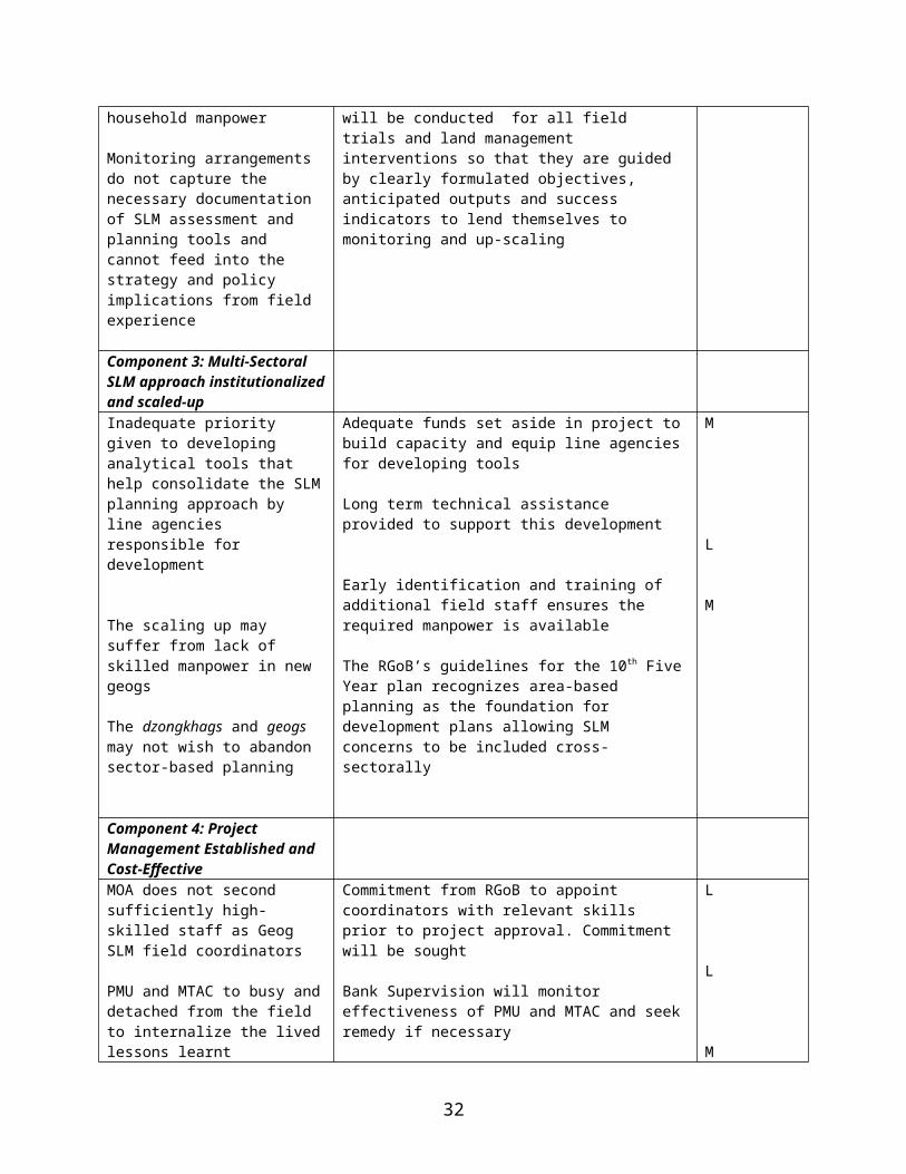
capabilities and constraints
management
Institutional setting for land and environment management
Environmental management has been mainstreamed into the various sectoral Ministries. The Department of Roads (DOR) and Ministry of Works and Human Settlements (MoWHS), have adopted the environment-friendly road construction methodology. The Ministry of Trade and Industry (MTI)’s Environmental Unit sets and monitors environmental standards of industrial and mining operations and promotes cleaner technology and environmental management (CTEM) in industries. The Department of Geology and Mines conducts geologic hazard and risk assessments, monitors natural hazards, advises on mitigation measures for natural disasters, provides geologic engineering services, and ensures environment-friendly exploitation of economic mineral resources. The National Environment Commission serves as an overall environmental advisor to the RGoB, prepares through its secretariat, NECS, environmental legislation, oversees compliance monitoring of the Environmental Assessment Act, 2000, and associated regulations and guidelines, and coordinates the implementation of the National Environment Strategy and national obligations to international environmental conventions. The NECS implements environmental advocacy and awareness programs for local authorities and communities and conducts training programs to develop the operational capacity of sectoral agencies and Dzongkhag Administrations for decentralized environmental assessment and monitoring.
The Ministry of Agriculture (MoA) is the overall authority for management of renewable natural resources, which includes agriculture, livestock development and forestry/ nature conservation. Within the MoA, the Land Use and Statistics Section undertakes land use planning and statistical works related to the RNR sector and the National Soil Service Center (NSSC) has the responsibility of providing technical services for soil and soil fertility management. The Department of Forestry Services (DFS), Department of Agriculture Services (DAS), and Department of Livestock Services (DLS) maintain technical staff at the dzongkhag and geog levels to guide and technically support local communities in the management of renewable natural resources. Other agencies that are concerned with land use and management include the Ministry of Works and Human Settlements (MoWHS); the Ministry of Trade and Industry (MTI); and the National Environment Commission (NEC). The MTI has a Department of Geology and Mines that conducts geologic hazard and risk assessments and monitors natural hazards
The decentralization policy of RGoB empowers the Dzongkhag Yargye Tshogdus (DYTs) and below them the Block or Geog Yargye Tshogchungs (GYTs), elected bodies that have regulatory and administrative powers, to plan and implement development activities, including those pertaining to sustainable natural resource management. The DYT and GYTs receive technical support from seconded line agency staff. The current 9th FYP (2002-2007) is sector-based derived from annual plans and wish-lists prepared by dzongkhag and geog, however, guided by a menu of technical programs offered by the central line agencies. There is strong move towards introducing area-based cross-sectoral planning, however there is a lack of tools, methodology and capacities at all levels as well as vertical integration of this concept.
Policy and Legal Framework
The following make up the core of the policy and legal framework for land and environmental management in Bhutan: (1) Dzongkhag Yargye Tshogdu and Geog Yargye Tshogchung Chathrims, 2002: legislation for dzongkhag and geog level decentralized policy and decision-making; (2) Land Act, 1979, includes regulations/procedures for land registration and transfer of land ownership, land tenure and usufruct rights, infrastructure development such, and land encroachment; (3) Forest and Nature Conservation Act, 1995, covers forest management, social and community forestry, soil and water
33

conservation, forest fire prevention etc.; (4) Draft Grazing Act, 2004; (5) National Environment Strategy, 1998; (6) Environmental Assessment Act, 2000; (7) Others: Livestock Act and By-Laws, 1980; Mines and Minerals Management Act, 1995; Pasture Development Act, 1997; and Biodiversity Action Plan for Bhutan, 2002.
Eligibility for GEF Support
The proposed project is consistent with the expected outcomes of the GEF’s Operational Program 15 by addressing the policy and regulatory framework; by mitigating the main causes of land degradation and maintaining functional integrity of the ecosystem that ensures people’s livelihood; and by strengthening institutional and human capacity at both local and central level. It supports partnerships with other donors (in particular Danida) working on land and environmental management, local farmers and other stakeholders, including government entities at the local, district and national levels in providing coordinated financial and technical support to address land degradation in a holistic and sustainable manner. The project is fully consistent with SLM Strategic Priorities #1 in that it would support capacity building and adoption of SLM practices by farmers and ensure that SLM principles are integrated into the Country’s five-year planning process. It is fully consistent with SLM Strategic Priority #2 in that it would support the implementation of innovative sustainable land use practices in pilot sites to test approaches to sustainable agriculture, rangeland management and forestry development. The project will contribute to the control of sediments in trans-boundary water bodies and promote cross-sectoral approaches at both policy and operational level and facilitate area-based planning with local level bodies. The SLMP will create synergy with the Danida EUSPS in changing policies and legislative framework by bringing lessons learnt back from local to policy level. The project will address the mitigation of the causes of land degradation on the structure and functional integrity of ecosystems, promote reduction of GHG and improve carbon sequestration, and help stabilize sediment release in targeted trans-boundary rivers systems. The project interfaces with OP 4 (Mountain Ecosystems), OP 9 (Integrated Land and Water), and OP 12 (Integrated Ecosystem Management) and give opportunity for Bhutan to build synergy between national programs and activities associated with CBD, UNCCCF, and UNCCD as land degradation issues are closely linked to those concerning biodiversity and climate change. Under the UNCCD, the project meets some of the global objectives of adopting an integrated approach, addressing the physical, biological and socio-economic aspects of the processes of desertification and drought and catalyses the use of existing and additional financial resources to combat desertification.
Bhutan’s communication to the International Conventions
The country became Party to the Convention on Biological Diversity and UN Framework Convention on Climate Change in August 1995. Recently, in August 2003, it acceded to the UN Convention to Combat Desertification (UNCCD). In addition to these three post Rio Conventions, the country is Party to nine other environment related international conventions and associated agreements: (1) UN Convention on the Law of the Sea, 1982; (2) International Plant Protection Convention, 1994; (3) CBD, 1995; (4) UNFCCC, 1995; (5) World Heritage Convention, 2001; (6) Basel Convention on Transboundary Movements of Hazardous Wastes and their Disposal, 2002; (7) Cartegana Protocol on Biosafety, 2002; (8) Kyoto Protocol, 2002; (9) Convention on International Trade in Endangered Species of Wild Fauna and Flora, 2002; (10) UNCCD, 2003; (11) Vienna Convention for the Protection of Ozone Layer, 2004; and (12) Montreal Protocol on Substances that Deplete the Ozone Layer, 2004.
Under the CBD, Bhutan produced its first Biodiversity Action Plan in 1998 and an updated version in 2002, and under the UNFCCC, it produced the Initial National Communication and the First National Greenhouse Gas Inventory in 2000. At the World Summit on Sustainable Development 2002 held in Johannesburg, the country presented the National Assessment of Agenda 21, titled Bhutan: Road from Rio, giving a succinct yet comprehensive account of the country’s path and progress in the
34

implementation of Agenda 21 outlined at UNCED 1992. Development of National Adaptation Programme of Action (NAPA) is ongoing under the framework of UNFCCC.
Support for sustainable land management at the national level and among sectoral agencies is now well-established. RGoB has requested the GEF and DANIDA to help it develop an integrated and cross-sectoral approach to SLM which is locally-based and nationally-supported. Upon acceding to the UNCCD in August 2003, Bhutan became one of the first eligible countries to receive GEF support under the new Operational Program 15 on Sustainable Land Management. DANIDA’s involvement is a continuation of its active support for land use planning in Bhutan since 1992. RGoB and DANIDA see the GEF focus on local and regional level support as a direct complement to DANIDA’s focus on the national and policy level and the World Bank as having a comparative advantage in implementing GEF’s Operational Program 15.
Rationale for Bank involvement
The Bank has been involved in many sectors in Bhutan and has witnessed the changes in the physical landscape over the last 20 years as sectoral development plans are implemented. It shares RGoB and donors’ concerns about the need to rationalize the use and management of Bhutan’s extremely limited available land resource for development to avoid the cumulative deterioration, which is becoming increasingly evident, and ensure long-term environmental sustainability. Donors, including the Bank, have tended to work with particular sectoral agencies, helping to strengthen their development agenda. With limited land resource and intensifying demand leading to overuse and degradation, there is a need to rationalize usage and enhance management of land using inter-disciplinary and participatory approaches. The RGoB asked for support from GEF under its Operational Program 15 through the World Bank to address its critical land degradation situation. The Bank shares the RGoB’s concerns to protect Bhutan’s land resources and the Bank is actively working with GEF and other donors in other countries to develop similar initiatives in sustainable land management. The Bank’s comparative advantage is that it has Bhutan experience, it is a GEF Implementing Agency, has undertaken consultations with Danida for parallel financing and has an active agenda to promote community participatory approaches. The Bank is able to guide Bhutan on the appropriation of GEF funding in a way that creates synergies with existing programs of other agencies. The SLMP corroborates the goals of the CAS (2000) that identifies six major environmental priorities: (i) Forest regeneration and biodiversity; (ii) Conservation and development; (iii) Greening of the National Accounts; (iv) Institutionalized capacity for Environment Impact Assessment; (v) Watershed management; and (vi) Environmental legislation.
35

Annex 2: Major Related Projects Financed by the Bank and/or other Agencies
The World Bank’s program of assistance in Bhutan began in the early 1980s. In the area of natural resource management, earlier projects focused on forest management and were sectoral in approach. Operations are generally rated satisfactory – having contributed to capacity development of government personnel and introduction of new practices for project management.
Projects financed by the BankProject Title US$ million Institution Approval OED RatingThird Forestry Development Project (closed 30 Jun 2002)
5.4 IDA 6 Jul 1993 Outcome: Moderately unsatisfactoryInstitutional development: ModestSustainability: Non-evaluableBank performance: UnsatisfactoryBorrower performance: SatisfactoryQuality of ICR: Satisfactory
Rural Access Project (with technical assistance from SNV) (ongoing)
WB: 11.6 SNV: 1 RGoB: 2.3
IDA 10 Oct 1999 PSR Ratings:Implementation progress: SatisfactoryDevelopment objective: Satisfactory
Bhutan Urban Development Project (ongoing)
WB: 10.8RGoB: 1.43
IDA 9 Sep 1999 PSR Ratings:Implementation progress: SatisfactoryDevelopment objective: Satisfactory
Decentralized Rural Development Program
8 IDA 1 March 2005
To be launched in 2005
Projects financed by the GEFProject Title Duration Budget
RGoB* (in US$)
Budget Donor(in US$)
Total
Bhutan National Greenhouse Gas Project Phase (IA: UNDP)
1997-2003 Not available (NA)
GEF: 396,000 296,000
National Biodiversity Conservation Strategy (IA: UNDP)
1997-2003 NA GEF: 281,300 281,300
Integrated Management of Jigme Dorji National Park (IA: UNDP)
1997-2003 378,569 GEF: 1,500,000UNDP: 270,662
2,149,231
Removing Barriers to Mini and Micro Hydropower Development for Decentralized Rural Electrification (IA: UNDP)
1997-2003 28,000 GEF: 228,500Swedish Fund: 135,000
391,500
Linking and Enhancing Protected Areas in the Temperate Broadleaf Forest Ecoregion of Bhutan (IA: UNDP)
2003-2007 420,000 GEF: 792,000WWF: 643,000
1,855,000
Self Assessment and Action Plan Development for National Capacity Building in Bhutan for Global
2004-2005 22,780 GEF: 199,100 221,880
36

Environmental Management (IA: UNDP)National Adaptation Program of Action for Climate Change
2004-2005 NA GEF: 199,000 199,000
Small Grants Program Started in 1998. Replenishment every 2 years
NA GEF: 478,407 478,407
Financed by other Donor AgenciesProject Title Donor Duration Budget
RGoB*Budget Donor
Total
Environment Sector Program Support
DANIDA 1998-2003 NA DKK 85 million
DKK 85 million
Urban Sector Program Support DANIDA 1999-2004 NA DKK 77 million
DKK 77 million
Environment and Urban Sector Program Support
DANIDA 2004-2008 NA DKK 110 million
DKK 110 million
RNR Extension Program in the Districts of Bumthang and Trongsa
Helvetas 1998-2002 NA CHF 1.6 million
CHF 1.6 million
Natural Resources Training Institute – Phase III
Helvetas 1998-2002 Nu 40.64 million
CHF 1.7 million
CHF 2.97 million
Natural Resources Training Institute – Phase IV
Helvetas 2002-2006 NA CHF 1.6 million
CHF 1.6 million
East Central Region Agriculture Development Program
Helvetas 2002-2007 NA CHF 2.5 million
CHF 2.5 million
RNR Research System – Phase II
SDC 2002-2003 NA CHF 4.17 million
CHF 4.17 million
Participatory Forest Management
SDC 2002-2007 NA CHF 3.8 million
CHF 3.8 million
Rural Development Training Project
SDC 2003-2007 Nu 23.16 million
CHF 2 million CHF 2.72 million
RNR Research System – Phase III
SDC 2004-2006 NA CHF 2.8 million
CHF 2.8 million
Wang Watershed Management Project
EC 2001-2007 Euro 4.1 million
Euro 9.2 million
Euro 13.3 million
Second Eastern Zone Agricultural Project
IFAD, SNV, UNCDF
2000-2005 US$ 5.06 million + US$ 0.62 million (by beneficiaries)
IFAD: US$ 9.51 millionSNV: US$ 2.11 millionUNCDF: US$ 0.53 million
US$ 17.83 million
Environment Friendly Road Construction
SNV, SDS 2003-2005 RGoB: Nu. 5.1 million
SNV: Nu 33.6 millionSDS: Nu. 39.3 million
Nu. 78 million
Community-based Biodiversity SDS2 2004-2008 Nu. 15 Nu. 87 million Nu 102 million
37

Conservation and Ecosystem Management
million
Strengthening Environmental Management and Education in Bhutan
UNDP 1996-2002 NA US$ 0.668 million
US$ 0.668 million
Support for Implementation of Micro Environmental Action Plans
UNDP 2003-2005 NA US$ 0.181 million
US$ 0.181 million
Road Improvement Project ADB 2001-2004 US$ 3.2 million
US$ 9.6 million
US$ 12.8 million
Urban Infrastructure Improvement Project
ADB 1999-2005 US$ 3.4 million
US$ 4.8 million
US$ 8.2 million
Bhutan-German Sustainable RNR Development in Punakha-Wangdue Valley
GTZ 2001-2005 NA Euro 3.5 million
Euro 3.5 million
Conservation Management Planning for Sakten Wildlife Sanctuary
MacArthur Foundation
2003-2006 NA Nu. 26.3 million
US$ 26.3 million
*N.B. - RGoB budget is generally in-kind contribution calculated in terms of recurrent costs for RGoB staff time, and use/ rental of office space, utilities and equipment for project-related activities. RGoB budget is not always defined in project documents. Where RGoB budget has been defined in project documents, the figures have been provided in the above tables and where such figures have been provided in local currency, they have been converted into the donor currency to get the total project budget using approximate exchange rate.
2 Sustainable Development Secretariat – Secretariat for collaboration between Netherlands, Costa Rica, Bhutan & Benin
38

Annex 3: Results Framework and Monitoring
PDO Results/ Outcome Indicators
Use of Results Information
Project Development Objective: To ensure that sustainable land management practices are mainstreamed into Bhutan's policy, planning, legal and regulatory framework, and contribute to improving people's livelihoods and economic well being.
Global Environment Objective: To combat land degradation and realize local and global benefits of protecting trans-boundary watersheds in a manner that preserves ecosystem integrity in Bhutan
A national policy, planning and regulatory framework for SLM in Bhutan adopted to secure land productivity, improved ecosystem functions, and improved livelihoods.
SLM approaches mainstreamed by 9 geogs and 3 dzongkhags contributing to ecosystem functions, improved productivity and grazing practices by end of project
30% of extent of managed landscapes in the 9 pilot geogs under sustainable land management by end of projectAdditional 5% of land in pilot geogs under community conservation initiatives by end of project10% of upstream shifting cultivation lands in pilot geogs converted to sustainable land cover by end of projectReduction in GHG emissions consequent to reduction in extent of land under shifting cultivation10% reduction in sediment flows in pilot geogs by end of project
YR2 Determine community interest in participating in SLM. YR3-YR4 Gauge land productivity and income changes in 3 pilot geogsYR3 Gauge number of policy and analytical papers on SLM relating to sector issues developed. YR3-YR4 determine extend that such policy and analytical papers being reviewed by sector ministries and feeding into national reforms
YR3 SLM Framework Plan for pilot geogs developed and informing development planning. YR3-YR4 Dzongkhags actively considering establishing SLM framework planning.
YR2-YR3 Assess extent to which all bio-physical mapping captures land hazards and ecosystem functionsYR4-YR6 Assess impact on local ecosystems
Intermediate Results Result Indicators for Each Component Use of Outcome Monitoring
Component 1:SLM Planning, Policy, Legislative, and Regulatory Framework established for management of land resources in Bhutan
SLM planning included in 10th 5-Year Planby YR 1 and 11th 5-Year Plan by YR6
SLM approach included in the target dzongkhags’ and geogs’ annual development planning process from YR 2 onwards
YR1 and YR5 RGoB Guidelines for 5-year planning incorporates SLM
39

SLM principles integrated into sector level policies (likely to be national watershed management policy and land use planning policy, grazing, forestry and urban development) by YR 3
SLM lessons brought into revision and development of relevant legislation (likely to be Nature and Forest Conservation, Grazing, Urban Development, etc) YR 4
Local level resource management regulatory systems/agreements formulated by geog and local communities for SLM outcomes from YR 2 onwards
YR3 Analytical papers on SLM relating to sector policy issues developed. YR3-YR4 determine extent to which such analytical papers being reviewed by sector ministries and feeding into national policy and legal reforms
YR2-YR3 Review number of local regulatory systems documentedYR3-YR5 Assess extent to which natural resource use conflicts equitably resolved
Component 2:SLM approaches demonstrated and validated in pilot geogs
Local inventories, resource assessment and socio-economic profiles, including tenure context and regimes, established to guide the local level planning of SLM activities from YR1 onwards
Chiog and geog level SLM framework and action plans under implementation from YR 1 onwards as mitigation measures to curb land degradation processes that are reflected in the following outcomes, the baselines of which would be developed in the initial months of the project:
x meters of riverine banks protected; y acres of steep erodable slopes
protected; z acres of sustainable agricultural
practices implemented; q acres of degraded forest
regenerated; k acres of grazing lands improved
and conflicts resolved; p acres of tseri converted to
sustainable land use practices in YR2, YR4, and YR6 respectively
Joint management introduced for open access resources for 100 acres/geog in YR2
Joint management and community forestry introduced for 50 acres for each of three pilot geog sites by YR3 and additional 50 acres per geog for the additional geogs in YR5.
Inter-geog and inter-dzongkhag agreements on grazing right-holding regimes at high altitudes for 2- 600
YR2-YR5 Determine extent to which such information guides chiog and geog level planning
YR3 onwards evaluate progress towards targets, assess if incentives for such community actions are appropriate, realign planning and incentives if progress not satisfactory.
40
acres/geog in YR3 and for double area in YR6
q% increase in incomes/productivity resulting from change from shifting cultivation to sustainable land cover in selected and sampled villages in each pilot geogs
SLM investment activities validated through establishment of monitoring criteria and monitoring proper for each intervention (physical SLM impact, organisation, gender, tenure, poverty etc) and impact studiesin YR3
Lessons learnt on transaction costs and benefits of new integrated SLM planning approach to RNR staff at geog and dzongkhag level in YR4
Lessons learnt on defining sustainable institutional modalities for SLM under prevailing tenurial framework in YR3 and onwards
YR2-YR3 Determine if conditions for up-scaling are viable
YR3 Determine work load of RNR staff in relation to SLM
YR2 onwards Evaluate number of management regimes studied and documented
Component 3:Multi-sectoral SLM approach institutionalized and scaled-up
Analytical tools for bio-physical baselines to SLM approach developed and adopted (land use typology, land capability and suitability, hazard zonation maps, degradation severity indices formulated) and applied in production of Geog SLM Framework and Action Plans from YR 3 onwards
Analytical tools for socio-economic baseline developed and adopted to guide definition of local level institutional arrangements for SLM of various resource regimes fromYR 3 onwards
SLM Lessons learnt and adopted by dzongkhag and upscaled to six other geogs in the pilot dzongkhags by YR3
Lessons from thematic upscaling supporting better understanding of ecosystem concerns
Capacity built in inter-sectoral planning for SLM mainstreaming as follows:
9 RNR staff at geog level trained in SLM multi-sectoral approach by YR1 and additional 18 by YR3
YR1-YR2 Assess if tools have been developedYR3-YR5 Determine extent to which tools have been used more widely
YR2-YR3 Assess number of lessons documented and criteria for upscaling developed
YR3 Determine appropriateness of themes and extent of interest and cost of expansion programs
YR2 onwards Determine if results of training being applied to planning
YR3 onwards Determine extent to which RNR staff interact with
41

GYTs and DYTs in 3 geogs and Dzongkhags respectively trained in SLM planning by YR2 and GYTs in additional 6 geogs by YR4
50% of farmers in 3 pilot sites trained in application of SLM technologies by YR3 and 6 additional sites by YR6
15 social mobilizers trained in SLM by YR2 and 30 additional by YR4
7 post-graduate trained in land management
Knowledge generated to inform SLM policy guidance
each other and other departments for SLM
YR 2 onwards review study proposals and TORs for relevance to policy.YR3 onwards review results of such studies
Component 4:Project Management established and cost-effective
A national PMU, MTAC and PSC effectively supporting the planning and mainstreaming of multi-sectoral SLM and measured as follows:
SLM policy issues on PSC agenda Frequency of meetings of MTAC to
support and monitor inter-departmental collaboration
DYTs and GYTs effect resolution of inter-geog and inter- dzongkhag resource use conflicts
DYTs and GYTs influence application of SLM to manage impacts originating from activities outside their control and mandates
YR 2 onwards Gauge extent to which these bodies effectively supporting inter-sectoral collaboration
YR 3 onwards Assess number of such conflicts issues being brought to GYT and DYT attention
YR4-YR6 Assess if DYT and GYT using framework plans to control such impacts
42

Arrangements for Monitoring
Outcome Indicators Baseline
Target Values Data Collection and Reporting
Yr 1 Yr 2 Yr 3 Yr 4 Yr 5 Yr 6Frequency
and ReportsData
Collection Instruments
Responsibility for Data Collection
A national policy, planning and regulatory framework for SLM in Bhutan adopted to secure land productivity, improved ecosystem functions, and improved livelihoods
Regulatory and sector policies have inadequate attention to SLM
Contradictions in regulatory framework impede suitable land management
Planning on a sectoral basis rather than multi-sectoral
Weak coordination between government agencies responsible for land management
Inadequate data on productivity failures of lands, land hazards and livelihood strategies
Inefficient and unsustainable land use practices
Bio-physical and socio-economic baseline completed in geogs 1-3
Base maps and thematic maps developed for pilot geogs 1-3
Area-based SLM inter-sectoral planning initiated in pilot geogs 1-3 end of YR 1
Analytical papers for policy and legal changes to incorporate SLM drafted
Bio-physical and socio-economic baseline completed in geogs 4-6 end of YR 2
Base maps and thematic maps developed for pilot geogs 4-6 end of YR 2
PSC members have worked actively to bring SLM lessons into sector policy development
Workshop proceedings and technical papers with field lessons prepared for sector ministries to guide policy reforms and SLM integration
Bio-physical and socio-economic baseline completed in geogs 7-9 end of YR 3
Base maps and thematic maps developed for pilot geogs 7-9 end of YR 3
PSC members have worked actively to bring SLM lessons into sector policy development
Policies and regulatory mechanisms revised based, among others, on lessons from the field, analytical papers and workshop proceedings
PSC members have worked actively to bring SLM lessons into sector policy development
Policies and regulatory mechanisms revised based, among others, on lessons from the field, analytical papers and workshop proceedings
Lessons learned from thematic expansion of SLMP to additional dzongkhags have informed on particular salient policy and legislative themes
Annual Progress review and monitoring through monitoring reports and formats from RNR and SLMP field staff submitted every 6 months
Analytical papers
Workshop proceedings
Workshops, field reports, monitoring reports, independent studies, reviews and evaluations
PMU, MTAC,Geog Field Co-ordinator dzongkhag SLMP committee
Department of Forest
Department of Survey and Records
NECS
43

Arrangements for Monitoring
Outcome Indicators Baseline
Target Values Data Collection and Reporting
Yr 1 Yr 2 Yr 3 Yr 4 Yr 5 Yr 6Frequency
and ReportsData
Collection Instruments
Responsibility for Data Collection
SLM approaches mainstreamed by 9 geogs and 3 dzongkhags contributing to ecosystem protection and improved productivity and hydrological functions by end of project
Present development planning at dzongkhag and geog level sector-based and prepared without concerns for SLM and ecosystem functions
No guidance from central level on SLM holistic planning allowing or promoting changes in land use
SLM approach streamlined in annual development planning in geog 1-3
SLM approach streamlined in annual development planning in geog 4-6
SLM approach partly streamlined in annual development planning in three dzongkhags
SLM approach streamlined in annual development planning in geog 7-9
Annual Progress Report
Dzongkhag Annual Development Plans and Five Year Plans
Geog Five Year Plans and Annual Development Plans
Reports, Plans, Studies, Analyses
PMU, MTAC, Dzongkhag SLMP Coordination Committee, Geog Field Coordinator, Geog GYT
Improved management of land through:
30% of managed landscapes in 9 pilot geogs under sustainable land management
NA NA 10% Open access resources mapped and initial joint management ideas preparedForest function surveys have catered to dev of preliminary biodiv assessment and defined options for jt. mgt regimes
20% Open access resources mapped and joint management models preparedForest function surveys have catered to dev of preliminary biodiversity assessment and defined options for
30% Open access resources mapped and joint management models prepared
Livestock, fuel and fodder demands integrated into annual plans for SLM outcome
30% Open access resources mapped and initial joint management ideas prepared
Livestock, fuel and fodder demands integrated into all annual and Five
Annual Progress Report
Dzongkhag Annual Development Plans and Five Year Plans
Geog Five Year Plans and
Reports, Plans, Studies, Analyses
PMU, MTAC, Dzongkhag SLMP Coordination Committee, Geog Field Coordinator, Geog GYT
44

Arrangements for Monitoring
Outcome Indicators Baseline
Target Values Data Collection and Reporting
Yr 1 Yr 2 Yr 3 Yr 4 Yr 5 Yr 6Frequency
and ReportsData
Collection Instruments
Responsibility for Data Collection
Livestock, fuel and fodder demands integrated into preliminary plans
Water drainage controlled
jt. mgt regimes
Livestock, fuel and fodder demands integrated into annual plans for SLM outcome
Water drainage controlled
Water drainage controlled
Year Plan plans for SLM outcome
Water drainage control
Annual Development Plans
Additional 5% of land in pilot geogs under biodiversity protection
Biodiversity assessment completed for 9 geogs
Biodiversity management plans developed
5% of additional land under biodiversity management
5% of additional land under biodiversity management
10% of unsustainable upstream shifting cultivation lands in pilot geogs converted to sustainable land cover
Reduction in GHG emissions from shifting cultivation
5% of upstream areas of unsustainable shifting cultivation lands converted to SLM land cover
Extrapolation of GHG emission
8% of upstream areas of unsustainable shifting cultivation lands converted to SLM land cover
Extrapolation of GHG emission
10% of upstream areas of unsustainable shifting cultivation lands converted to SLM land cover
Extrapolation of GHG emission
1. RESULTS INDICATORS FOR EACH COMPONENT
Component 1 SLM Planning, Policy, Legislative, and Regulatory Framework established for management of land resources in Bhutan
45

Arrangements for Monitoring
Outcome Indicators Baseline
Target Values Data Collection and Reporting
Yr 1 Yr 2 Yr 3 Yr 4 Yr 5 Yr 6Frequency
and ReportsData
Collection Instruments
Responsibility for Data Collection
1.1 Principles of SLM planning included in 10th and 11th Five-Year Plan by YR 2 and YR 5
Current Five Year Plan has no attention to SLM
Guidance notes for SLM integration developed to impact 10th Five Year Plan Guidelines
10th Five Year Plan integrates some SLM principles
Field lessons help revise Guidelines for 11th Five Year Plan
11th Five Year Plan effectively integrates SLM approaches
Annual Progress Report, MTRICR
SLM Workplans, workshops, monitoring, reviews, and evaluations
PMU
1.2 SLM approach included in the target dzongkhags’ and geogs’ annual development planning process in YR 2 onwards
(See also component 3)
Geog and Dzongkhag Plans currently prepared on sector basis
Training for RNR, GYT and selected dzongkhag staff for multi-sectoral planning for 3 pilot geogs completed to adopt SLM in annual planning.
Guidelines issued by central government for area-based planning in dzongkhag and geog
Initial elements of SLM adopted in plan
SLM elements adopted in 10th Five Year plans of target dzongkhags
Annual plans of selected Chiogs, Geogs and Dzongkhag are multi-sectoral for the RNR domain in 3 pilot dzongkhags
RNR, GYT and DYT have endorsed multi-sectoral SLM planning for remainng pilot geogs
Capacity of dzonkhags increased to adopt elements of SLMs and apply SLM to non-RNR sectors
Capacity of dzonkhags increased to adopt elements of SLMs and apply SLM to non-RNR sectors
Guidelines for preparation of 11th Five Year Plan carry explicit directions for SLM approach to all sectors
All 9 pilot geogs and 3 dzongkhags and possible incremental thematic dzongkhags or geogs have included SLM in annual planning
Annual Progress Report, MTRICR
SLM Workplans, workshops, monitoring, reviews, and evaluations
PMUDzongkhag adm. and DYT, Geog GYT
1.3 SLM principles integrated into sector level policies (likely to be national watershed management policy, forestry, grazing and urban development by YR3
Current sector policies lack attention to SLMThe EUSPS baseline undertakes studies of sector policies
Initial notes prepared for analysis of SLM issues in sector policies
Assessment of selected policies completed
Guidance Notes identifying SLM issues for sector level policies
Preliminary lessons from the field related to sector policy impact
Workshops proceedings from workshops conducted on SLM issues in existing regulatory framework based on
SLM lessons feeding into sector policy revision for selected RNR themes
Sector policies are holistic and include SLM elements
Sector policies are holistic and include SLM focus
Annual Progress Reports
Special reports
Monitoring reports
Review of RGOB agendas
PMU
46

Arrangements for Monitoring
Outcome Indicators Baseline
Target Values Data Collection and Reporting
Yr 1 Yr 2 Yr 3 Yr 4 Yr 5 Yr 6Frequency
and ReportsData
Collection Instruments
Responsibility for Data Collection
developed lessons from the field
1.4 SLM lessons brought into revision and development of relevant legislations (likely to be Nature and Forest Conservation,, Grazing and urban development etc YR 4
The EUSPS baseline provides support to studies and revision of the RGOB regulatory framework
Initial notes prepared for analysis of SLM issues in relevant national acts
Guidance notes identifying SLM issues for relevant regulations prepared
Workshops proceedings from workshops conducted on SLM issues in existing regulatory framework
Workshop proceedings
Papers to be presented to PSC on lessons learnt
SLM lessons feeding into revision of regulatory framework
SLM concerns reflected in selected draft bills and regulatory frameworks
New regulations related to land management include SLM concerns
Annual Progress Reports
Special reports
Studies
Monitoring
PMU
1.5 Local level resource management regulatory systems/agreements formulated by chiogs and geogs from YR 2 onwards
Existing traditional non-formal management systems
The GYT and DYT chhatrims
Baseline studies Adoption/adaptation of existing traditional management systems into SLM planning
Review numbers documented
Adoption/adaptation of existing traditional management systems into SLM planning
Review numbers documented
Analyze enabling conditions and sustainability criteria
Review of resolution of natural resource use conflicts through local agreements
Review of resolution of natural resource use conflicts through local agreements
Consolidation of lessons learned
Guidelines drafted for different local level management of different resource regimes
Annual Progress reports
Special studies and reports
Local level monitoring and studies
PMU, Geog SLMP Field Coordinator, Geog RNR staff
Component 2 Sustainable land management approaches demonstrated and validated in pilot sites
2.1 Local inventories, resource assessment and socio-economic profiles, including
Information on local conditions lacking
Baseline studies and thematic maps preparedto inform the
System and institutional arrangements for
Baseline studies andthematic maps preparedto inform the
Baseline studiesThematic maps preparedto inform the
NA NA Annual progress reports
Maps, inventoriesBaselines
Central level agencies such as Dept of Suvey and
47

Arrangements for Monitoring
Outcome Indicators Baseline
Target Values Data Collection and Reporting
Yr 1 Yr 2 Yr 3 Yr 4 Yr 5 Yr 6Frequency
and ReportsData
Collection Instruments
Responsibility for Data Collection
tenure context and regimes, established to guide the local level planning of SLM activities from YR 1 onwards
planning process in geog 1-3
Inventories and baselines for monitoring established
monitoring established linked to baselines
planning process in geogs 4-6
planning process in geogs 7-9
Study reports Land Records, Forestry Dept.
2.2 Chiog and geog level SLM framework and action plans under implementation from YR 1 onwards as mitigation measures to curb land degradation processes that are reflected in the following outcomes:-x m of riverine banks protected in YR 3-y acres of steep erodable slopes protected, -z acres of sustainable agricultural practices implemented,-q acres of degraded forest regenerated, -k acres of grazing lands improved and conflicts resolved, -p ares of tseri converted to sustainable land use practices in RY2, YR4, and RY6 respectively. -Joint management
SLM planning frameworks lacking
Baseline developed for the first three geogs
Participatory planning initiated at chiog level in the three pilot geogs
Chiog SLM Framework and Action plans prepared for selected chiogs by end of Yr 1
Chiog SLM Plans included in Geog Annual Development Plans
Participatory planning for chiogs in pilot geogs 4-6 completed end of YR 2
Framework-and Action Plans prepared for chiog and geog level
Ongoing assessment of results based on indicators developed for geog 1-3
10% of target land areas’ Outcome Indicators achieved
Planning and implementation extended to 3 additional geogs based on bottom up chiog planning
Chiog SLM Plans included in Geog Annual Development Plans
Ongoing assessment of results based on indicators developed
20% of target land areas’ Outcome Indicators achieved
Planning and implementation extended to 3 additional geogs based on bottom up chiog planning
Chiog SLM Plans included in Geog Annual Development Plans
Ongoing assessment of results based on indicators developed
40% of target land areas’ Outcome Indicators achieved
Chiog SLM Plans included in Geog Annual Development Plans
Ongoing assessment of results based on indicators developed
75% of target land areas’ Outcome Indicators achieved
Ongoing assessment of results based on indicators developed
100% of target outcomes achieved
Annual Progress report
Other reports such as MTR
Regular Monitoring studies
PMU, MTAC, Geog SLMP Coordinator and SLMP Planning Team together with RNR staff DYT and GYT
48

Arrangements for Monitoring
Outcome Indicators Baseline
Target Values Data Collection and Reporting
Yr 1 Yr 2 Yr 3 Yr 4 Yr 5 Yr 6Frequency
and ReportsData
Collection Instruments
Responsibility for Data Collection
introduced for open access resources for 100 acres/geog in RY2 and -Joint management and community forestry introduced for 50 acres for each of three sites by RY3 and additional 50 acres/additional geog in YR 5-Inter-geog and inter-dzongkhag agreements on grazing right-holding regimes at high altitudes for 2- 600 acres/geog in YR3 and for double area in PY6-q% increase in incomes/productivity resulting from change from shifting cultivation to sustainable land cover in selected and sampled villages in each pilot geog
Baseline developed for first 3 geogs
20% of target increase in income Outcome achieved
50% of target increase in income Outcome Indicators achieved
75% of target increase in income Outcome Indicators achieved
Baseline developed for additional six geogs
100% of target increase in income Outcome Indicators achieved
20% of target increase in income Outcome Indicators achieved
50% of target increase in income Outcome Indicators achieved
Special studies and reports
Geog SLMP Coordinator and SLMP Planning Team together with RNR staff
2.3 SLM investment activities validated through
NA Participatory definition of SLM success
Preliminary validation of results
Participatory validation of results in first geogs 1-3
Preliminary validation of results evaluation
Participatory evaluation of results in geogs 4-6
Participatory evaluation of results in geogs
Annual progress report from the field
Reports from SLM Geog Field
PMU, MTAC, Geog Field
49

Arrangements for Monitoring
Outcome Indicators Baseline
Target Values Data Collection and Reporting
Yr 1 Yr 2 Yr 3 Yr 4 Yr 5 Yr 6Frequency
and ReportsData
Collection Instruments
Responsibility for Data Collection
establishment of monitoring criteria and monitoring proper for each intervention (physical SLM impact, organisation, gender, tenure, poverty etc) and impact studiesin YR2-3 onwards
criteria/indicators along with plan formulation
All action plans to contain baseline data and quantitative and qualitative indicators
together with villagers, RNR staff and SLMP Planning Team
Preliminary recommendations for future planning
Preparation of guidelines for upscaling more widely based on validated results
Preliminary validated results brought to policy level
Recommendations adopted at as inputs at policy level
of results in geogs 4-6
Preparation of guidelines for wider upscaling based on validated results
Validated results brought to policy level
Recommendations adopted as inputs at policy level
Validation of results in geogs 7-9
Preparation of guidelines for wider upscaling based on validated results
Recommendations adopted at policy level
Upscaling validated and final recommendations prepared
7-9Studies
Research reports
Coordinator and Geog RNR staff
Studies and Research
Coordinator, Planning Team, DYT, GYT, Researchers
2.4 Lessons learnt on transaction costs and benefits of new integrated SLM planning approach to RNR staff at geog and dzongkhag level in YR4
NA Assessment of existing workload of geog and dzongkhag RNR staff
Preliminary integration of SLM approach into RNR staff’s sector work completed
Integration of SLM approach into RNR staff’s sector work completed
Study initiated for assessment of transaction costs and benefits at geog levelcompleted
Study initiated for assessment of transaction costs and benefits at dzongkhag levelcompleted
Recommendations for 11th Five Year Plan manpower requirements for mainstreaming SLM
Recommendations adopted in organization for 11th Five Year Plan implementation
Annual Progress report
Study reports and recommendations
Studies PMU,MTAC
Dzongkhag NRN staff
Geog RNR staff
2.5 Lessons learnt on defining sustainable institutional modalities for SLM under prevailing tenurial framework in YR3 onwards
Unclear relationship between viable institutional modalities and resource characteristics and use
Definition of terms of reference for study of viability of institutional arrangement at lowest appropriate level to feed
Study and monitoring on institutional modalities
Study carried out in first three geogs on community forestry, collective pasture development, collective agreements
Study and monitoring on institutional modalities
Recommendations feeding into analytical tools
Study and monitoring on institutional modalities
Recommendations for analytical tools
Summary prepared for a handbook on institutional development at village and geog level for SLM approach
Annual progress reports
Special reports
Studies
Research
PMU, MTAC
DYT
GYT
Geog field coordinator
50

Arrangements for Monitoring
Outcome Indicators Baseline
Target Values Data Collection and Reporting
Yr 1 Yr 2 Yr 3 Yr 4 Yr 5 Yr 6Frequency
and ReportsData
Collection Instruments
Responsibility for Data Collection
into formulation of local by-laws
on the use of tsamdrog and tseri lands
Researchers
Component 3 Multi-sectoral SLM approach institutionalized and scaled-up
3.1 Biophysical analytical tools for SLM developed and adopted (land use typology, land capability and suitability, hazard zonation maps, degradation severity indices formulated) to inform SLM methodology developed and adopted in production of Chiog and Geog SLM Framework and Action Plans by RY 3 onwards
NA Terms of reference drafted to carry out the mapping
Surveyors trained and fielded
Geog and Dzonkhag RNR staff get on-the- job training and understand the purpose of the tools
SLMP Planning Team, Field Coordinator and GYT assess the ways the data generated can feed into a Chiog and Geog SLM Framework and Action Plans
Revision of data-gathering approach for application in geogs 4-6
Revision of data-gathering approach for application in geogs 7-9
Biophysical analytical tools packaged for further up scaling to inform a holistic SLM approach in other geogs and dzongkhags outside pilot areas
The packaged tools reviewed by GYT, DYT and Dzongkhag SLM Coordination Committees in 3 dzongkhags in workshops
The costs of applying biophysical analytical tools assessed and viability of approach determined.
Approach potentially adapted to financial capacity of RGOB
The Biophysical analytical tools applied in thematic expansion of SLM approach
PSC/Central level agencies review tools
Preparation of handbook for application of biophysical tools as vol.1 of SLM Handbook
Annual Progress Reports
Special reports
Field Reports
Monitoring
PMU, Central level specialised agencies, Researchers
3.2 Analytical tools for socio-economic baseline developed and adopted to guide definition of local level institutional arrangements for SLM of various resource regimes from YR 3 onwards
NA Terms of reference drafted to prepare socio-economic profile and baselines
Surveyors trained
Geog and
SLMP Planning Team, Field Coordinator and GYT assess the ways the data generated can feed into the Chiog and
Socio-economic analytical tools packaged for further up scaling to inform a holistic SLM approach in other geogs and dzongkhags
The packaged tools
The costs of applying socio-economic analytical tools assessed and viability of approach determined.
The Socio-
PSC/Central level agencies review tools
Preparation of handbook for application of socio-economic tools as vol.II of SLM Handbook
Annual Progress Reports
Special reports
Field reports
Monitoring
Studies
PMU, Central level agencies, Geog Field Coordinator, Planning Team, Researchers
51

Arrangements for Monitoring
Outcome Indicators Baseline
Target Values Data Collection and Reporting
Yr 1 Yr 2 Yr 3 Yr 4 Yr 5 Yr 6Frequency
and ReportsData
Collection Instruments
Responsibility for Data Collection
Dzonkhag RNR staff get on-the- job training and understand the purpose of the tools
Geog SLM Framework and Action Plans
Revision of data-gathering approach for application geogs 4-6 and later 7-9
reviewed by GYT, DYT and Dzongkhag SLM Coordination Committee in workshops
economic analytical tools applied in thematic expansion of SLM approach
The packaged tools reviewed by GYT, DYT and Dzongkhag SLM Coordination Committee in workshops
3.3 SLM Lessons learnt adopted by dzongkhag and up scaled to six other geogs in the pilot dzongkhags from YR 3 onwards
NA NA Preliminary critical organisational and technical issues and criteria for geographical upscaling identified through Dzongkhag level workshop
Revision of data-gathering approach for application in geogs 4-6 and later 7-9
Participatory Planning in geog 4-6 initiated by Geog Planning Team and Geog Coordinator with RNR staff
Assessment of lessons learnt from geogs 1-3
Participatory Planning in geog 7-9
Assessment of institutional and technical sustainability of results in geogs1-3 learnt from monitoring studies
Monitoring results of geog 4-6
Institutional and technical sustainability assessment of geog 1-3 ongoing
Monitoring results of geog 7-9
Institutional and technical sustainability assessment of geog 1-3 and geog 4-6 and 7-9
Final assessment of sustainability and of ways and means to create policy impact from geog through dzongkhag to central level
Annual Progress reportsMonitoring reportsStudies
Field monitoing through focused reviews, interviews of villagers and RNR staff
PMU, MTAC, Geog field coordinator, SLMP Planning Team
3.4 Capacity built in inter-sectoral planning for SLM
NA Training Needs Assessment completed
Training Needs Assessment completed
Training Needs Assessment completed
Training Needs Assessment completed
Training workshops
On the job training DYT and GYT have actively
Annual Progress Reports
Evaluation reports by participants
PMU, MTAC, geog field coordinator.
52
Arrangements for Monitoring
Outcome Indicators Baseline
Target Values Data Collection and Reporting
Yr 1 Yr 2 Yr 3 Yr 4 Yr 5 Yr 6Frequency
and ReportsData
Collection Instruments
Responsibility for Data Collection
mainstreaming as follows:9 RNR staff at geog level trained in SLM multi-sectoral approach by PY 1 and additional 18 by YR 3
DYT and GYT members in three geogs and dzongkhags respectively trained in SLM planning by PY2 and DYT and GYT in additional six geogs by YR 4.
50% of farmers in 3 pilot sites changed their behavior as a result of training in application of SLM technologies by PY 3 and 50% in the six additional sites by YR 5-6
Learning Objectives defined
Capacity performance indicators established
Training conducted
Training impact evaluated
Learning Objectives defined
Capacity performance indicators established
Training Workshop conducted
On the job training carried out
25% of farmers have undergone training in SLM in 3 pilot geogs
Training impact evaluated
Learning Objectives defined
Training workshop conducted
On the job training carried out
Training impact evaluated
DYT and GYT have actively supported SLM
GYT and farmers have undertaken exchange visits and impacted upon other geogs
50% of farmers have undergone training in SLM in 3 pilot geogs
50% of farmers in three geogs have applied SLM techniques
Learning Objectives defined
Training workshopconducted
On the job training carried out
Training impact evaluated
DYT and GYT have actively supported SLM
GYT, DYT and farmers have undertaken exchange visits and impacted upon other geogs
50% of farmers in geog 4-6 trained
50% of farmers in geog 4-6 have applied SLM techniques
Training impact evaluated and handbook prepared with important training topics
Training workshops carried out for wider target group
DYT and GYT have actively supported SLM
GYT and farmers have undertaken exchange visits and impacted upon other geogs
50% of famers in geog 7-9 trained
50% of farmers in geog 7-9 have applied SLM techniques
supported SLM and adopted SLM approach in 11th Five Year Planning
DYT and GYT have capacity to present results of SLMP approach in planning to other dzongkhags and geogs
50% of farmers in all 9 geogs apply SLM techniques
Training procedures and topics adopted at national level
Recommendations for national level capacity building
Reports after each training session
Dzongkhag SLMP Coordination Committee
DYT
GYT
3.5 Lessons from thematic expansion supporting better understanding of
NA NA NA SLM Themes for thematic expansion to 1-2 other dzongkhags
Areas of unique ecosystem concerns identified
Thematic SLM programs under implementation
National Conference on selected thematic issues to present
Annual Progress Reports
Workshops reports
Monitoring
PMUselected dzongkhags
53

Arrangements for Monitoring
Outcome Indicators Baseline
Target Values Data Collection and Reporting
Yr 1 Yr 2 Yr 3 Yr 4 Yr 5 Yr 6Frequency
and ReportsData
Collection Instruments
Responsibility for Data Collection
ecosystem concerns identifiedExpansion planned and implemented
Intervention planned and implemented
Studies completed for lessons learned on particular themes
results of field experience and research
of expansion criteria
3.6 Knowledge generating information for SLM policy guidance
NA NA Terms of reference for studies on policy issues originating in the three pilot geogs
Studies on indigenous knowledge to provide inputs to planning
Studies under implementation
Results of studies discussed at geog and dzongkhag level and disseminated by PMU
Results discussed at regional RNR conferencesTerms of reference for land-and soil related studies completedTerms of reference prepared for rural-urban land issues prepared
Terms of reference for studies on institutional modalities and success of implementation in first 3 geogs
Results of land-and soil studies with farmers disseminated
Results of rural-urban land conflict studies completed and disseminated
Workshops and seminars at geog and dzongkhag level to discuss results of studies and provide recommendations
Compilation of all study papers
National Conference on selected issues to present results of field experience and studies
Annual Progress ReportsSpecial reports upon completion of work
Clear TORs, Field work, interviews among target group, publications and critique
PMU, research centres, individual researchers, collaboration with field staff
Component 4 Project Management Established and Cost-Effective
54

Arrangements for Monitoring
Outcome Indicators Baseline
Target Values Data Collection and Reporting
Yr 1 Yr 2 Yr 3 Yr 4 Yr 5 Yr 6Frequency
and ReportsData
Collection Instruments
Responsibility for Data Collection
4.1a A national PMU, MTAC, and PSC effectively supporting multi-sectoral planning and mainstreaming of SLM
RGOB initiates establishment of PMU and MTAC prior to project effectiveness
PMU and MTAC have guided preparation of local plans
SLM policy issues on PSC agenda
PMU and MTAC have guided preparation of policy analysis of SLM
PMU and MTAC have participated in ongoing RGOB working groups on area-based planning to include SLM
Dzongkhag line officers request guidance from MTAC members
SLM policy issues on PSC agenda
Lessons learnt from the field documented and disseminated by PMU and MTAC
Research results have been distributed widely by PMU
SLM policy issues on PSC agenda
Lessons learnt from the field documented and disseminated by PMU and MTAC
SLM policy issues on PSC agenda
Lessons learnt from the field documented and disseminated by PMU and MTAC
SLM policy issues on PSC agenda
Lessons learnt from the field documented and disseminated by PMU and MTAC
SLM policy issues on PSC agenda
Annual Progress Reports
Field monitoring arrangements
PMU
Field Coordinator
4.1b Dzongkhag Environment Committee/Dzongkhag SLMP Coordination Committee established
RGOB initiates establishment prior to project effectiveness
DEC/DzSLM CC have facilitated and instituted dzongkhag participation in mapping
GYT has brought SLM issues for DYT discussions
GYT has brought SLM issues for DYT discussions
DYT has discussed adoption of SLM Principles for dzongkhag planning
GYT has brought SLM issues for DYT discussions
DYT has discussed adoption of SLM Principles for dzongkhag planning
GYT has brought SLM issues for DYT discussions
DYT has discussed adoption of SLM Principles for dzongkhag planning
GYT has brought SLM issues for DYT discussions
DYT has discussed adoption of SLM Principles for dzongkhag planning
Annual Progress Reports
Field monitoring arrangements
PMU
Field Coordinator
Dzongkhag
55
Arrangements for Monitoring
Outcome Indicators Baseline
Target Values Data Collection and Reporting
Yr 1 Yr 2 Yr 3 Yr 4 Yr 5 Yr 6Frequency
and ReportsData
Collection Instruments
Responsibility for Data Collection
4.1c GYT SLMP focal group established in all 9 geogs
RGOB facilitates the GYT identify focal point for SLMP
GYT has supported mapping and provided information
GYT focal point interacts regularly with field coordinator
GYT has integrated SLM approach in 10th Five Yean Plan and annual development plan
GYT focal point interacts regularly with field coordinator
GYT has integrated SLM approach in 10th Five Yean Plan and annual development plan
GYT focal point interacts regularly with field coordinator
GYT has integrated SLM approach in 10th Five Yean Plan and annual development plan
GYT focal point interacts regularly with field coordinator
GYT has integrated SLM approach in 11th Five Yean Plan and annual development plan
GYT focal point interacts regularly with field coordinator
GYT has integrated SLM approach in 11th Five Yean Plan and annual development plan
Annual Progress Reports
Field Monitoring arrangements
PMU
Field Coordinator
Dzongkhag DYT and SLMP Coordinating Committee
Geog GYT
56
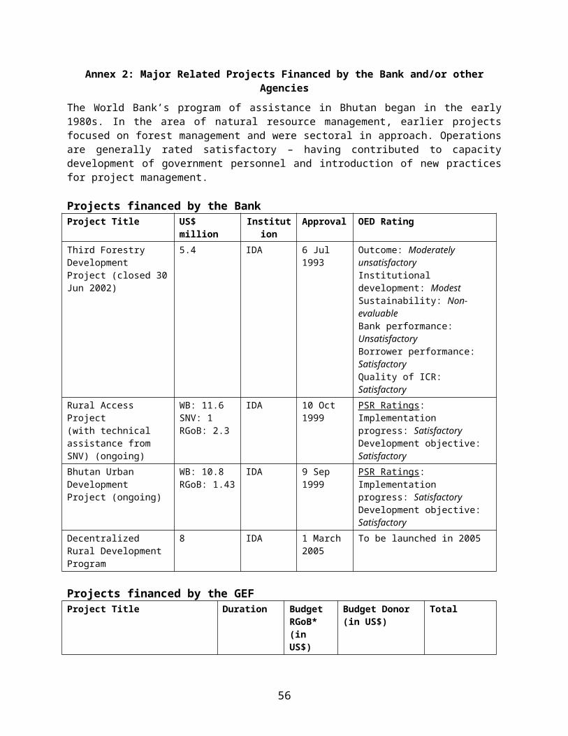
Annex 4: Detailed Project Description
PROJECT DEVELOPMENT OBJECTIVE AND KEY INDICATORS
The Project Development Objective is ensure that sustainable land management practices are mainstreamed into Bhutan's policy, planning, legal and regulatory framework, and contribute to improving people's livelihoods and economic well being. The indicators for the PDO are that a national policy, planning and regulatory framework for SLM in Bhutan is adopted to secure land productivity, improved ecosystem functions, and improved livelihoods and that SLM approaches are mainstreamed by 9 geogs and 3 dzongkhags contributing to ecosystem functions, and improved productivity and hydrological functions. The progress towards the objectives will be measured through a carefully designed monitoring system that is linked to the SLMP’s four components.
Project Global Environmental Objective and Key IndicatorsThe GEF Objective is to combat land degradation and realize local and global benefits of protecting trans-boundary watersheds in a manner that preserves ecosystem integrity in Bhutan. The indicator for the GEF objective is that SLM approaches are mainstreamed by 9 geogs and 3 dzongkhags contributing to ecosystem functions, and improved productivity and grazing practices and hydrological functions.
The project has been structured into the four mutually reinforcing and complementary components that align themselves with the Danida’s Environment and Urban Sector Program Support (EUSPS) project. The objective of EUSPS is to promote balanced development on a social, economic and environmentally sustainable basis through enforcement of appropriate legislation and policies, decentralized land use and management of natural resources, strengthened capacity to promote and support decentralized urban management and delivery of cost effective urban services with public participation. The GEF funding is requested to provide incremental assistance to assure the safe and environmentally-sustainable management of sloping lands in Bhutan, an internationally important country for biodiversity of mountains and tropical forests and a source of considerable sediment and land degradation that affects adjacent areas and neighbouring countries. The incremental GEF funding for environmental benefits is to be based operationally on cost sharing with Danida.
PROJECT COMPONENTS
The GEF increment would support four mutually reinforcing and complementary components that align themselves with the Danida EUSPS. The GEF funded SLMP encompasses on the ground planning and investment in pilot sites (Component 2) based on a cross-sectoral area-based planning originating from lowest appropriate decentralized level and based on relevant bio-physical and socio-economic information. Through careful monitoring it will generate lessons to feed into the formulation of new policies and revise the regulatory framework (Component1) for inter-sectoral SLM in close cooperation with the EUSPS and it will create the enabling conditions for mainstreaming the SLM approach in the RGoB development planning. Capacity building through bottom up participatory planning for SLM and institutionalised monitoring will validate and consolidate the SLM approach at all levels (Component 2 and 3). A careful set up for project management (Component 4) will ensure that all stakeholders from chiog to national level have access to participate and take part in decision-making, monitoring and evaluation.
Component 1: Sustainable Land Management Planning, Policy, Legislative, and Regulatory Framework established for management of land resources in Bhutan (GEF $1.05M and EUSPS $1.1M)
57

This component will support activities related to the regulatory arrangements for land management that would comprise of national level sector policies and legislative framework as well as local level by-laws. In synergy with the Danida EUSPS, the GEF project will bring incremental lessons learnt from investments at the pilot sites (Component 2) to feed back into national level revisions of the policy and legislative frameworks. In this way, the new modes of integrating sector planning for sustainable land management at chiog, geog and dzongkhag level will not only inform the guidelines for preparation of the tenth (2007-2011) and eleventh (2011-2016) five-year plans, but impact on key national level policies and acts, including watershed management, upland agriculture, grazing, forestry, urban planning and infrastructure development.
Output 1.1: SLM planning included in 10th and 11th 5-year Plans
The GEF increment will bring systematic lessons learnt back from chiog and geog levels to Dzongkhag and central levels and through Project Steering Committee (PSC) and the Policy and Planning Divisions (PPDs) of relevant sectoral departments inform guidelines for the preparation of 10 th and 11th Five-Year Plans (2007-2011) and (2011-2016) and their respective annual plans. In parallel with the EUSPS effort, the GEF project will support information management at chiog, geog and dzongkhag levels including environmental and socio-economic baseline and monitoring data to establish chiog and geog ‘profiles’ that will provide a basis for the 10th and 11th five-year planning process. In complement with the EUSPS activity to build environmental assessment capacity, the GEF project would support the strategic environmental assessments of SLM issues in the planning process and provide recommendations and methodologies to guide the mainstreaming of SLM approaches in the five-year plans.
Output 1.2: SLM approach included in the dzongkhags’ and geogs’ five-year and annual development planning processes
The GEF increment would facilitate the wider adoption of SLM approaches in dzongkhag and geog five-year and annual development planning processes through documentation, analysis and dissemination of processes, results and recommendations emanating from the pilot chiogs. This wider adoption builds on the experiences and documentation of the RNR sector officers and the SLM coordinators in the pilot geogs and their regularly interaction with Dzongkhag Administration, Dzongkhag SLM Coordination Committee, DEC, RNR and Planning Officers. The GEF project would provide opportunity for testing the SLM framework in other geogs and Dzongkhags in the country in collaboration with relevant area development projects. The EUSPS will support overall capacity building of dzongkhag administration planning and information management in support of decentralized land and natural resource management.
Output 1.3: SLM principles integrated into sector level policies
The GEF increment will support the integration of SLM principles into sector policies that are in the process of being revised or formulated. The likely policies are watershed management, grazing, land use planning, forestry and urban development. The GEF project will support the analysis of policy gaps, opportunities and constraints related to SLM and land degradation based on experiences and learning from the pilot sites to feed into policy recommendations and revisions that are being supported by the EUSPS project. This would be further complemented by thematic policy reviews related to SLM supported by the GEF project.
Output 1.4: SLM lessons brought into revision and development of relevant legislation
The EUSPS effort supports the revision and development of key environmental and natural resource legislation. In terms of urban-rural interfaces, the EUSPS will work in five district towns on district towns on land zoning regulations. The GEF increment will support the analysis of SLM experiences from
58

the pilot sites to provide guidance and recommendations for development and revision of legislation related to grazing, land use, conversion of tseri, nature conservation, licensing of forest lands for pasture development and urban planning related to its interfaces with rural areas. This will be further complemented by technical support from the GEF project to working groups and other relevant bodies working on the development or revision of such legislation.
Output 1.5: Local level resource management regulatory systems formulated by chiogs and geogs
The GEF increment will facilitate through its participatory planning process the recognition and development of local level chiog and geog rules and by-laws that build on traditional natural resources management systems and support long term sustainability of project impact. The methodology underlying this development will inform its wider replication in other parts of Bhutan. This wider replication will be supported by careful documentation of the characteristics of successful local regulatory and management systems for natural resources and its adoption through experience exchange visits with other chiogs and geogs. In addition, the GEF project will facilitate the dissemination of such documentation to policy level to feed into policy formulation. The GEF increment contributes to the EUSPS activities outlined in output 1.3 and 1.4 above.
Component 2: Sustainable Land Management approaches demonstrated and validated in pilot sites (GEF $1.4M and EUSPS $0.6M)
The GEF project will support the initial piloting of integrated multi-sectoral area-based planning and investment in SLM approaches in one geogs in each of three dzongkhags and later upscale the approach and investments to an additional two geogs in each of the three dzongkhags as an incremental activity to ongoing government sector investments in these sites. The geog constitutes the lowest government level where planning and investment in land management within agriculture, forestry and livestock takes place. One geog may comprise between 8 – 18 chiogs or villages that are often several hours of walking distant from each other. The project would institute an area-based ecosystem approach to SLM participatory planning at the chiog / village level catering to all land and water resources within the chiog’s area. The validation of successful SLM initiatives will feed into the revision of regulatory frameworks as outlined in Component 1 and through monitoring and documentation contribute to its institutionalization in other geogs and dzongkhags as envisaged in Component 3. A detailed description of the local level planning, implementation and monitoring process for SLM in the pilot geogs is outlined in Attachment 1 of Annex 4.
59
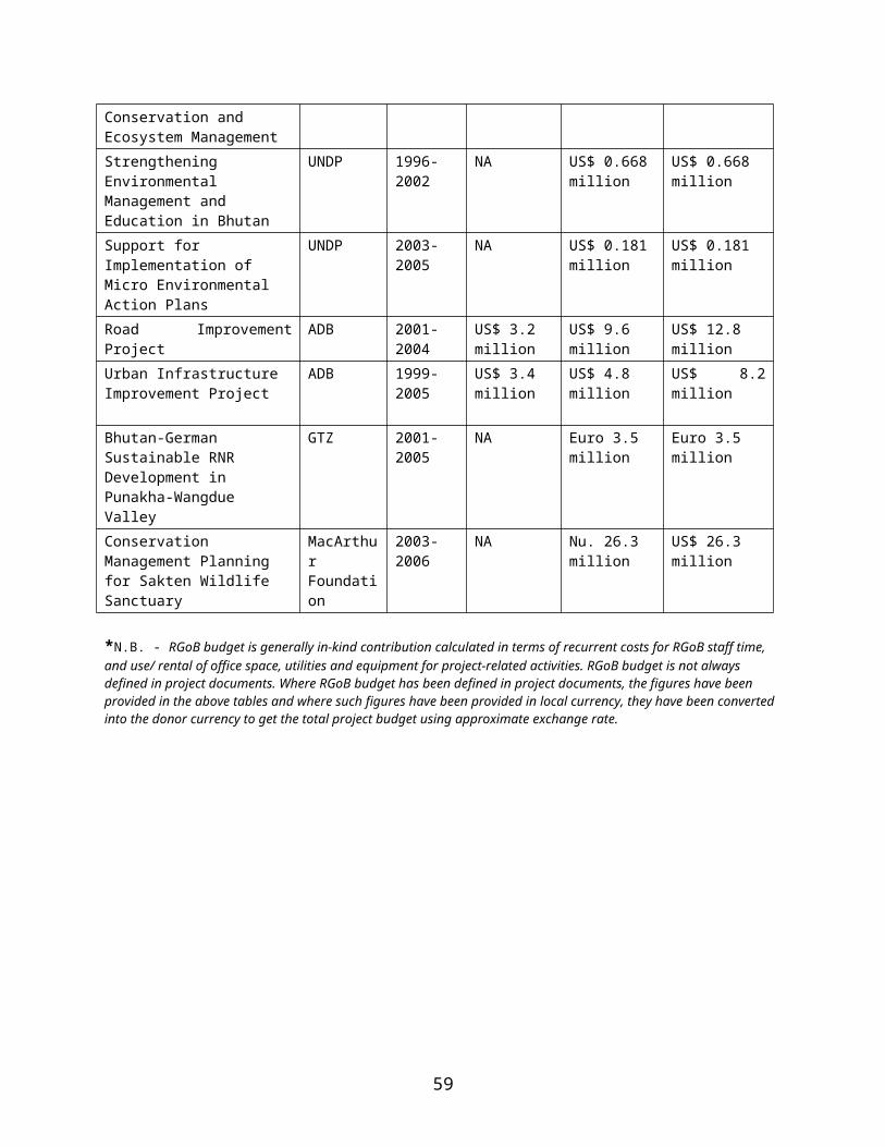
Pilot Geog Locations in Bhutan
Output 2.1: Local inventories, resource mapping, and socio-economic baselines established to guide the local level planning of SLM activities
The participatory resource mapping to be supported by the GEF project will constitute a critical input to the multi-sectoral planning of SLM activities at the chiog level and will establish the baseline for subsequent monitoring. The resource mapping to be carried out Chiog level will be supported by base and thematic maps produced by the Central Agencies (Component 3.1). The SLM Planning Team, Geog RNR staff and communities will undertake preparation of local inventories of the: (a) scale of resource utilization (pasture, fuelwood, agriculture, animal husbandry, etc); (b) extent of land degradation and condition of lands and potential erosion threat areas; (c) existing unsustainable resource uses, the type, nature and extent of such uses; (d) customary rights and overlapping or conflicts in resource use within and from outside the chiog and/or geog; and (e) condition of village infrastructure, in particular irrigation, water supply and erosion structures. In terms of customary rights to use of common lands (pasture, forests, etc) the mapping would provide information on: (i) location and size of the area and condition of resource; (ii) primary users, including those belonging to vulnerable group, that currently use or depend on these common lands; (iii) secondary users (e.g. graziers from another geog/ dzongkhag) and identify the types of uses they make. This information will be included in, and guide the preparation of the chiog and later geog SLM framework plan. The framework plan will form the basis for the development of the
60

respective five-year and annual SLM action plans. The EUSPS effort supports the preparation of Geog profiles that would benefit from the resource inventory methodology supported by the GEF project.
Output 2.2: Chiog and geog level SLM framework and action plans under implementation
On the basis of the chiog level resource inventories developed under Output 2.1, the Geog SLM Coordinator, Geog SLM Planning Team and Geog RNR staff will plan and implement with chiogs a number of SLM interventions addressing private, common, open access and government lands for inter-sectoral interventions in agriculture, livestock and (community) forestry. The GEF increment will support the multi-sectoral, ecosystem planning being piloted in the target sites and finance innovative and indigenous technologies and methodologies for promotion of sustainable agriculture, including irrigation water management, rangeland and pasture development, and forest management. The chiog five-year SLM action plans would be funded by the GEF project for the first three years and in subsequent years would be mainstreamed into dzongkhag and geog plans for funding by the RGoB through the existing decentralized financial system.
This ecosystem based planning approach to SLM will need to address and facilitate consensual resolution of inter-geog and inter-dzongkhag conflicts in resource use originating from contradictions between the existing right holding regimes and the administrative boundaries. A separate grant facility to address specific inter-geog or inter-dzongkhag natural resource management conflicts is included under this component.
The body of information in the chiog SLM Framework Plan will guide the preparation of a multi-sectoral SLM five-year Action Plan for each chiog with full participation of all local stakeholders, including women and vulnerable groups. The chiog SLM Framework and action plans will be make up the geog SLM Framework and Action Plan and feed into the Geog Annual Development plan which is fundable under the existing decentralized financial management system. This is how the SLM approach will eventually get mainstreamed into the regular government planning and development process for land management. As EUSPS is confined to limited pilot activities in the field and will therefore benefit highly from the lessons of the GEF project and provide opportunity for possible of up-scaling of SLM approach to a wider geographical area.
Output 2.3: SLM investment activities validated through monitoring and impact studies
Geog SLM Planning Team, geog coordinator and geog RNR staff will prepare two (interlinked) monitoring systems. One to report back to central level based on MOA’s Manual for Monitoring and Evaluation and secondly, to capture the new modes of inter-sectoral planning methodologies and results. The latter will encompass organizational costs and benefits, institutional and financial sustainability and results of on the ground investments. Monitoring criteria will be set up together with stakeholders in the villages and include explicit criteria related to gender, tenure and poverty. Data from the physical and socio-economic surveys, profiles and baselines that feed into the SLM Framework Plan will guide the development of relevant time-bound indicators that are simple to collect. Monitoring data are consolidated at geog level and fed to dzongkhag and to PMU to enable the consolidation of lessons for wider application and policy revisions. The monitoring arrangements are detailed in the Operational Manual. The EUSPS effort will consolidate existing methods for natural resource assessment practices at its field sites, while the GEF project will further develop such methods into descriptive and analytical tools particularly related to local level land management and the two will be analysed for producing analytical tools (Component.3).
61

Output 2.4: Lessons learnt on transaction costs and benefits of new integrated SLM planning approach
The GEF increment will assess the feasibility of institutionalizing innovative administrative and technical approaches for multi-sectoral SLM planning and implementation. Geog and Dzongkhag RNR staff will participate in studies on the time spent on regular RNR activities and the time spent on the GEF funded multi-sectoral SLM activities in order to identify synergies for future incorporation of the SLM approach into their regular work programs. The EUSPS baseline has no direct matching output except for what is mentioned under 2.1, but will working closely with the GEF project and RNR staff in pilot geogs to assess the feasibility of institutionalising the SLM approaches.
Output 2.5: Lessons learnt on sustainable institutional modalities for SLM under prevailing legislative and tenurial frameworks
The GEF increment will support studies on sustainability of a variety of institutional models tried out under output 2.2 in order to identify the enabling conditions for sustainability for easy replication at upscaling. RNR staff will record information on the existing tenurial and regulatory arrangements of the chiog area and provide some indicators to be used to capture the appropriate sustainable systems of rights and responsibilities and institutional framework for optimal SLM of grazing lands, paddy lands, dry lands, forest, water, streams, etc. This will contribute to the definition of the enabling conditions for institutional sustainability under different natural resource regimes. The parallel EUSPS effort supports the reviewing of tenurial, legal and administrative systems that will set the framework for ownership of land and water resources in its pilot sites, while the GEF project will bring lessons learnt on institutional sustainability to policy level.
Component 3: Multi-Sectoral SLM approaches institutionalized and scaled up (GEF $4.4M and EUSPS $4.1M)
The objective of this component is to enable the expansion of the SLM approach to other geogs and dzongkhags based on the learning and experience of Component 2. This will be done through expansion of the approach and its consolidation in governmental institutional system. This would entail the introduction of new organizational arrangements for multi-sectoral planning, capacity and skills development, budgetary realignment and analytical tools for sustaining the SLM approach. The new organizational arrangement encompasses both national level and the local dzongkhag and geog level modalities as they prepare the annual and five-year plans for land use and land management. The parallel EUSPS effort will support the development of dzongkhag administrative and technical MIS systems and capacity building that facilitates local decision-making and monitoring. In addition, the GEF project would support targeted research to better understand policy and institutional failures that drive land degradation and facilitate the adoption and promotion of innovative and indigenous land use practices.
Output 3.1: Analytical tools for bio-physical baselines developed and adopted
The GEF increment will support the development of base maps (1: 15,000-25,000) for the pilot geogs. The base maps will be used for plotting resource inventories at the chiog and geog level, hazard mapping, land capability, biodiversity richness mapping, and thematic information (such as tenure, trans-human routes, livestock distribution and community based management regimes). The information thus generated will inform a more holistic approach to SLM and development of the chiog and geog framework and action plans. These tools will be packaged to allow for the upscaling of the SLM approach to the pilot dzongkhag and elsewhere through out the country. The generation of these analytical tools will take place through the investments carried out under Component 2 and benefit from the EUSPS baseline support for the development of the NECS’ Environmental Information Management
62

System. EUSPS supports a large range of environmental and area based information systems, which will form a resource for further use and development by GEF project.
Output 3.2: Analytical tools for socio-economic baseline developed and adopted to guide definition of local level institutional arrangements for SLM of various resource regimes
The GEF increment will support the development and application of tools for analysis of socio-economic baseline and aspects (related to poverty, gender and tenure) and institutional aspects (related to management of grazing lands, private paddy and dry lands, open access resources, forests and water) at chiog and geog levels. The use of the analytical tools will expand as more geogs are included under the project. The socio-economic analytical tools along with the bio-physical and environmental mapping tools will provide a holistic foundation for the SLM approach. The generation of these analytical tools will take place through the investments carried out under Component 2. The packaging of these tools into a guideline will enable the dissemination and upscaling of the methodology for socio-economic analysis in relation to SLM more globally. This will complement the EUSPS-funded MTI and MOA study on gender
Output 3.3: Up-scaling (technical, institutional and geographical) defined for promotion of SLM in other geogs, dzongkhags and national level
The GEF project will support the adoption of SLM Lessons learnt from the pilot sites to other geogs in the same three pilot dzongkhags as described in Component 2 as well as in other dzongkhags. The dzongkhag level SLM Coordination Committee/Dzongkhag Environment Committee will conduct seminars and invite all geogs from the dzongkhag to attend presentation by pilot geog on lessons learnt. Other geog RNR staff will visit pilot geogs at least once a year as part of the upscaling. The Dzongkhag administration will participates actively in setting up criteria for up-scaling. The SLM coordinator and the Geog SLM Planning Team will move to new geogs to plan and implement with geog RNR staff.
The expansion of the SLM approach to additional six geogs in the pilot Dzongkhag would carry new investments, to facilitate the further testing of the analytical tools and planning approach. The additional geogs will be selected by the Dzongkhag administration based on established criteria. In addition, as part of the upscaling effort, the project will support some limited financing for geogs outside the nine pilot sites partly in response to land degradation severity problems and partly in response to further examination of specific thematic issues and concerns, such as solving inter-geog and inter-Dzongkhag resource use conflicts, watershed management, community forestry, and competing use of land between urban and rural populations. This entails the establishment of a funding mechanism to support the resolution of the thematic issues that would have emerged during implementation of the pilot geog activities.
The upscaling of the SLM model to Dzongkhag level will be supported by capacity building at the institutional and individual level for area based planning and mainstreaming of SLM as a cross cutting issue in Dzongkhag development planning, including infrastructure development. As part of the upscaling to Dzongkhag level, the GEF project will support the application of strategic environmental assessment methodology to its annual and five-year planning processes.
The promotion of SLM approach to the national level will be supported through investments in Component 1. As part of its efforts, EUSPS will cater to general capacity building that reinforces inter-sectoral approaches at dzongkhag and geog levels and pave the way for adoption of the GEF project results.
63

Output 3.4: Capacity built in inter-sectoral planning for SLM mainstreaming
The SLMP will carry out extensive training through learning-by-doing where RNR staff and other agencies will plan together with villagers under guidance of trainers and consultants. Also formal training programs identified by the local level as well as by PMU, MTAC and dzongkhags will be carried out. The capacity building will be linked to performance criteria. Together with the impact monitoring both will feed into revision of land management policies adopting a bottom-up inter-sectoral approach that guarantees attention to equity and livelihood concerns and facilitates the administrative and financial context for effectuating SLM approaches.
Output 3.5: Lessons from thematic expansion supporting better understanding of ecosystem concerns
SLM themes for thematic expansion will be identified in 2-3 other dzongkhags and studies undertaken to complement lessons learnt from pilot geogs and dzongkhags for policy level discussion and presentation at national conferences.
Output 3.6: Knowledge generating information of SLM policy guidance
The Project supported studies and field experiences would be largely geared towards generating information for SLM policy guidance originating from the pilot geogs. A studies needs assessment would be completed early in the project to identify specific knowledge. Some of the likely study topics might focus on indigenous knowledge to provide information for planning, rural-urban relationships in utilization of natural resources, resource use and local institutional and tenurial relationships, indigenous grazing practices, etc. Workshops and seminars to discuss study results and field-based experiences and learning will be supported and provide recommendations for policy guidance.
Component 4: Project Management established (GEF $0.8M)
Output 4.1: A national PMU and MTAC perform their role and Dzongkhag and Geog SLM Coordinating Committees appointed and at work
Prior to project effectiveness the RGOB will have identified project director, project manager and members of MTAC so that these bodies are ready for work when the project start. These will continue during the whole lifetime of the project. At Dzongkhag level a SLM Coordination Committee will be appointed which may coincide with the recently appointed Dzongkhag Environmental Committee in the target dzongkhags. At geog level the GYT or a smaller unit appointed by the Gup will serve as the geog SLM Committee and M&E Forum to interact with the SLM Field Coordinator, the Geog SLM Planning Team and the Geog RNR staff. Output 4.2: Geog Field Coordinator seconded to Geog by MOA and at work
Prior to project effectiveness the MOA will have identified 3 candidates for the position of Geog SLM field coordinator to be stationed in the three pilot geogs and later moved to other geogs within the same dzongkhags. The outcome of this component will be the establishment of a strategic policy, planning and regulatory framework at the local, regional and national levels based on improved information and analyses. This component is closely linked to Danida’s EUSPS program.
Output 4.3: Geog SLM Planning Team deployed by 4th month of project effectiveness
The PMU will collaborate with the Geog SLM Coordinator and the GYT to select candidates for the SLM Planning Team.
64
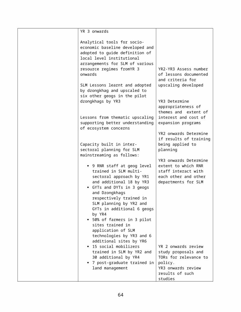
Output 4.4: Financial Management system established (SLMP Nu xxx Mill)
Prior to project effectiveness the RGOB will have identified project accountant and endorsed the system of financial management proposed by the SMLP. The system will be in effect from the first project month. Details of financial management specified in the Operational Manual.
65
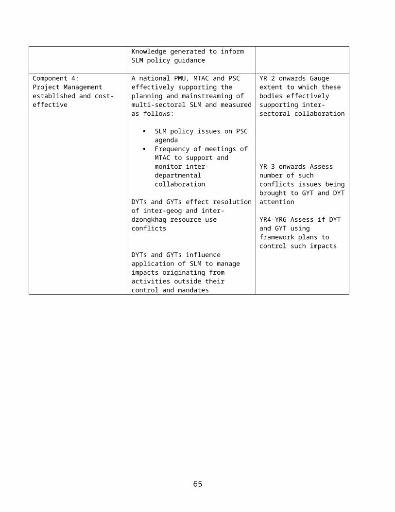
Attachment 1
Planning Framework for Participation of Local Communities in Implementation of Sustainable Land Management Approaches in Pilot Project Sites.
This Planning Framework outlines the approach for the involvement of communities in planning, decision making, implementation and monitoring of sustainable land management activities supported by the project. The approach would also serve along the Environmental and Social Management Framework as a tool to manage any potential negative environmental and social impacts of the project. .
Institutional set-up for integration of local communities in SLM activities
For each pilot project geog, a Geog SLM Planning Team (GPT) will be constituted to provide technical and planning inputs for implementation of project supported activities. The GPT would consist of a Geog SLM Field Coordinator (GFC) and 2-6 social mobilizers and existing geog RNR extension staff to the extent they are free from other duties in other chiogs. The GPC will be incremental staff seconded by the MoA to the geog level in support of the project, while the social mobilizers would be hired by the project from the geog itself. The GPT’s primary responsibility will be: (i) information dissemination, social mobilizations and strengthening of the chiog role in local decision making and prioritization of local needs within an SLM framework that would feed into the overall geog level SLM Framework and Action Plans; (ii) the assessment together with central RGoB agencies of extent of land degradation and baseline scenario and identification of underlying causes for such degradation in the respective chiogs; (iii) facilitation of a multi-sectoral approach to community planning and decision making on options for sustainable management of vulnerable community, public, state and private lands to reverse or mitigate against existing or future land degradation in the chiogs; (iv) implementation of sustainable land management activities in conjunction with local communities, including controls/rules established by the communities on the use of these lands; (v) implementation of community development and income generating activities to mitigate any limitations in community induced restrictions on resource access; (vi) monitoring of community sustainable land management activities and reciprocal commitments; (vii) liaising with RNR and other sector staff to support the multi-sectoral approach to land management at the chiog levels; (viii) ensuring that social and environmental screening and mitigation action are planned and implemented at the chiog level; (ix) ensure that local communities have access to technical support and capacity development in the implementation of SLM activities from the project or Dzongkhag administration; and (x) evaluate regularly (they are seen as members of GPT above) the lessons and experiences from multidisciplinary planning approach; (xi) liaise regularly and frequently with the GYT for information and endorsement of activities, including adoption of planned investments in the Geog Annual Development Plans; and (xii) liaise closely with the Dzongkhag SLM Coordination Committee and its representatives for lessons learnt, for defining upscaling process and for application to the Dzongkhag’s own development planning All management arrangements and community investments at the chiog level will be detailed in a chiog SLM framework and five-year management plans. The SLM framework and five-year management plan will form the basis of a MoU between chiog and GYT as the GPT moves on and no one is left after five years with a corporate status to guarantee this agreement except the GYT.
In order to facilitate participation of local villages, the tshogpa will organize chiog meetings and mobilize local community participation, disseminate project information and mobilize community feedback, prepare social and environmental screening with guidance of the GPT and assist the GPT in the socio-economic and ecological baseline surveys. All chiog households will be represented in all decision-making fora while a chiog SLMP contact person or the tshogpa himself/herself will keep up the contact with the GPT, depending on whether a chiog is 80 households or 3 households, so some flexibility will be built in to recognize the differences. An executive SLMP committee will be elected to participate in PRA
66

exercises, discuss and reach consensus on intra- and inter- community agreements and decision making with facilitation of the GPT, discuss and develop community SLM proposals relating to management and regulation of use of land and other resources, as well as dialogue with neighboring geogs on intra geog issues, as appropriate with guidance and assistance of the GPT.
The PRA exercise would be a participatory activity involving chiog members, tshogpa and GPT. The PRA would be tailored to focus specifically on land degradation issues and options for their management, rather than be an open ended exercise that deals with all the needs and concerns of the chiog. In conducting the PRA exercise, the GPT would ensure that it covers the range of natural resources that are utilized or impacted by the community. The GPT will be trained in PRA and community resource mapping prior to starting the exercise. The PRA will use the results of the surveys undertaken by central level agencies to prepare base maps, land hazard maps, soil capability maps etc. After the PRA has been carried out, the GPT with support from PMU and MTAC will consolidate the results of the PRA and present them to the local community in a chiog meeting, discuss their views and confirm consensus on the proposed activity. The PRA will not only create better community understanding of the conditions in which the proposed activity will take place but also reinforce community discussion and awareness of the rationale of the activity. Drawing on the discussion of the PRA results, the local community will discuss and plan, among other things, the scale, seasonality (if relevant) and timeframe of various activities that are to be restricted.
To enable implementation of any communally-agreed/jointly agreed restriction of access to vulnerable habitats and natural resources, the GPT will help the local community draw up an intra-community agreement if users belong to the same chiog. Where users (even if secondary) include communities from different chiogs but within the same geog, the GPT will help the concerned communities to draw up an inter-chiog agreement. The GPT will facilitate the development of these agreements in coordination with the GYT. All intra- and inter-chiog agreements between communities of the same geog will be reviewed and approved by the GYT with the Gup as the approving signatory. The development of the agreements will be on a case-by-case basis. Apart from defining the restrictions, it will define mechanisms or measures to prevent violation and redress grievances under the oversight of the GYT. Where restriction of access to natural resource involves communities from different geogs or dzongkhags, the GPT will help the local communities within the geog to prepare a community proposal for submission to the DYT through the GYT. In addition, the GPT (with support from the PMU and Project Steering Committee) would facilitate dialogue with central and local government institutions for devolution of management responsibility to local communities for management of forest, grazing and other resources through the promotion of joint management or resource sharing arrangements.
The GYT will review and approve intra-community agreements and inter-community agreements related to the regulation and management of access to resource use. The GYT would also review SLM proposals and facilitate their incorporation into the overall geog annual development plans. The GYT’s role would be to ensure integration of SLM activities in the overall development agenda and activities at the geog level in collaboration with Geog RNR Staff. GYT’s will liaise with other governmental agencies active in the respective geogs/dzongkhags (with engineers for instance) to coordinate project implementation and be able to access resources from other programs and projects. The GYT will also ensure that appropriate technical guidance and support is provided through the geog RNR extension agents or dzongkhag staff to the GPT and chiogs to implement and monitor both SLM and alternative livelihood investments for villagers.
The role of the Dzongkhag SLMP Coordination Committee/Dzongkhag Environment Committee consisting of the three RNR sector heads, finance officer, planning officer, engineer, Regional Trade and Industries Office Representative and representatives of other relevant agencies would be to oversee and guide the implementation of SLM activities in the geogs, facilitate agreements with communities from
67
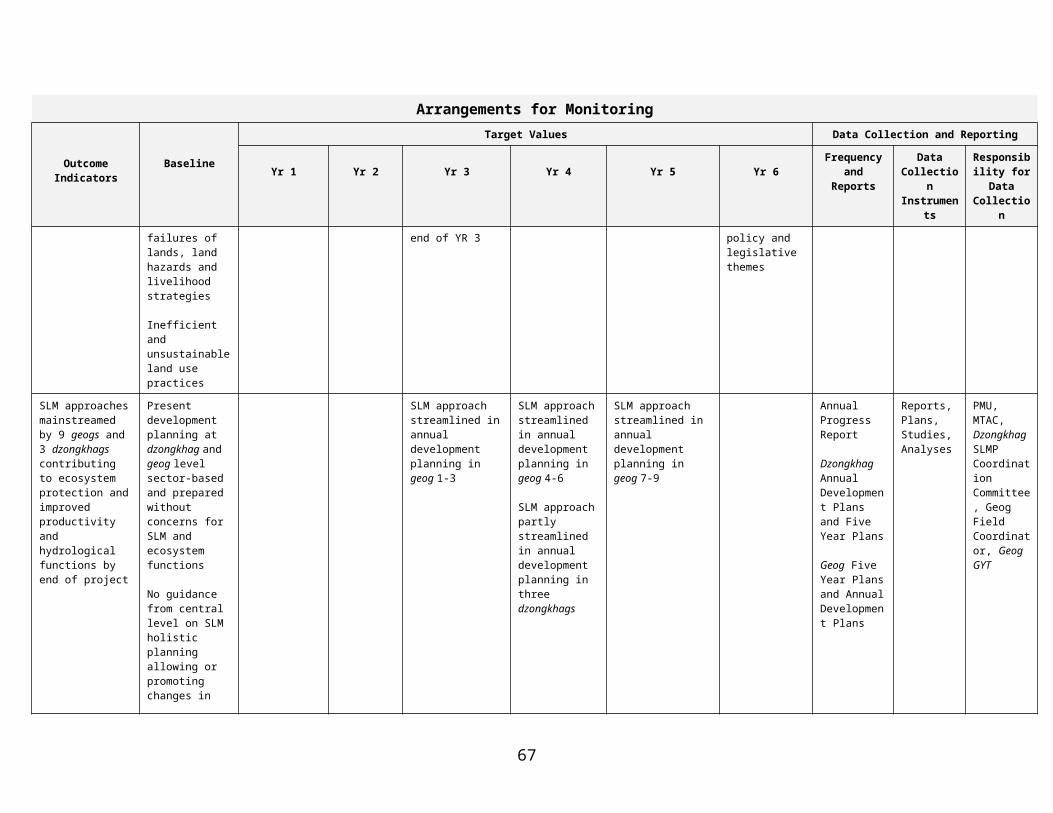
different geogs and adjoining dzongkhags on resource restrictions and use and otherwise participate in the monitoring of lessons learnt from the multi-sectoral approach. Along this line, the committee will also be responsible for facilitating learning and awareness of SLM initiatives and extension of such learning to other geogs to enable up-scaling of the SLM approach. Framework for community consultation and participation in planning, implementation and monitoring of SLM activities
Planning and implementation will proceed in a staggered fashion in the three pilot geogs beginning with a few chiogs and later extending to cover all of the chiogs within a particular geog, and subsequently extended to two additional geogs in each of three pilot dzongkhags. The key steps that constitute the process framework for participation of local communities in SLM comprise:
1. Prioritization of chiogs within each geog : While, the SLM planning approach will cover all chiogs within each geog, it is necessary to prioritize chiogs on the basis of the severity of the land degradation problem, such as extent of deforestation and overgrazing, unsustainable improper water and agricultural practices. This prioritization would enable the implementation of SLM practices in the more vulnerable chiogs before other chiogs are tackled. On the basis of existing information, data created by central agencies’ surveys, local RNR staff and community knowledge, chiogs in each geog would be ranked on the severity of the land degradation problem.
2. Community orientation and mobilization: The project objectives and approach will be disseminated by the GPT to all the local communities in the pilot geogs. In addition to dissemination of the project objectives and approach, orientation meetings would seek to complement the consultations undertaken during project preparation, to more accurately identify the perceptions of the local communities and other stakeholders regarding existing unsustainable land management practices and options for their better management, and identify key representatives of the community for participation in subsequent resource mapping. At these meetings the environmental and socio-economic profiles would be filled in order to be sure to have this information from stakeholders in a format that can be easily retrieved.
2. Mapping of community resources and their utilization: The participatory resource mapping (that would be supported by the scientific mapping undertaken by the central agencies) will constitute an input to the planning of SLM activities at the chiog level and will establish the baseline for subsequent monitoring. In addition to the participatory resource mapping, a base mapping, hazard mapping, forest function surveys, and soil capability mapping will be carried out by central level agencies to guide long term approach to SLM by highlighting ecosystem characteristics. The participatory mapping will provide information on (a) scale of resource utilization (areas of pasture, agriculture, volume of fuelwood, animal husbandry, etc); (b) extent of land degradation and condition of lands and potential erosion threat and landslide areas; (c) existing unsustainable resource uses, the type, nature and extent of such uses; (d) rights by cadastral surveys, customary tenure, including joint tenure, and overlapping tenure rights to areas used in different seasons by different users (where transhumance is practiced) (e) conflicts in resource use within and from outside the chiog and/or geog; (f) condition of village infrastructure, in particular irrigation, water supply and erosion structures. In terms of customary rights to use of common lands (pasture, forests, etc) the mapping would provide information on: (i) location and size of the area and condition of resource; (ii) primary users, including those belonging to vulnerable group, that currently use or depend on these common lands; (iii) secondary users (e.g. graziers from another geog/ dzongkhag) and identify the types of uses they make.
3. Strengthening Chiog households: During the orientation meetings and community mobilization process, the interest, capacity and skills of the chiog residents for SLM, would be accessed.
68

This will give opportunity to prepare a socio-economic profile that may later help in the social and environmental screening of projects proposed. The project would provide training in resource mapping, natural resource management evaluation, planning, construction supervision, maintaining of minutes of community meetings and basic account keeping and monitoring of resource access restriction agreements will be provided. Basically, most training will be on the job training as well as exchange visits to other chiogs and geogs where relevant solutions to problems have been implemented.
4. Development of Chiog SLM strategies and mitigation measures: Meetings will be held with individual chiogs to review the results of the community resource utilization mapping undertaken as a second step of this process framework and to agree on its implications regarding SLM strategies, resource access restrictions, mitigation and/or compensatory measures and community participation arrangements for mitigation and SLM activities. Activities that are selected for project support must comply with the following pre-requisites:
All project supported investments must be based on some minimum level of cost sharing by/involving local communities
Preferably, a clear and transparent linkage must exist between improving land management and the proposed investment, so that the village project agreements between communities and local governmental institutions help reduce land degradation by creating adequate incentives for local communities to take measurable actions that supports land conservation and sustainable use
All project investments, including restrictions on resource access must evolve through a common understanding and consensus amongst the local communities.
To be eligible for inclusion in the chiog SLM plans (that eventually are subsumed under the various sub-programs found in the geog annual development plan) for funding under the project, activities should comply with the following criteria:
Conserve and sustainably use land and other natural resources either directly or indirectly by creating sufficient incentives to commit local people to specific, measurable actions that improve the sustainable management of land.
Provide equitable share of benefits to local communities and mitigate any negative impacts to women, poor and disadvantaged groups who are currently most dependent on the land
Be socially sound and institutionally feasible ensuring that associated activities are culturally acceptable and do not impose an unnecessary heavy burden on individuals and that local institutional capacity is adequate to organize resource management, distribute benefits from common resources, provide physical maintenance, meet community agreements to resource use and access restrictions, ensure alternative livelihood benefits to affected members and monitor project impacts
Be low cost and financially feasible so that costs are within norms or approved by the GYT (or GPT), returns are sufficient to compensate for resource restrictions, and, for all investments intended to produce cash revenue or benefits that can be monetized, market linkages are adequate, cash flow requirements are viable, and returns compare favorably with alternative investment options.
Be technically feasible and innovative so that inputs and technical advice are adequate, physical conditions are suitable and the activity is technically sound.
69
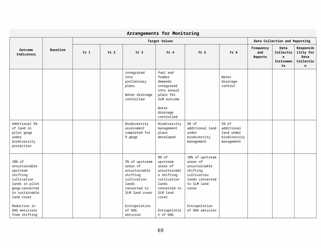
Be environmentally sustainable in support of global environmental objectives
Be selected and owned by local communities as ensured by a budgetary constraint mechanism, community contribution or co-financing requirement, and a commitment by the community to bear maintenance costs of any infrastructure component
Be supported by training and capacity development for strengthening all households.
Be supplemental or incremental in nature to ensure that activities supported under the project are not a substitution for what should be supported by the government as part of their development responsibilities or not of global benefit.
The project will establish procedures to screen requested SLM or income generating investments to ensure that they are technically feasible, have positive environmental impact and are part of a holistic approach to the local ecosystem management, likely to generate supplementary income, comply with sound social and environmental principles and are sustainable. The GPT will be primarily responsible for such screening. Decisions regarding the priority investments will be made by mutual consent of the GPT, tshogpa and community, with subsequent endorsement by the GYT. If required by budgetary or implementation capacity constraints, proposed activities will be prioritized based on their expected positive impact on global environmental objectives, the conservation and sustainable utilization of the land and livelihood restoration related to restrictions in resource access. The activities also need to be implemented in such a way that they create a learning situation and results that are of policy relevance. Examples of appropriate land management and livelihood activities might include: improved agricultural practices, improved livestock and pasture management, forest management and rehabilitation, including community forestry, bioengineering erosion control, environmentally friendly minor infrastructure rehabilitation (village irrigation and drinking water supply systems, minor erosion control structures, etc), alternative livelihood options (handicrafts/ handlooms enterprises, agricultural product processing and development, mushroom cultivation, marketing support, skills development, etc) and natural resource conflict management.
5. Implementation of Chiog SLM plans Activities discussed and agreed with the community would form the basis of the chiog level action plans that would then be incorporated into the overall geog annual development plans and the Five Year Plan and be funded either by the project or other sources. Once chiog level plans are approved, an agreement would be signed between the relevant tshogpa, GFC and Gup for carrying out the proposed activities. With technical support from the GPT and geog RNR extension staff, and Dzongkhag level staff (the latter particularly for engineering/infrastructure development support), the chiogs will implement the activities in their individual villages. The tshogpa and GPT will convene periodic meetings (quarterly) to review implementation progress (including social and environmental compliance and action) and resolve any specific issues arising from project implementation and monitor implementation outcomes and impacts. For all activities funded under the GEF alternative and incorporated in the Geog Plan a separate monitoring sheet will be prepared that will cater to establish firmly lessons of policy relevance.
6. Monitoring and Evaluation. The monitoring systems will provide for continuous learning and adjustment. One monitoring system follows the MoA’s Manual for Monitoring and Evaluation, which is sector-based, the other is designed in particular for SMLP as a participatory monitoring geared to capture the multi-sectoral approach using the relevant indicators which at the same time will be linked to indicators that are defined in a participatory manner by those involved in the investment activities. An independent monitoring agency will be employed each year to facilitate the monitoring process. While the MoA’s monitoring framework is given in its manual, a separate monitoring framework is defined in
70

chapter 7 of the Operational Manual. Four areas of significance for monitoring achievements of project objectives will be: (i) the ecological (relating to land management and conservation) aspects; (ii) community participation in SLM, mitigation planning and implementation, community compliance with resource use agreements and restrictions, and outcome of livelihood activities; (iii) institutional aspects, such as those relating to multi-sectoral planning at central, dzongkhag, and geog level, and modalities for conflict resolution and new community-based agreements on resource use and (iv) validation of all SLM interventions to identify and capture the appropriate sustainable systems of rights and responsibilities and institutional framework for optimal SLM of grazing lands, paddy lands, dry land agriculture, forest and streams, in order that these provide the basis for consolidation of analytical tools and up-scaling of approach to other geogs and dzongkhags.
Thie independemt monitoring will be supported by a participatory monitoring system involving the beneficiaries. The project together with the local villages establishes the baselines and relevant indicators of success that will guide the project’s own learning. The very planning process and the collaborative definition of indicators at that stage serve to create ownership of the process and the results. The facilitators for this process will be the GPT, the Geog Coordinator and the Geog RNR staff. Each chiog level plan/activity will have a small log-frame attached with time-bound indicators that are determined by the local stakeholders and which identifies both the socio-economic and environmental benefits to arise. The participatory monitoring process will be facilitated by the Geog SLM Coordinator and GPT. The Geog Planning Team with support from the RNR staff will undertake an annual assessment of the monitoring results at each chiog and provide feedback and guidance for adjustment to the farmers.
7. Scaling up of SLM activities. On the basis of the monitoring and evaluation and validation of the SLM interventions, the Dzongkhag SLMP Coordination/Environment Committee will conduct seminars and workshops in other non-pilot geogs on lessons learned and support site visits. Criteria for selecting the geogs for scaling-up will be established by the Dzongkhag administration in collaboration with the respective GYT’s and PMU. One a decision has been made to scale up to a new geog, the GFC moves to the new geogs to plan and implement project activities with the geog RNR staff. In the additional geogs, new GPTs will be formed from among local residents. They will be trained well in advance by their participating and visiting the ongoing activities and learning from the GPT of the first geogs.
71

Annex 5: Project Costs
Project Cost By Component and/or ActivityLocalUS
$million
ForeignUS
$million
TotalUS $million
1. SLM Planning, policy and legislative and regulatory framework
338.11 1,542.80 1,880.91
2. SLM approach validation in pilot 550.43 1,566.31 2,116.75
3. Institutional system and capacity for SLM 2,091.45 5,894.26 7,985.71
4. Project Management273.59 1,357.75 1,631.34
Total Baseline Cost 3,253.58 10,361.11 13,614.70Physical Contingencies 325.36 1,031.11 1,361.47Price Contingencies 235.05 672.96 908.01
Total Project Costs1 3,813.99 12,070.18 15,884.17Interest during construction
Front-end FeeTotal Financing Required 3,813.99 12,070.18 15,884.17
1Identifiable taxes and duties are US$m ___, and the total project cost, net of taxes, is US$m___. Therefore, the share of project cost net of taxes is ___%.
72

Annex 6: Implementation Arrangements
There is a partnership agreement with Danida for parallel financing. The Danida-assisted EUSPS and the GEF-assisted SLMP will both address rural and peri-urban environmental management through support to the MOA, MOWHS, MTI, MOF, MOHCA and NECS. While the EUSPS’s natural resources management component emphasizes policy and planning at the central level, SLMP works from the ground to promote mechanisms for sustainable land management at chiog and geog level as described in Annex 4. The EUSPS’ urban components are more field oriented and provide scope for addressing urban-rural interfaces directly in the field. A Memorandum of Understanding (MoU) signed between RGOB, Danida and the World Bank on 26 March 2004 outlines the cooperation and the sharing of a Steering Committee for SLMP and EUSPS. The two projects will coordinate their activities at central and local levels, including selection of target areas, capacity building, information management, technical documentation, and impact assessment, as well as use of long- and short-term advisors and consultants and the conduct of joint reviews and evaluation. The SLMP is hosted by the MOA, but the project may fund activities, which technically are under MTI, MOWHS or NECs, which all are represented in the MTAC (TORs in Attachment 4) and PSC (TORs in Attachment 1). This takes place when such activities appear in chiog and geog SLM action plans. The implementation arrangements for the GEF project are based on existing government structures but with a cross-sectoral PSC, MTAC and local level cross-sectoral teams to guide the project towards mainstreaming the SLM approach in RGOB development planning.
A Project Management Unit (PMU) under MOA located at the NSSC is entrusted with the day-to-day management of SLMP and comprise of a project director (TORs in Attachment 2), a full time project manager (TORs in Attachment 3), an accountant as well as secretarial staff. It has oversight of the entire work program set out in the Project Plan of Implementation (PIP). The Project Director is an ex-officio member of the PSC. The Project Director together with the Project Manager is responsible for close coordination with the MTAC, the EUSPS and for constant support to field implementation. International and National Technical Assistance support to the PMU is envisaged will facilitate on the job training. A central Multi-Sectoral Technical Advisory Committee (MTAC), a continuation of the cross-sectoral Working Group for GEF project preparation, represents the ministries collaborating cross-sectorally in the project and more involved in daily activities than PSC members. It provides regular advisory and operational technical support to the PMU and the field and caters to the alignment between the project activities and the respective sectoral plans and programs. The PMU will be supported by international and national consultants (TORs for key International Consultants in Attachment 8 & 9)
A Dzongkhag SLMP Coordination Committee (TORS in Attachment 5) will be formed by the Dasho Dzongda to constitute a coordination mechanism between geog and dzongkhag. It may preferably coincide with the Dzongkhag Environment Committee (DEC) and comprise of the dzongkag RNR staff, planning officer, engineer, and dzongkhag financial officer. The DYT as the dzongkhag’s elected body will carry forward all elements of the new approach as well as spearheading with the dasho dzongda possible negotiations with neighboring dzongkhags on grazing issues. The Geog SLMP Field Coordinator (TORs in Attachment 6) is an incremental staff seconded by the MOA to the geog level in support of the SLMP. S/he will lead the Geog SLM Planning Team (GPT) (TORs in Attachment 7) and coordinate with geog RNR staff on implementation. The GPT is a body hired by the project as social mobilisers that provide a collaborative training input to the geog RNR staff and facilitates the chiog level planning. There is one team for each of the three pilot geogs recruited among local residents/villagers. The size of the team depends on size of geog ranging from 2-3 men and 2-3 women. New GPTs will be formed as the project expands.
73

The GYT is the geog’s elected body headed by the Gup and consists of annually elected tshogpas who each represent a chiog as well as other members, including one who is Member of Parliament. The GYT may perform as the Geog SLMP Coordination Committee or set up a local working committee for regular interaction with the Field Coordinator and the GPT. Together with the geog RNR staff it will help scrutinize the SLM chiog SLM plans and merge them to Geog SLM Action Plan to be embedded in the Geog Annual Development Plan in order to submit this for SLMP funding through the normal channels.
The selection of the above bodies follow the existing RGOB system and only where on the job training is necessary through deployment of rotational incremental staff and consultants are these added. Capacity constraints are found in institutionalizing bottom-up area-and ecosystem-based SLM planning linked to geo-informatics. The GEF project recognizes capacity constraints in the implementation arrangements as geog RNR staff has other responsibilities but monitors this separately.
International technical assistance will be provided through a long-term (two-year) land management specialist, a public participation specialist and selected short term international consultants. National technical assistance for annual monitoring studies and particular topics would be obtained.
The financial management and procurement will be carried out primarily by the geog that receives a Letter of Credit, and the dzongkhag financial officer for consolidating reporting. The capacity of the geog would not be sufficient and training of local level geog staff in financial management, procurement, disbursements and financial progress monitoring is necessary. Training of geog level staff is envisaged also in the World Bank-assisted on Decentralized Rural Development Project, which covers three-quarters of all geogs in Bhutan. The SLMP will piggy-back on this training. Flow of funds and financial reporting is based on the RGOB system. Project funds flow through the Department of Budget and Accounts (DBA) of the Ministry of Finance directly to the relevant agencies charged with the implementation of project activities through a Letter of Credit. The SLM Work Plans that are an outcome of chiog planning will be integrated at the geog, dzongkhag and line agency level and presented as the overall Project Annual Budget in support of a PIP that clearly designates the shared responsibility for implementation of activities among stakeholders even though only one sector agency may be assigned the role as ‘lead agency’ in the present RGOB’s activity-based planning, budgeting and financial reporting system. The Project Director will have overall responsibility for project financial management.
74

SLMP Facilitation Rgob & Decentralised Line Agency SLMP Planning
Structure Structure Support Structure Tools
SLMP activities
Chiogs 1, 2, 3, 4, 5, 6, 7, 8, 9, 10, 11, 12, 13, 14, 15, etc.
Project Plan
Dzongkhag Plan &
Dzongkhag SLM Plan
(PY 3-4)
Chiog SLM PlansRgoB Activities (baseline)
Geog Accountant
Geog M&E Forum
RNR staff, advisors
and implementers
GSLMPT
of MT, MWHS
and RNR RC
Geog GYT
Dzongda and
Dzongkhag
DYT
Home Ministry
Danida
Dasho
(hired staff under the
Coordinator
Dzongkhag
SLM Coordinator &
Committee
(selected by Dasho
PSC
MTAC
Geog SLM coordinator
and Gup)
EUPS
(incremental, appointed
by MOA)
Geog SLMP
Planning Team
Dzongda among
existing staff)
Geog SLM Plans
PMU
Project Director &
Project Manager
Geog SLMP
Line Ministries
RNR staff
Planning Officer
Accountant
Regional Offices
75

Attachment 1Terms of Reference for Project Steering Committee
The SLMP shares its Project Steering Committee with the Danida EUSPS Programme. The Danida EUSPS has already started in 2004 and the PSC is constituted and has met.
Composition
Members of the Steering Committee are: Secretary, Ministry of Finance, Chair One member, National Environment Commission Secretariat (NECS) One member, Ministry of Agriculture (MoA) One member, Ministry of Trade and Industry (MTI) Two members, Ministry of Works and Human Settlement (MoWHS) One member, Ministry of Home and Cultural Affairs One member, Ministry of Home and Cultural Affairs One member, Liaison Office of Denmark (LOD) Project Director, ex-officio member for SLMP One member representing the WB
The specific tasks of the PSC are as follow Monitor the overall program in accordance with the program and project documents Approve of annual work plans and budgets. Review and approve annual and half-yearly progress reports and financial statements. Approve proposed budget revisions and re-appropriation within the budget framework of the
SLMP Project Document and the contingency. Approve revised job descriptions of advisers and consultants Approve the use of short-term advisors based on the ToR and ensure that the full potential for
collaboration and synergy between the EUSPS components and SLMP is explored Assess the annual audit and ensuring follow-up on recommendations. Approval of timing and ToR for the Joint Reviews The SLMP and the EUSPS may call for PSC meetings with minimum three weeks notice and
within two weeks of meeting forward all documents and issues for the PSC meeting along with a draft agenda.
Resource persons that may attend the PSC meetings include Component Directors (e.g. PPD heads or similar), Component Managers, Senior Technical Advisers and other stakeholders from partner institutions and implementing bodies as relevant.
76

Attachment 2Terms of Reference for the SLMP Project Director
The SLMP Project Director is a Program Director from NSSC, which had the lead in SLMP project preparation. The transition towards implementation would thus be relatively smooth.
The Project Director is responsible for the general management and strategic direction of the project in collaboration with the PM, MTAC, the Geog SLM Field Coordinator, and the Geog SLM Planning Team. The Project Director will ensure regular coordination with dzongkhag administration, DYT and the GYT and Gup. Thus, the Project Director will with advice from DADM and together with the PM and the Geog SLM Field Coordinator oversee the establishment of efficient administrative, financial and technical management procedures to serve national, dzongkhag and geog implementation needs. The Project Director will work on the project assisted by a Project Manager who works full-time.
The Project Director will take responsibility of informing all stakeholders at central and local levels of project inception
Set up easy flow of communication with target Dzongkhags and geogs Project Director will be ex-officio member of PSC and bring the results from field experience for
presentation in the PSC Submit reports and analyses to PSC regularly Project Director will keep close contact with the MTAC to facilitate continuous support to the
field The Project Director will ensure the logistics and systems of consolidation of lessons learnt from
the field are in good order Project Director will as member of PSC facilitate presentation to it of systemic issues arising in
the field related to SLM Project Director will oversee the work of project accountant and secretary servicing the PMU The Project Director and the Project Manager will support the Geog Coordinator, the GPT, the
GYT and the Dzongkhag in the preparation of Annual Work Planning Forms for SLMP that will cater to a new participatory mode of inter-sectoral planning at chiog and geog level
The Project Director and the Project Manager will set up the SLMP Monitoring System and ensure that all planning and monitoring forms are ready to implement the project’s monitoring system conducive to establishment of baselines and profiles as well as serving the participatory planning needs and the generation of SLM lessons learnt.
Facilitate the preparation of Annual Work-plans for all participating agencies based on plans from the field and consolidate these into detailed annual Project Implementation Plan and less detailed three year plan
Ensure the Environmental and Social Management Framework is applied Oversee with Project Manager the preparation of management reports (inception, revision of
Operational Manual, progress reporting, and terminal reports) Call monthly meetings of the MTAC Be responsible with PM for the disbursement of RGOB contributions at the national level in
terms of personnel, funds and equipment as detailed in the PAD Assist the Project Manager with day-to-day operations whenever called upon Facilitate the selection process for consultants, training candidates and facilitate the selection of
pilot areas. In collaboration with the Danida EUSPS facilitate that project results are incorporated into policy
statements of the RGOB and provide inputs to guidelines for Five-Year Plan Preparation, and amendments of policies and laws
Be the counterpart to international and national advisors
77

Attachment 3Terms of Reference for the SLMP Project Manager
The terms of reference for the national SLMP Project Manager reflect those of the Project Director but the Project Manager will be full time and closely involved in field activities while the Project Director will cater to the work with MTAC and consolidation of lessons learnt and their presentation to central level policy bodies. The National SLMP Project Manager should be an experienced government officer of MOA.
The Project Manager will along with Project Director take responsibility of informing all stakeholders at central and local levels of project inception. The Project Manager will travel to all three dzongkhags and geogs along with the Geog SLM Field Coordinators during the first month of project effectiveness.
The Project Manager will support the Project Director in consultation with all departments on drafting and preparing Annual Work Planning Forms for SLMP that will cater to a new participatory mode of inter-sectoral planning at chiog and geog level
Oversee the work of project accountant and secretary servicing the PMU Facilitate with Project Director the preparation of Annual Work-plans for all participating
agencies based on plans from the field and consolidate these into detailed annual Project Implementation Plan and less detailed three year plan
Ensure the Environmental and Social Management Framework is applied Project Manager under guidance from the Project Director will facilitate the setting up the SLMP
Monitoring System, its formats and logistics,and ensure that all planning and monitoring forms are ready for implementation of the Monitoring System conducive to establishment of baselines and profiles as well as serving the participatory planning needs and the generation of SLM lessons learnt.
Prepare with guidance from Project Director the management reports (inception, revision of Operational Manual, progress reporting, and terminal reports)
Submit through Project Director reports and analyses to PSC regularly Set up easy flow of communication with target dzongkhags and geogs and visit pilot dzongkhags
and geogs at least once each quarter Function as secretary to monthly/quarterly meetings of the MTAC Assist Project Director in the disbursement of Royal Bhutan Government counterpart
contributions at the national level in terms of personnel, funds and equipment as detailed in the PAD
Facilitate with Project Director the selection process for international, regional and national consultants, and training candidates and facilitate the selection of pilot area seconded staff and consultants
In collaboration with the Danida EUSPS facilitate that project results are incorporated into policy statements of the RGOB and provide inputs to amendments of policies and laws
78
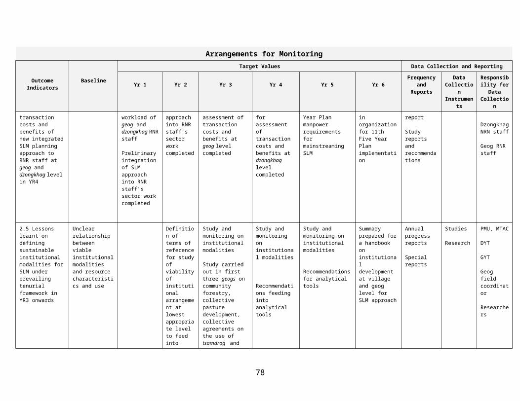
Attachment 4Terms of Reference for Multi-sectoral Advisory Committee (MTAC)
The MTAC is a continuation of the inter-sectoral project preparation Working Group established in 2004 that has followed the project preparation to its end through regular meetings and drafting of documents. The membership of MTAC will be endorsed by the members’ own departments. It will meet once a month or quarterly and/or when called upon by the Project Director. The MTAC refer collectively and individually to the Project Director.
It is a committee at central level that will:
work closely with the PMU and advice and facilitate sectoral inputs to the inter-sectoral working mode.
Individual members will bring forward the sectoral issues from their own departments and agencies related to SLM,
communicate with their higher level representative in the PSC, and overall integrate the skills and capacities of their agencies into the SLM planning process. facilitate that administrative procedures from own agencies can cater to the monitoring of
integrated land use planning and implementation. individually and collectively support the Geog SLMP Field Coordinator and his Planning
Team, the geog RNR staff, as well as the Dzongkhag SLMP Coordination Committee and their own line officers at dzongkhag level.
travel to the field to all three pilot sites at least once a year. facilitate that the Environmental and Social Management Framework is applied
Members will from their own perspective contribute to formulation of lessons learnt and bring these forward to policy level.
79

Attachment 5Terms of Reference for the Dzongkhag SLMP Coordination Committee
The Dzongkhag SLM Committee is composed of the RNR sector heads, Dzongkhag Finance Officer, Planning officer, Dzongkhag Engineer, Regional Trade and Industries Office (RTIO) representative and representatives from other relevant agencies as and when necessary. Dasho Dzongda will be the committee chairman. The committee may be the same or an extension of the Dzongkhag Environment Committee. The Dzongkhag SLMP Coordination Committee will
Assess human and financial resources required for the effective and efficient functioning of the Dzongkhag SLM committee and take necessary actions
Adopt or suggest amendments to Project Planning Forms for preparing annual work plans and monitoring
Support Geog RNR staff to prepare a work program that lends synergy among SLM planning and RNR staff’s scheduled field visits for RNR development work
Discuss with RNR staff the synergies among the RNR development work and SLM work With Field Coordinators and the SLM Planning Team prepare up-scaling of SLM approaches in
other geogs. Facilitate that all geogs included in the project have information on SLMP background Conduct Dzongkhag workshops with RNR staff (and consultants) to discuss lessons learnt from
Chiogs and geogs on root causes of land degradation Support Geog SLM planning team interventions that address public lands, common lands and
private lands in the watershed, in particular where these are crossing administrative boundaries such as grazing lands
Help ascertain for all investment activities the implementing body, group of persons or persons responsible for careful completion and maintenance of SLM initiatives.
Discuss with geog SLM coordinator, geog RNR staff, and SLM planning team the indicators that are defined for each investment activity so it will capture the success of each activity/intervention in year 2,3,4 onwards and use the indicators in the Planning and Monitoring Forms
Support a regular evaluation with geog RNR the lessons from interdisciplinary planning approach Facilitate that SLM concerns are incorporated into the Dzongkhag plans and programs while
preparing Annual Plans or Five Year Plans Have copies of relevant Acts, Regulations, EA sectoral guidelines and Environmental Codes of
Best Practices for reference or use by Gups and DYT Members Ensure that all project proposals fulfill requirements under the Environmental and Social
Management Framework of SLMP Ensure that environmental terms and conditions as stated in the environmental clearances are
implemented Attend relevant trainings and capacity building initiatives related to SLMP Oversee and guide the implementation of SLM activities in the geogs, Facilitate agreements with communities from different geogs and adjoining dzongkhags on
resource restrictions and use. Facilitate learning and awareness of SLM initiatives and extension of such learning to other
geogs to enable up-scaling of the SLM approach.
80

Attachment 6Terms of Reference of the Geog SLMP Field Coordinator
The Geog SLMP Field Coordinator is a person seconded by MOA to the geog level for execution of SLMP field activities. The coordinator reports to the project director and the gup. There is one Geog SLMP Field Coordinator for each of three pilot geogs. The coordinator will move to a new geog within the same dzongkhag after PY3. S/he will have a mandate exclusively for SLMP and cannot be diverted to other tasks. The effectiveness of most field level SLMP activities rests with this person. S/he is considered a trainer to the Geog RNR staff on inter-sectoral planning. The Coordinator and the Geog SLM Planning Team will be supported in initial months by national and international consultants skilled in social mobilisation and participatory planning.
The Geog SLMP Field Coordinator will head the Geog Planning Team that works in each chiog of the geog for social mobilization in collaboration with the tshogpas. It consists of 4-6 persons, equal number of men and women, paid by SLMP project funds. For each geog their employment is three years. They will remain back when the projects moves to other geogs during PY 2-3.
The functions and duties of the Geog SLMP Field Coordinator are:
Implementation of SLMP with focus on chiog level participatory planning for SLM, implementation, monitoring, reporting, and financial management
Define with Project Director and Project Manager the means of communication between field and central level
Advertise and select together with Project Manager/Director the candidates from local level who are suitable for deployment at chiog level to undertake social mobilisation and participatory SLM planning and make up the Geog SLM Planning Team
Set up an SLMP office at geog level in either the RNR centre or the Gup’s office Establish good working relations with the geog RNR staff to facilitate future joint planning,
implementation, monitoring and training. Familiarise herself/himself with the all existing geog data and existing RNR workprograms in
collaboration with the geog RNR staff Set up a library at SLMP office with all existing documents and data related to geog Plan visits to all chiogs during the first two months to share information about the SLMP and
select with RNR staff the first three chiogs to initiate planning Inform central level of ready arrangements at geog/chiog level for starting the land and soil
mapping and preparing the socio-economic profile Support central level agencies and external consultants during their work in the pilot site Establish procedures for using the M&E forms for both planning and monitoring. Preparation of Annual Work Planning Form detailing first three months, updating it every
quarter. The Annual Work Planning Form will contain separate list of technical inputs required from all agencies and budgets for activities in each chiog
Preparation of the Monitoring Forms for submission to GYT, dzongkhag SLM Committee, and PMU.
Set up with the GYT the financial management arrangements for SLMP activities. The arrangements include modalities for submission of request for funds, accounting procedures, identification of who can physically manage the funds at chiog. Technical support from DADM will be provided.
Establish relations to the Dzongkhag SLM coordinating Committee in order to prepare the way for Dzongkhag adoption of positive SLM lessons learnt
Initiate end PY 2 discussions with Dzongkhag on up scaling the approach to other geogs within the same Dzongkhag.
81

Attachment 7Terms of Reference for SLMP Geog Planning Team
The Geog SLM Planning Team is composed of project-hired staff paid by project funds. The Team will be composed of 4-6 persons, equal number of men and women, the number depending on size of geog. It will constitute the forefront of the SLMP reaching down where planning starts. The team members are identified among local residents in the geog who are respected and who have completed 10 years of school.
The team reports to the Geog SLMP Field Coordinator and through her/ him to the Geog RNR staff and the GYT. The Planning Team will work at chiog level to mobilise local communities for participation on SLM planning. The team will be trained and supported periodically during the 1st project year through deployment of national and international consultants familiar with participatory natural resources management planning. The team will thus assist and learn from external consultants coming to work in the geog, in particular for establishing the socio-economic baselines and participatory planning and monitoring.
The SLM Planning Team will:
Keep close contacts with each chiog in the geog and establish the chiog level arrangements for ongoing public information-sharing on project plans. This will be planned together with the tsogpha.
With Field Coordinator prepare for studies and baselines on geo-informatics to be carried out at chiog level
With Field Coordinator prepare for studies and baselines on socio-economic profile, including land and water tenure to be carried out by central agencies and external consultants
Adopt or suggest at an early stage amendments to Project Forms for preparing annual work plans and monitoring
Plan with Geog RNR staff a work program. Discuss with RNR staff the synergies among the RNR development work and SLM work With Field Coordinator plan with geog RNR to form an interdisciplinary team visiting the first
three chiogs and use the resource and socio-economic baselines already created to start chiog planning for SLM
Ensure all villagers have information on SLMP background and chiog meetings by using local communication media.
Ensure women are specifically targeted. Conduct chiog workshops with RNR staff (and consultants) to identify SLM activities at chiog
level that are GEF fundable by addressing root causes of land degradation Define interventions that address public lands, common lands and private lands in the watershed
with the villagers. Assist the RNR staff to undertake the socioeconomic and financial analyses of the proposed
intervention Identify investment activities and implementing bodies Information dissemination, social mobilizations and strengthening of the chiog role in local
decision making and prioritization of local needs that would feed into the overall geog level plans;
The assessment of extent of land degradation and baseline scenario and identification of underlying causes for such degradation in the respective chiogs;
facilitation of a multi-sectoral approach to community decision making on options for sustainable management of vulnerable community, public and private lands to reverse or mitigate against existing or potential future land degradation in the chiogs;
82

Implementation of sustainable land management activities in conjunction with local communities, including controls/rules established by the communities on the use of these lands;
Facilitation of implementation of community development and income generating activities to mitigate any limitations in community induced restrictions on resource access;
Monitoring of community sustainable land management activities; Liaising with RNR and other sector staff to support the multi-sectoral approach to land
management at the chiog levels; Ensuring that social and environmental screening and mitigation action are planned and
implemented at the chiog level; Ensure the application of the Environmental and Social Management Framework Ensure that local communities have access to technical support and capacity development in the
implementation of SLM activities from the project or Dzongkhag administration; and Evaluate regularly with geog RNR staff the lessons and experiences from multidisciplinary
planning approach. Set up with villagers and RNR staff indicators that will capture the success of each
activity/intervention in year 2,3,4 onwards and use the indicators in the Planning and Monitoring Forms
Evaluate regularly with geog RNR the lessons from interdisciplinary planning approach Participate in dzongkhag level meetings on SLMP experience
83

Attachment 8Terms of Reference for long-term International SLM Technical Advisor
BackgroundThe Sustainable Land Management Project (SLMP) is a GEF-funded project executed by Ministry of Agriculture (MOA) of the Royal Government of Bhutan. It aims at realizing global and national environmental benefits from introducing cross-sectoral land management planning and implementation in selected pilot sites and at bringing lessons learnt up to policy level for amendments of both planning procedures and regulatory framework. Local community resource-based planning within an ecosystem approach constitutes the foundation for the project.
One international Long Term Technical Advisor will be deployed full time for the first two project years and return 1mm/year for each of the consecutive 4 years, a total of 28 mm.3
Job description
The CTA will function as an advisor to the SLMP Project Director, support the inter-ministerial Multi-sectoral Technical Advisory Committee (MTAC) and facilitate the setting up of a smooth project implementation mechanism that relies on bottom up planning for sustainable land management at chiog, geog and dzongkhag level. S/he will report to the SLMP Project Director and support him/her with the inception planning, annual work plan preparation, implementation, monitoring arrangements and reporting of the project. The duties will include, but not necessary be limited to:
Support the Project Management Unit (PMU) and the MTAC in the overall planning, implementation, monitoring, management, and reporting of the SLMP
Support the preparation of semi-annual workplans and budgets at PMU, dzongkhag and geog level
Assist dzongkhag and geogs involved in the implementation of the SLMP in issues related to general programme management and to interfaces between the SLMP components
Support the geog SLM Field Coordinator and local level planning team in organising its work-programme, undertake on the job training in inter-sectoral planning and liaise with other agencies
Advise all partner institutions through the Project Director and MTAC in further developing mechanisms for inter-sectoral planning for sustainable land management in the pilot sites
Provide on-the-job training in interdisciplinary planning and implementation in support to the key staff responsible for administrative and technical implementation at central and local level
Assist PMU and MTAC in reviewing critical institutional, legal and technical land management issues in support of policy, strategy and legislative development.
Assist relevant government units in applying and further improving the Monitoring & Evaluation system for SLM, particularly for geog and dzongkhag application.
Assist in setting up of monitoring mechanisms for up-scaling plan preparation to other geogs in the dzongkhag and prepare recommendations and lessons learned for general application.
Assist the MTAC and other government agencies in disseminating lessons learnt and best practices to interested parties through organization of seminars, workshops and other events and publication of articles.
Assist the dzongkhags’ development administration, sector heads and extension officers in supporting local level land management planning to combat land degradation
Assist GYTs, SLMP field staff and technical partner institutions in preparing a Geog Sustainable Land Management Framework Plan and Action Plans
3 It is envisaged that collaborative TA may be provided on an ad hoc basis from the Danida EUSPS Programme, which is the SLMP parallel financing partner.
84

Facilitate and support collaboration between SLMP and EUSPS, particularly in the field of support to practical development interventions in capacity building, information management, technical documentation and impact assessment
Facilitate the collaboration of SLMP partner institutions with regional resource institutions, short-term consultants, and others, and help ensure the optimal use of these inputs.
Provide inputs to progress report and other reporting to the Project Steering Committee for SLMP.
Qualifications
At least 10 years of background in project management in Asia, in particular projects for inter-agency collaboration in natural resources management
At least 10 years experience in program planning, administration, monitoring and reporting, including financial management
Broad background at both practical, strategic and policy level, in particular in relation to mountainous watershed areas and areas prone to land degradation
Experience in working with local governments on natural resources and environmental management
Solid background in local level community planning for resource management and protection and bottom-up planning under decentralized land management regimes
Familiarity with institutional and regulatory frameworks under different land tenure regimes Experience in training and institutional development including planning/implementation of
human resource development. 10 years experience in implementation of development programs in Asia, preferably in
mountainous regions.
Fluency in verbal and written English is a precondition
85

Attachment 9Terms of reference for long term international participatory planning specialist
BackgroundThe Sustainable Land Management Project (SLMP) is a GEF-funded project executed by Ministry of Agriculture (MOA) of the Royal Government of Bhutan. It aims at realizing global and national environmental benefits from introducing cross-sectoral land management planning and implementation in selected pilot sites and at bringing lessons learnt up to policy level for amendments of both planning procedures and regulatory framework. Local community resource-based planning within an ecosystem approach constitutes the foundation for the project.
The specialist will work full time 1st Project Year and 3mm/year for each of two consecutive years, in total 18 mm. S/he will report to the Project Director.
JOB DESCRIPTION
The specialist will undertake on the job training of SLMP project staff, in particular the Geog Field Coordinator, the SLM Planning Team, and the Geog RNR staff focusing on skills in community and social group motivation, mobilization, group dynamics, consultative meeting organization, facilitation, negotiation, consensus building, conflict management and resolution, gender sensitivity and awareness of indigenous knowledge’s contribution to sustainable land management technologies.
The participatory planning specialist will in particular
assist the PMU in planning capacity building and on the job training of SLMP field staff during the first project month to ensure smooth implementation in the field
undertake on the job training in participatory planning in three geogs during the first project months
assist in developing a chiog socio-economic profile draft terms of reference for socio-economic surveys for baseline information in relation to
measuring impact of investments including mapping of groups and organizations and their importance for decision-making
participate with the SLM geog planning team in conducting chiog resource mapping and prepare inventories relevant to SLM
alert SLM planning team, RNR staff and Geog SLM Coordinator to possible impact of gender issues, poverty issues, and cultural issues in the planning process to avoid exclusion of very poor people
facilitate the defining logistics of applying the Environmental and Social Management Framework and screeing
ensure that major meetings for decision-making are not poorly attended and that some key stakeholders are not represented at all
assist in defining with stakeholders indicators of success/results/impact of project interventions at chiog level that are simple and conducive to participatory monitoring
facilitate the planning process and formulation of chiog SLM framework plan and action plans, including specifying through group consultation who is expected to participate in what activities, why, how, when and under what conditions, who is responsible for implementing the initiative, and who is responsible for monitoring and evaluating it
facilitate grassroot action learning through ongoing collection of information that is useful to villagers
86

facilitate building structures and networks for lateral learning and collective action as part of the learning process itself
facilitate mapping indigenous knowledge in SLM and local institutions for resource management and help analyze how they can be involved in SLM initiatives
undertake training in ‘conflict management assessment’ to map natural resources conflicts (their magnitude and connectivity) and the geographical distribution of the conflict/s and prioritization of the conflict/s
consider processes to address the conflicts and facilitate training for the conflicting parties in direct face-to-face negotiations and stakeholder consensual negotiations
address provision of facilitation/mediation/brokering services in support of existing customary, institutional or legal approaches
Qualifications: At least 10 years of background in public participation, decentralization and good governance in
natural resources management projects in Asia, comprising village level planning for sustainable land management, including community forestry, rangeland management, conflict resolution mechanisms
Experience in tenure analysis Broad background at both practical, strategic and policy level for recommendations of optimal
institutional arrangements for natural resources management under different ecological conditions Experience in working with local governments on natural resources and environmental
management Experience in training and institutional development including planning/implementation of
human resource development.
Fluency in verbal and written English is a precondition
87

J. Terms of reference for international Biodiversity Consultant K. Terms of reference for international rangelandsL. Terms of reference for national Indigenous KnowledgeM. Terms of reference for national GIS expert
88

Annex 7: Financial Management and Disbursement Arrangements
Executive Summary
1. The project will have a satisfactory financial management system. Financial management and disbursement arrangements have been streamlined, to the extent possible, to use the existing government system. The National Project Management Unit (PMU) at the central level will manage and facilitate the project. The PMU will be placed at the Ministry of Agriculture (MoA), and headed by a Project Director. The MoA will have overall responsibility for financial management of the project and the Project Director shall have appropriate level of financial power delegated by the Secretary of the Ministry of Agriculture. The MoA will also appoint a full time Finance Officer in the PMU with good experience in RGoB accounting and donor financial management.
2. Project’s financial management and disbursement arrangements will support RGoB’s efforts for promoting decentralization and greater ownership by the dzongkhags and geogs of project activities undertaken at the dzongkhag and geog level. Accordingly, for all project expenditure to be incurred by dzongkhags and geogs, funds will be budgeted, recorded, accounted and reported in the books of the dzongkhags. However, as this arrangement of adopting government system for which all the funds will flow through the Government budget system and the accounts are being audited for compliance by Royal Audit authority, financial management risk is assessed to be low.
3. All project disbursements will follow the transaction based system. Project funds will be deposited into a special account to be opened in the Royal Monetary Authority and will be operated by Department of Aid and Debt Management, according to terms and conditions acceptable to the IDA. Disbursements from the special account will be following the normal government procedure followed for other World Bank projects in Bhutan for making releases/payments.
4. Project accounts will be kept on a cash basis of accounting. Annual external auditing of project accounts will be carried out by the Royal Audit Authority, which is the supreme audit institution in Bhutan.
5. The PMU has agreed to produce the FMRs on a quarterly basis for reporting to the Bank. The formats for FMR were discussed during appraisal and will be confirmed at negotiations. The FMR formats have been simplified to facilitate easy extraction of necessary information from the existing government system.
Capacity building will be necessary for training of project accounting staff in the PMU, Dzongkags and at the Geog level on financial Management.
Overall, Bhutan has a record of satisfactory financial management system in Bank financed projects. Financial management system of the government is prescribed in the Financial Management Manual, dated 2001. RGoB has computerize the entire public sector accounting and reporting system.
A country level issue that could impact on the project is the accounting and reporting relationships between the dzongkhags/geog and the PMU. The RGoB encourages greater decentralization and increased ownership by the dzongkhags/geogs, and prefers that for activities to be carried out by them; budget appropriations and expenditures are shown in the records of the dzongkhags/geogs rather than in the records of central line ministries. However, several donor funded programs in the past have supported project implementation by central line ministries, and even in instances where dzongkhags had executed parts of the projects, often budgeting and recording of such expenditure were in the books of the central line ministries. As the dzongkhags are not accountable to the line ministries, the latter have had
89

difficulties in receiving accounts and reports on time. Further, this approach diminishes the ownership and motivation of the dzongkhags as such programs are seen to be driven by central line ministries.
Planning, Budgeting and Accounting
The project financing activities are under the following three components: (a) Strengthening pf Policy, Planning and Regulatory Framework for SLM at local, regional and national level (US$ 0.00 million); (b) Field level Demonstration, Validation and Scaling up of Effective SLM Approaches (US$ 0.00 million); and (c) Project Implementation System Established and Operational (US$ 0.00 million).
Risk Analysis
Risk Rating Risk Mitigation Measures1. Delays in receiving the quarterly
Financial Monitoring ReportsM The FMR reports have been simplified such
that information can be directly extracted from the current government accounting system.
2. Delays in recording, accounting and claiming disbursements for project expenditures incurred by the dzongkhags.
M The normal RGoB system used for budgeting, recording, accounting and reporting of dzongkhag expenditure will be followed, with only consolidation of expenses done by the PMU for the purpose of reporting to and claiming withdrawals from the IDA.
3. Lack of adequate funds to pre-finance GEF share of expenditure.
M RGoB agreed to pre-finance expenses, if not, to withdraw from the special accounts for expenses already incurred.
4. Lack of adequately qualified and experienced financial management staff solely assigned for handling the project expenditure.
M A legal covenant will be included so that the RGoB is obliged to ensure that throughout the implementation period of the project an adequately qualified and experienced financial management personnel, acceptable to the IDA, is available full-time for overseeing financial management and disbursements of the project.
Strengths and Weaknesses
The project has the following strengths: (i) the key implementing agency is under the Ministry of Agriculture and the ministry Administrative and Finance division (AFD) has experience in managing Bank financed projects; and (ii) the use of existing RGoB system for accounting, reporting, and disbursing funds for project activities.
The project has the following weaknesses:
Significant weaknesses Resolution
1. The are no capable and experienced Accountant in the PMU for managing the Financial Management of the project
RGoB has agreed to identify a dedicated financial management staff to work on the project by Negotiation. Additional training will be provided to staff on financial management procedures.
2. The Ministry of Agriculture had weak monitoring and evaluation unit in the past and therefore linkage between financial and physical
Task team needs to discuss this during the appraisal mission and agree in the action plan.
90

of project expenditure was not reliable3. As most of the activities are to be implemented
by the geogs, staff capacity is of a concern.RGoB will conduct periodic workshops/seminars to train the Accountants in FM and IDA will supplement the workshops during project launch and supervisions
Implementing Entity
A National Project Management Unit (PMU) in the Ministry of Agriculture will implement the project. The PMU will be supported by a Multi disciplinary Technical Advisory committee (MTAC) comprising of members from different ministries for technical support and coordination. At the local level the day to day management will be handled by the local committees comprising of the local communities representatives and local administration.
Flow of Funds
Project funds will be deposited into the Special Dollar Account (SA), to be opened at the Royal Monetary Authority (RMA). The SA will be used for all expenditures of the project and will be operated by DADM in MoF. Periodically, the PMU will prepare withdrawal applications to be submitted to IDA for replenishments.
The project financial management and disbursement arrangements will support RGoB’s policy of decentralization. Accordingly, for all project implementing expenditures to be incurred through various central agencies, dzongkhags and geogs, funds will be budgeted, recorded, accounted and reported in their books of accounts. Similarly, all the release from DBA to these agencies will be directly to their LC/PLC accounts. In doing so, the DBA will endorse a copy of the release letter to PMU to keep it informed. Based on the progress and expenditure report submitted by the implementing agencies/units, the PMU shall advise further releases of funds by DBA
The implementing agencies and the implementing units (such as dzongkhag, PMU) shall submit expenditure statements on a monthly basis as required under RGOB rules to DBA with a copy to PMU. The PMU shall consolidate monthly expenditure statements and submit FMR on a quarterly basis in the agreed formats.
For expenditures to be incurred by the PMU at the centre, funds will be transferred from SA to the Budget Fund Account (BFA) by DADM and from Budget Fund Account, DBA will disburse the fund by Project LC for Project Management Unit at MOA. For expenditures to be incurred in Dzongkhags, and Geogs, the DBA will release the fund to Dzongkhags and Geogs by Letter of Credits to their Accounts respectively. A PLC is DBA’s authorization to a bank to honor payments from each implementing agencies up to the specified limit.
As the government is not in a position to pre-finance the program activities, on authorization from DADM, the RMA will convert the requested dollar amount to local currency and transfer the same into a Government Budget Account (GBFA) with DBA in the Bank of Bhutan (BOB). DBA will issue the project letter of credit to the respective bank of each implementing units with copies to the implementing unit/units (i.e. PMU, Dzongkhag, and Geog). Thereafter, each implementing agencies will issue payment instructions (issue checks) against the PLC for meeting program expenditure. Periodically (usually monthly), each implementing agency will report to PMU and DBA on the fund utilization (within) 45-60 days from close of each months) against the funds released. The PMU shall maintain proper books of account to enable preparation of Financial Monitoring Report and processing withdrawal claims on a
91

timely basis. Subsequent fund disbursement request to DADM shall be routed through PMU and is subject to submission of accounts certified by PMU for earlier release.
Figure 1: Flow of Funds – Requisition and Sanctions
Reporting and Monitoring.(Formats will be agreed during Appraisal)
The Project will follow MOA reporting and monitoring formats, but address the Result Monitoring Framework of the PAD and capture also the global environmental benefits. The Geog Accountant will submit the financial progress in the Govt. reporting format to the respective Dzongkhags. The Finance Officer of the respective Dzongkhags will consolidate the financial progress reports and submits to DBA and a copy to the PMU of SLMP on a monthly basis. The PMU in turn will consolidate the overall financial progress Report and submit the report in the agreed FMR format to IDA and DADM on a quarterly basis.
Disbursement Arrangements.
The project will follow transaction based disbursements and allow the current Country Financing Parameters to be followed for project financing. As mentioned above centralized and decentralized expenditure will be maintained and expended separately. The supporting documents for expenditures at the Dzongkhags and Geogs will be maintained in the finance division of the respective Dzongkhags and Geogs. Statement of Expenditure (SOE) will be the basis of claiming the funds from GEF/IDA based on the procurement threshold. Contracts for civil works costing less than $ 0.00 m
GEF/IDA SA with RMA
GBFA
DBA
PMU
PLC, SLMPA
PLC, IAs
Request
Funds FlowImplementing Agency
92

Contracts for goods and equipment costing less that $ 0.00Contracts for Consultancy services with individuals costing less than $. 0.00mContracts for consultancy services with firms costing less than $. 0.00mAll training expenses
Special Account.
The Project Fund will be deposited in the SA to be opened in the Royal Monetary Authority of Bhutan and operated by DADM authorized signatory. The authorized allocation will be US$. 0.00 m
Staffing
The AFD currently has an experienced staff to oversee financial management and disbursement matters of the ongoing education project. However, due to very frequent transfers by the Finance Service Commission, turnover of project financial management staff is expected to be high. The RGoB has agreed to ensure that an adequately qualified and experienced personnel, acceptable to the IDA, is available, on a full-time basis, throughout the entire implementation period of the project. Prior to any transfer of such dedicated personnel, RGoB will ensure that there is sufficient transitional time for the succeeding candidate to be trained on-the-job.
Accounting Policies and Procedures
Project accounts and books of records will be maintained according to the prevailing rules of the RGoB, i.e. Financial Rules and Regulations (July 2001). The cash basis of accounting will be followed.
In order to facilitate reporting by project components, MoA will ensure that at the time of budget requisition, budget activity and sub-activity codes (which are decided at the time of budget preparation), coincide with the component and sub-component classifications in the PAD. For accounting by the Dzongkhags and Geogs, a similar pattern will be followed at the budget preparation stage. This will facilitate expenditure recording by project components using the normal RGoB system.
Audit
Internal Audit: The Internal Audit Unit in the MoA will also review activities of the project so that by the end of the project life all the implementing agencies will be covered by the internal audit. In order to enable the Internal Audit Unit to carryout this function, the MoA/PMU will provide all relevant and necessary documentation so that activities of the project can be included in the annual internal audit work plan. The Internal Audit Unit in the MoA will prepare a separate report on project transactions. Internal Audit Unit reports will be submitted directly to the Minister/Secretary of the MoA with a copy to IDA. A TOR will be prepared and agreed for the Internal Audit service. The IDA supervision mission will be provided with a report by the Internal Audit unit on its finding, recommendations and follow-up status.
External Audit: Consolidated project accounts will be audited each year by the Royal Audit Authority, which is the Supreme Audit Institution (SAI) in Bhutan and is acceptable to IDA for auditing Bank financed projects. The format of the financial statements to be audited will be confirmed at negotiations. This will consists of the Financial Monitoring Reports (FMRs) of the project along with a statement reconciling credit disbursements, as per IDA records, and balances available in the SDAs, as reported in the FMRs.
93

The PMU/MoA will be responsible for preparing the consolidated project financial statements and forwarding them for DADM’s review and submission to RAA by March 31 of each financial year.
For monitoring of the Audit reports by IDA, DADM will follow the action given in the table below:
Implementing Agency Audit Auditor Due byMinistry of Agriculture Project/SOE Royal Audit Authority Dec 31DADM, MoF Special Account Royal Audit Authority Dec 31
Format of Financial Statements
FMR formats to be developed and confirmed at credit negotiations, will be in accordance with the guidelines issued by the Bank on November 30, 2002.
Information Systems
MOA will rely on extracting information from the BAS reports. Initially, this extraction will be done manually; however, MoA has agreed to explore the possibility of discussing with DBA the automation of the production of FMRs from the BAS. Manual extraction is not deemed difficult as this exercise will need to be done only on a quarterly basis and from information already available in the BAS reports.
Allocation of Grant Proceeds [to be completed after project costs are available]
Category
Amount of theAllocated
(Expressed in SDRs)
% of Expenditures to be
Financed
A Civil works for all other Parts of the project
Financial Covenants
MoHE (MoA) will ensure that throughout the project period a satisfactory financial management system is maintained.
RGoB will ensure that adequately qualified and experienced financial management personnel, acceptable to the IDA, is available on a full-time basis and throughout the entire project implementation period, for overseeing financial management and disbursements of the project.
Submit to the IDA audited annual financial statements of the project, no later than six months after the end of the fiscal year, i.e. by December 31.
Produce FMRs and submit to the IDA no later than 45 days following the end of the reporting quarter.
Supervision Plans
The project will require periodic financial management supervision. After project launch, it will be necessary to provide training on the Bank’s disbursement guidelines and other financial management procedures applicable for the project to the project staff in the, PMU/MoA, DBA, Dzongkhags and Geogs
94

Action Plan
Action Responsible Person Target DateFinancial Monitoring Reports (FMR) formats IDA/RGoB At negotiationsExperienced Project Finance Officer/Accountant posting
IDA/DBA/MoA-PPD By Appraisal
Formats for annual project financial statements for audit
IDA/RGoB At negotiations
Training/Workshops programs plans on Financial Management and Disbursement Procedures for the project to all finance staff involved in the project
DADM/MoA/PMU At Project Launch stage and thereafter on an annual basis.
Prepare and submit to IDA TOR for Internal Audit and External Audit
DADM/MoA/PMU By Appraisal
Agree on TOR for Internal Audit and External Audit
DADM/PMU At negotiations
95

Annex 8: Procurement
A. General
Procurement of the proposed project under the GEF Grant would be carried out in accordance with the World Bank’s “Guidelines: Procurement Under IBRD Loans and IDA Credits” dated May 2004: and “Guidelines: Selection and Employment of Consultants by World Bank Borrowers” dated May 2004, and the provisions stipulated in the Legal Agreement. The general description of various items under different expenditure category is described below. For each contract to be financed by the Grant, the different procurement methods or consultant selection methods, the need for pre-qualification, estimated costs, prior review requirements, and time frame are agreed between the Borrower and the Bank Project team in the Procurement Plan. The Procurement Plan will be updated at least annually or as required to reflect the actual project implementation needs and improvements in institutional capacity.
Procurement of Works
Works procured under this Project, would include office renovation costing US$55,000. Procurement will be done using National SBD agreed with (or satisfactory to) the Bank or with NCB conditions below or shopping. The Project does not involve procurement by communities.
National Competitive Bidding (NCB) Provisions
All NCB contracts shall be awarded in accordance with the provisions of Paragraphs 3.3 and 3.4 of the Guidelines for Procurement under IBRD Loans and IDA Credits (May 2004). In this regard, all NCB contracts to be financed of the Grant shall follow the following principles:
a) Only the model bidding documents for NCB agreed with GoB Task Force (amended from time to time) shall be used for bidding.
b) Invitations to bid shall be advertised in at least one widely circulated national daily newspaper, at least 30 days prior to the deadline for the submission of bids
c) No special preference shall be accorded to any bidder either for price or for other terms and conditions when competing with foreign bidders, state owned enterprises, small-scale enterprises or enterprises from any given State.
d) Except with the prior concurrence of the bank, there shall be no negotiation of price with the bidders, even with the lowest evaluated bidder
e) Re-bidding shall not be carried out without the prior concurrence of the bank. The system of rejecting buds outside the pre-determined margin or bracket of prices shall not be used
f) Extension of bid validity shall not be allowed without the prior concurrence of the Bank: (i) for the first request if it is longer than eight weeks; and (ii) for all subsequent requests for the extension irrespective of the period {such concurrence shall be considered by the Bank only in cases of Force Majeure and circumstances beyond the control of the Purchaser/Employer}
g) Rate contract entered into by the State shall not be acceptable as a substitute for NCB procedures. Such contracts shall be, however, acceptable for any procurement under National Shopping Procedures.
h) Two or three envelope systems shall not be used
96

Procurement of Goods:
Goods procured under the Project would include office furniture, computers and laptops, motor cycles, field survey and other field equipment, workshop materials and documents. The total value of goods is estimated at US$_______million. The procurement will be done using the Bank’s SBD for all ICB and National SBD agreed with the Bank complying with NCB conditions as in Works, above or shopping. Software will be procured through direct contracting.
Procurement of Non-Consulting Services
The project envisages various technical assistance support covering planning, policy, legislative and regulatory frameworks, etc. This will be procured by engaging International Consultants and National Consultants. The Bank’s Standard RFP documents will be used. Short list of consultants for services estimated to cost less that US$200,000 or equivalent per contract may be composed entirely of national consultants in accordance with the provisions of Paragraph 2.7 of the Consultant Guidelines.
Operational Costs
Rental of vehicles including the cost of fuel and maintenance related to the implementation of the project would be procured using the Implementing Agency’s administrative procedures which were reviewed and found acceptable to the Bank.
Others
The project envisages extensive capacity building through training, seminars, networking, etc. estimated to cost an aggregate sum of around US$600,000. This would cover transport costs of the participants, training documentation, hiring of audio-visual equipment etc. RGoB may procure these in accordance with its own procurement procedures provided the cost on each occasion does not exceed US$5,000.
B. Assessment of the Agency’s Capacity to Implement Procurement
Procurement activities will be carried out by (name of Implementing Agency). The Agency is staffed by _______________________and the Procurement unit is staffed by _____________procurement officers (if used, the Project Implementation Manual will include, in addition to the procurement procedures, the SBDs to be used for each procurement method, as well as model contracts for works and goods provided)
An assessment of the capacity of the Implementing Agency to implement procurement actions for the project has been carried out by (the name of the procurement staff) on date. The assessment reviewed the organizational structure for implementing the project and the interaction between the project’s staff responsible for procurement and the Ministry’s relevant central unit for administrative and finance.
Most of the issues/risks concerning the procurement component for implementation of the project have been identified and include (describe the risks/issues). The corrective measures which have been agreed are (describe the corrective measures).
The overall project risk for procurement is __________________
C. Procurement Plan
The Borrower, at Appraisal, developed a Procurement Plan for project implementation which provides the basis for the procurement methods. This plan has been agreed between the Borrower and the Project
97

Team on (date….) and is available at (provide the office name and location). It will also be available in the Project’s database and in the Bank’s external website. The Procurement Plan will be updated in agreement with the Project Team annually or as required to reflect the actual project implementation needs and improvements in institutional capacity.
D. Frequency of Procurement Supervision
In addition to the prior review, supervision is to be carried out from the Bank offices. The capacity assessment of the Implementing Agency has recommended (frequency) supervision missions to visit the field and carry out post review of procurement actions.
Table A: Project Costs by Procurement Arrangements(US$ million equivalent)
Procurement Method1
Expenditure Category ICB NCB Other2 N.B.F. Total Cost1. Works 0.00 0.00 0.00 0.00 0.00
(0.00) (0.00) (0.00) (0.00) (0.00)2. Goods 0.00 0.00 0.00 0.00 0.00
(0.00) (0.00) (0.00) (0.00) (0.00)3. Services 0.00 0.00 0.00 0.00 0.00
(0.00) (0.00) (0.00) (0.00) (0.00)4. Miscellaneous 0.00 0.00 0.00 0.00 0.00
(0.00) (0.00) (0.00) (0.00) (0.00)5. [fill in] 0.00 0.00 0.00 0.00 0.00
(0.00) (0.00) (0.00) (0.00) (0.00)6. [fill in] 0.00 0.00 0.00 0.00 0.00
(0.00) (0.00) (0.00) (0.00) (0.00)7. [fill in] 0.00 0.00 0.00 0.00 0.00
(0.00) (0.00) (0.00) (0.00) (0.00)
Total 0.00 0.00 0.00 0.00 0.00(0.00) (0.00) (0.00) (0.00) (0.00)
1Figures in parentheses are the amounts to be financed by the {Loan/Credit/Trust Fund}. All costs include contingencies.2Includes civil works and goods to be procured through national shopping, consulting services, services of contracted staff of the project management office, training, technical assistance services, and incremental operating costs related to (i) managing the project, and (ii) re-lending project funds to local government units.
Table A1: Consultant Selection Arrangements (optional)(US$ million equivalent)
Selection Method
Consultant Services Expenditure Category QCBS QBS SFB LCS CQ Other N.B.F. Total
Cost1
98
A. Firms 0.00 0.00 0.00 0.00 0.00 0.00 0.00 0.00(0.00) (0.00) (0.00) (0.00) (0.00) (0.00) (0.00) (0.00)
B. Individuals 0.00 0.00 0.00 0.00 0.00 0.00 0.00 0.00(0.00) (0.00) (0.00) (0.00) (0.00) (0.00) (0.00) (0.00)
Total 0.00 0.00 0.00 0.00 0.00 0.00 0.00 0.00(0.00) (0.00) (0.00) (0.00) (0.00) (0.00) (0.00) (0.00)
Table B: Thresholds for Procurement Methods and Prior Review1
Expenditure Category Contract Value Threshold(US$ thousands) Procurement Method
Contracts Subject to Prior Review
(US$ millions)1. Works2. Goods3. Services4. [fill in]5. [fill in]6. [fill in]
1Thresholds generally differ by country and project. Consult OD 11.04 "Review of Procurement Documentation" and contact the Regional Procurement Adviser for guidance.
Total value of contracts subject to prior review: {value}
Overall Procurement Risk Assessment: {High/Average/Low}
Frequency of procurement supervision missions proposed: One every {number} months (includes special procurement supervision for post-review/audits)
Table C: Allocation of {Loan/Credit/Other} Proceeds
Expenditure Category Amount in US$ million Financing Percentage
Total Project CostsInterest during construction
Front-end FeeTotal
Use of statements of expenditures (SOEs): {if applicable}
Special Account: {if applicable}
99
Attachment 1
Details of Procurement Arrangements Involving International Competition
1. Goods and Works and Non-Consulting Services
(a) List of contract packages which will be procured following ICB and Direct Contracting
1 2 3 4 5 6 7 8 9Reference Number
Contract (Description)
Estimated Cost
Procurement Method
P-Q Domestic Preference (Yes/No)
Review by Bank
(Prior/Post)
Expected Bid
Opening Date
Comments
(b) ICB Contracts estimated to cost above (fill in threshold value) per contract and all Direct Contracting will be subject to prior review by the Bank
2. Consulting Services
(a) List of Consulting Assignments with short-list of International Firms
1 2 3 4 5 6 7Reference Number
Description of Assignment
Estimated Cost Selection Method
Review by Bank (Prior/Post)
Expected Proposals
Submission Date
Comments
(b) Consultancy services estimated to cost above (fill in threshold amount) per contract and Single Source selection of Consultants (firms) for assignments estimated to cost above (fill in threshold amount) will be subject to prior review by the Bank
(c) Short lists composed entirely of national consultants: Short list of consultants for services estimated to cost less than (fill in threshold amount) equivalent per contract, may be composed entirely of
national consultants in accordance with the provisions of paragraph 2.7 of the Consultant Guidelines.
100

Annex 9: Economic and Financial Analysis
Economic Analysis
Base Analysis
The analysis focuses on the value of reducing the rate of forest loss over the next fifty years – on the basis of modest assessments of a few parameters -- to establish a preliminary return to the investment of the proposed project. If this base return justifies or is close to justifying the scale of the proposed investment then the acceptability of Project from the points of view of both the Bhutanese economy and the rest of the world should be more likely than not. The values of avoided losses of agricultural soil and soil fertility due to erosion and of avoided losses in infrastructure from landslides would further improve upon this preliminary assessment. Currently, the rate of loss in forest area is estimated at 0.5 percent per year. The analysis considers a reduction in this rate of area loss to 0.25 percent per annum after ten years of implementing improved land use planning and management.
The value of forest area, in terms of the value of local forest products and downstream environmental services (within and outside Bhutan) should be at least as much as the value of using land generally for dry land agricultural production. This proposition follows as many steep, formerly forested areas are used for cultivation, and, if soil fertility of exiting cultivated areas continues to decline in a future without the Project as now forecast by RNR staff, new cultivation will encroach upon forests to maintain current levels of household income. Certainly not all land is available for cultivation; and many forest areas at specific sites are more valuable for their potential forest products than in alternative uses. The average economic value of dry land cultivation is proposed as a rough proxy valuation for forest areas in all their local and downstream services.
The average production of grains (wheat, barley and maize) on rainfed land in Bhutan is about 1 270 kilograms per hectare. The import parity border value of this production is approximately USD 125 per tonne (this is a conservative estimate – the value might likely be higher), or about USD 158 per hectare. After allocating about 60 percent of this value of production for the value of inputs (mostly local labour) the net value per hectare of land is approximately USD 60. The assertion here is that, in total, forest areas in Bhutan provide services each year having an average value of USD 60 or more per hectare (in 2005 constant values)4.
Forest areas in Bhutan comprise about 29 050 square kilometres, according to the most recently published official statistics. At the current estimated rate of loss in forest area in Bhutan (0.5 percent per annum), forest area fifty years from now would amount to about 22 700 square kilometres.
Under the proposed Project, this rate of forest loss should be reduced significantly in the long run. The analysis considers a reduction to a rate of 0.25 percent a year after ten years from the start of the implementation of the Project. This implies that fifty years from now the forest area would amount to 25 310 square kilometres as a result of the processes and practices introduced under the Project.
Project costs are estimated at USD 15 million or less in economic values. Given the proposed reduction in loss of forest area, the overall base economic rate of return (ERR) is estimated at 11 percent (10.8 percent). The spreadsheet calculation is provided in attached Table 1. The threshold rate of return for Bhutan may be considered to be 10 percent (or less). The preliminary estimation of the Project’s economic rate of return on the basis of these parameters suggests that the scale of the proposed investment in relation to the minimal potential benefits considered here should be acceptable.
4 Carbon sequestration is at least 100 tonnes per hectare.
101

Sensitivity Analysis
As formulated, the spreadsheet model of this analysis hinges on five principal parameters: the average border value of grain, the output per hectare of grain, the value of inputs (considered here to consist mostly of labour) per hectare of grain production, the initial forest area, the rate of forest area loss without the project and the rate of forest area loss with the project. The single parameter that most strongly affects the rate of return is the rate of loss of forest area without the project. With all other parameters at their base values, a rate of forest area loss of 0.4 percent per annum (a variation of 20 percent from the base value of 0.5 percent for this parameter) in the future without the project results in an ERR of about 8.3 percent. If the rate of future loss is 0.6 percent a year (a variation of 20 percent over the base value) the ERR becomes about 13 percent. For the other parameters, variations in any one parameter of plus or minus 20 percent, while keeping remaining parameters at their base values causes the ERR to switch between 9.6 and 11.8 percent. These exercises show that the base return is not particularly sensitive to any one value of the key parameters in the calculation. As the values of these key parameters are as likely to be above as below their base values, the valuation of a slowing of the rate of forest area loss (a halving of the current estimated rate of annual area loss), using as a proxy for the value of forest physical and other environmental services the potential economic value of using that land in dryland agriculture, generates an overall stable result.
Table … Model Parameters
Model Parameters Border Value of Grains (USD/t) 125Output (t/ha) 1,267 Gross Value of Production (USD/ha) 158 Labour as % of Gross Value 1 Value of Labour (USD/ha) 95 Net Value (USD/ha) 63 Initial Forest area (1000 ha) 2,905Rate of Loss w/o Project (% p.a.) 0.005Rate of Loss w Project (% p.a.) 0.0025
102
Phasing of reduction in rate of forest area loss:20% 40% 60% 80% 100%
ERR 10.8 %

103

Table … Results of Economic Analysis of Sustainable Land Management Project in Bhutan
Year 2005 2006 2007 2008 2009 2010 2011 2012 2013 2014 2015 2016 2017 2018 2019Forest Area Future w/o Project (‘000 ha)
2,905
2,890
2,876
2,861
2,847
2,833
2,819
2,805
2,791
2,777
2,763
2,749
2,735
2,722
2,708
Forest Area Future w Project (‘000 ha)
2,905
2,890
2,876
2,861
2,847
2,834
2,823
2,813
2,805
2,798
2,791
2,784
2,777
2,770
2,763
Avoided Area Loss(‘000 ha) 0 0 0 0 0 1 4 8 14 21 28 35 42 48 55 Value of Area (USD million) 0.0 0.0 0.0 0.0 0.0 0.1 0.3 0.5 0.9 1.3 1.8 2.2 2.6 3.1 3.5Project Costs (USD million) 5.0 5.0 5.0 5.0 5.0Incremental Net Value (USD million) -5.0 -5.0 -5.0 -5.0 -5.0 0.1 0.3 0.5 0.9 1.3 1.8 2.2 2.6 3.1 3.5
Table .. (continued) Year 2020 2021 2022 2023 2024 2025 2026 2027 2028 2029 2030 2031 2032 2033 2034Forest Area Future w/o Project (‘000 ha)
2,694
2,681
2,668
2,654
2,641
2,628
2,615
2,601
2,588
2,576
2,563
2,550
2,537
2,524
2,512
Forest Area Future w Project (‘000 ha)
2,756
2,749
2,742
2,735
2,728
2,722
2,715
2,708
2,701
2,695
2,688
2,681
2,674
2,668
2,661
Avoided Area Loss(‘000 ha) 62 68 75 81 88 94 100 107 113 119 125 131 137 143 149 Value of Area (USD million) 3.9 4.3 4.7 5.1 5.5 6.0 6.4 6.8 7.1 7.5 7.9 8.3 8.7 9.1 9.5Project Costs (USD million)Incremental Net Value (USD million) 3.9 4.3 4.7 5.1 5.5 6.0 6.4 6.8 7.1 7.5 7.9 8.3 8.7 9.1 9.5
Table .. (continued)
104
Year 2035 2036 2037 2038 2039 2040 2041 2042 2043 2044 2045 2046 2047 2048 2049Forest Area Future w/o Project (‘000 ha)
2,499
2,487
2,474
2,462
2,450
2,437
2,425
2,413
2,401
2,389
2,377
2,365
2,353
2,342
2,330
Forest Area Future w Project (‘000 ha)
2,654
2,648
2,641
2,635
2,628
2,621
2,615
2,608
2,602
2,595
2,589
2,582
2,576
2,569
2,563
Avoided Area Loss(‘000 ha) 155 161 167 173 178 184 190 195 201 206 212 217 223 228 233 Value of Area (USD million) 9.8 10.2 10.6 10.9 11.3 11.7 12.0 12.4 12.7 13.1 13.4 13.8 14.1 14.4 14.8Project Costs (USD million)Incremental Net Value (USD million) 9.8 10.2 10.6 10.9 11.3 11.7 12.0 12.4 12.7 13.1 13.4 13.8 14.1 14.4 14.8
Table .. (continued )
Year 2050 2051 2052 2053 2054Forest Area Future w/o Project (‘000 ha)
2,318
2,307
2,295
2,284
2,272
Forest Area Future w Project (‘000 ha)
2,557
2,550
2,544
2,537
2,531
Avoided Area Loss(‘000 ha) 238 244 249 254 259 Value of Area (USD million) 15.1 15.4 15.8 16.1 16.4Project Costs (USD million)Incremental Net Value (USD million) 15.1 15.4 15.8 16.1 16.4
105

Annex 10: Safeguard Policy Issues
Safeguard issues: The screening category of the project is B. The safeguard policy for Environmental Assessment (OP/BP/GP 4.01), Forests (OP/BP 4.36), and Pest Management (OP 4.09) are triggered. The Natural Habitats (OP/BP 4.04), and Cultural Property (OPN 11.03) have limited applicability. Due to the inherent highly consultative and participatory design of the project, most of the environmental and none of the social safeguard policies apply. The discussion of the policies and their applicability is given below.
Environmental Assessment: This is applicable given the project’s emphasis on land management spanning over large spatial territories. However, potential adverse environmental impacts on human populations or environmentally important areas including wetlands, forests, grasslands, and other natural habitats, are limited. These impacts will be site-specific, with few being irreversible. An Environment Assessment and Environmental Management Plan have been developed to ensure all environmental issues are considered in project planning, implementation and monitoring.
Natural Habitats: This is not applicable because since the pilot project sites do not fall inside any protected area, and when the project activities are scaled up to other sites no activities will be conducted inside protected areas. The project will not entail any conversion or degradation of natural habitats given that the individual activities will be at chiog- or household-scale and in essence be about improving natural resource management directly or indirectly.
Pest Management: The project might involve, on a limited scale, procurement and use of pesticides to enhance crop production. However, the procurement and distribution of pesticides in Bhutan is well controlled through a centralized system and there will be no procurement of pesticides classified as Class Ia, Ib and II by WHO. IPM training will be given and applied to the extent possible.
Forests: The project envisages community and private forestry, and afforestation/ reforestation of barren/degraded areas and catchment areas to curb land degradation. However, the project will not engage in commercial forestry activity.
Cultural Property: This is not applicable since the project will not permit any activitiy that will impact cultural property.. The protection of cultural properties is under the purview of the MoHCA and is built in the mandate of the DYTs and GYTs. No development activities that may have impact on cultural resources can be implemented without clearance from the Ministry.
Other: The project does not involve dams, international waters, or disputed areas.
106

Environmental Safeguard Policy Issues
Introduction: While the Project is inherently about improved environmental management, certain project activities may have subtle or indirect adverse environmental impacts which if overlooked may accrue into bigger impacts. It is in this context and in keeping with the principle of environmental sustainability which the RGoB and its project partners – WB, GEF and DANIDA – share that this Environmental Management Framework has been prepared.
Specifically, the Environmental Management Framework (EMF):
describes the country’s environmental conditions as well as those pertaining to the sites identified for implementation of the project interventions in the field;
examines the country’s existing policies, regulations, guidelines and procedures for environmentally sustainable development in relation to the WB environmental safeguard policies that are likely to be triggered by the project;
assesses local perception and understanding of the project especially with regards to its benefits, impacts and issues and the willingness and capacity to address potential adverse environmental impacts;
identifies potential adverse environmental impacts of probable project activities and provides corresponding mitigation measures;
provides a framework to operationalize environmental management measures based on existing national environmental policies, regulations and guidelines, and in concord with the requirements of relevant WB safeguard policies.
Methodology: The EMF has been prepared using information derived from literature review and stakeholder consultations. Various policies, laws, regulations and guidelines related to environmental management were extensively reviewed to make a comparative assessment with WB safeguard policies relevant to the project. In addition, documents pertaining to SLMP planning were reviewed. This included the report of local level stakeholder workshops conducted in the pilot sites and the Report of Project Formulation Processes and Outcomes, which is a consolidation of the processes and outcomes of local level stakeholder workshops, project design workshop and decision makers’ workshop.
Stakeholder consultations were done at both local and central levels. Local-level consultations were carried out with primary stakeholders, specifically the local communities, GYT members and geog RNR extension agents. At the central level, consultative meetings were held with the SLMP-Working Group, which includes representation from all the major stakeholder agencies: Ministry of Works and Human Settlement; Ministry of Trade and Industry; National Environment Commission Secretariat; and the Ministry of Agriculture and its Departments of Agriculture, Forestry, Livestock, and Survey and Land Records.
Environmental Policies: World Bank environmental safeguard policy that is likely to be triggered by this project is Environmental Assessment (OP 4.01), Forestry (OP 4.36), and Pest Management (OP 4.09). The other policies of Natural Habitats (OP 4.04), and Cultural Property (OP 4.11) have very limited applicability.
Bhutan’s Environmental Assessment Act, 2000, establishes procedures for the assessment of potential effects of strategic plans, policies, programs, and projects on the environment, and for the determination of policies and measures to reduce potential adverse effects and to promote environmental benefits. It makes environmental clearance mandatory for any project/ activity that may have adverse impact(s) on the environment. To support the implementation of the Environmental Assessment Act, 2000, the National Environment Commission has issued the Regulation for the Environmental Clearance of
107

Projects, 2002, defining responsibilities and procedures for the implementation of the environmental assessment process. Furthermore, sectoral guidelines currently exist for highways and roads, industrial projects, mines, urban development, forestry, hydropower, power transmission and distribution lines, and tourism projects; environmental codes of practice for storm water drainage, underground and overhead utilities, and tourism activities; and environmental discharge standard.
The National Forest Policy, 1974, places priority on conservation of forests and associated resources for their ecological values, such as soil and water conservation and contribution to production of food, water and energy. Economic benefit from forest resources is considered secondary and is to be derived within sustainable limits. The Forest and Nature Conservation Act, 1995, is the principal legislation for forest and nature conservation. The legislation is enforced through the implementation of Forest and Nature Conservation Rules, 2000, which covers forest management, prohibitions and concessions in Government Reserved Forests, forestry leases, social and community forestry, transport and trade of forestry produce, protected areas, wildlife conservation, soil and water conservation, and forest fire prevention.
Pesticide procurement and distribution is well controlled through a centralized system and are legally governed by the Pesticides Act of Bhutan, 2000. The purpose of the Act, among other things, is to ensure that integrated pest management is pursued, limiting the use of pesticides as the last resort and minimizing harmful effects on humans and the environment consequent to the application of pesticides. Integrated pest management guidelines are in place and being implemented as a regular programme of the National Plant Protection Center.
Although currently there is no specific legislation for protection of cultural properties, provisions for protection and maintenance of various cultural properties are embedded in various laws and regulations, particularly Thrimzhung Chenmo (the mother law) and the GYT and DYT Chathrims, 2002. Moreover, official clearance of the Ministry of Home and Cultural Affairs and the consent of the concerned GYT and DYT are pre-requisite for environmental clearance of any project/ activity that is located within 50 meters of a sacred landscape or site.
In addition to above and in the context of decentralized governance, the DYT and GYT Chathrims, 2002, mandate the DYT and GYT to exercise authority and regulations for environmental management at the local level.
Potential Environmental Impact of the Project: The potential adverse environmental impacts from the project are likely to be small and limited with on-the-ground investments taking place at household and chiog levels. On the whole, the project has been identified as a “Category B” project based on World Bank classification for Environmental Assessment.
The project impacts are expected to be moderate to low, for which mitigation measures can be readily designed and applied. As currently conceived, project activities that may have some adverse environmental impacts include: cash crop production, promotion of improved cattle breeds and stall-feeding, swapping or conversion of land, reforestation/ afforestation, community and homestead forest plantations, construction of soil stabilization/ protection structures, rehabilitation of small rural infrastructure, and alternate income-generating activities. By and large, these activities will be contributing to the improvement of environmental conditions and local livelihoods.
However, it is recognized that the activities above will have certain subtle or indirect adverse environmental impacts for which simple mitigation measures will be necessary. A list of potential adverse environmental impacts from the project is provided in the EMF. During project implementation, site- and design-specific environmental assessments will be carried out to more accurately and comprehensively identify potential adverse environmental impacts and corresponding mitigation measures.
108

During field consultations it was evident that the local communities were willing and confident to implement mitigation measures, where necessary. They felt that the project will not have any significant potential adverse environmental impact(s) and, therefore, will entail simple mitigation measures which they can readily implement with guidance from geog project team and geog RNR extension agents. The geog RNR extension agents shared the views and confidence of the local communities to implement mitigation measures and expressed their own ability to provide technical guidance.
Institutional Arrangements: The implementation of the EMF will involve a number of institutions ranging from chiogs at the local community level to line Ministries/ Departments and National Environment Commission Secretariat at the central level.
Chiogs will be responsible for field investigation, preparation of environmental information and implementation of mitigation measures with guidance and assistance from the Geog SLMP Planning Team.
The Geog SLMP Field Coordinator will have the responsibility of reviewing and verifying environmental information prepared by the chiogs, oversight and monitoring in the field with the support of the Geog SLMP Planning Team, and mobilization and coordination of technical assistance required for implementation of mitigation measures.
The Dzongkhag Environmental Committee will be responsible for reviewing environmental information and issuing/ denying environmental clearance for activities that are assigned to them as the Competent Authority, forwarding environmental information to the relevant Competent Authority or the National Environment Commission Secretariat for activities for which they are not the Competent Authority, and periodic monitoring to ensure compliance with environmental terms and conditions.
At the central level, the relevant Competent Authority will review environmental information and issue/deny environmental clearance for activities listed in Annex 2 of the Regulation for the Environmental Clearance of Projects, 2002, and the National Environment Commission Secretariat will do the same for activities not listed in Annex 2. The relevant Competent Authority and the National Environment Commission Secretariat will also have the responsibility for sporadic field checks to ensure compliance.
The Project Management Unit will keep track of the implementation of the Environmental Management Framework as a part of their overall project management responsibility. It will also have the responsibility to coordinate between the National Environment Commission Secretariat/ central agencies and geog project team to implement capacity building activities reflected in this Framework.
Operationalizing the Environmental Management Framework
Negative List of Activities: This negative list of activities has been compiled based on the laws, regulations and guidelines of the Royal Government of Bhutan and the World Bank safeguard policy requirements. Any activity belonging to this list will not be included in the project:
Activity Source/ BasisAny activity involving construction, settlement, land use, plantation and extraction of forest products inside the core zone of a protected area.
Forest and Nature Conservation Rules 2000 – Chapter VI Sec 62
Any activity that entails conversion of natural habitat harbouring any globally threatened or nationally protected species. Annex 9 of EMF provides the list of globally threatened and nationally protected species of birds and mammals in Bhutan.
WB Safeguard Policy on Natural Habitats (OP 4.04)
109

Any activity that may cause disturbance or pollution of a water source or watercourse
Forest and Nature Conservation Rules 2000 – Chapter III Sec 22 (1) a and b
Any activity that involves cutting of trees or land clearance within 100 feet on either side of the banks or edge of the rivers, streams, water courses or water sources kept as riparian reserve for conservation
Forest and Nature Conservation Act 1995 – Sec 14 (a) Forest and Nature Conservation Rules 2000 – Chapter VIII Sec 70 (6) c
Any activity that involves land clearance on slopes greater than 45 degree (100%);
Forest and Nature Conservation Act 1995 – Sec 14 (a) Forest and Nature Conservation Rules 2000 – Chapter VIII Sec 70 (6) c
Any activity that involves the procurement and/or use of pesticides categorized as Class Ia, Ib and II as per WHO Classification. Annex 10 of EMF provides the list of pesticides belonging to the above classes.
WB Safeguard Policy on Pest Management (OP 4.09)
Initial Environmental Screening: Before selection, every proposed project activity will be subjected to initial environmental screening to determine if it: (a) belongs to the negative list of activities; (b) does not belong to the negative list but requires environmental clearance according to Annex 2 of the Regulation for the Environmental Clearance of Projects, 2002; and (c) does not belong to the negative list and does not require environmental clearance. If it is (a), the proposed activity will not be taken up. If it is (b), the proposed activity will be subjected to environmental assessment procedures established by the Royal Government of Bhutan. If it is (c), the proposed activity will be included in the project. However, if it is likely to have certain adverse environmental impact, an environmental impact mitigation plan (format 3 provided in Annex 6 of EMF) will be prepared for internal project use.
Environmental Management Framework: The EMF outlines the mitigation, monitoring and institutional measures to be taken during implementation and operations to eliminate the adverse environmental and social impacts, offset them, or reduce them to acceptable levels. Any activities that may cause a negative impact will have an environmental mitigation plan. The EMF also includes a capacity building plan and the budget necessary to implement the EMF.
Social Aspects
Social sustainability is a keystone of World Bank and Global Environment Facility’s development assistance. The principle of socially sustainable development is also manifested in Bhutan’s vision statement Bhutan 2020: A Vision for Peace, Prosperity and Happiness. To guide the implementation of the SLMP in a socially sustainable manner, the Ministry of Agriculture has carried out a Social Assessment (SA). Specifically, the SA: (i) identifies primary stakeholders and social issues; (ii) assesses the participation of the primary stakeholders in project formulation and design, and their views on project benefits and impacts; and (iii) defines a process framework for participation of local communities in implementation and monitoring of sustainable land management at project sites.
This assessment has been prepared on the basis of consultations with primary stakeholders and information derived from literature review. Various policies, laws, regulations and guidelines relevant to social management in the context of World Bank social safeguard policies pertaining to Involuntary Resettlement and Indigenous Peoples were extensively reviewed. In addition, documents pertaining to SLMP planning were reviewed. This included the report of local level stakeholder workshops conducted
110

in the pilot sites and the Report of Project Formulation Processes and Outcomes, which is a consolidation of the processes and outcomes of local level stakeholder workshops, project design workshop and decision makers’ workshop. Stakeholder consultations were done at both local and central levels. Local-level consultations were carried out with primary stakeholders, specifically the local communities, Geog Yargye Tshogchung (GYT) members and geog Renewable Natural Resources (RNR) extension agents, for 2-3 days in each pilot project site. The consultations with local communities involved group discussions and household interviews. Altogether, 67 local people were consulted: 18 in Radhi geog; 26 in Nangkor geog; and 23 in Phuentsholing geog. During the field consultations, special attention was given to including women and vulnerable people. At the central level, consultative meetings were held with the SLMP-Working Group, which includes representation from all the major government agencies: Ministry of Works and Human Settlement; Ministry of Trade and Industry; National Environment Commission Secretariat; and the Ministry of Agriculture and its Departments of Agriculture, Forestry, Livestock, and Survey and Land Records.
Key findings from these consultations indicate that project affected people at the identified pilot sites strongly support the idea of having a project to address land degradation problems. Local people – especially in Radhi and Phuentsholing geogs, where land degradation is severe and where people have experienced significant losses from landslides and flash floods – were able to strongly relate to SLMP’s objectives and viewed it to be extremely valuable. They identified the main positive social impacts of the project as: reduction in incidents of landslides and flash floods, improvement of forest conditions, and improvement in livelihoods and farming practices.
It is highly unlikely that proposed project activities will result in any significant adverse social impacts, including the physical relocation of people or the acquisition of privately owned land. Some adverse impacts may arise from potential restriction on access by local communities to natural resources in the pilot sites. Since the project is community-based where the community using the resources decides to restrict access to natural resources and identifies appropriate measures to mitigate adverse impacts, if any, on affected people including the more vulnerable members of the community, the provisions of the World Bank’s O.P. 4.12 are not applicable to the project. However, to ensure transparency and equity, a Process Framework (PF) for the participation of local communities in the implementation of sustainable land management activities by the project has been developed to detail the principles and processes for assisting communities to manage any negative potential impacts. Since the exact social impacts of access will only be identified during project implementation, the Process Framework will ensure that mitigation of any negative impacts deriving from any potential restriction access by communities to natural resources (e.g. grazing land) will be based on a participatory resource mapping, involving all affected stakeholders, and on their consent regarding the scale of restriction and the type of mitigation measures to compensate any loss of income. Any desired changes by the communities in the ways in which local populations exercise customary tenure rights in the project sites will not be imposed on them, but will emerge for a consultative process satisfactory to the World Bank. Annual project work plans including management arrangements for community access to resources in project sites and associated mitigation measures will require World Bank agreement.
Restrictions by surrounding communities to utilize resources are possible, but such restrictions to resource access are not expected to be introduced by the government or project entities. Rather, they will be based on the consent of the community. In fact, specific forms of resource use may continue on a reduced scale or may be restricted, but these actions would evolve through an internal community decision making process, and alternative income or resource generations measures will be agreed with those who may face the loss of some income as a result of restrictions.
Field based consultations also indicated that there were no social groups present in these communities with a social and cultural identity distinct from the dominant society that would make them vulnerable to
111

being disadvantaged in the development process. Since project activities are based on local demands and identified through a highly participative and inclusive process, the policy required of the World Bank’s OD 4.20 on Indigenous Peoples to ensure the participation of indigenous and vulnerable groups in the decision making through out the planning and implementation phase of the project, and that these groups are provided assistance in accordance to their priorities are addressed by the design of the project. To effectively monitor project impacts on the vulnerable, the socio-economic baseline established for the project will include specific data on representative vulnerable households (e.g. women and women headed households, the most poor, farmers with marginal land holdings and the landless).
To assess the precise nature and magnitude of social impacts, each proposed activity under the project will be subjected to social screening. The project does not intend to undertake any activity that requires the physical relocation of people or acquisition of private or community land. Social screening will identify where the potential for such impacts is possible, and ensure that such activities are excluded from the project. In addition, it will identify if the proposed activity entails restriction of access to natural resources and ensure that such have activities have gone through the consultative process. If the proposed activity entails restriction of access to tsamdo or forest resources, the tshogpa will organize a chiog meeting to discuss with the local community the rationale of the activity and seek community consensus for the activity.
For each pilot project geog, a Geog SLM Planning Team (GPT) will be constituted to provide technical and planning inputs for implementation of project supported activities. The GPT would consist of a Geog SLM Field Coordinator (GFC) and 2-4 social mobilizers. The GPT’s primary responsibility will be: (i) information dissemination, social mobilizations and strengthening of the chiog role in local decision making and prioritization of local needs that would feed into the overall geog level plans; (ii) the assessment of extent of land degradation and baseline scenario and identification of underlying causes for such degradation in the respective chiogs; (iii) facilitation of a multi-sectoral approach to community decision making on options for sustainable management of vulnerable community, public and private lands to reverse or mitigate against existing or potential future land degradation in the chiogs; (iv) implementation of sustainable land management activities in conjunction with local communities, including controls/rules established by the communities on the use of these lands; (v) implementation of community development and income generating activities to mitigate any limitations in community induced restrictions on resource access; (vi) monitoring of community sustainable land management activities; (vii) liaising with RNR and other sector staff to support the multi-sectoral approach to land management at the chiog levels; (viii) ensuring that social and environmental screening and mitigation action are planned and implemented at the chiog level; (ix) ensure that local communities have access to technical support and capacity development in the implementation of SLM activities from the project or Dzongkhag administration; and (x) evaluate regularly with geog RNR staff the lessons and experiences from multidisciplinary planning approach. All management arrangements and community investments at the chiog level will be detailed in a chiog SLM annual plan that would form a memorandum of understanding between the respective chiogs and the GPT.
To enable implementation of communally-agreed restriction of access to natural resource, the GPT will help the local community draw up an intra-community agreement if users belong to the same chiog. Where users (even if secondary) include communities from different chiogs but within the same geog, the GPT will help the concerned communities to draw up an inter-community agreement. The GPT will facilitate the development of these agreements in coordination with the GYT. All intra- and inter-community agreements between communities of the same geog will be reviewed and approved by the GYT with the Gup as the approving signatory. The development of the agreements will be on a case-by-case basis. Apart from defining the restrictions, it will define mechanisms or measures to prevent violation and redress grievances under the oversight of the GYT. Where restriction of access to natural resource involves communities from different geogs or dzongkhags, the GPT will help the local
112

communities within the geog to prepare a community proposal for submission to the DYT through the GYT.
The PMU will provide overall support at the national level for planning and implementation of the SLM approach in the pilot geogs and for their up-scaling, as well as facilitate and monitor the development and promotion of the policy, regulatory and legal reform for implementation of multi-sectoral SLM activities throughout Bhutan. The PMU will also coordinate with the line agencies for delivery of project specific activities and support to the geogs and dzongkhags as well as liaise with Danida’s EUSPS project. The PMU will be supported by a multi-sectoral Technical Advisory Committee to ensue sectoral inputs to the multi-sectoral working mode. A Project Steering Committee at the national level will help coordinate between SLM project and Danida’s EUSPS activities, including selection of new geogs for up-scaling, capacity building, information management, technical documentation of lessons and experiences and impact assessment as well a use of long and short term consultants and the conduct of joint reviews and evaluation.
Training will be needed for Geog SLMP Field Coordinators, Geog SLMP Planning Teams, GYT members, and geog RNR extension agents, on the implementation of the Process Framework with special attention to developing their knowledge and skills for community orientation, consultative planning, and PRA tools and techniques. This training will need to be conducted at the immediate onset of project implementation in each geog where SLMP activities are to take place.
Recording and redressing grievances will be established at the geog level and implemented under the oversight of the GYT.
113
Annex 11: Project Preparation and Supervision
Planned ActualPCN reviewInitial PID to PICInitial ISDS to PICAppraisal 08/15/2005NegotiationsBoard/RVP approval 11/29/2005Planned date of effectiveness 01/01/2006Planned date of mid-term review 12/31/2008Planned closing date 12/31/2011
Key institutions responsible for preparation of the project: RGoB - Ministry of Finance, Ministry of Agriculture
Bank staff and consultants who worked on the project included:
Name Title UnitAi Chin Wee Senior Operations Officer MNSREYuka Makino Natural Resource Mang. Specialist SASESAfshan Khawaja Senior Social Specialist SASESMahadavan Balachandran Financial Management Specialist SARFMMalcolm Jansen Senior Environmental Specialist SASESRoger White ConsultantBarry Deren ConsultantKirsten Ewers-Andersen ConsultantDebabrata Chakraborti Procurement Specialist SARPSAli AwaisGhazali Raheem ConsultantYeshey Consultant
Bank funds expended to date on project preparation:1. Bank resources:2. Trust funds:3. Total:
Estimated Approval and Supervision costs:1. Remaining costs to approval:2. Estimated annual supervision cost:
114

115

Annex 12: Documents in the Project File
To be Completed
116

Annex 13: Statement of Loans and Credits
Original Amount in US$ Millions
Difference between expected
and actual disbursements
Project ID
FY Purpose IBRD IDA SF GEF Cancel. Undisb. Orig. Frm. Rev’d
P074114 2004 Education Development Project
0.00 31.00 0.00 0.00 0.00 31.16 0.10 0.00
P059481 2000 RURAL ACCESS ROADS 0.00 11.60 0.00 0.00 0.00 6.91 4.75 0.00P057570 2000 URBAN DEVELOPMENT
PROJECT0.00 10.80 0.00 0.00 0.00 6.58 5.22 2.22
P009574 1998 EDUCATION II 0.00 13.70 0.00 0.00 0.00 3.45 3.43 0.77
Total: 0.00 67.10 0.00 0.00 0.00 48.10 13.50 2.99
STATEMENT OF IFC’sHeld and Disbursed Portfolio
In Millions of US Dollars
Committed Disbursed
IFC IFC
FY Approval
Company Loan Equity Quasi Partic. Loan Equity Quasi Partic.
Total portfilio: 0.00 0.00 0.00 0.00 0.00 0.00 0.00 0.00
Approvals Pending Commitment
FY Approval
Company Loan Equity Quasi Partic.
Total pending committment:
0.00 0.00 0.00 0.00
117

Annex 14: Country at a Glance
118

119

Annex 15: Incremental Cost Analysis
General Environmental Conditions
The Kingdom of Bhutan, with a total area of 40,076 km2, is a small, landlocked, mountainous country in the Eastern Himalayan region. It is bordered by the Indian states of Arunachal Pradesh to its east, Assam and West Bengal to its south, and Sikkim to its west. The northern border is shared with the Tibetan Autonomous Region of China.
The strong conservation ethic of the Bhutanese people and a relatively low human population density have until recently contributed greatly to the preservation of the country’s rich biological diversity. Conservation is a central tenet of Buddhism, the dominant religion. RGoB’s policy has been to ensure that the process of development in all its aspects should be consistent with maintaining the environmental and cultural integrity of the country. This guiding principle is the essential basis for Bhutan’s sustainable development strategy, which was elaborated further in the 1990 Paro Resolution on Environment and Sustainable Development. Twenty-six percent of the country is under protected area management. In 1995, the 73rd Session of the National Assembly ruled that not less than 60 percent of the country must remain under forest cover.
As yet Bhutan has little to sell to the outside world to pay for its numerous needs. Foremost among these needs is the cost of funding its social development. The very policies that preserve Bhutan’s rich natural beauty and biodiversity restrict the commercial exploitation of the raw material upon which most national development schemes are based in other countries. There are tight restrictions on commercial logging aimed at preserving the forest cover, soil and water resources.
Land under cultivation is only 7.8 percent of the total land area of the country. Even of this small area, too high a proportion is on slopes that are too steep for cultivation without the risk of erosion in the short term. Nearly 30 percent of the cultivated area is under tseri or other forms of shifting cultivation, which is supposed to be phased out on environmental grounds (Ministry of Planning 1996), but, in many places where it is practised, it may be the only feasible low-input system of crop production. As there is no evidence of the existence anywhere in the county of an equivalent area that is suitable for permanent cultivation, the phasing out of shifting cultivation is a major challenge to be addressed.
Livestock owned by 90 percent of rural families are an important source of meat, milk, draught power and manure. At present land for pasture comprises only around 3.8 percent of the land area. The major source of cattle feed comes from grazing and foraging in the forest. Thus, the threats of permanent damage to increasing areas of forest cover and risk of pollution of water sources are very real. Any permanent damage to forest areas in water catchment areas would have serious consequences for the high-priority hydropower sector. A deterioration of water quality also affects populations beyond Bhutan’s borders. Bhutan has four major, fast-moving river systems that drain into India. Water quality in India is potentially at risk and increases in run-off affect the risks of downstream flooding as well.
Despite pressures of development and limited economic opportunities, RGoB has made it a policy to avoid over-exploitation of its forests and minerals. The Government has chosen instead to forego immediate economic gains and has placed a higher priority on the conservation of natural resources. Nevertheless, environmental concerns linked to current land uses are becoming increasingly salient.
The country has presently approximately 29,045 km2 under forest cover, comprising 72.5 % of the country’s total area according to the land use survey of 1995, conducted by the Ministry of Agriculture.
120

The survey categorizes a total of 3,258 km2 of this area as degraded forest area and natural scrub forest. An additional area of about 950 km2 has been identified as areas of land erosion and landslides.
The Department of Forestry has recently estimated the annual rate of forest degradation in Bhutan at 0.5 %, based on a comparison to data collated by the 1991 master plan for forestry which indicated that degraded forestland amounted to 2,316 km2. Although this assessment appears reasonable in view of available land use data and anecdotal observations, time series data are substantially incomplete and/or at too broad a scale to shed much information on processes contributing to current and potential problems. This preliminary estimate of forest degradation is an average figure that obscures the severity of damage concentrated in relatively few areas. Similar data problems exist regarding the extent, frequency and severity of land degradation outside forest areas. Much work needs to be done towards setting up a practical environmental information system that could generate useful geostatistics. In the meanwhile, current statistical ‘snapshots’ suggest areas of concern in line with past in-country analyses and some which appear to be inconsistent. The following tables illustrate some of these issues.
Table 1: Distribution of Principal Land Uses by Dzongkhag and Distribution of Land HoldersDzongkhag
% Total Area of Bhutan
Forest Area as % of Total Area
Pasture Area as % of Total Area
Agricultural Area as % of Total Area
% Distribution of All Land Holders
Bumthang 6.8% 4.5% 0.6% 0.1% 1.8%Chhukha 4.5% 3.9% 0.1% 0.4% 5.2%Dagana 3.5% 2.8% 0.0% 0.4% 2.8%Gasa/Punakha 13.4% 5.8% 0.6% 0.1% 2.9%Haa 4.3% 3.4% 0.3% 0.1% 1.5%Lhuntse 7.2% 5.4% 0.2% 0.3% 3.9%Mongar 4.9% 4.3% 0.0% 0.5% 6.7%Paro 3.2% 2.1% 0.2% 0.2% 3.6%Pemagatshel 1.3% 0.7% 0.0% 0.6% 3.9%Samdrup Jongkhar 5.8% 4.5% 0.0% 1.1% 6.4%Samtse 3.9% 3.2% 0.0% 0.6% 12.0%Sarpang 5.7% 4.8% 0.0% 0.7% 8.7%Thimphu 4.8% 2.7% 0.8% 0.1% 2.9%Trashigang/T. Yangtse 9.3% 7.2% 0.4% 1.1% 19.7%Trongsa 4.5% 3.9% 0.2% 0.3% 2.1%Tsirang 1.6% 1.2% 0.0% 0.3% 8.9%Wangdue Phodrang 10.0% 7.4% 0.4% 0.2% 4.1%Zhemgang 5.3% 4.6% 0.0% 0.6% 2.9%Total 100.0% 72.5% 3.9% 7.7% 100.0%
Table 2: Distribution of Forest, Pasture and Agricultural Areas by DzongkhagDzongkhag Area (ha) Forest Area
(ha)Pasture Area (ha)
Agricultural Area (ha)
Bumthang 272524 180347 25649 4008Chhukha 180347 157903 4008 16031Dagana 140270 112216 0 16031Gasa/Punakha 537032 232447 24046 4008Haa 172331 136262 12023 4008Lhuntse 288554 216416 8015 12023Mongar 196377 172331 0 20039Paro 128246 84162 8015 8015Pemagatshel 52100 28054 0 24046Samdrup Jongkhar
232447180347 0 44085
121

Samtse 156300 128246 0 24046Sarpang 228439 192370 0 28054Thimphu 192370 108208 32062 4008Trashigang/T. Yangtse
372716288554 16031 44085
Trongsa 180347 157903 8015 12023Tsirang 64123 48092 0 12023Wangdue Phodrang
400770296570 17634 8015
Zhemgang 212408 184354 0 24046Total 4007700 2904781 155499 308593
Table 3: Breakdown of Principal Land Uses by Dzongkhag
Dzongkhag% Area of Dzongkhag Under Forest
% Area of Dzongkhag Under Pature
% Area of Dzongkhag Under Agriculture
Bumthang 66.2% 9.4% 1.5%Chhukha 87.6% 2.2% 8.9%Dagana 80.0% 0.0% 11.4%Gasa/Punakha 43.3% 4.5% 0.7%Haa 79.1% 7.0% 2.3%Lhuntse 75.0% 2.8% 4.2%Mongar 87.8% 0.0% 10.2%Paro 65.6% 6.3% 6.3%Pemagatshel 53.8% 0.0% 46.2%Samdrup Jongkhar 77.6% 0.0% 19.0%Samtse 82.1% 0.0% 15.4%Sarpang 84.2% 0.0% 12.3%Thimphu 56.3% 16.7% 2.1%Trashigang/T. Yangtse 77.4% 4.3% 11.8%Trongsa 87.6% 4.4% 6.7%Tsirang 75.0% 0.0% 18.8%Wangdue Phodrang 74.0% 4.4% 2.0%Zhemgang 86.8% 0.0% 11.3%
Table 4: Areas of Degraded Forest/Scrub Forest by Dzongkhag
DzongkhagScrub/ Degraded Forest (ha)
% Total Scrub/ Degraded Forest
% of Dzongkhag Forest Classed as Degraded/Scrub
Bumthang 46447 14.3% 25.8%Chhukha 3198 1.0% 2.0%Dagana 3801 1.2% 3.4%Gasa/Punakha 67514 20.7% 29.0%Haa 28199 8.7% 20.7%Lhuntse 42850 13.2% 19.8%Mongar 3757 1.2% 2.2%Paro 7927 2.4% 9.4%Pemagatshel 269 0.1% 1.0%Samdrup Jongkhar 2759 0.8% 1.5%Samtse 2044 0.6% 1.6%Sarpang 2201 0.7% 1.1%Thimphu 17222 5.3% 15.9%Trashigang/T. Yangtse 43320 13.3% 15.0%Trongsa 17910 5.5% 11.3%Tsirang 175 0.1% 0.4%Wangdue Phodrang 33873 10.4% 11.4%Zhemgang 2347 0.7% 1.3%Total 325813 100.0%
122

Table 5: Distribution of Forest Areas Identified by the Forest Department as Degraded
DzongkhagForest Areas Identified as Degraded (ha) % Total Degraded Areas
% of Dzongkhag Scrub/Degraded Area
Bumthang 25 0.7% 0.1%Chhukha 800 21.6% 25.0%Dagana 171 4.6% 4.5%Gasa/Punakha 75 2.0% 0.1%Haa 15 0.4% 0.1%Lhuntse 263 7.1% 0.6%Mongar 283 7.7% 7.5%Paro 266 7.2% 3.4%Pemagatshel 130 3.5% 48.2%Samdrup Jongkhar 105 2.8% 3.8%Samtse 91 2.5% 4.5%Sarpang 174 4.7% 7.9%Thimphu 257 6.9% 1.5%Trashigang/T. Yangtse 777 21.0% 1.8%Trongsa 55 1.5% 0.3%Tsirang 66 1.8% 37.9%Wangdue Phodrang 97 2.6% 0.3%Zhemgang 51 1.4% 2.2%Total 3700 100.0%
Table 6: Distribution of Areas of Soil Erosion and LandslidesDzongkhag Landslides/ Erosion (ha) % Total Landslides/ ErosionBumthang 4330 4.5%Chhukha 279 0.3%Dagana 78 0.1%Gasa/Punakha 51119 53.6%Haa 6188 6.5%Lhuntse 2855 3.0%Mongar 156 0.2%Paro 7657 8.0%Pemagatshel 29 0.0%Samdrup Jongkhar 789 0.8%Samtse 697 0.7%Sarpang 307 0.3%Thimphu 8081 8.5%Trashigang/T. Yangtse 279 0.3%Trongsa 226 0.2%Tsirang 50 0.1%Wangdue Phodrang 12176 12.8%Zhemgang 134 0.1%Dzongkhag 95430 100.0%
If the data area correct, which date back to 1995, the tables show a considerable mix of conditions. Some dzongkhags have substantial areas of scrub/degraded forests such as Bumthang, but a relatively small percentage of the areas identified as degraded (due to overgrazing, shifting cultivation, etc) as opposed to being natural scrub forests. In Chhuka, a relatively small area of the dzongkhag’s forest areas has been identified overall as scrub/degraded, but a large portion of this area has been identified as degraded. In
123

Gasa and Punakha dzongkhags combined a substantial percentage of the forest area has been identified as scrub/degraded, but apparently only a small area within this area is degraded. Nevertheless, Gasa and Punkha together have the largest areas of soil erosion and landslides. In some dzongkhags the distribution of land holders seems to correlate with the distribution of degraded forest areas but not with the distribution of areas of soil erosion and landslides. Similarly some dzongkhags with relatively larger areas of land under cultivation also correspond with larger areas of forest degradation, but not with soil erosion and landslides. The earlier 1991 Master Plan for Forestry Development employed such data to show that in absolute magnitudes the dzongkhags of of Samtse, Chhukha, Zhemgang, Sarpang, Monggar, Trashigang and Samdruk Jongkhar have the largest areas of degraded forest; although, the inclusion of Zhemgang does not appear to be correct (as explained below large-scale assessments of physical degradation do not necessarily reflect degradation of forest quality).
Despite the fact that current land statistics for Bhutan are of limited utility for exploration or diagnosis, they are consistent with a consensus among technical staff and local governance within the country that the heterogeneous topography of Bhutan when coupled with local socio-economic conditions are generating distinctive environmental problems that are not readily generalized. The impacts of these distinctive local problems, however, are cumulative within watersheds and downstream of watersheds.
The local consensus draws the following conclusions: :
a) A large part of degraded forest and non-forest land is clustered around human settlements.b) Degraded forests are concentrated in the tropical and subtropical hardwood zones, but other
ecological zones are also affected.c) The largest part of the degraded forest land is on south –west slopes where inappropriate farming
practices on un-terraced and some terraced fields contribute to degradation.d) On the south-west slopes, a majority of the degraded forest land has a slope of more than 100
percent.e) Degraded forest land is mostly concentrated to the southern part of the country.f) The loss of local ecosystem l services provided by forests adjoining settlements is locally
perceivable, but the services provided over larger areas – as in the scale of a watershed – are not well understood locally.
g) Over-grazing is a significant and an increasingly prevalent mechanism contributing to land degradation, and is not necessarily clustered around settlements.
h) Agricultural and livestock land uses that generate land degradation problems are frequently interactive: land degradation is best addressed by considering issues concerning rural livelihoods in concert, not in isolation of one another.
i) Deforestation, forest fires and cultivation contribute to the occurrence of landslides, resulting in damage to infrastructure and areas that support sustainable rural livelihoods.
j) Poor water management also contributes to the loss of areas that could be sustainably managed for agricultural and other uses.
k) Inappropriate alignment and construction of farm and feeder roads and the construction of other poorly sited buildings and infrastructure contribute to the risks of landslides and soil erosion.
The problems associated with forest and land degradation are exemplified by conditions in the eastern region of the country.
Conditions within the Eastern Broadleaved Forests
One difficulty in measuring forest degradation is that damage may be manifest not so much as by the loss of physical cover of land by forest as by a loss of species composition. The eastern broadleaved forests are temperate climax forests of great age. Ages of 150 to 300 years for the upper canopy dominants are
124

not unusual and have been confirmed by counting growth rings in recently felled trees in harvested areas. The majority of the species of trees present in the canopy comprise just two main families dominants (Lauraceae and Fagaceae). Judging from the scattered occurrence of large decaying fallen logs, old shattered and rotting stumps and standing dead snags, mortality of the larger trees has occurred continuously in the past at a slow rate, creating gaps into which seedlings of the canopy are recruited. This natural process is continuing to the present day, where branches are shed from snags and whole trunks fall to the ground creating new gaps. Where they have been unaffected by humans or domestic livestock, these forests have become over-mature, senescent communities in which net biomass accumulation approaches zero or may even from time to time be negative.
Nevertheless, this type of forest can be considered healthy still, if the structure, species composition and ecosystem processes are all within the historical range exhibited by that system. The historical reference period is that period during which regional climate has not changed enough to cause a significant directional change in ecosystem potential.
Undisturbed stands may be called healthy under this definition, but it is difficult to consider the 150-300-year-old broadleaved forests of eastern Bhutan as a future renewable timber resource in the commonly accepted sense of the term (however, other harvestable, shorter-lived, non-timber resources such as bamboo in these forests are potentially renewable). After a timber harvesting event, the replacement canopy tree species may be capable of reaching a commercially viable size in 100 –150 years under appropriate silvicultural conditions, including employing artificial regeneration where necessary, but, the time required to do so (a span of more than four to six human generations) greatly exceeds society’s current economic and/or social time scales for people’s forward thinking and far outstrips the time horizon for future official planning. That is, these forests are renewable for timber only on a geological time scale, not on a much shorter socio-economic time scale. This geological time scale is also very long in relation to the relatively short time now being predicted over which significant global climate change is conjectured to take place and which in turn could cause natural forest type boundaries in Bhutan to shift in terms of both latitude and elevation.
Most of the accessible eastern broadleaved forests are utilised by people living in or near them. The continuing extension of main, feeder and forest access roads makes more and more of these forests accessible to both planned and unplanned commercial and non-commercial human use.
Data show that past selective commercial logging and introduction of large numbers of cattle in the span of one human generation and within one-tenth of one forest upper canopy generation, for example in Korila Forest Management Unit (FMU), have altered an apparently climax forest to one in which the size distributions of timber trees now do not exhibit a perfect reverse-J shape. This is because new seedling regeneration, and mortality of the larger un-logged trees left behind, both occur more sporadically now than was the case before the disturbances. The climax forest has reverted to a serial one. Germinating seedling numbers do not translate into reasonable numbers of saplings and poles in the case of the palatable gap opportunist canopy timber species. Under the influence of heavy grazing, the result is an early successional forest in which the mainly palatable timber trees are failing to regenerate and instead are being replaced by mainly non-palatable non-timber trees. The disturbed stands are therefore unhealthy and in decline both economically and ecologically.
In some areas having less forest coverage than average for the country – Radhi in the Trashigang dzongkhag, for example –past land management practices have produced acute conditions. Landslides have become more frequent and extensive as a result of over-grazing, intensive land use practices and poor water management in all eastern dzongkhags. In varying degrees these problems are replicated in other parts of the country.
125

Conditions in Western and Central Bhutan
In western and south western Bhutan blue pine dominates the flora of valley bottoms and is replaced by populus, mixed conifers and Rhododendron at higher altitudes. Agriculture is pursued relatively intensively in that most of the agricultural land is not left fallow at any time of the year. Competition among alternative land uses is evident in many places. For example, many sokshing lands – Government forests registered in an individual’s name for the collection of leaf litter – have been converted for horticulture.
The consequences of land use competition are particularly demonstrated in Phuentsholing geog in Chhuka dzongkhag, which borders India in the southwest of the country. Here, environmental concerns include the following.
Fuelwood, fodder, and other forest products continue to be collected from the catchment forests without replenishment or sustainable practices. Forests near the border are excessively exploited because they are also illegally used for grazing and collection of fuelwood, fodder and small timber by the burgeoning population on the Indian side. The porous international border makes it difficult for the local forest authorities to enforce controls and restrictions. While data on forest degradation is lacking, local government officials and villagers suggested that forest may have degraded by 20 to 25 per cent over the last 15-20 years.
Free grazing by cattle is common and is a major impediment to forest regeneration. Double grazing also occurs with migratory herds from Haa and Paro coming to the geog in winter because of customary grazing rights owned by the people from these two dzongkhags.
Urban and industrial expansion and attendant development of infrastructure such as roads are major environmental disturbances. There is also increased pollution of air, water and land due to growth in industrial and urban activities. Due to rampant population growth and high housing rental in Phuentsholing Urban Area, settlements of squatters have spawned in peripheral areas, causing pollution and degradation of adjacent forests. According to Phuentsholing Urban Population Survey, September 2003, there are some 125 families, making up altogether 649 people, living in various slums.
In order to meet growing construction demands in Phuentsholing and adjoining geogs, particularly Dala geog where the country’s largest power project – Tala Hydroelectric Project – is under construction, there is increased quarrying along roads and riverbeds for stone and sand. This is contributing to destabilization of slopes and riverbeds.
In contrast, in central Bhutan, there are areas where population density is significantly less than average for the country as a whole, the environmental issues related to land use are somewhat different, and may represent a preliminary stage of problems that are more fully developed elsewhere. In Nangkor geog of Zhemgang dzongkhag provides an example. The geog is characterized by rugged terrain and steep slopes with pockets of gently sloping lands. Shifting cultivation is the most dominant land use for agriculture Given that tseri is the most dominant form of agricultural land use, average landholding per household is relatively large. The geog has very good forest cover, with nearly 85 per cent of the total area being forested. Pasture is only 0.7 per cent of the total area, but this area is also used by herders from the adjoining Bumthang dzongkhag who possess customary grazing rights over much of the pasture in the geog.
126

Although Nangkor, as geog representative of Zhemgang dzongkhag as whole, would not appear to have the same population-related problems associated with other regions of Bhutan, it has a number of environmental issues that can become more sever in the future:
Reduced fallow period, partly induced by legal factor, has made tseri unsustainable and is, consequently, contributing to land degradation. Also, there is a desire among the local community to transit from subsistence agriculture to market-oriented farming practices now that market accessibility has been greatly improved with the construction of the Dakpai-Buli road. Local people are also finding tseri increasingly unviable due to crop depredation by wild animals and growing shortage of farm labor, especially to guard against crop depredation. The transit from tseri to more intensive farming will be environmentally challenging as it will necessitate increased farm inputs and services, including physical infrastructure.
Although the local livestock population is not very significant, grazing is intensive in some areas due to double grazing, involving resident cattle during summer and migratory herds from Bumthang in winter. Patches of degraded forests have been created in areas where cattle herders camp during the grazing season.
Human-wildlife conflict, more significantly in the form of crop depredation by wild animals (wild boar, deer, monkey, etc) and to a lesser extent livestock depredation by predators (leopard, wild dog, tiger, etc), is also a key issue. With much of the geog being forested and a good habitat for wildlife, incidents of crop and livestock depredation by wildlife are much more common than in many other parts of the country.
With improved accessibility as a result of the construction of Dakpai-Buli feeder road, the geog’s rich forest resources are now more exposed for exploitation. There is a plan to open a forest management unit (FMU) in the area for commercial logging. While logging in the country is by policy required to be within the limits of annual allowable cut based on sustained yield principle, it has its repercussions in terms of disturbance to ecologically sensitive areas, opening up the forest further with construction of logging roads, and deterioration of the existing feeder road and making it prone to landslides due to movement of heavy logging trucks and machinery.
Much of the environmental management policy and legislation development work in Bhutan has taken place over the last ten years. Key policies, legislation and regulations have been established in principal areas to provide the basis of an environmental management policy and legal framework. These instruments include:
The National Forest Policy, 1974
The Forest and Nature Conservation Act, 1995
Forest and Nature Conservation Rules, 2000
The Environmental Assessment Act, 2000
Regulation for the Environmental Clearance of Projects, 2002
Regulation for Strategic Environmental Assessment, 2002
The Pesticides Act of Bhutan, 2000
The Mines and Minerals Management Act, 1995
The Biodiversity Act of Bhutan, 2003 Draft Urban Act
127

While these enactments constitute a rather comprehensive basis for a practical policy and legal framework, these efforts have not led to a regular institutional process for incorporating technical, environmental considerations in land use planning and practices at the chiog (village), geog, dzongkhag and national levels, particularly across sectors (forestry, livestock, agriculture, wildlife, rural and urban infrastructure, and water).
Analysis
The Baseline Scenario
The Baseline Scenario includes activities undertaken by following parties.
Government. The Government will maintain current levels of expenditure for rural development in the pilot areas of the Project and elsewhere in the country in the sectors of forestry, livestock, agriculture and rural infrastructure. Projected baseline costs in the future without the Project are based on average annual expenditures of the Ninth Five-Year Plan. These planned expenditures include planned expenditures at the dzongkhag and geog levels for capital and current cost outlays in agriculture, livestock, forestry, roads (including mule tracts), power and telecommunications. They also include expenditures in the areas of human resource development (HRD) and environmental regulation.
Donors and IFIs. The RGoB heavily relies on the support of external donors to finance the priorities outlined in its five-year development plans. Under the baseline scenario this support continues within the framework of the Ninth and Tenth Five-Year Plans.
Baseline Costs. The full Baseline Scenario is therefore estimated to cost approximately USD 173.4 million in 2005 constant values, or approximately USD 196.5 million including price contingencies. This estimate includes financial resources allocated or to be allocated for activities related to agriculture, livestock, forestry and rural infrastructure, including roads, telecommunications and power, HRD and environmental regulation. This baseline scenario is consistent with current national development goals and institutional capacity.
Baseline Benefits and Constraints. Under the Baseline Scenario the Government will continue to pursue priorities set out in its development planning, which at the local and national levels does not embody sustainable land use management, integrated across technical sectors. Incremental improvements in rural livelihoods and some reduction in poverty will be achieved but in time will become increasingly more difficult to maintain as losses in soil fertility and grazing pressures on fragile lands increase requirements for agricultural inputs and demands to convert forest areas, in areas more remote from settlement areas than is now the case, for shifting cultivation undertaken in compensation for declining farm incomes. In some locations tseri in principle can be carried out responsibly, provided suitable soil conservation precautions are undertaken and cultivation follows appropriate practice. Current institutional and administrative conditions, however, are not such to assess or guide a proper role for tseri cultivation in sustainable land management in rural areas, and trends in land degradation with its associated downstream impacts are likely to continue without perceivable abatement in the future. At the same time difficulties in sustaining rural livelihoods would occasion pressures upon urban areas due to expanding migration and so exacerbate on-going land use disturbances at the boundaries of rural and urban areas.
128

GEF Alternative
Scope. The GEF Alternative embodies a project that will intervene in several significant areas, including local governance, technical capacity building, human resource development, on-the-ground forest/rangeland investments, targeted research, information dissemination and environmental monitoring in order to realize potential global benefits for sustainable land management and biodiversity conservation. In particular, the GEF Alternative will provide
assistance to support participatory processes that promote SLM planning and decision making, environmentally beneficial approaches (e.g., capacity building in land use planning and management,
in analysis of geographic information, in incentive and other policy frameworks) that improve the effectiveness and sustainability of land management,
increased investments in the rehabilitation of pasture lands and promotion of innovative forest rehabilitation/development,
knowledge generation and demonstration of best alternatives to inappropriate land use, environmental monitoring of land degradation trends. incremental support for the additional project administration requirements
Under the GEF Alternative resources that would become available under the remainder of the Ninth Five-Year Plan and during the Tenth Five-Year Plan are expected to have a fuller and more sustainable developmental impact than would be the case under the baseline scenario. This would occur as all stakeholders, at both local and central levels, will have the tools and capability to decide upon the use of financial physical resources for development in a manner oriented to achieving the implementation of sound, comprehensive land use management.
The Project implementing this alternative would still comprise the following components, expanded with GEF financing as explained in the following. Below, “Project” refers to a set of activities financed by GEF and activities coordinated with and undertaken by EUSPS through parallel co-financing from Danida in support of the objectives of the GEF alternative.
Component 1: SLM Planning, Policy, Legislative, and Regulatory Framework established for management of land resources in Bhutan. With GEF and Danida financing, the Project will support activities related to the regulatory arrangements for land management that would comprise of national level sector policies and legislative framework as well as local level by-laws affecting watershed management, upland agriculture, grazing, forestry, urban planning and infrastructure development.
The Project will bring systematic lessons learnt back from chiog and geog levels to dzongkhag and central levels and through Project Steering Committee (PSC) and the Policy and Planning Divisions (PPDs) of relevant sectoral departments inform guidelines for the preparation of 10th and 11th Five-Year Plans (2007-2011) and (2011-2016) and their respective annual plans. In parallel, the Project will support information management at chiog, geog and dzongkhag levels including environmental and socio-economic baseline and monitoring data to establish chiog and geog ‘profiles’ that will provide a basis for the 10th and 11th five-year planning process. With assistance from EUSPS the Project will build environmental assessment capacity, and support the strategic environmental assessments of SLM issues in the planning process and provide recommendations and methodologies to guide the mainstreaming of SLM approaches in the five-year plans.
The Project will facilitate the wider adoption of SLM approaches in dzongkhag and geog five-year and annual development planning processes through documentation, analysis and dissemination of processes, results and recommendations emanating from the pilot chiogs. This wider adoption builds on the experiences and documentation of the RNR sector officers and the SLM coordinators in the pilot geogs
129

and their regularly interaction with Dzongkhag Administration, Dzongkhag SLM Coordination Committee, DEC, RNR and Planning Officers. The GEF Project would provide opportunity for testing the SLM framework in other geogs and Dzongkhags in the country in collaboration with relevant area development projects. The EUSPS will assist overall capacity building of dzongkhag administration planning and information management in support of decentralized land and natural resource management.
Moreover, the Project will support the integration of SLM principles into sector policies that are in the process of being revised or formulated. The likely policies are watershed management, grazing, land use planning, forestry and urban development. The GEF Project will support the analysis of policy gaps, opportunities and constraints related to SLM and land degradation based on experiences and learning from the pilot sites to feed into policy recommendations and revisions that are being supported by the EUSPS. This would be further complemented by thematic policy reviews related to SLM supported by the GEF Project.
Analysis of SLM experiences from the pilot sites will provide guidance and recommendations for development and revision of legislation related to grazing, land use, conversion of tseri, nature conservation, licensing of forest lands for pasture development and urban planning related to its interfaces with rural areas. The task of revising legislation will be undertaken with support of the EUSPS, whose efforts will be assisted by technical support provided by the Project to working groups and other relevant bodies working on the development or revision of such legislation.
The Project will facilitate through its participatory planning process the recognition and development of local level chiog and geog rules and by-laws that build on traditional natural resources management systems and support long term sustainability of Project impact. The methodology underlying this development will inform its wider replication in other parts of Bhutan. This wider replication will be supported by careful documentation of the characteristics of successful local regulatory and management systems for natural resources and its adoption through experience exchange visits with other chiogs and geogs. In addition, the GEF Project will facilitate the dissemination of such documentation to policy level to feed into policy formulation.
Component 2: SLM Approaches Demonstrated and Validated in Pilot Geogs. The Project will support the initial piloting of integrated multi-sectoral area-based planning and investment in SLM approaches in one geog in each of three dzongkhags and later upscale the approach and investments to an additional two geogs in each of the three dzongkhags as an incremental activity to ongoing government sector investments in these sites. The geog constitutes the lowest government level where planning and investment in land management within agriculture, forestry and livestock takes place. The Project would institute an area-based ecosystem approach to SLM participatory planning at the chiog level catering to all land and water resources within the area of the chiog. The validation of successful SLM initiatives will feed into the revision of regulatory frameworks as outlined above and through monitoring and documentation contribute to its institutionalization in other geogs and dzongkhags.
The participatory resource mapping to be supported by the Project will constitute a critical input to the multi-sectoral planning of SLM activities at the chiog level and will establish the baseline for subsequent monitoring. The resource mapping to be carried out chiog level, and complemented by thematic maps, will guide the preparation of the chiog and later a geog SLM framework plan. The framework plan will form the basis for the development of the respective five-year and annual SLM action plans.
On the basis of the chiog level resource inventories developed in the pilot areas the Project will plan and implement with chiogs a number of SLM interventions addressing private, common, open access and government lands for inter-sectoral interventions in agriculture, livestock and (community) forestry. The Project will support the multi-sectoral, ecosystem planning being piloted in the target sites and finance
130

innovative and indigenous technologies and methodologies for promotion of sustainable agriculture, including irrigation water management, rangeland and pasture development, and forest management.
This ecosystem based planning approach to SLM will address and facilitate consensual resolution of inter-geog and inter-dzongkhag conflicts in resource use originating from contradictions between the existing right holding regimes and the administrative boundaries. The Project will provide resources to demonstrate resolutions to specific inter-geog or inter-dzongkhag natural resource management conflicts.
The body of information in the chiog SLM Framework Plan will guide the preparation of a multi-sectoral SLM five-year Action Plan for each chiog with full participation of all local stakeholders, including women and vulnerable groups. The chiog SLM Framework and action plans will be make up the geog SLM Framework and Action Plan and feed into the Geog Annual Development plan which is fundable under the existing decentralized financial management system. This is how the SLM approach will eventually get mainstreamed into the regular government planning and development process for land management.
The Project will assess the feasibility of institutionalizing innovative administrative and technical approaches for multi-sectoral SLM planning and implementation. Geog and Dzongkhag RNR staff will participate in studies on the time spent on regular RNR activities and the time spent on the GEF funded multi-sectoral SLM activities in order to identify synergies for future incorporation of the SLM approach into their regular work programs.
The Project will support studies on sustainability of a variety of institutional models to identify the enabling conditions for sustainability for easy replication at upscaling. RNR staff will record information on the existing tenurial and regulatory arrangements of the chiog area and provide some indicators to be used to capture the appropriate sustainable systems of rights and responsibilities and institutional framework for optimal SLM of grazing lands, paddy lands, dry lands, forest, water, streams, etc. This will contribute to the definition of the enabling conditions for institutional sustainability under different natural resource regimes.
Component 3: Multi-Sectoral SLM approaches institutionalized and scaled up. The Project will support the consolidation of the SLM approach in governmental institutional system. This would entail the introduction of new organizational arrangements for multi-sectoral planning, capacity and skills development, budgetary realignment and analytical tools for sustaining the SLM approach. The new organizational arrangement encompasses both national level and the local dzongkhag and geog level modalities as they prepare the annual and five-year plans for land use and land management. The EUSPS will support the development of dzongkhag administrative and technical MIS systems and capacity building that facilitates local decision-making and monitoring. In addition, the Project would support targeted research to better understand policy and institutional failures that drive land degradation and facilitate the adoption and promotion of innovative and indigenous land use practices.
The Project will develop and apply tools for analysis of socio-economic baseline and aspects (related to poverty, gender and tenure) and institutional aspects (related to management of grazing lands, private paddy and dry lands, open access resources, forests and water) at chiog and geog levels. The use of the analytical tools will expand as more geogs are included under the project. The socio-economic analytical tools along with the bio-physical and environmental mapping tools will provide a comprehensive foundation for the SLM approach. The generation of these analytical tools will take place through the investments carried out under Component 2. The packaging of these tools into a guideline will enable the dissemination and scaling-up of the methodology for socio-economic analysis in relation to SLM more globally.
131

The Project will disseminate lessons learnt from the pilot sites to other geogs in the same three pilot dzongkhags as described above as well as in other dzongkhags. The Project will finance land management investments in six additional geogs in the pilot dzongkhags to facilitate the further testing of the analytical tools and the planning approach. In addition, as part of the scaling-up strategy, the Project will support some limited financing for geogs outside the nine pilot sites partly in response to land degradation severity problems and partly in response to further examination of specific thematic issues and concerns, such as solving inter-geog and inter-dzongkhag resource use conflicts, watershed management, community forestry, and competing use of land between urban and rural populations. The Project will establish a funding mechanism to support the resolution of the thematic issues that will have emerged during implementation of the pilot geog activities.
The scaling-up of the SLM model to the dzongkhag level will be supported by capacity building at the institutional and individual level for area based planning and mainstreaming of SLM as a cross cutting issue in dzongkhag development planning, including infrastructure development. At the dzongkhag level the Project will support the application of strategic environmental assessment methodology to its annual and five-year planning processes.
The Project will provide extensive training through learning-by-doing where RNR staff and other agencies will plan together with villagers under guidance of trainers and consultants. EUSPS will finance general capacity building that reinforces inter-sectoral approaches at dzongkhag and geog levels and pave the way for adoption of Project results more widely in the country. Also, formal training programs identified by the local level as well as by PMU, MTAC and dzongkhags will be carried out. The capacity building will be linked to performance criteria. Together with the impact monitoring both will feed into revision of land management policies adopting a bottom-up inter-sectoral approach that guarantees attention to equity and livelihood concerns and facilitates the administrative and financial context for effectuating SLM approaches.
Component 4: Project Management established. The Project will assist RGoB to install capacity for managing implementation. While RGoB will provide staff and office facilities, the Project will finance office equipment, consumables, services and transport.
Cost. The total cost of the GEF Alternative is estimated for the 6 years period at the level of about USD 212.4 million (including contingencies). The Baseline Scenario, GEF Alternative and incremental costs, as well as corresponding local, national and global benefits, are displayed in summary form in the following table.
132

Incremental Cost Analysis SummaryProject Component Baseline Alternative (Baseline
+Increment)Increment
Component 1: SLM Planning, Policy, Legislative, and Regulatory Framework established for management of land resources in Bhutan
Efforts through traditional sectoral approaches address broad range of NRM issues especially linked to food security and poverty reduction.
Cost: USD 1.9 million
An improved legal, policy and planning/institutional framework for SLM management, providing basis for effective adoption of more sustainable on-farm practices and off-farm interventions.
Land degradation issues mainstreamed into the local and national development process. An improved approach is developed to plan and promote more sustainable land use, reducing pressure on ecosystem integrity.
Increased community commitment in the responsible use of natural resources.
Sustainable land use management fully integrated into wider environmental management programmes locally and nationally.
Cost: USD 4.1 million
Demonstration of good governance regarding conservation and sustainable use of biodiversity – practices that can be adapted and replicated in other parts of the region.
Institutional capacity in place to contribute more effectively to integrated management of land and other natural resources.
Cost: GEF: USD 1.05 millionDanida: USD 1.10 millionOther: USD 0 millionTotal: USD 2.2 million
Component 2: SLM approaches demonstrated and validated in pilot geogs
Continuation of standard agricultural extension messages within geogs.
Increased agricultural production and limited poverty reduction. Limited experience on identification and adoption of SLM practices.
Cost: USD 97.7 million
Transition to more sustainable livelihoods by supporting pilot activities in SLM. Increased community involvement in land and NR management leading to:
A slowing of the rate of local deforestation.
Reversal of ecological and economic decline of forests.
Reduction of frequency and severity of landslide damage to local infrastructure and livelihoods.
Enhancement of ecosystem services such as water quality, flood control, land productivity, improved biodiversity and C sequestation.
Demonstration of reduction of impacts of land degradation and identification of replicable models for other rural areas in Bhutan and South Asian and Southeast Asian regions.
Maintenance of water quality and water quantity over time of targeted
133

Improved soil fertility and restoration of agricultural land.
Preservation of hydro-electric generation potential and supplies of clean and renewable energy
Sustainable rural livelihoods.
Reduction of pressure to open new tseri lands.
Demonstration and development of viable incentives within and between local communities in support of:
Reducing damage caused by excess runoff and siltation.
Reducing local flood damage and potential damage to hydro-electric infrastructure and national income.
Preserving fauna and flora in fragile alpine ecosystems.
Preserving the knowledge and use of indigenous medicine
Protection of riparian habitats
Reduction of sediment flows.
Cost: USD 100.1 million
trans-boundary watersheds and rivers.
Reduction of risks of downstream flooding in and outside of Bhutan.
Increased storage of greenhouse gases and carbon sequestration in targeted geogs.
Decreased deforestation and preservation of land cove in targeted geogs.
Improved conservation of flora of potential pharmacological value.
Reduction of risks to habitats serving as refuges for fauna whose populations have declined or are endangered in other areas of the Himalayan range.
Preservation of landscapes that have influenced the development and continuity of a distinct Bhutanese culture, society and heritage.
Cost: GEF: USD 1.37 millionDanida: USD 0.60 millionOther: USD 0.48 millionTotal: USD 2.45 million
Component 3: Multi-sectoral SLM approaches institutionalized and scaled-up
On-going staff training within technical line agencies on sector-specific topics.
Cost: USD 96.9 million
Preparation of wide range of stakeholders for SLM and improved livelihood opportunities; expansion of SLM throughout the kingdom.
Development of appropriate tools and techniques for SLM.
Increased capacity in the Himalayan region for effective control of land degradation and biodiversity conservation outside of a formal protected area system.
Local capacity in place to contribute more effectively to the
134

Increased national and local understanding of ecological, economic and social consequences of alternative uses of natural resources.
National research programmes adapted towards local SLM; research staff trained to conduct re-oriented research agendas.
Improved local capacity for sustainable land use decision making.
Capacity for interagency participation in the management and development of watersheds and water management.
Progress towards the development of an Environmental Management Information System and local geostatistical expertise.
Cost: USD 106.2 million
achievement and monitoring of SLM for local and global benefits.
Cost: GEF: USD 4.41 millionDanida: USD 4.07 millionOther: USD 0.83 millionTotal: USD 9.31 million
Component 4: Project Management established and cost-effective
No suitable management structure for such a project currently exists.
Cost: USD 0 million
Project management and co-ordination.
Cost: USD 1.9 million
Cost: GEF: USD 0.82 millionDanida: USD 0 millionOther: USD 1.15 millionTotal: USD 1.97 million
Total Cost Baseline: USD 196.5 million
Alternative: USD 212.4 million
Increment: GEF: USD 7.66 millionDanida: USD 5.77 millionOther: USD 2.46 millionTotal: USD 15.89 million
135

Annex 16: STAP Roster Review
Professor Michael StockingSTAP Roster Expert (Land Degradation)
University of East Anglia, Norwich, UK26th May 2005
1. INTRODUCTION
This Report follows the standard Terms of Reference for STAP reviews and the specific ToRs provided by the World Bank to the reviewer (20 May 2005). This review focuses on the three substantive components of the project (total financing, $15.88 million), to be financed by GEF and co-financed by Danida and local partners in Bhutan GEF assistance requested is US$7.66 million (48% project costs) with co-financing in cash of $5.76 million (36%) and local financing in cash and kind of US$2.46 million (16%). The co-financing proportion of the project is 52%. Leveraging by GEF-financing is, therefore, substantial and at an amount relatively good for a project of this nature in a country with the developmental and environmental constraints of Bhutan.
In addition to project management (GEF cost, $0.8 m), the three components with substantial potential global environmental benefits are:
(1) SLM Planning, Policy, Legislative, and Regulatory Framework established for management of land resources in Bhutan (GEF $1.05m; co-fin. $1.1m)(2) SLM Approaches Demonstrated & Validated in Pilot Geogs (GEF $1.4m; co-fin. $0.6 m) (3) Institutional system for SLM established sustaining the multi-sectoral approach (GEF $4.4 m; co-fin. $4.1 m)
Although there is little reference in the project brief, there are substantial inter-linked developmental benefits in the proposal directed at the poorest sections of the rural community in Bhutan. As the strategic context discussion points out, Bhutan has one of the highest population growth rates, little cultivable land and possibly substantial hidden poverty5. Bhutan is ranked 136 in UNDP’s 2003 Human Development Index rankings, behind India and only a little above Nepal. SLM is essentially targeted at the shifting cultivators who constitute the greatest immediate threat to global environmental assets in Bhutan. So this project’s justification is greatly enhanced by its dual role in protecting the environment and enhancing developmental goals – see Recommendation No. 1.
The GEF funding is therefore requested to provide incremental assistance to assure the safe and environmentally-sustainable management of sloping lands in Bhutan, an internationally important country for biodiversity of mountains and tropical forests and a source of considerable sediment and land degradation that affects adjacent areas and neighbouring countries. To an admirable degree, incremental GEF funding for environmental benefits is to be based operationally on cost sharing with Danida.
2. KEY ISSUES
A. Scientific and Technical Soundness of the Project:
5 Bhutan has a well-developed Poverty Reduction Strategy. See Royal Government of Bhutan (2004) Poverty Reduction Strategy Paper: Ninth Plan Main Document. Department of Planning, Ministry of Finance, Thimpu. http://www.undp.org.bt/poverty/poverty%20reduction%20strategy%20paper.pdf
136

The Bhutan Sustainable Land Management (Bhutan-SLM) Project is designed as a joint project with Danida and the Royal Government of Bhutan (RGoB). It shares project management costs with its main co-financer, Danida, with the active participation of the relevant Bhutanese government agencies. It is good to have this high-level national and international level stakeholder involvement.
The Kingdom of Bhutan is the guardian of world-class global environmental assets. It has 72.5% of its total area under forest, which is under increasing pressure. It contains a large and important biodiversity representative of the Eastern Himalaya6. As pointed out in the Brief and supported from other sources7, Bhutan has a strong conservation ethic built into society and reflected in the 30.2% of the country under protected area status. Further, Bhutan has a Biodiversity Action Plan (2002), with a National Biodiversity Management Board8 to oversee the plan’s operation. An SLM project in Bhutan with its large area of sloping land and landscapes containing so much wild and managed biodiversity will complement and add value to these baseline strengths in the country. The project’s attention to planning, policy, legislative and regulatory framework issues as well as to the demonstration of SLM issues and their embedding into Bhutanese institutions is to be welcomed.
The project’s Outputs/Components/Intermediate Results (Annex 3, Results Framework)9 address the ‘underlying causes’ (cf. Table on p.ii of Summary) of land degradation well. Policy failure and institutional structures that cannot handle cross-sectoral issues are principal reasons for problems in implementing SLM. Technical issues, such as lack of appropriate technologies, are less important but will still be addressed in Component 2. In summary, the Components intend to tackle:
1. Planning, policy and legislation (49% GEF funded)2. SLM investment activities – demonstration and validation (70% GEF funded)3. Institutions and capacity (52% GEF-funded)4. Project Management/implementation of Activities (50% GEF-funded)
These adequately cover the range of activities that will be needed to address sustainable land management, and it is welcome to note that the balance in outputs reflects the intention of the project to institute change at a national level, rather than attempt to emulate (duplicate) standard activities of national agencies. This reviewer is pleased to note that quantitative targets in GEF-financed and non-financed Results Indicators are indicated in the Results Framework (Annex 3)10. This strengthens the project and will provide good guidance to project management and subsequent evaluations.
Notwithstanding the non-technical bias of the project, substantial attention is devoted in Component 2 to implementation of a number of technical measures, represented as targets for completion from Year One onwards. A fairly standard approach is to be adopted where the project via its central agency partners will undertake surveys of biophysical and socioeconomic information. A ‘Framework Plan for SLM’ will then be constructed and the project will fund activities for the first three years. It appears that a target-driven approach will be adopted where local professionals in pilot geogs will have to meet performance indicators. This is a dangerous route to follow as evidenced in an analysis of FAO-implemented and
6 WWF & ICIMOD. 2001. Ecoregion-based Conservation in the Eastern Himalaya. Identifying Important Areas for Biodiversity Conservation. Katmandu: WWF Nepal Program.7 http://earthtrends.wri.org Bhutan pages8 http://www.biodiv.org/doc/world/bt/bt-nbsap-01-p2-en.pdf 9 Note that Component titles in the Results Framework and elsewhere in the Brief do not exactly correspond (e.g. Comp.3 has “and capacity” added in Ann.3) – titles should be harmonised.10 However, at the time of review quantitative indicators had not been finalised for some of the activities in Component 2 – these should be decided with partner agencies in the light of what would be reasonable to accomplish with the time and finance available.
137

World Bank-funded projects undertaken by Norman Hudson.11 The Brief states that “full participation of all stakeholders” will happen and that a ‘Community Driven Development approach’ will be used. This is essentially a top-down approach with consultation; an approach that has been tried many times but which fails adequately to address community interests and viewpoints. This reviewer is worried that (a) the time frame of 3 years for financial support and (b) the professionally-led approach will invite the same failures as seen elsewhere, where local people will walk away from the SLM technologies after the project and revert to traditional forest-degrading practices. See Recommendation 2 below.
This reviewer would have liked to see some economic rationale for the SLM approaches that are to be introduced. This relates partly to ‘sustainability’ of the project – see below – but also to justifying the expenditure of considerable resources in Component 2 on what are to be pilot demonstrations. If the pilots are to be up-scaled after the project to other communities, then the economic and financial benefits and impacts on livelihoods will need to be assessed. It would be good for the project proposal to build in monitoring and evaluation techniques into the planning of SLM activities rather than tack them onto the end (see Results Framework, page 2). This reviewer believes that the only way to have SLM approaches spontaneously taken up is to ensure their economic rationality and social acceptability. See Recommendation 3.
The project proposes an elaborate institutional arrangement with an ‘SLMP facilitation structure’ including a Project Management Unit (PMU) linking with a Project Steering Committee (PSC), Multi-Sectoral Technical Advisory Committee (MTAC) and a Dzongkhag SLMP Coordination Committee. It is debatable whether creating such new structures within the existing institutional architecture of Bhutan is wise. Probably it is necessary. The PMU must liaise with line ministries and have the high-level backing afforded by the PSC and MTAC. Especially as MTAC is to meet monthly, it will provide a mechanism to cross-cut entrenched sectoral views and insist on co-operation and the implementation of a high-level of local participation. The question that must be asked, however, is how sustainable are these new structures – see Section F. below.
B. & C.Global Benefits and GEF Context:
The global benefits and GEF context are taken together because the delivery of global environmental benefits is the main criterion for GEF support and involvement to achieve the incremental benefits under the UN environmental conventions. Identifying the incremental benefits for OP15 sustainable land management projects is an inexact science. Annex 15 (seen only in early draft) presents the incremental cost analysis. There is more work and some reorganization to be done to the ICA and attached matrix and this has been discussed with the World Bank directly. Aspects that will need attention are the inclusion of Broad Developmental Goals that can easily be rooted in Bhutan’s FYPs; specification of baseline activities upon which the project will build (this reviewer suspects that the baseline as currently reported is understated); and identification of proportions of components allocated to GEF-finance and co-finance, based upon whether global environmental or domestic benefits accrue.
The project has excellent potential to support the goals of the GEF. The proposal supports the Operational Program 15 Sustainable Land Management to a significant degree. The project sensibly fits the overall operational goal of OP15: “to catalyze partnerships with other organizations working on land management issues, land users and other stakeholders at the local, national, regional and global levels to provide coordinated financial and technical support to address land degradation in a way that achieves 11 See Hudson, N.W. 1991.A study of the reasons for success or failure of soil conservation projects. FAO Soils Bulletin 64, UN Food and Agriculture Organization, Rome. In Hudson’s sample only 56% of projects were rated ‘successful’, and he reports World Bank evaluations with failure rates of over 40%. He gives an excellent checklist of ‘good project design requirments’ (p.viii Summary)
138

long-term global environmental benefits in the context of sustainable development” (OP15, 2003 revision, p. 7). A strength of this project is that it harnesses bilateral donor support from Danida, and builds a strong cross-sectoral form of partnerships for SLM objectives. The experience of this project should provide generic lessons and it is hoped these wil be distilled to inform the process in other countries that also need to change institutionally and build human capacity in SLM.
Further, the project implicitly addresses OP15’s Program Objective “to mitigate the causes and negative impacts of land degradation on the structure and functional integrity of ecosystems; reduce carbon dioxide emission and improve carbon sequestration; or stabilize sediment storage and release in water bodies” (OP15, 2003, p.7). There is very significant potential for the project to make a major contribution to other global environmental assets through the synergies of SLM with biodiversity conservation, control of climate change and protection of international waters. This reviewer was disappointed that little is made in the Project Brief of this great potential for supporting GEF objectives and operations. Only in Annex 15 and the incremental cost matrix was there any direct mention of synergetic global environmental benefits. Indeed, the project will play a major part in supporting Bhutan’s ratifications of the UNCBD and UNFCCC, as well as UNCCD. See Recommendation 4.
Under the UNCCD, the project meets some of the global objectives12 : viz, “adopting an integrated approach addressing the physical, biological and socio-economic aspects of the processes of desertification and drought; ……..and the promotion of the use of existing bilateral and multilateral financial mechanisms and arrangements that mobilize and channel substantial financial resources to affected developing country Parties in combating desertification and mitigating the effects of drought”. The project does less well in showing how Bhutan can integrate “strategies for poverty eradication into efforts to combat desertification and mitigate the effects of drought.” If the suggestions made above (and Recommendation 1) are implemented, then this link to poverty and livelihoods of local people will be established satisfactorily.
D. Regional Context:
Bhutan is in many ways unique. It has its own national philosophy and a strong conservation ethic. It has also been largely isolated from outside influences for hundreds of years, until very recently. Yet, in environmental terms, Bhutan displays a strong regional representation. It is typical of the Eastern Himalayas and has borders in common with similar areas in India (Sikkim, Assam, Arunachal Pradesh). It shares many of the problems of South Asia in SLM.13 It is part of the IPGRI South Asia Network on Plant Genetic Resources (SANPGR), established in 1990, through Bhutan’s National Biodiversity Centre. Bhutan is also an active participant in ICIMOD networks14 that span the Hindu-Kush Himalaya. It is to be hoped that the project will use these networks to upscale generic lessons to regional partners with hilly terrains such as Nepal, China, Pakistan and India.
12 UNCCD – see http://www.unccd.int/convention/text/convention.php?annexNo=-2
13 See comparative tables and discussion in the UNCCD sponsored meeting report, July 2004: http://www.unccd.int/regional/asia/meetings/subregional/colombo2004/SACEPdocument.pdf
14 See http://www.icimod.org/ where Bhutan, despite its size, plays a prominent role in the International Centre for Integrated Mountain Development.
139
E. & F. Replicability and Sustainability:
Replicability and sustainability are taken together because the issues are interlinked. The project is in one respect a ‘pilot’ for the introduction and validation of SLM approaches locally in Bhutan. Implicit here is that it will influence up-scaling and affect decisions taken by areas of the country outside the immediate project. To justify this, the project has designed institutional and human capacity building to ensure that the views and cross-sectoral planning skills are in place to ensure this replicability and long-term sustainability of project outputs.
In addition, there is also good scope for replication of the approach and concept regionally – see Section D immediately above.
The proposal includes a useful ‘Critical Risks’ analysis in the Summary. Two areas of sustainability are critical for the continuation of the project and its approaches in Bhutan. The first is how far the Component 2 activities can be embedded into geogs and there be spontaneous uptake. Suggestions and recommendations on this have already been made by this review, partly to ensure sustainable up-scaling of project outputs and lessons.
The second area of sustainability that may turn out to be critical is whether the new institutional structures turn out to be enduring and continue to be able to cross sectoral divides in line ministries (i.e. replicability). They will also need to foster new ways of dealing with multi-sectoral challenges in SLM approaches. In that the project will sponsor substantial human capacity building, there should be broad confidence that this aspect of sustainability is assured. Nevertheless, it is an aspect that needs close monitoring because views and approaches change only slowly.
This reviewer would like the project explicitly to address sustainability questions such as:
What are the long-term vision and goals for the project and its partners?What written commitments has the project obtained about continuation?What contingency plans are there for key personnel and partnership changes?What plans are there for incorporating the project within the RGoB sector agencies commitments)?What plans are there for additional funding and support for the project beyond the time of the original grant? What project promotion and marketing plan is there for raising awareness of the project and updating and disseminating its products?
Only some of these questions are answerable at this stage, but they will all need to be addressed by project completion. However, during the appraisal phase of the project and as part of initial project activities – and certainly as part of Component 4 – replicability and sustainability questions should be explicitly addressed. See Recommendation 5.
3. Secondary Issues
Linkages to other focal areas
The project is targeted at land degradation control, which is itself multi-focal with important links to biodiversity, climate change (via carbon sequestration) and international waters. Recommendations have
140

already been made to strengthen the articulation of these links as part of the justification for global environmental benefits.
Linkages to other programs and action plans at regional or sub-regional levels The project has good national linkages through the Project Management Unit and its relationship to line ministries and regional offices. There is a stated intention in the project brief to build synergies between national programs and activities associated with CBD, UNFCCC and UNCCD. Ther is, however, little mention of other GEF-supported projects in Bhutan, and GEF Secretariat may well want to see clearer linkages in the proposal.15 See Recommendation 6.
Other beneficial or damaging environmental effects
The project is fundamentally ‘environmental’, seeking to build a sustainable basis for using land and protecting national environmental assets that are globally important. No other beneficial or damaging environmental effects are noted.
Degree of involvement of stakeholders in the project
GEF attaches the greatest importance to stakeholder involvement. The proposed project is closely linked to relevant stakeholders at national level. The primary stakeholders in local communities are specifically identified as a target for benefits, while government agencies are the main beneficiaries of capacity building. The project brings together the key agencies in data collection and management (cf Implementation Arrangements). This reviewer is impressed by the attention to stakeholder involvement, and the concentration of effort in the proposal to embrace a wide range of institutions. The only area where it is felt that a change of emphasis is needed is on the degree and type of participation with local people. This is already commented upon above.
Capacity-building aspects Component 3 is for institutional strengthening and capacity-building. Capacity enhancement is especially intended in inter-sectoral planning for SLM and the mainstreaming of concepts. This is to be welcomed and it is hoped that up-scaling will be ensured through these trained staff. It is not entirely clear how the proposers see capacity as actually being built in order to ensure skills in sustainable land management (although the training of 7 postgraduates is mentioned in Annex 3).
Innovativeness of the project Innovation of this project primarily arises from its focus on building inter-sectoral planning and programmes that cross the divisions between the interests of sectoral agencies. It is hoped that lessons may be learned of a more generic nature on how this is best done. The approach of the project is to build this capacity through new institutions that draw upon key staff of other agencies. .
4. Overall Assessment and Recommendations
The project has a sound scientific and technical basis. It contains sound argumentation and has objectives that are sensible and rational. There is good evidence that the project offers good long-term solutions for sustainable land management in Bhutan, a country of greatest mountain biodiversity. Suggestions for
15 See, for example, UNDP-GEF Integrated Management of Jigme Dorji National Park. Total finance US$2.528 million, 1996-2002; World Bank-GEF Trust Fund for Environmental Conservation, GEF finance US$10 m. Plus a number of MSPs and Enabling Activities. See http://www.gefonline.org/projectList.cfm .
141

enhancing the proposal technically, strengthening its justification, minimising the risk of failure of some of the interventions and for building wider applicability are made below.
This STAP review commends the project to the GEF as an appropriate use of funds entrusted and an eminently suitable vehicle to drive forward sustainable land management that will help protect land resources, conservation of biodiversity of mountain and forest ecosystems in the Eastern Himalaya, and international waters in the river systems flowing through South Asia.
Recommendations on Points that Should be Considered for Strengthening
Recommendation 1. Developmental benefits. The project has substantial potential developmental benefits which enhance the fundamental reasons for GEF involvement through (1) potentially securing a more sustainable environmental future by addressing the poorest sections of the rural community; and (2) creating the institutions and policies that assure that development proceeds without exploiting global environmental assets. The reviewer feels that the case is insufficiently made in the draft Brief, especially in its ‘Strategic Context and Rationale’ (main brief) and ‘General Development Context’ (Annex 1).
Response by the Project Team The Project Team agrees that the original draft did not adequately reflect the development benefits of sustainable land management, in particular for the poor rural communities, but this aspect has been strengthened in the project summary document and project brief (PAD). Poverty is now widely viewed as encompassing both income and non-income dimensions of deprivation—including lack of income and other material means; lack of access to basic social services such as education, health, and safe water; lack of personal security; and lack of empowerment to participate in the political process and in decisions that influence someone’s life. Extreme vulnerability to external shocks is now seen as one of its major features. Being a predominantly agrarian society, 79% of Bhutan’s population live in rural areas and subsist on an integrated livelihood system of crop agriculture, livestock rearing and use of a wide variety of forest products. A large majority of Bhutan’s poor (around 98%) live in rural areas, where poverty is six times greater than urban areas. One of the factors affecting poverty is ownership and access to productive assets, including land. More than half the rural families have less than two hectares of land. Land degradation and loss of fertility are among the causes of poverty in Bhutan, where 32% of the population is classified as poor by standards that include a food poverty line. The promotion of sound and sustainable management of natural resources is an important strategy for reduction of poverty. Clearly, the GEF project has developmental benefits by combining an integrated sustainable land management approach with poverty reduction that addresses this vulnerability. Livelihood strategies and food security of the poor depend directly on healthy ecosystems and the diversity of goods and ecological services they provide. The poorest are most dependent on environmental income in relative terms. Poor people are affected by natural resource degradation and biodiversity loss much more than the better off because of their limited assets and their greater dependence on common property resources for their livelihoods. Hence, degradation of natural resources would hurt the poorest the most. Soil and water degradation and the loss of pest and drought-resistant crop and livestock varieties are major threats to improving agricultural productivity. Improving environmental management in ways that benefit the poor requires policy and institutional changes that cut across sectors. The GEF project will through its planning process at lowest level empower civil society, in particular poor and marginalized groups, influence environmental management policy and planning processes and expand public access to environmental information. It will reduce the poor’s vulnerability to environmental hazards and natural resource – related conflicts. It will protect the environmental assets and livelihood opportunities of the poor and attempt to reduce environment-related conflict by improving conflict resolution mechanisms in the management of natural resources and biodiversity and by addressing the underlying political and economic issues that affect resource access and use. It will improve poverty-environment monitoring and assessment by strengthening local level institutions and government to monitor environmental change.
142

Recommendation 2. Community participation and drivenness. Component 2 needs to reflect current thinking and approaches on technology introductions at local level. Participation needs to be at a high level, using techniques that have been validated from other projects.16
Response by the Project Team The Project Team believes that the proposed approach would not be target driven but participatory and learning-by-doing. There are two kinds of plans, a Framework Plan and Action Plans at the Dzongkhag and Geog levels. The first contains data and visions for SLM and is not budgeted, the second kind of plans comprises a number of SLM Action Plans that are defined by villagers themselves under guidance from information in the Framework Plan and the Action Plans are budgeted.
The Framework Plan is not a fundable Plan but a document that carries long term vision statements by local communities and authorities based on data generated through surveys, partly by central level agencies (hazard mapping, soil capability, forest function etc) and partly by local villagers and RNR officers, for instance through 3-D modelling (see below). The Framework Plan itself will contain a number of (OP 15- related) indicators for sustainable land management in the geog and include attention to externalities and cross-geog issues and even cross-geog/dzongkhag issues such as Chumey herders’ rights in Nangkor geog and similar problems in Radhi geog. The Framework Plan will also include attention to other pressures coming from outside, such as impact from FMU activities, both on the forest and its rich biodiversity and on the feeder road to Buli that will suffer under logging trucks for which it is ill suited. Thus, the indicators of the Framework Plan will be of biological and physical nature as well as of policy, socio-economic and tenurial (right-holding) nature. The Framework Plan itself should be a technical document, though it may be appropriate for it to be supported by legislation and in some circumstances to be adopted as a legal document. The Framework Plan may have management objectives defined for each important feature of the ecosystem (land and water and biodiversity) of the geog and for all other important features related to the functions and values of the local ecosystem in combating land degradation (“deterioration of the natural potential of land that affects ecosystem integrity either in terms of reducing its sustainable ecological productivity or in terms of its native biological richness and maintenance of resilience”).
Under the Framework Plan chiog and geog SLM Action Plans will be consequently be developed in a fashion described in Attachment 1 to Annex 4 of the Project Brief and PAD. The planning framework developed for the project outlines the approach for participation of local communities in all aspects of planning, decision-making, implementation and monitoring of sustainable land management activities to be supported by the project. The Action Plans are developed bottom-up and in a participatory manner by villagers with the Geog Planning Team and Geog RNR staff, and the Action Plans will be budgeted. As the monitoring framework and the definition of indicators is part of the planning process, only activities for which local communities can define the success criteria/indicators will be implemented. In this way the definition of indicators becomes part of a local level capacity building process.
The tools for involving the villagers in the Framework Planning Process and carry over into the Action Plans may be 3-Dimensional models of the land built from papier mâché or photocopies of 1:20.000 maps cut and glued together as a visual representation of the geog’s ecosystem, its hazards, land degradation/slides, productive activities etc. A participatory 3-D Model is a
16 See, for example, the community mapping toolbox developed by IAPAD, including 3-D Mapping that engages with communities so that they determine the technologies with professional guidance rather than instruction. http://www.iapad.org/toolbox.htm
143

community-based tool, which merges GIS-generated data and peoples' knowledge. It can portray various kinds of information, also that generated by research. This low cost technology has been used in many projects with great success among local level stakeholders. The 3-Dimensional Modeling integrates participatory land and water mapping, and spatial information (contour lines) to produce a stand-alone scaled relief model which is a user-friendly and relatively accurate research, planning and management tool. Local communities together with tshogpas (and trained facilitators) produce sketch maps portraying land and water issues and transfer the information to blown-up topographical paper maps. Later, following validation by all parties involved, information from the topographical map may be transposed with minimal distortion to a GIS-generated map and returned to the communities for re-validation. Once a consensus had been reached, community-land resource maps can be collated and used in subsequent consultations on sustainable land management. Both chiog and geog 3-D models may be built depending on the circumstances.
Skills to facilitate the construction of 3-D relief models with villagers may not be present in Bhutan and external expertise from Southeast Asia may be called upon.
Recommendation 3. Ensuring sustainability through economic rationality. This review recommends that the project explicitly builds in economic and financial monitoring of the performance of interventions, and relates these to an overall livelihoods impact analysis. An appropriate M&E system should be introduced at the planning stages of Component 2, not added at the end.
Response by the Project Team The Project Team agrees there must be an economic rationale for the SLM approaches. As stated in section B 5 of Project Brief (or PAD) text (lessons learnt) the visibility of benefits must be clear to the communities from the beginning and the economic and financial benefits of the investment must be sound. The economic rationality and incentives would be integral in the assessment of the land planning and use options under the project. The project would not be prescriptive in nature, but rather ensure that options/activities supported under the project would evolve through informed decision making by communities based on their economic and financial benefits. The monitoring is clearly seen as integrated into the planning process (that monitoring sits at the bottom of page 2 of the Results Framework does not mean that it is tacked onto the end). As stated, each intervention, i.e. each action plan project will as part of the planning identify success criteria or indicators as an integrated part of the planning proper in order to create ownership and learn reasons for success and failures in order to up scale and replicate later. The monitoring will address both livelihood concerns, the ecosystem concerns as highlighted through the visions of the SLM Framework Plan, and the institutional concerns, meaning the work burden on the RNR staff to institutionalise the process of bottom up SLM Planning with the given manpower and logistics of work in areas where villages may be several days of walk apart.
Recommendation 4. Global environmental benefits and the GEF context. This reviewer recommends that the significant potential of the project to address benefits other than land degradation control through synergies of SLM with biodiversity, climate change and protection of waters be elaborated in the text.17
This should appear in the summary under ‘global environmental issues’, ‘eligibility for GEF support’ and possibly also in Annexes 1, 4 and 15.
Response by the Project Team The Project Team has now highlighted the synergies between with biodiversity, climate change and trans-boundary waters in the revised documents. Synergetic global environmental benefits arise from the project’s support to UNCBD, UNFCCC and UNCCD. In the
17 For some ideas on how to do this, see UNDP 2002. Synergies in National Implementation of Rio Agreements. http://www.undp.org/seed/guide/synergies
144

section of Project Summary Section on ‘Eligibility for GEF Support’ the said conventions are all mentioned and Bhutan’s ratification highlighted. It indicates a synergy with the SLMP as the Strategic Context had mentioned that Bhutan forms a major part of the Eastern Himalayan Ecosystem, which is identified as a Global Biodiversity Hotspot. The project will contribute to global benefits by working with the communities living within this biodiversity hotspot in helping them manage their landscape and natural resources while protecting these important habitats. One of the pilot sites is located in a watershed with a high presence of several globally significant species, such as Golden Langur (endangered on the IUCN red list), Rufous necked-hornbill and beautiful nuthatch (both vulnerable in the IUCN red list), tiger (endangered), dhole (vulnerable). The project also provides a carbon sequestration benefit for the global community by improved soil management in agriculture and preventing the loss of forests and habitat. One of the project sites will also address tseri, a form of slash and burn agriculture, which is practiced on steep land. Addressing tseri will produce the global benefit of reduce emission of greenhouse gases through the prevention of forest loss and restoration of degraded watersheds in other areas. By taking point of departure of the OP15, the SLMP relates to the UNCCD and captures the linkages to poverty reduction. The impacts of erosion, land degradation and deforestation are primarily felt by rural households, whose homes and livelihoods are frequently disrupted by landslides, and who face declining crop yields in areas affected by loss of soil nutrients and organic matter, damage to irrigation systems, waterlogging of soils, gully formation, and riverbank erosion. The project reflects a clear strategy for strengthening partnership arrangements with the donor community (particularly Danida), local farmers and other stakeholders and provides a coordinated approach to leverage financial and technical support for SLM.
Basin irrigated rice (“chhushing”) and short-fallow cropping systems are especially prone to depletion of soil nutrients and reduced soil biodiversity; waterlogging of soils is common in areas crossed by logging roads; wind erosion reduces crop yields and vegetation cover in valleys such as Wangdi; and cultivated lands are vulnerable to rill erosion during heavy pre-monsoon rains. In southern Bhutan, landslips and landslides are common, and can be triggered by even small seismic tremors, while the clay-rich soils of eastern Bhutan and areas such as Punakha and Lobeysa are highly vulnerable to gully and sheet erosion. Finally, many of the country’s most productive agricultural areas are concentrated along valley bottoms, where they are vulnerable to riverbank erosion, flooding, and deposition of silt and debris carried by flooding. These problems are especially serious in remote and isolated communities where food security is uncertain and where subsistence livelihoods provide very little margin for coping with natural disasters or crop failures. One-third of Bhutanese geogs are not connected to feeder roads, and the same proportion face food insecurity. In addition to the threats to agricultural production and food security, erosion resulting in land slides and the deposition of silt and debris in Bhutan’s river systems is a threat to the rapidly-growing hydropower industry, which needs reliable water supply to sustain much-needed revenue that currently underwrites some 40% of Bhutan’s development budget
Recommendation 5. Sustainability. As part of project management (Component 4) and during the appraisal phase of this project, the questions posed about institutional sustainability (see F.) should be asked and commitments sought from the key agencies involved.
Response by the Project Team The sustainability of project investments is a critical aspects that the Project Team has focused on (see Annex C section (b) of the Project Summary for additional details relating to sustainability). Specific comments of the reviewer are addressed below:
Long-term vision and goals of the project and partners: The long term vision of the project and RGoB is to ensure that area-based, multi-sectoral planning approaches would be instituted and mainstreamed into national policies, planning and regulatory frameworks for SLM in Bhutan. To this end the RGoB has already postulated moving towards an area-based planning and decentralized development mode for the 10th five-year planning process (2007-2011) and beyond. The decentralized development approach would
145

move planning, decision making and financial control for government developmental activities to the dzongkhag and geog administrations and away from the sectoral agency controls. This would greatly facilitate a multi-sectoral approach to land management that is defined by the priorities of the local people and local governments rather than by the priorities and interests of the sector agencies. The sector agencies would be responsible for technical support and guidance to the dzongkhags and geogs in the implementation of the geog and dzongkhag five year and annual plans. The GEF project would greatly support RGoB’s efforts to test and demonstrate the application and usefulness of the area-based multi-sectoral planning approach that if successful could facilitate the expansion of the multi-sectoral approach to the rest of Bhutan. Clearly, RGoB has had a long interest and commitment towards promoting such an approach and the project provides a means to initiate and support such an effort.
Written commitments about continuation of SLM approach. As mentioned in the preceding paragraph, the long-term commitment of the RGoB to environmental management is unquestionable. Preservation of the environment is one of the five overall goals governing the ongoing 9 th five-year plan. The establishment and functioning of the high level Project Steering Committee and the Multi-Sectoral Technical Advisory Committee clearly demonstrates this commitment. Both these committees were actively and vigorously engaged in project design and are expected to guide its implementation particularly in ensuring the project lessons are mainstreamed national policy, regulatory and planning frameworks for SLM in Bhutan and integrated into the planning of the dzongkhag and geog five year frameworks and annual plans. A written request was made by the Ministry of Finance for World bank and GEF support for development of an integrated and cross-sectoral approach to SLM at both policy and project level in order to enable the mainstreaming this approach into the government’s development planning.
Contingency plans for key personnel and partnership changes. The project is embedded within the existing structures of the government and its implementation will be carried out through the existing decentralized government structure, with technical support and guidance from existing RNR and other sector staff at the central, dzongkhag and chiog levels. The existing dzongkhag and chiog administration will be overall responsible for implementation of the project activities through their existing annual planning processes and plans, using existing staff and expertise. The intention is that SLM activities will be mainstreamed within existing dzongkhag and geog programs, plans and budgets, so that existing staff and resources will on the longer-term be responsible for SLM activities. The project is not creating new structures, but providing additional facilitation support through the PMU and geog planning teams in the short-term, particularly as the concept is new. It is however, anticipated that the geog planning teams will operate in each geog for a limited period of time, until RNR and geog staff are trained and capable of undertaking SLM activities, so certainly not for the entire period of the project. There will be a gradual phasing out of the geog SLM planning teams and a transfer of this responsibility to geog staff. Training and capacity building, including learning by doing, would support the up-scaling and mainstreaming of SLM approaches in other geogs and eventually throughout Bhutan. It is not the intention of the project to build new institutional structures at the expense of existing ones. The PSC and MTAC will continue to function beyond the project period to guide longer-term multi-sectoral planning, while the Dzongkhag Environmental/SLM Coordinating Committee is not project-specific, but a long-term need that RGoB has recognized to be necessary to ensure that local development is carried out in an environmentally sustainable fashion. The PMU is the only real structure that is project specific, but it will be very lean and only has a coordination and facilitation role. It will largely be comprised of existing staff of the MoA that already have a mandate and responsibility for land management.
Plans for incorporating approach within RGoB sector agencies. The role of the high level PSC and MTAC have been mentioned as a conduit for mainstreaming SLM approaches (based on lessons emanating from on-the-ground activities proposed under Component 2. Under the decentralized approach to development that has been introduced by the government, the role of the sector agencies is to
146

provide technical and extension facilitation support to the dzongkhags and geogs for implementation of their annual development plans. RGoB has accepted the principle of area-based planning as opposed to sector-based planning and is actively pursuing such an approach in their development planning. Consequently, mainstreaming of SLM approaches will take place largely at the dzongkhag and geog levels and the sector agencies will need to equip and adjust to the new approach if they are to stay relevant in the development planning process in Bhutan. The project will provide extensive training and capacity building to sector agencies at the central, dzongkhag and geog levels to enable transition to the new approach.
Plans for additional funding and support beyond existing GEF Grant. The support will support an approach that RGoB is already pursuing as part of its development agenda. It is anticipated that GEF funding will be largely aimed at development of the tools and capabilities for multi-sectoral planning and that support for SLM investment at the pilot geogs would be geared to demonstration of the new technologies and techniques for SLM. While funding for SLM activities might be an additionality at the geog level in the initial years, it is envisaged that multi-sectoral area based planning would gradually replace the sectoral based planning, so that future RGoB SLM investments at the geog (and later dzongkhag) level would be exclusively based on the multi-sectoral planning approach. Further, efforts would be made to ensure that the returns from the investments is sufficient to maintain interests with the farmers. In addition, the project support will largely focus on one-time investments on the land so that future costs would only relate to maintenance by the farmers themselves. All investments are on a significant cost-sharing basis (particularly for labor costs), which will serve to ensure farmers’ motivation for the activity and future sustainability. The GEF project will therefore institute a participatory approach that would help in identifying priority SLM needs of the villagers on the basis of their technical, financial and manpower feasibility. The planning and implementation of project related SLM activities at the geog level would be largely defined within existing budgetary constraints that operate at the geog level, so as not be place an unduly large financial burden on RGoB into the future years and certainly beyond the GEF project period. The GEF project will support through the mediation of the social mobilizers the formation of local self-help groups, saving and user groups or cooperatives that will have the capacity to pool means for future investments. It is anticipated that RGoB would take over funding of the SLM five year plans in the pilot geogs from its regular development budget after an initial three years of project funding, so that there will be gradual transition to a more sustainable mode of financing.
Project promotion and marketing plans for raising awareness of the project and updating and disseminating its products. The Land Management Campaign planned by the Minister of Agriculture in eastern Bhutan in July 2005, would provide the platform for creating awareness to land degradation in Bhutan and opportunities for their mitigation, including policy, planning and regulatory aspects. The government at the highest possible level is actively campaigning for change in behaviour and approaches to land management. In terms of the project, a number of activities have been identified and budgeted for creating awareness to results and experiences of the project, in particular the on-the-ground investments in the pilot geogs. While monitoring would document and record the merits of the proposed technologies and approaches to SLM, a communications strategy would be developed to help disseminate and create awareness of successes and failures to help and guide replication and up-scaling to other geogs and dzonkhags. In particular, project experiences and lessons would be disseminated through the annual national RNR Conference, Regional Research Planning Meetings and Annual Extension Review and Planning workshops. In addition, the project would support a number of seminars and workshops, prepare background documents based on project SLM lessons that would guide sector strategy and legislation revision. The project would support study visits to pilot geog by staff of other dzongkhags and geogs to enable learning and experience of SLM work. Publications and audio visual materials would be developed for dissemination through radio, newspaper and other means so as to facilitate up-scaling of the SLM approach.
147

Recommendation 6. Linkages to other programs and action plans at regional or sub-regional level. It is suggested that the proposal more clearly mentions other GEF-supported and related projects and briefly states how this SLM project will build on their outputs.
Response by the Project Team All completed GEF supported projects in Bhutan are listed in Section B5 of Project Brief (and PAD) and lessons learnt are mentioned and explicitly applied in the design of the SLM Project. This is reproduced below.
Support from GEF was provided for the Bhutan Trust Fund for Environmental Conservation (April 2, 1998). A lesson at the start was the need for a reliable additional funding source not dependent on income from the trust fund in order to carry out benchmark activities. The National Capacity Self-Assessment for Global Environmental Management (UNDP) involved stakeholder consultations with relevance for future work. The lessons from the Integrated Management of Jigme Dorji National Park (1997-2003)(UNDP-GEF) emphasized the value of maintaining a flexible and adaptive approach to project design and implementation and to ensure that realistic targets were set commensurate with actual staff strength and that adequate remuneration was provided. The Energy and Environment Project, UNDP Bhutan (April 2004) highlights that policy impacts are often more sustainable if achieved through demonstration projects with a bottom-up entry point to policy formulation, that environmental goals and results are intricately linked to broader political and governance structures, that integration of organizational functions is necessary relying on incentives for information exchange and joint programming, and that capacity development needs to look beyond project duration for long-term impact rather than focus on short training and study tours.
The review of UNDP/GEF Small Grants Programme (SGP) indicates that where stakeholder consultations were cursory projects suffered from lack of community motivation and understanding of project objectives, that visibility of benefits was key to community participation as it is natural for local people to be reluctant to dedicate their time and energy on projects that do not demonstrate immediate benefits. Where benefits were tangible and immediate, community participation and zeal to do their bit was profound. This was most notable in the Biomass Fuel Efficiency Project in Tsirang, Shingneer Watershed Management Project, and Cane and Bamboo Management Project in JSWNP. In Ngatshang Integrated Land Management Project, which had an intense work plan because of the short project duration, the staff and students of the Ngatshang Community School found the project onerous. SGP projects have helped redefine forester-people relationship and promote the concept of Community-Based Organisations (CBO), which is a new concept in Bhutan. SGP can be regarded as a ground-breaking instrument in bringing about this concept in the country.
wb155260/tt/file_convert/5af6a5617f8b9ae9488f0e97/document.doc
148