proceedings of the geology and food conference, with - usgs
TRANSCRIPT

GEOLOGICAL SURVEY CIRCULAR 768
Proceedings of the Geology and
Food Conference, with Related
U.S. Geological Survey Projects
and a Bibliography

Proceedings of the Geology and
Food Conference, with Related
U.S. Geological Survey Projects
and a BibliographyBy Omer B. Raup, Editor
Bibliography compiled by Flora K. Walker
GEOLOGICAL SURVEY CIRCULAR 768
1977

United States Department of the InteriorCECIL D. ANDRUS, Secretary
Geological SurveyV. E. McKelvey, Director
Library of Congress catalog-card No. 77-600060
Free on application to Branch of Distribution, U.S. Geological Survey, 1200 South Eads Street, Arlington, VA 22202

CONTENTSPage
Purpose and organization of the Geology and Food Conference __________ 1Abstracts_______,__________________________________________ 2
Introductory remarks _______________________________________ 2Fertilizer materials (titles and speakers listed on page 1) ______________ 3Soil amendment materials (titles and speakers listed on page 2)_____ 12Weathering of rocks, soils, trace elements, and plant nutrition (titles and speakers listed on page 2) 16Related studies (titles and speakers listed on page 2) ________________ 20
Summary of recommendations from abstracts and discussions of papers 23Fertilizer materials _______________________________________ 23
Phosphate________________________________________________ 23Potash __________________________________________________ 24Sulfur__________________________._______________________ 24
Soil amendment materials________ ___________________________ 24Weathering of rocks, soils, trace elements, and plant nutrition _______________ 24Related studies __________________________________________ 24General recommendations ___________________________________________ 24
Workshop sessions _________________________________________ 25Report from the Fertilizer Materials Workshop _____________ 25Report from the Soil Amendment and Rock Weathering Workshop ________ 28
Current USGS projects _____________________. _______________________ 29Fertilizer materials _________________________________________ 30Soil amendment materials_________________________________ _- 30Weathering of rocks, soils, trace elements, and plant nutrition ________ 31Land use___________________________________________ 34
Bibliography _________________._______________________________ 35Fertilizer materials _____________________________________ 35
Geology of phosphate_____________________________________- 35Geology of potash _ _ __ ___ __ _ _ _ _ _ _ _ _ _____ _ _ ____ _ __ _ ____ _ 40Geology of nitrates and sulfur ___________________ ______________ 41General fertilizer materials__________________ 42
Soil amendment materials_______ ________ ________ ________ ______ 42Weathering of rocks, soils, trace elements, and plant nutrition ___ 44Land-use maps ___ _ _ __ _ ___ ___ _ _ __ _ _ _ ___ __ _____ _____ _ _ 49
III

PROCEEDINGS OF THE GEOLOGY AND FOOD CONFERENCE, WITH RELATED
U.S. GEOLOGICAL SURVEY PROJECTS AND A BIBLIOGRAPHY
By Omer B. Raup, EditorBibliography compiled by Flora K. Walker
PURPOSE ANDORGANIZATION OFTHE GEOLOGY ANDFOOD CONFERENCE
Food production is a major factor in the national economy, both in terms of domestic consumption and foreign export. Modern intensive agricultural practices have strained the production capacity of the Nation's agricultural lands and constitute a major geologic process changing the geochemical and physical properties of the land surface. As a result, the environmental quality and agricultural productivity are threatened. In addition, rapid exploitation of fertilizer-mineral deposits coupled with withdrawal of fertilizer mineral-bearing lands for environmental reasons has placed our domestic supply of fertilizer minerals in jeopardy. It is, therefore, vital to the social and economic needs of the Nation to have a program focused on the geologic factors that relate to intensifying the agricultural productivity of the land.
The U.S. Geological Survey has a number of projects in progress which contribute directly or indirectly to the agricultural needs of the Nation. Five projects are devoted to the study of the geol ogy and geochemistry of phosphate, one of the major components in fertilizer. Six other projects concern various aspects of some of the other fer tilizer minerals, such as potash, nitrates, and sul fur. Several projects are devoted to studies of trace elements in soils, regional geochemistry, and en vironmental and land-use mapping, all of which
apply directly or indirectly to the solution of prob lems that have application in the general field of agriculture.
At the request of the Chief Geologist, a confer ence was organized to investigate areas in which the U.S. Geological Survey might increase its re search activities to make a greater contribution to the field of agriculture. The conference, entitled "Geology and Food," was held January 22-24, 1975, in the Building 25 Auditorium at the Denver Federal Center. Presentations were made by 24 U.S. Geological Survey personnel. The following is a list of the speakers and their papers, arranged by category:
Richard P. Sheldon, Chief Geologist Introductory remarks.
FERTILIZER MATERIALSAlfred J. Bodenlos Soil sulfur Requirements, deficiencies,
and replenishment. James B. Cathcart Distribution and resources of phosphate
in the eastern United States and in Latin America. James B. Cathcart Environmental and cultural problems
related to phosphate mining and processing. David F. Davidson and Richard P. Sheldon (speaker) The
geographic and geologic distribution of phosphate deposits. Walter G. Dupree, Jr. Fertilizer demand Domestic and
worldwide. George E. Ericksen Geology, resources, and development
potential of naturally occurring nitrates. Robert J. Kite A geochemical success story in northeast
Thailand.Robert J. Kite Phosphate and evaporites A direct relation
ship? Charles L. Jones Potash resources and economics.

Keith B. Ketner Nature of the Phosphoria sea and the rela tion of upwelling to rich phosphate deposits.
Richard F. Meyer Energy requirements of the agriculture industry.
Richard P. Sheldon Upwelling model and its applications.
SOIL AMENDMENT MATERIALSAlfred L. Bush Distribution of volcanic rocks potentially
useful as soil amendments.Cornelia C. Cameron Peat as a soil amendment.Harold A. Hubbard and George E. Ericksen (speaker) Lime-
'stone and dolomite in agriculture.Ronald C. Severson Soil amendments and physical proper
ties of soils.Richard A. Sheppard Potential role of natural zeolites in
agriculture and animal husbandry.Vernon E. Swanson Humate as a soil additive.Ray E. Wilcox Volcanic ash and related materials as soil
amendments.
WEATHERING OF ROCKS,SOILS, TRACE ELEMENTS,
AND PLANT NUTRITION
Helen L. Cannon The importance of elemental interrelation ships in biological systems.
T. T. Chao Soil chemical properties and plant nutrient av ailability.
Wallace R. Griffitts Problems of lateritic soils.Hansford T. Shacklette Major nutritional elements in soils
and plants A balance sheet.Ronald R. Tidball Composition as a measure of soil quality.Richard W. White Weathering, and the parent materials of
soils.
RELATED STUDIESSimon Cargill Computer-based data systems for fertilizer
materials.Roger B. Morrison How remote sensing can assist in map
ping surficial and fertilizer materials.Robert D. Watson Phosphate rock detection using solar-
stimulated luminescence.
Eleven guests from industry, universities, and other Government agencies were invited to attend the conference. They were requested to discuss the papers and participate in the workshop sessions. The following is a list of the invited participants:Joseph Coffman, U.S. Bureau of Mines, Spokane, Wash.G. Donald Emigh, Monsanto Industrial Chemicals Co., St.
Louis, Mo. Donald L. Everhart, International Minerals and Chemical
Corp., Libertyville, 111.Leonard Garrand, Garrand Corporation, Salt Lake City, Utah. Ray Gremillion, Tennessee Valley Authority, Muscle Shoals,
Ala. Tommie Holder, Soil Conservation Service, Denver, Colo.
Clifford Holmes, Phillips Petroleum Co., Bartlesville, Okla.Robert B. Kayser, International Minerals and Chemical Corp.,
Libertyville, 111.Albert E. Ludwick, Colorado State University, Fort Collins,
Colo.Guerry McClellan, Tennessee Valley Authority, Muscle
Shoals, Ala.Sterling R. Olsen, U.S. Department of Agriculture, Agricul
tural Research Service, Fort Collins, Colo.
The conference was organized into three parts:1. Presentation of papers by U.S. Geological Sur
vey personnel in the following subject areas fertilizer materials; soil amendment materials; weathering of rocks, trace ele ments, and plant nutrition; and related studies.
2. The invited participants were requested to give their reactions to the research that was re ported on in the papers and to make any other comments that they felt were appropriate. In addition, they were asked to answer the ques tion, "What could or should the USGS do that would aid the agricultural industry?"
3. The speakers and invited participants were di vided into two major study groups. These consituted the workshop sessions on (a) fer tilizer materials, and (b) soil amendments and rock weathering. The workshops met for about 6 hours. These sessions were followed by a report from the chairman of each work shop in which he gave a consensus of the recommendations of the group.
ABSTRACTSINTRODUCTORY REMARKS
By Richard P. Sheldon
A proper objective for man is to feed himself adequately without getting the world ecology out of balance now or in the future.
But we are a long way from achieving this rather Utopian objective, which in fact has never been achieved in the past and may be unachieva ble in the future. Certainly the recent famine in the Sahel and the present one in India and Bangladesh are evidence of the failure of the pres ent system, and a great apprehension exists today about man's future ability to feed himself.
Obvious factors contributing to this crisis are population growth, limited farm land, and lack of fertilizer and water. Some of the not-so-obvious factors are the following:
1. Low productivity of existing farms.

2. Inadequate food distribution.3. Loss of food to pests.4. Misallocation of food.5. Pollution from intensive farming technology.6. Energy requirements of intensive farming
technology.7. Loss of soil through erosion.
It would appear that man is on the brink of a major change in his way of producing his food.
What can geologists do to impact this problem which seems largely biologic and is in an area where we have played a relatively minor role in the past?
I would propose that the science of geology can contribute in some degree to the following objec tives:
1. Increase in arable acreage by land reclamation.2. Optimum agricultural use of ground and sur
face water.3. Adequate supply of fertilizer and soil-amend
ment raw nlaterial.4. Understanding of the geochemical and geologic
processes operating within a balanced ecologic system.
5. Projection of the mineral resource supply to which the agricultural system must adjust in the long term.
The next question is, "What can the USGS do to contribute in solying this national and world pro blem?"
That is the pujrpose of this conference.
FERTILIZER MATERIALS
SOIL SULFUR REQUIRE MENTS, DEFICIENCIES, AND REPLENISHMENT
By Alfred J- Bodenlos
Sulfur is one of the 11 elements essential to life; it is needed specifically in the synthesis of pro teins, vitaminfe, enzymes, and, indirectly, chlorophyll. Boljh plants and animals contain about as much sulfur as phosphate, and the ratio of nitrogen to sulfur should be 15:1 to insure adequate synthesis of proteins.
Notwithstanding, soils in parts of most of our States and in parts of Canada, Japan, western Europe, Australia, New Zealand, South America, and Africa do not contain sufficient sulfur to achieve maximum crop yields or protein content; and this in turn Results in reduced yields of meat,
wool, and milk. These deficiencies can result from a variety of causes: excessive leaching of soils due to heavy annual rainfall or to the high porosity of the soils themselves; intensive agriculture or poor livestock management; insufficient replenish ment of sulfur from natural rock weathering or atmospheric fallout; or use of low-sulfur fertilizers.
Sulfur resources are globally widespread, occur ring as elemental deposits in evaporites and in volcanic terrain, as gypsum and anhydrite, as sul- fide-bearing metallic minerals, and as organic and inorganic compounds in most fossil fuels; Africa is the only continent that seems to have limited re sources of sulfur-bearing rocks, minerals, or fuels. Yet most sulfur, either in elemental form or as pyrite, is produced from mines or recovered as a byproduct from base-metal smelters, oil refineries, or gas processing plants located in the indus trialized nations; therefore, most of those coun tries should have sufficient resources of sulfur and sulfur-bearing materials to permit adequate fer tilization to compensate for deficiencies in soil sul fur. Providing adequate sulfur to the agricultural belts of the less-developed nations will be more difficult because of problems involving economic factors and deficiencies in the infrastructures needed to move large tonnages of sulfur-bearing minerals or chemicals from local sources to the cultivated segments of such countries.
Sulfur is used in the processing of phosphate rock in addition to its use as an essential element in fertilizers. Sulfur, in the form of sulfuric acid, is used to acidulate phosphate rock into phosphoric acid which is the soluble form necessary for fer tilizer manufacture. More than half the sulfur an nually consumed in the United States has one of those two uses. Sulfur compounds also are indis pensable in neutralizing the alkaline soils of arid regions and in increasing their porosity.
DISTRIBUTION AND RE SOURCES OF PHOSPHATE IN THE EASTERN UNITED
STATES AND IN LATIN AMERICA
By J. B. Cathcart
Phosphate deposits of igneous origin, those de rived from guano, and phosphorites of sedimen tary origin are widespread in the Eastern United States and in Latin America. About 75 percent of the production of phosphate is from sedimentary

phosphate deposits, 20 percent from igneous apa tites, and the remainder from guano. Production in the United States in 1974 was 44.7 million short tons all but a trace from sedimentary phospho rites.
Reserves and resources in metric tons in the Eastern United States and in Latin America are as follows:
Reserves Resources
Eastern United States
Guano or guano -derived Igneous apatite Secondary
Sedimentary phosphorite
None Hundreds of thousands Tens of millions
Billions
Tens of thousands Millions Hundreds of
millions Hundreds of
billions
Latin America
Guano or guano -derived Igneous apatite
Secondary Sedimentary phosphorite
Tens of millions Hundreds of millions
None Hundreds of millions
Millions Hundreds of
millions or billions
None Billions
Phosphate deposits and occurrences in these areas are summarized in tables 1 and 2.
TABLE 1. Phosphate deposits of the Eastern United States[Leaders (...) indicate no data]
State
Florida ........
Georgia .......
Area
. .. Polk, HillsboroughCounties
Hardee, Manatee, DeSoto Counties
Hamilton, Alachua, Lake, Orange; and
. . . Lowndes, Echols Counties
General geology
Sedimentary phosphates
rocks, reworked from Miocene.
Turbulent mixing on flanks of rising domes; phosphate pellets in sand, clay, limestone; may be reworked, concentrated, enriched in marine or continental environment; pellets contain as much as 38 percentPA-
Reserves (metric tons)
600 X ID*
300 xlO6
100 xlO6
Resources (metric tons)
1000 X lO*^
1000 X 106 (
>800 xlOJ>l
y
Recoverable pellets of 30 percentPA
Florida, Georgia, Throughout peninsular Hawthorn Formation; Miocene; phosphate pellets in None >100 x 109 (pellets). South Carolina. Florida in coastal plain to limestone and marls; pellets contain 20-30 percent
South Carolina. P.O..
Georgia Savannah River at Atlantic Hawthorn Formation (Miocene) and Duplin Marl Ocean. (Pliocene); phosphate pellets in sand, clay, marl;
pellets contain 30 percent P2OS.
None >1.6 xlO9 (pellets).
.... ...... do. ......................................
sand, clay, marl ; pellets contain 30 percent P2O5.1 xiO» tonnes of
pellets
Hundreds of millions(pellets).
10 x 109 (pellets).
Other occurrences of phosphate pellets and nodules are in the Eocene Castle Hayne Limestone of North Carolina, the Eocene Tallahatta Formation of Georgia, and the Oligocene Cooper Marl of South Carolina.
Alabama, Georgia, Widely distributed in Mississippi. several counties.
Oklahoma, Kansas, Eastern Oklahoma, Missouri. Kansas, and adjacent
western Missouri.
Cretaceous; several formations of limestone, chalk, marl, None containing phosphate pellets and nodules; pellets may have 30 percent P2O5, rock only about 3 percent.
Pennsylvania!! ; phosphate pellets and nodules in shales None interbedded with limestone; several phosphate- bearing shales; nodules are 30 percent P20S, shales 2-3 percent.
No data; could be very large, but tonnes per unit area too small to be minable.
Do.

TABLE 1. Phosphate deposits of the Eastern United States Continued
State Area General geologyReserves
(metric tons)Resources
(metric tons)
Sedimentary phosphates Continued
Texas ............ Llano uplift ....... ...... Morrowan; sandy, calcareous phosphorite at base; may Nonebe lag gravel ; phosphorite contains 10 15 percent
>40 X 106
Arkansas hwestern part of Pitkin Limestone (Mississippian) and Hale Formation 5 x 10* (Mississippian) ; lenticular beds of calcareous phosphorite at base of Hale Formation; some mining in past, started again in 1975.
Several times the reserves, but still limited; millions.
Mississippian ; Fayetteville Shale ; beds of shale may None ; too low grade . No data, but in contain as much as 6 percent P205 ; pelletal; content of aggregate may be pellets not known ; may be an area of upwelling. large, billions (?).
Alabama, Georgia, Various counties in Tennessee, contiguous States. Kentucky, Ohio, Indiana.
Devonian and Mississippian Chattanooga and New None ; too few No data, but probably Albany Shales and Mississippian Maury Shale; nodules per unit billions of tonnes of contains sparse phosphate nodules ; nodules as much as area. nodules throughout the 30 percent P205, shale beds 2 -3 percent. very extensive outcrop
belt.Arkansas Northwestern part of
State, into OklahomaW.Devonian; Sylamore Sandstone Member of Chattanooga None
Shale; some phosphate in basal sandstone.Nodata,small(?).
New York, Pennsylvania, Virginia
Iowa, Wisconsin, Illinois.
PerI
ry, Maury, Lewis, jckman Counties.
Central New York, South- Central Pennsylvania, Southwest Virginia
Twi
Int
TndC
he Tri-State area.
ependence, Izard <o unties.
Devonian; Hardin Sandstone Member of Chattanooga Shale contains phosphate pellets reworked from underlying Ordovician rocks; so-called "blue rock"; mined in the past; thin, as much as 25 percent P205.
Devonian; Oriskany Sandstone; base is sandy phosphorite; thin beds as much as 25 percent P205.
Ordovician; lag gravels at base of Decorah Shale and Galena Dolomite.
Ordovician; Maquoketa Shale; thin beds at base of Manquoketa contain as much as 15 percent P205 ; sandy phosphorite.
Ordovician; Cason Shale; phosphate nodules and pellets in shale-^thin beds (1-)- m) contain as much as 20 percent P205 ; on southern flankof rising Ozark dome.
None; mining problems.
None
None
None; mining problems.
........do....
80 x 10«; may be greater.
No data; may be some tens of millions of tonnes.
Probably small.
8 x 10H of rock near Dubuque that could be stripped; total is probably much larger.
.. 20 x lost; may be muchmore; tonnage estimated from outcrop area plus few
Tennessee Nadeposited on west flankof rising Nashville dome; turbulent mixing of laterally moving currents at an optimum water depth.
None; too low phosphate content.
3-5 X 10* ; average about 5 percent P205. Source rock for the "brown rock" deposits.
Sevier, Polk Counties. Precambrian; Ocoee Supergroup; lenticular beds of pelletal phosphate associated with shale and limestone; beds as much as 1.3 m thick; contain as much as 35 percent P205 .
None No data; probably small in individual deposits; may be large in total.
Michigan Marquette and Baraga Counties.
Precambrian X (middle) ; large phosphate nodules in None, too little siliceous slaty conglomerate ; one 15-m bed contains 15 known . percent P205 ; oldest phosphorite known in the United States.
May be large.
Secondary deposits of phosphate rock
Tennessee, Alabama, Kentucky.
Nashville basin and Residual: Tens of millions. Adjacent areas both north "Brown rock"; acid weathering in modern cycle of and south. Ordovician phosphatic limestone ; calcite removed;
residually concentrated apatite.
About same as reserves.
Tennessee Johnson, Perry Counties. Phosphatizedrock; None; mining"White rock"; phosphate, leached by acid ground water; problems,
replaces underlying carbonate rock.
Tens of millions.
Florida, Georgia. Msiny counties ........... "Hardrock." Origin same as above .do ............ Tens to hundreds ofmillions.
Florida Several counties Aluminum phosphate; wavellite, crandallite; formed by None; processingleaching of phosphate by acid water; phosphate problems, combines with alumina of clay minerals.
Florida, Georgia, South Carolina.
Many counties Reworked: None; mining "River pebble"; phosphate, eroded by modern rivers problems.
from marine phosphorites, is concentrated as bars andin the flood plains of the rivers.
100 X 108.
Millions.

TABLE 1. Phosphate deposits of the Eastern United States Continued
State
Jersey, Massachusetts.
Area General geology
Apatite deposits of igneous origin
Reserves Resources (metric tons) (metric tons)
...... Nil Small ; in individualdeposits.
...... None Tens to hundreds ofthousands.
Missouri ......... Pea Ridge .............. Intrusive sheets; high phosphorus iron ore, apatite Hundreds of millions of tons of iron ore thatconcentrated in processing byproduct, may amount to contain about 4 percent apatite. 100,000 metric tons per year.
Arkansas ......... Magnet Cove Carbonatite; apatite-rich in places Nil Small, probably.
Guano or guano-derived
Florida........... Monroe Pellets, in bird rookery, derived from guano Nil Very small.
TABLE 2. Phosphate deposits of Latin America
Country Area General geologyReserves
(metric tons)Resources
(metric tons)
Sedimentary Phosphorite
[No phosphate deposits are known in Argentina, Bolivia, and Ecuador, but all have reported sedimentary beds that contain minor amounts of P205. Consequently, potential exists for marine phosphorite deposits in beds of Cretaceous and Tertiary age. There are reports of Ordovician phosphate in Argentina]
Mexico Zacatecas ............. Jurassic; La Caja Formation; calcareous phosphorite; 150 x 106 , 130-km2 area; folded, faulted; totalmarine; miogeosyncline; best is 5-7 m thick, as much as >13 percent resources probably billions.20 percent P205. P205 .
Baja California ......... Miocene; Monterey Formation; siliceous phosphorite;platform facies; 80km strike; best is 2-m thick, 19 percent P205.
None Probably hundreds of millions.
Nicaragua . .
Colombia . . .
Brazil .....
. Cerro Papayal .........
. Cordillera Oriental.
. Tachira ..............
Falcon ...............
Modern beach sand; probably reworked Miocene; 80 km long; 3 per cent P205.
. Phosphatic sandstone; as much as 25 percent P205, in smallpocket of sediments on volcanics.
uncovered in road building.Cretaceous; shelf facies is sandy; miogeosynclinal facies is
calcareous; Plaeners and La Luna Formations; beds as much as 5m thick, average about 20 percent P205 .
Colombia.
hardrock of Florida.
to 4 m thick at base limestone of Gramame; total area underlain by the Gramame Formation is 100 x 12km.
None
None
100 x 106
1 X10⁶
15 X106
500-1000 x 106.
No data; may be moderate.
f
500 x Vindicated; total probably billions.
the formation; no data.
Minas Gerais Precambrian Bambui Group; lenticular isoclinally folded phosphorite bodies, as much as 80 m thick in shales of Bambui.
300 x 10« 700 x 106.
Peru ........ Central
Northern
Sechura .
Jurassic; Aramachay Formation; miogeosynclinal None phosphorite in limestone, mudstone; as much as 17 m thick; 10percent P205.
Cretaceous; Muerto Formation; phosphatic limestone, None reported to be tens of meters thick with 5 percent P205 .
Miocene; Zapayal Formation; pelletal phosphorite beds in 500 x 106 clay, sand, and diatomaceous clay; best bed is 1.3m and 23 percent P205. ____ ______ _______
May be very large; phosphate beds crop out over 100 km; folded and faulted sequence.
May be large.
900 x 106 . May be much larger. Tonnages computed for "best" material.
Apatite deposits of igneous origin
Brazil Widespread
Bahia .....
Carbonatite bodies contain apatite at Araxa, Jacupiranga, 100 x 106 Catalab, Tapira, Serrote, and elsewhere.
Pegmatite apatite; may be thoroughly metamorphosed None sediments of Precambrian age.
Many carbonatite bodies are being investigated. Resources are many times reserves.
Millions.
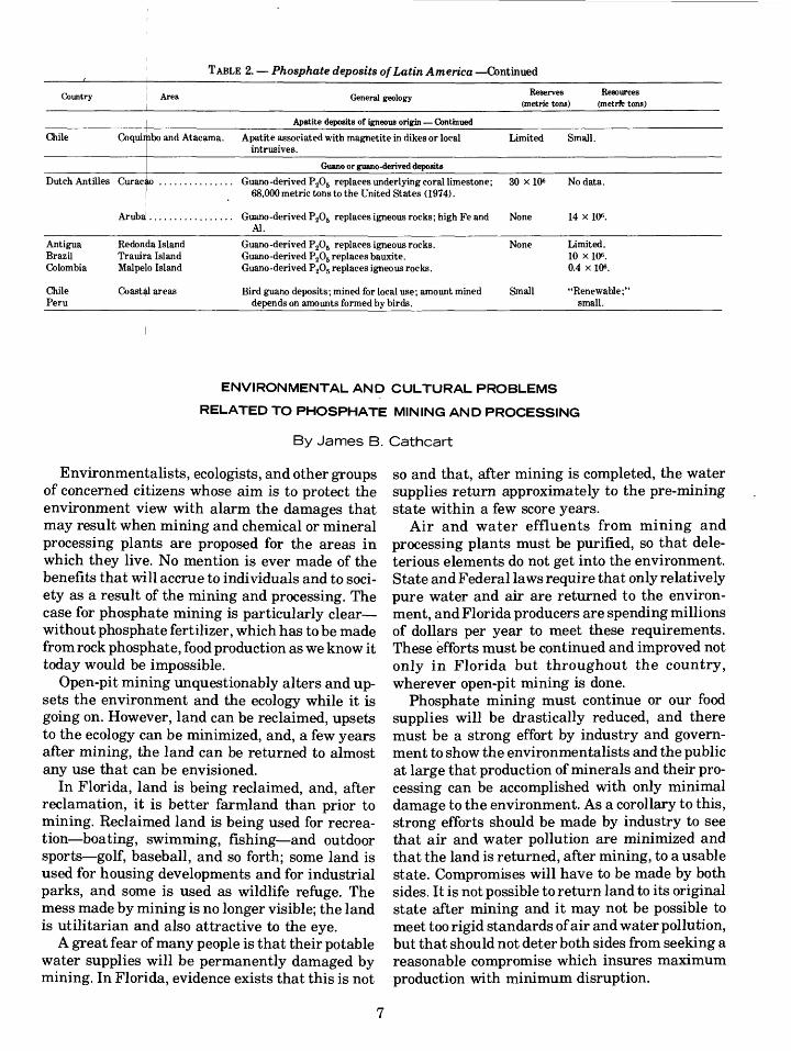
TABLE 2. Phosphate deposits of Latin America Continued
Country Area General geologyReserves
(metric tons)Resources
(metrfc tons)
Apatite deposits of igneous origin Continued
Chile Coquiifibo and Atacama. Apatite associated with magnetite in dikes or local intrusives.
Limited Small.
Guano or guano-derived deposits
Dutch Antilles Curaciio Guano-derived P205 replaces underlying coral limestone; 68,000 metric tons to the United States (1974).
30 x 106 No data.
Antigua Brazil Colombia
Chile Peru
Redonda Island Trauiita Island Malpelo Island
Coastal areas
Al.Guano -derived P205 replaces igneous rocks. Guano-derived P205 replaces bauxite. Guano-derived P205 replaces igneous rocks.
Bird guano deposits; mined for local use; amount mined depends on amounts formed by birds.
None
Small
14 x 106.
Limited. 10 x 106. 0.4 x 10⁶ .
"Renewable;" small.
ENVIRONMENTAL AND CULTURAL PROBLEMS
RELATED TO PHOSPHATE MINING AND PROCESSING
By James B. Cathcart
Environmentalists, ecologists, and other groups of concerned citizens whose aim is to protect the environment view with alarm the damages that may result when mining and chemical or mineral processing plants are proposed for the areas in which they live. No mention is ever made of the benefits that will accrue to individuals and to soci ety as a result of the mining and processing. The case for phosphate mining is particularly clear without phosphate fertilizer, which has to be made from rock phosphate, food production as we know it today would be impossible.
Open-pit mining unquestionably alters and up sets the environment and the ecology while it is going on. However, land can be reclaimed, upsets to the ecology can be minimized, and, a few years after mining, the land can be returned to almost any use that can be envisioned.
In Florida, land is being reclaimed, and, after reclamation, it is better farmland than prior to mining. Reclaimed land is being used for recrea tion boating, swimming, fishing and outdoor sports golf, baseball, and so forth; some land is used for housing developments and for industrial parks, and some is used as wildlife refuge. The mess made by mining is no longer visible; the land is utilitarian and also attractive to the eye.
A great fear of many people is that their potable water supplies will be permanently damaged by mining. In Florida, evidence exists that this is not
so and that, after mining is completed, the water supplies return approximately to the pre-mining state within a few score years.
Air and water effluents from mining and processing plants must be purified, so that dele terious elements do not get into the environment. State and Federal laws require that only relatively pure water and air are returned to the environ ment, and Florida producers are spending millions of dollars per year to meet these requirements. These efforts must be continued and improved not only in Florida but throughout the country, wherever open-pit mining is done.
Phosphate mining must continue or our food supplies will be drastically reduced, and there must be a strong effort by industry and govern ment to show the environmentalists and the public at large that production of minerals and their pro cessing can be accomplished with only minimal damage to the environment. As a corollary to this, strong efforts should be made by industry to see that air and water pollution are minimized and that the land is returned, after mining, to a usable state. Compromises will have to be made by both sides. It is not possible to return land to its original state after mining and it may not be possible to meet too rigid standards of air and water pollution, but that should not deter both sides from seeking a reasonable compromise which insures maximum production with minimum disruption.

THE GEOGRAPHIC AND
GEOLOGIC DISTRIBUTION OF PHOSPHATE
DEPOSITS
By David F. Davidson and Richard P. Sheldon
Phosphate resources of the world are large and are widely distributed both geographically and stratigraphically.
Guano and apatite deposits probably will not bulk large in the production picture for the foreseeable future most production will continue to come from deposits of marine phosphate rock. The already identified resource of such deposits appears to amount to tens of billions of tons.
Large resources have been identified in rocks of Phanerozoic age, but much further work must be done to make a realistic appraisal of these re sources. Such an appraisal should lead to de velopment of new ideas to be used in the search for so far unknown deposits.
FERTILIZER DEMAND- DOMESTIC AND WORLDWIDE
By Walter G. Dupree, Jr.
Two of the three main fertilizer materials ni trates, potash, and phosphates are experiencing short-run supply problems. The nitrates and phos phates will be in short supply from the present until 1980, while potash will have surplus capac ity.
In the long run, potassium (from potash) in the United States is expected to increase in consump tion from 4 to 12 million metric tons. Phosphorus (from the phosphates) is expected to increase in consumption from 4 to 12 million metric tons, while nitrogen (from natural gas) consumption will increase from 18.7 to 60.6 million metric tons.
The greatest fertilizer problem in the United States will be related to phosphates owing to the increasing number of constraints placed on its de velopment in the United States. The conclusions are as follows:
1. An enhanced resource evaluation program is necessary.
2. A research program for increasing yields from phosphatic raw materials is necessary.
3. Rationalization of local, State, and Federal con straints is necessary.
GEOLOGY, RESOURCES,AND DEVELOPMENT
POTENTIAL OF NATURALLY
OCCURRING NITRATES
By George E. Ericksen
The sources and uses of fixed nitrogen chemicals have changed dramatically during the past three decades, chiefly because of a phenomenal growth in the use of synthetic nitrate fertilizers. Chilean nitrate deposits, which furnished nearly all of the world's fixed nitrogen in the late 19th and early 20th centuries, yielded only about 0.25 percent of fixed nitrogen supplies in 1970. In 1940, world consumption of fixed nitrogen products, used largely as fertilizer and munitions, was about 1 million metric tons of contained nitrogen. About 25 percent was supplied by the Chilean deposits. In 1970, world production was nearly 39 million met ric tons of contained nitrogen (about 80 percent used as fertilizer), of which Chile contributed only 100,000 metric tons. On the basis of present growth rates, projected world consumption will be about 165 million metric tons in the year 2000. The Chilean contribution in 2000 will probably be less than in 1970 unless new technology is devised and the Chilean nitrate industry is broadened to re cover other saline components, such as lithium, magnesium, sulfate, chloride, perchlorate, and bo- rate, in the nitrate salts of ore. In the early 1970's, the only components being recovered were sodium and potassium nitrate and iodine.
Naturally occurring nitrate deposits include caliche layers and playa deposits in desert envi ronments, cave deposits and field efflorescences due to action of nitrifying bacteria on animal wastes, and sea bird guano in coastal desert envi ronments. With the exception of the Chilean caliche deposits, the resources of all naturally oc curring nitrate deposits are insignificant in terms of world consumption. In addition to the Chilean deposits, caliche deposits are known to exist in other deserts for example, Death Valley, Calif. but none is of commercial grade and size. The possibility of finding commercial deposits out side of Chile is remote. Prior to the 20th century, cave deposits and animal wastes were sources of potassium nitrate for manufacture of gun powder. Culturation of animal wastes to promote nitrifica tion by bacteria yielded important quantities of nitrate until the mid-19th century when Chilean production became dominant. However, India con-
8

tinued to produce potassium nitrate from animal and human wastes well into the 20th century.
The nitrate deposits of northern Chile are part of the saline complex of the Atacama Desert, a saline desert that is more arid than most, if not all, other deserts of the world. The nitrate deposits are in a region nearly 700 km long, mainly along the eastern border of the Coastal Range but also within the Coastal Range and, to a lesser extent, in the Central Valley and along the lower Andean front. The deposits are caliches in which saline minerals occur as a cement or as impregnations in unconsolidated regolith and fractured bedrock, and as high-purity veins in the cemented regolith and bedrock of all types. The zone of abundant saline minerals in which the host rock is firmly cemented generally extends to depths of only a few meters, but at a few places nitrate ores are found at depths of as much as 12 m. The layer of nitrate ore is highly irregular in grade and thickness. Typical nitrate caliche being exploited in the 1970's con tains 7-12 percent NaNOa (including small amounts of KNOs) and is on the order of 1-3 m thick. During the 19th century the caliches that were exploited generally had an average grade of 15 percent or more NaNOs; and some, particularly during the earliest days of mining, averaged 50 percent or more NaNOs.
The role of natural nitrates as fertilizers is dis tinctly limited in a world of mechanized agricul ture, because resources are small in terms of pres ent-day fertilizer needs. For example, reserves of NaNOs in commercial-grade Chilean nitrate ore (>7 percent NaNOs) are estimated to be about 200,000,000 metric tons, which is equivalent to 33 million tons of contained nitrogen and is less than world annual consumption during the early 1970's. Probable resources of lower grade caliche (1-7 percent NaNOs) are several times as great as those of the currently commercial-grade ore, but they are still equivalent to only 2 or 3 years of current world consumption of fixed nitrogen.
A GEOCHEMICAL SUCCESSSTORY IN NORTHEAST
THAILAND
By Robert J. Hite
Thick beds of rock salt have been penetrated by numerous water wells in the Khorat Plateau of northeastern Thailand and central Laos. These deposits of Cretaceous age occur in the Maha
Sarakam Formation of the Mesozoic Khorat Group.
The salt-bearing Maha Sarakam Formation ex tends over 21,000 km2 in the Sakon Nakhon basin in the northern half of the plateau. An additional 36,000 km2 occurs to the south in the Khorat basin. The maximum thickness of the halite facies is un known but may exceed 1,000 m. In the Sakon Nakhon basin, three salt beds are present. The lowermost bed is 340 m thick at Vientiene and is probably the thickest salt bed in the world.
Preliminary studies of trace bromine and potas sium in halite cores from the western edge of the Khorat basin indicated that the thick basal halite bed in Maha Sarakam Formation was a very favorable target for potash exploration.
Following the recommendations based on the bromine and potassium geochemistry, a core hole was drilled at Udon Thani in the Sakon Nakhon basin. This hole penetrated a carnallite deposit at 89 m, which continued to the depth of 130 m. Sub sequent drilling has shown this deposit to extend over about 1,800 km2 in Thailand. The extension of the potash deposit into Laos has been verified by a core, hole recently completed on the Vientiene plain. This hole penetrated a high-grade deposit of sylvite.
Although part of the Sakon Nakhon basin is still unexplored and little drilling has been done in the large Khorat basin, the preliminary results suggest that the Khorat Plateau hosts one of the largest, if not the largest, potash deposit in the world.
PHOSPHATE AND
EVAPORITES A DIRECT
RELATIONSHIP?
By Robert J. Hite
Many sedimentary sequences in the world show lateral gradation of phosphorite, chert, carbonate, and evaporite facies. Two classic examples are the Permian Phosphoria Formation and the Jurassic Fernie Group and equivalent rocks of the northern Rocky Mountains, U.S.A. and Canada.
Current theories on the origin of phosphorite facies require no direct relationship with evapo- rites. This paper proposes that apatite, chert, and dolomite are precipitated by the mixing of warm brines from evaporite basins with cold ocean water. This mixing takes place in and at the mouths of marine accessways to Mediterranean-

type evaporite basins, where high-density brines reflux back to the ocean. The mechanism provides conditions favoring the accumulation of prodigi ous amounts of organic matter a common feature of phosphorite facies. Reactions in the basin bet ween the evaporite brine and detrital silicate min erals may mobilize Si, F, Cr, Ni, V, Fe, rare earths, and other elements that frequently occur in anomalously large amounts in the phosphorite facies. Phosphorus, which other theories assume is supplied by the ocean, may be supplied by reac tions between brine and detrital apatite from igneous or sedimentary sources. The proposed mechanism may also be responsible for the forma tion of some sedimentary deposits of barite and iron ore.
POTASH RESOURCES
AND ECONOMICS
By C. L. Jones
World production of potash (RzO) now exceeds 20 million metric tons per year. Slightly more than 96 percent of the total originates in the industrial nations of Europe and North America; the re mainder comes mostly from the Middle East, with smaller amounts from Australia, Asia, and South America. Among the industrial nations, four coun tries Canada, West Germany, East Germany, and the U.S.S.R. control 72 percent of the world production capacity and 96 percent of the reserves. The United States produces about one-tenth of the world supply, has less than one-half of 1 percent of the reserves, and imports over one-half of its an nual supply.
National and world sources of potash are evapo rite and brine deposits. These sources provide known reserves of potash in excess of 120 billion metric tons, and they are sufficient to fulfill world requirements for a few thousand years. Tonnage of reserves obviously is not a problem, but other fac tors are of immediate concern. The concentration of production facilities and reserves in a few coun tries favors the development of an international cartel and gives rise to governmental control over the production, distribution, and pricing of potash. All too recently, governmental action in Canada disrupted world trade by glutting the market; this action resulted in the premature closure of potash mines in the United States, a reduction in domes tic output, and a loss of potash reserves.
The outlook for the United States is bleak. There will be further reductions in potash supplies from existing domestic sources, a steadily rising demand for potash, and a large increase in im ports. This projection suggests that the United States must weigh the alternatives of paying an inflated price for potash on the world market or developing new domestic sources of potash. The latter may be less expensive.
NATURE OF THE PHOSPHORIA SEA AND
THE RELATION OF
UPWELLING TO RICHPHOSPHATE DEPOSITS
By Keith B. Ketner
Upper Middle Pennsylvanian to Upper Permian conglomeratic, sandy, and silty rocks cover part of southern California, most of Nevada, and much of Idaho. Their distribution, facies trends, and cur rent vectors indicate that detrital components were shed mainly from a tectonic belt of highlands that extended generally northward through southern California, central Nevada, and western Idaho. Their enormous volume suggests that the provenance terrain was of major proportions. Sed iments shed eastward from this belt were depo sited in the shallow epicontinental Phosphoria sea, where they mingled with limestone, dolomite, evaporites, spicule chert, and phosphorite; but those shed westward were deposited in deeper water off the edge of the continent as debris flows and turbidites and they mingled with coarse vol canic sediments, tuffs, lava flows, and radiolarian cherts. The volcanic sediments, tuffs, and lavas emanated from an archipelago that lay parallel to, and a short distance west of, the tectonic belt. The tectonic highlands formed a barrier between the ocean to the west and the epicontinental Phos phoria sea to the east, with profound effects on sedimentation in the latter. Obviously the high land belt supplied an enormous volume of detrital material; but, beyond that, it probably indirectly affected sedimentation by restricting circulation of both water and air. It served as a barrier bet ween the Phosphoria sea and the ocean. Without such a barrier the formation of evaporite beds would have been impossible and the formation of extensive dolomite beds unlikely. The exact condi tions under which phosphorite was deposited are
10

poorly understood, but the abundance of phospho rite east of the highland belt and its scarcity west of it suggest that restriction of circulation was important. The effect of the Humboldt belt on air circulation can only be guessed, because its topog raphic relief is unknown and atmospheric circula tion patterns before uplift of the highland belt are unknown. To the extent that the highland belt was a mountain range, it must have had the effect of increasing aridity over the Phosphoria sea, for it would have formed a barrier to moist oceanic air and would have promoted evaporation and hyper- salinity.
The currently popular concept of Kazakov (1937), which relates rich phosphate deposits di rectly to up welling oceanic waters, should be re garded only as a working hypothesis, not as a proven theory. New information and new concepts on which to base additional working hypotheses are needed, because too much reliance on a single concept in exploration could result in failure to locate important deposits. The need for new ideas can be illustrated by a consideration of the exact spatial relation of known commercial phosphate deposits of the Phosphoria sea to possible sites of upwelling.
Although it is hardly conceivable that upwel ling could have taken place within the shallow, restricted Phosphoria sea, it is theoretically quite possible that deep-seated oceanic waters welled up along the western edge of the continent, west of the highland belt, in Permian time. However, phos phate beds of commercial grade are not known to have been deposited outside the Phosphoria sea, where upwelling may have taken place, nor in the western part of the sea close to the upwelling wat ers; but, rather, they were deposited near the center of the widest part of the sea, hundreds of kilometers from the nearest possible site of upwel ling oceanic waters. If exploration for phosphate in the early days had been based on an assumed close genetic connection with upwelling oceanic waters, the commercial phosphate deposits of southeast ern Idaho would not have been discovered.
Reference Cited
Kazakov, A. V., 1937, The phosphorite fades and the genesis of phosphorites, in Geological investigations of agricultural ores: Sci. Inst. Fertilizers and Insecto-Fungicides Trans., no. 142 (published in Leningrad for the 17th Sess. Internat. Geol. Cong.), p. 95-113.
ENERGY REQUIREMENTS OF THE AGRICULTURE INDUSTRY
By Richard F. Meyer
The United States appears to possess large re sources of potassium in the form of potash, phos phorus in phosphate rocks, nitrogen in atmos pheric nitrogen, and sulfur in many forms. These are the essential ingredients for fertilizer.
The potash is crushed and separated from other salts by flotation or fractional crystallization and may then be applied directly. The major energy required, in addition to that needed for mining and milling, is heat for drying. About 94 percent of potassium goes for agricultural chemicals.
Phosphate rock is decomposed with sulfuric acid and applied as fertilizer in several forms. Eighty- four percent of phosphorus demand is for fertilizer and 10 percent for animal feed.
About half of all sulfur mined is used in fer tilizer manufacture, and 72 percent of elemental sulfur is obtained by the Frasch process, which depends entirely upon natural gas for heating the processing water.
Nitrogen for agricultural purposes is supplied in the form of ammonia, which is either applied di rectly or used to make other fertilizer materials. The ammonia is synthesized from nitrogen and natural gas.
At least 16 billion m3 of natural gas per year are required for the fertilizer industry, of which about 14 billion are needed to synthesize ammonia. Be cause of natural-gas-supply curtailments, there will be a curtailment this year (1975) of 400,000 to 500,000 metric tons of ammonia.
As a whole, the agricultural industry requires 13 percent of the total U.S. input of 37 quadrillion kcal/kg of energy. This energy is needed for farm production and family living, food processing, marketing and distribution, and input manufac ture, including fertilizer and pesticides.
If the energy crisis is, in fact, more approp riately an investment capital crisis, then any po tential agricultural shortfalls due to the energy crisis must also be resolved in terms of investment capital.
UPWELLING MODEL AND
ITS APPLICATIONS
By R. P. Sheldon
The history of exploration for a mineral resource generally begins with an empirical-technique
11

phase and, after geologic knowledge and theory have been developed to explain the distribution of the deposits, ends with a deductive-technique phase. Phosphate exploration was empirical until about 1950. After 1950, when the upwelling theory of the origin of phosphate was developed, this theory was instrumental in the discovery of de posits in Baja California, Sechura desert of Peru, Huancayo district of Peru, Australia, India, An gola, and extensions of phosphogenic provinces in North Africa and the Middle East. The upwelling model was described by McKelvey (1963, 1967), McKelvey and others (1953), and Sheldon (1963), and the Phosphoria Formation example developed by McKee and others (1967). This deductive explo ration technique uses, more or less sequentially, the following geologic theories and tools as guides: regional tectonics, plate tectonics, reconnais sance-level* stratigraphic sections, chert-black shale-phosphorite association, and uranium as sociation. Is the theory still useful? Yes, but the theory is becoming less useful as the deposits that can be found with it are found. Some important deposits do not fit this model well, if at all; these include the Florida-North Carolina Tertiary de posits and the Rajasthan, India, Precambrian de posits. These deposits should be studied inten sively if we are to develop new theory and new deductive exploration techniques.
References Cited
McKee, E. D., Oriel, S. S., and others, 1967, Paleotectonic maps of the Permian System: U.S. Geol. Survey Misc. Geol. Inv. Map 1-450, 20 pi., text.
McKelvey, V. E., 1963, Successful new techniques in prospect ing for phosphate deposits: Natural Resources, United States papers prepared for the United Nations Conference on the application of science and technology for the benefit of the less developed areas, v. 2, p. 163-172. U.S. Govt. Printing Office.[ Repr. 1966, Australian Mining, v. 58, no. 3; 1967, Colombia Boletin Geologico, v. XV, p. 45-64 (in Spanish); 1968, ECAFE Min. Res. Dev. Ser., no. 32, p. 207-211.]
1967, Phosphate deposits: U.S. Geol. Survey Bull. 1252-D. [Abs. repr. 1968, ECAFE Min. Res. Dev. Ser., no. 32.]
McKelvey, V. E., Swanson, R. W., and Sheldon, R. P., 1953, The Permian phosphate deposits of Western United States, in Saint Guilhem, P. L. R., ed.: Origine des gisements de phosphates de chaux: Internat. Geol. Cong., 19th, Algiers, Comptes Rendus, sec. 11, fasc. 11, p. 45-64.
Sheldon, R. P., 1964, Exploration for phosphorite in Turkey A case history: Econ. Geology, v. 59, p. 1159-1175.
SOIL AMENDMENT MATERIALS
DISTRIBUTION OF VOLCANIC ROCKS POTENTIALLY USEFUL AS
SOIL AMENDMENTS
By Alfred L. Bush
Glassy volcanic rocks appear to be most suitable for use in upgrading soils because they break down easily in the weathering environment. They re lease such elements as K, P, and Fe to soil solu tions at low-energy levels, because the elements are not tied up in crystal lattices. A variety of glassy rocks are available as soil amendments, ranging widely in composition (basaltic, andesitic, rhyolitic), in texture (ash, pumice, obsidian, per- lite, scoria), and in form (air-fall blankets, re worked bedded deposits, flows, domes, cinder cones). Although volumes and tonnages are very large, distribution is spotty.
Because glasses do not persist for geologically long periods, they are mostly Miocene in age or younger. They occur in the western parts of North and South America, through Central America, in the islands of the Pacific Ocean, along the eastern borderlands of Asia and Southeast Asia, through the Indonesian Archipelago, and in parts of east ern Australia and New Zealand. Another major zone extends through the Mediterranean area, the Balkans, and Asia Minor into India; and a third, in a very generalized way, follows the Rift Valleys of Africa and extends into the western Arabian Peninsula.
Utilization of these rocks depends on a mul titude of factors, including (1) rates of release of elements from glass in a variety of climatic and agricultural environments, (2) specific element de ficiencies in specific environments, (3) needed ton nages and costs of distribution and application of the natural materials, and (4) relative economics and efficiencies of the use of alternative natural and manufactured materials. We have far more questions than answers.
PEAT AS A SOIL AMENDMENT
By Cornelia C. Gamer on
Peat forms mainly from dead plant remains and occurs in bogs, swamplands, or marshes. It has an ash content not exceeding 25 percent by dry weight according to the ASTM standard. Ash is defined as the solid material that remains after the peat is
12

heated to 550°C. The organic content and the abil ity of peat to hold water in its fibers make it valu able as a soil amendment. In addition to its mois ture-storing ability, peat produces a humic acid, through slow decay, that moderates the uptake of mineral fertilizer by plants. Peat, therefore, helps prevent plants from being "burned" by the mineral fertilizers and promotes increased crop yield.
Peat bogs underlie 150 million ha of the world's land surface. They contain deposits ranging from high-quality peat that is excellent for soil amend ments to organic soils that have little or no soil amendment capacity. Ninety-three percent of the bogs are located chiefly in latitudes north of the United States. Five percent are in the United States, and the remaining 2 percent, at the same latitudes and south.
The United States does not produce enough peat to meet national consumption; yet, undeveloped deposits of peat, excellent for soil amendment use, are believed to lie in the Eastern United States, in the Rocky Mountains, and in States bordering the Great Lakes and the Pacific Ocean. Peat producers are beginning to mine deposits in central Florida drained during phosphate mining operations. Here, phosphate fertilizer is mixed with peat and sold to citrus growers.
Undoubtedly, peat resource potentials exist in other countries and could benefit agriculture. For example, Uganda has deposits of peat in areas of clay soils, India has deposits of peat in its uplands, and the Latin American countries have deposits of mangrove peat in the tropics as well as reed-sedge peat in Argentina.
Peat prospecting techniques are being studied in this country to enable peat producers to expand the growing need for peat; production in 1973 was 10 percent above that of 1972. As we become more self-sufficient in using peat in conjunction with fertilizers, our example may be followed by other countries in which peat exists and food is needed.
LIMESTONE AND DOLOMITE IN AGRICULTURE
By Harold A. Hubbard and George E. Ericksen
Liming of agricultural soils is common practice in regions of acid soils in developed nations. Lim ing has two effects: (1) It acts as a fertilizer furnish ing calcium and magnesium, which are essential
to plant growth; and (2) it acts as an amendment that causes an increase in soil pH (hydrogen ion concentration). The pulverized stone may also im prove the physical structure of clayey soils, thereby increasing permeability.
Acid soils predominate in areas of moderate to relatively high rainfall and are particularly preva lent in the humid tropics. Many acid soils in tem perate or tropical areas respond dramatically to liming by showing significant increases in crop yields.
Limestone and dolomite promote plant growth because an increase in pH makes more cations available for exchange in soil solutions. Plants can use metallic cations, whereas non-ionized metals adsorbed on soil particles or in chemical com pounds cannot be used. As the hydrogen ion con centration of soil or soil solution decreases, metal lic elements ionize more readily and the concen tration of metallic ions in the soil solution in creases.
As the carbonates dissociate, metallic ions are exchanged with hydrogen adsorbed in soil solution and on clay particles. When limestone is added to the soil, new equilibria are established; calcium ions from the limestone replace hydrogen at ex change sites on clay particles and the hydrogen forms water by combining with oxygen from the carbonate radical.
Liming in general is beneficial to plant growth, but its effects vary with different plants. Most crops grow best in slightly to moderately acid soil. A few crops grow well only in relatively strongly acid soils, and a few others grow well only in nearly neutral soils.
In countries where farmers have total cash in comes of tens to hundreds of dollars a year, many farmers cannot pay for limestone, fertilizers, and other soil additives. In these countries farmers may use lime or fertilizer only if it is paid for with government or foundation aid. However, the value of increased crop production due to liming will generally far exceed the cost of the lime and its application, and could contribute to many national economies by materially reducing food imports.
SOIL AMENDMENTS AND
PHYSICAL PROPERTIES OF SOILS
By R. C. Severson
The use of soil amendments to improve physical properties of soils must be put into perspective in
13

terms of plant growth factors. Moisture, nutrients, heat, light, and a medium (soil) are all necessary for plant growth. The improvement of physical properties of soils is aimed at increasing the effi ciency, or ease, with which the plant is able to assimilate the other factors. If any of the factors are limiting, it will serve no useful purpose to alter factors that are not limiting. Therefore, physical properties of soils should be altered only if they are suspected of being limiting to plant growth.
Within the soil, physical, chemical, biological, and microbiological processes are integrated so that a process cannot be singled out and treated alone. The physical properties and processes of soils can be treated as a singular entity while the chemical, biological, and microbiological changes which are related to and result from changing physical soil properties are ignored.
Certain features of the soil landscape are more amenable to change than others. Soil features such as structure, moisture, aeration, and temperature are subject to change by amendment with some extraneous material, but "permanent" soil fea tures such as texture, slope, ground water, flood ing, and climate are not readily changed by the simple incorporation of some extraneous material into the soil. We should concentrate our first ef forts on those soil features that are amenable.
Soil porosity and soil structural stability (aggregation) are the targets of soil physical amendments. These two properties effectively de termine the magnitudes of water infiltration, water retention, water runoff, soil dispersion, soil-surface crusting, soil aeration, and soil tem perature. Soil porosity and aggregation are re sponsible for the quality of physical soil environ ment available for plant growth.
The properties of materials that account for their usefulness as physical soil amendments are particle size, surface area, and exchange capacity.
Mechanized agriculture results in soil proper ties being modified by powerful machines. The re quired energy is as yet more economical than the use of soil amendments to maintain adequate physical soil properties for plant growth. As energy becomes more expensive, as expanding populations demand more production from a finite resource (the soil), and as lands considered margi nal for agriculture are brought into production, the potential of amendments for improving or maintaining soil physical properties will be recog nized.
The task of determining the potential of various amendment materials is largely one for agricul tural scientists. Crop response, in terms of yield, to various amendment materials is determined by the specific combinations of plant growth factors at the site. The response can only be quantified by empirical methods, as has been the usual approach in soil fertility studies. The main role of the scien tist in the U.S. Geological Survey is perhaps locat ing and characterizing the sources of potential amendment materials and characterizing the specific properties of the materials themselves. It follows that a cooperative effort would lead to the most efficient utilization of available expertise.
RECOMMENDED TERMINOLOGY
The terms, additive, admixture, amendment, conditioner, fertilizer, and stabilizer have been variously used to describe types of soil modifica tion. The absence of a generally accepted ter minology for describing specific soil modification processes aimed at specific uses leads to confusion.
The dictionary presents the following meanings for each of the words:
Additive to be added, of the nature of an addition, charac terized by addition.
Admixture anything added, an alien element or ingredient.Amendment act of amending, correction, improvement.Condition(er) a restrictive, limiting, or modifying cir
cumstance.Fertilizer any material used to enrich the soil for crops, espe
cially a commercial or chemical manure.Stabilizer any compound which, when included with a mate
rial, decreases the ability of the material to decompose spontaneously.
Inasmuch as additive, admixture, and stabilizer are generally used in describing the modification of soil properties for engineering purposes, I pro pose that these terms not be used in referring to the modification of soil properties for agricultural purposes. Conditioner and amendment have the same general connotation, but since the label con ditioner has been employed quite extensively in the agronomic literature for synthetic materials used in the modification of soil properties for ag ronomic purposes, I propose that amendment be employed to describe materials of geologic origin used in agronomic aspects of soil modification. The remaining terms should be employed in agree ment with their intended function and prefixed with descriptive terms to further describe their mode of action. For example, if limestone is incor-
14

porated into the soil to specifically supply calcium for plant growth, it should be referred to as an inorganic fertilizer. If limestone is incorporated into the soil with the intent of changing the soil pH, it should be referred to as a chemical amend ment.
I have limited the list of employable terms to two fertilizer and amendment. The rationale is to avoid confusion in use and interpretation, and to simplify the terminology and yet retain integrity. This can be obtained by using the terms with mod ifiers to make their intended meanings clear.
POTENTIAL ROLE OF
NATURAL ZEOLITES IN AGRICULTURE AND ANIMAL HUSBANDRY
By Richard A. Sheppard
Zeolites, crystalline hydrated aluminosilicate minerals of the alkali and alkaline-earth ele ments, are important rock-forming constituents in sedimentary rocks and are potentially valuable industrial minerals. Although more than 30 species of zeolites occur in nature, only about six occur abundantly in sedimentary deposits. These are analcime, chabazite, clinoptilolite, erionite, mordenite, and phillipsite. These zeolites are very finely crystalline (<1-60 /Am) and are especially common and abundant in Cenozoic tuffs. Zeolites in sedimentary deposits have been recognized in about 40 countries throughout the world, but only in Japan are deposits being used in food produc tion. The properties of zeolites that make them useful for agriculture as well as industry include cation exchange, adsorption, and reversible de hydration.
The Japanese use zeolitic tuffs as (1) soil amendments that neutralize acid soils and release small amounts of exchangeable potassium, (2) zeolite-chemical fertilizer mixes that improve the soil's retention of nitrogen and result in more com plete utilization of the nitrogen by plants, (3) low- grade fertilizer after application to cattle feedlots, and (4) carriers for insecticides and herbicides. Other potential agricultural uses are as low-grade fertilizer after use in tertiary sewage treatment plants and as material added to Sr90-contaminated soils to reduce the strontium uptake by plants.
Besides the application to cattle feedlots, the Japanese use crushed clinoptilolite-rich tuff to deodorize and dry the excrement of pigs and chick
ens. The spent zeolite-excrement mixture is then used for fertilizer. Another use in animal husban dry is the addition of 5 percent clinoptilolite to the feed of pigs and chickens. Test animals experi enced faster growth than control animals, and less feed was required. Severe cases of scours (diarrhea) in pigs were relieved when the afflicted animals were placed on a diet containing 15 per cent clinoptilolite.
Three areas warrant further attention: (1) We need to set up communications between geologists and food industry personnel if only to let them know that a voluminous natural resource exists that has great potential but has been mostly ig nored; (2) accelerated experimental work is needed, chiefly by those in agronomy and animal husbandry, on the utilization of natural zeolites; and (3) we should prepare an inventory of worldwide zeolite resources with special emphasis on the countries of Southeast Asia and Central and South America.
HUMATE AS A SOIL ADDITIVE
By Vernon E. Swanson
Humate is a naturally occurring, dark-brown to black, solid organic substance that is formed dur ing the oxidation and decomposition of plant mate rial, is soluble in slightly alkaline water, and can be transported in water in its soluble or colloidal forms, which are the humic acids or fulvic acids common in the tea-colored streams of swamps and peat bogs. When precipitated either by encounter ing acid water (pH<3) or seawater, or by adsorbing excess metal ions, humate is a structureless gel that solidifies to a brittle, glistening coal-like material indistinguishable from vitrain in ap pearance. Its ash-free composition is generally about 60 percent carbon, 4 percent hydrogen, 35 percent oxygen, and 1 percent nitrogen. Humate having the same chemical characteristics is simi larly derived from oxidizing peat and lignite.
The following properties of humate make it use ful in the fertilizer business:
1. Its solubility characteristics in natural waters.2. Its ability to adsorb plant-nutrient metals to as
much as 20 percent dry weight, and to release these metals in a plant-available form.
3. Its organic composition, which contributes to the humus content of the soil.
4. Its abundant resources, which can be cheaply processed for market distribution.
15

The major, but still limited, agrobiologic use of humate has been as a nutrient-metal (for example, Fe, Cu, Mn, and Zn) soil additive, either applied as a granulated solid or added to irrigation water, especially for horticultural and hydroponic use.
Two major sources of humate are (1) the hu- mate-impregnated sands irregularly distributed along parts of an 80-km-wide coastal belt from Pamlico Sound, N. C., on the Atlantic Ocean, to Mobile Bay, Ala., on the Gulf of Mexico; and (2) the irregularly distributed leonardite deposits as sociated with, and parts of, the lignite and sub- bituminous coal of the Northern Great Plains States. No reliable estimates of humate resources exist, but the humate that can be readily obtained from each of the above sources is reckoned in the hundreds of millions of metric tons. Considering that the yearly production of humate is 50,000 metric tons or less, it would be relatively simple to delineate recoverable reserves that would last many hundreds of years. For example, the Trail Ridge heavy minerals mine in northeast Florida alone has a "byproduct stockpile" of about 10 mill ion metric tons of humate, which is more than a 200-year supply of humate based on present de mand.
Any great increase in the use of humate in ag riculture will depend on (1) the refinement of knowledge of micronutrient deficiencies in specific food plants and animals grown in different areas, and (2) an improvement in technology to custom- process different humate additives that will meliorate these deficiencies and result in optimum growth characteristics and nutritional value of the product.
VOLCANIC ASH AND RELATED MATERIALS AS SOIL AMENDMENTS
By Ray E. Wilcox
During the present century the suggestion has been made repeatedly that pyroclastic materials should be mixed into crop soils to provide paced release of plant nutrients, such as K, P, Ca, and Fe, and to improve physical properties of the soils. One basis for the suggestion is the apparent fertility and productivity of certain young soils developed on terrains covered by volcanic ash that is chiefly of basic and intermediate composition.
Interesting and appealing as this proposition seems, few definitive agronomic tests have been reported (in striking contrast to the many investi
gations of natural volcanic-ash soils and their own special problems).
The geologist can indicate the varieties of young pyroclastic materials and the accessible deposits. A careful assessment of the current knowledge of natural volcanic-ash soils may provide an idea of the benefits to be expected from addition of such material to normal soils. The critical answers, however, await results of controlled field trials by agronomists and soil scientists.
WEATHERING OF ROCKS,SOILS, TRACE ELEMENTS,AND PLANT NUTRITION
THE IMPORTANCE OF ELEMENTAL
INTERRELATIONSHIPS IN
BIOLOGICAL SYSTEMS
By Helen Cannon
Widespread areas of crop deficiency exist in the United States and in many countries of the world. Many deficiencies in plants are induced by the addition of fertilizers, which changes the availa bility of other elements. Various crop species have different requirements and tolerances for avail able elements, and so absolute levels cannot be determined for the growth of all plants. Animals (including man) are also strongly affected by imbalances in available nutrients. Certain inter relationships such as Ca-Zn, Cu-Mo, and Na-Li-K have been linked with specific diseases.
To improve crop quality, the agronomic situa tion must be thoroughly understood and the effects of additives on the availability of other elements must be anticipated. Crop plants that are particu larly tolerant of abnormal soils or particularly ef ficient at absorbing scarce nutrients may be sub stituted for the plants commonly grown.
SOIL CHEMICAL PROPERTIES AND
PLANT NUTRIENT AVAILABILITY
By T. T. Chao
In order to evaluate the effectiveness of a fer tilizer in soil, two factors related to plant nutrient availability should be considered the intensity factor and the capacity factor. The intensity factor represents the concentration of a given nutrient in the soil solution, and the capacity factor represents the ability of the soil to maintain that intensity in
16

the soil solution, or the rate at which a nutrient concentration can be reestablished after uptake by plants. Whether an applied fertilizer will be satis factory is greatly affected by chemical and mineralogical properties of the soil.
Because the soil solution is not a simple aqueous solution, there is a constant reaction between the nutrient element supplied by a fertilizer and the solid components of a soil. One of these reactions, important from the standpoint of plant nutrient availability, is fixation of a nutrient element by soil, whereby availability of the nutrient is drasti cally reduced. Moderate retention, however, may be beneficial to plant growth, because it lessens the risk of leaching loss of the nutrient element.
Fixation or retention by soils of phosphate and sulfate, and of several micronutrient elements such as cobalt, molybdenum, and boron may be influenced by numerous factors. Among these are the content of secondary iron, manganese, and aluminum oxides, and the degree of crystallinity of the oxides. Amorphous oxides usually can fix large amounts of the above nutrient elements in forms not readily usable by the plant. In extreme cases, considerable amounts of a nutrient element may be rendered unavailable to the plant.
Certain soils, especially those containing ver- miculite and degraded illite clay minerals, have the ability to fix potassium and ammonium added as fertilizers in much less available forms. An ex planation for the striking similarity between the capacities of these soils to fix potassium and am monium can be found in the "lattice cavity" theory. According to this theory, cation fixation is related to the size of the cation as well as to the mineralogy of the fixing materials. Cations that fit snugly into openings of the exposed surface between the layers of 2:1 lattice-type minerals will be fixed very tightly as they approach the negative electric charges of the crystal lattice.
PROBLEMS OF LATERITIC SOILS
By W. R. Griffitts
Laterites, in a strict sense, are soils that are hard enough to be used as building material or become hard upon exposure to weather. Lateritic soil is one that contains laterite. For purposes of discussion, I include saprolite as a lateritic soil.
Laterite and lateritic soils result from nearly complete leaching of alkalis, alkaline earths, and combined silica. Aluminum, iron, and, in some
places, manganese, phosphate, or other elements of the RzOs group are concentrated.
Old laterites contain kaolinite, gibbsite, and limonite as the dominant minerals. Those no older than Pliocene contain more amorphous silica and alumina, halloysite, and allophane, which may be more effective in making phosphate unavailable to plants. The relation is not entirely clear inasmuch as soils in western Africa containing allophane and much organic matter are said to have a longer lasting fertility than allophane-free soils.
In forest and savannah areas, the plants' roots gather some of the trace amounts of nutrients from large volumes of lateritic soil. These accumulate in a thin layer near the surface as plant debris de cays. Potassium, calcium, phosphate, sulfur, zinc, and, to some extent, magnesium show such surfi- cial concentrations. The trees in one hectare of a 40-year-old forest in Guinea were estimated to contain 127 kg of phosphorus, 829 kg of potassium, 2,556 kg of calcium, and 350.5 kg of magnesium. The plants in the savannahs contained one-third to one-ninth of these amounts. Nitrogen and sulfur were not included in the estimates because they are largely lost when the plant material burns, a common preliminary to cultivating the land. Other studies suggest that these elements proba bly constituted a few hundred kilograms of the plant material on 1 ha of land. This surficial con centration of plant nutrients is the basis of "slash and burn" agriculture. In Indonesia and the moun tains of Burma, one crop can be raised every 5 to 10 years. In subtropical China this kind of agricul ture has been carried on for several thousand years with no reported ill effects. Improper technique or attempts to raise unsuitable plants can severely damage the soil. ,
Lateritic soils are widespread in Southeastern United States, show the usual low contents of sev eral important plant nutrients, and, as a result, are less intensively cultivated than other soils.
MAJOR NUTRITIONAL ELEMENTS IN SOILS
AND PLANTS A BALANCE SHEET
By Hansford T. Shacklette
Food produced on agricultural lands exploits a nonrenewable resource the natural supply of major and minor nutritive elements in the soil. Not only the elements contained in the food that is removed from the land, but also the element losses associated with agricultural practices, such as
17

those caused by erosion, leaching, and volatiliza tion, must be replaced if acceptable crop yields are to be maintained. In agrarian societies the losses from soils can be greatly reduced by returning plant, animal, and human wastes to the soil from which they came through labor-intensive prac tices, if a relatively low yield of produce is accepta ble. This system of management does not result in an increase in essential elements in the soil naturally poor soils will gradually become poorer and crop yields will reflect the element deficiencies. The cost of food then becomes a major item in the economy of the society. In societies having a well-developed industrial base, on the other hand, agricultural soils are brought to the level of maximum crop yields by utilizing addi tional sources, largely geologic in origin, for sup plying the essential plant nutrients, particularly phosphorus, potassium, and nitrogen. This system of management results in energy-intensive prac tices, low labor requirements, and high crop yields, which make food relatively inexpensive; it also permits the accumulation of a food surplus for ex port.
The movement of phosphorus through the human food chain can be used as an example of the losses in essential plant elements that must be corrected by application of "commercial" or "chem ical" fertilizers. Much of the phosphorus contained in our foods eventually enters city sewers. The total municipal sewage solids produced per year in the United States is estimated to be 45 million metric tons. This amount of sewage, on the basis of analyses of metropolitan Chicago sewage, con tains 1.7 million metric tons of phosphorus, and only a small percentage of this total is returned to the farm lands where it originated and where it can reenter the human food chain. Much of the United States diet consists of meat of animals that were fed grains in feedlots. In 1970, 24,970,000 head of cattle were in U.S. feedlots, each animal producing an average of about 27 kg of manure per day, resulting in a total of about 250 billion kg of manure per year. On the basis of an "average" analysis of this manure, 5 billion kg of phosphorus are contained in this annual manure output. Much of this phosphorus is never effectively recycled in food production. There is another less commonly considered sink for the elements contained in our foods the human body. Ash of the human body contains about 24 percent phosphorus, and the ash constitutes about 5 percent of live weight. Assum
ing that the "average" human weighs 45 kg and that the present U.S. population is 219 million, there are 113 million kg of phosphorus in the bodies of this population. Regardless of whether these figures are accurate, two important aspects stand out: (1) This phosphorus was principally de rived from the available phosphorus in soils, which constitutes about 5 percent or less of the total soil phosphorus; and (2) most of this phosphorus will never again enter the food-production chain.
The elements in foods that are exported repre sent a total loss to the agricultural soils of a coun try. For example, one railroad carload of wheat weighs about 2.7 metric tons, and this amount of wheat contains about 11 kg of phosphorus. An "average" hectare of U.S. soils contains about 146 kg total phosphorus in the plow zone, but only a small amount (about 45 kg per ha) exists in a form available to plants. At a yield rate of 3.4 metric tons per hectare, the crop of wheat removes about 13.4 kg of phosphorus from a hectare of soil. Ero sion losses can be estimated at 11.2 kg per ha. These two losses, 24.6 kg, would exhaust the available phosphorus in a hectare of soil in 2 years, in the same time that a carload of wheat was being produced on the hectare.
The losses in potassium using the same cropping procedures are equal to, or greater than, those of phosphorus. Certain management practices can reduce these losses; but, in the long run, our expor tation of foodstuffs exploits a* nonrenewable re source just as surely as does the exportation of petroleum or metals. For example, Hawaii exports 2,000,000 kg of potassium annually in its pineap ple crop alone. The net losses in nutrient elements by another country, Ecuador, are exemplified by its exportation of 4,600,000 kg of potassium annu ally in its banana crop, while importing only half this amount of potassium in fertilizers. The bal ance sheet for two other major nutrient elements, nitrogen and sulfur, generally follows the trend in losses of phosphorus and potassium, except that certain amounts of the two former elements are added to the soil by natural processes.
These examples illustrate the general trend in soil depletion by food production that must be cor rected by applications of fertilizers. Even the best systems of returning unused crop residues and animal wastes to the soil, sometimes called "or ganic farming," will only reduce but not eliminate the loss; they also result in yields unacceptably low in relation to the world demand for food. Moreover,
18

the economics of technologically advanced food production do not at present permit advantageous use of organic fertilizers. To produce maximum crop yields, the cost of obtaining and applying suf ficient organic material (which contains only low percentages of the major nutrient elements) con trasted to the cost of using high-test commercial fertilizers cannot be justified economically. The present trend is to apply more of the plant nutrient elements as "chemical" fertilizers per year than are removed from the soil in foodstuffs in order to allow for volatilization, chemical fixation, leach ing, erosion, and other losses. Commercial fertiliz ers obtained directly or indirectly from geologic sources form the basis of U.S. agricultural sys tems; they permit food to be produced in excess of national needs so that an exportable surplus re mains.
COMPOSITION AS A MEASURE OF
SOILQUAUTY
By Ronald R. Tidball
An extensive study of soil composition through out the State of Missouri provides basic data that may be applied to the solution of various problems. Examples are presented to illustrate the useful ness of this type of study.
Do these soils have a basic chemical signature? This fundamental question was investigated by factor analysis using the total composition of soils as expressed by 32 elements (Tidball, 1973). Ap proximately 95 percent of the variance in the sam ples could be accounted for by only 16 elements. These are aluminum, barium, carbon, calcium, gallium, iron, lithium, magnesium, potassium, scandium, silicon, sodium, strontium, titanium, vanadium, and zirconium. The samples may be best described by a four-factor model in which the theoretical end-members are best related to the predominating parent materials.
Human mortality data compiled according to cause of death within Missouri counties were com pared with the soil composition within correspond ing counties using multiple regression procedures (Tidball and Sauer, 1975). This was a test of the hypothesis that the mortality rate of the human population is proportional to the quality (as mea sured by element concentration) of the soils in the locality of their longtime residence. Little signifi cant association was found, so the hypothesis can not be accepted. This finding suggests that either
the hypothesis is much too simplistic or we failed to measure the most appropriate properties of the soil.
Birth defects among swine were also compiled according to type of defect by Missouri counties and were compared to the corresponding soil com position data (Selby and Tidball, in press). The hypothesis that was tested was that the frequency of occurrence of a birth defect was associated with the composition of the soils within the correspond ing locality. The hypothesis was better supported here than with human populations, perhaps be cause the swine are in more intimate contact with the soil. Nearly 50 percent of the variance in selected birth defects was related to phosphorus concentration in the soil.
The quality of soil (or land) for general agricul tural use has been routinely judged during the soil mapping program of the Soil Conservation Service using criteria such as soil texture, drainage, pro file depth, rockiness, and slope. Chemical composi tion could not be included as a criterion because the data were unavailable. The U.S. Geological Survey has been developing methods by which such data could be obtained. Maximum yields of agricultural products (plants and animals) are achieved in those areas where the conditions of temperature, water, and soil quality are simul taneously optimum. Land-use priorities could be designed according to land-classification units that recognize this unique combination of factors. Those areas that have great potential for food pro duction should not be permanently assigned to support the physical structures of man, such as buildings, highways, parking lots, and reservoirs.
REFERENCES CITED
Selby, L. A., and Tidball, R. R., in press, The environmental geochemistry of agricultural soils in Missouri and its as sociation with malformations in domestic swine: Trace Substances in Environ. Health, 10th Ann. Conf., Colum bia, Missouri, June 8-10, 1976, Proc.
Tidball, R. R., 1973, Distribution of elements in agricultural soils of Missouri: Geol. Soc. America Abs. with Programs, v. 5, no. 4, p. 358-359.
Tidball, R. R., and Sauer, H. L, 1975, Multivariate relation ships between soil composition and human mortality rates in Missouri, in Freedman, Jacob, ed., Trace element geochemistry in health and disease: Geol. Soc. America Spec. Paper 155, p. 41-59.
19

WEATHERING, AND THE PARENT
MATERIALS OF SOILS
By R. W. White
The parent material of a soil is defined as that material from which the A and B horizons of the soil were derived which may (or may not) be the same as that in the horizon underlying B. It is weathered rock or other loosely consolidated material. The influence of the parent material on properties of a soil decreases with time and pro gressive soil development, but it is never elimi nated. Soil boundaries, clay mineralogy and con tent, nutrient content, tilth, depth, grain-size dis tribution, permeability, and other properties of soils are influenced or controlled by the parent material. These properties have an important ef fect on the agricultural productivity of the soil.
Geological studies can and should be useful to students of soil genesis; but, in practice, conven tional geologic mapping, as it presently is con ducted by the U.S. Geological Survey, is of mini mal value to pedologists and soil mappers. The reasons for this are several:
Few agricultural soils are residual, derived di rectly from bedrock. Thin surficial deposits such as loess are responsible for the productivity of many soils that at first glance appear to be residual. Conventional geologic studies typically ignore such deposits.
Even where soils are truly residual, the rocks and residual parent materials exert their influ ence through their lithology, such as the clay mineralogy of shales, the plagioclase and biotite contents of volcanic rocks, and the insoluble resi due of limestones. Conventional mapping of rock- stratigraphic units does not address such aspects of lithology.
The most important agricultural soils, except for tropical areas, are derived from young uncon- solidated materials. These have high sustained natural fertility because they contain large amounts of unweathered silicate minerals throughout the profile, are relatively deep but not excessively leached, generally have good tilth, and are gently sloping to level. Relatively little lithologic mapping of such materials has ever been done by the U.S. Geological Survey, particularly in important agricultural areas.
The following studies, if implemented, could have an influence on pedology and soil science and thereby on food production:
1. Lithologic mapping of surficial materials, de termining mineralogy (primarily silicates and clays), grain-size distribution, permea bility and its orientation, and total-element chemistry.
2. Preparation of interpretative maps based on the above studies, urban-area studies, or studies of other regions of intensive geologic mapping (Kentucky), showing the parent materials of soils and, by implication, poten tial agricultural value of soils.
RELATED STUDIES
COMPUTER-BASED DATA SYSTEMS
FOR FERTILIZER MATERIALS
By Simon M. Cargill
The study of food and fertilizers requires the collection of large volumes of data. These data can be stored in a computer file while awaiting further analysis. CRIB presently contains several hundred records on phosphates, potash, and ni trates, but these data are being moved to a data handling system that will provide a user with in teractive access to the files. The new system is GARNET, which accesses the CRIB file and allows a user to'produce graphic displays of the areal distribution of deposits, as well as to update and maintain the data file with new information. In addition, analysis of problems and decisionmaking aids are associated with GARNET as independent modeling programs. Finally, GARNET and CRIB files are an integral part of a teleconferencing sys tem called FORUM, which links together experts through use of the fertilizer-materials data base.
HOW REMOTE SENSING CAN ASSIST IN MAPPING
SURFICIAL AND FERTILIZER MATERIALS
By Roger B. Morrisen
To aid in detecting conditions at the Earth's surface, remote sensing uses instruments ranging from aerial cameras to side-looking radar to sense the reflected or emitted energy from various parts of the electromagnetic spectrum. Aerial cameras and multispectral scanners, which utilize the visi ble-light and near-infrared regions, are the opera tional workhorses they are the cheapest and
20

easiest to operate and yield the greatest amount of geologic-terrain data (tables 1-2). These photo graphic sensing systems, operated from medium- and high-altitude aircraft and satellites, have the following advantages:
1. Superior spatial resolution.2. Record maximum amount of geologic-terrain
information.3. Metric capability (for planimetric accuracy).4. Relatively low cost.5. Photography and processing relatively simple;
complicated circuitry and calibration not needed.
6. Multispectral capability (including color and color-IR).
7. Interpreted by conventional techniques.
In contrast, they have these disadvantages:
1. Require daylight and clear weather without clouds.
2. Limited to visible and near-infrared spectrum.3. Not "real time" (delayed processing).4. Potential for enhancement less than for digi
tally recorded imagery.
SLAR (side-looking airborne radar), which oper ates from aircraft, also produces useful data and has the following advantages:
1. Day and night and virtually all-weather capa bility (penetrates most cloud cover).
2. Single images cover large areas.3. Rapidly acquired.4. Oblique "illumination" aids in recognition of
obscure faults, fractures, and outcropping strata, often better than with airphotos.
5. Orientation and angle of "illumination" can be changed at will, in contrast to the orientation of illumination in airphotos.
6. Modern SLAR imagery has good planimetric accuracy.
7. Megaview with moderate resolution suppresses minor surface details (such as vegetation), thus enhancing larger geologic features.
8. Interpretation of imagery is similar to (though different from) conventional photogeologic interpretation.
9. Stereoscopic viewing is possible from overlap ping radar imagery.
10. Longer wavelengths penetrate some vegeta tion and the top few millimeters of soil.
However, it has three limitations:
1. Moderate resolution.2. High cost.3. No information from shadowed zones.
Unfortunately, remote sensing offers little promise of finding new deposits of mineral fertiliz ers in the United States. Surface deposits already are known, and subsurface ones are not amenable to discovery using this technique. There is greater promise of aiding in the discovery of surface de posits of fertilizers in poorly mapped foreign areas and also of aiding the exploration for various min eral soil amendments, such as agricultural lime stone, gypsum, volcanic ash and pumice, peat, and sedimentary zeolite soil conditioners, both within the United States and offshore.
Probably the chief way that remote sensing can aid in the production of foodstuffs is through the general and specialized mapping of soils (table 3). Even in the United States, large areas lack adequate soil maps. Specialized soil maps, focus ing on such topics as soil depth, nutrient-deficient soils, saline and alkali soils, toxic soils, erosion damage and erosion hazard, and poorly drained soils are needed in order to plan for optimum food production. Multispectral, multiseasonal aerial photography or scanning are the best tools for effi cient and rapid production of soil maps, both gen eral ones such as soil associations and soil capabil ity for agriculture, and also specialized ones such as soil limitations and problem soils.
TABLE 1. Photographic sensing systems, operated from medium- and high-altitude aircraft and satellites
Spectral region Wavelength Common applicable imagine sensors
Near and middle 0.280 -0.393 fan ultraviolet.1
Visible ......... 0.393-0.759 /urn
Near infrared ... 0.759- 3/ion
Intermediate and 3.0 -1,000 fanfar infrared.
Microwave, active 0.1 100cm(radar) andpassive.
Photographic film (quartz lenses); scanners with photomultiplier detectors; image- converter tubes.
Photographic film; scanners with photomultiplier detectors; television.
Photographic film (to approximately 0.9 fan); scanners with infrared detectors.
Scanners with infrared detectors.
Scanning antennas with radio-frequency.
1 Far and "vacuum" ultraviolet wavelengths (0.004-0.280 jum) do not penetrate the Earth's atmosphere significantly, so they are not useful for remote sensing. The portion of the electromagnetic spectrum generally used for remote sensing ranges from 0.3 fan (near-ultraviolet) to 3cm (microwave/radar).
21

TABLE 2. Attributes of various parts of the photographic spectrum
Spectral region
Near ultraviolet .
Violet ..........
Blue ...........
Yellow .........
Red ............
Near infrared . . .
Wavelength in micrometers (/um)
0.315-0.393
0.393(extreme visible)
.470 (mean)
0.515 (mean)
0.560 (mean).620 (mean).700 (mean).759
(extreme visible)
0.759-1.0
Characteristics
Good water penetration; good discrimination of rock and soil types; poor resolution (scattering) ; poor haze penetration; and weak shadows.
Maximum water penetration(blue).
Weak shadows.
radiation; poor haze penetration; and moderate shadows.
Fair resolution.
Strong shadows.
Fair to poor resolution; nowater penetration; good haze penetration; and vegetation discrimination.
TABLE 3. Utility of remote sensors for various types of soil mapping[VG, very good; G, good; F, fair; and P, poor. Leaders (...) indicate not applicable. Multispectral medium- and high-altitude airplanes, stereoscopic, and multiseasonal]
Type of soil map b
Soil associations (1:125,000 to 1:250,000 scale) .....
Soil capability for agriculture
Soil depth ........................Favorable and unfavorable topography Saline and alkali soils ..............Nutrient -deficient soils .............Toxic soils (for example, seleniferous) Poorly drained soils; soils liable to
Excessively clayey soils ............Soils with deficient moisture-holding
capability .......................
Erosion damage ...................Erosion hazard (potential credibility)
Conventional ilack-and-white
air photos
F
F-GF-G
G-VG F-GP-FP-F
F-GF-GF-G
F-GF-G
GF-G
Multispectral medium -altitude
airphotos
F-VG
F-VGF-GVG
F-GF-GF-G
VGVGVG
VGF-GVG
F-VG
Multispectral high-altitude
airphotos
F-G
F-GP-GVG
P-GFF
VGF
F-G
GF-G
GF-G
Multispectral Skylab
photographs
P-F
P T1
P I?
G P-FP-FP-F
F-GF-PP-G
P-FP-FP-FF-G
Thermal infrared1
P
PPP P
P
P-FPG
P-FPPP
SLAR
P
PP
F-G P
P-FF
F-P
P-FP
P-FP
At optimum time of year and time of day.
PHOSPHATE ROCK DETECTION USING SOLAR-STIMULATED LUMINESCENCE
By Robert D. Watson
Sedimentary phosphate rock is an increasingly important raw material for production of agricul tural fertilizer. A common problem in prospecting for this material, however, is that cursory field
observation reveals few physical properties that distinguish phosphatic from nonphosphatic beds. Although small hand-carried ultraviolet lamps have been used to stimulate luminescing minerals and rocks, these methods of prospecting are lim ited because the lamps are low powered, the effec tive range is limited to a meter or less, and the work must be conducted at night because the low- intensity luminescence is obscured by bright sun-
22
light. An instrument, called an FLD (Fraunhofer Line Discriminator), has been recently developed that overcomes the above-mentioned difficulties and measures solar-stimulated luminescence at several orders of magnitude below the intensity detectable with the human eye. To assess the ap plication of the FLD in prospecting for phosphate rocks, the luminescence of sedimentary phosphate rock samples from several geographic locations was measured using a laboratory fluorescence spectrometer at the 486.1-, 589.0-, and 656.3-nm wavelengths. Luminescence at the 486.1-nm Fraunhofer wavelength exceeded that at 589.0 and 656.3 nm, and the luminescence of all samples was within the sensitivity limits of the FLD and indicated the need for a field test.
A high-grade phosphate deposit crops out near Pine Mountain, northeast of Santa Barbara, Calif., in the upper part of the Santa Margarita Formation (Miocene), where a 24-m-thick phos phate zone occurs in siltstone and siliceous shale. The FLD was flown aboard a HU1B helicopter over the Pine Mountain area on November 26,1974, at a hover altitude of 50 m. Luminescence measure ments of phosphate rocks and soil, background rocks and soil, and vegetation along Chorro Grande Canyon were obtained at the 486.1-nm Fraunhofer wavelength. Phosphate rocks and soils were found to average 3.2 and 2.7 times more lum inescent than background rocks, soil, and vegeta tion and were readily detected with the FLD. Fu ture experiments are planned for FLD measure ments of the luminescence of phosphate rocks in other areas from a fixed wing aircraft.
SUMMARY OF RECOMMEN DATIONS FROM ABSTRACTS
AND DISCUSSIONS OF PAPERS
The following recommendations, listed by subject, were made in the foregoing abstracts, during dis cussions of the papers, and by our invited particip ants in.their presentations. Further recommenda tions are made in the next section, "Workshops."
FERTILIZER MATERIALS
PHOSPHATE
1. A worldwide appraisal of phosphate rock re sources must be made. Phosphate is one of the three major fertilizer constituents, but
its worldwide abundance is less than that of either potash or nitrogen. Although present known reserves of phosphate are abundant, the long-term future of the fertilizer indus try, and therefore of the world's food-produ cing capacity, is limited to the discovery and proper management of its phosphate re sources.
2. Research should be initiated to develop theories of origin for all types of phosphate deposits. New information and new con cepts on which to base additional working hypotheses are needed. Too much reliance on a single concept in exploration could re sult in failure to locate important deposits.
3. Research is recommended on the problem of phosphate fixation in soils rich in oxides of iron, manganese, and aluminum. The pos sibility should be explored of adding some substance to phosphate fertilizers that will allow the phosphate to stay free of fixation.
4. Phosphate data should be plotted on paleotec- tonic maps.
5. More research is needed on the occurrence of apatite in igneous and metamorphic rocks.
6. Investigations to determine the possible metamorphic equivalents of sedimentary marine phosphate deposits are needed.
7. More overseas work on phosphate deposits is desirable.
8. Further work should be done to characterize the extent of the Western phosphate field.
9. Work is needed to determine the relationships between the altered and unaltered phos phate rock in the Western phosphate field.
10. Geophysical techniques need to be developed for the exploration of phosphate deposits.
11. Geochemical techniques need to be developed for exploration for phosphate.
12. The U.S. Geological Survey should publish more open-file maps of phosphate areas.
13. Research is needed to determine factors con trolling ore deposition on a small to medium scale (2 km or less).
14. The phosphate industry could benefit from a large, comprehensive publication that would bring recent work up to date in a single book.
15. The potential of the FLD (Fraunhofer Line Discriminator) as an instrument for pros pecting for outcrops of phosphate rock should be investigated.
23
POTASH
1. More general research is needed on potash and related evaporites in the United States and worldwide.
2. More research should be done to determine the existence of an eastward trend of the New Mexico potash deposits.
3. Geophysical techniques need to be developed for exploration of potash deposits.
4. Better geochemical techniques for exploration of potash deposits are needed.
5. Efforts should be made to promote resource de velopment of potash.
6. Research to determine the controlling factors for potash ore deposition on a small to medium scale (2 km or less) should be done.
7. Economic geologic studies of potash are needed.
SULFUR
1. A worldwide inventory of available sulfur sources should be made to indicate areas of deficiency.
2. Economic geologic studies of sulfur are needed.
is needed to assure a continuing supply as the demand increases.
3. Maps should be prepared that show the dis tribution of agricultural limestone, dolomite, and gypsum. As the use of these materials increases, the most efficient distribution sys tems will depend on complete knowledge of the sources of these materials.
4. An effort should be made to locate the sources of any type of potential soil amendment mate rials and to characterize them in terms of their chemical and physical properties.
5. It is recommended that the U.S. Geological Survey prepare an inventory of worldwide sedimentary zeolite resources with special emphasis on the countries of Southeast Asia and Central and South America.
6. Compilations of resources of bulk commodities such as sand and gravel, limestone, and gyp sum should be coordinated with and done in cooperation with the State geological sur veys.
SOIL AMENDMENT MATERIALS
1. The proposal has been made that volcanic ash and other pyroclastic materials, many of which are rich in glassy components, would decompose fairly rapidly and would, there fore, be an excellent soil amendment mate rial. The texture of these materials could also improve the physical properties of soils. The geologist can indicate the varieties of young pyroclastic materials and the accessible de posits. A careful assessment of the current knowledge of natural volcanic-ash soils may provide an idea of the benefits to be expected from the addition of such material to normal soils. The decomposition of glassy rock mate rials in various soils and climatic environ ments should also be studied. The rates of release of various elements and in what form they are released are necessary information. The critical answers, however, await results of controlled field trials by agronomists and soil scientists.
2. Peat and other natural organic materials are very useful in certain types of agricultural applications. An inventory of these materials
WEATHERING OF ROCKS,SOILS, TRACE ELEMENTS,AND PLANT NUTRITION
1. Geochemical surveys should be made of the major soil types, worldwide, to identify those soils of greatest potential for particular crops.
2. Lithologic maps of surficial materials should be made to determine the mineralogy (primar ily silicates and clays), grain-size distribu tion, permeability, and total element chemis try.
RELATED STUDIES
1. A worldwide computer inventory should be es tablished for fertilizer and soil amendment materials.
2. Various remote sensing techniques should be investigated for use in mapping soil types and their distribution.
GENERAL RECOMMENDATIONS
1. Resource development of all of the fertilizer and soil amendment materials should be pro moted.
2. Public education in the field of all mineral commodities is needed.
24
3. The U.S. Geological Survey should establish briefing sessions for members of Congress on the status of all mineral commodities.
4. The U.S. Geological Survey should write more reports on fertilizer commodities.
5. The U.S. Geological Survey should do more mapping of surficial materials soil maps.
6. The U.S. Geological Survey should initiate more ground-water studies relative to prob lems in agriculture. Such studies could in clude leaching of elements from soils, redis tribution or concentration of certain ele ments in soils, and residence times of fer tilizer elements in soils.
WORKSHOP SESSIONS
REPORT FROM THEFERTILIZER MATERIALS
WORKSHOP
R. P. Sheldon, Chairman R. F. Meyer, recorder
INTRODUCTION
About 30 participants entered into the work shop deliberations on the final day of the Geology and Food Conference. The expertise of the par ticipants included mineral economics, economic geology, fertilizer mineral petrology, physical oceanography, mineral extraction, beneficiation and production, Federal land management, data processing and systems analysis, and Federal sci ence administration. Participants represented private industry, academia, and the Federal gov ernment.
The questions probed at the workshop related to present and potential shortages of the fertilizer minerals both on the world market and in local economies, and also related to ways these shor tages might be alleviated by U.S. Geological Sur vey programs directed at new commodities as well as at better understanding of the distribution of presently used commodities.
This report presents generalizations about the problems of the fertilizer minerals, then deals in dividually with the specifics of each commodity, and finally presents recommendations for future U.S. Geological Survey programs.
ECONOMIC AND GEOLOGIC
INFORMATION REQUIREDFOR THE MINERAL SUPPLY
SYSTEM
The mineral supply system for any mineral is a complex multilateral system that (1) functions within governmental laws and regulations and hence is directed by public policies, (2) requires economic data and analysis in order to set both public and private industry policies, (3) requires geologic data and analysis in order for industry to formulate exploration and exploitation plans and for government to manage lands under its jurisdic tion and carry out its other responsibilities, (4) requires continued basic research in the origin of mineral deposits and in new techniques of explora tion and exploitation in order for reserves to be renewed from the undiscovered and subeconomic resources of the country as they are depleted, (5) requires reserve and production analysis in order to project short-term mineral availability, and (6) requires resource and exploration analysis in order to project long-term mineral availability and to understand the long-term viability of the total mineral supply system. These six requirements suggest programs, mostly within the jurisdiction of the U.S. Geological Survey, that must be carried out to insure effective working of the mineral sup ply system. These programs may be categorized as follows:
1. Economic studies of mineral demand.2. Geologic1 study of the commodity, including:
a. Field studies of known deposits to determine the geologic parameters controlling the local and regional distribution of the de posits;
b. Laboratory studies to determine the geochemistry and mineralogy of the commodity; and
c. Analogue studies of modern environments to understand processes of formation of commodities.
3. Geologic studies of little-known but potentially mineralized areas leading to resource ap praisal and exploration-target identification.
4. Research in exploration techniques.5. Resource analysis to project long-range min
eral supply.
'The term geology is used in its broad sense in this report and includes geochemis try and geophysics.
25
Depending on the character of the commodity, program needs vary between the last four program elements. However, economic studies of mineral demand are needed equally because of the inter dependence of individual fertilizers in agricultural fertilizer application programs. Thus, this subject is treated separately.
FERTILIZER MIN ERAL DEMAND
The U.S. Geological Survey has no direct role to play in economic studies of the demand for fer tilizer minerals within the Department of the Interior. That role is carried out by the Bureau of Mines. However, it is essential for the U.S. Geolog ical Survey to be aware of changes in demand caused by changing agricultural technology and national and international economic trends. In order to set meaningful priorities, to establish realistic justification of geologic studies, and to usefully categorize resource estimates, not only the quantitative but also the qualitative demand for commodities must be known. The deleterious as well as the beneficial materials occurring with the fertilizer mineral resources must be appraised in order that they may be economically evaluated.
The above considerations make it essential that the U.S. Geological Survey develop sufficient ex pertise in mineral-demand economics to be able to understand such studies and to interact with the organizations responsible for them.
The workshop participants recognized that a better understanding of the quality categories of phosphate rock and the potential coproducts of various deposits must be established. Also, a long- term-demand study of potash would be helpful to set priorities for study of deposits that are pre sently uneconomic due to unfavorable mineralogy.
NITRATES
The present supply of nitrate fertilizer is based on air as a nitrogen source and natural gas as an energy source for nitrogen fixation. The limiting mineral in nitrate fertilizer production is natural gas, and consideration of its supply was beyond the scope of the workshop. In this context, however, several geologic studies of nitrogenous materials could be carried out.
Natural nitrates of consequence are known to occur only in Chile. G. E. Ericksen of the U.S. Geological Survey has recently completed a long study of these deposits; he has demonstrated that
the deposits are probably unique in the world and constitute only a small resource in relation to present world demand. From the standpoint of mineral supply, no present justification exists for further USGS study. However, the origin of these deposits is still in doubt, and a fuller understand ing might lead to discovery of a natural process of nitrogen fixation that requires less energy than present processes.
The main compound of nitrogen in fertilizer production is urea, and its production need not depend on natural gas. Carbon dioxide and nitro gen in air can be combined to form urea. This possibility should be pursued to establish the time frame of its economic feasibility. The resources of COa in nonmethane natural gas wells in the United States should be appraised. Sufficient data presently exist in the U.S. Geological Survey to quickly make a preliminary appraisal.
Combined nitrogen occurs in oil shale and crude oil, and this occurrence should be studied to estab lish its feasibility as a source of nitrate.
Buddingtonite, an ammonium-bearing feldspar, has been discovered in abundance in the Phosphoria Formation in southeastern Idaho. Al though it is in a relatively insoluble mineral form, its resources should be estimated and fertilizer scientists should be made aware of its existence. Also, other phosphate deposits of marine origin should be examined for similar occurrences, par ticularly young deposits which, instead of bud- dingtonite, may contain an ammonium-rich zeo lite that probably would be a valuable fertilizer and soil amendment material.
Programs of study of potentially mineralized areas, exploration research, and resource analysis should await results from the above studies of the geology of nitrates and CO2.
POTASH
GEOLOGY OF POTASH
Potash is concentrated in saline waters and de posited as evaporite minerals, so its origin is no mystery. However, the processes of chemical sedimentation are imperfectly understood, par ticularly with respect to basin fluid dynamics and geochemical processes attending surficial evap oration. Three kinds of modeling studies are needed to enlarge the geologic understanding of the basinal distribution of potash deposits.
26

First, geologic facies studies of rocks containing potash need to be carried out to develop conceptual sedimentation models based on real deposits.
Second, these conceptual models should be used as the basis of computer modeling. Or, to put it another way, the conceptual models should be tested by computer modeling.
Finally, actual-scale modeling should be carried out in arid areas to test the results of the first two modeling studies.
RESOURCE APPRAISAL
Potash deposits are known in the United States, but some are not well appraised. Also, some pos sibilities exist for additional discoveries. In par ticular, the following program opportunities exist:
1. Potash deposits of eastern New Mexico and western Texas probably contain only polyha- lite, but the resources are only poorly known. The future demand for polyhalite needs to be determined, as its sulfate content may make it valuable in some fertilizers. It is also possi ble that the dissemination of knowledge of a large resource of polyhalite to industry could stimulate its demand.
2. The Michigan basin seems to offer a potash po tential that is too poorly known at present to evaluate.
3. The salt domes of the Gulf Coast have not been properly studied for potential potash content.
Although workshop participants discussed the need for a computerized resource data bank only in relation to phosphate, it is equally urgent that such a data bank, including all deposits through out the world, be developed for potash. Not only should identified resources be listed in the data bank, but the undiscovered resources should be appraised and entered in the bank. This is an es sential step to analyzing the long-term availabil ity of potash.
EXPLORATION RESEARCH Further study of bromine-chloride ratios needs
to be made to improve this exploration technique. A major deterrent to better exploration technol
ogy is the difficulty of accurately logging drill holes. Geophysical research in this area could greatly improve present techniques.
RESOURCE ANALYSIS
The long-term availability of potash must be determined in relation to long-term demand esti
mates. This determination involves analyzing the undiscovered resources by search and occurrence modeling. Thus, a family of projections of future supply can be constructed using varying assump tions of future prices and costs (including the ex ternal costs), exploration technology, and mining and recovery technology.
SEDIMENTARY PHOSPHATES
GEOLOGY OF PHOSPHATE
Although much research has been carried out on the genesis of sedimentary phosphorite, the prob lem is complex enough and the data are sparse enough to allow multiple genetic interpretations for even the better known deposits. These differing hypotheses of origin lead to differing exploration strategies, so it is important that more research be carried out on the subject.
The geochemical cycle of phosphorus from igneous apatite petrology through the weathering and transportation phases to sedimentation needs better definition. Particularly important is more precise consideration of mass balance of the cycle. This study must be based on better data of the geochemistry of phosphate in the lithosphere.
The mineralogy and geochemistry of sedimen tary apatite are still poorly understood in terms of defining the range of natural compositions and mineral structures and the chemical processes of formation. Further laboratory research on these subjects is needed.
Stratigraphic and sedimentologic research on at least four phosphate-bearing formations needs to be continued in order to derive more accurate sedimentologic models from them. These include the Miocene rocks of southern California, the Permian rocks of the Rocky Mountains, the Ter tiary rocks of the Atlantic Coast, and the Precam- brian phosphorite and related rocks in Rajasthan, India.
Phosphatic sediments have been found on the sea floor, largely in areas of coastal upwelling, as the result of widespread bottom sampling in all oceans. This environment should be studied in de tail to better understand the controls and charac ter of the sedimentation of phosphatic and related sediments. The best opportunity for study is offshore Baja California, but the continental shelves of Peru and of Northwest and Southwest Africa are also reported areas of phosphatic sedi ments. In addition, a study of other marine
27

sedimentary environments, such as the Atlantic shelf of the United States, the Bass Strait, the Chatham Rise, and selected seamounts in the trop ical northeast Pacific Ocean could contribute to an understanding of the conditions under which the Miocene phosphorites of the Southeastern United States were deposited. A number of the existing hypotheses of origin could be tested and sharpened by such marine sediment studies.
Finally, the models of marine phosphate sedimentation, conceived from ancient rock studies and supported by laboratory and marine geologic studies, should be computer modeled to develop a better predictive capability for use in phosphate prospecting.
RESOURCE APPRAISAL
The major phosphate deposits of the United States are the Miocene and Pliocene deposits of the Southeastern United States, mainly Florida and North Carolina, and the Permian deposits of Idaho and adjacent States. The phosphate resources of the Southeastern United States are fairly well ap praised although some regional overview studies could be profitably made, particularly if company data could be made available. The Permian de posits of the West badly need to be appraised. This would consist largely of analyzing and synthesiz ing existing data, although some additional geologic mapping should be undertaken.
In addition, some phosphate is known to exist in other areas, particularly Alaska and the Great Basin, and should be better appraised.
A phosphate data bank should be established internationally at the earliest opportunity. The necessary computer format and software have al ready been developed for coal resources and could be readily adapted to a phosphate data bank. An informal international group of geologists in terested in phosphate has been in existence for some years. Preliminary discussions among this group indicate that building such a data bank not only would be feasible but would be undertaken enthusiastically. The data bank would contain not only data on well-studied large deposits but also data on occurrences of phosphate deposits that are not economic. It would constitute an objective basis for the appraisals of undiscovered resources that are necessary for national and world plan ning. National and multinational development organizations might be interested in financially supporting this project.
EXPLORATION RESEARCH Preliminary studies have revealed that the FLD
(Fraunhofer Line Discriminator) is a very promis ing exploration technique. This geophysical air borne instrument would work particularly well in areas of arid climate where little vegetation is present. Further development would be warranted and could be carried out in Baja California or in several other desert areas of known phosphate oc currences.
Studies of the fate of weathering products of phosphorite and their occurrence in ground water should be carried out. These include fluorine, helium, and perhaps trace metals.
RESOURCE ANALYSIS
The projections of long-term availability of phosphate should be made in a similar manner as that described for potash.
IGNEOUS APATITE
The discovery of igneous apatite in some parts of the world has been increasing in recent years, and a short study of the feasibility of discovery of igneous apatite in the United States should be undertaken.
SULFUR
A short study of the future requirements of sulfur should be made and, if the requirements are significant, a follow-up study of the feasibility of discovering U.S. sulfur deposits should be made.
REPORT FROM THE SOIL AMENDMENT AND ROCK WEATHERING WORKSHOP
Jon J. Connor, Chairman Richard A. Sheppard, Recorder
Considerable discussion took place in the first part of the workshop as to what materials are suitable for soil amendments. A tentative list in cluded peat, volcanic ash, zeolites, fly ash, basic slag, gypsum, limestone, garbage, sewage, hu- mates, sand, clay, and mine tailings. An attempt was made to rank these in order of importance, and although this was not accomplished for all mate rials, it was agreed that limestone and gypsum should be near the top of the list.
28

The primary objection raised against large- scale application of such common amendments was economic. In order to substantially improve large areas of poor soil through amendments, in credibly large quantities of the amendments must be transported from "source" areas to "need" areas. The tremendous energy requirements of distribu tion, whether long-distance or local (spreading it on large acreages of tillable soil) seem prohibitive. This fact was brought out in a lengthy discussion on the present and potential uses of peat. Its ag ricultural uses are primarily in "truck garden" crops, but the relatively low cost-benefit ratio in volved in widespread redistribution accounts for the fact that it is not widely used in large-scale farm crops.
That realization forces one to look at improving use of the amending materials in place. This, in turn, calls for an up-to-date inventory of the world's "good" soils. In this respect, most of the discussion was devoted to various types of map ping that could be done. It was emphasized that we need more and better maps of surficial deposits. Such maps should include the types of materials, the depth to bedrock, the physical properties, and perhaps the depth to the water table. The need for large-scale maps of surficial deposits was em phasized, and it was stated that such maps should be lithologic rather than genetic.
The discussion of maps continued with a listing of numerous kinds of so-called "nutritional" maps. Some examples follow:
1. Types of amendment materials.2. Depth to bedrock.3. Soil physical properties.4. Depth to water table.5. Salt seeps.6. Limestone.7. Gypsum.8. Dolomite.9. Land-use planning.
10. Element distribution.11. Toxic element.12. Beneficial element.13. Hard pan.14. Peat map.15. Volcanic ash.
Some research areas were also recommended. It was suggested that, to better understand the geochemistry of soils, the U.S. Geological Survey could study the release of elements to soils from
the primary minerals in the soils. In connection with this, the release of elements from fertilizers in the soils and the behavior of elements during weathering in general should be studied.
The most important result of the discussion was a general recognition that the group could not agree on a common approach to geologic work in the subject area of soil amendments. This lack of consensus reflected, in part, the natural desire of the individual participant to "push" his own par ticular interests; but, more fundamentally, it re flected the unspoken awareness that soil problems in terms of food production are by their nature agronomic rather than geologic. Four points kept recurring through the discussion. These are the need for (1) better data banks, (2) bibliographies, (3) better maps, and (4) better and more interdis ciplinary communication.
CURRENT USGS PROJECTS
The following is a current list of USGS projects that have direct or indirect application to research related to agricultural problems. They are ar ranged under the following categories:
1. Fertilizer materials.2. Soil amendment materials.3. Weathering of rocks, soils, trace elements, and
plant nutrition.4. Land use.
The projects in the categories of fertilizer mate rials and soil amendment materials apply directly to research related to agriculture.
The projects under weathering of soils, trace elements, and plant nutrition are both directly and indirectly related. For instance, some projects in volve studies of trace elements in soils for the pur pose of developing exploration techniques for find ing metallic ore deposits in the bedrock beneath the soils. The basic data, however, can be applied to studies of soil chemistry.
The projects under the subject of land use derive much data which can be used in agricultural appli cations. Such information as determination of soil types, water supply, surface drainage, steepness of slopes, distribution of glacial deposits, flood-prone areas, and natural vegetation; problems of erosion and land utilization; and areas of potential strip mining and urban development are examples of
29

the types of data that have or could have an impact on agricultural development.
FERTILIZER MATERIALS
Subject: PhosphateTitle: Phosphate in Southeastern United States,
9430-00139Project Chief: J. B. Cathcart Economic geology and resource appraisal, re serves, stratigraphy, structure, mineralogy, chem istry, origin of deposits.
Subject: PhosphateTitle: Petrology and geochemistry of Phosphoria
Formation, 9430-00137 Project Chief: R. A. Gulbrandsen Emphasis on chemical composition, mineralogy, and petrography of phosphorites and phosphatic rocks; CCfe, Sr, and Y determinations on apatite; environmental impact work.
Subject: PhosphateTitle: Great Basin phosphate, 9430-01346 Project Chief: K. B. Ketner Stratigraphy of phosphatic rocks and their rela tion to Phosphoria Formation in Idaho, phosphate reserves and origin, relation of Phosphoria sea to oceanic upwelling, quadrangle mapping.
Subject: PhosphateTitle: California phosphorites, 9430-01578 Project Chief: A. E. Roberts Phosphate content of selected marine units having future phosphate potential for example, Mon- terey Formation; stratigraphic and areal distribu tion of phosphorites; chemical and mineralogical composition; physical, chemical, and biological environments of phosphorites, including diagene- tic effects and localization of phosphates; mapping.
Subject: PhosphateTitle: Geologic map of Wyoming, 9530-00544Project Chief: J. D. LoveCompilation of geologic map of Wyoming; mappedthe distribution of the Phosphoria Formation.
Subject: Phosphate Stratigraphy and structureof southeastern Idaho.
Title: Snake River Plain, 9530-00873 Project Chief: Steven S. Oriel Mapping of upper Paleozoic rocks (including Phos phoria Formation) in the ranges southeast of the
Snake River Plain; consulting with Conservation Division on public lands in Idaho withdrawn for phosphate; consulting on multiagency assessment of environmental impact on Federal phosphate lands.
Subject: PotashTitle: Mineralogy of nonmetallic deposits, 9430-
00141Project Chief: B. M. Madsen Emphasis on mineralogy, petrography, and chem ical composition of salines and related rocks; low- temperature and pressure alteration of sediments; support work for other projects.
Subject: PotashTitle: Paradox basin salt studies, Utah-Colorado,
9430-00146Project Chief: O. B. RaupDevelopment of a physico-chemical model of basinal evaporite deposition; origin of potash de posits and associated petroleum and metallic min eral deposits; surface and subsurface stratigraphy, structure, and lithofacies analysis; petrography; mineralogy; geochemistry.
Subject: PotashTitle: New Mexico potash studies, 9430-00153 Project Chief: C. L. JonesGeology and resource evaluation of Permian potash deposits in southeastern New Mexico; sur face and subsurface study of distribution, lithol- ogy, structure, and history of the deposit.
Subject: Study of sulfur accumulations Title: Sulfur in coal, lignite, and peat, 9420-01092 Project Chief: Alfred J. Bodenlos Investigation of the paleoenvironments and geochemistry leading to the accumulation of sul fur in coal; compilation of sulfur tonnages in coal, a potential resource of elemental sulfur or sulfuric acid when recovery systems are developed; Project Chief also serves as USGS sulfur commodity geologist.
SOIL AMENDMENT MATERIALS
Subject: Lightweight aggregates as soil amend ments
Title: Lightweight aggregate resources of the Un ited States, 9350-00171
Project Chief: Alfred L. Bush
30

Appraisal and assessment of the reserves and re sources of lightweight aggregate materials for the entire United States; changes in uses, consump tion patterns (geographic and economic), technol ogy, and energy requirements; delineation of favorable areas for exploration and development of guides to ore for the numerous kinds of suitable materials.
Subject: Humate as a soil amendmentTitle: Geology and geochemistry of coal and hu-
mate, 9420-00106 Project Chief: Vernon E. Swanson Primary emphasis currently on chemical composi tion and geochemical genesis of coal, particularly trace elements, based on complete analyses of 3,800 samples from 36 States; determination of the progenitors and processes of alteration of humic organic materials in sedimentary rocks, and espe cially identification of the processes of mobilizing, transporting, and precipitating soluble organic substances and the associated metals (Cu, Ni, U, etc.) concentrated in humates; distribution, ap proximate tonnages, lithologic associations, and stratigraphic relations of humate deposits for example, humate sands in north Florida and east ern South Carolina, and leonardite in North Dakota, Wyoming, and New Mexico.
Subject: Zeolites as soil amendmentsTitle: Zeolites in southeastern California, Arizona,
and Oregon, 9430-00164 Project Chief: R. A. Sheppard Formation and distribution of zeolites and au- thigenic silicate minerals in Cenozoic lacustrine deposits of the Western United States; comparison and correlation of optical and cell parameters of natural zeolites with variations in chemical com position; geochemistry and mineralogy of unusual hydrous silicate deposit in Trinity County, Calif.
Subject: Bentonite as a soil amendmentTitle: Bentonite resources in the Rocky Mountain
region, 9430-01288 Project Chief: C. A. Wolfbauer Determination of physical, chemical, and mineralogical properties of bentonite; strati- graphic, geographic, and environmental distribu tion; relationship of physical properties to chemi cal and mineralogical composition; Na:Ca ex changeable ion ratios.
Subject: Volcanic ash (pyroclastic material) as soilamendments
Title: Volcanic ash chronology, 9720-00324 Project Chief: Ray E. Wilcox Development of methods and criteria for use of volcanic ash beds as time-stratigraphic markers in upper Cenozoic deposits; correlations based on de terminations of chemical, optical, and weathering characteristics of the constituents of the ashes.
Subject: Peat as a soil amendment Title: Peat studies, 9360-00254 Project Chief: Cornelia Cameron Exploration of peat deposits suitable for soil-con ditioner and horticultural use by field study in areas representing major terrane types typical of the United States; discovery of physiographic and geologic controls of deposit occurrence and size; determination of relation of stratigraphy and ecol ogy to water movement and diagenesis affecting peat quality; cataloging of major deposits accord ing to ASTM standards for current agricultural uses and anticipated uses in manufacture of foodstuffs and pollution controls.
WEATHERING OF ROCKS,SOILS, TRACE ELEMENTS,AND PLANT NUTRITION
Subject: SoilsTitle: Quaternary dating techniques, 9530-01559 Project Chief: Kenneth L. Pierce Studies of thick sections of loess showing several buried soils that are more developed than the sur face soil; fission-track dating.
Subject: Surficial geology and geochronology Title: Methodology of Quaternary dating
techniques, 9530-01937 Project Chief: George O. Bachman Evaluation and application of various radiometric, stratigraphic, and geochemical techniques for dat ing surficial deposits, with emphasis on soil-form ing processes in the arid environment.
Subject: SoilsTitle: Geotechnical measurements and services,
9550-00645Project Chief: Harold W. Olsen Tests and analyses of soils and rocks in support of
31

research projects of an engineering geology na ture; engineering soil property tests including size analysis, Atterberg limits, specific gravity, poros ity, moisture-density relationships, pH determi nations, volume change, and compressive, shear and bearing strengths.
Subject: Geochemistry of the Earth's crust Title: Data of geochemistry, 9760-00429 Project Chief: Michael Fleischer Provides major reference source for element abun dances in the Earth's crust, including geologic materials used as fertilizers and physical soil amendments.
Subject: Analytical services, food and feed plants Title: Plant laboratory support, 9760-00433 Project Chief: T. F. HarmsProvides special methods necessary for chemical analysis of plant materials, including food and feed plants.
Subject: Rock, soil, and plant data storage andretrieval
Title: Geochemical data systems, 9760-00440 Project Chief: R. V. Mendes A basic data bank for chemical analyses, including composition of rocks and native and cultivated soils and plants.
Subject: Geochemistry of surficial materials, in cluding soils
Title: Urban geochemistry, 9760-00512 Project Chief: Harry A. Tourtelot Effects of geologic formations and urban pollution on chemical constituents of urban and agricultural soils, and effects of sewage-sludge applications on crop lands.
Subject: Chemical elements in rocks and displacedgeologic materials
Title: Western coal regions rocks, 9760-01135 Project Chief: R. J. EbensEstablishment of geochemical baselines for range and crop lands subject to disturbance by mining operations.
Subject: Chemical elements in natural soils andmine spoil
Title: Western coal regions soils, 9760-01136 Project Chief: R. R. Tidball Establishment of geochemical baselines for soils to
use in assessing chemical changes produced by effects of coal exploitation on crop and range lands.
Subject: Chemical elements in native vegetationand crop plants
Title: Western coal regions plants, 9760-01137 Project Chief: J. A. Erdman Establishment of geochemical baseline data for shrubs, range grasses, and grains in relation to effects of present and future coal-mining opera tions; revegetation and reclamation of mine spoil.
Subject: Bioavailability of trace elements to plants Title: Element availability, soils, 9760-01876 Project Chief: R. C. Severson Identification of those chemical properties of soil substrates that best predict the trace-element con tent of rooted plants.
Subject: Bioavailability of trace elements to plants Title: Element availability, plants, 9760-01877 Project Chief: L. P. GoughDistribution andtranslocation of trace elements in plant tissue.
Subject: Studies of scavenging by Fe, Mn oxides, inpart immobilizing metals
Title: Research in methods of chemical analysis forgeochemical exploration, 9330-00085
Project Chief: T. T. ChaoResearch topic: Hydro- and biogeochemistry of heavy metals.Principal Investigator: T. T. Chao Scavenging of various metals by Mn and Fe oxides.
Subject: Studies of scavenging by Fe, Mn oxidesfrom ground waters
Title: Surface and ground waters in geochemicalexploration, 9330-00087
Project Chief: Gary A. Nowlan Research topic: Anomaly characterization Principal Investigator: Gary A. Nowlan Study of scavenging of metals from surface water and bed-flow water by Fe, Mn oxides and develop ment of devices for sampling streambeds that would be useful in water-quality and irrigation studies.Research topic: Hydrogeochemistry as a tool used in the search for metals Principal Investigator: W. R. Miller Use of natural water and its trace metal content to develop a tool for mineral-deposit location and identification.
32

Subject: Studies of scavenging by oxides, in partimmobilizing metals
Title: Geochemical exploration research in desert, semidesert, temperate, tropical, and subtropi cal regions, 9330-00088
Project Chief: Robert E. Learned Research topic: Geochemical exploration in lateri- tic territoryPrincipal Investigator: Wallace R. Griffitts Degree of accumulation of metals in the uppermost soil zones the root zone of most food plants and the zone that is enriched in metal through decay of plant material; lateral variations in total contents of some metals; combined geochemical-heavy mineral survey.Research topic: Minor elements in detrital miner alsPrincipal Investigator: W. C. Overstreet Limonite scavenging of uranium in the alkalic complex at Darby Mountain in stream beds; study of surficial processes, including agricultural, as means of working out history of sampled material; ties in with project 9330-00079. Research topic: Basin Range exploration Principal Investigator: Henry V. Alminas Extensive geochemical maps showing distribution of the micronutrients Cu, Zn, Mo, and Co in surfi cial materials in south-central New Mexico; min eral sampling of plants.Research topic: Research exploration geochemis try, Puerto RicoPrincipal Investigator: Robert E. Learned Soil profiles over porphyry copper deposits in Puerto Rico; areal geochemical maps of large areas, including, as usual, minor nutrients Cu, Co, Mo, and Zn.
Subject: General plant-soil interrelationsTitle: Geochemical exploration research in arctic,
subarctic, alpine, and subalpine regions,9330-00089
Project Chief: J. Howard McCarthy, Jr. Research topic: Geochemical investigation in al pine and subalpine environment Principal Investigator: Gary C. Curtin Interrelations between plant and soil metal con tents in Colorado, Alaska, and Idaho; analysis of soils, humus, plants, and sediment in neighboring creeks. Gathering of much basic data on the ability of plants of various families to pick up nutrient metals in the three environments. Research topic: Geochemical Exploration
techniques in the arid environment Principal Investigator: Maurice A. Chaffee Sampling of soils, stream and wash sediments, and plants; studies of important brouse plants, minor in direct human nutrition.
Subject: General geochemical surveys of soil met als. Title: Geochemical characterization of metal-
logenic provinces and mineralized areas,9330-00093
Project Chief: George J. Neuerburg Research topic: Geochemical exploration, Coeur d'Alene districtPrincipal Investigator: Garland B. Gott Areal distribution of micronutrients of smelter as well as of natural origin.Research topic: Geochemical exploration studies with selenium, tellurium, and thallium Principal Investigator: John R. Watterson Nutritional aspects of selenium and thallium both toxic and beneficial as micronutrients. Research topic: Accessory sulfides of igneous rocks Principal Investigator: George J. Neuerburg Alunite group of minerals and its phosphate and arsenate analogs; scavenging of Cu, Zn, Mo by hydrous iron and managanese in the alpine and subalpine environments.
Subject: Botanical studiesTitle: Biogeochemical research in geochemical
exploration, 9330-00099 Project Chief: John B. Cathrall Research topic: Botanical research Principal Investigator: Helen L. Cannon Relationship of geochemistry and geobotany to public health problems, including nutrition. Research topic: Elements in organic-rich mate rialsPrincipal Investigator: Fred N. Ward Development and application of analytical methods useful with organic materials, food, and non-food plants.
Subject: Plant-soil interrelations in desert orsemidesert environmentsTitle: Mexican Coop., 9330-01366Project Chief: Paul K. TheobaldResearch topic: General plant-soil interrelationsin desert or semidesert environmentPrincipal Investigators: Glenn H. Allcott and PaulK. Theobald
33

Plant-soil interrelationships of Arabia, South Dakota, Arizona, and Mexico.
LAND USE
Subject: Environmental data Title: Denver urban corridor studies, 9530-00555 Project Chief: Wallace R. Hansen Emphasis on recasting geologic and hydrologic data 'into forms readily usable by nongeologists; production of maps and reports concerning land- use, nonmetallic mineral resources, climatog- raphy, geologic hazards, vegetation, natural and historic landmarks, trace elements, and flood- prone areas along the Front Range urban corridor of Colorado.
Subject: Environmental data Title: Central Nebraska basin Bedrock geology
and thickness of overlying Quaternary de posits, 9530-00588
Project Chief: George E. Prichard Data from the files of the Nebraska Geological Survey supplemented by the current test-well drilling program and reconnaissance field work being used to delineate the bedrock geology and determine the thickness of overlying Quaternary deposits, which consist of loess, fill, alluvium, and lake sediments; bedrock geology superimposed on a topographic base map at a scale of 1:250,000 and thickness of Quaternary deposits shown by isopach lines on map.
Subject: Environmental data Title: Denver mountain soils, 9530-00861 Project Chief: Paul W. Schmidt Study of suitability of mountain areas along the Front Range, Colorado, for homesites, road loca tions, underground utility corridors, waste-dis posal sites, and ground-water recharge; relation ship of distribution, thickness, and character of mountain soils to urbanization.
Subject: Surficial mappingTitle: Surficial Snake River Plain, 9530-00871Project Chief: William E. ScottReconstruct geomorphic events that producedsuch land resources as the arable land and uncon-fined artesian and perched ground-water aquifers;determine physical properties and age relations ofunconsolidated materials; provide basis for evalu
ation of engineering properties and material re sources, such as foundation conditions for con struction, water supply, waste disposal, and so forth; investigate problems of soil erosion.
Subject: Surficial mappingTitle: Black Mesa surficial geology and environ
mental study, 9530-01552 Project Chief: Thor N. V. Karlstrom Surficial and environmental geology of an area of active strip mining, with special attention to late Pleistocene and Holocene climatic and geomorphic events.
Subject: Environmental data Title: Dillon 2° sheet, Montana, 9530-01557 Project Chief: E. T. RuppelGeologic studies; potential for nonmetallic min eral and water resources; thickness of valley fills; and other environmental geologic topics as needed for land-use information.
Subject: Environmental dataTitle: Geologic factors for mapping reclamation
potential of western coal lands, 9530-01560 Project Chief: Harold E. Malde Determination of reclamation potential based on measurement of such pertinent geologic, hyd rologic, and geomorphic factors as variety and steepness of slope, diversity of landscape, condi tions of erosion, density and character of surface drainage, and variations in soil and overburden.
Subject: Environmental dataTitle: Environmental aspects of coal development,
eastern Powder River Basin, Wyoming,9530-01565
Project Chief: Donald A. Coates Acquire, compile, and interpret basic land and re source data for environmental impact evaluation of large-scale surface mining of the thick Wyodak-Anderson coal bed along the eastern margin of the Powder River Basin in Wyoming.
Subject: Environmental dataTitle: Energy lands Oil shale, 9530-01598Project Chief: Robert B. Raup, Jr.Acquire and assemble a knowledge base of bedrockand surficial geologic data at regional scales
34

(1:250,000) and combine these data with hydro- logic, topographic, soils, geochemical, resource, and related earth science data to define and car- tographically display assessments of land capabil ity.
Subject: Surficial mappingTitle: Environmental geologic studies,
Kaiparowitz coal basin, Utah, 9530-01637 Project Chief: Kenneth A. Sargent Surficial geologic mapping and compilation of land-use and geologic-hazard map folio.
Subject: Surficial geologic mappingTitle: Environmental geology of San Juan Basin,
9530-01932Project Chief: Glenn R. Scott Surficial geology and environmental mapping at 1:250,000 of the entire basin, and detailed map ping of strippable coal areas.
Subject: Surficial geologic mappingTitle: Environmental geology of Williston basin,
9530-01936Project Chief: Donald E. Trimble Surficial geologic mapping of coal lands of Willis ton basin, Montana and North Dakota, at 1:100,000 and 1:500,000, and environmental geologic studies of areas of strippable coal.
Subject: Environmental dataTitle: Engineering geologic mapping research,
Powder River Basin, 9550-01631 Project Chief: Frank W. Osterwald Basic engineering geologic data to serve as background for land-use planning; surface and subsurface data on engineering properties and predictable behavioral characteristic of the surfi- cial and bedrock units in the area; interpretations of the geologic and engineering data for the use of land-use planners, civil engineers, architects, and government officials.
Subject: Environmental dataTitle: Denver metropolitan area, Colorado, 9550-
00632Project Chief: Robert M. Lindvall Preparation of detailed general-purpose geologic maps of eight quadrangles covering the major part of the Denver area to provide basic information pertinent to maximum land utilization; engineer ing properties of the surficial and bedrock units,
areas subject to flooding, and location and extent of sand and gravel deposits necessary for construc tion aggregate materials.
Subject: Environmental dataTitle: Geology of Salt Lake City and vicinity,
9550-00636Project Chief: Richard Van Horn Geologic mapping of the Salt Lake area with em phasis on surficial deposits; special purpose maps relating to specific environmental features includ ing floodwater and surface-water information, re lative geologic stability, thickness of loosely packed sediments and depth to bedrock, and minimum depth to water in shallow aquifers.
BIBLIOGRAPHY OF PUBLICATIONS BY U.S. GEOLOGICAL SURVEY
AUTHORS THROUGH 1975 THAT PERTAIN TO SUBJECTS RELATED TO THE GEOLOGY AND FOOD CONFERENCE
Compiled by Flora K. Walker
FERTILIZER MATERIALS
GEOLOGY OF PHOSPHATE
This list of references covers 30 years of research in the U.S. Geological Survey in various subjects related to the geology of phosphate. The publica tions include such topics as stratigraphy, mineral ogy, geochemistry, and economic geology.
Altschuler, Z. S., 1958, The petrography and beneficiation of Negev phosphates: United Nations Tech. Assistance Admin. Kept. TAA-1SR-26, 59 p.
1959, The petrography of phosphorites from Mona Is land: U.S. Geol. Survey Prof. Paper 317-C, p. 157-162.
1965, Precipitation and recycling of phosphate in the Florida land-pebble phosphate deposits, in Geological Sur vey research 1965: U.S. Geol. Survey Prof. Paper 525-B, p. B91-B95.
1974, The weathering of phosphate deposits environ mental and geochemical aspects, Chapt. Ill, p. 33-96, in Environmental Phosphorus Handbook: John Wiley and Sons, New York, 700 p.
35

Altschuler, Z. S., Herman, Sol, and Cuttitta, Frank, 1965, Rare earths in phosphorites geochemistry and potential re covery, in Geological Survey research 1967: U.S. Geol. Survey Prof. Paper 575-B, p. B1-B9.
Altschuler, Z. S., Cathcart, J. B., and Young, E. J., 1964, Geol ogy and geochemistry of the Bone Valley Formation and its phosphate deposits, west-central Florida: Geol. Soc. America Guidebook, Field Trip 6, Ann. Mtg., Nov. 1964, 68 p.
Altschuler, Z. S., Cisney, E. S., and Barlow, I. H., 1953, X-ray evidence of the nature of carbonate-apatite [abs.]: 19th Internal Geol. Cong. Proc., Algiers, Fasc. 11, p. 1. (Also published in Am. Mineralogist and Geol. Soc. America Proc. for 1952.)
Altschuler, Z. S., Clarke, R. S., Jr., and Young, E. J., 1958, Geochemistry of uranium in apatite and phosphorite: U.S. Geol. Survey Prof. Paper 314-D, 45 p.
Altschuler, Z. S., Jaffe, E. B., and Cuttitta, Frank, 1958, Geochemistry of uranium in apatite and phosphorite: U.S. Geol. Survey Prof. Paper 314-D, 45 p.
Altschuler, Z. S., Jaffe, E. B., and Cuttitta, Frank, 1956, The aluminum phosphate zone of the Bone Valley Formation and its uranium deposits, in Contributions to the geology of uranium and thorium by the United States Geological Survey and Atomic Energy Commission for the United Nations International Conference on Peaceful uses of Atomic Energy, Geneva, Switzerland, 1955: U.S. Geol. Survey Prof. Paper 300, p. 495-504.
Armstrong, F. C., and Oriel, S. S., 1965, Tectonic development of the Idaho-Wyoming thrust belt: Am. Assoc. Petroleum Geologists Bull., v. 49, no. 11, p. 1847-1866.
Axelrod, J. M., Thayer, T. P., Carron, M. K., and Milton, Charles, 1952, Phosphate mineralization at Bomi Hill and Bambuta, Liberia, West Africa: Am. Mineralogist, v. 37, no. 11-12, p. 883-909.
Brown, D. W., and Gulbrandsen, R. A., 1973, Chemical compo sition of a saline lake on Enderbury Island, Phoenix Island Group, Pacific Ocean: U.S. Geol. Survey Jour. Research, v. 1, p. 105-111.
Cannon, W. F., and Klasner, J. S., 1976, Phosphorite and other apatite-bearing sedimentary rocks in the Precambrian of Northern Michigan: U.S. Geol. Survey Circ. 746, 6 p.
Cathcart, J. B., 1950, Notes on the land-pebble phosphate de posits of Florida, in Snyder, F. G., ed., Symposium on min eral resources of the southeastern United States (1949 Proe.): Univ. Tennessee Press, Knoxville, Tenn., 20 p.
1954, Results of drilling airborne radioactivity a- nomalies in Florida, Georgia, and South Carolina: U.S. Geol. Survey open-file rept., 10 p.
1956a, Economic geology of the phosphate deposits of Florida [abs.]: Econ. Geology, v. 51, p. 111-112.
1956b, Distribution and occurrence of uranium in cal cium phosphate zone of the land-pebble phosphate district of Florida, in Contributions to the geology of uranium and thorium by the United States Geological Survey and Atomic Energy Commission for the United Nations Inter national Conference on Peaceful uses of Atomic Energy,
'Geneva, Switzerland, 1955: U.S. Geol. Survey Prof. Paper 300, 6 p.
1960, Phosphate deposits, land-pebble district, Florida, in Manual of methods of the Assoc. Florida Phosphate Mining Chemists: p. 4-5.
1961, Geology of phosphate deposits of the eastern Uni
ted States: Am. Chem. Soc., 140th Ann. Mtg., Chicago, 111., Sept. 1961.
1963a, Economic geology of the Keysville quadrangle, Florida: U.S. Geol. Survey Bull. 1128, 82 p.
1963b, Economic geology of the Plant City quadrangle, Florida: U.S. Geol. Survey Bull. 1142-D, 56 p.
1963c, Economic geology of the Chicora quadrangle, Florida: U.S. Geol. Survey Bull. 1162-A, 66 p.
1964, Economic geology of the Lakeland quadrangle, Florida: U.S. Geol. Survey Bull. 1162-G, 128 p.
1965, Miocene phosphorite deposits of North Carolina [abs.]: Am. Inst. Mining Me tall. Engineers, Chicago, 111., Feb. 1965.
1966a, Economic geology of phosphate deposits in the eastern United States [abs.]: Am. Inst. Mining Metall. Engineers, Tampa, Fla. mtg., Oct. 1966.
1966b, Economic geology of the Fort Meade quadrangle, Polk and Hardee Counties, Florida: U.S. Geol. Survey Bull. 1207, 97 p.
1967, Phosphate exploration in Colombia a case his tory: U.S. Geol. Survey open-file rept., 19 p.
1968a, Phosphate deposits of the Atlantic and Gulf Coas tal Plains, in 4th Forum on Geology of Industrial Minerals: Univ. Texas Bur. Econ. Geology, p. 23-34.
1968b, Texture and composition of outcropping phospho rite in the Turayf region, northern Saudi Arabia, in Geological Survey research 1968: U.S. Geol. Survey Prof. Paper 600-C, p. C4-C12.
1968c, Florida-type phosphate deposits origin and techniques for prospecting, in Seminar on Sources of min eral raw materials for the fertilizer industry in Asia and the Far East, Proc.: United Nations, Min. Res. Dev. Ser., no. 32, p. 178-186.
1968d, Phosphate exploration in Colombia a case his tory reference, in Seminar on Sources of mineral raw mate rials for the fertilizer industry in Asia and the Far East, Proc.: United Nations, Min. Res. Dev. Ser., no. 32, p. 248- 254.
1968e, Marine phosphorite deposits economic consid erations, in Seminar on Sources of Mineral raw materials for the fertilizer industry in Asia and the Far East, Proc.: United Nations, Min. Res. Dev. Ser., no. 32, p. 295-300.
1970, Phosphate deposits in the Jawf-Sakakah Basin, Kingdom of Saudi Arabia, Part III, Preliminary observa: tions on the texture and composition: U.S. Geol. Survey Open-File Rept. (IR) SA-^83, 23 p.
197 la, Economic geology, phosphate deposits of the land-pebble district, Florida [abs.]: 7th Forum on Geology of Industrial Minerals, Tampa, Florida, April 1971.
1971b, Phosphate investigations in Colombia, 1969 a progress report with a note on the aluminous laterite de posits of the Department of Cauca: U.S. Geol. Survey open-file rept., 44 p.
1973, Geology and mineralogy of phosphate rocks in the Bambui Group near Cedro de Abaete and vicinity, Minas Gerais, Brazil: U.S. Geol. Survey Open-File Rept. 74-219 [1974].
1974, Phosphate potential, Wakulla County, Florida, in Cameron, C. C., and Morey, P. C., Mineral resources of the Bradwell Bay-Sopchoppy River study area, Wakulla County, Florida: Submitted for publication as U.S. Geol. Survey Bull. 1431.
1975a, Phosphate fertilizer materials in Colombia Im-
36

ports, uses, and domestic supplies: U.S. Geol. Survey Jour. Research, v. 3, no. 6, p. 659-663.
1975b, Uranium in phosphate rock: U.S. Geol. Survey Open-File Kept. 75-321, 20 p.
-1976, Fluorine in phosphate deposits, in Shawe, D. R.,ed., Geology and resources of fluorine in the United States: U.S. Geol. Survey Prof. Paper 933, p. 82-83.
Cathcart, J. B., Blade, L. V., Davidson, D: F., and Ketner, K. B., 1953, Geology of Florida land-pebble phosphate deposits, in Origine des gisements des phosphate de chaux: 19th Internal Geol. Cong., Algiers 1952, Sec. 11, Fasc. 11,15 p.
Cathcart, J. B., and Davidson, D. F., 1952, Distribution and origin of phosphate in the land-pebble district of Florida [abs.]: Econ. Geology, v. 47, p. 127.
Cathcart, J. B., and Gulbrandsen, R. A., 1973, Phosphate de posits, in Brobst, D. A., and Pratt, W. P., eds., United States Mineral Resources: U.S. Geol. Survey Prof. Paper 820, p. 515-525.
Cathcart, J. B., and Houser, F. N., 1950, Development and distribution of leached rocks in the land-pebble phosphate district, Florida: Geol. Soc. America Bull., v. 61, p. 1449.
Cathcart, J. B., and McGreevy, L. J., 1959, Results of geologic exploration by core drilling, 1953, land-pebble phosphate district, Florida: U.S. Geol. Survey Bull. 1046-K, p. 221- 298.
Cathcart, J. B., and Osterwald, F. W., 1957, Relation of phos- phatic sediments to tectonics of the easternU.S. [abs.]: Am. Inst. Mining Metall. Engineers, Tampa, Fla. mtg., Oct. 1957.
Cathcart, J. B., and Schmidt, D. L., 1977, Middle Paleozoic sedimentary phosphate in the Pensacola Mountains, An tarctica: U.S. Geol. Survey Prof. Paper 456-E, 17 p.
Cathcart, J. B., and Ward, E. L. M., 1953, Ownership maps of parts of Hillsborough and Polk Counties, land-pebble phosphate district, Florida: U.S. Geol. Survey open-file rept.
Cathcart, J. B., and Zambrano, F., 1967, Roca fosfatica en Colombia: Servicio Geol. Nac. Bol. Geol., v. XV, nos. 1, 2, and 3, p. 65-162.
1969, Phosphate rock in Colombia A preliminary re port: U.S. Geol. Survey Bull. 1272-A, 77 p.
Cheney, T. M., Sheldon, R. P., Waring, R. G., and Warner, M. A., 1954, Stratigraphic sections of the Phosphoria Forma tion in Wyoming, 1951: U.S. Geol. Survey Circ. 324, 22 p.
Clarke, R. S., and Altschuler, Z. S., 1958, Determination of the oxidation state of uranium in apatite and phosphorite de posits: Geochim. et Cosmochim. Acta, v. 13, p. 127-142.
Cressman, E. R., and Gulbrandsen, R. A., 1955, Geology of the Dry Valley quadrangle, Idaho: U.S. Geol. Survey Bull. 1015-1, p. 257-270.
Davidson, D. F., and Gulbrandsen, R. A., 1957, Selenium in the Phosphoria formation in Idaho, Wyoming, Utah, and Mon tana: Geol. Soc. America Bull., v. 68, no. 12, p. 1714.
Davidson, D. F., and Lakin, H. W., 1961, Metal content of some black shales of the western United States in Short papers in the geologic and hydrologic sciences: U.S. Geol. Survey Prof. Paper 424-C, p. C329-C331.
Davidson, D. F., Smart, R. A., Peirce, H. W., and Weiser, J. D., 1953, Stratigraphic sections of the Phosphoria formation in Idaho, 1949, Pt. 2: U.S. Geol. Survey Circ. 305, 28 p.
Eckel, E. B., and Milton, Charles, 1953, Reconnaissance of phosphate deposits near Minas, Uruguay: Econ. Geology, v. 48, no. 7, p. 437^46.
Goudarzi, G. H., Blade, L. V., Couto, P. A., Corvalho Filho, A. R. de, and Souza, C. H. de, 1971, Apatite deposits in east-cen tral Bahia, Brazil [abs.]: 7th Forum on Geology of Indust rial Minerals, Abstracts, p. 6-7.
Goudarzi, G. H., Couto, P. A., and Souza, C. H. de, 1972, Geol ogy and apatite deposits, east-central Bahia, Brazil, in Puri, H. S., ed., Geology of phosphate, dolomite, limestone, and clay deposits: Florida Dept. Natl. Res. Forum on Geol ogy of Industrial Minerals Proc., 7th, Tampa, Fla., April 1971, Spec. Pub. 17, p. 117-138.
Gower, H. D., and Madsen, B. M., 1964, The occurrence of phosphate rock in California, in Geological Survey re search 1964: U.S. Geol. Survey Prof. Paper 501-D, p. D79-D85 [1965].
Gulbrandsen, R. A., 1958, Petrology of the Meade Peak Member of the Phosphoria Formation at Coal Canyon, Wyoming: Dissert. Abs., v. 19, p. 297-298.
1960a, Minor elements in phosphorites of the Phos phoria Formation: Geol. Soc. America Bull., v. 71, no. 12, p. 1876.
1960b, Petrology of the Meade Peak phosphatic shale member of the Phosphoria formation at Coal Canyon, Wyoming: U.S. Geol. Survey Bull. 1111-C, p. 71-146 [1961].
1966a, Chemical composition of phosphorites of the Phosphoria Formation: Geochim. et Cosmochim. Acta, v. 30, p. 769-779.
1966b, Precambrian phosphorite in the Belt Series in Montana, in Geological Survey research 1966: U.S. Geol. Survey Prof. Paper 550-D, p. D199-D202.
1967, Some compositional features of phosphorites of the Phosphoria Formation, in Hale, L. A., ed., Anatomy of the Western phosphate field: Intermtn. Assoc. Geologists, 15th Ann. Field Conf., Salt Lake City, Utah, p. 99-102.
1969, Physical and chemical factors in the formation of marine apatite: Econ. Geology, v. 64, p. 365-382.
-1970, Relation of carbon dioxide content of apatite of thePhosphoria Formation to regional facies, in Geological Survey research 1970: U.S. Geol. Survey Prof. Paper 700-B, p. B9-B13.
Gulbrandsen, R. A., and Cremer, Marcelyn, 1970, Co- precipitation of carbonate and phosphate from sea water, in Geological Survey research 1970: U.S. Geol. Survey Prof. Paper 700-C, p. C125-C126.
Gulbrandsen, R. A., Jones, D. L., Tagg, K. M., and Reeser, D. W., 1963, Apatized wood and leucophosphite in nodules in the Moreno Formation, California, in Short papers in geol ogy and hydrology: U.S. Geol. Survey Prof. Paper 475-C, p. C100-C104.
Gulbrandsen, R. A., Kramer, J. R., Beatty, L. B., and Mays, R. E., 1966, Carbonate-bearing apatite from Faraday Township, Ontario, Canada: Am. Mineralogist, v. 51, p. 819-824.
Gulbrandsen, R. A., and McKelvey, V. E., 1954, Problems in sampling the Phosphoria Formation: Am. Statistical Assoc. Jour., v. 49, p. 345.
Gulbrandsen, R. A., McLaughlin, K. P., Honkala, F. S., and Clabaugh, S. E., 1956, Geology of the Johnson Creek quad rangle, Caribou County, Idaho: U.S. Geol. Survey Bull. 1042-A, p. 1-23.
Gulbrandsen, R. A., and Roberson, C. E., 1973, Inorganic phos phorus in seawater, in Environmental Phosphorus Hand-
37

book, E. J. Griffith, Alfred Bee ton, J. M. Spencer, and D. T. Mitchell, eds.: John Wiley and Sons, New York, p. 117-140.
Gulbrandsen, R. A., and Sheldon, R. P., 1971, Introduction to the Permian and Triassic rocks in southwestern Montana, in International Conference on the Permian and Triassic Systems Guidebook, Permian and Triassic exposures of western North America (Joseph Luitz, Jr., ed.): Geol. Sur vey Canada and Univ. Calgary, Calgary, Alberta, p. 1-11.
Harrington, J. F., Ward, D. F., and McKelvey, V. E., 1966, Sources of fertilizer minerals in South America A pre liminary study: U.S. Geol. Survey Bull. 1240, 66 p.
Kite, R. J., 1974, Role of the evaporite basin in the origin of marine phosphorite deposits A new theory [abs.], in 4th Symposium on Salt: Northern Ohio Geol. Soc., p. 323.
Irving, E. M., 1953, The phosphate deposits of Angaur Island, Palau group, western Carolines [abs.]: 7th Pacific Sci. Congress Proc., v. 2, New Zealand 1949, p. 248, 249.
1956, Problems in the origin of phosphate ores of Angaur Island, Palau group, western Carolines [abs.]: 8th Pacific Sci. Congress Proc., v. 2-A, Philippines 1953, p. 593. (Also published in Mining Newsletter, v. 7, no. 5: Manila, p. 161, 162).
Irving, E. M., and Teves, J. S., 1947, Guano caves of Pupug, Municipality of Mabini, Bohol, Philippines: Philippine Geologist, v. 1, no. 4, p. 1-8.
Johnson, R. F., and Sukamto, Rab., 1961, Cave deposits of phosphate rock in central Djawa, Indonesia: Djawatan Geologi Tech. Pub. 2, Econ. Geol. Ser., 35 p. (Also published in Short papers in the geologic and hydrologic sciences: U.S. Geol. Survey Prof. Paper 424-D, p. D219-D221.)
Ketner, K. B., 1977, Late Paleozoic orogeny and sedimentation, southern California, Nevada, Idaho, and Montana, in Paleozoic paleogeography of the western United States, J. H. Stewart, C. H. Stevens, and A. E. Fritsche, eds.: Soc. Econ. Paleontologists and Mineralogists, Pacific Coast paleogeography symposium I, p. 363-369.
Ketner, K. B., Keefer, W. R., Fisher, F. S., Smith, D. L., and Raabe, R. G., 1966, Mineral resources of the Stratified Primitive area, Wyoming: U.S. Geol. Survey Bull. 1230-E, 56 p.
Keefer, W. R., and Van Lieu, J. A., 1966, Paleozoic formations in the Wind River Basin, Wyoming: U.S. Geol. Survey Prof. Paper 495-B, 60 p.
Lewis, R. W., Jr., and others, 1969, Feasibility of geochemical prospecting for sedimentary phosphate in Minas Gerais, Brazil [abs.]: Soc. Brasileira Geol., Bol. Esp. 1, p. 44.
Love, J. D., 1964, Uraniferous phosphatic lake beds of Eocene age in intermontane basins of Wyoming and Utah: U.S. Geol. Survey Prof. Paper 474-E, 66 p.
Malde, H. E., 1959, Geology of the Charleston phosphate area, South Carolina: U.S. Geol. Survey Bull. 1079, 105 p.
McKee, E. D., Oriel, S. S., and others, 1967a, Paleotectonic maps of the Permian System: U.S. Geol. Survey Misc. Geol. Inv. Map 1-450.
1967b, Paleotectonic investigations of the Permian Sys tem in the United States: U.S. Geol. Survey Prof. Paper 515, 271 p.
McKelvey, V. E., 1946, Stratigraphy of the phosphatic shale member of the Phosphor ia formation in western Wyoming, southeastern Idaho, and northern Utah: U.S. Geol. Survey open-file rept., Univ. Wisconsin Ph. D. thesis.
1949a, Stratigraphy of the phosphatic shale member of the Phosphoria formation in western Wyoming, southeast
ern Idaho, and northern Utah, in Summaries of Doctoral Dissertations, v. 9: Univ. Wisconsin, p. 540-542.
1949b, Geological studies of the western phosphate field: Mining Trans., v. 184, p. 270-279.
1956, Uranium in phosphate rock: U.S. Geol. Survey Prof. Paper 300, p. 477-481. (Also published in Geology of uranium and thorium: Internat. Conf. on peaceful uses of atomic energy Proc., v. 6, p. 499-502.)
1959, Relation of marine upwelling waters to phospho rite and oil [abs.]: Geol. Soc. America Bull., v. 70, no. 12, p. 1783-1784.
1963, Successful new techniques in prospecting for phos phate deposits, in Natural Resources, United States papers prepared for the United Nations conference on the applica tion of science and technology for the benefit of the less developed areas, v. 2, p. 163-172: U.S. Govt. Printing Of fice. [Repr. 1966, Australian Mining, v. 58, no. 3; 1967, Colombia Boletin Geologico, v. XV, p. 45-64 (in Spanish); and 1968, ECAFE Min. Res. Dev. Ser., no. 32, p. 207-211.]
1967, Phosphate deposits: U.S. Geol. Survey Bull. 1252-D. [Abstract repr. 1968, ECAFE Min. Res. Dev. Ser., no. 32.]
1968a, Phosphates and guano: Encyclopedia of Earth Sciences.
1968b, Mineral phosphates: Encyclopedia Britannica. -1971, Abundance and distribution of phosphorus in the
lithosphere, in Environmental phosphorus handbook: John Wiley and Sons, New York.
McKelvey, V. E., Armstrong, F. C., Gulbrandsen, R. A., and Campbell, R. M., 1953, Stratigraphic sections of the Phos phoria Formation in Idaho, 1947-1948, pt. 2: U.S. Geol. Survey Circ. 301, 58 p.
McKelvey, V. E., and Carswell, L. D., 1956, Uranium in the Phosphoria formation: U.S. Geol. Survey Prof. Paper 300, p. 483-487. [Also published in Geology of uranium and thorium: Internat. Conf. on the peaceful uses of atomic energy Proc., v. 6, p. 503-506; and in Anatomy of western phosphate field: Internat. Assoc. Geologists Guidebook, 1967, p. 119-124.]
McKelvey, V. E., Cathcart, J. B., Altschuler, Z. S., Swanson, R. W., and Buck, K. L., 1953, Domestic phosphate deposits, in Soil and fertilizer phosphorus (W. H. Pierre and A. G. Norman, eds.): Academic Press, Inc., New York, p. 347- 376.
McKelvey, V. E., Davidson, D. F., O'Malley, F. W., and Smith, L. F., 1953, Stratigraphic sections of the Phosphoria forma tion in Idaho, 1947-1948, pt. 1: U.S. Geol. Survey Circ. 208, 49 p.
McKelvey, V. E., and Gulbrandsen, R. A., 1953, Problems in sampling the Phosphoria formation [abs.]: Am. Statistical Assoc., v. 49, p. 345.
McKelvey, V. E., and James, E. L., 1952, Phosphate a plenti ful material: President's Materials Policy Comm. Rept., Resources for freedom, v. 2, p. 156-157.
McKelvey, V. E., Smith, L. E., Hoppin, R. A., and Armstrong, F. C., 1953, Stratigraphic sections of the Phosphoria forma tion in Wyoming, 1947-1948: U.S. Geol. Survey Circ. 210, 33 p.
McKelvey, V. E., Swanson, R. W., and Sheldon, R. P., 1953a, The Permian phosphate deposits of Western United States, in Origine des gisements de phosphates de chaux, P. L. R. Saint Guilhem, ed.: 19th Internat. Geol. Cong., Algiers, Comptes Rendus, sec. 11, Fasc. 11, p. 45-64.
38

1953b, Phosphoria formation in southeastern Idaho and western Wyoming: 4th Ann. Field Conf., Intermtn. Assoc. Petroleum Geologists, 1953, p. 41-47.
McKelvey, V. E., Williams, J. S., Sheldon, R. P., Cressman, E. R., Cheney, T. M., and Swanson, R. W., 1959, The Phos phoria, Park City, and Shedhorn formations in the western phosphate field: U.S. Geol. Survey Prof. Paper 313-A, 47 p. (Repr., in part, in Anatomy of the western phosphate field: Internat. Assoc. Geologists Guidebook, 1967, p. 15-33.)
Meissner, C. R., 1970, Results of core drilling in the West Thaniyat phosphate area: Saudi Arabia Directorate Gen. Mineral Resources Research 1968-1969, 2 p.
1973, Phosphatic rock in the Nizampur area of the Kara Chitta Hills, Pakistan: U.S. Geol. Survey Open-File Rept. (IR) PK-6, 15 p. [In press, Pakistan Geol. Survey.]
Murata, K. J., Friedman, Irving, and Gulbrandsen, R. A., 1972, Geochemistry of carbonate rocks in Phosphoria and related formations of the western phosphate fields, in Geological Survey research 1972: U.S. Geol. Survey Prof. Paper 800-D, p. D103-D110.
Mytton, J. W., 1966, Geologic map of the Turayf phosphate area (Arabia): Saudi Arabia Ministry Petroleum and Mineral Resources Min. Inv. Map MI-3, scale 1:100,000.
1967, Phosphate deposits in the Jawf-Sakakah Basin, Saudi Arabia, Part II, Thaniyat Turayf and Quraymiz: U.S. Geol. Survey Open-File Rept. (IR) SA-74, 20 p.
Oliviera, J. F., Aragae, G. C. de, Couto, P. A., Silva, V. G. da, and Goudarzi, G. H., 1969, The pe de Serra-Jacuipe apatite deposits, Bahia [abs.]: Soc. Brasiliera Geol., Cong. Brasiliero Geol. XXIII, Bol. Esp. 1, p. 35-36.
O'Malley, F. W., Davidson, D. F., Hoppin, R. A., and Sheldon, R. P., 1953, Stratigraphic sections of the Phosphoria forma tion in Idaho, 1947-1948, Pt. 3: U.S. Geol. Survey Circ. 262, 43 p.
Oriel, S. S., 1969, Geology of the Fort Hill quadrangle, Lincoln County, Wyoming: U.S. dreol. Survey Prof. Paper 594-M, 40 p.
Oriel, S. S., and Platt, L. B., 1977, Geology of the Preston, Idaho-Wyoming 1° x 2° sheet: U.S. Geol. Survey Misc. Geol. Inv. Map, scale 1:250,000 [in prep.].
Owens, J. P., Altschuler, Z. S., and Berman, R., 1960, Millisitein phosphorite from Homeland, Florida: Am. Mineralogist,v. 45, p. 547-561.
Quema, J. C., and Irving, E. M., 1950, Possible sources ofphosphate fertilizer for the Philippines: Philippines Bur.Mines Inf. Circ. 9, p. 1-33.
Rogers, C. L., Ulloa A., Salvador, and Tavera A., Eugenio,1952a, Los depositos de fosfatos de Concepcion del OroZacatecas: Convencion Interam. Recursos Minerales, 1st,Mexico 1951, Mem., p. 83-91.
1952b, Phosphate deposits of the Concepcion del Oro district, Zacatecas, Mexico: U.S. Geol. Survey open-file rept., 11 p.
-1953, Los depositos fosforiticos de la region de Concepcion del Oro y Mazapil, Zacatecas, Mexico: 19th Internat. Geol. Cong., Algiers 1952, Comptes rendus, sec. 11, pt. 11, p. 33-43.
Rogers, C. L., Cserna, Zolton de, Tavera A., Eugenio, and Ulloa A., Salvador, 1957, General geology and phosphate de posits of Concepcion del Oro district, Zacatecas, Mexico: U.S. Geol. Survey Bull. 1037-A, 102 p. [Also published in
1956 (in Spanish) in Mexico Consejo Recursos Nat. no. Renovables Bol. 38, 152 p.]
Rogers, C. L., Tavera A., Eugenio, Ojeda R., Jesus, Cserna, Zoltan de, and van Vloten, Roger, 1961, Marine phospho rites of north-central Mexico, in Short papers in the geologic and hydrologic sciences: U.S. Geol. Survey Prof. Paper 424-D, p. D222-D224.
Rogers, C. L., Cserna, Zoltan de, Tavera A., Eugenio, van Vol- ten, Roger, and Ojeda R., Jesus, 1961, Reconocimiento geologico y depositos de fosfatos del norte de Zacatecas y areas adyacentes en Coahuila, Nuevo Leon y San Luis Potosi: Mexico Consejo Recursos Nat. no Renovables Bol. 56, 322 p.
Rubey, W. W., 1973, Geologic map of the Afton quadrangle and part of the Big Piney quadrangle, Lincoln and Sublette Counties, Wyoming: U.S. Geol. Survey Misc. Geol. Inv. Map 1-686, scale 1:62,500.
Rubey, W. W., and Oriel, S. S., 1977 , Geology of the Cokeville 30' quadrangle, Wyoming: U.S. Geol. Survey Misc. Field Inv. Map [in prep.].
Rubey, W. W., Oriel, S. S., and Tracy, J. L, Jr., 1975, Geology of the Sage and Kemmerer quadrangles, Lincoln County, Wyoming: U.S. Geol. Survey Prof. Paper 855.
Sever, C. W., Cathcart, J. B., and Patterson, S. H., 1967, Phos phate deposits of south-central Georgia and north-central Peninsular Florida: Georgia Dept. Mines, Mining, and Geology, South Georgia Minerals Program Proj. Rept. 7, 62 p.
Sheldon, R. P., 1955, Stratigraphy of the Phosphoria formation in the Wyoming and Wind River Ranges: Wyoming Geol. Assoc. Guidebook, 10th Ann. Field Conf., p. 64.
1956, Stratigraphy of the Phosphoria formation in the Jackson Hole region, Wyoming: Wyoming Geol. Assoc. Guidebook, llth Ann. Field Conf., p. 66-69.
1957, Physical stratigraphy of the Phosphoria formation in northwestern Wyoming: U.S. Geol. Survey Bull. 1042-E, p. 105-185.
1959, Geochemistry of uranium in phosphorites and black shales of the Phosphoria formation: U.S. Geol. Sur vey Bull. 1084-D, p. 83-115.
1964a, Paleolatitudinal and paleogeographic distribu tion of phosphorite, in Geological Survey research 1964: U.S. Geol. Survey Prof. Paper 501-C, p. C106-C113.
1964b, Exploration for phosphorite in Turkey a case history: Econ. Geology, v. 59, p. 1159-1175.
1966a, Preliminary appraisal of the Australian Conti nent for sedimentary phosphate deposits: Dept. National Development, Bur. Mineral Resources, Geology and Geophysics, Commonwealth of Australia, open-file rept., 12 p.
1966b, Suggestions on the role to be played by the BMR in sedimentary phosphorite exploration and research in Australia: Australia Dept. Natl. Dev. records No. 1966/17, 5 p.
1967, World tectonic distribution of economic sedimen tary phosphate deposits [abs.]: Intermtn. Assoc. Geologists, 15th Ann. Field Conf., p. 97.
1969, World phosphate resources: Mining Congress Jour., v. 55, no. 2, p. 115-118. 1972, Phosphate deposition seaward of barrier islands at edge of Phosphoria sea in northwestern Wyoming [abs.]:
39

Paper presented at Am. Assoc. Petroleum Geologists Con vention, April 18, 1972.
-1973, Reconnaissance evaluation of Pakistan for phosphate rock: U.S. Geol. Survey Open-File Kept. (IR) PK-32, 20 p.
Sheldon, R. P., Cressman, E. R., Carswell, L. D., and Smart, R. A., 1954, Stratigraphic sections of the Phosphoria forma tion in Wyoming, 1952: U.S. Geol. Survey Circ. 325, 24 p.
Sheldon, R. P., Waring, M. A., Warner, M. A., and Smart, R. A., 1953, Stratigraphic sections of the Phosphoria formation in Wyoming, 1949-1950: U.S. Geol. Survey Circ. 307,45 p.
Sheldon, R. P., Warner, M. A., Thompson, M. E., and Peirce, H. W., 1953, Stratigraphic sections of the Phosphoria forma tion in Idaho, 1949, part 1: U.S. Geol. Survey Circ. 304, 30 p.
Smart, R. A., Waring, R. G., Cheney, T. M., and Sheldon, R. P., 1954, Stratigraphic sections of the Phosphoria formation in Idaho, 1950-1951: U.S. Geol. Survey Circ. 327, 22 p.
Stanin, S. A., and Hasan, M. S., 1973, Reconnaissance for phos phate in Pakistan: U.S. Geol. Survey Open-File Rept. (ER) PK-S, 22 p.
Swanson, R. W., Carswell, L. D., Sheldon, R. P., and Cheney, T. M., 1956, Stratigraphic sections of the Phosphoria forma tion, 1953: U.S. Geol. Survey Circ. 375, 30 p.
Swanson, R. W., McKelvey, V. E., and Sheldon, R. P., 1953, Progress report on investigations of western phosphate deposits: U.S. Geol. Survey Circ. 297, 16 p.
Trimble, D. E., 1977 , Geology of the Yandell Springs quad rangle, Idaho: U.S. Geol. Survey Bull or Misc. Geol. Inv. Map [in prep.].
Witkind, I. J., 1969, Geology of the Tepee Creek quadrangle, Montana-Wyoming: U.S. Geol. Survey Prof. Paper 609, 101 p.
GEOLOGY OF POTASH
Twenty-four years of research in the U.S. Geological Survey on subjects related to potash are covered in this bibliography. The papers focus on mineralogy, stratigraphy, geochemistry, economic geology, and geological maps that cover areas of potash deposits.
Brokaw, A. L., Jones, C. L., Cooley, M. E., and Hays, W. H., 1972, Geoldgy and hydrology of the Carlsbad potash area, Eddy and Lea Counties, New Mexico: U.S. Geol. Survey open-file rept., 86 p.
Cathcart, J. B., 1949, Open fracture in langbeinite, Interna tional Minerals and Chemical Corporation's potash mine, Eddy County, New Mexico: Am. Inst. Mining Metall. En gineers Mining Trans., v. 18F, 3 p.
1951, Isopach of langbeinite and of sylvite concentra tions, 800 level, IMCC potash mine, in Dunlap, J. C., ed., Geologic studies in a New Mexico potash mine: Econ. Geol ogy, v. 46, p. 909-923.
Kite, R. J., 1960, Stratigraphy of the saline facies of the Paradox Member of the Hermosa Formation of southeast ern Utah and southwestern Colorado: U.S. Geol. Survey open-file rept. (Also printed in Four Corners Geol. Soc. Guidebook, Field Conf. 3, p. 86-89.)
1961, Potash-bearing evaporite cycles in the salt anti clines of the Paradox basin, Colorado and Utah, in Short
papers in the geologic and hydrologic sciences: U.S. Geol. Survey Prof. Paper 424-D, Art. 337, p. D135-D138. 1963, Problems of joint development of potash and oil and gas in the Paradox basin, in Oil and gas possibilities of Utah, re-evaluated: Utah Geol. and Mineralog. Survey Bull., v. 54, p. 519-526. 1964, Salines, in Mineral and water resources of Utah: Utah Geol. and Mineralog. Survey Bull. 73.
1967, Distribution and geologic habitat of marine halite and associated potash deposits: U.S. Geol. Survey open-file rept., 41 p.
1968a, Salt deposits of the Paradox Basin, southeast Utah and southwest Colorado: Geol. Soc. America Spec. Paper 88, p. 319-330.
1968b, Distribution and geologic habitat of marine ha lite and associated potash deposits, in Sources of raw mate rials for the fertilizer industry in Asia and the Far East A symposium: Mineral Res. Dev. Ser. 32, p. 307-326.
1972a, Potassium and magnesium in Cretaceous evapo- rites of northeast Brazil [abs.]: Am. Assoc. Petroleum Geologists Bull., v. 56, no. 3, p. 627.
1972b, Saline resources of the Rocky Mountains, in Mal- lory, W. W. ed., Geologic Atlas of the Rocky Mountains: Rocky Mtn. Assoc. Geologists, p. 318-321.
1973, Suggested origin for the tachyhydrite-producing brines of the Sergipe basin, Brazil, in Prog. XVII Congresso Braziliero de Geologica, Aracaja, Sergipe, Brazil.
-1974, Evaporite deposits of the Khorat Plateau, northeast Thailand, in 4th Symposium on Salt, p. 135-146.
Kite, R. J., and Cater, F. W., 1972, Pennsylvanian rocks and salt anticlines, Paradox Basin, Utah and Colorado, in Mal- lory, W. W., ed., Geologic Atlas of the Rocky Mountains: Rocky Mtn. Assoc. Geologists, p. 133-138.
Kite, R. J., and Gere, W. C., 1958, Potash deposits of the Paradox Basin, in Intermountain Assoc. Geologists Guidebook, 9th Ann. Field Conf.: p. 221-225.
Kite, R. J., and Liming, J. A., 1972, Stratigraphic cross section through Pennsylvanian rocks of the Paradox Basin, in Mallory, W. W., ed., Geologic Atlas of the Rocky Moun tains: Rocky Mtn. Assoc. Geologists, p. 134-135.
Jones, C. L., 1953, Some geologic features of a potash deposit [abs.]: Econ. Geology, v. 48, p. 329.
1954, Occurrence and distribution of potassium miner als in southeastern New Mexico, in New Mexico Geol. Soc. Guidebook, 5th Ann. Field Conf.: p. 107-112.
1959, Potash deposits in the Carlsbad district, south eastern New Mexico [abs.]: Econ. Geology, v. 54, p. 1349.
1963, Geologic and petrographic features of Upper Per mian evaporites in southeastern New Mexico [abs.]: Geol. Soc. America Spec. Paper 73, p. 276.
1965, Petrography of evaporites from the Wellington Formation near Hutchinson, Kansas: U.S. Geol. Survey Bull. 1201-A, 70 p.
1970, Potash in halitic evaporites, Salt Range, West Pakistan, in Geological Survey research 1970: U.S. Geol. Survey Prof. Paper 700-D, p. D140-D145.
1972, Permian basin potash deposits, southwestern United States, in Geology of saline deposits Geologic des depots salins: UNESCO, Earth Sci. Ser. 7, p. 191-201.
40

1973, Salt deposits of Los Medanos area, Eddy and Lea Counties, New Mexico: U.S. Geol. Survey open-file rept., 67 p. 1974a, Salt deposits of the Mescalero Plains area, Chaves County, New Mexico: U.S. Geol. Survey open-file rept., 21 p.
-1974b, Salt deposits of the Clovis-Portales area, east-central New Mexico: U.S. Geol. Survey Open-File Rept. (74-60), 22 p.
Jones, C. L., and Asrarullah, 1968, Potential for potash and other evaporite mineral resources in West Pakistan: U.S. Geol. Survey Open-File Rept. (IR) PK-46, 18 p.
Jones, C. L., Bowles, C. G., and Bell, K. G., 1960, Experimental drill hole logging in potash deposits of the Carlsbad dis trict, New Mexico: U.S. Geol. Survey open-file rept., 22 p.
Jones, C. L., and Madsen, B. M., 1959, Observations on igneous intrusions in late Permian evaporites, southeastern New Mexico [abs.]: Geol. Soc. America Bull., v. 70, no. 12, p. 1625-1626.
1968, Evaporite geology of Fifth ore zone, Carlsbad dis trict, southeastern New Mexico: U.S. Geol. Survey Bull. 1252-B, 21 p.
Jones, C. L., and Waggaman, W. H., 1952, Potash 1,000 year supply, in Report to President, Materials Policy Comm., v. 2: p. 157-158.
Peterson, J. A., and Kite, R. J., 1968, Pennsylvanian evaporite cycles and petroleum production, southern Rocky Moun tains: Am. Assoc. Petroleum Geologists Bull., v. 52, no. 3, p. 544.
1969, Pennsylvanian evaporite-carbonate cycles and their relation to petroleum occurrence, southern Rocky Mountains: Am. Assoc. Petroleum Geologists Bull., v. 53, no. 4, p. 884-908.
Raup, O. B., 1964, Salts of sodium and potassium, in Mineral and water resources of Colorado: Report of U.S. Geol. Sur vey for use of Senate Committee on Interior and Insular Affairs, 88th Cong., 2d Sess., Washington, D.C., p. 173- 177.
1970, Brine mixing an additional mechanism for for mation of basin evaporites: Am. Assoc. Petroleum Geologists Bull., v. 54, no. 12, p. 2246-2259.
Smith, G. L, 1966, Potash, in Mineral resources of California: U.S. Cong., 89th, 2d Sess., Comm. Interior and Insular Affairs, p. 334-336. (Also printed in California Div. Mines and Geology Bull. 191.)
1969, Geologic frontiers in exploration for sedimentary industrial minerals, in Hoover, K. V., ed., Fifth Forum on Geology of industrial minerals Proc.: Pennsylvania Bur. Topographic Survey Bull. M-64, p. 141-152.
Smith, G. L, Jones, C. L., Culbertson, W. C., Ericksen, G. E., and Dyni, J. R., 1973, Evaporites and brines, in Brobst, D. A., and Pratt, W. P., eds., United States mineral resources: U.S. Geol. Survey Prof. Paper 820, p. 197-215.
GEOLOGY OF NITRATES AND SULFUR
These papers cover the geology, mineralogy, and economic geology of nitrates and sulfur. There is a vast literature on the technology of recovering nitrogen from the air, which is our main source of
nitrogen for fertilizer. Those papers, however, beyond the scope of this conference.
are
Bodenlos, A. J., 1969a, Sulfur, in Mineral and water resources of Arizona: U.S. Geol. Survey, Arizona Bur. Mines, and U.S. Bur. Reclamation report to Committee on Interior and Insular Affairs, U.S. Senate, p. 456-462.
1969b, Sulfur possibilities in Saudi Arabia, in Mineral resources research 1967-1968: Ministry of Petroleum and Mineral Resources, Directorate General of Mineral Re sources, Jidda, p. 74-76.
1970, Cap-rock development and salt-stock movement, in Geology and technology of Gulf Coast salt, a symposium: School of Geoscience, Louisiana State Univ., Baton Rouge, p. 73-83c.
-1973, Sulfur, in Brobst, D. A., and Pratt, W. P., eds.,United States mineral resources: U.S. Geol. Survey Prof. Paper 820, p. 605-618.
Ericksen, G. E., 1961, Rhyolite tuff, a source of the salts of northern Chile, in Short papers in the geologic and hydro- logic sciences: U.S. Geol. Survey Prof. Paper 424-C, Art. 230, p. 224-225.
1963, Geology of the salt deposits and the salt industry of northern Chile: U.S. Geol. Survey Open-File Rept. 689, 164 p.
-1964, Geology of the Chilean nitrate deposits: Geol. Soc.America Abs. with Programs 1964, p. 57.
Ericksen, G. E., Fahey, J. J., and Mrose, M. E., 1967, Humber- stonite, KaNa-MgafSO^etNOate-eHaO, a new saline min eral from the Chilean nitrate deposits: Geol. Soc. America Spec. Paper 115, p. 59.
Ericksen, G. E., and Mrose, M. E., 1970, Mineralogical studies of the nitrate deposits of Chile (II): Darapskite, Na3(NO3)(SO4)-H2O: Am. Mineralogist, v. 55, p. 1500- 1517.
1972, High-purity veins of soda-niter, NaNOa, and as sociated saline minerals in the Chilean nitrate deposits, in Geological Survey research 1972: U.S. Geol. Survey Prof. Paper 800-B, p. 43^9.
Ericksen, G. E., Mrose, M. E., and Marinenko, J. W., 1974, Mineralogical studies of the nitrate deposits of Chile (IV), Bruggenite, CadQak HaO, a new saline mineral: U.S. Geol. Survey Jour. Research, v. 2, p. 471-478.
Ericksen, G. E., and Stoertz, G. E., 1973, Features of salars in northern Chile and nearby Andean regions of Argentina, Bolivia, and Peru: Caracas, II Congreso Latinoamericano de Geologia Resumenes, p. 161-162.
Grossling, B. F., and Ericksen, G. E., 1971, Computer studies of the composition of Chilean nitrate ores: data reduction, basic statistics, and correlation analysis: U.S. Geol. Survey open-file rept., 82 p.
Mrose, M. E., and Ericksen, G. F., 1970, Mineralogical studies of the nitrate deposits of Chile (I): The identity of nitro- glauberite with darapskite: Am. Mineralogist, v. 55, p. 776-783.
Mrose, M. E., Ericksen, G. E., and Marinenko, J. W., 1971a, Crystal chemistry of the calcium iodates in the system Ca(IOs)2 HaO: Geol. Soc. America Abs. with Programs, v. 3, p. 653.
1971b, Bruggenite, CadOaJ-HaO, a new saline mineral from the Chilean nitrate deposits; Mineral. Soc. America, Clay Minerals Conf. Proc.
41

Mrose, M. E., Fahey, J. J., and Ericksen, G. E., 1970, Mineralogical studies of the nitrate deposits of Chile (III): Humberstonite, KaNavMgatSOnMNOsJ-eHbO: Am. Min eralogist, v. 55, p. 1518-1533.
Smith, G. I., Jones, C. L., Culbertson, W. C., Ericksen, G. E., and Dyni, J. R., 1973, Evaporites and brines, in Brobst, D. A., and Pratt, W. P., eds., United States mineral resources: U.S. Geol. Survey Prof. Paper 820, p. 197-216.
Stoertz, G. E., and Ericksen, G. E., 1974, Geology of salars in northern Chile: U.S. Geol. Survey Prof. Paper 811, 65 p.
GENERAL FERTILIZER MATERIALS
Harrington, J. F., and Hubach, Enrique, 1953, Fuentes de fer- tilizantes minerales en Colombia; Colombia Servicio Geol. Nac., Ministerio Minas y Petroleos Informe 977, 10 p. Harrington, J. F., Ward, D. E., and McKelvey, V. E.,
1966, Sources of fertilizer minerals in South America A pre liminary study: U.S. Geol. Survey Bull. 1240, 66 p.
Irving, E. M., 1967, Conceptos preliminares sobre el desarrollo y uso de fertilizantes en Colombia: Colombia Servicio Geol. Nac., Bol. Geol., v. XV, nos. 1-3, p. 167-174.
Russel, D. A., Lehr, J. R., Livingston, O. W., Blade, L. V., and Wangh, D. L., 1971, Lime, fertilizer, and agricultural po tential in Paraguay: Tennessee Valley Authority LA(QA) 13-71: Rept. prepared for U.S. Dept. of State, Agency for Internat. Development, 108 p.
SOIL AMENDMENT MATERIALS
Many different materials are used to improve the tilth and other physical properties of soils. These include limestone, gypsum, and various kinds of organic material such as peat and ma nure. Sand can be added to soils that are too rich in clay, and vice versa. Other materials, such as vol canic ash and sedimentary zeolites, might be used in various parts of the world to improve soils. The use of such materials would depend on their loca tion relative to the area of need and the cost of moving and distributing the materials.
The following articles describe the geology, mineralogy, and geochemistry of various mate rials that either are used or have potential use as soil amendment materials.
Bush, A. L., 1951, Sources of lightweight aggregates in Col orado: Colorado Sci. Soc. Proc., v. 15, no. 8, p. 305-368.
1963, Mineral resources, in Report of the United States Delegation to the United Nations Conference on the Appli cation of Science and Technology for the Benefit of the Less Developed Areas, Geneva, Switzerland, Feb. 4-20, 1963, Dept. of State, Agency for International Development: p. 73-106.
1964, Lightweight aggregates, in Mineral and water resources of Colorado: U.S. Cong., 88th, 2d Sess., Senate
Comm. Interior and Insular Affairs, Comm. Print, p. 197- 202.
1973, Lightweight aggregates, in Brobst, D. A., and Pratt, W. P., eds., United States mineral resources: U.S. Geol. Survey Prof. Paper 820, p. 333-356.
-1974, National self-sufficiency in lightweight aggregateresources: First Internat. Congress on the Exploitation of Industrial Minerals and Rocks Proc., Comm., Sess. 3, In dustrial Minerals, Turin, Italy, Oct. 4-6, 1974, p. 1-17.
Bush, A. L., and Sweeney, J. W., 1968, Lightweight aggregates, in Mineral resources of the Appalachian region: U.S. Geol. Survey Prof. Paper 580, p. 210-224.
Cameron, C. C., 1965, The new technique in subsurface maptp- ing of glacial drift in southern Iowa: Internat. Assoc. Quaternary Research, 7th Ann. Internat. Cong., p. 60.
1968a, Peat, in Mineral resources of the Appalachian region: U.S. Geol. Survey Prof. Paper 580, p. 136-145.
1968b, Relation of commercial quality peat to bedrock and geologic structure [abs.]: 3d Internat. Peat Cong., Quebec, Canada, p. 29.
1969a, Reflection of bedrock geology in peat ash of southeastern New York: Geol. Soc. America Abs. with Programs, Pt. I, Northeastern Sec. Mtg., p. 6.
1969b, Peat, in Mineral and water resources of Oregon: U.S. Cong., 90th, Senate Comm. Interior and Insular Af fairs, Comm. Print, p. 218-222.
1970a, Relation of commercial peat to bedrock and geologic structure: 3d Internat. Peat Cong. Proc., Quebec, Canada, p. 98-101.
I970b, Geologic factors related to peat resources near the Allegheny Front south of the glacial border: Geol. Soc. America Abs. with Programs, Southeastern Sec. Mtg., p. 199.
1970c, Peat deposits of northeastern Pennsylvania: U.S. Geol. Survey Bull. 1317-A, 90 p. [1971].
1970d, Peat deposits of southeastern New York: U.S. Geol. Survey Bull. 1317-B, 32 p.
1970e, Peat resources of the unglaciated uplands along the Allegheny structural front in West Virginia, Mary land, and Pennsylvania, in Geological Survey research 1970: U.S. Geol. Survey Prof. Paper 700-D, p. D153-D161 [1971].
1971, Stratigraphic controls and diagenetic significance of Eh and pH variations in peat deposits: Geol. Soc. America Abs. with Programs, Southeastern Sec. Mtg., v. 3, no. 5, p. 299-300.
1972a, Diagenesis and quality of peat deposits, in 4th Internat. Peat Cong. Proc., v. 1, Oraniemi, Finland, 1972: p. 233-245.
1972b, A preliminary study of peat resources in eastern Maine: U.S. Geol. Survey open-file rept., 25 p.
1973, Peat, in Brobst, D. A., and Pratt, W. P., eds., Un ited States mineral resources: U.S. Geol. Survey Prof. Paper 820, 11 p.
-1975, Some peat deposits in Washington and southeastern Aroostook Counties, Maine: U.S. Geol. Survey Bull. 1317-C.
Cameron, C. C., and Wright, N. A., 1974, Some peat bogs in Washington County, Maine their formation and trace element content: Geol. Soc. America Abs. with Programs, v. 6, no. 7, p. 679.
42
Ericksen, G. E., and Cox, D. P., 1968, Limestone and dolomite,in Mineral resources of theAppalachian region: U.S. Geol.Survey Prof. Paper 580, p. 227-252.
Ericksen, G. E., and Thomson, R. D., 1968, Lime, in Mineralresources of the Appalachian region: U.S. Geol. SurveyProf. Paper 580, p. 225-227.
Frezon, S. E., and Schultz, L. G., 1961, Possible bentonite bedsin the Atoka Formation in Arkansas and Oklahoma, inGeological Survey research 1961: U.S. Geol. Survey Prof.Paper 424-C, p. C82-C84.
Gude, A. J., 3d, and Sheppard, R. A., 1966, Silica-rich chabazite from the Barstow Formation, San Bernardino County, southern California: Am. Mineralogist, v. 51, p. 909-915.
1967, Composition and genesis of analcime in the Barstow Formation, San Bernardino County, California [abs.], in Bailey, S. W., ed., Clays and clay minerals: Fif- teenthNati. Conf. on clays and clay minerals Proc., p. 189.
Hubbard, H. A., and Ericksen, G. E., 1973, Limestone and dolomite, in Brobst, D. A., and Pratt, W. P., eds., United States mineral resources: U.S. Geol. Survey Prof. Paper 820, p. 357-364.
Madsen, B. M., and Murata, K. J., 1970, Occurrence of laumon- tite in Tertiary sandstones of Central Coast Range, California, in Geological Survey research 1970: U.S. Geol. Survey Prof. Paper 700-D, p. D188-D195 [1971].
Mumpton, F. A., and Sheppard, R. A., 1972, Zeolites: Geotimes, v. 17, no. 3, p. 16-17. (Also published in Ore Bin, v. 34, no. 9, p. 152-153.)
Munson, R. A., and Sheppard, R. A., 1974, Natural zeolites their properties, occurrences, and uses: Minerals Sci. Eng., v. 6, no. 1, p. 19-34.
Shacklette, H. T., and Severson, R. C., 1975, Sources and use of fertilizers and other soil amendments for'food produc tion an outline: U.S. Geol. Survey Open-File Rept. 75-23, 94 p.
Schultz, L. G., 1965a, Lithium and potassium, DTA, and in frared properties of some montmorillonites: Clays and clay minerals, v. 13, p. 275.
1965b, Mineralogy and correlation of marl beds in the lower part of the Pierre Shale, South Dakota and Ne braska: U.S. Geol. Survey Prof. Paper 392-B, p. B1-B19.
1969, Lithium and potassium absorption, dehydroxyla- tion temperature, and structural water content of alumi nous smectite: Clays and clay minerals, v. 17, p. 115-149.
Sheppard, R. A., 1967, Measured sections of the Barstow For mation, Mud Hills, San Bernardino County, California: U.S. Geol. Survey open-file rept., 29 p.
1969, Zeolites, in Mineral and water resources of Arizona: U.S. Cong., 90th, 2d Sess., Comm. Interior and Insular Affairs, Comm. Print, p. 464-^167. [Also published as Arizona Bur. Mines Bull. 180.]
197la, Zeolites in sedimentary deposits of the United States a review, in Gould, R. F., ed., Molecular sieve zeolites I: Am. Chem. Soc., Advances in chemistry ser. 101, p. 279-310.
1971b, Clinoptilolite of possible economic value in sedimentary deposits of the conterminous United States: U.S. Geol. Survey Bull. 1332-B, 15 p.
1972, Bedded zeolites in United States potential in dustrial minerals [abs.]: Am. Assoc. Petroleum Geologists Bull., v. 56, no. 3, p. 653.
1973a, Zeolites, in Mineral and water resources of North Dakota: U.S. Cong., 93d, 1st Sess., Comm. Interior and Insular Affairs, p. 130-132. (Also published in North Dakota Geol. Survey Bull. 63.)
1973b, Zeolites in sedimentary rocks, in Brobst, D. A., and Pratt, W. P., eds., United States mineral resources: U.S. Geol. Survey Prof. Paper 820, p. 689-695.
1973c, Zeolites and zeolite ore from Union Carbide Cor poration's EZ No. 225 placer mining claim, Graham County, Arizona: U.S. Geol. Survey open-file rept., 38 p.
1974a, Zeolites in tuffaceous rocks of alkaline saline- lake deposits of the United States [abs.], in Abstracts and Proceedings of a seminar on "Occurrence, origin, and utili zation of sedimentary zeolites in the circum-Pacific re gion:" U.S.-Japan Coop. Sci. Program, p. 39-40.
1974b, Zeolites, in Macropedia, v. 19, p. 1139-1143: En cyclopaedia Brittanica, 15th ed., Chicago.
1975a, Zeolites in sedimentary rocks, in Lefond, S. J., ed., Industrial minerals and rocks, 4th ed.: Am. Inst. Mi ning, Me tall., and Petroleum Engineers, Inc., New York, p. 1257-1262.
1975b, Zeolites in sedimentary deposits of the north western United States potential industrial minerals [abs.]: Presented at llth Forum on Geology of Industrial Minerals, Kalispell, Montana, July 18-20, 1975.
-1975c, Zeolites, in Mineral and water resources of SouthDakota: U.S. Cong., 94th, 1st Sess., Comm. Interior and Insular Affairs, Comm. Print, p. 155-157.
Sheppard, R. A., and Gude, A. J., 3d, 1964, Reconnaissance of zeolite deposits in tuffaceous rocks of the Mojave Desert and vicinity, California, in Geological Survey research 1964: U.S. Geol. Survey Prof. Paper 501-C, p. C114-C116.
1965a, Zeolitic authigenesis of tuffs in the Ricardo For mation, Kern County, southern California, in Geological Survey research 1965: U.S. Geol. Survey Prof. Paper 525-D, p. D44-D47.
1965b, Potash feldspar of possible economic value in the Barstow Formation, San Bernardino County, California: U.S. Geol. Survey Circ. 500, 7 p.
1968a, Distribution and genesis of authigenic silicate minerals in tuffs of Pleistocene Lake Tecopa, Inyo County, California: U.S. Geol. Survey Prof. Paper 597, 38 p.
1968b, Authigenic silicate minerals in tuffs of Pleis tocene Lake Tecopa, Inyo County, California [abs.]: Geol. Soc. America Spec. Paper 101, p. 419-420.
1969a, Diagenesis of tuffs in the Barstow Formation, Mud Hills, San Bernardino County, California: U.S. Geol. Survey Prof. Paper 634, 35 p.
1969b, Chemical composition and physical properties of the related zeolites, offretite and erionite: Am. Mineralogist, v. 54, p. 875-886.
1970, Calcic, siliceous chabazite from the John Day Formation, Grant County, Oregon, in Geological Survey research 1970: U.S. Geol. Survey Prof. Paper 700-D, p. D176-D180.
1971, Sodic harmotome in lacustrine Pliocene tuffs near Wikieup, Mohave County, Arizona, in Geological Survey research 1971: U.S. Geol. Survey Prof. Paper 750-D, p. D50-D55.
1972a, Zeolite resources in vitroclastic rocks, in Work shop on techniques of mineral resource appraisal: U.S. Geol. Survey Proc., p. 146-157.
43

1972b, Big Sandy Formation near Wikieup, Mohave County, Arizona: U.S. Geol. Survey Bull. 1354-C, 10 p.
1973a, Zeolites in tuffaceous rocks of the Big Sandy Formation, Mohave County, Arizona, in Uytterhoeven, J. B., ed., Molecular sieves: Third Internal Conf. on Molecu lar Sieves Proc., p. 151-155.
1973b, Zeolites and associated authigenic silicate min erals in tuffaceous rocks of the Big Sandy Formation, Mohave County, Arizona: U.S. Geol. Survey Prof. Paper 830, 36 p.
1973c, Boron-bearing potassium feldspar of authigenic origin in closed-basin deposits: U.S. Geol. Survey Jour. Research, v. 1, p. 377-382.
1975a, Distribution of zeolites in pliocene lacustrine rocks, Durkee Basin, Baker County, Oregon [abs.]: Geol. Soc. America Abs. with Programs, v. 7, no. 3, p. 374.
1975b, Occurrence, properties, and utilization of chaba- zite from sedimentary deposits in the United States [abs.]: Internal Clay Conf., Mexico City, July 1975.
Sheppard, R. A., Gude, A. J., 3d, and Griffin, J. J., 1970, Chemi cal composition and physical properties of phillipsite from the Pacific and Indian Oceans: Am. Mineralogist, v. 55, p. 2053-2062.
Sheppard, R. A., Gude, A. J., 3d, and Munson, E. L., 1965, Chemical composition of diagenetic zeolites from tufface ous rocks of the Mojave Desert and vicinity, California: Am. Mineralogist, v. 50, p. 244-249.
Sheppard, R. A., and Walker, G. W., 1969, Zeolites, in Mineral and water resources of Oregon: U.S. Cong., 90th, 2d Sess., Comm. Interior and Insular Affairs, Comm. Print, p. 268- 271. (Also published in Oregon Dept. Geol. and Mineral Industries Bull. 64.)
Swanson, V. E., and Palacas, J. G., 1965, Humates in coastal sands of northwest Florida: U.S. Geol. Survey Bull. 1214-B, p. B1-B29.
Swanson, V. E., Frost, I. C., Rader, L. F., Jr., and Huffman, Claude, Jr., 1966, Metal sorption by northwest Florida humate: U.S. Geol. Survey Prof. Paper 550-C, p. C174-C177.
Swanson, V. E., and Ging, T. G., 1972, Possible economic value of trona-leonardite mixtures, in Geological Survey re search 1972: U.S. Geol. Survey Prof. Paper 800-D, p. D71-D74. (Also published as Tech. Note, Dec. 1972, Soc. Mining Eng., Am. Inst. Mining and Metall. Engineers Trans., v. 252, no. 4, p. 371-372.)
Vine, J. D., 1969, Authigenic laumontite in arkosic rocks of Eocene age in the Spanish Peaks area, Las Animas County, Colorado, in Geological Survey research 1969: U.S. Geol. Survey Prof. Paper 650-D, p. D80-D83.
Withington, C. F., 1962, Gypsum and anhydrite in the United States, exclusive of Alaska and Hawaii: U.S. Geol. Survey Min. Res. Map MR-33, scale 1:3,168,000, with text, 18 p.
1968, Gypsumin Appalachia, in Mineral resources of the Appalachian region: U.S. Geol. Survey Prof. Paper 580, p. 206-210.
Withington, C. F., and Jaster, M. C., 1960, Selected annotated bibliography of gypsum and anhydrite in the United States and Puerto Rico: U.S. Geol. Survey Bull. 1105, 126 p.
Wolfbauer, C. A., 1975, Bentonite resources in the eastern Bighorn Basin, Wyoming: Wyoming Geol. Assoc., 27th Ann. Field Conf. Guidebook, p. 249-254.
WEATHERING OF ROCKS,TRACE ELEMENTS, AND
PLANT NUTRITION
This list of references covers a wide range of subjects. Much of the trace-element data for soils was collected in order to develop exploration techniques for finding metallic ore deposits in the rocks under the soils. The papers are included here because these data are also useful in characteriz ing the chemical properties of soils. Four papers that pertain primarily to climatic conditions have been included because climate influences the types of soils that form in any given area.
Allcott, G. H., 1970, Preliminary results from biogeochemical prospecting in Saudi Arabia, in Mineral Resources Re search, 1968-69: Saudi Arabia Directorate General of Mineral Resources, p. 122-124.
Bachman, G. O., and Dane, C. H., 1962, Preliminary geologic map of the northeastern part of New Mexico: U.S. Geol. Survey Misc. Geol. Inv. Map 1-358, scale 1:380,160.
Bachman, G. O., and Harbour, R. L., 1970, Geologic map of the northern part of the San Andres Mountains, central New Mexico: U.S. Geol. Survey Misc. Geol. Inv. Map 1-600, scale 1:62,500.
Bachman, G. O., and Myers, D. A., 1969, Geology of the Bear Peak area, Dona Ana County, New Mexico: U.S. Geol. Survey Bull. 1271-C, 46 p.
Baker, R. G., and Richmond, G. M., 1977, Palynology of two pre-Pinedale lake sediment sequences in and near Yellow- stone National Park, and their paleoclimatic significances: Quaternary Research [in press].
Bloom, Harold, 1955, A field method for the determination of ammonium citrate soluble heavy metals in soils and al luvium: Econ. Geology, v. 50, no. 5, p. 533-541.
Canney, F. C., and Hawkins, D. B., 1958, Cold acid extraction of copper from soils and sediments A proposed field method: Econ. Geology, v. 53, p. 877-886.
Canney, F. C., and Nowlan, G. A., 1964a, Solvent effect of hydroxylamine hydrochloride in the citrate-soluble heavy metals test: Econ. Geology, v. 59, p. 721-724.
1964b, Determination of ammonium citrate-soluble cobalt in soils and sediments: Econ. Geology, v. 59, p. 1361-1367.
Canney, F. C., Ward, F. N., and Bright, M. J., Jr., 1961, Molyb denum content of glacial drift related to molybdenite-bear ing bedrock, Aroostook County, Maine, in Short papers in the geologic and hydrologic sciences: U.S. Geol. Survey Prof. Paper 424-B, p. B276-B277.
Cannon, H. L., 1952, The effect of uranium-vanadium deposits on the vegetation of the Colorado Plateau: Am. Jour. Sci., v. 250, p. 735-770.
1955, Geochemical relations of zinc-bearing peat to the Lockport dolomite, Orleans County, New York: U.S. Geol. Survey Bull. 1000-D, p. 119-185.
1957, Description of indicator plants and methods of botanical prospecting for uranium deposits on the Colorado Plateau: U.S. Geol. Survey Bull. 1030-M, p. 399-516.
44

1960a, Geochemistry of sandstones and related vegeta tion in the Yellow Cat area of the Thompson district, Grand County, Utah, in Short papers in the geological sciences: U.S. Geol. Survey Prof. Paper 400-B, p. B96-B97.
1960b, Development of botanical methods of prospecting for uranium on the Colorado Plateau: U.S. Geol. Survey Bull. 1085-A, 50 p.
1960c, Botanical prospecting for ore deposits: Science, v. 132, no. 3427, p. 591-598.
1963, The biogeochemistry of vanadium: Soil Sci., v. 96, no. 3, p. 196-204.
1964, Geochemistry of rocks and related soils and vege tation in the Yellow Cat area, Grand County, Utah: U.S. Geol. Survey Bull. 1176, 127 p.
1970, Trace element excesses and deficiencies in some geochemical provinces of the United States, in Trace sub stances in environmental health, III, D. D. Hemphill, ed.: Univ. Missouri, p. 21-44.
-1971, The use of plant indicators in ground water surveys, geologic mapping and mineral prospecting: Taxon, v. 20, p. 197-226.
Cannon, H. L., and Anderson, B. M., 1972, Trace element con tent of the soils and vegetation of the Four Corners Power Plant, in Rept. of Coal Resources Work Group, Southwest Energy Study, Pt. IE: U.S. Dept. Interior.
Cannon, H. L., and Hopps, H. C., 1970, Metals of the geochemi cal environment health and disease: Science, v. 170, p. 1232.
1971, (eds.), Environmental geochemistry in health and disease: Geol. Soc. America Mem. 123, 230 p.
1972a, Minor metals of the geochemical environment, health and disease, in Man and his physical environment, McKenzie and Utgard, eds.: Burgess Pub. Co., Min neapolis, Minn., p. 99-100.
-1972b, Geochemical environment in relation to healthand disease: Geol. Soc. America Spec. Paper 140, 77 p.
Cannon, H. L., Papp, C. S. E., and Anderson, B. M., 1972, Problems of sampling and analysis in trace-element inves tigations of vegetation, in Hopps, H. C., and Cannon, H. L., eds., Geochemical environment in relation to health and disease: New York Acad. Sci. Annals, v. 199, p. 124-136.
Cannon, H. L., and Starrett, W. H., 1956, Botanical prospecting for uranium on La Ventana Mesa, Sandoval County, New Mexico: U.S. Geol. Survey Bull. 1009-M, 17 p.
Case, A. A., Selby, L. A., Hutcheson, D. P., Ebens, R. J., Erdman, J. A., and Feder, G. L., 1973, Infertility and growth suppression in beef cattle associated with abnor malities in their geochemical environment, in D. D. Hemphill, ed., Trace substances in environmental health VI: Missouri Univ. 6th Ann. Conf. on Trace Sub stances in Environmental Health Proc., p. 15-21.
Chaffee, M. A., 1970, Determination of acid-soluble and total manganese in geological and botanical materials by atomic absorption, in Geological Survey research 1970: U.S. Geol. Survey Prof. Paper 700-D, p. D217-D221.
Chaffee, M. A., and Hessin, T. D., 1971, An evaluation of geochemical sampling in the search for concealed "por phyry" copper-molybdenum deposits on pediments in southern Arizona, in Boyle, R. W., ed., Geochemical Explo ration: Third Internat. Geochemical Expl. Symposium Proc., Canadian Inst. Mining and Metallurgy Spec. Vol. 11, Toronto, p. 401-409.
Chao, T. T., 1972, Selective dissolution of manganese oxides from soils and sediments by acidified hydroxylamine: Soil Sci. Soc. America Proc., v. 36, p. 764-768.
Chao, T. T., and Sanzolone, R. F., 1973, Atomic absorption spectrophotome trie determination of microgram levels of Co, Ni, Cu, Pb, and Zn in soil and sediment extracts con taining large amounts of Mn and Fe: U.S. Geol. Survey Jour. Research, v. 1, no. 6, p. 681-685.
Chase, G. H., and McConaghy, J. A., 1972, Generalized surfi-cial geologic map of the Denver area, Colorado: U.S. Geol.Survey Misc. Geol. Inv. Map 1-731, scale 1:62,500 [1973].
Colton, R. B., Lemke, R. W., andLindvall, R. M., 1961, Glacialmap of Montana east of the Rocky Mountains: U.S. Geol.Survey Misc. Geol. Inv. Map 1-327, scale 1:500,000.
1963, Preliminary glacial map of North Dakota: U.S. Geol. Survey Misc. Geol. Inv. Map 1-331, scale 1:500,000.
Connor, J. J., Erdman, J. A., Sims, J. D., and Ebens, R. J., 1971, Roadside effects on trace metal content in some rocks, soils, and plants of Missouri, in D. D. Hemphill, ed., Trace sub stances in environmental health IV: Missouri Univ. Fourth Ann. Conf. on Trace Substances in Environmental Health Proc., p. 26-34.
Connor, J. J., Keith, J. R., and Anderson, B. M., 1976, Trace metal variation in soils and sagebrush in the Powder River Basin, Wyoming and Montana: U.S. Geol. Survey Jour. Research, v. 4, no. 1, p. 49-59.
Connor, J. J., Shacklette, H. T., and Erdman, J. A., 1971, Extraordinary trace-element accumulations in roadside cedar near Centerville, Missouri, in Geological Survey re search 1971: U.S. Geol. Survey Prof. Paper 750-B, p. B151-B156.
Connor, J. J., Shacklette, H. T., and others, 1977, Background geochemistry of some rocks, soils, plants, and vegetables in the United States: U.S. Geol. Survey Prof. Paper 574-F. [In press.]
Crandell, D. R., 1963, Surficial geology and geomorphology of the Lake Tapps quadrangle, Washington: U.S. Geol. Sur vey Prof. Paper 388-A, p. A1-A84.
1969, Surficial geology of Mt. Rainier National Park, Washington: U.S. Geol. Survey Bull. 1288, 41 p. [1970].
Crandell, D. R., and Miller, R. D., 1974, Quaternary strati graphy and extent of glaciation in the Mount Rainier re gion, Washington: U.S. Geol. Survey Prof. Paper 847,59 p.
Curtin, G. C., and King, H. D., 1972, An auger-sleeve sampler for stony soils: Jour. Geochemical Exploration, v. 1, no. 2, p. 203-206.
Curtin, G. C., King, H. D., and Mosier, E. L., 1974, Movement of elements into the atmosphere from coniferous trees in sub- alpine forests of Colorado and Idaho: Jour. Geochemical Exploration, v. 3, p. 245-263.
Curtin, G. C., Lakin, H. W., and Hubert, A. E., 1970, The mobility of gold in mull (forest humus layer), in Geological Survey research 1970: U.S. Geol. Survey Prof. Paper 700-C, p. C127-C129.
Curtin, G. C., Lakin, H. W., Hubert, A. E., Mosier, E. L., and Watts, K. C., 1971, Utilization of mull (forest humus layer) in geochemical exploration in the Empire district, Clear Creek County, Colorado: U.S. Geol. Survey Bull. 1278-B, p. B1-B39.
Curtin, G. C., Lakin, H. W., Neuerburg, G. J., and Hubert, A. E., 1968, Utilization of humus-rich forest soil (mull) in
45
geochemical exploration for gold: U.S. Geol. Survey Circ. 562, 11 p.
Cuthbert, M. E., and Ward, F. N., 1964, Determination of iodine in vegetation, in Geological Survey research 1964: U.S. Geol. Survey Prof. Paper 501-C, p. C154-C156.
Dane, C. H., and Bachman, G. 0., 1965, Geologic map of New Mexico: U.S. Geol. Survey Spec. Geol. Map, scale 1:500,000. (Prepared with cooperation of New Mexico Inst. Mining and Tech., State Bur. Mines and Min. Res. Div., and Univ. New Mexico, Dept. Geology.)
Ebens, R. J., Erdman, J. A., Feder, G. L., Case, A. A., and Selby, L. A., 1973, Geochemical anomalies of a claypit area, Cal- laway County, Missouri, and related imbalance in beef cattle: U.S. Geol. Survey Prof. Paper 807, 24 p.
Ebens, R. J., Erdman, J. A., and Tidball, R. R., 1974, Establish ing environmental baselines trace-element variation in sagebrush and the associated soil and parent material, Powder River Basin, Montana-Wyoming: Geol. Soc. America Abs. with Programs, v. 6, no. 7, p. 717.
Erdman, J. A., and Shacklette, H. T., 1973, Concentrations of elements in native plants and associated soils of Missouri [abs.]: Geol. Soc. America Abs. with Programs, v. 5, no. 4, p. 313.
Erickson, R. L., and Marranzino, A. P., 1964, Copper determi nations on samples of alluvium and caliche from the Rocky Range, Beaver County, Utah: U.S. Geol. Survey open-file rept.
Federa, G. L., Ebens, R. J., and Connor, J. J., 1972, The re lationship between lithology and trace-element content of ground water: Short papers of the Eighth Am. Water Re sources Conf., St. Louis, Mo., Oct. 30-Nov. 2,1972, p. 104.
Ficklm, W. H., 1970, A rapid method for the determination of fluoride in rocks and soils, using an ion-selective electrode, in Geological Survey research 1970: U.S. Geol. Survey Prof. Paper 700-C, p. C186-C188.
Fleischer, Michael, 1967, Fluoride content of ground water in the conterminous United States: Geol. Soc. America Spec. Paper 90, p. 65.
Fleischer, Michael, Forbes, R. M., Harriss, R. C., Krook, L., and Kubota, J., 1974a, Fluorine, in Geochemistry and the envi ronment: National Acad. Sci., v. 1, p. 22-25.
1974b, Iodine, in Geochemistry and the environment: National Acad. Sci., v. 1, p. 26-28.
Fleischer, Michael, Sarofini, A. F., Fassett, D. W., Hammond, Paul, Shacklette, H. T., Nisbet, I. C. T., and Epstein, Samuel, 1974, Environmental impact of cadmium a re view by the panel on hazardous trace substances: En vironmental Health Perspectives, May 1974, p. 253-323.
Griffitts, W. R., and Alminas, H. V., 1968, Geochemical evi dence for possible concealed mineral deposits near the Monticello Box, northern Sierra Cuchillo, Socorro County, New Mexico: U.S. Geol. Survey Circ. 600, 13 p.
Griffitts, W. R., and Ward, F. N., 1972, Observations on the geochemistry and molybdenum at Eagle Mountain, Guyana, in Second Seminar on Geochemical Prospecting Methods and Techniques Proc. (with special reference to their applicability in tropical humid zones): U.N. Econ. Comm. for Asia and the Far East, Mineral Res. Dev. Ser., no. 38, p. 166-169, United Nations, New York. [Held at the Univ. Ceylon, Peradeniya, Sept. 10-20, 1970.]
Hansen, W. R., Chronic, John, and Matelock, J., [in press], Climatography of the Front Range Urban Corridor and vicinity: U.S. Geol. Survey Prof. Paper 1019.
Hopps, H. C., and Cannon, H. L., 1972, Geochemical environ ment in relation to health and disease: New York Acad. Sci. Annals, v. 199, 352 p.
Hubert, A. E., 1971, A sensitive method for the determination of tellurium in vegetation, in Geological Survey research 1971: U.S. Geol. Survey Prof. Paper 750-D, p. D162-164.
Huff, L. C., Lovering, T. G., Lakin, H. W., and Myers, A. T., 1961, A comparison of analytical methods used in geochemical prospecting for copper: Econ. Geology, v. 56, p. 855-872.
Keith, J. R., 1973, The use of high altitude infrared photo graphy for small-scale vegetation mapping [abs.]: Am. Assoc. Adv. Sci., 49th Ann. Mtg., Southwestern and Rocky Mtn. Div., Lubbock, Tex., April 19, 1973.
1975, The use of ERTS satellite imagery in vegetation mapping of the coal resources area, north-central U.S. [abs.]: XII Internal Bot. Cong., Leningrad, USSR, July 1975 [in press].
Keith, J. R., and Maberry, J. O., 1973, Vegetation map of the Parker quadrangle, Arapahoe and Douglas Counties, Col orado: U.S. Geol. Survey Map I-770-N, scale 1:24,000.
1977, Vegetation map of the Highlands Ranch quad rangle, Arapahoe and Douglas Counties, Colorado: U.S. Geol. Survey Map [in prep,].
Keith, J. R., Anderson, B. M., and Connor, J. J., 1974, Trace metal variation in the Powder River Basin, in Geochemical survey of the Western coal regions, First Ann. Prog. Rept. (July 1974): U.S. Geol. Survey Open-File Rept. 74-250, p. 14-29.
Lakin, H. W., 1961, Geochemistry of selenium in relation to agriculture (Chap. 3); Vertical and lateral distribution of selenium in sedimentary rocks in Western United States (Chap. 4); and Selenium content of soils (Chap. 6), in Selenium in agriculture: U.S. Dept. Agriculture, in coop eration with U.S. Geol. Survey, Agriculture Handbook 200.
1973, Selenium in our environment, in Kothny, E. L., ed., Trace elements in the environment: Am. Chem. Soc., Adv. in Chemistry Ser. 123, Washington, D.C.
Lakin, H. W., Hunt, C. B. t Davidson, D. F., and Oda, Uteana, 1963, Variation in minor-element content of desert var nish, in Short papers in geology and hydrology: U.S. Geol. Survey Prof. Paper 475-B, Art. 8, p. 28-31.
Lemke, R. W., 1960, Geology of the Souris River area, North Dakota: U.S. Geol. Survey Prof. Paper 325, 138 p.
Lemke, R. W., Laird, W. M., Tipton, M. J., and Lindvall, R. M., 1965, Quaternary geology of northern Great Plains, in Wright, H. E., Jr., and Frey, D. G., eds., Quaternary of the United States: Princeton Univ. Press, 822 p.
Lovering, T. S., and Engel, Celeste, 1967, Translocation of silica and other elements from rock into Equisetum and three grasses: U.S. Geol. Survey Prof. Paper 594-B, p. B1-B16.
Machette, M. N., 1975, Geology of the Lafayette quadrangle, Adams, Boulder, and Jefferson Counties, Colorado: U.S. Geol. Survey Misc. Geol. Field Inv. Map MF-656, scale 1:24,000.
Malde, H. E., 1955, Surficial geology of the Louisville quad rangle, Colorado: U.S. Geol. Survey Bull. 996-E, p. 217- 259.
1965, Snake River Plain, in Wright, H. E., Jr., and Frey, O. G., eds., Quaternary of the U.S.: Princeton Univ. Press, 822 p.
46

Malde, H. E., Powers, H. A., and Marshall, C. H., 1963, Recon naissance geologic map of west-central Snake River Plain, Idaho: U.S. Geol. Survey Misc. Geol. Inv. Map 1-373, scale 1:125,000.
Masironi, R., Miesch, A. T., Crawford, M. D., and Hamilton, E. I., 1972, Chemical environments, trace elements and car diovascular diseases: World Health Organization Bull., v. 47, p. 139-150.
Miesch, A. T., and Huffman, Claude, Jr., 1972, Abundance and distribution of lead, zinc, cadmium, and arsenic in soils, in Helena Valley, Montana, Area Environmental Pollution Study: U.S. Environmental Protection Agency, p. 65-80.
Morrison, R. B., 1964, Lake Lahontan: Geology of southern Carson Desert, Nevada: U.S. Geol. Survey Prof. Paper 401, 156 p.
1965a, Lake Bonneville: Quaternary stratigraphy of eastern Jordan Valley south of Salt Lake City, Utah: U.S. Geol. Survey Prof. Paper 477, 80 p.
1965b, Quaternary geology of the Great Basin, in Wright, H. E., Jr., and Frey, D. G., eds., Quaternary of the U.S.: Princeton Univ. Press, 822 p.
-1974, Application of the Skylab EREP photographs tomapping of landforms and environmental geology in the Great Plains and Midwest; progress report for period January 1- June 30,1974; NASA Earth Resources Survey Program, Nati. Tech. Inf. Service.
Morrison, R. B., and Hallberg, G. R., 1977, Evaluation of ERTS-1 imagery for mapping Quaternary deposits and landforms in the Great Plains and Midwest. Type III (final) report for period 15 June 1972 to 31 December 1973: NASA Earth Resources Survey Program, Natl. Tech. Inf. Service [in prep.].
Mosier, E. L., 1972, A method for semiquantitative spectro- graphic analysis of plant ash for use in biogeochemical and environmental studies: Appl. Spectroscopy, v. 26, no. 6, p. 636-641.
Mullineaux, D. R., 1970, Geology of the Renton, Auburn, and Black Diamond quadrangles, Washington: U.S. Geol. Sur vey Prof. Paper 672, 92 p.
Ong, H. L., Swanson, V. E., and Bisque, R. E., 1970, Natural organic acids as agents of chemical weathering, in Geologi cal Survey research 1970: U.S. Geol. Survey Prof. Paper 700-C, p. C130-C137.
Overstreet, W. C., and Ward, P. N., eds., 1970, Second Seminar on Geochemical Prospecting Methods and Techniques, Proc. (with special reference to their applicability in tropi cal humid zones): U.N. Econ. Comm. Asia and the Far East, Minerals Res. Dev. Ser., no. 38, 413 p.
Pierce, K. L., 1973a, Surficial geologic map of the Mount Holmes quadrangle and parts of the Tepee Creek, Crown Butte, and Miner quadrangles, Yellowstone National Park, Wyoming and Montana: U.S. Geol. Survey Misc. Geol. Inv. Map 1-640, with text, scale 1:62,500.
1973b, Surficial geologic map of the Mammoth quad rangle and part of the Gardiner quadrangle, Yellowstone National Park, Wyoming and Montana: U.S. Geol. Survey Misc. Geol. Inv. Map 1-641, with text, scale 1:62,500.
1975, Surficial geologic map of the Abiathar Peak and parts of adjacent quadrangles, Yellowstone National Park, Wyoming and Montana: U.S. Geol. Survey Misc. Geol. Inv. Map 1-646, with text, scale 1:62,500.
1977, Glaciation of northern Yellowstone National
1977, Surficial geologic map of the Tower Junction quad rangle and part of the Mount Wallace quadrangle, Yellow- stone National Park, Wyoming and Montana: U.S. Geol. Survey Misc. Geol. Inv. Map 1-647, with text, scale 1:62,500 [in press].
Prichard, G. E., Burchett, R. R., and Dreeszen, V. H., 1977, Bedrock geologic map of the Sioux City quadrangle, Ne braska: U.S. Geol. Survey Misc. Geol. Inv. Map, scale 1:250,000 [in prep.].
Reed, J. C., Jr., and Keith, J. R., 1972, Vegetation of the Ever green quadrangle, Jefferson County, Colorado: U.S. Geol. Survey Misc. Geol. Inv. Map I-786-B.
Richmond, G. M., 1962, Quaternary stratigraphy of the La Sal Mountains, Utah: U.S. Geol. Survey Prof. Paper 324,135 p.
1965, Glaciation of the Rocky Mountains, in Wright, H. E., Jr., and Frey, D. G., eds., Quaternary of the U.S.: Princeton Univ. Press, 822 p.
1972, Appraisal of the future climate of the Holocene in the Rocky Mountains: Quaternary Research, v. 2, p. 315- 322.
1973a, Surficial geologic map of the West Thumb quad rangle, Yellowstone National Park, Wyoming: U.S. Geol. Survey Misc. Geol. Inv. Map 1-643, with text, scale 1:62,500.
1973b, Surficial geologic map of the Grassy Lake Reser voir quadrangle, Yellowstone National Park, Wyoming: U.S. Geol. Survey Misc. Geol. Inv. Map 1-644, with text, scale 1:62,500.
1973c, Geologic map of Fremont Lake South quadrangle, Sublette County, Wyoming: U.S. Geol. Survey Geol. Quad. Map GQ-1138, scale 1:24,000.
1973d, Surficial geologic map of the Warm River Butte quadrangle, Yellowstone National Park, Wyoming and Idaho: U.S. Geol. Survey Misc. Geol. Inv. Map 1-645, with text, scale 1:62,500.
1974, Surficial geologic map of the Frank Island quad rangle, Yellowstone National Park, Wyoming: U.S. Geol. Survey Misc. Geol. Inv. Map 1-642, with text, scale 1:62,500.
1976, Pleistocene stratigraphy and chronology in the mountains of western Wyoming, in Quaternary stratig raphy of North America, W. C. Mahoney, ed.: Dowden, Hutchinson, and Ross, Inc., Stroudsburg, Pa., p. 353-379.
1977, Deglaciation of the last icecap in the basin of Yel lowstone Lake: U.S. Geol. Survey Prof. Paper [in prep.].
Richmond, G. M., Fryxell, Roald, Neff, G. E., and Weis, P. L., 1965, The Cordilleran ice sheet of the Northern Rocky Mountains and related Quaternary history of the Colum bia Plateau, in Wright, H. E., Jr., and Frey, D. G., eds., Quaternary of the United States: Princeton Univ. Press, 822 p.
Richmond, G. M., and Hansley, P. L., 1977a, Geologic map of the Lament quadrangle, Fremont and Teton Counties, Idaho: U.S. Geol. Survey Geol. Quad. Map [in prep.].
1977b, Geologic map of the Drummond quadrangle, Fremont and Teton Counties, Idaho: U.S. Geol. Survey Geol. Quad. Map [in prep.].
-1977c, Geologic map of the Linderman Dam quadrangle,
Park: U.S. Geol. Survey Prof. Paper [in prep.].
Fremont, Madison, and Teton Counties, Idaho: U.S. Geol. Survey Geol. Quad. Map [in prep.].
Richmond, G. M., Mullenders, William, and Coremans, Mady, 1977, Two pollen analyses of rocks of latest Pliocene age in
47
the Washburn Range, Yellowstone National Park, Wyom ing: U.S. Geol. Survey Jour. Research [in press].
Richmond, G. M., and Pierce, K. L., 1971a, Surficial geologic map of the Two Ocean Pass quadrangle, Yellowstone Na tional Park and adjoining area, Wyoming: U.S. Geol. Sur vey Misc. Geol. Inv. Map 1-635, scale 1:62,500.
197 Ib, Surficial geologic map of the Mount Hancock quadrangle, Yellowstone National Park and adjoining area, Wyoming: U.S. Geol. Survey Misc. Geol. Inv. Map 1-636, scale 1:62,500.
Richmond, G. M., and Waldrop, H. A., 1977, Surficial geologic map of the Norris Junction quadrangle: U.S. Geol. Survey Misc. Geol. Inv. Map 1-650, with text, scale 1:62,500 [in press].
Robinson, W. O., Lakin, H. W., and Reichen, L. E., 1947, The zinc content of plants of the Friedensville zinc slime ponds in relation to biogeochemical prospecting: Econ. Geology, v. 42, no. 6, p. 572-582.
Root, R. R., Smedes, H. W., Roller, N. E. G., and Despain, D., 1974, Color terrain map of Yellowstone National Park, computer derived from ERTS MSS data, in 9th Internat. Symposium on remote sensing of environment, Proc.: En vironmental Research Inst. of Michigan, Ann Arbor, v. 2, p. 1369-1398.
Sainsbury, C. L., Curry, K. J., and Hamilton, J. C., 1973, An integrated system of geologic mapping and geochemical sampling by light aircraft: U.S. Geol. Survey Bull. 1361, 28 p.
Sainsbury, C. L., Hamilton, J. C., and Huffman, Claude, Jr., 1968, Geochemical cycle of selected trace elements in the tin-tungsten-beryllium district, western Seward Penin sula, Alaska A reconnaissance study: U.S. Geol. Survey Bull. 1242-F, 42 p.
Scott, G. R., 1963, Quaternary geology and geomorphic history of the Kassler quadrangle, Colorado: U.S. Geol. Survey Prof. Paper 421-A, 70 p.
1965, Nonglacial Quaternary geology of the southern and middle Rocky Mountains, in Wright, H. E., Jr., and Frey, D. G., eds., Quaternary of the U.S.: Princeton Univ. Press, 822 p.
-1977, Cenozoic surfaces and deposits in the southernRocky Mountains: Geol. Soc. America Mem. 144.
Severson, R. C., 1974, Solution transport of major ions in forest soils A column lysimeter study: Univ. Minnesota, Ph. D. Thesis, 167 p. [in press].
Severson, R. C., and Arneman, H. F., 1972, Physical, chemical, and morphological properties of a soil biosequence in northwestern Minnesota: Agronomy Abs., Am. Soc. Ag ronomy, Madison, Wisconsin, p. 122.
1973, Soil characteristics of the forest-prairie ecotone in northwestern Minnesota: Soil Sci. Soc. America Proc., v. 37, no. 4, p. 593-599.
Severson, R. C., and Gough, L. P., 1976, Concentration and distribution of elements in plants and soils near phosphate processing factories, Pocatello, Idaho: Jour. Environ. Qual., v. 5, no. 4,p. 476-482.
Severson, R. C., Grigal, D. F., and Arneman, H. F., 1975, Perco lation losses of phosphorus, calcium, and potassium from some Minnesota forest soils: Soil Sci. Soc. America Proc., v. 39, no. 3, p. 540-543.
Shacklette, H. T., 1962, Influences of the soil on boreal and arctic plant communities: U.S. Geol. Survey open-file rept., 349 p.
1972, Cadmium in plants: U.S. Geol. Survey Bull. 1314_G, 28 p. [1973].
Shacklette, H. T., Boerngen, J. G., Cahill, J. P., and Rahill, R. L., 1973, Lithium in surficial materials of the contermi nous United States and partial data on cadmium: U.S. Geol. Survey Circ. 673, 8 p.
Shacklette, H. T., Boerngen, J. G., and Turner, R. L., 1971, Mercury in the environment surficial materials of the conterminous United States: U.S. Geol. Survey Circ. 644, 5 p.
Shacklette, H. T., and Connor, J. J., 1973, Airborne chemical elements in Spanish moss: U.S. Geol. Survey Prof. Paper 574-E, 46 p.
Shacklette, H. T., and Cuthbert, M. E., 1963, Iodine content of plant groups as influenced by variation in rock and soil type, in H. L. Cannon and D. F. Davidson, eds., Relation of geology and trace elements to nutrition: Geol. Soc. America Spec. Paper 90, 68 p.
Shacklette, H. T., Erdman, J. A., Harms, T. F., and Papp, C. S. E., 1977, Trace elements in plant foodstuffs, in Oehme, F. W., ed., Toxicity of heavy metals in the environment: Mar cel Dekker, Inc., New York [in press].
Shacklette, H. T., Erdman, J. A., and Keith, J. R., 1973, Trace elements in unprocessed plant foodstuffs, in Savage, E. P., ed., Environmental chemicals, human and animal health: Colorado State Univ., 2nd Ann. Conf. Proc., Ft. Collins, Colo., 232 p.
Shacklette, H. T., Hamilton, J. C., Boerngen, J. G., andBowles, J. M., 1971, Elemental composition of surficial materials in the conterminous United States: U.S. Geol. Survey Prof. Paper 574-D, 71 p.
Shacklette, H. T., Keith, J. R., and Erdman, J. A., 1976, Ele mental composition of corn, soybeans, pasture grasses, and associated soils from selected areas in Missouri: U.S. Geol. Survey Prof. Paper 574-D, 23 p.
Shacklette, H. T., Sauer, H. L, and Miesch, A. T., 1970, Geochemical environments and cardiovascular mortality rates in Georgia: U.S. Geol. Survey Prof. Paper 574-C, 39 p.
Shacklette, H. T., and Severson, R. C., 1975, Source and use of fertilizer and other soil amendments for food production an outline: U.S. Geol. Survey Open-File Rept. 75-23,94 p.
Tidball, R. R., 1966, A study of soil development on dated pumice deposits from Mount Mazama, Oregon: Dissert. Abs., v. 26, no. 7, p. 3872-3873.
1970, Geochemical variation in midwest soils [abs.]: Univ. Missouri 4th Ann. Conf. on Trace Substances in Environmental Health, Program with Abs.
1971, Geochemical variation in Missouri soils, in Hemp- hill, D. D., ed., Trace substances in environmental health IV: Univ. Missouri 4th Ann. Conf. on Trace Sub stances in Environmental Health, Proc., p. 15-25.
1973, Distribution of elements in agricultural soils of Missouri: Geol. Soc. America Abs. with Programs, v. 5, no. 4, p. 358-359.
-1974, Average composition of agricultural soils in Missouri counties: U.S. Geol. Survey Open-File Rept. 74-66, 25 p.
Tidball, R. R., and Connor, J. J., 1970, Distribution of elements in a black shale parent and its derivative soil, western Kentucky: Geol. Soc. America Abs. with Programs, v. 2, no. 3, p. 244-245.
48

Tidball, R. R., Erdman, J. A., and Ebens, R. J., 1974, Geochemi cal baselines for sagebrush and soil, Powder River Basin, Montana-Wyoming, in Geochemical survey of the western coal regions, 1st Ann. Progress Rept. (July 1974): U.S. Geol. Survey Open-File Rept. 74-250, p. 6-13.
Tidball, R. R., and Sauer, H. L, 1972, Soil composition and human death rates in Missouri: Geol. Soc. America Abs. with Programs, v. 4, no. 7, p. 690-691.
1975, Multivariate relationships between soil composi tion and human mortality rates in Missouri, in Freedman, Jacob, ed., Trace element geochemistry in health and dis ease: Geol. Soc. America Spec. Paper 155, p. 41-59.
Tidball, R. R., and Severson, R. C., 1975, Geochemical recon naissance of soils in the northern Great Plains coal prov ince, in U.S. Geol. Survey, Geochemical survey of the west ern coal regions, 2d Ann. Progress Rept., July 1975: U.S. Geol. Survey Open-File Rept. 75-436, p. 36-49.
1976, Chemistry of northern Great Plains soils, in U.S. Geol. Survey, Geochemical survey of the western energy regions, 3d Ann. Progress Rept., July 1976: U.S. Geol. Survey Open-File Rept. 76-729, p. 57-81.
Tourtelot, H. A., 1971, Chemical compositions of rock types as factors in our environment, in Cannon, H. L., and Hopps, H. C., eds., Environmental geochemistry in health and disease: Geol. Soc. America Mem. 123, p. 13-29.
1973, Regional geochemical investigations, Front Range Urban Corridor, Colorado: Geol. Soc. America Abs. with Programs, v. 5, no. 6, p. 520-521.
Tourtelot, H. A., and Miesch, A. T., 1977, Sampling designs in environmental geochemistry: Geol. Soc. America Spec. Paper 155 [in press].
Tourtelot, H. A., and Neiman, H. G., 1974, Geochemical pat terns, Front Range Urban Corridor, Colorado, and possible technological influences: Geol. Soc. America Abs. with Programs, v. 6, no. 7, p. 990.
Tourtelot, H. A., Schultz, L. G., and Huffman, Claude, Jr., 1961, Boron in bentonite and shale from the Pierre Shale, South Dakota, Wyoming, and Montana, in Short papers in the geologic and hydrologic sciences: U.S. Geol. Survey Prof. Paper 424-C, p. C228-C292.
Trimble, D. E., 1963, Geology of Portland, Oregon, and adjacent areas: U.S. Geol. Survey Bull. 1119, 119 p..
1977, Geologic story of the Great Plains: U.S. Geol. Sur vey Bull, [in prep.].
Trimble, D. E., and Carr, W. J., 1961, Late Quaternary history of the Snake River in the American Falls region, Idaho: Geol. Soc. America Bull., v. 72, no. 12, p. 1739-1748.
U.S. Geological Survey, 1972a, Geochemical survey of Mis souri, plans and progress for first 6-month period (July- December 1969): U.S. Geol. Survey open-file rept., 49 p.
1972b, Geochemical survey of Missouri, plans and prog ress for second 6-month period (January-June 1970): U.S. Geol. Survey open-file rept., 60 p.
1972c, Geochemical survey of Missouri, plans and prog ress for third 6-month period (July-December 1970): U.S. Geol. Survey open-file rept., 33 p.
1972d, Geochemical survey of Missouri, plans and prog ress for fourth 6-month period (January-June 1971): U.S. Geol. Survey open-file rept., 63 p.
1972e, Geochemical survey of Missouri, plans and prog ress for fifth 6-month period (July-December 1971): U.S. Geol. Survey open-file rept., 145 p.
1972f, Geochemical survey of Missouri, plans and prog ress for sixth 6-month period (January-June 1972): U.S. Geol. Survey open-file rept., 86 p.
1972g, Surficial geologic map of Yellowstone National Park: U.S. Geol. Survey Misc. Geol. Inv. Map 1-710, scale 1:125,000.
-1973, Geochemical survey of Missouri, plans and progress for seventh 6-month period (June-December 1972): U.S. Geol. Survey open-file rept., 59 p.
Van Horn, Richard, 1972, Surficial geologic map of the Sugar House quadrangle, Salt Lake County, Utah: U.S. Geol. Survey Misc. Geol. Inv. Map I-766-A, scale 1:24,000.
Waldrop, H. A., 1975, Surficial geologic map of the West Yellowstone quadrangle, Yellowstone National Park and adjoining area, Montana, Wyoming, and Idaho: U.S. Geol. Survey Misc. Geol. Inv. Map 1-648, with text, scale 1:62,500.
1977 , Surficial geologic map of the Old Faithful quad rangle, Yellowstone National Park, Wyoming: U.S. Geol. Survey Misc. Geol. Inv. Map 1-649, with text, scale l:62,500[in press].
Waldrop, H. A., and Pierce, K. L., 1975, Surficial geologic map of the Madison Junction quadrangle, Yellowstone Na tional Park, Wyoming: U.S. Geol. Survey Misc. Geol. Inv. Map 1-650, with text, scale 1:62,500.
Ward, F. N., and McHugh, J. B., 1964, Determination of mer cury in vegetation with dithizone A single extraction procedure, in Geological Survey research 1964: U.S. Geol. Survey Prof. Paper 501-D, p. D128-D130 [1965].
Williams, P. L., 1972, Map showing types of bedrock and surfi- cial deposits, Salina quadrangle, Utah: U.S. Geol. Survey Misc. Geol. Inv. Map I-591-H, scale 1:250,000.
Witkind, I. J., 1959, Quaternary geology of the Smoke Creek- Medicine Lake-Glenora area, Montana and North Dakota: U.S. Geol. Survey Bull. 1073, 80 p.
Yeend, W. E., 1969, Quaternary geology of the Grand and Battlement Mesa area, Colorado: U.S. Geol. Survey Prof. Paper 617, 50 p.
LAND-USE MAPS
The workshop on Soil Amendment Materials concluded that a primary function of the U.S. Geological Survey that could contribute to the geology of agriculture is specialized geologic map ping. It was suggested that maps could be prepared that would show such things as types of soil amendment materials, depth to bedrock, distribu tion of soils and their various physical and chemi cal properties, depth to water table, distribution of limestone and gypsum, and many others.
The following list of references includes a number of special-purpose land-use maps that have been prepared for use in engineering and environmental applications. Although these maps do not have direct application to agriculture, they indicate the type of mapping that can be done to solve specific problems.
49

Bryant, Bruce, 1972a, Map showing ground-water potential in the Aspen quadrangle, Pitkin County, Colorado: U.S. Geol. Survey Misc. Geol. Inv. Map I-785-B, scale 1:24,000.
1972b, Map showing relative ease of excavation in the Aspen quadrangle, Pitkin County, Colorado: U.S. Geol. Survey Misc. Geol. Inv. Map I-785-C, scale 1:24,000.
1972c, Slope map of the Aspen quadrangle, Pitkin County, Colorado: U.S. Geol. Survey Misc. Geol. Inv. Map I-785-E, scale 1:24,000.
-1972d, Map showing relative permeabilities of rocks andsurficial deposits of the Aspen quadrangle, Pitkin County, Colorado: U.S. Geol. Survey Misc. Geol. Inv. MapI-785-F, scale 1:24,000.
Burchett, R. R., Dreeszen, V. H., Reed, E. C., and Prichard, G. E., 1972, Bedrock geologic map showing thickness of over lying Quaternary deposits, Lincoln quadrangle and part of Nebraska City quadrangle, Nebraska and Kansas: U.S. Geol. Survey Misc. Geol. Inv. Map 1-729, scale 1:250,000 [1973].
Burchett, R. R., Reed, E. C., Dreeszen, V. H., and Prichard, G. E., 1977, Bedrock geologic map showing thickness of over lying Quaternary deposits, Fremont quadrangle and part of the Omaha quadrangle, Nebraska: U.S. Geol. Survey Misc. Geol. Inv. Map 1-905, scale 1:250,000 [in press].
Colton, R. B., and Cushman, R. V., 1963, Contour map of the bedrock surface of the Manchester quadrangle, Connec ticut: U.S. Geol. Survey Misc. Geol. Inv. Map 1-402, scale 1:24,000.
Covington, H. R., 1972a, Map showing length of freeze-free season in the Salina quadrangle, Utah: U.S. Geol. Survey Misc. Geol. Inv. Map I-591-E, scale 1:250,000.
1972b, Surface water map of the Salina quadrangle, Utah: U.S. Geol. Survey Misc. Geol. Inv. Map I-591-F, scale 1:250,000.
-1972c, Map showing springs in the Salina quadrangle,Utah: U.S. Geol. Survey Misc. Geol. Inv. Map I-591-G, scale 1:250,000.
Covington, H. R., and Gable, D. J., 1973, Map showing density of dwelling units in the Tungsten quadrangle, Boulder, Gilpin, and Jefferson Counties, Colorado: U.S. Geol. Sur vey Misc. Geol. Inv. Map I-792-B, scale 1:24,000.
Covington, H. R., and Williams, P. L., 1972, Map showing normal annual and monthly precipitation in the Salina quadrangle, Utah: U.S. Geol. Survey Misc. Geol. Inv. Map I-591-D, scale 1:250,000.
Crandell, D. R., 1973, Map showing potential hazards from future eruptions of Mount Rainier, Washington: U.S. Geol. Survey Misc. Geol. Inv. Map 1-836, scale 1:250,000 [1974].
Driscoll, L. B., 1974, Land-use classification map of the Boul der-Fort Collins-Greeley area, Front Range Urban Cor ridor, Colorado: U.S. Geol. Survey Misc. Geol. Inv. Map I-855-B.
1975, Land classification map of the Colorado Springs- Castle Rock area, Front Range Urban Corridor, Colorado: U.S. Geol. Survey Misc. Geol. Inv. Map I-857-B.
-1977, Land classification map of the Greater Denverarea: U.S. Geol. Survey Misc. Geol. Inv. Map I-856-E [in press].
Gable, D. J., 1973, Map showing water wells and springs in the Tungsten quadrangle, Boulder, Gilpin, and Jefferson Counties, Colorado: U.S. Geol. Survey Misc. Geol. Inv. Map I-792-C, scale 1:24,000.
Gardner, M. E., Simpson, H. E., and Hart, S. S., 1971, Prelimi nary engineering geologic map of the Golden quadrangle,
Jefferson County, Colorado: U.S. Geol. Survey Misc. Field Studies Map MF-308, scale 1:24,000 [1972].
Hackman, R. J., 1973, Vegetation map of the Salina quad rangle, Utah: U.S. Geol. Survey Misc. Geol. Inv. Map I- 591-P, scale 1:250,000.
1977, Land use and change in land use over 20 years in the Rexburg Bench, Bonneville County, Idaho: U.S. Geol. Survey Misc. Field Studies Map, scale 1:62,500 [in prep.].
Hackman, R. J., and Williams, P. L., 1972, Map showing drain age basins and historic cloudburst floods in the Salina quadrangle, Utah: U.S. Geol. Survey Misc. Geol. Inv. Map I-591-N, scale 1:250,000.
Hansen, W. R., 1976, Geomorphic constraints on land develop ment in the Front Range Urban Corridor, in Urban Geomorphology, D. R. Coates, ed.: Geol. Soc. America Spec. Paper 174, p. 85-109.
Keith, J. R., and Maberry, J. O., 1973, Vegetation map of the Parker quadrangle, Arapahoe and Douglas Counties, Col orado: U.S. Geol. Survey Misc. Geol. Inv. Map I-770-N, scale 1:24,000.
Love, J. D., 1973a, Map showing rock materials useful for construction in the Jackson quadrangle, Teton County, Wyoming: U.S. Geol. Survey Misc. Geol. Inv. Map I-769-B, scale 1:24,000.
1973b, Map showing distribution of loamy soils in the Jackson quadrangle, Teton County, Wyoming: U.S. Geol. Survey Misc. Geol. Inv. Map I-769-C, scale 1:24,000.
-1973c, Map showing differences in the stability of theground, Jackson quadrangle, Wyoming: U.S. Geol. Survey Misc. Geol. Inv. Map I-769-F, scale 1:24,000.
Love, J. D., and Covington, H. R., 1973, Map showing steepness of slopes in the Jackson quadrangle, Teton County, Wyo ming: U.S. Geol. Survey Misc. Geol. Inv. Map I-769-E, scale 1:24,000.
Maberry, J. O., 1972a, Map showing areas of past flooding in the Parker quadrangle, Arapahoe and Douglas Counties, Colorado: U.S. Geol. Survey Misc. Geol. Inv. Map I-770-B, scale 1:24,000.
1972b, Map showing landslide deposits and areas of po tential landsliding in the Parker quadrangle, Arapahoe and Douglas Counties, Colorado: U.S. Geol. Survey Misc. Geol. Inv. Map I-770-E, scale 1:24,000.
1972c, Slope map of the Parker quadrangle, Arapahoe and Douglas Counties, Colorado: U.S. Geol. Survey Misc. Geol. Inv. Map I-770-F, scale 1:24,000.
1972d, Map showing relative erodibility of geologic materials in the Parker quadrangle, Arapahoe and Doug las Counties, Colorado: U.S. Geol. Survey Misc. Geol. Inv. Map I-770-G, scale 1:24,000.
1972e, Map showing relative excavatability of geologic materials in the Parker quadrangle, Arapahoe and Doug las Counties, Colorado: U.S. Geol. Survey Misc. Geol. Inv. Map I-770-H, scale 1:24,000.
1972f, Map showing inferred permeability of geologic materials in the Parker quadrangle, Arapahoe and Doug las Counties, Colorado: U.S. Geol. Survey Misc. Geol. Inv. Map I-770-I, scale 1:24,000.
-1973, Map showing construction materials resources inthe Parker quadrangle, Arapahoe and Douglas Counties, Colorado: U.S. Geol. Survey Misc. Geol. Inv. Map I-770-L, scale 1:24,000.
Morrison, R. B., 1974, Application of Skylab ERGP photo graphs to study of the modern episode of accelerated ero sion in southern Arizona; progress report for period
50

January 1-June 30,1975; NASA Earth Resources Survey Program, Natl. Tech. Inf. Service.
Morrison, R. B., andCooley, M. E., 1977, Application of ERTS-1 imagery to detecting and mapping modern erosion fea tures, and to monitoring erosion changes, in southern Arizona. Type III (final) report for period 15 July 1972 to 31 January 1974: NASA Earth Resources Survey Program, Natl. Tech. Inf. Service [in prep.].
Pierce, K. L., and Schmidt, P. W., 1975a, Reconnaissance map showing relative amounts of soil and bedrock in the moun tainous part of the Ralston Buttes quadrangle and adjoin ing areas to the east and west in Jefferson County, Col orado: U.S. Geol. Survey Misc. Field Studies Map MF-689, scale 1:24,000.
1975b, Reconnaissance map showing relative amounts of soil and bedrock in the mountainous part of the Eldorado Springs quadrangle, Boulder and Jefferson Counties, Col orado: U.S. Geol. Survey Misc. Field Studies Map MF-695, scale 1:24,000.
Price, Donald, 1972a, Map showing general chemical quality of ground water in the Salina quadrangle: U.S. Geol. Survey Misc. Geol. Inv. Map I-591-K, scale 1:250,000.
1972b, Map showing general availability of ground water in the Salina quadrangle, Utah: U.S. Geol. Survey Misc. Geol. Inv. Map I-591-M, scale 1:250,000.
Reed, J. C., and Keith, J. R., 1972, Vegetation map of the Evergreen quadrangle, Jefferson County, Colorado: U.S. Geol. Survey Misc. Geol. Inv. Map I-786-B, scale 1:24,000.
Schmidt, P. W., 1972, Slope map of the Evergreen quadrangle, Jefferson County, Colorado: U.S. Geol. Survey Misc. Geol. Inv. Map I-786-C, scale 1:24,000.
1976a, Reconnaissance map showing relative amounts of soil and bedrock in the mountainous part of the Morri- son-Evergreen quadrangles and adjoining areas to the west in Jefferson County, Colorado: U.S. Geol. Survey Misc. Field Studies Map MF-740, scale 1:24,000.
1976b, Reconnaissance map showing relative amounts of soil and bedrock in the mountainous part of the Indian Hills quadrangle, Jefferson County, Colorado: U.S. Geol. Survey Misc. Field Studies Map MF-741, scale 1:24,000.
1976c, Reconnaissance map showing relative amounts of soil and bedrock in the Conifer quadrangle and adjoining areas to the westsin Jefferson County, Colorado: U.S. Geol. Survey Misc. Field Studies Map MF-770.
1976d, Reconnaissance map showing relative amounts of soil and bedrock in the Platte Canyon quadrangle in Jefferson County, Colorado: U.S. Geol. Survey Misc. Field Studies Map MF-803.
-1976e, Reconnaissance map showing relative amounts of
Stroudsburg, Pa., Dowden, Hutchinson, and Ross, Inc., 360 p.
Schmidt, P. W., and Reed, J. C., Jr., 1972, Map showing approx imate locations, depths, and estimated yields of water wells in the Evergreen quadrangle, Jefferson County, Col orado: U.S. Geol. Survey Misc. Geol. Inv. Map I-786-E, scale 1:24,000 [1973].
Scott, G. R., 1972a, Map showing water courses and areas inundated by historic floods in the Morrison quadrangle, Jefferson County, Colorado: U.S. Geol. Survey Misc. Geol. Inv. Map I-790-F, scale 1:24,000.
1972b, Map showing inferred relative permeability of geologic materials in the Morrison quadrangle, Jefferson County, Colorado: U.S. Geol. Survey Misc. Geol. Inv. Map I-790-G, scale 1:24,000 [1973].
Shown, L. M., 1973, Land-use map of the Gillette area, Wyo ming, 1970: U.S. Geol. Survey Misc. Geol. Inv. Map I- 848-A, scale 1:125,000.
Simpson, H. E., 1973, Map showing landslides in the Golden quadrangle, Jefferson County, Colorado: U.S. Geol. Survey Misc. Geol. Inv. Map I-761-B, scale 1:24,000.
Smedes, H. W., 1975, ERTS images aid in land-use planning in Yellowstone National Park, Wyoming, Montana, and Idaho, in ERTS-1, A new window on our planet, Williams, R. S., Jr., and Carter, W. D., eds.: U.S. Geol. Survey Prof. Paper 929, 400 p.
Van Horn, Richard, 1972a, Slope map of Sugar House quad rangle, Salt Lake County, Utah: U.S. Geol. Survey Misc. Geol. Inv. Map I-766-C, scale 1:24,000.
1972b, Landslide and associated deposits map of the Sugar House quadrangle, Salt Lake County, Utah: U.S. Geol. Survey Misc. Geol. Inv. MapI-766-D, scale 1:24,000.
-1972c, Relative slope stability map of the Sugar House
soil and bedrock in the Pine quadrangle and adjoining areas to the west in Jefferson County, Colorado: U.S. Geol. Survey Misc. Field Studies Map MF-804.
Schmidt, P. W., and Pierce, K. L., 1976, Mapping of mountain soils west of Denver, Colorado, for land-use planning, in Geomorphology and Engineering, Coates, D. R., ed.:
quadrangle, Salt Lake County, Utah: U.S. Geol. Survey Misc. Geol. Inv. Map I-766-E, scale 1:24,000.
1973, Construction materials map of the Sugar House quadrangle, Salt Lake County, Utah: U.S. Geol. Survey Misc. Geol. Inv. Map I-766-G, scale 1:24,000.
Williams, P. L., 1972a, Map showing relative ease of excavation in the Salina quadrangle, Utah: U.S. Geol. Survey Misc. Geol. Inv. Map I-591-J, scale 1:250,000.
1972b, Map showing landslides and areas of potentiallandsliding in the Salina quadrangle, Utah: U.S. Geol.Survey Misc. Geol. Inv. Map I-591-L, scale 1:250,000[1973].
Witkind, I. J., 1972a, Generalized slope map of the Henrys Lakequadrangle, Idaho and Montana: U.S. Geol. Survey Misc.Geol. Inv. Map I-781-B, scale 1:62,500.
1972b, Map showing construction materials in the Hen rys Lake quadrangle, Idaho and Montana: U.S. Geol. Sur vey Misc. Geol. Inv. Map I-781-F, scale 1:62,500.
I972c, Map showing relative ease of excavation of geologic units in the Henrys Lake quadrangle, Idaho and Montana: U.S. Geol. Survey Misc. Geol. Inv. Map 1-781-G, scale 1:62,500 [1973].
51
