pro-forma for notice paper word 7 - city of stonnington€¦ · web viewpursuant to clause 52.06...
TRANSCRIPT

NOTICE PAPER
Monday 6 May 2013 at 7:00 p.m.
Council Chamber, Stonnington City Centre(enter off Glenferrie Road, Malvern)

RECONCILIATION STATEMENT
We acknowledge that we are meeting on the traditional land of the Boonwurrung and Wurundjeri people and offer our respects to the elders past and present. We recognise and respect the cultural heritage of this land.
PRAYER
Almighty God, we humbly beseech you, to grant your blessing on this Council, direct and prosper its deliberations to the advancement of your glory, and the true welfare of the people of the City of Stonnington. Amen.
NOTE
Council business is conducted in accordance with Part 4 Division 3 of the Meeting Procedure section of Council’s General Local Law 2008 (No 1). Some copies are available with the agenda or you can find a copy on Council’s website www.stonnington.vic.gov.au under local laws.
Page 2
Council MeetingNotice Paper6 May 2013
Order of Business and Indexa) Reading of the Reconciliation Statement and Prayer;b) Apologies;c) Adoption and confirmation of minutes of previous meeting(s) in accordance with Section 63 of
the Act and Clause 423 of General Local Law 2008 (No 1);d) Disclosure by Councillors of any conflicts of interest in accordance with Section 79 of the Act1
e) Questions to Council from Members of the Public;f) Correspondence – (only if related to council business);g) Questions to Council Officers from Councillors;h) Tabling of Petitions and Joint Letters;i) Notices of Motion;j) Reports of Special and Other Committees; - Assembly of Councillorsk) Reports by Delegates;l) General Business;
1. AMENDMENT C181 – THE AVENUE HERITAGE PRECINCT HO148 PROPOSED EXTENSION..................................62. PLANNING APPLICATIONS......................................................................................................................... 10
1.1. PLANNING APPLICATION 0548/12 - 40 & 42 THE AVENUE - THE AVENUE PRIVATE HOSPITAL , WINDSOR - ADDITIONS AND ALTERATIONS TO EXISTING HOSPITAL AND CONSTRUCTION OF A CAR PARK.................10
1.2. PLANNING APPLICATION 0784/12 – 1341 DANDENONG ROAD, MALVERN EAST - CHADSTONE SHOPPING CENTRE – STAGE 3B - DEMOLITION OF THE EXISTING NORTHERN MALL TO MAKE WAY FOR THE CONSTRUCTION OF A NEW MALL TO CONSIST OF FOUR RETAIL AND ENTERTAINMENT FLOOR LEVELS, INCLUDING AN EXTENSION TO THE EXISTING COLES CAR PARK............................................................27
1.3. PLANNING APPLICATION 0785/12 – 1341 DANDENONG ROAD, MALVERN EAST – CHADSTONE SHOPPING CENTRE – STAGE 3C - CONSTRUCTION OF TWO CINEMA “BOXES” KNOWN AS CINEMAS 8 AND 11 OUTSIDE OF THE BUILDING ENVELOPE AS SHOWN ON THE INCORPORATED PLAN DATED AUGUST 2012...............66
1.4. PLANNING APPLICATION 0905/12 – 1341 DANDENONG ROAD, MALVERN EAST – CHADSTONE SHOPPING CENTRE – STAGE 4 - CONSTRUCTION OF HOTEL AND OFFICE TOWERS ABUTTING THE PRINCES HIGHWAY........................................................................................................................................................ 80
1.5. PLANNING APPLICATION 179/09 – 85-97 HIGH STREET, PRAHRAN –CONSTRUCTION OF A FURTHER (EIGHTH) LEVEL TO THE APPROVED SEVEN STOREY BUILDING...........................................................106
1.6. PLANNING APPLICATION 0179/09 - 85 - 97 HIGH STREET, PRAHRAN – AMENDMENT TO THE PERMIT AND ENDORSED PLANS FOR A CHANGE IN USE OF THE GROUND FLOOR RESTRICTED RETAIL (SHOWROOM) TO SHOP (SUPERMARKET) AND RESTRICTED RECREATION FACILITY (GYMNASIUM) AND ASSOCIATED CAR PARKING AND LOADING BAY DISPENSATION AND VARIOUS BUILDING DESIGN AND LAYOUT CHANGES.......................................................................................................................... 113
1.7. PLANNING APPLICATION 0776/12 - 1980 MALVERN ROAD, MALVERN EAST – CONSTRUCTION OF A DOUBLE WIDTH CARPORT WITHIN THE FRONT SETBACK OF AN EXISTING DWELLING............................127
1.8. PLANNING APPLICATION 0136/12 - 10 ELLESMERE ROAD, WINDSOR - ALTERATIONS AND ADDITIONS TO AN EXISTING BUILDING TO CREATE A MULTI-DWELLING DEVELOPMENT IN A RESIDENTIAL 1 ZONE WITH
1 Note that s.79(1)(a) of the Act requires Councillors to disclose the nature of a conflict of interest immediately before the relevant consideration or discussion.
Page 3

ASSOCIATED CAR PARKING DISPENSATION AND VARIATIONS TO THE DESIGN STANDARDS FOR CAR PARKING......................................................................................................................................... 133
1.9. PLANNING APPLICATION 0026/12 - 2 STIRLING AVENUE, MALVERN EAST – ALTERATIONS TO AN EXISTING DWELLING AND CONSTRUCTION OF A SECOND DWELLING ON A LOT IN A RESIDENTIAL 1 ZONE............153
3. CARBON PRICING SCHEME....................................................................................................................... 1694. CHAPEL STREET – PROPOSED VICROADS CYCLE LANE TREATMENT...........................................................1725. LLOYD STREET, MALVERN EAST – UPDATE REVIEW OF SAFETY ISSUES RELATED TO THE LLOYD STREET
PRIMARY SCHOOL AND ENFORCEMENT OF SUPERVISED SCHOOL CROSSINGS.............................................1886. REGIONAL KITCHEN / COMMUNITY CHEF REPRESENTATION........................................................................1927. COUNCILLOR CODE OF CONDUCT.............................................................................................................1958. Prahran Market Operating Report to Council for the Quarter Ended 31 March 2013..........................197
m) Urgent Business; andn) Confidential Business.1. PRAHRAN MARKET PTY LTD THREE YEAR ROLLING BUSINESS PLAN………………………………..….1982. PRAHRAN MARKET PTY LTD FINANCIAL REPORT TO COUNCIL FOR THE PERIOD ENDED 31 MARCH 20131983. CONSIDERATION OF PROPOSED PROPERTY PURCHASE……………………………………………….…1984. HAROLD HOLT SWIM CENTRE – STATUS REPORT……………………………………………………….….1985. CHIEF EXECUTIVE OFFICER’S ANNUAL APPRAISAL AND PERFORMANCE REVIEW 2012-2013…………...198
Page 4
ADOPTION AND CONFIRMATION OF MINUTESOF PREVIOUS MEETINGS
6 MAY 2013
RECOMMENDATION
That the Council confirms the Minutes of the Ordinary Meeting of the Stonnington City Council held on 22 April 2013 and Minutes of the Confidential Meeting of the Stonnington City Council held on 22 April 2013 as an accurate record of the proceedings.
Page 5

GENERAL BUSINESS6 MAY 2013
1. AMENDMENT C181 – THE AVENUE HERITAGE PRECINCT HO148 PROPOSED EXTENSION
Acting Manager: Susan PriceExecutive Manager: Karen Watson
PURPOSE
The purpose of this report is to seek Council endorsement for a request to the Minister for Planning to authorise the preparation of Amendment C181 to extend The Avenue Heritage Precinct (HO148) to include the property at 42 The Avenue, Windsor in the heritage overlay.
BACKGROUND
Council adopted a Heritage Strategy Action Plan in December 2006. The action plan followed the preparation of Council’s Thematic Environmental History 2006 and was designed to provide Council with a sound framework for a comprehensive and coordinated review of existing heritage places and the assessment of new places.
Council’s Heritage Strategy addresses the issue of buildings not currently under the heritage overlay.
A planning permit application (548/12) was received by Council on 15 August 2012. The application proposes to extend The Avenue Hospital at 40 The Avenue to provide eighteen additional day stay beds and three additional operating theatres. The application also proposes to demolish the building at 42 The Avenue to use the land for an at-grade car park associated with the hospital (See separate report regarding planning application 548/12 at the same Council meeting).
It has been identified that the property at 42 The Avenue has been mistakenly omitted from the Heritage Overlay The Avenue Precinct (HO148) that applies to properties directly to the north.
DISCUSSION
## The properties in The Avenue were first identified for a heritage control by the Prahran Character and Conservation Study (1992). This Study recommended a heritage control for eight dwellings at numbers 42-56 The Avenue. A site-specific building information sheet was prepared for No. 42 identifying it as an A2 graded building. Refer to map and photo in Attachment 1 and 2.
The Avenue Precinct is described as comprising:
‘a group of eight detached houses which seven are Victorian asymmetrical villa and the eighth, no. 48 St Mathews vicarage, is a two storey early Edwardian.’
‘Architecturally, these villas demonstrate the characteristics and styles of the late Victorian period, illustrating a diversity of detailing elements while also reflecting a substantial continuality of form, height and setback. Each is an excellent example of the single storey villas of the late 1880s-90s and each demonstrates considerable elaboration on its finishes and detailing.‘
Page 6

GENERAL BUSINESS6 MAY 2013
The Building and Streetscapes Grading Register produced as part of the same Study incorrectly noted a C grading against the building. Errors of this type are commonplace in this document.
In 1993, an independent review of The Prahran Character and Conservation Study was undertaken. The citation for the area prepared as part of the review confirmed the findings of the 1992 study and noted that:
‘The Avenue Urban Conservation Area comprises a group of eight detached houses of which seven are Victorian asymmetrical villas and the eighth No 48 … is a two storey Edwardian Building’.
This review recommended that the Minister adopt the area of eight detached houses to be included in the Heritage Overlay. The mapping that accompanied this recommendation covered only seven detached houses. Number 42 The Avenue was mistakenly omitted from the mapping.
Following this review The Avenue Heritage Precinct (HO148) was introduced into the Planning scheme following gazettal of Amendment L24 on 27 July 1994.
# Council’s Heritage Advisor has reviewed the heritage significance of the property at 42 The Avenue and recommendations of previous studies, (refer Attachment 3) reaffirming the recommendations of the earlier studies.
It is recommended that the existing boundary of the Heritage Overlay (HO148) be extended to include the property at 42 The Avenue as an A2 graded building to accurately protect this area of seven Victorian and one Edwardian heritage significant buildings.
Next Steps
A full review of the existing heritage citation for HO148 will be conducted to include 42 The Avenue. Council will apply to the Minister for Planning for authorisation to prepare Amendment C181 to extend the boundary of HO148 and include a revised citation. Once authorisation has been received, the amendment will be exhibited. A future report will be brought to Council to consider any submissions.
Additionally, it is recommended that Council write to the Minister for Planning to request interim heritage protection of the place at 42 The Avenue, Windsor. The application of an interim Heritage Overlay will allow the heritage significance of the place to be properly considered at a future VCAT hearing for the planning permit application for demolition.
POLICY IMPLICATIONS
The proposed Amendment C181 is consistent with the following Council Plan strategy:
'Celebrate the municipality's heritage and diverse buildings by balancing its existing character with complementary and sustainable developments'.
It is also consistent with Council’s Municipal Strategic Statement Clause 21.02-3 of the Stonnington Planning Scheme which seeks to:
‘Identify, assess and protect places with architectural, cultural or historical significance.’
Page 7

GENERAL BUSINESS6 MAY 2013
FINANCIAL AND RESOURCES IMPLICATIONS
Cost for the protection of heritage places within the municipality has been included in the budget of Council's Strategic Planning Unit for 2012/2013 and 2013/2014.
May 2013 June 2013 Sept 2013 Nov 2013 Jan 2014Authorisation Exhibition Panel Adoption Approval
LEGAL ADVICE AND IMPLICATIONS
Any affected parties will have the opportunity to make a submission on Amendment C181 when the amendment is on exhibition.
CONCLUSION
Council’s Heritage Advisor has conducted a review of the place at 42 The Avenue and has recommended that the boundary of the Heritage Overlay (HO148) be amended to include 42 The Avenue.
It is recommended the Council request authorisation from the Minister for Planning to proceed with preparing a Planning Scheme Amendment to extend the boundary of Heritage Overlay (HO148) to include 42 The Avenue and include a new citation in HO148.
It is also recommended that Council request interim heritage controls to protect the place at 42 The Avenue prior to the planning application for demolition being taken to VCAT.
HUMAN RIGHTS CONSIDERATION
This recommendation complies with the Victorian Charter of Human Rights and Responsibilities Act 2006.
Page 8

GENERAL BUSINESS6 MAY 2013
RECOMMENDATION
That Council:
1. Applies to the Minister for Planning in accordance with Section (9)(3) of the Planning and Environment Act 1987 to obtain authorisation to prepare Amendment C181 to extend the boundary of The Avenue Precinct (HO148) to include the place at 42 The Avenue, Windsor in the heritage overlay.
2. Authorises Council officers to prepare the amendment documents and exhibit Amendment C181 in accordance with Sections 17-19 of the Planning and Environment Act 1987.
3. Requests the Minister for Planning to prepare an Amendment to the Stonnington Planning Scheme to provide interim heritage protection for the place at 42 The Avenue, Windsor.
4. Advises the owners of 42 The Avenue, Windsor of Council's resolution.
5. Notifies the Owners and Occupiers of the affected properties of Amendment C181 of exhibition.
Page 9

GENERAL BUSINESS6 MAY 2013
2. PLANNING APPLICATIONS
1.1. PLANNING APPLICATION 0548/12 - 40 & 42 THE AVENUE - THE AVENUE PRIVATE HOSPITAL , WINDSOR - ADDITIONS AND ALTERATIONS TO EXISTING HOSPITAL AND CONSTRUCTION OF A CAR PARK
(Statutory Planning Manager: Alexandra Kastaniotis)(General Manager: Stuart Draffin)
PURPOSE
For Council to consider a planning application for additions and alterations to an existing Hospital and construction of a car park at 40 and 42 The Avenue Windsor.
Executive Summary
Applicant: Australian Hospital Care (The Avenue) Pty Ltd Ward: SouthZone: Residential 1Overlay: Incorporated Plan Overlay Date lodged: 16/08/2012Statutory days: 207 Trigger for referral to Council:
Four storeys, Councillor call up and more than seven objections
VCAT Hearing Date 24 June 2013 Number of objections: Seventeen Consultative Meeting: NoOfficer Recommendation: That Council advise VCAT that had a Failure to Determine appeal
not been lodged, a Refusal to Grant a Planning Permit
BACKGROUND
The Proposal
The plans that form part of the basis of Council's consideration were prepared by Billard Leace Partnership Pty Architects and Urban Planners entitled ”Avenue Private Hospital Extension 40 - 42 The Avenue Windsor Vic 3181” and are known as project no 12902, Drawing No’s AA01-0100, AA01-0101, AA03-0100-A, AA04-0100, AA04-0101, AA04-0102, AA04-103, AA04-0103, AA04-0104, AA04-0105, AA04-0106, AA04-0107, AA10-0100, AA10-0101, AA10-0102, AA10-0200, AA10-0201, AA10-0300, AA10-301, AA10-0400, AA10-0401, AA10-0500, AA10-0501, AA20-0101, AA20-0102, AA30-0102, AA30-0101, AA89-0100 and Council date stamped 15 August 2012.
Key features of the proposal are:
Construction of a four storey addition to the south western corner of the existing hospital building.
The addition will provide 18 additional “day stay” hospital beds and three new operating theatres and will increase the hospital built area by approximately 1327sqm.
A new plant area is proposed on the top of the new addition. The addition will have a total height of 14.6m to the top of the fourth storey and a total
height to the top of the plant area of 16.9m. The addition will have a contemporary design with a glazed finish. The new addition will require the removal of nine (9) existing car spaces.
Page 10

GENERAL BUSINESS6 MAY 2013
The application also proposes the demolition of the existing building at 42 the Avenue and construction of an “at grade” car park for forty (40) spaces. The car park will also provide access to the bin store and loading area at the rear of the hospital. The car park will be accessed from The Avenue via a new vehicle crossover.
Site and Surrounds
The site is located on the eastern side of The Avenue Windsor approximately 360m north of Dandenong Road.
The site has the following significant characteristics:
The subject site comprises two properties (40 and 42 The Avenue) which have a combined frontage of 78sqm and a combined area of approximately 6169sqm.
The site at 40 The Avenue is an irregular shaped lot that has dual frontages to The Avenue and Lewisham Road and which has an area of approximately 5134sqm. Since 1971 the site has been used as a private hospital known as “The Avenue Hospital”. o The hospital provides a total of 122 beds. o The hospital site contains one large four to five storey hospital building that covers the
majority of the site. o A total of 142 car spaces are provided for the hospital. The majority of these spaces
are provided in a basement that is accessed from a driveway on the southern side of the site via The Avenue. 18 car spaces are provided at grade in the south western corner accessed from the same driveway.
o Along the northern boundary of the site is a driveway accessed from The Avenue which provides access to a loading area at the rear of the hospital. This driveway also serves as an access way to the car park areas provided for the medical centres to the north at 42 and 44 The Avenue.
o The site does not contain and significant vegetation but has a row of Sweet Pittosporum trees provided as screen planting along the southern boundary of the site.
The site at 42 The Avenue is a rectangular shaped lot with a frontage to The Avenue of 16m and a depth of 68m resulting in an area of approximately 1088sqm. A single storey Victorian dwelling of some architectural distinction is constructed at the front of the site with a car park area (7 spaces) to the rear. This site is currently used as a medical centre.
The Avenue has a mixed character which consists of various single to four storey buildings, some exhibiting Victorian era architecture, but mainly an array of three to four storey detached walk up flat buildings and more contemporary infill buildings. The architectural styles are mixed and there is not one consistent character. The street is lined with large existing plane trees and can be described as having an inner urban neighbourhood character setting. It is noted that the site is located within 300m of the Chapel Street Principal Activity Centre.
The seven dwellings at 44-56 The Avenue are included in Heritage Overlay HO148 (The Avenue Conservation Area). This Conservation Area comprises a group of detached houses which are Victorian asymmetrical villas except for No 48 which is a two storey Edwardian Building. Under the Heritage citation, this conservation area is significant for the fine grouping of late Victorian house set on large garden allotments and illustrating the architectural qualities and subtle diversity in detailing of this period.
The site interfaces with adjoining properties as follows:
The site to the north at 44 The Avenue is a previous dwelling that now operates as a medical centre approved by Planning Permit 1382/97. The permit allows for a four (4) medical specialists.
Page 11

GENERAL BUSINESS6 MAY 2013
A car parking area is provided at the rear of the site which is accessed through the driveway on The Avenue hospital site.
The site to the south at 32 - 34 The Avenue is developed with a three storey block of units which is constructed over the majority of the site. The building is setback 3.5m from the shared boundary and contains a series of ground, first and second floor windows and balconies that interfaces directly with the subject site.
To the west are residential dwellings fronting Lewisham Road Previous Planning Applications
A search of Council records indicates the following relevant planning applications:
Planning Permit No 71/448 issued by the former AAT for a private hospital Planning Permit No 74/206 Issued by the former AAT for alterations to floor layout and
increase in beds to 118. Planning Permit 87/638 issued by the former AAT for alterations to hospital Planning Permit No 88/489 issued by the former AAT for the use of the rear of the building
for a health centre. Planning Permit No 94/463 issued by Council for extension of hospital including
hydrotherapy pool. This permit was not acted upon. Planning Permit No 1178/96 issued by Council on 17 March 1997 for construction and
alterations of buildings for use as a hospital. Plans were endorsed on 27 June 1997. This permit authorised the major redevelopment of the hospital that commenced in 1997 and was completed in 2000. It included the construction of a basement car park and a new extension which involved the completion of a 30 bed orthopaedic unit and a 30 bed general surgery as well as an additional operating theatre. This permit is the main governing permit which the hospital operates under today. Among other conditions, this permit required 142 car spaces to be provided for the hospital (Condition 7) and limited the number of beds to 122 (Condition 8).
An amendment request was made on 7 April 2006 to delete condition 4 (collection time of bulk goods). This request was refused by Council on 11 May 2006.
Planning Permit No 767/06 issued on 10 November 2006. This permit allows for works to the existing hospital. The works were primarily internal works that resulted in an increase in the gross area of the hospital. This permit includes a condition (condition 2) that planning permit 1178/96 will continue to apply, including a limit of 122 beds for patients.
The Title
The site comprises four land parcels described on Certificate of Title Volume 09096 Folio 155 and Volume 09860 Folio 546. No covenants affect the land. There is a carriageway easement over The Avenue registered on the title of 40 and 42 The Avenue.
Planning Controls
The following controls/permit triggers are considerations for this application:
Zone
Clause 32.01 - Residential 1Pursuant to Clause 32.01-01 a permit is required to use the land at 42 The Avenue for a Hospital Pursuant to Clause 32.01-6 a permit is required for buildings and works associated with a Hospital (Section 2 Use)
Page 12

GENERAL BUSINESS6 MAY 2013
Overlays
Clause 43.03 – Incorporated Plan Overlay (Schedule 1) Pursuant to Clause 43.03 a permit must not be granted to use or subdivide land, construct a building or construct or carry out works until an incorporated plan has been incorporated into this scheme.
This does not apply if a schedule to this Overlay specifically states that a permit may be granted before an incorporated plan has been incorporated into the scheme.
Schedule 1 of the Incorporated Plan Overlay includes a provision that a permit may be granted before an incorporated plan has been incorporated into the scheme.
Particular Provisions
Clause 52.06 – Car ParkingPursuant to Clause 52.06-2 prior to a new use commencing or a new building being occupied, the car spaces required under Clause 52.06-5 must be provided on the land or as approved under Clause 52.06-3 to the satisfaction of the Responsible Authority.
Pursuant to Clause 52.06-5, where a use is not specified in Table 1, in another provision of this scheme or in a Parking Overlay, car parking spaces must be provided to the satisfaction of the responsible authority.
A Hospital is not included in Table 1. Hence, the increase in floor area of the existing Hospital must be to the satisfaction of Council.
Relevant Planning Policies
Clause 11.04 Metropolitan MelbourneClause 15.01 Urban EnvironmentClause 15.02 Sustainable DevelopmentClause 19.02-1 Health FacilitiesClause 21 Municipal Strategic StatementClause 22.02 Urban Design PolicyClause 22.06 Residential Character, Amenity and Interface PolicyClause 22.07 Discretionary Uses in Residential Areas PolicyClause 22.16 Institutional Uses Policy
Advertising
The application has been advertised pursuant to Section 52 of the Planning and Environment Act 1987 by sending notices to the owners and occupiers of adjoining land and by placing 3 signs on the site. The public notification of the application has been completed satisfactorily.
The site is located in South Ward and objections from 17 different properties have been received. The objections van be summarised as follows: Overdevelopment Intensification of the hospital use / Will become more than a local facility Demolition of the dwelling at 42 The Avenue will have a negative impact on the streetscape
and character of the neighbourhood 42 The Avenue should be included in the Heritage Overlay and is only not included because
of an error when the overlay was created
Page 13

GENERAL BUSINESS6 MAY 2013
Loss of a heritage building Visual bulk and massing of the new addition New addition is out of character with the surrounding area and will have an adverse impact
on the streetscape Overlooking / loss of privacy Overshadowing Noise from plant equipment Increased noise from intensification of use Noise associated with the new car park New vehicle access point will affect property on other side of The Avenue including the
impact of headlights Loss of screening vegetation on boundary of hospital Traffic Parking Loss of access to the medical centre at 44 The Avenue (currently have access rights through
a driveway on the hospital) An Incorporated Plan should be provided for the Hospital to give certainty over future
development No master plan has been prepared Loss of street trees Waste Visibility of new plant area
A Consultative Meeting was not held.
Referrals
Urban Design
Council’s Urban Designer has provided comments that any future expansion of the hospital should be done through a long term development plan and not through piecemeal application by application basis.
Regarding the specific works, Council’s Urban Designer considers the loss of a high quality late Victorian building at 42 The Avenue as unacceptable. This building is one of several important villas, that taken together as a group contribute to the distinctive character and quality of The Avenue. The loss of this building would result in the erosion of the critical mass of buildings that provide The Avenue with much of its character and quality. The proposed open car park and the new crossing and associated loss of street trees would have a detrimental impact on the streetscape. Concerns have also been raised about the possibility that the approval for the car park could lead to a future extension of the hospital over this piece of land.
The new addition is also not supported. The four storey hospital building is already the largest building on the street and the proposal for an even taller extension would exacerbate an already poor streetscape relationship. The interface of this addition to the three storey apartment building to the south is also considered problematic and so is the proposed location and extent of the roof plant room from the street frontage.
Heritage
Comments have been provided by Council’s Heritage Advisor that they believe there is a mapping error in relation to HO148 and that this Heritage Overlay should have included the dwelling at No 42 The Avenue.
Page 14
GENERAL BUSINESS6 MAY 2013
Council’s Heritage Advisor is of the opinion that the mapping that accompanies the recommendation for the Heritage Overlay was done incorrectly and that 42 The Avenue was omitted by mistake. The building at No 42 The Avenue is an unusual Victorian dwelling of some architectural distinction which appears to be one of the more distinctive of the group of buildings that are covered in the Heritage Overlay. Council’s Heritage Advisor notes that the study that was originally undertaken for the Heritage Overlay identified the 42 The Avenue building as an A2 graded building.
Council’s Heritage Advisor does not support the demolition of this building as proposed, but notes that without the protection of a Heritage control there is little statutory force to refuse the demolition of the building on heritage grounds. Council’s Heritage Advisor is of the opinion that the error should be corrected as soon as possible in order to protect the building.
Transport and Parking
Comments have been received that the traffic generation and impact of the proposed development is considered reasonable and likely to have a minimal impact on the safety and operation of the surrounding road network. The subject site is accessed from The Avenue which has direct connection to the major arterial routes Dandenong Road and High Street, and therefore is anticipated that motorists will utilise these main roads to access/ exit the site / street.
Council’s Transport and Parking Unit have provided comments that the proposal represents a parking surplus of three (3) spaces from the requirements of the empirical assessment with 30 spaces provided and 27 spaces required for the proposal. This surplus is considered satisfactory. Concerns have been raised towards the survey information in the submitted Traffic Impact Assessment (TIA) as it has included parking spaces in front of residential properties which cannot be accepted. Nevertheless, Council’s Transport and Parking Unit accept the provisions that have been made and do not consider it necessary for parking surveys to support the proposal. It has been recommended that the hospital consider implementing a parking management scheme to ensure that off street parking is provided for visitors as well as staff. It is also recommended that staff be encouraged to utilise sustainable transport options such as public transport and bicycle commuting to reduce the reliance on car based travel. In regard to access and manoeuvring, more information has been requested in regard to the proposed ambulance bay, disabled parking space, dimensions of the parking spaces in the “at grade” car park, location of columns, minimum gradients of parking floors, ramp grades, headroom clearance, sight distances at the property boundary and bicycle facilities.
Comments have been provided that the loading facilities are unsatisfactory. The vehicle crossing that is to be provided to the revised car park is not considered to be sufficiently wide to accommodate service vehicles entering and accessing the site at the same time as vehicles travelling in the opposite direction. Comments have also been provided that the turning templates that have been provided suggest multiple movements are required to access and egress the loading area. Further the parking spaces near the loading area may have longer vehicles that overhang the spaces further obstructing access to the loading area. The access arrangement is therefore not accepted and should be revised. In addition the turning circles appear to show that access for service vehicles into the site from The Avenue need to travel on the wrong side of the road to turn into the site from the north and when exiting to the south. This cannot be accepted.
Infrastructure
Council’s Infrastructure Unit has raised concerns about the proximity of the proposed works to a number of drains on the site.
Page 15

GENERAL BUSINESS6 MAY 2013
The concern stems from the several different lots that make up the site but would be alleviated if the owner consolidated all the lots to clarify the drain as a private drain which is the responsibility of the property owner.
Council’s Infrastructure Unit have recommended that should a permit be issued a condition be included for a report for the legal point of discharge be obtained from Council and a drainage design for the development be prepared by a suitably qualified engineer. The installation of water tanks for re-cycling and to address WSUD have also been encouraged.
Arborist
Comments have been provided that the proposed vehicle crossing to 42 the Avenue would adversely affect two significant London Plane Street trees in front of the property. A non destructive root exploration works were undertaken on the site on September 11, 2012 which found substantial root matter (both in size and volume) at the edge of each Structural Root Zone (SRZ). Based on these findings Councils Arboriculture Unit will not support a crossover in this location.
On the 40 The Avenue (hospital) site a number of Sweet Pittosporum trees on the southern boundary of the car park are proposed to be removed. These trees provide a good screening element between the hospital and the adjacent apartment complex. The removal of the trees are supported but only on the provision that suitable replacement planting is provided, which is equal to the height and canopy density of the trees which are to be removed.
Waste
Council’s Waste Management Coordinator has provided comments that existing legislative requirements under various Federal State and Local laws are sufficient to regulate most management of solid wastes at this hospital. Therefore, Council’s Waste Management Coordinator does not believe that a Waste Management Plan is require for this development. It is recommended that a condition is included should a permit be issued which states that Wastes must only be collected from within the curtilage of the property and within times permitted by Stonnington Local Laws and the EPA.
KEY ISSUES
Hospital Use
As stated in the history section above, the current operation of the hospital is governed by Planning Permit 1178/96. This permit includes conditions that restrict the number of beds (122) for the hospital and the minimum number of car spaces (142) that must be provided. This permit also includes a number of other controls regulating access and the operation of the hospital. In line with other planning permits that have been issued after 1996, it is recommended that should a permit be granted, a condition is included which links this permit to Planning Permit 1178/96. It is noted that the new application proposes the provision of 18 additional “day stay” hospital beds. Should a permit be issued it is recommended that a condition be included that the 18 additional “day stay” beds must not be used for overnight patients.
Page 16

GENERAL BUSINESS6 MAY 2013
State Policy
The most relevant State Planning Policy is Clause 19 – Health Facilities. The objective of this Clause is ‘to assist the integration of health facilities with local and regional communities.’ The following strategies are identified in order to deliver the State objective:
Facilitate the location of health-related facilities (including acute health, aged care, disability services and community care facilities) with consideration given to demographic trends, the existing and future demand requirements and the integration of services into communities
Plan public and private developments together, where possible, including some degree of flexibility in use.
Locate hospitals and other large health service facilities in areas highly accessible to public and private transport.
Adequate car parking facilities should be provided for staff and visitors.
The proposed extension would improve the services available to the hospital and in this regard the proposal would be beneficial to the needs of the local community. The hospital is located close to both public and private transport services and the proposed increase in car parking would provide better car parking facilities for staff and visitors.
Nevertheless, there are concerns that without any long term development plan for the site this application fails to balance the future needs of this health facility with the competing harmony of the local residential community.
Local Policy
Local Planning Policy encourages the preparation of master plans for all institutions located in residential areas (21.05-4 and 22.16). The Institutional Uses Policy (22.16) includes specific policy basis that a master plan could address built form matters and attempt to pro actively plan for and deal with issues relating to parking and traffic problems surrounding the institution. This policy includes the following objectives:
To ensure that the future use and development needs of institutional uses take place in an orderly manner and are complementary to the context of the surroundings especially any surrounding residential areas
To provide certainty and to reach consensus on appropriate future use and development for individual institutions and there surrounding community
To develop and maintain a cooperative relationship between the responsible authority, the community and the institution on matters relating to the interface between the institutional uses and the surrounding area.
This application has been made without any details of a master or long term plan and this absence of any type of future plan is considered particularly problematic. Both the new addition and proposed car park will not complement the surrounding residential area. In particular the proposed demolition of the building at 42 The Avenue for a car park illustrates a lack of any coordinated approach to the future development of The Avenue Hospital. While an application can be made and considered under the provisions of the Incorporated Plan Overlay, in this instance, a Master Plan should have been prepared to address issues such as built form, car parking and the impact on residential amenity.
Page 17

GENERAL BUSINESS6 MAY 2013
The Residential Character, Amenity and Interface Policy (22.06) is also a relevant consideration for this application. Clause 22.06 includes objectives to maintain and enhance the residential character and amenity of residential areas and to encourage new development that reflects the scale, character and appearance of surrounding residential areas. These objectives are further reiterated in the policy which states the following:
The proposed development reflects, maintains and enhances the predominant scale and built form character of the surrounding area
The proposed use and development maintains and enhances the overall amenity of the surrounding area, particularly the protection of residential properties from unreasonable: o Overlooking and overshadowing o Noise, odours or emissions, traffic or parking associated with the useo Visual bulk
The proposed addition and new car park is inconsistent with this policy. The new addition and construction of the car park are both elements that would be out of place with the character of the surrounding area. The large addition on the southern side of the existing building would reinforce the significant scale of the Hospital building and it’s dominating impact on The Avenue streetscape. The loss of the building at 42 The Avenue would further erode the residential streetscape quality of the streetscape through the removal of one of the more architecturally distinctive original buildings that still exists in the street. Moreover, the potential loss of the significant London Plane Street trees would further diminish the tree lined quality which is an important feature of The Avenue streetscape. The new addition would also be built close to a residential apartment block and its four storey form would have a significant visual bulk impact on this property.
For these reasons, it is considered that the proposal is inconsistent with the strategic direction outlined by the Stonnington Planning Scheme. The specific built form and amenity impacts are considered in greater detail in the assessment below. Heritage
The area to the north of the subject site contains a group of seven houses that are protected by a Heritage Overlay. The citation for this Heritage Overlay (HO 148 - The Avenue Conservation Area) states that this conservation area is significant for the fine grouping of late Victorian house set on large garden allotments and illustrating the architectural qualities and subtle diversity in detailing of this period. Given the proximity of the 42 The Avenue site to the Heritage Overlay, a referral was made to Council’s Heritage Advisor. The comments provided have found that the Heritage Overlay should have included 42 The Avenue as it appears that this site was omitted from the overlay due to a mapping error. In light of this information, Council is currently undertaking a review of the Heritage Overlay with the view of including 42 The Avenue in HO148.
In light of the information provided by Council’s Heritage Advisor, it is considered that Council should not support the proposed demolition of the building at 42 The Avenue. The purpose of the Heritage Overlay and supporting Local Heritage Policy (22.04) seeks the conservation of identified heritage places. The demolition of the building at 42 The Avenue would detract from the fine grouping of late Victorian buildings which make up this overlay area and erode the critical mass of buildings that provide The Avenue with much of its character and quality. The building was previously graded as an A2 (regional or metropolitan significance) heritage building. The City of Stonnington Heritage Guidelines 2002 states that buildings graded A1, A2 or B are categorized as significant buildings under the Stonnington Planning Scheme, should be retained as a matter of priority. On this basis the demolition of the building at 42 The Avenue is not supported.
Page 18
GENERAL BUSINESS6 MAY 2013
Built Form
The application proposes two main areas of redevelopment being the construction of a new car park to the north of the existing hospital and new addition to the south of the hospital building. The built form impact of these will be addressed below:
New Car Park
The application proposes the demolition of the existing Victorian building on the 42 The Avenue site and its replacement with an “at grade” car park. As discussed above the building at 42 The Avenue has been identified as one which has particular heritage significance and which was omitted from the Heritage Overlay in error. Regardless of the heritage matters associated with the proposed demolition, the loss of this architecturally significant building for a car park is considered a poor Urban Design outcome.
The building at 42 The Avenue is part of a consistent streetscape in this section of The Avenue, being one of seven similar Victorian buildings that have managed to survive in this section of the street. In its own right the building is of significant aesthetic value, being a high quality example of a Victorian dwelling with interesting architectural features. The proposed removal of this building would significantly detract from The Avenue streetscape both through the loss of an interesting and quality piece of architectural expression and through the loss of consistency in built form. The proposed replacement of this building with an “at grade” car park would create a gap in the streetscape that would be inconsistent within this street. Further, the construction of an “at grade” car park is a poor urban design outcome in its own right. Residential streets, particularly ones of such significance as The Avenue should not have “at grade” car parks. An open car park provides no activation to the street and something that would out of place and contrary to the form and visual interest of the rest of the street.
The referral comments from Council’s Urban Designer highlight the poor urban design outcome of the proposed car park. Council’s Urban Designer does not support the proposed works to what they consider one of the best residential streets in the city. In regard to the proposed demolition and replacement car park, the following comments have been provided:
“A high-quality late-Victorian villa is proposed for demolition to create a ground- level car park. This building is one of several important villas that, taken together as a group, contribute to the distinctive character and quality of The Avenue. The proposed demolition of the building at No.42 will, in my opinion, result in an erosion of the critical mass of period buildings that provide The Avenue with much of its character and quality”.
“The proposed open car-park would have a detrimental impact on the streetscape”.
In light of above, both the proposed demolition of the existing building and the replacement car park are not supported. New Addition
The application proposes the development of a contemporary styled glazed four storey addition attached to the south of the existing hospital building. Clause 15.01-1 includes strategies for the assessment of non residential development against the design principals listed under this policy. The following is an assessment against the guidelines in Clause 15.01-1:
Page 19

GENERAL BUSINESS6 MAY 2013
Context / Height
The Avenue has a mixed character which consists of various single to four storey buildings, some exhibiting Victorian era architecture, but mainly an array of three to four storey detached walk up flat buildings and more contemporary infill buildings. The architectural styles are mixed and there is not one consistent character. The hospital building at 40 The Avenue is the largest building within the street and has a dominating presence within The Avenue streetscape.
The proposed four storey addition would have a height of 14.6m rising to 16.9m to the top of the new plant area proposed on the roof. The new addition would be highly visible in The Avenue streetscape given its size and position near the front of the site. Comments have been received from Council’s Urban Designer that they do not support the addition. Council’s Urban Designer is critical towards the visibility of the addition and the impact it would have on The Avenue streetscape. In their opinion the proposed addition would exacerbate the already poor streetscape relationship that the existing hospital building has within the street. The location and extent of the proposed roof plant area (setback 4.3m from the front of the building) further extends the height of the addition creating a five storey form that would create a building form that is significantly larger than that which is otherwise found in the street.
The Avenue hospital building already dominates The Avenue streetscape and the proposal to extend and enlarge the size and scale of the building will further reinforce the imposing impact of the hospital. As depicted on the submitted streetscape elevation and perspective drawings (AA20-0102 and AA89-0100) the new addition is much larger than the three storey residential building to the south. When combined with the original building the hospital would extend across virtually the entire frontage of the site with a four to five storey building. In the context of the existing streetscape, the size and scale of the addition is considered to be too large and the resulting form of The Avenue Hospital would be far too visually imposing and dominant in the streetscape.
Council’s Urban Designer is also critical of the relationship the new addition would have to the residential building to the south. The interface relationship in terms of form, scale and landscaping between the proposed four storey addition and the three storey apartment is not considered acceptable.
The Public Realm
The new addition has been designed with glazed walls which would provide an appropriate level of activation with the street.
Safety
The proposed addition would not detrimentally impact on the safety of the surrounding public environment. The proposed building has been orientated to overlook the street so as to provide passive surveillance over the street.
Landmarks, Views and Vistas
The proposed development does not detract from any landmarks, views or vistas.
Pedestrian Spaces
The interface of the addition will provide an appropriate level of interaction with pedestrian spaces.
Page 20

GENERAL BUSINESS6 MAY 2013
Heritage
As discussed above the proposed demolition of the building at 42 The Avenue raises particular heritage concerns. The new addition to the south of the existing hospital building would not affect the heritage significance of the place.
Consolidation of Site and Empty Sites
In line with referral comments from Council’s Infrastructure Unit the number of lost that make up the hospital site should be consolidated. In addition should the car park be approved it should also be consolidated with the hospital to ensure it could never operate as an independent car park in the future.
Light and Shade
The proposed development will not detrimentally impact sunlight and shade to the public realm.
Energy and Resource Efficiency
The building will make efficient use of resources and energy efficiency.
Architectural Quality
While significant concerns have been raised about the scale of the development and its impact on the streetscape, the finishes / materials proposed and the design detail are considered appropriate for the hospital addition.
Landscape Architecture
The application proposes to remove the screen planting (Sweet Pittosporum trees) that has been planted along the southern boundary of the site. This screen planting currently provides an effective screen and landscaped buffer between the hospital and the residential apartment building at 32 - 34 The Avenue that it interfaces with to the south.
The submitted John Patrick Landscape Plan shows that replacement shrubs will be replanted along the southern boundary but that no canopy trees will be planted along the southern boundary. The removal of the screen planting will remove this important buffer between the commercial and residential uses and would further exacerbate the visual dominance of the large four to five commercial building on residential sites. The removal of this screen planting is not acceptable.
Amenity Impacts
There is only one residential interface that would be affected by the proposed development, which is to the south at 32 - 34 The Avenue. While clause 55 is not applicable to the assessment of the proposed hospital addition, it provides a useful guide in considering the impact of the proposed building upon the adjoining residential property. The below assessment therefore considers the application against the relevant amenity standards of Clause 55.
Visual Bulk and Daylight to Existing Windows
The site to the south at 32 - 34 The Avenue is developed with a three storey residential building that is setback 3.5m from the boundary it shares with the subject site. The northern elevation of this building contains habitable room windows and balconies that interface directly to the subject site.
Page 21

GENERAL BUSINESS6 MAY 2013
The application proposes a sheer 12.2 - 13.2m high wall setback 6 - 7m from the boundary. The section of wall that will be opposite the adjoining balconies / habitable room windows of 32 – 34 The Avenue (20m from the front of the addition) has a height between 12.2 and 12.5m
In using a Clause 55 assessment as a guide, the proposed walls would not meet Standard B17 (Side and Rear Setbacks) which suggests a 12.2m high wall be setback 7.29m from the boundary and a 12.5m high wall be setback 7.59m from the boundary. Against Standard B20 (North Facing Windows) the proposed walls also do not meet the setbacks which suggest a 12.2m high wall be setback 8.28m from the boundary and a 12.5m high wall be setback 8.58m from the boundary.
The proposed addition is set significantly closer than suggested under the relative amenity standards of Clause 55. It is considered that the large four storey form would have a considerable visual bulk impact on the balconies and habitable room windows of the residential apartment building at 32 - 34 The Avenue. The setback provided would also have an adverse impact on daylight and sunlight to the adjoining residential dwellings. The setback of the addition is therefore not considered appropriate as it would have an unreasonable impact on the amenity of occupiers of the units on the abutting property. The removal of the Sweet Pittosporum trees, that are currently planted along the boundary, would compound the detrimental visual impact of the new addition. This illustrates that little thought has been put into providing any sort of suitable buffer between the hospital and its residential neighbours.
Overshadowing
The application plans include a number of shadow diagrams (plan view and elevation) illustrating the potential overshadowing impact of the new hospital addition. These shadow diagrams show that the balcony at the ground level would be overshadowed by the proposed hospital addition. The overshadowing of the balcony of 32-34 The Avenue would have an unreasonable impact on the amenity of the occupiers of the adjoining residential building and is not supported. Overlooking
The submitted elevation plan shows that obscure glass will be provided for all windows along the southern elevation. The obscure treatment is not proposed for the entire length of the window with the bottom section (0.7 - 1m) shown to not be obscured. It is considered that the screening treatment provided to the windows combined with the 9.5m separation distance between the windows of the hospital addition and the balconies / windows at the 32 - 34 The Avenue site would prevent unreasonable overlooking of the adjoining residential property.
Traffic and Car parking
Traffic Generation
Comments have been received from Council’s Transport and Parking Department that the traffic generation and impact of the proposed development is considered reasonable and likely to have minimal impact on the safety and operation of the surrounding road network. The subject site is accessed from The Avenue which has direct connection to the major arterial routes of Dandenong Road and High Street, and therefore it is anticipated that motorist will utilise these main roads to access the site.
Parking
Pursuant to Clause 52.06 there is no numerical statutory parking requirement for a hospital use. The provision of parking is to be provided to the satisfaction of the Responsible Authority.
Page 22

GENERAL BUSINESS6 MAY 2013
Council’s Transport and Parking Department have provided comments that the proposal represents a parking surplus of three (3) spaces from the requirements of the empirical assessment. This surplus is considered satisfactory.
It has been recommended that the hospital consider implementing a parking management scheme to ensure that off street parking is provided for visitors as well as staff. It is also recommended that staff be encouraged to utilise sustainable transport options such as public transport and bicycle commuting to reduce the reliance on car based travel. Should a permit be issued a condition must be included requiring a parking management scheme to be provided, which ensures that off street parking be provided for visitors as well as staff.
Access and Manoeuvring
Council’s Transport and Parking Department have requested more information in regard to the proposed ambulance bay, disabled parking space, dimensions of the parking spaces in the “at grade” car park, location of columns, minimum gradients of parking floors, ramp grades, headroom clearance, sight distances at the property boundary and bicycle facilities. It is recommended that specifications for the access requirements such that they are generally in accordance with the Australian Standards or to the satisfaction of the Responsible Authority be included as conditions should a permit be issued for the development.
Loading Bay
Comments have been provided from Councils Transport and Parking Department that the loading area that has been proposed in unsatisfactory. The Transport and Parking Department are concerned about the width of the actual loading area and the access point provided into the new car park. From the information that has been submitted it appears that multiple movements are required to access and egress the loading area and access to the site appears to only be possible through movement from the wrong side of the road. On the basis of these access issues the loading bay is not considered acceptable.
Street Trees
A new vehicle crossing is proposed for the car park at 42 The Avenue which would be in close proximity to two significant London Plane Street trees in front of the property. Given the potential impact on the two street trees the application was referred to Council’s Arborist for comment. Non destructive root exploration works were undertaken on the site on September 11, 2012 in order to investigate the potential impact of the new vehicle crossing on the street trees. Council’s Arborist has confirmed that the root exploration works found substantial root matter (both in size and volume) at the edge of each Structural Root Zone (SRZ). On this basis, the proposed crossing has not been supported as it would result in a negative impact on the health and longevity of the significant trees at the front of the site. The street trees that are found in The Avenue are an important feature of this street which creates a mature leafy character which is important in the quality of this streetscape. The removal of two significant street trees to enable a new vehicle crossing is not supported.
Infrastructure
Council’s Infrastructure Unit have recommended the following conditions need to be included should a permit be issued: A condition requiring the consolidation of lots that make up The Avenue hospital (in order to
clarify the drain that runs through the hospital is a private drain which is the responsibility of the property owner)
A report for the legal point of discharge be obtained from Council
Page 23

GENERAL BUSINESS6 MAY 2013
A drainage design for the development to be prepared by a suitably qualified engineer.
It is recommended that these should be included as conditions should a permit be issued.
Waste
The application has been referred to Council’s Waste Management Coordinator who has provided comments that a Waste Management Plan is not required for this development as existing legislative requirements under various Federal, State and Local laws are sufficient to regulate most management of solid wastes at this hospital. However, a condition has been recommended that states that wastes must only be collected from within the curtilage of the property and within times permitted by Stonnington Local Laws and the EPA. It is recommended that this should be included as a condition should a permit be issued.
Objections
In response to the grounds of objection not already discussed in the report, the following comments are made:
Intensification of the hospital use / become more than a local facility
The redevelopment of the hospital would allow for intensification of the existing use. However, the level of changes proposed are not considered to be to the extent that would substantially change the operation of the hospital to something greater than a local hospital facility. It is noted that the application does not propose any increase in the number of overnight beds provided.
Noise from plant equipment
Objections have been received that there are concerns about the impact that plant equipment will have on residential property. Objections have also been received about the existing noise generated by the development which does not meet the conditions of previous approvals for the hospital use. Given the proximity of the new plant area to residential property there may be unreasonable noise impact that would affect adjoining residents and it is recommended that this be included as a ground of refusal.
Should any permit be issued, a condition should be included (in line with condition 3 on the existing planning permit – 1178/96 that governs the use of the site) that all extraction fans, air conditioning and other plant equipment meet the relevant Environmental Protection Authority (EPA requirements).
Loss of access to the medical centre at 44 The Avenue (currently have access rights through a driveway on the hospital)
The matter of access rights through the hospital to medical centre at 44 The Avenue is a private arrangement outside Council’s control.
Human Rights Consideration
This application has been assessed in accordance with the requirements of the Planning and Environment Act 1987 (including the Stonnington Planning Scheme), reviewed by the State Government and which complies with the Victorian Charter of Human Rights and Responsibilities Act 2006.
Page 24

GENERAL BUSINESS6 MAY 2013
CONCLUSION
Having assessed the application against the relevant planning controls, it is recommended that the proposal be refused for the following reasons:
The absence of any long term or master plan is contrary to the provisions of Clause 21.05-4 and 22.16 and illustrates a lack of any coordinated approach to the future development of the hospital.
The “at grade” car park does not respect the character of the surrounding neighbourhood and is contrary to Clause 22.06 (Residential Character, Amenity and Interface Policy).
The scale and form of the proposed new hospital addition at 40 The Avenue is out of character with the surrounding neighbourhood, The Avenue streetscape and is contrary to Clause 22.06 (Residential Character, Amenity and Interface Policy).
The demolition of the building at 42 The Avenue is not supported by Clause 15.03 (Heritage) and Clause 22.04 (Heritage Policy) of the Stonnington Planning Scheme, as the works will remove a significant heritage building.
The demolition of the building at 42 The Avenue would detract from the fine grouping of late Victorian buildings which make up the Avenue Conservation Area (HO148) and erode the critical mass of heritage buildings that contribute to The Avenue character.
The height and bulk of the hospital addition as it presents to the south would have unacceptable amenity impacts on the adjoining residential property.
The proposed vehicle crossing would adversely affect the health and longevity of the two London Plane Street Trees which are of particular landscaped significance to The Avenue streetscape.
Loading has not been adequately addressed. The loading area is not of sufficient size and adequate access has not been provided.
The proposal will create unreasonable noise impact on adjoining residential property.
Page 25

GENERAL BUSINESS6 MAY 2013
RECOMMENDATION
That Council advise VCAT that had a Failure to Determine appeal not been lodged, a Notice of Refusal to Grant Planning Permit No 548/12 would have been issued for the land located at 40 and 42 The Avenue, Windsor under the Stonnington Planning Scheme for additions and alterations to an existing Hospital and construction of a car park on the following grounds:
1. The absence of any long term or master plan is contrary to the provisions of Clause 21.05-4 and 22.16 and illustrates a lack of any coordinated approach to the future development of the hospital.
2. The “at grade” car park does not respect the character of the surrounding neighbourhood and is contrary to Clause 22.06 (Residential Character, Amenity and Interface Policy).
3. The scale and form of the proposed new hospital addition at 40 The Avenue is out of character with the surrounding neighbourhood, The Avenue streetscape and is contrary to Clause 22.06 (Residential Character, Amenity and Interface Policy).
4. The demolition of the building at 42 The Avenue is not supported by Clause 15.03 (Heritage) and Clause 22.04 (Heritage Policy) of the Stonnington Planning Scheme, as the works will remove a significant heritage building.
5. The demolition of the building at 42 The Avenue would detract from the fine grouping of late Victorian buildings which make up the Avenue Conservation Area (HO148) and erode the critical mass of heritage buildings that contribute to The Avenue character.
6. The height and bulk of the hospital addition as it presents to the south would have unacceptable amenity impacts on the adjoining residential property.
7. The proposed vehicle crossing would adversely affect the health and longevity of the two London Plane Street Trees which are of particular landscaped significance to The Avenue streetscape.
8. Loading has not been adequately addressed. The loading area is not of sufficient size and adequate access has not been provided.
9. The proposal will create unreasonable noise impact on adjoining residential property
Page 26

GENERAL BUSINESS6 MAY 2013
1.2. PLANNING APPLICATION 0784/12 – 1341 DANDENONG ROAD, MALVERN EAST - CHADSTONE SHOPPING CENTRE – STAGE 3B - DEMOLITION OF THE EXISTING NORTHERN MALL TO MAKE WAY FOR THE CONSTRUCTION OF A NEW MALL TO CONSIST OF FOUR RETAIL AND ENTERTAINMENT FLOOR LEVELS, INCLUDING AN EXTENSION TO THE EXISTING COLES CAR PARK.
(Statutory Planning Manager: Alexandra Kastaniotis)(General Manager: Stuart Draffin)
PURPOSE
For Council to consider a planning application for buildings and works under the Business 1 Zone at 1341 Dandenong Road, Malvern East.
Executive Summary
Applicant: Colonial First State Global Asset ManagementC/- Urbis
Ward: EastZone: Business 1Overlay: Incorporated Plan Overlay (Schedule 2)
Special Building OverlayDate lodged: 26/10/2012Statutory days: (as at council meeting date)
192
Trigger for referral to Council:
Application of local significance
VCAT Hearing Date N/ANumber of submissions: Eight (8) submissionsConsultative Meeting: Yes – held on 20 December 2012Officer Recommendation: Issue a Planning Permit
BACKGROUND
Chadstone Shopping Centre requested Council to prepare and exhibit Amendment C154 to the Stonnington Planning Scheme to allow for the expansion and redevelopment of the Chadstone Shopping Centre in October 2011. The Amendment sought, amongst other things, to modify the schedule the Business 1 Zone to increase the maximum combined leasable floor area for shop at Chadstone Shopping centre from 146,000 m² to 160,000 m² and delete reference to a minimum of 10,000 m² of restricted retail floor space. It also sought to amend the Incorporated Plan to allow for variations to the building envelope to the north and south of the site.
The Amendment was adopted by Council on 13 August 2012 and was gazetted on 15 November 2012 following approval by the Minister of Planning. The Amendment has now been included in the Stonnington Planning Scheme.
Throughout the Amendment process, an Indicative Development Concept was provided to illustrate how the Amendment could facilitate development as part of future planning permit applications.
Page 27

GENERAL BUSINESS6 MAY 2013
Due to the location of development on the site, the expansion of the Shopping Centre is proposed to take place in several stages and a number of these planning applications have now been lodged with Council.
The stages of development that Council has recently approved are listed as follows:
Stages of Development Proposals (Summarised)
Stage 2A A new bus interchange to the south of the 'fresh food' entrance of the shopping centre; a new motor repairs (K-Auto) within the south-east corner of the site; variations to the Myer car park including a new first floor car parking deck; and road works to the intersection of Eastern Access Road and Dandenong Road.
Planning Permit was issued on 5 February 2013. An appeal against one of the conditions of this permit has been lodged with the Victorian Civil and Administrative Tribunal (VCAT). More details are provided later in this report.
Stage 2B A new multi level basement car park and road works to the intersection of Central Access Road and Dandenong Road.
Planning Permit was issued on 5 February 2013. An appeal against one of the conditions of this permit has been lodged with the Victorian Civil and Administrative Tribunal (VCAT). More details are provided later in this report.
Stage 3A Full demolition of the existing multi level car park to the north-west of the main shopping centre building to be replaced by a new basement, a retail tenancy (Target) at lower ground and two car parking levels above. The proposal includes a new loading dock to the north of the Target tenancy.
Planning Permit was issued on 6 March 2013. An appeal against one of the conditions of this permit has been lodged with the Victorian Civil and Administrative Tribunal (VCAT). More details are provided later in this report.
The applications that are currently being considered by Council are:
Stages of Development Proposals (Summarised)
Stage 3B (Subject of this report)
The main redevelopment of the northern mall which involves demolition of the existing mall and construction of four new retail and entertainment floor levels. The works also include expansion of the Coles car park which is located to the east of the main shopping centre building.
Stage 3C Includes works for two cinema “boxes” (Cinemas 8 and 11) which sit outside of the building envelope shown on the Incorporated Plan (August 2012). This application is directly linked with Stage 3B (subject of this
Page 28

GENERAL BUSINESS6 MAY 2013
report).
Stage 4 Proposes to construct a new ten storey office building and new eleven storey residential hotel to contain 240 hotel rooms. The hotel will include an ancillary restaurant and conference centre. The development will amend the basement car park approved under Planning Permit 0547/12 to provide a total of 504 car spaces. 77 car spaces will be for the exclusive use of the hotel and 427 car spaces will be shared between the office on weekdays and the retail centre on weekends and public holidays. A reduction in the statutory car parking rate for the office is also sought.
Some of the above proposals (Stage 3A and Stage 3C) include works that are not generally in accordance with the Incorporated Plan (August 2012). Where works are generally in accordance with the Incorporated Plan, these applications are exempt from third party notice and review rights under the Planning and Environment Act 1987. Further discussion on notice is provided later in this report (see Advertising).
An indicative programme for the staging of development has been provided to Council which suggests that the applicant proposes to commence works in April 2013 with works to be completed in October 2015. The indicative staging sequence proposes that the office and hotel development (Stage 4) will be completed in April 2014, prior to the completion of Stage 3B in October 2015.
The Proposal
The plans that form part of the basis of Council's consideration were prepared by The Buchan Group and are known as File No. 0784/12, Drawing No’s: ATP300, ATP301, ATP302, ATP304, ATP305, ATP306, ATP307, ATP308, ATP309, ATP310, ATP312, ATP313, ATP314, ATP315, ATP316, ATP317, ATP319, ATP320, ATP321, ATP322, ATP323, ATP324, ATP325, ATP326, ATP327, ATP328, ATP329 all Council date stamped 26 October 2012 and ATP303, ATP311 and ATP318 Council date stamped 28 November 2012.
The application was also accompanied by the following supplementary documents:
Landscape Plans prepared by Formium known as plans LC3.01, LC3.02 and LC3.03 all Revision A and Council date October 2012;
A Traffic Impact Assessment Report prepared by GTA Consultants, document reference 12M1001017 Issue A and dated 23 October 2012; and
An Acoustic Assessment from Marshall Day Acoustics Pty Ltd dated 26 September 2012.
All of the above accompanying reports and plans are Council date stamped 26 October 2012.
Key features of the proposal are:
Floor area
Demolition of the existing northern mall to make way for the construction of a basement car park and four new retail floor levels including a cinema based entertainment complex.
The total floor area for the Chadstone Shopping Centre at the conclusion of Stage 3B will be 197,403 square metres, resulting in an increase of 24,762 square metres of floor area.
The table below shows the proposed floor areas to each use within the Centre at the completion of Stage 3B (including approved works under Stages 2A, 2B and 3A):
Page 29

GENERAL BUSINESS6 MAY 2013
Description Floor area (post development) Variation (+/-) to floor area
Shop 144,507sqm 23,695.0sqm
Restricted Retail 9,689sqm 414.4sqm
Food and drink premises 8,295sqm 1,532.7sqm
Cinema based entertainment
12,125sqm (2,600 seats)
1,126.0sqm (-906 seats)
Place of assembly 0sqm -350.5sqm
Indoor recreation facility 2,309sqm 0sqm
Service industry 621sqm -25sqm
Other 5,155sqm -127sqm
Office (corporate) 14,703sqm -1,504.2sqm
Total 197,403sqm 24,762sqm
Uses
The development proposes to reinstate the majority of retail and non-retail uses within the Centre. The new fourth floor level will contain a cinema based entertainment facility. As part of the new mall arrangement an outdoor dining area is proposed on the mezzanine level and will have an outlook over the upper level car park deck approved under Stage 3A. The outdoor dining area will link with the new food and drinks area and is located a minimum distance of approximately 75 metres from the nearest residential properties to the north.
Built form
Northern Mall
The new northern mall is proposed to be constructed within the building heights specified by the Incorporated Plan (August 2012) and will have a maximum wall height of 21.7 metres when measured above the internal ring road. The overall height of the additions will vary between RL64.5 and RL 73.5.
The northern elevation has been partially recessed at the upper levels and a variety of finishes and materials have been proposed to achieve an articulated design response.
The development is setback within the boundaries of the building envelope between 0.5 metres and 2.3 metres on the northern and eastern elevations.
The development is setback between 15.5 metres and 17.1 metres from north and east boundaries. The approved building envelope specifies a minimum 15 metre setback.
The upper level of the development incorporates cinema “boxes” that are articulated by coloured metal panels and folded metal cladding.
The works proposed include a section of development to the east (known as Cinemas 8 and 11), which form part of a separate application known as Stage 3C. The eastern elevation shows the entire development incorporating both Stage 3B and 3C, although the sections of Cinemas 8 and 11 that sit above the approved building envelope (RL64 and RL68) are to form part of separate approval. The application for Stage 3C forms part of the current agenda.
A feature glazed roof is proposed over the new northern mall and will serve as a skylight and central atrium. The apex of the glazed roof is nominally located at RL 79.00. It is noted that
Page 30

GENERAL BUSINESS6 MAY 2013
the Incorporated Plan (August 2012) allows for architectural features and glazed roofs to exceed the building envelope.
Coles Car Park
Extension of the existing Coles car park in a westerly direction, bringing the building within close proximity of the eastern wall of the Shopping Centre. The car park will not be increased in height.
An internal travelator is proposed which will connect the car park to the shopping centre. The works will also include the construction of a bridge link between the cinema level and the
car parking deck to be used as an emergency exit only.
Car Parking
This development proposes 1288 new car spaces in the following locations:o 616 new car spaces below the new Target development (approved by Stage 3A);
and o 672 new car spaces within the extended Coles car park.
Total Car Parking Rate Post Stage 3B Development
The total required car parking rate post development of Stage 3B (including all development approved to date by Stages 2A, 2B and 3A) is 10,570 spaces and the Applicant suggests that a total of 10,610 car spaces will be provided.
Internal Road Works
The new basement level car park is to be accessed from a mini roundabout at the north-eastern entrance ramp which will provide access to the 616 car spaces below the Target tenancy (approved by Stage 3A).
Changes to the internal ring road due to the extension of the Coles car park in a westerly direction. The internal ring road that currently runs between the Coles car park and the Shopping Centre will be converted to a car parking aisle.
Landscaping
The proposal includes new landscaping along the northern side of the internal ring road and to the east along Virginia Grove.
The landscaping works will include new trees along the northern boundary which abut the rear of the properties fronting Midlothian Street.
Landscaping to the east will involve embellishing the existing garden beds along the southern side of Virginia Grove and the new canopy trees at the western end of Virginia Grove.
Integrated Transport and Access Plan (ITAP) and Share Paths
As per the requirements of the Incorporated Plan Overlay, Schedule 2 an Integrated Transport and Access Plan (ITAP) was approved on 1 May 2013 and includes details of the new bus interchange, green travel plan, share paths and bicycle parking facilities. Importantly, a new share path along the northern edge of the building has been included which will impact on this stage of development. This share path connects with the share path to the north from Chapman Street and the share path that extends through the new northern car park (approved under Stage 3A).
Bicycle Parking
Page 31

GENERAL BUSINESS6 MAY 2013
The proposal will include a new bicycle store and changing room within the basement level car park to the far north of the site as well as bicycle parking at each of the entrances. This particular application proposes between 18 and 20 additional bicycle spaces for the exclusive use by staff of the Shopping Centre within the basement. It is noted that bicycle parking has been implemented throughout other stages of development including a long term bicycle parking facility for 50 bicycles as part of Stage 2A and 25 new spaces as part of Stage 3A.
Site and Surrounds
Chadstone Shopping Centre is located on the northern side of Dandenong Road (Princes Highway) in Malvern East. The site is irregular in shape and has a total area of approximately 27 hectares. The site is adjacent to the Princes Highway and additional vehicle access to the Shopping Centre is provided from Chadstone Road (west) and Middle Road, which runs east to west off Warrigal Road (east). The site is dominated by one building positioned diagonally across the land and is generally surrounded by open air car parks and multi-level car parking decks. An internal ring road extends around the boundary of the land, allowing for vehicles to circulate within the site and enter and exit from the east, west or south.
The Shopping Centre itself currently contains approximately 130,086 square metres of shop floor area (including restricted retail) and 41,293 square metres of ‘other’ floor area, such as office, food and drink premises and place of assembly, to name a few. As per the figures presented to the Panel during Amendment C154, there are presently 9,390 car parking spaces provided on the site in seven car parking locations around the Shopping Centre.
Chadstone Shopping Centre is identified as a Principal Activity Centre within Council’s Municipal Strategic Statement (Clause 21) of the Stonnington Planning Scheme. The subject site is bound by residential properties to the north, east and west with the exception being the McDonalds restaurant located on the north-west corner of Dandenong and Chadstone Roads. Within the wider surrounding area there are a variety of non-residential uses such a medical centres, schools, religious and cultural facilities. These are generally situated adjacent to arterial roads.
On the opposite (south) side of Dandenong Road, east of Poath Road, is the City of Monash. West of Poath Road is the City of Glen Eira. Lots on the southern side of Dandenong Road are zoned Residential 1 and access is provided via a service lane.
More broadly, the Monash Freeway and Waverley Road are located to the north of the site. Scotchman’s Creek and parklands are situated on the eastern side of Warrigal Road. To the north-west is the Percy Treyvaud Memorial Park which sits amongst residential properties.
With regard to this specific application, the northern boundary of the site has an interface to residential properties (fronting Midlothian Street), as does the eastern interface to Virginia Grove. The northern boundary currently consists of established vegetation and the internal ring road separates this landscape buffer from the northern wall of the Shopping Centre. Importantly, there is a significant difference in ground level between the subject site and the adjoining residences as the land abruptly rises to the north and east.
In February and March 2013, three planning permits were approved for this land. Importantly, Stage 3A (Planning Permit 0783/12) increases the shop floor area on the site by 7,179 square metres. The works also permitted a new centralised bus interchange, a new first floor Myer car parking deck, a new Kmart Tyre and Auto building, a new basement car park and roadworks to the Princes Highway.
Page 32

GENERAL BUSINESS6 MAY 2013
Plans associated with each of these applications have not been endorsed and as such construction works have not commenced on site. More detail on these applications is provided below.
Previous Planning Applications
This site has a complex and extensive history with regard to previous planning permits. A search of Council records indicates the following most recent planning applications:
Planning Permit 0407/12 was issued on 27 August 2012 for building and works to the existing building and the reconfiguration of the existing loading dock.
Planning Permit 0546/12 was issued on 5 February 2013 and allows for a new bus interchange; variations to the Myer car park including a new car parking deck; road works to the Princes Highway; and the relocation and construction of a new Kmart Tyre and Auto Service Centre. This application is known as Stage 2A and plans have not been endorsed in accordance with the conditions of the Permit.
A condition of this Permit has been appealed by the Applicant and is currently before the Victorian Civil and Administrative Tribunal (VCAT Reference: P716/2013). The condition being appealed is known as Condition 16, subsection (d) and relates to prohibiting construction on Sundays and public holidays.
Planning Permit 0547/12 was issued on 5 February 2013 and allows for the construction of a new four level basement car park and road works to the intersection of the Princes Highway and Central Access Road. This application is known as Stage 2B and plans have not been endorsed in accordance with the conditions of the Permit.
A condition of this Permit has been appealed by the Applicant and is currently before the Victorian Civil and Administrative Tribunal (VCAT Reference: P715/2013). The condition being appealed is known as Condition 10, subsection (d) and relates to prohibiting construction on Sundays and public holidays.
Planning Permit 0783/12 was issued on 6 March 2013 and allows for the construction of a new building to contain a new basement level car park, a retail tenancy (Target) at lower ground level and two car parking decks at the upper floor levels. This application is known as Stage 3A and plans have not been endorsed in accordance with the conditions of the Permit.
A condition of this Permit has been appealed by the Applicant and is currently before the Victorian Civil and Administrative Tribunal (VCAT Reference: P714/2013). The condition being appealed is known as Condition 24, subsection (d) and relates to prohibiting construction activity on Sundays and public holidays.
Planning Application 0785/12, known as Stage 3C, was lodged concurrently with this application and seeks approval for the construction of two cinema “boxes” which extend beyond the approved building envelope specified on the Incorporated Plan (August 2012). This application is being considered concurrently with Stage 3B.
Planning Application 0905/12 was lodged with Council on 12 December 2012 for the construction and use of new office and residential hotel buildings along the Princes Highway frontage including a dispensation in the statutory car parking rate for an office. This application is known as Stage 4 and is currently being considered by Council as part of this agenda.
Page 33
GENERAL BUSINESS6 MAY 2013
Planning Permit 0066/13 was issued on 10 April 2013 and allows for the removal of restrictive covenant E036771 from the Certificate of Title. The Covenant has been breached for in excess of 20 years.
Planning Scheme Amendments
The most recent Planning Scheme Amendment for this site is known as Amendment C154 and was gazetted on 15 November 2012. The Amendment allowed for larger developable areas along the northern and southern boundaries of the Chadstone Shopping Centre site. More specifically, the Amendment:
modified the Schedule to the Business 1 Zone to increase the maximum combined leasable floor area for shop at Chadstone Shopping centre from 146,000 m² to 160,000 m² and deleted the reference to minimum of 10,000 m² of restricted retail floor space;
amended Schedule 2 to the Incorporated Plan Overlay including to replace the existing Chadstone Shopping Centre Incorporated Plan June 2005 with Chadstone Shopping Centre Incorporated Plan August 2012; and
amended the Schedule to Clause 81.01 to refer to the updated ‘Chadstone Shopping Centre Incorporated Plan, August 2012’.
The Amendment also varied Schedule 2 of the Incorporated Plan Overlay to include numerous requirements for road works and new design guidelines. The redevelopment of the Chadstone Shopping Centre as anticipated by Amendment C154 is to be achieved through numerous Planning Permit Applications of which this application forms one (hereafter known as Stage 3B).
Prior to Amendment C154, another Planning Scheme Amendment known as C32 was gazetted on 21 December 2005 that notably amended the Schedule to the Business 1 Zone to increase the maximum combined leasable floor area for Shop from 106,000sqm to 146,000sqm.
The Title
The site is described as Lot 1 on Title Plan 824914 (Volume 11259, Folio 101) and there are numerous restrictions which affect the land.
Covenant A718781 was registered on the title on the Transfer of Land 31 March 1959, between Sisters of the Good Shepherd (vendor) and Chadmyr Pty Ltd. The covenant is in relation to the purchase price of the land.
Covenant E036711 was registered on the Transfer of Land 1971, between the Roman Catholic Trusts Corporation for the Diocese of Melbourne (vendor) and Myer Shopping Centres Pty Ltd (purchaser). The Covenant a) prohibits the construction of flat roof structures unless behind a parapet wall; and b) requires the construction of a brick wall not less than eight feet in height along the southern boundary of the land transferred.
Planning Application 0066/13 was approved on 10 April 2013 by Council and allows for the removal of the above restriction.
Agreement M056681Y was entered into on 21 October 1985 between The Mayor Councillors and Citizens of the City of Malvern and Bridgehead Pty Ltd. The agreement provides for landscaping of the land immediately adjoining Middle Road, Chadstone between Warrigal Road and Capon Street and leading up to the shopping centre as well as the provision of an acoustic fence erected in conjunction with the widening of Middle Road.
Page 34

GENERAL BUSINESS6 MAY 2013
Agreement R26177X, was entered into on 18 February 1991 between The Mayor Councillors and Citizens of the City of Malvern and Bridgehead Pty Ltd. The agreement references a previous planning scheme amendment to the Malvern Planning Scheme and four planning permits and links the aforementioned planning approvals to the requirements of Section 55A of the Building Control Act 1981. Agreement R361771X also makes note that the gross leasable floor area for shop is to limited to 60,000 square metres.
Under Planning Permit 954/07 legal advice was sought which determined that this restriction is redundant and an application should be made to have the restriction removed.
Agreement S675494B, was entered into on 6 September 1993 between The Mayor Councillors and Citizens of the City of Malvern and Bridgehead Pty Ltd. The agreement relates to Amendment RL142 to the Malvern Planning Scheme, prepared at the request of the owner to rezone the subject land facilitating expansion of the shopping centre. The agreement requires the owner to make payments to Council for community facilities commensurate with the then proposed retail expansion.
Agreement V215634S, was entered into on 20 January 1998 between Stonnington City Council and Perpetual Trustees Australia Ltd & Bridgehead Pty Ltd. The agreement had been prepared in accordance with Section 173 of the Planning and Environment Act 1987 and allows works over a Council easement, built over by the north-east (Coles) car park. The agreement relates to access protection and maintenance of this easement.
Agreement AG218150S, was registered on 17 November 2008 between Stonnington City Council, Perpetual Ltd and Bridgehead Pty Ltd and Commonwealth Managed Investments Ltd. The agreement had been prepared in accordance with Section 173 of the Planning and Environment Act 1987 and allowed the construction of a bridge over a drainage easement in favor of Council (easement known as ‘E31’) subject to the Owners entering into the covenants and conditions contained within the Agreement.
Agreement AG298761J, was registered on 16 January 2009 between Stonnington City Council, Perpetual Ltd and Bridgehead Pty Ltd and Commonwealth Managed Investments Ltd. The agreement had been prepared in accordance with Section 173 of the Planning and Environment Act 1987. The Agreement was required under condition 54a of Planning Permit 0981/06 and condition 53 of Planning Permit 0508/06. The Agreement stipulates that the Owner agrees:
a) to indemnify the Council against any loss, damage and costs that may arise as a consequence of development within the property under Planning Permit 0981/06 and Planning Permit 0508/06;
b) that the Basement Car Park will not be used for any other purpose other than the parking of vehicles, offloading or collection of goods and activities directly associated with those uses; and
c) that the proposed development allowed under Planning Permit 0981/06 and Planning Permit 0508/06 and any future development that may be subjected to the flooding associated with the “Special Building Overlay” under the Planning Scheme must be designed and constructed to provide appropriate protection from flooding.
The applicant has declared that whilst encumbrances affect the site, the works as proposed under this Planning Permit application will not contravene or breach the restrictions on the certificate of title. It is considered that the proposal will not breach the restrictions on the title.
Page 35

GENERAL BUSINESS6 MAY 2013
Planning Controls
The following controls/permit triggers are considerations for this application:
Zone
Clause 34.01 Business 1 Zone
Uses
Pursuant to Clause 34.01-1, a permit is not required to use the land for a shop if the combined maximum leasable floor area, as specified in the schedule, is not exceeded. Based on information presented as part of Amendment C154 the Centre currently has 130,086 square metres of shop floor area. At the conclusion of this application the Centre will have a total shop floor area of 154,196 square metres (including restricted retail). This falls below the 160,000 square metres maximum specified by the Schedule to the zone and therefore no permit is required for the shop use.
It is noted that non-retail uses such as place of assembly, service industry and offices which currently exist within this section of the Centre are being removed or floor areas lowered.
The proposal does include an increase in the floor area for the cinema based entertainment facility and the food and drink premises which are listed as uses which do not require a planning permit under Clause 34.01-1.
Buildings and Works
Pursuant to Clause 34.01-4 a permit is required to construct a building or construct or carry out works. This includes the internal rearrangement of a building if the maximum leasable floor area specified in the schedule to this zone is exceeded. As noted above, the maximum combined leasable floor area specified by the schedule is not being exceeded by this proposal.
Overlays
Clause 43.03 Incorporated Plan Overlay (Schedule 2)
Pursuant to Clause 43.03-1 a permit granted must:
Be generally in accordance with the incorporated plan, unless a schedule to this overlay specifies otherwise.
Include any conditions or requirements specified in a schedule to this overlay.
Schedule 2 of Clause 43.03 is known as “Chadstone Shopping Centre Incorporated Plan (August 2012)”and includes numerous requirements and conditions for permits. Consideration must be given to the relevant subsections of Schedule 2. Although not relevant to this application, the schedule allows for a permit to be granted for works that are not in accordance with the Incorporated Plan.
Section 3.1 of the Schedule sets out road works (Infrastructure Works and Public Realm Improvements) and requires that if a permit will increase the amount of shop floor area above 146,000 square metres or other floor area above 65,000 square metres, then the requirement for the road works to be carried out is triggered.
Page 36

GENERAL BUSINESS6 MAY 2013
All of the infrastructure works listed at Section 3.1 of the schedule have been triggered by this proposal which will increase shop floor area above 146,000 square metres to 154,196 square metres. The details of these works are primarily dealt with and approved by VicRoads.
Section 3.2 of the schedule relates to the Chadstone Road curfew and requires that any permit that increases floor area on the subject site must include a condition stating that the Chadstone Road entrance is to be closed between midnight and 6.00am, except on ten (10) days every year.
Other relevant requirements of this Schedule include Section 3.4 which requires that, “a permit which results in an increase in any floor space by more than 10,000 square metres must give effect to the recommendations contained in an Integrated Transport and Access Plan (ITAP)”. This document was prepared by the Applicant and was approved by Council on 1 May 2013. Further discussion on this document will be provided later in this report.
Section 3.5 specifies that a permit which results in an increase in any floor space by more than 5,000 square metres must give effect to the recommendations contained in an Ecologically Sustainable Development (ESD) Framework. An ESD Framework was approved by Council on 25 January 2013.
Other considerations include car parking rates, design guidelines and the decision guidelines which will be discussed later within this report.
Furthermore, Clause 43.03-2 of this Overlay exempts a planning permit application from third party notice and review rights if the application is generally in accordance with the approved Incorporated Plan. The proposed development is generally in accordance with the Incorporated Plan, August 2012.
Clause 44.05 Special Building Overlay
A Special Building Overlay affects part of this site. Works associated with this stage of development are not located within the Special Building Overlay and therefore the provisions of Clause 44.05 do not apply. It is noted that the use of the basement (approved as part of Stage 3A) forms part of this application although the works fall under the permit for Stage 3A (Planning Permit 0783/12).
Particular Provisions
Clause 52.06 Car Parking
Pursuant to Clause 52.06-2 prior to a new use commencing or a new building being occupied, the car spaces required under Clause 52.06-5 must be provided on the land or as approved under Clause 52.06-3 to the satisfaction of the Responsible Authority.
Although 52.06-5 specifies a rate of 4 spaces to each 100 square metres of leasable floor area for a shop use, Clause 52.06-5 states that “the car parking requirement specified in Table 1 does not apply if there is a car parking requirement for the particular use under another provision or if a schedule to the Parking Overlay or the schedule to Clause 52.06 varies the number of car parking spaces required”.
Schedule 2 to the Incorporated Plan Overlay provides varied rates of car parking of which were the topic of detailed consideration during the Amendment C154 process. Any permit that issues must meet the requirements specified in the Schedule to the Overlay, which are:
Page 37

GENERAL BUSINESS6 MAY 2013
Shop(Excluding Restricted Retail Premises)
6.5 spaces per 100 square metres of leasable floor area
Restricted Retail Premises 2.7 spaces per 100 square metres of leasable floor area
Food and Drink Premises 6.5 spaces per 100 square metres of leasable floor area
Based on the figures outlined within the proposal section of this report, this application requires the following provision of car parking:
Description Additional floor AreaProposed by Stage 3B
Required Car Spaces Based on IPO2 Rates
Shop 16,931sqm 1100
Restricted Retail 414.4sqm 11
Food and drink premises 1,532.7sqm 99
Total 1210
This development proposes 1288 car spaces. Therefore, based on the above the car parking rates are in accordance with the requisites of Schedule 2 of the Incorporated Plan Overlay. Further discussion on the parking rates and total provision for the Shopping Centre will be discussed in the “Assessment” section of this report.
Clause 52.07 Loading and unloading of goods
The purpose of this provision is, “to set aside land for loading and unloading commercial vehicles to prevent loss of amenity and adverse effect on traffic flow and road safety”.
No building or works may be constructed for the manufacture, servicing, storage or sale of goods or materials unless: Space is provided on the land for loading and uploading for vehicles as specified in the table
to Clause 52.07. The driveway to the loading bay is at least 3.6 metres wide. The road that provides access to the loading bay is at least 3.6 metres wide.
Additional loading bays are proposed within the existing loading dock to the east (opposite Virginia Grove).
Clause 52.34 Bicycle Facilities
Clause 52.34 seeks to encourage cycling as a mode of transport and provide secure, accessible and convenient bicycle parking spaces and facilities. The provisions of Clause 52.34-3 require the following bicycle spaces:
Page 38

GENERAL BUSINESS6 MAY 2013
UseFloor area (sqm)
Statutory RateStatutory Requirement
Employee Shopper Employee Shopper
Shop 16,931
1 employee bicycle space be provided to each 600 square meters of Shop floor area where the floor area exceeds 1000 square metres
1 shopper space be provided to each 500 square metres where the floor area exceeds 1000 square metres
28 spaces 33 spaces
Retail 414 1 to each 300sqm of leasable floor area
1 to each 500sqm of leasable floor area
1 space 1 space
Food and Drinks Premises
1,533 1 to each 100sqm of net floor area
1 to each 50sqm of net floor area 15 spaces 30 spaces
44 spaces 64 spaces
Therefore, a total of 108 bicycle spaces are required consisting of 44 employee spaces and 64 shopper spaces. Also based on the 44 employee spaces required, 4 shower and change room facilities are required under Clause 52.34-3.
This application proposes approximately 20 long-term bicycle spaces within the basement for staff and approximately 10 short-term bicycle spaces outside of the Coles entrance.
Clause 52.36 Integrated Public Transport Planning
Pursuant to 52.36-1 an application to construct a building or to construct or carry out works for any alteration or development of public transport infrastructure or stops and a new retail premises of 4000 or more square metres of leasable floor area, must be referred in accordance with Section 55 of the Act to the Director of Public Transport.
The application was required to be referred to Public Transport Victoria and the feedback received is detailed within the “Referrals” section of this report.
Relevant Planning Policies:
In the State Planning Policy Framework:
Clause 11 - Settlement - including Activity Centres Clause 15 - Environment and Heritage Clause 17.01 - Commercial Clause 18 – Transport Clause 19 - Infrastructure
In the Municipal Strategic Statement:
Clause 21.01 Vision for the City of Stonnington Clause 21.02-2 Urban Environment and Character
Page 39
GENERAL BUSINESS6 MAY 2013
Clause 21.04 Economic Development Clause 21.05-1 Transport
In the Local Planning Policy Framework:
Clause 22.02 - Urban Design Policy Clause 22.09 - Retail Centres Policy Clause 22.11 - Chadstone Commercial Centre Policy Clause 22.12 - Traffic Policy Clause 22.13 - Parking Policy Clause 22.15 - Infrastructure Policy
Other Considerations:
Amendment C161 proposes to revise the Local Planning Policy Framework which includes Clause 21 - Municipal Strategic Statement and Clause 22 - Local Planning Policies and was adopted by Council on 4 March 2013. The new Municipal Strategic Statement (MSS) updates Council's vision and policies for land use and development in the City. It consolidates policy from the existing Planning Scheme with new policy adopted as part of the 2010 Review and from other Council work. Several Local Policies are deleted and their policy positions included in the MSS.
Draft Clause 22.18 Stormwater Management (Water Sensitive Urban Design) Policy is a seriously entertained document and applies to all new buildings. The objectives of this policy are:
To promote the use of water sensitive urban design, including stormwater re-use. To mitigate the detrimental effect of development on downstream waterways, by the
application of best practice stormwater management through water sensitive urban design for new development.
To minimise peak stormwater flows and stormwater pollutants to improve the health of water bodies, including creeks, rivers and bays.
To reintegrate urban water into the landscape
Advertising
Pursuant to Clause 43.03-2 of the Stonnington Planning Scheme the application is exempt from the notice and appeal rights under the Planning and Environment Act 1987, as works are considered to be generally in accordance with the Incorporated Plan, August 2012.
However, policy at Clause 22.11 (Chadstone Commercial Centre Policy) directs that where an application is proposed in accordance with the Incorporated Plan, informal display will be conducted and public comment sought. This requirement allows for discretion as to the extent of notification required based on the scale of development.
This application was made available to members of the public between Monday 19 November 2012 and Monday 3 December 2012. The site is located in East Ward and eight (8) submissions were received with the concerns generally relating to:
Visual bulk Reflective surfaces Noise Loading dock activity Safety and security Overlooking Light pollution
Page 40

GENERAL BUSINESS6 MAY 2013
Not a sustainable design
A Consultative Meeting was held on Thursday 20 December 2012. The meeting was attended by all East Ward Councillors, representatives of the applicant, submitters and Council planning officers.
Following the meeting, the applicant revised the design for the northern elevation (Council date stamped 12 February 2013) to address the concerns relating to visual bulk. It was also confirmed that no reflective materials are proposed.
Car parking arrangements and rates were also highlighted by Council as being of concern and additional information was provided via a Traffic Impact Assessment (in conjunction with the application for Stage 4 – Planning application 0905/12 discussed elsewhere in this agenda) to better clarify the expectations for shared parking supply and demand. The additional traffic information was provided on 21 February 2013.
Referrals
Public Transport Victoria (PTV)
Public Transport Victoria has reviewed the proposal and has no objection to the grant of a planning permit subject to conditions.
VicRoads
Comments were sought from VicRoads as this application triggers the full package of road works specified by the Schedule to the Incorporated Plan. There was no objection to the proposal subject to conditions relating to the external road works. Council’s Arborist
Council’s Arborist reviewed the landscape plans prepared by Formium and Council date stamped 26 October 2012. It was noted that the landscaping proposed on Plan LC3.01 is suitable, although establishing the new trees in such close proximity to the existing screen planting could prove a challenge and will require a good maintenance regime.
It was also noted that the landscaping proposed on LC3.02 needed to show the existing plantings on the north side of the fence (on Virginia Grove) and corrected plans were requested. The applicant provided an updated Landscape Plan Drawing Reference 1780 LC3.02 Rev A on 27 November 2012. It was then confirmed that the proposal was generally acceptable, although the garden bed along the south side of Virginia Grove requires an improved maintenance regime including mulching. This along with the revised plan reference is to be dealt with by way of conditions.
Council’s Transport and Parking Department and O’Brien Traffic
Council’s Transport and Parking Department and O’Brien Traffic (external consultants assisting Council) have reviewed the application material and have provided detailed comments on the proposal. The feedback, including areas of concern, has been summarised below:
Page 41

GENERAL BUSINESS6 MAY 2013
Capacity
Council’s Traffic Department have stated that they have no issues with the demand calculation presented, however there is significant doubt over the likelihood that the assumed “all stages” parking supply will have a cumulative total of 10,610 car spaces or that it will exceed the calculated demand.
Parking Layouts
The following have been highlighted as concerns with the car parking layouts for Stage 3B:
Cross-intersections that should be removed; Blind aisles that should be shortened or removed; Pedestrian pathways and crossings that are needed to provide a safe environment for
pedestrians while minimising the disruption to vehicle movement; Poor column locations near the northern roundabout; and Poor sight distance/manoeuvring area at the base of a travelator.
It is expected that changes to correct the above and to accommodate trolley bays will add to the loss of car parking from the 10,610 supply that is proposed.
There are no concerns with the design of the upper levels proposed for the Coles Parking Area and the only loss of parking space would result from trolley bays.
In addition to the change proposed to the access to the Coles Parking Area in the Stage 3B traffic report, the northern roundabout access to Coles Parking Area also needs to be adjusted to accommodate an improved southern approach layout, new shared paths, changes to the adjacent loading dock access, and adjustments to proposed columns for the Stage 3B parking deck extension.
Loading Arrangements
The proposed capacity (i.e. the number of bays), layout and access for the Coles loading dock are all appropriate when considered in isolation. However, when the need to accommodate a shared path alongside this dock is also considered, changes to the layout and access to the loading dock area may be required.
Overview:
The predominant concerns with the Stage 3B plans are the lack of dedicated pedestrian facilities connecting the car parking areas to the building entrances. This is considered particularly pertinent opposite main entrances and at the base of the travelator in the basement where significant pedestrian activity is expected to occur in conflict with significant traffic flows.
O’Brien Traffic have also highlighted significant concerns with the ground level columns in the north-west corner of the Coles car park extension and this is considered to be a significant issue as it may require structural changes that may impact on the overall development. It is also noted that this change is needed due to the poor location of the proposed columns in relation to the roundabout for traffic and pedestrian safety and operations. Therefore, this arrangement must be addressed.
Revised layouts that offer solutions to the concerns above have been proposed by O’Brien Traffic and are shown in Figures 11, 12, 13 and 14 of the advice to Council dated 27 November 2012.
Page 42

GENERAL BUSINESS6 MAY 2013
These plans have been circulated to the Applicant who has not made any changes to the plans to address the car parking and traffic comments. Therefore, the outstanding items will be addressed by way of conditions.
Council’s Infrastructure Department
Council’s Infrastructure Department reviewed the plans and provided the same advice as per the Stage 3A planning application (0783/12). It has been advised that the works can be accepted subject to conditions relating to the legal point of discharge and protection from flooding. It was also noted that there are drains which may be impacted upon and conditions regarding these will be required as part of any approval. Note was also made on the inclusion of the new 200,000L rainwater tank and recycling of the water.
Council’s Urban Designer
The plans were reviewed by Council’s Urban Designer who raised concern with the design response. Specifically, concern as raised with the visual bulk and a lack of articulation in the form of the northern addition and how it responds to the design guidelines specified by the Schedule to the Incorporated Plan. Council’s Urban Designer noted that the development, “seeks to ‘fill the IPO Building Envelope’ at the expense of achieving the accompanying design objectives that form part of the IPO requirements”. Other comments raised concern with the minimal setbacks for the cinema complex from the adjacent dwellings and the visual impact on these residences.
It was also noted that the RLs of the parapets have not been shown on the plans and this is to be addressed by way of a condition.
Hansen Partnership Pty Ltd (external consultant assisting Council)
Hansen reviewed the application plans and responded to Council in early December 2012. The comments raised several concerns with the proposal including that:
The overall height and presentation of the form to the adjoining residential area is notably bulky, and little consideration has gone into presentation, aesthetic treatment or openings at the pedestrian scale. The level of bulk presented to the wrapping north elevation is unreasonable, and limited efforts have gone into improving this or providing visual relief.
To address the expanse of the northern elevation Hansen recommended that “as a minimum broad vertical division is incorporated with a rhythm in the order of 20 – 25 metres”. These comments were provided to the Applicant who submitted a revised scheme for the northern elevation that improved the articulation of the northern face of the building. The response proposed fine grain proportions and a varied palette of materials and colours in an effort to reduce the impacts of visual bulk in accordance with the feedback from Hansen and Council’s Urban Design Team. Importantly, the form of the northern wall was amended to include vertical division with a rhythm in the order of 20 - 25 metres as per the advice of Hansen.
The amended proposal (North facade - Option 07) was forwarded to Hansen who responded with positive comments noting that the expressed boxes at the upper level aid in providing legibility to the northern edge of the Centre. Also the sections of coloured precast with horizontal banding help to break up the mass as desired. However, it was suggested that, “the desired effect would be best achieved with a contrasting material, rather than just a contrast within the same material. Also, the contrasting sections should have a depth to cast shadow and aid in the overall effort to break up the mass. A protrusion of around 500-800mm would be effective to achieve this”.
Page 43

GENERAL BUSINESS6 MAY 2013
A further revision to the plans (North facade - Option 08) include folded metal cladding to increase the perception of the depth through shadows and has also allowed for another contrasting element in the design. Hansen confirmed that the “North Facade Elevation Study as viewed from internal ring road - Option 08” Council date stamped 12 February 2013 addressed the design comments that had been raised and was a satisfactory outcome.
With regard to internal amenity, Hansen noted that the development appears to be well considered and will provide for a positive internal experience of the Centre. Additionally, “the proposed skylight roof also has the potential to be quite interesting, both internally and in longer range views of the centre”.
Hansen also raised some concern the Coles extensions in terms of how the building will present to the east given that the “car park has been extended but not to the building edge. This move results in poor integration with the centre”. It was also suggested that the sense of streetscape and landscaping will be lost and this is considered to adversely impact on wayfinding around the Centre. Concern was also raised with the emergency exit which extends as a bridge between the cinemas and the Coles car park due to visual clutter. The Applicant has stated that the gap between the car park structure and the Shopping Centre is required for ventilation and the exit bridge is to be used only in event of emergency. Lastly Hansen commented on the loading dock to the north-east of the Centre and recommended that a combination of physical and landscape screens be pursued to conceal and enclose the existing loading dock. While improved treatment of this area is recommended, Hansen also acknowledged that the existing loading bays in this area “are relatively well handled”.
Burton Acoustics Group
The application has been reviewed by Burton Acoustics Group (external consultants assisting Council) and it was confirmed that the monitoring locations for the northern retail extension and the extended Coles Car park “will allow valid future comparisons with post development noise levels”.
Additional comment was made on the outdoor dining area as follows:
“Concerning the Food and Drink premises and subject to the proposed hours of operation, it may be necessary for MDA to conduct attended background octave band noise measurements to determine suitable criteria under SEPP N-2. It should be noted that this additional monitoring will only be necessary if hours of operation extend after 10 pm”.
An acoustic report is to be required by way of condition and additional conditions relating to SEPP N-1 and SEPPN-2 will be included as part of an approval.
KEY ISSUES
Strategic context
Chadstone Shopping Centre is defined as a Principal Activity Centre (PAC) by State and local policies and is renowned as Australia’s largest stand alone shopping centre. The Centre contains approximately 130,000 square metres of shop floor area and approximately 500 tenancies. As discussed in the earlier sections of this report, the proposed works as part of this application were considered in a conceptual format during the Amendment C154 process. The Indicative Development Concept showed a new northern mall for the shopping centre, new hotel and office towers along the southern portion of the site and a new centralised bus interchange.
Page 44

GENERAL BUSINESS6 MAY 2013
The approval of Amendment C154 facilitates the expansion and redevelopment of the Centre, reinforcing the expectations of growth and investment within this commercial precinct.
Council’s own strategic visions as defined in the Municipal Strategic Statement of Clause 21 of the Stonnington Planning Scheme seeks (inter alia) to encourage a mix of uses within principal activity centres which strengthen commercial viability and provide increased opportunities for employment. In this regard, Chadstone Shopping Centre plays a vital role in meeting these objectives.
Supported by both State and local strategic objectives as evidenced by the recent approval of Planning Scheme Amendment C154, the proposed expansion is considered to be acceptable to the future aspirations of this Principal Activity Centre (PAC). While the expansion is supported in principle, an assessment of the detailed design and amenity impacts is undertaken below.
Integrated Transport and Access Plan (ITAP)
Schedule 2 to the Incorporated Plan Overlay requires that an Integrated Transport and Access Plan (ITAP) be approved prior to the issue of a permit that results in an increase in floor area by more than 10,000 square metres. A permit which results in an increase of more than 10,000 square metres must give effect to the recommendations of the approved ITAP.
An Integrated Transport and Access Plan (ITAP) was approved by Council on 1 May 2013. The ITAP was approved following lengthy consultation between Council, O’Brien Traffic, the applicant, representatives of the applicant, Public Transport Victoria and VicRoads. During this consultation process Council advocated for an inclusive bicycle network for the activity centre which would improve pedestrian and cyclist connectivity through the site and to the wider area.
Council presented an integrated bicycle network at the Panel Hearing as part of the Amendment C154 process. The Report of the Panel (dated 17 July 2012) made note on the need for a modal shift to be addressed in a serious way via an Integrated Transport and Access Plan. The Panel found that “the share of walking and cycling needs to grow” and that “a well connected network of paths, including share paths, are integral to increasing the mode share for walking and cycling” (Report of the Panel, p. 53).
Some of the share paths proposed by Council were agreed upon in January 2013 and these have been included in a schematic form as attachments to the Integrated Transport and Access Plan (ITAP). The plans provide indicative locations of the share paths and how these will impact on the proposed developments that have been considered by Council to date (Stages 2A, 2B and 3A).
Of relevance to this application is the northern share path (known as path D1 on the O’Brien Traffic Recommended Share Path Network). This share path runs along the northern edge of the development forming this application and connects to Chapman Street, as well as the share path approved under Stage 3A (known as share path B2 on the O’Brien Traffic Recommended Share Path Network).
The new link along the northern side of the building will provide direct access from the north of the site (Chapman Street and Percy Treyvaud Memorial Park) to the new Coles entrance. The path then provides access to Virginia Grove, albeit a cyclist will need to dismount to cross the internal ring road and negotiate a switchback to address the significant ground level variation. Alternatively, cyclists can dismount and pass in front of the new Coles entrance and then continue on along the share path to Middle Road or the Princes Highway (further south).
It has been Council’s objective to achieve a fully integrated share path link around the Centre, whereby cyclists are not required to dismount.
Page 45
GENERAL BUSINESS6 MAY 2013
However, the Applicant has expressed concern with this arrangement due to potential cyclist/pedestrian/vehicle conflict outside of the Coles entrance, the main southern entrances and the ‘Capital Kitchen’ entrance to the west. As such an unspecified pedestrian entry threshold area has been proposed on the Integrated Transport and Access Plan (ITAP) to the Coles entrance and the north-west entrance.
Taking into account the need to achieve a balance of objectives for this site, it is considered that the pedestrian entry threshold treatment is a suitable balance between competing uses given that many of the share paths sought by Council have been agreed to by the Applicant. Notwithstanding, the pedestrian entry threshold treatment must be specified in detail and shown on the plans. This area must be treated with suitable safety mechanisms to manage traffic flow and reduce conflict. It is expected that this will be in the form of signage, changes in pavement surfaces and bollards, to name a few options. It is also necessary that bicycle parking be shown on the plans at the point in which the share path ends, as is depicted in the ITAP. The development plans show bicycle parking facilities on the opposite side of the entrances to where the share path ends. This scenario is likely to increase conflict and therefore will be addressed by way of a condition to ensure the location of all bicycle parking facilities correlates with the ITAP.
Full details of the share paths will be required by way of condition and these details must elaborate on the schematic plans included as part of the Integrated Transport and Access Plan (ITAP).
Built Form
The proposal includes the construction of a new four level development that is to be integrated with the development approved by Stage 3A and a section of the upper level (known as Cinemas 8 and 11), which is contained within Stage 3C. It is important to acknowledge that these developments are all intricately linked and are reliant on one another. The buildings and works forming part of this application have been assessed against the relevant provisions of the Stonnington Planning Scheme including Clause 15.01-2 (Urban Design Principles) and the design guidelines at Section 3.7 of Schedule 2 to the Incorporated Plan Overlay. The following design guidelines are specified within the Schedule for new development located in the area known as the “Northern Precinct” (shown at Figure 1 at Section 3.7):
Moderate the perceived bulk, mass and visual impact of buildings and works on the adjoining residential area and achieve a sensitive interface between built form in the Chadstone Activity Area and the adjoining residential area.
Achieve a high degree of articulation and division of building form at the upper level as presenting to the north, east and west.
Moderate new development by landscaping or screening to soften the impact and presence of built form.
Avoid sheer walls on a single vertical plane where practicable.
Notably, the proposed development is wholly located within the approved building envelope indicated on the Incorporated Plan (August 2012). Therefore, it is considered that the height of the building raises no concern and is acceptable with regard to the expected growth of the Centre as envisioned by Amendment C154.
Presentation to the North
It was considered that the initial design of the northern elevation as shown on the plans dated 26 October and 14 November 2012 did not appropriately respond to the design guidelines.
Page 46
GENERAL BUSINESS6 MAY 2013
As confirmed by the Urban Design comments it was considered that the wall did not provide visual relief when viewed from the north and would not achieve a moderated outcome in accordance with the guidelines.
In an effort to address these concerns, Hansen Partnership Pty Ltd advised that a vertical rhythm of between 20-25 metres would achieve a more fine grain and articulated facade when viewed from the north. These suggestions were accepted by the applicant who provided Council with an amended design (known as “North Facade Elevation Study as viewed from internal ring road - Option 08”), on 12 February 2013. The revised design included vertical rhythm of between 20-25 metres, the use of horizontal and vertical banding of varying heights and widths, expressed metal panels, folded metal panels, variations in colours and projections of up to 500mm at the upper levels to further provide a sense of depth.
The revised scheme is considered to be an improved outcome that achieves a satisfactory outcome with regard to the bulk and mass. The articulation through a variety of materials, colours and banding techniques reduces the impacts of visual bulk and provides visual interest and modulation. The revised plan Council dated stamped 12 February 2013 is now considered to comply with the design guidelines as specified above and this position was confirmed by both Hansen Partnership Pty Ltd and Council’s Urban Designer. As such, the revised plan will be required to be substituted by way of a condition.
During the consultative meeting an objector raised concern with reflected light from the northern wall and it has since been confirmed that the development will not include any reflective materials. This will be further confirmed by way of a condition.
Presentation to the East
With regard to the presentation to the east, the development proposes a similar treatment as the northern elevation. It is noted that the length of visible wall from Virginia Grove will be substantially less than the expanse of the northern wall.
The eastern elevation has been articulated through the use of expressed cinema “boxes” and a varied palette of materials. The eastern wall will be visible when standing in Virginia Grove, however the development has been setback within the approved building envelope and the height of the development is 4.5 metres lower than the maximum height permitted by the Incorporated Plan (August 2012). Therefore, the building as proposed does not “fill” the envelope allowed by Amendment C154 and will be substantially lower than the Indicative Concept Plan presented as part of the Amendment C154 process. While the building is lower than initially proposed, the building has been extended further east to incorporate works for Cinemas 8 and 11 which form part of Stage 3C (Planning Application 0785/12).
When considering the bulk and mass of the building, it is important to note that Virginia Grove is raised approximately 6 metres above the internal ring road of the subject site. Therefore, when standing at the western end of Virginia Grove, within the public realm, the full height of the new wall will not be appreciated. The wall is to be setback approximately 15.5m from Virginia Grove and there will be no direct interface with a sensitive area (i.e. an area of private open space is not located opposite the new eastern wall).
Important consideration for this development relates to the need to, “moderate new development by landscaping or screening to soften the impact and presence of built form”. As part of this application landscaping has been proposed to soften the built form when viewed from the north and east.
Page 47

GENERAL BUSINESS6 MAY 2013
As per the landscape plans submitted with this application, increased vegetation is proposed to both the northern boundary of the site, the eastern boundary and along the southern side of Virginia Grove. The landscaping to the north will seek to thicken the vegetation that currently assists in screening the Shopping Centre from the properties on the southern side of Midlothian Street.
The proposal includes 10 new Queensland Brush Box on the north side of the ring road. These trees are to be planted at approximately 3 metres in height and are expected to grow to 10 metres in height. The new vegetation will increase the existing soft buffer and will further obscure views of the Shopping Centre from the residences. It is noted that in addition to screening along the northern boundary, the development approved by Stage 3A (Planning Permit 0783/12) will also include vertical screening on the walls of the new car park and Target retail building which will further soften the built form on views from the north.
The landscaping proposed to the east will predominantly seek to enhance and embellish the existing garden beds along the west and south sides of Virginia Grove. The western end of Virginia Grove is raised substantially above the Chadstone Shopping Centre site and therefore large canopy trees when mature will have the potential to significantly obscure views of the new built form. This has been demonstrated by the computer 3D model that was submitted by the Applicant in response to the concerns with Stage 3C. The model confirms that vegetation will serve to significantly moderate the bulk of the building. The landscaping proposal in Virginia Grove includes 8 new Luscious trees that will infill the gaps between the existing trees and shrubs. The landscaping treatments are considered to sufficiently assist in meeting the design guidelines and will enhance the soft buffer between the residences and the Chadstone Shopping Centre site.
Coles Car Park Expansion
As noted earlier in this report, Hansen raised concern with the works to the Coles car park and how the building will present to the east. It was noted that the sense of streetscape and landscaping will be lost and this may adversely impact on wayfinding around the Centre. It was also noted that the emergency exit bridge extending between the main northern mall and the Coles car park will create visual clutter.
While these comments are noted, the Coles entrance is located on an internal wall and does not have an abuttal or direct interface with the public realm. Therefore, there may be some visual change when viewed from Virginia Grove, however when compared to the scale of development occurring elsewhere on the site, the extension to car park will not appear out of place. It is further considered that the loss of internal streetscape character can be adequately addressed with a suitable design response for landscaping and pedestrian spaces.
“Street landscaping” has been proposed between the ground floor Coles entrance and the new car park extension. Details have not been provided, although the Applicant has stated that it will include bicycle hoops, realignment of kerbing and new paving. A detailed response will be required by way of a condition. It is anticipated that a suitable outcome will need to balance the requirements of reducing cyclist and pedestrian conflict in accordance with the Integrated Transport and Access Plan (ITAP), providing suitable pedestrian connectivity and achieving DDA requirements for access.
The proposed emergency exit bridge for the cinemas was raised as a concern by Hansen due to visual clutter. Given the size of the bridge and the small gap between the car park and the main shopping centre, it is not considered that this bridge will result in clutter. Furthermore, the bridge will integrate with the Coles car park extension and new northern mall and will appear as a minor addition in the overall scheme.
Page 48
GENERAL BUSINESS6 MAY 2013
North-West Interface
The new north-western elevation will link directly with the car parking and Target retail tenancy approved by Stage 3A (Planning Permit 0783/12). The works proposed by this application will ensure that direct access is achieved between each level of the retail and car parking structure to the new northern mall. This will allow for ease of access to the interior of the building and will also allow for disabled car parking bays to be provided in close of proximity to main entrances.Part of the basement was approved by Stage 3A, while this application increases the size of the basement and introduces the car parking layout. Importantly, the basement area contained within Stage 3B relies on access provided by Stage 3A and therefore the applications are critically linked.
The upper level of the northern mall will link directly with the car parking deck and will include an outdoor dining terrace at the entry to the building. The Applicant has advised that a physical edge will be provided to delineate the car parking area from the dining area although no details have been provided to date. It was suggested that a barrier could take the form of landscaping or ‘up stands’. It is considered that a suitable treatment can be achieved to define these spaces and as such a condition of the permit will require that detailed design of the dining area be provided for endorsement.
Amenity Impacts
Overshadowing
The new development will not increase shadows to the surrounding residential properties due to the development being located to the south of the residences along Midlothian Street and to the west of Virginia Grove. All shadow cast from the new development will fall within the subject site.
Overlooking
The majority of the northern development will present with a solid interface to the north and east, although there will be sections of glazing and a new “glazed feature wall” to the north and north-west. The new feature glazing (below Cinema 3 and 4) is located approximately 17 metres from residential properties to the north. It is difficult to determine from the plans whether there will be unreasonable overlooking. As such, details of this “glazed feature wall” are to be provided and any measures needed to minimise overlooking of adjoining residential properties will be required via a condition.
Glazing is also shown for the full length of the north-west wall of the mall that overlooks the upper level car park. This glazing is a considerable distance from a sensitive interface and due to the outlook across the upper level car parking deck there will be no views downwards. These windows provide limited, if any, opportunities for overlooking. It is considered that the glazing is acceptable and will maximise natural daylight to the internal spaces within the shopping centre.
Light
The extension to the Coles car park will include new light poles on the roof of the car parking deck. While previous permits have required lighting management plans where proposals have included entirely new car parking decks, this proposal is likely to result in one new light pole within close proximity of Virginia Grove. Therefore, a lighting management plan will not be required; however the lights will be required to be located and baffled to avoid unreasonable light spill on the surrounding residential properties through a condition of the permit.
Page 49
GENERAL BUSINESS6 MAY 2013
Noise
An acoustic statement was undertaken by Marshall Day Acoustics which highlights the proposed location of post development noise testing. This was reviewed by Burton Acoustic Group and it was confirmed that noise testing locations were appropriate at No. 14 and 20 Midlothian Street.
A detailed acoustic report will be required by way of a condition of the permit to ensure that the SEPP N-1 and SEPP N-2 are met and appropriate screening and noise attenuation measures are in place for any plant equipment to the north of the Shopping Centre building.
As mentioned earlier in this report, the application includes an outdoor dining terrace that is orientated to the north-west and has an outlook over the upper level car parking deck. Limited detail has been provided of this dining area and it is unknown at this stage how many patrons will be catered for in this location. While the use of the land for a food and drinks premises is an as of right use, activity within this area will be required to comply with State Noise Regulations. It was suggested by Burton Acoustics Group (external consultant assisting Council) that it may be necessary to conduct attended background octave band noise measurements to determine suitable criteria under SEPP N-2 if hours of operation for the outdoor dining area extend after 10 pm.
Previous planning permits for this site (PL0981/06) have required that seating capacity of food and drinks premises with an external outlook be provided to Council for approval. As the current application proposes an outdoor dining area with potential for amenity impacts on a residential interface, a condition will be placed on this permit requiring that the hours of operation and patron numbers for the outdoor dining areas be submitted to Council for approval prior to the commencement of the use. In the event that the hours of operation exceed 10pm on any night, a suitably qualified noise consultant on behalf of the owner is to conduct attended background octave band noise measurements to determine the suitable criteria under SEPP N-2. A report detailing how the use complies with SEPP N-2 must then be submitted to Council for approval.
It is noted that this proposal does not include an application for a liquor licence. Therefore, no liquor may be served without further planning approval.
Car Parking and Traffic
It is noted that the car parking assessment for this application includes the car parking proposed by Stage 2B (Planning Permit 0547/12). This permit was issued in February 2013 and requires that amended plans be prepared for endorsement “to provide a layout which allows for customer access, to the satisfaction of the Responsible Authority”. Based on the proposal for Stage 2B, the approved basement will provide a total of 461 car spaces. It is likely that this number will be reduced to achieve a layout which allows for customer access. As this traffic assessment relies on the additional car parking proposed by Stage 2B, a condition of this permit will require that the floor area within Stage 3B is not to commence operating until the car parking required by Stage 2B is made available for use by the Shopping Centre.
Car parking rates set out at Section 3.6 of Schedule 2 to the Incorporated Plan Overlay requires that 6.5 car spaces be provided to each 100 square metres of shop floor area; 2.7 car spaces be provided to each 100 square metres of restricted retail floor area; and 6.5 car spaces be provided to each 100 square metres of food and drinks premises.
This application proposes to provide 1288 new car spaces and this is commensurate with the amount of floor area proposed (refer to the table below):
Page 50
GENERAL BUSINESS6 MAY 2013
Description Additional Floor Area Proposed by Stage 3B
Required Car Spaces Based on IPO2 rates
Shop 16,931.0sqm 1100
Restricted Retail 414.4sqm 11
Food and drink premises 1,532.7sqm 99
Total 1210
It is also noted that the cinema based entertainment facility is being increased in floor area by 1,126 square metres; however a reduction in the number of seats is proposed. Based on the car parking provision specified at Clause 52.06, a cinema based entertainment facility requires 0.3 car spaces to each patron catered for. The existing cinema has 3,506 seats while this proposal will reduce the seats to 2,600. Due to the fact that there will be 906 less seats than the existing cinema, no additional car parking for this use is required by the Stonnington Planning Scheme.
The car parking provision for this site is complex and needs to be considered in the broader context of the entire Shopping Centre expansion. At the conclusion of Stage 3B a total of 10,570 car spaces are required based on the cumulative floor area proposed. The GTA submission provided in support of the application suggests that a total of 10,610 car spaces will be provided. O’Brien Traffic suggests that the car parking rate is more likely to be 10,510 spaces due to the need to incorporate design changes such as trolley bays, servicing equipment and share paths. Therefore, the development at the conclusion of Stage 3B is expected to provide less than the statutory rate.
It is noted that the location of trolley bays, servicing equipment and share paths will be required to be shown on amended plans at the time they are lodged for endorsement and losses are to be minimised.
While it is acknowledged that the statutory car parking rate will not be met, it is considered that a slightly reduced rate of car parking can be accepted to facilitate the inclusion of the share paths around the Centre. As evidenced by the approved Integrated Transport and Access Plan (ITAP) many of the share paths sought by Council have been agreed to by the Applicant. This is considered to be positive in promoting a modal shift away from private vehicle use.
Furthermore, additional information provided by GTA Consultants suggests that car parking demands around the Centre during weekdays often fall below the maximum supply and therefore during the majority of operating times the site will operate with a considerable surplus. GTA also supplied a graph highlighting post-development car parking rates on a Saturday which show a peak at 3pm. This peak sees the car parking demand reach the statutory rate of 10,570. On this basis, it is considered that a slight reduction below the statutory rate can be accepted to facilitate the share paths, as it is unlikely to result in an unreasonable overflow of vehicles into the surrounding residential areas for the majority of the time.
Implications of Stage 4 on Car Parking Rates
It is important to note that the above assessment assumes that all car parking spaces approved within the basement at Stage 2B will be for the exclusive use of the Shopping Centre.
Page 51

GENERAL BUSINESS6 MAY 2013
In the event that Stage 4 is approved as proposed, the number of car spaces that will be available for retail use will be reduced. Based on the Stage 4 application that is currently being considered by Council, the new uses on the land are proposed along with an additional 43 new car spaces. The basement as part of Stage 2B is proposed to be enlarged to accommodate the additional 43 spaces. This subject application has been recommended for approval on the basis that all car parking that has been approved to date (Stages 2A, 2B, 3A), is for the exclusive use of the Shopping Centre.
Parking Layouts
As noted in the Referrals section of this report, there are concerns with the parking layouts for the new basement car park below the Target tenancy and the extension of the Coles car park. The concerns primarily relate to: pedestrian safety and connectivity through the car parking areas to the entrances; blind aisles; and poor sight distances due to manoeuvring areas and column locations. These concerns can be overcome with design changes that have been highlighted by O’Brien Traffic in their advice to Council on 27 November 2012. The changes are shown in Figures 11, 13 and 14 and show improvements for safety, pedestrian links, access to bicycle parking facilities and also make corrections to errors on the plans. As the Applicant has not lodged amended plans in response to these concerns, a condition of the permit will require that the car parking layouts be amended to reflect the changes shown by Figures 11, 13 and 14 by O’Brien Traffic.
NB The applicant stated that of the two options provided by O’Brien Traffic shown in Figure 11 and 12, that the preference was for the changes as per Figure 11. Therefore, the variations shown by Figure 12 will not be included as a condition. Middle Road / Capon Street Traffic Signals
Council has identified that the signals at the corner of Middle Road and Capon Street require amendments to improve safety given the high accident risk that is apparent due to poor sight lines. This relates to both vehicle and pedestrian safety and is to be addressed via a condition which will require installing right-turn G/Y/R lanterns for the right-turn and re-programming the signals. These works are deemed to be justified due to the increase in traffic that will be apparent as a result of the proposed works.
Loading and Unloading
The existing Coles loading dock will continue to operate and serve the northern mall post Stage 3B. The dock will however be rearranged to include the addition of three small loading bays catering for small rigid 6.4m vehicles and two pick up bays. The new bays are proposed for use by the speciality retail uses and cinemas within the northern mall. The arrangement of these loading bays has been confirmed as being acceptable by Council’s Traffic Engineers although it was noted that when a share path is introduced alongside this dock (as shown per the ITAP documents), changes to the layout and access may be required.
It is also noted that the existing Coles loading dock currently operates outside of the hours specified by Council’s Local Laws. While this situation may have been accepted previously, there are concerns with noise impacts on surrounding residences given that the volume of traffic to this loading dock is expected to increase. Based on the figures provided by GTA the loading dock is expected to cater for 232 deliveries per day, producing a peak rate of 26 movements per hour. Therefore, the loading dock is required to operate for 9 hours per day to cater for this number of deliveries.
Page 52

GENERAL BUSINESS6 MAY 2013
Council’s Local Laws allow loading between 7.00am and 10.00pm (Monday to Saturday) and 9.00am and 10.00pm (Sundays and public holidays). This provides between 10 and 12 hours for loading activity to occur on any day.
It is considered justified to restrict the activity at early hours given that the capacity of the loading dock is being increased by this planning permit application and the noise complaints that have been received from surrounding residents.
Hansen suggested in their response to Council that the loading dock include additional screening to improve the interface with the residential area. As with all planning assessments a balance needs to be achieved between competing objectives which in this case includes a share path adjacent to the loading dock. While increased screening in this location may improve the interface to the east, it may also obstruct sight lines or increase opportunities for traffic conflict which is not supported. Therefore, in an effort to manage both amenity impacts and safety it is considered that the hours of operation of the loading dock be restricted in line with Council’s Local Laws.
Landscape Plans
As mentioned earlier in the “Referrals” section of this report, a concept Landscape Plan has been reviewed by Council’s Arborist and the landscaping response is deemed to be generally acceptable subject to conditions requiring improved maintenance of the garden beds on Virginia Grove and a revised landscape plan to accurately show existing conditions. These are to be addressed by way of conditions.
Disability Discrimination Act
A standard condition will require that the plans be updated to show parking for people with disabilities, including layout, dimensions and total number needed for the development in accordance with the relevant standard.
Ecologically Sustainable Development (ESD) Framework
An Ecologically Sustainable Development (ESD) Framework was approved by Council on 25 January 2013. This document was prepared by Colonial First State Global Asset Management (CFSGAM) dated January 2013, and Council date stamped 22 January 2013. The Framework outlines the overarching sustainability objectives which are sought by future development works for this site. The ESD Framework sets out a strategic vision for the Centre which is to be reflected in each development application via a Sustainability Management Plan (SMP). These plans outline the measures to be incorporated into the development to address things such as energy/carbon, waste, sustainable transport, products and materials and water.
A detailed Sustainability Management Plan (SMP) has not been provided as part of this application and is to be required by way of a condition of approval.
Water Sensitive Urban Design
The basement car park includes a new 200,000L rainwater tank. The inclusion of new rainwater tanks is a positive inclusion which is likely to reduce stormwater run-off. While the addition of on-site rainwater retention is in accordance with Council’s draft Clause 22.18 policy, a Water Sensitive Urban Design Response will be required to explain how water re-use for the new development will operate.
Some concerns have been raised from the surrounding residents with regard to flooding. It is noted that the site is affected by a Special Building Overlay of which Stonnington is the relevant authority.
Page 53

GENERAL BUSINESS6 MAY 2013
Council’s Infrastructure Department have advised that as the majority of the site is sealed and therefore run off will be not be exacerbated by the new development. Therefore, on the basis that the development is not seeking to increase impervious surfaces, there is nothing to suggest that flooding will be worsened as a result of the expansion of the Centre.
Construction Management Plan
The preparation and implementation of Construction Management Plans is a crucial aspect in ensuring that development approval does not degrade existing residential amenity to an unreasonable degree. Construction Management Plans will be required by way of a condition for each stage of development and will require that these plans be prepared in consultation with Council’s Planning, Building and Transport Departments. As part of any permit that issues, a condition will require that a comprehensive Construction Management Plan be developed and approved that will require details on, amongst other things, staging, parking, hours of construction, notification to residents, noise and vibration controls, traffic and waste management, monitoring and key contacts.
It is important to note that construction activity, including the hours of construction must comply with Council’s Local Laws. It is noted that the objective of the Construction Management Plan is to limit unreasonable impacts on surrounding residential amenity and a combination of factors will need to be considered during the planning and preparation of this document with Council.
In conjunction with a Construction Management Plan, a car parking management strategy is also required which outlines how car parking will be managed over the various stages of development to minimise shortfalls of parking on the site during construction. This will also be required via a condition of approval.
Objections
In response to the grounds of objection not already discussed in the report, the following comments are made:
Damage to property during construction
The concern of damage to property during construction has been raised by objectors to this development. Property damage is not a relevant consideration of the Stonnington Planning Scheme as it is addressed under Building Regulations. The Building Act 1993 sets out the legislation to protect adjoining residences from damage during construction.
Notwithstanding that the planning process cannot address this matter, the requirement for a Construction Management Plan as a part of any permit that issues will assist in regulating and managing construction activity to reduce adverse amenity impacts on the surrounding residents.
Human Rights Consideration
This application has been assessed in accordance with the requirements of the Planning and Environment Act 1987 (including the Stonnington Planning Scheme), reviewed by the State Government and which complies with the Victorian Charter of Human Rights and Responsibilities Act 2006.
Page 54

GENERAL BUSINESS6 MAY 2013
CONCLUSION
Having assessed the application against the relevant planning controls, it is recommended that the proposal be supported for the following reasons: The development proposed is in accordance with the approved building envelope shown on
the Incorporated Plan (August 2012) and meets the design guidelines of the Incorporated Plan and Clause 15.01 of the Stonnington Planning Scheme.
The works to the northern boundary will not result in unreasonable amenity impacts on the residences with regard to visual bulk, overshadowing, light and noise pollution or loss of privacy.
The development proposes a car parking rate commensurate with the floor area proposed as part of this application and car parking on the site will not result in unreasonable impacts on the surrounding street network.
RECOMMENDATION
That a Planning Permit No: 0784/12 for the land located at 1341 Dandenong Road, Malvern East be issued under the Stonnington Planning Scheme for buildings and works under the Business 1 Zone and a reduction in the standard car parking rate of Clause 52.06 for the cinema based entertainment complex and the car parking rates set out in the Incorporated Plan Overlay subject to the following conditions:
1. Before the commencement of the development, three (3) copies of plans drawn to scale and fully dimensioned, must be submitted to and approved by the Responsible Authority. The plans must be generally in accordance with the plans submitted with the application prepared by the Buchan Group known as ATP300, ATP301, ATP302, ATP304, ATP305, ATP306, ATP307, ATP308, ATP309, ATP310, ATP312, ATP313, ATP314, ATP315, ATP316, ATP317, ATP319, ATP320, ATP321, ATP322, ATP323, ATP324, ATP325, ATP326, ATP327, ATP328, ATP329 all Council date stamped 26 October 2012 and ATP303, ATP311 and ATP318 Council date stamped 28 November 2012 but modified to show:
a) Northern elevation to be updated to show the changes as per plan “North Facade Elevation Study as viewed from internal ring road Option 08”, Council date stamped 12 February 2013;
b) Buchan Group plans are to show the complete parking area for all of the levels in the Coles Parking Area;
c) The location of trolley bays, bicycle parking facilities, plant rooms and general servicing requirements are to be shown on the plans, ensuring that these services result in minimal loss of car parking;
d) Plans to be updated to include details of parking for people with disabilities, including layout, dimensions and total number needed for the development;
e) Plans to clearly state the number of car parking spaces proposed on each level of the car parks;
f) Plans updated to show details the proposed light pole, including height above finished floor level and details of how the lights will be baffled to prevent any adverse impact on adjoining land;
g) Details of the physical edge that will be provided to define/delineate the outdoor dining space from the car parking area. This may be in the form of landscape treatments or ‘up stands’.
h) Details of the “glazed feature wall” to be provided including any measures needed to minimise overlooking of sensitive areas on adjoining residential properties to the satisfaction of the Responsible Authority;
Page 55
GENERAL BUSINESS6 MAY 2013
i) Detailed design of the street landscape between the Coles car park and the Shopping centre building to achieve a high quality environment with regard to pedestrian amenity and safety for customers of the Centre;
j) Plans be amended to include implementation of a fully controlled right-turn phase at the Middle Road/Capon Street intersection signals operating from Middle Road west to Capon Street south with the intersection modifications and signal operation being subject to VicRoads approval;
k) Details of the bicycle storage room and changing facilities within the basement car park in accordance with the requirements of Clause 52.34 of the Stonnington Planning Scheme;
l) Bicycle parking provision is to be in accordance with the requirements of Clause 52.34 of the Stonnington Planning Scheme and the approved Integrated Transport and Access Plan (ITAP);
m) Share paths are to be shown on all plans and are to be in accordance with the plan details included within the Integrated Transport and Access Plan (ITAP) but further modified to show:i. Detailed design of the paths for approval; and
ii. Details of pedestrian threshold treatments including, but not limited to, signage, paving or barriers, as required, to limit pedestrian and cyclist conflict;
n) Labelling of the floor levels is to be the same on the architectural plans and GTA plans for the Coles Parking Area for clarity;
o) Plans to be updated to show northern roundabout access to Coles Parking Area adjusted to accommodate an improved southern approach layout, new shared paths, changes to the adjacent loading dock access, and adjustments to proposed columns for the parking deck extension, all to the satisfaction of the Responsible Authority.
p) Plans to be updated to show the changes to the Ground Level Coles Parking Area as per Figure 11 of the O’Brien Traffic advice to Council (Figure 11: Stage 3B – Ground Level (Coles Parking Area) Plan ATP307) dated 27 November 2012;
q) Plans to show the changes to the Target basement as shown by Figure 13 of the O’Brien Traffic advice to Council (Figure 13: Stage 3B – Basement Level Parking Area Plan ATP303) dated 27 November 2012;
r) Parapet heights are to be noted on all elevations and sections;s) Materials and finishes schedule as required by Condition 5;t) Road Safety Audit relating to the internal road works as required by Condition 7;u) Landscape Plans updated as per Condition 19;v) Sustainability Management Plan as required by Condition 23;w) Water Sensitive Urban Design Response as required by Condition 28;x) Car Parking Management Plan as required by Condition 30;y) An Acoustic Report as required by Condition 33;
All of the above requirements must be to the satisfaction of the Responsible Authority. For items w) and x) a request may be made to the Responsible Authority for the provision of such information at a later date to the satisfaction of the Responsible Authority.
2. The plans endorsed to accompany the permit must not be amended without the written consent of the Responsible Authority.
3. The floor area hereby approved by this permit is not to commence operating until the total car parking provision approved by Stage 2B (Planning Permit 0547/12) is provided to the satisfaction of the Responsible Authority.
Page 56
GENERAL BUSINESS6 MAY 2013
4. Concurrent with the endorsement of the plans, all share paths and bicycle facilities as required by the Integrated Transport and Access Plan approved by and to the satisfaction of the Responsible Authority, are to be shown on the plans.
5. Concurrent with the endorsement of the plans, a schedule of construction materials, external finishes and colours to the satisfaction of the Responsible Authority must be submitted and approved. When approved, the schedule will be endorsed and will form part of the permit. A note is to be included on the schedule that no material is to have more than 20 per cent reflectivity.
6. Prior to the commencement of the use of any outdoor dining areas, the hours of operation and patron numbers are required to be submitted to Council for approval. In the event that the hours of operation exceed 10pm on any night, a suitably qualified noise consultant on behalf of the owner is to conduct attended background octave band noise measurements to determine the suitable criteria under SEPP N-2. A report detailing how the use complies with SEPP N-2 must then be submitted to Council for approval.
7. Concurrent with the endorsement of the plans, any works which include roadworks on internal roads which will carry circulating traffic must be accompanied by an independent road safety audit relating to the roadworks to the satisfaction of the responsible authority prior to the approval of the works.
8. Traffic management devices are to be installed in parking aisles that are greater than 1OOm long as per section 2.3 of AS 2890.1 Australian Standards.
9. Before the use and / or development starts, areas set-aside for parked vehicles and access lanes as shown on the endorsed plans must be:
a) Constructed to the satisfaction of the Responsible Authority. b) Properly formed to such levels that they can be used in accordance with the
plans. c) Surfaced with an all-weather sealcoat or surfaced with crushed rock or gravel to
the satisfaction of the Responsible Authority. d) Drained and maintained to the satisfaction of the Responsible Authority. e) Line-marked to indicate each car space and all access lanes to the satisfaction of
the Responsible Authority. Parking areas and access lanes must be kept available for these purposes at all times.
10. Prior to the commencement of use / occupation of this stage of development, the car spaces hereby approved must be made available and used by customers and staff of the Shopping Centre at all times.
11. All loading and unloading of goods must be undertaken in accordance with Council’s Local Laws being between 7.00am and 10.00pm (Monday to Saturday) and 9.00am and 10.00pm (Sundays and public holidays).
Page 57
GENERAL BUSINESS6 MAY 2013
12. The use and development must be managed so that the amenity of the area is not detrimentally affected through the:
a) Transport of materials, goods or commodities to or from the landb) Appearance of any building, works or materials c) Emission of noise, artificial light, vibration, smell, fumes, smoke, vapour, steam,
soot, ash, dust, waste water, waste products, grit or oild) Presence of vermin
13. Any poles, service pits or other structures/features on the footpath required to be relocated to facilitate the development must be done so at the cost of the applicant and subject to the relevant authority’s consent.
14. A report for the legal point of discharge is to be obtained from Council and a drainage design for the development must be prepared by a suitably qualified Engineer in accordance with that report prior to a building permit being issued. The drainage must be constructed in accordance with the Engineer’s design.
15. If any private drains discharging into the subject are impacted by the proposed works, these drains must be re-directed and constructed at the owner’s cost to provide an effective legal point of discharge to the satisfaction and under the supervision Council’s Infrastructure Unit.
16. Any Major Traffic Control Items, as defined in the Victorian Road Rules, proposed to be installed must be accompanied by an appropriate Memorandum of Consent from VicRoads, prior to the use of the new roads and car parks allowed by this permit unless a devolution agreement has been entered into between VicRoads and the applicant or its representative.
17. External lighting must be designed, baffled and located so as to prevent any adverse effect on adjoining land to the satisfaction of the Responsible Authority.
18. The development must be provided with external lighting capable of illuminating access to each car parking space, bicycle parking space, store, refuse areas, pedestrian walkways, stairwells and lifts. Lighting must be located, directed, shielded and of limited intensity so that no nuisance or loss of amenity is caused to any person within and beyond the site, to the satisfaction of the Responsible Authority.
Landscape Plan
19. Concurrent with the endorsement of the plans, a landscape plan to be prepared by a landscape architect or suitably qualified or experienced landscape designer, must be submitted to and approved by the Responsible Authority. When approved, the landscape plan will be endorsed and will then form part of the permit. The landscape plan must be drawn to scale with dimensions and three copies must be provided. The landscape plan must be in accordance with the landscape concept plan dated 26 October 2012 prepared by Formium, but modified to show:
a) A survey (including botanical names) of all existing vegetation to be retained and / or removed
b) Updated Landscape Plan LC3.02 in accordance with the plan Landscape Plan LC3.02 Rev A submitted to Council on 27 November 2012 but modified in accordance with subsection c) of this condition;
Page 58

GENERAL BUSINESS6 MAY 2013
c) Plans updated to detail the maintenance regimes for the new vegetation along the northern boundary and the south side of Virginia Grove and this is to include mulching;
all to the satisfaction of the Responsible Authority.
20. Before the use starts the landscaping works as shown on the endorsed plans must be carried out and completed to the satisfaction of the Responsible Authority. Landscaping must then be maintained to the satisfaction of the Responsible Authority, including that any dead, diseased or damaged plants are to be replaced.
Incorporated Plan Requirements
21. Prior to the closure of any existing bus bays or prior to the occupation of any additional shop floor area above 146,000 square metres and other floor area up to 65,000 square metres, whichever occurs first, the following works must be completed to the satisfaction of the responsible authority in consultation with the Roads Corporation and Public Transport Victoria as appropriate, and at the owner’s cost:
a) The new centralised bus interchange (generally in accordance with the Chadstone Shopping Centre Bus Interchange Works Concept Design, drawing number 12M1001005-102P3 prepared by GTA Consultants but subject to the preparation of detailed construction plans).
b) Creation of an additional dedicated left turn slip lane at the Princes Highway Eastern Access (generally in accordance with Chadstone Shopping Centre Bus Interchange Works Concept Design, drawing number 12M1001005-107P1 prepared by GTA Consultants but subject to the preparation of detailed construction plans).
c) Creation of a bus queue jump lane on Princes Highway eastbound at the intersection with Chadstone Road and Poath Road (generally in accordance with Chadstone Activities Area Princes Highway/Poath Road/Chadstone Road Concept Layout Plan, drawing number 12M1001005-103P3 prepared by GTA Consultants but subject to the preparation of detailed construction plans).
22. The Chadstone Road entrance is to be closed between midnight and 6.00am, except on ten (10) days every year. The operation of the entrance is to allow for efficient access during extended trading over the Christmas period and for special trading events. It is a requirement that the specific dates and times when the entrance is to be left open are advised to the occupiers of properties in Chadstone Road, at least one month prior to the first of these special trading days, in each year.
Sustainability Management Plan
23. Concurrent with the endorsement of the plans, a Sustainability Management Plan prepared by a suitably qualified person must be submitted and approved by the Responsible Authority. When approved, the plan will be endorsed and will form part of the permit. The plan must address the requirements of the Ecologically Sustainable Development (ESD) Framework approved by Council on 25 January 2013, to the satisfaction of the Responsible Authority.
Page 59

GENERAL BUSINESS6 MAY 2013
24. The sustainable management plan must be implemented to the satisfaction of the Responsible Authority. No alterations may be made without the prior written approval of the Responsible Authority.
25. Prior to the occupation of the building approved under this permit, a report from the author of the Sustainability Management Plan (SMP) approved pursuant to this permit, or similarly qualified person or company, must be submitted to the Responsible Authority. The report must be to the satisfaction of the Responsible Authority and must confirm that all measures specified in the SMP have been implemented in accordance with the approved plan.
Car Parking Management Strategy
26. Prior to the commencement of any buildings and works, a Car Parking Management Strategy is required to be prepared. This strategy is to identify management measures to be put in place to minimise the impact of the shortfall in parking spaces across the centre during the construction period.
Construction Management Plan
27. Prior to the commencement of any buildings and works, a Construction Management Plan must be submitted to the satisfaction of the Responsible Authority for endorsement. The CMP must include the following to the satisfaction of the Responsible Authority:
a) Staging of construction of the buildings and an indication of when completed stages are intended to be occupied;
b) Parking Plan showing where parking will be provided as stages of the development becomes occupied;
c) Public and worker access and safety control mechanisms to be instituted for pedestrians, cyclists and vehicles;
d) Hours of construction activity (including any proposed out-of-hours work) with details of the type of work proposed to be conducted outside normal hours.
e) An estimate of critical periods of construction work, such as demolition of buildings, site clearance, excavation, concrete pour and deliveries of cranes, pre-cast panels and other voluminous materials/equipment.
f) A notification process for residents in the vicinity of the subject site; advising of critical processes associated with construction of the extension.
g) Noise and vibration control and attenuation measures to be implemented for transport, construction and other activities relevant to the development.
h) The preferred location of public and workers zones, loading zones, hoisting zones and construction zones, including the location of gantries, cranes, hoists, site sheds, workers parking areas, worker’s amenities, material storage areas, vehicle storage and large machinery accommodation areas.
i) Traffic Management Plan showing: Entry and exit points for construction vehicles Entry and exit points for workers Typical entry and exit timetable for workers and deliveries Temporary and permanent vehicle crossings and Anticipated road closures, road occupation and footpath closures and
local traffic interruptionsj) Measures to be implemented to protect public infrastructure
Page 60

GENERAL BUSINESS6 MAY 2013
k) Waste Management Strategy for waste generated from the demolition, site preparation and construction stages of the development
l) Environment Protection Measures that will be implemented to control pollutants produced from the site during construction such as contaminated soil, silt, sediment, concrete washes, spills on roadways, stormwater run-off, placement of rubbish skips, dust etc
m) Monitoring and inspection program for all of the aboven) Identification and contact details of the responsible person for managing all
of the above measures, as appropriate, for the proposed development to be carried out in accordance with Construction Techniques for Sediment Pollution Control (EPA publication 275) and EPA Noise Control Guidelines Publication 1254 (Section 2 - Construction and Demolition Site Noise); and
o) Notification process in the event that significant contamination of the land or groundwater occurs during works, such notification being provided to Council and the EPA immediately upon detection
Water Sensitive Urban Design
28. Concurrent with the endorsement of plans, the applicant must provide a Water Sensitive Urban Design Response addressing the Application Requirements of the draft Stormwater Management (Water Sensitive Urban Design) Policy to the satisfaction of the Responsible Authority.
29. The project must incorporate the Water Sensitive Urban Design initiatives detailed in the endorsed site plan and/or stormwater management report.
Car Parking Management Plan
30. Concurrent with the endorsement of the plans, a car parking management plan prepared by an appropriately qualified traffic consultant must be submitted to and approved by the Responsible Authority. When approved, the car parking management plan will be endorsed and form part of this permit. The car parking management plan must address, but is not necessarily limited to, all of the following:
(a) the number and location of the car parking spaces;(c) the number and location of ‘small car’ spaces, including provision of line
marking; (d) details of disabled parking bays including locations and signage markings;(e) details of wayfinding, cleaning, security of end of trip bicycle facilities; (f) details of directional signage within the car park;(g) markings of bicycle and pedestrian routes and any ramps; and(g) car park hours of operation;
all to the satisfaction of the responsible authority.
31. The car parking management plan must be implemented to the satisfaction of the Responsible Authority. No alterations may be made without the prior written approval of the Responsible Authority.
32. Adequate provision must be made for the storage and collection of wastes and recyclables within the site prior to the commencement of use or occupation of the building. This area must be appropriately graded, drained and screened from public view to the satisfaction of the Responsible Authority.
Page 61

GENERAL BUSINESS6 MAY 2013
Acoustic conditions
33. Post Construction Noise monitoring must be undertaken by the owner of the centre to the satisfaction of the Responsible Authority from approved external monitoring locations which must include but are not limited to the following properties:
14 Midlothian Street; and 20 Midlothian Street
Monitoring shall be in accordance with the methodology contained in “State Environment Protection Policy No.1: Control of Noise from Commerce, Industry and Trade (SEPP N-1). Monitoring shall be taken as follows:
a) Prior to the commencement of any buildings and works allowed by the permit over at least 3 days in order to benchmark existing noise conditions environments;
b) Following completion of the development, commencement of the use and once traffic flows have stabilised to the satisfaction of the Responsible Authority;
c) At the above locations on a twice yearly basis for a period of one year and then every two years unless further monitoring is requested to the satisfaction of the Responsible Authority where monitoring has revealed a requirement to implement further measures to ensure compliance.
34. In the event that noise emission readings exceed the specified levels, the owner of the shopping centre must carry out noise mitigation works to the satisfaction of the Responsible Authority.
35. Noise emanating from the subject land must not exceed the permissible noise levels when determined in accordance with State Environment Protection Policy (Control of Noise from Commerce, Industry and Trade) No. N-1, to the satisfaction of the Responsible Authority. Any works required to ensure and maintain the noise levels from the plant and equipment area and loading bays and car parking areas are in compliance with this policy must be completed prior to the commencement of the use or occupation of the site and maintained thereafter, all to the satisfaction of the Responsible Authority.
36. Noise emanating from the subject land must comply with State Environment Protection Policy (Control of Music Noise from Public Premises) No. N-2, to the satisfaction of the Responsible Authority. Any works required to ensure and maintain the noise levels from the (plant and equipment area and loading bay or specify other as relevant) are in compliance with this policy must be completed prior to the commencement of the use or occupation of the site and maintained thereafter, all to the satisfaction of the Responsible Authority.
Page 62
GENERAL BUSINESS6 MAY 2013
VicRoads Conditions (Condition 35 to 37)
37. Before the occupation of the new or redeveloped area, the following road works must be completed to the satisfaction of and at no costs to VicRoads:
i. Modification of the intersection of Prince Highway and Warrigal Road to provide a second right turn lane on Warrigal Road from south to east and a third right turn lane on Princes Highway from east to north generally in accordance with drawing number 13M1569005-02 Issue F1 dated 18/12/2012 prepared by GTA Consultants but modified to show lane widths on the east approach to be 2.9m for lanes 1,8 and 9 (the left turn lanes and the two right most right turn lanes and 3.0 m for all through lanes.
ii. Provision of a dedicated left turn lane into Middle Road on the northbound carriageway of Warrigal Road generally in accordance with drawing number 13M1569005-01 issue F2 dated 11 December 2012 prepared by GTA Consultants.
iii. An extension to the right turn lane from Waverley Road into Chadstone Road and associated signal hardware modifications generally in accordance with drawing number 13M1569005-03 Issue F1 dated 18 December 2012 prepared by GTA Consultants, unless otherwise agreed in writing By VicRoads .
iv. The installation of CCTV camera systems at the Warrigal Road/Middle Road intersection and the Poath Road/Chadstone Road/Princes Highway intersection.
38. Before the commencement of any road works required by VicRoads under this permit, a detailed engineering design generally in accordance with the accepted functional layout plan and a design stage road safety audit must be prepared to the satisfaction of VicRoads. Small refinements to the design will still be considered during the detailed design stage, and in response to issues that arise in relation to the road safety audit report and its response, services and their relocation, vegetation, drainage, treatment of hazards within clear zones and other matters.
39. The preparation of the detailed engineering design and the construction and completion of all work must be undertaken in a manner consistent with current VicRoads’ policy, procedures and standards and at no cost to VicRoads. In order to meet VicRoads’ requirements for these tasks the applicant will be required to comply with the requirements documented as “Standard Requirements - Developer Funded Projects” and any other requirements considered necessary depending on the nature of the work.
Public Transport Victoria Conditions (Conditions 38 through to 39)
40. Unless otherwise agreed in writing with Public Transport Victoria prior to the commencement of works approved by this permit the new bus interchange in stage 2A must be completed and fully operational to the satisfaction of Public Transport Victoria.
Page 63

GENERAL BUSINESS6 MAY 2013
41. Unless otherwise approved in writing with the Responsible Authority prior to the occupation of the development approved by this permit the recommendations must be implemented as set out in the approved Integrated Transport and Access Plan required by the Chadstone Shopping Centre Incorporated Plan 2012 (Clause 3.4 to Schedule 2 Incorporated Plan Overlay Stonnington Planning Scheme).
Permit Expiry
42. This permit will expire if one of the following circumstances applies:
a) The development is not started within two years of the date of this permit. b) The development is not completed within four years of the date of this permit.
The Responsible Authority may extend the periods referred to if a request is made in
writing before the permit expires or within three months afterwards.
NOTES:
This permit does not constitute any authority to carry out any building works or occupy the building or part of the building unless all relevant building permits are obtained.
Nothing in this permit hereby issued shall be construed to allow the removal of, damage to or pruning of a significant tree (including the roots) without the further written approval of Council.
“Significant tree” means a tree:
a) with a trunk circumference of 180 centimeters or greater measured at its base; or b) with a trunk circumference of 140 centimeters or greater measured at 1.5 metres
above its base; orc) listed on the Significant Tree Register.
Please contact the Council Arborists on 8290 1333 to ascertain if permission is required for tree removal or pruning or for further information and protection of trees during construction works.
Nothing in the permit hereby issued may be construed to allow the removal of, damage to or pruning of any street tree without the further written consent of the Stonnington City Council. Contact the Council Arborists on 8290 1333 for further information.
Nothing in this permit allows the display of advertising signage which would otherwise require a permit under the requirements of the Stonnington Planning Scheme.
VICROADS NOTES
Advice to the ApplicantAs a condition of this permit VicRoads requires design and construction activities to be undertaken in a manner consistent with current policy, procedures and standards. In order to meet VicRoads’ requirements for these tasks the applicant will be required to comply with the requirements documented as “Standard Requirements - Developer Funded Projects” and any other requirements considered necessary.
Page 64

GENERAL BUSINESS6 MAY 2013
In general, the applicant will be required to comply with the following terms and conditions: The applicant takes full responsibility for the adequacy, implementation and
completion of its design and construction activities The use of prequalified consultants and contractors unless otherwise approved Detailed designs are required to be reviewed and may require proof engineering Certification Audits on the work are required (surveillance and inspection)
Page 65

GENERAL BUSINESS6 MAY 2013
1.3. PLANNING APPLICATION 0785/12 – 1341 DANDENONG ROAD, MALVERN EAST – CHADSTONE SHOPPING CENTRE – STAGE 3C - CONSTRUCTION OF TWO CINEMA “BOXES” KNOWN AS CINEMAS 8 AND 11 OUTSIDE OF THE BUILDING ENVELOPE AS SHOWN ON THE INCORPORATED PLAN DATED AUGUST 2012.
(Statutory Planning Manager: Alexandra Kastaniotis)(General Manager: Stuart Draffin)
PURPOSE
For Council to consider a planning application for building and works in a Business 1 Zone and built form that is generally not in accordance with the Incorporated Plan (August 2012) at 1341 Dandenong Road, Malvern East.
Executive Summary
Applicant: Colonial First State Global Asset ManagementWard: EastZone: Business 1Overlay: Incorporated Plan Overlay (Schedule 2)
Special Building OverlayDate lodged: 26/10/2012Statutory days: (as at council meeting date)
143
Trigger for referral to Council:
More than six objections
Number of objections: 8 propertiesConsultative Meeting: Yes – held on 20 December 2012Officer Recommendation: Issue a Notice of Decision to Grant a Planning
BACKGROUND
Chadstone Shopping Centre requested Council to prepare and exhibit Amendment C154 to the Stonnington Planning Scheme to allow for the expansion and redevelopment of the Chadstone Shopping Centre in October 2011. The Amendment sought, amongst other things, to modify the schedule the Business 1 Zone to increase the maximum combined leasable floor area for shop at Chadstone Shopping centre from 146,000 m² to 160,000 m² and delete reference to minimum of 10,000 m² of restricted retail floor space. It also sought to amend the Incorporated Plan to allow for variations to the building envelope to the north and south of the site.
The Amendment was adopted by Council on 13 August 2012 and was gazetted on 15 November 2012 following approval by the Minister of Planning. The Amendment has now been included in the Stonnington Planning Scheme.
Throughout the Amendment process, an Indicative Development Concept was provided to illustrate how the Amendment could facilitate development as part of future planning permit applications. Due to the location of development on the site, the expansion of the Shopping Centre is proposed to take place in several stages and a series of planning applications have now been lodged with Council, some of which have been approved.
Page 66
GENERAL BUSINESS6 MAY 2013
The stages of development that Council has recently approved are listed as follows:
Stages of Development Proposals (Summarised)
Stage 2A A new bus interchange to the south of the 'fresh food' entrance of the shopping centre; a new motor repairs (K-Auto) within the south-east corner of the site; variations to the Myer car park including a new first floor car parking deck; and road works to the intersection of Eastern Access Road and Dandenong Road.
Planning Permit was issued on 5 February 2013. An appeal against one of the conditions of this permit has been lodged with the Victorian Civil and Administrative Tribunal (VCAT). More details are provided later in this report.
Stage 2B A new multi level basement car park and road works to the intersection of Central Access Road and Dandenong Road.
Planning Permit was issued on 5 February 2013. An appeal against one of the conditions of this permit has been lodged with the Victorian Civil and Administrative Tribunal (VCAT). More details are provided later in this report.
Stage 3A Full demolition of the existing multi level car park to the north-west of the main shopping centre building to be replaced by a new basement, a retail tenancy (Target) at lower ground and two car parking levels above. The proposal includes a new loading dock to the north of the Target tenancy.
Planning Permit was issued on 6 March 2013. An appeal against one of the conditions of this permit has been lodged with the Victorian Civil and Administrative Tribunal (VCAT). More details are provided later in this report.
The applications that are currently being considered by Council are:
Stages of Development Proposals (Summarised)
Stage 3B The main redevelopment of the northern mall which involves demolition of the existing mall and construction of four new retail and entertainment floor levels. The works also include expansion of the Coles car park which is located to the east of the main shopping centre building.
This application is to be considered by Council as part of the current agenda.
Stage 3C (Subject of this report)
Includes works for two cinema “boxes” (Cinemas 8 and 11) which sit outside of the building envelope shown on the Incorporated Plan (August 2012). This application is directly linked with Stage 3B (subject of this report).
Page 67
GENERAL BUSINESS6 MAY 2013
This application is to be considered by Council as part of the current agenda.
Stage 4 Proposes to construct a new ten storey office building and new eleven storey residential hotel to contain 240 hotel rooms. The hotel will include an ancillary restaurant and conference centre. The development will amend the basement car park approved under Planning Permit 0547/12 to provide a total of 504 car spaces. 77 car spaces will be for the exclusive use of the hotel and 427 car spaces will be shared between the office on weekdays and the retail centre on weekends and public holidays. A reduction in the statutory car parking rate for the office is also sought.
This application is to be considered by Council as part of the current agenda.
Some of the above proposals, including this application and Stage 3A, propose works that are not generally in accordance with the Incorporated Plan (August 2012). Where works are generally in accordance with the Incorporated Plan, these applications are exempt from third party notice and review rights under the Planning and Environment Act 1987. A further discussion on notice is provided later in this report (see Advertising).
An indicative programme for construction of the development was critical in the assessment of these proposals and it was suggested that works would commence in April 2013 with works to be completed in October 2015. The indicative staging sequence proposes that the office and hotel development (Stage 4) was to be completed in April 2014, prior to the completion of Stage 3B in October 2015. To date no plans have been endorsed in accordance with any permits issued and as such it is likely that the schedule has been modified since these dates were provided to Council in 2012.
The Proposal
The plans that form part of the basis of Council's consideration were prepared by The Buchan Group and are known as File No. 0785/12, Drawing Nos: ATP400, ATP401, ATP402, ATP403, ATP404 and Council date stamped 26 October 2012.
It is noted that additional plans, namely a 3D model and perspectives, were provided to Council on 6 February 2013. These plans were submitted following a consultative meeting and feedback from Council’s Urban Design Team. The plans were provided to clarify and better represent the impact of the proposed works when viewed from Virginia Grove.
Key features of the proposal are:
Construction of two cinema “boxes” known as Cinema 8 and Cinema 11 which project outside of the approved building envelope.
The “boxes” will extend beyond the RLs specified by the Incorporated Plan (August 2012) by between 5 metres and 9.5 metres at a minimum distance of 50 metres from the nearest residence on Virginia Grove. The maximum heights in the location relevant to this application as shown on the approved building envelope are RL64 and RL68. This proposal seeks approval for heights as follows:
Page 68
GENERAL BUSINESS6 MAY 2013
Cinema RL as per the Approved Building Envelope Proposed RL
Cinema 8 64 69
Cinema 11 64 and 68 73.5
The “boxes” will have a width of 11.5 metres to the east of the approved building envelope and a length of 58 metres to the south.
The floor area associated with the cinema “boxes” has been included as part of Stage 3B and therefore consideration of this application relates primarily to the external built form.
Site and Surrounds
Chadstone Shopping Centre is located on the northern side of Dandenong Road (Princes Highway) in Malvern East. The site is irregular in shape and has a total area of approximately 27 hectares. The site is adjacent to the Princes Highway and additional vehicle access to the Shopping Centre is provided from Chadstone Road (west) and Middle Road, which runs east to west off Warrigal Road (east). The site is dominated by one building positioned diagonally across the land and is generally surrounded by open air car parks and multi-level car parking decks. An internal ring road extends around the boundary of the land, allowing for vehicles to circulate within the site and enter and exit from the east, west or south.
The Shopping Centre itself currently contains approximately 129,924 square metres of shop floor area and 41,293 square metres of ‘other’ floor area, such as office, food and drink premises and place of assembly, to name a few. As per the figures presented to the Panel during Amendment C154, there are presently 9,390 car parking spaces provided on the site in seven car parking locations around the Shopping Centre.
Chadstone Shopping Centre is identified as a Principal Activity Centre within Council’s Municipal Strategic Statement (Clause 21) of the Stonnington Planning Scheme. The subject site is bound by residential properties to the north, east and west with the exception being the McDonalds restaurant located on the north-west corner of Dandenong and Chadstone Roads. Within the wider surrounding area there are a variety of non-residential uses such a medical centres, schools, religious and cultural facilities. These are generally situated adjacent to arterial roads.
On the opposite (south) side of Dandenong Road, east of Poath Road, is the City of Monash. West of Poath Road is the City of Glen Eira. Lots on the southern side of Dandenong Road are zoned Residential 1 and access is provided via a service lane.
More broadly, the Monash Freeway and Waverley Road are located to the north of the site. Scotchman’s Creek and parklands are situated on the eastern side of Warrigal Road. To the north-west is the Percy Treyvaud Memorial Park which sits amongst residential properties.
In February and March 2013, three planning permits were approved for this land. Importantly, Stage 3A (Planning Permit 0783/12) increases the shop floor area on the site by 7,179 square metres. The works also permitted a new centralised bus interchange, a new first floor Myer car parking deck, a new Kmart Tyre and Auto building, a new basement car park and roadworks to the Princes Highway. Plans associated with each of these applications have not been endorsed and as such construction works have not commenced on site. More detail on these applications is provided below.
Previous Planning ApplicationsPage 69

GENERAL BUSINESS6 MAY 2013
This site has a complex and extensive history with regard to previous planning permits. A search of Council records indicates the following most recent planning applications:
Planning Permit 0407/12 was issued on 27 August 2012 for building and works to the existing building and the reconfiguration of the existing loading dock.
Planning Permit 0546/12 was issued on 5 February 2013 and allows for a new bus interchange; variations to the Myer car park including a new car parking deck; road works to the Princes Highway; and the relocation and construction of a new Kmart Tyre and Auto Service Centre. This application, known as Stage 2A and was determined at a Council Meeting held on 4 February 2013. Plans have not been endorsed in accordance with the conditions of the Permit.
A condition of this Permit has been appealed by the Applicant and is currently before the Victorian Civil and Administrative Tribunal (VCAT Reference: P716/2013). The condition being appealed is known as Condition 16, subsection (d) and relates to prohibiting construction on Sundays and public holidays.
Planning Permit 0547/12 was issued on 5 February 2013 and allows for the construction of a new four level basement car park and road works to the intersection of the Princes Highway and Central Access Road. This application is known as Stage 2B and was determined at a Council Meeting held on 4 February 2013. Plans have not been endorsed in accordance with the conditions of the Permit.
A condition of this Permit has been appealed by the Applicant and is currently before the Victorian Civil and Administrative Tribunal (VCAT Reference: P715/2013). The condition being appealed is known as Condition 10, subsection (d) and relates to prohibiting construction on Sundays and public holidays.
Planning Permit 0783/12 was issued on 6 March 2013 and allows for the construction of a new building to contain a new basement level car park, a retail tenancy (Target) at lower ground level and two car parking decks at the upper floor levels.
A condition of this Permit has been appealed by the Applicant and is currently before the Victorian Civil and Administrative Tribunal (VCAT Reference: P714/2013). The condition being appealed is known as Condition 24, subsection (d) and relates to prohibiting construction on Sundays and public holidays.
Planning Application 0784/12 was lodged concurrently with the subject application (Stage 3C) on 26 October 2012 and includes the main redevelopment of the northern mall which involves demolition of the existing mall and construction of four new retail and entertainment floor levels. This application also seeks to extend the Coles car park to the east of the main shopping centre building. The application is known as Stage 3B and is being considered concurrently with the subject application.
Planning Application 0905/12 was lodged with Council on 12 December 2012 for the construction and use of new office and residential hotel buildings along the Princes Highway frontage including a dispensation in the statutory car parking rate for an office. This application is known as Stage 4 and is being considered concurrently with the subject application.
Page 70

GENERAL BUSINESS6 MAY 2013
Planning Permit 0066/13 was issued on 10 April 2013 and allows for the removal of restrictive covenant E036771 from the Certificate of Title. The Covenant has been breached for in excess of 20 years.
Planning Scheme Amendments
The most recent Planning Scheme Amendment for this site is known as Amendment C154 and was gazetted on 15 November 2012. The Amendment allowed for larger developable areas along the northern and southern boundaries of the Chadstone Shopping Centre site. More specifically, the Amendment:
modified the Schedule to the Business 1 Zone to increase the maximum combined leasable floor area for shop at Chadstone Shopping centre from 146,000 m² to 160,000 m² and deleted the reference to minimum of 10,000 m² of restricted retail floor space;
amended Schedule 2 to the Incorporated Plan Overlay including to replace the existing Chadstone Shopping Centre Incorporated Plan June 2005 with Chadstone Shopping Centre Incorporated Plan August 2012; and
amended the Schedule to Clause 81.01 to refer to the updated ‘Chadstone Shopping Centre Incorporated Plan, August 2012’.
The Amendment also varied Schedule 2 of the Incorporated Plan Overlay to include numerous requirements for road works and new design guidelines. The redevelopment of the Chadstone Shopping Centre as anticipated by Amendment C154 is to be achieved through numerous Planning Permit Applications of which this application forms one (hereafter known as Stage 3C).
Prior to Amendment C154, another Planning Scheme Amendment known as C32 was gazetted on 21 December 2005 that notably amended the Schedule to the Business 1 Zone to increase the maximum combined leasable floor area for Shop from 106,000sqm to 146,000sqm.
The Title
The site is described as Lot 1 on Title Plan 824914 (Volume 11259, Folio 101) and there are numerous restrictions which affect the land.
Covenant A718781 was registered on the title on the Transfer of Land 31 March 1959, between Sisters of the Good Shepherd (vendor) and Chadmyr Pty Ltd. The covenant is in relation to the purchase price of the land.
Covenant E036711 was registered on the Transfer of Land 1971, between the Roman Catholic Trusts Corporation for the Diocese of Melbourne (vendor) and Myer Shopping Centres Pty Ltd (purchaser). The covenant a) prohibits the construction of flat roof structures unless behind a parapet wall; and b) requires the construction of a brick wall not less than eight feet in height along the southern boundary of the land transferred.
Importantly, Planning Application 0066/13 has been approved by Council and allows for the removal of the above restriction.
Agreement M056681Y was entered into on 21 October 1985 between The Mayor Councillors and Citizens of the City of Malvern and Bridgehead Pty Ltd. The agreement provides for landscaping of the land immediately adjoining Middle Road, Chadstone between Warrigal Road and Capon Street and leading up to the shopping centre as well as the provision of an acoustic fence erected in conjunction with the widening of Middle Road.
Page 71

GENERAL BUSINESS6 MAY 2013
Agreement R26177X was entered into on 18 February 1991 between The Mayor Councillors and Citizens of the City of Malvern and Bridgehead Pty Ltd. The agreement references a previous planning scheme amendment to the Malvern Planning Scheme and four planning permits and links the aforementioned planning approvals to the requirements of Section 55A of the Building Control Act 1981. Agreement R361771X also makes note that the gross leasable floor area for shop is to limited to 60,000 square metres.
Under previous Planning Permit 954/07 legal advice was sought which determined that this restriction is redundant and an application should be made to have the restriction removed.
Agreement S675494B was entered into on 6 September 1993 between The Mayor Councillors and Citizens of the City of Malvern and Bridgehead Pty Ltd. The agreement relates to Amendment RL142 to the Malvern Planning Scheme, prepared at the request of the owner to rezone the subject land facilitating expansion of the shopping centre. The agreement requires the owner to make payments to Council for community facilities commensurate with the then proposed retail expansion.
Agreement V215634S was entered into on 20 January 1998 between Stonnington City Council and Perpetual Trustees Australia Ltd & Bridgehead Pty Ltd. The agreement had been prepared in accordance with Section 173 of the Planning and Environment Act 1987 and allows works over a Council easement, built over by the north-east (Coles) car park. The agreement relates to access protection and maintenance of this easement.
Agreement AG218150S was registered on 17 November 2008 between Stonnington City Council, Perpetual Ltd and Bridgehead Pty Ltd and Commonwealth Managed Investments Ltd. The agreement had been prepared in accordance with Section 173 of the Planning and Environment Act 1987 and allowed the construction of a bridge over a drainage easement in favor of Council (easement known as ‘E31’) subject to the Owners entering into the covenants and conditions contained within the Agreement.
Agreement AG298761J was registered on 16 January 2009 between Stonnington City Council, Perpetual Ltd and Bridgehead Pty Ltd and Commonwealth Managed Investments Ltd. The agreement had been prepared in accordance with Section 173 of the Planning and Environment Act 1987. The Agreement was required under condition 54a of Planning Permit 0981/06 and condition 53 of Planning Permit 0508/06. The Agreement stipulates that the Owner agrees:
a) to indemnify the Council against any loss, damage and costs that may arise as a consequence of development within the property under Planning Permit 0981/06 and Planning Permit 0508/06;
b) that the Basement Car Park will not be used for any other purpose other than the parking of vehicles, offloading or collection of goods and activities directly associated with those uses; and
c) that the proposed development allowed under Planning Permit 0981/06 and Planning Permit 0508/06 and any future development that may be subjected to the flooding associated with the “Special Building Overlay” under the Planning Scheme must be designed and constructed to provide appropriate protection from flooding.
The applicant has declared that whilst encumbrances affect the site, the works as proposed under this Planning Permit application will not contravene or breach the restrictions on the Certificate of Title. It is considered that the proposal will not breach the restrictions on the title.
Page 72

GENERAL BUSINESS6 MAY 2013
Planning Controls
The following controls/permit triggers are considerations for this application:
Zone
Clause 34.01 Business 1 Zone
Buildings and WorksPursuant to Clause 34.01-4 a permit is required to construct a building or construct or carry out works. This includes the internal rearrangement of a building if the maximum leasable floor area specified in the schedule to this zone is exceeded. The schedule specifies a maximum combined leasable floor area of 160,000 m² for a shop within Chadstone Shopping Centre. The maximum combined leasable floor area is not being exceeded by this proposal.
Overlays
Clause 43.03 Incorporated Plan Overlay (Schedule 2)
Pursuant to Clause 43.03-1 a permit granted must: Be generally in accordance with the incorporated plan, unless a schedule to this overlay
specifies otherwise. Include any conditions or requirements specified in a schedule to this overlay.
Schedule 2 relates to the Chadstone Shopping Centre Incorporated Plan (August 2012) and at Section 2.0 states:
A permit may be granted to use or subdivide land, construct a building or construct or carry out works that is not generally in accordance with the Incorporated Plan.
Schedule 2 also includes numerous requirements and conditions for permits including design guidelines for development within the northern envelope. Clause 44.05 Special Building Overlay
A Special Building Overlay partially affects this site. The proposed works for this stage of development are not located within the Special Building Overlay and therefore the provisions of Clause 44.05 do not apply.
General Provisions
Clause 65 - Decision Guidelines
The Decision Guidelines of Clause 65 of the Stonnington Planning Scheme are relevant to this application and require consideration to be given to a variety of matters including the Planning Scheme policies, the purpose of the zone, orderly planning and the impact on amenity.
Relevant Planning Policies
In the State Planning Policy Framework:
Clause 11 Settlement - including Activity Centres Clause 15 Environment and Heritage
Page 73
GENERAL BUSINESS6 MAY 2013
Clause 17.01 Commercial
In the Municipal Strategic Statement:
Clause 21.01 Vision for the City of Stonnington Clause 21.02-2 Urban Environment and Character Clause 21.04 Economic Development
In the Local Planning Policy Framework:
Clause 22.02 - Urban Design Policy Clause 22.09 - Retail Centres Policy Clause 22.11 - Chadstone Commercial Centre Policy
Advertising
The application has been advertised pursuant to Section 52 of the Planning and Environment Act 1987 by sending notices to the owners and occupiers of adjoining land and by placing one sign on the site. The public notification of the application has been completed satisfactorily.
As the proposed works are not generally in accordance with the Incorporated Plan (August 2012) this application is not exempt from third party notice and appeal rights under the Planning and Environment Act 1987.
The site is located in East Ward and objections from eight (8) different properties have been received. The concerns raised can be summarised as follows:
Visual bulk Height Building will exceed the building envelope and height approved under Planning Scheme
Amendment C154 Contrary to local policy Clause 22.11
A Consultative Meeting was held on 20 December 2012. The meeting was attended by all East Ward Councillors, representatives of the Applicant, objectors and Council planning officers. The meeting did not result in any changes to the plans. However, the applicant did provide a 3D computer model to Council on 6 February 2013 clarifying how the works would present to the east. The 3D model was referred to Council’s Urban Designer and Hansen Partnership Pty Ltd for further comment and the feedback is detailed in the section below.
Referrals
Urban Design
Council’s Urban Designer reviewed the initial plans and raised concern with impacts of visual bulk and lack of effective articulation of the built form.
As noted earlier, the Applicant submitted an interactive 3D computer model to Council on 6 February 2013 that sought to clarify the extent of visibility of the cinema “boxes” which sit above the building envelope. These plans were re-referred to Council’s Urban Designer who subsequently responded noting that the works are generally acceptable having once seen the more informative perspectives of the development.
Page 74

GENERAL BUSINESS6 MAY 2013
Hansen Partnership Pty Ltd
The initial application plans were referred to Hansen Partnership Pty Ltd who also raised concerns with the extension above the approved building envelope. As noted above, following the initial feedback the Applicant provided a 3D model of the proposal in an effort to demonstrate more accurately the views from Virginia Grove. This information was re-referred to Hansen for further comment.
On 12 February 2013, Hansen advised that they no longer had concerns with the protrusion of the cinema “boxes” above the building envelope. Specifically, the comments stated:
While the original plans did not give clear indication of the materials and design treatment for works included in Stage 3C, the model indicates that these additions will be treated to the same standards as the cinema boxes in Stage 3B which is acceptable.
KEY ISSUES
The application has been assessed against the relevant provisions of the Stonnington Planning Scheme including Clause 15.01-2 (Urban Design Principles) and the design guidelines at Section 3.7 of Schedule 2 to the Incorporated Plan Overlay. Urban design and built form considerations are discussed below. Importantly, the Incorporated Plan Overlay does not prohibit works outside of the building envelope but simply removes the exemptions for notice and review under the Planning and Environment Act 1987. To simply refuse the application on the basis of non-compliance with the building envelope would not be appropriate given that Section 2.0 of Schedule 2 of the Incorporated Plan Overlay (Clause 43.03), which allows for a permit to be granted that is not generally in accordance with the Incorporated Plan. As such, this assessment must consider the impact of the proposal on the surrounding area to determine the appropriateness of built form which exceeds the preferred building heights shown in the Incorporated Plan (August 2012).
The assessment of the cinema “boxes” is therefore focused on three issues, being:
Is there sufficient policy support to allow the cinema “boxes” to protrude above the building envelope to the extent proposed?
Does the proposal provide an appropriate urban design response? Will the cinema “boxes” result in adverse amenity impacts on the surrounding residential
area?
As stated above, the provisions which apply to this site allow for works to be approved outside of the building envelope. Additionally, the site is designated as a Principal Activity Centre and there is an expectation of growth and investment as evidenced by the recent approval of Amendment C154 that facilitates the expansion and redevelopment of the Centre. Therefore, it is considered that overarching State and local planning policies relevant to this site allow for intensified activity and development on this land. Therefore, the potential for a modest encroachment beyond the discretionary building envelope, where off-site amenity impacts are also reasonable, may be acceptable.
One of the objectives of Clause 22.11 seeks, “to ensure the form, scale and layout of the use and development have regard to the visual amenity and character of the surrounding area”.
Page 75

GENERAL BUSINESS6 MAY 2013
The proposed works need to be considered in the context of the wider redevelopment of the Centre and the development proposed by Stage 3B (Planning Application 0784/12). Stage 3B seeks to remove 38,500 square metres of floor area to allow for the re-construction of the northern part of the Centre with four retail and entertainment floor levels. The cinema “boxes” form part of the upper floor level which will contain a cinema and bowling complex. Importantly, the cinema “boxes” are to be read as a subset of the Stage 3B development, as the height of Cinemas 8 and 11 is relative to the development of the northern mall. The proposed height of this development is similar to the maximum RLs proposed by the adjoining application (Stage 3B).
In addition to the above, Section 3.7.1 (Northern Precinct) at Schedule 2 to the Incorporated Plan Overlay outlines a series of design guidelines for new development located in the area denoted as the “Northern Precinct” (shown at Figure 1 at Section 3.7). As this development falls within this “precinct” development should seek to achieve the following:
Moderate the perceived bulk, mass and visual impact of buildings and works on the adjoining residential area and achieve a sensitive interface between built form in the Chadstone Activity Area and the adjoining residential area.
Achieve a high degree of articulation and division of building form at the upper level as presenting to the north, east and west.
Moderate new development by landscaping or screening to soften the impact and presence of built form.
Avoid sheer walls on a single vertical plane where practicable.
While the initial feedback from Council’s Urban Designer and Hansen raised concern with the protrusion of the building above the building envelope, the initial plans poorly illustrated the impact and visibility to the east. The 3D model (provided following these initial comments) allowed for the visual impact of the projecting “boxes” to be better understood.
The 3D model demonstrates that views of the cinema “boxes” will not be evident when standing within 60 metres of the additions along Virginia Grove. When standing at approximately 120 metres tot from the cinema “boxes” along Virginia Grove, views of the projecting box will be minimal. Views from further afar will result in more of the addition being visible; however the actual impact at such distances will be negligible. Additionally the “boxes” are to be finished to the same standard as the cinema boxes in Stage 3B and therefore will blend with the development to the north, providing continuity between the new northern mall (Stage 3B) and the addition proposed by this application.
While the development will exceed the recommended building envelope by between 5 metres and 9.5 metres, the height will at no point exceed the maximum RL73.5 permitted to the north by the current building envelope. It is also noted that the works under the Stage 3B application have not been proposed to the maximum height allowed by the building envelope. The proposed cinemas to the north (proposed under Stage 3B) will have a height of RL69.
The eastern wall proposed by Stage 3B is to be 4.5metres below the approved building envelope across the majority of the eastern facade as it presents to Virginia Grove. The reduced height has resulted in a need to push the building envelope 11.5 metre further east to provide the desired functional space for the proposed use. The 11.5 metre protrusion beyond the building envelope to the east for Cinema 8 will be the same height as the development proposed by Stage 3B. Furthermore, there is no direct interface to Virginia Grove where the building protrudes to the east beyond the building envelope. Therefore, direct views of the cinema “boxes” will not be apparent from within the public realm.
Page 76

GENERAL BUSINESS6 MAY 2013
Where the cinema “box” extends to a height of 9.5 metres above the building envelope, the development is setback a distance of 49 metres from the southern side of Virginia Grove. At this distance the cinema “box” will not be visible at street level as the proposed eastern wall of the northern mall (proposed under Stage 3B) will obscure views of the additions.
Landscaping currently exists along the southern and western sides of Virginia Grove to soften views of the Shopping Centre and provides a soft buffer between the residences to the north. The existing garden beds are proposed to be enhanced and embellished under the Stage 3B application with an array of additional plantings and canopy trees. The increased landscaping, including additional screening trees at the western end of Virginia Grove will further assist in softening the views of the new additions. While additional vegetation will assist in screening the bulk of the Stage 3B proposal, the works for Stage 3C will be minimally visible from Virginia Grove.
Amenity Impacts and Interface Issues
The projection of the cinema “boxes” will have no appreciable amenity impacts on the surrounding area due to the location of the cinema “boxes” on the site. Cinemas 8 and 11 are located between 27.5 metres and 49 metres from the southern side of Virginia Grove, respectively. The front title boundaries of the residences along Virginia Grove are located an additional 21 metres from the southern side of the road reserve. Importantly, the western end of Virginia Grove is raised above the Chadstone Shopping Centre site with the road reserve situated approximately 6 metres above the internal ring road. Furthermore, the eastern wall of Cinema 8 is located opposite the Coles car park on the Chadstone Shopping Centre site. Based on the above factors, the development will not result in additional overshadowing on the residences to the north-east and all shadows from Cinema 8 and 11 will fall within the site. Additionally, there is no glazing or openings proposed to the eastern wall of Cinemas 8 and 11 and therefore no opportunities exist for unreasonable light spill, noise emissions or overlooking.
Objectors have raised concerns with visual bulk and this has been discussed above. It is considered that while there will be some ability to view the projecting Cinema “boxes” these views will be from significant distances from the site. It is also noted that the additions will be largely concealed by the existing Coles car park and the new development proposed under Stage 3B when viewed from the public realm. It is also noted that due to Virginia Grove being raised above the site, the height of the development will not present as an overbearing building mass when viewed from street level (Virginia Grove). It is reiterated that the proposed height of the cinema “boxes” are consistent with the height of the development proposed by Stage 3B, which sits well within the building envelope. No plant or ancillary equipment has been identified on the application plans and it is likely that these services would be located to the north as part of the Stage 3B development. Notwithstanding, as no details have been shown a condition of any permit that issues will require that any plant and equipment (including air-conditioning units) is to be located or screened so as not to be visible from any of the surrounding footpaths and adjoining properties and baffled so as to minimise the emission of unreasonable noise.
Car Parking and Traffic
The proposal for Stage 3C does not include the floor area associated with the cinemas and therefore does not trigger any requirement for car parking. While the works as part of this application will facilitate the construction of two cinemas, all car parking considerations for the northern mall are addressed within the report for Stage 3B (Planning Application 0784/12).
Page 77
GENERAL BUSINESS6 MAY 2013
Objections
All concerns raised by the objectors have been duly considered and there are no outstanding matters to address. It is reiterated that as the development proposes work outside of the building envelope, and therefore is not exempt from third party notice and appeal rights under the Planning and Environment Act 1987. Therefore, objectors are able to lodge an appeal with the Victorian Civil and Administrative Tribunal (VCAT).
Human Rights Consideration
This application has been assessed in accordance with the requirements of the Planning and Environment Act 1987 (including the Stonnington Planning Scheme), reviewed by the State Government and which complies with the Victorian Charter of Human Rights and Responsibilities Act 2006.
CONCLUSION
Having assessed the application against the relevant planning controls, it is recommended that the proposal be supported for the following reasons:
Schedule 2 to the Incorporated Plan Overlay allows for a permit to be granted for works that are not generally in accordance with the Incorporated Plan.
The works will be setback within the site and will be largely concealed by the development to the north under Stage 3B (Planning Permit Application 0784/12).
The proposed cinema “boxes” will be treated to the same standards as the cinema boxes in Stage 3B which are acceptable.
The “boxes” will not have a direct interface to Virginia Grove and are located a minimum distance of 27.5 metres from the site’s eastern boundary.
The proposal is not considered to result in unreasonable off-site amenity impacts due to the location of the “boxes” and the considerable setbacks from surrounding residential properties.
RECOMMENDATION
That a Notice of Decision to Grant a Planning Permit No: 0785/12 for the land located at 1341 Dandenong Road, Malvern East be issued under the Stonnington Planning Scheme for buildings and works in Business 1 Zone and works not in accordance with the Incorporated Plan (August 2012) subject to the following conditions:
1. Before the commencement of the development, three (3) copies of plans drawn to scale and fully dimensioned, must be submitted to and approved by the Responsible Authority. The plans must be generally in accordance with the plans submitted with the application prepared by the Buchan Group and Council dated 26 October 2012 but modified to show:
a) The parapet heights (RLs) are to be annotated on the plans; andb) Materials and finishes schedule as required by Condition 3.
2. The plans endorsed to accompany the permit must not be amended without the written consent of the Responsible Authority.
Page 78

GENERAL BUSINESS6 MAY 2013
3. Concurrent with the endorsement of the plans, a schedule of construction materials, external finishes and colours to the satisfaction of the Responsible Authority must be submitted and approved. When approved, the schedule will be endorsed and will form part of the permit.
4. The works approved by this permit may only be constructed in conjunction with the proposed development to the north under Planning Application: 0784/12.
5. All plant and equipment (including air-conditioning units) shall be located or screened so as not to be visible from any of the surrounding footpaths and adjoining properties (including from above) and shall be baffled so as to minimise the emission of unreasonable noise to the environment in accordance with Section 48A of the Environment Protection Act 1970 to the satisfaction of the Responsible Authority.
6. This permit will expire if one of the following circumstances applies:
a) The development is not started within two years of the date of this permit. b) The development is not completed within four years of the date of this permit.
The Responsible Authority may extend the periods referred to if a request is made in writing before the permit expires or within three months afterwards.
NOTES:
A. This permit does not constitute any authority to carry out any building works or occupy the building or part of the building unless all relevant building permits are obtained.
B. Nothing in this permit hereby issued shall be construed to allow the removal of, damage to or pruning of a significant tree (including the roots) without the further written approval of Council.
“Significant tree” means a tree:
with a trunk circumference of 180 centimeters or greater measured at its base; or
with a trunk circumference of 140 centimeters or greater measured at 1.5 metres above its base; or
listed on the Significant Tree Register.
Please contact the Council Arborists on 8290 1333 to ascertain if permission is required for tree removal or pruning or for further information and protection of trees during construction works.
C. Nothing in the permit hereby issued may be construed to allow the removal of, damage to or pruning of any street tree without the further written consent of the Stonnington City Council. Contact the Council Arborists on 8290 1333 for further information.
D. Nothing in this permit allows the display of advertising signage which would otherwise require a permit under the requirements of the Stonnington Planning Scheme.
Page 79

GENERAL BUSINESS6 MAY 2013
1.4. PLANNING APPLICATION 0905/12 – 1341 DANDENONG ROAD, MALVERN EAST – CHADSTONE SHOPPING CENTRE – STAGE 4 - CONSTRUCTION OF HOTEL AND OFFICE TOWERS ABUTTING THE PRINCES HIGHWAY
(Statutory Planning Manager: Alexandra Kastaniotis)(General Manager: Stuart Draffin)
PURPOSE
For Council to consider a planning application for buildings and works, use of the land as a residential hotel and waiver of the statutory car parking requirements of Clause 52.06 for office at 1341 Dandenong Road, Malvern East.
Executive Summary
Applicant: Colonial First State Global Asset Management C/- Urbis
Ward: EastZone: Business 1Overlay: Incorporated Plan Overlay (Schedule 2)
Special Building OverlayDate lodged: 12/12/2012Statutory days: (as at council meeting date)
48
Trigger for referral to Council:
Application of interest
Number of submissions: Four (4)Consultative Meeting: Yes – held on 18 April 2013Officer Recommendation: Issue a Refusal to Grant a Planning Permit
BACKGROUND
Chadstone Shopping Centre requested Council to prepare and exhibit Amendment C154 to the Stonnington Planning Scheme to allow for the expansion and redevelopment of the Chadstone Shopping Centre in October 2011. The Amendment sought, amongst other things, to modify the schedule of the Business 1 Zone to increase the maximum combined leasable floor area for shop at Chadstone Shopping Centre from 146,000 m² to 160,000 m² and delete reference to minimum of 10,000 m² of restricted retail floor space. It also sought to amend the Incorporated Plan to allow for variations to the building envelope to the north and south of the site.
The Amendment was adopted by Council on 13 August 2012 and was gazetted on 15 November 2012 following approval by the Minister of Planning. The Amendment has now been included in the Stonnington Planning Scheme.
Throughout the Amendment process, an Indicative Development Concept was provided to illustrate how the Amendment could facilitate development as part of future planning permit applications. Due to the location of development on the site, the expansion of the Shopping Centre is proposed to take place in several stages and a number of these planning applications have been lodged with Council.
Page 80

GENERAL BUSINESS6 MAY 2013
The stages of development that Council has recently approved are listed as follows:
Stages of Development Proposals (Summarised)
Stage 2A A new bus interchange to the south of the 'fresh food' entrance of the shopping centre; a new motor repairs (K-Auto) within the south-east corner of the site; variations to the Myer car park including a new first floor car parking deck; and road works to the intersection of Eastern Access Road and Dandenong Road.
Planning Permit was issued on 5 February 2013. An appeal against one of the conditions of this permit has been lodged with the Victorian Civil and Administrative Tribunal (VCAT). More details are provided later in this report.
Stage 2B A new multi level basement car park and road works to the intersection of Central Access Road and Dandenong Road.
Planning Permit was issued on 5 February 2013. An appeal against one of the conditions of this permit has been lodged with the Victorian Civil and Administrative Tribunal (VCAT). More details are provided later in this report.
Stage 3A Full demolition of the existing multi level car park to the north-west of the main shopping centre building to be replaced by a new basement, a retail tenancy (Target) at lower ground and two car parking levels above. The proposal includes a new loading dock to the north of the Target tenancy.
Planning Permit was issued on 6 March 2013. An appeal against one of the conditions of this permit has been lodged with the Victorian Civil and Administrative Tribunal (VCAT). More details are provided later in this report.
The applications that are currently being considered by Council are:
Stages of Development Proposals (Summarised)
Stage 3B The main redevelopment of the northern mall which involves demolition of the existing mall and construction of four new retail and entertainment floor levels. The works also include expansion of the Coles car park which is located to the east of the main shopping centre building.
Stage 3C Includes works for two cinema “boxes” (Cinemas 8 and 11) which sit outside of the building envelope shown on the Incorporated Plan (August 2012). This application is directly linked with Stage 3B.
Page 81
GENERAL BUSINESS6 MAY 2013
Stage 4 (Subject of this report)
Proposes to construct a new ten storey office building and new eleven storey residential hotel to contain 240 hotel rooms. The hotel will include an ancillary restaurant and conference centre. The development will amend the basement car park approved under Planning Permit 0547/12 (Stage 2B) to provide a total of 504 car spaces. 77 car spaces will be for the exclusive use of the hotel and 427 car spaces will be shared between the office on weekdays and the retail centre on weekends and public holidays. A reduction in the statutory car parking rate for the office is also sought.
Some of the above proposals (Stage 3A and Stage 3C) include works that are not generally in accordance with the Incorporated Plan (August 2012). Where works are generally in accordance with the Incorporated Plan, these applications are exempt from third party notice and review rights under the Planning and Environment Act 1987. Further discussion on notice is provided later in this report (see Advertising).
An indicative programme for the staging of development has been provided to Council which suggests that development will commence in April 2013 with works to be completed in October 2015. The indicative staging sequence proposes that the office and hotel development (Stage 4) will be completed in April 2014, prior to the completion of Stage 3B in October 2015.
The Proposal
The plans that form part of the basis of Council's consideration were prepared by The Buchan Group and are known as File No. 0905/12, Drawing No.s: TP00, TP01, TP02, TP03, TP100, TP101, TP102, TP103, TP104, TP104A, TP105, TP106, TP501, TP502, TP503, TP504, TP601, TP602, TP603, TP604, TP701, TP702, TP800, TP801, TP802, TP803, TP803a, TP804, TP900, TP901 and Council date stamped 19 March 2013.
The submission also included the following additional documents in support of the application:
Landscape Concept Plans prepared by Formium Landscape Architects, Drawing No.s LC1 Rev D, LC2 Rev C, LC3 Rev D, LC4 Rev D and Council date stamped 21 February 2013.
Traffic Impacts Assessment undertaken by GTA Consultants, Reference 12M1001011, Issue C and Council date stamped 21 February 2013.
Acoustic Assessment undertaken by Norman Disney and Young, Revision 4.0, issued 20 February 2013 and Council date stamped 21 February 2013.
Environmental Wind Speed Measurements on a Wind Tunnel Model of the Chadstone Office and Hotel Development undertaken by MEL Consultants, Reference 64/12 R1, dated February 2013 and Council date stamped 8 March 2013.
Waste Management Plan undertaken by Wastech Services Pty Ltd, for Project Site “Chadstone Office, Princes Highway Chadstone” issued 28 February 2013 and Council date stamped 8 March 2013.
Waste Management Plan undertaken by Wastech Services Pty Ltd, for Project Site “Chadstone Hotel, Princes Highway Chadstone” issued 25 February 2013 and Council date stamped 8 March 2013.
Page 82

GENERAL BUSINESS6 MAY 2013
Key features of the proposal are:
Construction of a ten storey office building and an eleven storey residential hotel. The maximum height of the buildings will be 46.7m above ground level. The new glazed towers have been designed as ellipses in plan view and are orientated at right angles to one another.
The two towers are to be separated by a distance of approximately 12 metres, although at ground level they are joined by a single storey podium.
The residential hotel will contain 240 hotel rooms and an ancillary restaurant and conference centre.
Variations are proposed to the basement car park approved under Planning Permit 0547/12 (Stage 2B) to provide a total of 504 car spaces. These spaces are to be used by the hotel, office and shop uses on the site.
A full waiver of the statutory car parking rate required by Clause 52.06-5 for an office is sought. However, it is proposed that 77 car spaces will be for the exclusive use of the hotel and 427 car spaces will be shared between the office on weekdays and the retail centre on weekends and public holidays.
Office
The office building proposes 15,788 square metres of net floor area and will include an ancillary cafe at the ground floor level. The building is to be ten storeys in height and has been positioned perpendicular to the Princes Highway. The length of the building will run alongside the Eastern Access Road. The main pedestrian entrance is provided at the ground level beneath a porte-cochere that will connect the hotel and office towers.
Hotel
The 240 room residential hotel is to be eleven storeys in height and the longest side of the building has been orientated to the Princes Highway. The hotel includes an ancillary restaurant and conference / function centre facilities.
A porte-cochere is proposed at the ground floor level for office and hotel vehicles allowing passengers to depart or alight. Vehicle access is provided from a ramp on the Eastern Access Road just south of the bus interchange.
The proposal incorporates a covered pedestrian walkway to the north of the porte-cochere which will link to the main Shopping Centre. This pedestrian walkway will extend along the western side of the upper level Myer car parking deck that was approved under Planning Permit 0546/12 (known as Stage 2A).
The restaurant within the hotel has been orientated to the north-west at ground level, away from the residential interface, although an outdoor terrace has been proposed to the east of the function and conference facilities.
Conference / Function Use
The application material suggests that conference and function facilities (597 square metres) are anticipated to operate at the following times and are likely to cater for a maximum of 400 guests:
Conferences: Weekdays Functions: Friday and Saturdays from 6pm
Page 83

GENERAL BUSINESS6 MAY 2013
Car Parking and Loading Docks
The proposal seeks to modify the basement that was approved under Stage 2B (Planning Permit 0547/12) to allow for 504 car spaces. The car spaces are proposed to be shared between the office, hotel and retail uses on the site. This is an increase of 43 car spaces from the 461 spaces approved by Stage 2B (Planning Permit 0547/12).
Loading is proposed within the basement and one dock is proposed to serve both the hotel and office loading activity.
Bicycle parking
The development proposes 100 bicycle parking spaces within the Basement Mezzanine Level (Plan reference: TP103) and 15 visitor spaces at the Ground Floor Level (Plan reference: TP104).
Share paths are required to be shown on the plans in accordance with the approved Integrated Transport and Access Plan (ITAP). The plans show a 2.5 metre wide footpath on the northern side of Dandenong Road and do not include the share paths links that were included as part of the Stage 2A and 2B Planning Permits. A condition of any permit will require that all plans be updated as required to show the share paths as per the Integrated Transport and Access Plan (ITAP).
Landscaping
Concept landscape plans have been provided which show a landscape response that will include, among other things, an avenue of trees along the Princes Highway and Eastern Access Road. The landscape plan also includes a 5 metre wide landscaped strip along the Princes Highway frontage in accordance with the requirements of the Incorporated Plan (August 2012).
Site and Surrounds
Chadstone Shopping Centre is located on the northern side of Dandenong Road (Princes Highway) in Malvern East. The site is irregular in shape and has a total area of approximately 27 hectares. The site is adjacent to the Princes Highway and additional vehicle access to the Shopping Centre is provided from Chadstone Road (west) and Middle Road, which runs east to west off Warrigal Road (east). The site is dominated by one building positioned diagonally across the land and is generally surrounded by open air car parks and multi-level car parking decks. An internal ring road extends around the boundary of the land, allowing for vehicles to circulate within the site and enter and exit from the east, west or south.
The Shopping Centre itself currently contains approximately 130,086 square metres of shop floor area and 41,293 square metres of ‘other’ floor area, such as office, food and drink premises and place of assembly, to name a few. As per the figures presented to the Panel during Amendment C154, there are presently 9,390 car parking spaces provided on the site in seven car parking locations around the Shopping Centre.
Chadstone Shopping Centre is identified as a Principal Activity Centre within Council’s Municipal Strategic Statement (Clause 21) of the Stonnington Planning Scheme. The subject site is bound by residential properties to the north, east and west with the exception being the McDonalds restaurant located on the north-west corner of Dandenong and Chadstone Roads. Within the wider surrounding area there are a variety of non-residential uses such a medical centres, schools, religious and cultural facilities. These are generally situated adjacent to arterial roads.
Page 84
GENERAL BUSINESS6 MAY 2013
On the opposite (south) side of Dandenong Road, east of Poath Road, is the City of Monash. West of Poath Road is the City of Glen Eira. Lots on the southern side of Dandenong Road are zoned Residential 1 and access is provided via a service lane.
More broadly, the Monash Freeway and Waverley Road are located to the north of the site. Scotchman’s Creek and parklands are situated on the eastern side of Warrigal Road. To the north-west is the Percy Treyvaud Memorial Park which sits amongst residential properties.
With regard to this specific application, the southern boundary of this site has an interface to Princes Highway and residential properties to the south-east along Castlebar Road and Woodlands Grove. This section of the land currently contains an at-grade car park providing 251 car spaces for the Shopping Centre. Planning Permit 0547/12 (Stage 2B) issued on 5 February 2013 allows for this area to be redeveloped for a new basement car park for 461 car spaces.
Additionally, in February and March 2013, three planning permits were approved for this land allowing for a new centralised bus interchange, a new first floor Myer car parking deck, a new Kmart Tyre and Auto building, a new basement car park and road works to the Princes Highway. Plans associated with each of these applications have not been endorsed and as such construction works have not commenced on site. More detail on these applications is provided below.
Previous Planning Applications
This site has a complex and extensive history with regard to previous planning permits. A search of Council records indicates the following most recent planning applications:
Planning Permit 0407/12 was issued on 27 August 2012 for building and works to the existing building and the reconfiguration of the existing loading dock.
Planning Permit 0546/12 was issued on 5 February 2013 and allows for a new bus interchange; variations to the Myer car park including a new car parking deck; road works to the Princes Highway; and the relocation and construction of a new Kmart Tyre and Auto Service Centre. This application is known as Stage 2A and plans have not been endorsed in accordance with the conditions of the Permit.
A condition of this Permit has been appealed by the Applicant and is with the Victorian Civil and Administrative Tribunal (VCAT Reference: P716/2013). The condition being appealed is known as Condition 16, subsection (d) and relates to prohibiting construction on Sundays and public holidays.
Planning Permit 0547/12 was issued on 5 February 2013 and allows for the construction of a new four level basement car park and road works to the intersection of the Princes Highway and Central Access Road. This application is known as Stage 2B and plans have not been endorsed in accordance with the conditions of the Permit.
A condition of this Permit has been appealed by the Applicant and is with the Victorian Civil and Administrative Tribunal (VCAT Reference: P715/2013). The condition being appealed is known as Condition 10, subsection (d) and relates to prohibiting construction on Sundays and public holidays.
Page 85

GENERAL BUSINESS6 MAY 2013
Planning Permit 0783/12 was issued on 6 March 2013 and allows for the construction of a new building to contain a new basement level car park, a retail tenancy (Target) at lower ground level and two car parking decks at the upper floor levels. This application is known as Stage 3A and plans have not been endorsed in accordance with the conditions of the Permit.
A condition of this Permit has been appealed by the Applicant and is with the Victorian Civil and Administrative Tribunal (VCAT Reference: P714/2013). The condition being appealed is known as Condition 24, subsection (d) and relates to prohibiting construction on Sundays and public holidays.
Planning Permit Application 0784/12 was lodged with Council on 26 October 2012 and includes the main redevelopment of the northern mall which involves demolition of the existing northern mall and construction of four new retail and entertainment floor levels. This application also seeks to extend the Coles car park to the east of the main shopping centre building. This application is known as Stage 3B and forms part of this Council agenda.
Planning Application 0785/12, known as Stage 3C, was lodged concurrently with this application and seeks approval for the construction of two cinema “boxes” which extend beyond the approved building envelope specified on the Incorporated Plan (August 2012). This application forms part of this Council agenda
Planning Permit 0066/13 was issued on 10 April 2013 and allows for the removal of restrictive covenant E036771 from the Certificate of Title. The Covenant has been breached for in excess of 20 years.
Planning Scheme Amendments
The most recent Planning Scheme Amendment for this site is known as Amendment C154 and was gazetted on 15 November 2012. The Amendment allowed for larger developable areas along the northern and southern boundaries of the Chadstone Shopping Centre site. More specifically, the Amendment:
modified the Schedule to the Business 1 Zone to increase the maximum combined leasable floor area for shop at Chadstone Shopping centre from 146,000 m² to 160,000 m² and deleted the reference to minimum of 10,000 m² of restricted retail floor space;
amended Schedule 2 to the Incorporated Plan Overlay including to replace the existing Chadstone Shopping Centre Incorporated Plan June 2005 with Chadstone Shopping Centre Incorporated Plan August 2012; and
amended the Schedule to Clause 81.01 to refer to the updated ‘Chadstone Shopping Centre Incorporated Plan, August 2012’.
The Amendment also varied Schedule 2 of the Incorporated Plan Overlay to include numerous requirements for road works and new design guidelines. The redevelopment of the Chadstone Shopping Centre as anticipated by Amendment C154 is to be achieved through numerous Planning Permit Applications of which this application forms one (hereafter known as Stage 4).
Prior to Amendment C154, another Planning Scheme Amendment known as C32 was gazetted on 21 December 2005 that notably amended the Schedule to the Business 1 Zone to increase the maximum combined leasable floor area for Shop from 106,000sqm to 146,000sqm.
Page 86
GENERAL BUSINESS6 MAY 2013
The Title
The site is described as Lot 1 on Title Plan 824914 (Volume 11259, Folio 101) and there are numerous restrictions which affect the land.
Covenant A718781 was registered on the title on the Transfer of Land 31 March 1959, between Sisters of the Good Shepherd (vendor) and Chadmyr Pty Ltd. The covenant is in relation to the purchase price of the land.
Covenant E036711 was registered on the Transfer of Land 1971, between the Roman Catholic Trusts Corporation for the Diocese of Melbourne (vendor) and Myer Shopping Centres Pty Ltd (purchaser). The Covenant a) prohibits the construction of flat roof structures unless behind a parapet wall; and b) requires the construction of a brick wall not less than eight feet in height along the southern boundary of the land transferred.
Planning Application 0066/13 was approved on 10 April 2013 by Council and allows for the removal of the above restriction.
Agreement M056681Y was entered into on 21 October 1985 between The Mayor Councillors and Citizens of the City of Malvern and Bridgehead Pty Ltd. The agreement provides for landscaping of the land immediately adjoining Middle Road, Chadstone between Warrigal Road and Capon Street and leading up to the shopping centre as well as the provision of an acoustic fence erected in conjunction with the widening of Middle Road.
Agreement R26177X, was entered into on 18 February 1991 between The Mayor Councillors and Citizens of the City of Malvern and Bridgehead Pty Ltd. The agreement references a previous planning scheme amendment to the Malvern Planning Scheme and four planning permits and links the aforementioned planning approvals to the requirements of Section 55A of the Building Control Act 1981. Agreement R361771X also makes note that the gross leasable floor area for shop is to limited to 60,000 square metres.
Under Planning Permit 954/07 legal advice was sought which determined that this restriction is redundant and an application should be made to have the restriction removed.
Agreement S675494B, was entered into on 6 September 1993 between The Mayor Councillors and Citizens of the City of Malvern and Bridgehead Pty Ltd. The agreement relates to Amendment RL142 to the Malvern Planning Scheme, prepared at the request of the owner to rezone the subject land facilitating expansion of the shopping centre. The agreement requires the owner to make payments to Council for community facilities commensurate with the then proposed retail expansion.
Agreement V215634S, was entered into on 20 January 1998 between Stonnington City Council and Perpetual Trustees Australia Ltd & Bridgehead Pty Ltd. The agreement had been prepared in accordance with Section 173 of the Planning and Environment Act 1987 and allows works over a Council easement, built over by the north-east (Coles) car park. The agreement relates to access protection and maintenance of this easement.
Agreement AG218150S, was registered on 17 November 2008 between Stonnington City Council, Perpetual Ltd and Bridgehead Pty Ltd and Commonwealth Managed Investments Ltd. The agreement had been prepared in accordance with Section 173 of the Planning and Environment Act 1987 and allowed the construction of a bridge over a drainage easement in favor of Council (easement known as ‘E31’) subject to the Owners entering into the covenants and conditions contained within the Agreement.
Page 87
GENERAL BUSINESS6 MAY 2013
Agreement AG298761J, was registered on 16 January 2009 between Stonnington City Council, Perpetual Ltd and Bridgehead Pty Ltd and Commonwealth Managed Investments Ltd. The agreement had been prepared in accordance with Section 173 of the Planning and Environment Act 1987. The Agreement was required under condition 54a of Planning Permit 0981/06 and condition 53 of Planning Permit 0508/06. The Agreement stipulates that the Owner agrees:
a) to indemnify the Council against any loss, damage and costs that may arise as a consequence of development within the property under Planning Permit 0981/06 and Planning Permit 0508/06;
b) that the Basement Car Park will not be used for any other purpose other than the parking of vehicles, offloading or collection of goods and activities directly associated with those uses; and
c) that the proposed development allowed under Planning Permit 0981/06 and Planning Permit 0508/06 and any future development that may be subjected to the flooding associated with the “Special Building Overlay” under the Planning Scheme must be designed and constructed to provide appropriate protection from flooding.
The applicant has declared that whilst encumbrances affect the site, the works as proposed under this application will not contravene or breach the restrictions on the certificate of title. It is considered that the proposal will not breach the restrictions on the title.
Planning Controls
The following controls/permit triggers are considerations for this application:
Zone
Clause 34.01 Business 1 Zone
Uses
Pursuant to Clause 34.01-1 a permit is not required for an office as it is a Section 1 (Permit not required) use. It is noted that the Schedule to the Overlay does not specify a maximum floor area.
Pursuant to Clause 34.01-1 a permit is required for a residential hotel as it is a Section 2 (Permit required) use. The definition of a Residential Hotel under the Stonnington Planning Scheme can allow for “the service of liquor, function or conference rooms, entertainment, dancing, amusement machines, and gambling, if it has at least 20 bedrooms”.
The proposed residential hotel is to have 240 rooms and will include an ancillary restaurant and conference and function facilities with a maximum patron capacity of 400 guests. No permit has been sought for the service or sale of liquor as part of this application. It is expected this will form part of a future application.
It is further noted that Clause 52.28 (Gaming) prohibits gaming within certain shopping complexes. The Schedule to this provision prohibits gaming machines at Chadstone Shopping Centre.
Buildings and Works
Pursuant to Clause 34.01-4 a permit is required to construct a building or construct or carry out works. This includes the internal rearrangement of a building if the maximum leasable floor area specified in the schedule to this zone is exceeded. The schedule does not specify maximum floor areas for the proposed uses.
Page 88

GENERAL BUSINESS6 MAY 2013
Overlay(s)
Clause 43.03 Incorporated Plan Overlay (Schedule 2)
Pursuant to Clause 43.03-1 a permit granted must:
Be generally in accordance with the incorporated plan, unless a schedule to this overlay specifies otherwise.
Include any conditions or requirements specified in a schedule to this overlay.
Schedule 2 of Clause 43.03 relates to the Chadstone Shopping Centre Incorporated Plan (August 2012) and includes numerous requirements and conditions for permits. Schedule 2 requires that consideration be given to road works, the approved Integrated Transport and Access Plan (ITAP) and Ecologically Sustainable Development (ESD) Framework, as well as car parking rates and design guidelines.
Discussion on each of the above requirements, as relevant, will be provided later in this report.
Furthermore, the Incorporated Plan Overlay exempts a planning permit application from third party notice and review rights if the application is generally in accordance with the approved Incorporated Plan. The proposed development is considered to be generally in accordance with the Incorporated Plan, August 2012 and therefore is exempt from third party notice and review rights.
Clause 44.05 Special Building Overlay
A Special Building Overlay partially affects this site. Works associated with this stage of development are not located within the Special Building Overlay and therefore the provisions of Clause 44.05 do not apply to this application.
Particular Provisions
Clause 52.06 - Car Parking
Pursuant to Clause 52.06-2 prior to a new use commencing or a new building being occupied, the car spaces required under Clause 52.06-5 must be provided on the land or as approved under Clause 52.06-3 to the satisfaction of the Responsible Authority.
Clause 52.06 states that, “the car parking requirement specified in Table 1 does not apply if there is a car parking requirement for the particular use under another provision or if a schedule to the Parking Overlay or the schedule to Clause 52.06 varies the number of car parking spaces required”. While Schedule 2 to the Incorporated Plan Overlay specifies car parking rates for "Shop", "Restricted Retail Premises" and "Food and Drink Premises", there is no varied rate set out for an “Office”. Therefore the statutory requirements of Clause 52.06-5 apply.
Clause 52.06-5 requires that 3.5 car spaces be provided to each 100 square metres of net floor area of an office. This application proposes 15,788 square metres of net floor area, resulting in a requirement for 552 car spaces. This application seeks a full reduction of the statutory car parking rate pursuant to Clause 52.06-3.
It is noted that while a full reduction is sought, the development does propose that office car parking will be provided for in the basement below the development during the weekdays. This will be discussed later in this assessment.
Page 89

GENERAL BUSINESS6 MAY 2013
No specific car parking rate is specified for a residential hotel and therefore car parking is to be to the satisfaction of the Responsible Authority. While a permit is not sought for a conference or function centre in its own right, these uses are defined as a place of assembly, which requires that 0.3 car spaces be provided for each patron catered for. Consideration is given to this rate later in this assessment.
Clause 52.07 Loading and unloading of goods
The purpose of this provision is, “to set aside land for loading and unloading commercial vehicles to prevent loss of amenity and adverse effect on traffic flow and road safety”.
No building or works may be constructed for the manufacture, servicing, storage or sale of goods or materials unless:
Space is provided on the land for loading and uploading for vehicles as specified in the table to Clause 52.07.
The driveway to the loading bay is at least 3.6 metres wide. The road that provides access to the loading bay is at least 3.6 metres wide.
Basement Level 1 proposes loading docks for the office and hotel uses (Plan reference TP102) and this will be discussed later in the assessment section of this report.
Clause 52.34 Bicycle Facilities
Clause 52.34 seeks to encourage cycling as a mode of transport and provide secure, accessible and convenient bicycle parking spaces and facilities.
The table at Clause 52.34-3 requires the following rate of bicycle parking be provided to each new use:
Use Employee VisitorRequired Bicycle Spaces for this Proposal
Office
1 to each 300 sq m of net floor area if the net floor area exceeds 1000 sq m
1 to each 1000 sq m of net floor area if the net floor area exceeds 1000 sq m
67
Motel 1 to each 40 rooms None 6
Total 73
The proposal provides 115 bicycle spaces both within the basement and at the ground floor building entrances.
Clause 52.36 Integrated Public Transport Planning
Pursuant to 52.36-1 an application to construct a building or to construct or carry out works for an office development of 10,000 or more square metres of leasable floor area, must be referred in accordance with Section 55 of the Act to the Director of Public Transport.
Page 90

GENERAL BUSINESS6 MAY 2013
The application was required to be referred to Public Transport Victoria and the feedback received is detailed within the “Referrals” section of this report.
General Provisions
Clause 65 - Decision Guidelines
The Decision Guidelines of Clause 65 of the Stonnington Planning Scheme are relevant to this application and require consideration to be given to a variety of matters including the Planning Scheme policies, the purpose of the zone, orderly planning and the impact on amenity.
For clarity a permit is required as follows:
Use of the land for a residential hotel under the Business 1 Zone; Buildings and works in the Business 1 Zone; and Waiver of the car parking requirements under Clause 52.06 for an office.
Relevant Planning Policies:
In the State Planning Policy Framework:
Clause 11 - Settlement - including Activity Centres Clause 15 - Environment and Heritage Clause 17.01 - Commercial Clause 18 – Transport Clause 19 - Infrastructure
In the Municipal Strategic Statement:
Clause 21.01 Vision for the City of Stonnington Clause 21.02-2 Urban Environment and Character Clause 21.04 Economic Development Clause 21.05-1 Transport
In the Local Planning Policy Framework:
Clause 22.02 - Urban Design Policy Clause 22.03 – Advertising Policy Clause 22.09 - Retail Centres Policy Clause 22.11 - Chadstone Commercial Centre Policy Clause 22.12 - Traffic Policy Clause 22.13 - Parking Policy Clause 22.15 - Infrastructure Policy
Other Considerations:
Amendment C161 which proposes to revise the Local Planning Policy Framework which includes Clause 21 - Municipal Strategic Statement and Clause 22 - Local Planning Policies and was adopted by Council on 4 March 2013. The new Municipal Strategic Statement (MSS) updates Council's vision and policies for land use and development in the City. It consolidates policy from the existing Planning Scheme with new policy adopted as part of the 2010 Review and from other Council work. Several Local Policies are deleted and their policy positions included in the MSS.
Page 91

GENERAL BUSINESS6 MAY 2013
Draft Clause 22.18 Stormwater Management (Water Sensitive Urban Design) Policy is a seriously entertained document and applies to all new buildings. The objectives of this policy are:
To promote the use of water sensitive urban design, including stormwater re-use. To mitigate the detrimental effect of development on downstream waterways, by the
application of best practice stormwater management through water sensitive urban design for new development.
To minimise peak stormwater flows and stormwater pollutants to improve the health of water bodies, including creeks, rivers and bays.
To reintegrate urban water into the landscape
Advertising
Pursuant to Clause 43.03-2 of the Stonnington Planning Scheme, an application that is generally in accordance with the Incorporated Plan is exempt from the notice and review rights of the Planning and Environment Act 1987.
However, policy at Clause 22.11 (Chadstone Commercial Centre Policy) details that where an application is proposed in accordance with the Incorporated Plan, written notice and display of application material is to be conducted and public comment sought. This requirement allows for discretion as to the extent of notification required based on the scale of development.
This application was made available to the public for comment between 14 March 2013 and 28 March 2013.
The site is located in East Ward and four (4) submissions have been received. The concerns generally relate to:
Height and setback of the development Overlooking Light pollution Air pollution Overshadowing Noise No pokie machines Car parking Traffic congestion Depreciation of property values Health impacts Additional landscaping Increased need for security in the area Property damage during construction Construction hours Loading/delivery hours No Sustainability Management Plan provided Share paths to Dandenong Road
A Consultative Meeting was held on 18 April 2013 at the Malvern Town Hall. The meeting was attended by Councillors McMorrow and Stubbs, representatives of the applicant, objectors and Council planning officers. The meeting did not result in any changes to the plans.
Referrals
Page 92

GENERAL BUSINESS6 MAY 2013
VicRoads
VicRoads responded to Council on 19 April 2013 indicating that they object to the proposal on the grounds that they do not support the access for the porte-cochere. While, not a technical referral authority under the Planning Scheme, this raises significant concern for access to the development as VicRoads consent is required for internal traffic signals.
Public Transport Victoria Public Transport Victoria has confirmed that they do not object to the grant of a permit subject to conditions. The conditions relate to bus interchange operation and compliance with the Integrated Transport and Access Plan.
Council’s Urban Designer
Council’s Urban Designer has reviewed the plans and has observed that the site area designated for this project is extremely limited – and therefore unsuitable - for the size and satisfactory functioning of the twin developments that are being proposed.
It is considered that the crowding of the buildings, combined with their scale, presents a significant degree of visual bulk at this location. It was also noted that the office building, due to its scale, presents a dominating presence to the residential properties to the south.
It is recommended by Council’s Urban Designer that a development of this scale requires a larger parcel of land and it is suggested that the building be moved to the north to achieve a greater separation distance from the neighbouring residential properties; and to minimise impacts of visual bulk.
It is recommended that consideration be given to enlarging the designated site for these proposed developments and in particular, re-assessing the siting and orientation of the office building to minimize off-site impacts on the neighbouring residential properties.
Hansen Partnership
Hansen Partnership Pty Ltd have reviewed the application plans and are generally supportive of the application, “to provide office and hotel uses in two tower forms on the Princes Highway frontage at the eastern entrance to Chadstone Shopping Centre”.
Hansen has noted that the design is of a high standard yet there are two elements of the development that raise concern. These are:
the breadth and subsequent bulk of the office building as it presents to the east; and the ground floor interface to the Princes Highway.
With regard to the office building the following comments were provided to Council from Hansen:
The office building is proposed to be positioned some 30 – 40m from residential buildings the Princes Highway and Woodlands Grove. We consider that this 70m wide building, which has a strong horizontal emphasis in broad views, will exhibit excessive visual bulk in the view from these and surrounding dwellings.
Page 93

GENERAL BUSINESS6 MAY 2013
As for the hotel interface to the Princes Highway, the following comment was provided:
Despite the stated intention to position the hotel to activate the Princes Highway frontage, the ground floor contains a large amount of back-of-house and presents a defensive edge separated from the public realm by screening vegetation.
Notwithstanding the above concerns, Hansen has stated that the location of the buildings is generally positive and provides activity to this otherwise long and inactive frontage of the centre. The comments note that the architectural presentation is of a high standard and while the towers relate to each other, “each of the towers has a well resolved identity”.
Bearing in mind that the buildings are sited at right angles to another, where the new buildings are closest to each other the separation distance is to be 12 metres. This is said to be adequate for future amenity; however this break may not be evident on some long range views along Dandenong Road. While Hansen raised this as an area that could be improved upon, it is not considered to be a fatal flaw in the overall design.
It is noted that a generally positive interface is achieved at the ground floor level via the shared porte-cochere. There are no concerns with the frontage to the Eastern Access Road as there is an opening that links the porte-cochere and the pedestrian route. However, improvements are required to the Princes Highway frontage and the hotel activities should better engage with the public realm. The ground floor contains a large amount of back-of-house and presents a defensive edge separated from the public realm by screening vegetation.
Hansen note that on some views (i.e. to the narrow end of the towers) the rising forms proposed are quite elegant, however, in side on views and most oblique views this is not the case. It is considered that the hotel building proportions are acceptable as broad views will be to the Princes Highway. However, views from the east are more problematic as noted below:
We do not believe that a building of these proportions will be successful in this location, we feel that a break in the built form or modification of its upper levels will be required. That being said, we would welcome any attempts by the design team to introduce a strong sense of verticality and modulation into this form to alleviate our concerns.
Hansen raised no concern with the extent of overshadowing that will present to the east.
In conclusion it was noted that the proposed office building achieves a transition in scale to the residential area as a result of compliance with the Incorporated Plan envelope. However, it is considered that the bulk exhibited in the expansive of the 70 metre frontage will be an overwhelming presentation to the south-east that needs to be addressed.
Transport and Parking Department and O’Brien Traffic (external consultants assisting Council)
The Transport and Parking Department in conjunction with O’Brien Traffic have reviewed the application material at length and have significant concerns with the application. It is important to note that this development seeks to introduce a new hotel and office use while providing an additional 43 car spaces on the subject site. Car parking for the office use is expected to be accommodated within the basement car park. These spaces are to then be used by shoppers or Shopping Centre staff on weekends.
Page 94

GENERAL BUSINESS6 MAY 2013
Car Parking Provision
Fundamentally, the Transport Department have confirmed that the site must meet the 6.5 spaces for each 100 square metres of shop floor area at the identified peak times being Saturday afternoons. It was also confirmed that accommodating the recommended rate of parking for the new Stage 4 uses as per the analysis undertaken by O’Brien Traffic is required. Based on this recommendation the development needs to provide an additional 254 car spaces to satisfy the anticipated demand that is to be generated at a peak times by all uses on the land.
O’Brien Traffic has undertaken extensive analysis and has concluded that the following forecast rates of car parking are required for the new uses on the land:
120 space provision for the conference/function facility (which currently has no provision in the proposal) at the Planning Scheme rate of 0.3 spaces/patron permitted;
Full provision for the hotel (120 spaces) at the 0.5 spaces per room rate proposed in the traffic report; and
Full provision for the office use (552 spaces) at the Planning Scheme rate of 3.5 spaces per 100 square metres.
The above equates to a total permanent provision of 792 car spaces.
Importantly, the management and allocation of the spaces does not result in a need to provide an additional 793 car spaces on the land. Based on a scenario put forward by O’Brien Traffic in their advice to Council, a satisfactory outcome can be achieved if this application provides an additional 254 car spaces and spaces are clearly allocated and managed.
Car Parking Layout
O’Brien Traffic also raised concerns with the car parking layout, operation and management. The main concerns have been highlighted as:
The full parking provision for Stage 4 needs to be allocated on the site All car parking levels must be constructed and controlled so that no public access is
available Pedestrian access to lifts across the loading dock cannot be achieved when a truck is
parked.
Other changes were suggested to the plans in an effort to improve safety and access and these variations include such things as:
Improve turn-around areas; Remove substandard tandem parking bays; Address cross-intersection layouts; and Install boom gates to restrict access to the general public.
Burton Acoustics Group (external consultant assisting Council)
The revised acoustic report received on 21 February 2013 was referred to Burton Acoustic Group who confirmed that the recommendations undertaken by Norman Disney and Young, Revision 4.0, issued 20 February 2013, are supported. It is noted that additional restrictions will be required to either restrict the hours of music to midnight on any day, or require closure and locking of all external doors and windows to function rooms at midnight. These measures are to ensure that noise from the outdoor terrace does not impact on the adjoining residences.
Page 95
GENERAL BUSINESS6 MAY 2013
Burton Acoustic Group also suggested that a simplified acoustic condition be required for the proposed works at Stage 4 which requires post development testing on at least two separate occasions to demonstrate compliance with SEPP N-1 and SEPP N-2. This condition could form part of any permit that issues.
Council’s Arborist
The initial plans (lodged 12 December 2012) were referred to Council’s Arborist who made several comments on the proposed landscaping, including suggested improvements. The applicant then provided a revised Landscape Plan, Council date stamped 21 February 2013, incorporating the suggested changes. Council’s Arborist confirmed on 8 March 2013 that the updated Landscape Plan is acceptable.
Infrastructure Department
Council’s Infrastructure Unit has reviewed the proposal and has no concerns with the proposed development. It was noted that the site is already fully developed (paved) and the proposed rainwater tank of 60,000L is relatively small compared to the area of the development. However, the tank will provide some nominal benefit in reducing stormwater runoff from the site provided it is connected to a significant number of toilets as well as being used for irrigation.
It was noted that conditions requiring a report for the legal point of discharge and drainage design for the development would be required for any permit that issues.
KEY ISSUES
Strategic Context
Chadstone Shopping Centre is defined as a Principal Activity Centre (PAC) by State and local policies and is renowned as Australia’s largest stand alone shopping centre. The Centre contains approximately 130,000 square metres of shop floor area and approximately 500 tenancies. As discussed in the earlier sections of this report, the proposed works as part of this application were considered in a conceptual format during the Amendment C154 process. The Indicative Development Concept showed a new northern mall for the shopping centre, new hotel and office towers along the southern portion of the site and a new centralised bus interchange. The approval of Amendment C154 facilitates the expansion and redevelopment of the Centre, reinforcing the expectations of growth and investment within this commercial precinct.
Council’s own strategic visions as defined in the Municipal Strategic Statement of Clause 21 of the Stonnington Planning Scheme seeks (inter alia) to encourage a mix of uses within principal activity centres which strengthen commercial viability and provide increased opportunities for employment. In this regard, Chadstone Shopping Centre plays a vital role in meeting these objectives.
Additionally it is important to acknowledge the significance of diversity within activity centres to provide a range of businesses, goods and services that will enhance economic viability. This proposal will seek to introduce a new hotel use to the Centre which is considered to be a complementary use that will diversify and promote a mix of activities on the land, beyond what currently exists. The importance of enhancing commercial viability and creating distinct identities for activity centres is promoted throughout State and local planning policies.
Supported by both State and local strategic objectives as evidenced by the recent approval of Planning Scheme Amendment C154, the proposed expansion is considered to be acceptable to the future aspirations of this Principal Activity Centre (PAC). While the expansion is supported in principle, an assessment of the detailed design and amenity impacts is undertaken below.
Page 96
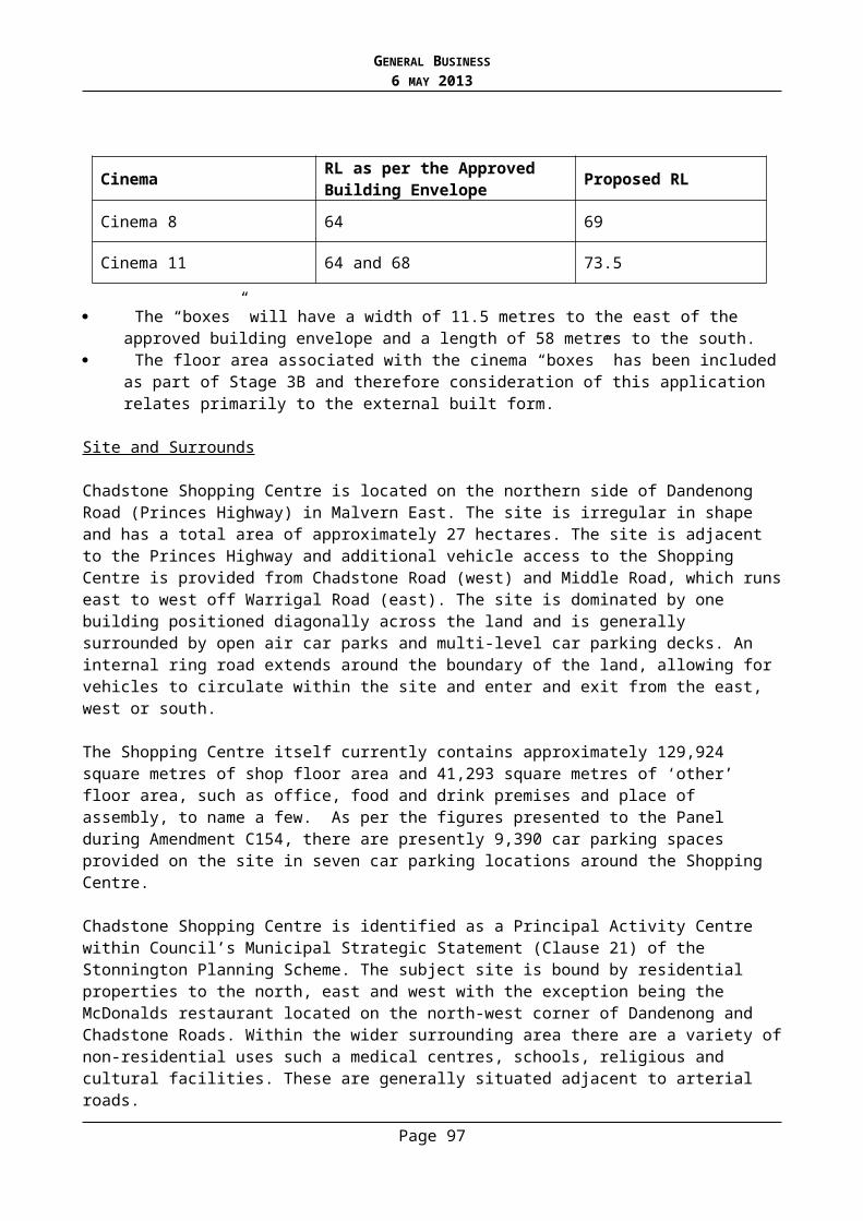
GENERAL BUSINESS6 MAY 2013
Car Parking and Traffic Impacts
Under the requirements of Clause 52.06-5, an office use requires 3.5 car spaces be provided to each 100 square metres of leasable floor area. This application seeks a full statutory waiver of the car parking rate, although in reality the offices will be provided car parking during the week within the basement car park.
The basement proposes 504 car spaces of which 77 are to be permanently allocated to the hotel use. The remaining 427 of these spaces are to be technically allocated to the Shopping Centre use, although these spaces are proposed to be used by the offices on weekdays. Therefore, 427 car spaces are to be provided for the retail use on weekends and public holidays only, with these being used by the office during the week.
Importantly, the previous Planning Scheme Amendment for this site, known as Amendment C32 (approved in 2005), allowed for corporate offices with an allocated car parking rate of zero. This was due to the empirical evidence that was provided at the time of this amendment, which relied on sufficient surplus of car parking spaces on the site during weekdays to cater for the office uses, without the need for additional parking (demand was calculated at 93.2% of the then proposed supply). Therefore, it was justified that no additional car parking be required for corporate offices on the site.
In 2012 during the Amendment C154 process, GTA Consultants proposed a rate of 6.2 car spaces per 100 square metres of shop floor area with an anticipated demand of 10,772 car spaces. As part of the Indicative Concept Plans, 10,790 car spaces were proposed, which equated to 99.8% of the proposed supply. Additionally, this figure assumed no car parking spaces being used by the offices on a Saturday. The Panel found that:
Consequently, the car park would be effectively full at the 85th percentile Saturday peak. There would be no buffer as was the case in the Amendment C32 scenario. (Report of the Panel, dated 17 July 2012, p.85)
Importantly the above figures under Amendment C154 were based on a hotel with 180 rooms with car parking provided at a rate of 0.5 spaces per room and generally the same increases in shop, retail and food and drinks premises floor areas as has been proposed by the other stages of development (Stage 2A, 2B, 3A, and 3B) to date.
As part of this planning application, GTA Consultants have proposed a rate of 0.32 spaces per room for the hotel with no additional car parking allowances for the conference and function facilities which can generate an additional 400 patrons on the site at any one time. Based on a rate of 0.32 car spaces per room, the proposal has included 77 exclusive hotel car spaces. Management of these spaces is to occur via a boom gate (secure entry and exit) to ensure that office and shopping centre users do not occupy these spaces at any time.
It is noted that car parking rates for the hotel were discussed as part of the Panel Hearing where O’Brien Traffic suggested a requirement of no less than one car space per hotel room and additional spaces to be provided for a conference facility. O’Brien Traffic also noted that while they were not opposed to the sharing of car spaces for retail and office uses, the extent of sharing may be of concern. It was stated that “offices will be in use on some peak days near Christmas so sharing needs to be limited”. It is noted that the proposal has been altered from the plans discussed as part of the Panel process and therefore variations to previous advice given have also resulted.
Page 97

GENERAL BUSINESS6 MAY 2013
O’Brien Traffic has reviewed the traffic impact assessment prepared by GTA for this application and disagrees with the car parking demand and allowances. In the advice to Council dated March 2013, O’Brien Traffic suggest that a rate of 0.5 car spaces to each room within the hotel will now be satisfactory for this application, along with 120 spaces for the conference/function facility (which currently has no provision in the proposal) at the Planning Scheme rate of 0.3 spaces per patron permitted. The conference rate of 0.3 spaces is derived from the place of assembly calculation under the provisions of Clause 52.06-5. This equates to a permanent requirement of 240 car spaces for this specific use.
Material supplied by the Applicant in support of this application states that there will be an overall total of 10,642 car spaces on the subject site at the conclusion of the Stage 4. However, the actual number is more likely to be in the vicinity of 10,553 car spaces, taking into account the design changes, trolleys bays, servicing equipment and share paths that have been required by previous planning permits for Stages 2A, 2B, 3A and 3B.
O’Brien Traffic noted in their early observations of the application material that,”...the Saturday analysis shows a peak demand of 10646 spaces compared to a claimed total provision of 10661 spaces (i.e. 99.86% full with only 15 spaces free and with the conference or weekend office demand excluded)”. On this basis, the anticipated car parking supply on the site at peak weekend periods will not be sufficient to cater for the demand generated. This is of serious concern, particularly given that the Amendment C154 Panel specifically commented on car parking as follows:
...the Panel is not convinced that a tightening of the number of car spaces on the subject site as floor space expands will bring about mode shift in the absence of significant changes to public transport services to Chadstone. It may simply push more vehicles into the surrounding streets, something that should not be consciously encouraged unless it is sanctioned by a structure plan for the broader activity centre, prepared with appropriate public participation. (Report of the Panel, dated 17 July 2012, p. 86)
As part of the Panel Hearing, it was suggested by the proponent that car parking demand may fall as improved pedestrian and cyclist connections are integrated and the centralised bus interchange becomes operational. These factors were not considered to be valid claims as there was no evidence that a modal shift would occur as public transport services were not being increased to the site.
O’Brien Traffic has reviewed the proposal and has provided an alternative rate of car parking based on their forecast demands of the new uses. It suggests that a permanent parking provision of 792 spaces is required for the Stage 4 uses. This includes:
120 space provision for the conference/function facility (which currently has no provision in the proposal) at the Planning Scheme rate of 0.3 spaces/patron permitted;
Full provision for the hotel (120 spaces) at the 0.5 spaces per room rate proposed in the traffic report; and
Full provision for the office use (552 spaces) at the Planning Scheme rate of 3.5 spaces per 100 square metres.
Additionally O’Brien Traffic highlights concerns with the traffic rates that have been proposed, some of which include:
Offices are likely to generate some parking demand on weekends, particularly if tenants are call centres or other similar potential 24 hour/7 day activities.
Page 98

GENERAL BUSINESS6 MAY 2013
Weddings and other functions do occur during the Christmas lead-up period and school holiday peaks and so the exclusion of the conference/function facility from the demand assessment is unrealistic.
Corporate Christmas functions are not listed and these do occur during the nominated busy period for the CSC of November/December.
Although O’Brien Traffic suggests that the supply is insufficient at Stage 4, it is acknowledged that the bulk of the office parking demand is likely to occur on weekdays when a sufficient amount of vacant parking should be available across the Chadstone Shopping Centre site. Importantly, this level of parking availability on weekdays will not be present in the lead-up to Christmas and during school holidays. Nonetheless, it is acknowledged that there is potential for a degree of different uses sharing parking on this site at their different peak, non peak times. Other considerations raised by O’Brien Traffic relate to the fact that the analysis provided by the Applicant has not accounted for weekend office parking. O’Brien Traffic suggests that 5% is a realistic expectation which would equate to 28 car spaces. The issue of car parking forming part of commercial office leases has not been discussed at length here; however it is noted that this could further complicate and reduce the availability of car parking for shoppers.
Additionally, based on the fact that hotel is located in a suburban context the comparisons drawn between hotels within the CBD are not considered to be realistic or accurate for forecasting traffic and parking demands.
Therefore, based on the information provided by O’Brien Traffic, it is recommended that 268 spaces be reserved on weekends for weekend office, hotel and function centre uses. At present 77 spaces are reserved for the hotel and no spaces are exclusively allocated to the function/conference use or office on weekends. A substandard number of car spaces will not be accepted as the projected demand generated by the cumulative activity at this Centre at the conclusion of Stage 4 cannot be accommodated on the site and has a high potential to result in an overflow into the surrounding street network. Furthermore, the new uses proposed by Stage 4 rely on surplus car parking for the Shopping Centre which at peak periods will not exist. As stated in the Officers Report for Stage 3B (Planning Permit 0784/12), the rate of car parking for shop uses on the land will already fall below the statutory rate on Saturday peak periods and therefore the increased demand generated by Stage 4 cannot be accommodated on the site.
Based on the above, it is considered that the proposal fails to achieve a satisfactory rate of car parking commensurate with the demand expected on the land. The Applicant has suggested that management plans could be required by way of condition to demonstrate how traffic and car parking impacts can be managed. However, this does not resolve the fundamental issue that is, an inadequate number of car spaces are proposed by this development. It is for this reason that the application cannot be supported and it is recommended that Council refuse the application.
Built Form
The application has been assessed against the provisions of the Stonnington Planning Scheme including Clause 15.01 and the design guidelines specified in the Schedule to the Incorporated Plan. The design guidelines relate to the southern building envelope (Southern precinct) and are detailed as follows:
Achieve high quality architecture commensurate with the visual prominence of new buildings in this precinct.
Page 99

GENERAL BUSINESS6 MAY 2013
Ensure adequate spacing between buildings and avoid the creation of continuous built form within the building envelope.
Achieve a high quality amenity for pedestrians at ground level. Ensure that built form at the lower levels is of an appropriate scale to interface with street
frontages and encourage pedestrian and outdoor activity at ground level. Achieve attractive and, as appropriate, active frontages to Princes Highway, Chadstone
Road and other parts of the site to ensure a proportionate response for towers. Rising forms should establish a tower / base element relationship by providing towers that express an explicit transition from lower level to upper tower form and are shaped to provide slimmer, more elegant forms where possible.
Ensure built form does not create unacceptable overshadowing to adjacent dwellings. Ensure built form provides a suitable transition to adjacent residential areas to the east and
west.
As noted in the advice from Hansen the proposed towers are considered to be appropriate to this location and are deemed to meet the design guidelines above. There are two exceptions and these will be discussed below. However, the overall design creates a distinctive and landmark built form outcome that distinguishes the site as a gateway and announces arrival at a Principal Activity Centre. Furthermore, the height of the towers is in accordance with the building envelope approved by Amendment C154 and therefore is acceptable.
Interface to the East
While it is noted that the towers will present as elegant narrow forms on some angles, these slim proportions will not be appreciated on views of the office from the south-east. On this aspect the office will present as a 70 metre wide building with strong horizontal detailing via the sunshades. The horizontal details, coupled with the continuous height and length of this wall will exacerbate the perceived breadth of this building resulting in a presentation of visual bulk. When standing in the residential streets and private open spaces of the residences to the south-east (a minimum distance of 35 metres from the office), the new tower will be a strong element in the skyline and does not provide adequate visual relief.
Horizontal and vertical features on the facades have been used to create a distinct sense of individuality for each of the buildings; however it has been recommended by Hansen that further vertical articulation within the broad profile of the south-east elevation is required as a means of reducing the impacts of visual bulk of the office building.
While this concern could have been addressed to some degree by way of a condition; it was acknowledged that there are multiple ways in which verticality could have been achieved for this building. Some suggestions included openings (i.e. terrace spaces at each level for ventilation and ESD benefit) or other effects such as a vertically inclined podium base wrapping around the hem of the building.
Therefore, had all other aspects of this proposal been supported it would have been preferred that the designers had provided Council with a suitable alternative in consultation with Council’s Urban Design Team to address this concern. However, given no response was offered by the designers, it is considered that this aspect of the design is an issue that cannot currently be addressed via conditions. Should further design suggestions and discussions be pursued by the Applicant, it is possible that these issues could be satisfactorily resolved.
Page 100
GENERAL BUSINESS6 MAY 2013
Interface to the Princes Highway
Concern was raised by Hansen with regard to the interface to the Princes Highway as was shown on the application plans dated December 2012. These comments were provided to the Applicant and no changes were made to the plans lodged 19 March 2013. The design guidelines at Section 3.7.3 seek to (amongst other things):
Provide a strong connection between the outdoor and indoor environments by design measures to enable people indoors to look out of the Chadstone Activity Area and people outside to look in.
The development as proposed does not satisfactorily engage with the public realm and this is due to the ground floor containing a large amount of back-of-house and a “defensive edge” separated from the public realm by screening vegetation. While not a fatal flaw in the design, it is considered that improvements could be made to achieve greater activation of the ground floor interface to the Princes Highway.
The Public Environment and Pedestrian Spaces:
As per the design guidelines at Section 3.7.3 of the Schedule to the Overlay, consideration is given to the pedestrian experience from the car parking areas to the main buildings on the land. The applications to date (Stages 2A, 2B, 3A, 3B and 3C) have sought to achieve a high level of pedestrian connectivity and amenity through careful consideration of car parking layouts and share paths. This application will include a new covered pedestrian link which will extend from the office and hotel porte-cochere to the Chadstone Shopping Centre. The path provides an important link between the new southern development and the existing uses on the land as well as providing a high degree of pedestrian connectivity and comfort from the Princes Highway.
While the ground floor level treatment between the porte-cochere and the Shopping Centre provides for a quality pedestrian experience, the basement level car park beneath the office and hotel is poorly connected to the Shopping Centre. It has been suggested by the Applicant that the basement levels will be used by shoppers on weekends and this raises concern with regard to safety and access. A customer of the centre would be required to take a lift from the basement to the ground floor level (office and hotel) lobby and then proceed through the pedestrian link to the entrance of the Shopping Centre.
Given that this could be a deterrent for shoppers to park within the basement, there is a need for a clear management plan to be in place to demonstrate how and when this basement car park will be used by the retail centre that ensures an adequate supply of parking is provided for the Shopping Centre. As suggested by O’Brien Traffic this car park is more suited for retail staff parking on weekends as these spaces will experience lower turn-over rates and staff will become familiar with the parking layouts.
Overall, the pedestrian experience and integration of the public realm with the Shopping Centre, bus interchange and the Princes Highway is considered to be satisfactory and meets the design guidelines.
Amenity Impacts
Visual bulk has been highlighted as a significant concern with regard to the impact on the residential area to south-east of the subject development as previously mentioned. Other amenity considerations are discussed below.
Page 101

GENERAL BUSINESS6 MAY 2013
Overshadowing
The development will not unreasonably overshadow adjoining properties as per the requirements of the design guidelines. This is a view shared by Hansen Partnership Pty Ltd. The closest residential properties (being 1373 Dandenong Road and 4 Woodlands Grove) are situated approximately 35 metres to the east of the new office. At this distance shadows will predominantly fall across Eastern Access Road and minimally impact on the adjacent residences at 2pm and 3pm on the Equinox.
It is also important that shadows be considered in the context of an approved building envelope that allows for buildings of the height proposed. In this regard, the approval of the amended building envelope under Amendment C154 suggests that impacts of shadow are considered to be reasonable given the interface to a residential zone.
Overlooking
The office building is proposed to be located a minimum distance of 35 metres from the nearest residential properties to the east and views into existing residential properties would therefore be at long distances. Importantly, this development is located within a Principal Activity Centre that has a direct interface to a low rise residential zone. Overlooking was raised in the Report of the Panel (dated 17 July 2012) where it was stated that, “even though backyards may be visible from office and hotel windows the amenity of the residents will not be significantly impacted based on the standards typically applied through the Scheme” (Report of the Panel, page 92).
The typical standards (ResCode) used to determine unreasonable overlooking to a residential property use a distance of 9 metres as a guide. Based on these standards there are no sensitive areas within 9 metres of a new window within the office development. Therefore, it is considered that there are no unreasonable overlooking impacts.
Light Spill
Opportunities for intrusive light spill from the office and hotel buildings could be mitigated through conditions of a permit to reduce unreasonable impacts on the surrounding residents. Plans that demonstrate where lights are to be located and how lights will be baffled can be required through conditions.
Concern has been raised with generated luminance from the office tower to the residential area during the night. Light spill from lights left on within the office building could have been addressed through conditions requiring lighting management plans had the application been supported.
Noise
The acoustic report undertaken by Norman Disney and Young provides details on how the development will seek to comply with State Noise Regulations SEPP N-1 and SEPP N-2. The Acoustic Report was reviewed by Burton Acoustic Report and it was confirmed that the recommendations contained within the report are satisfactory. It was noted that a condition of the permit may need to address music noise beyond 12am and that another requirement may seek the closure and locking of external doors to the outdoor (ground floor) terrace at 12am. Had this application been supported these comments could have been addressed via conditions.
Page 102

GENERAL BUSINESS6 MAY 2013
Wind Effects
The application material included the submission of a Wind Assessment undertaken by MEL Consultants, reference no. 64/12 R1 and dated February 2013. The Wind Assessment confirms that the development falls within the criterion for walking comfort for all wind directions.
Integrated Transport and Access Plan
Schedule 2 to the Incorporated Plan Overlay requires that a permit which results in an increase in any floor space by more than 10,000 square metres must give effect to the recommendations contained in an Integrated Transport and Access Plan (ITAP) prepared to the satisfaction of the Responsible Authority. The Integrated Transport and Access Plan (ITAP) was approved by Council on 1 May 2013.
The purpose of the Integrated Transport and Access Plan (ITAP) is to address access and to promote a shift towards sustainable modes of transport to the Centre. The document includes share path locations, bus interchange details, wayfinding signage, bicycle facilities and green travel plans. The recommendations of the Integrated Transport and Access Plan (ITAP) are required to be shown as part of this application. The share paths have not been shown on the plans and this would be required as a condition of any permit that issues. Details of how the share paths integrate and connect with the share paths approved in conjunction with the development under Stages 2A and 2B would be required by any permit that issues.
Loading Bays
O’Brien Traffic highlighted concerns with the loading areas in the advice to Council on 8 January 2013. The concerns related to potential conflict as a result of sharing of the loading dock with public parking and pedestrian traffic. The applicant responded to these concerns as part of the Request for Further Information on 19 March 2013 and showed the loading area restricted from public parking, with the exception 11 hotel staff parking spaces. While this is an improved outcome the loading area is still of concern as pedestrians will not be able to access the lifts when a truck is in the loading bay. O’Brien Traffic has suggested in that this issue is unresolvable based on the current loading configuration.
Bicycle Parking
The proposal includes new bicycle parking facilities for the office and hotel development in the form of 100 staff bicycle parking spaces within the basement and 15 spaces at the building entrances for visitors. Details of the parking facilities and change rooms have not been shown on the plans and this level of detail could form a condition of the permit. In terms of the provision, the number of bicycle parking facilities is in accordance with Clause 52.34 of the Stonnington Planning Scheme. Ecologically Sustainable Development (ESD) Framework
An Ecologically Sustainable Development (ESD) Framework was approved by Council on 25 January 2013. This document was prepared by Colonial First State Global Asset Management (CFSGAM) dated January 2013, and Council date stamped 22 January 2013. The Framework outlines the overarching sustainability objectives which are sought by future development works for this site. The ESD Framework sets out a strategic vision for the Centre which is to be reflected in each development application via a Sustainability Management Plan (SMP). These plans outline the measures to be incorporated into the development to address things such as energy/carbon, waste, sustainable transport, products and materials and water.
Page 103

GENERAL BUSINESS6 MAY 2013
A detailed Sustainability Management Plan (SMP) has not been provided as part of this application and could be required by way of a condition of approval.
Water Sensitive Urban Design
A Water Sensitive Urban Design response has not been provided as part of this application. The application does propose a 60,000L rainwater tank within the basement. It was confirmed by Council’s Infrastructure Department that the tank will provide some nominal benefit if it is connected to a significant number of toilets as well as being used for irrigation. These details would have been required has Council been supportive of the application. It is likely that this could be addressed concurrently with the Sustainability Management Plan (SMP).
Disability Discrimination Act
Had Council been supportive of this application, conditions would have required that the plans be updated to show parking for people with disabilities, including layout, dimensions and total number needed for the development in accordance with the relevant standard.
Construction Management Plan
Had Council been supportive of the application the preparation and implementation of a Construction Management would have been required by way of a condition. This document would have been prepared in consultation with Council’s Planning, Building and Transport Departments.
In conjunction with a Construction Management Plan, a car parking management strategy would also have been required to demonstrate how car parking could be managed over the various stages of development to minimise shortfalls of parking on site during construction.
Submissions
In response to the concerns not already discussed in the report, the following comments are made:
Air pollution Health impacts Depreciation of property values Property damage during construction
The above concerns are not relevant considerations under the Stonnington Planning Scheme that can be addressed by this application. Where relevant these may be addressed through the building permit process.
As for the need for increased security in the area, this is not considered to be a relevant consideration. There is nothing to suggest that there will be an increase in crime in the area as a result of a new hotel or office use.
It is again reiterated that under the provisions of the Planning and Environment Act 1987 and the Stonnington Planning Scheme (Clause 43.03) there is no statutory provision for third party appeal rights of this application. Therefore, no appeal can be made by submitters against the decision made by Council at the Victorian Civil and Administrative Tribunal (VCAT).
Page 104
GENERAL BUSINESS6 MAY 2013
Human Rights Consideration
This application has been assessed in accordance with the requirements of the Planning and Environment Act 1987 (including the Stonnington Planning Scheme), reviewed by the State Government and which complies with the Victorian Charter of Human Rights and Responsibilities Act 2006.
CONCLUSION
Having assessed the application against the relevant planning controls, it is recommended that the proposal be refused for the following reasons:
Insufficient car parking is proposed for the new office and hotel uses and this will result in unreasonable overflow to the surrounding street network.
The design treatment of the eastern elevation of the office tower has not been adequately resolved to reduce impacts of visual bulk on the adjoining residences to the east.
The ground floor interface of the residential hotel to the Princes Highway does not satisfactorily engage with the public realm due to the ground floor containing a large amount of back-of-house and a “defensive edge” separated from the public realm by screening vegetation.
RECOMMENDATION
That a Notice of Refusal to Grant a Planning Permit No: 0905/12 for the land located at 1341 Dandenong Road, Malvern East be issued under the Stonnington Planning Scheme for construction of buildings and works, use of the land as a residential hotel, and waiver of the statutory car parking requirements of Clause 52.06 on the following grounds:
1. The proposal does not provide adequate car parking spaces to cater for the demand generated by the new uses on the site and car parking is not in accordance with Clause 52.06 and Schedule 2 of the Incorporated Plan (August 2012) of Clause 43.03 of the Stonnington Planning Scheme.
2. The eastern elevation of the office building has not been adequately articulated to reduce impacts of visual bulk on the residential area to the south-east.
3. The residential hotel does not provide a suitable urban design outcome with regard to activation of the ground floor interface to the Princes Highway.
Page 105

GENERAL BUSINESS6 MAY 2013
1.5. PLANNING APPLICATION 179/09 – 85-97 HIGH STREET, PRAHRAN –CONSTRUCTION OF A FURTHER (EIGHTH) LEVEL TO THE APPROVED SEVEN STOREY BUILDING
(Statutory Planning Manager: Alexandra Kastaniotis)(General Manager: Stuart Draffin)
PURPOSE
For Council to consider an amendment to Planning Permit 179/09 and the associated endorsed plans pursuant to Section 87A of the Planning and Environment for the construction of an eighth level to the approved building.
Given the original permit was issued at the direction of the Victorian Civil and Administrative Tribunal, any amendments to the requirements/wording of the permit and significant amendments to the plans must be determined by the Tribunal. Council’s role, as the Responsible Authority, is to assess the proposed amendments and advise VCAT of its position. Ultimately, VCAT will decide on the proposed amendments.
Executive Summary
Appellant Ashwerth Pty LtdWard: SouthZone: Business 2 Zone and Residential 1 Zone to the rear half of the siteOverlay: NilAppeal No: P2104/2012VCAT Hearing Date: 24 May 2013Trigger for referral to Council:
Increase in building height to an approved seven storey building
Number of persons who lodged statements of grounds:
None
Officer Recommendation: Advise VCAT that Council objects to the proposed S87A Amendment Request
Appellant Ashwerth Pty Ltd
BACKGROUND
Application history
A Planning Application 179/09 was lodged on 24 March 2009 for construction of a nine storey building to contain 108 dwellings, 96 car spaces, 1700m² of office floor space and a food and drink premises (café).
Council refused the planning permit application without giving notice on 9 June 2009 based on impact to neighbourhood character, neighbouring residential amenity, internal amenity and traffic.
Page 106

GENERAL BUSINESS6 MAY 2013
An appeal was lodged against the Refusal to Grant a Planning Permit on 22 June 2009. Pursuant to the VCAT Order dated 21 December 2009, Councils was directed to issue a permit for the construction of a building in a Business 2 Zone and Residential 1 Zone to be used as a food and drinks premises (cafe, restaurant or convenience restaurant), office (as of right use) and dwellings (as of right use in the Residential 1 Zone) with associated car parking dispensation.
Relevantly, the decision required the development to be reduced in height from 9 storeys to 7 storeys by removing two levels.
Plans to comply with the permit were endorsed on the 18 June 2010 together with the approval of a ‘secondary consent’ amendment application. On 14 January 2011 a second secondary consent application was approved.
The two secondary consent amendments generally allowed a reduction to the approved commercial floor area, an increase in the number of dwellings and car spaces, various dwelling and commercial tenancy layout changes, basement layout revisions and minor setback changes to the building and balconies.
On 21 July 2011, a s.87 amendment application was lodged with the Tribunal for the change of use of the three ground floor office tenancies to restricted retail premises (showroom) and associated reduction in the car parking requirements and associated waiver of loading bay requirements. It also sought the increase in the number of car spaces by two, as well as various minor changes to the building envelope and layout.
Council supported these changes at the Council meeting of 21 November 2011. Two VCAT hearings took place in relation to these changes, with the Tribunal approving the changes as per the Order dated 30 April 2012. An amended permit was issued in accordance with this Order on 9 May 2012, which contained a number of new conditions.
Plans to comply with these amended permit conditions were endorsed on the 18 December 2012. These are the current endorsed plans by which the development must be constructed.
The key features of the current approval are:
Construction of a seven storey building over two levels of basement car parking. A total of 109 dwellings and 111 car spaces. A total of 700m² of restricted retail (showroom/commercial) floor area and 140 m² of cafe
floor area at ground level.
Current application
The amendment that forms the basis of this report (lodged with the Tribunal on 24 July 2012) comprises the fourth amendment to the development.
The Tribunal need to deal with this amendment directly (via s.87A of the Act) given the proposal was considered to have a ‘consequential impact’ and could thereby not be considered pursuant to ‘secondary consent’. Further, s.72 is not a mechanism available for permits issued at the direction of VCAT. Finally, the proposal seeks to ‘reopen’ matters considered by VCAT, whereby they previously considered that an eight storey building was not appropriate.
The details of this are provided below in the ‘proposal’ section.
Page 107

GENERAL BUSINESS6 MAY 2013
Further amendments
A fifth amendment (secondary consent) was applied for in December 2012 to make relatively minor changes to the development, including the regularisation of the ‘as built’ conditions at roof level (altering plant and stairwell location). This amendment was approved on 29 April 2013.
Lastly, a sixth amendment (s.87A) was lodged in February 2013 for the conversion of the approved ground level Restricted Retail tenancies/showrooms to a Supermarket and a Restricted Recreation Facility (gym). This s.87A report is also presented to Council as a separate item for consideration as part of this Council agenda.
The Proposal
The plans that form part of the basis of Council's consideration were prepared by CBG Architects and are known as Drawing No.s: TP01, TP02, TP03, TP04 and TP05, all dated 16 May 2005 (with Council date stamp 20 August 2012).
The proposal essentially seeks to construct an additional (8th) level in the southeastern portion of the site. This additional floor space will enlarge the approved dwelling 608 such that two bedrooms and a north-facing living area are provided at 8th floor level. A stairwell will be provided in leiu of the currently approved bedroom, while the approved west-facing living area will become a study.
Currently, unit 608 (located at 7th floor level) provides for a one bedroom dwelling, with a western aspect opening onto a 8 sqm balcony.
The top level will have a minimal eastern set back from the seventh floor below (0m – 800mm), and between 2m and 2.5m setback from the eastern boundary (due to angle of the title).
It will be set back approximately 11m from the front title boundary, and approximately 7m from the (seventh) floor below.
It is set back a substantial distance from the western and northern property boundaries.
It is noted that the proposed Upper Level plan (TP03) shows a different layout to that currently endorsed with respect to the location of the stair core and lift overrun. It also removes reference to solar panels.
The proposed TP03 does however broadly correlate with the secondary consent application plans currently under consideration by Council officers.
Site and Surrounds
The subject site is located on the north east corner of the intersection of High Street and Charles Street, Prahran. The land is irregular in shape with the main area being a rectangular and an “L” shaped parcel which extends from the site’s north east corner, behind the adjacent properties to the north and then returns to Charles Street. A second parcel of land is encumbered with rights of access to the dwellings occupying 10, 12, 14 and 16 Charles Street. The total site area is approximately 2651m².
Vehicular access to the property is via Charles Street (a one way, south direction only local street) and there are some significant trees along the site’s eastern boundary, most notably a River Red Gum which is being retained.
Page 108

GENERAL BUSINESS6 MAY 2013
To the north, the site abuts single storey dwellings on small narrow allotments. Residential properties also face the subject site from the west side of Charles Street.
The Sandringham Railway line abuts the site to its east and demarcates the boundary of the Prahran and South Yarra Principle Activity Centre. Between the railway cutting and the site is a pedestrian walkway which connects High Street with the Prahran Railway Station to the north. South of the site is mixed in terms of use and built form - most sites are developed with an average of two storeys and primarily occupied by offices and/or showrooms.
The approved development is largely completed and is up to a ‘fit-out’ stage. The proposed works as part of this s.87A application are not retrospective.
The Title
The site is described on Certificate of Title as Land in Plan of Consolidation 351222L (Volume 10080 Folio 039) and no covenants affect the land. Easements and caveats recorded on the Certificate of Title and Plan of Consolidation are not relevant to the specific amendment.
Planning Controls
The following controls/permit triggers are considerations for this application:
Zone
Clause 32.01 - Residential 1 ZoneIt appears that the works are fully contained within the Business 2 Zone and do not extend into the Residential 1 Zone.
Clause 34.02 – Business 2 ZonePursuant to Clause 34.02-4, a permit is required to construct or carry out works.
A permit is also triggered given a dwelling is a Section 2 Use. It is noted that this proposal seeks to extend an approved dwelling use and hence its principle is established.
Particular Provisions
Clause 52.06 – Car ParkingPursuant to Clause 52.06-5, one car space is required for a 1 or 2 bedroom dwelling, whilst two spaces are required for a 3-4 bedroom dwelling. Given the proposal seeks to transform a one-bedroom dwelling to a three bedroom dwelling (including study), Clause 52.06 requires a further car space.
As per the submitted GTA traffic statement (dated 11 July 2012), the provision of car parking remains unchanged.
Relevant Planning Policies
The most relevant policies to this proposal include Clause 15.01 (Urban Environment) and Clause 22.02 (Urban Design policy).
Notice
No Statements of Grounds have been lodged in response to notification. Notification was provided by the permit applicant to adjoining owners and occupiers.
Page 109
GENERAL BUSINESS6 MAY 2013
KEY ISSUES
The key issue in this matter relates to the visual impact from the additional level, particularly in relation to its proximity to the eastern property boundary.
In terms of car parking, Clause 52.06 requires one further car space to be provided or allocated. Whilst no allocation for the various dwellings, the car park ratio per dwelling remains unchanged (0.95 spaces per dwelling). This is an increase to the rate that was approved by VCAT in 2010 (0.65 spaces per dwelling). Overall, it is considered that there would be no discernible impact from the increase in size of one dwelling such that it provides for three bedrooms as opposed to one bedroom.
Built form
The original VCAT decision reduced the proposed development from 9 storey to 7. Figure 1 below demonstrates the extent of built form considered by VCAT, with the largest built form concentrated to the southeastern corner of the site. Figure 2 shows the current s.87A proposal presented to Council for consideration.
Figure 1: High Street elevation showing the 9 level building considered in the original VCAT decision
Page 110

GENERAL BUSINESS6 MAY 2013
Figure 2: High Street elevation showing the proposed eighth level (circled in dash)
Paragraphs 38-40 of the December 2009 VCAT Order provide a useful summary of VCAT’s views in relation to the proposed built form:
38. While we recognise the positive aspects of the progressive built form setbacks proposed, particularly in relation to the adjacent residential neighbours to the north, the stepping up of massing to the southeast corner of this proposal would still be seen as excessive in relation to the surrounding finer grain and low scale allotments. (emphasis added)
39. Chapel Vision envisaged that there would be incremental opportunities for infill development, to a scale of 11 to 19 metres or three to five levels with setbacks. We consider that [whilst] this may be on the small side, it provides a sensible basis that can be adjusted upwards depending on the merits and circumstances of the particular sites. We find it is difficult to support the proposal for the site under consideration that is outside the ‘core’ of the PAC.
40. We consider that the building should be a gateway building that defines the edge of the PAC. We consider that a building of seven storeys with the same three principal design elements as proposed can achieve a commanding presence without an overwhelming dominance. It is our view that two levels should be removed from the development. We do not intend to prescribe the levels to be removed, this is best done by the proponents who will need to weigh up design and financial considerations. However we would prefer that one level be removed from the middle section and one level should be removed from the upper section. This would remove in the order of eighteen dwellings from the development. We consider that a development that provides in the order of ninety apartments, 1700 sqm of office floor space and a café on a site close to an activity centre and public transport to be a very positive planning outcome and entirely consistent with the state and local planning policy framework. (emphasis added)
Page 111

GENERAL BUSINESS6 MAY 2013
The proposal, which seeks to re-insert built form in the south eastern corner of the development, flies in the face of the original Tribunal decision. This built form will be highly visible in wide views across the railway reserve from the east and will add height to a building that is already the tallest and most prominent in its immediate environs.
Whilst the southern (front) set back will sit 7m behind the sixth level below, the minimal eastern set back from its seventh floor counterpart fails to conceal or even minimise built form across this wide viewing corridor. The resultant built form is one that is highly prominent when standing in either High or Porter Street – and is one that presents as a bona-fide eight storey building.
The Tribunal, in reaching its original decision, clearly considered that a seven level building was the appropriate threshold. There is no good reason to depart from the Tribunal’s earlier consideration.
Human Rights Consideration
This application has been assessed in accordance with the requirements of the Planning and Environment Act 1987 (including the Stonnington Planning Scheme), reviewed by the State Government and which complies with the Victorian Charter of Human Rights and Responsibilities Act 2006.
CONCLUSION
Having assessed the application against the relevant planning controls, it is recommended that the Council should not support the proposal for the following reason:
The proposal would result in an excessively tall and dominant building, particularly as viewed from the east. This is contrary to the existing or emerging character of the area, as well as the original VCAT decision.
RECOMMENDATION
That Council advise VCAT and other interested parties that it does not consent to the proposed application to amend Planning Permit no. 179/09 pursuant to Section 87A of the Planning and Environment Act 1987 for the construction of an eighth storey at 85-97 High Street, Prahran, on the following ground:
1. The proposed additional storey would result in an excessively tall, dominant and incongruous building, particularly when viewed from the east. This is contrary to the existing or emerging character of the area as well as the original VCAT decision.
Attachments - Locality Plans, Site Plan, Floor Plans, Elevations etc.
Page 112

GENERAL BUSINESS6 MAY 2013
1.6. PLANNING APPLICATION 0179/09 - 85 - 97 HIGH STREET, PRAHRAN – AMENDMENT TO THE PERMIT AND ENDORSED PLANS FOR A CHANGE IN USE OF THE GROUND FLOOR RESTRICTED RETAIL (SHOWROOM) TO SHOP (SUPERMARKET) AND RESTRICTED RECREATION FACILITY (GYMNASIUM) AND ASSOCIATED CAR PARKING AND LOADING BAY DISPENSATION AND VARIOUS BUILDING DESIGN AND LAYOUT CHANGES
(Statutory Planning Manager: Alexandra Kastaniotis)(General Manager: Stuart Draffin)
PURPOSE
For Council to consider an amendment to Planning Permit 179/09 and the associated endorsed plans pursuant to Section 87A of the Planning and Environment Act for a change in use from restricted retail use to shop (supermarket) and restricted recreation facility (gymnasium) and associated reduction in the car parking requirements and waiver of the loading bay requirements and various building design and layout changes at 85-97 High Street, Prahran.
Given the original permit was issued at the direction of the Victorian Civil and Administrative Tribunal, any amendments to the requirements/wording of the permit and significant amendments to the plans must be determined by the Tribunal. Council’s role, as the Responsible Authority, is to assess the proposed amendments and advise VCAT of its position. Ultimately, VCAT will decide on the proposed amendments.
Executive Summary
Appellant Ashwerth Pty LtdWard: SouthZone: Business 2 Zone and Residential 1 Zone to the rear half of the siteOverlay: NilAppeal No: P445/2013VCAT Hearing Date: 27 May 2013Trigger for referral to Council:
This application also relates to P2104/2012 VCAT appeal which is also being considered by Council as part of the agenda
Number of persons who lodged statements of grounds:
One
Officer Recommendation: Advise VCAT and other interested parties that Council objects to the proposed S87A Amendment Request
BACKGROUND
A Planning Application 179/09 was lodged on 24 March 2009 for construction of a nine storey building to contain 108 dwellings, 96 car spaces, 1700m² of office floor space and a food and drink premises (café).
Council refused the planning permit application without giving notice on 9 June 2009 based on impact to neighbourhood character, neighbouring residential amenity, internal amenity and traffic.
Page 113

GENERAL BUSINESS6 MAY 2013
An appeal was lodged against the Refusal to Grant a Planning Permit on 22 June 2009. Pursuant to the VCAT Order dated 21 December 2009, Council was directed to issue a permit for the construction of a building in a Business 2 Zone and Residential 1 Zone to be used as a food and drinks premises (cafe, restaurant or convenience restaurant), office (as of right use) and dwellings (as of right use in the Residential 1 Zone) with associated car parking dispensation.
Relevantly, the decision required the development to be reduced in height from 9 storeys to 7 storeys by removing two levels.
Plans to comply with the permit were endorsed on the 18 June 2010 together with the approval of a ‘secondary consent’ amendment application. On 14 January 2011 a second secondary consent application was approved.
The two secondary consent amendments generally allowed a reduction to the approved commercial floor area, an increase in the number of dwellings and car spaces, various dwelling and commercial tenancy layout changes, basement layout revisions and minor setback changes to the building and balconies.
On 21 July 2011, a s.87 amendment application was lodged with the Tribunal for the change of use of the three ground floor office tenancies to restricted retail premises (showroom) and associated reduction in the car parking requirements and associated waiver of loading bay requirements. It also sought the increase in the number of car spaces by two as well as various minor changes to the building envelope and layout.
Council supported these changes at the Council meeting of 21 November 2011. Two VCAT hearings took place in relation to these changes, with the Tribunal approving the changes as per the Order dated 30 April 2012. An amended permit was issued in accordance with this Order on 9 May 2012, which contained a number of new conditions.
Plans to comply with these amended permit conditions were endorsed on the 18 December 2012. These are the current endorsed plans by which the development must be constructed.
The key features of the current approval are:
Construction of a seven storey building over two levels of basement car parking. A total of 109 dwellings and 111 car spaces. A total of 700m² of restricted retail (showroom/commercial) floor area and 140 m² of cafe
floor area at ground level.
Current application
A sixth amendment (s.87A) to the Permit was lodged with the Tribunal in February 2013 for the conversion of the approved ground level Restricted Retail tenancies/showrooms to a Shop (supermarket) and a Restricted Recreation Facility (gym). The details of this are provided below in the ‘proposal’ section.
Further Amendments
An s.87A amendment was lodged with the Tribunal on 24 July 2012 and comprises the fourth amendment to the development. The proposal seeks to construct an additional (8th) level in the south-eastern portion of the site. A decision has not been made and this s.87A report is also being presented to Council as part of this agenda.
Page 114

GENERAL BUSINESS6 MAY 2013
Notably, a fifth amendment (secondary consent) was applied for in December 2012 to make relatively minor changes to the development, including the regularisation of the ‘as built’ conditions at roof level (altering plant and stairwell location). This amendment is yet to be determined by Council.
The Proposal
The plans that form part of the basis of Council's consideration were prepared by CBG and MGS Architects dated December 2008 and are Council date stamped 5 March 2013. The plans are known as Drawing No’s, TP01.1 Revision C, TP01 Revision N, TP09 Revision H, TP12 Revision H and TP13 Revision K.
Key features of the proposal are:
Change in use of the three ground floor showroom/commercial tenancies to a restricted recreation facility (gymnasium) and a shop (supermarket) with associated packaged liquor licence.
Tenancies 2 and 3 will be consolidated for use as a shop (supermarket). No conditions restricting operating hours have been proposed.
Tenancy 1 will be used for a restricted recreation facility (gymnasium). No conditions restricting operating hours or number of patrons have been proposed.
Associated reduction in the car parking requirements and waiver in the loading bay requirements associated with the new use.
The following amendments to the permit preamble are sought:
The permit preamble would need to be amended to delete reference to ‘restricted retail’ and replace with ‘restricted recreation facility (gym)’ and ‘shop (supermarket)’. It is sought to amend the preamble from:
‘Construction of a building in the Business 2 Zone and Residential 1 Zone to be used as a food and drink premises ( café, restaurant or convenience restaurant), restricted retail and dwellings (as of right use in the residential 1 zone) with associated car parking dispensation and waiver of the loading bay requirements.’
To:
‘Construction of a building in the Business 2 Zone and Residential 1 Zone to be used as a food and drink premises (café, restaurant or convenience restaurant), shop (supermarket and liquor store), restricted recreation facility (gymnasium) and dwellings (as of right use in the residential 1 zone) with associated car parking dispensation and waiver of the loading requirements in accordance with the endorsed plans’.
The amendments proposed to the plans include:
Ground Floor Plan
Tenancies 2 and 3 will be combined to allow for use as a supermarket and Tenancy 1 will be used as a gymnasium.
A roller door installed along Charles Street providing loading access to the proposed supermarket.
The existing loading area on High Street noted
Page 115

GENERAL BUSINESS6 MAY 2013
Upper Basement
Service area changed to a supermarket back of house and cool room.
West elevation
A roller door installed along Charles Street providing loading access to the proposed supermarket. This is proposed in replace of part of the tenancy window to Charles Street.
Site and Surrounds
The subject site is located on the north east corner of the intersection of High Street and Charles Street, Prahran. The land is irregular in shape with the main area being a rectangular and an “L” shaped parcel which extends from the site’s north east corner, behind the adjacent properties to the north and then returns to Charles Street. A second parcel of land is encumbered with rights of access to the dwellings occupying 10, 12, 14 and 16 Charles Street. The total site area is approximately 2651m².
Vehicular access to the property is via Charles Street (a one way, south direction only local street) and there are some significant trees along the site’s eastern boundary, most notably a River Red Gum which is being retained.
To the north, the site abuts single storey dwellings on small narrow allotments. Residential properties also face the subject site from the west side of Charles Street.
The Sandringham Railway line abuts the site to its east and demarcates the boundary of the Prahran and South Yarra Principle Activity Centre. Between the railway cutting and the site is a pedestrian walkway which connects High Street with the Prahran Railway Station to the north. South of the site is mixed in terms of use and built form - most sites are developed with an average of two storeys and primarily occupied by offices and/or showrooms.
The approved development is largely completed and is up to a ‘fit-out’ stage.
The Title
The site is described on Certificate of Title as Land in Plan of Consolidation 351222L (Volume 10080 Folio 039) and no covenants affect the land. Easements and caveats recorded on the Certificate of Title and Plan of Consolidation are not relevant to the specific amendment.
Planning Controls
The following controls/permit triggers are considerations for this application:
Zone
Residential 1 Zone
Pursuant to Clause 32.01-1 a restricted recreation facility is a Section 2 use – permit required, and a shop is a Section 3 use – prohibited. It is noted the location of the shop and the restricted recreation facility are in the Business 2 Zone and as such, the provisions of this zone do not apply.
Page 116

GENERAL BUSINESS6 MAY 2013
Business 2 Zone
Pursuant to clause 34.02-1 a restricted recreation facility (gymnasium) and shop (supermarket) are Section 2 uses – permit required.
Pursuant to clause 34.02-4 a planning permit is required to construct a building, construct or carry out works.
Particular Provisions
Clause 52.06 – Car Parking
Pursuant to Clause 52.06-1, a new use must not commence or the floor area of an existing use must not be increased until the required number of car spaces is provided on the land. A permit may be granted to reduce or to waive the number of car spaces required by the table.
Pursuant to Clause 52.06-5:- A supermarket requires a rate of 5 car spaces to each 100m² of leasable floor area. A total
area of 500sqm of floor area is proposed to the supermarket which results in a statutory car parking requirement of 25 spaces.
- Restricted recreation facility is not listed in the table at Clause 52.06-5. Where a use is not specified in Table 1, car parking spaces must be provided to the satisfaction of the Responsible Authority.
A total of 7 car parking spaces is proposed on-site for the proposed uses and as such, the applicant is seeking a car parking waiver associated with the shop (supermarket) use and car parking consent associated with the restricted recreation facility (gymnasium) use. It has not been stated exactly how the 7 spaces will be allocated.
Clause 52.07 – Loading and Unloading of Vehicles
Pursuant to Clause 52.07 no building or works may be constructed for the manufacture, servicing, storage or sale of goods or materials unless:
- Space is provided on the land for loading and uploading for vehicles as specified in the table to Clause 52.07.
- The driveway to the loading bay is at least 3.6 metres wide. - The road that provides access to the loading bay is at least 3.6 metres wide.
A permit may be granted to reduce or waive these requirements.
No on-site loading bay is proposed to be provided on site and as such, the applicant is seeking a waiver of the loading bay requirements associated with the proposed supermarket.
Clause 52.27 Licensed Premises
Pursuant to Clause 52.27 a permit is required to use land to sell or consume liquor if a licence is required under the Liquor Control Act 1998. A permit is required for the proposed packaged liquor licence associated with the proposed shop (supermarket).
Clause 52.34 – Bicycle Parking
Pursuant to Clause 52.34 a new use must not commence or the floor area of an existing use must not be increased until the required bicycle facilities and associated signage has been provided on the land.
Page 117

GENERAL BUSINESS6 MAY 2013
Pursuant to Clause 52.34-3:
- A supermarket requires a rate of 1 bicycle space to each 600m² of leasable floor area for employees if the area exceeds 1000sqm and 1 to each 500 sq m of leasable floor area for visitors/shoppers if the area exceeds 1000sqm. The tenancy does not exceed 1000sqm and as such, there is no statutory requirement for bicycle spaces.
- A restricted recreation facility is not listed in the table. However, ‘Minor Sports and Recreation Facility’ is listed in the table and ‘restricted recreation facility’ falls under this in the nesting tables listed at Clause 75. A ‘Minor Sorts and Recreation Facility’ requires a rate of 1 bicycle space for every 4 employees and 1 visitor/customer space for every 200sqm of net floor area. The use has a statutory requirement of 1 visitor space. The proposed number of staff of the gymnasium has not been detailed in the application and as such, the statutory requirement is undetermined.
- A total of 6 visitor bicycle spaces have been approved adjacent to Tenancy 1 and 27 staff spaces have been approved in the basement. These bicycle spaces are still proposed to be installed.
Relevant Planning Policies
Clause 11.01 Activity CentresClause 15.01-1 Urban DesignClause 21.02 Settlement and EnvironmentClause 22.02 Urban Design PolicyClause 22.09 Retail Centres PolicyClause 22.10 Licensed Premises PolicyClause 22.13 Parking PolicyClause 52.27 Licenced Premises Clause 65 Decision Guidelines
Notice
One Statement of Grounds has been lodged in response to notification. The grounds relate to concerns with car parking.
Referrals
Traffic and Parking Unit
Parking The report prepared by GTA Consultants advises that the proposed parking arrangements
on site which were developed for the showroom use are also sufficient for the proposed altered use, being a 500m2 supermarket, and a 250m2 gymnasium.
The analysis ignores the contribution of the gymnasium. The Transport and Parking Unit is aware of some other fitness and health services on arterial roads near residential streets which have resulted in significant resident concerns regarding parking infiltration in residential streets, which have resulted in investigations and in some cases alterations to existing parking restrictions to protect resident amenity. The lack of on-site parking provision for gymnasium customers indicates that this is the intention for the use, and as such this raises significant concerns.
Page 118

GENERAL BUSINESS6 MAY 2013
The proposed operation of the gymnasium has not been clearly stated at this time. If class-based exercise is proposed, the parking demands can be more pronounced, and the duration of stay can be affected. The layout shown on the plans appears to show a more generic gym layout, but this is marked as indicative only. The applicant is to clarify what types of gym services are proposed, and it may be appropriate to control this via a permit condition to limit class-based activity.
The report indicates that a gymnasium demand rate of 5.1 spaces per 100m2 floor area is appropriate, with 20% for staff, indicating a parking requirement for the gymnasium of 10 visitor spaces and 2 staff spaces. This assessment appears sound and it is recommended that these spaces be provided on site.
The report states that the likely parking generation for the supermarket and gymnasium will peak in the evenings and on weekends, with lower demand on weekdays. At present there is a greater number of parking spaces available on-street in the surrounding area in the evenings and on weekends, however it should be noted that this is subject to change. Increases in development are leading to stricter restrictions on many streets in the Prahran and Windsor area, extending overnight and on weekends, and it is considered that should this development be approved with these changed uses, it is likely that the parking within nearby residential streets would be altered. This directly impacts the availability of parking for the proposed supermarket and gymnasium, and therefore should not be relied on.
The parking on High Street is unlikely to be further restricted in the near future, as residents are not exempt from timed parking restrictions on arterial roads. As such, High Street could be considered an appropriate source of parking for the development. However, it should be noted that Clearway restrictions apply on the south side of High Street between 7am and 9am, and on the north side of High Street between 4:30pm and 6:30pm. These restrictions appear to coincide with the peak times for the gymnasium, and possibly also the supermarket, based on the evidence presented. These restrictions are likely to force more vehicles to seek parking in residential streets, which as discussed above is not likely to be possible in the future.
An empirical assessment has been completed at an IGA supermarket on Toorak Road, South Yarra, including customer counts and surveys. From this, GTA anticipate a car parking demand of 3 customer car parking spaces and 5 staff spaces. However, the characteristics of the locations are not sufficiently similar for this to be considered appropriate. The proposed location of the new supermarket at 85 High Street is located near a small shopping strip, whereas the Toorak Road supermarket is part of a main shopping strip. This is likely to have affected the results. Some trips to the 85 High Street site may occur as people leave the railway station or tram stops, but the volume of passing foot traffic as part of general shopping is likely to be significantly lower. The anticipated car mode share for customers of 16% developed from these surveys is considered to be too low. Based on the empirical analysis presented, the report indicates that a parking requirement of 3 visitor and 5 staff spaces is required. As stated, the Transport and Parking Unit is not satisfied that the customer demand has been appropriately determined.
Page 119
GENERAL BUSINESS6 MAY 2013
The applicant demand assessment for the two land uses is 13 visitor spaces, and 7 staff spaces. The staff component of the assessment is considered broadly appropriate, with all staff spaces to be provided on site. No visitor spaces are proposed on site, and therefore the applicant is seeking to provide all visitor parking (which they estimate at 13 spaces) to be provided in the on-street network. Survey data suggests that spaces are available. However, as discussed, it is considered that future restrictions on surrounding residential streets will remove much of the anticipated (and surveyed) supply, and that the demand assessment for the supermarket is low. As such, the proposed parking provision cannot be considered satisfactory.
Loading Arrangements
The applicant is seeking a waiver of the requirement to provide loading facilities.
The proposed area may be considered insufficient for loading taking into account the construction already occurring on site. However, this is not believed to be the intention of the Planning Scheme in this case. The development should be considered as a whole, in which case there is sufficient space on the site to incorporate an off-street loading area, and this is considered appropriate for the proposed supermarket use.
A loading zone is located on the north side of High Street, immediately west of Charles Street. However, this loading zone is only in operation between 9am and 4:30pm. The applicant has stated that loading will occur in the early morning and the evening, and therefore it is unclear how this will assist. Further, the applicant has not stated the size of vehicles typically used to deliver goods to supermarket developments of this type.
The Transport and Parking Unit are aware of issues which arose at the IGA supermarket in Toorak Road, due to no on-site loading being provided. In this example, trucks regularly park illegally to load large pallets, disrupting traffic.
The size of vehicle used for loading has not been specified. The size of vehicles used is a factor which contributes to frequency of loading, as is the freshness of goods (for example, bakery products may be delivered daily, so too newspapers).
The lower rates of parking provision within the development will likely result in unrestricted overnight parking along High Street being fully utilised. As such, it is unclear where on-street parking will be available for loading. The report indicates that loading activities are likely to occur in the morning or evenings, which may coincide with use peaks, and when parking restrictions are not in place to provide turnover.
Corporate and Community Planning
In summary, we recommend that the liquor store component of the application not be approved for the following reasons:
The Municipal Public Health Plan 2009-2013 (MPHP ) identifies that alcohol is a health issue for Stonnington residents. Alcohol’s destructive effect on the long and short-term health of the community is recognised by Council and by State government. Alcohol has been identified as one of the most easily preventable causes of ill health in Australia (Commonwealth of Australia 2008).
Page 120
GENERAL BUSINESS6 MAY 2013
Research shows that 75% of alcohol is purchased from packaged liquor outlets. Recently, Vichealth stated that there is ‘complete saturation’ in bottle shops in Victoria (Awash with booze, Stonnington Leader 27 March 2012).
The effects of alcohol overconsumption are clear in skyrocketing rates of hospitalisation for alcohol-related injuries and disease. The recent Range and Magnitude of Alcohols Harm to Others report (Alcohol Education and Rehabilitation Foundation 2010) showed the enormous social and economic cost caused by overuse of alcohol.
Recent research shows that an increase in the proximity of packaged liquor outlets to where people live increases the likelihood of risky drinking. The more venues within 1 km of a person’s home, the more likely they are to engage in risky drinking. Increased risk was found where there were three to four outlets or eight to ten outlets within one kilometre of a person’s home (Victorian Health Promotion Foundation, 2011).
Despite the applicant’s claim in two sections of their application, just because antisocial behaviour does not occur in the immediate vicinity of the premises does not lessen the impact of that behaviour to the community.
DPCD Practice Note 61 states that the clustering of licensed premises may lead to a negative impact even though any given premises in the cluster may be well managed. A cluster exists if there are 15 more licensed premises (including the proposed premises) within a radius of 500 metres from the subject land. Within 500 metres of this site there are already 125 licenses. Of these, 43 are On-premises licenses. A further nine, however, are General licenses which allow the sale of liquor for consumption off the premises. An additional six are packaged Liquor Licenses.
The proposed site is next to a residential zone. Potential social impacts of this proposal include excessive noise and undue pressure on car parking.
It is common for packaged liquor outlets being used by young people to ‘preload’ in the surrounding area before going into nightclubs, with negative social and health effects. The site is close to the Swinburne TAFE. In future the site may continue to be used for educational uses.
The proposal does not nominate opening hours. It is therefore not possible to evaluate the proposal in this area. However, without giving any approval to the proposal, opening hours for the sale of Liquor should be restricted to Ordinary Trading Hours (11pm), given its proximity to a residential zone.
The operation of the supermarket and other components of the proposal have the potential to affect the amenity of local residents through noise, parking pressure and traffic increase. If approved, opening hours should be set at appropriate levels to mitigate any nuisance effects.
Urban Design
The currently-approved development has a well-activated edge to High Street.
The proposed use of the current tenancies 2 & 3 for a supermarket will significantly reduce the activation of the High Street edge from a pedestrian point of view. Empirical evidence drawn from the internal design and operation of many supermarkets would confirm this observation.
Page 121
GENERAL BUSINESS6 MAY 2013
The subject site is located outside of the Principal Activity Centre (PAC). In my view, the proposed supermarket use would be more appropriately located within the PAC where it would be more accessible and more compatible with other activity centre uses.
Based on the above observations, I do not support this proposed substitution of use in this particular location on High Street.
KEY ISSUES
Change of use of Tenancy 1 (restricted retail) to a restricted recreation facility (gymnasium).
Use
The application proposes to use the land as a ‘restricted recreation facility’ (gymnasium). Details of the operating hours were not detailed and as such, it is presumed for this assessment that it is intended to operate 24hours, seven days a week.
The site is located within a Business 2 Zone and Pursuant to Clause 34.02, the purpose of the zone is ‘to encourage the development of offices and associated commercial uses’. The site is located next to a Principal Activity Centre which contains a number of different uses (e.g. shop, office, residential, food and drink premises and late night venues).
Clause 17.01 (Economic Development – Commercial) encourages Council to locate commercial facilities in existing or planned activity centres. As noted above, the subject site is located next to a Principal Activity Centre which is regarded as the highest level within the hierarchy table of the Economic Development Policy (Clause 21.04-2). In addition, Council’s Retail Centres Policy (Clause 22.09) also encourages commercial uses within Activity Centres and designates this area as a Group 2 Centre, encouraged to provide for sub-regional retail, office and service activities and needs. It is considered that the intended use will not only provide for a service in accordance with Clause 22.09, but will also complement the surrounding land uses.
The proposed hours of operation (24 hours) is considered appropriate given the low intensity impact from such a use and its location abutting a Principal Activity Centre. The propose use will activate the existing laneway that leads to the Prahran Railway Station. The use will also provide for passive surveillance of the laneway and will create a better sense of security.
Although there are residential uses proposed above and adjacent to the subject tenancy, the site of this use is located within a Business 2 Zone. Given the purpose of the Business Zone and the sites location, any prospective resident will expect some level of commercial use in the immediate area. With relation to noise generated from the site, it is considered that general training noise will not be unreasonable however, noise from group classes late at night is a concern. Details on what type of gym is proposed have not been provided. As such, Council cannot determine if there will be group classes late at night that would have a detrimental impact on the amenity of the area.
Car Parking
The change in use triggers a requirement under Clause 52.06 (Car Parking) for a reduction in car parking. Given that the use is not listed in the table of uses at Clause 52.06-5, car parking spaces should be provided to the satisfaction of the Responsible Authority.
The report prepared by GTA Consultants (dated 21 December 2012) and submitted with this amendment application, suggests a peak parking rate of 5.1 spaces per 100sqm of floor area, with 20% for staff. This is based on an empirical assessment of surveys taken on other gymnasiums by GTA and other consultants.
Page 122
GENERAL BUSINESS6 MAY 2013
This suggests a parking requirement for the gymnasium of 10 visitor spaces and 2 staff spaces. Councils Transport and Parking Unit supports this empirical assessment of the car parking demand.
It is proposed to allocate seven spaces (including one disabled parking space) to both the supermarket use and gym use. Whilst the proposed allocation has not been advised, the GTA report has estimated that there will be a peak parking demand of 2 staff spaces for the gym use and 5 staff spaces for the supermarket. The report details that the staff spaces can be accommodated on site (in the seven car parking spaces allocated) and that there is sufficient car parking vacancies in the proximate area to accommodate the peak visitor parking demand.
This provision of parking is considered appropriate. The subject site is highly accessible by major forms of public transport. Prahran Train Station is within walking distance of the subject site and there are trams located along Chapel Street and High Street all within the immediate vicinity. It is envisaged that potential members are more likely to be people who live or work in this area and as such, will not be driving to the site. These people will have options to access the premises by walking, cycling or taking public transport.
For those who would drive to the site, it is considered there is sufficient on street parking along High Street available to cater for the estimated 10 peak visitor spaces. It is expected that the proposed use would be busier in the evenings and weekends when it is noted there are more moderate demands for parking.
It is further noted that Council’s Sustainable Transport Policy encourages use of more sustainable modes of transport (e.g. walking, cycling and public transport).
A total of 6 visitor bicycle spaces are proposed outside the gym tenancy which is considered sufficient. It is also noted that 27 bicycle spaces are proposed in the upper basement for staff of the gym and supermarket which is considered more than sufficient.
In light of the use proposed, available public car parking, bicycle spaces and proximity to public transport, the provided car parking spaces are considered appropriate and can be supported.
Change of use of Tenancies 2 and 3 (restricted retail) to a shop (supermarket and liquor store) and waiver of the car parking and loading bay requirements.
Use
The application proposes to use existing Tenancies 2 and 3 as a ‘shop’ (supermarket) with associated packaged liquor licence. The floor area is proposed to be increased from 450sqm to 500 sqm. Details of the operating hours were not provided and therefore, it is presumed for this assessment that it is intended to operate 24hours, seven days a week. Details of the ‘red line’ area have not been provided.
Councils Urban Designer has raised concerns with the proposed use as a supermarket. It is considered that the use of a supermarket will significantly reduce the activation of the High Street edge from a pedestrian point of view. Typically supermarkets such as ‘IGA’ supermarkets are designed in a way which limits activation to the street by virtue of their internal design orientation. Internal branding signs and shelves are usually placed up against windows and views into and out of such shops are usually minimal. The currently approved development has a well activated edge to High Street which is a feature that is envisaged for any new use in this section of High Street. The approval of a supermarket would provide a ‘dead’ frontage and cannot be supported for this reason.
Page 123

GENERAL BUSINESS6 MAY 2013
A liquor licence associated with the proposed supermarket use is also proposed. It is noted that no red line plan has been provided and therefore, it is assumed that the red line area is proposed to cover the entire tenancy.
There has been a growing awareness of the impact of the clustering of many licensed venues and the collective impact that this can have on the amenity of neighbourhoods, the misuse of alcohol and social impacts associated with alcohol misuse.
Council’s Community and Corporate Planning Division have advised that a cluster exists in the location of the subject site given the total number of licensed premises within 500metres of the subject site. Within 500 metres of this site there are 125 licenses. Of these, 43 are On-premises licenses, a further nine, are General licenses which allow the sale of liquor for consumption off the premises and an additional six are Packaged Liquor Licenses. It is considered that an additional packaged liquor licence will result in an unreasonable impact to the surrounding area. This is at odds with the objectives of Clause 22.10-3 Licensed Premises Policy which states licensed premises should not be concentrated to the extent that there is an adverse cumulative effect on the area.
In addition, it is considered that it is common for packaged liquor outlets to be used by young people to ‘preload’ in the surrounding area before going into nightclubs etc which raises concerns with this proposal. The proposed packaged liquor licence is considered to have negative social and health effects, as well as detrimental impacts to the amenity of nearby residents.
The addition of a packaged liquor licence is considered to have a detrimental impact not only to existing residential uses but also the residents of the proposed residential uses. It is noted that trading after 11:00pm is discouraged for licensed premises adjacent to a residential zone/use pursuant to Clause 22.10-3 Licensed Premises. As such, it is considered that the proposal does not comply with the relevant objectives and policy statements of the Licensed Premises Policy at Clause 22.10 and the decision guidelines of the Licenses Premises Particular Provision at Clause 52.27. The proposed liquor licence cannot be supported for the reasons discussed above.
Car Parking
The change in use triggers a requirement under Clause 52.06 Car Parking and Clause 52.07 Loading and Uploading of Vehicles.
Pursuant to Clause 52.06-5, a supermarket requires a rate of 5 car spaces to each 100m² floor area. As such, the proposal generates a statutory parking requirement of 25 car spaces for 500m² of floor area. The report submitted by GTA Consultants (dated 21 December 2012) details an empirical assessment of the proposed use and estimates the peak car parking demand to be in the order of 3 customer’s spaces and 5 staff spaces. This is based on surveys conducted at another IGA Supermarket in South Yarra (No.172 Toorak Road, South Yarra).
It is proposed to allocate seven spaces (including one disabled parking space) to both the supermarket use and gym use. Whilst the proposed allocation has not been advised, the GTA report has estimated that there will be a peak parking demand of 2 staff spaces for the gym use and 5 staff spaces for the supermarket. The report details that the staff spaces can be accommodated on site (in the seven car parking spaces allocated) and that there is sufficient car parking vacancies in the proximate area to accommodate the peak customer parking demand associated with the supermarket.
It is considered that the provision of parking is appropriate. An IGA shop is likely to cater to the shopping needs of predominantly local residents. The likelihood of someone from outside of the area driving to Prahran to patronise the proposed IGA is not very likely.
Page 124

GENERAL BUSINESS6 MAY 2013
The site is located close to both train and tram services. Prahran Railway Station is located to the east of the site and in immediate walking distance. The No.6 Trams operates along High Street to the front of the site and there are trams operating along Chapel Street to the east of the site. The convenient access to public transport leaves these modes of travel as preferable to driving, and is likely to be used by staff/customers to access the site. It is also noted, that the bulk of the customers of the proposed use is likely to be the future residents of the 109 dwellings approved on site.
In addition, it is considered that the parking generation for the supermarket will peak in the evenings and on weekends, with lower demand on weekdays. At present there is a greater number of parking spaces available on-street in the surrounding area in the evenings and on weekends.
Pursuant to Clause 52.07, no building or works may be constructed for the manufacture, servicing, storage or sale of goods or materials unless space is provided on the land for loading and unloading vehicles. A permit may be granted to reduce or waive these requirements.
An existing loading bay along High Street, to the west of Charles Street is proposed to be utilised for loading and unloading associated with the supermarket. The applicant has advised that loading is expected to be early in the mornings or late in the afternoon/evenings.
Council’s Traffic Engineer has advised that the loading facilities in the area (along High Street, west of Charles Street) cannot sufficiently accommodate the needs of the proposed use given the proposed intended delivery hours. This bay allows loading between 9:00am and 4:30pm Monday to Friday and the applicant has stated that loading will occur in the early morning and evenings. In addition, the size of the truck and frequency of loading has not been detailed.
The proposed loading bay along High Street is not considered appropriate for the intended use. Supermarket deliveries are considered to be more frequent than loading activities typically associated with commercial/showroom uses. Deliveries usually include fresh deliveries for bread and daily deliveries for newspapers etc, as well as standard deliveries of other goods. It is not considered appropriate for the proposed supermarket to rely on this space for all deliveries given the frequent nature of such deliveries. Councils Transport Unit have also advised of illegal parking issues associated with vehicles loading and unloading at the IGA in South Yarra (172 Toorak Road, South Yarra) which does not have an on-site loading bay. It is considered that similar issues could arise in this scenario if a loading bay is not provided on-site.
It is also noted that a roller door is proposed along Charles Street for loading associated with the supermarket. This is considered to have a detrimental impact on the amenity of surrounding residential uses. A roller door in this location will encourage loading on Charles Street which is not supported. In addition, a large roller door of this nature fronting a residential Street is considered to be a poor design outcome.
Charles Street is a one way street and runs in a southerly direction, and it is not considered appropriate to support commercial vehicles or trucks passing through the residential neighbourhood or street network to gain access to the basement or to this proposed loading area. High St is a main arterial Road, and Vic Roads approval would be required for any new access. It is believed that they would be unlikely to support any new access for this purpose. Notwithstanding this, any proposal for the provision of loading vehicle access to the building facade along High Street would be a poor urban design outcome and would not be supported. The site having regard to its context and access cannot accommodate loading facilities on site.
Page 125

GENERAL BUSINESS6 MAY 2013
The site cannot accommodate an on-site loading bay and the existing on street loading bay along High Street is not considered sufficient to accommodate the needs of the supermarket. Therefore, the use of the supermarket is not considered appropriate given that adequate loading and unloading arrangements cannot be provided.
Additional plan changes
The amendments to the plans include changing the approved service area at the upper basement level to a supermarket back of house and cool room. These internal reconfigurations do not raise any concerns.
CONCLUSION
Having assessed the application against the relevant planning controls, it is recommended that the proposal be refused for the following reasons:
The change of use to a shop (supermarket) will unacceptably reduce activation of the High Street frontage.
The proposed roller door is a poor design outcome. The proposed packaged liquor licence will have a detrimental impact on the amenity of the
surrounding residential area. The proposed shop (supermarket) does not have sufficient loading facilities to operate and a
waiver of loading requirements is not accepted..
Human Rights Consideration
This application has been assessed in accordance with the requirements of the Planning and Environment Act 1987 (including the Stonnington Planning Scheme), reviewed by the State Government and which complies with the Victorian Charter of Human Rights and Responsibilities Act 2006.
RECOMMENDATION
That Council advise VCAT and other interested parties that it does not consent to the proposed application to amend Planning Permit 179/09 pursuant to Section 87A of the Planning and Environment Act 1987 for the development at No. 85-97 High Street, Prahran, on the following grounds:
1. The proposed supermarket will fail to provide an active frontage to High Street which is not in accordance with Clause 22.02 Urban Design Policy which seeks to ensure the design and scale of new development makes a positive contribution to the built form of the area.
2. The proposed roller door to Charles Street is a poor design outcome and will result in inappropriate amenity impacts on nearby residential uses.
3. The proposal does not comply with the relevant objectives and policy statements of the Licensed Premises Policy at Clause 22.10 and the decision guidelines of the Licenses Premises Particular Provision at Clause 52.27.
4. The change of use is not supported on the basis that sufficient loading and unloading of vehicles facilities have not been proposed pursuant to Clause 52.07 Loading and Unloading of Vehicles.
Page 126

GENERAL BUSINESS6 MAY 2013
1.7. PLANNING APPLICATION 0776/12 - 1980 MALVERN ROAD, MALVERN EAST – CONSTRUCTION OF A DOUBLE WIDTH CARPORT WITHIN THE FRONT SETBACK OF AN EXISTING DWELLING
(Statutory Planning Manager: Alexandra Kastaniotis)(General Manager: Stuart Draffin)
PURPOSE
For Council to consider a planning application for construction of a carport on a lot less than 500sqm and in a Heritage Overlay at 1980 Malvern Road, Malvern East.
Executive Summary
Applicant: Oliver Blumberg & Jane TierneyWard: EastZone: Residential 1Overlay: Heritage Overlay 350Date lodged: 24/10/2012Statutory days: 178Trigger for referral to Council:
Councillor Call Up
Number of objections: NoneConsultative Meeting: NoOfficer Recommendation: Refusal to Grant a Planning Permit
BACKGROUND
The Proposal
The plans that form part of the basis of Council's consideration were prepared by Accent Plans and are known as Job No. 054/11, Drawing No.s: 1 – 4 of 4 and 1 and 2 of 2 Council date stamped 24 October 2012.
Key features of the proposal are:
Construction of an open sided double width carport. Subsequent widening of the existing driveway. Carport has a slight pitched roof with a maximum height of 2.85m. The carport is 5.4 metres long and wide, built within the front setback and along the north-
west property boundary. The carport is setback from the Malvern Road street frontage by 12.15m.
Page 127

GENERAL BUSINESS6 MAY 2013
Site and Surrounds
The subject site is located at 1980 Malvern Road, Malvern East, on the south-west side of Malvern Road. The site has the following significant characteristics:
Irregular in shape with a frontage of 10.62m, depth of 39.01m and a total site area of approximately 492sqm.
Developed with a ‘B’ graded single-storey interwar building paired with 1982 Malvern Road. Currently used as a residential dwelling. Existing single crossover and onsite parking along the driveway. Existing garage constructed to the south-west corner of the lot.
The subject site is located within a Residential 1 Zone and Heritage Overlay. Features of the adjoining land and properties are summarised as follows:
Land immediately surrounding the subject site is zoned for residential purposes. To the north-west at 1978 Malvern Road is a single storey ‘B’ graded semi detached interwar
dwelling with a modern double storey rear addition. To the south-east at 1982 Malvern Road is a single storey ‘B’ graded interwar building paired
with the subject site. A right of way shown on the property title originally serviced the rear of the properties along
this section of Malvern Road, however currently the road is obstructed by property fences. Beyond the right of way is 4 and 6 Melrose Avenue, Malvern East, both located within a
Residential 1 Zone and constructed with ‘B’ graded interwar semi detached dwellings. Further to the south of the subject site is the Malvern and Waverley Road Neighbourhood
Activity Centre, Waverley Oval and East Malvern Train Station. On street parking is available along Malvern Road. The surrounding area is predominately characterised by single storey interwar dwellings.
Crossovers and onsite parking is also a prevailing feature of the area. A mixture of parking arrangements exist, ranging from open air parking to carports and garages with the majority of parking arrangements located to the rear or side of the dwellings. It is noted that few double carports or garage exist within HO350.
Previous Planning Applications
A search of Council records indicates no relevant planning applications.
The Title
The site is described as Lot 3 on Plan of Subdivision 033813, Certificate of Title Volume 08121 Folio 618 and contains the following two restrictive covenants:
1472607 & 1680431Both of these covenants restrict excavation, removal or carrying away of any earth, clay, stone, gravel or soil except for the purpose of laying the foundations of any building.
It is considered that the proposed works do not breach these covenants.
Planning Controls
The following controls/permit triggers are considerations for this application:
Page 128

GENERAL BUSINESS6 MAY 2013
Zone:
Clause 32.01 Residential 1 Zone
Pursuant to Clause 32.01-03 a permit is required to construct or extend one dwelling on a lot between 300 square metres and 500 square metres.
Overlay:
Clause 43.01 Heritage Overlay 349
Pursuant to Clause 43.01-1 a permit is required to construct a building or construct or carry out works.
Relevant Planning Policies
Clause 15.03 HeritageClause 22.02 Urban Design PolicyClause 22.04 Heritage PolicyClause 22.04-4 Reference DocumentsClause 32.01 Residential 1 ZoneClause 43.01 Heritage OverlayClause 54 One Dwelling on a LotClause 65 Decision Guidelines
Advertising
The application has been advertised pursuant to Section 52 of the Planning and Environment Act 1987 by sending notices to the owners and occupiers of adjoining land. The public notification of the application has been completed satisfactorily.
No objections have been received.
Referrals
Heritage
The application was referred to Councils Heritage Advisor. The comments can be summarised as follows:
The City of Stonnington Heritage Guidelines generally discourage the construction of garages in such prominent locations
The carport as proposed is inappropriate in terms of its design and siting. Its double-car width and location to the front of the house would impinge upon views to the valued building.
Where vehicle accommodation has been provided, it is usually sited in unobtrusive locations to the rear or side of the principal building facades.
Applying some discretion to the application of the heritage guidelines, it would be possible to support a single-width carport on the subject site. The carport should ideally be set further back, in line with the front of the existing pergola.
If this is not possible, a single-width carport could be supported at the same front setback as the proposed double carport, so long as it was sited along the north side boundary.
Page 129

GENERAL BUSINESS6 MAY 2013
The carport design should be reconsidered to give the appearance of a flat roofed timber-framed pergola.
With either carport option, the driveway could be reconfigured as currently proposed. This would provide on-site parking for a second car without impeding access to the carport.
KEY ISSUES
Heritage
The proposed double car width carport conflicts with Council’s Heritage Guidelines, which state that “vehicle accommodation should not detract from the historic character of the place” and “carports and garages should preferably be located at a setback from the facade of an existing building”.
The location of the proposed carport within the front setback and protruding beyond the front facade is considered to be inappropriate and unsympathetic to the heritage area. Additionally, pursuant to Clause 43.01, the location, bulk, form and appearance of the carport is deemed to adversely impact on the heritage place. It is noted that vehicle accommodation in this area is a common characteristic of the neighbourhood, however it is typically setback from the principle facade or located towards the rear of the lot.The presence of the double carport measuring with an area of 5.4 metres, with a pitched roof form within the front setback is considered to be obtrusive and will impair upon the legibility of the heritage place. The application was referred to Council’s Heritage Advisor who affirmed that the building and this section of Malvern Road appears to be substantially intact with relatively few intrusive modern interventions in the form of high fences and visible upper storey additions. Additionally it was also stated that the carport as proposed is inappropriate in terms of its design and siting, stating “its double-car width and location to the front of the house would impinge upon views to the valued building. Through its visual prominence, it would diminish the significant character of the subject building and the area generally and set a precedent for further inappropriate works in the area”.
Council’s Heritage Advisor makes observation that where vehicle accommodation has been provided, it is usually sited in unobtrusive locations to the rear or side of the principal building facades. Stating that, “vehicle accommodation does not contribute to the valued early character of the streetscape and its presence should be minimised in order to preserve its valued character”.
The comments received conclude to acknowledge that only a small number of double garages and carports can be found in HO350 with examples of more prominent single car garages at 1984 and 2000 Malvern Road with further single width carports attached to the sides and located to the rear of dwellings.
Applying discretion, the Heritage Advisor accepts that it would be possible to support a single-width carport on the subject site, providing two possible scenarios. Examples of a suitable outcome would be a single carport setback in line with the existing pergola structure or alternatively a single carport along the north-west boundary to the same front setback as the current proposal. Either option should also incorporate a flat roofed timber-framed lightweight structure.
During the application process the applicant was given the opportunity to revise the design but they were not willing to make changes.
Given the applicants limited willingness to revise the proposal and uncertainty of the future design, with multiple options provided by Council’s Heritage Advisor, the application is not considered suitable to condition and therefore is recommended for refusal.
Page 130

GENERAL BUSINESS6 MAY 2013
The current proposal serves to diminish the heritage value of the area and is considered to be a poor outcome which does not warrant support.
Built Form
The proposed buildings and works include a new double width carport built along the north-west boundary and the subsequent widening of the existing driveway. The carport has a pitched roof form with a maximum height of 2.85 metres and a length and depth of 5.4 metres.
At Clause 22.02 Council’s Urban Design Policy provides direction for height and built form. Specifically through the following objective and policy statement:
To ensure the design and scale of new development makes a positive contribution to the built form of the area and is respectful to the existing character and streetscape.
Design, height and location of any proposed new front fences, carports, garages and landscaping complement both the building on the site and the streetscape, such as if fences are low, carports and garages are not generally to be located in the frontage setback.
Council’s Local Policy supports the concept of garages and carports, in particular where it forms a common characteristic of the area. As stated above, the majority of properties along this section of Malvern Road have crossovers and allow for onsite vehicle accommodation. However, where the proposal fails to meet Council’s Policy is with the siting of the carport within the front setback, being 2.6 metres in front of the principal facade. Given the lack of carports and garages protruding beyond the principal facade, the above double carport proposal is contrary to this policy.
As stated above by Council’s Heritage Advisor it may be appropriate to accommodate a single width carport on the subject site but a double carport in this location is not suitable.
Amenity Impacts
The provisions of Clause 54 are relevant to this proposal and will be referred to in this assessment.
Based on the most relevant standards and objectives of Clause 54 the proposal does not create any amenity impacts. The carport is to be constructed along the property boundary and complies with both the length and height standard requirements. In addition, the development provides for a setback of 2.85 metres to the opposite habitable room windows at 1978 Malvern Road, which well exceeds the standard requirements.
Further to this, the application will not result in any overshadowing to adjoining secluded private open space and raises no overlooking concerns.
Internal Amenity
The carport is not considered to cause any internal amenity impacts as it will not reduce any existing levels of secluded private open space, daylight to habitable windows or unreasonable impact upon the site coverage or permeability.
Further to this, no significant trees will be affected as a result of this proposal.
Page 131
GENERAL BUSINESS6 MAY 2013
Human Rights Consideration
This application has been assessed in accordance with the requirements of the Planning and Environment Act 1987 (including the Stonnington Planning Scheme), reviewed by the State Government and which complies with the Victorian Charter of Human Rights and Responsibilities Act 2006.
CONCLUSION
Having assessed the application against the relevant planning controls, it is recommended that the proposal be refused for the following reasons:
The proposal fails to meet the requirements of Clause 15.03 (Heritage Conservation), Clause 22.04 (Heritage Policy), Clause 43.01 (Heritage Overlay) and Council’s Heritage Guidelines 2002.
The proposal fails to meet the requirements of Clause 22.02 (Urban Design Policy).
RECOMMENDATION
That a Refusal to Grant a Planning Permit No: 776/12 for the land located at 1980 Malvern Road, Malvern East be issued under the Stonnington Planning Scheme for construction of a double width carport on a lot less than 500sqm and in a Heritage Overlay on the following grounds:
1. The proposal does not comply with Clause 15.03 Heritage Conservation as it does not encourage appropriate development that respects places with identified heritage values.
2. The proposal does not comply with the Heritage Policy (Clause 22.04) and the City of Stonnington Heritage Guidelines 2002, as the design and location of the carport is not sympathetic to the heritage area and detracts from the historic character of the place.
3. The proposal does not comply with the Heritage Overlay as the location, bulk, form and appearance of the carport negatively impacts on the character of the heritage place.
4. The proposal does not comply with Clause 22.02–3 - Urban Design Policy, as the design and location of the carport does not complement both the building on the site and the streetscape.
Page 132

GENERAL BUSINESS6 MAY 2013
1.8. PLANNING APPLICATION 0136/12 - 10 ELLESMERE ROAD, WINDSOR - ALTERATIONS AND ADDITIONS TO AN EXISTING BUILDING TO CREATE A MULTI-DWELLING DEVELOPMENT IN A RESIDENTIAL 1 ZONE WITH ASSOCIATED CAR PARKING DISPENSATION AND VARIATIONS TO THE DESIGN STANDARDS FOR CAR PARKING
(Statutory Planning Manager: Alexandra Kastaniotis)(General Manager: Stuart Draffin)
PURPOSE
For Council to consider a planning application for alterations and additions to an existing building to create a multi-dwelling development in a Residential 1 Zone with associated car parking dispensation and variations to the design standards for car parking at 10 Ellesmere Road, Windsor.
This item was considered at the Council meeting of 22 April 2013. The application is now re-presented to Council for further consideration.
Executive Summary
Applicant: Woodgain Pty LtdWard: SouthZone: Residential 1Overlay: NoneDate lodged: 19 March 2012Statutory days: (as at council meeting date)
86 days
Trigger for referral to Council:
More than seven (7) objections
Number of objections: 13 objections from 12 different properties Consultative Meeting: Yes – held on 5 September 2012Officer Recommendation: Notice of Decision to Grant a Planning Permit
BACKGROUND
The Proposal
The plans that form part of the basis of Council's consideration were prepared by Finnis Architects and are known as Drawing No.s: TP00 Rev D, TP01 Rev D, TP04 Rev D, TP05 Rev D, TP06 Rev D, TP07 Rev D, TP08 Rev D, TP09 Rev D, TP10 Rev D, TP11 Rev D, TP12 Rev D, TP13 Rev D and TP14 Rev D, Council date stamped 18 January 2013; Drawing No.s: TP02 and TP03, Council date stamped 6 July 2012. Additional information submitted for Council’s consideration includes: Town Planning Report prepared by Taylors Development Strategists Pty Ltd, Council date stamped 6 July 2012.
The application proposes to extend the existing two-storey apartment building to create three (3) additional dwellings. The development would result in a total of four (4), three-bedroom dwellings and one (1), two-bedroom dwelling. Key features of the proposal are:
Retention of the existing double-storey Art Deco building with minor external and internal alterations.
Page 133

GENERAL BUSINESS6 MAY 2013
Eight (8) car parking spaces are provided at the rear of the ground floor (i.e. 6 in the form of non-independent car stackers and 2 at grade parking spaces). Access to the car park is via the existing crossover located adjacent to the eastern boundary.
The stackers have a maximum column height of 2.1m and are setback 4.05m from the western boundary and 0.81m from the eastern boundary.
Construction of a two-storey extension above the proposed rear car parking area (with an effective height of three storeys) and an additional floor above the existing two-storey building.
Each level of the building would contain:- Ground level – 1 X 3 bedroom apartment + study (Unit 1), private open space of Unit 2,
external storage facilities, bin enclosures, five (5) bicycle parking facilities and car parking.
- Level 1 – 1 X 3 bedroom apartment + study (Unit 2) and 1 X 3 bedroom apartment (Unit 3).
- Level 2 – 1 X 2 bedroom apartment (Unit 4) and 1 X 3 bedroom apartment (Unit 5). Installation of a 1.65 metres high rendered front fence with sliding gates and pedestrian
gates. Pedestrian access to Unit 1 is via a gate/pathway located central to the frontage of the site.
Pedestrian access to Units 2-5 is provided via a gate located adjacent to the western boundary.
Private open space of Units 1 and 2 is provided in the form of a courtyard while the remaining dwellings are provided with a terrace with a size ranging from 12.5sqm to 15sqm.
Apart from the ground floor car stackers that are to be located close to the southern boundary, the proposed extension is setback from all boundaries as follows:
- 2.86m from the western boundary on the first floor and between 1.72m and 4.35m on the second floor;
- 1.38m from the eastern boundary on the first floor and between 1.5m and 3.4m on the second floor;
- Between 4m and 4.24m from the southern boundary on the first floor and between 4.49m and 4.69m on the second floor.
The proposed extension has a maximum building height of 9.5m (taken from west elevation). The proposed extension is designed to match the existing building. Materials and finishes
include a combination of render, timber and glass.
Drawing No.s: TP00 Rev D, TP01 Rev D, TP04 Rev D, TP05 Rev D, TP06 Rev D, TP07 Rev D, TP08 Rev D, TP09 Rev D, TP10 Rev D, TP11 Rev D, TP12 Rev D, TP13 Rev D and TP14 Rev D, Council date stamped 18 January 2013 were formally submitted to Council as revised plans. The revised plans include the following changes:
Reduction in the car parking provision (i.e. from 10 to 8) so as to provide more opportunities for landscaping on the ground floor;
Increase in the rear and side setbacks; Additional screening to the habitable room windows and terraces; A 0.5m reduction in building height along a section of the east elevation (i.e. kitchen of Unit
4); Deletion of the first floor planter along the eastern and western boundaries; and Revisions to the shadow diagrams.
Page 134
GENERAL BUSINESS6 MAY 2013
Site and Surrounds
The site is located on the southern side of Ellesmere Road, approximately 115 metres west of its intersection with Williams Road and approximately 70 metres north of Dandenong Road. The site has the following significant characteristics:
A generally rectangular shaped lot with a frontage to Ellesmere Road of 17.37m, a depth of 36.58m and a total area of approximately 635sqm.
The land slopes up from the north-western corner to the south-eastern corner by approximately 0.5m.
The site is currently developed with a double-storey Art Deco building, which includes two separate dwellings.
Vehicle access is provided via two separate crossovers which are located adjacent to the eastern and western boundary respectively.
The rear setback contains a number of sheds and mature trees and shrubs.
Ellesmere Road is a local residential street and generally features a mix of single and double storey detached dwellings, with a large number of two to three storeys apartment buildings. In considering an application at 17 Ellesmere Road (McCombe v Stonnington CC [2010] VCAT 4), Member Read characterised the street as follows:
Ellesmere Road contains a variety of dwellings, mostly within multi-unit buildings with a variety of sizes and heights. [….] Other buildings in the street cover the range between and beyond these two (Victorian, Interwar, mid-to late 20th century (or later) and vary in height between one and four storeys, but predominantly of two to three storeys.
The site interfaces with adjoining properties as follows:
Directly adjacent to the west of the subject site, No. 8 Ellesmere Road is a single-storey Art Deco detached dwelling. This building has a number of windows facing the subject site. Its rear setback contains a number of mature trees, including a large Ligustrum lucidum (Shiny Privet) tree which is located close to the common boundary. A 2m high paling fence extends along the common boundary.
To the east of the site is No. 12 Ellesmere Road, which is a three-storey Art Deco apartment building. A driveway runs along the common boundary and provides vehicle access to the garages located at the south-eastern corner of the property. The rear setback of 12 Ellesmere Road is fully paved.
Further east at 17 Ellesmere Road, VCAT recently approved a four-storey apartment building comprising 23 dwellings over a basement car park.
To the south of the subject site is a large two-storey apartment building at 237 Dandenong Road. The rear of 237 Dandenong Road is paved and a row of carports/outbuildings extend along the common boundary with the subject site.
To the south-west of the subject site, at 235 Dandenong Road, is a large three-storey apartment building. The private open space of 14/235 Dandenong Road abuts the subject site. According to the endorsed plans of the development at 235 Dandenong Road, this private open space has a width of 4m and a length of approximately 15m.
Previous Planning Application
A search of Council records indicates the following relevant planning application:
Planning Application No. 795/09 for the construction of two additional dwellings and alterations to the existing dwellings was refused under delegation on 14 October 2010.
Page 135

GENERAL BUSINESS6 MAY 2013
Application No. 795/09 proposed to construct a three-storey building at the rear of the subject site, comprising two separate dwellings. Key features of the proposal are:
Retention of the existing two-storey Art Deco building with no external alterations. A ground floor that is constructed along the western, southern and eastern boundaries. It
contains two single garages, and entry, store and powder room for each dwelling. A first floor that is positioned along the southern and eastern boundaries, with a balcony sits
next to the western boundary. A second floor that sits along the southern and eastern boundaries, with a 3m setback from
the western boundary. The maximum building height is 8.6 metres.
Council’s Delegate considered that the proposal was inconsistent with the character of the existing neighbourhood character and will result in unreasonable amenity impacts on the adjoining properties. As a result, a refusal was issued on 14 October 2010.
The current application at hand is completely different from the previous scheme as the proposed addition will be setback from the eastern and western boundaries and the existing building will be altered to accommodate an additional level.The Title
The land is described as Lot 1A and 2A on Plan of Subdivision 423507F and is contained in Title Volume 10486 Folio 206. No covenants or easements affect the land and the applicant has signed a declaration to this effect.
Planning Controls
The following controls/permit triggers are considerations for this application:
Zone
Clause 32.01 – Residential 1 ZonePursuant to Clause 32.01-4 of the Stonnington Planning Scheme, a permit is required to extend a dwelling if there are two or more dwellings on a lot. A development must meet the requirements of Clause 55.
Overlay
None
Particular Provisions
Clause 52.06 – Car ParkingPursuant to Clause 52.06-2, the car parking spaces required under Clause 52.06-5 must be provided on the land prior to a new building being occupied. A permit may be granted to reduce or waive the number of car spaces required by the table included in Clause 52.06-5.
Pursuant to Clause 52.06-5:A dwelling requires the following rates:1 parking space for each one or two bedroom dwelling;2 parking spaces for each three or more bedroom dwelling;1 parking space for visitors to every 5 dwellings for developments of 5 or more dwellings.
A total of ten (10) parking spaces are required for this application (specifically, that is 9 for residents and 1 for visitors). The proposal will provide eight (8) on-site parking spaces. Therefore, permission is required under this clause to reduce the parking requirement.
Page 136

GENERAL BUSINESS6 MAY 2013
Permission is also required to vary the design standards set at Clause 52.06-8, namely standard 1 – Access ways and standard 2 – Car parking spaces.
Relevant Planning Policies
Clause 11.01 Activity CentresClause 15.01 Urban EnvironmentClause 15.02 Sustainable DevelopmentClause 16.01 Residential DevelopmentClause 21.01 Vision for the CityClause 21.02 Settlement and the EnvironmentClause 21.03 HousingClause 22.02 Urban design policyClause 22.06 Residential Character, Amenity, and Interface PolicyClause 32.01 Residential 1 ZoneClause 65 Decision Guidelines
Advertising
The application has been advertised pursuant to Section 52 of the Planning and Environment Act 1987 by sending notices to the owners and occupiers of adjoining land and by placing one sign on the site. The public notification of the application has been completed satisfactorily.
The site is located in South Ward and 13 objections from 12 different properties have been received. In summary, the objections raised the following concerns:
Overdevelopment of the land Excessive building height, bulk and scale Insufficient setbacks Traffic and parking impacts Insufficient landscaping Poor sense of address Amenity impacts (e.g. loss of light, overshadowing, overlooking and visual bulk) Parking arrangement is inappropriate Noise emission from balconies and car stackers Devaluation of the adjoining properties
A Consultative Meeting was held on 5 September 2012. The meeting was attended by Councillors Sehr and Ullin, representatives of the applicant, objectors and a Council Planning Officer. As stated above, the applicant lodged revised plans as an attempt to address the concerns raised by Council’s officers and the objectors. The revised plans include the following changes:
Reduction in the car parking provision (i.e. from 10 to 8) so as to provide more opportunities for landscaping on the ground floor;
Increase in the rear and side setbacks; Additional screening to the habitable room windows and terraces; A 0.5m reduction in building height along a section of the east elevation (i.e. kitchen of Unit
4); Deletion of the first floor planter along the eastern and western boundaries; and Revisions to the shadow diagrams.
Page 137

GENERAL BUSINESS6 MAY 2013
The revised plans were re-advertised and two further submissions from existing objectors were received from the owners of 1/22 Ellesmere Road and 237 Dandenong Road. The objectors raised concerns regarding parking and setback of the top level from the eastern boundary.
Referrals
All the comments were made based on the plans advertised in July 2012. As the revised plans generally show a reduction in the building footprint, the revised plans were not formally referred to the internal and external referral bodies for comments.
Transport
Comments were received from Council’s Transport Department indicating they do not expect the development to adversely affect the existing traffic conditions in the surrounding road network. However, the Transport Department raised concerns with the lack of visitor parking, details of the bicycle parking facilities, details and dimensions of the car stackers, access into the stacker bays, car park layout, blind aisles, column location and spacing, access way width, headroom clearance and sight distance at property boundary. Revised plans were requested in regards to the following:
Provision of on-site parking for visitors. Bicycle spaces to meet the requirements of the Planning Scheme and/or the Australian
Standards or the satisfaction of the Responsible Authority. Dimensions of the platform, headroom and operation of the stackers to the satisfaction of
the Responsible Authority. Turning templates to show access to the parking spaces to the satisfaction of the
Responsible Authority. The proposed parking aisle to be extended 1m past parking bay 9/10 as per Australian
Standards. Columns be setback at least 3.65m from the front wall and 750mm from the parking aisle
for 5.4m long parking bay. Access way be of a minimum width of 3.6m. Sufficient sight distance be provided on both the east and west approaches of the proposed
driveway.
Infrastructure
Council’s Infrastructure Engineer commented that there are no apparent Infrastructure related concerns. However, measures for water recycling are encouraged. Should a permit be issued, the following condition has been requested to be included:
A report for the legal point of discharge must be obtained from Council and a drainage design for the development must be prepared by a suitably qualified Engineer in accordance with the report prior to a building permit being issued. The drainage must be constructed in accordance with the Engineer’s design.
Page 138

GENERAL BUSINESS6 MAY 2013
Landscape
The application was referred to Council’s Arborist who provided the following comments:
There are no significant trees on this site. There is a significant Ligustrum lucidum (Shiny Privet) tree located adjacent to the western
boundary of the subject site. Whilst this species is generally considered to be a woody weed and this tree has a poor structure, a Tree Management Plan (TMP) is required to ensure that this tree maintains its health during construction works.
Prior to works occurring, protection fencing must be erected around the juvenile Fraxinus ornus (Manna Ash) street tree. It must be at least 1.5m high, run from kerb to footpath, and 1m either side of the tree stem.
KEY ISSUES
Strategic Justification
The State Planning Policy Framework encourages higher density development to be located in or close to activity centres, employment corridors and public transport, so as the development will improve housing choice and make efficient use of existing infrastructure. In addition, the local policies support medium density housing in key strategic locations and along arterial roads where the development will be in close proximity to existing medium density development.
Having regard to the policies, provisions and decision guidelines of the Stonnington Planning Scheme and the context of the subject site and its surrounds, it is considered that the proposed multi-dwelling development is consistent with the strategic directions of the State and Local Policy Framework, in particular Clause 11.01 (Activity Centres), Clause 15.02 (Sustainable Development), Clause 16.01 (Residential Development), Clause 21.01 (Vision for the City) and Clause 21.03-1 (Locations for Housing Diversity) for the reasons outlined below:
Although not within an activity centre, the subject site is located close to a number of Activity Centres (i.e. Chapel Street, Windsor – large Neighbourhood Activity Centre, High Street/Williams Road – small Neighbourhood Activity Centre and Prahran/South Yarra – Principle Activity Centre) which include commercial facilities and community services. As a result, it is considered that the proposal is in accordance with the objective and direction of Clause 11.01-2, which seeks to ‘encourage a diversity of housing types at higher densities in and around activity centres’.
The subject site is highly accessible to public transport, with Windsor Railway Station located within walking distance and trams along Dandenong Road and buses along Williams Road. The development of the site for a multi-unit apartment building is in accordance with the policy direction of Clause 16.01-2 which encourages ‘higher density housing development on sites that are well located in relation to activity centres, employment corridors and public transport.’ In addition, it is considered that the proposal is in line with the objective of Clause 15.02-1, which seeks to ‘promote consolidation of urban development and integration of land use and transport’.
The proposal will provide for a greater range of housing stock in this section of Windsor. This is considered to be consistent with Clause 21.03-1 (Housing Needs) which calls for ‘options for smaller households [to] include multi-unit development, dual occupancies and other forms of medium density housing’.
Council’s Residential Character Policy at 21.03-2 promotes the retention and renovation of older style dwellings which are in sound condition and which contribute to the character of the streets.
Page 139

GENERAL BUSINESS6 MAY 2013
VCAT has previously considered that Ellesmere Road has the potential to accommodate higher density developments because of the existing large built form, its close proximity to a principle public transport route and access to high quality activity centres. In determining the application for a four-storey apartment building at 17 Ellesmere Road (refer to Ellesmere Rd Developments Pty Ltd v Stonnington CC [2010] VCAT 2108), Member Cook remarked:
A consistent principle of planning policy is support for increased residential densities in appropriate, fully serviced locations. It may be true that there is no particular policy direction in support of a building of this height or overall intensity in this particular location. However, context is vital. Such a proposal could nevertheless be found to be acceptable on its own merit, all matters considered, even though it is not on a main road or directly adjoining an activity centre or train station. It is also relevant that this street is not subject to a Heritage Overlay, Neighbourhood Character or Design and Development Overlay that may temper its development potential.
For all the reasons discussed above, it is considered that the subject site has strategic support for higher density development and is appropriate for the achievement of urban consolidation and increased housing choice.
Notwithstanding the above, consideration must also be given to Council’s Municipal Strategic Statement, Urban Design Policy and Residential Character, Amenity and Interface Policy which require proposals to respect the scale and character of the area, minimise amenity impacts and display good design outcomes. Neighbourhood Character / Built Form
The proposal can be divided into two components: a) construction of a third level above the existing two-storey building; and b) construction of a two-storey extension above the proposed car parking area at the rear of the existing building.
The proposed additional level above the existing building is considered to be acceptable in both character and amenity terms. As discussed earlier, Ellesmere Road features a large number of multi-storey apartment buildings and the streetscape is highly varied in terms of building forms, eras, scale and materials. Given the robust nature of the streetscape of Ellesmere Road, it is considered that a three-storey building can be easily accommodated within the streetscape and such an outcome is respectful and compatible with the existing neighbourhood character.
The proposed second floor addition generally adopts the same building footprint and architectural expression of the existing building. Due to the absence of heritage or other design-specific controls, this is considered to be a legitimate approach to reflect the form and style of the surrounding Art Deco buildings. In addition, as the proposed second floor is setback from the eastern and western boundaries as the existing building does, it maintains the rhythm of spacing between properties along Ellesmere Road. The setbacks are also adequate to ensure the eastern and western adjoining properties will not suffer from unreasonable amenity impacts such as visual bulk and loss of daylight. This will be discussed in detail in the amenity assessment section of this report.
Turning to the rear section of the proposed development, which interfaces with five different properties (i.e. 8 and 12 Ellesmere Road, 235, 237 and 241 Dandenong Road). The objectors raised concerns such as “rear neighbourhood character”, “external amenity impacts” and “restriction on landscaping opportunities”. A holistic assessment is therefore needed to review the proposed rear extension in its context.
Page 140
GENERAL BUSINESS6 MAY 2013
The proposal involves the placement of three sets of car stackers and two at-grade parking spaces adjacent to the rear boundary, with a setback between 1.68m and 2m from the side boundaries. The parking area will be roofed and therefore appears as a row of carports. Whilst the proposed parking area is located close to the rear boundary, it is noted that built form commonly exists in the rear setbacks in this neighbourhood. The surrounding buildings along Ellesmere Road and the nearby properties fronting Dandenong Road have carports/garages located along or close to the rear boundary. As a result, it is considered that this area does not display a strong “backyard character” and the location of the proposed parking facilities are consistent with the prevailing character of developments in this locale.
Having said this, it is considered that the width of the parking facilities should be reduced so as to provide more opportunities for landscaping. Amendment C161 seeks to introduce a revised Municipal Strategic Statement to the Stonnington Planning Scheme. This document includes objectives and strategies to maximum opportunities for canopy tree landscaping in new developments. The strategic direction is to prevent further erosion of the existing landscape character and repairing the damage of the past and to establish high standards of landscape integration with all new developments. The proposed parking facilities are setback between 1.68m and 2m from the side boundaries, which is insufficient for the provision of meaningful landscaping. The lack of meaningful landscaping in the rear setback will in turn restrict the opportunity to soften the new built form when viewed from the surrounding properties. As a result, a condition that requires parking bays No. 1 and 8 be replaced with one set of independent car stacker and the space be used for landscaping purpose will be included on any permit that issues. This condition will not reduce the overall number of parking provision but will reduce the width of the parking facilities by 2.6m.
The proposed first and second floors are setback between 4m and 4.24m, and between 4.49m and 4.69m from the rear boundary. The proposed rear setbacks are considered to be acceptable subject to modifications for the following reasons:
The setbacks are in compliance with the requirement of Standard B17 (side and rear setbacks) and are sufficient to make the upper levels visually recessive.
The southern adjoining property at 237 Dandenong Road has a 3.5m high carport/outbuilding constructed along the common boundary and the area to the south of the carport/outbuilding is not a sensitive area (i.e. paved for car parking/turning purpose).
The proposed planters above the roof of the ground floor car park, adjacent to the rear boundary, will soften the appearance of the proposed development. However, it is noted that details of the planters have not been provided. In addition, it is unclear how the planters will be irrigated. This information will be required via permit conditions should a permit be granted.
The proposed rear extension will not result in unreasonable overshadowing impact on the adjoining properties (refer to assessment of Standard B21 below).
The terrace and associated screening to bedroom 2 of Unit 3 will be highly visible from the private open space of 14/235 Dandenong Road. The length of the external screen along the west elevation on the first floor is considered to be excessive and does not provide visual relief, thus resulting significant bulk impact. As a result, this terrace and associated screening will be required to be deleted. The removal of this terrace will not significantly impact on the internal amenity afforded to this unit.
The terrace for bedroom 3 of Unit 3 may provide access to the planter area, which could result in overlooking and safety issues. As a result, this terrace and associated screening will also be required to be removed. It is considered necessary to include a condition that ensures the planter area at the first and second floor is not trafficable.
Page 141

GENERAL BUSINESS6 MAY 2013
In relation to the setbacks of the proposed rear extension from the western boundary, it is noted that the setback of the first floor from the western boundary complies with Standard B17 (except the staircase) but there is a minor non-compliance on the second floor (i.e. the staircase to the lobby, the west facing wall of bedroom 1 and 2 of Unit 4 and the associated external screening). As a result, a condition that requires the second floor west elevation to be setback from the western boundary in accordance with Standard B17 will be included on any permit that issues. This may be achieved through a combination of increased side setbacks, reduced wall heights and reduced internal ceiling heights. The resulting setbacks would be more consistent with the pattern of spacing between properties along Ellesmere Road and would have minimal amenity impacts on 8 Ellesmere Road.
With regard to the eastern side setbacks, the first floor east-facing terrace of Unit 3 and the second floor east-facing terrace and kitchen of Unit 4 encroach into the ResCode envelope. However, it is noted that the rear section of the eastern adjoining property at 12 Ellesmere Road is paved and is not used as a private open space. As a result, the non-compliance will not result in unreasonable amenity impacts such as visual bulk and overshadowing on the eastern adjoining property. Furthermore, the setbacks comply with Standard B19 (daylight to existing windows) and would ensure light access to the eastern adjoining habitable room windows will not be significantly restricted (refer to assessment of Standard B19 below). The proposed eastern side setbacks are also considered to be acceptable in maintaining the separation between properties.
As shown on the elevations, the proposed extension at the rear includes different setbacks and materials that break up the building mass and avoid a long unbroken plane. The proposed render finish matches the front section of the proposed development and is considered to be appropriate in a neighbourhood character context.
In light of the above, it is considered that the proposed rear extension is acceptable for its context. It does not constitute an overdevelopment and would provide an acceptable built form, landscaping and amenity outcomes subject to some modifications.
In relation to the proposed front fence, it is noted that fencing style and height varies in this area. The proposed 1.65m front fence is not considered to be excessive in height and the sliding gates and pedestrian gates provide certain transparency. As a result, the proposed front fence is considered to be acceptable.
Off-site Amenity
This application has been assessed against the relevant requirements of Clause 55 and the section below outlines the key findings:
Side and rear setbacks
Standard B17 (side and rear setbacks) sets out numeric requirements for side and rear setbacks. The table below illustrates how the proposal meets these requirements:
South elevation West Elevation East Elevation
Wall height
Setback required
Setback proposed
Wall height
Setback required
Setback proposed
Wall height
Setback required
Setback proposed
Ground floor
Max 3.7m 1.03m 0.3m –
0.5mMax 3.7m 1.03m 2m
Max 3.6m 1m 1.68m
First floor
Max 6.3m 1.81m 4m –
4.24mMax 6.3m 1.81m 1.77m –
2.86mMax 6.2m 1.78m 2m – 3.4m
Second floor
Max 9.3m 4.39m 4.49m –
4.69m8.7m -9.3m
3.79m -4.39m
2.82m – 4.35m
8.6m – 9.2m
3.69m – 4.29m
2.35m – 3.35m
Page 142

GENERAL BUSINESS6 MAY 2013
* Setbacks exclude balcony setbacks
The ground floor parking facilities are located adjacent to the rear boundary and do not comply with Standard B17. However, as they will be abutting the neighbouring carports/outbuildings, the non-compliance will not cause detriment to the amenity of the southern adjoining property at 237 Dandenong Road. For the reasons discussed earlier, the location of the proposed parking facilities are consistent with the prevailing character of developments in this locale. It is noted that the height of the carports/outbuildings at 237 Dandenong Road shown on the elevations does not match the notation (i.e. 3.5m). As a result, a condition will be included to correct this error.
The first floor staircase along the west elevation marginally falls short of the side setback requirement. However, it is noted that there is an existing staircase located in a similar location. Therefore, the minor non-compliance is unlikely to cause substantial impacts than what the existing staircase does. The setbacks of the second floor staircase to the lobby, the west facing wall of bedroom 1 and 2 of Unit 4 and the associated external screening do not comply with Standard B17. In order to minimise the amenity impact on 8 Ellesmere Road, a condition that requires the second floor west elevation to be setback from the western boundary in accordance with Standard B17 will be included on any permit that issues. This may be achieved through a combination of increased side setbacks, reduced wall heights and reduced internal ceiling heights.
As discussed above, the eastern elevation of the first and second floor falls short of the side setback requirements. However, as the rear section of 12 Ellesmere Road is not considered to be a sensitive interface, the non-compliance will not result in unreasonable amenity impacts such as visual bulk, loss of daylight and overshadowing. Furthermore, the proposed eastern side setbacks are considered to be acceptable in character terms for the reasons outlined above.
Wall on boundaries
No wall will be constructed on or within 150mm of a side or rear boundary. Therefore, Standard B18 is not applicable in this instance.
Daylight to existing windows
The eastern and western adjoining properties have a number of habitable room windows facing the subject site. Standard B19 sets out setback requirements to allow adequate daylight into existing habitable room windows.
West Elevation East Elevation
Wall height Setback required
Setback proposed Wall height Setback
requiredSetback proposed
Ground floor
The proposed parking facilities are not opposite any habitable room windows
The proposed parking facilities are not opposite any habitable room windows
First floor Not opposite any habitable room windows 4.7m (first floor terrace of Unit 3) 2.45m 3.7m
Second floor
Max 9.5m (dining/kitchen + bedroom 3 of Unit 5) 4.75m 5.5m
7.6m (second floor terrace of Unit 4) 3.8m 3.9m
As shown in the table above, the proposal complies with Standard B19 and therefore will not significantly restrict daylight access to the existing habitable room windows of the adjoining properties.Overshadowing
The relevant assessment mechanism for overshadowing of neighbouring areas of private open space is the Overshadowing Open Space Objective, including Standard B21. This Standard states the following:
Page 143

GENERAL BUSINESS6 MAY 2013
Where sunlight to the secluded private open space of an existing dwelling is reduced, at least 75 per cent, or 40 square metres with minimum dimension of 3 metres, whichever is the lesser area, of the secluded private open space should receive a minimum of five hours of sunlight between 9 am and 3 pm on 22 September.
If existing sunlight to the secluded private open space of an existing dwelling is less than the requirements of this standard, the amount of sunlight should not be further reduced.
The Objective states: To ensure buildings do not significantly overshadow existing secluded private open space.
The submitted shadow diagrams demonstrate that there will be additional shadows cast onto the private open space of 8 Ellesmere Road and 14/235 Dandenong Road, each of which has a size larger than 40sqm. As the additional shadows will not be clear before 10am, the standard is not met. However, the overshadowing impact is not considered to be unreasonable given most of the additional shadows will be clear by 10:30am and the extent of overshadowing is relatively minor. In addition, requiring the west elevation of the second floor to comply with Standard B17 will reduce the overshadowing impact on these two properties.
The eastern adjoining properties at 12 Ellesmere Road and 241 Dandenong Road will experience some additional shadows in the afternoon. However, as the rear of these properties as not used as primary private open space, it is considered that the additional shadowing will not result in unreasonable amenity impacts and the objective has been met.
The southern adjoining property at 237 Dandenong Road will not experience any additional shadows because of the proposed rear setbacks and the existence of carports/outbuildings along the common boundary.
Overlooking
The key assessment tool to determine unreasonable overlooking is the Overlooking Objective, including Standard B22. The standard provides a 9m 45 degree angle arc that determines unreasonable overlooking, and windows or balconies that are located in such a position must be screened to a height of 1.7m above finished floor level accordingly. The standard does not apply to any overlooking issues from the ground level as all the existing boundary fences are at least 1.8 metres in height and the finished floor level is less than 0.8 metres above ground level at the boundary. Assessment of overlooking impacts from the first floor to each interface is provided as follows:
- North Elevation
The north facing windows/terraces front the street and therefore will not result in any overlooking issue.
- West Elevation
The first floor west-facing windows to the living/dining area of Unit 2 will not be screened. However, this is considered to be acceptable as this is the existing condition and the proposal will not result in an increase in the level of activity within this habitable room. The windows to the lobby area are not habitable room windows and therefore do not need to be screened. The remaining new first and second floor habitable room windows/terraces have external screens up to 1.7m above the finished floor level, with the exception of the west facing window to bedroom 3 of Unit 5. As a result, a condition that requires the west facing window to bedroom 3 of Unit 5 to be screened in accordance with Standard B22 will be included on any permit that issues.
Page 144
GENERAL BUSINESS6 MAY 2013
It is considered that the external screens at first floor level, opposite the west facing windows to bedrooms 1 and 2 of Unit 3 will cause unreasonable bulk impacts on the western adjoining property. The screen measures at approximately 7 metres in length and is orientated towards the private open space of 8 Ellesmere Road. As a result, it is considered necessary to require the screen to be removed and a different screening method in accordance with Standard B22 be adopted (such as obscure glazing or highlight windows).
- East Elevation
The east facing window to bedroom 2 of Unit 5 is not screened and may result in overlooking into the adjoining habitable room windows. Therefore, the window will be conditioned to be screened in accordance with Standard B22. The remaining new first and second floor habitable room windows/terraces all have external screens up to 1.7 metres above the finished floor level.- South Elevation
As discussed earlier, the first floor south facing terrace and associated screening to bedroom 2 of Unit 3 will be required to be deleted. However, it is noted that the south facing window to bedroom 2 of Unit 3 will not result in overlooking issue. As a result, there is no need to require this window to be screened. The south facing window to bedroom 3 of Unit 3 will not overlook into any sensitive secluded private open space and therefore it is acceptable to leave it unscreened. The second floor south facing habitable room window is screened by a 1.7m external screen.
It is noted that the plans do not specify the maximum transparency of the external screens. In order to ensure the external screens are in compliance with the requirements of Standard B22, a condition that requires a note to be included confirming the maximum transparency of the external screens does not exceed 25% will be placed on any permit that issues.
On-Site Amenity
Dwelling Entry and others
Pedestrian access to Unit 1 is via a gate/pathway located central to the frontage of the site while pedestrian access to Units 2-5 is provided via a gate located adjacent to the western boundary. The entry gates are clearly identifiable from Ellesmere Road. This type of arrangement is not uncommon and is considered to be acceptable.
Internal amenity
With respect to the amenity provided to each dwelling, it is considered that the proposal provides all the necessary components for comfortable living within each dwelling, including the provision of windows to all habitable rooms. It is noted that all the habitable areas have clear outlook and direct solar/daylight access. Furthermore, the relevant Building Regulations are in place to ensure all new residential buildings meet the relevant energy efficiency standards.
Private open space
Unit 1 is provided with a courtyard on the ground floor that exceeds 25 square metres. Unit 2 has a courtyard on the ground floor and a terrace on the first floor, which would be sufficient to meet the recreational need of the residents of this unit. The private open space for the additional dwellings (i.e. Units 3, 4 and 5) is provided in the form of a terrace/balcony, which is larger than 8 square metres with a minimum width greater than 1.6 metres. As a result, the proposal meets the requirements of Standard B28.
Page 145

GENERAL BUSINESS6 MAY 2013
Service facilities
The proposal provides areas for the necessary site services. Mail boxes are provided at the entry to the development. The car parking spaces will also be conveniently accessed. Each dwelling is provided with a storage facility. However, the plans do not indicate the capacity of the external storage facilities. Thus, a condition requiring each dwelling to be provided with at least 6 cubic metres of external storage facility will be placed on any permit that issues.
Landscaping
Whilst Ellesmere Road does not display a significant landscape character, as recommended by Amendment C161, new development should enhance and contribute to the landscape character of the area. As a result, a condition that requires the submission of a landscape plan will be included on any permit that issues.
Traffic and Car Parking
It is noted that a number of objections have been received in relation to traffic and parking. The application proposes 5 dwellings. There is a statutory requirement to provide 10 car spaces (that is 9 for residents and 1 for visitors). The development provides 8 car spaces, representing a shortfall of 2 parking spaces. As Member Cook remarked in Order P2239/2010:
[…] both the street and local network can reasonably absorb the additional projected traffic movement without undue impact on the overall functionality or capacity of the street/s or on residents’ amenity. In this assessment, I regard the ‘inner’ Melbourne location of the street and high number of existing apartments as relevant to residents’ reasonable expectations for future development.
Therefore, it is considered that the proposal will generate a minimal impact on the traffic volumes, safety and operation of the surrounding road network. It is also considered that the proposed parking waiver can be supported for the following reasons:
The subject site is located close to a number of Activity Centres and is highly accessible to public transport.
Council’s Sustainable Transport Policy encourages use of more sustainable modes of transport (e.g. walking, cycling and public transport).
The owners and occupiers of the dwellings will not be eligible to receive “Resident Parking Permits” in accordance with Council Policy, thus reducing impacts on the street parking network.
To address issues raised by Council’s Transport Engineer, the following conditions will be included:
Dimensions of the bicycle parking spaces in accordance the Australian Standards or otherwise to the satisfaction of the Responsible Authority.
The proposed parking bays and parking aisles dimensioned and designed in accordance with the Planning Scheme and/or the Australian Standards or otherwise to the satisfaction of the Responsible Authority.
Details/specification of the car stackers to the satisfaction of the Responsible Authority. All proposed columns location and spacing within the car park for the development in
accordance with the Australian Standards or otherwise to the satisfaction of the Responsible Authority.
Turning templates to show access to the parking area to the satisfaction of the Responsible Authority.
Access way be of a minimum width of 3.6m
Page 146
GENERAL BUSINESS6 MAY 2013
Sufficient sight distance be provided on both the east and west approaches of the proposed driveway.
These conditions will adequately address the concerns raised by Council’s Transport Engineer. Furthermore, these conditions will ensure the proposed variations to the design standards for car parking will not affect the function of the parking area.
It is noted that the proposed car stackers (No. 1 & 2, 3 & 4, 5 & 6) are not independent stackers. However, the applicant confirmed that each set of the stackers will be allocated to one unit. This arrangement is considered to be appropriate and a car parking allocation plan will be required via permit conditions to ensure this.
The proposed car stackers have a column height of 2.1m. As the existing boundary fence along the western and eastern boundary has a height of 2m and 3.5m respectively, it is likely that the stackers will be visible from the neighbouring private open space when cars are lifted. In order to conceal the stackers from views from the adjoining private open space, it is considered necessary to introduce landscaping along the eastern and western side boundaries adjacent to the proposed car stackers. This can be done via permit conditions.
Waste Management
The applicant did not lodge a Waste Management Plan as part of the application. As a result, a condition requiring a Waste Management Plan will be included on any permit that issues.
Water Sensitive Urban Design
The proposed ground floor indicates an underground water tank will be installed at the rear of the subject site. However, details of the water tank (e.g. capacity) have not been provided. As a result, the applicant will be required to provide a detailed WSUD response in accordance with Council’s draft WSUD Policy.
Objections
In response to the grounds of objection not already discussed in the report, the following comments are made:
Noise emission - the development will not generate noise over and above that expected with normal dwellings. In regard to noise emission from car stackers, an acoustic report will be required to ensure that noise emission from the car stackers would be in compliance with State environment protection policy (Control of Noise from Commerce, Industry and Trade) No. N-1. In addition, the operation of the car stackers will be required to comply with SEPP-N1 at all times. This is considered to be a sensible approach and in accordance with VCAT decisions (refer to Hometime Development Group Pty Ltd v Bayside CC [2007] VCAT 1100).
Devaluation of property value – this is not a valid planning consideration.
Human Rights Consideration
This application has been assessed in accordance with the requirements of the Planning and Environment Act 1987 (including the Stonnington Planning Scheme), reviewed by the State Government and which complies with the Victorian Charter of Human Rights and Responsibilities Act 2006.
Page 147
GENERAL BUSINESS6 MAY 2013
CONCLUSION
Having assessed the application against the relevant planning controls, it is recommended that the proposal be supported for the following reasons:
The proposed multi-dwelling development is consistent with the strategic direction outlined by the Stonnington Planning Scheme which encourages medium density residential development in and around neighbourhood activity centres.
The design, orientation and built form of the building are consistent with the existing neighbourhood character subject to conditions.
The proposed development will not result in unreasonable amenity impacts.
RECOMMENDATION
That a Notice of Decision to Grant a Planning Permit No: 136/12 for the land located at 10 Ellesmere Road, Windsor be issued under the Stonnington Planning Scheme for alterations and additions to an existing building to create a multi-dwelling development in a Residential 1 Zone with associated car parking dispensation and variations to the design standards for car parking subject to the following conditions:
1. Before the commencement of the development, three (3) copies of plans drawn to scale and fully dimensioned, must be submitted to and approved by the Responsible Authority. The plans must be generally in accordance with the plans Council date stamped 6 July 2012 and 18 January 2013 but modified to show:
a) Deletion of parking bays No. 1 and 8 and replacement with one independent car stacker using pit system. The space made available must be used for the provision of meaningful landscaping.
b) Deletion of the first floor south facing terraces and associated screening to bedrooms 2 and 3 of Unit 3.
c) West elevation of the second floor staircase, external wall of bedrooms 1 and 2 of Unit 4 and associated privacy screens be setback from the western boundary in accordance with Standard B17. This may be achieved through a combination of increased side setbacks, reduced wall heights and reduced internal ceiling heights.
d) The second floor west-facing window to bedroom 3 and east-facing window to bedroom 2 of Unit 5 be screened in accordance with Standard B22 of Clause 55 of the Stonnington Planning Scheme.
e) Removal of the first floor external screen to the west facing windows of bedrooms 1 and 2 of Unit 3. These two windows must be screened through obscure glazing or by increasing the sill heights in accordance with Standard B22.
f) Height of the adjoining carport at 237 Dandenong Road shown on the elevations be corrected to match the stated 3.5m height.
g) Annotation on the plans confirming the planter area at the first and second floor is not trafficable.
h) Capacity of the external storage facilities be of a minimum of 6m3 in accordance with Standard B30.
Page 148
GENERAL BUSINESS6 MAY 2013
i) The parking arrangement and car park layout, including but not limited to, details/specification of the car stackers, parking bays and parking aisles, columns location and spacing within the car park, gradients within the proposed car stacker platform, parking bays and areas, width of the access way, headroom at the entry point and throughout the car park, and sight distance at property boundary must be dimensioned on plans and comply with the design requirements of the Australian Standards or to the satisfaction of the responsible authority.
j) Dimensions of the bicycle parking facilities in accordance with the Australian Standards or otherwise to the satisfaction of the Responsible Authority.
k) Turning templates to show access to the parking area to the satisfaction of the Responsible Authority.
l) Any changes required by the Water Sensitive Urban Design Response in accordance with condition 3.
m) Any changes required by the Waste Management Plan in accordance with condition 5.
n) Any changes required by the Tree Management Report in accordance with condition 7.
o) Any changes required by the Landscape Plan in accordance with condition 9.p) Any changes required by the Acoustic Report in accordance with condition 18.All to the satisfaction of the Responsible Authority.
2. The development must be in accordance with the endorsed plans unless otherwise agreed in writing by the Responsible Authority.
3. Concurrent with the endorsement of plans, the applicant must provide a Water Sensitive Urban Design Response addressing the Application Requirements of the draft Stormwater Management (Water Sensitive Urban Design) Policy to the satisfaction of the Responsible Authority.
4. The project must incorporate the Water Sensitive Urban Design initiatives detailed in the endorsed site plan and/or stormwater management report.
5. Concurrent with the endorsement of plans, a Waste Management Plan must be submitted to and approved by the Responsible Authority. The Waste Management Plan must include:a) Dimensions of waste areasb) The number of bins to be providedc) Method of waste and recyclables collectiond) Hours of waste and recyclables collection e) Method of presentation of bins for waste collectionf) Strategies for how the generation of waste and recyclables from the
development will be minimisedWhen approved, the plan will be endorsed and will then form part of the permit. Waste collection from the development must be in accordance with the plan, to the satisfaction of the Responsible Authority.
6. Adequate provision must be made for the storage and collection of wastes and recyclables within the site prior to the commencement of use or occupation of the building. This area must be appropriately graded, drained and screened from public view to the satisfaction of the Responsible Authority.
Page 149
GENERAL BUSINESS6 MAY 2013
7. Concurrent with the endorsement of development plans, a tree management plan prepared by a suitably qualified arborist must be submitted to and approved by the Responsible Authority. When approved, the tree management plan will form part of this permit and all works must be done in accordance with the tree management plan.The tree management plan must detail measures to protect and ensure the viability of the significant Ligustrum lucidum (Shiny Privet) tree located adjacent to the western boundary of the subject site.
Without limiting the generality of the tree management plan it must have at least three sections as follows:
a) Pre-construction – details to include a tree protection zone, height barrier around the tree protection zone, amount and type of mulch to be placed above the tree protection zone and method of cutting any roots or branches which extend beyond the tree protection zone.
b) During-construction – details to include watering regime during construction and method of protection of exposed roots.
c) Post-construction – details to include watering regime and time of final inspection when barrier can be removed and protection works and regime can cease.
Pre-construction works and any root cutting must be inspected and approved by the Parks Unit. Removal of protection works and cessation of the tree management plan must be authorised by the Parks Unit.
8. Prior to the commencement of works, protection fencing must be erected around the juvenile Fraxinus ornus (Manna Ash) street tree. The protection fencing must be at least 1.5m high, run from kerb to footpath, and 1m either side of the tree stem, to the satisfaction of the Responsible Authority.
9. Concurrent with the endorsement of development plans, a landscape plan to be prepared by a landscape architect or suitably qualified or experienced landscape designer must be submitted to and approved by the Responsible Authority. When approved, the landscape plan will be endorsed and will then form part of the permit. The landscape plan must be drawn to scale with dimensions and three copies must be provided. The landscape plan must show:
a) A survey (including botanical names) of all existing vegetation to be retained and/or removed
b) Buildings and trees (including botanical names) on neighbouring properties within three metres of the boundary
c) Details of surface finishes of pathways and drivewaysd) A planting schedule of all proposed trees, shrubs, ground covers and planter on
the first and second floor, including botanical names, common names, pot sizes, sizes at maturity, and quantities of each plant
e) The extent of any cut, fill, embankments or retaining walls associated with the landscape treatment of the site
f) Details of all proposed hard surface materials including pathways, patio or decked areas.
g) Details of irrigation to the planter on the first and second floor. h) Landscaping along the western and eastern boundaries adjacent to the car
stackers so as to conceal the stackers from views from the adjoining private open space.
Page 150
GENERAL BUSINESS6 MAY 2013
10. Before the occupation of the development, the landscaping works as shown on the endorsed plans must be carried out and completed to the satisfaction of the Responsible Authority. Landscaping must then be maintained to the satisfaction of the Responsible Authority, including that any dead, diseased or damaged plants are to be replaced.
11. Concurrent with the endorsement of plans, a Car Parking Allocation Plan must be submitted to and approved in writing. The Car Parking Allocation Plan must detail allocation of parking spaces to individual properties to the satisfaction of the Responsible Authority.
12. A report for the legal point of discharge must be obtained from Council prior to a building permit being issued. A drainage design for the development must be prepared by a suitably qualified Engineer in compliance with the above report prior to the commencement of works and the drainage must be completed in accordance with the Engineer’s design.
13. Any poles, service pits or other structures on the footpath required to be relocated to facilitate the development must be done so at the cost of the applicant and subject to the relevant authority’s consent.
14. All utility services to the subject land and buildings approved as part of this permit must be provided underground to the satisfaction of the Responsible Authority by completion of the development.
15. The level of the footpaths must not be lowered or altered in any way to facilitate access to the site.
16. Prior to the occupation of the building, privacy screens designed to limit overlooking as required in accordance with the endorsed plans must be installed to the satisfaction of the Responsible Authority and maintained to the satisfaction of the Responsible Authority thereafter for the life of the building.
17. Prior to occupation of the building, any existing vehicular crossing made redundant by the building and works hereby permitted must be broken out and re-instated as standard footpath and kerb and channel at the permit holders cost to the approval and satisfaction of the Responsible Authority.
18. All plant and equipment (including air-conditioning units) shall be located or screened so as not to be visible from the surrounding footpaths and adjoining properties (including from above) and shall be baffled so as to minimise the emission of unreasonable noise to the environment in accordance with Section 48A of the Environment Protection Act 1970 to the satisfaction of the Responsible Authority.
19. Prior to commencement of development, an acoustic report must be submitted to the satisfaction of the Responsible Authority that assesses compliance of stackers with SEPP-N1 and identifies any measures to achieve compliances with SEPP N1. The operation of the stackers must comply with SEPP-N1 at all times.
20. This permit will expire if one of the following circumstances applies: a) The development is not started within two years of the date of this permit. b) The development is not completed within four years of the date of this permit.
The Responsible Authority may extend the periods referred to if a request is made in writing before the permit expires or within three months afterwards.
Page 151

GENERAL BUSINESS6 MAY 2013
NOTES:
This permit does not constitute any authority to carry out any building works or occupy the building or part of the building unless all relevant building permits are obtained.
The owners and occupiers of the dwelling/s hereby approved are not eligible to receive “Resident Parking Permits”.
Nothing in this permit hereby issued shall be construed to allow the removal of, damage to or pruning of a significant tree (including the roots) without the further written approval of Council.
“Significant tree” means a tree:a) with a trunk circumference of 180 centimetres or greater measured at its base; or b) with a trunk circumference of 140 centimetres or greater measured at 1.5 metres
above its base; orc) listed on the Significant Tree Register.
Please contact the Council Arborists on 8290 1333 to ascertain if permission is required for tree removal or pruning or for further information and protection of trees during construction works.
Attachments - Locality Plans, Site Plan, Floor Plans, Elevations etc.
Page 152
GENERAL BUSINESS6 MAY 2013
1.9. PLANNING APPLICATION 0026/12 - 2 STIRLING AVENUE, MALVERN EAST – ALTERATIONS TO AN EXISTING DWELLING AND CONSTRUCTION OF A SECOND DWELLING ON A LOT IN A RESIDENTIAL 1 ZONE
(Statutory Planning Manager: Alexandra Kastaniotis)(General Manager: Stuart Draffin)
PURPOSE
For Council to consider a planning application for alterations to an existing dwelling and construction of a second dwelling on a lot in a Residential 1 Zone at 2 Stirling Avenue, Malvern East.
This item was considered at the Council meeting of 22 April 2013. The application is now re-presented to Council for further consideration.
Executive Summary
Applicant: Piyasak AkkarasriprapaiWard: EastZone: Residential 1Overlay: NoneDate lodged: 23/01/2012Statutory days: (as at council meeting date)
153
Trigger for referral to Council:
More than six objections
Number of objections: 49 propertiesConsultative Meeting: 3 April 2013Officer Recommendation: Notice of Decision to Grant a Planning Permit
BACKGROUND
An application for the construction of two double storey dwellings (to the rear of the existing dwelling) on this land was refused at the Victorian Civil and Administrative Tribunal in July 2011 (VCAT Reference: P243/2011). The applicant subsequently lodged a revised scheme with Council for the construction of two dwellings on the land in January 2012. The initial plans dated 14 February 2012 showed the removal of the existing dwelling and the construction of two double storey residences. These plans were advertised and over forty objections were received.
Following the notice period, a revised proposal was lodged with Council on 16 October 2012 (plans dated 6 September and 16 October 2012), which showed the retention of the existing dwelling and the construction of a single storey dwelling to the rear (east). These plans were re-advertised in October 2012 and additional objections were received while one objection was withdrawn. A total of 49 properties have lodged objections against the development of this land.
Details of the proposal as shown on the application plans dated 6 September and 16 October 2012 is provided as follows:
Page 153

GENERAL BUSINESS6 MAY 2013
The Proposal
The plans that form part of the basis of Council's consideration were prepared by bp design studio and are known as File No. 0026/12, Drawing No.s: TP04, TP05-1, TP05, TP07, TP08, TP09, TP13 and Council date stamped 6 September 2012 and 16 October 2012.
Key features of the proposal are:
Variations to the rear of the existing dwelling and the removal of the existing garage to facilitate the construction of a new single storey dwelling to the east. A single car space of 3.5 metres in width by 5 metres in length is proposed at the rear of this dwelling, perpendicular to the southern boundary. An area of 52.9 square metres and 41.2 square metres of secluded private open space is proposed to the north and south of the dwelling, respectively.
The construction of a new single storey dwelling to the rear of the existing dwelling. The new dwelling is proposed to have two bedrooms, a centralised bathroom and an open plan living and kitchen area.
Private open space is to be located to the north, east and south of the new residence and will equate to an area of 56.5 square metres.
A single car space (4 metres in width by 5 metres in length) has been proposed along the northern side the dwelling.
The residence is to be finished in white render with a light grey metal roof.
Site and Surrounds
The site is located on the eastern side of Stirling Avenue in Malvern East between Argyll Street and The Boulevard. The subject land has the following significant characteristics:
The site is a rectangular allotment with a frontage of 15 metres and a depth of 46 metres yielding an overall site area of 696 square metres.
The site is occupied by a single storey detached dwelling with outbuildings. A garage is constructed to the north and a driveway extends along the northern boundary, accessed from Stirling Avenue.
The land slopes from the rear to the site’s frontage by approximately 1 metre.
The site forms part of a residential precinct that is largely developed with single dwellings on generous lots. The residential precinct of which this development forms part of is known as Malvern Meadows Estate. There are some examples of infill development within the surrounding neighbourhood, including directly to the north of the subject site at 4A Stirling Avenue. Notably, dual occupancy developments within this Estate have generally maintained a single storey profile.
The area is well located near a neighbourhood activity centre, Holmesglen Train Station, Holmesglen TAFE as well as recreation and community facilities. The Malvern Valley Golf Course bounds the estate to the north and Warrigal Road runs along the eastern side of the Estate.
Previous Planning Application
A search of Council records indicates the following relevant planning application to this site:
Page 154

GENERAL BUSINESS6 MAY 2013
Planning Application 0530/10 was lodged with Council in July 2010 for the construction of two double storey dwellings to the rear of the existing dwelling. An application for review was lodged with the Victorian Civil and Administrative Tribunal in January 2011 against Council’s failure to make a determination on the application in the statutory timeframe. In February 2011 Council resolved that had it been in a position to make a decision it would have refused the application as the proposal did not fit with the neighbourhood character and was considered to be a poor design.
The application for review (P243/2011) was heard by the Victorian Civil and Administrative Tribunal on 30 June 2011 and the decision of Council was affirmed. No permit was granted.
The Title
The site is described on Certificate of Title as Lot 476 on Plan of Subdivision 010296 (Volume 03543, Folio 460). A covenant known as 1549847 affects the land and restricts manufacturing and quarrying other than for the purpose of excavating the foundations of any building. The works proposed as part of this application will not contravene the restrictions of the covenant.
There are no easements that affect the land.
Planning Controls
The following controls/permit triggers are considerations for this application:
Zone
Clause 32.01 - Residential 1
Pursuant to Clause 32.01-4 a permit is required to construct a dwelling if there is at least one dwelling existing on the lot. New development must meet the objectives of Clause 55 of the Stonnington Planning Scheme.
Overlay(s)
There are no overlays that affect this site.
Particular Provisions
Clause 52.06 Car Parking
Pursuant to Clause 52.06-2 prior to a new use commencing or a new building being occupied, the car spaces required under Clause 52.06-5 must be provided on the land or as approved under Clause 52.06-3 to the satisfaction of the Responsible Authority.
Pursuant to Clause 52.06-3 a permit may be granted to reduce (including reduce to zero) the requirement to provide the number of car parking spaces required under this clause.
The table at Clause 52.06-5 states one car parking space is required to each two bedroom dwelling. The development proposes two, two-bedroom dwellings with one car space to each. Therefore, car parking is in accordance with the requirements of the Stonnington Planning Scheme.
Clause 55 – Two or more dwellings on a lot and residential buildings
Page 155

GENERAL BUSINESS6 MAY 2013
Given Clause 32.01-4 is triggered an assessment against Clause 55 (ResCode) is applicable.
General Provisions:
Clause 65 - Decision Guidelines
The Decision Guidelines of Clause 65 of the Stonnington Planning Scheme are relevant to this application and require consideration to be given to a variety of matters including the Planning Scheme policies, the purpose of the zone, orderly planning and the impact on amenity.
Relevant Planning Policies:
Clause 15.01-1 Urban designClause 15.01-5 Cultural identity and neighbourhood characterClause 15.02 Sustainable Development Clause 16.01 Residential Development
Clause 21.01 Vision for the City of StonningtonClause 21.02 Settlement and the EnvironmentClause 21.03 Housing
Clause 22.02 Urban Design PolicyClause 22.06 Residential Character, Amenity, and Interface Policy
Clause 32.01 Residential 1 ZoneClause 52.06 Car Parking Clause 55 ResCodeClause 65 Decision Guidelines
Other Considerations:
Amendment C161 which proposes to revise the Local Planning Policy Framework which includes Clause 21 - Municipal Strategic Statement and Clause 22 - Local Planning Policies is currently on exhibition. The new Municipal Strategic Statement (MSS) updates Council's vision and policies for land use and development in the City. It consolidates policy from the existing Planning Scheme with new policy adopted as part of the 2010 Review and from other Council work. Several Local Policies are deleted and their policy positions included in the MSS.
Draft Clause 22.18 Stormwater Management (Water Sensitive Urban Design) Policy is a seriously entertained document and applies to all new buildings. The objectives of this policy are:
To promote the use of water sensitive urban design, including stormwater re-use. To mitigate the detrimental effect of development on downstream waterways, by the
application of best practice stormwater management through water sensitive urban design for new development.
To minimise peak stormwater flows and stormwater pollutants to improve the health of water bodies, including creeks, rivers and bays.
To reintegrate urban water into the landscape
Page 156

GENERAL BUSINESS6 MAY 2013
Advertising
The application has been advertised pursuant to Section 52 of the Planning and Environment Act 1987 by sending notices to the owners and occupiers of adjoining land and by placing 1 sign on the site. The public notification of the application has been completed satisfactorily.
The site is located in East Ward and objections from 48 different properties were received in total to both the original and revised applications. The concerns can be summarized as follows:
Out of character with the area Height Mass and bulk Overlooking and loss of privacy Design detail and materials are not in keeping with the street Lack of landscaping Overdevelopment Increased flood risk Poor internal amenity Poor energy efficiency Excessive number of bedrooms Loss of views Setbacks are insufficient from boundaries Noise Insufficient car parking No access for people with limited mobility Has not addressed the previous VCAT Order Impacts on private drain No landscape plan provided as part of revised scheme (October 2012 plans) Amended plans do not show rainwater tanks, storage, refuse storage areas or air
conditioning units.
The application plans were formally substituted on 16 October 2012 (plans dated 6 September and 16 October 2012) under Section 57A of the Planning and Environment Act 1987. These plans were re-advertised in October 2012. Some additional objections were received and 1 objection was withdrawn.
A Consultative Meeting was held on Wednesday 3 April 2013 and was attended by all East Ward Councillors, the applicant, objectors and a Council planning officer. The meeting resulted in one change to the proposal which relates to the internal storage area for Unit 1. The applicant agreed that the storage room for Unit 1 be amended so that external doors are to be shown on the southern side of this room for access from the exterior of the building. This was in response to the concerns that this room did not satisfy the requirements for external storage associated with the dwelling. The changes to the plans will be required by way of a condition.
Additionally, the Applicant has also agreed to conditions requiring that the new dwelling is to be constructed in brick veneer with a tile roof.
Page 157

GENERAL BUSINESS6 MAY 2013
Referrals
Infrastructure
The application plans dated 16 October 2012 were referred to Council’s Infrastructure Unit who had no fundamental objections to the proposal. Comments on a private drain, potential flooding and drainage were received and conditions requiring a report for the legal point of discharge will be required via conditions. The feedback also promotes the use of rainwater tanks to minimise stormwater runoff.
Notably, the revised mapping study for the Special Building Overlay identifies Stirling Avenue as subject to flooding and as such all floor and garage levels must be at least 34.26m A.H.D. (200mm above the flood level).
Concerns on the impact on a private drain were provided to Council from a neighbouring property (3 Ayr Avenue). The comments note that a private drain runs through the subject site and the plans fail to show the drain. Discussions have taken place between the owner of 3 Ayr Avenue, the Applicant and Council’s Infrastructure Department and the matter is being resolved among the parties. It is noted that the concerns relating to implied easements and rights over the easement is a legal matter which cannot be addressed here. Council’s Infrastructure Unit believe that such a drain which is deemed to be covered by implied easements cannot be increased in size or relocated without the agreement of the affected property owner. However, Council has advised the owner of No. 3 Ayr Avenue that legal advice on this matter should be sought.
Notwithstanding, a condition of any permit that issues will require that, “any private drain from the neighbouring properties that is believed to exist within the subject property must be protected or relocated clear of the development at the owner’s cost to the satisfaction of Council”.
It has been confirmed by the Infrastructure Department that the “owner” referred to above is the owner of the development site being 2 Stirling Avenue.
Transport and Parking Department
Council’s Transport and Parking Department have reviewed the proposal and have noted that the parking arrangement raises some concern with regard to the parking access for the existing dwelling. It is noted that,
“Generally speaking, where a development connects to a local street in the network and traffic movements generated are expected to be low, the requirement to access and egress a property in forwards direction can be relaxed. However, it is noted that in this case the distance between the parking area and the street is relatively long, and the movement between the parking area east of Unit 1 in particular is onerous. It is therefore recommended that the layout be revised to allow vehicles to turn around on site and exit in a forwards direction”.
The car parking arrangement will be discussed below in the “Assessment” section of this report. Furthermore, details of the driveway widths and gradients of parking floors are to be required by way of conditions.
Page 158

GENERAL BUSINESS6 MAY 2013
Council’s Urban Designer
The plans were reviewed by Council’s Urban Designer who made the following observations:
1. The form of the rear addition has been reduced to a simple, single-storey building with a pitched/hipped roof.
2. I note that there is no landscape plan accompanying the proposal. This will be an important consideration in ensuring the integration of this building with its host site and the neighbourhood.
3. I also note that the roof is proposed to be clad with metal sheeting. Whist it is unlikely that a significant portion of the roof will be visible from either the street or from neighbouring properties; for the sake of consistency, it is suggested that the roof be tiled to match the existing building.
Where necessary the above will be addressed by way of a condition.
KEY ISSUES
An application for the construction of two double storey dwellings on this land was previously refused for the reasons outlined earlier in this report (VCAT Reference: P243/2011). The applicant has since lodged the revised scheme with Council for the construction of two dwellings on the land (the subject application). The initial plans dated 14 February 2012 showed the removal of the existing dwelling and the construction of two double storey residences. Following notice of the application, a revised proposal was then lodged with Council on 16 October 2012, which showed the retention of the existing dwelling and the construction of a single storey dwelling to the rear (east).
An assessment of the proposal as shown on the plans dated 6 September and 16 October 2012 is provided below: What Did the Tribunal Find Last Time?
As mentioned earlier in this report, a previous application for this site was refused by the Victorian Civil and Administrative Tribunal in July 2011. At that time the application sought to retain the existing dwelling and construct two double storey dwellings to the rear of the land. The Tribunal found that the building bulk would be inappropriate in this neighbourhood as follows:
I find the proposed development to comprise excessive built form and visual bulk, located to the rear of the property, that would not respect or be consistent with the character of the neighbourhood. It would also comprise excessive hard surfacing that would be contrary to the vegetated character of the streetscape. (VCAT Order P243/2011 Page 6 of 9)
Further to the comments above, the Tribunal went on to say that, “I think a well designed development on this land could include two storey components”. Indeed the Member found that the proper approach to developing the two or more dwellings on this site would require removal of the existing dwelling to be able to design the dwellings from first principles.
To some extent the initial plans lodged as part of this application, dated 14 February 2012, attempted this by proposing to remove the existing dwelling and replacing it with two double storey dwellings. However, the double storey buildings were not in keeping with the character of the area. This was a view shared by surrounding residents who lodged objections to the proposal.
Page 159
GENERAL BUSINESS6 MAY 2013
The development that is now being considered is for the addition of a single storey dwelling to the rear of the site and variations to the existing dwelling which will not be visible to the street.
In principle, the Tribunal also found that the site itself is “suitable for a well designed development comprising two or more dwellings”. However, “the interfaces with adjoining properties should be carefully considered”.
Based on the findings of the previous VCAT Order (P243/2011) it is considered that the proposal has sought to address the concerns raised by:
Significantly reducing the extent of works. Retaining the existing dwelling and vegetation within the front setback, “allowing continuity
of the prevailing built form and established front setback and garden” (VCAT Order 243/2011).
Reducing the bulk at the rear of the site by proposing a single storey dwelling with a maximum height of 4.56 metres.
Positioning private open spaces to the north allowing for adequate solar access.
The issue of drainage
The previous VCAT decision made note of the issue of the private drain on the land as follows:
Mr Watson tabled plans that indicate his land should drain via easements to the properties to the east and south of the review site. However, no pipes are located within these easements. His property actually drains via private drains located within the review site. He says he has an implied easement over part of the subject land, and the proposed development may contravene this implied easement.
The Tribunal also noted that, “should the permit applicant or another party intend to lodge a further application to redevelop this land, I think the drainage matters need to be clearly resolved prior to planning approval being sought”. The drainage issue has been referred to Council’s Infrastructure Department who has noted that there are rights associated with the private drain; however issues relating to an implied easement are a legal matter between the two property owners. Notwithstanding, the approval of the works at 2 Stirling Avenue will not allow for any damage to the private drain and if relocation is required, this is to be undertaken and funded by the owner of No. 2 Stirling Avenue. In this regard it is considered that the private drain is adequately protected through the grant of this permit.
Neighbourhood Character
The application has been assessed against the provisions of Clause 55 in conjunction with Council’s local policies Clause 22.02 (Urban design policy) and Clause 22.06 (Residential character, amenity and interface policy).
As previously discussed in the “Site and Surrounds” section of this report, the area surrounding the site has a distinct single storey character although there are some examples of infill development. Most notably the property to the north includes a dual occupancy, where a single storey dwelling has been constructed to the rear of No. 4 Stirling Avenue. The development proposed by this application will allow for a single storey dwelling in a similar arrangement as the development to the north. No. 4A Stirling Avenue is setback from the boundaries at approximately 1.5 metres and these setbacks have been replicated by the proposed development under consideration. .
Some objectors have raised concern with the use of materials proposed for this development as it is considered that brick and tile roofing are distinct characteristics of the area.
Page 160

GENERAL BUSINESS6 MAY 2013
While it is agreed that these finishes are commonly seen in the Malvern Meadows Estate, it is considered that the use of light coloured render is appropriate given that the development will sit behind the existing dwelling and will be minimally seen from the street. The roof of the new residence will be partially visible from the directly surrounding properties at a maximum height of 4.56 metres. While the height will not dominate the site, Council’s Urban Designer has noted that “for the sake of consistency, it is suggested that the roof be tiled to match the existing building”. Based on these comments and the fact that tile roofing is a characteristic of this neighbourhood, a condition of approval will require that the roof be tiled to match the existing building. The Applicant has also agreed to construct the new dwelling in brick veneer with a tile roof and this is to be addressed via conditions of any permit that issues.
Landscaping has also been raised as an important feature of this development that must be addressed to ensure that an appropriate garden setting is achieved. As such a permit condition will require that a landscape plan be provided for approval.
It is considered that the new dwelling on this lot will be no more apparent than the development to the north at 4A Stirling Street. On this basis, there are no concerns with the proposal as it will not disrupt the homogeneity of the Stirling Avenue streetscape.
Building Height
The new dwelling will have a height of 4.56 metres to the pitch of the roof and wall heights will be approximately 2.86 metres above natural ground level. The height of this dwelling is well below the maximum height recommended by Standard B7 and therefore complies with the objective being, “to ensure that the height of buildings respects the existing or preferred neighbourhood character”.
The height of the existing dwelling is not being altered by this proposal and therefore the presentation of the dwelling to the street will remain unchanged.
Site Coverage
The development on the site will result in 35.6 per cent site coverage which is substantially less than the maximum 60 per cent site coverage recommended by the Standard. Permeable ground will also equate to 32.5 per cent of the total site area, which is 12.5 cent higher than the minimum provision recommended by Standard B9. Therefore, the level of site coverage and permeability complies with ResCode guidelines and will continue to reflect the density of built form and garden characteristics that are evident in the area.
A condition of the permit will require that all permeable surfaces be shown on the plans to equate to 32.5 per cent of the total site area.
Energy Efficiency
The new residence includes windows to all habitable rooms and the open plan layout will promote cross ventilation. The principal living area includes north and east facing windows and sliding doors with a direct outlook to the north-facing secluded private open space. The proposal provides an appropriate response with regard to energy efficiency in accordance with the requirements of Clause 55.
All habitable rooms within the existing dwelling will continue to receive natural light and ventilation in accordance with the Objective of Clause 55. The variations to the rear of the residence will include north facing living room windows with direct access to private open space.
Page 161
GENERAL BUSINESS6 MAY 2013
Landscaping
A Landscape Plan has not been provided by the Applicant for the revised proposal that was submitted 6 September 2012 and 16 October 2012. The application plans include a note that the existing front garden and paved driveway are to remain. Vegetation to the rear of the site has not been identified. As previously noted a Landscape Plan will be required by way of condition. Notably, the Landscape Plan will be required to show all vegetation within the front setback retained and appreciable landscaping along the rear site boundaries.
Amenity Impacts
Side and Rear Setbacks
The new dwelling proposes 2.86 metre high walls setback between 1.4metres and 4 metres from the boundaries. Standard B17 (Side and rear setbacks) recommends that a wall of this height be setback a minimum 1 metre from the boundary. In this case the walls are setback in excess of 1 metre and therefore comply.
The setbacks of the existing dwelling are not being amended by this proposal.
Overshadowing
As the new dwelling will have a maximum overall height of 4.56 metres and wall heights below 3 metres, the impact of overshadowing will be minimal. The existing fences along the east and south boundary currently cast shadows into the private open spaces of No. 83, 85, 87 Argyll Street and No. 1 Ayr Avenue. These shadows will be minimally affected by addition of the new residence which is setback from the side and rear boundaries by approximately 1.4-1.5 metres. It is considered that the new dwelling will not adversely impact on solar access to the private open spaces abutting the subject site.
There will be no variations to the height of the existing dwelling on the land.
Overlooking
As the development seeks to construct a single storey dwelling there will be no opportunities for overlooking to the adjoining properties due to on-boundary fencing. Additionally, fencing has been proposed around the private open space for Unit 1 (existing dwelling) which will protect the privacy of this residence from within the site.
Noise
It is not expected that the proposed new residence will generate noise over and beyond a normal dwelling. If air conditioning units are proposed at a later stage, they are required to comply with State noise regulations stipulated by the Environment Protection Authority. All noise generated on the subject site is subject to Environment Protection (Residential) Noise Regulations 2008.
Internal Amenity
The variations to the existing dwelling will not remove any windows to habitable rooms or reduce private open space to an unreasonable degree. Areas of open space for the exclusive use of the existing dwelling will be reduced to accommodate a new dwelling to the rear of the site, yet 94.1 square metres of secluded private open space will be retained to the north and south of the dwelling.
Page 162

GENERAL BUSINESS6 MAY 2013
The new dwelling will also be provided with approximately 56.5 square metres of private open space, including 30 square metres of secluded private open space with a northerly orientation and direct access from the living area. Standard B28 recommends the following:
An area of 40 square metres, with one part of the private open space to consist of secluded private open space at the side or rear of the dwelling or residential building with a minimum area of 25 square metres, a minimum dimension of 3 metres and convenient access from a living room.
The above recommendation has been met by this proposal and the secluded private open space will have a minimum width of 4 metres.
An objector also raised a concern that the shadow plans have not included the impacts of shadow from the boundary fences. The fences will cast some shadow into the private open space area of Unit 2 throughout the day, however the impact is not considered to be unreasonable. The principal area of secluded private open space will receive adequate northern sunlight throughout the day.
Both dwelling entrances will be accessed from the northern driveway and will be visible from the street. The new timber paling fence to Unit 1 will limit direct views of the rear dwelling entry, however the proposed covered entry porch will provide a clearly defined and identifiable entrance when approaching from the street.
Designated storage facilities have not been incorporated into the new dwelling and some objectors have raised concern with a lack of information on the plans with regard to rainwater tanks, air conditioning units and refuse storage. Some of these items will be required to be shown on the plans by way of condition and are to be located to reduce off-site amenity impacts on the adjoining properties in accordance with the relevant Standards of Clause 55.
The development will maintain on-site car parking for the dwellings with one car space provided to each residence. While concern has been raised by some objectors on the number of bedrooms proposed, it is Council’s understanding that there are to be two, two-bedroom dwellings on this site and therefore the car parking provision is in accordance with Clause 52.06-5.
An objector raised concern with access to the new dwelling for people with limited mobility. The dwelling is a single storey residence accessible directly from ground level and there are no impediments to the entry. Therefore, it is considered that the dwelling is suitable for those with limited mobility in accordance with Standard B25 of Clause 55 (ResCode).
Car Parking and Traffic
As mentioned above, the car parking provision proposed on the site is deemed to be in accordance with the statutory requirements of Clause 52.06-5. Some objectors have raised concern that the existing dwelling shows a storage room which is in fact a bedroom and therefore the proposal is not in accordance with the statutory parking rate. The Applicant has confirmed in writing that Unit 1 (the existing dwelling) will contain two bedrooms only as shown on the plans.
The design of parking areas is subject to the design standards at Clause 52.06-8. The application was also referred to Council’s Transport and Parking Department for review and it was confirmed that the car parking layout is not ideal. Access to the car park for the existing dwelling is considered to be onerous in that a vehicle will be required to negotiate a turn while reversing out of the site.
Page 163

GENERAL BUSINESS6 MAY 2013
While there may be some potential for conflict between the vehicles utilising the shared driveway, it is considered that the arrangement poses a minimal risk given that the works will introduce one new dwelling to the rear of the site. It is noted that the works will not increase the number of vehicles that access the site from what currently exists. The existing dwelling allows for two vehicles to park on site. This will be the same number of spaces proposed by this application.
Given that the volume of traffic is not being increased to the site, the risk of conflict is considered to be low and a full redesign is not warranted. While an ideal outcome would allow for all vehicles to exit the site in a forward direction, this is not realistically achievable on lots of this size and is not commonly seen in the surrounding area. It is expected that future residents on this site will become familiar with the car parking arrangement and the distance for reversing will not be difficult when undertaken regularly. Additionally, the impact on footpath amenity will not be dissimilar to other properties in the street where vehicles reverse from garages and carports over the footpath.
With regard to potential on-site conflict, the driveway is approximately 30 metres in length and as such vehicles will not be able to reach high speeds. At the point in which the two driveways intersect it is likely that vehicles will be travelling at slow speeds, most likely nearing a complete stand still.
Fencing around the permitter of the secluded private open space area for Unit 1 is to be 2.1m high and has been provided for privacy. The height and location of the fence will reduce visibility along the driveway for the vehicle exiting the site from Unit 1. However, for the reasons outlined above the arrangement poses a minimal risk of conflict and as such privacy to the open space of the existing dwelling is considered to be more pertinent.
It was noted by Council’s Traffic Engineers that the proposed driveway width at the narrow point between the northern boundary and the timber paling fence to the north of Unit 1, has not been dimensioned on the plans. As the driveway is constrained on both sides, a minimum width of 3.6 metres is required for the full width of the driveway. This is to be addressed by way of a condition.
The car parking bays are shown to comply with the requirements of the Planning Scheme. It was noted by Transport that a slightly longer bay is recommended by Australian Standards however the application is only required to comply with the provisions Planning Scheme. Additionally the floor gradients of the parking areas have not been shown on the plans and will be required by way of condition to comply with Australian Standard (AS 2890.1), being 1 in 100 (1.0%) for outdoor areas to allow for adequate drainage.
With regard to design standard 7 (Landscape) the application has not included a Landscape Plan which details plantings to the rear of the site. This is to be required by way of a condition of the permit to ensure that appropriate landscaping will be provided. Based on the levels of permeable ground proposed (32.5%), a suitable landscape response can be achieved to reflect the garden characteristics of the area. Water Sensitive Urban Design
The plans initially lodged in February 2012 included details of rainwater tanks for on-site water retention to be used for flushing of toilets. The plans substituted on 16 October 2012 removed reference to the rainwater tanks and did not include a Water Sensitive Urban Design Response in accordance with Council’s draft Stormwater Management (Water Sensitive Urban Design) Policy. Details of how the development will address Water Sensitive Urban Design will be required by way of a condition to ensure that the minimum best practice (100% STORM) rating is achieved.
Page 164
GENERAL BUSINESS6 MAY 2013
Objections
In response to the grounds of objection not already discussed in the report, the following comments are made:
Increased flood risk
The proposed development has been referred to Council’s Infrastructure Unit who has advised that they have no concerns with flooding from this property subject to conditions requiring drainage design by a suitably qualified engineer and raised floor levels. Additionally, a Water Sensitive Urban Design response is to be provided in accordance with Council’s draft Stormwater Management (Water Sensitive Urban Design) Policy.
Loss of views
Loss of views is not a relevant consideration under the provisions of the Stonnington Planning Scheme and as such cannot be considered as part of the assessment of this application.
Human Rights Consideration
This application has been assessed in accordance with the requirements of the Planning and Environment Act 1987 (including the Stonnington Planning Scheme), reviewed by the State Government and which complies with the Victorian Charter of Human Rights and Responsibilities Act 2006.
CONCLUSION
Having assessed the application against the relevant planning controls, it is recommended that the proposal be supported for the following reasons:
The works are of an appropriate scale and form to integrate with the existing streetscape and are compatible with existing neighbourhood character of the Malvern Meadows Estate.
The addition of a new single storey dwelling to the rear of the existing dwelling will not result in unreasonable off-site amenity impacts and is deemed to comply with the objectives of Clause 55 (ResCode) of the Stonnington Planning Scheme.
The development is considered to have satisfactorily addressed the concerns on which the application was initially refused by the Victorian Civil and Administrative Tribunal.
Page 165

GENERAL BUSINESS6 MAY 2013
RECOMMENDATION
That a Notice of Decision to Grant a Planning Permit No: 0026/12 for the land located at 2 Stirling Avenue, Malvern East be issued under the Stonnington Planning Scheme for alterations to the existing dwelling and the construction of a second dwelling on a lot in a Residential 1 Zone subject to the following conditions:
1. Before the commencement of the development, three (3) copies of plans drawn to scale and fully dimensioned, must be submitted to and approved by the Responsible Authority. The plans must be generally in accordance with the plans submitted with the application and Council date stamped 6 September and 16 October 2012 but modified to show:
a) Plans to show the location of any private drains on the subject site;b) A notation on the plans stating that any private drain from the neighbouring
properties that exist within the subject property must be protected or relocated clear of the development at the owner’s cost to the satisfaction of the Responsible Authority;
c) Internal storage room for Unit 1 is to be amended so that external doors are shown on the southern side of this room for access from the exterior of the building and no access is provided from within the dwelling;
d) Plans amended to show the new dwelling constructed as brick veneer with a tiled roof to match the existing dwelling and details to be shown as part of the materials and finishes schedule as required by Condition 3;
e) Plans to show the location of bin and recycling enclosures and mailboxes to each dwelling in accordance with Standard B34 of Clause 55 of the Stonnington Planning Scheme;
f) The new dwelling (Unit 2) is to be provided with storage in accordance with Standard B30 of Clause 55 of the Stonnington Planning Scheme;
g) Plans to include notations showing all permeable surfaces equating to 32.5 per cent of the total site area;
h) All proposed floor levels are to be noted on the plans and all finished floor levels are to be at least 34.06m A.H.D;
i) Plans to detail the proposed floor gradients of the parking areas in accordance with AS 2890.1 or otherwise to the satisfaction of the Responsible Authority;
j) Plans to detail the proposed driveway width including at the narrow point between the northern property boundary and the timber paling fence north of Unit 1, at a minimum width of 3.6m or otherwise to the satisfaction of the Responsible Authority;
k) A Landscape Plan as required by Condition 4;l) A Water Sensitive Urban Design Response as required by Condition 6;
all to the satisfaction of the Responsible Authority.
2. The development must be in accordance with the endorsed plans unless otherwise agreed in writing by the Responsible Authority.
3. Concurrent with the endorsement of the plans, a schedule of construction materials, external finishes and colours to the satisfaction of the Responsible Authority must be submitted and approved. When approved, the schedule will be endorsed and will form part of the permit.
Page 166

GENERAL BUSINESS6 MAY 2013
4. Concurrent with the endorsement of the plans, a landscape plan to be prepared by a landscape architect or suitably qualified or experienced landscape designer, must be submitted to and approved by the Responsible Authority. When approved, the landscape plan will be endorsed and will then form part of the permit. The landscape plan must be drawn to scale with dimensions and three copies must be provided. The landscape plan must show:
a) A survey (including botanical names) of all existing vegetation to be retained and/or removed
b) Buildings and trees (including botanical names) on neighbouring properties within three metres of the boundary
c) Details of surface finishes of pathways and drivewaysd) A planting schedule of all proposed trees, shrubs and ground covers, including
botanical names, common names, pot sizes, sizes at maturity, and quantities of each plant
e) Landscaping and planting within all open areas of the sitef) All vegetation within the front setback retained.g) Landscaping to private open space associated with Unit 2, including vegetation
along the east and south boundaries. h) The extent of any cut, fill, embankments or retaining walls associated with the
landscape treatment of the sitei) Details of all proposed hard surface materials including pathways, patio or
decked areas.
5. Before the occupation of the development, the landscaping works as shown on the endorsed plans must be carried out and completed to the satisfaction of the Responsible Authority. Landscaping must then be maintained to the satisfaction of the Responsible Authority, including that any dead, diseased or damaged plants are to be replaced.
6. Concurrent with the endorsement of plans, the applicant must provide a Water Sensitive Urban Design Response addressing the Application Requirements of the draft Stormwater Management (Water Sensitive Urban Design) Policy to the satisfaction of the Responsible Authority.
7. The project must incorporate the Water Sensitive Urban Design initiatives detailed in the endorsed site plan and/or stormwater management report.
8. Any poles, service pits or other structures/features on the footpath required to be relocated to facilitate the development must be done so at the cost of the applicant and subject to the relevant authority’s consent.
9. All utility services to the subject land and buildings approved as part of this permit must be provided underground to the satisfaction of the Responsible Authority by completion of the development.
10. The legal point of discharge must be obtained from Council and a drainage design for the development must be prepared by a suitably qualified Engineer in accordance with that report prior to a building permit being issued. The drainage must be constructed in accordance with the Engineer’s design.
Page 167
GENERAL BUSINESS6 MAY 2013
11. Any private drain from the neighbouring properties that exist within the subject property must be protected or relocated clear of the development at the owner’s cost to the satisfaction of the Responsible Authority.
12. The level of the footpaths and/or laneways must not be lowered or altered in any way to facilitate access to the site.
13. This permit will expire if one of the following circumstances applies:
a) The development is not started within two years of the date of this permit. b) The development is not completed within four years of the date of this permit.
The Responsible Authority may extend the periods referred to if a request is made in writing before the permit expires or within three months afterwards.
NOTES:
This permit does not constitute any authority to carry out any building works or occupy the building or part of the building unless all relevant building permits are obtained.
Nothing in the permit hereby issued may be construed to allow the removal of, damage to or pruning of any street tree without the further written consent of the Stonnington City Council. Contact the Council Arborists on 8290 1333 for further information.
Nothing in this permit hereby issued shall be construed to allow the removal of, damage to or pruning of a significant tree (including the roots) without the further written approval of Council.
“Significant tree” means a tree:
a) with a trunk circumference of 180 centimetres or greater measured at its base; or b) with a trunk circumference of 140 centimetres or greater measured at 1.5 metres
above its base; orc) listed on the Significant Tree Register.
Please contact the Council Arborists on 8290 1333 to ascertain if permission is required for tree removal or pruning or for further information and protection of trees during construction works.
Page 168

GENERAL BUSINESS6 MAY 2013
3. CARBON PRICING SCHEME
Author: Sarah Buckley Manager: Geoff OvensGeneral Manager: Simon Thomas
PURPOSE
The purpose of this report is to inform Council of the current financial implications of the carbon pricing scheme and to recommend Council request further energy efficiency funding opportunities through the ‘Clean Energy Future’ Plan.
BACKGROUND
From the 1 of July 2012 the Australian Federal Government introduced a carbon pricing scheme to reduce the amount of pollution Australia produces and ensure that major polluters pay for their carbon pollution. The carbon price is part of the government’s ‘Clean Energy Future’ plan which aims to reduce Australian carbon dioxide equivalent (CO2e) emissions by at least 5 per cent from 2000 levels by 2020 and 80 per cent by 2050.
The carbon price was legislated by the Federal Government through the carbon price framework, which is the central component of the carbon scheme, and introduced a starting price on carbon of $23 per tonne of carbon dioxide equivalent (CO2e) on 1 July 2012. The carbon price is fixed for three years until July 1 2015, when the price will be determined by the market under a ‘cap-and-trade’ emissions trading scheme.
The impact of carbon pricing on the majority of Local Governments has been through the increased costs incurred from general domestic waste to landfill and electricity and gas prices. Many Local Governments across Victoria are considering and implementing a range of initiatives to offset their carbon costs ranging from raising their waste management charges to increasing energy efficiency in Council buildings to reduce electricity use.
DISCUSSION
Federal Governments Carbon Pricing Scheme
In July 2012 the Federal Government introduced a carbon pricing scheme to ensure that Australia reduces the amount of pollution it produces by at least 5% by 2020 compared with 2000 levels.
The carbon pricing scheme places a price on carbon pollution produced by the largest polluters and provides an incentive for these polluters to reduce their pollution and invest in clean technology and operating efficiencies.
Under the Federal Governments ‘Clean Energy Future’ Plan more than half of the revenue raised from carbon pricing is allocated to assisting households to adjust to the increased associated costs through a Household Assistance Package and via income tax cuts, increases in pensions and household allowances.
Page 169

GENERAL BUSINESS6 MAY 2013
The Federal Government will allocate around 40% of the carbon price revenue to help businesses and support jobs. A jobs and competitive program will provide 8.6 billion of assistance over the first 3 years of the carbon pricing mechanism to safeguard jobs in industries which experience international competition and produce more pollution.
Implications for Council
WasteUnder the carbon price arrangements, landfills that emit more than 25,000 tonnes of CO2e from waste deposited after 1 July 2012 will incur a liability for the carbon tax. Council collects waste weekly as part of its residential garbage service and deposits this waste at landfills liable for the carbon price. The actual emissions attributable to each landfill depends on several factors including the extent to which landfill operators offset potential emissions through abatement measures.
Currently the disposal of waste to landfill is the greatest carbon cost impost for Stonnington Council. The 2013/14 Council budget has allowed for $918K for the cost of carbon on waste disposal which is approximately 23% of the total costs incurred by Council for the disposal of all waste.
ElectricityThe impact of carbon pricing on coal-fired electricity and gas is determined by the extent of on-passing of the carbon pricing burden by generators to retailers and then to consumers, including councils. The Federal Treasury has estimated that 10% of an organisation’s electricity bill and 9% of its gas bill can be attributed to the cost of carbon.
Based on these estimates, the cost of carbon from Stonnington Council’s electricity and gas bills (buildings and street lighting) is approximately $150k of the total $1.58 million spent annually on Council’s electricity and gas.
A much greater cost impost to Council is the 30% price rise in electricity over the past four years due to a combination of factors, including rising network charges, electricity generation and retail costs. This is generally a result of decades of underinvestment and growing demands on network infrastructure
FuelCouncil will not face potential carbon costs related to fuel until July 1 2014. This will only apply to fleet vehicles in excess of 4.5 tonnes where the predominant use is off road. The carbon costs will be in the form of a reduction in fuel tax credits.
Council Initiatives
In order to offset some of the its carbon costs, improve energy efficiency and work towards a more sustainable municipality Council is undertaking a variety of environmental efficiency measures;
Energy Efficiency Implementation Program – through investing $500K of capital per annum into energy reduction initiatives at Council buildings and facilities ranging from solar power systems through to speed drive technology in council pools.
Investment of $100,000 per annum into energy efficient lighting systems across Council buildings and facilities.
Investment of $100,000 per annum to upgrade 400 streetlights annually with energy efficient T5 globes to provide a 67% reduction in energy consumption of each light. Purchasing 10% green power for Councils street lighting.
Page 170

GENERAL BUSINESS6 MAY 2013
Purchasing vehicles that have low fuel consumption ratings or use alternative fuels such as LPG.
Assistance for Local Governments
The Federal Government has provided some assistance to Local Governments through Low Carbon Communities (competitive) Grants Program;
$400 million through the Community Energy Efficiency Program (CEEP) to support energy efficiency upgrades to Council and community-use buildings, facilities and street lighting.
$100 million thought the Low Income Energy Efficiency Program to support Local Councils and community organisations to trial energy efficiency approaches in low income households.
The City of Stonnington applied in Round 1 of the CEEP Program in 2012, for a grant to support Council’s Energy Efficiency Implementation Program at Council facilities, however was unsuccessful in securing funding. Council has recently made a second application in Round 2 of the CEEP Program to support Councils in the eastern region to continue the implementation of energy efficient Street lighting. Council will learn the outcome of its Round 2 application in the coming months.
Stonnington Council would benefit from further funds being made available through the ‘Clean Energy Future’ Plan assisting Council to adjust to the financial implications of carbon pricing.
FINANCIAL AND RESOURCES IMPLICATIONS
On current projections it is estimated that the financial costs to Council associated with the carbon pricing scheme for the 2013/14 financial year will be $1.07 million. Of this, $918K can be attributed to the cost of disposal of household waste and $150K to the cost of Council’s electricity and gas usage.
CONCLUSION
The Federal Government introduced the carbon pricing scheme on July 1 2012 aiming to reduce the pollution Australia produces. Whilst the carbon pricing scheme is largely aimed at the major polluters it still has financial implications for Local Governments.
Although the City of Stonnington is planning to try and alleviate these costs through capital investment into resource efficiency, it would be greatly beneficial for Stonnington and other Victorian Local Governments to be provided with more opportunities to apply for Federal funding through the current ‘Clean Energy Future’ Plan
RECOMMENDATION
A letter be prepared on behalf of Council to the Hon Greg Combet AM MP Minister for Climate Change and Energy Efficiency, requesting that further funding opportunities are made available to Local Governments for assistance with Energy Efficiency Programs.
Page 171

GENERAL BUSINESS6 MAY 2013
4. CHAPEL STREET – PROPOSED VICROADS CYCLE LANE TREATMENT
Author: Tom Haysom Manager: Ian McLauchlanGeneral Manager: Simon Thomas
PURPOSE
To advise Council of: VicRoads preferred cycle lane treatment for Chapel Street; Alternative bicycle lane treatment options for Chapel Street; and To seek endorsement of a proposed response to VicRoads.
BACKGROUND
At its meeting, 25 June 2012, Council considered the matter of the State Government’s commitment of $270,000 to provide enhanced north-south bicycle lanes on Chapel Street, between Dandenong Road and Toorak Road, and resolved:
“That Council,
6. Ask VicRoads for further details demonstrating the benefits from the implementation of green bicycle lanes in Chapel Street.”
On July 6 2012, the Chief Executive Officer, accompanied by Council Officers met with VicRoads senior staff to discuss the scope and delivery method for the project. At this meeting VicRoads agreed to develop:
1. A crash diagram for Chapel Street between Toorak Road and Dandenong Road for the five year period of Jan 2007 to Dec 2011; and
2. A number of alternative treatment options on Chapel Street.
Following this meeting VicRoads undertook an analysis of the crash data on Chapel Street, and assessed the type of bicycle related crashes occurring on Chapel Street. The results indicated that the most common bicycle crash type involved a cyclist colliding with an opening car door. Car ‘dooring’ collisions represented 36% (31 of 86) of all cyclist related crashes on Chapel Street over the five year period (2007-2011).
Using the results of this analysis VicRoads then developed a small number of alternative bicycle treatment options. The final option was presented to Council officers at a meeting on 25 January 2013 – refer discussion below.
Alternative Bicycle Lane Treatment OptionsFollowing the Councillor Briefing of 25 March 2013 details of some of the alternative bicycle lane treatment options for Chapel Street have been incorporated into the report as follows;1. Alternative 1 - Re-marking the Current Bicycle Provisions including green bicycle lanes
at intersections and headstart boxes; 2. Alternative 2 - Re-mark and Provide a Full-Width Green Bicycle Lane (1.4m wide) the
Entire Length of Chapel Street, Between Dandenong Road and Toorak Road, Including Marking a Solid Parking Bay Line
3. Alternative 3 - Re-mark the Current Green Bicycle Lane Sections and Extend the Bicycle Lane as an Exclusive, Non-Coloured Bicycle Lane, Including Marking a Solid Parking Bay Line.
4. Alternative 4 - Multi-mode Lane Share
Page 172

GENERAL BUSINESS6 MAY 2013
DISCUSSION
A. VicRoads Proposed Treatment
The proposed treatment involves the application of a 0.6m wide green pavement treatment in parallel and abutting the yellow tram lines to encourage cyclists to ride away from the area in which the doors of parked vehicles open, known as the ‘dooring’ zone.
Figure 1: Typical Half Sectional Diagram of VicRoads preferred cycle lane treatment for Chapel Street.
Reducing Parking Bay WidthThe VicRoads design includes a reduction in the width of parking bays in Chapel Street to a minimum of 2.0m (where they are not already 2.0m or less). VicRoads plans to achieve this by marking a continuous outer parking bay line. This has dual objectives: firstly to achieve 1.4m wide bicycle lanes (0.6m to be marked with a green strip); and secondly to change parking behaviour by encouraging vehicles to park closer to kerb.
Study MethodologyVicRoads have agreed to undertake a before and after study of their proposed treatment. VicRoads have engaged CDM Research to identify an appropriate study methodology and define the measures of success for this treatment. Council officers acknowledge that the methodology proposed by VicRoads to undertake the before and after study is satisfactory.
Page 173
GENERAL BUSINESS6 MAY 2013
Benefits Chapel Street is a preferred cyclist route. VicRoads permanent bicycle counters have shown that cycling trips on key routes in Melbourne have increased by approximately 12 per cent per year since 2006. Though there is only a limited bicycle count data available on Chapel Street, the trend is not expected to be dissimilar, as highlighted by a recent Council commissioned study into cycling on Chapel Street conducted by CDM Research which shows that cyclist volumes of the most likely alternative arterial routes – Williams Road and Orrong Road - are less than a quarter of those on Chapel Street. This supports the long standing assumption that Chapel Street is a major trip attractor in itself that provides a direct and relatively flat route from St Kilda in the south to Richmond in the north. These factors are likely to mean that for many cycling trips, Chapel Street will continue to be a preferred route, irrespective of any improvements along adjacent routes. In part, this is supported by the Bicycle Network Victoria (2011) interviews at Alexandra Avenue where 38% of cyclists stated they had started their journey in Stonnington suburbs directly along Chapel Street.
VicRoads have designed the proposed treatment primarily to address the incidence of cyclist collisions with opening car doors. A Council commissioned in-depth analysis of VicRoads CrashStats data has confirmed that by far the most common type of crash in Chapel Street involved a cyclist colliding with an opening car door. Several of the ‘out of control’ crashes are also attributable to an initial collision with a car door, where a cyclist has swerved to avoid an initial collision and lost control (usually on tram tracks). To this end VicRoads have devised the application of a 0.6m wide green pavement treatment abutting and in parallel with the yellow tram lines to encourage cyclists to ride away from the parked vehicles. The width of the car door opening zone, or ‘dooring’ zone, is taken to be 0.8m.
Issues A number of potential issues have been identified, which are summarised below.
Effectiveness and safety:- Motorists may falsely assume cyclists should not ride in the undefined 0.8m space
(the ‘dooring’ zone), which could result in fewer drivers checking for cyclists before opening their door or pulling out;
- Motorists may falsely assume that additional parking width has been created in the undefined ‘dooring’ zone area, forcing cyclists further into the through carriageway;
- There is potential to cause conflict between trams and cyclists by encouraging cyclists to ride close to the fairway lines and
- The proposed treatment may still place cyclists within the ‘dooring’ zone for parked cars in some of the narrower sections of Chapel Street.
Reduction in width of on-street parking bays:- Narrowing the bays to 2m (less than the recommended standard width of 2.1m to
2.3m), with or without full parking bay line marking, is likely to have minimal effect. The practical reality is that it is difficult for vehicles to reverse park and remain within the very narrow parking bays, particularly in areas with kerbside dining; and
- In many locations along Chapel Street parking bays are already 2.0m wide, and as such any desire to achieve additional width for cyclists will require reducing the parking bays below 2.0m, which is not reasonable.
Delivery and program of works: - Under this proposal Council will be responsible for the maintenance of this
treatment, at an estimated cost of $250,000 - $300,000 to re-install the treatment. The anticipated treatment life is between 3 and 6 years depending on the location.
Page 174
GENERAL BUSINESS6 MAY 2013
Proposed re-sheeting works for Chapel Street:- Chapel Street is being considered for re-sheeting over the next 2 years, and under
VicRoads proposal to deliver the treatment in the near future, Council would be required to re-implement the treatment following re-sheeting, at cost to Council.
Given the issues raised above, it is considered more appropriate to trial the VicRoads proposal over a smaller length of the street (also allowing for a trial of alternative treatment options, if desired), before proceeding with a permanent installation. The desire to proceed with a trial has been raised with VicRoads, however it has been made clear that the proposed treatment cannot be implemented as a trial. VicRoads’ intention is to deliver the project along the entire length of Chapel Street (excluding signalised intersections) between Dandenong Road and Toorak Road as a government committed project.
VicRoads intend to complete the installation of this treatment by the end of this financial year to provide a link with the $1 million State Government commitment to improve bicycle connections on the VicRoads managed section of Chapel Street (north of Toorak Road, to Alexandra Avenue). This second stage of the project is currently being developed and is likely to be installed before the end of the financial year. The complete project, “providing green bicycle lanes from Dandenong Road to the Yarra River on Chapel St, South Yarra”, has been outlined as a priority project to be delivered under the Victorian Government's new cycling strategy, Cycling into the Future 2013-23.
Bicycle Network Victoria CommentsWith permission from VicRoads, Council officers sought comments from Bicycle Network Victoria on VicRoads proposed cycle lane treatment for Chapel Street.
Bicycle Network Victoria advised that their organisation had some concerns with the proposed treatment, primarily that the treatment may degrade the standing of cyclists as a road user group, by marginalising the available road space for cyclists. They did, however, support the creation of a legally defined bicycle lane.
Bicycle Network Victoria also raised concerns that the proposed treatment may undermine current educational work centred around motorist awareness of the legal obligation to check for cyclists before opening a car door, as perception may be that cyclists must ride clear of the ‘dooring’ zone. The entire bicycle lane is for use of cyclists, and this must be clear to both cyclists and other road users.
Safety issues including potential conflict with trams were also raised.
Yarra Trams CommentsCouncil Officers also sought comments from Yarra Trams on VicRoads proposed cycle lane treatment for Chapel Street. Yarra Trams advised that encouraging cyclists to travel closer to trams and tram tracks did not, in their view, improve cyclist safety.
B. Alternative Bicycle Lane Treatment Options Presented below is a summary of four alternative cyclist treatment options for Chapel Street, broadly aligned with the options requested by Councillors as a result of the Briefing of 25 March 2013.
Each of the four options is presented with the following assumptions:1. On street car parking width is already below standard so is not to be reduced any
further;
Page 175

GENERAL BUSINESS6 MAY 2013
2. Given known carriageway width restraints on Chapel Street, all bicycle lanes (including existing) will vary in width on different sections of Chapel Street. Some widths will not constitute what could be classified as a standard treatment to accord with either Austroads or Cycle Notes; and
3. All diagrams contained in this report reflect the narrowest sections of Chapel Street.
Finally, a number of studies have been undertaken on behalf of the City which are relevant to this review: CDM Research was commissioned to critically examine the current cycling provisions
on Chapel Street, and the opportunities arising out of the State government funding commitment to improve conditions for cyclists in Chapel Street.
HDS Australia was commissioned to conduct a road safety and condition audit on all on-road cycle lanes in Stonnington.
Alternative 1 Re-marking the Current Bicycle Provisions
In recent years Council in consultation with VicRoads has introduced a number of improvements for cyclists along Chapel Street in recent years, including;
non-exclusive on-road bicycle lanes (2005), advanced bicycle standing boxes at signalised intersections (2008), and green surface treatments across side streets (2011).
These treatments in conjunction with the T & L parking bay line markings and Yarra Trams yellow fairway line marking establishes the current bicycle provisions for Chapel Street.
Page 176

GENERAL BUSINESS6 MAY 2013
Alternative 1
Benefits Safety
- The current cycling provisions on Chapel Street implemented to provide solutions to particular conflict points have shown positive results. While intersection conflicts have not disappeared entirely CDM Research did find that since the introduction of the treatments described above there has been no increase in serious injuries. An internal audit also verified that the dominant casualty crash type previously recorded at intersections between cyclists and motorists had reduced in the 2 year period since
Page 177
Figure 2: Re-marking Current Bicycle Provisions Mid-block
Figure 3: Re-marking Current Bicycle Provisions at Intersections
Chapel Street Carriageway Width Restraints
1. All diagrams contained in this report reflect the narrowest sections of Chapel Street;
2. All bicycle lanes (including existing) will vary in width on different sections of Chapel Street. A 1.30m bike lane reflects the narrowest width; and
3. On street car parking width is not to be reduced. A 1.95m parking lane reflects the narrowest width.

GENERAL BUSINESS6 MAY 2013
the introduction of the green intersection treatments, which suggests that the treatment has been effective.
Independently recommended:- Both CDM Research and HDS Australia on-road cyclist audits have recommended
re-marking the current bicycle provisions as the minimum treatment option for maintaining cyclist safety on Chapel Street.
Issues Safety
- Re-marking the current cyclist provision on Chapel Street will not directly address ‘dooring’ accidents.
Cost EstimateA quote prepared by one of Council’s line marking contractors indicates the cost for the above works in the order of $225k, following a re-sheeting of the road.
Alternative 2 Re-mark and Provide a Full-Width Green Bicycle Lane (1.4m wide) the Entire Length of Chapel Street, Between Dandenong Road and Toorak Road, Including Marking a Solid Parking Bay Line
Page 178

GENERAL BUSINESS6 MAY 2013
Alternative 2
Benefits Bicycle Network Victoria preferred treatment for Chapel Street:
- Solid lines on either side legally defines the bicycle lane;- Full-width green marking raises motorist awareness of cyclists;
Safety:- CDM Research contends that extending the width of the green surface treatment
should increase motorist awareness of the presence of the bicycle lane (and, by inference, of cyclists themselves);
Page 179
Figure 4: Re-mark and Provide a Full-Width Green Bicycle Lane the Entire Length of Chapel Street, Between Dandenong Road and Toorak Road
Figure 5 Re-mark and Provide a Full-Width Green Bicycle Lane the Entire Length of Chapel Street, Between Dandenong Road and Toorak Road at Intersection
Chapel Street Carriageway Width Restraints
1. All diagrams contained in this report reflect the narrowest sections of Chapel Street;
2. All bicycle lanes (including existing) will vary in width on different sections of Chapel Street. A 1.30m bike lane reflects the narrowest width; and
3. On street car parking width is not to be reduced. A 1.95m parking lane reflects the narrowest width.

GENERAL BUSINESS6 MAY 2013
- May reduce the instances of ‘dooring’ as this treatment would increase the likelihood of drivers scanning the bicycle lane as they enter and exit parking; and
- May reduce the instances of ‘dooring’ and intrusion by parked cars into the lane, as motorists are more likely to avoid parking on green pavement.
Issues Cost and maintenance:
- This is a high cost option and will require a similarly expensive long term maintenance commitment; and
- Will take upwards of 3-4 months to completely implement along the identified length of Chapel Street.
Cost EstimateA quote prepared by one of Council’s line marking contractors indicates the cost for the above works in the order of $750k, following a re-sheeting of the road.
Alternative 3 Re-mark the Current Green Bicycle Lane Sections and Extend the Bicycle Lane as an Exclusive, Non-Coloured Bicycle Lane, Including Marking a Solid Parking Bay Line.
While this treatment comprises of re-marking the current bicycle lane sections as presented in Alternative 1, there are important additions to this treatment. By marking a solid parking bay line and a solid line adjacent to the yellow fairway line establishes an exclusive bike lane. This is an important distinction to Alternative 1 as it clearly defines the legal classification of the bicycle lane, whereby riders should be able to choose their position according to the variable conditions, and people exiting cars should be aware of their legal obligations of not causing a hazard to any bicycle in the lane, no matter where the cyclist is positioned. We also intend to mark the bicycle pavement symbol at minimum intervals of 50m, much greater than the recommended Australian Standard of intervals of 200m.
Page 180
GENERAL BUSINESS6 MAY 2013
Alternative 3
Page 181
Figure 6: Alternative 3 - Re-mark the Current Green Bicycle Lane Sections and Extend the Bicycle Lane as an Exclusive, Non-Coloured Bicycle Lane
Figure 7: Alternative 3 - Re-mark the Current Green Bicycle Lane Sections and Extend the Bicycle Lane as an Exclusive, Non-Coloured Bicycle Lane at Intersection
Chapel Street Carriageway Width Restraints 1. All diagrams contained in this report reflect the narrowest sections of Chapel Street;
2. All bicycle lanes (including existing) will vary in width on different sections of Chapel Street. A 1.30m bike lane reflects the narrowest width; and
3. On street car parking width is not to be reduced. A 1.95m parking lane reflects the narrowest width.

GENERAL BUSINESS6 MAY 2013
Benefits Safety:
- HDS Australia has recommended that a treatment comparable to this could reduce accidents on Chapel Street;
- Marking a solid parking bay line with a solid white line adjacent to the yellow tram fair way line (Figure 3) and increasing the bicycle pavement symbol to intervals of 50m will assist with increasing the visibility of the bike lanes, this may reduce through-traffic intrusion into the lane;
- May reduce the instances of ‘dooring’ by limiting the encroachment of parked cars into the bicycle operating space by better defining parking areas and as opposed to the VicRoads proposed treatment by not reducing parking bay widths any further; and
- Reflects the comments of Bicycle Network Victoria regarding the establishment of a legally defined bicycle lane.
Evolution and consistency of the Chapel Street bicycle lanes:- The advanced bicycle standing boxes at signalised intersections (installed 2008),
and the green surface treatments across side streets (installed 2011) were implemented as an attempt to provide solutions to particular conflict points;
- Will provide a consistent bicycle treatment for Chapel Street (including the Port Phillip & VicRoads managed sections).
- This is a standard bicycle treatment consistent across metropolitan Melbourne.
Issues Untested:
- While it is intended that marking a solid parking bay line will influence drivers to park within the parking bay and therefore as a by-product reduce the instances of ‘dooring’, these results have never been independently tested on a road environment similar to Chapel Street. Although as mentioned above this treatment is a consistent treatment across metropolitan Melbourne
Cost EstimateA quote prepared by one of Council’s line marking contractors indicates the cost for the above works in the order of $225K, following a re-sheeting of the road.
Alternative 4 Multi-mode Lane Share
An alternative arrangement, drawing on concepts utilised in Europe and with a basis in “sharrow” schemes developed in the USA, is to remove the marked bicycle lane entirely and encourage all vehicles to utilise the through lane on Chapel Street equitably. Currently, road space allocation is primarily an exercise of segregating uses, which can be beneficial in promoting certain uses where desired, but has the consequence that provision for one mode necessarily requires removal of road space from another competing use. This proposed treatment concept would deliver a fair road space allocation by allowing all modes to share the travel space (as distinct from parking areas, which could remain), essentially on a first-come, first-served basis.Vehicles on Chapel Street would not be permitted to overtake. Bicycles, trams, cars, buses, and any other vehicles on Chapel Street would utilise the through lane, with no passing. Bicycles would be directed to ride in the centre of the lane. Parking bay areas could be widened to accord with the full requirements of the Australian Standards, and the remaining road would be for through travel.
Page 182
GENERAL BUSINESS6 MAY 2013
Alternative 4
Figure 8: Multi – mode Lane Share
BenefitsThis treatment concept is expected to be particularly effective in the stated VicRoads aim of reducing ‘dooring’ type crashes for cyclists, as cyclists would be riding with significant separation from parked vehicles.
The physical constraints of Chapel Street are known, and this approach to road space allocation can resolve the ongoing issue of providing substandard facilities to one or more of parking, cycling, and through traffic.
Issues It should be noted that at this stage this treatment is a concept only. VicRoads have not been consulted, nor have Yarra Trams. Both agencies would be expected to have some issues.
In order for this treatment to be effective and safe for all users, it would likely require a reduction in the speed limit on Chapel Street, to manage the expectations of users of faster modes. Education would be required, as this type of treatment concept has not been used in Melbourne to date.
Cost EstimateUnknown. As this is a concept we are unable to gauge an accurate cost estimate. However, there would be substantial cost in public education, in the forms of advertisement and promotion required.
Page 183

GENERAL BUSINESS6 MAY 2013
C. TrialThe possibility of State government funds provides Council with an opportunity to trial the effectiveness or otherwise of applying a dedicated bicycle lane in mid-block locations as a counter measure to ‘dooring’ accidents.
According to CDM Research, it would seem most sensible to treat any one section on both sides of the road, and to do so for the full length of that block. As such, the block from Commercial / Malvern Roads to Toorak Road would be a suitable initial option (12 crashes, 2006-2010) followed by High Street to Commercial / Malvern Roads (9 crashes, 2006-2010).
Therefore, Council Officers consider it more appropriate to request VicRoads to re-mark the existing bicycle provisions on Chapel Street while trialling a dedicated bicycle lane in mid-block locations (Alternative 3), before determining a suitable treatment for the entire street. This should include a detailed ‘before and after’ analysis to determine if this treatment is in fact effective in reducing the incidents of ‘dooring’ and whether it should be applied on a permanent basis and along the full length of Chapel Street.
D. Summary
VicRoads have been delegated the responsibility of delivering the State Government commitment to provide enhanced north-south bicycle lanes on Chapel Street, between Dandenong Road and Toorak Road. Recognising the primary cause of cyclist accidents on Chapel Street as the incidence of cyclist collisions with opening car doors, VicRoads have designed a treatment to directly address this accident type.
Council officers have reviewed the proposed treatment and have raised some issues. The treatment may complete the stated aim to reduce instances of ‘dooring’, however the impact on cyclist behaviour is unknown. The effectiveness of the treatment has will also be affected by the current parking behaviour on Chapel Street, and the reliance of the treatment on narrowing the kerbside parking bay width to 2m (less than the recommended standard width of 2.1 to 2.3m). Combining this with a 0.8m gap between the parking bay and marked green cycle line may establish an undefined area where cyclist’s provision will be downgraded in the eyes of other road users.
Given these concerns, and advice provided by Yarra Trams and Bicycle Network Victoria, the preference for Council officers is to consider alternative designs, and trial an approved design over a smaller subject length of Chapel Street, before determining a suitable treatment for the entire length.
Four alternative treatment options have been investigated and are presented in this report. Alternative 3, to re-mark the current green bicycle provision at intersections on Chapel Street and establish the remaining bicycle lane as an exclusive, non-coloured bicycle facility in mid-block locations, presents the officer recommendation as the best cost/benefit balance.
The advanced bicycle standing boxes at signalised intersections (installed 2008), and the green surface treatments across side streets (installed 2011) were implemented to address identified conflict points by raising motorist awareness of the presence of the bicycle lane. Marking a solid parking bay line is intended to further influence parking behaviour, as motorists will be naturally more inclined to park within marked bays. This may help reduce
Page 184

GENERAL BUSINESS6 MAY 2013
the most common mid-block conflict type, being ‘dooring’ crashes, through the limiting of parked vehicle encroachment into bicycle operating space.
This treatment option will also ensure a consistent bicycle treatment for Chapel Street (including both the Port Philip and VicRoads managed sections).
POLICY IMPLICATIONS
Providing improved cycling infrastructure along Chapel Street is supported by the Council Plan, by Council Strategies and Policies, and by the Inner Melbourne Action Plan.
FINANCIAL AND RESOURCES IMPLICATIONS
The financial and resource implications will differ between each treatment options for Chapel Street. For this reason each option and the financial and resource implications are presented separately below.
VicRoads Proposed TreatmentApplying the VicRoads proposed cycle lanes to both sides of Chapel Street, between Dandenong Road and Toorak Road, as well as conducting a detailed ‘before and after’ analysis of this project, will be fully funded by the State government as part of their election promise to improve cycling infrastructure in Chapel Street.
Assuming that this treatment will be installed after Council have completed the re-sheeting work on Chapel Street, this treatment will initially have negligible financial implications, although Council staff resources will be required to oversee implementation and review. Under this proposal any future maintenance work, to ensure the green surface treatment’s continued efficacy, will have to be funded out of Council’s Capital Works budget, as is the case for maintenance of any other infrastructure. According to calculations from Councils annual supply and install contractor of pavement marking, it is estimated that it would cost Council approximately $200,000 excluding GST to re-install the bike treatment, plus an additional $50,000 - $100,000 in traffic management costs.
Alternative Treatments Applying an alternative bicycle treatment option to both sides of Chapel Street, between Dandenong Road and Toorak Road, as well as conducting a detailed ‘before and after’ analysis of this project, may be partially or fully funded by the State Government. The State Government has dedicated funding to fulfil an election promise to improve cycling infrastructure in Chapel Street. The extent of this funding is currently unknown, although it is separate to the $1 million State Government commitment to improve bicycle connections on the VicRoads managed section of Chapel Street north of Toorak Road to Alexandra Parade.
VicRoads officers have made Council officers aware that they will be required to report back to the Victorian Government Minister for Transport and Roads stating Councils preferred option. A decision will be made whether the funding will remain available.
It should also be noted that the life span of the line marking paint compels Council to a long term maintenance commitment. The life span of the line marking that will be required for each proposed treatment is typically between 6 – 8 years, however in high traffic environments line markings have been known to last as little as 4 years.
Page 185

GENERAL BUSINESS6 MAY 2013
To maximise the lifespan of the line marking paint it is recommended that it be installed directly after road re-sheeting.
CONCLUSION
Given Council officer issues with VicRoads proposed cyclist treatment for Chapel Street and advice provided by Yarra Trams and Bicycle Network Victoria, it is recommended that Council consider the alternative designs presented in this report.
Alternative 3, to re-mark the current green bicycle provision at intersections on Chapel Street and establish the remaining bicycle lane as an exclusive, non-coloured bicycle facility in mid-block locations, presents the officer recommendation as the best cost/benefit balance.
However, as the benefits or otherwise of making an exclusive, non-coloured bicycle lane in mid-block locations have not been independently tested on a road environment similar to Chapel Street it is recommended that Council requests VicRoads to re-mark the existing bicycle provisions on Chapel Street, while implementing a trial section of dedicated marked bicycle lane in a mid-block locations (Commercial / Malvern Roads to Toorak Road would be the preferred section, followed by High Street to Commercial / Malvern Roads), before determining a suitable treatment for the entire street. This should include a detailed ‘before and after’ analysis to determine if this treatment is effective in reducing the incidents of ‘dooring’ and whether it should be applied on a permanent basis and along the full length of Chapel Street.
HUMAN RIGHTS CONSIDERATION
Providing cycling infrastructure along Chapel Street does not limit rights as defined by the Victorian Charter of Human Rights and Responsibilities Act 2006.
RECOMMENDATION
That;
1. VicRoads be advised that subject to part 2 below Council’s current preference for improving cycling infrastructure in Chapel Street would be to remark and upgrade the existing bicycle provisions (including a solid parking bicycle lane lines, green lane sections across intersections, green head start boxes, and bicycle pavement symbols marked at 50m centres).
2. Before a decision is made to proceed with a treatment option VicRoads be requested to commission independent road safety audits on both Council’s preferred option and the current VicRoads proposed option, so as to identify the most appropriate approach to improving on-road bicycle facilities in Chapel Street.
3. VicRoads be advised that installation of any treatment option be coordinated to occur following proposed re-sheeting works to be scheduled for Chapel St, the timing of which will be subject to consultation with the Streets Ahead Traders Association and other stakeholders as appropriate.
Page 186

GENERAL BUSINESS6 MAY 2013
4. Any option assessment process also consider the relative merits of conducting a trial on one section of Chapel St of any non- standard treatment that may be recommended, including before and after analysis of accident data associated with such a treatment.
5. Following the road safety audit and assessment process referred to in part 2 above, a further report be prepared for Council consideration, including advice on the outcome of the road safety audit and assessment process, timing of installation, details of any proposed trial, installation costs, and ongoing maintenance cost implications.
Page 187

GENERAL BUSINESS6 MAY 2013
5. LLOYD STREET, MALVERN EAST – UPDATE REVIEW OF SAFETY ISSUES RELATED TO THE LLOYD STREET PRIMARY SCHOOL AND ENFORCEMENT OF SUPERVISED SCHOOL CROSSINGS
Author: Peter Kyrkylis Manager: Ian McLauchlan General Manager: Simon Thomas
PURPOSE
To advise Council of the recent consultation outcome with the Lloyd Street Primary and the Lloyd Street residents.
To update Council on the outcome of the extended enforcement program undertaken on the streets surrounding the Lloyd Street Primary School.
To address the safety issues associated with the school drop off and pick up times.
BACKGROUND
Council considered a report regarding the review of safety issues around the Lloyd Street Primary School on the 18th February 2013 and resolved at the meeting:
“That:
1. the program of vigorous enforcement of prohibited parking offences continues;
2. the program of vigorous enforcement of prohibited parking offences be expanded to all supervised school crossings;
3. the residents of Lloyd Street are consulted on a program to install “No Stopping” signs across driveways to operate during the school drop off and pick up times;
4. the “15 min” parking on Lloyd Street also be continually enforced;
5. the Lloyd Street school are asked to comment on a proposal to install a ‘Loading Zone’ on the east side of Lloyd Street, north of the existing 15min parking bay;
6. the Lloyd Street Primary School is asked to close the Lloyd Street school gate and inform parents and students as required;
7. the Lloyd Street school are asked to consider “No Parking, 5 Minute Limit, 8-9am, 3-4pm, School Days, restrictions on the north side of Summerhill Avenue and the south side of Rothesay Avenue abutting the school frontages only operating on School Days;
8. those previously consulted be notified of the decision; and
9. A status report on the project to date be brought back to Council in thirty days”.
This report outlines the enforcement program results and feedback provided by both the school and the Lloyd Street residents.
Page 188

GENERAL BUSINESS6 MAY 2013
DISCUSSION
Enforcement Program
Prior to the vigorous enforcement program, the school was contacted by telephone advising them of the enforcement strategy that was being implemented.
Enforcement at the Lloyd Street School was undertaken from 25/2/2013 up to 15/04/2013.
There was 1, 2 week school holiday in this period.
Lloyd Street 35 patrols 4 Parked across driveway2 Double parked1 No Stopping
Rothesay Avenue 31 patrols 26 Parked in No Stopping 7 Period longer
Summerhill Avenue 35 patrols 36 Period longer38 Parked in No Stopping
The information suggests that Lloyd Street did not have significant illegal parking issues, but there were significant “No Stopping” offences in Rothesay Avenue and Summerhill Avenue.
Lloyd Street School - Feedback
In response to the letter Council delivered to the school advising them of a strategy to assist with drop/pick up near the school and improve overall road safety during the peak school times, in other words resolutions 5, 6 and 7 the school advised:
1. “The proposal to install a ‘Loading Zone’ would be welcomed by the school as it would enable deliveries to occur even when the 15 minute car park is currently in use.”
2. “The school would be willing to trial closing the Lloyd Street School gate at peak times. However, we are unsure as to whether this would make a discernible difference, as an extremely low number of students enter the school this way”.
3. “In regard to the “No Parking, 5 Minute Limit, 8-9am, 3-4pm, School Days, restrictions on the north side of Summerhill Avenue and the south side of Rothesay Avenue abutting the school frontages only operating on School Days, the school would like more information about how the Council perceives this will improve student safety. We would appreciate being contacted by phone or in writing in relation to this matter.”
Lloyd Street – ‘No Stopping’ Signs Across Driveway to Operate
In response resolution 3, a circular letter has been delivered to the abutting residential property occupiers in Lloyd Street on a proposal to install “No Stopping” signs across driveways to operate during the school drop off and pick up times to indicate better delineation of the parking available which doesn’t hinder resident access.
Page 189

GENERAL BUSINESS6 MAY 2013
The consultation result confirms that 3 of the 4 properties consulted were not in favour of the “No Stopping” signs across driveways proposal. (Response was received from one property).
Feedback from the residents included:
Install parking restrictions on the east side of Lloyd Street. This would result in the teachers parking further away and the on-street spaces would be available for parents to drop off and pick up.
Make Lloyd Street ‘One Way’ flow. This would cut congestion and have even traffic flow.
Make the whole block ‘One Way’ flow.
All of the suggestions raised above have been previously considered and addressed, therefore not responded to in this report.
Notwithstanding, based on the feedback from both the school and residents, officers suggest Council:
install the ‘Loading Zone’ on the east side of Lloyd Street, north of the existing 15 minute parking bay;
discuss with the school a reasonable plan to trial closing the Lloyd Street School gate at peak times; and,
install “No Parking, 5 Minute Limit, 8-9am, 3-4pm, School Days, restrictions on the north side of Summerhill Avenue and the south side of Rothesay Avenue abutting the school frontages only operating on School Days as a trial, following suitable discussions with the school to satisfy them on the implications, benefits and operational details of the trial.
The proposal to install ‘No Stopping’ signs across the driveways in Lloyd Street directly opposite the school be abandoned based on resident feedback.
CONCLUSION
Based on the feedback of Lloyd Street residents the proposal to install “No Stopping” signs across driveways to operate during the school drop-off and pick-up times should be abandoned.
Based on the school’s feedback on 3 proposals consulted Council should install the Loading Zone proposal: have further discussions with the school regarding the gate closure; and implement the “No Parking, 5 Minute Limit, 8-9am, 3-4pm, School Days, restrictions on the north side of Summerhill Avenue and the south side of Rothesay Avenue abutting the school frontages only operating on School Days for a trial period of 6 months.
HUMAN RIGHTS CONSIDERATION
The above proposal complies with the Victorian Charter of Human Rights and Responsibilities Act 2006
RECOMMENDATION Page 190

GENERAL BUSINESS6 MAY 2013
That:
1. The program to install “No Stopping” signs across driveways to operate during the school drop off and pick up times be abandoned and the residents of Lloyd Street previously consulted on this program advised of the decision.
2. A ‘Loading Zone’ on the east side of Lloyd Street, north of the existing 15min parking bay be installed operating 8am to 5pm.
3. Council is to discuss with the Lloyd Street Primary School a plan to close the Lloyd Street school gate as a trial and inform parents and students as required subject to agreement with the Lloyd Street Primary School.
4. Following further discussion with the Lloyd Street Primary School, Council implement on a 6 month trial basis, “No Parking, 5 Minute Limit, 8-9am, 3-4pm, School Days, restrictions on the north side of Summerhill Avenue and the south side of Rothesay Avenue abutting the school frontages only to assist with more orderly pick-up/set-down of students.
5. Residents of Lloyd Street previously consulted, residents of Summerhill Avenue and Rothesay Avenue opposite the Lloyd Street Primary School and the Lloyd Street Primary School be advised of the decision.
Page 191

GENERAL BUSINESS6 MAY 2013
6. REGIONAL KITCHEN / COMMUNITY CHEF REPRESENTATION
(Author: Penny Pavlou)(General Manager: Connie Gibbons)
PURPOSE
The purpose of this report is to seek Council’s nomination for a suitable candidate for the position of Ordinary Director of the Community Chef Board and the Regional Kitchen Board. The report also seeks Council’s endorsement to appoint the General Manager Corporate Services as Council’s shareholder representative for Community Chef.
BACKGROUND
The City of Stonnington is a shareholder of two related companies: Regional Kitchen Pty Ltd and RFK Pty Ltd trading as Community Chef. These companies were formed by a group of local governments in 2004 to manufacture meals for their delivered meals (meals on wheels) programs. The companies attracted significant State and Federal funding and a new state-of-the-art meals production facility opened in Altona in 2011.
Regional Kitchen Pty Ltd, a company formed by 13 local governments, bought land and constructed a purpose built, $24 million food production facility to lease to Community Chef (RFK Pty Ltd). Shareholding in Regional Kitchen no longer offered to additional local governments.
RFK Pty Ltd trading as Community Chef leases the purpose-built facility from Regional Kitchen Pty Ltd, produces and supplies food. To become a customer of Community Chef, local governments must first become a shareholder in the company.
Each company has a board comprised of Ordinary Directors, who must be Councillors or Officers, and Independent directors, who are appointed for their skills and experience in the food industry.
In March 2008, Council endorsed the appointment of the General Manager Social Development as Shareholder Representative for Regional Kitchen Pty Ltd. When the Community Chef was subsequently formed, the General Manager became Council’s shareholder representative for both companies.
DISCUSSION
Shareholder representatives
The General Manager Social Development is currently the shareholder representative for both companies. It is recommended that Council appoints the General Manager Corporate Services as the shareholder representative for Community Chef. The purpose of this is to enhance Council’s financial oversight of the companies and to provide backup when one shareholder representative is unable to attend a meeting.
Page 192

GENERAL BUSINESS6 MAY 2013
Board Appointment Process
In accordance with Section 5 of the Shareholder Agreement and resolutions of the Annual General Meetings 30 November 2012, all shareholder Councils have been invited to nominate a suitably qualified person for one of two positions of Ordinary Director for both RFK Pty Ltd and Regional Kitchen Pty Ltd. Both positions for both boards (four in total) will be filled simultaneously and one of the newly appointed Directors will be selected to serve as a Director on both the RFK and the Regional Kitchen boards in accordance with the Joint Charter. Stonnington is not required to nominate a candidate for either board.
Regional Kitchen shareholders (including Stonnington) are eligible to put forward two nominations, one for each company. Unless Stonnington wishes to specify one company only for a nominee, the nominees will be considered for both boards. Horner Recruitment has been appointed to undertake the selection process and prepare recommendations to be considered at the 2013 Annual General Meeting that is to be held in late October, early November.
In consultation with the Board Chairs and the committee appointed to brief the consultant, Horner Recruitment has prepared a skills matrix and position description for each position, indicating the skills required and held by current serving Board members. (Position descriptions and skill matrices are found in Attachment 1.) When submitting a nomination, it is necessary to provide a resume for the nominee that addresses the qualifications, skills and experience contained in the position description and how this relates to the skills matrix. Horner will use this information to shortlist up to three candidates per position for interview.
Only Councillors and Council employees are eligible for Ordinary Director positions and the practice has been for Councillors to receive a sitting fee of $1,350.00 for each meeting, but Council employees do not receive payment.
Nominations must be submitted to Horner Recruitment by 31 May 2013. Nominations will remain confidential to Horner and the selection committee.
HUMAN RIGHTS CONSIDERATION
The recommendation complies with the Victorian Charter of Human Rights and Responsibilities Act 2006.
CONCLUSION
Nominations for the four vacant positions of Ordinary Director for Regional Kitchen and Community Chef have been requested by the boards of the two companies. Stonnington is not required to make nomination, but is entitled to put forth two nominations, one for each company.
It is also recommended that the General Manager Corporate Services be endorsed as the shareholder representative for Community Chef to enhance Council’s financial oversight of the companies and to provide backup when one shareholder representative is unable to attend a meeting.
Page 193

GENERAL BUSINESS6 MAY 2013
RECOMMENDATION
That Council:1. Nominates ________________ and ___________________ for one of the two
positions of Ordinary Director for both RFK Pty Ltd trading as Community Chef and Regional Kitchen Pty Ltd.
2. Endorses the appointment of the General Manager Corporate Services as Shareholder Representative for RFK Pty Ltd.
Page 194

GENERAL BUSINESS6 MAY 2013
7. COUNCILLOR CODE OF CONDUCT
Author: Fabienne ThewlisGeneral Manager: Geoff Cockram
PURPOSEThe purpose of this report is for Council to review its Code of Conduct.
BACKGROUNDSection 76C (2) of the Local Government Act 1989 requires Council to review its Councillor Code of Conduct within 12 months after a general election.
Council ‘s Code of Conduct was originally adopted in 2001 with subsequent revisions in 2004, 2008 and 2009. Councillors made and signed the following declaration when they were sworn in as Councillors on 8 November 2012:
“I, (name), do solemnly, sincerely, and truly declare and affirm that I will observe and perform my duties as a Councillor of the Stonnington City Council in accordance with the Council’s Code of Conduct under section 76B, 76BA and 76C of the Local Government Act 1989 and General Local Law 2008(No 1) section 451.”
Revised Councillor Code of Conduct# Attached for consideration by Council is a revised Councillor Code of Conduct.
The revised code has been prepared based on the existing code with layout changes and additional matters included and commentary in line with the Council Plan 2013 – 17.
The Councillor Code of Conduct (a) must include the Councillor conduct principles;(b) may set out processes for the purpose of resolving an internal dispute between
Councillors;(c) must include provisions in respect of any matter prescribed for the purpose (d) may include any other matters relating to the conduct of Councillors which the
Council considers appropriate.
The Code addresses such matters as: Councillor standards Councillor /staff relationships Council and confidential information Disclosure of Interest procedures Ward issues Protected Disclosure Equal opportunity Human rights Caretaker policy Assembly of Councillors Councillor Briefings Dispute resolution Mayor’s role
RECOMMENDATIONPage 195
GENERAL BUSINESS6 MAY 2013
That:
1. the Councillor Code of Conduct be approved and adopted and Councillors reaffirm that they will observe the Code of Conduct for Councillors by renewing their declaration;
2. a copy of the adopted Councillor Code of Conduct be provided to all Councillors;
3. the adopted Councillor Code of Conduct be included on Council’s website;
4. the adopted Councillor Code of Conduct be available for inspection by the public at Council offices and libraries.
Page 196

GENERAL BUSINESS6 MAY 2013
8. PRAHRAN MARKET OPERATING REPORT TO COUNCIL FOR THE QUARTER ENDED 31 MARCH 2013
(Author and General Manager: Geoff Cockram)(CEO: Warren Roberts)
PURPOSE
The purpose of this report is to consider the quarterly operating report of Prahran Market Pty Ltd for the quarter ended 31 March 2013.
DISCUSSION
# A copy of the Prahran Market operating report to Council for the quarter ended 31 March 2013 is attached.
Items of particular note are:
a number of significant community and new events in the Market extensive advertising and promotional campaign.
RECOMMENDATION
That the Prahran Market operating report to Council for the quarter ended 31 March 2013 be received.
Page 197

GENERAL BUSINESS6 MAY 2013
n) Confidential Business
1. PRAHRAN MARKET PTY LTD THREE YEAR ROLLING BUSINESS PLAN
(Author / General Manager: Geoff Cockram)
Confidential report circulated separately.
2. PRAHRAN MARKET PTY LTD FINANCIAL REPORT TO COUNCIL FOR THE PERIOD 31 MARCH 2013
(Author / General Manager: Geoff Cockram)
Confidential report circulated separately.
3. CONSIDERATION OF PROPOSED PROPERTY PURCHASE
(Author / General Manager: Geoff Cockram)
Confidential report circulated separately.
4. HAROLD HOLT SWIM CENTRE – STATUS REPORT
(Author / General Manager: Connie Gibbons)
Confidential report circulated separately.
5. CHIEF EXECUTIVE OFFICER’S ANNUAL APPRAISAL AND PERFORMANCE REVIEW 2012-2013
(Author / General Manager: Geoff Cockram)
Confidential report circulated separately.
Page 198