priority port master planning - sustainable development of...
TRANSCRIPT

Department of State Development
Sustainable development of the priority Port of GladstoneQueensland | Australia | 2017
Priority port master planning

The priority Port of Gladstone is Queensland’s largest multi-commodity port and plays a critical role in supporting the state’s economy.
Through master planning under the Sustainable Ports Development Act 2015 (Ports Act) the Queensland Government is demonstrating its commitment to supporting its sustainable development, jobs creation in the region and growth of the state’s trade and investment opportunities.
The priority Port of Gladstone is located 525 kilometres from Brisbane and operates within the Great Barrier Reef World Heritage Area (GBRWHA). The priority port is a major economic hub for central Queensland and handles over 30 different products including the export of coal, alumina, cement, Liquefied Natural Gas (LNG), petroleum and grain.
In 2015-16, the port had a total throughput of 115.9 million tonnes,
representing approximately 34 per cent of the state’s total trade port throughput.
The state government is delivering a master plan for the priority Port of Gladstone in accordance with the Ports Act.
The master plan will establish a long-term strategic outlook for the port and the surrounding land and marine areas vital for its sustainable development.
The master plan considers issues beyond strategic port land, including marine and land-based impacts, port and supply chain infrastructure capacity and connectivity and economic, community and environmental interests.
Master planning for the priority Port of Gladstone
Photo courtesy QGC Pty Limited

Port of GladstoneLocated 525 kilometres north of Brisbane, the Port of Gladstone covers 4 448 hectares of land, including more than 700 hectares of reclaimed land.
Six main berth centres – 21 wharves:
• RG Tanna Coal Terminal (RGTCT) – four wharves Gladstone Ports Corporation (GPC) owned and operated
• Barney Point Terminal – one wharf GPC owned and operated
• Auckland Point – four wharves GPC owned and operated by others
• Fisherman’s Landing – four wharves operated by multiple companies
• South Trees – two wharves operated by Queensland Alumina Limited (QAL)
• Boyne Wharf – one wharf operated by Boyne Smelters
Curtis Island LNG Precinct – three wharves, separately owned and operated by three LNG proponents:
• Australia Pacific LNG (APLNG)• Queensland Curtis LNG (QCLNG)• Gladstone LNG (GLNG)
One wharf owned and operated by Wiggins Island Coal Export Terminal Pty Ltd (WICET):
• Wiggins Island Coal Terminal (WICT)
Source: Gladstone Ports Corporation 2015-16 Annual Report
1
A program of priority port master planning
Master planning for the priority ports of Gladstone, Abbot Point, Townsville and Hay Point/Mackay is advancing under the Ports Act and delivers state government port-related actions and commitments of the Reef 2050 Long-Term Sustainability Plan (Reef 2050). The objective of master planning is to optimise the use of infrastructure and address operational, economic, environmental and community relationships, as well as supply chains and surrounding land uses.
Through priority port master planning, the state government will effectively manage the land and
marine areas needed for the efficient development and operation of the priority ports while ensuring that the Outstanding Universal Value (OUV) of the GBRWHA is an intrinsic consideration in priority port development, management and governance.
Master planning will support the sustainable development of critical economic infrastructure, the state’s priority ports, in a way that will balance growth, job creation, environmental values and community interests.

Implementing the master plan
The master plan will be implemented over the master planned area through a port overlay, a regulatory instrument required by the Ports Act which will operate in a coordinated way with the broader regulatory framework for priority ports.
A draft port overlay will be prepared in consultation with the port authority, the local government, state agencies and other key stakeholders.
In accordance with the Ports Act, the draft port overlay will be released for public consultation providing the community an opportunity to have their say.
The Queensland Government has prepared a draft master plan for the priority Port of Gladstone and its surrounding land and marine areas.
In accordance with Ports Act and with a long-term outlook to 2050, the draft master plan:
• outlines the strategic vision, objectives and desired outcomes for the port and the land and marine areas vital for its future development (the master planned area)
• takes into consideration state interests associated with the port, including managing port-related development
• includes an environmental management framework (EMF) which identifies and maps environmental values and states the objectives and measures to manage impacts from port operations and development consistent with the principles of ecologically sustainable development.
The draft master plan has been prepared with consideration to the Guideline: Master planning for priority ports, Reef 2050 and the Reef 2050 policy guideline for decision makers.
The draft master plan has been prepared in consultation with GPC,
Gladstone Regional Council, state agencies and other key stakeholders.
The broader community has the opportunity to comment on the draft master plan through statutory public consultation under the Ports Act.
Have your say View the draft master plan, supporting master planning documentation and details of how to make a submission at www.statedevelopment.qld.gov.au/sustainableports
Submissions close at 5.00 pm on Monday 9 October 2017.
A long-term outlook
2 | Sustainable development of the priority Port of Gladstone

Master planned area
The master plan will apply to a master planned area which encompasses areas beyond strategic port land, and includes both land and marine areas associated with the long-term sustainable development of the priority port.
A master planned area will include the port’s strategic port land under the Transport Infrastructure Act 1994 and may also include:
• land within state development areas (SDA) or priority development areas (PDA)
• local government areas (LGAs)
• marine areas (subject to the constraints of the Ports Act).
The proposed priority Port of Gladstone master planned area encompasses a total area of about 73 000 hectares.
This includes marine areas within the port limits and approximately:
• 4 400 hectares of land controlled by the Gladstone Ports Corporation
• 7 000 hectares of land within the Gladstone Regional Council area
• 27 000 hectares of the Gladstone SDA.
Historically, Queensland ports have focussed on land use planning within strategic port land.
Priority port master planning considers issues beyond strategic port land including marine and land-based impacts, port and supply chain capacities and connectivity, and environmental and community values.
3
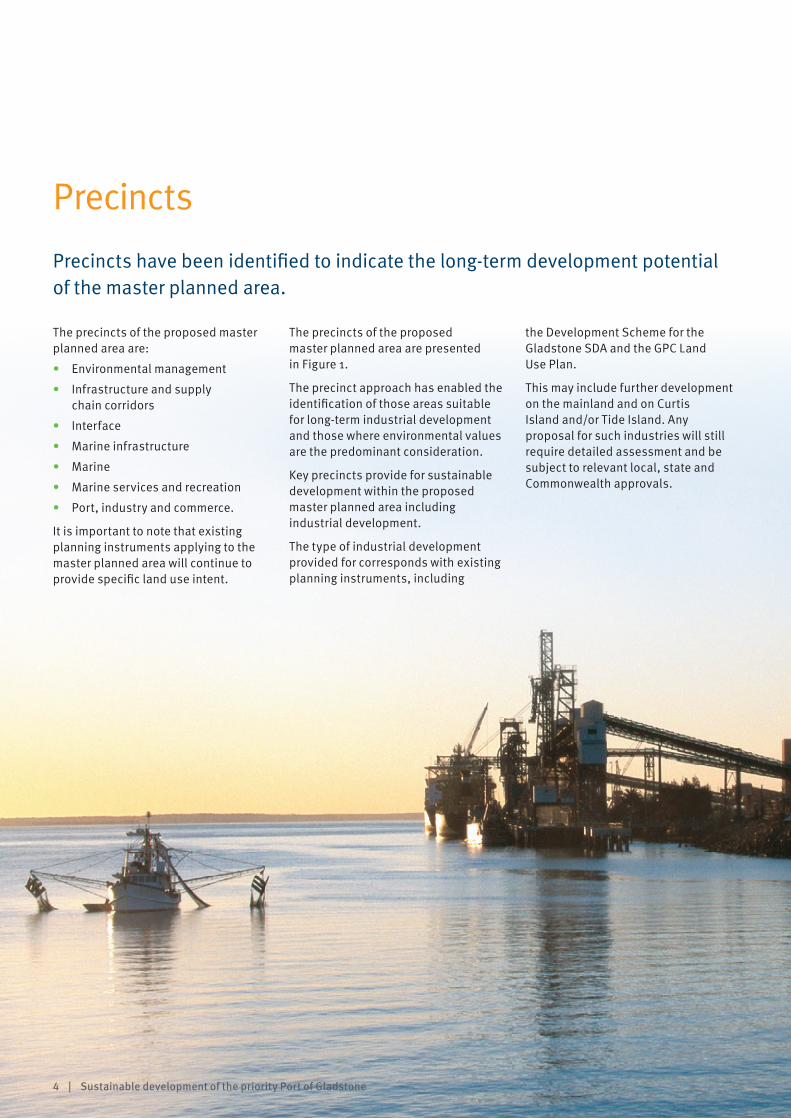
Precincts
Precincts have been identified to indicate the long-term development potential of the master planned area.
The precincts of the proposed master planned area are:
• Environmental management
• Infrastructure and supply chain corridors
• Interface
• Marine infrastructure
• Marine
• Marine services and recreation
• Port, industry and commerce.
It is important to note that existing planning instruments applying to the master planned area will continue to provide specific land use intent.
The precincts of the proposed master planned area are presented in Figure 1.
The precinct approach has enabled the identification of those areas suitable for long-term industrial development and those where environmental values are the predominant consideration.
Key precincts provide for sustainable development within the proposed master planned area including industrial development.
The type of industrial development provided for corresponds with existing planning instruments, including
the Development Scheme for the Gladstone SDA and the GPC Land Use Plan.
This may include further development on the mainland and on Curtis Island and/or Tide Island. Any proposal for such industries will still require detailed assessment and be subject to relevant local, state and Commonwealth approvals.
4 | Sustainable development of the priority Port of Gladstone

Draft master plan for the priority Port of Gladstone 28
Figure 3 – Priority Port of Gladstone master planned area precincts Figure 1: Proposed priority Port of Gladstone master planned area precinctsDraft master plan for the priority Port of Gladstone 29
Figure 4 – Priority Port of Gladstone master planned area precincts (inset)
5
REFER INSET
INSET

Growth of the priority Port of Gladstone
The priority Port of Gladstone represents important economic infrastructure for the state and its sustainable growth will enable opportunities for regional employment, trade and investment into the future.
Master planning for the priority Port of Gladstone has taken into consideration the priority port’s long-term growth outlook and sustainable development and provides for a port throughput of up to 294 million tonnes per annum by 2050.
The draft master plan:
• identifies and protects the land and marine areas, corridors and infrastructure critical to the port’s long-term future
• examines the opportunities for optimising infrastructure and supply chains associated with the port.
The draft master plan recognises the importance of land-based and marine-based infrastructure at the port and in the surrounding land and marine areas. Land-based infrastructure includes pipelines, conveyors, roads and rail lines and marine-based infrastructure includes maritime infrastructure such as jetties, wharves, berth pockets, swing basins and navigational channels critical for vessel access throughout the port.
The growth of the port and its port-related industries relies on the sustainable development of land and marine-based infrastructure. In turn these infrastructure types, indirectly or directly, rely on ongoing dredging activities at the priority Port of Gladstone.
The draft master plan acknowledges maintenance and capital dredging as an ongoing requirement for the port to maintain existing navigational channels, berth pockets and swing
basins and create new marine-based infrastructure, with a focus on safe and efficient vessel movement though Gladstone Harbour.
The Queensland Government’s Maintenance Dredging Strategy for Great Barrier Reef World Heritage Area Ports, released in 2016 in response to an action of Reef 2050, will guide the priority Port of Gladstone in its future maintenance dredging.
Under the Ports Act, capital dredging is prohibited for development of new and expansion of existing port facilities in the GBRWHA outside the priority ports. The Ports Act allows capital dredging within the priority Port of Gladstone master planned area however the material generated must not be deposited or disposed of in a restricted area unless the material is beneficially reused. A restricted area is any area that is within the GBRWHA but outside the Commonwealth marine park.
Beneficial reuse of dredged material may include land reclamation, beach nourishment or forms of environmental restoration. Master planning for the priority Port of Gladstone has enabled the identification of areas which may have the potential for the beneficial reuse of dredged material, subject to compliance with Commonwealth and state legislation.
Figure 2 is an indicative map presenting potential material placement areas at the priority Port of Gladstone. It is included in the draft master plan’s supporting documentation and informs the master planning process for the
priority Port of Gladstone. It does not infer government approval and any beneficial reuse of dredged material within the master planned area will require full assessment and statutory approvals prior to proceeding, including considerations of alternative dredged material beneficial reuse options.
Managing environmental values
The draft master plan, through the EMF and the precinct approach, supports the sustainable development of the port and its surrounding land and marine areas and will ensure environmental values, including the OUV of the GBRWHA, are effectively managed into the future.
The EMF assesses the potential impacts of port and port-related development on the identified environmental values within and surrounding the master planned area. It also outlines the objectives and measures to manage these potential impacts.
The EMF takes into consideration all potential development within each of the precincts and considers the potential material placement areas within the master planned area (Figure 2).
6 | Sustainable development of the priority Port of Gladstone

Figure 2: Potential material placement areas, Priority Port of Gladstone master planning preliminary draft port overlay
7
REFER INSET
INSET

An EMF is an important element of the master plan for the priority Port of Gladstone.
In accordance with the Ports Act the EMF:
• identifies and maps the environmental values within and surrounding the master planned area including the local expression of the OUV of the GBRWHA
• assesses the potential impacts of port and port-related development on these values
• outlines the objectives and measures to manage these potential impacts. The EMF adopts a precinct approach and includes objectives and measures for managing potential impacts on the identified environmental values within each precinct.
The objectives and measures will be implemented through the port overlay, including during planning processes such as development assessment and plan-making.
The draft port overlay will be prepared following the finalisation of the master plan and will be subject to public comment prior to its finalisation.
The EMF has been developed through a robust analysis of environmental values within and surrounding the master planned area and the potential impacts of development on these values with a focus on the principles of ecologically sustainable development. Figure 3 outlines the EMF development approach.
The EMF has been developed in consultation with GPC, the Gladstone Regional Council and other key stakeholders.
An independent advisors panel, representing environmental specialists, has also reviewed the EMF in the context of the draft master plan and has advised the state government that the EMF adequately considers the principles of ecologically sustainable development.
Outstanding Universal Value
The OUV of the GBRWHA has been an intrinsic consideration in master planning.
The EMF within the draft master plan identifies the local expression of OUV of the GBRWHA at the priority Port of Gladstone and its surrounding marine and land areas. This approach is consistent with Reef 2050 and the recommendations of the Independent Review of the Port of Gladstone (2013). The EMF requires the preparation of an environmental assessment guideline for the priority Port of Gladstone which will ensure OUV is consistently considered during environmental approval processes.
8 | Sustainable development of the priority Port of Gladstone
Environmental management framework

Figure 3: Priority port master planning EMF development approach
Priority port master planning – Environmental management framework
Sustainable Ports Development Act 2015
Environmental values contributing to the local expression of OUV of the Great Barrier Reef World Heritage Area (GBRWHA) are identified.
Risk assessment of environmental values contributing to the local expression of the OUV of GBRWHA – including presence, contribution and integrity of values.
Local expression of OUV of the GBRWHA is managed through relevant port overlay content.
Continued commitment to managing impacts on environmental values that contribute to local expression of OUV of the GBRWHA.
Intrinsic consideration of the Outstanding Universal Value of the Great Barrier Reef World Heritage Area
IdentificationIdentify and map environmental values in and surrounding the master planned area including:
• natural/physical
• social
• cultural
Risk assessmentAnalyse potential impacts on environmental values as a result of growth scenarios.
Consider how to manage potential impacts if they are not already addressed by existing management mechanisms.
Management measures and implementationDevelop priority management measures and objectives for managing potential impacts.
Review & improveReview effectiveness of priority management measures. Incorporate findings of the review into updates of the master plan and port overlay.
1 2 3 4

More information Visit www.statedevelopment.qld.gov.au/sustainableports
Email [email protected]
Phone +61 7 3452 7050
@QldEconDev