preliminary biological inventory of st. anne woods …
TRANSCRIPT

PRELIMINARY BIOLOGICAL INVENTORY OF ST. ANNE WOODS AND
WETLANDS, CAMPBELL COUNTY, KENTUCKY
FINAL REPORT
Submitted by
Kentucky State Nature Preserves Commission
801 Teton Trail
Frankfort, Kentucky 40601-1403
Prepared for
Campbell County Conservation District
Alexandria, Kentucky
January 2016

i
On the cover: Swamp Milkweed (Asclepias incarnata) at St. Anne Woods and Wetlands.
Photograph by Tara Littlefield, KSNPC.
Kentucky State Nature Preserves Contributing Staff (alphabetically)
Michael Compton, Aquatic Zoologist
Martina Hines, Ecologist
Ellis Laudermilk, Invertebrate Zoologist
Tara Littlefield, Botanist
Kyle Napier, Southeastern Regional Nature Preserve Manager
Brian Yahn, Ecologist
Additional terrestrial vertebrate surveys conducted by:
Jason Butler, Zoologist, Aquatic Resources Management LLC
ii
EXECUTIVE SUMMARY
A preliminary biological inventory of St. Anne Woods and Wetlands (SAWW) was conducted
by the Kentucky State Nature Preserves Commission in 2014-2015. A synopsis of the findings is
presented below.
A total of 451 species was found at SAWW during this study.
There were 227 vascular plants documented for SAWW; approximately 19% percent of
the flora is non-native.
No federally listed plants were found at SAWW; however, one state-listed plant was
found, the Spinulose Woodfern (Dryopteris carthusiana). It is listed as special concern.
Forty-four non-native plants were found, of which twenty-eight are listed as exotic
invasive by the Kentucky Exotic Pest Plant Council.
This study documented 12 dragonfly and damselfly, 3 beetle, 32 butterfly, 70 moth, and 1
hornet taxa from the SAWW for a total of 118 insect taxa. No state or federally listed
species were observed. The most notable finds were the second Kentucky record of the
Sociable Renia Moth (Renia factiosalis), and a population of the American Copper
butterfly (Lycaena phlaeus) found in a meadow along KY 8. The meadow also provides
good habitat for many pollinator species not documented in the study.
Terrestrial vertebrate surveys yielded 11 amphibian, 3 reptile, 71 bird, and 21 mammal
species. Eight bat species were encountered. Big Brown (Eptesicus fuscus) and Northern
Red (Lasiurus borealis) bats were captured in nets and identified through software
analysis of the acoustic recordings. Tricolored (Perimyotis subflavus) and Gray (Myotis
grisescens) bats were also identified through call analysis with high probability. Lower
probability and single call hits indicated Indiana (Myotis sodalis), Little Brown (Myotis
lucifugus), Hoary (Lasiurus cinereus) and Silver-haired (Lasionycteris noctivagans) bats
may also be present on the property. Gray and Indiana bats are federally endangered and
in decline. Little Brown and Tricolored bats and are also in decline due to the spread of
White-nose Syndrome.
Natural community surveys revealed a total of 13 communities that in general have been
heavily disturbed (logging, agriculture, etc.) since European settlement with much of the
existing forests heavily degraded. The remaining forested areas vary in their land-use
history (young to mature), with only one 14 acre area of low disturbance, older growth
and better quality (natural); the rest is of lower quality (semi-natural and anthropogenic).

iii
TABLE OF CONTENTS
TABLE OF CONTENTS ............................................................................................................ iii
LIST OF FIGURES ...................................................................................................................... v
LIST OF TABLES ....................................................................................................................... vi
INTRODUCTION......................................................................................................................... 1
STUDY AREA DESCRIPTION .................................................................................................. 1
General ........................................................................................................................................ 1
Geology and Physiographic Position .......................................................................................... 3
Soils............................................................................................................................................. 6
METHODS .................................................................................................................................... 8
Botanical Inventories .................................................................................................................. 8
Insects ..................................................................................................................................... 9
Terrestrial Vertebrates ............................................................................................................ 9
Aquatic Fauna ....................................................................................................................... 10
Ecological Community Inventories .......................................................................................... 10
Community Classification and Delineation .............................................................................. 10
Vegetation Communities: Natural vs. Semi-natural vs. Anthropogenic............................... 10
RESULTS AND DISCUSSION ................................................................................................. 12
Botanical Inventories ................................................................................................................ 12
General Flora ........................................................................................................................ 12
KSNPC- listed Plants ............................................................................................................ 12
Invasive Plants ...................................................................................................................... 14
Zoological Inventories .............................................................................................................. 14
Insects ................................................................................................................................... 14
iv
Invasive Insects ..................................................................................................................... 20
Terrestrial Vertebrates .......................................................................................................... 20
Aquatic Fauna ....................................................................................................................... 24
Ecological Community Inventories .......................................................................................... 27
ACKNOWLEDGMENTS .......................................................................................................... 38
LITERATURE CITED .............................................................................................................. 39
APPENDIX 1. SPECIES LIST, ARRANGED ALPHABETICALLY BY SPECIES NAME
WITHIN EACH GROUP, FOR ST. ANNE WOODS AND WETLANDS. .......................... 41

v
LIST OF FIGURES
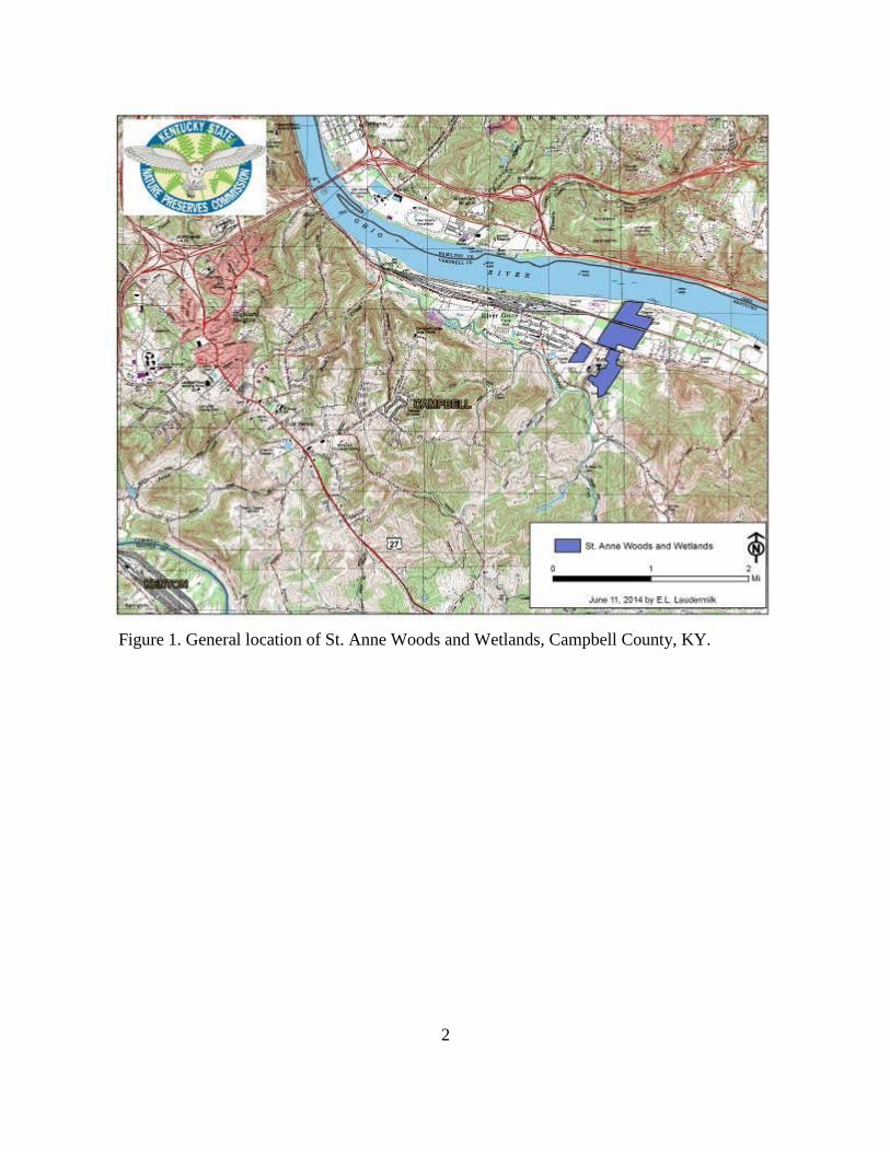
Figure 1. General location of St. Anne Woods and Wetlands, Campbell County, KY. ................. 2
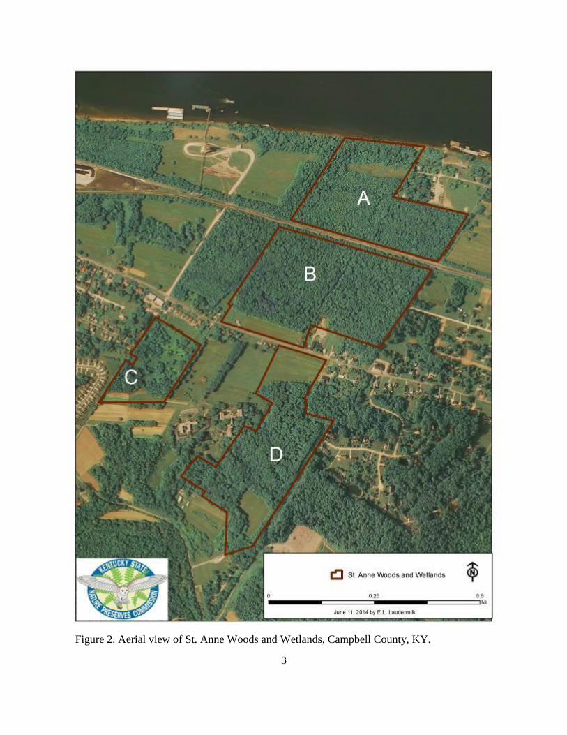
Figure 2. Aerial view of St. Anne Woods and Wetlands, Campbell County, KY. ......................... 3
Figure 3. Geology of St. Anne Woods and Wetlands, Campbell County, KY. .............................. 5
Figure 4. Soils of St. Anne Woods and Wetlands, Campbell County, KY. ................................... 7
Figure 5. Spinulose Woodfern (Dryopteris carthusiana). Photograph by Tara Littlefield. ......... 12
Figure 6. Location of state-listed plants at St. Anne Woods and Wetlands.................................. 13
Figure 7. Sociable Renia Moth (Renia factiosalis). Photograph by Loran D. Gibson. ................ 15
Figure 8. The American Copper (Lycaena phlaeas). Photograph by Ellis L. Laudermilk. .......... 16
Figure 9. The Giving Fields, a communal garden near St. Anne Woods and Wetlands.
Photograph by Tara Littlefield. ..................................................................................................... 17
Figure 10. American Copper and other pollinator habitat. ........................................................... 18
Figure 11. Communal vegetable gardens in proximity to meadow pollinator habitat. ................. 19
Figure 12. Streamside Salamander (Ambystoma barbouri). Photograph by Jason Butler. ........... 21
Figure 13. Southern Ravine Salamander (Plethodon richmondi). Photograph by Jason Butler... 22
Figure 14. Common Gartersnake (Thamnophis sirtalis). Photograph by Jason Butler. ............... 23
Figure 15. Wetland habitat surveyed within Tract A, October 8, 2014. Photograph by Mike
Compton. ....................................................................................................................................... 25
Figure 16. Crayfish burrow entrance, Tract A. Photograph by Mike Compton. .......................... 26
Figure 17. Ortmann's Mudbug (Cambarus ortmanni), Tract A. Photograph by Mike Compton. 27
Figure 18. Vegetation communities of St. Anne Woods and Wetlands. ...................................... 36
Figure 19. Photos of selected natural, semi-natural, and anthropogenic communities (a-f). ....... 37

vi
LIST OF TABLES
Table 1. Vegetation Communties of St. Anne Woods and Wetlands. .......................................... 28

1
INTRODUCTION
The Campbell County Conservation District acquired St. Anne Woods and Wetlands
(SAWW) from the Congregation of Divine Providence, St. Anne Province Center in Melbourne,
Kentucky with funding from the Kentucky Heritage Land Conservation Fund (KHLCF). Under
the regulations that govern the use of lands acquired through the KHLCF a final resource
management plan must be developed for SAWW. This report provides the results of a
preliminary biological inventory completed by the Kentucky State Nature Preserves Commission
(KSNPC) as part of the requirements for the management plan.
STUDY AREA DESCRIPTION
General
St. Anne Woods and Wetlands is located in eastern Campbell County near the
community of Melbourne, Kentucky (Figure 1). Four distinct tracts make up SAWW and they
were lineated as “A – D” in Figure 2 for descriptive purposes throughout this report. Tracts A
and B are north of KY 8 and are separated by a railroad; Tract A is bordered by the Ohio River
to the north. Tracts C and D are south of KY 8 and near the main campus of the St. Anne
Province Center (Figure 2). Tract A is approximately 16.79 hectares (41.24 acres) and B is
approximately 22.60 hectares (55.84 acres) in size; Tract C is approximately 6.61 hectares (16.33
acres) and D is approximately 18.60 hectares (45.96 acres) in size. Elevation of the site ranges
from approximately 470-650 feet above mean sea level.
2
Figure 1. General location of St. Anne Woods and Wetlands, Campbell County, KY.
3
Figure 2. Aerial view of St. Anne Woods and Wetlands, Campbell County, KY.

4
Geology and Physiographic Position
St. Anne Woods and Wetlands is located within the Bluegrass Natural Region of the
Interior Low Plateaus Physiographic Province (Quarterman and Powell 1978; Abernathy et al.
2010). The Bluegrass is an ancient, eroded limestone dome that is characterized by rolling to
steep hills with entrenched cliff-lined rivers and streams (Abernathy et al. 2010).
Tracts A, B, and the northern sections of C and D are underlain with Quaternary-age
Alluvium. A railroad separates tracts A and B, and is underlain with artificial fill. The southern
half of Tract C is underlain with Quaternary-age Glacial Outwash. Tract D is the most
geologically diverse of the four tracts. Most of the southern two-thirds of this tract is underlain
with Quaternary-age Loess, with the exception of a small band of Illinoian Glacial Drift in the
southern one-third of the tract. A band of Glacial Outwash found in Tract C extends east into the
northern one-third of Tract D. A small area located between the Glacial Outwash and Loess of
Tract D is underlain with the Kope Formation of Ordivician age. A detailed delineation of the
geology of SAWW is found in Figure 3 and Gibbons (1973).

5
Figure 3. Geology of St. Anne Woods and Wetlands, Campbell County, KY.

6
Soils
Tracts A-D as delineated in Figure 2 will be used to describe the soils of SAWW. Soils are
described generally from a north to south direction. Tract A consists of Huntington Silt Loam
(Hu), Wheeling Silt Loam (2-6% slopes) (WhB), Avonburg Silt Loam (Av), Robertsville Silt
Loam (Ro), Alluvial Land (AlD), Rossmoyne Silt Loam (RsB), and Newark Silt Loam (Nk)
(Figure 4).
Tract B consists of Newark Silt Loam (Nk), Rossmoyne Silt Loam (RsB), Wheeling Silt Loam
(2-6% slopes) (WhB), Avonburg Silt Loam (Av), and Ashton Silt Loam (AsB).
Tract C consists of Robertsville Silt Loam (Ro), Wheeling Silt Loam (6-12% slopes) (WhC),
Wheeling Silt Loam (2-6% slopes) (WhB), Avonburg Silt Loam (Av), Alluvial Land (AlD), and
Lakin Loamy Fine Sand (2-12% slopes) (LaC).
Tract D consists of Lakin Loamy Fine Sand (0-2% slopes) (LaA), Brashear Silty Clay (12-20%
slopes) (BsD3), Eden Silty Clay Loam (20-35% slopes) (EdE2), Alluvial Land (AlD), Wheeling
Silt Loam (6-12% slopes) (WhC), Rossmoyne Silt Loam (RsB), Licking Silty Clay Loam (LIC),
and Lakin Loamy Fine Sand (2-12% slopes) (LaC). Figure 4 provides a complete delineation of
soil types in the area.

7
Figure 4. Soils of St. Anne Woods and Wetlands, Campbell County, KY.

8
METHODS
Botanical Inventories
All plant species found while surveying the site were noted or, where necessary, collected
for identification. Specimens are housed at the Kentucky State Nature Preserves Commission
and are expected to be processed and deposited in the Eastern Kentucky University Herbarium.
Botanical surveys were conducted in spring, summer and fall. The majority of the site was
surveyed at least once and most areas were visited multiple times. In particular, specialized
habitats (wetlands, mature forests) were identified through analyzing maps (aerial, LIDAR shade
relief, topographic, soils and geology) and were given the highest priority for surveying.
During the botanical survey notes were taken regarding the location/habitat type and
abundance of native and exotic species. Abundance is an ecological term that refers to the
distribution of a species within a given area. We used a simple, qualitative 5-level scale ACFOR,
which stands for: abundant, common, frequent, occasional and rare.
Relative Abundance Scale:
R (Rare): 1–25 plants or colonies, few populations very difficult to find in one or two locations;
O (Occasional): 25–100 plants or colonies, distributed populations found in some locations;
F (Frequent): 100–500 plants or colonies, well distributed populations found in several locations;
C (Common): 500–1000 plants or colonies, populations commonly found in many locations;
A (Abundant): greater than 1000 plants or colonies, plentiful populations throughout of
diagnostic, characteristic, or dominant species in numerous locations.
Scientific nomenclature and common names for plants follow the USDA plant database
(USDA 2015) and Flora of North America (FNAEC 1993+). Weakley’s (2015) flora and Jones
(2005) were used for plant identifications, and the KSNPC database (KSNPC 2014) and Julian
Campbell’s Atlas of Kentucky Plants (Campbell 2015) were referenced to access plant
distributions across the state.
The Kentucky Exotic Pest Plant Council (KEPPC 2013) maintains a list of plants that
present either a severe, significant, or lesser threat based on their ability to invade native plant
communities and displace native plants. This list was used to identify those pest plants that could
threaten the area’s biological integrity.
In addition, Northern Kentucky University Herbarium Curator Maggie Whitson and
several students have collected botanical specimens from SAWW. Their collections were
analyzed, and any species that was not already reported by KSNPC was included in the report.
9
Zoological Inventories
Insects
No known insect surveys of the SAWW have been conducted, and surveys for insects in
Campbell County in general are limited (Covell 1999; Covell et al. 2013). Previous surveys for
insects in the Campbell County recorded only 7 damselfly and dragonfly species (Laudermilk
and Cook, unpublished data) and 88 butterfly and moth taxa (Covell 1999; Covell et al. 2013).
Insect species diversity and time and funding constraints required the inventory to focus
on a manageable subset of insects. Butterflies and moths (Lepidoptera) and damselflies and
dragonflies (Odonata), hereafter collectively referred to simply as “insects” were the target
groups. Nomenclature sources were: butterflies (Pelham 2008), moths (Covell 1984; MPG
2013), damselflies (Westfall and May 2006), and dragonflies (Needham et al. 2000).
Diurnal insects were sampled during the spring, summer, and early fall seasons (see
Appendix 1 for collection dates). All diurnal insects were identified in the field with the
assistance of a pair of 8 x 32 Kahles binoculars. Some individuals were caught with an aerial
insect net, identified, and released.
On July 10, 2014 Mr. Loran Gibson conducted nocturnal sampling for moths using
blacklight bucket traps with 8 – and 15 – watt bulbs, respectively. Three traps were left overnight
in Tract B, and one was left overnight in Tract D. One of the 8-watt traps placed in the woods of
Tract B was stolen and never recovered. Additional nocturnal sampling was not conducted.
Terrestrial Vertebrates
Amphibian, reptile and mammal observations were gathered through daytime encounter
searches on March 15, 2015 and May 9, 2015 and a nighttime encounter search on August 7,
2015. Techniques included dipnetting aquatic habitat, searching beneath cover such as logs and
stones, visually scanning terrestrial habitat, listening for frog and mammal vocalizations, and
looking for tracks in soft-soil areas.
Bats were surveyed on August 7th through mist-netting and acoustic monitoring using
two Anabat SD2 recorders (Titley Scientific, Columbia, MO). The recorders were set on
opposite ends of the wet meadow on the northern portion of the property adjacent to the Ohio
River (Tract A). Call analysis was performed through ECHOCLASS v 3.1 (U.S. Army Engineer
Research and Development Center) using the default settings.
Birds were identified visually with the assistance of binoculars or by the songs of singing
males. Surveys conducted on May 5, 2014 were particularly productive since it was near the
peak of the spring migration. Nomenclature for all terrestrial vertebrates followed NatureServe
(2016).
10
Aquatic Fauna
Aquatic surveys were conducted within wetland habitats and focused on crayfish because
the SAWW property lacked permanent flowing water. Very few crayfish records exist within
Campbell County, and they are mostly limited to the mainstem Licking River (Taylor and
Schuster 2004). Crayfish inhabit most aquatic habitats, but records for wetland areas are sporadic
because individuals often burrow and reside underground, which makes them difficult to collect.
On October 8, 2014 crayfish surveys were conducted within tracts A and B. Surveys
consisted of walking the tracts looking for specific areas that may support crayfish. Typically,
evidence of recent crayfish activity and crayfish burrows are strong signals that live crayfish
could be encountered. Once an area was identified, burrows were excavated by hand and shovel
to reach the groundwater table where specimens could be extracted from their burrows more
easily by hand.
Ecological Community Inventories
Community Classification and Delineation
A vegetation classification was developed for SAWW, including a vegetation community
map and a brief description of each community. Classifying the vegetation of this property is
based on data collected during field surveys (spring to summer 2014), an evaluation of aerial
photographs ((primarily USDA-NAIP/KY EPPC color digital orthophotography (2006, 2012,
2014) and USGS/KY EPPC digital orthophoto quadrangle (1993-1996)) and information
gathered from soil surveys (Weisenberger et al. 1973).
Areas not ground surveyed that share similar vegetation cover-type, geology, soils and/or
topographic position with surveyed areas were assumed to have similar species composition and
community type. Past disturbance from clearing, logging, etc. (using aerial photos and topo
maps) helped determine semi-natural and anthropogenic communities not surveyed. KSNPC
classifies vegetative types as natural, semi-natural or anthropogenic (i.e., unnaturally disturbed or
modified) (see descriptions below).
Vegetation Communities: Natural vs. Semi-natural vs. Anthropogenic
Communities described as natural include any plant community adapted to the changes
imposed by the natural environment and which is relatively undisturbed by humans (or has
recovered sufficiently from previous disturbances) and has the flora and fauna that represents, to
the best of KSNPC’s knowledge, the natural (ecological) communities that existed in Kentucky
at the time of European settlement.
Communities described as semi-natural include any plant community altered from its
natural state but still functioning similar to this original (natural) state by maintaining species
composition and community structure (at some recognizable level). Disturbance-tolerant
invasive species usually occur, but in limited numbers.
11
Communities classified as anthropogenic include any plant community heavily-altered
from its natural state and functioning in response to stressors and manipulations applied by
humans. These are mostly composed of plant species that thrive under disturbed soils and intense
environmental changes (i.e., light exposure, temperature, and hydrology). This may be caused by
the drainage of wetlands, the removal or degradation of the natural vegetation (e.g., removal of
trees and understory), removal of soil and/or bedrock, modification by planting (e.g., agricultural
fields), intense grazing or mowing and/or subsequent successional changes. For more
information, please see the semi-natural and anthropogenic communities 2011 draft classification
for descriptions of communities and their conditions (KSNPC 2011).
Note: Northern Kentucky University (NKU) faculty and students have conducted research at
SAWW over the years. With the exception of botanical data referenced above, those data could
not be obtained for this report. For information about those studies, please contact the NKU
Department of Biological Sciences.

12
RESULTS AND DISCUSSION
Botanical Inventories
General Flora
The annotated checklist of the flora is arranged alphabetically by genus and species
(Appendix 1). There were 227 vascular plants documented at SAWW. Approximately 19% of
the flora is non-native.
KSNPC- listed Plants
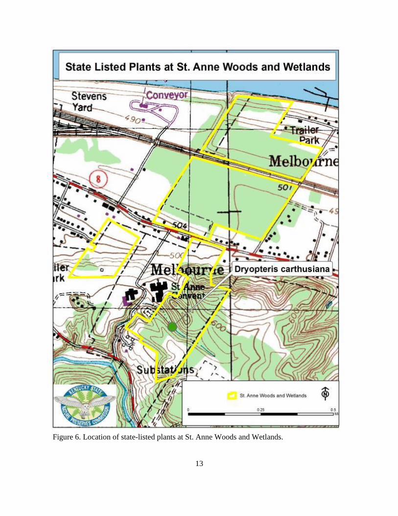
No federally listed plants were found at SAWW; however, one state-listed plant was
found, the Spinulose Woodfern (Dryopteris carthusiana). It is state-listed as special concern.
The location of the Spinulose Woodfern population is shown in Figure 5.
Figure 5. Spinulose Woodfern (Dryopteris carthusiana). Photograph by Tara Littlefield.
13
Figure 6. Location of state-listed plants at St. Anne Woods and Wetlands.
14
Invasive Plants
Forty-four non-native plants were found at SAWW, of which twenty-eight are listed as
exotic invasive by the Kentucky Exotic Pest Plant Council (KY-EPPC) (see Appendix 1, the
general list of flora). Japanese Honeysuckle (Lonicera japonica), Amur Honeysuckle (Lonicera
maackii) and Multiflora Rose (Rosa multiflora) were widely scattered throughout the site. Some
of the higher priorities for management, if the goal is to preserve the native floristic diversity at
this site, would be to address the invasive plants in the higher quality communities (see Figure 18
indicating higher quality community types) and also to focus in areas with listed plant
occurrences (see Figure 6 listed plants).
Focusing on the calcareous mesophytic forest in Tract D by removing Garlic Mustard
(Alliaria petiolata), Nepalese Browntop (Microstegium vimineum), Amur Honeysuckle, and
Japanese Honeysuckle in this higher quality community not only would preserve the integrity of
this maturing forest type, but would benefit the Spinulose Woodfern that is also found within this
forest. Focusing on removing the invasive plants around the Spinulose Woodfern population first
and then expanding to the larger calcareous mesophytic forest (14 acres) would be a noble goal.
The wetland areas, including the open wetlands, riparian forests, and bottomland hardwood
forests, have numerous severe threats from invasive plants, including Japanese Chaff Flower
(Achyranthes japonica), Small Carpgrass (Arthraxon hispidus), Japanese Honeysuckle and Amur
Honeysuckle.
Zoological Inventories
Insects
This study documented 12 dragonfly and damselfly, 3 beetle (incidental observations), 32
butterfly, 70 moth, and 1 hornet taxa from SAWW for a total of 118 insect taxa (Appendix 1).
No state or federally listed species were observed in the project area, and most species are
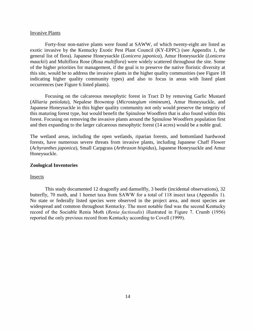
widespread and common throughout Kentucky. The most notable find was the second Kentucky
record of the Sociable Renia Moth (Renia factiosalis) illustrated in Figure 7. Crumb (1956)
reported the only previous record from Kentucky according to Covell (1999).
15
Figure 7. Sociable Renia Moth (Renia factiosalis). Photograph by Loran D. Gibson.
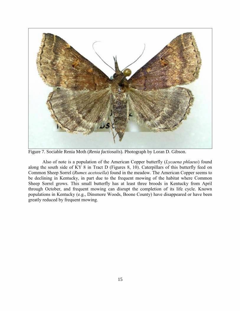
Also of note is a population of the American Copper butterfly (Lycaena phlaeus) found
along the south side of KY 8 in Tract D (Figures 8, 10). Caterpillars of this butterfly feed on
Common Sheep Sorrel (Rumex acetosella) found in the meadow. The American Copper seems to
be declining in Kentucky, in part due to the frequent mowing of the habitat where Common
Sheep Sorrel grows. This small butterfly has at least three broods in Kentucky from April
through October, and frequent mowing can disrupt the completion of its life cycle. Known
populations in Kentucky (e.g., Dinsmore Woods, Boone County) have disappeared or have been
greatly reduced by frequent mowing.
16
Figure 8. The American Copper (Lycaena phlaeas). Photograph by Ellis L. Laudermilk.
The meadow where the American Copper is found is also good habitat for native bees
and other pollinators, providing a place for them to gather pollen and nectar, rear young, and for
adults of some species to overwinter. Many native bees were observed nectaring on favorite
flowers, such as Indianhemp (Apocynum cannabinum), in this meadow. Native bees, beetles,
flies, and butterflies and moths, etc. are part of the pollinator community, and many pollinators
are suffering well known declines locally, nationally, and even globally. Pollinators are required
by most native plants, as well as fruit and vegetable gardens, orchards, and flower gardens in the
area. They are critical to the food supply for humans. The presence of native pollinators can
increase quality, and the size and yields of fruits and vegetables and many other crops (Garibaldi
2013; Klatt, et al. 2013; Mallinger and Gratton 2014).
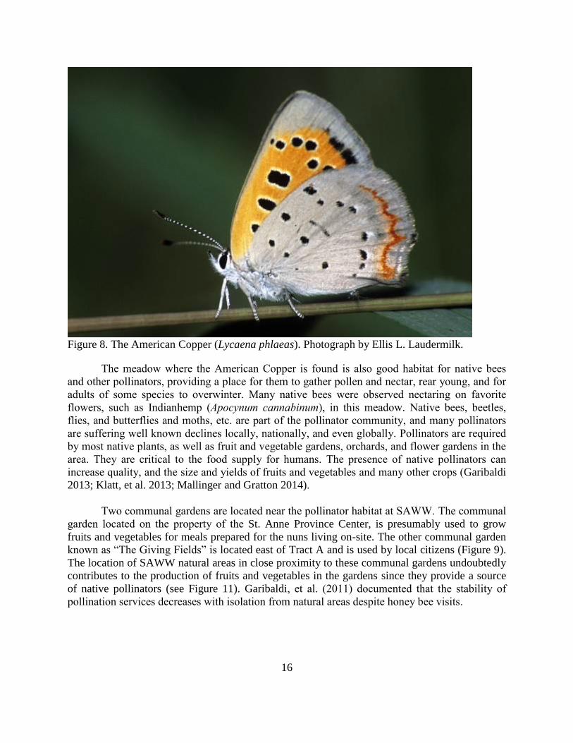
Two communal gardens are located near the pollinator habitat at SAWW. The communal
garden located on the property of the St. Anne Province Center, is presumably used to grow
fruits and vegetables for meals prepared for the nuns living on-site. The other communal garden
known as “The Giving Fields” is located east of Tract A and is used by local citizens (Figure 9).
The location of SAWW natural areas in close proximity to these communal gardens undoubtedly
contributes to the production of fruits and vegetables in the gardens since they provide a source
of native pollinators (see Figure 11). Garibaldi, et al. (2011) documented that the stability of
pollination services decreases with isolation from natural areas despite honey bee visits.
17
Figure 9. The Giving Fields, a communal garden near St. Anne Woods and Wetlands.
Photograph by Tara Littlefield.
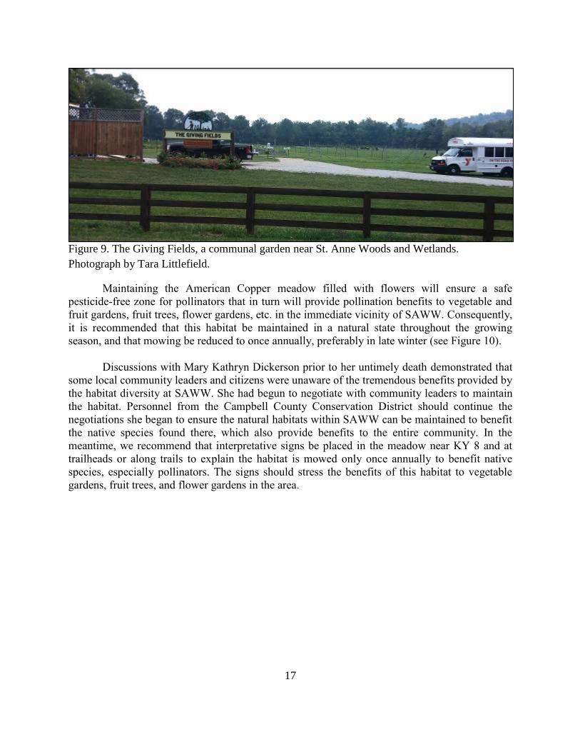
Maintaining the American Copper meadow filled with flowers will ensure a safe
pesticide-free zone for pollinators that in turn will provide pollination benefits to vegetable and
fruit gardens, fruit trees, flower gardens, etc. in the immediate vicinity of SAWW. Consequently,
it is recommended that this habitat be maintained in a natural state throughout the growing
season, and that mowing be reduced to once annually, preferably in late winter (see Figure 10).
Discussions with Mary Kathryn Dickerson prior to her untimely death demonstrated that
some local community leaders and citizens were unaware of the tremendous benefits provided by
the habitat diversity at SAWW. She had begun to negotiate with community leaders to maintain
the habitat. Personnel from the Campbell County Conservation District should continue the
negotiations she began to ensure the natural habitats within SAWW can be maintained to benefit
the native species found there, which also provide benefits to the entire community. In the
meantime, we recommend that interpretative signs be placed in the meadow near KY 8 and at
trailheads or along trails to explain the habitat is mowed only once annually to benefit native
species, especially pollinators. The signs should stress the benefits of this habitat to vegetable
gardens, fruit trees, and flower gardens in the area.

18
Figure 10. American Copper and other pollinator habitat.

19
Figure 11. Communal vegetable gardens in proximity to meadow pollinator habitat.

20
These survey results do not represent a comprehensive inventory of insects or even any
of the insect groups sampled. The adults of many insects are active for only a short time making
them difficult to detect. Undoubtedly, hundreds of additional insect species seasonally or
periodically use the tracts, and a thorough inventory would require sampling multiple habitats at
least every two or three weeks minimally from March through November. Intensive surveys such
as these are usually cost-prohibitive.
Invasive Insects
The evidence of larval feeding sign of the Emerald Ash Borer (Agrilus planipennis) is
widespread throughout the Inner Bluegrass and SAWW. Campbell County is one of ten
Kentucky counties considered to have a high infestation of this invasive beetle as of 2014 (COA
2015). It should be assumed that without treatment of individual ash trees many will die as a
result of this invasive insect.
Terrestrial Vertebrates
Terrestrial vertebrate surveys yielded 72 bird, 11 amphibian, 3 reptile, and 21 mammal
species during multiple visits. On 15 March 2015 four salamander species were observed in the
small, forested watershed behind the covenant building (Tract D) including a Streamside
Salamander (Ambystoma barbouri) guarding eggs within the stream. Two-lined Salamanders
(Eurycea cirrigera) were abundant in the stream; Jefferson’s (Ambystoma jeffersonianum) and
Southern Ravine salamanders (Plethodon richmondi) were found under logs and rocks in the
riparian area. The northern tracts of the property (Tracts A and B) were inundated by the Ohio
River and were inaccessible, although Spring Peepers (Pseudacris crucifer) were heard calling
from the forest. Later in the spring, after the Ohio River floodwaters had retreated, five frog
species (Acris crepitans, Anaxayrus americanus, Hyla chrysoscelis, Lithobates catesbeiana, L.
clamitans) and Marbled Salamander (Ambystoma opacum) were observed in the pools of the wet
meadow along the northern boundary of the property (Tract A). A nighttime summer visit also
produced observations of breeding frogs. The observed amphibian assemblage is typical for the
area.

21
Figure 12. Streamside Salamander (Ambystoma barbouri). Photograph by Jason Butler.

22
Figure 13. Southern Ravine Salamander (Plethodon richmondi). Photograph by Jason Butler.
23
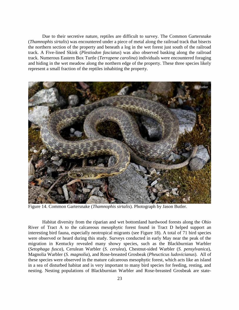
Due to their secretive nature, reptiles are difficult to survey. The Common Gartersnake
(Thamnophis sirtalis) was encountered under a piece of metal along the railroad track that bisects
the northern section of the property and beneath a log in the wet forest just south of the railroad
track. A Five-lined Skink (Plestiodon fasciatus) was also observed basking along the railroad
track. Numerous Eastern Box Turtle (Terrapene carolina) individuals were encountered foraging
and hiding in the wet meadow along the northern edge of the property. These three species likely
represent a small fraction of the reptiles inhabiting the property.
Figure 14. Common Gartersnake (Thamnophis sirtalis). Photograph by Jason Butler.
Habitat diversity from the riparian and wet bottomland hardwood forests along the Ohio
River of Tract A to the calcareous mesophytic forest found in Tract D helped support an
interesting bird fauna, especially neotropical migrants (see Figure 18). A total of 71 bird species
were observed or heard during this study. Surveys conducted in early May near the peak of the
migration in Kentucky revealed many showy species, such as the Blackburnian Warbler
(Setophaga fusca), Cerulean Warbler (S. cerulea), Chestnut-sided Warbler (S. pensylvanica),
Magnolia Warbler (S. magnolia), and Rose-breasted Grosbeak (Pheucticus ludovicianus). All of
these species were observed in the mature calcareous mesophytic forest, which acts like an island
in a sea of disturbed habitat and is very important to many bird species for feeding, resting, and
nesting. Nesting populations of Blackburnian Warbler and Rose-breasted Grosbeak are state-

24
listed as threatened and special concern, respectively; however, no nests or nesting activity was
observed and these observations likely represented migrants passing through Kentucky on their
way to northern breeding sites.
The mammals encountered on the property are common in the region, with the exception
of some of the bats identified through acoustic analysis. Eastern Chipmunk (Tamias striatus),
Eastern Gray Squirrel (Sciurus carolinensis) and Eastern Fox Squirrel (Sciurus niger) were
observed foraging within and along the forests. White-tailed Deer (Odocoileus virginianus),
Raccoon (Procyon lotor), and Striped Skunk (Mephitis mephitis) tracks were observed along the
headwater stream behind the covenant building. A Virginia Opossum (Didelphis virginiana)
skeleton was observed on the railroad tracks. A Short-tailed Shrew (Blarina brevicauda) was
found in a pitfall trap.
A nighttime mist-netting and acoustic survey for bats in the wet meadow located within
Tract A produced observations of eight species. Big Brown Bat (Eptesicus fuscus) and Northern
Red Bat (Lasiurus borealis) were captured in nets and identified through software analysis of the
acoustic recordings. Tricolored Bat (Perimyotis subflavus) and Gray Bat (Myotis grisescens)
were also identified through call analysis with high probability. Lower probability and single call
hits indicated Indiana Bat (Myotis sodalis), Little Brown Bat (Myotis lucifugus), Hoary Bat
(Lasiurus cinereus) and Silver-haired Bat (Lasionycteris noctivagans) may also be present on the
property. Gray and Indiana bats are federally endangered and in decline. Little Brown and
Tricolored bats are also in decline due to the spread of White-nose Syndrome.
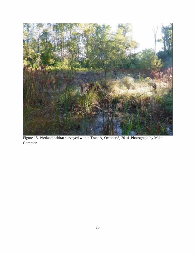
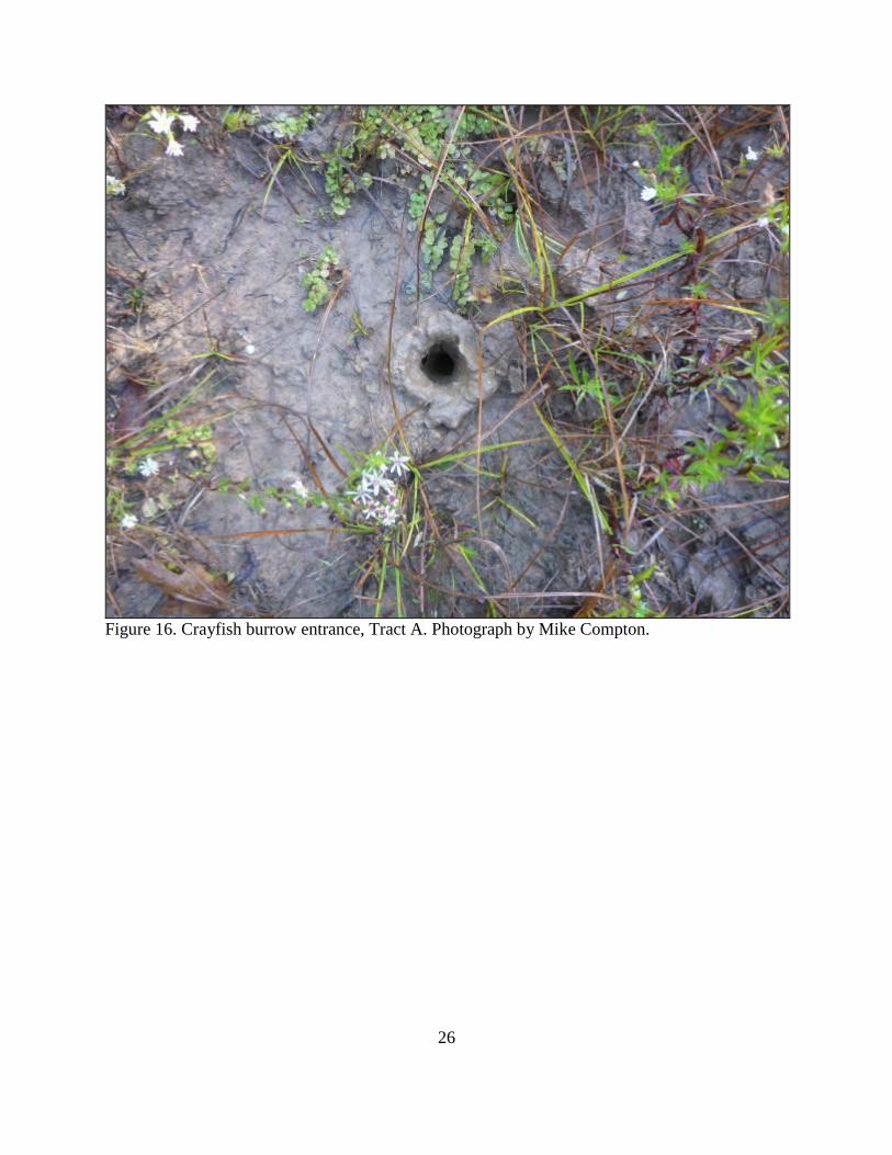
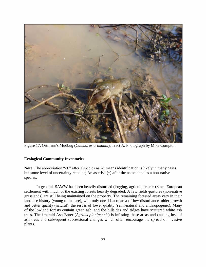
Aquatic Fauna
Surveys were conducted within Tract A and Tract B on October 8, 2014. The habitat
surveyed within Tract A was an open wetland with shallow standing water (Figure 15). Several
burrows were excavated (Figure 16) and four specimens of Ortmann’s Mudbug (Cambarus
ortmanni) were encountered (Figure 17). The habitats surveyed within Tract B were forested
wetland habitat adjacent to a dry stream channel, and within the stream channel itself. There was
no standing water observed within Tract B at the time of the survey. However, evidence of
recent crayfish activity was present and several burrows were excavated. Five specimens of C.
ortmanni were encountered.
Cambarus ortmanni is considered a primary and secondary burrower and commonly
found in hydric soils (Taylor and Schuster 2004). The specimens encountered from Tracts A and
B are the first documented accounts for C. ortmanni in Campbell County according to Taylor
and Schuster (2004). However, C. ortmanni has been documented from nearby Boone, Kenton,
and Bracken counties. The discovery of C. ortmanni from Campbell County is most likely a
reflection of the lack of crayfish surveys within the county, especially from wetland habitats.
25
Figure 15. Wetland habitat surveyed within Tract A, October 8, 2014. Photograph by Mike
Compton.
26
Figure 16. Crayfish burrow entrance, Tract A. Photograph by Mike Compton.
27
Figure 17. Ortmann's Mudbug (Cambarus ortmanni), Tract A. Photograph by Mike Compton.
Ecological Community Inventories
Note: The abbreviation “cf.” after a species name means identification is likely in many cases,
but some level of uncertainty remains; An asterisk (*) after the name denotes a non-native
species.
In general, SAWW has been heavily disturbed (logging, agriculture, etc.) since European
settlement with much of the existing forests heavily degraded. A few fields-pastures (non-native
grasslands) are still being maintained on the property. The remaining forested areas vary in their
land-use history (young to mature), with only one 14 acre area of low disturbance, older growth
and better quality (natural); the rest is of lower quality (semi-natural and anthropogenic). Many
of the lowland forests contain green ash, and the hillsides and ridges have scattered white ash
trees. The Emerald Ash Borer (Agrilus planipennis) is infesting these areas and causing loss of
ash trees and subsequent successional changes which often encourage the spread of invasive
plants.

28
The 14 acre area, mentioned above, has been classified as a natural community (highest
quality that can occur) for SAWW, representing 8.8% of the property (this Calcareous
mesophytic forest was delineated using KSNPC’s 2009 draft classification) (KSNPC 2009). As
mentioned, the rest of the property is made up of lightly to heavily disturbed communities, a total
of 12 communities covering 91.2% of the property. These semi-natural and anthropogenic
communities have been delineated using a 2011 draft classification (KSNPC 2011).
Table 1. Vegetation Communities of St. Anne Woods and Wetlands.
Natural and Semi-natural Communities:
organized from mesic to wet (bold = natural) Anthropogenic Communities:
organized by structure: non-forest vs. forest
Calcareous mesophytic forest Non-forest
Calcareous mesophytic forest (stressed) Disturbed wet grassland/marsh/meadow
Riparian forest (stressed) Mixed tree/shrub thicket
Bottomland hardwood forest (stressed) Non-native grassland/field
Wet bottomland hardwood forest (altered
hydroperiod)
Urban
Wet bottomland hardwood forest
(successional)
Forest
Disturbed deciduous forest
Disturbed wet forest/swamp
Planted deciduous forest
Calcareous mesophytic forest Area mapped: 14 acres or 8.8%
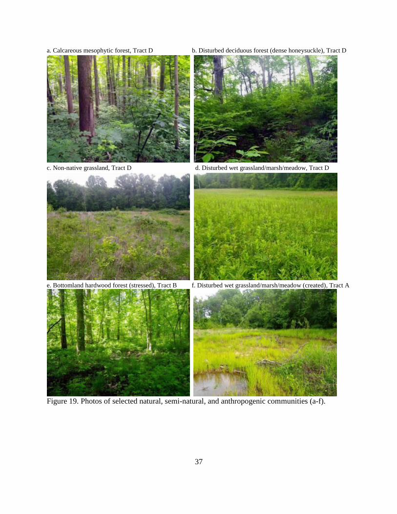
This mature forest is found completely within Tract D (Figure 18) and lies just behind the
buildings and cemetery of the St. Anne Convent. This is the only area delineated as a natural
community, and it is considered the most significant at SAWW due to the forest age and
understory quality. This community is developed on upper to lower slopes, and has a mesic, rich
soil developed from loess deposits. Soils are mostly silty and sandy loams, very deep and well-
drained (Weisenberger et al. 1973). The community is rich in diversity, with tulip trees and sugar
maples in the canopy, buckeyes and pawpaws in the midstory, and a healthy variety of spring
wildflowers on the forest floor (Figure 19a). In fact, the only rare plant documented on the
property, Spinulose Woodfern, occurs here. A well-maintained trail courses through this
community. Invasive plants also occur in this community, so the forest is not pristine (quality is
somewhat reduced). It is highly encouraged to chemically treat and/or mechanically remove the
invasive plants before they become a serious problem.
Canopy – dominant: Sugar Maple (Acer saccharum), Tulip Tree (Liriodendron tulipifera);
secondary or characteristic: Ohio Buckeye (Aesculus glabra), Common Hackberry (Celtis
29
occidentalis), American Beech (Fagus grandifolia), White Ash (Fraxinus americana), White
Oak (Quercus alba), Sassafras (Sassafras albidum), American Basswood (Tilia americana), and
American Elm (Ulmus americana).
Midstory, Shrubs and Vines – dominant: Ohio Buckeye (Aesculus glabra), Pawpaw (Asimina
triloba); secondary or characteristic: American Beech (Fagus grandifolia), and Spicebush
(Lindera benzoin).
Herbaceous – dominant: Wood Nettle (Laportea canadensis), False Solomon's-seal
(Maianthemum racemosum), Wild Blue Phlox (Phlox divaricata)cf., Mayapple (Podophyllum
peltatum); secondary or characteristic: Jack-in-the-pulpit (Arisaema triphyllum), Spinulose
Woodfern (Dryopteris carthusiana), Stickywilly (Galium aparine), Great Waterleaf
(Hydrophyllum appendiculatum) cf., Celandine Poppy (Stylophorum diphyllum), Poison Ivy
(Toxicodendron radicans), Nodding Wakerobin (Trillium flexipes), and Toadshade (Trillium
sessile).
Invasives – rare to infrequent but need treatment: Tree-of-heaven (Ailanthus altissima)*, Asian
Bitter-sweet (Celastrus orbiculata)*, Winged Burning Bush (Euonymus alatus)*, Amur
Honeysuckle (Lonicera maackii)*, and Common Chickweed (Stellaria media)*.
Calcareous mesophytic forest (stressed) Area mapped: 7.6 acres or 4.8%
This forest type is a degraded (semi-natural) form of the Calcareous mesophytic forest
mentioned previously. It occurs adjacent to this natural community, also completely within Tract
D (Figure 18). Geology and soils are similar. Plant composition similarities overlap too, but this
type is better defined by species listed below. In general, the stressed type is mature, but it has
large populations of invasive and/or weed species. At SAWW, this is often due to forests being
surrounded by highly disturbed communities with abundant populations of weeds. It is highly
encouraged to chemically treat and/or mechanically remove the invasive plants that occur, as
they are a serious problem.
Canopy – common: Tulip Tree (Liriodendron tulipifera); secondary or characteristic: Bitter-
nut Hickory (Carya cordiformis), Common Hackberry (Celtis occidentalis), Kentucky Coffee-
tree (Gymnocladus dioicus), Black Walnut (Juglans nigra), Sycamore (Platanus occidentalis),
and American Elm (Ulmus americana).
Midstory, Shrubs and Vines – frequent- Sugar Maple (Acer saccharum), Winged Burning Bush
(Euonymus alatus)*, Amur Honeysuckle (Lonicera maackii)*, Spicebush (Lindera benzoin),
Virginia Creeper (Parthenocissus quinquefolia); infrequent- Red Maple (Acer rubrum), Ohio
Buckeye (Aesculus glabra), Pawpaw (Asimina triloba), Japanese Barberry (Berberis
thunbergii)*, and Wild Black Cherry (Prunus serotina).
Herbaceous – common: False Solomon's-seal (Maianthemum racemosum); secondary or
characteristic: Cutleaf Toothwort (Cardamine concatenata), Blue Cohosh (Caulophyllum
30
thalictroides), Richweed (Collinsonia canadensis), Licorice Bedstraw (Galium circaezans),
False Baby's Breath (Galium mollugo)*, Ground Ivy (Glechoma hederacea)*, Wood Nettle
(Laportea canadensis), Sensitive Fern (Onoclea sensibilis), Jumpseed (Polygonum virginianum),
Bloodroot (Sanguinaria canadensis), Nodding Wakerobin (Trillium flexipes), and Toadshade
(Trillium sessile).
Riparian forest (stressed) Area mapped: 3.4 acres or 2.1%
This semi-natural community follows the floodplain corridor of the Ohio River, located
along the northernmost section of the property, Tract A (Figure 18). Huntington silt loam (0 to 4
percent slopes, occasionally flooded) is the typical soil type where this community has been
mapped. Flooding and scouring are regular natural disturbances in this community. After
flooding, when water levels recede, the Huntington silt loam is fairly quick to drain. Although
this community is riverine and flooding occurs regularly, the well-drained aspect supports only a
limited array of wetland species. With repeated disturbance, weedy and invasive species are
often apart of the understory, as well as, native riparian species. A limited survey was conducted
on this community (therefore, the species list is incomplete).
Canopy – dominant: Silver Maple (Acer saccharinum), Sycamore (Platanus occidentalis),
Eastern Cottonwood (Populus deltoides); secondary or characteristic: Black Walnut (Juglans
nigra).
Midstory, Shrubs and Vines – frequent: Box Elder (Acer negundo).
Herbaceous – common: Japanese Chaff-flower (Achyranthes japonica)*, Garlic Mustard
(Alliaria petiolata)*, Canada Wild-ginger (Asarum canadense), Spotted Jewel-weed (Impatiens
capensis), Wood Nettle (Laportea canadensis), Canadian Black-snakeroot (Sanicula
canadensis), Wingstem (Verbesina alternifolia); secondary or characteristic: a wildrye (Elymus
sp.), and Japanese Knotweed (Polygonum cuspidatum)*.
Bottomland hardwood forest (stressed) Area mapped: 29 acres or 18%
This forest type is a degraded (semi-natural) form of the Bottomland hardwood forest
(the natural community has not been classified on SAWW due to degraded conditions). At 29
acres, this community makes up the 2nd highest acreage on the property. It is located within Tract
B (Figures 18 and 19e) and is the dominant community on this tract. Soils are predominately
Newark Silt Loam, occasionally flooded (i.e., somewhat poorly drained bottomland soils)
(Weisenberger et al. 1973).
In general, the stressed type is maturing but has large populations of invasive and/or
weed species compared to the natural community. Shrubs and herbaceous layers often have
disturbance-tolerant weed and/or hardier species as well (e.g., Multiflora Rose, Amur
Honeysuckle). This wetland community is often saturated during the wettest months of the year,
31
with occasional short-duration flooding. The natural community (better quality) is considered of
conservation concern (Vulnerable (S3)). Efforts to restore/minimize man-made disturbance to
this semi-natural type will support a healthier, more stable community, which in this condition is
rare on the Kentucky landscape.
Canopy – frequent: Red Maple (Acer rubrum), Silver Maple (Acer saccharinum), Tulip Tree
(Liriodendron tulipifera), Pin Oak (Quercus palustris); secondary or characteristic: Green Ash
(Fraxinus pennsylvanica), and Swamp White Oak (Quercus bicolor).
Shrubs and Vines: Canopy – frequent: Red Maple (Acer rubrum), Pawpaw (Asimina triloba),
Multiflora Rose (Rosa multiflora)*, Spicebush (Lindera benzoin), Amur Honeysuckle (Lonicera
maackii)*, Pin Oak (Quercus palustris), Poison Ivy (Toxicodendron radicans); secondary or
characteristic: Trumpet-creeper (Campsis radicans), Swamp Rose (Rosa palustris), and
Southern Arrow-wood (Viburnum dentatum).
Herbaceous – frequent: Gray's Sedge (Carex grayi), Spotted Jewel-weed (Impatiens capensis)cf.,
Creeping Jenny (Lysimachia nummularia)*, Poison Ivy (Toxicodendron radicans); secondary or characteristic: Asian Bitter-sweet (Celastrus orbiculata)*, Cream Avens (Geum
virginianum) cf., Fowl Manna-grass (Glyceria striata), and Sensitive Fern (Onoclea sensibilis).
Wet bottomland hardwood forest (altered hydroperiod) Area mapped: 1.9 acres or 1.2%
This forest type is a degraded (semi-natural) form of the Wet bottomland hardwood
forest. (KSNPC lists the natural type of this wetland in Kentucky as imperiled (S2)). The
community is found on flat, poorly-drained lowlands along the Ohio River, Tract A (Figure 18)
and makes up only one small area of the property, thus minimal species have been documented.
Also known as a hardwood swamp, it holds water (floods) during the wettest months of the year
and trees are usually widely spaced, with the midstory and shrub layer often weakly developed;
but woody vines are often abundant. Although disturbed, the canopy maintains native wetland
trees like Silver Maple, Sycamore and Eastern Cottonwood.
Canopy: - frequent: Silver Maple (Acer saccharinum); secondary or characteristic: Sycamore
(Platanus occidentalis) and Eastern Cottonwood (Populus deltoides).
Midstory, Shrubs and Vines: no species recorded.
Herbaceous – common: Creeping Jenny (Lysimachia nummularia)*; (other species recorded at
SAWW that are expected here: Poison Ivy, Butterweed, Lizard's Tail, Fowl Manna-grass, etc.).

32
Wet bottomland hardwood forest (successional) Area mapped: 0.7 acres or 0.4%
This forest type is a degraded (semi-natural) form of the Wet bottomland hardwood
forest. It has younger stands of trees with larger populations of wetland trees that respond and
grow quickly after logging/clearing. These include: Silver Maple, Green Ash, Sycamore and
Eastern Cottonwood. Shrub and herb layers often have disturbance-tolerant weed and/or hardier
species as well. This wetland community holds water during the wettest months of the year (see
previous community for common and characteristic species).
Disturbed wet grassland/marsh/meadow Area mapped: 2.6 acres or 1.6%
This community is found in low-lying poorly drained soils within or next to agricultural
fields (Figure 19d). Slopes are generally flat to rolling. Most areas mapped are colonized by
wetland weeds and adjacent weeds from drier pastures. Management to sustain and expand such
areas is encouraged since natural wet meadows are extremely rare in Kentucky (that is,
encouraged if fields are being maintained anyway). Native wetland sun-loving plants should be
encouraged by chemically treating and/or hand removal of non-native species (e.g., remove
invasive plants like Small Carpgrass).
Three, relatively small, wet areas occur within three different tracts (A, C, D, Figure 18)
at SAWW. The marsh/meadow matrix at Tract A includes a modified wetland complex created
by staff and students at Northern Kentucky University (Figure 19f). The history and development
of this area is unknown to KSNPC (i.e., What was the habitat occurring before modification?,
Were native wetland species planted?, If so, which species?, etc.), but species were recorded
during surveys and are included together here. The mapping unit on Tract C was not well
surveyed. The unit has been classified based on wetland soils (poorly drained) and aerial photos
(i.e., open, field-like appearance).
Shrub – infrequent: Coastal Plain Willow (Salix caroliniana)cf.
Herbaceous – common to infrequent: Harvestlice (Agrimonia parviflora), a bentgrass (Agrostis
sp.), American Water-plantain (Alisma subcordatum), American Groundnut (Apios americana),
Indianhemp (Apocynum cannabinum), Small Carpgrass (Arthraxon hispidus)*, Swamp
Milkweed (Asclepias incarnata), Fescue Sedge (Carex festucacea)cf., Cat-tail Sedge (Carex
typhina), Velvet Panicum (Dichanthelium scoparium)cf., Common Rush (Juncus effusus)cf.,
Marsh Seedbox (Ludwigia palustris), a dock (Rumex sp.), Woolgrass (Scirpus cyperinus), Calico
Aster (Symphyotrichum lateriflorum)cf., Narrow-leaved Cattail (Typha angustifolia), Giant
Ironweed (Vernonia gigantea), and Winter Vetch (Vicia villosa ssp. varia)*.

33
Mixed tree/shrub thicket Area mapped: 0.26 acres or 0.16%
This community is represented by an old (abandoned) field on the southwest corner of
Tract D (Figure 18). Dense hardwood saplings and/or shrubs have invaded the old field. Weeds
are common, but the area is dominated by native woody species (more than non-native). Part of
the survey included a tree/shrub thicket area along Mary Ingles Highway, but this area has been
recently planted to hardwood trees and is now classified differently (see Planted deciduous
forest). A limited survey was conducted on this community; therefore, the species list is lacking.
Canopy: - infrequent: Slippery Elm (Ulmus rubra), Virginia Pine (Pinus virginiana).
Young trees, Shrubs and Vines – frequent: Black Locust (Robinia pseudoacacia), Multiflora
Rose (Rosa multiflora)*, Sawtooth Blackberry (Rubus argutus); secondary or characteristic:
Eastern Red Cedar (Juniperus virginiana), and Sycamore (Platanus occidentalis).
Herbaceous – common: Broom-sedge (Andropogon virginicus).
Non-native grassland/field Area mapped: 18 acres or 11%
This community represents old grazing and hay pastures originally planted in tall fescue*
and other pasture grasses (Figure 19c). The community makes up the 4th highest acreage on the
property, including at least one mapped area on each tract (Figure 18). Other native herbaceous
and woody species also occur (e.g., Sawtooth Blackberry, Canada Goldenrod and Velvet
Panicum). Along with the invasive grasses, invasive vines, shrubs and forbs commonly occur
here, including Japanese Honeysuckle* and Chinese Lespedeza*. There is limited species
occurrence data and other community information due to low ecological importance of this
community.
Young trees, Shrubs and Vines – infrequent: Box Elder (Acer negundo), Tree-of-heaven
(Ailanthus altissima)*, Multiflora Rose (Rosa multiflora)*, and Sawtooth Blackberry (Rubus
argutus).
Herbaceous: common: Chinese Lespedeza (Lespedeza cuneata)*, Tall Fescue (Lolium
arundinaceum)*, Japanese Honeysuckle (Lonicera japonica)*; secondary or characteristic: a
bentgrass (Agrostis sp.), Indianhemp (Apocynum cannabinum), Orchard Grass (Dactylis
glomerata), Velvet Panicum (Dichanthelium scoparium)cf., Nepalese Browntop (Microstegium
vimineum)*, Common Yellow Wood-sorrel (Oxalis stricta), Canada Goldenrod (Solidago
canadensis), Field Clover (Trifolium campestre)*, Red Clover (Trifolium pratense)*, Wingstem
(Verbesina alternifolia), Giant Ironweed (Vernonia gigantea), and Winter Vetch (Vicia villosa
ssp. varia)*.
34
Planted deciduous forest Area mapped: 2 acres or 1.2%
This community is represented by an old field along Mary Ingles Highway that has
recently been planted to hardwood trees (the survey in May of 2014 identified the area as Mixed
tree/shrub thicket, no planting). This area is located on the northern margin of Tract B (Figure
18). Hardwood saplings and/or shrubs present in the Mixed tree/shrub thicket (see above) are
expected to be naturally growing alongside the recently planted hardwood trees.
Urban Area mapped: 1.7 acres or 1%
This cover type represents areas where vegetation is permanently removed (e.g.,
buildings, pavement, etc.) or finely manicured (e.g., lawns). Two urban areas (residential houses)
border the property line with margins that impede on SAWW vegetation; these two areas are
large enough to digitize mapping units (northern line of Tract B, Figure 18).
Disturbed deciduous forest Area mapped: 58 acres or 36%
The Disturbed deciduous forest is the most abundant community found on SAWW,
representing 58 acres (Figure 18). Past disturbance from logging, grazing and clearing of the
original forest has created a forested community composed of native and non-native disturbance-
tolerant species (i.e., abundant weeds). This community includes soils of acidic, neutral and basic
conditions, as well as, soil moistures ranging from dry to mesic. Invasive species are abundant
here, and considered a serious problem to the overall ecological health of the SAWW property
(Figure 19b).
Canopy – dominant: Tulip Tree (Liriodendron tulipifera), Wild Black Cherry (Prunus serotina),
Sassafras (Sassafras albidum); secondary or characteristic: Red Maple (Acer rubrum), Sugar
Maple (Acer saccharum), Tree-of-heaven (Ailanthus altissima)*, Shag-bark Hickory (Carya
ovata), Common Hackberry (Celtis occidentalis), American Beech (Fagus grandifolia), Black
Walnut (Juglans nigra), Eastern Red Cedar (Juniperus virginiana), Blackgum (Nyssa sylvatica),
Sycamore (Platanus occidentalis), Pin Oak (Quercus palustris), Shumard's Oak (Quercus
shumardii), Black Locust (Robinia pseudoacacia), and American Elm (Ulmus americana).
Midstory, Shrubs and Vines – dominant/common: Red Maple (Acer rubrum), Asian Bitter-
sweet (Celastrus orbiculata)*, Winged Burning Bush (Euonymus alatus)*, Chinese Privet
(Ligustrum sinense)*, Amur Honeysuckle (Lonicera maackii)*, Virginia Creeper
(Parthenocissus quinquefolia), Multiflora Rose (Rosa multiflora)*; secondary or characteristic:
Box Elder (Acer negundo), Pawpaw (Asimina triloba), Japanese Barberry (Berberis
thunbergii)*, Eastern Red Cedar (Juniperus virginiana), Spicebush (Lindera benzoin), Sawtooth
Blackberry (Rubus argutus), and Sassafras (Sassafras albidum).

35
Herbaceous – dominant weeds: Garlic Mustard (Alliaria petiolata)*, Spotted Jewel-weed
(Impatiens capensis), Wingstem (Verbesina alternifolia), Poison Ivy (Toxicodendron radicans);
less-weedy natives: Canada Wild-ginger (Asarum canadense), Spotted Geranium (Geranium
maculatum), False Solomon's-seal (Maianthemum racemosum), Mayapple (Podophyllum
peltatum), Smooth Solomon's-seal (Polygonatum biflorum), Toadshade (Trillium sessile);
secondary or characteristic: White Snakeroot (Ageratina altissima), Field Garlic (Allium
vineale)*, Smallspike False Nettle (Boehmeria cylindrica), Broadleaf Enchanter's Nightshade
(Circaea lutetiana), Chinese Yam (Dioscorea polystachya)*, Indian Mock-strawberry
(Duchesnea indica)*, Winter-creeper (Euonymus fortunei)*, Cream Avens (Geum
virginianum)cf., Japanese Honeysuckle (Lonicera japonica)*, Common Moonseed
(Menispermum canadense), Sensitive Fern (Onoclea sensibilis), Hooked Crowfoot (Ranunculus
recurvatus), Common Elderberry (Sambucus canadensis), Canadian Black-snakeroot (Sanicula
canadensis), Common Chickweed (Stellaria media)*, and Wingstem (Verbesina alternifolia).
Disturbed wet forest/swamp Area mapped: 20 acres or 12.5%
The Disturbed wet forest/swamp is a low quality forest community found on SAWW.
This disturbed forest/swamp is found among the wettest soil types on Tracts A, B and C (Figures
4 and 18). Past disturbance from logging, grazing and clearing of the original forest has created a
forested community composed of native and non-native disturbance-tolerant species. This
community includes soil moistures that are long-saturated or inundated. Invasive species are
common here, and a serious problem.
Canopy – frequent: Red Maple (Acer rubrum), Silver Maple (Acer saccharinum), Sycamore
(Platanus occidentalis), and Pin Oak (Quercus palustris).
Midstory, Shrubs and Vines – frequent: Pawpaw (Asimina triloba), Spicebush (Lindera
benzoin), Amur Honeysuckle (Lonicera maackii)*, Virginia Creeper (Parthenocissus
quinquefolia), Multiflora Rose (Rosa multiflora)*, Poison Ivy (Toxicodendron radicans), and
American Elm (Ulmus americana).
Herbaceous – common: Creeping Jenny (Lysimachia nummularia)*, Smooth Solomon's-seal
(Polygonatum biflorum), Poison Ivy (Toxicodendron radicans); frequent to rare: Chinese Yam
(Dioscorea polystachya)*, Winter-creeper (Euonymus fortunei)*, Butterweed (Packera glabella),
and Lizard's Tail (Saururus cernuus).

36
Figure 18. Vegetation communities of St. Anne Woods and Wetlands.
37
a. Calcareous mesophytic forest, Tract D b. Disturbed deciduous forest (dense honeysuckle), Tract D
c. Non-native grassland, Tract D d. Disturbed wet grassland/marsh/meadow, Tract D
e. Bottomland hardwood forest (stressed), Tract B f. Disturbed wet grassland/marsh/meadow (created), Tract A
Figure 19. Photos of selected natural, semi-natural, and anthropogenic communities (a-f).

38
ACKNOWLEDGMENTS
The late Mary Kathryn Dickerson provided logistical support during the early stages of
this project. She was highly motivated to implement the best management practices on all of the
sites she managed. She, along with her dedication and conservation-minded spirit, is sorely
missed.
Special thanks to Loran Gibson for donating his time, equipment, and expertise both in
the field and in the lab. Unfortunately, it came with a greater cost since one of his light traps was
stolen from the SAWW property during the project. He collected and identified most of the
moths and helped with butterfly and bird surveys. His companionship was also appreciated.
39
LITERATURE CITED
Abernathy, G., D. White, E.L. Laudermilk, and M. Evans. 2010. Kentucky’s natural heritage: an
illustrated guide to biodiversity. The University Press of Kentucky, Lexington, KY.
Campbell, J. 2015. Atlas of vascular plants in Kentucky. Microsoft Access Database.
http://www.bluegrasswoodland.com/Kentucky_Plants_Flora.html.
[COA] College of Agriculture. 2015. Kentucky emerald ash borer information. University of
Kentucky, Lexington, KY. http://pest.ca.uky.edu/EXT/EAB/welcomeeab.html. Accessed
18 December 2015.
Covell, C.V., Jr. 1984. A field guide to moths: eastern North America. Houghton Mifflin
Company, Boston, MA.
Covell, C.V., Jr. 1999. The butterflies and moths (Lepidoptera) of Kentucky: an annotated
checklist. Kentucky State Nature Preserves Commission Scientific and Technical Series
6:1-220.
Covell, C.V., Jr., B.D. Marcus, and J.M. Marcus. 2013. KY Butterfly Net: An Interactive Web
Database to facilitate Lepidoptera research and education in Kentucky.
http://www.kybutterfly.net. Accessed 25 September 2013.
Crumb, S.E. 1956. The larvae of the Phalaenidae. United States Department of Agriculture
Technical Bulletin 1135.
[FNAEC] Flora of North America Editorial Committee, eds. 1993+. Flora of North America
North of Mexico. New York and Oxford. 19+ vols.
Jones, R.L. 2005. Plant life of Kentucky. An illustrated guide to the vascular flora. The
University Press of Kentucky. Lexington, KY.
Garibaldi, L.A., I. Steffan-Dewenter, C. Kremen, J.M. Morales, R. Bommarco, S.A.
Cunningham, L.G. Carvalheiro, N.P. Chacoff, J.H. Dudenhöffer, S.S. Greenleaf, A.
Holzschuh, R. Isaacs, K. Krewenka, Y. Mandelik, M.M. Mayfield, L.A. Morandin, S.G.
Potts, T.H. Ricketts, H. Szentgyörgyi, B.F. Viana, C. Westphal, R. Winfree, A.M. Klein.
2011. Stability of pollination services decreases with isolation from natural areas despite
honey bee visits. Ecology letters 14:1062-1072.
Garibaldi, L.A., I. Steffan-Dewenter, R. Winfree, M.A. Aizen, R. Bommarco, S.A. Cunningham,
C. Kremen, L.G. Carvalheiro, L.D. Harder, O. Afik, I. Bartomeus, F. Benjamin, V.
Boreux, D. Cariveau, N.P. Chacoff, J.H. Dudenhöffer, B.M. Freitas, J. Ghazoul, S.
Greenleaf, J. Hipólito, A. Holzschuh, B. Howlett, R. Isaacs, S.K. Javorek, C.M. Kennedy,
K.M. Krewenka, S. Krishnan, Y. Mandelik, M.M. Mayfield, I. Motzke, T. Munyuli, B.A.
Nault, M. Otieno, J. Petersen, G. Pisanty, S.G. Potts, R. Rader, T. H. Ricketts, M.
Rundlöf, C.L. Seymour, C. Schüepp, H. Szentgyörgyi, H. Taki, T. Tscharntke, C.H.
Vergara, B.F. Viana, T.C. Wanger, C. Westphal, N. Williams, and A.M. Klein. 2013.
Wild Pollinators Enhance Fruit Set of Crops Regardless of Honey Bee Abundance.
Science 339: 1608-1611.
Gibbons, A.B. 1973. Geologic map of parts of Newport and Withamsville Quadrangles,
Campbell and Kenton counties, Kentucky. US. Geological Survey, Washington, D.C.
[KEPPC] Kentucky Exotic Pest Plant Council. 2013. Exotic pest plant list. Southeast Exotic Pest
Plant Council. www.se-eppc.org.

40
Klatt, B.K., A. Holzschuh, C. Westphal, Y. Clough, I. Smit, E. Pawelzik, and T. Tscharntke.
2013. Bee pollination improves crop quality, shelf life and commercial value.
Proceedings of the Royal Society B 281: 20132440.
http://dx.doi.org/10.1098/rspb.2013.2440.
[KSNPC] Kentucky State Nature Preserves Commission. 2009. Kentucky natural communities.
Kentucky State Nature Preserves Commission, Frankfort, KY.
[KSNPC] Kentucky State Nature Preserves Commission. 2011. Unpublished report. Kentucky
semi-natural and anthropogenic communities (draft). Kentucky State Nature Preserves
Commission, Frankfort, KY.
[KSNPC] Kentucky State Nature Preserves Commission. 2014. Kentucky natural heritage
database. Kentucky State Nature Preserves Commissoin, Frankfort, KY.
Mallinger, R.E., and C. Gratton. 2014. Species richness of wild bees, but not the use of managed
honey bees, increases fruit set of a pollinator-dependent crop. Journal of Applied Ecology
52:323-330.
[MPG] Moth Photographers Group. 2013. North American Moth Photographers Group.
Mississippi Entomological Museum, Mississippi State University, Starkville, MS.
http://mothphotographersgroup.msstate.edu/MainMenu.shtml.
NatureServe. 2016. NatureServe Explorer: An online encyclopedia of life [web application].
Version 7.1. Arlington,VA. http://www.natureserve.org/explorer/. Accessed 27 January
2016.
Needham, J.G., M.J. Westfall, Jr., and M.L. May. 2000. Dragonflies of North America.
Scientific Publishers, Gainesville, FL.
Pelham, J.P. 2008. A catalogue of the butterflies of the United States and Canada with a
complete bibliography of the descriptive and systematic literature. Journal of Research on
the Lepidoptera 40:1-658.
Quarterman, E., and R.L. Powell. 1978. Potential ecological/geological natural landmarks on the
Interior Low Plateaus. National Park Service, United States Department of the Interior,
Washington, District of Columbia.
Taylor, C.A., and G.A. Schuster. 2004. The crayfishes of Kentucky. Illinois Natural History
Survey Special Publication 28. 227 pp.
[USDA] United States Department of Agriculture, Natural Resources Conservation Service.
2015. Plant database. http://plants.usda.gov/java/stateSearch.
Weakley, A.S. 2015. Flora of the southern and mid-Atlantic states. UNC Herbarium, North
Carolina Botanical Garden, University of North Carolina at Chapel Hill.
http://www.herbarium.unc.edu/FloraArchives/WeakleyFlora_2015-05-29.pdf.
Weisenberger, B.C., C.W. Dowell, T.R. Leathers, H.B. Odor, and A.J. Richardson. 1973. Soil
survey of Boone, Campbell and Kenton Counties, Kentucky. United States Department
of Agriculture, Soil Conservation Service, In Cooperation with Kentucky Agricultural
Experiment Station, Washington DC.
Westfall, M.J., Jr., and M.L. May. 2006. Damselflies of North America, revised edition.
Scientific Publishers, Gainesville, FL.

41
APPENDIX 1. SPECIES LIST, ARRANGED ALPHABETICALLY BY SPECIES NAME
WITHIN EACH GROUP, FOR ST. ANNE WOODS AND WETLANDS.