prefeasibility report - welcome to...
TRANSCRIPT

PREFEASIBILITY REPORT
OF
Khub Limestone Mine (ML Area: 9.66Ha)
Proposed Production:475,095 TPA of Limestone, and 1,74,420 TPA
of Sandstone
AT
Village,Lumshnong, Tehsil Khliehriat,
Distt. East Jaintia Hills, Meghalaya.
Project Proponent
Cement Manufacturing Co. Ltd.
Cement Manufacturing Company Limited 281, Deepali, Pitam Pura,Delhi
Environmental Consultant M/s Perfact Enviro Solutions Pvt Ltd
(NABET Registered vide list of accredited consultants organizations
Rev 27/8thFebruary, 2015 at S.No-113
5th Floor, NN Mall, MangalamPalace Sector 3, Rohini, New Delhi
Phone No.: 011-47528467, Fax: 011-47528434
2
Table of Contents
1. Executive summary
2. Introduction of the project/ Background information
3. Project Description
4. Site Analysis
5. Planning Brief
6. Proposed Infrastructure
7. Rehabilitation and Resettlement (R & R) Plan
8. Project Schedule & Cost Estimates
9. Analysis of Proposal (Final Recommendations)

3
PREFEASIBILITY REPORT
1.Executive Summary
Introduction of the project/ Background information
The state Govt. granted two mining leases for Khub-I,4.96 ha & Khub-II, 4.70 ha to CMCL
for meeting the limestone requirement of the cement plant CMCL. Two mining leases were
applied for the amalgamation to the state Govt. on 08-12-2006 and permitted. Mining plan for
the amalgamated Khub mine of 9.66 hectares is under preparation
The Narpuh reserved forest was declared as wildlife sanctuary which falls within 5 km. As
general condition is applicable on the project therefore the project is considered as Category
“A” project. The Project will be submitted to MOEF for Environment Clearance.
Total proposed production of Limestone from the amalgamated mine will be 475,095 TPA,
Limestone and 1,74,420 TPA, Sand Stone for running Cement plant. CMCL has entrusted
M/s Perfact Enviro Solutions Private Ltd., New Delhi, for the preparation of EIA/EMP
report.
The production from Khub-I (4.96 ha) started in 2004 & from Khub-II in 2006. So far
1,893,565.299 MT have been produced from Khub-I & 3,042,248.486 MT from Khub-II
(upto May, 2014). The yearly production was within permitted quantity as per mining plan.
In all 71 persons will be directly employed, besides substantial amount of indirect
employment will be generated in the form of dhabas, transporters etc. which will improve the
economic conditions of the area.
Location details
The lease area falls in Survey of India Topo sheet No.83 C/8 with Latitude 250 948 to
250104.3N & Longitude 9202205.3 to 9202223.6E. The lease area is near village
Lumshnong, tehsil Khliehriat, Dist. East Jaintia Hills in Meghalaya state.

4
The lease area is situated at a distance 1 km west of NH-44 connecting Shillong to Silchar.
The nearest railway station at a distance of 38.5 km from Lumshnong is Badarpur.
Magnitude of Operations & Extent of Mechanization:
Working for limestone is done by adopting mechanized opencast method. It is proposed to
produce a maximum of 4,75,095 TPA, Limestone and 174420 MTPA, Sandstone from the
lease area of 9.66 ha by way of progressive mining plan as per the approval from the IBM. It
is a mechanized mine with deep hole drilling-blasting and loading through excavators to
tipper. Apart from these equipments water tanker will be provided for sprinkling.
Raw Materials required:
Total of 43 KLD of water will be required, out of which 3 KLD will be utilized for drinking
& domestic purposes, 25 KLD will be utilized for mining & allied activities including dust
suppression, and 15 KLD for plantation.
The total diesel requirement will be 800 KLD
Geology and Reserves:
The different litho units of the area belong to Jaintia series of Eocene age. The limestone unit
belongs to sylhet stage of Jaintia series of middle Eocene age.
Three bands of limestone occur in the area, which are known as Prang, Umlatdoh and
Lakadong limestone bands. These are separated by Narpuh sandstone and Lakadong
sandstone. The topmost limestone band i.e Prang limestone occurs further south of the
prospect.
The total mineable reserves are of the order of 17.60 million tones.
The average grade of limestone is having CaO 44.50-48.50%, MgO 1.50-3.00%, SiO2 -2.50-
3.0%, Al2O
31.50-2.50% & Fe
2O
31.00-2.00%
Proposed Production & life of mine:
The proposed annual production will be @475,095 TPA, Lime Stone and 174420 TPA, Sand
Stone and life of mine will be about 12 years.

5
Waste Generation and Disposal: There is no overburden.
Site Analysis:
Connectivity:
The lease area is situated at a distance 1 km west of NH-44 from 67.5 Km stone connecting
Shillong to Silchar. The nearest railway station at a distance of 38.5km from Lumshnong is
Badarpur on Guwahati-Lumding-Silchar meter gauge section of N.E.F. Railway.
Land Form, Land use and Land ownership: The land is private waste land. It is non-forest, non-agricultural. The consent of land owners
of the land by CMCL and the mine is operated since year 2000.
Topography:
Topography of the ML area and its surroundings are rugged and mountainous. Maximum
and minimum contours passing through the area are 546 m and 520 m respectively. South-
Western part of the area is at a higher elevation with respect to south-eastern part. A
perennial nallah flows about 400 m. south of the southern lease boundary.
Existing land use pattern:
All the land is private waste land. It is non-forest, nonagricultural. At present 8.09 ha land is
mined out land and remaining 1.57 ha land is virgin or undisturbed.
Infrastructure:
At present the infrastructure available in the mine area are service roads, workshop building,
canteen, power line, sub post office, primary & middle school. Weekly market is at
Lumshnong The nearest road is at distance of 1Km in the East. Nearest railway station is
Badarpur at distance of 38.5 Km. The nearest airport is at Silchar at 67.5 Km.
Climatic data from secondary sources:
The climate in the study area is typically tropical. The region experiences tropical monsoonic
climate that varies from western to eastern part of the plateau. Jaintia Hills District has
tropical climate characterized by high rainfall and humidity, generally warm summer and
moderately cold winter. The lower elevated areas experience fairly high temperature for most
part of the year having a mean maximum of 230C to 260C and a mean minimum of 120C to

6
170C. The mean summer temperature is 260C and the mean winter temperature is 90 C. The
mean annual rainfall varies from 4,000-6,000 mm with most rainfall concentrated from May
to September.
Social Infrastructure:
The study area of buffer zone is having social infrastructure facilities like hospital, schools,
electricity, potable water, transport facilities, post & communication etc. These facilities have
been strengthened as CSR activities and the reachable distances to facilities of social
infrastructure has been reduced.
Planning Brief
A mining project is much different than other industrial projects. Therefore its planning part
also differs. In case of mining, the lease is granted only after an approved mining plan is
submitted to the government. It is an opencast mechanized mining and the salient features are
as below.
Mechanized open cast mining with drilling & blasting will be undertaken with the help of
Excavator /loader and dumper.
Bench height will be kept at 6 m & width 20 m. The maximum strength of workers will be
71persons. Most of the employees will be from local area. The plantation will be made within
and outside the lease for improving the environment. The company is involved in CSR
activities like running of school, hospital, sports and other cultural activities.
Proposed Infrastructure:
Under the Corporate Social Responsibility, lessee will continue to provide infrastructure
support to nearby schools and other community needs
Green belt is proposed to be developed in safety zone and plantation will be carried out.
Besides this, it is also proposed that a plantation drive in the surrounding will be undertaken
with the total involvement of community, which is expected to give better survival rates.
As far as drinking water is concerned, it would be apt to reiterate here that residential
accommodation will not be provided to its workers as there is a colony nearby. The main
drinking water requirement will be of mine workers. The proposed strength is 71. It can be

7
seen that daily domestic and drinking water requirement will be about 3 KLD. The drinking
water is provided from CMCL Plant.. There is no overburden.
The power required for mine is for lighting on haul road, mining lease area and office. The
requirement is roughly 0.5 MW. The supply is Meghalaya State Electricity R & R plan will
be implemented as per the rules laid down in National R & R Policy, 2007.
Project Schedule & Cost Estimates.
The proposed mining activity will commence immediately on getting environment clearance
and approval of mining plan. The total project cost of mining is about Rs.675 Lakhs.
Analysis of proposal (Final Recommendations):
The project is proposed in the barren land. It will be captive mine for its cement plant. It will
be provided direct employment up to 71 persons, and preference will be given to local
people. Further, the share of indirect employment will likely increase the purchasing power,
dhabas and retail shops etc. is largely shared by local residents. The most important aspect of
the project is the land under mining is almost barren thus it does not create a negative impact
on the livelihood of residents. Further, taxes are earned by the state government in the form
of royalty.
2. Introduction of the project/ Background information
Cement Manufacturing Company Ltd (CMCL) is an ISO 9001:2000 certified Public Limited
Company with Registered office and works at Lumshnong, East Jaintia Hills district,
Meghalaya. CMCL was accorded approval for setting up a 900 TPD cement plant at
Lumshnong village, East Jaintia Hills district Meghalaya by the Govt. of Meghalaya in the
year 2002 and subsequently was accorded approval for expanding the capacity to 3000 TPD
in the year 2003.
The state Govt. granted two mining leases vide letter no. 47/2008/23, dated 22/07/2004 for
4.96 hectares and vide letter no. MG/21/2003/394 dated 04/07/2005 for 4.70 hectares for
meeting the limestone requirement of the cement plant CMCL. As per EIA Notification 2006,
8
Environment Clearance is not required for area < 5 ha, hence no environmental clearance for
individual mines was obtained.
Two mining leases were applied for the amalgamation to the state Govt. on 08-12-2006 and
State Govt. permitted amalgamation vide letter no. MG.98/2008/23 dated 01/04/2009
(Annexure-2). Mining plan for the amalgamated mine along with the progressive mine
closure plan over the combined area of 9.66 hectares is under preparation.
CMCL had applied to obtain Environment Clearance from SEIAA, Meghalaya, on
24.04.2013 SEIAA granted the TOR under Category “B”. The Public hearing was conducted
on 12/06/2014. Thereafter, before the final the final appraisal by SEAC, the Narpuh reserved
forest was declared as wildlife sanctuary. As such general condition became applicable on
this project also therefore the project is now considered as Category “A” project. Therefore,
project will be submitted to MOEF for Environmental Clearance.
Total production of Limestone from amalgamated mine will be 4,75,095 TPA, Lime Stone
and 1,74,420 TPA,, Sand Stone for running Cement plant which is 3.50 km from the pit head,
CMCL has engaged M/s Perfact Enviro Solutions Private Ltd., New Delhi, for the
preparation of Environment Impact Assessment study and Environmental Management Plan
through Terms of Reference (TOR).
Brief description and nature of the project
CMCL proposes to amalgamate two existing limestone mine Khub-I (4.96 ha) and Khub-II (4.96 ha)
based on state-of-the-art technology at the said mining lease area in East Jaintia Hills District of
Meghalaya.
DETAILS OF LIMESTONE MINE ARE GIVEN BELOW
Topography and Drainage
Topography of the ML area and its surroundings are rugged and mountainous. Maximum
and minimum contours passing through the area are 546 m and 520 m respectively. South-
Western part of the area is at a higher elevation with respect to south-eastern part. It is
represented in lease plan and surface drainage plan (Plate-7). A perennial nallah flows about
400 m. south of the southern lease boundary.
Regional Geology
9
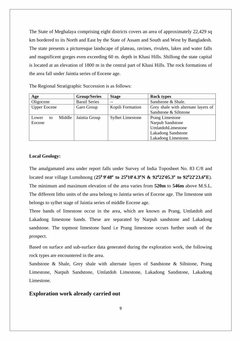
The State of Meghalaya comprising eight districts covers an area of approximately 22,429 sq
km bordered to its North and East by the State of Assam and South and West by Bangladesh.
The state presents a picturesque landscape of plateau, ravines, rivulets, lakes and water falls
and magnificent gorges even exceeding 60 m. depth in Khasi Hills. Shillong the state capital
is located at an elevation of 1800 m in the central part of Khasi Hills. The rock formations of
the area fall under Jaintia series of Eocene age.
The Regional Stratigraphic Succession is as follows:
Age Group/Series Stage Rock types
Oligocene Barail Series -- Sandstone & Shale.
Upper Eocene Garo Group Kopili Formation Grey shale with alternate layers of
Sandstone & Siltstone
Lower to Middle
Eocene
Jaintia Group Sylhet Limestone Prang Limestone
Narpuh Sandstone
UmlatdohLimestone
Lakadong Sandstone
Lakadong Limestone.
Local Geology:
The amalgamated area under report falls under Survey of India Toposheet No. 83 C/8 and
located near village Lumshnong (250 948 to 250104.3N & 9202205.3 to 9202223.6E).
The minimum and maximum elevation of the area varies from 520m to 546m above M.S.L.
The different litho units of the area belong to Jaintia series of Eocene age. The limestone unit
belongs to sylhet stage of Jaintia series of middle Eocene age.
Three bands of limestone occur in the area, which are known as Prang, Umlatdoh and
Lakadong limestone bands. These are separated by Narpuh sandstone and Lakadong
sandstone. The topmost limestone band i.e Prang limestone occurs further south of the
prospect.
Based on surface and sub-surface data generated during the exploration work, the following
rock types are encountered in the area.
Sandstone & Shale, Grey shale with alternate layers of Sandstone & Siltstone, Prang
Limestone, Narpuh Sandstone, Umlatdoh Limestone, Lakadong Sandstone, Lakadong
Limestone.
Exploration work already carried out
10
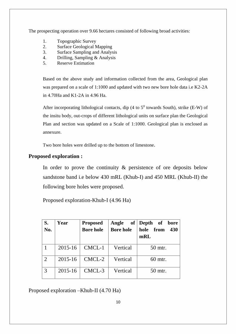
The prospecting operation over 9.66 hectares consisted of following broad activities:
1. Topographic Survey
2. Surface Geological Mapping
3. Surface Sampling and Analysis
4. Drilling, Sampling & Analysis
5. Reserve Estimation
Based on the above study and information collected from the area, Geological plan
was prepared on a scale of 1:1000 and updated with two new bore hole data i.e K2-2A
in 4.70Ha and K1-2A in 4.96 Ha.
After incorporating lithological contacts, dip (4 to 50 towards South), strike (E-W) of
the insitu body, out-crops of different lithological units on surface plan the Geological
Plan and section was updated on a Scale of 1:1000. Geological plan is enclosed as
annexure.
Two bore holes were drilled up to the bottom of limestone.
Proposed exploration :
In order to prove the continuity & persistence of ore deposits below
sandstone band i.e below 430 mRL (Khub-I) and 450 MRL (Khub-II) the
following bore holes were proposed.
Proposed exploration-Khub-I (4.96 Ha)
S.
No.
Year Proposed
Bore hole
Angle of
Bore hole
Depth of bore
hole from 430
mRL
1 2015-16 CMCL-1 Vertical 50 mtr.
2 2015-16 CMCL-2 Vertical 60 mtr.
3 2015-16 CMCL-3 Vertical 50 mtr.
Proposed exploration –Khub-II (4.70 Ha)
11
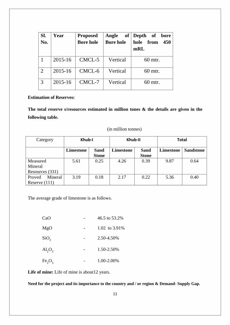
Estimation of Reserves:
The total reserve s/resources estimated in million tones & the details are given in the
following table.
(in million tonnes)
Category Khub-I Khub-II Total
Limestone Sand
Stone
Limestone Sand
Stone
Limestone Sandstone
Measured
Mineral
Resources (331)
5.61 0.25 4.26 0.39 9.87 0.64
Proved Mineral
Reserve (111)
3.19 0.18 2.17 0.22 5.36 0.40
The average grade of limestone is as follows.
CaO - 46.5 to 53.2%
MgO - 1.02 to 3.91%
SiO2 - 2.50-4.50%
Al2O
3 - 1.50-2.50%
Fe2O
3 - 1.00-2.00%
Life of mine: Life of mine is about12 years.
Need for the project and its importance to the country and / or region & Demand- Supply Gap.
Sl.
No.
Year Proposed
Bore hole
Angle of
Bore hole
Depth of bore
hole from 450
mRL
1 2015-16 CMCL-5 Vertical 60 mtr.
2 2015-16 CMCL-6 Vertical 60 mtr.
3 2015-16 CMCL-7 Vertical 60 mtr.

12
Need of the project
The limestone being the main raw material for manufacturing of cement is always in demand
in a developing country like ours. The existence of project will cater the needs of cement
production,
Demand-Supply Gap:
8 to 10 % growth of cement is taking place in the country; therefore there will be always
demand of limestone in the country. The mine under reference is a captive mine of Cement
Manufacturing Co. Ltd.
Imports vs. Indigenous production/ Export possibility.
It is the captive lime stone mine to the Cement Manufacturing Co. Ltd. Limestone will be
supplied directly to cement plant. Therefore the mine is for indigenous production and no
import is being made. There are no chances of export either.
Employment Generation
71 persons will be directly employed, Besides substantial amount of indirect employment
will be generated in the form of dhabas, transporters etc. which will improve the economic
conditions of the area.
Yearly Production data from 2004-05 to 2014-15
As mentioned earlier, the mines Khub –I & II are amalgamated with an area of 9.66 ha,
however, the mines Khub-I and Khub-II have been under operation since 2004-05.
Production from these mines are given as under.
Year Khub-I (4.96 ha) (TPA) Khub-II (4.96 ha) (TPA)
2004-05 46,297.710 -
2005-06 3,80,626.325 -
2006-07 6,55,558.484 6,657.425
2007-08 1,56,516.520 3,68,981.520

13
2008-09 1,29,371.850 5,78,525.540
2009-10 79,228.780 3,46,566.660
2010-11 1,54,419.810 5,43,617.630
2011-12 89,003.580 6,32,502.800
2012-13 1,78,858.45 4,75,841.020
2013-14 23,682.79 89,555.900
Total 1,893,565.299 (TPA) 3,042,248.486 (TPA)
3. Project Description
(i) Type of Project including interlinked and interdependent project, if any:
This is a mining project of limestone mine with opencast mechanized mining. This is a
captive mine of cement plant. The pre-existing mines of Khub-I (4.96 ha) & Khub-II (4.70
ha) are proposed to be amalgamated to Khub mine of 9.66 ha.
(ii) Interlinked Projects:
This is a captive limestone mine to the Cement Manufacturing Co. Ltd. The cement plant is
located at a distance of 3 Km.
(iii) Lease Details:
Name of owner: M/s Cement Manufacturing Co. Ltd.
(Mr. Devender Bansal, Resident Director, nominated owner)
Address: Village Lumshnong, P.O. Khliehriat,
Dist. East Jaintia Hills
Lease area: 9.66 ha.
Date of grant: Yet to be granted. LOI issued vide letter No.MG-98/2008/23, dated
01.04.2009.
(iv)Location details:
The geographical location of mining lease area is given in the following Table.
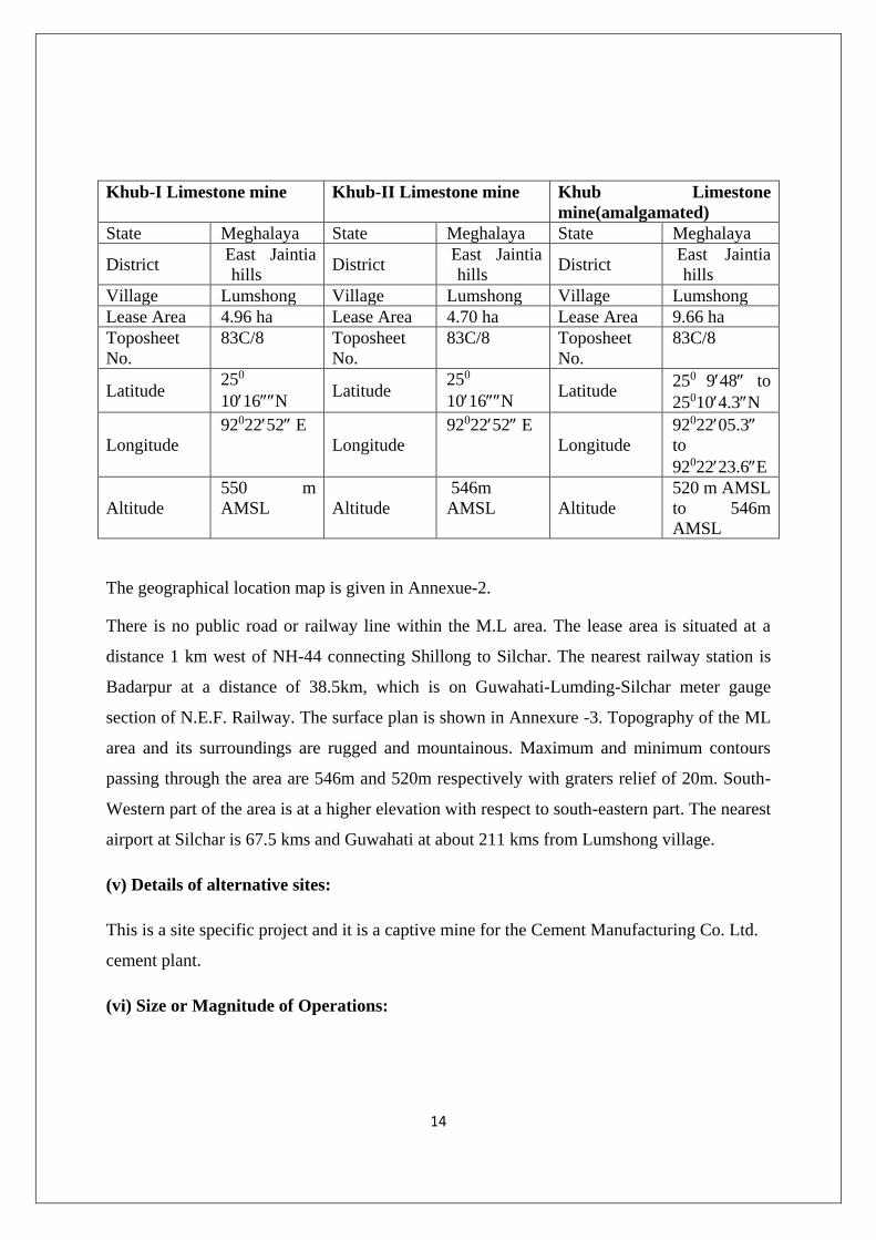
14
Khub-I Limestone mine Khub-II Limestone mine Khub Limestone
mine(amalgamated)
State Meghalaya State Meghalaya State Meghalaya
District East Jaintia
hills District
East Jaintia
hills District
East Jaintia
hills
Village Lumshong Village Lumshong Village Lumshong
Lease Area 4.96 ha Lease Area 4.70 ha Lease Area 9.66 ha
Toposheet
No.
83C/8 Toposheet
No.
83C/8 Toposheet
No.
83C/8
Latitude 250
1016N Latitude
250
1016N Latitude
250 948 to
250104.3N
Longitude
9202252 E
Longitude
9202252 E
Longitude
9202205.3
to
9202223.6E
Altitude
550 m
AMSL Altitude
546m
AMSL Altitude
520 m AMSL
to 546m
AMSL
The geographical location map is given in Annexue-2.
There is no public road or railway line within the M.L area. The lease area is situated at a
distance 1 km west of NH-44 connecting Shillong to Silchar. The nearest railway station is
Badarpur at a distance of 38.5km, which is on Guwahati-Lumding-Silchar meter gauge
section of N.E.F. Railway. The surface plan is shown in Annexure -3. Topography of the ML
area and its surroundings are rugged and mountainous. Maximum and minimum contours
passing through the area are 546m and 520m respectively with graters relief of 20m. South-
Western part of the area is at a higher elevation with respect to south-eastern part. The nearest
airport at Silchar is 67.5 kms and Guwahati at about 211 kms from Lumshong village.
(v) Details of alternative sites:
This is a site specific project and it is a captive mine for the Cement Manufacturing Co. Ltd.
cement plant.
(vi) Size or Magnitude of Operations:

15
Working for limestone is done by adopting mechanized opencast method. It is proposed to
produce a maximum of 4,75,095 TPA Lime Stone , I,74,420 TPA Sand Stone from the lease
area of 9.66 ha by way of progressive mining plan as per the approval from the IBM.
Salient Features of the Mode of Working:
Mechanized open cast mining will be undertaken with the help of Excavator /loader
and dumper.
Bench height will be kept at 6 m.
The width of ultimate width will not be less than bench height, however, working
bench will have a width around 20 m
Drilling& blasting will be taken up. Excavator and dumpers/trucks combination will
be used for removal of excavated material
(vii) Project description with process details (a schematic diagram/flow chart
showing the project layout, components of the project etc. should be given)
The mine will be worked by Mechanized Opencast Method of working. Heavy earth
moving machinery in conjunction with deep hole drilling and blasting will be
utilized for the mining. The height of the bench will be kept of 6 Meters and width of
the bench will be kept 20 Meters.
The blast holes of 115 mm dia will be drilled using hydraulic drills. The blast holes
will be drilled in staggered pattern keeping burden of 3.0 to 4.0 Meters and spacing
of 4.0 to 6.0 Meters.
The blast holes will be charged with ANFO/slurry explosives/SME along with prime
charges. Almost 30 % of blast hole depth will be stemmed for effective blasting and
to reduce noise and fly rock. The explosives will be blasted by using non–electric
detonators (NONEL). This enables bottom initiation in the holes and with this
technique each hole is blasted separately by providing delay in each hole. The
bottom initiation and delay in each hole not only control the throw of the blast but
also reduce the ground vibration and noise pollution.
The mine working will be highly mechanized. For operations like drilling,
excavating and hauling, heavy earth moving machineries viz. drill machine,
16
hydraulic excavator and dumpers will be used. Hydraulic drill machine will be used
for drilling 115 mm dia blast holes. Hydraulic Excavators will be used for loading of
blasted material. The dumpers of 25 tons payload will be used for transporting of and
limestone to cement plant at 3 Km. distance.
(viii) Extent of Mechanization and List of Equipments.
It will be a mechanized mine with deep hole drilling-blasting and loading through excavators
to tipper. Apart from these equipments water tanker will be provided for sprinkling. The list
of equipment is given below;
List of Equipments:
1. Hydraulic Excavator:-
Make : VOLVO.
Model : EC 290 BLC - 01 Nos.
2. Hydraulic Excavator:-
Make : L&T Komatsu,
Model : PC-200 - 01 No.
3. Hydraulic Breaker HB 1200 :-
Make : Atlas Copco – 01 No.
4. TIPPRS:-
Make : TATA
Model : 2516 HYVA - 06 Nos. capacity – 18MT
5. Screw Compressor
Make : ATLAS COPCO,
Model : XAH 210 –02 No. ;
130-210 Ltr/Second Used with Crawler Drill ROC-203 – 01 No.;
17
Crawler Drill,
Make : Atlas Copco,
Model : ROC-203 – 02 No. 115mm dia hole drill.
6. Bull Dozer:-
Make : BEML,
Model : D-50 – 01 No.
7. Water Tanker 10KL capacity Mounted on TATA Chassis – 01 No.
8. Maintenance Van – 01 No.
(ix) Raw Materials required along with estimated quantity.:
Total of 43 KLD of water will be required, out of which 3KLD will be utilized for drinking &
domestic purposes, 25KLD will be utilized for mining & allied activities including dust
suppression, and 15 KLD for plantation.
The total diesel requirement will be 800 LPD
.(x) Market and Mode of transport:
All the limestone from mine to cement plant at a distance of 3 Km. will be transported by
trucks.
Raw material required for finished product.
It is a captive mine of Cement Manufacturing Co. Ltd. Cement Plant. It requires namely fuel
oil, explosives & water. The diesel requirement is 800 LPD. Water requirement for drinking
& domestic use, mining activities including sprinkling, &plantation use will be 3KLD,
25KLD, &15KLDrespectively.
(xi) Resource Optimization/Recycling:

18
Limestone mineral from the mine will be optimally mined and will be utilized for cement
production. High grade & low grade benches will be mined to produce acceptable grade of
limestone. Thus conservation aspect of mineral will be of paramount importance.
(xii) Schematic representation of the feasibility which gives information of EIA purpose.
Detailed Schematic representation of the feasibility covering the purpose of EIA will be
given in EIA report.
4. Site Analysis:
(i) Connectivity:
The lease area is situated at a distance 1 km west of NH-44 from 67.5 Km stone connecting
Shillong to Silchar. The nearest railway station at a distance of 38.5km from Lumshnong is
Badarpur on Guwahati-Lumding-Silchar meter gauge section of N.E.F. Railway. The road
distances of the major towns from the mine are as under.
Jowai : 35.40 Km
Badarpur : 38.5 Km
Silchar :67.5 Km
(ii) Land Form, Land use and Land ownership: The land is private waste land. It is non-forest, non-agricultural. Consent for mining from the
land owners of the land have already been obtained
(iii) Topography (alongwith map:
Topography of the ML area and its surroundings are rugged and mountainous. Maximum
and minimum contours passing through the area are 546 m and 520 m respectively. South-
Western part of the area is at a higher elevation with respect to south-eastern part. A
perennial nallah flows about 400 m. south of the southern lease boundary.
(iv) Existing land use pattern:
The total lease area of 9.66 ha is private waste land. Out of this 8.09 ha is mined out area and
remaining 1.57 ha is undisturbed. In the mined out area, the ramps have been made which
19
acts as haul road and joins approach road for mineral transportation from mine to the cement
plant at 3 Km. distance.
(v) Existing Infrastructure:
At present the infrastructure available in the mine area are service roads, workshop building,
canteen, power line for lighting, sub post office, primary & middle school. Weekly market is
at Lumshnong. The nearest road is at distance of 1Km. in East. Nearest railway station is
Badarpur at distance of 38.5 Km. The nearest airport is at Silchar at 67.5 Km.
(vi) Soil Classification:
There is no top soil available in ML area and it was already removed.
(vii) Climatic data from secondary sources:
The climate in the study area is typically tropical. The region experiences tropical monsoonic
climate that varies from western to eastern part of the plateau. Jaintia Hills District has
tropical climate characterized by high rainfall and humidity, generally warm summer and
moderately cold winter. The lower elevated areas experience fairly high temperature for most
part of the year having a mean maximum of 230 C to 260 C and a mean minimum of 120 C to
170 C. The mean summer temperature is 260 and the mean winter temperature is 90 C. The
mean annual rainfall varies from 4,000-6,000 mm with most rainfall concentrated from May
to September.
(viii) Social Infrastructure:
Educational Facilities
All the villages in the study area have some education facility. It wa found that eduacational
facilities have been further strengthened in the study area. Vidya Bharti School has been
established upto Xth level from this year by CMCL.Preference od admission is given to the
employees and villagers of Lumshnong .
Medical Facilities:
Only 2 villages were having medical facilities within 10 Km. study area. Based on the survey
made in the study area, medical facilities have been further strengthened now and number of
private doctors are also practicing in the study area. Medical Aid Centre, with 4 beds have
20
been provided by CMCL at the Plant site. Two MBBS doctors, compounder, dentist, trained
nurses and lab technicians are provided in CMCL hospital. Local people are given free
medicine available in the hospital. Hospital is equipped with X-Ray machine and blood test
facilities. Regular medical camps are organized by CMCL in the local nearby villages. Two
ambulances are available 24 hrs. in the CMCL hospital.
Electric Power Availability
Most of the villages (71%) in the study area had access to power supply. Based on the survey
made in the study area, facilities have further improved now.
Potable Water
All the villages in the study area have water supply for domestic purposes. The wells, tanks
and Hand-pumps are the dominant sources of drinking water throughout the study area. Some
villages have tapped water facility. Based on the survey made in the study area, facilities
have further improved now. Surface water source like fountain or spring is not available. On
request from villagers tanker with drinking water is also provided by CMCL during summer.
Transport Facilities
The main mode of transportation is by road. About 65% villages in the study area had
access to bus service and private taxi services. Facilities were available within 10 Km. At
present, transport facilities in the study area have been improved significantly.
Post and Telegraph Facilities
Except 2 villages of study area have post office facility at 5-10 Km. The cement plant and
mine have telephone facilities. Villages on the main road have public phone facilities. The
communication facilities in villages in the study area are very poor and need improvement.
Based on the survey made in the study area, facilities have further improved now at a
distance of less than 5 Km.
5. Planning Brief
A mining project is much different than other industrial projects. Therefore its planning part
also differs. In case of mining, the lease is granted only after an approved mining plan is

21
submitted to the government. It is an opencast mechanized mining and the salient features are
as below.
Mechanized open cast mining will be undertaken with the help of Excavator
/loader and dumper.
Bench height will be kept at 6 m.
The width of ultimate width will not be less than bench height, however,
working bench will have a width around 20 m
Drilling blasting will be taken up on a tested designed pattern for optimum
utility.
Excavator and dumpers/trucks combination will be used for removal of
excavated material
The maximum strength of workers will be 71persons. Most of the employees
will be from local area.
The plantation will be made within and outside the lease for improving the
environment.
The company is involved in CSR activities like running of school, hospital,
sports and other cultural activities.
Limestone from this mine will be utilized to produce cement which is of great
importance for infrastructure development of the state.
6. Proposed Infrastructure:
Physical Infrastructure:
No additional significant infrastructure is expected due to proposed mining activity. However
under the Corporate Social Responsibility, lessee will continue to provide infrastructure
support to nearby schools and other community needs
Green Belt / Afforestation:
Green belt is proposed to be developed along the periphery of lease area in the statutory
width of 7.5 m. Plantation will be carried out in an area of 1.57 ha. Besides this, it is also

22
proposed that a plantation drive in the surrounding will be undertaken with the total
involvement of community, which is expected to give better survival rates.
Drinking Water Management ( Source & Supply of Water ):
As far as drinking water is concerned, it would be apt to reiterate here that residential
accommodation will not be provided to its workers as there is a colony nearby. The main
drinking water requirement will be of mine workers. The proposed strength is 71. It can be
seen that daily domestic and drinking water requirement will be about 3 KLD. The drinking
water is provided from CMCL Plant..
Sewerage System:
It is not significant as residential accommodation will not be provided within the mining
lease.
Solid Waste Management:
There is no overburden.
Power requirement:
The power required for mine is for lighting on haul road, mining lease area and office. The
requirement is roughly0.5 MW. The supply is Meghalaya State Electricity Board.
7. Rehabilitation and resettlement (R & R Plan )
R & R plan will be implemented as per the rules laid down in National R & R Policy, 2007.
8. Project Schedule & Cost Estimates.
Likely date of start of construction and likely date of completion:
The proposed mining activity will commence immediately on getting environment clearance
and approval of mining plan.
Project cost along with analysis in terms of economic viability of the project:

23
The Total project cost of mining is about Rs.675Lakhs. The limestone will be dispatched
directly to the cement plant through trucks at a distance of 3 Km. The cost of limestone is Rs
70 per tone.
9. Analysis of proposal (Final Recommendations):
The project is proposed in the barren land. It will be captive mine for its cement plant. It will
provide direct employment to 71 persons. About 60% of the total employment will be given
to locals. Further, the share of indirect employment will likely increase the purchasing power,
dhabas and retail shops etc. is largely shared by local residents. The most important aspect of
the project is the land under mining is almost barren thus not creating a negative impact on
the livelihood of residents. Furthermore, taxes are earned by the state government in the form
of royalty.

24
Annexure-I Letter of Amalgamation

25
Annexure-II LOCATION PLAN

26
SURFACE-GEOLOGICAL PLAN Annexure-III
27
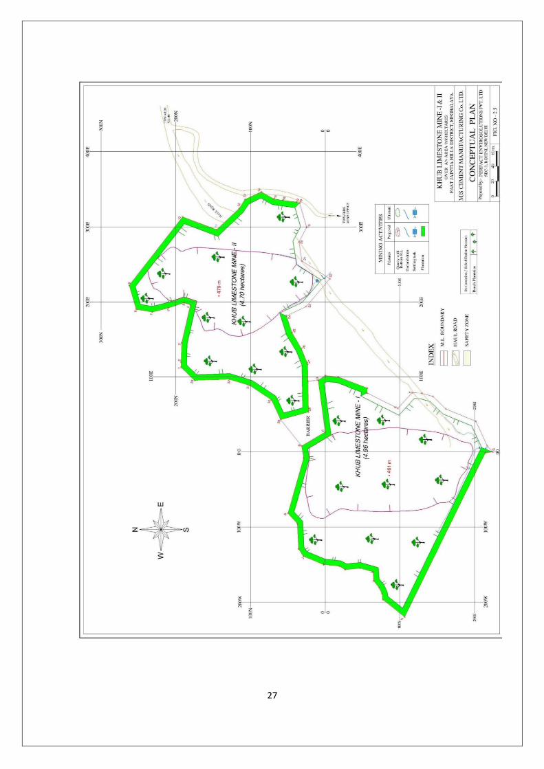
Annexure-IV CONCEPTUAL PLAN
28
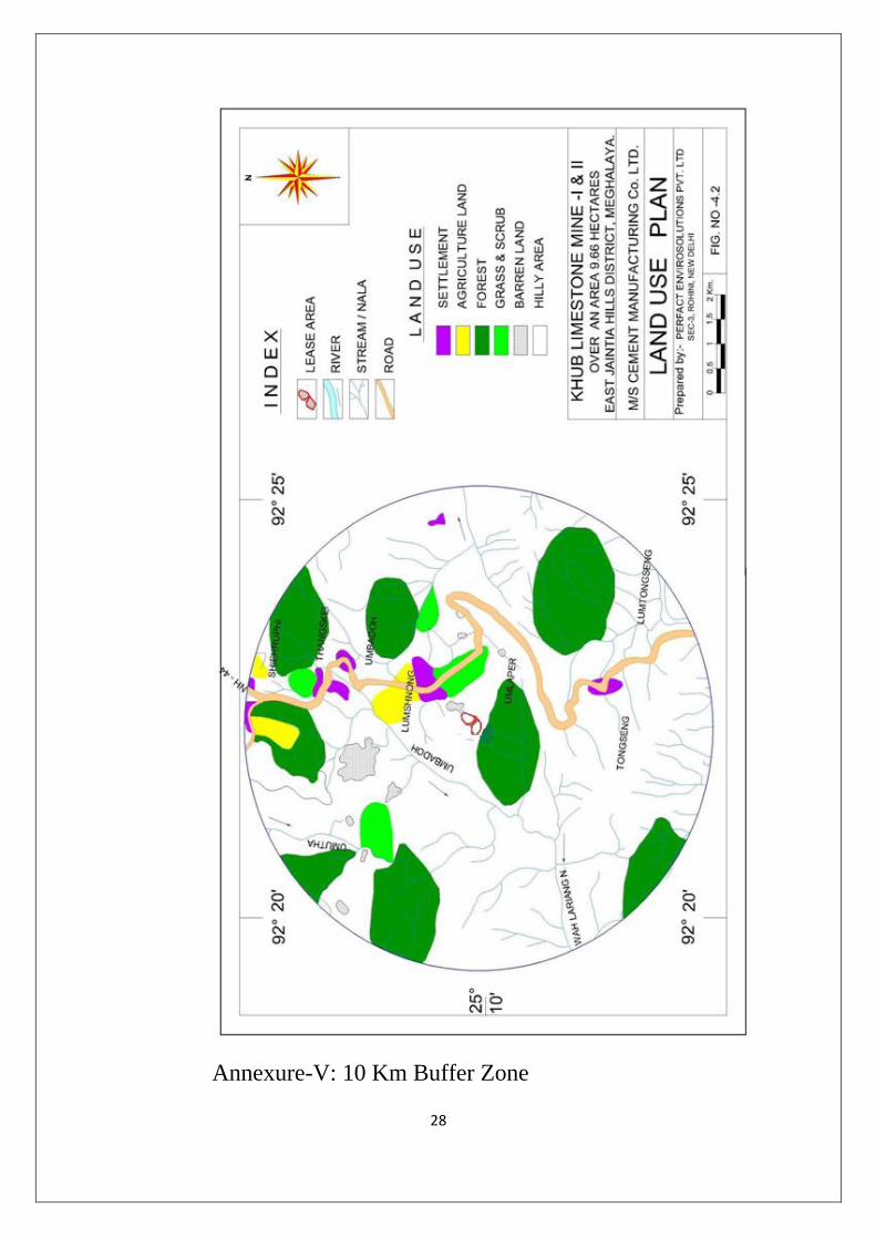
Annexure-V: 10 Km Buffer Zone