practical lidar-acquisition considerations for forestry ...3).pdf · practical lidar-acquisition...
TRANSCRIPT

United States Department of Agriculture
Forest Service
Remote Sensing Applications Center
Geospatial Management Office
Practical Lidar-Acquisition Considerations for Forestry
ApplicationsOctober 2008 RSAC-0111-Brief1
AbstractSeveral federal agencies need terrain and vegetation data that include vertical as well as positional information (Haugerud and others 2007). This data can be topographic but can also include information about the height of objects on the ground such as buildings, other types of infrastructure, and trees. Lidar (light detection and ranging) data can provide this information.
Lidar technology has evolved quickly since the late 1990s; therefore, acquisition requirements have changed to keep pace with this relatively new remote sensing data source. Several government agencies have formed consortia with academic and research institutions to share costs.
The goal of this document is to 1) make lidar users aware of the specifications that have been developed by the Puget Sound Lidar Consortium (PSLC) and the Oregon Lidar Consortium (OLC) for areas with heavy forest cover; 2) describe typical products that can be created using lidar data; and 3) make recommendations for developing specifications for acquiring lidar for natural-resource applications. An example of a lidar specification for a forestry application on the Coronado National Forest is included in the appendix.
Key Wordslidar, lidar acquisition, forest structure, mapping
AuthorsDenise Laes is a geologist and remote sensing analyst working at the Remote Sensing Applications Center and employed by RedCastle Resources in Salt Lake City, Utah.
Steve Reutebuch is a team leader working at the Pacific Wildland Fire Sciences Laboratory at the Pacific Northwest Research Station in Seattle, Washington.
Bob McGaughey is a research forester at the Pacific Wildland Fire Sciences Laboratory at the Pacific Northwest Research Station.
Paul Maus is a remote sensing/GIS analyst working at the Remote Sensing Applications Center and is a principal of RedCastle Resources.
Tom Mellin is the remote sensing coordinator for the Southwestern Regional Office in Albuquerque, New Mexico.
Craig Wilcox is a forest silviculturist for the Safford Ranger District of the Coronado National Forest in Safford, Arizona.
John Anhold is the Arizona zone leader for the Forestry and Forest Health program in Region 3 in Flagstaff, Arizona
Mark Finco is a senior analyst working at the Remote Sensing Applications Center and a principal of RedCastle Resources.
Ken Brewer is program leader for the Inventory, Analysis, and Accuracy Assessment Program at the Remote Sensing Applications Center.
AcknowledgmentsThe Remote Sensing Applications Center (RSAC) would like to extend special thanks to Bob McGaughey and Steve Reutebuch of the Pacific Northwest Research Station for their input and support over the last several years in bringing RSAC up to speed about lidar technology. Without their knowledge and experience, the information needed to compile this document would not have been readily available to the Forest Service. Although this report is the outcome of a cooperative IRS (integrating remote sensing) project with the Coronado National Forest in Arizona, it would not have been possible without several years of support from the IAAA program (Inventory, Analysis and Accuracy Assessment) under the lead of Ken Brewer.
Laes, D.; Reutebuch, S.; McGaughey, B.; Maus, P.; Mellin, T.; Wilcox, C.; Anhold. J.; Finco, M.; Brewer, K. 2008. Practical lidar acquisition considerations for forestry applications. RSAC-0111-BRIEF1. Salt Lake City, UT: U.S. Department of Agriculture, Forest Service, Remote Sensing Applications Center. 32 p.
iii
Table of Contents
Abstract ii
Acknowledgments ii
Introduction 1
Overview of Lidar Technology 1
Lidar Awareness 1
Lidar Contract Specifications 2
Information to Include in a Contract with a Lidar Vendor 2
Minimum Lidar-Acquisition Requirements for Forestry Applications 4
Balancing Costs with Data Requirements 4
Conclusion 6
References and URLs 7
Appendix A: Example of an Expired Request for Quotation 8

iv
1 | RSAC-0111-BRIEF1
IntroductionFederal agencies such as the United States Geological Survey (USGS), USDA Forest Service (FS) and the Bureau of Land management (BLM), need terrain and vegetation data that include vertical measurements (Z) in addition to positional (XY) information (Haugerud and others 2007). This vertical component can be just topographic (elevation) but can also include information about the height of objects on the ground such as buildings, and other kinds of infrastructure, and trees. Lidar (light detection and ranging) data can provide the XYZ information, because its technology has evolved quickly since the late 1990s (Goetz and others 2006).
As happens with any evolving technology, acquisition specifications for lidar must keep changing to keep pace with this relatively new remote sensing data source. Several government agencies have formed consortia with academic and research institutions to share costs.
This document has three goals:
to make lidar users aware of the updated specifications that have been developed by some of these consortia, particularly the Puget Sound Lidar Consortium (PSLC) and the Oregon Lidar consortium (OLC), for areas with heavy forest cover;
To describe typical products that can be created from lidar data; and
To make general recommendations about the way to apply these specifications accurately and appropriately.
These lidar-acquisition specifications are in the public domain. Information about the PSLC and OLC can be found at the following Web sites:
PSLC: http://pugetsoundlidar.ess.washington.edu/ (accessed February 6, 2009).
OLC: http://www.oregongeology.org/sub/projects/olc/default.htm (accessed February 6, 2009).
Overview of Lidar TechnologyThere are several types of airborne lidar systems; this report focuses on the most common terrain-mapping system—discrete-return, small-footprint lidar with a typical laser-beam diameter in the range of 0.2—1.0 m. Discrete-return airborne lidar systems were developed over the last 15 years for the specific purpose of mapping terrain (Wehr and Lohr 1999). Lidar systems combine a laser range finder, GPS unit, inertial measurement unit (IMU), and high-precision clocks, all mounted in an aircraft. The system sends out near-infrared laser pulses and measures the time until it receives a return signal. The two-way travel distance from the laser to the ground and back is calculated based on precise timing and the speed of light. The position of the sensor is recorded by the onboard GPS and IMU. The resulting dataset is a “point cloud” of XYZ coordinates. In areas where vegetation is present, the outgoing pulse often generates multiple returns; some energy beams will be reflected by upper and lower foliage layers, and the rest will penetrate to and be reflected by the ground (Reutebuch and others 2005; Goetz, and others 2006).
Lidar AwarenessLidar data can be used for a variety of projects. As with aerial photography, the data-acquisition parameters are influenced by the intended application. The most commonly derived products from a lidar point cloud are the following (Reutebuch and others 2005):
Ground surface model: a high spatial-resolution bare-earth model representing the elevations of the surface topography.
Canopy surface model: objects such as trees, buildings, and infrastructure are superimposed on the topography. In areas where the top of the vegetation data points generates the surface information, the result is a canopy surface model, which contains information about the elevation of the vegetation.
Canopy height model: the crucial information required concerns the vegetation height. Which can be derived by subtracting the ground surface model from the canopy surface one.
Intensity image: besides measuring time, most sensors can also determine how much energy in the originating infrared pulse returns to the sensor. This is called intensity data, which can then be processed into a high-resolution image corresponding to a noncalibrated infrared reflection that is like an orthophoto.
Knowing the way that lidar specifications affect the information in lidar data is useful for a variety of reasons. It allows planners to gauge whether existing lidar data will fulfill particular project needs. In addition, it facilitates informed discussion and negotiation with vendors prior to acquiring lidar data. Loosening certain specifications may have minimal impact on the utility of the lidar data but may still significantly decrease the acquisition costs.
The Federal Emergency Management Agency (FEMA) has been involved in several of the ongoing or recently completed statewide lidar acquisitions. Unfortunately for vegetation mapping, several of these surveys only generated
2 | RSAC-0111-BRIEF1
bare-earth ground models. When both the first and the last returns are available, the lidar data may be more useful, but often the pulse density is not sufficient for many vegetation projects. Likewise, intermediate returns are not commonly available.
FEMA acquired data generate up-to-date flood-zone elevation models that possess better topographic detail than what was previously available from existing 10-meter USGS digital elevation models (DEMs). Capturing last returns is the minimal information required to generate these models and is less expensive than collecting the typically higher-density lidar data necessary for vegetation mapping. Little forestry information other than a digital terrain model can be derived from FEMA’s last-return lidar data. When first returns are also included in the lidar data, generalized canopy surface models can be created and the canopy height can be derived from them. The nominal density of 1 pulse per 1.5 square meters satisfies FEMA’s data needs to generate a topographic model in relatively open terrain. Areas with dense vegetation cover, like the Pacific Northwest, require higher density collections (1 to 6 pulses per square meter is typical) to increase the likelihood that enough pulses will reach the surface to produce an accurate ground surface model. Neither of these two FEMA requirements—density and last/first return—is good enough to be used in the majority of forestry applications which require a higher pulse density and additional intermediate returns to characterize midcanopy structure.
When lidar data acquired for utility-corridor management (e.g., power-transmission lines) are available to the forester, the specifications, such as 20-plus pulses per square meter, are often higher than what is required for many forestry applications. Vertical accuracy requirements that satisfy transportation and engineering needs
may also be more than forestry studies require. High accuracy requirements can be cost effective for high value projects but may become prohibitively expensive for larger areas. Often one must consider practical trade-offs between the accuracy and volume of the lidar data when forestry applications must cover the potentially large land areas associated with national forests.
Lidar Contract SpecificationsThis section provides specific information about acquiring lidar data and the way the specified parameters can affect the final products and costs. Specifically, the objectives are to do the following:
1. List the information and items to include in a contract with a lidar vendor,
2. Provide minimum requirement information for forestry applications, and
3. Provide recommendations that will help balance cost against data needs.
Information to Include in a Contract with a Lidar Vendor
The first thing is to decide what the vendor needs to know to fulfill the client’s data requirements in the best possible way and determine what the vendor and client should discuss to optimize cooperation. In addition to typical specifications for lidar acquisition, it is important to list items that should be included with the contract to acquaint the vendor with project-specific issues, for example, providing a map of the area; communicating conditions that may restrict acquisition times, such as weather or leaf fall; and determining if flight or airspace is restricted. Special care needs to be taken to word the specifications to eliminate ambiguity.
Table 1 lists minimum lidar data-acquisition specifications for topographic surveys and vegetation mapping following the general guidelines listed here. Most lidar contract specifications should include these items:
The location of the acquisition area, including a narrative, maps, and shape file(s)
A description of applications that will use the data
Potential problems the vendor needs to be aware of, such as flight-restricted areas
The lidar survey specifications (the client knows what is required; the vendor knows the capabilities and limitations of the equipment)
Instrument and aircraft specifications
Data-acquisition parameters
Accuracy specifications
Completeness of the data set
Spatial reference framework (datum, projections, units)
Deliverables (including optional ones)
Formats and data organization (consistent file names, accessible file formats),
Time frame for data acquisition and delivery
Contact information between vendor/client
Insurance/liability clauses
Contract nullification conditions
Data ownership

3 | RSAC-0111-BRIEF1
An example of the items listed in an actual lidar-acquisition contract appears in Appendix 1. These specifications were derived from ones developed by the PSLC and the OLC. These consortia have more than 10 years of cooperative experience in acquiring lidar data. More details about the specifications can be found on the following Web sites:
BLM and FS) http://www.oregongeology.com/sub/projects/olc/proposed_PNW_lidar_spec.pdf (accessed February 6, 2009).
The specifications posted on these two sites were developed in accordance with forestry needs in the Pacific Northwest based on 2007 market conditions. Because of the Puget Sound area’s dense
Table 1—Example of minimum lidar data-acquisition specification guidelines for two projects: topographic mapping in open terrain and mapping and/or vegetation characterization in dense cover (McGaughey and others 2006, Reutebuch and McGaughey 2008)
Topographic mapping in relatively open terrain (medium-resolution ground model: ≥ 2-meter grid)
a. Vegetation characterizationb. Topographic mapping with dense vegetation cover or for high-resolution ground model (< 1-meter grid)
Scan angle ≤ ± 20° of nadir ≤ ± 13° of nadir
Flying height (m)* 2,200 1,200
Pulse repetition frequency** 10 to 70 kHz 30 kHz to > 100 kHz
Ground beam footprint < 100 cm Narrow setting, ≤ 30 cm
Swath width* 1,600 m 500 > – < 800 m
Nominal aggregate pulse density (per sq. meter)
0.3–1 a. 3 to 8 b. > 4 (for some applications > 8)
Returns per pulse Last Minimum 2 (first [surface model] and last [for ground model])> 4 for vegetation and structure modeling
Time of year Leaf-off without snow cover Depends on the project; no snow cover
Horizontal accuracy 25 cm 0.5 mSwath-to-swath vertical accuracy 10 cm 15 cm
Vertical accuracy (in open areas) 15 cm 50 cm absolute accuracy;
relative accuracy can be more important
* These two parameters are influenced by aircraft and project requirements. They are interdependent as well as dependent on minimum scan angle and more. The values in the table are general guidelines only. Discussion between vendor and client will set the best values for these parameters.** Changes as instrument technology improves
Note: acquisition specification requirements for high-precision lidar measurements may surpass those for projects involving vegetation or dense cover.
for the PSLC http://pugetsoundlidar.ess.washington.edu/PSLC_specifications.pdf (accessed February 6, 2009) and
for the OLC (USGS, Washington Dept. of Natural Resources, Oregon Dept. of Geology and Mineral Industries and Dept. of Forestry, Puget Sound Regional Council,

4 | RSAC-0111-BRIEF1
vegetation cover and the young geological terrain, the data requirements for the region are conservative. The recommendations developed by the OLC contain concise details about GPS procedures, the data-tiling scheme, the return classification, and information that should be contained in the metadata. The canopy lidar-acquisition specifications for the Pinaleño Mountains, a sky island in southern Arizona (Appendix 1), were also adapted from these two sources.
The FEMA specifications detailed at (http://www.fema.gov/plan/prevent/fhm/gs_main.shtm (accessed Feb. 6, 2009)) and outlined in Appendix A (Guidelines for Aerial Mapping and Surveying) of the document, are designed for topographic surveys. Most forestry applications will need specifications more closely aligned with the PSLC’s in the areas of pulse density and number of returns.
Overall, it is best to look at the PSLC specifications as a set of guidelines for items that should be included in the contract. They are not meant to restrict the vendor, nor are they set in stone. Knowing what the data needs are and which projects the information will be used for is a first step.
Minimum Lidar-Acquisition Requirements for Forestry Applications
Table 2 lists recommended minimum specifications that embody the most important mission variables to include when contracting for lidar projects
(from Reutebuch and McGaughey 2008). These specifications are intended for forestry projects where more information is desired from the data than a ground surface model. Forest vegetation information can be based on direct elevation/height measurements, or it can be modeled from these measurements in the lidar data or the structural information contained in the multiple returns. Examples of vital forest vegetation information are stand statistics, canopy models, cover density, forest structure, and fuel-model parameters (Seielstad and Queen 2003; Andersen and others 2005; McGaughey and others 2006).
Balancing Costs with Data Requirements
Easing up on some of the specifications can provide less data over a larger area or reduce the cost of acquisition. However, less-stringent specifications also diminish the quality of the data. Reducing the project area is not always the best way to cut costs either. It can actually increase the cost. A major expense for small and midsize acquisitions is the mobilization cost of the aircraft. Mobilization is a fixed cost that becomes larger per acre as the size of the project goes down.
When not enough funding is available to cover the entire study area using certain data requirements, one solution is to divide the area into two or more blocks and prioritize them depending on objectives. The other block(s) can be included either if additional money becomes available before the acquisition
or overall costs go down (e.g., another client needs data for a project in the same geographic location or a more cost-effective vendor becomes available). In case it remains impossible to acquire data for the entire area in a single mission, the lower-priority sections may be added at a later time.
Two vendors recently estimated that 80 percent of the cost of using lidar data is in collection, as opposed to postprocessing. So one way to cut costs is to reduce the time the aircraft is flying. Timing of the mission and accuracy can also influence cost. Table 3 provides scenarios for making trade-offs to balance costs and data acquisition.
Also it is not recommended that digital imagery be acquired at the same time as lidar data. While it initially sounds counterintuitive, the cost of simultaneous collection of imagery and lidar data will most likely be greater than combining two separate flights to obtain lidar data and imagery. High-quality imagery can only be acquired during the day in cloud-free conditions, preferably at high sun angles to increase sun energy and reduce shadowing. This limitation narrows the time window that’s available to fly the lidar mission. In addition, recommended altitude of the aircraft for lidar flights is often lower than optimal for obtaining imagery. When images are taken at this lower altitude, the frames are small with a lot of radial displacement from the photo centers (layover). Stitching these frames together to create an image for the project area results in an image that is not well orthorectified and can be difficult to interpret.

5 | RSAC-0111-BRIEF1
Table 2—Important lidar mission variables
Partial List of Lidar Project Specifications in Forested Areas*
Pulse density per sq. meter
Minimum 1 for stand-level canopy models and medium-resolution ground models (2-m grid).4+ for individual tree-canopy measurements and high-resolution ground models (1-m grid).
Returns per pulse Minimum 2 for canopy and ground-surface measurements.4+ for improved mid- and low-canopy structure measurements.
Laser beam divergence
Narrow beam settings have provided better tree-height information and a higher percentage of ground returns in limited studies. Narrow beam allows higher flight altitudes.
Scan angle
±15 degrees of nadir (13 degrees recommended) or less increases ground returns in heavy forest cover, but narrower scan angles increase the number of flight lines required and costs. Because the operational mechanics of most sensors require them to slow down before they reverse scanning direction as well as a little time to speed up again, the pulse density will increase along the outer edges of the swath width. To keep the point density more evenly spaced across a swath width (and over the project area), the vendor should acquire data over a slightly wider swath width (say, for example, a few degrees wider than required) but clip these outer additional degrees on both sides from the data set. The aggregate point density should be calculated based on the data clipped to the narrow scan angle.
Swath overlap
Usually 50 percent or more sidelap on adjoining swaths, i.e., survey is designed for 100 percent double coverage at planned aircraft height above ground to reduce any possibility of data gaps. Adjacent flight lines should come from parallel opposing directions. Ideally 50 percent sidelap provides information from different scan angles for areas on or near the surface. The opposing directions can help in the flight line to flight line calibration.
Season of survey
Leaf-off in areas of significant hardwood cover and no significant snow cover result in better ground measurements but can be difficult to achieve in higher elevations. Leaf-off flight window can be very constrained by weather in the Northwest, resulting in lower probability of on-time mission success. Leaf-off also allows separation of hardwoods from conifers, but dead trees are difficult to distinguish from leaf-off hardwoods. Leaf-on for distinguishing live from dead trees. Conifer areas can be flown leaf-on, but poor visualization of hardwoods from conifers results. Leaf-on flight window is often larger, resulting in higher probability of on-time mission success.
Absolute lidar measurement accuracy
Horizontal: typically +/-0.5 to 1 m, depending on survey objectives. Vertically: typically +/-0.15 to 0.5 m, depending on survey objectives
Swath-to-swath lidar relative accuracy
Horizontal: +/-0.25 to 0.5 m, depending on survey objectives. Vertically: +/-0.10 to 0.5 m, depending on survey objectives
Lidar instrument ownership
A vendor who owns the sensor needed to meet the required specifications will be able to do so at a lower cost than one who has to subcontract with others or lease an instrument for the job.
*Adopted from the Puget Sound Lidar Consortium (PSLC)

6 | RSAC-0111-BRIEF1
ConclusionAs with any technology, collecting and processing lidar data will continue to evolve. This report provides an overview of minimum data-acquisition specifications for collecting lidar data for projects requiring vegetation characterization. The report also compares acquisition specifications for vegetation characterization projects with those requiring only topographic mapping. Much of the information
Table 3—Potential cost-saving considerations for lidar acquisitions
Action Consequences
Higher aircraft altitude
This produces a wider swath width, but it also increases the footprint size at or near the surface. A wide footprint is less likely to penetrate to the topographic surface where dense vegetation is present, which can result in a less-accurate bare-ground model. Also, in dissected terrain, pulses in deep valley bottoms often produce fewer returns due to atmospheric attenuation of the pulse energy.
Flying faster
This results in fewer pulses per nominal ground surface when flying height is constant. Projects emphasizing forest structure need at least 3 to 5 pulses per square meter. A topographic model may be difficult to derive in areas with very dense vegetation cover.
Increasing the scan angle
This provides a wider data swath, but along the edges of the data, fewer points will reach the ground in densely covered terrain. In open terrain, a wider scan angle has less effect on the number of ground points.
Less sidelap
Reducing sidelap to 30 percent usually guarantees there are no data gaps between flight lines, but the entire area will not be covered from two angles, which is useful to characterize individual stems. It may also be impossible to achieve high pulse densities (e.g., 4 pulses per sq. m.) in areas with only single-swath coverage.
Accuracy
Emphasizing relative accuracy over absolute accuracy is crucial. For many applications, it may be more important to calibrate data from adjacent flight lines against each other (swath-to-swath matching) than verify that the XYZ attributes of the return are within a certain specified range of real-world XYZ coordinates. This is especially true for data that will be used in tabulated applications or statistical models. However, keep in mind the need for field verification when required.
Acquisition window
Give the vendor as large a window as possible without compromising the data needs. A large acquisition window allows the vendor the opportunity to share aircraft mobilization, ferrying, and base-station setup costs across multiple projects. If leaf-on conditions are acceptable, vendors often have wider windows for acquisition and lower scheduling demands, resulting in lower bids for projects. In many mountainous areas, it is impractical to specify leaf-off conditions because snow often persists until well after leaves appear.
provided here is condensed from various lidar consortia available in the public domain. Appendix 1 includes technical specifications for acquiring lidar data for a vegetation mapping project on the Coronado National Forest in AZ. The specifications were part of a request for proposals (RFP) resulting in a contract for acquiring lidar data over an 80,000 acre area. The resulting contract is also included. While lidar data-acquisition
specifications will continue to change, it is useful to recognize that requirements differ depending upon the application and that currently, a one-size-fits-all approach is not yet recommended for lidar data acquisition. We recommend that the potential purchasers and users of lidar data become familiar with these recommendations so that they can appropriately request and better use the resulting lidar products.

7 | RSAC-0111-BRIEF1
For additional information, contact: Brian Schwind Remote Sensing Applications Center 2222 West 2300 South Salt Lake City, UT 84119
phone: (801) 975-3750 e-mail: [email protected].
This publication can be downloaded from the RSAC Web sites: http://fsweb.rsac.fs.fed.us
The Forest Service, United States Department of Agriculture (USDA), has developed this information for the guidance of its employees, its contractors, and its cooperating Federal and State agencies and is not responsible for the interpretation or use of this information by anyone except its own employees. The use of trade, firm, or corporation names in this document is for the information and convenience of the reader. Such use does not constitute an official evaluation, conclusion, recommendation, endorsement, or approval by the Department of any product or service to the exclusion of others that may be suitable.
The U.S. Department of Agriculture (USDA) prohibits discrimination in all its programs and activities on the basis of race, color, national origin, age, disability, and, where applicable, sex, marital status, familial status, parental status, religion, sexual orientation, genetic information, political beliefs, reprisal, or because all or part of an individual’s income is derived from any public assistance program. (Not all prohibited bases apply to all programs.) Persons with disabilities who require alternative means for communication of program information (Braille, large print, audiotape, etc.) should contact USDA’s TARGET Center at (202) 720–2600 (voice and TDD). To file a complaint of discrimination, write to USDA, Director, Office of Civil Rights, 1400 Independence Avenue, S.W., Washington, D.C. 20250–9410, or call (800) 795–3272 (voice) or (202) 720–6382 (TDD). USDA is an equal-opportunity provider and employer.
References and URLsAndersen, H.-E.; McGaughey, R.J.; Reutebuch, S.E. 2005. Estimating forest canopy fuel parameters using lidar data. Remote Sensing of Environment 94(4): 441–449.
Federal Emergency Management Agency. 2003. Guidelines and specification for flood hazard mapping partners. Appendix A: Guidance for aerial mapping and surveying [online]. Available: http://www.fema.gov/plan/prevent/fhm/gs_main.shtm [February 6, 2009].
Goetz, W.; Laes D.; Maus P.; Lachowski H. 2006. Lidar mapping for resource managers. RSAC-0073-RPT1. Salt Lake City, UT: U.S. Department of Agriculture, Forest Service, Remote Sensing Applications Center. 22 p.
Haugerud, R.; Curtis, T.; Madin, I.; Martinez, D.; Nelson, S.; Nile, E.; Reutebuch, S. 2007. A proposed specification for lidar surveys in the Pacific Northwest [online]. Available: http://www.oregongeology.com/sub/projects/olc/proposed_PNW_lidar_spec.pdf [February 6, 2009; draft version].
McGaughey, R.; Andersen, H-E.; Reutebuch, S. 2006. Considerations for planning, acquiring, and processing lidar data for forestry applications. In Proceedings of the eleventh Forest Service remote sensing applications conference, April 24–28, 2006, Salt Lake City, UT. Bethesda, Maryland: American Society of Photogrammetry and Remote Sensing. Unpaginated CD-ROM.
Oregon Lidar Consortium [online]. Available:
http://www.oregongeology.org/sub/projects/olc/
default.htm [February 6, 2009].
Puget Sound Lidar Consortium [online]. Available: http://pugetsoundlidar.ess.washington.edu. [February 6, 2009].
Reutebuch, S.E.; Andersen, H-E.; McGaughey, R.J. 2005. Light detection and ranging (lidar): An emerging tool for multiple resource inventory. Journal of Forestry 103(6): 286–292.
Reutebuch, S.E.; McGaughey, B. 2008. Airborne laser scanning (lidar): an emerging tool for multiple resource measurement, planning and monitoring. Western Forester. 53(2): 1–5.
Seielstad, C.; Queen, L. 2003. Using airborne laser altimetry to determine fuel models for estimating fire behavior. Journal of Forestry 101(4): 10–15.
Wehr, A.; Lohr, U. 1999. Airborne laser scanning—an introduction and overview. ISPRS Journal of Photogrammetry and Remote Sensing 54: 68–82.

8 | RSAC-0111-Appendix A
Appendix A: Example of an Expired Request for QuotationLidar Canopy Mapping on the Pinaleno Mtns on the Safford District, AZ
REQUEST FOR QUOTATION PAGE OF PAGES
(THIS IS NOT AN ORDER) THIS RFQ X IS IS NOT A SMALL BUSINESS SET- ASIDE 1 25 1. REQUEST NO. 2. DATE ISSUED 3. REQUISITION/PURCHASE REQUEST NO. 4. CERT. FOR NAT.DEF. RATING
R3-08-33 6/30/08 UNDER BDSA REG. 2 � AND/OR DMS REG. 1
5a. ISSUED BY 6. DELIVER BY (Date)
5b. FOR INFORMATION CALL (NO COLLECT CALLS) 7. DELIVERY FOB DESTINATION NAME TELEPHONE NUMBER OTHER (See Schedule) AREA CODE NUMBER 9. DESTINATION
a. NAME OF CONSIGNEE
8. TO:
a. NAME b. COMPANY b. STREET ADDRESS c. STREET ADDRESS c. CITY d. CITY e. STATE f. ZIP CODE d. STATE e. ZIP CODE
10. PLEASE FURNISH QUOTATIONS TO THE ISSUING OFFICE IN BLOCK 5A ON OR BEFORE CLOSE OF BUSINESS
IMPORTANT: This is a request for information, and quotations furnished are not offers. If you are unable to quote, please so indicate on this form and return it to the address in BLOCK 5a. This request does not commit the Government to pay any costs incurred in the preparation of the
JULY 30, 2008 submission of this quotation or to contract for supplies or services. Supplies are of domestic origin unless otherwise indicated by quoter. Any representations and/or certifications attached to this Request for Quotations must be completed by the quoter.
11. SCHEDULE (Include applicable Federal, State and local taxes) ITEM NO. SUPPLIES/SERVICES QUANTITY UNIT UNIT PRICE AMOUNT
(a) (b) (c) (d) (e) (f) LiDAR CANOPY MAPPING
The Contractor shall provide all equipment, labor, and materials necessary to map forest structure in the mixed-conifer and spruce-fir forests, using the LiDAR technology, on the Pinaleno Mountains of the Safford Ranger District, southwest of Safford, Arizona in accordance with the attached specifications.
01 LiDAR Canopy Mapping 1 JOB $____________
a. 10 CALENDAR DAYS (%) b. 20 CALENDAR DAYS (%)
c. 30 CALENDAR DAYS (%) d. CALENDAR DAYS
12. DISCOUNT FOR PROMPT PAYMENT � NUMBER PERCENTAGE
NOTE: Additional provisions and representations are are not attached.
13. NAME AND ADDRESS OF QUOTER 14. SIGNATURE OF PERSON AUTHORIZED TO 15. DATE OF a. NAME OF QUOTER SIGN QUOTATION QUOTATION
b. STREET ADDRESS 16. SIGNER
a. NAME (Type or print) b. TELEPHONE
c. COUNTY AREA CODE
d. CITY e. STATE f. ZIP CODE c. TITLE (Type or Print) NUMBER
NSN 7540-01-152-8084 Previous edition not usable
18-121 STANDARD FORM 18 (Rev. 6-95) Prescribed by GSA-FAR (48 CFR) 53.215-1(a)
9 | RSAC-0111-Appendix A
SECTION C—DESCRIPTION/SPECIFICATIONS/STATEMENT OF WORK
SCOPE OF CONTRACT
The Contractor shall provide all equipment, labor, and materials necessary to map forest structure in the mixed-conifer and spruce-fir forests, using the Light Detection and Ranging (LiDAR) technology, on the Pinaleno Mountains of the Safford Ranger District, southwest of Safford, Arizona. The data will be used to help implement and monitor an ecosystem restoration project, create a Mount Graham red squirrel habitat model and piece together likely presettlement forest characteristics based on such items as historical aspen clones and remaining patches of old growth.
TECHNICAL SPECIFICATIONS
Pinaleno Mountains lidar acquisition specs (date: 7 Feb 08):
1. Acquisition Area:
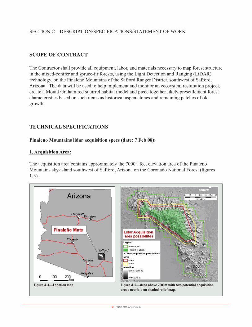
The acquisition area contains approximately the 7000+ feet elevation area of the Pinaleno Mountains sky-island southwest of Safford, Arizona on the Coronado National Forest (figures 1-3).
Figure A-1—Location map. Figure A-2—Area above 7000 ft with two potential acquisition areas overlaid on shaded relief map.

10 | RSAC-0111-Appendix A
2. Purpose of the study:
The data products will be mainly used for vegetation applications including canopy height model, understory vegetation information (fuels) and canopy structure. A good topographic model is also required to calculate and/or model the vegetation information.
3. Potential acquisition problems:
• Limited time of year suitable to acquire the data• Data should be acquired during leaf-on
o to study aspen occurrenceo to distinguish between live and defoliated or burned trees
• The ground should be generally clear of snow with the exception of a few remaining snow banks.
o Snow season: December to Aprilo Monsoon season: (July to September)
• The area of interest is a sky-island. The elevation differences range from around 900 m (approximately 3,000 ft.) at the desert valley bottom to a max elevation of 3267 m (nearly 11,000 ft).
• The acquisition of interest corresponds to the locations above 2133 m (7,000 feet). Two bounding boxes are drawn around this area (figures A-2 and A-3).
o The smaller red box (±61,000 acres) contains the core study area. o The larger yellow bounding box corresponds to an area of 83,400 acres. The area
includes lower elevation terrain where the data acquired over this terrain will be
Figure A-3—Possible lidar acquisition areas overlaid on map.

11 | RSAC-0111-Appendix A
used for primarily for modeling fuels.• The Mount Graham International Observatory (MGIO) is at an elevation of 10,400 ft. and is
8 stories high (figure A-4). If data are acquired during the night, the pilot shall be aware of the location and height of the building.
(http://mgpc3.as.arizona.edu/)The observatory shall be informed about the acquisition date and time.
4. Air space restrictions:
The Contractor shall check with space observatory about general restriction during day and night.
Figure A-4—Photos of the Mount Graham International Observatory (MGIO) at the University of Arizona south of Saffard, Arizona.

12 | RSAC-0111-Appendix A
5. Data acquisition & Completeness:
The table below outlines the desired acquisition parameters. The data will be routinely evaluated for completeness.
Data acquisition Survey Design Minimum requirements1
Wavelength 900-1600 nm discrete return Returns per pulse Up to 4 On-ground laser beam diameter
Approx. 25 cm Use Narrow divergence setting - if instrument allows for it
Between 10 cm and 100 cm
Scan angle ± 13 degrees ≤ ± 20 degrees Aircraft altitude For vendor to determine in
agreement with CNF
Aircraft speed For vendor to determine in agreement with CNF
Ground swath width For vendor to determine in agreement with CNF
Swath overlap 50% sidelap (100% overlap) Between 30% and 50% sidelap No voids between swaths. No voids because of cloud cover or instrument failure < 20% no overlap area per project. No arbitrary 1km x 1km square with > 50% no-overlap area
Aggregate pulse density 3 plus pulses/m2 Baring non-reflective areas (e.g. open water, wet asphalt):
• ≥ 85% design pulse density for entire project area
• within areas of swath overlap, no 30m x 30m area with <50% design pulse density
Flight line direction Opposing GPS base line length ≤ 50 km GPS PDOP ≤3.0, ≥ 6 satellites in view ≤3.5, ≥ 6 satellites in view Survey conditions Leaf-on and no significant
snow cover at discretion of Coronado NF
1. Local relief, turbulence, inability to maintain an exact flying height, and aircraft and instrument availability routinely lead to departures from the survey design. Minimum requirements listed here are the minimum acceptable under this contract.
6. Accuracy:
Accuracy Survey design Vertical accuracy 30 cm at 95% CI Horizontal accuracy Depends on flying height but at least 1m at 95% CI Between-swath reproducibility ≤ 15 cm vertical on horizontal surfaces
13 | RSAC-0111-Appendix A
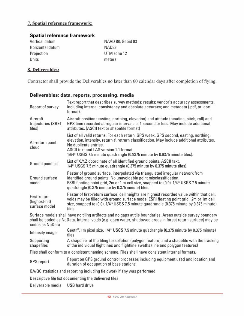
7. Spatial reference framework:
Deliverables: data, reports, processing. media
Report of surveyText report that describes survey methods; results; vendor’s accuracy assessments, including internal consistency and absolute accuracy; and metadata (.pdf, or .doc format).
Aircraft trajectories (SBET files)
Aircraft position (easting, northing, elevation) and attitude (heading, pitch, roll) and GPS time recorded at regular intervals of 1 second or less. May include additional attributes. (ASCII text or shapefile format)
All-return point cloud
List of all valid returns. For each return: GPS week, GPS second, easting, northing, elevation, intensity, return #, retrurn classification. May include additional attributes. No duplicate entries.ASCII text and LAS version 1.1 format1/64th USGS 7.5 minute quadrangle (0.9375 minute by 0.9375 minute tiles).
Ground point list List of X.Y.Z coordinate of all identified ground points. ASCII text.1/4th USGS 7.5 minute quadrangle (0.375 minute by 0.375 minute tiles).
Ground surface model
Raster of ground surface, interpolated via triangulated irregular network from identified ground points. No unavoidable point misclassification.ESRI floating point grid, 2m or 1 m cell size, snapped to (0,0). 1/4th USGS 7.5 minute quadrangle (0.375 minute by 0.375 minute) tiles.
First-return (highest-hit) surface model
Raster of first-return surface, cell heights are highest recorded value within that cell, voids may be filled with ground surface model ESRI floating point grid , 2m or 1m cell size, snapped to (0,0), 1/4th USGS 7.5 minute quadrangle (0.375 minute by 0.375 minute) tiles
Surface models shall have no tiling artifacts and no gaps at tile boundaries. Areas outside survey boundary shall be coded as NoData. Internal voids (e.g. open water, shadowed areas in forest return surface) may be codes as NoData
Intensity image Geotiff, 1m pixel size, 1/4th USGS 7.5 minute quadrangle (0.375 minute by 0.375 minute) tiles
Supporting shapefiles
A shapefile of the tiling tessellation (polygon feature) and a shapefile with the tracking of the individual flightlines and flightline swaths (line and polygon features)
Files shall conform to a consistent naming scheme. Files shall have consistent internal formats.
GPS report Report on GPS ground control processes including equipment used and location and duration of occupation of base stations
QA/QC statistics and reporting including fieldwork if any was performed
Descriptive file list documenting the delivered files
Deliverable media USB hard drive
Spatial reference frameworkVertical datum NAVD 88, Geoid 03Horizontal datum NAD83Projection UTM zone 12Units meters
8. Deliverables:
Contractor shall provide the Deliverables no later than 60 calendar days after completion of flying.

14 | RSAC-0111-Appendix A
SECTION D—PACKAGING AND MARKING
{For this Solicitation, there are NO clauses in this Section}

15 | RSAC-0111-Appendix A
SECTION E—INSPECTION AND ACCEPTANCE
FAR 52.252-2 Clauses Incorporated by Reference (FEB 1998) This contract incorporates one or more clauses by reference, with the same force and effect as if they were given in full text. Upon request, the Contracting Officer will make their full text available. Also, the full text of a clause may be accessed electronically at this/these address(es): www.arnet.gov/far/
FEDERAL ACQUISITION REGULATION (48 CFR CHAPTER 1) CLAUSES
52.246-1 Contractor Inspection Requirements (APR 1984)

16 | RSAC-0111-Appendix A
SECTION F—DELIVERIES OR PERFORMANCE
FAR 52.252-2 Clauses Incorporated by Reference (FEB 1998)
This contract incorporates one or more clauses by reference, with the same force and effect as if they were given in full text. Upon request, the Contracting Officer will make their full text available. Also, the full text of a clause may be accessed electronically at this/these address(es): www.arnet.gov/far/
FEDERAL ACQUISITION REGULATION (48 CFR CHAPTER 1) CLAUSES
1.1-15 Stop Work Order (AUG 1989)
AGAR 452.211-74 Period of Performance (FEB 1988)
The period of performance of this contract is restricted for the season (leaf on for flying). Deliverables shall be completed within 60 calendar days after completion of flying
17 | RSAC-0111-Appendix A
SECTION G—CONTRACT ADMINISTRATION DATA
AGAR 452.215-73 Post Award Conference (NOV 1996)
A post award conference with the successful offeror is required. It will be scheduled within __5____ days after the date of contract award. The conference will be held at __Southwestern Region, 333 Broadway, Albuquerque, New Mexico_________.

18 | RSAC-0111-Appendix A
SECTION H—SPECIAL CONTRACT REQUIREMENTS
{For this Solicitation, there are NO clauses in this Section}
19 | RSAC-0111-Appendix A
PART II—CONTRACT CLAUSES
SECTION I—CONTRACT CLAUSES
FAR 52.252-2 Clauses Incorporated by Reference (FEB 1998)
This contract incorporates one or more clauses by reference, with the same force and effect as if they were given in full text. Upon request, the Contracting Officer will make their full text available. Also, the full text of a clause may be accessed electronically at this/these address(es): www.arnet.gov/far/www.usda.gov/procurement/policy/agar.html
FEDERAL ACQUISITION REGULATION (48 CFR CHAPTER 1) CLAUSES
52.209-6 Protecting the Government’s Interest when Subcontracting with Contractors Debarred, Suspended, or Proposed for Debarment (SEP 2006) (Applicable if contract exceeds $30,000)
52.215-8 Order of Precedence—Uniform Contract Format (OCT 1997)52.219-6 Notice of Total Small Business Set-Aside (JUN 2003) 52.222-3 Convict Labor (JUN 2003)52.222-21 Prohibition of Segregated Facilities (FEB 1999)52.222-26 Equal Opportunity (MAR 2007) (Applicable if contract exceeds $10,000) 52.222-36 Affirmative Action for Workers with Disabilities (JUN 1998) (Applicable if
contract exceeds $10,000)52.222-41 Service Contract Act of 1965, as Amended (JUL 2005)52.222-50 Combating Trafficking in Persons (SEP 2007)52.223-6 Drug-Free Workplace (MAY 2001) (Applicable if contract is awarded to an individual)52.232-1 Payments (APR 84)52.232-8 Discounts for Prompt Payment (FEB 2002)52.232-11 Extras (APR 1984)52.232-23 Assignment of Claims (JAN 1986)52.232-25 Prompt Payment (OCT 2003)52.232-33 Payment by Electronic Funds Transfer – Central Contractor Registration (OCT
2003)52.233-1 Disputes (JULY 2002)52.233-3 Protest After Award (AUG 1996)52.233-4 Applicable Law for Breach of Contract Claim (OCT 2004)52.237-2 Protection of Government Buildings, Equipment, and Vegetation (APR 1984)52.243-1 Changes—Fixed-Price (AUG 1987)—Alternate I (APR 1984) 52.244-6 Subcontracts for Commercial Items (MAR 2007)52.245-1 Property Records (JUN 2007) 52.249-1 Termination for Convenience of the Government (Fixed-Price) (Short From)
(APR 1984) 52.249-8 Default (Fixed-Price Supply and Service) (APR 1984) 52.253-1 Computer Generated Forms (JAN 1991)
20 | RSAC-0111-Appendix A
AGRICULTURE ACQUISITION REGULATION (48 CFR CHAPTER 4) CLAUSES
452.237-70 Loss, Damage, Destruction or Repair (FEB 1988)1.1-75 Restrictions Against Disclosure (FEB 1988)
52.204-7 Central Contractor Registration (JUL 2006)(a) Definitions. As used in this clause—
“Central Contractor Registration (CCR) database” means the primary Government repository for Contractor information required for the conduct of business with the Government.
“Data Universal Numbering System (DUNS) number” means the 9-digit number assigned by Dun and Bradstreet, Inc. (D&B) to identify unique business entities.
“Data Universal Numbering System+4 (DUNS+4) number” means the DUNS number means the number assigned by D&B plus a 4-character suffix that may be assigned by a business concern. (D&B has no affiliation with this 4-character suffix.) This 4-character suffix may be assigned at the discretion of the business concern to establish additional CCR records for identifying alternative Electronic Funds Transfer (EFT) accounts (see the FAR at Subpart 32.11) for the same parent concern.
“Registered in the CCR database” means that—
(1) The Contractor has entered all mandatory information, including the DUNS number or the DUNS+4 number, into the CCR database; and
(2) The Government has validated all mandatory data fields, to include validation of the Taxpayer Identification Number (TIN) with the Internal Revenue Service (IRS), and has marked the record “Active”. The Contractor will be required to provide consent for TIN validation to the Government as a part of the CCR registration process.
(b)
(1) By submission of an offer, the offeror acknowledges the requirement that a prospective awardee shall be registered in the CCR database prior to award, during performance, and through final payment of any contract, basic agreement, basic ordering agreement, or blanket purchasing agreement resulting from this solicitation.
(2) The offeror shall enter, in the block with its name and address on the cover page of its offer, the annotation “DUNS” or “DUNS+4” followed by the DUNS or DUNS+4 number that identifies the offeror’s name and address exactly as stated in the offer. The DUNS number will be used by the Contracting Officer to verify that the offeror is registered in the CCR database.
21 | RSAC-0111-Appendix A
(c) If the offeror does not have a DUNS number, it should contact Dun and Bradstreet directly to obtain one.
(1) An offeror may obtain a DUNS number—
(i) If located within the United States, by calling Dun and Bradstreet at 1-866-705-5711 or via the Internet at http://www.dnb.com; or
(ii) If located outside the United States, by contacting the local Dun and Bradstreet office.
(2) The offeror should be prepared to provide the following information:
(i) Company legal business name.
(ii) Tradestyle, doing business, or other name by which your entity is commonly recognized.
(iii) Company physical street address, city, state and Zip Code.
(iv) Company mailing address, city, state and Zip Code (if separate from physical).
(v) Company telephone number.
(vi) Date the company was started.
(vii) Number of employees at your location.
(viii) Chief executive officer/key manager.
(ix) Line of business (industry).
(x) Company Headquarters name and address (reporting relationship within your entity).
(d) If the Offeror does not become registered in the CCR database in the time prescribed by the Contracting Officer, the Contracting Officer will proceed to award to the next otherwise successful registered Offeror.
(e) Processing time, which normally takes 48 hours, should be taken into consideration when registering. Offerors who are not registered should consider applying for registration immediately upon receipt of this solicitation.
(f) The Contractor is responsible for the accuracy and completeness of the data within the CCR database, and for any liability resulting from the Government’s reliance on inaccurate or incomplete data. To remain registered in the CCR database after the initial registration, the Contractor is required to review and update on an annual basis from the date of initial registration or subsequent updates its information in the CCR database to ensure it is current,
22 | RSAC-0111-Appendix A
accurate and complete. Updating information in the CCR does not alter the terms and conditions of this contract and is not a substitute for a properly executed contractual document.
(g)
(1)
(i) If a Contractor has legally changed its business name, “doing business as” name, or division name (whichever is shown on the contract), or has transferred the assets used in performing the contract, but has not completed the necessary requirements regarding novation and change-of-name agreements in Subpart 42.12, the Contractor shall provide the responsible Contracting Officer a minimum of one business day’s written notification of its intention to:
(A) Change the name in the CCR database;
(B) Comply with the requirements of Subpart 42.12 of the FAR;
(C) Agree in writing to the timeline and procedures specified by the responsible Contracting Officer. The Contractor must provide with the notification sufficient documentation to support the legally changed name.
(ii) If the Contractor fails to comply with the requirements of paragraph (g)(1)(i) of this clause, or fails to perform the agreement at paragraph (g)(1)(i)(C) of this clause, and, in the absence of a properly executed novation or change-of-name agreement, the CCR information that shows the Contractor to be other than the Contractor indicated in the contract will be considered to be incorrect information within the meaning of the “Suspension of Payment” paragraph of the electronic funds transfer (EFT) clause of this contract.
(2) The Contractor shall not change the name or address for EFT payments or manual payments, as appropriate, in the CCR record to reflect an assignee for the purpose of assignment of claims (see FAR Subpart 32.8, Assignment of Claims). Assignees shall be separately registered in the CCR database. Information provided to the Contractor’s CCR record that indicates payments, including those made by EFT, to an ultimate recipient other than that Contractor will be considered to be incorrect information within the meaning of the “Suspension of payment” paragraph of the EFT clause of this contract.
(h) Offerors and Contractors may obtain information on registration and annual confirmation requirements via the Internet at http://www.ccr.gov or by calling 1-888-227-2423, or 269-961-5757.

23 | RSAC-0111-Appendix A
PART III—LIST OF DOCUMENTS, EXHIBITS, AND OTHER ATTACHMENTS
SECTION J—LIST OF ATTACHMENTS
Wage Determination 1995-0222, Revision No. 26 3 pages

24 | RSAC-0111-Appendix A
WD 95-0222 (Rev.-26) was first posted on www.wdol.gov on 06/03/2008Aerial Photographers/Seeding/Spraying******************************************************************************REGISTER OF WAGE DETERMINATIONS UNDER ³ U.S. DEPARTMENT OF LABOR THE SERVICE CONTRACT ACT ³ EMPLOYMENT STANDARDS ADMINISTRATIONBy direction of the Secretary of Labor ³ WAGE AND HOUR DIVISION ³ WASHINGTON, D.C. 20210 ³ ³ Shirley F. Ebbesen Division of Wage ³ Wage Determination No: 1995-0222Director Determinations ³ Revision No: 26 ³ Date Of Revision: 05/29/2008----------------------------------------------------------------------------------Nationwide: Applicable in the continental U.S. Alaska, Puerto Rico, Hawaii andVirgin Islands.----------------------------------------------------------------------------------
**Fringe Benefits Required Follow the Occupational Listing**
Employed on U.S. Government contracts for aerial photographer, aerial seeding,aerial spraying, transportation of personnel and cargo, fire reconnaissance,administrative flying, fire detection, air taxi mail service, and other flyingservices.
OCCUPATION CODE - TITLE MINIMUM WAGE RATE 31010 - Airplane Pilot 23.62 (not set) - First Officer (Co-Pilot) 21.51 (not set) - Aerial Photographer 11.80 EXCEPT SCHEDULED AIRLINE TRANSPORTATION AND LARGE MULTI-ENGINE AIRCRAFT SUCH ASTHE B-727, DC-8, AND THE DC-9. ____________________________________________________________________________________________________ALL OCCUPATIONS LISTED ABOVE RECEIVE THE FOLLOWING BENEFITS:
HEALTH & WELFARE: $3.24 per hour or $129.60 per week or $561.60 per month
VACATION: 2 weeks paid vacation after 1 year of service with a contractor orsuccessor; 3 weeks after 5 years, and 4 weeks after 15 years. Length of serviceincludes the whole span of continuous service with the present contractor orsuccessor, wherever employed, and with the predecessor contractors in theperformance of similar work at the same Federal facility. (Reg. 29 CFR 4.173)
HOLIDAYS: A minimum of ten paid holidays per year, New Year’s Day, Martin LutherKing Jr’s Birthday, Washington’s Birthday, Memorial Day, Independence Day, LaborDay, Columbus Day, Veterans’ Day, Thanksgiving Day, and Christmas Day. (Acontractor may substitute for any of the named holidays another day off with payin accordance with a plan communicated to the employees involved.) (See 29 CFR4174)
VACATION (Hawaii): 2 weeks paid vacation after 1 year of service with acontractor or successor; 3 weeks after 10 years, and 4 weeks after 15 years.Length of service includes the whole span of continuous service with the presentcontractor or successor, wherever employed, and with the predecessor contractorsin the performance of similar work at the same Federal facility. (Reg. 29 CFR4.173)
HEALTH & WELFARE (Hawaii): $1.37 per hour, or $54.80 per week, or $237.47 permonth hour for all employees on whose behalf the contractor provides health carebenefits pursuant to the Hawaii prepaid Health Care Act. For those employees whoare not receiving health care benefits mandated by the Hawaii prepaid HealthCare Act, the new health and welfare benefit rate will be $3.24 per hour.

25 | RSAC-0111-Appendix A
HAZARDOUS PAY DIFFERENTIAL: An 8 percent differential is applicable to employeesemployed in a position that represents a high degree of hazard when working withor in close proximity to ordinance, explosives, and incendiary materials. Thisincludes work such as screening, blending, dying, mixing, and pressing ofsensitive ordance, explosives, and pyrotechnic compositions such as lead azide,black powder and photoflash powder. All dry-house activities involvingpropellants or explosives. Demilitarization, modification, renovation,demolition, and maintenance operations on sensitive ordnance, explosives andincendiary materials. All operations involving regrading and cleaning ofartillery ranges.
A 4 percent differential is applicable to employees employed in a position thatrepresents a low degree of hazard when working with, or in close proximity toordance, (or employees possibly adjacent to) explosives and incendiary materialswhich involves potential injury such as laceration of hands, face, or arms ofthe employee engaged in the operation, irritation of the skin, minor burns andthe like; minimal damage to immediate or adjacent work area or equipment beingused. All operations involving, unloading, storage, and hauling of ordance,explosive, and incendiary ordnance material other than small arms ammunition.These differentials are only applicable to work that has been specificallydesignated by the agency for ordance, explosives, and incendiary materialdifferential pay.
** UNIFORM ALLOWANCE **
If employees are required to wear uniforms in the performance of this contract(either by the terms of the Government contract, by the employer, by the stateor local law, etc.), the cost of furnishing such uniforms and maintaining (bylaundering or dry cleaning) such uniforms is an expense that may not be borne byan employee where such cost reduces the hourly rate below that required by thewage determination. The Department of Labor will accept payment in accordancewith the following standards as compliance:
The contractor or subcontractor is required to furnish all employees with anadequate number of uniforms without cost or to reimburse employees for theactual cost of the uniforms. In addition, where uniform cleaning and maintenanceis made the responsibility of the employee, all contractors and subcontractorssubject to this wage determination shall (in the absence of a bona fidecollective bargaining agreement providing for a different amount, or thefurnishing of contrary affirmative proof as to the actual cost), reimburse allemployees for such cleaning and maintenance at a rate of $3.35 per week (or $.67cents per day). However, in those instances where the uniforms furnished aremade of “wash and wear” materials, may be routinely washed and dried with otherpersonal garments, and do not require any special treatment such as drycleaning, daily washing, or commercial laundering in order to meet thecleanliness or appearance standards set by the terms of the Government contract,by the contractor, by law, or by the nature of the work, there is no requirementthat employees be reimbursed for uniform maintenance costs.
The duties of employees under job titles listed are those described in the“Service Contract Act Directory of Occupations”, Fifth Edition, April 2006,unless otherwise indicated. Copies of the Directory are available on theInternet. A links to the Directory may be found on the WHD home page athttp://www.dol.gov/esa/whd/ or through the Wage Determinations On-Line (WDOL)Web site at http://wdol.gov/.
REQUEST FOR AUTHORIZATION OF ADDITIONAL CLASSIFICATION AND WAGE RATE {StandardForm 1444 (SF 1444)}
Conformance Process:
The contracting officer shall require that any class of service employee whichis not listed herein and which is to be employed under the contract (i.e., thework to be performed is not performed by any classification listed in the wagedetermination), be classified by the contractor so as to provide a reasonablerelationship (i.e., appropriate level of skill comparison) between such unlistedclassifications and the classifications listed in the wage determination. Such

26 | RSAC-0111-Appendix A
conformed classes of employees shall be paid the monetary wages and furnishedthe fringe benefits as are determined. Such conforming process shall beinitiated by the contractor prior to the performance of contract work by suchunlisted class(es) of employees. The conformed classification, wage rate, and/orfringe benefits shall be retroactive to the commencement date of the contract.{See Section 4.6 (C)(vi)} When multiple wage determinations are included in acontract, a separate SF 1444 should be prepared for each wage determination towhich a class(es) is to be conformed.
The process for preparing a conformance request is as follows:
1) When preparing the bid, the contractor identifies the need for a conformedoccupation(s) and computes a proposed rate(s).
2) After contract award, the contractor prepares a written report listing inorder proposed classification title(s), a Federal grade equivalency (FGE) foreach proposed classification(s), job description(s), and rationale for proposedwage rate(s), including information regarding the agreement or disagreement ofthe authorized representative of the employees involved, or where there is noauthorized representative, the employees themselves. This report should besubmitted to the contracting officer no later than 30 days after such unlistedclass(es) of employees performs any contract work.
3) The contracting officer reviews the proposed action and promptly submits areport of the action, together with the agency’s recommendations and pertinentinformation including the position of the contractor and the employees, to theWage and Hour Division, Employment Standards Administration, U.S. Department ofLabor, for review. (See section 4.6(b)(2) of Regulations 29 CFR Part 4).
4) Within 30 days of receipt, the Wage and Hour Division approves, modifies, ordisapproves the action via transmittal to the agency contracting officer, ornotifies the contracting officer that additional time will be required toprocess the request.
5) The contracting officer transmits the Wage and Hour decision to thecontractor.
6) The contractor informs the affected employees.
Information required by the Regulations must be submitted on SF 1444 or bondpaper.
When preparing a conformance request, the “Service Contract Act Directory ofOccupations” (the Directory) should be used to compare job definitions to insurethat duties requested are not performed by a classification already listed inthe wage determination. Remember, it is not the job title, but the requiredtasks that determine whether a class is included in an established wagedetermination. Conformances may not be used to artificially split, combine, orsubdivide classifications listed in the wage determination.
** OCCUPATIONS NOT INCLUDED IN THE SCA DIRECTORY OF OCCUPATIONS **Aerial PhotographerThe aerial photographer must be skilled in reading flight maps, capable ofassisting the pilot to adhere to flight lines, be able to level and operate acartographic camera and its auxiliary equipment mounted in the aircraft so thatthe photographs that are taken will have the required forward lap and side lapfor use in photogrammetric mapping equipment, and possess a working knowledge ofaerial films and camera filters to insure proper exposure of the films.
First Officer (Co-Pilot)Is second in command of commercial airplane and its crew while transportingpassengers, mail, or other cargo on scheduled or nonscheduled flights. Assistsor relieves an airline captain in operating the controls of an airplane;monitoring flight and engine instruments; and maintaining air-to-groundcommunications.
27 | RSAC-0111-Appendix A
PART IV—REPRESENTATIONS AND INSTRUCTIONS
SECTION K—REPRESENTATIONS, CERTIFICATIONS, ANDOTHER STATEMENTS OF OFFERORS OR RESPONDENTS
AGAR 452.219-70 SIZE STANDARD AND NAICS CODE INFORMATION (JANUARY 2005)
The North American Industrial classification System Code(s) and business size standard(s) describing the products and/or services to be acquired under this solicitation are listed below:
Contract line item(s): ALL —NAICS Code 541360 —Size Standard $4.5
The small business size standard for a concern which submits an offer in its own name, other than on a construction or service contract, but which proposes to furnish a product which it did not itself manufacture, is 500 employees.
52.204-8 ANNUAL REPRESENTATIONS AND CERTIFICATIONS (JAN 2006)(a)(1) The North American Industry Classification System (NAICS) code for this acquisition is _______541360___________ .
(2) The small business size standard is ____$4.5_________.
(3) The small business size standard for a concern which submits an offer in its own name, other than on a construction or service contract, but which proposes to furnish a product which it did not itself manufacture, is 500 employees.
(b)(1) If the clause at 52.204-7, Central Contractor Registration, is included in this solicitation, paragraph (c) of this provision applies.
(2) If the clause at 52.204-7 is not included in this solicitation, and the offeror is currently registered in CCR, and has completed the ORCA electronically, the offeror may choose to use paragraph (c) of this provision instead of completing the corresponding individual representations and certifications in the solicitation. The offeror shall indicate which option applies by checking one of the following boxes:

28 | RSAC-0111-Appendix A
[ ] (i) Paragraph (c) applies.
[ ] (ii) Paragraph (c) does not apply and the offeror has completed the individual representations and certifications in the solicitation.
(c) The offeror has completed the annual representations and certifications electronically via the Online Representations and Certifications Application (ORCA) website at http://orca.bpn.gov. After reviewing the ORCA database information, the offeror verifies by submission of the offer that the representations and certifications currently posted electronically have been entered or updated within the last 12 months, are current, accurate, complete, and applicable to this solicitation (including the business size standard applicable to the NAICS code referenced for this solicitation), as of the date of this offer and are incorporated in this offer by reference (see FAR 4.1201); except for the changes identified below [offeror to insert changes, identifying change by clause number, title, date]. These amended representation(s) and/or certification(s) are also incorporated in this offer and are current, accurate, and complete as of the date of this offer.
FAR Clause # Title Date Change ____________ _________ _____ _______
Any changes provided by the offeror are applicable to this solicitation only, and do not result in an update to the representations and certifications posted on ORCA.
FAR 52.219-28 Post-Award Small Business Program Rerepresentation. (June 2007)
(a) Definitions. As used in this clause— Long-term contract means a contract of more than five years in duration, including options. However, the term does not include contracts that exceed five years in duration because the period of performance has been extended for a cumulative period not to exceed six months under the clause at 52.217-8, Option to Extend Services, or other appropriate authority. Small business concern means a concern, including its affiliates, that is independently owned and operated, not dominant in the field of operation in which it is bidding on Government contracts, and qualified as a small business under the criteria in 13 CFR part 121 and the size standard in paragraph (c) of this clause. (b) If the Contractor represented that it was a small business concern prior to award of this contract, the Contractor shall rerepresent its size status according to paragraph (e) of this clause or, if applicable, paragraph (g) of this clause, upon the occurrence of any of the following: (1) Within 30 days after execution of a novation agreement or within 30 days after modification of the contract to include this clause, if the novation agreement was executed prior to inclusion of this clause in the contract.
29 | RSAC-0111-Appendix A
(2) Within 30 days after a merger or acquisition that does not require a novation or within 30 days after modification of the contract to include this clause, if the merger or acquisition occurred prior to inclusion of this clause in the contract. (3) For long-term contracts— (i) Within 60 to 120 days prior to the end of the fifth year of the contract; and (ii) Within 60 to 120 days prior to the exercise date specified in the contract for any option thereafter. (c) The Contractor shall rerepresent its size status in accordance with the size standard in effect at the time of this rerepresentation that corresponds to the North American Industry Classification System (NAICS) code assigned to this contract. The small business size standard corresponding to this NAICS code can be found at http://www.sba.gov/services/contractingopportunities/sizestandardstopics/. (d) The small business size standard for a Contractor providing a product which it does not manufacture itself, for a contract other than a construction or service contract, is 500 employees. (e) Except as provided in paragraph (g) of this clause, the Contractor shall make the rerepresentation required by paragraph (b) of this clause by validating or updating all its representations in the Online Representations and Certifications Application and its data in the Central Contractor Registration, as necessary, to ensure they reflect current status. The Contractor shall notify the contracting office by e-mail, or otherwise in writing, that the data have been validated or updated, and provide the date of the validation or update. (f) If the Contractor represented that it was other than a small business concern prior to award of this contract, the Contractor may, but is not required to, take the actions required by paragraphs (e) or (g) of this clause. (g) If the Contractor does not have representations and certifications in ORCA, or does not have a representation in ORCA for the NAICS code applicable to this contract, the Contractor is required to complete the following rerepresentation and submit it to the contracting office, along with the contract number and the date on which the rerepresentation was completed: The Contractor represents that it ( ) is, ( ) is not a small business concern under NAICS Code ______________ assigned to contract number ______________. [Contractor to sign and date and insert authorized signer’s name and title].
30 | RSAC-0111-Appendix A
SECTION L—INSTRUCTIONS, CONDITIONS, AND NOTICES TO OFFERORS OR RESPONDENTS
FAR 52.252-1 Solicitation Provisions Incorporated by Reference (FEB 1998)
This solicitation incorporates one or more solicitation provisions by reference, with the same force and effect as if they were given in full text. Upon request, the Contracting Officer will make their full text available. The offeror is cautioned that the listed provisions may include blocks that must be completed by the offeror and submitted with its quotation or offer. In lieu of submitting the full text of those provisions, the offeror may identify the provision by paragraph identifier and provide the appropriate information with its quotation or offer. Also, the full text of a solicitation provision may be accessed electronically at this/these address(es): www.arnet.gov/far/www.usda.gov/procurement/policy/agar.html
FEDERAL ACQUISITION REGULATION (48 CFR CHAPTER 1)
52.215-1 Instructions to Offerors—Competitive Acquisition (JAN 2004) 52.237-1 Site Visit (APR 1984)
AGRICULTURE ACQUISITION REGULATIONS (48 CFR CHAPTER 4) CLAUSES 452.204-70 Inquiries (FEB 1988)
FAR 52.215-5 Facsimile Proposals (OCT 1997)
(a) Definition. “Facsimile proposal,” as used in this provision, means a proposal, revision or modification of a proposal, or withdrawal of a proposal that is transmitted to and received by the Government via facsimile machine.
(b) Offerors may submit facsimile proposals as responses to this solicitation. Facsimile proposals are subject to the same rules as paper proposals.
(c) The telephone number of receiving facsimile equipment is:
(d) If any portion of a facsimile proposal received by the Contracting Officer is unreadable to the degree that conformance to the essential requirements of the solicitation cannot be ascertained from the document—
(1) The Contracting Officer immediately shall notify the offeror and permit the offeror to resubmit the proposal.

31 | RSAC-0111-Appendix A
(2) The method and time for resubmission shall be prescribed by the Contracting Officer after consultation with the offeror; and
(3) The resubmission shall be considered as if it were received at the date and time of the original unreadable submission for the purpose of determining timelines, provided the offeror complies with the time and format requirements for resubmission prescribed by the Contracting Officer.
(e) The Government reserves the right to make award solely on the facsimile proposal. However, if requested to do so by the Contracting Officer, the apparently successful offeror promptly shall submit the complete original signed proposal.

32 | RSAC-0111-Appendix A
SECTION M—EVALUATION FACTORS FOR AWARD
AWARD DETERMINATION
Award will be made to the offer(s) whose proposal is considered to the best value to the Government, price and other factors considered. The Government intends to award this contract without discussions.
Proposals will be evaluated based on the following factors. The sum of the non-cost evaluation factors, listed under the Technical Proposal, are approximately equal to the cost evaluation factor listed under the Price Proposal.
EVALUATION FACTORS
A. Price Proposal
Furnish price for all services and materials to complete the work described herein, including appropriate taxes, on the Request for Quotation form as “One Job”. No additional information will be necessary to determine reasonableness of price.
B. Technical Proposal
1. Past Performance—consisting of; timeliness of performance, quality of service, and business relations.
2. Prior Experience—identify previous and ongoing projects that are similar with the type of work required by this solicitation, specifically LiDAR data collection and processing for forest canopy modeling and assessment.
3. Qualifications—capability to accomplish the tasks identified.
Submit your proposal addressing the Evaluation Factors shown above.