potential for a basin-centered gas - usgs · retreat of the cretaceous seaway from northern new...
TRANSCRIPT

Potential for a Basin-Centered GasAccumulation in the Raton Basin, Colorado and New Mexico
By Ronald C. Johnson and Thomas M. Finn
U.S. Geological Survey Bulletin 2184-B
U.S. Department of the InteriorU.S. Geological Survey
Geologic Studies of Basin-Centered Gas SystemsEdited by Vito F. Nuccio and Thaddeus S. Dyman
This work funded by the U.S. Department of Energy, National Energy Technology Laboratory, Morgantown, W. Va., under contracts DE-AT26-98FT40031 and DE-AT26-98FT40032, and by the U.S. Geological Survey Central Region Energy Resources Team
U.S. Department of the InteriorGale A. Norton, Secretary
U.S. Geological SurveyCharles G. Groat, Director
Any use of trade, product, or fi rm names in this publicationis for descriptive purposes only and does notimply endorsement by the U.S. Government
This publication is only available online at:http://geology.cr.usgs.gov/pub/bulletins/b2184-b/
Posted online June 2001, version 1.0

III
Contents
Abstract .......................................................................................................................................................... 1Introduction ................................................................................................................................................... 1Thermal Maturity and Coal Rank in the Raton Basin.............................................................................. 5Coal-Bed Methane in the Raton Basin...................................................................................................... 5Geology of Basin-Centered Gas Accumulations..................................................................................... 7Evidence for a Basin-Centered Gas Accumulation in the Raton Basin............................................... 9Discussion...................................................................................................................................................... 9References Cited ........................................................................................................................................ 12
Figures
1. Generalized geologic map of the Raton Basin, Colorado and New Mexico ...................... 2 2. Generalized stratigraphic column for the Colorado portion of the Raton Basin................ 3 3. Generalized stratigraphic column for Cretaceous and Tertiary rocks
in the Raton Basin......................................................................................................................... 4 4. East-west stratigraphic cross section across the southern part of the
Raton Basin showing vertical and lateral variations in Upper Cretaceous and Paleocene rocks ................................................................................................................... 5
5. Coal rank map at the base of the Vermejo Formation, Raton Basin..................................... 6 6. Map showing areas of current coal-bed methane production in the
Raton Basin.................................................................................................................................... 8 7. Approximate depths to the top of the Trinidad Sandstone .................................................. 11
Table
1. List of wells in the Raton Basin that tested gas of had gas shows in sandstones of Upper Cretaceous and Paleocene age ........................................................ 10
Abstract
The Raton Basin appears to contain a signifi cant continu-ous or basin-centered gas accumulation in sandstones of the Upper Cretaceous Trinidad Sandstone and Vermejo Formation and Upper Cretaceous and Paleocene Raton Formation. The accumulation is underpressured and occurs at comparatively shallow (<3,500 ft) depths. The sandstones are interbedded with coal beds that are currently being developed for coal-bed methane, and the coals are the likely source for gas found in the sandstones. Based on analogs with other Rocky Mountain basins, relatively water-free production should occur where levels of thermal maturity in the coals exceed a vitrinite refl ec-tance value of 1.1 percent. This level of thermal maturity occurs over much of the central part of the Raton Basin. Because of the shallow depths, some of the accumulation has probably been degraded by surface water invasion.
Introduction
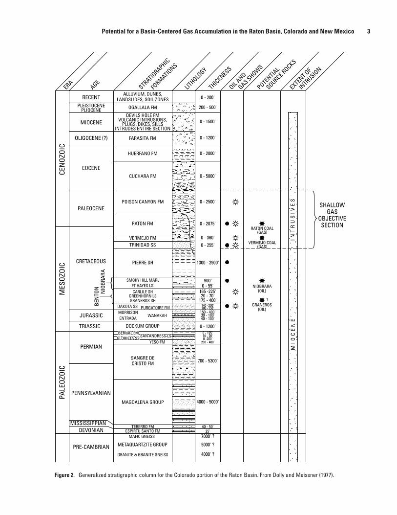
The Raton Basin covers an area of about 4,000 mi2 in southeastern Colorado and northeastern New Mexico. The basin is bounded on the west by the Sangre de Cristo Moun-tains, on the north by the Wet Mountains, on the southeast by the Sierra Grande arch, on the east by the Las Animas arch, and on the northeast by the Apishapa arch (fi g. 1). The basin is highly asymmetrical, with the deep basin axis just east of the Sangre de Cristos. The east fl ank of the basin is gently tilted toward the west at from 1° to 5°, whereas steep dips and thrust faults occur along the west fl ank adjacent to the Sangre de Cristo Mountains. The Raton Basin is in the southeastern part of the area that was affected by the Laramide orogeny (Late Cretaceous through Eocene) in the central Rocky Mountain region. The Basin contains a thick stratigraphic section of Devonian through Plio-Pleistocene-age rocks (fi g. 2).
Evidence for a basin-centered or continuous gas accumu-lation of some sort in the Raton Basin has been presented by many authors (Dolly and Meissner, 1977; Broadhead, 1982, 1991; Rose and others, 1986; and Woodward, 1987). The reservoir units considered by these authors most likely to contain a basin-centered gas accumulation include the Upper Cretaceous Trinidad Sandstone and Vermejo Formation, Upper Cretaceous and Paleocene Raton Formation, and the Paleocene Poison Canyon Formation (fi g. 3). In addition, minor amounts of hydrocarbons have been produced on structures at shallow depths (< 3,000 ft) from fractured reservoirs in the Cretaceous Niobrara, Carlile, and Greenhorn Formations, and the Cre-taceous Pierre Shale in the Raton Basin since 1892. Production from these units in the Denver Basin to the north is considered unconventional because of low pressures and low matrix per-meabilities (see Denver Basin discussion in Gautier and others, 1995). It is possible that unconventional or basin-centered accumulations could occur in these fractured Cretaceous units at greater depths in the Raton Basin. This possibility has not been addressed by previous workers and is beyond the scope of this paper. The purpose of this report is to summarize the evidence for a basin-centered gas accumulation in the Trinidad Sandstone, Vermejo Formation, and Raton Formation presented by previous authors and to reexamine this evidence in light of new understandings about how basin-centered accu-mulations are created and destroyed.
The marginal-marine Trinidad Sandstone conformably overlies the Pierre Shale throughout the basin and was depos-ited along an eastward-prograding shoreline during the fi nal retreat of the Cretaceous Seaway from northern New Mexico and southern Colorado. The Trinidad Sandstone was deposited in shallow marine, shoreface, and deltaic environments (Pill-more and Maberry, 1976; Billingsley, 1977). It varies from 0 to more than 300 ft thick (Rose and others, 1986, fi g. 7) and is truncated by the Poison Canyon Formation in the northernmost part of the basin.
The Upper Cretaceous Vermejo Formation conformably overlies the Trinidad Sandstone. The Vermejo Formation varies from 0 to 380 ft thick and is also truncated by the Poison Canyon Formation in the northernmost part of the basin. The
Potential for a Basin-Centered Gas Accumulation in the Raton Basin, Colorado and New Mexico
By Ronald C. Johnson1 and Thomas M. Finn1
1 U.S. Geological Survey, Denver, Colo.
1

Figure 1. Generalized geologic map of the Raton Basin, Colorado and New Mexico. From Flores and Bader (1999).
37˚
105˚
Alluvium, slopewash, andlandslide material
Basalt flows
Cuchara Formation
Huerfano Formation
Middle Tertiary intrusives
Trinidad Sandstone andPierre Shale undividedPierre Shale/Niobrara undivided
Poison Canyon Formation
Precambrian rock undivided
Raton Formation
Vermejo Formation
ColoradoNew Mexico
Colorado
NewMexico
Raton Basin
Raton Basin boundary
Apishapa
archSi
erra
Gra
nde
arch
Las
Ani
mas
Sangred
eC
ristoM
ountains
Basin axis
Holocene andQuaternary
Tertiary
Cretaceous
}}
arch
0 15 Miles
0 20 Kilometers
Raton
Walsenburg
Stonewall
2
Geologic Studies of B
asin-Centered Gas System
s
RECENTPLEISTOCENE
PLIOCENE
MIOCENE
OLIGOCENE (?)
EOCENE
PALEOCENE
CRETACEOUS
JURASSIC
TRIASSIC
PERMIAN
PENNSYLVANIAN
DEVONIANMISSISSIPPIAN
PRE-CAMBRIAN
ERAAGE
STRATIGRAPHIC
FORMATIO
NS
OIL AND
GAS SHOWS
SOURCE ROCKS
POTENTIAL
INTRUSIO
N
EXTENT OF
LITHOLO
GY
THICKNESSCE
NOZ
OIC
MES
OZOI
CPA
LEOZ
OIC
ALLUVIUM, DUNES,LANDSLIDES, SOIL ZONES
OGALLALA FM
DEVILS HOLE FMVOLCANIC INTRUSIONS,
PLUGS, DIKES, SILLSINTRUDES ENTIRE SECTION
FARASITA FM
HUERFANO FM
CUCHARA FM
POISON CANYON FM
RATON FM
VERMEJO FMTRINIDAD SS
PIERRE SH
SMOKY HILL MARLFT HAYES LS
NIO
BRAR
ABE
NTO
N
CARLILE SHGREENHORN LSGRANEROS SH
DOCKUM GROUP
DAKOTA SS PURGATOIRE FMMORRISONENTRADA
WANAKAH
YESO FM
SANGRE DECRISTO FM
MAGDALENA GROUP
TERERRO FMESPIRTU SANTO FM
MAFIC GNEISS
METAQUARTZITE GROUP
GRANITE & GRANITE GNEISS
0 - 200'
200 - 500'
0 - 1500'
0 - 1200'
0 - 2000'
0 - 5000'
0 - 2500'
0 - 2075'
0 - 360'0 - 255'
1300 - 2900'
900'0 - 55'
BERNAL FMSAN ANDRESS LSGLORIETA SS
165 -225'20 - 70'
175 - 400'140 -200'100 -150'
150 - 400'30 - 100'40 - 100'
0 - 1200'0 - 125'10 - 20'0 -200'
200 - 400'
700 - 5300'
4000 - 5000'
40 - 50'25'
7000' ?
5000' ?
4000' ?
RATON COAL(GAS)
VERMEJO COAL(GAS)
NIOBRARA(OIL)
GRANEROS(OIL)
?IN
TR
US
IVE
SM
IOC
EN
E
SHALLOWGAS
OBJECTIVESECTION
Figure 2. Generalized stratigraphic column for the Colorado portion of the Raton Basin. From Dolly and Meissner (1977).
Potential for a Basin-Centered Gas Accumulation in the Raton Basin, Colorado and New Mexico 3

Vermejo was deposited in fl uvial channel, overbank-levee, cre-vasse splay, fl ood-plain lake, low-lying and raised mire envi-ronments (Strum, 1985; Flores, 1987; Flores and Pillmore, 1987). Total coal in the Vermejo Formation ranges to more than 30 ft (Tyler and others, 1995).
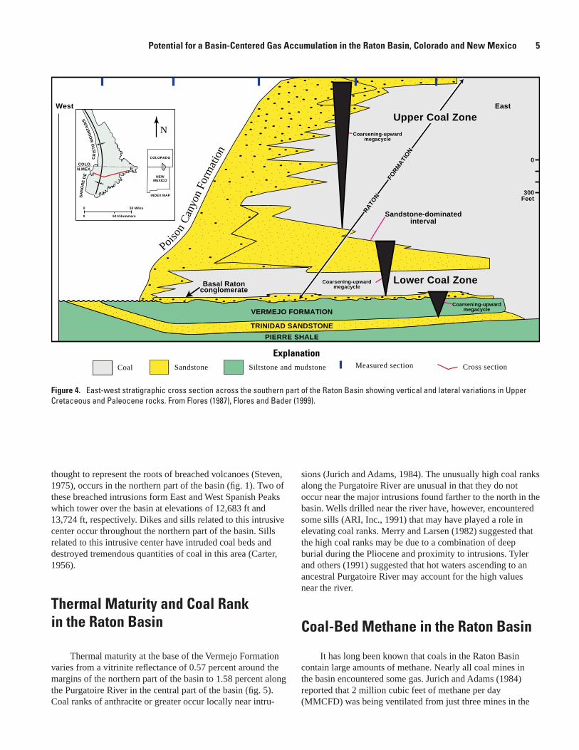
The Upper Cretaceous through Paleocene Raton Forma-tion unconformably overlies the Vermejo Formation through-out much of the basin and ranges from 0 to 2,100 ft thick. It is divided into a basal conglomeratic interval, a lower coal-rich interval, a sandstone-rich interval, and an upper coal-rich interval (fi g. 4). The Cretaceous-Tertiary boundary is conform-able in the Raton Basin and occurs near the top of the lower coal-rich interval in the Raton Formation (Tschudy and others, 1984; Pillmore and Flores, 1984). The basal conglomerate unit is as much as 50 ft thick and consists of interbedded pebble conglomerate and quartzose sandstone (Pillmore and Flores, 1987). The lower coal-rich zone varies from 100 to 250 ft thick, and the upper coal-rich zone varies from about 600 to 1,100 ft thick. Both are composed of interbedded sand-stone, siltstone, mudstone, carbonaceous shale, and coal. The coaly intervals include lenticular channel sandstones and thin,
comparatively persistent, crevasse-splay sandstones. Total net thickness of coal in the Raton Formation ranges from less than 20 ft to more than 140 ft (Tyler and others, 1995). The sand-dominated interval separates the two coal-rich zones and varies from 180 to 600 ft thick. Sandstones are coarsest in the sand-dominated interval. Estimates of total coal in both the Vermejo and Raton Formations vary from 1.5 to 4.8 billion short tons (Read and others, 1950; Wanek, 1963); however, more recently, Amuedo and Bryson (1977) estimated 5 billion short tons in the Vermejo Formation alone.
The Poison Canyon Formation varies from 0 to about 2,500 ft thick and conformably overlies and intertongues with the Raton Formation (Johnson and Wood, 1956; Flores, 1987). The formation consists of interbedded coarse-grained con-glomeratic sandstone, mudstone, and siltstone (Hills, 1888; Johnson and others, 1966) and becomes fi ner grained toward the east in the basin. The Poison Canyon contains little coal or carbonaceous shale.
The Raton Basin was extensively intruded by dikes, sills, laccoliths, and stocks in middle to late Tertiary time. A major intrusive center of Oligocene and Miocene age (26 to 22 Ma),
Figure 3. Generalized stratigraphic column for Cretaceous and Tertiary rocks in the Raton Basin. From Flores and Bader (1999), modifi ed from Pillmore (1969), Pillmore and Flores (1987), and Flores (1987).
TE
RT
IAR
Y
PA
LE
OC
EN
E
ME
SO
ZO
IC
UP
PE
R C
RE
TAC
EO
US
AGELITH-
OLOGYFORMATION NAME
POISON CANYONFORMATION
VERMEJOFORMATION
RATONFORMATION
TRINIDAD SANDSTONE
PIERRE SHALE
APPROX.THICKNESS
IN FEET
500+
1800-1900
0(?)–2,100
0–380
0–300
K/T boundary
GENERAL DESCRIPTION
SANDSTONE–Coarse to conglomeratic beds 13–50 feet thick. Interbeds of soft, yellow-weathering clayey sandstone. Thickens to the west at expense of underlying Raton Formation
SANDSTONE--Fine to medium grained; contains casts of Ophiomorpha
SHALE--Silty in upper 300 ft. Grades upward to fine-grained sandstone. Contains limestone concretions
SANDSTONE–Fine to medium grained with mudstone, carbonaceous shale, and extensive, thick coal beds. Local sills
Formation intertongues with Poison Canyon Formation to the west
UPPER COAL ZONE–Very fine grained sandstone, siltstone, and mudstone with carbonaceous shale and thick coal beds
BARREN SERIES–Mostly very fine to fine-grained sandstone with minor mudstone, siltstone, with carbonaceous shale and thin coal beds
LOWER COAL ZONE–Same as upper coal zone; coal beds mostly thin and discontinuous. Conglomeratic sandstone at base; locally absent
{{{
4 Geologic Studies of Basin-Centered Gas Systems
thought to represent the roots of breached volcanoes (Steven, 1975), occurs in the northern part of the basin (fi g. 1). Two of these breached intrusions form East and West Spanish Peaks which tower over the basin at elevations of 12,683 ft and 13,724 ft, respectively. Dikes and sills related to this intrusive center occur throughout the northern part of the basin. Sills related to this intrusive center have intruded coal beds and destroyed tremendous quantities of coal in this area (Carter, 1956).
Thermal Maturity and Coal Rank in the Raton Basin
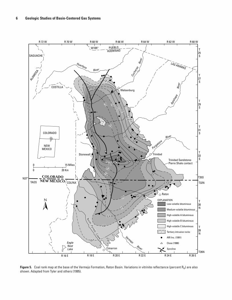
Thermal maturity at the base of the Vermejo Formation varies from a vitrinite refl ectance of 0.57 percent around the margins of the northern part of the basin to 1.58 percent along the Purgatoire River in the central part of the basin (fi g. 5). Coal ranks of anthracite or greater occur locally near intru-
sions (Jurich and Adams, 1984). The unusually high coal ranks along the Purgatoire River are unusual in that they do not occur near the major intrusions found farther to the north in the basin. Wells drilled near the river have, however, encountered some sills (ARI, Inc., 1991) that may have played a role in elevating coal ranks. Merry and Larsen (1982) suggested that the high coal ranks may be due to a combination of deep burial during the Pliocene and proximity to intrusions. Tyler and others (1991) suggested that hot waters ascending to an ancestral Purgatoire River may account for the high values near the river.
Coal-Bed Methane in the Raton Basin
It has long been known that coals in the Raton Basin contain large amounts of methane. Nearly all coal mines in the basin encountered some gas. Jurich and Adams (1984) reported that 2 million cubic feet of methane per day (MMCFD) was being ventilated from just three mines in the
INDEX MAP
COLORADO
NEWMEXICO
0
0 50 Kilometers
50 Miles
COLO.N.MEX.
SA
NG
RE
DE
CR
IST
OM
OU
NTA
INS
Poiso
nC
anyo
nFo
rmat
ion
Coal Sandstone
West East
Measured section Cross section Siltstone and mudstone
VERMEJO FORMATION
PIERRE SHALE
Coarsening-upwardmegacycle
Coarsening-upwardmegacycleBasal Raton
conglomerate
TRINIDAD SANDSTONE
Sandstone-dominatedinterval
Lower Coal Zone
RA
TON
FOR
MA
TIO
N
Upper Coal Zone
Coarsening-upwardmegacycle
0
300Feet
N
wE
Explanation
Figure 4. East-west stratigraphic cross section across the southern part of the Raton Basin showing vertical and lateral variations in Upper Cretaceous and Paleocene rocks. From Flores (1987), Flores and Bader (1999).
Potential for a Basin-Centered Gas Accumulation in the Raton Basin, Colorado and New Mexico 5
HuerfanoRiver
Rive
r
Cuch
aras
Apish
apa
Rive
r
PurgatoireRiver
VermejoRiver
EagleNestLake
0 15 Miles
0 20 Km
Low-volatile bituminous
Medium-volatile bituminous
High-volatile A bituminous
High-volatile B bituminous
High-volatile C bituminous
Tertiary intrusive rocks
ARI Inc. (1991)
Close (1988)
EXPLANATION
Syncline
COLORADO
NEWMEXICO
R 72 W R 68 WR 70 W R 66 W R 64 W R 62 W R 60 W
T25S
T27S
T29S
T31S
T33S
T35S
T32N
T30N
T28N
T26NR 16 E R 18 E R 20 E R 22 E R 24 E R 26 E
N37°
0.70.8
0.9
1.0
1.1
1.21.3
1.51.4
1.31.2
1.1
1.0
0.9
0.8
0.7
0.7
W105°
SAGUACHE
ALAM
OSA
COSTILLA
PUEBLOHUERFANO
LAS ANIMAS
COLORADONEW MEXICOTAOS COLFAX
Stonewall Trinidad
Raton
Walsenburg
Trinidad Sandstone-Pierre Shale contact
Cimarron
NorthPontilo
Creek
Figure 5. Coal rank map at the base of the Vermejo Formation, Raton Basin. Variations in vitrinite refl ectance (percent Ro) are also shown. Adapted from Tyler and others (1995).
6 Geologic Studies of Basin-Centered Gas Systems
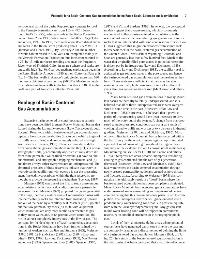
west-central part of the basin. Reported gas contents for coal in the Vermejo Formation vary from 115 to 492 ft3/short ton (3.6–15.5 cm3/g), whereas coals in the Raton Formation contain from 23 to 193 ft3/short ton (0.72–6.07 cm3/g) (Tyler and others, 1995). In 1998, there were about 85 coal-bed meth-ane wells in the Raton Basin producing about 17.5 MMCFD (Johnson and Flores, 1998). By February 2000, the number of wells had increased to 459. Wells are completed mainly in the Vermejo Formation. Production thus far is concentrated in a 25- by 15-mile northeast-trending area near the Purgatoire River, west of Trinidad, Colo., in an area where coal ranks are unusually high (fi g. 6). Coal-bed methane exploration began in the Raton Basin by Amoco in 1980 at their Cottontail Pass unit (fi g. 6). The best wells in Amoco’s unit yielded more than 590 thousand cubic feet of gas per day (MCFD). Maximum depth for coal-bed methane wells in the basin is about 2,400 ft in the northwest part of Amoco’s Cottontail Pass unit.
Geology of Basin-Centered Gas Accumulations
Extensive basin-centered or continuous gas accumula-tions have been identifi ed in many Rocky Mountain basins that formed during the Laramide orogeny (Late Cretaceous through Eocene). Reservoirs within basin-centered gas accumulations typically have low permeabilities (in situ permeability to gas of 0.1 millidarcy or less) and are commonly referred to as tight gas reservoirs (Spencer, 1989). These accumulations differ from conventional gas accumulations in that they (1) cut across stratigraphic units, (2) commonly occur structurally down dip from more permeable water-fi lled reservoirs, (3) have no obvi-ous structural and stratigraphic trapping mechanism, and (4) are almost always either overpressured or underpressured. The abnormal pressures of these reservoirs indicate that water in hydrodynamic equilibrium with outcrop is not the pressuring agent. Instead, hydrocarbons within the tight reservoirs are thought to provide the pressuring mechanism (Spencer, 1987).
Masters (1979) was one of the fi rst to study these unique accumulations, which occur downdip from more permeable, water-wet rocks. Masters (1979) proposed that gases generated in the deep, thermally mature areas of sedimentary basins with low-permeability rocks are inhibited from migrating upward and out of the basin by a capillary seal. Masters (1979) pointed out that low-permeability rocks (<1 mD), with 40 percent water saturation, are only three-tenths as permeable to gas as they are to water, and, at 65 percent water saturation, the rock is almost completely impervious to the fl ow of gas. The concepts for the development of basin-centered gas accumula-tions in the Rocky Mountains have been further refi ned by a number of workers such as Jiao and Surdam (1993), Meissner (1980, 1981, 1984), McPeek (1981), Law (1984), Law and others (1979, 1989), Law and Dickinson (1985), MacGowan and others (1993), Spencer and Law (1981), Spencer (1985,
1987), and Yin and Surdam (1993). In general, the conceptual models suggest that overpressuring, which is commonly encountered in these basin-centered accumulations, is the result of volumetric increases during gas generation in source rocks that are interbedded with sandstone reservoir rocks. Law (1984) suggested that migration distances from source rock to reservoir rock in the basin-centered gas accumulation of the Greater Green River Basin of Wyoming, Colorado, and Utah are generally less than a few hundred feet. Much of the water that originally fi lled pore spaces in potential reservoirs is driven out by hydrocarbons (Law and Dickinson, 1985). According to Law and Dickinson (1985), the capillary seal is activated as gas replaces water in the pore space, and hence the basin-centered gas accumulations seal themselves as they form. These seals are so effi cient that they may be able to maintain abnormally high pressures for tens of millions of years after gas generation has ceased (MacGowan and others, 1993).
Many basin-centered gas accumulations in Rocky Moun-tain basins are partially to totally underpressured, and it is believed that all of these underpressured areas were overpres-sured at some time in the past (Meissner, 1978; Law and Dickinson, 1985). Moreover, it is believed that a previous period of overpressuring would have been necessary to drive much of the water out of the system. A change from overpres-sured to underpressured conditions can occur as a result of cooling related to uplift and erosion or to a decrease in thermal gradient (Meissner, 1978; Law and Dickinson, 1985). Most of the cooling in Rocky Mountain basins has occurred within the last 10 m.y. as the onset of major regional uplift initiated a period of rapid downcutting throughout the region. For a summary of the evidence for late Cenozoic uplift in the Rocky Mountain region, see Keefer (1970) and Larson and others (1975). Overpressured areas became underpressured during cooling as gas contracted and the rate of gas generation decreased (Meissner, 1978; Law and Dickinson, 1985). Sur-face water enters the basin-centered accumulation through newly created permeability pathways created as pore throats and fractures dilate. According to Meissner (1978) this con-traction may ultimately result in a “dead” basin where the basin-centered accumulation has been completely dissipated. Many Rocky Mountain basin-centered gas accumulations have underpressured zones surrounding an overpressured central core indicating that this process has only partially run to com-pletion. The underpressured zone will grade outward into a predominantly water-bearing zone that is in pressure equilib-rium with the local hydrodynamic regime. Any gas present in this water-bearing zone will be trapped in conventional reservoirs on anticlinal structures or in stratigraphic pinch-outs.
Levels of thermal maturity defi ne areas where potential source rocks have generated gas at some time in the past and are commonly used as an indirect method of defi ning the limits of a basin-centered gas accumulation. Masters (1984, p. 27, fi g. 25), in a study of the basin-centered gas accumulation in the deep basin of Alberta, indicated that a vitrinite refl ectance
Potential for a Basin-Centered Gas Accumulation in the Raton Basin, Colorado and New Mexico 7
0 15 Miles
0 20 Km
COLORADO
NEWMEXICO
R 72 W R 68 WR 70 W R 66 W R 64 W R 62 W R 60 W
T25S
T27S
T29S
T31S
T33S
T35S
T32N
T30N
T28N
T26NR 16 E R 18 E R 20 E R 22 E R 24 E R 26 E
N37°
Producing area
Potential producing area
Syncline
EXPLANATION
Amoco CottontailPass unit
Evergreen SpanishPeak unit
C.I.S. explorationproject
LorencitoCanyon areaStroud Apache
Canyon area
Thrust fault
W105°
SAGUACHE
ALAM
OSA
COSTILLA
PUEBLOHUERFANO
LAS ANIMAS
COLORADONEW MEXICOTAOS COLFAX
Stonewall Trinidad
Raton
Walsenburg
Trinidad Sandstone-Pierre Shale contact
Cimarron
Raton
Basi
nsy
nclo
nal
axis
RatonBasin
synclinalaxis
Figure 6. Map showing areas of current coal-bed methane production in the Raton Basin. Adapted from Hemborg (1996).
8 Geologic Studies of Basin-Centered Gas Systems

(Rm) of 1.0 percent corresponds approximately to the limit of the accumulation. In the Piceance Basin of western Colorado, Johnson and others (1987) used a vitrinite refl ectance (Rm) of 1.1 percent to defi ne the limits of the basin-centered gas accumulation. Rm values of from 0.73 to 1.1 percent were used to defi ne a transition zone containing both tight reservoirs and reservoirs with conventional permeabilities. Johnson and others (1996, 1999) used these same thermal maturity limits to help defi ne the basin-centered gas accumulation in the Wind River Basin of Wyoming and the Bighorn Basin of Wyoming and Montana. In the Greater Green River Basin of Wyoming, Colorado, and Utah, Law and others (1989) used an Rm of 0.80 percent to defi ne the top of overpressuring in that basin-centered gas accumulation.
Evidence for a Basin-Centered Gas Accumulation in the Raton Basin
Evidence for gas at shallow depths in uppermost Cre-taceous and Paleocene strata in the Raton Basin has been documented by Dolly and Meissner (1977), Broadhead (1982, 1991), Rose and others (1986), and Woodward (1987) and is summarized in table 1. According to Dolly and Meissner (1977, p. 259) “...gas fl ows encountered during the drilling and testing of exploratory and shallow water wells are of a nearly universal nature in sandstones, coals, and fracture zones present in Poison Canyon, Raton, Vermejo, and Trinidad formations.” Dolly and Meissner (1977) describe sandstones in these formations as “tight, clay-fi lled” and similar to produc-tive Cretaceous and Tertiary sandstones in many other Rocky Mountain basins. They cite one well, the Filon no. 1 Golden Cycle in sec. 11, T. 29 S., R. 67 W. that tested 30 MCF of gas from a zone at 1,630 to 1,760 ft in the lower part of the Raton Formation. An unusually low fl uid pressure gradient of 0.25 psi/ft was noted by Dolly and Meissner (1977, p. 268) in the tested interval from this well indicating signifi cant underpres-suring. They noted that this pressure gradient corresponds to a potentiometric head of approximately 780 ft below the well site. Initial production testing, after fracturing with nitrogen foam and KCl-inhibited water, indicated a fl ow rate of 75 MCFPD and 1,500 barrels of water per day (BWPD). After 2 months, the well stabilized at about 72 MCFPD and 100 BWPD. It is unclear how much of the initial water production was “frac” water. Although Dolly and Meissner (1977, fi g. 13) clearly believed that discrete gas-water contacts existed in the productive lenticular sandstones, the presence of underpres-sured gas in tight reservoirs is characteristic of many basin-centered gas accumulations in the Rocky Mountain region. Underpressuring indicates that the reservoirs are isolated from the regional ground-water regime.
More recently, Rose and others (1986) used variations in resistivity logs to try to delineate the gas-saturated basin-centered accumulation in just the Trinidad Sandstone in the
northern part of the basin. The Trinidad is a marginal marine “blanket-like” sandstone that persists throughout the Raton Basin. This contrasts with the much more lenticular fl uvial sandstones found in the nonmarine parts of the Upper Creta-ceous and Paleocene section in the basin. Rose and others (1986) suggested that an analog to the Trinidad Sandstone may be the highly gas productive Upper Cretaceous marginal-marine Pictured Cliffs Sandstone in the San Juan Basin to the west. The Pictured Cliffs Sandstone produces gas from stratigraphic traps formed by stratigraphic step-ups toward the northeast (Meissner, 1984).
Regional underpressuring at shallow depths in the Raton Basin has been documented by several workers (Howard, 1982; Geldon, 1990; Close and Dutcher, 1990; Tyler and others, 1995). A potentiometric surface map of the Vermejo-Raton aquifer constructed by Stevens and others (1992) and published by Tyler and others (1995, p. 170) indicates that underpressured conditions exist in the main coal-bearing inter-vals throughout most of the basin. Tyler and others (1995, p. 169–170) state that the pressure regime in the basin is poorly understood but list some of the possible causes for this underpressuring. They noted that low pressures indicate that the rocks are isolated from topographically high recharge areas along the west margin of the basin and suggest that low perme-ability in the sandstones and coal beds may limit hydrologic connection.
Discussion
It has long been suspected that a signifi cant basin-cen-tered type gas accumulation is present in Upper Cretaceous and Paleocene sandstones in the Raton Basin. Few attempts have been made to develop these resources because of the lack of gas pipelines out of the basin. Success with the current coal-bed methane exploration in the basin will eventually alleviate this pipeline problem and should lead to new attempts to develop these sandstone gas resources. Gas resources found in coal beds and in adjacent sandstone reservoirs are developed concurrently in many Rocky Mountain basins.
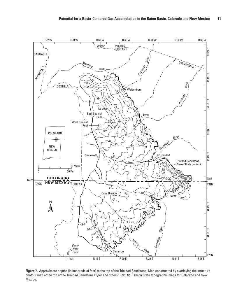
It is suggested here that the widespread gas shows and abnormally low pressures encountered in the Vermejo and Raton Formations indicate a basin-centered gas accumulation developed in these units. Using analogs from other Rocky Mountain basins, intervals where thermal maturities of source rocks are greater than an Rm of 1.1 percent were probably once overpressured and largely gas saturated. At lower levels of thermal maturity, both gas-charged and water-wet sand-stones were probably present. The big unanswered question in the Raton Basin is how much of the original accumulation is still intact? Present-day depths to the top of the Trinidad Sand-stone are less than 3,500 ft throughout most of the basin (fi g. 7) except in the immediate vicinity of the Spanish Peaks where it is deeper than 9,000 ft. The widespread reports of underpres-sured gas-saturated sandstones at shallow depths suggests that
Potential for a Basin-Centered Gas Accumulation in the Raton Basin, Colorado and New Mexico 9

a largely intact basin-centered gas accumulation still exists in the Trinidad Sandstone, Vermejo Formation, and Raton Forma-tion.
Gas from coal beds and gas from sandstones are typically developed together in Rocky Mountain basins. The San Juan Basin of New Mexico and Colorado has by far the most suc-cessful coal-bed methane production in the United States. Yet the original exploration targets were not the coal beds but the adjacent sandstones, which were typically gas charged (Dugan and Williams, 1988). Only after gas wells started experiencing increases in rates of production did operators begin to suspect
that adjacent coal beds were contributing signifi cantly to pro-duction. At Grand Valley fi eld in the Piceance Basin of western Colorado, lenticular fl uvial sandstones interbedded with coals of the Cameo-Fairfi eld coal zone have become the principal exploration target in the fi eld, although both coals and sand-stones were originally targeted (Reinecke and others, 1991). Sandstones adjacent to the thick lower Tertiary coal beds in the Powder River Basin of Wyoming and Montana are typi-cally gas charged (Hobbs, 1978) and are increasingly becom-ing targets for exploration. Gas from coal beds and adjacent sandstones are typically comingled in the Upper Cretaceous
Table 1. List of wells in the Raton Basin that tested gas of had gas shows in sandstones of Upper Cretaceous and Paleocene age.
[Data compiled from Dolly and Meissner (1977), Broadhead (1982, 1991), Rose and others (1986), and Woodward (1987). TKr, Raton Formation; Kv, Vermejo Formation; Kt, Trinidad Sandstone; Kp, Pierre Shale]
Operator Well Location Remarks Source
Colorado
Filon Expl. .............. 1 Bohlman .............. 28S-67W-4 ............... No DST’s. Gas shows from TKr, Kv. ........ Dolly and Meissner (1977) Kimbark Oper. ....... 1 Dog Spr. .............. 28S-68W-16 ............. Rec. gas from DST from Kt & Kp. ................................................. Rose and others (1986) Pan Amer. Pet......... M-1 State................ 29S-66W-33 ............. DST gas show fromTKr. ........................... Dolly and Meissner (1977) Pan Amer. Pet......... 1 Dick Realty.......... 29S-67W-3 ............... Rec. gas from DST from TKr & Kv. .............................................. Dolly and Meissner (1977) Pan Amer. Pet......... 1 Rohr..................... 29S-67W-9 ............... Rec. gas from DST from TKr & Kv. .............................................. Dolly and Meissner (1977) Filon Expl. .............. 1 Golden Cycle....... 29S-67W-11 ............. Rec. gas from DST from TKr. Gas show in Tpc. .......................... Dolly and Meissner (1977) Clark & Perkins...... 1 Goemmer............. 29S-67W-11 ............. Rec. gas from DST from TKr (?).................................................... Dolly and Meissner (1977) HBB Inc. ................ 22-7 Goemmer........ 30S-68W-7 ............... Shut-in gas well. Perfs. 4898–5100, Kt &Kp. .............................. Completion card. Filon Expl. .............. 1 Zele's Hope.......... 31S-65W-31 ............. Gas shows during drilling.......................... Dolly and Meissner (1977) HBB Inc. ................ 1 Schultz................. 31S-67W-27 ............. Rec. gas from Kt........................................ Rose and others (1986) Wood, et al. ............ 1 State..................... 32S-67W-36 ............. Shut-in gas well. Prod. zone; 1935-2135, Kv. ............................. Completion card.
New Mexico
Odessa Nat. Corp.... 4-X W.S. Ranch ..... 29N-18E-12 .............. Gas show in Kp. ........................................ Completion card. Amer. Fuels ............ 1 W.S. Ranch.......... 29N-19E-6 ................ Gas shows in Kp........................................ Woodward (1987) Odessa Nat. Corp.... 3 W.S. Ranch.......... 29N-19E-24 .............. Gas shows in Kp........................................ Woodward (1987) Odessa Nat. Corp.... 1 W.S. Ranch.......... 30N-18E-16 .............. Gas shows in Kv & TKr. ........................... Woodward (1987) Amer. Fuels Corp. .. 3 W.S. Ranch.......... 30N-18E-22 .............. Gas shows in Kp........................................ Woodward (1987) Odessa Nat. Corp.... 5 W.S. Ranch.......... 30N-18E-22 .............. Gas shows in Kp & Kt............................... Completion card. Odessa Nat. Corp.... 2 Vermejo............... 30N-19E-16 .............. Gas shows in Kp........................................ Woodward (1987) Odessa Nat. Corp.... 2 W.S. Ranch.......... 30N-20E-30 .............. Gas shows in Kp........................................ Woodward (1987) Continental Oil ....... 1 St. Louis .............. 30N-22E-13 .............. Gas shows in Kp........................................ Completion card. Penzoil Co. ............. 2 Vermejo............... 31N-17E-1 ................ Shut- in gas well. Prod. zone, Kp, 691 MCFD. ............................ Completion card. Penzoil Co. ............. 1 Vermejo Ranch.... 31N-17E-34 .............. Gas show in Kt. ......................................... Broadhead (1982) Penzoil Co. ............. 311 M Castle Rock . 31N-18E-31 .............. Extensive oil shows in TKr & Kv. .......................................... Broadhead (1991) Continental Oil ....... 2 St. Louis .............. 31N-21E-26 .............. Oil in fractures in Kp................................. Woodward (1987) Pan Amer. Pet......... 1 Kaiser Steel ......... 31N-22E-31 .............. Gas show in Kt. ......................................... Completion card.
10 Geologic Studies of Basin-Centered Gas Systems
0 15 Miles
0 20 Km
COLORADO
NEWMEXICO
R 72 W R 68 WR 70 W R 66 W R 64 W R 62 W R 60 W
T25S
T27S
T29S
T31S
T33S
T35S
T32N
T30N
T28N
T26NR 16 E R 18 E R 20 E R 22 E R 24 E R 26 E
N37°
W105°
SAGUACHE
ALAM
OSA
COSTILLA
PUEBLOHUERFANO
LAS ANIMAS
COLORADONEW MEXICOTAOS COLFAX
Stonewall Trinidad
Raton
Walsenburg
Trinidad Sandstone-Pierre Shale contact
Cimarron
HuerfanoRiver
Rive
r
Cuch
aras
Apish
apa
Rive
r
PurgatoireRiver
VermejoRiver
NorthPontilo
Creek
EagleNestLake
Lynn
Cana
dian
Rive
r
La Veta
Casa Grande
West SpanishPeak
East SpanishPeak
4540
35
45
2535
155
3025
20
15
105
20
15
10525
2015
5
10
Figure 7. Approximate depths (in hundreds of feet) to the top of the Trinidad Sandstone. Map constructed by overlaying the structure contour map of the top of the Trinidad Sandstone (Tyler and others, 1995, fi g. 113) on State topographic maps for Colorado and New Mexico.
Potential for a Basin-Centered Gas Accumulation in the Raton Basin, Colorado and New Mexico 11
Ferron Sandstone Member of the Mancos Shale in the Wasatch Plateau of central Utah.
Within a few years, the Raton Basin may well evolve into both a coal-bed methane play and a basin-centered sandstone gas play. At present, there appears to be no identifi ed produc-tion in the Raton Basin from sandstones within the basin-centered accumulation, and it is diffi cult to assess how suc-cessful this play will be. A more comprehensive study of this potential gas resource should be made once reliable informa-tion is available concerning sandstone-production characteris-tics in the basin.
References CitedAmuedo, C.L., and Bryson, R.S., 1977, Trinidad-Raton Basins: A model
coal resource evaluation program, in Murray, D.K., ed., Geology of Rocky Mountain Coal: Proceedings of the 1976 Symposium, Colorado Geological Survey, p. 45–60.
ARI, Inc., 1991, Geologic assessment of natural gas from coal seams in the Raton Basin: Geologic peer review prepared for the Gas Research Institute, 93 p.
Billingsley, L.T., 1977, Stratigraphy of the Trinidad Sandstone and associated formations Walsenburg area, Colorado, in Veal, H.K., ed., Exploration Frontiers of the Central and Southern Rockies: Rocky Mountain Association of Geologists Guidebook, p. 235–246.
Broadhead, R.F., 1982, Oil and gas discovery wells drilled in New Mexico in 1981: New Mexico Geology, v. 4, no. 2, p. 17–19.
Broadhead, R.F., 1991, Oil and gas discovery wells drilled in New Mexico in 1990: New Mexico Geology, v. 13, no. 4, p. 75–81.
Carter, D.A., 1956, Coal deposits of the Raton Basin, in McGinnis, C.J., ed., Geology of the Raton Basin, Colorado: Rocky Mountain Association of Geologists Guidebook, p. 89–92.
Close, J.C., 1988, Coalbed methane potential of the Raton Basin, Colorado and New Mexico: Southern Illinois University, Department of Geology Ph.D. thesis, 432 p.
Close, J.C., and Dutcher, R.R., 1990, Update on coalbed methane potential of Raton Basin, Colorado and New Mexico: Society of Petroleum Engineers, Proceedings, 65th Technical Conference, SPE Paper 20667, p. 497–512.
Dolly, E.D., and Meissner, F.F., 1977, Geology and gas exploration potential, Upper Cretaceous and lower Tertiary strata, northern Raton Basin, Colorado, in Veal, H.K., ed., Exploration Frontiers of the Central and Southern Rockies: Rocky Mountain Association of Geologists Guidebook, p. 247–270.
Dugan, T.A., and Williams, B.L., 1988, History of gas produced from coal seams in the San Juan Basin, in Fassett, J.E., ed., Geology and coalbed methane resources of the northern San Juan Basin, Colorado and New Mexico: Rocky Mountain Association of Geologists Guidebook, p. 1–9.
Flores, R.M., 1987, Sedimentology of Upper Cretaceous and Tertiary siliciclastics and coals in the Raton Basin, New Mexico and
Colorado, in Lucas, S.G., and Hunt, A.P., eds., Northeastern New Mexico: New Mexico Geological Society 38th Annual Field Conference, p. 255–264.
Flores, R.M., and Bader, L.R., 1999, A summary of Tertiary coal resources of the Raton Basin, Colorado and New Mexico, chap. SR of Fort Union Coal Assessment Team, 1999 Resource Assessment of Selected Tertiary Coal Beds and Zones in the Northern Rocky Mountains and Great Plains Region: U.S. Geological Survey Professional Paper 1625-A [available only on CD-ROM].
Flores, R.M., and Pillmore, C.L., 1987, Tectonic control on alluvial paleoarchitecture of the Cretaceous and Tertiary Raton Basin, Colorado and New Mexico, in Ethridge, F.G., Flores, R.M., and Harvey, M.D., eds., Recent developments in Fluvial Sedimentology: Society of Economic Paleontologists and Mineralogists Special Publication 39, p. 311–321.
Gautier, D.L., Dolton, G.L., Takahashi, K.I., and Varnes, K.L., 1995, National assessment of Unites States oil and gas resources—Results, methodology, and supporting data: U.S. Geological Survey Digital Data Series DDS-30, release 2, [CD-ROM].
Geldon, A.L., 1990, Ground-water hydrology of the central Raton Basin, Colorado and New Mexico: U.S. Geological Survey Water Supply Paper 2288, 81 p.
Hemborg, H.T., 1996, Raton Basin coalbed methane production picking up in Colorado: Oil and Gas Journal, Nov. 11, 1996, p. 101–102.
Hills, R.C., 1888, The recently discovered Tertiary beds of the Huerfano River Basin, Colorado: Colorado Scientifi c Society, Proceedings, v. 3, p. 148–164.
Hobbs, R.G., 1978, Methane occurrences, hazards, and potential resources—Recluse geologic analysis area, northern Campbell County, Wyoming: U.S. Geological Survey Open-File Report 78-401, 20 p.
Howard, W.B., 1982, The hydrogeology of the Raton Basin, south-central Colorado: Indiana University M.S. thesis, 95 p.
Jiao, Z.S., and Surdam, R.C., 1993, Low-permeability rocks, capillary seals, and pressure compartment boundaries in the Cretaceous section of the Powder River Basin, in Stroock, B., and Andrew, S., eds., Wyoming Geological Association Jubilee Anniversary Field Conference Guidebook, p. 297–310.
Johnson, R.B., and Wood, H.H., Jr., 1956, Stratigraphy of Upper Cretaceous and Tertiary rocks of Raton Basin, Colorado and New Mexico: American Association of Petroleum Geologists Bulletin, v. 40, p. 707–721.
Johnson, R.B., Dixon, G.H., and Wanek, A.A., 1966, Late Cretaceous and Tertiary stratigraphy of the Raton Basin of New Mexico and Colorado, in Northrop, S.A., and Read, C.B., eds., Guidebook of Taos-Raton-Spanish Peaks Country, New Mexico and Colorado: New Mexico Geological Society 17th Field Conference, p. 88–98.
Johnson, R.C., Crovelli, R.A., Spencer, C.W., and Mast, R.F., 1987, An assessment of gas resources in low-permeability sandstones of the Upper Cretaceous Mesaverde Group, Piceance Basin, Colorado: U.S. Geological Survey Open-File Report 87-357, 165 p.
Johnson, R.C., Finn, T.M., Crovelli, R.A., and Balay, R.H., 1996, An assessment of in-place gas resources in low-permeability Upper
12 Geologic Studies of Basin-Centered Gas Systems
Cretaceous and lower Tertiary sandstone reservoirs, Wind River Basin, Wyoming: U.S. Geological Survey Open-File Report 96-264, 67 p.
Johnson, R.C., and Flores, R.M., 1998, Developmental geology of coalbed methane from shallow to deep in Rocky Mountain basins and in Cook Inlet–Matanuska Basin, Alaska, U.S.A. and Canada: International Journal of Coal Geology 35, p. 241–282.
Johnson, R.C., Crovelli, R.A., Lowell, B.G., and Finn, T.M., 1999, An assessment of in-place gas resources in the low-permeability basin-centered gas accumulation of the Bighorn Basin, Wyoming and Montana: U.S. Geological Survey Open-File Report 99-315-A, 123 p.
Jurich, D., and Adams, M.A., 1984, Geologic overview, coal and coalbed methane resources of Raton Mesa region, Colorado and new Mexico, in Rightmire, C.T., Eddy, G.E., and Kirr, J.N., eds., Coalbed Methane Resources of the United States: American Association of Petroleum Geologists Studies in Geology Series 17, p. 163–184.
Keefer, W.R., 1970, Structural geology of the Wind River Basin, Wyoming: U.S. Geological Survey Professional Paper 495-D, 35 p.
Larson, E.E., Ozima, M., and Bradley, W.C., 1975, Late Cenozoic basin volcanism in northwestern Colorado and its implications concerning tectonism and the origins of the Colorado River system, in Curtis, B.F., ed., Cenozoic History of the Southern Rocky Mountains: Geological Society of America Memoir 144, p. 155–178.
Law, B.E., 1984, Relationships of source-rock, thermal maturity, and overpressuring to gas generation and occurrence in low-permeability Upper Cretaceous and lower Tertiary rocks, Greater Green River Basin, Wyoming, Colorado, and Utah, in Woodward, J., Meissner, F.F., and Clayton, J.L., eds., Hydrocarbon Source Rocks of the Greater Rocky Mountain Region: Denver, Colo., Rocky Mountain Association of Geologists, p. 469–490.
Law, B.E., and Dickinson, W.W., 1985, Conceptual model for the origin of abnormally pressured gas accumulations in low-permeability reservoirs: American Association of Petroleum Geologists Bulletin, v. 69, no. 8, p. 1295–1304.
Law, B.E., Spencer, C.W., and Bostick, N.H., 1979, Preliminary results of organic maturation, temperature, and pressure studies in the Pacifi c Creek area, Sublette County, Wyoming, in 5th DOE Symposium on Enhanced Oil and Gas Recovery and Improved Drilling Methods, Proceedings, v. 3 [Gas and Drilling]: Tulsa, Okla., Petroleum Publishing Co., p. 1–13.
Law, B.E., Spencer, C.W., Charpentier, R.R., Crovelli, R.A., Mast, R.F., Dolton, G.L., and Wandrey, C.J., 1989, Estimates of gas resources in overpressured low-permeability Cretaceous and Tertiary sandstone reservoirs, Greater Green River Basin, Wyoming, Colorado, and Utah, in Eisert, J.L., ed; Gas Resources of Wyoming: Wyoming Geological Association 14th Field Conference Guidebook, p. 39–61.
MacGowan, D.B., Garcia-Gonzalez, M., Britton, D.R., and Surdam, R.C., 1993, Timing of hydrocarbon generation, organic-inorganic diagenesis, and the formation of abnormally pressured gas compartments in the Cretaceous of the Greater Green River Basin: A geochemical model, in Stroock, B., and Andrew, S., eds.,
Wyoming Geological Association Guidebook, Jubilee Anniversary Field Conference, p. 325–348.
Masters, J.A., 1979, Deep basin gas trap western Canada: American Association of Petroleum Geologists Bulletin, v. 63, no. 2, p. 151–181.
Masters, J.A., 1984, Lower Cretaceous oil and gas in western Canada, in Masters, J.A. ed., Elmworth Case Study of a Deep Basin Gas Field: American Association of Petroleum Geologists Memoir 38, p. 1–33.
McPeek, L.A., 1981, Eastern Green River Basin—A developing giant gas supply from deep, overpressured Upper Cretaceous sandstone: American Association of Petroleum Geologists Bulletin, v. 65, p. 1078–1098.
Meissner, F.F., 1978, Patterns of source-rock maturity in non-marine source rocks of some typical western interior basins in non-marine Tertiary and Upper Cretaceous source rocks and the occurrences of oil and gas in the west-central U.S.: Rocky Mountain Association of Geologists Continuing Education Course Notes.
Meissner, F.F., 1980, Examples of abnormal fl uid pressure produced by hydrocarbon generation: American Association of Petroleum Geologists Bulletin, v. 65, p. 749.
Meissner, F.F., 1981, Abnormal pressures produced by hydrocarbon generation and maturation and their relation to processes of migration and accumulation: American Association of Petroleum Geologists Bulletin, v. 65, p. 2467.
Meissner, F.F., 1984, Cretaceous and lower Tertiary coals as sources for gas accumulations in the Rocky Mountain area, in Woodward, Jane, Meissner, F.F., and Clayton, J.L., eds., Hydrocarbon Source Rocks of the Greater Rocky Mountain Region: Rocky Mountain Association of Geologists, p. 401–431.
Merry, R.D., and Larsen, V.E., 1982, Geologic investigation of the methane potential of western U.S. coalbeds: Final report prepared for the Gas Research Institute under contract no. CE-807083, 155 p.
Pillmore, C.L., 1969, Geology and coal deposits of the Raton coal fi eld, Colfax County, New Mexico: Mountain Geologist, v. 6, p. 125–142.
Pillmore, C.L., and Maberry, J.O., 1976, Depositional environments and trace fossils of the Trinidad Sandstone, southern Raton Basin, New Mexico, in Ewing, R.C., and Kues, B.S., eds., Guidebook to Vermejo Park Northeastern New Mexico: New Mexico Geological Society 27th Field Conference, p. 191–195.
Pillmore, C.E., and Flores, R.M., 1984, Field Guide and discussion of coal deposits, depositional environments and the Cretaceous-Tertiary boundary, southern Raton Basin, in Lintz, J., Jr., ed., Western Geological Excursions: Geological Society of America Annual Meeting Guidebook, v. 3, p. 1–51.
Pillmore, C.E., and Flores, R.M., 1987, Stratigraphy and depositional environments of the Cretaceous-Tertiary boundary clay and associated rocks, Raton Basin, New Mexico and Colorado, in Fassett, J.E., and Rigby, J.K., Jr., eds., The Cretaceous-Tertiary Boundary in the San Juan and Raton Basins, New Mexico and Colorado: Geological Society of America Special Paper 209, p. 111–130.
Potential for a Basin-Centered Gas Accumulation in the Raton Basin, Colorado and New Mexico 13

Read, C.B., Duffney, R.T., Wood, G.H., Jr., and Zapp, A.D., 1950, Coal resources of New Mexico: U.S. Geological Survey Circular 89, 24 p.
Reinecke, K.M., Rice, D.D., and Johnson, R.C., 1991, Characteristics and development of fl uvial sandstone and coalbed reservoirs of Upper Cretaceous Mesaverde Group, Grand Valley fi eld, Garfi eld County, Colorado, in Schwochow, S.D., Murray, D.K., and Fahy, M.F., eds., Coalbed Methane of Western North America: Rocky Mountain Association of Geologists 1991 Guidebook, p. 209–225.
Rose, P.R., Everett, J.R., and Merin, I.S., 1986, Potential basin-centered gas accumulation in Cretaceous Trinidad Sandstone, Raton Basin, Colorado, in Spencer, C.W., and Mast, R.F., eds., Geology of Tight Gas Reservoirs: American Association of Petroleum Geologists Studies in Geology Series 24, p. 111–128.
Spencer, C.W., 1985, Geologic aspects of tight gas reservoirs in the Rocky Mountain region: Journal of Petroleum Technology, July, p. 1308–1314.
Spencer, C.W., 1987, Hydrocarbon generation as a mechanism for overpressuring in the Rocky Mountain region: American Association of Petroleum Geologists Bulletin, v. 71, p. 368–388.
Spencer, C.W., 1989, Review of characteristics of low-permeability gas reservoirs in Western United States: American Association of Petroleum Geologists Bulletin, v. 73, no. 5, p. 613–629.
Spencer, C.W., and Law, B.E., 1981, Overpressured, low-permeability gas reservoirs in Green River, Washakie, and Great Divide Basins, southwestern Wyoming [abs.]: American Association of Petroleum Geologists Bulletin, v. 65, p. 569.
Stevens, S.H., Lombardi, T.E., Kelso, B.S., and Coates, J.M., 1992, A geological assessment of natural gas from coal seams in the Raton and Vermejo Formations, Raton Basin: Advanced Resources International, Inc., [topical report prepared for the Gas Research Institute under contract no. 5091-214-2316, GRI 92/0345], 84 p.
Steven, T.A., 1975, Middle Tertiary volcanic fi eld in the southern Rocky Mountains, in Curtis, B.F., ed., Cenozoic History of the Southern Rocky Mountains: Geological Society of America Memoir 144, p. 75–94.
Strum, S., 1985, Lithofacies and depositional environments of the Raton Formation (Upper Cretaceous–Paleocene) of northeastern New Mexico: North Carolina State University M.S. thesis, 81 p.
Tschudy, R.H., Pillmore, C.L., Orth, C.J., Gilmore, J.S., and Knight, J.D., 1984, Disruptions of the terrestrial plant ecosystem at the Cretaceous-Tertiary boundary, Western Interior: Science, v. 225, no. 4666, p. 1030–1034.
Tyler, R., Ambrose, W.A., Scott, A.R., and Kaiser, W.R., 1991, Coalbed methane potential of the Greater Green River, Piceance, Powder River and Raton Basins: University of Texas at Austin, Bureau of Economic Geology, [topical report prepared for the Gas Research Institute under contract no. 5087-214-1544, GRI-91/0315], 244 p.
Tyler, R., Kaiser, W.R., Scott, A.R., Hamilton, D.S., and Ambrose, W.A., 1995, Geologic and hydrologic assessment of natural gas from coal: Greater Green River, Piceance, Powder River, and Raton Basins, Western United States: Austin, Tex., Bureau of Economic Geology, Report of Investigations 228, 219 p.
Wanek, A.A., 1963, Geology and fuel resources of the southwestern part of Raton coal fi eld, Colfax County, New Mexico: U.S. Geological Survey Coal Investigations Map C-45.
Woodward, L.A., 1987, Oil and gas potential of the Raton Basin, New Mexico, in Lucas, S.G., and Hunt, A.P., eds., Northeastern New Mexico: New Mexico Geological Society Guidebook, p. 331–338.
Yin, P., and Surdam, R., 1993, Diagenesis and overpressuring in the Almond Sandstone, Mesaverde Group, in Stroock, B., and Andrew, S., eds., Wyoming Geological Association Guidebook, Jubilee Anniversary Field Conference, p. 349–357.
Manuscript approved for publication May 21, 2001Published in the Central Region, Denver, ColoradoEditing, page layout, photocomposition—Richard W. Scott, Jr.Cover design—Carol A. QuesenberryGraphics by the authors
14 Geologic Studies of Basin-Centered Gas Systems