planning for climate resilient barangays in the...
TRANSCRIPT

Planning for Climate Resilient Barangays in the Philippines: The Case of Barangay Tumana in Marikina City, Metro Manila
Nicasio B. Espina, Jr, Senior Lecturer, University of the Philippines Open University (UPOU) Faculty of Management and Development Studies and University of the Philippines – Diliman (UPD) School of Urban and Regional Planning and (corresponding author)
[email protected] (+63 2) 920 – 6853 SURP Building, E. Jacinto Street cor. Magsaysay Street, UP Diliman, Quezon City, 1101 Metro Manila, Philippines
Abstract The Philippines is one of the most at risk countries to climate change. It ranks fifth in the list of Global Climate Risk Index 2017 in terms of extreme weather events (Kreft, Eckstein, and Melchior 2016, 6). This, plus other human and developmental factors compound the challenge for barangays, the smallest political and administrative units in the country, to build and scale-up resilience. Strengthening and increasing resilience requires a thorough and systematic analysis of vulnerability elements of the unit through evidence-based planning that will render key recommendations and policy options for lessening its vulnerability (ADB 2013). This paper presents a case study in the Philippines, specifically in Barangay Tumana in Marikina City, Metro Manila. Barangay Tumana was chosen because it was seen as the most devasted barangay in Marikina City when Typhoon Ondoy (international name: Ketsana) hit the country in 2009. Moreover, it has the second largest population in Marikina City with 41,809 residents as of 2010 (PSA 2016). It is in this context that the study takes off, scientifically analyzing the key hazards and characterizing the elements at risk viz-a-viz the environmental impacts brought about by climate change. The paper seeks to answer the research question: What are the elements of the communities in Barangay Tumana that contribute to its vulnerability to climate-related hazards? The guiding definition of the United Nations Framework Convention on Climate Change (UNFCCC) is used to frame the process of analysis. In particular, the study inquires about the biophysical/environmental risks and socio-economic/ demographic character of the communities (exposure and sensitivity elements) in Barangay Tumana that can be addressed through barangay planning as a strategy to further community resilience and, at the same time, enhance the quality of life of the community in the long term (Ensor, and Berger 2009). The study employs various methods of data gathering and analysis. Primary data gathering is conducted through a questionnaire survey to generate empirical data and baseline information on the socio-economic condition of the case study barangay. The key findings from the survey results are supplemented by collection and review of secondary data, as well as the conduct of key informant interviews with technical barangay personnel and community stakeholders. In addition, Geographic Information System (GIS) is used in processing and analyzing acquired primary and secondary (spatial and non-spatial) data. An extensive review of critical information of key documents, and conventional literature searches are likewise carried out. A multi-stakeholder validation and consultation are conducted in order to validate the research
findings and come up with strategic and proactive approaches, through mitigation and adaptation strategies, towards building barangay resilience in the context of climate change. 1. Introduction Marikina City has long been plagued by numerous environmental hazards, especially flooding. The swelling of the Marikina River has been a long-standing problem - incidents of large-scale flood, in particular, have been documented as far back as 1937 when Marikina was still a largely agricultural town. A huge flood in 1988 saw the Marikina River rise up to 19 meters. The early 90s to the first decade of 2000 saw intermittent flooding in the city, with floods reaching as high as 18 meters. Tropical Storm Ketsana (locally known as Ondoy) brought about flashfloods that inundated 80% of Metro Manila on September 26, 2009,. The waters of the Marikina River reached a record high of 22.8 meters and left Marikina City severely affected. Tropical Storm Meari (locally named Falcon) brought heavy rains to the country in June 2011, and the Marikina River again reached its critical level. In November of the same year, Typhoon Nesat (locally named Pedring) dumped heavy rains comparable to Typhoon Ondoy. Water levels reached as high as 20.1 meters, submerging several barangays in the process. In August 2012, the monsoon rains or habagat caused the river to swell to 20.6 meters, just a few meters below the record level set by Typhoon Ondoy. The rains affected the rest of Metro Manila, with some areas submerged in flood waters up to 3 meters high. These flood incidents, apart from extreme weather events had been driven by topographic and anthropogenic factors, and resulted in the displacement of hundreds of households particularly in the informal settlement areas in Marikina, mostly those by the riverbanks (Delos Reyes, and Espina, 2016). Given these disasters brought about by typhoons and monsoon rains, cities especially those that have been repeatedly affected are encouraged to do socio-economic profiling of disaster risk areas to determine their level of exposure to inform planning and disaster response operations (ADB 2013). With Marikina as one of the cities constantly plagued by flooding, the study has zeroed in on Barangay Tumana, one of the barangays severely affected during the onslaught of Typhoon Ondoy and the recent monsoon rains, as its case study area. 2. Study Context 2.1. Research Questions
The project is set to answer the main research question: What are the exposure and sensitivity factors of the communities in Barangay Tumana that contribute to its vulnerability to climate-related hazards?
In particular, the study inquires on what the biophysical/environmental risks and socio-economic/ demographic character of the geographic site viz its communities are; and how these can be addressed through barangay planning to further resilience.
2.2. Objectives
To answer the questions above, the research intends to accomplish the following objectives:
a. To determine climate-related exposure and risks of Barangay Tumana; b. To characterize and analyze Barangay Tumana’s sensitivity to climate-related
risks, particularly its socio-economic and demographic profile; and c. To formulate policy and strategy options to further barangay resilience.
2.3. Research Methodology
The study uses various methods of data gathering and analysis. Among them are the following:
a. Administration of Survey. A survey was conducted from November to December
2013 in the barangay. The sample size of 384 households was determined through stratified random sampling, applying the Slovin’s Formula to the total number of households.
b. GIS. The use of GIS was done in processing acquired primary and secondary (spatial and non-spatial) data;
c. Key Informant interviews (KIIs). KII’s and consultation meetings were likewise done for assessment and triangulation of data/results.
2.4. Scope of the Research
a. Spatial Coverage: Analysis of the socio-economic profile and exposure data of Marikina City is focused on Tumana, a barangay with high flood risk.
b. Time Frame: The study examines the events that happened during Typhoon Ondoy in September 2009, Typhoon Falcon in June 2011, and the Monsoon Rains/ Habagat in August 2012. Environmental/biophysical and climate-related exposures are analyzed and projected for the medium term (year 2020) and for the long term (year 2050). The survey focusing on the socioeconomic condition of the population was conducted from November to December 2013.
c. Target Population: The study focuses on the population affected by flooding during Typhoon Ondoy in 2009 and Habagat in August 2012. The unit of analysis is the household level.
d. Planning and Policy Focus: The study focuses on the assessment of exposure and sensitivity aspects of the site to inform the formulation of planning and policy options for the following areas: • Database formulation and local government decision making • Development planning and barangay resilience
3. Framework of Analysis
The guiding definition of the United Nations Framework Convention on Climate Change (UNFCCC) on climate change vulnerability (Figure 3.1.) is used to frame the analysis. Namely, the exposure, sensitivity and adaptive capacity level of the households in

Tumana, Marikina are assessed in this study. Existing government data, available research, people’s accounts, and other official studies on indicators and factors relevant to the elements are used as bases in defining them.
• Exposure is what is at risk from climate change (e.g. population, resources,
property), the change in climate itself and its implications (e.g. sea level rise, temperature, precipitation, extreme events, etc.).
• Sensitivity is defined as the degree to which a system is affected by the biophysical impact of climate change. It considers the socio-economic context of the system being assessed.
• Adaptive capacity is the ability of a system to adjust to climate change (including climate variability and extremes) to moderate potential damages, to take advantage of opportunities, or to cope with the consequences.
The general analysis of the exposure criterion is through the examination of what is at risk in the locality in addition to the identification of the climate-induced hazards and stresses. Sensitivity analysis is done through the examination and characterization of the social and economic profile of the community affected by climate change impacts. Adaptive capacity is probed also through examination of the socioeconomic conditions/ availability of resources, as well as institutional capacity and the preparedness of the community for disasters, among others.

4. Results and Discussion The following results are presented according to the UNFCCC Framework. The first part highlights the exposure information, while the second part highlights the socio-economic or the sensitivity aspect of Barangay Tumana. 4.1. Exposure Information
4.1.1. Spatial and Geographic Context: What is at Risk?
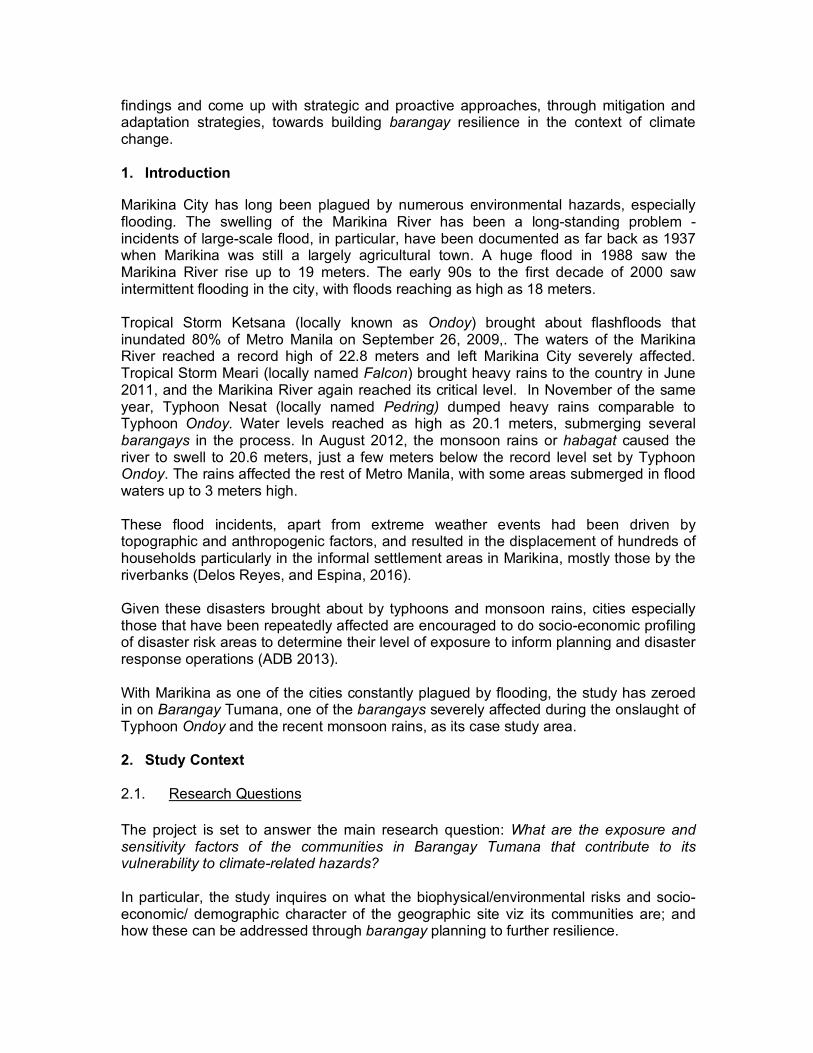
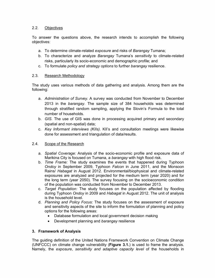
Tumana is one of the 16 barangays that constitute Marikina City. It is part of the 2nd District of Marikina and is situated at the North-West portion of the city. It is bounded by Barangay Nangka on the North-Eastern side, by Barangay Concepcion Uno on the Eastern side, and Barangay Malanday on the Southern side of the barangay. Tumana has a land area of approximately 181.97 hectares (Marikina City 2010b) and a total population of 41.809 as of 2010 (PSA 2016). The barangay has been identified as one of the low-lying barangays at risk to flooding.

The lowest areas of the barangay, and therefore the first areas to be flooded at 16 meters above sea level, are those by the creek side of Angel Santos and Amplaya, the portion of Palay Street near the creek, the streets of Pipino, Singkamas, Mais (at Tumana Proper), and Iwahig and Ilaw (at Doña Petra). The higher ground is found along the streets of Upo, Okra, Patola, and portions of Palay and Farmers II at the central part of Tumana Proper (streets not in maps). Certain portions of Doña Petra are the same level as the Central Level of Tumana Proper. Adding to its susceptibility to flooding is the river system traversing the barangay as shown in Figure 4.1.1.4.
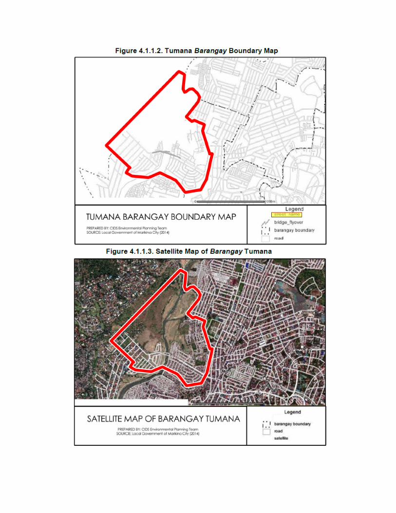
The eastern side of the barangay is subjected to intermittent flooding brought about by the overflowing of Marikina River during the rainy season as illustrated in Figure 4.1.1.5. This is particularly noteworthy as this area is home to clusters of families, approximately 8,000 households (Marikina City 2010a), which live in shanties in the outskirts of the Marikina River and its surrounding esteros. During the 2013 Monsoon Rains, data from the local government of Marikina show that the eastern portion of the barangay was subjected to greater than 2 meters of flood inundation from the ground (Figure 4.1.1.6).

During the onslaught of Typhoon Ondoy in 2009, the whole area on the eastern portion of the Marikina River was inundated by floodwater of more than 2.5 meters in height from the ground.
Zooming into the zoning map of Marikina City (Figure 4.1.1.8), Barangay Tumana is assigned five main land uses. The land uses affected by intermittent flooding are the designated Socialized Settlement Zone, Low Density Residential Zone, High Density Industrial Zone, and Parks/Open Space/ Recreation Zone. The current residents in these zones, except those in the upscale Loyola Grand Villas found at the western portion of the barangay, are considered informal.

4.1.2. Climate Change Projections
Data from the Philippine Atmospheric Geophysical and Astronomical Services Administration (PAGASA) under the Department of Science and Technology (DOST) reveal the medium and long term climate projections for Tumana, Marikina, which will affect greatly the population and units operating within the barangay. The projected climate change scenarios culled from possible extreme events in average emission scenarios are shown as bases for the indicative macro-level climate assessment. These scenarios are then used for deducing changes in climate parameters: precipitation, temperature, and extreme events.
a. Projected Changes in Average Temperature in Marikina City
The projections made by PAGASA illustrate significant warming in the Philippines by the middle of the century. Average annual mean temperature is projected to increase by 0.9°C-1.1°C by 2020 and by 1.7°C-3.0°C by 2050. Higher temperatures are generally expected in all regions of the country by 2050, with the rates doubling from 2020 levels. Adopting these projections, the estimated changes in Seasonal Mean Temperature in Marikina City in 2020 and 2050 under the medium-range emission scenario are shown in Figures 4.1.2.1 and 4.1.2.2.

b. Projected Changes in Seasonal Rainfall in Marikina City
PAGASA projects a change in annual precipitation of -0.5-17.4% in 2020 and -2.4-16.4% in 2050 in the Philippines. Increases in rainfall are particularly evident in most areas of Luzon and Visayas, while Mindanao is projected to undergo a drying trend. Average annual rainfall increase over most parts of Luzon and the Visayas is estimated at 2-17% by 2020 and 1-16% by 2050. Projected changes in seasonal rainfall in Marikina in 2020 and 2050 under the medium-range emission scenario are presented in Figures 4.1.2.3 and 4.1.2.4.

c. Projections on Extreme Climate Events in Marikina City Hot days are expected to increase by 81% and 185% from observed conditions by 2020 and 2050, respectively, while dry days are seen to decline by 16-17% in those years. Days with precipitation are also projected to increase by 44% in 2020 and by 89% in 2050.

d. Summary and Implications of Climate Projections in Marikina City
Marikina City, in summary, is expected to have a 1°C incremental change in temperature by 2020. This implies that upcoming storms will be more intense, with longer dry spells between them. Sporadic precipitation will ensue across the years. Increasing temperatures, changing rainfall patterns, sea level rise, and extreme weather events form the backdrop upon which the Philippines, particularly Tumana in Marikina City, endeavors to pursue its development goals. Such exposure factors affect key geographic and spatial contexts where population and systems at risk operate. The ability of a unit to address such impacts affect the facility by which sustainable development and resiliency are pursued. 4.2. Sensitivity Information 4.2.1. Socio-Economic Profile of the Informal Settler Families in Tumana, Marikina
The following data on the Socio-Economic Profile of Informal Settler Families in Barangay Tumana was generated from survey conducted in 384 households from November to December in 2013. They form part of the sensitivity data and some adaptive capacity data for analysis.
a. Household Size
The household sizes were stratified into the following number of people per household: 1 to 3, 4 to 6, 7 to 9, and 10 and above.
Majority (60.4%) of the households reported having 4 to 6 members, and only 4.2% have about 10 or more members. The average number of people in every household is 5.

b. Sex Distribution
In about 2,045 household members making up the surveyed households, the distribution of male-female is almost equal, with the males numbering 1,036 (50.7%), and the females 1,009 (49.7%).
Data gathered also reveal that there are more females (79%) taking on the role of household heads than males (21%).
c. Age Distribution
Residents aged 25 to 54 make up the largest population (37.6%) in the barangay. They are followed by those aged 6 to 14 years of age (21.0%), and those aged 15 to 24 (20.5%). The group aged 55 and above only comprises 2.4% of the population.

With residents aged 0 to 14, and 65 and above considered dependents, dependency rate in the area is about 47%.
d. Educational Attainment Out of the households surveyed, 32.03% have at least one high school graduate. 26.04% have at least one member who attended college, and only 19.27% have a college graduate.
As for the highest educational attainment of household heads, 17.45% attended college but only 4.69% graduated. 38.02% finished high school, while 17.97% attended high school but did not graduate. Around 4.95% finished vocational schooling and a very small percentage (1.04%) have a Ph.D./Masters Degree.

e. Employment Status About 63% of the surveyed population belongs to the labor force (i.e. ages 15-64). Of the population, 41.7% reported having full-time jobs and 14.6% are self-employed. Those working part time and on-call make up 8.6% and 11.5%, respectively. The non-working population is 23.4%.
f. Engagement in Business
Only a third of the households are engaged in businesses. Most (43.27%) are into Retail/Wholesale, while a third (32.69%) are vendors (neighborhood variety stores, recyclables collectors, and the like). Around 11.24% are engaged in Home/ Small Scale Industries, 8.65% in Personal Services, and 2.88% in Transport.

g. Income and Savings
As of 2009, the average annual income and expenditure of families in Metro Manila amounted to PhP356,000 and PhP309,000, respectively (PSA, n.d.). This translates to an average monthly income of Php29,667 and expenditure of Php25,750. Survey results show that household heads’ earnings average PhP 9,307.12, and monthly household income average PhP15,838.33 – 46.61% below the regional average.
Almost half (49.16%) of the household heads earn PhP5,001 to PhP10,000, 23.41% earn PhP5,000 or lower, and less than 1% receive PhP30,000 or more.
At the household level, 29.60% earn Php20,001 to Php30,000 a month. 20% earn PhP15,001 to PhP20,000 while 18.67% make above PhP30,000. Only 2.93% earn PhP5,000 or less. Findings are detailed in Table 4.2.1.5 and Figure 4.2.1.4.

Given the income of the households which are below regional average income and expenditure, it is not surprising that around three-fourths of the surveyed families do not have monthly savings. Of those with savings, only 2.1% set aside PhP10,000 or more.
h. Land Ownership
With regard to ownership of land, only 15.1% of the households own land; 84.9% do not own any land. Locations of lands owned are shown in Table 4.2.1.7.
i. Medical/Health Insurance
Medical/ Health Insurance is uncommon in the community. Only 5.29% of the population has household members with Health/ Medical Insurance.
j. Social Programs/Services Availed from the Government
Results show that almost half of the households surveyed have not availed of any of the programs/services available to them. These programs range from education to housing, health, security, and financial assistance. As for the recipients, the most popular program (with 34.4% having availed of it) is the Pantawid Pamilyang Pilipino Program (4Ps), the government’s conditional cash transfer

56%
13%
26%
0%2% 3%
Single
Live-In
Married
LegallySeparated
(CCT) program. Next are the Family Planning Program availed by 13.8%, and scholarships that benefited 11.7%.
k. Age of Houses Based on the survey, 26.8% of the houses have been around in the last 16 to 20 years while 17.4% were built less than 5 years ago. Only 8.9% of the structures are more than 30 years old.

l. Structural Types of Houses
The average floor area per household in Tumana is 42 sqm, with the smallest being 5 sqm and the biggest 300 sqm. Five structural types of houses (based on appearance) were identified: Type 1 (Salvaged), Type 2 (Light), Type 3 (Semi-Concrete), Type 4 (Concrete), and Type 5 (Mixed Materials). Majority of the houses are Type 3, followed by Types 5 and 4. Less than 1% are Type 1.

m. Accounts of Calamity
• Exposure to Geophysical Hazards
The whole barangay is reported to be affected by typhoons. Almost all (99.2%) of them are affected by flooding. Likewise, 31.3% reported to have been affected by earthquakes, and 10.2% by fires.

• Experience during Typhoon Ondoy and Habagat
The onslaught of Typhoon Ondoy and the monsoon rains or Habagat distressed 98.70% of the population. Flood height averaged 17.3 meters, with 70.7% of the households affected by 11 to 20 feet of floodwater. 92.6% reported that it usually took at least a day for the water to subside. The average duration was 1.2 days, while the shortest and longest durations were 1 and 7 days, respectively.
During Ondoy/Habagat, 54.4% of the houses emerged in need of repairs. Out of these, 33.5% needed PhP10,000 or more to cover repair costs.

n. Calamity Preparedness
When asked about the implementation of Disaster Drills in Barangay Tumana, 46.1% confirmed their awareness of Disaster Drills conducted in the barangay while 53.9% responded that there have been no drills. Of those who are aware, 33.3% know of the Flood Drills, 16.4% are aware of Fire Drills, and 17.7% are aware of Earthquake Drills.
o. Perceived Safety of Houses
As for House Safety, 19% feel that their houses are safe from flooding while 20.3% feel that their houses can withstand earthquakes based on the physical condition of their houses. On the basis of location, 8.3% said that their houses are spared from flooding while 9.1% believe they are safe from earthquakes.

p. Willingness to Relocate
Almost half (47.9%) of the households affirmed that they have plans to relocate but not within the next five years. 36.2% plan to immediately transfer while 15.9% do not have plans of transferring at all. Unwillingness to transfer stems from various reasons such as distance from school or place of employment, attachment or length of stay in the area, and lack of financial capability to rent or buy a new house.
10.7% of the surveyed households have been recipients to a Relocation Program, 7.3% of which were recipients of the city’s relocation program, 2.9% were beneficiaries of the National Housing Authority (NHA) program, while less than 1% received assistance from other organizations.

As for the rest of the population (89.3%) who did not receive any form of Relocation Program, 92.4% would consider relocating if a program on Housing for People in Risk Areas is to be implemented, while 7.6% still would not.
q. Housing Preferences • Location
44.1% of the respondents who consider relocation prefer to be relocated within Metro Manila, except Marikina. 31.9% favor relocation within Marikina, while 12% prefer another part of the barangay. Another 12% do not mind being relocated to other provinces or municipalities outside of Metro Manila.
• Type of Housing
59.3% prefer a Single-detached housing, 23.2% prefer a Medium Rise type of building, while 10% prefer a Duplex. Among those who prefer Medium Rise structures, 77.7% favor a 2 storey building, while 16.2% prefer a 3 storey-high building. Only 6.1% prefer 4 storeys or higher.
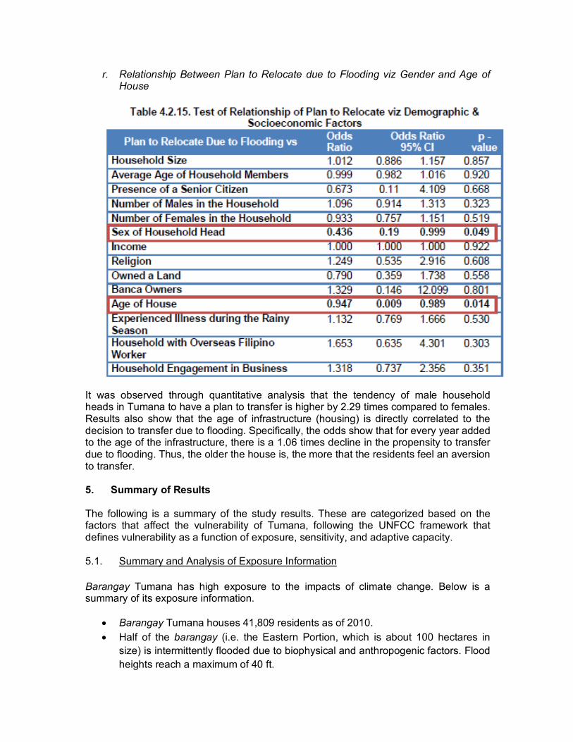
r. Relationship Between Plan to Relocate due to Flooding viz Gender and Age of House
It was observed through quantitative analysis that the tendency of male household heads in Tumana to have a plan to transfer is higher by 2.29 times compared to females. Results also show that the age of infrastructure (housing) is directly correlated to the decision to transfer due to flooding. Specifically, the odds show that for every year added to the age of the infrastructure, there is a 1.06 times decline in the propensity to transfer due to flooding. Thus, the older the house is, the more that the residents feel an aversion to transfer. 5. Summary of Results The following is a summary of the study results. These are categorized based on the factors that affect the vulnerability of Tumana, following the UNFCC framework that defines vulnerability as a function of exposure, sensitivity, and adaptive capacity.
5.1. Summary and Analysis of Exposure Information
Barangay Tumana has high exposure to the impacts of climate change. Below is a summary of its exposure information.
• Barangay Tumana houses 41,809 residents as of 2010. • Half of the barangay (i.e. the Eastern Portion, which is about 100 hectares in
size) is intermittently flooded due to biophysical and anthropogenic factors. Flood heights reach a maximum of 40 ft.

• Marikina is projected to have fewer but stronger typhoons (comparable to Typhoon Ondoy) and sporadic precipitations/monsoon rains (Habagat). Projections point to a hotter summer season, particularly in the months of March, April, and May, and heavier rains during the rainy season, particularly in the months of June, July, and August.
• The Socialized Settlement zone is situated in an environmentally critical area. Parks & Open Space, and Low Density Residential Land Uses are also affected by intermittent flooding.
5.2. Summary of Sensitivity and Adaptive Capacity Information
Barangay Tumana has a high degree of sensitivity to hydrometeorological risks, particularly to the changes in climate, given its socio-economic condition. This necessitates a proactive approach, through mitigation and adaptation strategies, towards building its capacities and thereby lessening its vulnerability. The following is a summary of the degree of sensitivity and adaptive capacity for Barangay Tumana.
• There are 47 dependents (6 old dependents + 41 young) for every 100
population. • Approximately 1 out of 4 of the surveyed population is non-working. • Approximately 50% are high school graduates, or have reached the high school
level, but did not graduate. • About a third of the population has lived in Tumana for 10-20 years. • About 50% of the household heads earn only PhP5,000 - PhP10,000. • 4 out of 5 households do not have medical insurance/health cards. • 4 out of 5 households do not have savings. • 9 out of 10 households do not own land. • All have experienced the effects of typhoon and flooding wherein flood height is
“lagpas-tao", or well above people’s heads. • 4 out of 5 do not feel safe due to typhoon and flooding in Marikina and/or within
Metro Manila. • Half of the respondents have experienced Disaster Drills led by the city
government. • 4 out of 5 respondents have plans to relocate. 9 out of 10 are willing to transfer if
given a relocation program. They prefer to be relocated within Marikina and/or within Metro Manila
6. Policy Options and Recommendations The following recommendations to further barangay resilience were arrived at from the findings of the study:
• Build resilience through barangay development planning

Such high exposure and degree of sensitivity to climate change affect key geographic and spatial contexts where population and systems at risk operate. The ability of a unit to address such impacts affect the facility by which sustainable development and resiliency are pursued. In order to achieve them, it is important to ensure strategies (e.g. mapping and identifying risks and exposure data) are in place at the onset of barangay development planning, and promote barangay programs that increase socio-economic standards.
• Increase capacity of barangay communities
It is recommended that Barangay Tumana’s adaptive capacity be increased through the provision of trainings and seminars on Disaster Risk Reduction and Management (DRRM) and Climate Change Adaptation (CCA). Further, the population should be given better access to finance and insurance policies. Barangay development programs and projects that increase social and economic development, and promote awareness on local environmental management must be prioritized as well.
• Enact/enforce legislative measures to protect the environmentally critical
areas including the high risk flood-prone areas in Barangay Tumana
It is likewise recommended that legislative measures be promoted to protect areas that have been identified as environmentally critical including the high risk flood-prone areas of the barangay. The Socialized Settlement and the Low Density Residential zones should not be situated in this area. while the Parks, Open Spaces, and Recreation Land Use designated in this area should be maintained. The easement policies (i.e. keeping a distance of 96 meters on both sides of the river) should be effectively enforced and monitored.
• Explore safer areas for a comprehensive in-city resettlement program
Designating areas in safer grounds of the city for relocating the highly exposed and sensitive communities from the impacts of climate change can be explored to further community resilience. Acknowledgement The author would like to thank the city government of Marikina for its assistance with this study. In particular, he extends his gratitude to then Marikina Mayor Del De Guzman, Barangay Captain of Tumana Ziffred A. Ancheta and Tumana Councilor Jimmy M. Ceguerra who shared with him their extensive knowledge on Barangay Tumana, Marikina. Likewise, special thanks is given to Dr. Mario R. Delos Reyes, team leader of the program: Environmental Planning and Governance on Disaster Risk Prevention, Mitigation and Management at Selected Pilot Priority Areas in Laguna de Bay and Manila Bay Regions, where this research is a subcomponent project under his tutelage through the UP Center for Integrative and Development Studies. In addition, the author extends his thanks to Ms. Annlouise Genevieve Castro, Ms. Angelina Caluag, Ms. Michelle Yu, and Mr. Bhen Aguihon for formatting, facilitating and documenting the survey and workshops for this research. Lastly, the author thanks Chancellor Melinda DP. Bandalaria and Dean Primo G. Garcia of the UP Open University for funding the

dissemination of this research which made possible the presentation of the findings in the Fifth International Conference on Sustainable Development in New York City. References 1 ADB (Asian Development Bank). 2013. Moving from Risk to Resilience: Sustainable
Urban Development in the Pacific. Mandaluyong: ADB. 2 Delos Reyes, Mario R., and Nicasio B. Espina, Jr. 2016. “Analysis on
Decentralization and its Implications to Land Use and Local Environmental Planning and Management: The Case of Marikina City as Microcosm for the Philippines.” In Decentralisation and Regional Development: Experiences and Lessons from Four Continents Over Three Decades, edited by Eva Dick, Karin Gaesing, Daniel Inkoom, and Teodoro Kausel, 107-130. Cham: Springer International Publishing AG.
3 Ensor, Jonathan, and Rachel Berger. 2009. Understanding Climate Change Adaptation: Lessons from Community-Based Approaches. Rugby: Practical Application Publishing.
4 ESSC (Environmental Science for Social Change, Inc.). 2010. “Historical Mapping for Marikina Flooding: learning from the past – land, people, and science.” ESSC. http://essc.org.ph/content/view/273/46/
5 IPCC (Intergovernmental Panel on Climate Change). 2007. Climate Change 2007: Synthesis Report. Contribution of Working Groups i, II and III to the Fourth Assessment Report of the Intergovernmental Panel on Climate Change. Edited by Core Writing Team, Rajendra Pachauri, and Andy Reisinger. Geneva: IPCC.
6 Kreft, Sönke, David Eckstein, and Inga Melchior. 2016. Global Climate Risk Index 2017. Edited by Joanne Chapman-Rose and Daniela Baum. Berlin: Germanwatch e.V. www.germanwatch.org/en/cri
7 Marikina City. 2010a. Marikina City Comprehensive Land Use Plan. Marikina: n.p. 8 Marikina City. 2010b. Marikina City Ecological Profile. Marikina: n.p. 9 PAGASA (Philippine Atmospheric, Geophysical and Astronomical Services
Administration). 2011. Climate Change in the Philippines. Quezon: PAGASA. 10 PSA (Philippine Statistics Authority). 2016. “Philippine Standard Geographic Code:
City of Marikina.” PSA. http://nap.psa.gov.ph/activestats/psgc/municipality.asp? muncode=137402000& regcode=13&provcode=74
11 ——. n.d. “Family Income.” PSA. http://www.nap.psa.gov.ph/secstat/d_income. asp