footscray central activities area...
TRANSCRIPT
F O O T S C R AY S T R U C T U R E P L A N 2 0 1 3
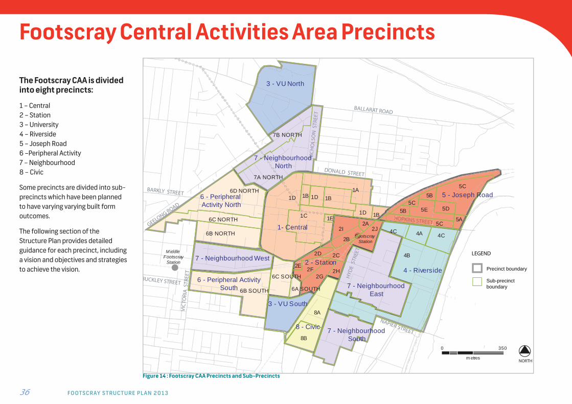
Footscray Central Activities Area Precincts
Figure 14 : Footscray CAA Precincts and Sub-Precincts
The Footscray CAA is divided into eight precincts:
1 – Central2 – Station3 – University 4 – Riverside5 – Joseph Road6 –Peripheral Activity7 – Neighbourhood8 – Civic
Some precincts are divided into sub-precincts which have been planned to have varying varying built form outcomes.
The following section of the Structure Plan provides detailed guidance for each precinct, including a vision and objectives and strategies to achieve the vision.
36
GEELONG ROAD
BALLARAT ROAD
DONALD STREET
BARKLY STREET
HOPKINS STREET
NAPIER STREET
BUCKLEY STREET
NIC
HO
LSO
N S
TREE
T
VIC
TORI
A S
TREE
T
HYD
E S
TREE
T
HOPKINS STREETTI
HYD
E SS
TREE
SEE
TS
EE
NIC
HO
LSO
N S
TREE
TL
ST
Footscray Station
Middle Footscray
Station
5 - Joseph Road
4 - Riverside
7 - Neighbourhood South
2 - Station
7 - Neighbourhood East
3 - VU South
6 - Peripheral ActivitySouth
7 - Neighbourhood West
6 - Peripheral Activity North
1- Central
7 - Neighbourhood North
3 - VU North
8 - Civic
7B NORTH
2J2A
2I
2B
2D 2C
2E2F
2G
1D1A
1B 1D 1B
1D 1B1E1C
4B
4C 4A 4C
5A5B
5B5C
5C
5D5C
6D NORTH
6B NORTH
6A SOUTH6B SOUTH
6C SOUTH
7A NORTH
8A
8B
6C NORTH
5E
2H
350
m etres
0
NORTH
LEGEND
Precinct boundary
Sub-precinct boundary

37
Precinct 1 – Central Precinct
V I S I O NThe Central Precinct forms the heart of Footscray and is a vibrant mixed use
precinct off ering a rich, diverse, and busy urban mix of retail, commercial and
residential. The area is active 24 hours a day with diff erent facilities and services.
The retail off er meets the needs of the local residents and workers and draws in
shoppers from the surrounding region. The centre is pedestrian focused with active
streets that provide high pedestrian amenity and encourage walking and cycling.
In the heart there is a fi ne grain built form increasing to a medium scale around the
edges. Key public realm areas are activated and provide opportunities for social
interaction. Heritage streetscapes have been sensitively redeveloped, incorporating
heritage buildings alongside new development to create a high quality urban
streetscape.
Precinct Objectives: To promote a high quality public realm, good quality urban design, protection
of heritage places, and public safety throughout the precinct. To ensure the offer of shops, entertainment and dining meet the needs
of the future resident, visitor and worker population. To encourage the provision of further supermarket and department store retail uses. To encourage the development of an evening economy, including restaurants,
cafes, arts and entertainment uses. To ensure that retail is concentrated in this precinct and avoids further
dispersal of key shopping facilities. To support the establishment of medical facilities along Paisley Street. To encourage the provision of student services and facilities. To support the establishment of an Arts facility. To create dynamic streets and a ‘market atmosphere’ in the precinct
including outdoor eating opportunities and active frontages. To revitalise Maddern Square as an urban plaza with active edges
comprising restaurants, speciality stores and services. To promote mixed-use buildings, including higher density housing,
affordable housing and offi ce uses at upper fl oor levels. To encourage a transition to neighbouring residential areas by promoting
residential and other complementary uses between Ryan and Donald Streets and along the eastern side of Moore Street, north of Byron Street.
To emphasise Nicholson Street and Leeds Street as key north/south corridors through the Footscray CAA.
To enhance the connectivity of pedestrian routes within the precinct and to other parts of the Footscray CAA, particularly universities and transport facilities.
To maximise opportunities to improve public transport connections. To upgrade the pedestrian experience along key pedestrian routes. To enhance the image of Footscray’s retail areas through protection
of heritage places, improvements to the appearance of the built form and renewal of the public realm.

F O O T S C R AY S T R U C T U R E P L A N 2 0 1 3 38
Design Requirements:
Height Range:
Fine grain centre 1-3 storeys
Northern and Eastern edges 2-6 storeys
Surrounding ring 2-10 storeys
Market site 4-25 storeys
Strategies Maintain the fi ne grain and heritage streetscapes
within identifi ed heritage areas through low rise development outcomes and well articulated facades.
Maintain the fi ne grain urban form by: reinforcing the historic character of the 5-6 metre
wide retail premises; Including heritage buildings into redevelopment;
and providing streets and lanes which create a highly
permeable pedestrian environment. Key public realm spaces such as the Nicholson Street
Mall and Maddern Square should have good solar access and outlook (between 10am and 3pm at the equinox) to maintain and enhance activity.
New built form on the north side of main walking routes should ensure that reasonable sunlight access is maintained on the south side of the street, especially along key streets in the CAA, such as Barkly / Hopkins Street and Paisley Street (between 9am and 3pm at the equinox, September 22).
Emphasise the Barkly and Hopkins Street east-west corridor through built form by building to boundaries; providing for passive surveillance; and providing pedestrian weather protection.
Buildings in areas identifi ed as transitional areas should be designed to make an appropriate transition in height, scale and built form between the higher scale built form and the sensitive interface with lower scale residential buildings.
Provide a high quality pedestrian environment through prioritisation of pedestrians; minimising parking access ways; activation of street frontages; and provision of pedestrian protection including awnings, planting and lighting, and including continuous weather protection and activation along frontages to designated pedestrian priority routes
Require noise attenuation measures to be incorporated within new dwellings along the Barkly/ Hopkins Street corridor.
Prohibit the use of solid roller doors on shop fronts.
Carpark, Irving StreetLarge expanses of parking provide opportunities
for activation and redevelopment
Artists Impression, Byron StreetThe Byron Street carpark provides an opportunity for redevelopment
as a mixed use precinct with public plaza and parking
Leeds StreetExisting buildings combine retail and residential, providing a mixed
use model for the future core
Precinct 1 – Central Precinct
39
ALB
ERT
STRE
ET
NIC
HO
LSO
N S
TREE
T
HOPKINS STREET
PAISLEY STREET
Footscray Market
LEED
S ST
REET
Footscray Station
BYRON STREET
RYAN STREET
DONALD STREET
BARKLY STREET
SHEL
LEY
ST
MO
ORE
STR
EET
DA
LMA
HO
Y S
T
LEED
S ST
REET
DROOP STREET
Medical Centre
Supermarket
Footscray Plaza
Little Saigon Market
Parking
Parking
Nic
hols
on M
all
NIC
HO
LSO
N S
TREE
T
Maddern Sq
Funeral parlour
Consolidated Bus stops& Taxi ranks
FREN
CH S
T
Potential Plaza & Playground
IRVING STREET
Parking
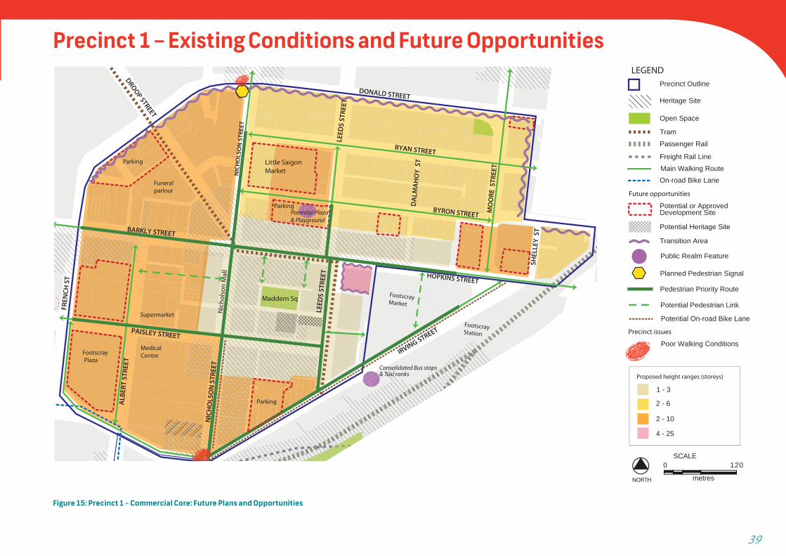
Figure 15: Precinct 1 – Commercial Core: Future Plans and Opportunities
Planned Pedestrian Signal
Tram
Passenger Rail
Freight Rail Line
Open Space
LEGEND
Future opportunities
Precinct Outline
Heritage Site
Public Realm Feature
Potential Pedestrian Link
Potential or Approved Development Site
Potential Heritage Site
Transition Area
2 - 6
2 - 10
4 - 25
Proposed height ranges (storeys)
1 - 3
SCALE120
metres
0
NORTH
Pedestrian Priority Route
On-road Bike Lane
Precinct issues
Poor Walking Conditions
Potential On-road Bike Lane
Main Walking Route
Precinct 1 – Existing Conditions and Future Opportunities
F O O T S C R AY S T R U C T U R E P L A N 2 0 1 3 40
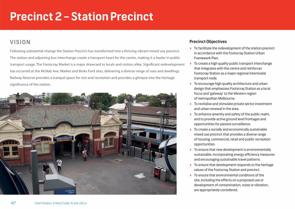
Precinct 2 – Station Precinct
V I S I O NFollowing substantial change the Station Precinct has transformed into a thriving vibrant mixed use precinct.
The station and adjoining bus interchange create a transport heart for the centre, making it a leader in public
transport usage. The Footscray Market is a major drawcard to locals and visitors alike. Signifi cant redevelopment
has occurred at the McNab Ave, Market and Binks Ford sites, delivering a diverse range of uses and dwellings.
Railway Reserve provides a tranquil space for rest and recreation and provides a glimpse into the heritage
signifi cance of the station.
Precinct Objectives To facilitate the redevelopment of the station precinct
in accordance with the Footscray Station Urban Framework Plan.
To create a high quality public transport interchange that integrates with the centre and reinforces Footscray Station as a major regional intermodal transport node.
To encourage high quality architecture and urban design that emphasises Footscray Station as a local focus and ‘gateway’ to the Western region of metropolitan Melbourne.
To revitalise and stimulate private sector investment and urban renewal in the area.
To enhance amenity and safety of the public realm, and to provide active ground level frontages and opportunities for passive surveillance.
To create a socially and economically sustainable mixed use precinct that provides a diverse range of housing, commercial, retail and public recreation opportunities.
To ensure that new development is environmentally sustainable, incorporating energy effi ciency measures and encouraging sustainable travel patterns.
To ensure that development responds to the heritage values of the Footscray Station and precinct.
To ensure that environmental conditions of the site, including the effects on a proposed use or development of contamination, noise or vibration, are appropriately considered.

41
Design Requirements:
Precinct 2A - gateway 15 storeys
Precinct 2B - Irving St north 12 storeys
Precinct 2C - forecourts no buildings in public open space
Precinct 2D - Irving St south 8 storeys
Precinct 2E - Station/park interface
5 storeys
Precinct 2F - Railway Reserve 3 storeys
Precinct 2G - McNab Ave(former bowls site)
12 storeys on McNab Ave; 14 storeys at Teardrop site
Precinct 2H - Hyde St parking 6 storeys
Precinct 2I - Footscray Market 25 storeys at Footscray Market site; 20 storeys at corner site
Precinct 2J - former Binks Ford site
3 storeys on Talbot St interface; 6 storeys on Cowper St; 10 storeys on railway interface
Strategies Development proposals should contribute to the
creation of a socially, culturally and environmentally sustainable community, including through the provision of affordable housing.
Development should complement the retail function of the core precinct and not compete with or detract from it.
Development should accommodate a broad mix of land uses which support daytime and evening activity and be accessible to the whole community.
Development should retain the pedestrian focus and space around the station, and strengthen its identity as an oasis within an area of change.
New built form should respond to its central and strategic location within the ‘transport hub’, with iconic or landmark buildings.
New built form should minimise impacts of traffi c and of the railway corridor interface, such as noise,
vibrations and outlook, on amenity within buildings. Development should emphasise station entry points. New development should enhance the sense of arrival
into the CAA and reinforce the pedestrian experience, through new built form frontages, land uses and pedestrian space.
Buildings located within the Transition Area should provide appropriate reductions in building height and mass toward existing lower scale development at the interface and not exceed 3 storeys.
Reduced off street car parking may be considered having regard to the proximity and availability of public transport, and any agreements to implement car parking demand reduction measures.
Built form should respect the heritage context allowing for heritage prominence to be maintained and sensitively mitigated.
Station, Irving Street, MarketFootscray Market and nearby sites are key opportunities to redevelop
higher intensity land uses with excellent public transport access
Irving Street and forecourt to stationIrving Street prior to Regional Rail Link and transport hub
redevelopment
Planned Station entry from Irving StreetAccess to the station will be upgraded and a public transport
Interchange will be created at Irving Street
F O O T S C R AY S T R U C T U R E P L A N 2 0 1 3 42
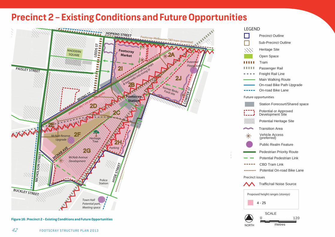
Precinct 2 – Existing Conditions and Future Opportunities
Figure 16 : Precinct 2 – Existing Conditions and Future Opportunities
#
Footscray-Melbourne CBD tram (potential)
HOPKINS STREET
PAISLEY STREET
IRVING ST
potential dev’t site post RRL works
Consolidation of all bus stops
& taxi ranks into Irving St
PotentialPlayground
McNab AvenueDevelopment
BUNBURY STREET
TALBOT STREET
Footscray Station
HYD
E ST
REET
Town HallPotential park, Meeting space
former BinksFord site
Footscray Market
McNab Reserve Upgrade
COW
PER
ST
NIC
HO
LSO
N S
TREE
T
LEED
S ST
BUCKLEY STREET
Heritage Tree
Parking
MADDERN SQUARE
Police Station
MCNAB AVE
Pedestrian link upgrade
LEGENDPrecinct Outline
Heritage Site
Tram
Passenger RailFreight Rail Line
Open Space
Future opportunities
Potential or Approved Development Site
Main Walking Route
Potential Pedestrian Link
Vehicle Access (preferred)
On-road Bike Path Upgrade
Precinct issues
Traffic/rail Noise Source
4 - 25
Proposed height ranges (storeys)
SCALE120
metres
0
NORTH
CBD Tram Link
Public Realm Feature
Potential Heritage Site
Transition Area
Station Forecourt/Shared space
Pedestrian Priority Route
On-road Bike Lane
Potential On-road Bike Lane
Sub-Precinct Outline
43
V I S I O NThe University Precinct accommodates the two campuses
that provide the basis for University Town - a key theme
of the FCAA. The students and staff are key contributors
to the liveliness and vibrancy of the FCAA. Although the
primary use of the precinct is education, some student
accommodation is also provided. The open spaces,
pathways and services of the university are accessible
to the public, melding the precinct into the broader FCAA.
Precinct Objectives: To support the University’s ongoing role in providing
regionally signifi cant tertiary education facilities. To provide for uses and developments which support the
University needs within the precinct, whilst facilitating university services to locate within the broader FCAA, drawing students and staff into the centre of the CAA.
To ensure the University campuses and their students are integrated in the broader Footscray CAA.
To discourage commercial and retail uses unless they are associated with the operations of the University or are part of the development of an integrated mixed use education area.
To improve pedestrian access and links to the University campuses in particular the key pedestrian link along Nicholson St to the VU South campus.
To ensure optimal utilisation of land within the precinct and minimise large expanses of at grade car parking.
Design Requirements:
Height Range:
VU North Campus 2-6 Storeys
VU South Campus 2-6 Storeys
Guidelines/ strategies Consideration should be given to locating university
uses that would benefi t from a wider audience (eg: performing spaces) within the central FCAA precincts.
Future redevelopment of the precinct’s existing car park sites should create a mixed-use area focussed on education and incorporating student and staff accommodation, teaching, research and conference facilities, and student services and facilities.
Street wall heights should generally range between 2 and 4 storeys, other than on major roads such as Ballarat and Geelong roads, where the street wall height may be up to 6 storeys to assist in providing a traffi c noise buffer to development behind.
Where streetscape context refl ects zero front and side setbacks, new built form should maintain this condition, forming a continuous ‘street wall’.
Buildings located within the Transition Area should provide appropriate reductions in building height and mass toward existing lower scale development at the interface and not exceed 3 storeys.
When new development adjoins heritage buildings, the design should have regard to the height, scale, rhythm and proportions of the heritage buildings including characteristic, fi ne-grain frontage widths.
The arrangement of buildings should facilitate pedestrian and cycle access routes into and through the precinct which contribute to the permeability of the wider pedestrian and cycle network.
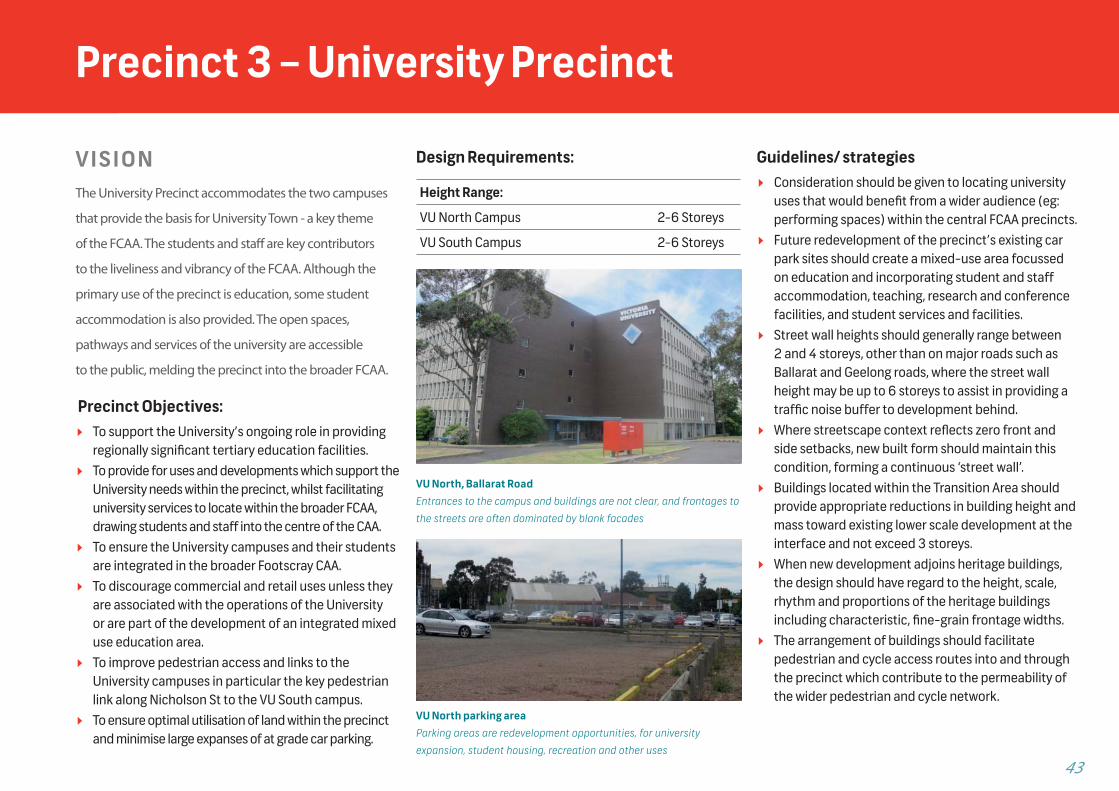
VU North, Ballarat RoadEntrances to the campus and buildings are not clear, and frontages to
the streets are often dominated by blank facades
VU North parking areaParking areas are redevelopment opportunities, for university
expansion, student housing, recreation and other uses
Precinct 3 – University Precinct
F O O T S C R AY S T R U C T U R E P L A N 2 0 1 3 44
VU Childcare
Childcare
Sculpture
VU Sports and Aquatic Centre
NIC
HO
LSO
N S
TREE
T
BALLARAT ROAD
GEELONG ROAD
BALLARAT RD
Victoria UniversityNorth Campus
VU ParkingVU Parking
Memorial Garden
Bowls Club
Youth Centre
DAVID STREET
PETER STREET
FEDERAL ST
TIERNAN ST
DROOP STREET
Potential level tram stop
LEGEND
Precinct Outline
Heritage Site
Tram
Open Space
Striking Long Views
Future opportunities
Potential or Approved Development Site
Potential Pedestrian Link
Main Walking Route
Public Realm Feature
2 - 6
Proposed height ranges (storeys)
SCALE120
metres
0
NORTH
Precinct issues
Traffic/rail Noise Source
Poor Walking Conditions
On-road Bike Lane
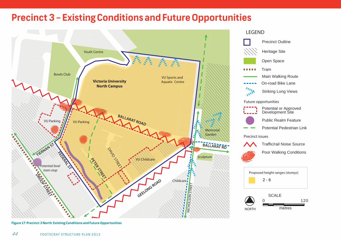
Precinct 3 – Existing Conditions and Future Opportunities
Figure 17: Precinct 3 North: Existing Conditions and Future Opportunities
45
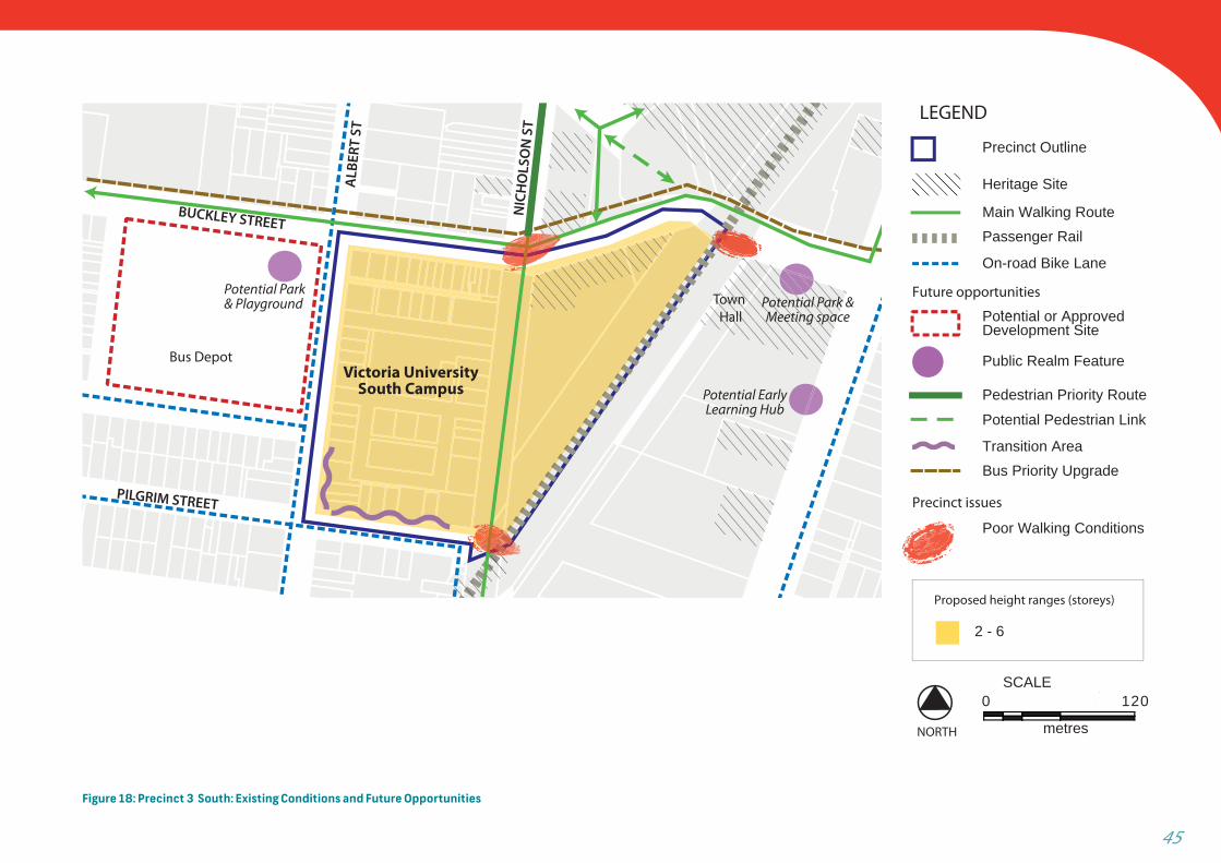
Figure 18: Precinct 3 South: Existing Conditions and Future Opportunities
Street
LEGEND
Precinct Outline
Heritage Site
Passenger RailMain Walking Route
Future opportunities
Potential or Approved Development Site
Bus Priority Upgrade
On-road Bike Lane
Public Realm Feature
Transition Area
2 - 6
Proposed height ranges (storeys)
Precinct issues
Poor Walking Conditions
SCALE120
metres
0
NORTH
Pedestrian Priority Route
Potential Pedestrian Link
NIC
HO
LSO
N S
T
ALB
ERT
ST
BUCKLEY STREET
PILGRIM STREET
Victoria UniversitySouth Campus
Potential Park & Playground Potential Park &
Meeting space
Potential Early Learning Hub
Town Hall
Bus Depot

F O O T S C R AY S T R U C T U R E P L A N 2 0 1 3 46
Precinct 4 – Riverside Precinct
V I S I O NThe Riverside Precinct capitalises on its Maribyrnong River frontage providing multiple access points
for people from the wider CAA to access the river. The mixed use precinct off ers a range of housing and
employment uses, utilising various building and allotment types and sizes, responding to the diff erent
urban conditions throughout the precinct. The precinct is the central focus for the arts and creative
industries fl ourishing in Footscray. The aboriginal, archaeological and built heritage is evident and
celebrated. Public realm and built form responses minimise the impact of traffi c on the residents
and deliver high amenity streetscapes.
Precinct Objectives: To maintain and respect the precinct’s diversity
and historic value. To create a distinct precinct that capitalises on its
River frontage and incorporates arts, historical and maritime themes.
To encourage a mixed use precinct that provides for local employment and services local needs without compromising the amenity of residential areas.
To create multiple walking and cycling linkages to the River, nearby uses and development, and the central and station precincts of the CAA.
To ensure development respects the historic nature of buildings and streetscapes within the precinct.
To ensure new residential development is well protected from traffi c noise.
To develop the precinct as a focus for the arts and creative industries.
To encourage use and activation of the river and riverfront through creation of a distinct, vibrant and active urban edge along the waterfront.
To maintain public access to the River and its activities and prevent privatisation of space along the River.
To ensure built form transitions to lower heights near the River frontage.
47
Design Requirements:
Height Range:
Hopkins St Frontage Blocks (2) 2-10 Storeys
St Monica’s Block 1-3 Storeys
Remainder of Precinct 2-6 Storeys
Strategies In public realm areas structures and landscape
treatments should enhance access to the riverfront. Where development fronts the river it should actively
engage with the river frontage. Development should create a lower, human scale form
along the riverfront.
Opportunities should be maximised for generous planting including canopy trees and other plants of a resilient nature.
Encourage taller building forms to front Hopkins Street and transition down to River frontage areas and established residential areas.
On larger sites encourage internal access ways which refl ect the grid character of surrounding streets. Built form should respond to the internal street environment.
Ensure buildings include appropriate building design to mitigate against traffi c noise in particular along Hopkins, Whitehall and Napier Streets.
Encourage development to capitalise on the precinct being the arts and creative industries focus of the CAA through provision of public art and adaptability of building forms.
Buildings within the Transition Area, in particular along Moreland and Bunbury Streets and along the riverfront should provide appropriate reductions in building height and mass toward the existing lower scale buildings at the interface and not exceed 3 storeys.
Built form should respect the heritage context allowing for heritage prominence to be maintained and sensitively mitigated.
Development that adjoins heritage buildings should have regard to height, scale, rhythm and proportions of the heritage buildings.
The Maribyrnong River Valley Design guidelines should be consulted in regard to building siting, scale and materials for development east of Moreland Street.
Support removal of the railway line along the River in the event that it is deemed redundant to Port operations.
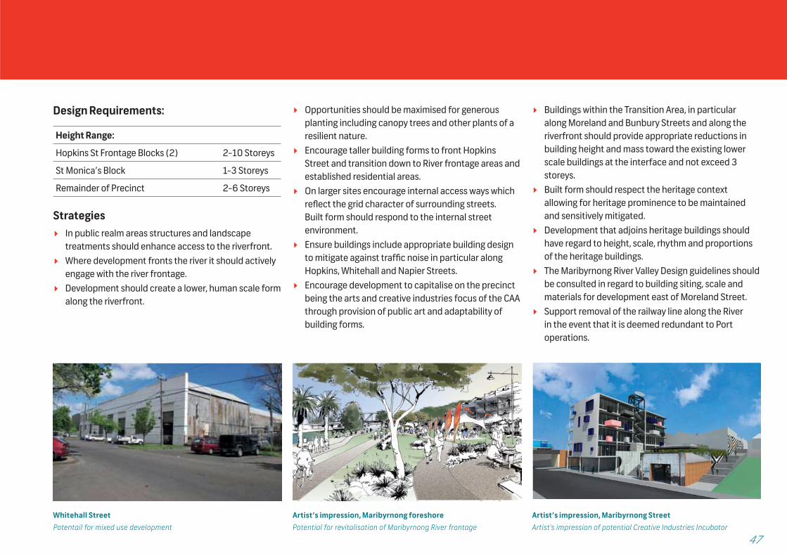
Whitehall StreetPotentail for mixed use development
Artist’s impression, Maribyrnong foreshorePotential for revitalisation of Maribyrnong River frontage
Artist’s impression, Maribyrnong StreetArtist’s impression of potential Creative Industries Incubator

F O O T S C R AY S T R U C T U R E P L A N 2 0 1 3 48
NAPIER STREET
IRVING STREET
WH
ITEH
ALL
STRE
ET
HOPKINS STREET
HYD
E ST
REET
BUNBURY ST
WINGFIELD ST
MO
RELA
ND
STR
EET
COW
PER
STRE
ET
Hotel
Potential Arts Walk
LT JOHN STREET
Convent
House
PotentialPlayground
Playground & Riverfront Upgrade
Ryco site
St Monica’sSchool
Saltwater Place Recent Res. Dev.
PotentialArts Incubator
FootscrayArts Centre
Existing Offices
Existing Open Space
RecentRes. Dev.
Recent ResidentialDevelopment
Art Studio
Petrol & Carwash
Recent Res. Dvpmt
M A
R I
B Y
R N
O N
G R
I V
E R
Ercildoune House & Art Studio
Hotel
Ercildoune House & Art Studio
Hotel
WWWH
WWH
ITEH
AIT
LL S
TRE
STRERE
L ST
HAL
LW
HIT
EH
IT
ETEET
MO
RM
OOR
MEL
AND
STR
DST
RAN
DRE
LD
STR
EET
TREE
TD
ST
LEGEND
Precinct Outline
Passenger Rail
Main Walking Route
Future opportunities
Potential or Approved Development Site
Potential Heritage Site
Potential Traffic Calming
Public Realm Feature
CBD Tram Link
2 - 6
2 - 10
Proposed height ranges (storeys)
1 - 3
SCALE120
metres
0
NORTH
Potential Pedestrian Link
Transition Area
Open Space
Shared Pedestrian/Cycle Path
Precinct issues
Traffic/rail Noise Source
Heritage Site
Striking Long Views
Precinct 4 – Existing Conditions and Future Opportunities
Figure 19: Precinct 4 – Riverside Precinct: Existing Conditions and Future Opportunities
49
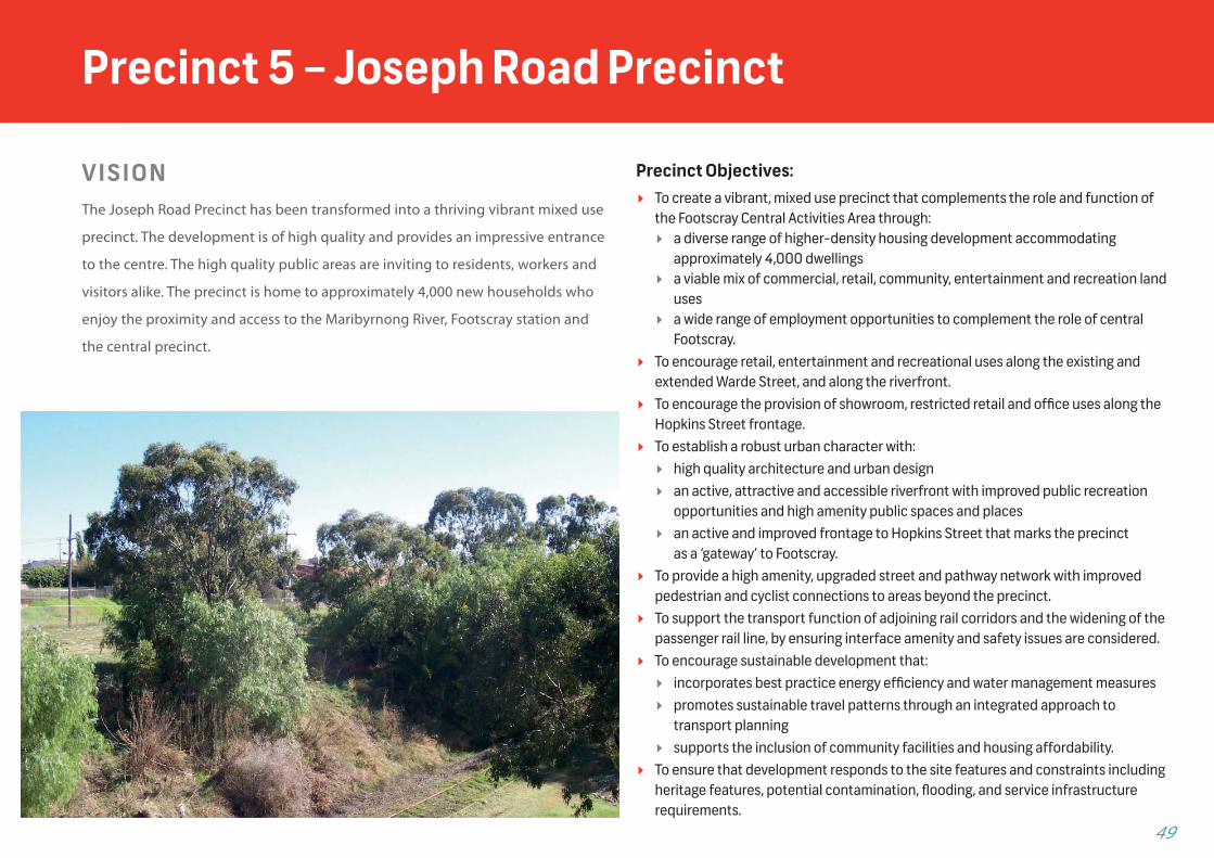
V I S I O NThe Joseph Road Precinct has been transformed into a thriving vibrant mixed use
precinct. The development is of high quality and provides an impressive entrance
to the centre. The high quality public areas are inviting to residents, workers and
visitors alike. The precinct is home to approximately 4,000 new households who
enjoy the proximity and access to the Maribyrnong River, Footscray station and
the central precinct.
Precinct Objectives: To create a vibrant, mixed use precinct that complements the role and function of
the Footscray Central Activities Area through: a diverse range of higher-density housing development accommodating
approximately 4,000 dwellings a viable mix of commercial, retail, community, entertainment and recreation land
uses a wide range of employment opportunities to complement the role of central
Footscray. To encourage retail, entertainment and recreational uses along the existing and
extended Warde Street, and along the riverfront. To encourage the provision of showroom, restricted retail and offi ce uses along the
Hopkins Street frontage. To establish a robust urban character with:
high quality architecture and urban design an active, attractive and accessible riverfront with improved public recreation
opportunities and high amenity public spaces and places an active and improved frontage to Hopkins Street that marks the precinct
as a ‘gateway’ to Footscray. To provide a high amenity, upgraded street and pathway network with improved
pedestrian and cyclist connections to areas beyond the precinct. To support the transport function of adjoining rail corridors and the widening of the
passenger rail line, by ensuring interface amenity and safety issues are considered. To encourage sustainable development that:
incorporates best practice energy effi ciency and water management measures promotes sustainable travel patterns through an integrated approach to
transport planning supports the inclusion of community facilities and housing affordability.
To ensure that development responds to the site features and constraints including heritage features, potential contamination, fl ooding, and service infrastructure requirements.
Precinct 5 – Joseph Road Precinct
F O O T S C R AY S T R U C T U R E P L A N 2 0 1 3 50
Precinct 5 – Joseph Road Precinct
Design Requirements:
Height Range:
Joseph Road Precinct 4-25 Storeys
Strategies
Development should respond to interfaces with transport corridors. The design and construction of buildings for sensitive uses with interfaces to Hopkins Street or rail infrastructure should ensure that potential noise and vibration impacts generated by heavy vehicles or train movements are addressed.
A network of high amenity public places and pedestrian spaces should be provided as shown in the Joseph Road Precinct Urban Framework Plan.
Visual and physical connections between the river and the precinct should be provided.
Active frontages created by retail, entertainment and recreation uses at ground level are encouraged along the main connections to the river along Warde Street and along Hopkins Street.
Development proposals should respect planned pedestrian and cycling networks.
Pedestrian/cycle bridges provided across the passenger rail line and crossing points of the freight rail line should be defi ned by robust landscaping and clear sight lines, and designed to the satisfaction of VicTrack and Department of Transport.
Development proposals with river frontage should include opportunities for activation along the riverside.
Development should provide a high quality street environment which incorporates footpaths, cycle paths, and on-street car parking, and maximises opportunities for street planting where appropriate.
Opportunities should be provided to green the urban environment both in the public realm and as a part of
new developments. Taller forms should be generally located towards the
centre of the precinct, with a transition to lower forms adjacent to the riverfront and the residential area to the west.
Built form should create a robust urban character with minimal boundary setbacks that reinforce the geometry and pattern of the existing road network, except where development should respond to the proposed changes to the existing road network through the construction of proposed new pedestrian and cycle links as shown in the Joseph Road Precinct Urban Framework Plan.
The primary vehicle access point to and from the precinct should be via a signalised intersection at the corner of Hopkins Street and Moreland street, with associated intersection treatments. Secondary vehicle access points should be provided at the intersections of Whitehall and Maribyrnong streets, with Hopkins Street.
Direct vehicle access from Hopkins Street to development should be avoided. Car parking and service vehicle access for development along Hopkins Street will be provided from the precinct’s internal street network.
On street car parking should be provided in streets whilst ensuring suffi cient width to accommodate parallel car parking spaces as well as bicycle lanes, pedestrian footpaths, and landscaping treatments.
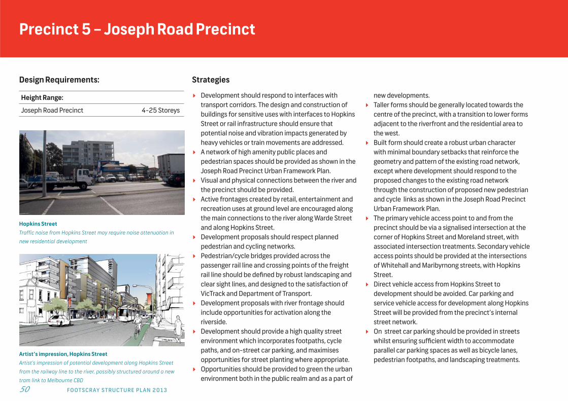
Hopkins StreetTraffic noise from Hopkins Street may require noise attenuation in
new residential development
Artist’s impression, Hopkins StreetArtist’s impression of potential development along Hopkins Street
from the railway line to the river, possibly structured around a new
tram link to Melbourne CBD

51
Precinct 5 – Existing Conditions and Future Opportunities
Figure 20: Precinct 5 – Joseph Road Precinct Built Form Framework Plan
PRIMARY ACCESS TO PRECINCT (SIGNALISED)
SECONDARY ACCESS TO PRECINCT (SIGNALISED)
ACTIVE FRONTAGE (SHOWROOM AND OFFICE) WITH 3m SETBACK
ACTIVE FRONTAGE (RETAIL, ENTERTAINMENT, RECREATION AND COMMUNITY)
MIXED USE (PRIMARILY RESIDENTIAL)
PROPOSED PUBLIC REALM
PROPOSED NEW STREET
HERITAGE OBJECT/PLACE
PRECINCT BOUNDARY
PEDESTRIAN/BICYCLE CONNECTIONS
PREFERRED MAXIMUM BUILDING HEIGHT
PREFERRED PODIUM HEIGHT
NOISE SOURCE
POTENTIAL FUTURE EXPANSION OF THE RAIL CORRIDOR (SUBJECT TO CONFIRMATION BY PUBLIC TRANSPORT VICTORIA)
PREFE
NOISE
POTENTO CO
3-10
6
6 25 25
25
4
1212
4-5p
4-5p4-5p
4-5p
1212
123-4p
4-5p5-6p
25
2525
1512
4-5p
4-5p
EXISTING RESIDENTIAL PRECINCT
EXISTING RAIL WAY LINE
MARIBYRNONG RIVER
HOPKINS ST
Mar
ibyr
nong
St
Joseph Rd
Mor
elan
d St
Whi
teha
ll St
Ryan St Railway Place
Cow
per S
t
Warde St
Neilson Plac e
0 50 100 200
6666666666
6666
1212
4-5p4-5p
4-5p
222222555555522222222
25
1511122222222111111222222211122222222
4-5p
44444444-4-4-4-4-55p5p5p444444
EEXISTING REESIDENTIAL PRECINCT
EXISTING RAIL WAY LINEAA
MARIBYRNONNG R
Mar
ibyr
nongggg
SSSSSSSttttttt
ph RdJJJJJJJJJJJo ph Rdos h RdJoseph Rdph Rd
ort
elan
d St
hall
St
Railway Place
WarWW ddde St
NNNN iills PPllNNeNeiNeiNeiNeieiillslsolsolsosososonnnn Pn PPPPllaclaclaclacacac eee
LEGEND
3-6p

F O O T S C R AY S T R U C T U R E P L A N 2 0 1 3 52
Precinct 6 – Peripheral Activity Precinct
V I S I O NThis precinct is a lively mixed use area that includes numerous service, educational, commercial,
and accommodation uses. The precinct also includes retail uses which complement the retail
within the central precinct. Key assets are the individual heritage places and heritage streetscape
along Barkly Street, which through ongoing protection and restoration contribute to the overall
diversity of the area. The precinct includes medium scale buildings that provide activation at the
ground level providing a high amenity pedestrian experience.
Design Requirements:
Height Range: Storeys:
6D NORTH 4-14
6C NORTH - North side of Paisley St 2-10
6B NORTH - between Paisley and Pickett Sts
2-6
6B SOUTH - West and south of precinct
2-6
6A SOUTH - East side of Nicholson St north of Buckley St
1-3
6C SOUTH - between Nicholson and
Albert Sts
2-10Precinct Objectives:
To support the growing mixed use character of the precinct with an emphasis on employment uses, commercial services and small businesses which support the regional role of the CAA.
To support development along main street frontages that provides for a variety of activity at ground floor level that can accommodate a range of uses that will activate the street.
To encourage shops along Barkly Street that complement the retail core of the CAA. To encourage medical, community and health services in Paisley Street. To encourage employment related uses including offi ces and small businesses. To preserve identifi ed heritage buildings and incorporate into new developments. To ensure that new business activity is compatible with nearby dwellings. To provide additional open space to serve the southern part of the activity centre as
part of any redevelopment of the bus depot. To ensure development in areas identifi ed as Transitional Areas is designed to make an
appropriate transition in height, scale and built form to adjoining residential areas. To increase pedestrian permeability between Barkly and Paisley streets and
investigate related crossings over Paisley Street. To facilitate provision of car parking thus minimising the need within the central
precinct whilst ensuring parking provision minimises undesirable impacts on pedestrians caused by blank walls and lack of access ways.
6D NORTH6C NORTH
6B NORTH
6C SOUTH6B SOUTH 6A
SOUTH
Paisley Street
Pickett Street
Raleigh Street
Buckley Street
Geelong Road
Irving Street
oop Street
Fren
ch S
tree
t
Alb
ert S
tree
t
Nic
hols
on S
tree
t
Barkly Street
Vict
oria
Str
eet
53
Strategies Require noise attenuation measures for dwellings
along Barkly and Buckley Streets and Geelong Road, or where there is adjacent commercial activity that operates late at night.
Buildings within the Transition Area should provide appropriate reductions in building height and mass toward the existing lower scale buildings at the interface and not exceed 3 storeys.
Maintain a low scale residential interface to Walter Street in future development of the Bus Depot site.
Emphasise the Barkly St and Nicholson St urban corridors through appropriate built form by building to boundaries, providing for passive surveillance and providing pedestrian protection, including continuous weather protection and activation along frontages to designated pedestrian priority routes.
Maintain a distinction between lower order streets and the Barkly Street corridor.
Use solid building massing in conjunction with other sound barrier treatments to help reduce the impact of traffi c noise from Geelong Road.
New built form on the north side of main walking routes should ensure that reasonable sunlight access is maintained on the south side of the street, especially along key streets in the CAA such as Barkly and Paisley Streets (between 9am and 3pm at the equinox, September 22).
Prohibit the use of roller shutters for retail premises. Maintain the fi ne grain and heritage streetscape
within the Barkly and Hopkins Street corridor. Retain prominent landmark buildings such as places
of worship and civic buildings.
Provide improved pedestrian connections between Barkly and Paisley Streets.
Street wall heights should generally range between 2 and 3 storeys and respect adjoining heritage buildings and streetscrapes where applicable, in particular along Barkly Street.
Side setbacks should refl ect the existing context within the CAA and should maintain a continuous street wall frontage where appropriate along key streets such as Barkly Street and Buckley Street.
Larger sites should accommodate medium density development to maximise land use, whilst maintaining the existing fi ne grain, active streetscape presentation.
New built form should respect and respond to the heritage context of the retail core on Barkly Street, allowing for heritage prominence to be maintained and sensitively managed, with careful consideration of built form massing, articulation, distribution of features and architectural style.
When new development adjoins heritage buildings, the design should take into consideration the height, scale, rhythm and proportions of the heritage buildings including characteristic fi ne grain frontage widths.
New development should seek to refl ect the minor setback condition of residential streetscapes such as Paisley Street and Buckley Street through landscape treatments or gardens, providing a point of difference between the retail core and peripheral activity precincts.
Tower forms at upper levels should be set back from the streetscape at least 5 metres, to reduce visual bulk and the effect of wind downdrafts.
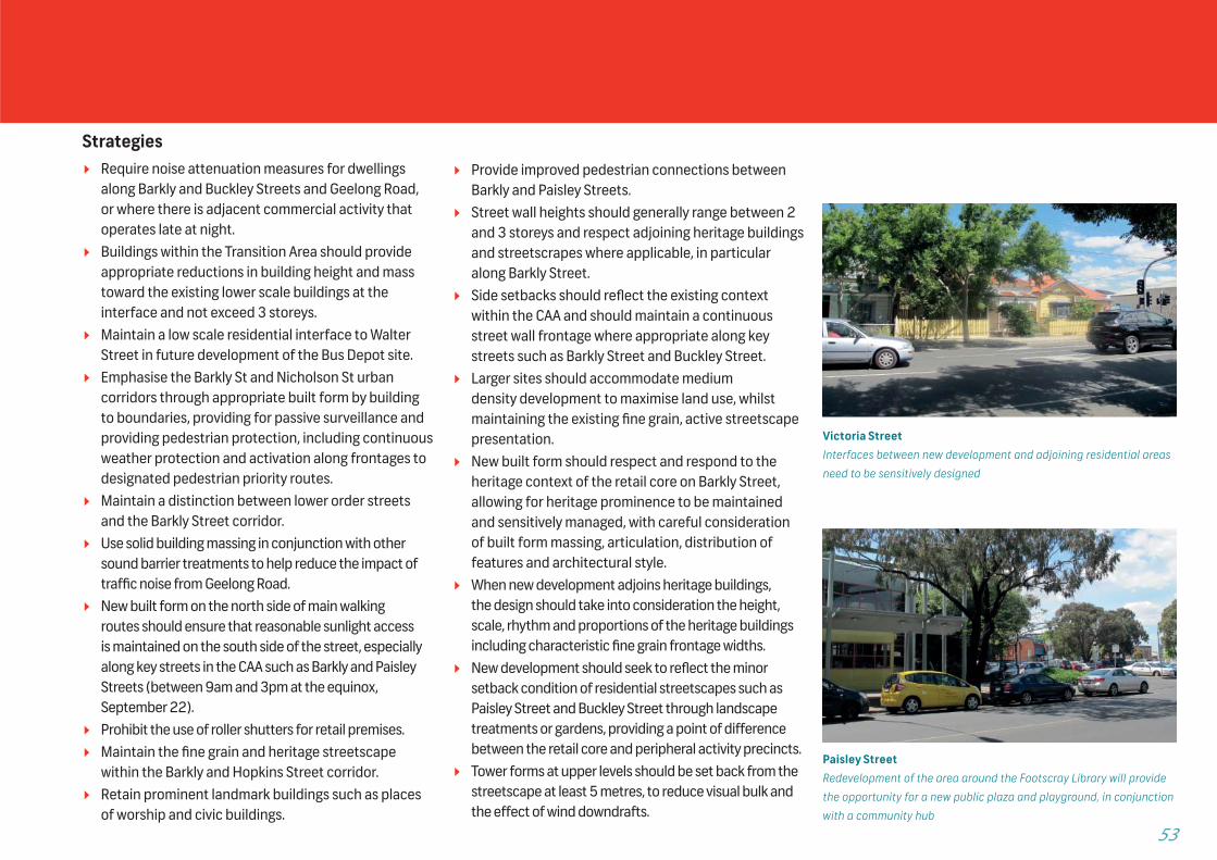
Victoria StreetInterfaces between new development and adjoining residential areas
need to be sensitively designed
Paisley StreetRedevelopment of the area around the Footscray Library will provide
the opportunity for a new public plaza and playground, in conjunction
with a community hub
F O O T S C R AY S T R U C T U R E P L A N 2 0 1 3 54
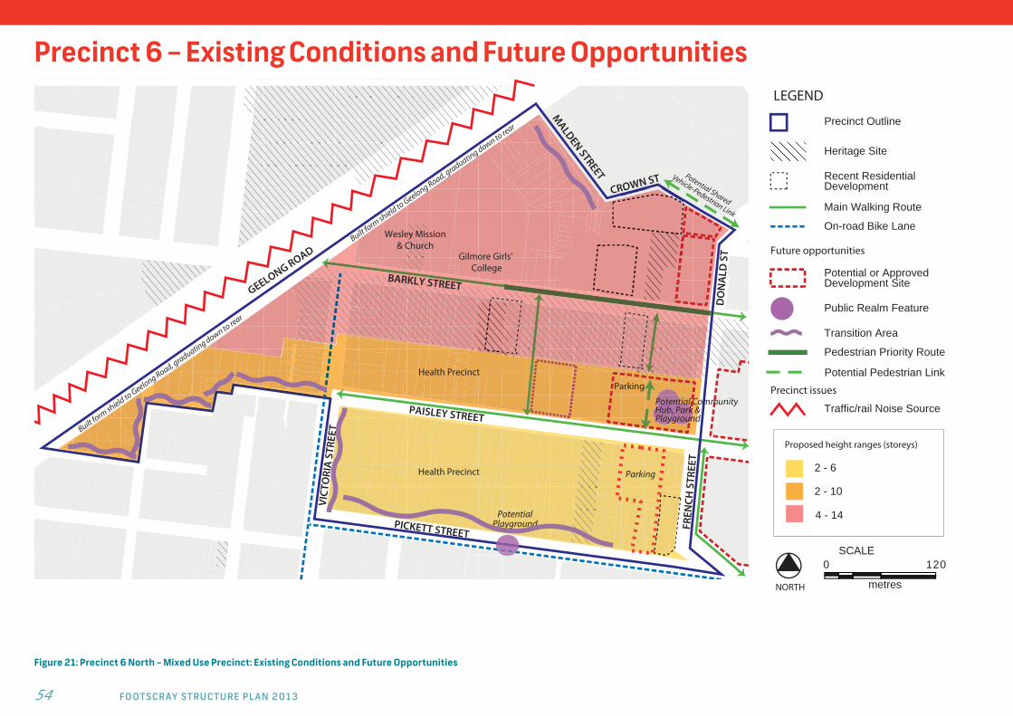
Precinct 6 – Existing Conditions and Future Opportunities
Figure 21: Precinct 6 North – Mixed Use Precinct: Existing Conditions and Future Opportunities
$
GEELONG ROAD
Potential Community Hub, Park & Playground
PAISLEY STREET
PICKETT STREET
FREN
CH S
TREE
T
VICT
ORI
A S
TREE
T
Potential Playground
Gilmore Girls’ College
MALDEN STREET
CROWN ST
DO
NA
LD S
T
Parking
Parking
Wesley Mission& Church
Health Precinct
Health Precinct
BARKLY STREET
Built form
shield to Geelong Road, graduating down to rear
LEGEND
Precinct Outline
Heritage Site
Future opportunities
Potential or Approved Development Site
Recent Residential Development
Main Walking Route
On-road Bike Lane
Public Realm Feature
Transition Area
Pedestrian Priority Route
Precinct issues
Traffic/rail Noise Source
2 - 6
2 - 10
Proposed height ranges (storeys)
4 - 14
SCALE120
metres
0
NORTH
Built form
shield to Geelong Road, graduating down to rear
Potential Pedestrian Link
55
Potential Park & Playground
Bus Depot
Victoria University
RALEIGH STREET
ALB
ERT
STRE
ET
NIC
HO
LSO
N S
T
PICKETT STREET
BUCKLEY STREET
SHORT ST
VICT
ORI
A S
T
HU
NTL
Y ST
REET
STA
FF S
TREE
T
AD
MIR
AL
STRE
ET
BILS
TON
STR
EET
BUTE
STR
EET
ARR
AN
STR
EET
WALTER STREET
Youth CentreParking
VICT
ORI
A S
TLEGEND
Precinct Outline
Heritage Site
Passenger Rail
On-road Bike Lane
Main Walking Route
Recent Residential Development
Future opportunities
Potential or Approved Development Site
Potential Heritage Site
Transition Area
Precinct issues
Traffic/rail Noise Source
Poor Walking Conditions
SCALE120
metres
0
NORTH
2 - 6
2 - 10
Proposed height ranges (storeys)
1 - 3
Public Realm Feature
Pedestrian Priority Route
Bus Priority Upgrade
Potential Bike Path
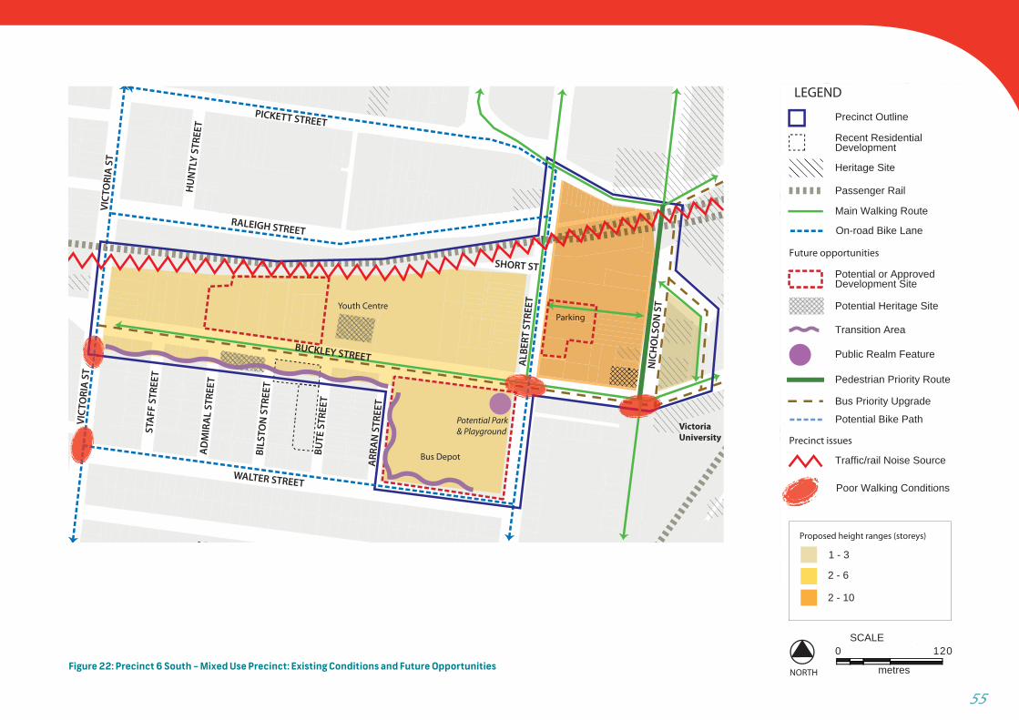
Figure 22: Precinct 6 South – Mixed Use Precinct: Existing Conditions and Future Opportunities
F O O T S C R AY S T R U C T U R E P L A N 2 0 1 3 56
Precinct 7 – Neighbourhood Precincts
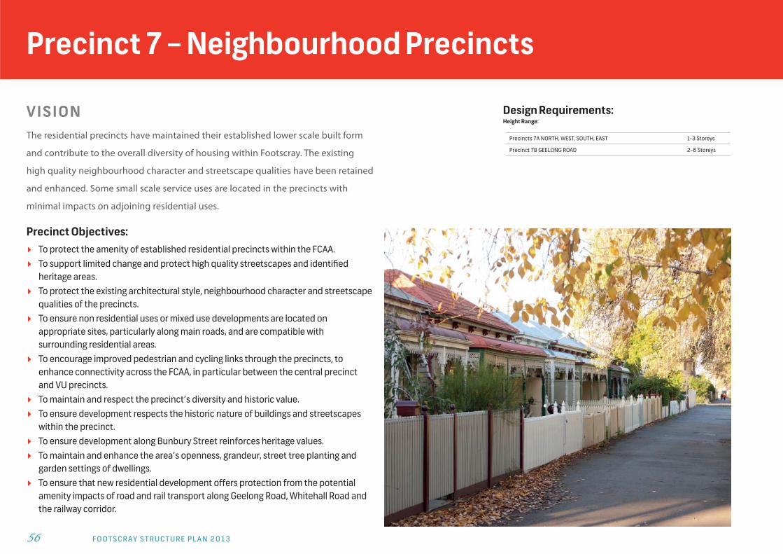
V I S I O NThe residential precincts have maintained their established lower scale built form
and contribute to the overall diversity of housing within Footscray. The existing
high quality neighbourhood character and streetscape qualities have been retained
and enhanced. Some small scale service uses are located in the precincts with
minimal impacts on adjoining residential uses.
Precinct Objectives: To protect the amenity of established residential precincts within the FCAA. To support limited change and protect high quality streetscapes and identifi ed
heritage areas. To protect the existing architectural style, neighbourhood character and streetscape
qualities of the precincts. To ensure non residential uses or mixed use developments are located on
appropriate sites, particularly along main roads, and are compatible with surrounding residential areas.
To encourage improved pedestrian and cycling links through the precincts, to enhance connectivity across the FCAA, in particular between the central precinct and VU precincts.
To maintain and respect the precinct’s diversity and historic value. To ensure development respects the historic nature of buildings and streetscapes
within the precinct. To ensure development along Bunbury Street reinforces heritage values. To maintain and enhance the area’s openness, grandeur, street tree planting and
garden settings of dwellings. To ensure that new residential development offers protection from the potential
amenity impacts of road and rail transport along Geelong Road, Whitehall Road and the railway corridor.
Design Requirements:Height Range:
Precincts 7A NORTH, WEST, SOUTH, EAST 1-3 Storeys
Precinct 7B GEELONG ROAD 2-6 Storeys
57
Strategies Ensure existing residential land use focus and built
form diversity is maintained as the transitional space within the CAA boundary.
Major development should be focussed on large existing lots or consolidated sites.
In Precinct 7 west a low scale development interface with existing residential areas to the west, outside of the FCAA, should be provided.
Heritage places should be retained and protected. New built form should be respectful and responsive
in the heritage context around Bunbury, Cowper and Nicholson streets, allowing for heritage prominence to be maintained and sensitively managed. Built form massing, articulation and distribution of features should be carefully considered.
In areas where the Heritage Overlay applies: New development, including additions to existing
buildings, should be distinguishable from the original dwelling stock through the use of innovative and contemporary yet sympathetic architecture.
Articulation and visual interest through colour, building details and architectural reinterpretation is encouraged.
When new development adjoins heritage buildings, the design should have regard to the height, scale, rhythm and proportions of the heritage buildings including characteristic, fi ne grain frontage widths.
Front setbacks to built form are encouraged on local streets to refl ect the residential garden character of the streetscapes.
Large, established trees should be retained and provision should be made for the planting of new trees where possible.
New built form should provide: Front setback of no less than the average setback
of the adjoining two dwellings. Side setbacks that accord with the predominant
setback patterns in the street. Front fences up to 1 metre in height, or open style
front fences up to 1.2 metres in height other than in exceptional circumstances.
Street wall heights of no more than 2 storeys. Upper level(s) setback from the streetscape to
maintain the 2 storey street wall frontage. Garages and carports located behind the line of the
dwelling. Vehicular access from a rear laneway if available.
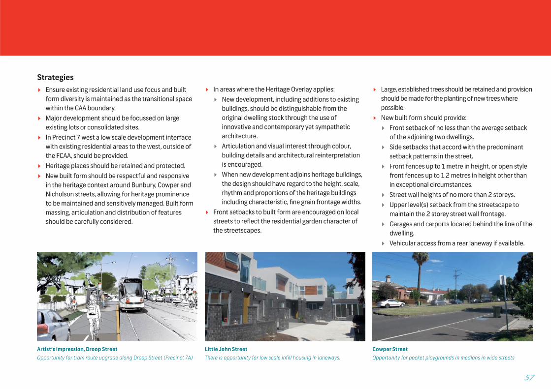
Artist’s impression, Droop StreetOpportunity for tram route upgrade along Droop Street (Precinct 7A)
Cowper StreetOpportunity for pocket playgrounds in medians in wide streets
Little John StreetThere is opportunity for low scale infill housing in laneways.

F O O T S C R AY S T R U C T U R E P L A N 2 0 1 3 58
Precinct 7 – Existing Conditions and Future Opportunities
Figure 23: Precinct 7 North – Neighbourhood: Existing Conditions and Future Opportunities
Potential Level Tram Stop
Built form
shield to Geelong Road, graduatin
g down to rear
Sculpture
NIC
HO
LSO
N S
TREE
T
BALLARAT ROAD
GEELONG ROAD
VU parking
DROOP STREET
GALLANT STREET
COWARD ST
FITZROY STREET
MALDEN STREET
DONALD STREET
Parking
FORD
STR
EET
LINDA CT
STIRLING ST
LYNCH STREET
NEWELL STREET
Poor walking (traffic, wait times, etc)
Precinct issues
Traffic/rail Noise Source
Poor Walking Conditions
SCALE120
metres
0
NORTH
2 - 6
Proposed height ranges (storeys)
1 - 3
Tram
Open Space
LEGEND
Striking Long Views
Precinct Outline
Heritage Site
Main Walking Route
Future opportunities
Public Realm Feature
Potential Pedestrian Link
Potential or Approved Development Site
Transition Area
Planned Pedestrian Signal
On-road Bike Lane
59
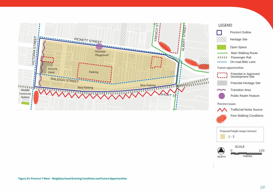
Figure 24: Precinct 7 West – Neighbourhood Existing Conditions and Future Opportunities
RALEIGH STREET
PICKETT STREET
Parking
Potential Playground
VIC
TOR
IA S
TREE
T
ALBE
RT
STR
EET
FREN
CH
ST
SHORT ST
Victoria Hotel
MiddleFootscray
Station
New ParkingNew Parking
SCALE
120
Future opportunities
Public Realm Feature
Potential or Approved Development Site
Potential Heritage Site
Transition Area
Precinct issues
Traffic/rail Noise Source
Poor Walking Conditions
SCALE120
metres
0
NORTH
Proposed height ranges (storeys)
1 - 3
Passenger Rail
Open Space
LEGEND
Precinct Outline
Heritage Site
Main Walking Route
On-road Bike Lane
F O O T S C R AY S T R U C T U R E P L A N 2 0 1 3 60
Precinct 7 – Existing Conditions and Future Opportunities
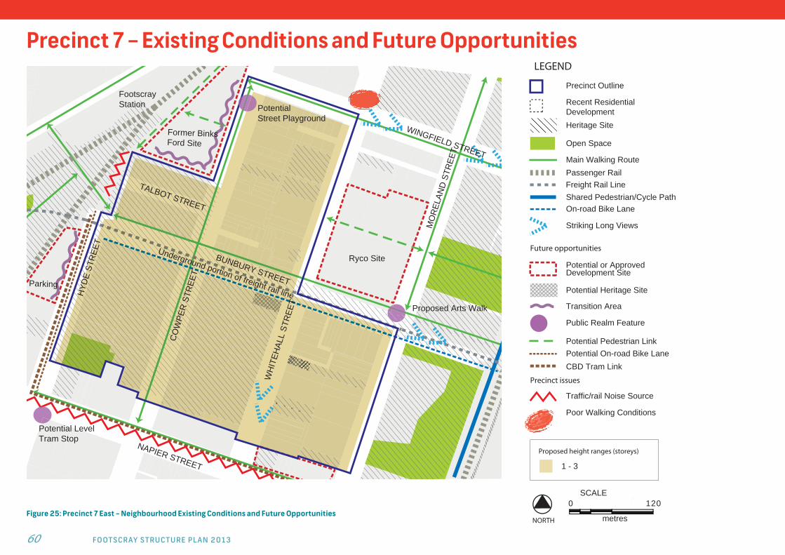
Figure 25: Precinct 7 East – Neighbourhood Existing Conditions and Future Opportunities
Proposed Arts Walk
Potential LevelTram Stop
Underground portion of freight rail line
Ryco Site
NAPIER STREET
WH
ITEH
ALL
STR
EET
HYD
E ST
REE
T
BUNBURY STREET
CO
WPE
R S
TREE
TTALBOT STREET
WINGFIELD STREET
MO
REL
AND
STR
EET
PotentialStreet Playground
Footscray Station
Former BinksFord Site
Parking
Precinct issues
Traffic/rail Noise Source
Poor Walking Conditions
SCALE120
metres
0
NORTH
Proposed height ranges (storeys)
1 - 3
Passenger Rail
Open Space
LEGEND
Shared Pedestrian/Cycle Path
Striking Long Views
Precinct Outline
Heritage Site
Recent Residential Development
Main Walking Route
On-road Bike Lane
Future opportunities
CBD Tram Link
Public Realm Feature
Potential Pedestrian Link
Potential or Approved Development Site
Potential Heritage Site
Transition Area
Potential On-road Bike Lane
Freight Rail Line
61
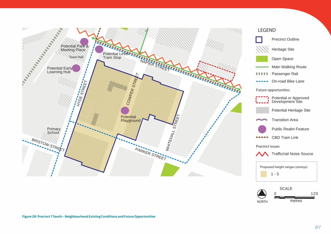
Figure 26: Precinct 7 South – Neighbourhood Existing Conditions and Future Opportunities
NAPIER STREET
HYD
E ST
REE
T
CO
WPE
R S
TREE
T
Potential Playground
Potential Park & Meeting Place
Potential Early Learning Hub
Primary School
Town Hall
PARKER STREET
WH
ITEH
ALL
STR
EET
BRISTOW STREET
Potential LevelTram Stop
Precinct issues
Traffic/rail Noise Source
Potential Heritage Site
SCALE120
metres
0
NORTH
Proposed height ranges (storeys)
1 - 3
Passenger Rail
Open Space
LEGEND
Precinct Outline
Main Walking Route
Heritage Site
On-road Bike Lane
Future opportunities
CBD Tram Link
Public Realm Feature
Potential or Approved Development Site
Transition Area
F O O T S C R AY S T R U C T U R E P L A N 2 0 1 3 62
Precinct 8 – Civic Precinct
V I S I O NThe Civic Precinct bridges the old and new Footscray
with prominent heritage buildings such as the Town
Hall, Scout Hall and Footscray City Primary School
complemented by modern development such as the
Police Station and the more recently completed Early
Years Hub. The precinct has a strong community focus
providing easily accessible services to all members of
the community and capitalising on its proximity to
Footscray Station.
Precinct Objectives: To support the precinct’s position as the civic centre
of Footscray by continued and expanded municipal, community and education uses.
To allow for sensitive redevelopment which complements the heritage values of the precinct and adjoining residential area.
To improve pedestrian access, amenity and safety through the precinct, particularly to the station and new community meeting spaces.
Design Requirements:
Height Range:
Northern Portion 2-6 Storeys
Southern Portion 1-3 Storeys
Strategies New built form should be respectful and responsive
to the heritage context of the precinct allowing for heritage prominence to be maintained and sensitively approached through careful consideration of built form massing, articulation, distribution of features and architectural style.
Support increased usage and accessibility of the Town Hall to the community through adaptation of the former Town Hall to a public meeting space and the Town Hall gardens as a public open space.
Support development of an Early Years Hub that capitalises on existing community services provision.
Enhance pedestrian access, amenity, safety and orientation through provision of safe, walkable connections of high amenity through and around the area with active street frontages, clear signage and the minimisation of potential pedestrian / vehicle confl ict areas.
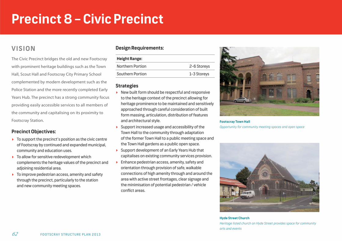
Footscray Town HallOpportunity for community meeting spaces and open space
Hyde Street ChurchHeritage listed church on Hyde Street provides space for community
arts and events

63
Precinct 8 – Existing Conditions and Future Opportunities
Figure 27: Precinct 8 – Civic Precinct: Existing Conditions and Future Opportunities
Town Hall
Primary School
Police Station
Scouts
Parking
Potential Park& Playground
McNab AvenueDevelopment
BUNBURY ST
HYD
E ST
REE
T
McNab Reserve Upgrade
NIC
HO
LSO
N S
TREE
T
ALBE
RT
STR
EET
BUCKLEY STREET
McNAB AVENUE
NAPIER ST
PARKER STREETBRISTOW STREET
PotentialEarly Years
Hub
Potential Park & Meeting Space
EnhancedPed. Access
PotentialLevel Tram Stop
Precinct issues
Traffic/rail Noise Source
Poor Walking Conditions
SCALE120
metres
0
NORTH
2 - 6
Proposed height ranges (storeys)
1 - 3
Future opportunities
Public Realm Feature
Potential Pedestrian Link
Potential or Approved Development Site
Pedestrian Priority Route
Transition Area
Tram
Passenger Rail
Freight Rail Line
Open Space
LEGEND
Precinct Outline
Heritage Site
Main Walking Route
On-road Bike Lane
Potential On-road Bike LanePotential CBD Tram Link
F O O T S C R AY S T R U C T U R E P L A N 2 0 1 3 64
More information
» (03) 9688 0200
» Maribyrnong City Council Street - Corner Hyde and Napier Streets Footscray VIC 3011Postal - PO Box 58, Footscray VIC 3011
» www.maribyrnong.vic.gov.au
» Published February 2013
INTERPRETERPH: 131 450