pkm 282 shepherd’s inn 282 buckinghorse r. bellsalaska.mobi /alaskahighway w.a.c. bennet dam 23 29...
TRANSCRIPT

Peace River
Wonowonkm162
1
2
km126
km184
km115
Halfway River
Sikanini Chief River
km75
km56
56
1477
64
7511
19
47
64
46
97
29
52
52
2
Hudson’sHope
BritishColumbia
GwillimLakeProvincialPark
DawsonCreek km0
To Prince George
To Tumbler Ridge
To Edmonton
Hart Highway
P
P km17
Km55PeaceIslandPark
Pkm218
FortStJohn
Taylor
1
2
Sasquatch Crossing
km 232
Shepherd’s Inn
km 115
3
Buffalo Inn
km 226
Pkm233PinkMountainkm2266
km232 Beatton River
R
97
CharlieLakeParkkm86
km48
km32 R
29
R
©Bell’s Travel Guides
km86
km226
49
Kiskatin
aw River
Chetwynd
Scantoseemilebymilehighway
descriptions
3
P km200
BuckinghorseRiverProvincialParkkm278
km282Buckinghorse R.
P
Bellsalaska.mobi/alaskahighway
W.A.C.BennetDam
23
29
km26
km34
TetsaRiver
Km552ProvincialPark
km484
Old Alaska Hwy
km454
FortNelson
AndyBaileyPark
Tetsa R.
Muskwa R.
Fort
Nel
son
R.
Prop
het
Riv
er
Muskw
a River
Buckinghorse R.
BritishColumbia
Prophet R
.
BuckinghorseRiverProvincialPark
km282
©Bell’s Travel Guides
km293P
km320
87
97
ProphetRiverkm365km366P
89
km375P
km427
km419P
km509 P
km536iR
km545
IndianHeadRock
Km549
TeeteringRock
30
Alaska HighwayConnecting Routes
P
numbers indicate KilometresRedBetween White Dots
Ri
Parking
Parking w/ Info Signs
Rest Area (Toilets, Trash Bins) Camping
Hiking
Viewpoint
Fishing
City/Town/JunctionRecommended Stops
Redfern - Keily
Provincial Park
Klua Lakes
Protected
Area
km278
Kledo Ck.
SteamboatSummit
Northern Rocky Mountains
Provincial Park
km284Redfern-Keily
P
km359P
P km526
P
12
P
Park
Dease
Riv
er
Liard River
72
68
BritishColumbia
Yukon
58
Hyl
and
Riv
er
12
Co
al R
iver
Kech
ika
Rive
r
Rab
bit
Riv
er
©Bell’s Travel Guides
17
Smit
h R
iver
Boya Lake
Smith RiverEco. Reserve
SmithRiver
km792
CoalRiverkm823
km814
WhirlpoolCanyonkm832
Firesidekm840
km880Allen’sLookout
km909
km912
Pkm937
LiardCanyon&LuckyLake
km980
WatsonLake
WatsonLakeCampground
UpperLiardVillagekm992
10
km1003
1
Cass
iar
Hig
hw
ay
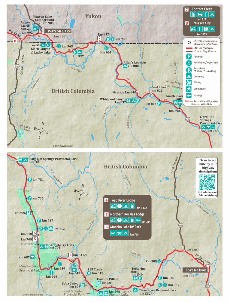
Contact Creek
km 912
7
Nugget City
km 1003
8
Alaska HighwayConnecting Routes
P
numbers indicate KilometresRedBetween White Dots
Ri
Parking
Parking w/ Info Signs
Rest Area (Toilets, Trash Bins) Camping
Hiking
Viewpoint
Fishing
City/Town/JunctionRecommended Stops
LiardHotSpringsProvincialPark
km765
P
i
RP
km905
R
km965i
37
97
87
R
km984
Falls
km970
Fort Nelson River
Liard River
Toad
Riv
er
Dunedin R
.
R.
Old Alaska Hwy
Liar
d H
ighw
ay
Rac
ing
97TetsaRiverRegionalParkkm598
km537
km509
km647.4
km708
km710
km751
km687
km726
km717
61
30
164
km454
FortNelson
BritishColumbia
LiardHotSpringsProvincialParkkm765
77
2
Stone MountainProvincial Park
km484
Muncho Lake
Provincial ParkTeetering
km549
km552
km601
km617
km605
km641
km712
Muncho Lake
km659
km735
StrawberryFlatskm701
4
5
Muncho Lake RV Park
km 710
Toad River Lodge
km 647.4
6
Northern Rockies Lodge
km 708
SummitLakeTetsa R.
Toad R
.
©Bell’s Travel Guides
R
Kledo Ck.
Rock
P km526P
P
P
P
ErosionPillars
BabaCanyon
115Creek
i
km668i
P
5
6
R
R
iP
Scantoseemilebymilehighway
descriptions
Bellsalaska.mobi/alaskahighway
4
55
i

km1329km1393
BritishColumbia
Alaska
Lake
AtlinLake
14212
16
45
69
YukonTagish
km1420
Jake’sCorner
Skagway
Haines
Whitehorse
Carcross
SquangaLakeMarshLake
km1316
2 7
Atlin
Teslin
Kusawa Lake
Takhin
i Rive
r
km1244
53
Johnson’sCrossing
km1258TeslinLake
km1342
6
Teslin L.
TakhiniHotSprings
km1296
Lake
Tagish
AtlinLake
LakeBennett
22
32
Marsh L.
km1404 km1379
Yukon River
5
Hain
es
Hig
hw
ay
Klon
dike
Hig
hway
km1437
km1487
Rkm1566
Pine L.
To Aishihik
km1572
Dezadeash R.
94
Tutshi
Little
181
31
33
DezadeashLake
Can
ol R
oad
HainesJunction
km1579
3
Klukwan
U.S.A/CanadaBorder
63
Klo
nd
ike
Hig
hw
ay
52
37
Fraser
©B
ell’s Travel Gu
ides
Tatshenshini-Alsek
Wilderness Provincial Park
Kluane
National
Park
i R
1
1
km1248
ikm1454
9
R
RWolfCreekkm1408
km1548RPineLk.
i
R
11
10
MacBride Museum on the Copperbelt
91928 Alaska Hwy
9
10
Frances R.
Liard R.
Hyl
and
R.
BritishColumbia
Yukon
37
Liard
R.
Dea
se R
.
Blue
R.
Litt
le R
anch
eria
R.
Ran
cher
ia R
.
Daughney L.
Cabin L.
Dorsey L.
Morley L.
Teslin L.
Gladys L.Hall L.
Swift R. Tootsee L.Swan L.
133
108
km1063
km1152
km1120
km1242
km1084
km1042
SwiftRiverkm1136
km1244Teslin
km1003
WatsonLake
22
4
Cam
pb
ell H
ighw
ayBigCreekCampground
WatsonLakeCampground
km1036
R
P1 Pi
km1112RancheriaFalls
1
km980
Rkm1194
km1204
Nugget City
km 1003
8
©Bell’s Travel Guides
Alaska HighwayConnecting Routes
P
numbers indicate KilometresRedBetween White Dots
Ri
Parking
Parking w/ Info Signs
Rest Area (Toilets, Trash Bins) Camping
Hiking
Viewpoint
Fishing
City/Town/JunctionRecommended Stops
R
R
R
R
Pkm1177
Cassia
r Hig
hw
ay
Park
Boya Lake
8
km984
MorleyRiver
km1246
UpperLiardVillagekm992
Scantoseemilebymilehighway
descriptions
Bellsalaska.mobi/alaskahighway
P

Kluane
National
Park
Asi Keyi
Territorial
Park
Wra
ng
ell
- St.
Elia
s N
atl
. Park
Kluane Wildlife Sanctuary
Glaciated
Area
1
Kluane Lake
Wellesley L.
79
27
16
170
Yukon
SpruceBeetleTrailkm1597
Canada
km1579
km1584
km1726
LakeCreekkm1791
km1858
CanadaCustomskm1874
km1902
BeaverCreek
SnagJunctionkm1850
km1903HM1222
km1871
U.S.A.
1
P
P
i
HainesJct
km1658
i
km1756
Klu
an
e R
.
Do
nje
k R
.
Do
nje
k R
.White R.
White
R.
USCustoms
PickhandleLakekm1802
Koidern R.
CongdonCreekkm1666
TachalDhalVisitorInfokm1649
Duke R.
DestructionBaykm1684.5
©Bell’s Travel Guides
km1685
km1872
km1884
12
Rocking Star Adventures
km 1701
13
Cottonwood RV Park
km 1658
14
Talbot Arm Motel
Km 1684.5
Kluane Museum
km 1701
15
BurwashLandingkm1701
Alaska HighwayConnecting Routes
P
numbers indicate KilometresRedBetween White Dots
HM indicates Historical Mileposts on the Alaska Highway
Ri
Parking
Parking w/ Info Signs
Rest Area (Toilets, Trash Bins) Camping
Hiking
Viewpoint
Fishing
City/Town/JunctionRecommended Stops
Mount Luciana17,147 Ft/5,226 m
Mount Steele16,644 Ft/5,073 m
km1610
32
R
R
P
HM1202
P
km1635i
R
P km1628
R
R
R
R km1841
R
14 15
13
12
iR
iR
12
66
10
61
81
Alaska
Fox ChenaHotSprings
EielsonA.F.B.M342
M1370
DonnaLakeM1392
LisaLakeM1381
Yukon
M1222
Chicken
Boundary
U.S.A
Can
ada
JackWade
Jct
Tanacross5
2
4
1
M1244
37
42
7 M1264
M1273
R i M1289
TetlinJct.M1302
Hwy
Ric
hard
son
Hw
y
Tok Cut-off
Tok
M1326
M1357
2
M288(RH)
BirchLakeM305(RH)
P
HardingLakeM322(RH)
M364(RH)
35
DotLakeM1361
DeltaJunction
83
2
Del
ta R
iver
Tan
an
a R
iver
Tana
na R
iver
Salcha RiverLittle Salcha R.
Yukon River
Gak
ona
R.
Copper R.
DeadmanLakeM1249
Northway
USCustoms
12
TokRiverM1309
FortymileRiver
Middle Fork
Wes
t Fork
M349(RH)
Steese Highway
Wrangell St. Elias National Park
Chena River State Rec. Area
To Glennallen
iM275(RH)
VisitorCenterM1229
Important NoteDue to Highway Reconstruction in the Yukon there is a
40 mile difference between Yukon and Alaska mileposts. Alaska still uses original mileposts.
Tetlin Wildlife Refuge
Taylo
r Hig
hway
Tok R.
LakeviewM1257
Slana1
Nabesna©B
ell’ s Travel Gu
ides
11
Fairbanks
6
NorthPole15 Chen
a R.
30
City/Town/Junction
Alaska HighwayConnecting RoutesGravel Roads
numbers indicate MilesRedBetween White Dots
(RH) Indicates Mileposts on the Richardson Highway
(Valdez = Mile 0 on Richardson Hwy)
M266(RH)
43
Nabesna R.
Paxson
M1314
Denali
Rika’sRoadhouse
M1412
M1345
MoonLakeM1332
M1422
QuartzLake&LostLakeM278(RH)
R
P
P
ChenaLakesM347(RH)
i
i
P
i
Scantoseemilebymilehighway
descriptions
Bellsalaska.mobi/alaskahighway
P
P

12
66
10
61
81
Alaska
Fox ChenaHotSprings
EielsonA.F.B.M342(RH)
M1370
DonnaLakeM1392
LisaLakeM1381
Yukon
M1222
Chicken
Boundary
U.S.A
Can
ada
JackWade
Jct
Tanacross5
2
4
1
M1244
37
42
7 M1264
M1273
R i M1289
TetlinJct.M1302
Hwy
Ric
hard
son
Hw
y
Tok Cut-off
Tok
M1326
M1357
2
M288(RH)
BirchLakeM305(RH)
P
HardingLakeM322(RH)
M364(RH)
35
DotLakeM1361
DeltaJunction
83
2
Del
ta R
iver
Tan
an
a R
iver
Tana
na R
iver
Salcha RiverLittle Salcha R.
Yukon River
Gak
ona
R.
Copper R.
DeadmanLakeM1249
Northway
USCustoms
12
TokRiverM1309
FortymileRiver
Middle Fork
Wes
t Fork
M349(RH)
Steese Highway
Wrangell St. Elias National Park
Chena River State Rec. Area
To Glennallen
iM275(RH)
VisitorCenterM1229
Important NoteDue to Highway Reconstruction in the Yukon there is a
40 mile difference between Yukon and Alaska mileposts. Alaska still uses original mileposts.
Tetlin Wildlife Refuge
Taylo
r Hig
hway
Tok R.
LakeviewM1257
Slana1
Nabesna©B
ell’ s Travel Gu
ides
11
Fairbanks
6
NorthPole15 Chen
a R.
30
M266(RH)
43
Nabesna R.
Paxson
M1314
Denali
Rika’sRoadhouse
M1412
M1345
MoonLakeM1332
M1422
QuartzLake&LostLakeM278(RH)
R
P
P
ChenaLakesM347(RH)
i
i
P
i
Scantoseemilebymilehighway
descriptions
Bellsalaska.mobi/alaskahighway
P
P
numbers indicate MilesRedBetween White Dots
(RH) Indicates Mileposts on the Richardson Highway
(Valdez = Mile 0 on Richardson Hwy)
City/Town/Junction
Alaska HighwayConnecting RoutesGravel Roads
P
Ri
Parking
Parking w/ Info Signs
Rest Area (Toilets, Trash Bins) Camping
Hiking
Viewpoint
Fishing