phase i esa template 1527-05 version - burlington ... · phase i environmental site assessment...
TRANSCRIPT


PHASE I ENVIRONMENTAL SITE ASSESSMENT REPORT
AIP #74 Various Properties
South Burlington, Vermont 05403
October 14, 2011
Prepared for:
Stantec Consulting Inc. 55 Green Mountain Drive
South Burlington, Vermont 05403
Prepared by:
P.O. Box 787 368 Avenue D, Suite 15
Williston, VT 05495 (802) 383-0486
(802) 383-0490 fax [email protected]
KAS Proj. #509110222

Phase I Environmental Site Assessment Report
AIP 74, South Burlington, Vermont
October 14, 2011 i KAS Project #509110222
Table of Contents
Section Page
1.0 EXECUTIVE SUMMARY_________________________________________________ ii
2.0 INTRODUCTION ________________________________________________________1
3.0 SITE DESCRIPTION _____________________________________________________5
4.0 USER SUPPLIED INFORMATION _________________________________________7
5.0 RECORDS REVIEW ______________________________________________________9
6.0 SITE RECONAISSANCE _________________________________________________12
7.0 INTERVIEWS __________________________________________________________18
8.0 FINDINGS_____________________________________________________________19
9.0 OPINION ______________________________________________________________19
10.0 CONCLUSIONS_______________________________________________________20
11.0 DEVIATIONS_________________________________________________________21
12.0 ADDITIONAL SERVICES ______________________________________________22
13.0 REFERENCES________________________________________________________23
14.0 SIGNATURES OF ENVIRONMENTAL PROFESSIONALS __________________25
15.0 QUALIFICATIONS OF ENVIRONMENTAL PROFESSIONALS ______________25
16.0 APPENDICIES________________________________________________________26

Phase I Environmental Site Assessment Report
AIP 74, South Burlington, Vermont
October 14, 2011 1 KAS Project #509110222
1.0 EXECUTIVE SUMMARY KAS, Inc. of Williston, Vermont conducted a Phase I Environmental Site Assessment (ESA) of land and premises at ten residential properties located in the City of South Burlington, Vermont (collectively referred to as AIP # 74). The ESA was conducted pursuant to the American Society of Testing and Materials (ASTM) Standard Practice for Environmental Site Assessments: Phase I Environmental Site Assessment Process (ASTM E 1527-05). This assessment was conducted for Stantec Consulting Inc. herein referred to as client. The owner of record of the property as of the date of this report is the City of Burlington, herein referred to as owner.1 The user of this document is the Burlington International Airport.
AIP #74 consists of ten individual residential properties located at the following addresses: 200-202 Airport Parkway; 4, 6, 8, 10, and 12 Picard Circle; 61 and 76 Dumont Avenue, 400 White Street; and, 7 Shamrock Road (see Appendix A: Site Location Map and Appendix B: Site Plans). All of the properties are single family residential on 0.753 acre or less lots except 200-202 Airport Parkway which is multi-family residential. The properties are located in a predominantly suburban residential portion of the City of South Burlington. The character of the area is fully developed with residential structures on suburban lots. Neighboring properties are also residential. East or south of the residential neighborhoods is the Burlington International Airport. To the north of the residential area is a commercial zone including retail stores, public works facility, and interstate 89. To the south is Williston Road and commercial uses associated with that area.
The ten properties within AIP group #74 have been assessed and it has been determined that the historic and current uses have been for residential housing. Prior to the development of the properties the general area was determined to be used for agricultural purposes.
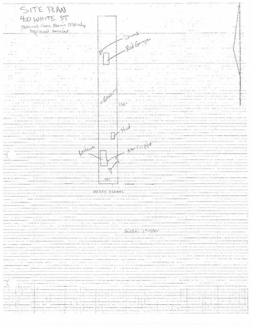
One recognized environmental condition (REC) was identified during this assessment: the presence of three corroded and damaged drums immediately outside a garage that appeared to be used for automobile repair at the 400 White Street property. Although the drums were empty and no staining was noted around the drums visual observations of the garage near the drums suggested automobiles were repaired inside the garage. A mark was observed on the concrete floor inside the garage. The markings were representative of an above ground lift. Additionally, the garage was constructed with a high ceiling immediately above the marks on the concrete. The presence of the empty and damaged drums outside this area suggests that there was a potential release of hazardous materials at one time. The drums were unlabeled and thus the previous contents of the drums could not be determined.
A recognized environmental condition is defined in ASTM E 1527 as “the presence or likely presence of any hazardous substances or petroleum products on a property under conditions that indicate an existing release, a past release, or a material threat of a release of any hazardous substances or petroleum products into structures on the property or into the ground, groundwater
1 City of South Burlington Land Records, various books, pages.

Phase I Environmental Site Assessment Report
AIP 74, South Burlington, Vermont
October 14, 2011 2 KAS Project #509110222
or surface water of the property. The term includes hazardous substances or petroleum products even under conditions in compliance with laws. The term is not intended to include de minimis conditions that generally do not present a threat to human health or the environment and that generally would not be the subject of an enforcement action if brought to the attention of appropriate governmental agencies. Conditions determined to be de minimis are not recognized environmental conditions.”
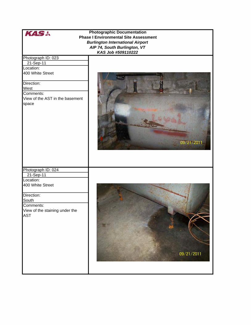
Evidence of three of the properties previously using fuel oil to heat the structures was noted during the site reconnaissance. These three properties are 400 White Street, 61 Dumont Street, and 200-202 Airport Parkway. Additionally, the potential presence of an underground storage tank was noted at the 76 Dumont Street property. The remaining properties did not supply visual evidence suggesting oil was stored on these properties. Typical of Chittenden County urban areas, natural gas was installed in the 1960’s and many of the tanks and oil burners were removed or left in place. There was no evidence of fuel oil contamination encountered during the reconnaissance except at the 400 White Street property where some staining was noted under the AST in the basement. There were no indications of foundation wall penetrations by oil lines which could be indicative of USTs outside the buildings. The staining noted under the above ground storage tank inside the basement of the 400 White Street property and on the concrete floor within the garage at 61 Dumont Avenue is considered a de minimis condition as defined by ASTM and as outlined in Sections 9.0 and 10.0.
None of the properties are included in regulatory database listings for environmental concerns. A few properties in the vicinity appear in the regulatory database report but none appear to present tangible environmental risk to the subject properties.
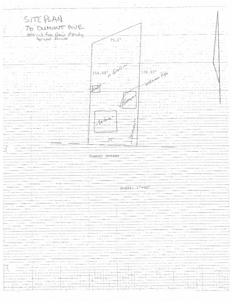
An additional investigation is deemed necessary to ascertain the presence or absence of a REC at the 76 Dumont Avenue property and the 4, 6, 8, 10, and 12 Picard Circle properties. The steel pipe protruding from the ground near the garage at the 76 Dumont Avenue property needs additional investigation to determine if this pipe is associated with an underground storage tank. An interview with the former owner of an adjacent property of land to the Picard Circle properties indicated a dump used to be present near the properties. Additional investigation is needed to ascertain whether or not this is a REC.
As part of the Phase I ESA, KAS also provided an opinion regarding asbestos-containing building materials (ACBMs) and lead-based paint (LBP) in accordance with 13.1.5 List of Additional Issues in the ASTM E 1527-05 Standard. In accordance with National Emissions Standard for Hazardous Air Pollutants (NESHAPS) – Asbestos and 18 VSA Chapter 26, a Pre-Demolition Asbestos Inspection shall be performed and NESHAPS notification submitted 10 business days prior to commencement of demolition of all buildings. Based on the ages of the buildings (pre-1978), LBP may be present in all buildings except 4, 6, 8, 10, and 12 Picard Circle. KAS recommends that paints present in the AIP 74 buildings except 4, 6, 8, 10, and 12 Picard Circle be assumed to be lead based and that appropriate pre-disposal characterization testing be performed. The demolition contractor should be required to comply with applicable local, state and federal safety and disposal requirements.

Phase I Environmental Site Assessment Report
AIP 74, South Burlington, Vermont
October 14, 2011 3 KAS Project #509110222
The following table is a summary of the environmental issues associated with each property: Property Environmental Issues Recommendations 200-202 Airport Parkway
• ~275 gallon fuel oil AST in basement at each unit
• Suspect ACBM • Suspect LBP
• Remove ASTs and waste in accordance with applicable regulations
• Pre-Demolition Asbestos Inspection • Assume LBP is present
4 Picard Circle • Suspect ACBM • Possible historic dump adjacent to
subject property
• Pre-Demolition Asbestos Inspection • Conduct additional investigation to
determine if historic dump is present 6 Picard Circle • Suspect ACBM
• Possible historic dump adjacent to subject property
• Pre-Demolition Asbestos Inspection • Conduct additional investigation to
determine if historic dump is present 8 Picard Circle • Deminimus quantities of Kodak plate
developer • Suspect ACBM • Possible historic dump adjacent to
subject property
• Properly remove and dispose of liquid • Pre-Demolition Asbestos Inspection • Conduct additional investigation to
determine if historic dump is present
10 Picard Circle
• Deminimus quantities of Kodak plate developer
• Suspect ACBM • Possible historic dump adjacent to
subject property
• Properly remove and dispose of liquid • Pre-Demolition Asbestos Inspection • Conduct additional investigation to
determine if historic dump is present
12 Picard Circle
• Deminimus quantities of spray paint • Suspect ACBM • Possible historic dump adjacent to
subject property
• Properly remove and dispose of paint • Pre-Demolition Asbestos Inspection • Conduct additional investigation to
determine if historic dump is present 61 Dumont Avenue
• Minor staining on concrete floor in garage
• Former AST fill pipe remains present without connection to tank
• Suspect ACBM • Suspect LBP
• Dispose of concrete in accordance with solid waste regulations
• Remove fill pipe to prevent inadvertent fuel delivery and spill
• Pre-Demolition Asbestos Inspection • Assume LBP is present
76 Dumont Avenue
• Pipe of unknown origin observed outside garage
• Suspect ACBM • Suspect LBP
• Investigate pipe to determine if it is connected to an underground storage tank
• Pre-Demolition Asbestos Inspection • Assume LBP is present
400 White Street
• ~275 gallon fuel oil AST in basement • Minor staining noted under AST in
basement • Three empty drums noted on exterior
of property near garage • Suspect ACBM • Suspect LBP
• Remove AST and waste in accordance with applicable regulations
• Confirm spill is cleaned up and dispose of clean up materials in accordance with VTDEC regulations.
• Remove drums and test soils around the drums to determine if a release occurred
• Pre-Demolition Asbestos Inspection • Assume LBP is present
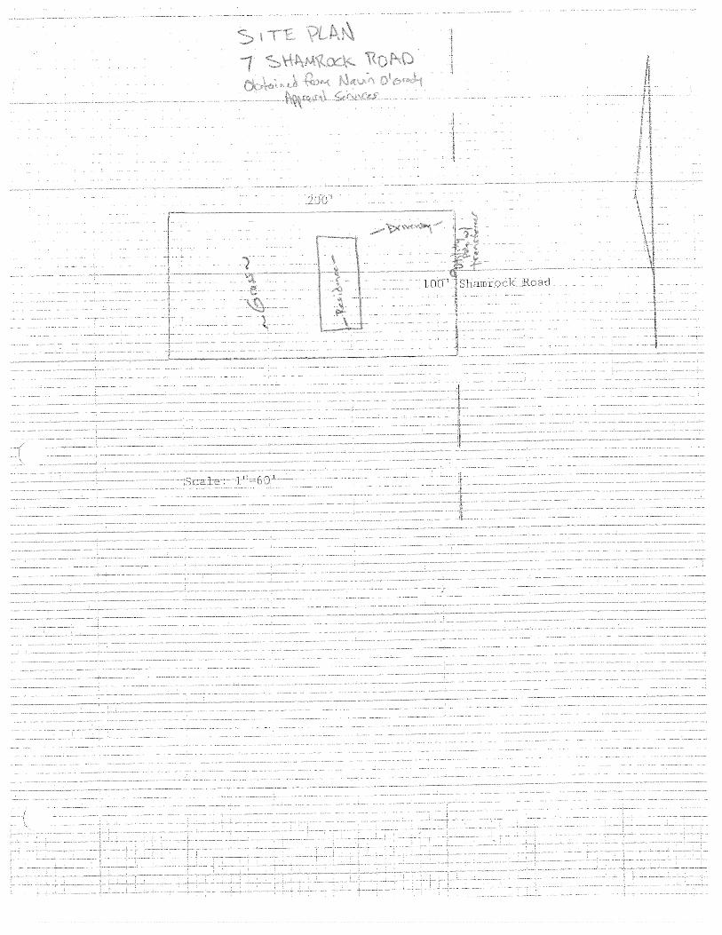
7 Shamrock Road
• Suspect ACBM • Suspect LBP
• Pre-Demolition Asbestos Inspection • Assume LBP is present

Phase I Environmental Site Assessment Report
AIP 74, South Burlington, Vermont
October 14, 2011 4 KAS Project #509110222
2.0 INTRODUCTION KAS, Inc. of Williston, Vermont (KAS) conducted a Phase I Environmental Site Assessment (ESA) of land and premises at ten residential properties located in the City of South Burlington, Vermont (collectively referred to as AIP # 74; see Appendix A: Site Location Map2 and Appendix B: Site Plans). The ESA was conducted pursuant to the American Society of Testing and Materials (ASTM) Standard Practice for Environmental Site Assessments: Phase I Environmental Site Assessment Process (ASTM E 1527-05). This assessment was conducted for Stantec Consulting Inc. herein referred to as client. The owner of record of the property as of the date of this report is the City of Burlington, herein referred to as owner.3 The user of this document is the Burlington International Airport.
2.1. Purpose The purpose of this ESA was to identify recognized environmental conditions (RECs), historic RECs and de minimis conditions in association with the property as defined and described in the ASTM standard.
2.2. Detailed Scope-of-Services KAS was engaged by client to conduct a Phase I ESA as defined in ASTM E-1527-05. The Phase I ESA work scope included the following elements:
A general description of the site and vicinity, current property and adjoining property uses, description of improvements.
An evaluation of user supplied information including land records, liens, limitations, specialized knowledge, and valuation information.
A review of practically reviewable regulatory and historic records in connection with the property.
A site reconnaissance including general site setting, interior and exterior observations. Interviews with owner, site manager, occupants, local government officials and others as
available. Presentation of Findings, Opinion, Conclusions, Deviations and the results of any out of
scope contract obligations between client and KAS. Unless otherwise stated in Section 12.0 of this document, no invasive environmental testing was conducted, and no assessment or testing of asbestos, lead paint, radon or other structural environmental hazards was conducted. If any of these tasks were contracted between KAS and client, the methodology, limitations and results of such tasks may be presented in Section 12.0 of this document.
2 USGS, 1987 and Acquired Land Location Plan 3 City of South Burlington Land Records, various books, pages

Phase I Environmental Site Assessment Report
AIP 74, South Burlington, Vermont
October 14, 2011 5 KAS Project #509110222
3.0 SITE DESCRIPTION
3.1. Location AIP #74 consists of ten individual residential properties located at the following addresses: 200-202 Airport Parkway; 4, 6, 8, 10, and 12 Picard Circle; 61 and 76 Dumont Avenue, 400 White Street; and, 7 Shamrock Road (see Appendix A Site Location Map and Appendix B Site Plans). All of the properties are single family residential on 0.753 acre or less lots except 200-202 Airport Parkway which is multi-family residential.
3.2. Site and Vicinity General Characteristics The properties are located in a predominantly suburban residential portion of the City of South Burlington, Vermont (see Site Location Map in Appendix A). The character of the area is fully developed with residential structures on suburban lots. Neighboring properties are also residential. East or south of the residential neighborhoods is the Burlington International Airport. To the north of the residential area is a commercial zone including retail stores, public works facility, and interstate 89. To the south is Williston Road and commercial uses associated with that area. The general topography in the area is flat. Depth to groundwater is likely to be more than 10’ below grade. The groundwater flow direction beneath the property is most likely toward the north based on the location of the Winooski River. The depth to groundwater and predicted flow direction were not confirmed during this Phase I ESA.
3.3. Current Use of the Property As of September 21, 2011 (site reconnaissance date) the properties were unoccupied and were not in use.
3.4. Descriptions of On-Site Structures, Roads and Other Improvements As of September 21, 2011 the properties were developed as follows: 200-202 Airport Parkway Property Description:
The property consists of 0.47 acres and hosted one approximately 2,000 square foot residential duplex building with a full basement. The on site building was a one story wood framed building with a concrete block foundation and a concrete slab in the basement. The structure was reportedly built in 1959. The basement space was partially finished. The residential building was unoccupied on the date of the reconnaissance. A gravel drive was located on the southern portion of the property, and a grassy area was noted on the eastern, western, and northern portions of the property. No other improvements were noted on the subject property. The subject property was serviced by municipal water and sewer. Electric power and telephone utilities were noted overhead on the subject property.

Phase I Environmental Site Assessment Report
AIP 74, South Burlington, Vermont
October 14, 2011 6 KAS Project #509110222
4 & 6, and 10 Picard Circle Property Description:
These properties consist of 0.35 acres each. Each property hosted one approximately 1,500 square foot residential single family building with a partial basement and one car attached garage. The on site buildings were two story wood framed structures with a concrete block foundation and a concrete slab in the basement. The structures were reportedly built in 1989. The basement spaces were partially finished. The residential buildings were unoccupied on the date of the reconnaissance. A paved driveway was located on the southern portion of each property, and a grassy area was noted on the remaining portions of the properties. No other improvements were noted on the subject properties. The subject properties were serviced by municipal water and sewer. Electric power and telephone utilities were noted overhead on the each property.
8 & 12 Picard Circle Property Description:
These properties consist of 0.35 acres each. Each property hosted one approximately 1,500 square foot residential single family building with a partial basement and one car attached garage. The on site buildings were two story wood framed structures with a concrete block foundation and a concrete slab in the basement. The structures were reportedly built in 1989. The basement spaces were unfinished. The residential buildings were unoccupied on the date of the reconnaissance. A paved driveway was located on the southern portion of each property, and a grassy area was noted on the remaining portions of the properties. Two sheds were noted on the rear of the 12 Picard Parkway property; one approximate 6’x10’ wooden shed and one approximate 6’x10’ aluminum. The sheds were noted to be empty. No other improvements were noted on the subject properties. The subject properties were serviced by municipal water and sewer. Electric power and telephone utilities were noted overhead on the each property.
61 Dumont Avenue Property Description:
The property consists of 0.33 acres and hosted one approximately 1,260 square foot residential single family building with a full basement. The on site building was a one story wood framed building with a concrete block foundation and a concrete slab in the basement. The structure was reportedly built in 1957. An addition was added at some time on the northern side of the original structure. The basement space was partially finished. The residential building was unoccupied on the date of the reconnaissance. A paved driveway was located on the western portion of the property, and a grassy area was noted on the remaining portions of the property. An approximately 800 square foot detached garage was present to the west of the residential building. An approximate 6’x6’ partially damaged aluminum shed was observed on the northern side of the property. The shed and garage were noted to be empty. No other improvements were noted on the subject property. The subject property was serviced by municipal water and sewer. Electric power and telephone utilities were noted overhead on the subject property.
76 Dumont Avenue Property Description:
The property consists of 0.27 acres and hosted one approximately 1,300 square foot residential single family building with a full basement. The on site building was a two story wood framed building with a concrete block foundation and a concrete slab in the basement. The structure was reportedly built in 1956. The basement space was partially finished. The residential building was unoccupied on the date of the reconnaissance. A paved driveway was located on the western portion of the property, and a grassy area was noted on the remaining portions of the property. An approximately 400 square foot detached garage was present to the west of the residential building. An approximate 10’x6’ wooden shed was observed on

Phase I Environmental Site Assessment Report
AIP 74, South Burlington, Vermont
October 14, 2011 7 KAS Project #509110222
the northern side of the property. The shed and garage were noted to be empty except for the presence of a few wooden crates inside the shed. No other improvements were noted on the subject property. The subject property was serviced by municipal water and sewer. Electric power and telephone utilities were noted overhead on the subject property.
400 White Street Property Description:
The property consists of 0.75 acres and hosted one approximately 1,300 square foot residential single family building with a full basement. The on site building was a two story wood framed building with a concrete block foundation and a concrete slab in the basement. The structure was reportedly built in the 1950’s. The basement space was partially finished. The residential building was unoccupied on the date of the reconnaissance. A paved driveway was located on the western portion of the property, and a grassy area was noted on the remaining portions of the property. An approximately 400 square foot detached garage was present to the west of the residential building. Two wooden sheds were noted on the rear of the property; one being approximately 10’x12’ and one being approximately 10’x20’ in size. The sheds and garage were noted to be empty except. No other improvements were noted on the subject property. The subject property was serviced by municipal water and sewer. Electric power and telephone utilities were noted overhead on the subject property.
7 Shamrock Road Property Description:
The property consists of 0.46 acres and hosted one approximately 960 square foot residential single family building with a full basement. The on site building was a one story wood framed building with a concrete block foundation and a concrete slab in the basement. The structure was reportedly built in 1967. The basement space was unfinished. The residential building was unoccupied on the date of the reconnaissance. A gravel driveway was located on the western portion of the property, and a grassy area was noted on the remaining portions of the property. No other improvements were noted on the subject property. The subject property was serviced by municipal water and sewer. Electric power and telephone utilities were noted overhead on the subject property.
3.5. Current Uses of Adjoining Properties Land uses adjacent to the properties as of the date of this assessment were generally suburban residential except as follows. • 200-202 Airport Parkway is immediately abutted by the Burlington International Airport
runway.
4.0 USER SUPPLIED INFORMATION
4.1. Title Records KAS reviewed chain of title information for the properties at the City of South Burlington Clerk’s office. Records were reviewed to the apparent first development of the properties. No recorded environmental liens or other items of interest were found during the land record review. A summary of the land record research for each property is included in Appendix C.

Phase I Environmental Site Assessment Report
AIP 74, South Burlington, Vermont
October 14, 2011 8 KAS Project #509110222
4.2. Environmental Liens or Activity and Use Limitations No environmental liens or activity and use limitations were discovered during review of land records. User did not provide positive information of the existence of environmental liens or activity and use limitations in connection with the property.
4.3. Specialized Knowledge User provided the following specialized knowledge regarding the property: see Section 7.0.
4.4. Commonly Known or Reasonably Ascertainable Information User provided the following commonly known or reasonable ascertainable information regarding the property: see Section 7.0.
4.5. Valuation Reduction for Environmental Issues User indicated that the transaction was executed at fair market value with no valuation reduction for environmental issues. KAS reviewed portions of the appraisal conducted at each property prior to its purchase. No valuation reduction for environmental issues was noted in the appraisals.
4.6. Owner, Property Manager, and Occupant Information User identified the properties owner and manager as the Burlington International Airport. The properties are currently vacant.
4.7. Reasons for Performing Phase I User indicated that this Phase I ESA was being performed in advance of demolition of the properties as part of the owner’s noise impact reduction program.
4.8. Other User Supplied Information and Documentation User provided the following other information and documentation: The Appraisal Report prepared for each property by Navin O’Grady Appraisal Services and an Acquired Land Location Map showing the locations of each subject property.

Phase I Environmental Site Assessment Report
AIP 74, South Burlington, Vermont
October 14, 2011 9 KAS Project #509110222
5.0 RECORDS REVIEW
5.1. Standard Environmental Record Sources
5.1.1 Regulatory Database Search KAS contracted with Environmental FirstSearch Technology Corporation to perform a review of state and federal regulatory records during this Phase I ESA. A copy of the FirstSearch Search Report is included in Appendix F. A summary of the pertinent data contained in the First Search report is presented below. Property The subject properties were not listed on the FirstSearch Report except for 200-202 Airport Parkway which is listed as being a spill site. According to the FirstSearch Report 5 gallons of #2 fuel oil spilled within the basement space on July 5, 2001. The spill occurred from the above ground storage tank (AST) located within the 200 unit basement space. The spill was cleaned up by Agway and the tenants. No additional work was conducted and no odors remained in the building space. The spill was issued a closed status by the Vermont Department of Environmental Conservation (VTDEC). Immediately Adjacent Sites One immediately adjacent Site to one or more of the subject properties (The Burlington International Airport) was listed on the FirstSearch Report as being a RCRA generator (RCRAGN) site, an underground storage tank (UST) site, and a leaking UST site. Other Sites All of the subject properties are in close proximity to the Burlington International Airport which was listed on the FirstSearch Report as being a RCRA generator (RCRAGN) site, an underground storage tank (UST) site, and a leaking UST site. Based on the FirstSearch Report various quantities of ignitable waste, corrosive waste, reactive waste, and petroleum products are stored at the Burlington International Airport. The storage of these materials classifies the site property as a RCRA generator site. The airport also has USTs present on the property. It is unclear from reading the FirstSearch Report exactly how many USTs are located on the property; however, the report does list fuel oil and aviation fuel as being present in some of the USTs. The FirstSearch report also indicates that several USTs have been removed from the Airport property. The FirstSearch Report indicates no contamination or contamination below state standards was found beneath several of the removed USTs; however, the report states that contamination was encountered above state standards at some of the removed UST locations. It appears the presence of contamination was reported to the Vermont Department of Environmental Conservation (VTDEC); however, no additional information is given on the extent of contamination.

Phase I Environmental Site Assessment Report
AIP 74, South Burlington, Vermont
October 14, 2011 10 KAS Project #509110222
The Hertz Rental Corp, located at the Burlington International Airport, was also listed on the FirstSearch Report has being a RCRA generator site, a UST site, and a state listed site. Based on the FirstSearch report one 10,000-gallon gasoline UST is currently present on the property and one was removed in 1992. The UST removed in 1992 appears to have leaked which resulted in contamination present on the property. The contamination has been monitored since 1992 and groundwater enforcement standards are currently exceeded in several wells. According to the FirstSearch Report there are no sensitive receptor impacts. The North/South hanger at the Burlington International Airport is a state listed site according to the FirstSearch Report. Based on the report it appears a dry well was removed and contamination was encountered. However, the report indicates that the site was closed as of November 1999 and it does not appear additional work is necessary as a result of this contamination. The Vermont Air National Guard located at the Burlington International Airport is a state listed site according to the FirstSearch Report. Based on the report remedial activities were conducted at this property in the summer 2004 to clean up petroleum contamination from above ground tanks and spills. According to the report sensitive receptors are impacted and the site is listed as a high priority clean up site by the VTDEC. Several other sites are included in the FirstSearch report within ½ mile of the subject property. None of these properties appear to pose an environmental threat to the subject property. The listed properties are located downgradient from or at a significant distance away from the property so as to not pose a tangible environmental threat to the subject property.
5.2. Additional Environmental Record Sources
The following reports/documents pertaining to environmental investigations conducted on adjacent properties were reviewed on line at the VTDEC Waste Management Interactive Database (http://www.anr.state.vt.us/dec/wastediv/SMS/WMID_Intro.htm) during this Phase I ESA:
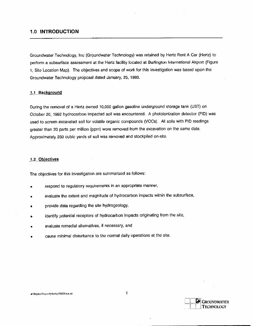
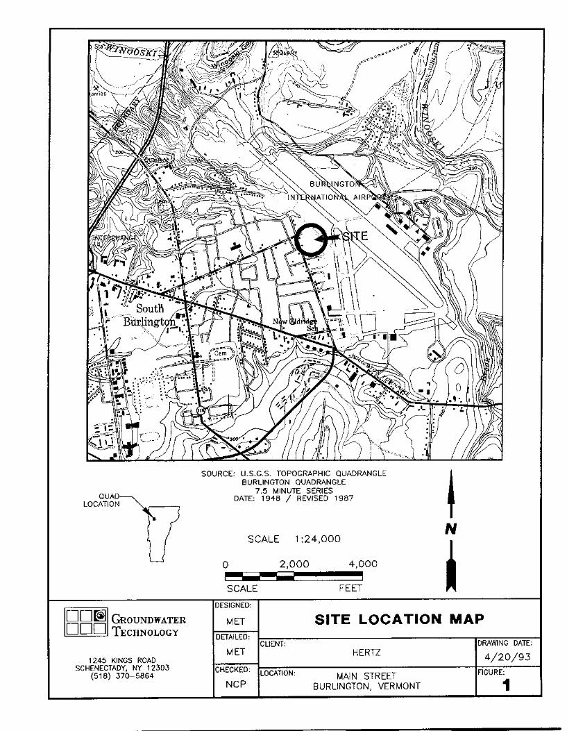
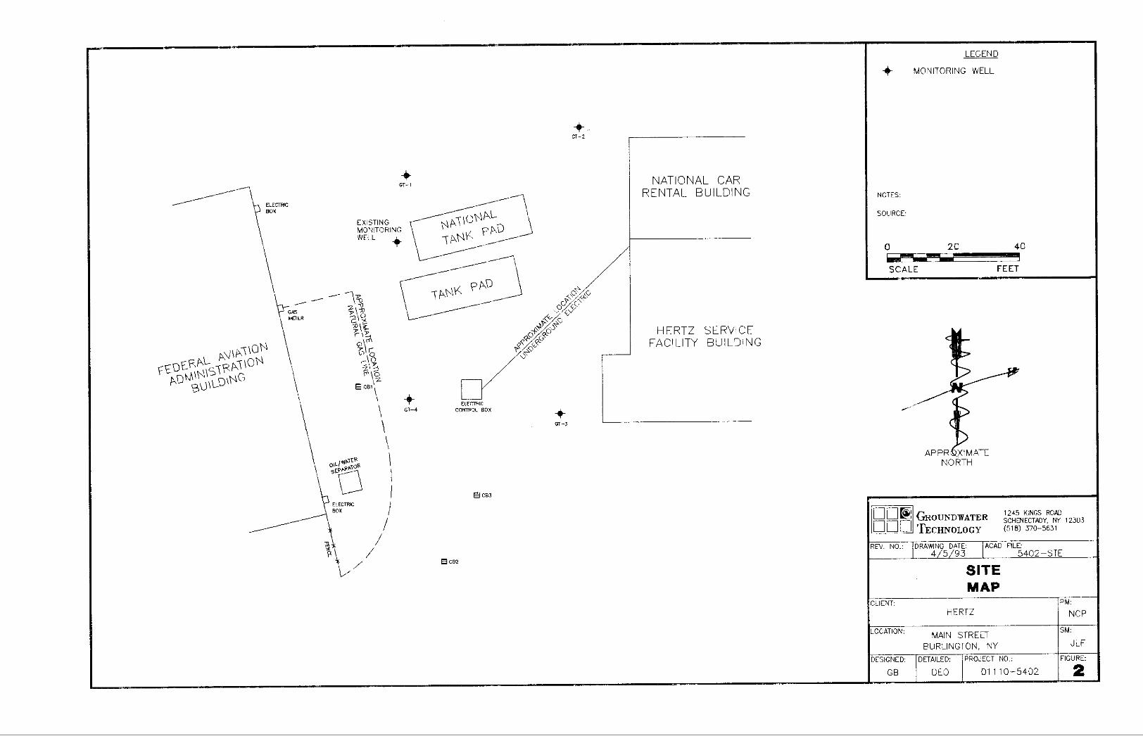
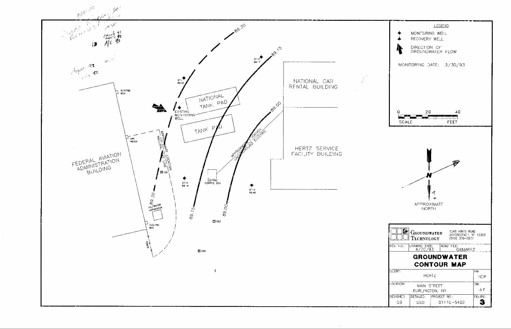
o Subsurface Investigation Report – Hertz Rent-A-Car, Burlington International Airport dated May 20, 1993 and prepared by Groundwater Technology, Inc;
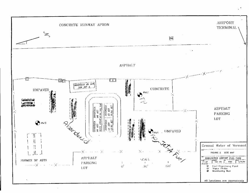
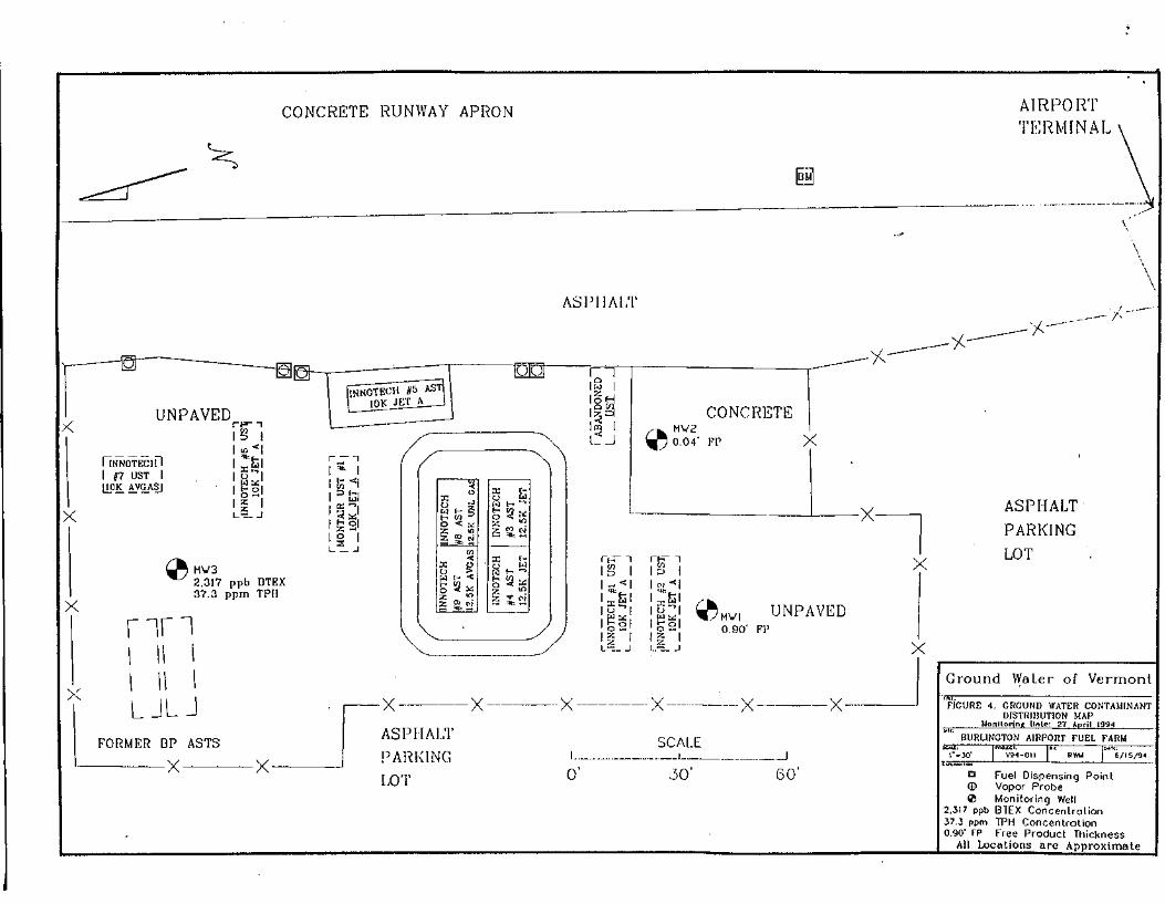
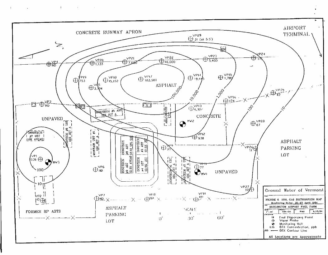
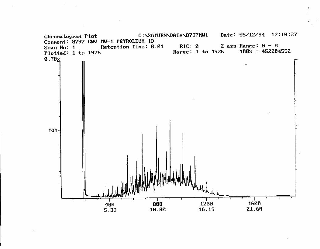
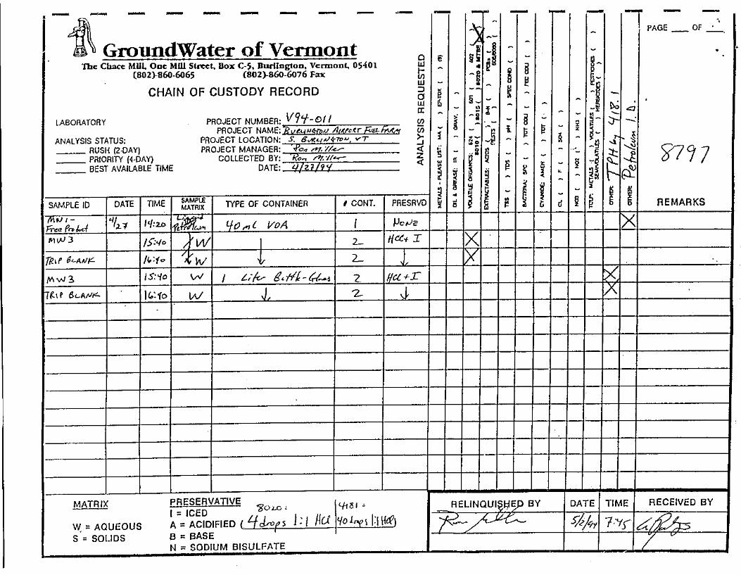
o Site Investigation Report - Burlington International Airport Innotech Fuel Farm dated September 21, 1994 and prepared by Groundwater of Vermont;
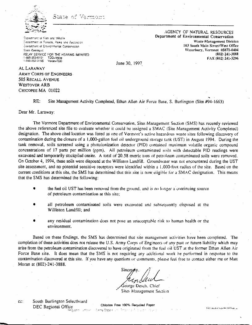
o Vermont Department of Environmental Conservation Site Management Activity Completed Letter for the Ethan Allen Air Force Base, dated June 30, 1997;
o Vermont Department of Environmental Conservation Site Management Activity Completed Letter for the North/South Hanger Burlington International Airport, dated November 23, 1999; and,
o Site Status Letter, Vermont Air National Guard Base, May 2002.
Phase I Environmental Site Assessment Report
AIP 74, South Burlington, Vermont
October 14, 2011 11 KAS Project #509110222
These five documents pertain to the reported contamination at properties located at the Burlington International Airport. It appears that two of the properties, Ethan Allen Air Force Base (VTDEC Site #94-1663) and the North/South Hanger (VTDEC Site #97-2200) have received site closure status from the VTDEC. According to the Subsurface Investigation Report dated June 4, 1993 prepared for the Hertz Car Rental property groundwater was documented to flow towards the northeast and contamination was determined to be limited to the immediate area of the site property. According to the Site Investigation Report dated September 21, 1994 prepared for the Burlington International Airport Innotech Fuel Farm property groundwater was documented to flow towards the southwest. Contamination was determined to be extensive and the full extent of the plume was not defined. According to the Site Status letter for the Vermont Air National Guard Base dated May 2002 contamination is present on this property from multiple sources including an former landfill dump areas, former dry wells, former underground storage tanks, and former fuel pits. Both petroleum and chlorinated contamination is present on this property which reportedly extends off the base property towards Poor Farm Road and Country Club Estates property. A copy of these reports/documents are included in Appendix J.
5.3. Physical Setting Sources
5.3.1 USGS Topographic Maps
The most recent USGS topographic quadrangle map was reviewed during this assessment. No buildings are identified on the map due to the housing density of the area4.
5.3.2 State Geological Maps
Bedrock in the vicinity of the property consists of Ordovician-aged Cutting Dolomite and/or Bascom formation.5 Both bedrock units are carbonate rocks with varying amounts of sandstone. The overburden deposits in the area of the property are mapped as pebbly marine sand.6
5.3.3 Other Physical Setting Sources
KAS reviewed the current City of South Burlington Comprehensive Land Use Plan for information about the subject properties. According to this plan, land use of all the subject properties is currently residential. Future land uses are also indicated as residential.7 4 USGS, 1987 5 Doll et. al. 1961. 6 Doll et. al. 1970.

Phase I Environmental Site Assessment Report
AIP 74, South Burlington, Vermont
October 14, 2011 12 KAS Project #509110222
5.4. Historical Use Information on the Property and Adjoining Properties 5.4.1 Standard Historical Sources Aerial Photographs KAS reviewed aerial photographs dated May 1962,8 April 19999 and April 2004.10 The aerial photograph dated May 1962 depicts the subject properties and the surrounding properties in a similar configuration to that observed in September 2011 with the following exceptions; the Picard Circle properties and 7 Shamrock Road property are not shown on the 1962 map. An April 1999 and April 2004 aerial photo of the subject property was reviewed on line at the KAS office. The photo shows the subject properties and the surrounding properties consistent with how they were observed in September 2011. Copies of the aerial photographs are included in Appendix E. Fire Insurance Maps KAS has determined that there is no available Sanborn Fire Insurance Map coverage for the subject properties.11 Historic USGS Topographic Maps Two historic USGS topographic quadrangle maps were reviewed during this assessment. These included the 1906 and the 1948 USGS topographic quadrangle maps for Burlington, Vermont.12 Based on review of these maps, in 1906 the area was largely undeveloped except for scattered buildings along the main roads. The Burlington Airport was not present in 1906. By 1948, the southeastern part of the airport had been developed and there were more structures along the roads. The northern part of the airport had not yet been developed. The resolution of these maps is not sufficient to determine the identity of individual homes included in this assessment.
6.0 SITE RECONAISSANCE
6.1. Methodology and Limiting Conditions On September 21, 2011, Jeremy Roberts of KAS conducted a site reconnaissance to inspect the individual properties for indications of environmental risks or hazardous conditions. A completed site inspection checklist is included in Appendix H. KAS was accompanied by Mr.
7 South Burlington Comprehensive Plan, Maps 1 and 6. 8 VT 62-L Vermont Law Library 9 MSR Aerial Photo 10 Google Earth Image. 11 FirstSearch No Coverage Letter. 12 University of New Hampshire Collections.

Phase I Environmental Site Assessment Report
AIP 74, South Burlington, Vermont
October 14, 2011 13 KAS Project #509110222
Kurt Miller, employee and designated representative of the Burlington International Airport, during the site reconnaissance. Photographs of the property are included in Appendix D.
6.2. General Site Setting
6.2.1 Current Uses All properties were single family residential housing except for 200-202 Airport Parkway which was a multi family housing/duplex unit. All properties were not being used except for 200-202 Airport Parkway and 6, 4, 8, 10, and 12 Picard Parkway which were being used seasonally as Halloween scare houses.
6.2.2 Past Uses
Past uses appear to be as a single or multi family residential housing.
6.2.3 Current and Past Uses of the Adjoining Properties
Current uses of adjacent properties are included in section 3.5. Past uses appear to be similar to current uses.
6.2.4 Current and Past Uses in the Surrounding Area
Surrounding area is predominately residential with the airport near by. Past uses appear to be similar to current uses.
6.2.5 Geologic, Hydrogeologic and Topographic Conditions All properties are generally flat. No bedrock was observed.
6.2.6 General Description of Structures
The on-site residential structures consisted of a wood framed building with a full basement and concrete foundation. The buildings contained 2 to 4 bedrooms. All properties contained a garage which was either attached or detached from the residential building except at 7 Shamrock Road. No other structures were noted on the subject properties except at 12 Picard Circle which housed two approximate 6’x6’ sheds; 400 White Street which housed one approximate 10’x12’ wooden shed; 76 Dumont Avenue which housed one approximate 6’x10’ wooden shed; and, 61 Dumont Avenue which housed one approximate 6’x6’ aluminum shed.

Phase I Environmental Site Assessment Report
AIP 74, South Burlington, Vermont
October 14, 2011 14 KAS Project #509110222
6.2.7 Roads
Airport Parkway is located immediately west of 200-202 Airport Parkway, and 4, 6, 8, 10, and 12 Picard Circle. White Street is located south of the 400 White Street property. Dumont Avenue is located north of 61 Dumont Street and south of 76 Dumont Avenue. Shamrock Road is located east of the 7 Shamrock Road property.
6.2.8 Potable Water Supply
Potable water supply is most likely municipal based on the proximity of fire hydrants near the subject properties. A water meter was noted to be present inside the basement at each property.
6.2.9 Sewage Disposal System
Sewage disposal system is most likely municipal based on the presence of sewer manholes in the vicinity of the subject properties.
6.3. Exterior Observations
6.3.1 Current Usage
The exterior of the subject properties is primarily used as a driveway and parking area. A lawn area is located behind the on site buildings.
6.3.2 Hazardous Substances and Petroleum Products
No evidence of hazardous substance and/or petroleum products were noted on the subject properties except at 400 White Street where three empty drums were observed (see Section 6.3.6). Above ground storage tank (AST) fill pipes were noted at 200-202 Airport Parkway, 400 White Street, and 61 Dumont Street (see Section 6.4.3) and a possible underground storage tank (UST) fill pipe was noted at 76 Dumont Street.
6.3.3 Storage Tanks
No evidence of storage tanks were noted on the exterior of the subject properties. A hollow steel pipe was observed protruding out of the ground near the garage on the 76 Dumont Street property. The purpose of the pipe was not clear from the site reconnaissance.
6.3.4 Odors
No unusual odors were noted on the subject properties.

Phase I Environmental Site Assessment Report
AIP 74, South Burlington, Vermont
October 14, 2011 15 KAS Project #509110222
6.3.5 Pools of Liquid
No pools of liquid were noted on the subject properties.
6.3.6 Drums
No drums were noted on the subject properties except at 400 White Street which contained three empty drums located next to the red garage on the northern end of the property. The drums were unlabeled and were heavily corroded. They were tipped over on their side. No staining was noted around the drums.
6.3.7 PCBs
No evidence of PCB containing materials or products was noted on the subject properties except at 7 Shamrock Road where an electric transformer was noted to be present on a utility pole located on the eastern end of the property near Shamrock Road. The transformer was noted to be in good condition and no adverse environmental conditions were noted. Some of the buildings were noted to be built pre 1970 therefore it is possible the paint and/or caulk within these buildings could contain PCBs.
6.3.8 Pits, Ponds and Lagoons
No pits, ponds, or lagoons were noted on the subject properties.
6.3.9 Stained Soil or Pavement
No stained soil or pavement was noted on the subject properties.
6.3.10 Stressed Vegetation
No evidence of stressed vegetation was noted on the subject properties.
6.3.11 Solid Waste
No evidence of solid waste was noted on the properties.
6.3.12 Drains and Waste Water
No evidence of waste water was noted on the subject property.
6.3.13 Wells
No wells were noted on the subject property.

Phase I Environmental Site Assessment Report
AIP 74, South Burlington, Vermont
October 14, 2011 16 KAS Project #509110222
6.3.14 Septic Systems No evidence of septic systems were noted on the subject property.
6.4. Interior Observations
6.4.1 Current Usage
The interior spaces of the on site buildings were not being used except at 200-202 Airport Parkway and 6, 4, 8, 10, and 12 Picard Circle which were being used seasonally as Halloween scare houses.
6.4.2 Hazardous Substances and Petroleum Products
No hazardous substances or petroleum products were noted on the interior of the properties except at 12 Picard Circle where deminimus quantities of spray paint were observed and at 8 and 10 Picard Circle where deminimus quantities of Kodak plate developer were noted. An inactive fuel oil above ground storage tank (AST) was noted in the basement space at 200-202 Airport Parkway and 400 White Street during the site reconnaissance.
6.4.3 Storage Tanks
No above ground storage tanks were noted in the on site buildings during the site reconnaissance except at 200-202 Airport Parkway and 400 White Street. The ASTs appeared to be in good condition. No spillage or staining was noted near the ASTs except at 400 White Street where an area of staining was noted under the tank and a pool of liquid was observed. The liquid appeared to be water; however, this was not verified during the site reconnaissance. Evidence of a former AST was noted at the 61 Dumont property where a fill pipe was observed protruding from the building structure and pipes were noted in the basement.
6.4.4 Odors
No odors were noted during the site reconnaissance except at 7 Shamrock Road, 400 White Street, 61 Dumont Avenue, and 76 Dumont Avenue where a strong to moderate mold/mildew odor was noted inside the residential space.
6.4.5 Pools of Liquid
No pools of liquid were noted during the site reconnaissance except at 7 Shamrock Road where approximately 6” of standing water was noted across the basement floor and at 400 White Street where a small pool of liquid was noted under the above ground storage

Phase I Environmental Site Assessment Report
AIP 74, South Burlington, Vermont
October 14, 2011 17 KAS Project #509110222
tank. The liquid appeared to be water; however, this was not verified during the site reconnaissance.
6.4.6 Drums
No drums were noted during the site reconnaissance except at 8 Picard Circle where two 55-gallon drums were noted in the living room area. One drum was black and made of steel and the other was blue and made of plastic. Both drums were in good condition and appeared to be empty. No labeling was noted on the drums. No adverse environmental conditions were noted in association with drums.
6.4.7 PCBs
No PCBs were noted during the site reconnaissance. Some of the buildings were noted to be built pre 1970 therefore it is possible the paint and/or caulk within these buildings could contain PCBs.
6.4.8 Heating and Cooling
Evidence suggesting the on-site buildings were heated via natural gas was noted at all of the properties except at 200-202 Airport Parkway where it appeared the building was heated by fuel oil. Two ASTs were observed at this location. Also, historical evidence of the buildings being heated by fuel oil was found at 61 Dumont Street, 400 White Street, and possibly 76 Dumont Street.
6.4.9 Stains and Corrosion
No stains or corrosion was noted during the site reconnaissance except at 400 White Street where staining was noted under the above ground storage tank in the basement space and at 61 Dumont Avenue where some minor staining was noted no the concrete floor inside the garage.
6.4.10 Drains and Sumps No drains or sumps were noted during the site reconnaissance except at 76 Dumont Avenue where a floor drain and sump was noted in the basement space and where a floor drain was noted inside the detached garage and 7 Shamrock Road which contained a sump inside the basement space.

Phase I Environmental Site Assessment Report
AIP 74, South Burlington, Vermont
October 14, 2011 18 KAS Project #509110222
7.0 INTERVIEWS
7.1. Interview with Property Owner The current property owner is the City of Burlington (see Section 7.5). KAS attempted to contact the past owners of the site properties to complete an interview questionnaire. Failed attempts were made for the subject properties except for 12 Picard Circle and 7 Shamrock Road. Mr. James Kirk, previous owner of 12 Picard Circle, and Mr. Jack Russell, previous owner of 7 Shamrock Road, completed an interview questionnaire on October 5, 2011. A copy of the interview questionnaire is provided in Appendix G. Important points brought up during the interview included the following. • The subject properties have always been used as a residential property to their knowledge. • Mr. Kirk lived at the property since its construction in 1989. • The on site buildings were always heated by natural gas. • No hazardous substances were stored on the properties to their knowledge.
7.2. Interview with Site Manager See Section 7.5
7.3. Interview with Occupants None; all units were unoccupied.
7.4. Interview with Local Government Officials KAS interviewed Chief Douglas Brent and Captain Gary Rounds of the City of South Burlington Fire Department in person at the South Burlington Fire Department on September 26, 2011. Chief Brent and Captain Rounds have been with the department for more than 40 years. Neither Chief Brent nor Captain Rounds recall having responded to a hazardous materials incident at any of the properties in this AIP group or the surrounding properties during their tenure at the department.
7.5. Interview with Others The user of this document (client) completed an interview form on October 14, 2011. The interview form was completed by Ms. Heather Kendrew, Director of Maintenance, Engineering, and Environmental. A copy of the interview questionnaire is provided in Appendix G. Important information noted in the interview included the following.

Phase I Environmental Site Assessment Report
AIP 74, South Burlington, Vermont
October 14, 2011 19 KAS Project #509110222
No environmental cleanups liens or activity and use limitations are known to exist for the properties.
No environmental cleanups are known to have occurred at the properties.
Mr. Mike Franco, previous owner of 120 Airport Parkway, completed an interview questionnaire on October 11, 2011. This property lies adjacent to the Picard Circle properties. Mr. Franco stated that he previously heard there used to be a dump in the location of the cul-de-sac near the Picard Circle properties and that it was used for cars. The cars were reportedly dug up and removed prior to the construction of the development.
8.0 FINDINGS One REC was identified during this Phase I ESA as defined by ASTM and as outlined in Sections 9.0 and 10.0: the presence of three corroded and damaged drums immediately outside a garage that appeared to be used for automobile repair at the 400 White Street property.
9.0 OPINION The properties have been adequately assessed and it has been determined that the historic and current uses have been for residential housing. One REC was identified during this assessment: the presence of three corroded and damaged drums immediately outside a garage that appeared to be used for automobile repair at the 400 White Street property. Although the drums were empty and no staining was noted around the drums visual observations of the garage near the drums suggested automobiles were repaired inside the garage. A mark was observed on the concrete floor inside the garage. The markings were representative of an above ground lift. Additionally, the garage was constructed with a high ceiling immediately above the marks on the concrete. The presence of the empty and damaged drums outside this area suggests that there was a potential release of hazardous materials at one time. The drums were unlabeled and thus the previous contents of the drums could not be determined. Evidence of three of the properties previously using fuel oil to heat the structures was noted during the site reconnaissance. These three properties are 400 White Street, 61 Dumont Street, and 200-202 Airport Parkway. Additionally, the potential presence of an underground storage tank was noted at the 76 Dumont Street property. The remaining properties did not supply visual evidence suggesting oil was stored on these properties. Typical of Chittenden County urban areas, natural gas was installed in the 1960’s and many of the tanks and oil burners were removed or left in place. There was no evidence of fuel oil contamination encountered during the reconnaissance except at the 400 White Street property where some staining was noted under
Phase I Environmental Site Assessment Report
AIP 74, South Burlington, Vermont
October 14, 2011 20 KAS Project #509110222
the AST in the basement. There were no indications of foundation wall penetrations by oil lines which could be indicative of USTs outside the buildings. Some staining was noted on the concrete floor within the garage located at 61 Dumont Avenue. No floor drain was noted to be present in the garage and the staining appeared to be from a spill of oil or lubricant for an automobile. The staining noted under the above ground storage tank inside the basement of the 400 White Street property and on the concrete floor within the garage at 61 Dumont Avenue is considered a de minimis condition as defined by ASTM and as outlined in Sections 9.0 and 10.0. There are no nearby properties on record of environmental concern that present tangible environmental risk. The nearest properties are either located some distance away or in locations that do not appear to jeopardize the environmental status of these properties based on documented groundwater flow directions and/or contamination levels. 9.1 Additional Investigation An additional investigation is deemed necessary to ascertain the presence or absence of a REC at the 76 Dumont Avenue property and the 4, 6, 8, 10, and 12 Picard Circle properties. The steel pipe protruding from the ground near the garage at the 76 Dumont Avenue property needs additional investigation to determine if this pipe is associated with an underground storage tank. An interview with the former owner of an adjacent property of land to the Picard Circle properties indicated a dump used to be present near the properties. Additional investigation is needed to ascertain whether or not this is a REC. No other investigations are deemed necessary to ascertain the presence or absence of RECs. Per ASTM E-1527-05, this opinion regarding additional investigations is only intended to convey those additional investigations that may be necessary to ascertain the presence or absence of a REC. It does not convey any recommendation relative to the need to evaluate identified RECs at the property.
10.0 CONCLUSIONS We have performed a Phase I Environmental Site Assessment in conformance with the scope and limitations of ASTM Practice E 1527 of land and premises at ten residential properties located in the City of South Burlington, Vermont (collectively referred to as AIP # 74). Any exceptions to, or deletions from, this practice are described in Section 11.0 of this report. This assessment has revealed evidence of one recognized environmental condition in connection with the 400 White Street property: the presence of three corroded and damaged drums immediately outside a garage that appeared to be used for automobile repair at the 400 White Street property.

Phase I Environmental Site Assessment Report
AIP 74, South Burlington, Vermont
October 14, 2011 21 KAS Project #509110222
The staining noted under the above ground storage tank inside the basement of the 400 White Street property and on the concrete floor within the garage at 61 Dumont Avenue is considered a de minimis condition as defined by ASTM and as outlined in Sections 9.0 and 10.0. A recognized environmental condition is defined in ASTM E 1527 as “the presence or likely presence of any hazardous substances or petroleum products on a property under conditions that indicate an existing release, a past release, or a material threat of a release of any hazardous substances or petroleum products into structures on the property or into the ground, groundwater or surface water of the property. The term includes hazardous substances or petroleum products even under conditions in compliance with laws. The term is not intended to include de minimis conditions that generally do not present a threat to human health or the environment and that generally would not be the subject of an enforcement action if brought to the attention of appropriate governmental agencies. Conditions determined to be de minimis are not recognized environmental conditions.”
11.0 DEVIATIONS
11.1. Deviations/Data Gaps Noted deviations to the ASTM Standard Practice for Environmental Site Assessments: Phase I Environmental Site Assessment Process (ASTM E 1527-2005) included: inability to contact past owner of all the properties within AIP # 74 except 12 Picard Circle and 7 Shamrock Road. A relatively complete historical record was presented for the property from 1906 to present. There are several intervals where documentation gaps exceed the 5-year period specified in ASTM E 1527-05 at §8.3.2.1; however, in light of the continuous property usage (residential), it is KAS’ opinion that the data gaps are not of significance.
11.2. Significant Assumptions KAS undertook performance of this Phase I ESA according to the following assumptions: None.
11.3. Limitations and Exclusions KAS has prepared this Phase I ESA report in accord with ASTM E-1527-05 using the best efforts of Environmental Professionals and information available at the time of preparation. This report is intended to convey a point-in-time environmental evaluation of the property, as well as relevant information on past uses. The user of this document must recognize the limitations inherent in conducting a Phase I ESA, as stated in ASTM E-1527-05, which include but are not necessarily limited to:

Phase I Environmental Site Assessment Report
AIP 74, South Burlington, Vermont
October 14, 2011 22 KAS Project #509110222
This document does not address regulatory compliance issues and KAS makes no assurances relative to the federal, state or local regulatory compliance of the property (ref. Section 1.4).
All appropriate inquiry as defined by ASTM E-1527-05 is not an exhaustive assessment of a clean property (ref. Section 4.5.2).
A variable level of inquiry may be conducted depending on the specific characteristics and features of the property and the information developed during the course of the assessment (ref. Section 4.5.3).
An assessment meeting or exceeding the requirements of ASTM E-1527-05 and completed less than 180 days prior to the date of acquisition or intended transaction is presumed to be valid (ref. Section 4.6).
All appropriate inquiry as defined by ASTM E-1527-05 is not exhaustive and does not require assessment of historic uses more frequently than every five years (ref. Section 8.3.2.1).
11.4. Special Contractual Conditions None.
11.5. User Reliance This report is for the use and benefit of client as defined herein. Affiliates of client, and third parties authorized in writing by KAS and client, may rely upon this report to the extent that client is entitled to do so, provided said parties agree to abide by the limitations and exclusions as stated herein.
12.0 ADDITIONAL SERVICES At Client request, KAS conducted a preliminary visual assessment of the potential for asbestos-containing building materials (ACBM) and lead-based paint (LBP) in each of the assessed homes. This work did not include inspections as defined by relevant ACBM/LBP regulations, and no sampling was conducted. The purpose of performing this work was to provide a preliminary indication of the need to conduct ACBM/LBP inspections in the future. This work was performed pursuant to §13.1.5 “List of Additional Issues” contained in ASTM E 11527-05. Based on the preliminary visual assessment, the residential structures on the properties have the potential to contain asbestos-containing building materials (ACBM). In accordance with National Emissions Standard for Hazardous Air Pollutants (NESHAPS) – Asbestos and 18 VSA Chapter 26, a Pre-Demolition Asbestos Inspection must be performed and NESHAPS notification submitted 10 business days prior to commencement of demolition for all properties. Based on the ages of the buildings (pre-1978), LBP may be present in all buildings except 4, 6, 8, 10, and 12 Picard Circle. KAS recommends that paints present in the AIP 74 buildings except

Phase I Environmental Site Assessment Report
AIP 74, South Burlington, Vermont
October 14, 2011 23 KAS Project #509110222
4, 6, 8, 10, and 12 Picard Circle be assumed to be lead based and that appropriate pre-disposal characterization testing be performed. The demolition contractor should be required to comply with applicable local, state and federal safety and disposal requirements.
13.0 REFERENCES 1. United States Geological Survey (USGS), Topographic Map of South Burlington, Vermont,
1987, viewed on line at www.msrmaps.com 2. City of South Burlington Land Records viewed in person at the South Burlington City
Clerk’s office, 575 Dorset Street, South Burlington, Vermont. 3. Environmental FirstSearch Technology Corporation, Norwood, MA, FirstSearch Database
Report for South Burlington, Vermont, acquired by KAS on September 20, 2011. 4. Subsurface Investigation Report – Hertz Rent-A-Car, Burlington International Airport, May
20, 1993, prepared by Groundwater Technology, Inc viewed on line at the Vermont DEC Waste Management Interactive Database http://www.anr.state.vt.us/WMID/HazSites.aspx.
5. Site Investigation Report - Burlington International Airport Innotech Fuel Farm, September 21, 1994, prepared by Groundwater of Vermont viewed on line at the Vermont DEC Waste Management Interactive Database http://www.anr.state.vt.us/WMID/HazSites.aspx.
6. Vermont Department of Environmental Conservation Site Management Activity Completed Letter for the Ethan Allen Air Force Base, June 30, 1997 viewed on line at the Vermont DEC Waste Management Interactive Database http://www.anr.state.vt.us/WMID/HazSites.aspx.
7. Vermont Department of Environmental Conservation Site Management Activity Completed Letter for the North/South Hanger Burlington International Airport, November 23, 1999 viewed on line at the Vermont DEC Waste Management Interactive Database http://www.anr.state.vt.us/WMID/HazSites.aspx.
8. Site Status Letter, Vermont Air National Guard Base, May 2002 viewed on line at the Vermont DEC Waste Management Interactive Database
9. Doll, Charles G., ed., 1961, Centennial Geologic Map of Vermont, State of Vermont, on file at KAS’ offices, Williston, Vermont.
10. Doll, Charles G., ed., 1970, Surficial Geologic Map of Vermont, State of Vermont, on file at KAS’ offices, Williston, Vermont.
11. City of South Burlington Comprehensive Land-Use Plan, March 2011, viewed on line at http://www.southburlingtonvt.govoffice2.com/
12. Vermont Law Library, State St. Montpelier, Vermont, 1962 low altitude aerial photograph collection.
13. USGS, Aerial Photograph of South Burlington, Vermont, April 1999, viewed on line at www.msrmaps.com
14. Google Earth Image, South Burlington, Vermont April 2004. 15. Historic USGS Topographic Maps of South Burlington, Vermont acquired from the
University of New Hampshire on line at http://docs.unh.edu 16. KAS, Inc. telephone interview with Mr. James Kirk and Mr. Jack Russell on October 5,
2011.

Phase I Environmental Site Assessment Report
AIP 74, South Burlington, Vermont
October 14, 2011 24 KAS Project #509110222
17. KAS, Inc. personal interview with Chief Douglas Brent and Captain Gary Rounds of the City of South Burlington Fire Department on September 26, 2011; (802) 846-4110.
18. KAS, Inc. standard user questionnaire for ASTM E 1527-05 completed by Heather Kendrew, Director of Maintenance, Engineering, and Environmental.


Phase I Environmental Site Assessment Report
AIP 74, South Burlington, Vermont
October 14, 2011 22 KAS Project #509110222
16.0 APPENDICIES A. Site Location Maps B. Site Plan C. Land Record Research D. Site Photographs E. Historical Research Documentation F. Regulatory Records Documentation G. Interview Documentation H. Site Reconnaissance Checklist I. Qualifications of Environmental Professionals J. Additional Environmental Records
Phase I Environmental Site Assessment Report
AIP 74, South Burlington, Vermont
October 14, 2011 26 KAS Project #509110222
APPENDIX A
SITE LOCATION MAPS

KAS Job Number 509110222Source: http://msrmaps.com/
Date: 09/29/11 Drawing No. 0 Scale: 1:24,000 By: JR
Burlington International AirportAIP 74, South Burlington, VT
Site Location mapJuly 1987 USGS Map
NORTH
Subject Property Area

Page 18 of 18

Phase I Environmental Site Assessment Report
AIP 74, South Burlington, Vermont
October 14, 2011 27 KAS Project #509110222
APPENDIX B
SITE PLAN


Phase I Environmental Site Assessment Report
AIP 74, South Burlington, Vermont
October 14, 2011 28 KAS Project #509110222
APPENDIX C
LAND RECORD RESEARCH

Phase I Environmental Site Assessment Report
AIP 74, South Burlington, Vermont
October 14, 2011 29 KAS Project #509110222
Table 4-1 Property Ownership Summary – (200-202 Airport Parkway) Grantor Grantee Book Page Date Demetrios, Alexandra, Paul & Maria Michaelides
City of Burlington 912 318 12/23/2009
George B. & Anna L. Thabault Demetrios, Paul & Maria Michaelides
115 525 7/24/74
Hildred E. Dumas George B. & Anna L. Thabault 111 501 9/11/73 Joseph R. & Lois J. Mailloux Hildred E. Dumas, Pauline D.
O’Brien, and Shirley K. Debarge 96 466 5/13/71
John & Bertha May Trono Joseph & Lois Mailloux 73 485 8/31/65 Archie J. Muir John & Bertha May Trono 48 43 10/3/58 Archie J. and Rachel Muir John & Bertha May Trono 50 43 10/3/58
Table 4-1 Property Ownership Summary – (4 Picard Circle) Grantor Grantee Book Page Date Michael P. & Michelle I. Henry City of Burlington 824 581 9/29/2008 Zhong Q. Wang & Xian H. Zhan Michael P. & Michelle I. Henry 648 80 11/18/2003 Banglove & Preethie Vijayraghavan
Zhong Q. Wang & Xian H. Zhan
466 534 11/29/99
A.C.M. Associates Banglove & Preethie Vijayraghavan
283 68 8/18/89
Mary E. Franco A.C.M Associates 272 31 11/2/88 Vito Franco Vito Franco & Mary E. Franco 272 25 4/29/87 Henry & Mary Dumont Vito Franco 12 358 3/14/39 Benjamin F. White Mary Dumont 12 28 4/4/27 Robert A. & Eugene T. White Benjamin F. White 11 329 4/13/26 Benjamin F. White Robert and Eugene T. White 8 427 5/14/25 Irene V. And Guy G. Iby Benjamin F. White 8 417 5/14/25 Nelson E. & Minney Kingsley I&G Iby 8 530 2/1/21 John P. McKenzie Charles Martin Sr. 3 /468 2/23/04
Table 4-1 Property Ownership Summary – (6 Picard Circle) Grantor Grantee Book Page Date Charles & Claudette Thibault City of Burlington 853 334 4/13/2009 Guy L. Rosenthal & Kyle M. Roggenbuck
Charles & Claudette Thibault 392 569 5/10/96
A.C.M. Associates Guy Rosenthal 283 93 5/16/89 Mary E. Franco A.C.M Associates 272 31 11/2/88 Vito Franco Vito Franco & Mary E. Franco 272 25 4/29/87 Henry & Mary Dumont Vito Franco 12 358 3/14/39 Benjamin F. White Mary Dumont 12 28 4/4/27 Robert A. & Eugene T. White Benjamin F. White 11 329 4/13/26 Benjamin F. White Robert and Eugene T. White 8 427 5/14/25 Irene V. And Guy G. Iby Benjamin F. White 8 417 5/14/25 Nelson E. & Minney Kingsley I&G Iby 8 530 2/1/21 John P. McKenzie Charles Martin Sr. 3 /468 2/23/04
Phase I Environmental Site Assessment Report
AIP 74, South Burlington, Vermont
October 14, 2011 30 KAS Project #509110222
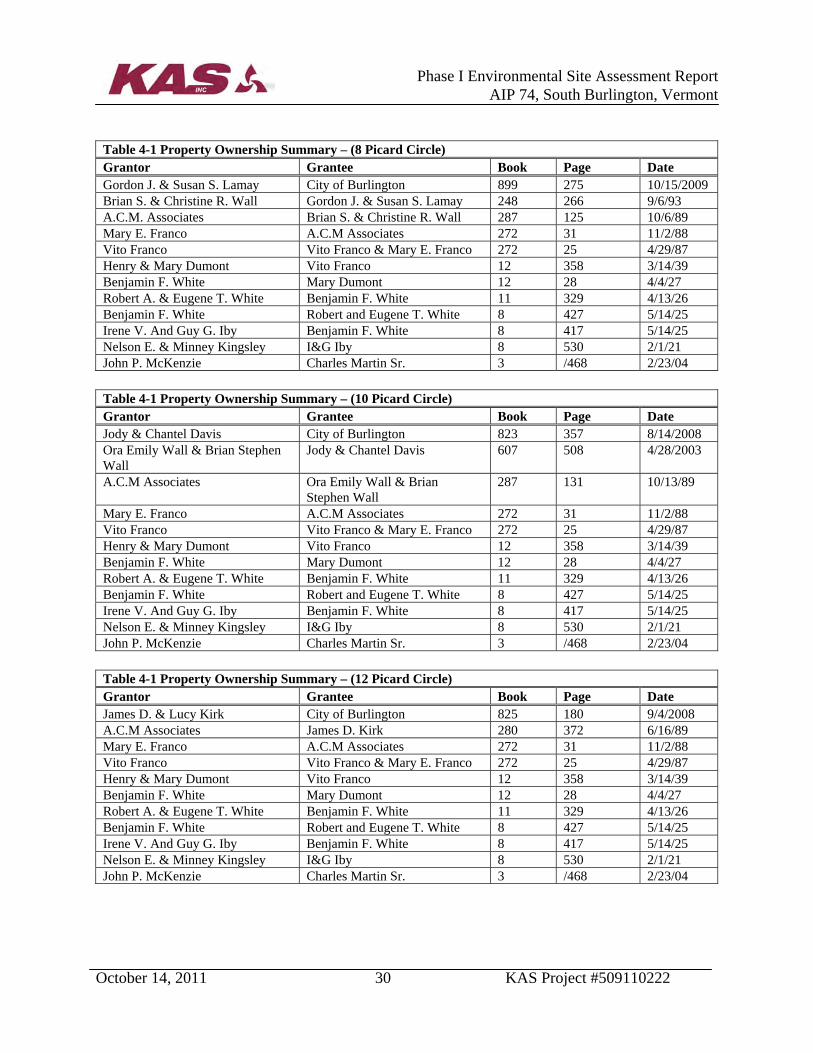
Table 4-1 Property Ownership Summary – (8 Picard Circle) Grantor Grantee Book Page Date Gordon J. & Susan S. Lamay City of Burlington 899 275 10/15/2009 Brian S. & Christine R. Wall Gordon J. & Susan S. Lamay 248 266 9/6/93 A.C.M. Associates Brian S. & Christine R. Wall 287 125 10/6/89 Mary E. Franco A.C.M Associates 272 31 11/2/88 Vito Franco Vito Franco & Mary E. Franco 272 25 4/29/87 Henry & Mary Dumont Vito Franco 12 358 3/14/39 Benjamin F. White Mary Dumont 12 28 4/4/27 Robert A. & Eugene T. White Benjamin F. White 11 329 4/13/26 Benjamin F. White Robert and Eugene T. White 8 427 5/14/25 Irene V. And Guy G. Iby Benjamin F. White 8 417 5/14/25 Nelson E. & Minney Kingsley I&G Iby 8 530 2/1/21 John P. McKenzie Charles Martin Sr. 3 /468 2/23/04
Table 4-1 Property Ownership Summary – (10 Picard Circle) Grantor Grantee Book Page Date Jody & Chantel Davis City of Burlington 823 357 8/14/2008 Ora Emily Wall & Brian Stephen Wall
Jody & Chantel Davis 607 508 4/28/2003
A.C.M Associates Ora Emily Wall & Brian Stephen Wall
287 131 10/13/89
Mary E. Franco A.C.M Associates 272 31 11/2/88 Vito Franco Vito Franco & Mary E. Franco 272 25 4/29/87 Henry & Mary Dumont Vito Franco 12 358 3/14/39 Benjamin F. White Mary Dumont 12 28 4/4/27 Robert A. & Eugene T. White Benjamin F. White 11 329 4/13/26 Benjamin F. White Robert and Eugene T. White 8 427 5/14/25 Irene V. And Guy G. Iby Benjamin F. White 8 417 5/14/25 Nelson E. & Minney Kingsley I&G Iby 8 530 2/1/21 John P. McKenzie Charles Martin Sr. 3 /468 2/23/04
Table 4-1 Property Ownership Summary – (12 Picard Circle) Grantor Grantee Book Page Date James D. & Lucy Kirk City of Burlington 825 180 9/4/2008 A.C.M Associates James D. Kirk 280 372 6/16/89 Mary E. Franco A.C.M Associates 272 31 11/2/88 Vito Franco Vito Franco & Mary E. Franco 272 25 4/29/87 Henry & Mary Dumont Vito Franco 12 358 3/14/39 Benjamin F. White Mary Dumont 12 28 4/4/27 Robert A. & Eugene T. White Benjamin F. White 11 329 4/13/26 Benjamin F. White Robert and Eugene T. White 8 427 5/14/25 Irene V. And Guy G. Iby Benjamin F. White 8 417 5/14/25 Nelson E. & Minney Kingsley I&G Iby 8 530 2/1/21 John P. McKenzie Charles Martin Sr. 3 /468 2/23/04
Phase I Environmental Site Assessment Report
AIP 74, South Burlington, Vermont
October 14, 2011 31 KAS Project #509110222
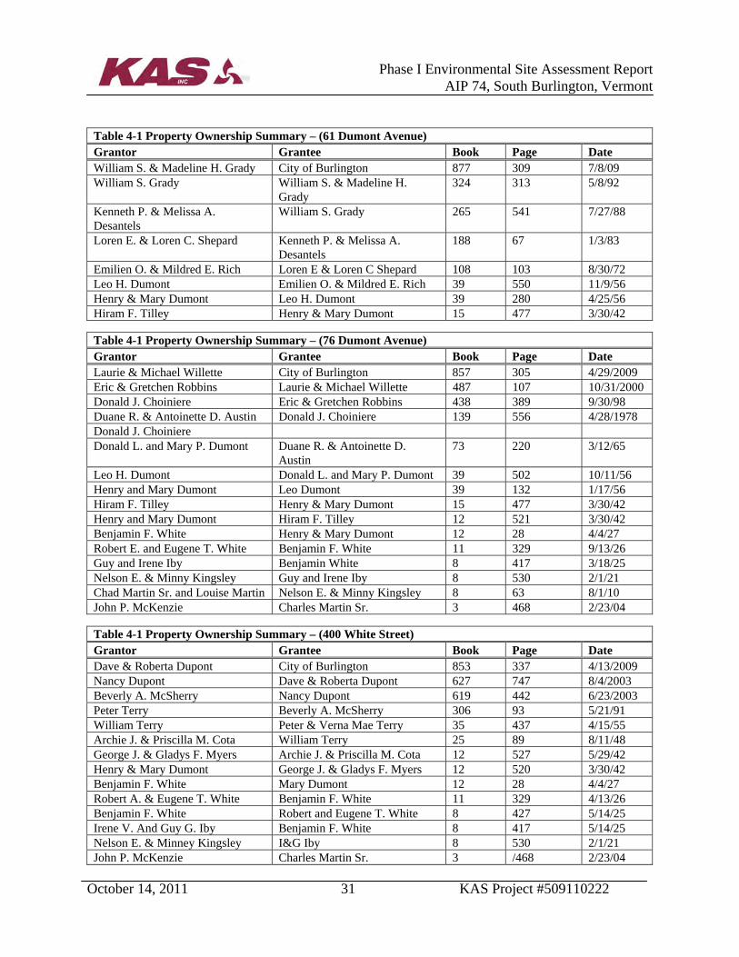
Table 4-1 Property Ownership Summary – (61 Dumont Avenue) Grantor Grantee Book Page Date William S. & Madeline H. Grady City of Burlington 877 309 7/8/09 William S. Grady William S. & Madeline H.
Grady 324 313 5/8/92
Kenneth P. & Melissa A. Desantels
William S. Grady 265 541 7/27/88
Loren E. & Loren C. Shepard Kenneth P. & Melissa A. Desantels
188 67 1/3/83
Emilien O. & Mildred E. Rich Loren E & Loren C Shepard 108 103 8/30/72 Leo H. Dumont Emilien O. & Mildred E. Rich 39 550 11/9/56 Henry & Mary Dumont Leo H. Dumont 39 280 4/25/56 Hiram F. Tilley Henry & Mary Dumont 15 477 3/30/42
Table 4-1 Property Ownership Summary – (76 Dumont Avenue) Grantor Grantee Book Page Date Laurie & Michael Willette City of Burlington 857 305 4/29/2009 Eric & Gretchen Robbins Laurie & Michael Willette 487 107 10/31/2000 Donald J. Choiniere Eric & Gretchen Robbins 438 389 9/30/98 Duane R. & Antoinette D. Austin Donald J. Choiniere 139 556 4/28/1978 Donald J. Choiniere Donald L. and Mary P. Dumont Duane R. & Antoinette D.
Austin 73 220 3/12/65
Leo H. Dumont Donald L. and Mary P. Dumont 39 502 10/11/56 Henry and Mary Dumont Leo Dumont 39 132 1/17/56 Hiram F. Tilley Henry & Mary Dumont 15 477 3/30/42 Henry and Mary Dumont Hiram F. Tilley 12 521 3/30/42 Benjamin F. White Henry & Mary Dumont 12 28 4/4/27 Robert E. and Eugene T. White Benjamin F. White 11 329 9/13/26 Guy and Irene Iby Benjamin White 8 417 3/18/25 Nelson E. & Minny Kingsley Guy and Irene Iby 8 530 2/1/21 Chad Martin Sr. and Louise Martin Nelson E. & Minny Kingsley 8 63 8/1/10 John P. McKenzie Charles Martin Sr. 3 468 2/23/04
Table 4-1 Property Ownership Summary – (400 White Street) Grantor Grantee Book Page Date Dave & Roberta Dupont City of Burlington 853 337 4/13/2009 Nancy Dupont Dave & Roberta Dupont 627 747 8/4/2003 Beverly A. McSherry Nancy Dupont 619 442 6/23/2003 Peter Terry Beverly A. McSherry 306 93 5/21/91 William Terry Peter & Verna Mae Terry 35 437 4/15/55 Archie J. & Priscilla M. Cota William Terry 25 89 8/11/48 George J. & Gladys F. Myers Archie J. & Priscilla M. Cota 12 527 5/29/42 Henry & Mary Dumont George J. & Gladys F. Myers 12 520 3/30/42 Benjamin F. White Mary Dumont 12 28 4/4/27 Robert A. & Eugene T. White Benjamin F. White 11 329 4/13/26 Benjamin F. White Robert and Eugene T. White 8 427 5/14/25 Irene V. And Guy G. Iby Benjamin F. White 8 417 5/14/25 Nelson E. & Minney Kingsley I&G Iby 8 530 2/1/21 John P. McKenzie Charles Martin Sr. 3 /468 2/23/04

Phase I Environmental Site Assessment Report
AIP 74, South Burlington, Vermont
October 14, 2011 32 KAS Project #509110222
Table 4-1 Property Ownership Summary – (7 Shamrock Road) Grantor Grantee Book Page Date Jack & John A. Russell City of Burlington 875 195 6/29/2009 Fairdale Farms, Inc. John A. Russell 289 608 1/12/90 Rene J. and June A. Berard Norman J. and Arlene I. Barrett 85 266 5/31/67 Parcel One Ethan Allen Farms, Inc. Rene J. and June A. Berard 56 357 5/1/61 Dumas J. Weston, Allen C. and Mary A. Alfred
Ethan Allen Farms, Inc. 50 118 12/31/58
Mose & Hildred Dumas Allen C. & Mary H. Alfred 20 450 6/6/47 Phineas Loomis Mose & Hildred Dumas 20 278 Matilda M .Tobey Louis Dumas 8 513 4/10/17 Parcel Two “Duprey” Farm, Allen Alfred Free Press Association, Trustee 20 332 4/28/61 Vina, Ernest, Leo, and Alice Duprey
Allen Alfred 13 190 9/26/39
Albert A. and Julia Larrow Vina, Ernest, Leo, and Alice Duprey
8 268 5/16/19

Phase I Environmental Site Assessment Report
AIP 74, South Burlington, Vermont
October 14, 2011 33 KAS Project #509110222
APPENDIX D
SITE PHOTOGRAPHS

Photograph ID: 0121-Sep-11
Location:200-202 Airport Parkway
Direction:EastComments:Front of duplex family housingstructure
Photograph ID: 0221-Sep-11
Location: 200 Airport Parkway
Direction: NorthComments:View of AST in basement space
Photographic DocumentationPhase I Environmental Site Assessment
Burlington International AirportAIP 74, South Burlington, VT
KAS Job #509110222

Photograph ID: 0321-Sep-11
Location:202 Airport Parkway
Direction:SouthComments:View of AST in basement space
Photograph ID: 0421-Sep-11
Location:200-202 Airport Parkway
Direction:SouthComments:View of the interior living space
Phase I Environmental Site AssessmentBurlington International Airport
AIP 74, South Burlington, VTKAS Job #509110222
Photographic Documentation

Photograph ID: 0521-Sep-11
Location:4 Picard Circle
Direction:NortheastComments:Front of single family housingstructure
Photograph ID: 0621-Sep-11
Location:4 Picard Circle
Direction:NortheastComments:View of the interior living space
Burlington International AirportAIP 74, South Burlington, VT
KAS Job #509110222
Photographic DocumentationPhase I Environmental Site Assessment

Photograph ID: 0721-Sep-11
Location:6 Picard Circle
Direction:NortheastComments:Front of single family housingstructure
Photograph ID: 0821-Sep-11
Location:6 Picard Circle
Direction: NortheastComments:View of the interior living space
KAS Job #509110222
Photographic DocumentationPhase I Environmental Site Assessment
Burlington International AirportAIP 74, South Burlington, VT

Photograph ID: 0921-Sep-11
Location:8 Picard Circle
Direction:EastComments:Front of single family housingstructure
Photograph ID: 01021-Sep-11
Location:8 Picard Circle
Direction: NorthComments:View of interior living space and two empty drums
Phase I Environmental Site AssessmentBurlington International Airport
AIP 74, South Burlington, VTKAS Job #509110222
Photographic Documentation

Photograph ID: 01121-Sep-11
Location:10 Picard Circle
Direction:EastComments:Front of single family housingstructure
Photograph ID: 01221-Sep-11
Location:10 Picard Circle
Direction: EastComments:View of interior living space
AIP 74, South Burlington, VTKAS Job #509110222
Photographic DocumentationPhase I Environmental Site Assessment
Burlington International Airport

Photograph ID: 01321-Sep-11
Location:12 Picard Circle
Direction:SoutheastComments:Front of single family housingstructure
Photograph ID: 01421-Sep-11
Location:12 Picard Circle
Direction: SoutheastComments:View of interior living space
Photographic DocumentationPhase I Environmental Site Assessment
AIP 74, South Burlington, VTKAS Job #509110222
Burlington International Airport

Photograph ID: 01521-Sep-11
Location:61 Dumont Street
Direction:SouthComments:Front of single family housingstructure
Photograph ID: 01621-Sep-11
Location:61 Dumont Street
Direction: SouthComments:View of former AST fill pipes in basement space
KAS Job #509110222
Photographic DocumentationPhase I Environmental Site Assessment
Burlington International AirportAIP 74, South Burlington, VT

Photograph ID: 01721-Sep-11
Location:61 Dumont Street
Direction:EastComments:View of AST fill pipe on theexterior of the house
Photograph ID: 01821-Sep-11
Location:61 Dumont Street
Direction: SouthComments:View of some staining on the concrete floor in the garage
Photographic DocumentationPhase I Environmental Site Assessment
Burlington International AirportAIP 74, South Burlington, VT
KAS Job #509110222

Photograph ID: 01921-Sep-11
Location:76 Dumont Street
Direction:NorthComments:Front of single family housingstructure
Photograph ID: 02021-Sep-11
Location:76 Dumont Street
Direction: NortheastComments:View of steel pipe protruding fromthe ground near the garage
Photographic DocumentationPhase I Environmental Site Assessment
Burlington International AirportAIP 74, South Burlington, VT
KAS Job #509110222

Photograph ID: 02121-Sep-11
Location:61 Dumont Street
Direction:EastComments:View of the floor drain inside thegarage
Photograph ID: 02221-Sep-11
Location:400 White Street
Direction: NorthComments:Front of single family housingstructure
Photographic DocumentationPhase I Environmental Site Assessment
Burlington International AirportAIP 74, South Burlington, VT
KAS Job #509110222
Photograph ID: 02321-Sep-11
Location:400 White Street
Direction:WestComments:View of the AST in the basementspace
Photograph ID: 02421-Sep-11
Location:400 White Street
Direction: SouthComments:View of the staining under the AST
Photographic DocumentationPhase I Environmental Site Assessment
Burlington International AirportAIP 74, South Burlington, VT
KAS Job #509110222

Photograph ID: 02521-Sep-11
Location:400 White Street
Direction:WestComments:View of the three drums noted onthe exterior of the property
Photograph ID: 02621-Sep-11
Location:7 Shamrock Road
Direction: WestComments:Front of single family housingstructure
Photographic DocumentationPhase I Environmental Site Assessment
Burlington International AirportAIP 74, South Burlington, VT
KAS Job #509110222

Photograph ID: 02721-Sep-11
Location:7 Shamrock Road
Direction:EastComments:View of the interior living space
AIP 74, South Burlington, VTKAS Job #509110222
Photographic DocumentationPhase I Environmental Site Assessment
Burlington International Airport

Phase I Environmental Site Assessment Report
AIP 74, South Burlington, Vermont
October 14, 2011 34 KAS Project #509110222
APPENDIX E
HISTORICAL RESEARCH DOCUMENTATION

KAS Job Number 509110222Source: University of New Hampshire on line map collection, http://docs.unh.edu
Date: 09/29/11 Drawing No. 0 Scale: 1:62,500 By: JR
Burlington International AirportAIP 74, South Burlington, VT
1906 USGS Topographic Map
NORTH
NORTH
Subject Property Area

KAS Job Number 509110222Source: University of New Hampshire on line map collection, http://docs.unh.edu
Date: 09/29/11 Drawing No. 0 Scale: 1:62,500 By: JR
Burlington International AirportAIP 74, South Burlington, VT
1948 USGS Topographic Map
NORTH
NORTH
Subject Property Area
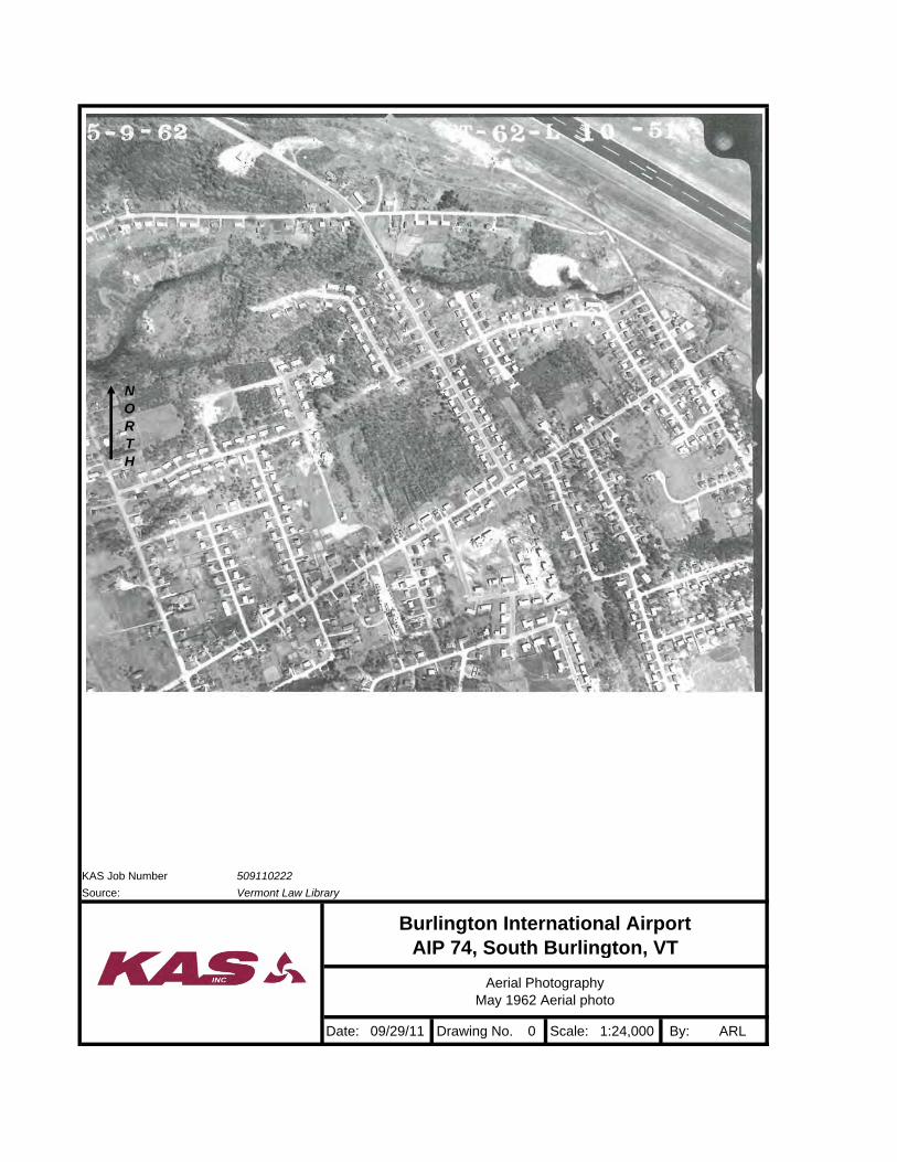
KAS Job Number 509110222Source: Vermont Law Library
Date: 09/29/11 Drawing No. 0 Scale: 1:24,000 By: ARL
Burlington International AirportAIP 74, South Burlington, VT
Aerial PhotographyMay 1962 Aerial photo
NORTH

KAS Job Number 509110222Source: Vermont Law Library
Date: 09/29/11 Drawing No. 0 Scale: 1:24,000 By: ARL
Burlington International AirportAIP 74, South Burlington, VT
Aerial PhotographyMay 1962 Aerial photo
NORTH
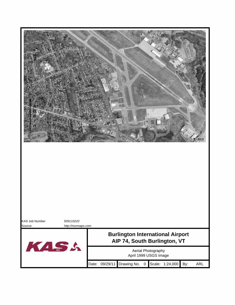
KAS Job Number 509110222Source: http://msrmaps.com
Date: 09/29/11 Drawing No. 0 Scale: 1:24,000 By: ARL
Burlington International AirportAIP 74, South Burlington, VT
Aerial PhotographyApril 1999 USGS Image
NORTH

KAS Job Number 509110222Source: http://msrmaps.com
Date: 09/29/11 Drawing No. 0 Scale: 1:24,000 By: ARL
Burlington International AirportAIP 74, South Burlington, VT
Aerial PhotographyApril 1999 USGS Image
NORTH
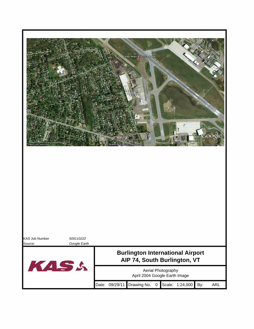
KAS Job Number 509110222Source: Google Earth
Date: 09/29/11 Drawing No. 0 Scale: 1:24,000 By: ARL
Burlington International AirportAIP 74, South Burlington, VT
Aerial PhotographyApril 2004 Google Earth Image
NORTH
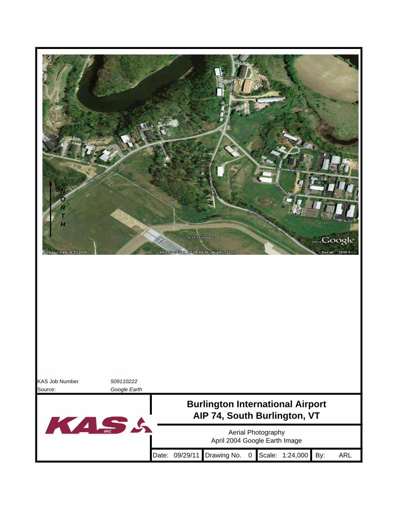
KAS Job Number 509110222Source: Google Earth
Date: 09/29/11 Drawing No. 0 Scale: 1:24,000 By: ARL
Burlington International AirportAIP 74, South Burlington, VT
Aerial PhotographyApril 2004 Google Earth Image
NORTH

9/23/2011509110222
200 AIRPORT PKWY279111
Report Date:Client Job Number:
FirstSearch Index Number:Site Address(es):
SOUTH BURLINGTON, VT 05403
HISTORICAL FIRE INSURANCE MAPS
A search of FirstSearch Technology Corporation's proprietary database of historical fire insurance map availability confirmed that there are NO MAPS AVAILABLE for the Subject Location as shown above. FirstSearch Technology Corporationôs proprietary database of historical fire insurance map availability represents abstracted information from the SanbornÈ Map Company LLC obtained through online access to the Library of Congress as well as the result of a review of the other fire insurance map microfilm collections available via various local libraries.
NO MAPS AVAILABLE
Certain SanbornÈ Fire Insurance Maps are copyrighted material and may not be reproduced without the expressed permission of the Sanborn Map Company or other authorized third party distributors. Any reproduction of this material is covered under the copyright law of the United States (Title 17 U.S. Code) for which customer assumes all liability for the making of photocopies or other reproductions of copyrighted material. FirstSearch Technology Corporation warrants that it will employ its best efforts to maintain and deliver its information in an efficient and timely manner. Customer acknowledges that it understands that FirstSearch Technology Corporation obtains the above information from sources FirstSearch Technology Corporation considers reliable. However, THE WARRANTIES EXPRESSED HEREIN ARE IN LIEU OF ALL OTHER WARRANTIES, either expressed or implied, including without limitation any implied warranty of merchantability or fitness or suitability for a particular purpose (whether or not FirstSearch Technology Corporation may know, have reason to know, or have been advised of such purpose), whether arising by law or by reason of industry custom or usage. ALL SUCH OTHER WARRANTIES ARE HEREBY EXPRESSLY DISCLAIMED.
FirstSearch Technology Corporation 10 Cottage Street, Norwood, MA 02062
Tel: 781-551-0470 Fax: 781-551-0471
Copyright Policy Disclaimer

Phase I Environmental Site Assessment Report
AIP 74, South Burlington, Vermont
October 14, 2011 35 KAS Project #509110222
APPENDIX F
REGULATORY RECORDS DOCUMENTATION

FirstSearch Technology Corporation
TM
Environmental FirstSearch Report
Target Property:
200 AIRPORT PKWY
SOUTH BURLINGTON VT 05403
Job Number: 509110222
PREPARED FOR:
KAS, Inc.
368 Avenue D, Suite 15
Williston, VT 05495
09-20-11
Tel: (781) 551-0470 Fax: (781) 551-0471
Environmental FirstSearch is a registered trademark of FirstSearch Technology Corporation. All rights reserved.

Environmental FirstSearchSearch Summary Report
Target Site: 200 AIRPORT PKWYSOUTH BURLINGTON VT 05403
FirstSearch Summary
Notice of Disclaimer
Waiver of Liability
Database Sel Updated Radius Site 1/8 1/4 1/2 1/2> ZIP TOTALS
NPL Y 08-15-11 1.00 0 0 0 0 0 0 0NPL Delisted Y 08-15-11 0.50 0 0 0 0 - 0 0CERCLIS Y 07-26-11 0.50 0 0 0 0 - 0 0NFRAP Y 07-26-11 0.50 0 0 0 0 - 0 0RCRA COR ACT Y 07-11-11 1.00 0 0 0 0 0 0 0RCRA TSD Y 07-11-11 0.50 0 0 0 0 - 0 0RCRA GEN Y 07-11-11 0.25 0 1 9 - - 0 10Federal Brownfield Y 07-05-11 0.50 0 0 0 0 - 0 0ERNS Y 07-18-11 0.12 0 0 - - - 0 0Tribal Lands Y 12-01-05 1.00 0 0 0 0 0 1 1State/Tribal Sites Y 07-08-11 1.00 0 0 3 7 25 2 37State Spills 90 Y 07-08-11 0.12 0 0 - - - 6 6State/Tribal SWL Y 04-15-09 0.50 0 0 0 0 - 6 6State/Tribal LUST Y 07-08-11 0.50 0 6 9 6 - 5 26State/Tribal UST/AST Y 07-08-11 0.25 0 3 7 - - 1 11State/Tribal EC Y NA 0.25 0 0 0 - - 0 0State/Tribal IC Y NA 0.25 0 0 0 - - 0 0State/Tribal VCP Y NA 0.50 0 0 0 0 - 0 0State/Tribal Brownfields Y 05-01-11 0.50 0 0 0 0 - 0 0Federal IC/EC Y 08-01-11 0.50 0 0 0 0 - 0 0
-TOTALS- 0 10 28 13 25 21 97
Due to the limitations, constraints, and inaccuracies and incompleteness of government information and computer mapping data currently available to FirstSearchTechnology Corp., certain conventions have been utilized in preparing the locations of all federal, state and local agency sites residing in FirstSearch TechnologyCorp.'s databases. All EPA NPL and state landfill sites are depicted by a rectangle approximating their location and size. The boundaries of the rectangles representthe eastern and western most longitudes; the northern and southern most latitudes. As such, the mapped areas may exceed the actual areas and do not represent theactual boundaries of these properties. All other sites are depicted by a point representing their approximate address location and make no attempt to represent theactual areas of the associated property. Actual boundaries and locations of individual properties can be found in the files residing at the agency responsible for suchinformation.
Although FirstSearch Technology Corp. uses its best efforts to research the actual location of each site, FirstSearch Technology Corp. does not and can not warrantthe accuracy of these sites with regard to exact location and size. All authorized users of FirstSearch Technology Corp.'s services proceeding are signifying anunderstanding of FirstSeaarch Technology Corp.'s searching and mapping conventions, and agree to waive any and all liability claims associated with search andmap results showing incomplete and or inaccurate site locations.

Environmental FirstSearchSite Information Report
Request Date: 09-20-11 Search Type: AREARequestor Name: ALAN LIPTAK 0.07 sq mile(s)Standard: ASTM-05 Job Number: 509110222
Filtered Report
Target Site: 200 AIRPORT PKWY
SOUTH BURLINGTON VT 05403
Demographics
Sites: 97 Non-Geocoded: 21 Population: NA
Radon: 0 - 6.6 PCI/L
Fire Insurance Map Coverage: No
Site Location
Degrees (Decimal) Degrees (Min/Sec) UTMs
Longitude: -73.165383 -73:9:55 Easting: 645911.753
Latitude: 44.476318 44:28:35 Northing: 4926198.906
Elevation: 326 Zone: 18
Comment
Comment:
Additional Requests/Services
Adjacent ZIP Codes: Services:
ZIPCode City Name ST Dist/Dir Sel Requested? Date
Fire Insurance Maps Yes 09-20-11
Aerial Photographs No
Historical Topos No
City Directories No
Title Search No
Municipal Reports No
Liens No
Historic Map Works No
Online Topos No
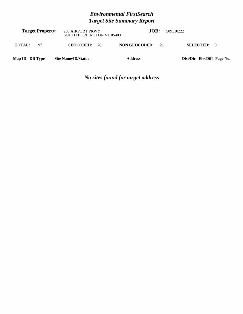
Environmental FirstSearchTarget Site Summary Report
Target Property: 200 AIRPORT PKWY JOB: 509110222SOUTH BURLINGTON VT 05403
TOTAL: 97 GEOCODED: 76 NON GEOCODED: 21 SELECTED: 0
No sites found for target address
Map ID DB Type Site Name/ID/Status Address Dist/Dir ElevDiff Page No.

Environmental FirstSearchSites Summary Report
Target Property: 200 AIRPORT PKWY JOB: 509110222SOUTH BURLINGTON VT 05403
TOTAL: 97 GEOCODED: 76 NON GEOCODED: 21 SELECTED: 0
Map ID DB Type Site Name/ID/Status Address Dist/Dir ElevDiff Page No.
1 RCRAGN F A A SSC-86EB 1250 AIRPORT DR 0.03 SE + 12 2VTR000008243/VGN SOUTH BURLINGTON VT 05403
2 UST BURLINGTON INTERNATIONAL FUEL 1160 AIRPORT DR 0.04 SE + 10 3966/INSTITUTIONAL SOUTH BURLINGTON VT 05403
2 UST MORTAIR RAMP 1160 AIRPORT DR 0.04 SE + 10 4965/INSTITUTIONAL SOUTH BURLINGTON VT 05403
2 LUST BURLINGTON INTERNATIONAL FUEL 1160 AIRPORT DR 0.04 SE + 10 5966/PULLED UST DATABASE SOUTH BURLINGTON VT 05403
2 LUST BURLINGTON INTL AIRPORT AIRPORT DR 0.04 SE + 10 69999643/PULLED UST DATABASE SOUTH BURLINGTON VT 05401
2 LUST MORTAIR RAMP 1160 AIRPORT DR 0.04 SE + 10 7965/PULLED UST DATABASE SOUTH BURLINGTON VT 05401
3 UST INNOTECH/BURLINGTON AIRPORT AIRPORT DR 0.11 SE + 4 81604/ SOUTH BURLINGTON VT 05403
3 LUST INNOTECH/BURLINGTON AIRPORT AIRPORT DR 0.11 SE + 4 91604/PULLED UST DATABASE SOUTH BURLINGTON VT 05403
4 LUST GAMACHE RESIDENCE 82 SUBURBAN SQ 0.11 SW + 24 112001088/PULLED UST DATABASE SOUTH BURLINGTON VT
5 LUST CHAMBERLIN SCHOOL 262 WHITE ST 0.12 NW + 8 12628/PULLED UST DATABASE SOUTH BURLINGTON VT 05401
6 RCRAGN HERTZ RENTAL CORP BURLINGTON INTERNATIONAL A 0.13 NE + 16 13VTR000010207/VGN SOUTH BURLINGTON VT 05403
6 STATE HERTZ RENT A CAR/NATIONAL CAR 0 BURLINGTON INTRNTNL AIRPO 0.13 NE + 16 14921313/ACTIVE SOUTH BURLINGTON VT
6 UST HERTZ BURLINGTON AIRPORT 0.13 NE + 16 151182/ACTIVE SOUTH BURLINGTON VT 05403
7 RCRAGN ATLANTIC AVIATION SERVICES BURLINGTON INTERNATIONAL A 0.15 SE + 21 16VTR000008227/SGN SOUTH BURLINGTON VT 05403
7 RCRAGN BURLINGTON INTL AIRPORT 1200 AIRPORT 1 DR 0.15 SE + 21 17VTD988380572/VGN SOUTH BURLINGTON VT 05403
7 RCRAGN F B O AVCENTER 1200 AIRPORT DR 0.15 SE + 21 18VTR000011346/SGN SOUTH BURLINGTON VT 05403
7 RCRAGN US T S A BURLINGTON INTL AIRPORT 1200 AIRPORT DR 0.15 SE + 21 19VTR000510883/VGN SOUTH BURLINGTON VT 05403
7 UST ATLANTIC AVIATION - EAST HANGER BURLINGTON INTERNATIONAL A 0.15 SE + 21 206583662/ACTIVE SOUTH BURLINGTON VT 05403
7 UST BURLINGTON INTERNATIONAL AIRPORT 1200 AIRPORT DR 0.15 SE + 21 21460/ACTIVE SOUTH BURLINGTON VT 05403
7 UST BURLINGTON INTERNATIONAL AIRPORT 0 NATIONAL WEATHER SERVICE 0.15 SE + 21 241001663/INSTITUTIONAL SOUTH BURLINGTON VT 05403

Environmental FirstSearchSites Summary Report
Target Property: 200 AIRPORT PKWY JOB: 509110222SOUTH BURLINGTON VT 05403
TOTAL: 97 GEOCODED: 76 NON GEOCODED: 21 SELECTED: 0
Map ID DB Type Site Name/ID/Status Address Dist/Dir ElevDiff Page No.
7 UST FAA ASR BURLINGTON INTERNATIONAL A 0.15 SE + 21 251663/ACTIVE SOUTH BURLINGTON VT 05403
7 UST NATIONAL ALAMOENTERPRISE CAR RENTA BURLINGTON INTERNATIONAL A 0.15 SE + 21 261453/ACTIVE SOUTH BURLINGTON VT 05403
7 LUST BROCKWAY AIRCRAFT HANGER BURLINGTON INTERNATIONAL A 0.15 SE + 21 276585071/PULLED UST DATABASE SOUTH BURLINGTON VT 05401
7 LUST BURLINGTON INTERNATIONAL AIRPORT NATIONAL WEATHER SERVICE 0.15 SE + 21 281001663/PULLED UST DATABASE SOUTH BURLINGTON VT 05403
7 LUST FAA ASR BURLINGTON INTERNATIONAL A 0.15 SE + 21 291663/PULLED UST DATABASE SOUTH BURLINGTON VT 05403
8 LUST POWER RESIDENCE 4 MILLS AVE 0.15 SE + 18 312005090/PULLED UST DATABASE SOUTH BURLINGTON VT
8 LUST POWER RESIDENCE 4 MILLS AVE 0.15 SE + 18 325551796/ SOUTH BURLINGTON VT 05403
9 LUST THRIFTY CAR RENTAL 1700 WILLISTON RD 0.19 SE + 8 33236/PULLED UST DATABASE SOUTH BURLINGTON VT 05401
10 RCRAGN INNOTECH AVIATION INC 1130 AIRPORT DR 0.20 SE + 11 34VTD065195760/VGN SOUTH BURLINGTON VT 05403
10 LUST FBO AVCENTER NEW HANGER 1130 AIRPORT DR 0.20 SE + 11 365559028/PULLED UST DATABASE SOUTH BURLINGTON VT 05403
11 STATE NORTH/SOUTH HANGER B I A 0 AIRPORT DR 0.21 SE + 13 37972200/CLOSED SOUTH BURLINGTON VT
12 RCRAGN DR JOHN L WOLFF DDS 1683 WILLISTON RD 0.22 SE + 9 38VTR000507350/VGN SOUTH BURLINGTON VT 05403
13 RCRAGN WESCO INC AIRPORT EXXON 1800 WILLISTON RD 0.23 SE - 4 39VTR000009993/VGN SOUTH BURLINGTON VT 05403
13 STATE AIRPORT EXXON 1800 WILLISTON RD 0.23 SE - 4 40972140/CLOSED SOUTH BURLINGTON VT
13 UST AIRPORT SHELL B8 1800 WILLISTON RD 0.23 SE - 4 411679/ACTIVE SOUTH BURLINGTON VT 05403
14 RCRAGN KINNEY DRUGS #55 1653 WILLISTON RD 0.24 SE 0 44VTR000514992/VGN SOUTH BURLINGTON VT 05403
15 LUST MERRIAM-GRAVES COMPANY 1550 WILLISTON RD 0.24 SW + 12 458636826/PULLED UST DATABASE SOUTH BURLINGTON VT 05401
16 LUST MAYNARD AUTO 1725 WILLISTON RD 0.25 SE + 1 469990216/PULLED UST DATABASE SOUTH BURLINGTON VT
17 STATE AIRPORT MOBIL 1801 WILLISTON RD 0.32 SE - 20 47900632/ACTIVE SOUTH BURLINGTON VT
18 STATE BUDGET RENT A CAR 700 AIRPORT PKWY 0.38 NW - 19 48931526/CLOSED SOUTH BURLINGTON VT

Environmental FirstSearchSites Summary Report
Target Property: 200 AIRPORT PKWY JOB: 509110222SOUTH BURLINGTON VT 05403
TOTAL: 97 GEOCODED: 76 NON GEOCODED: 21 SELECTED: 0
Map ID DB Type Site Name/ID/Status Address Dist/Dir ElevDiff Page No.
18 LUST BUDGET RENT A CAR 700 AIRPORT PKWY 0.38 NW - 19 49621/PULLED UST DATABASE SOUTH BURLINGTON VT 05403
19 STATE NORTHERN RENT A CAR 1890 WILLISTON RD 0.40 SE - 34 50931406/CLOSED SOUTH BURLINGTON VT
20 STATE HOWARD BANK-WILLISTON RD. 0 WILLISTON RD 0.40 SE - 29 51911055/CLOSED SOUTH BURLINGTON VT
21 STATE CRW CORP 1879 WILLISTON RD 0.42 SE - 26 5220033139/CLOSED SOUTH BURLINGTON VT
21 LUST CRW CORPORATION 1879 WILLISTON RD 0.42 SE - 26 535555758/PULLED UST DATABASE SOUTH BURLINGTON VT
22 LUST VERMONT AIR NATIONAL GUARD 105 NCO DRIVE/BURLINGTON AI 0.46 NE - 18 541995/PULLED UST DATABASE SOUTH BURLINGTON VT 05403
23 LUST KNEELAND FLIGHT FACILITY 0 BLDG 890 BURLINGTON AIRPO 0.47 SE + 15 571037/PULLED UST DATABASE SOUTH BURLINGTON VT 05402
24 STATE NORTH COUNTRY RESTAURANT SERVICES 1891 WILLISTON RD 0.47 SE - 24 5920033174/CLOSED SOUTH BURLINGTON VT
24 LUST ZACHERY S 1891 WILLISTON RD 0.47 SE - 24 605559472/PULLED UST DATABASE SOUTH BURLINGTON VT 05403
25 STATE LOGAN EQUIPMENT 1901 WILLISTON RD 0.47 SE - 27 61992611/ACTIVE SOUTH BURLINGTON VT
26 LUST LAKE CHAMPLAIN SUBARU 1907 WILLISTON RD 0.50 SE - 22 629990215/PULLED UST DATABASE SOUTH BURLINGTON VT
27 STATE U S POST OFFICE 60 WHITE ST 0.53 SW - 11 63972299/CLOSED SOUTH BURLINGTON VT
28 STATE GRACEY S STORE 0 WILLISTON RD 0.54 SW + 7 64951924/ACTIVE SOUTH BURLINGTON VT
29 STATE WILLISTON ROAD MOBIL 1314 WILLISTON RD 0.54 SW + 3 65921327/ACTIVE SOUTH BURLINGTON VT
30 STATE U-SAVE BEVERAGE 0 WILLISTON RD 0.55 SW - 6 66900496/ACTIVE SOUTH BURLINGTON VT
31 STATE BURLINGTON INTERNATIONAL AIRPORT 0 AIRPORT RD 0.58 NE + 2 67931503/ACTIVE SOUTH BURLINGTON VT
32 STATE VERMONT AIR NATIONAL GUARD 0 AIRPORT RD 0.58 NE - 19 68770043/ACTIVE SOUTH BURLINGTON VT
33 STATE KELCO FACILITY 73 ETHAN ALLEN DR 0.60 NE - 101 6920002783/CLOSED SOUTH BURLINGTON VT
34 STATE OFFSET HOUSE UNKNOWN 0.66 NW - 28 70870107/CLOSED SOUTH BURLINGTON VT
34 STATE OFFSET HOUSE PROPERTY UNKNOWN 0.66 NW - 28 71770075/CLOSED SOUTH BURLINGTON VT

Environmental FirstSearchSites Summary Report
Target Property: 200 AIRPORT PKWY JOB: 509110222SOUTH BURLINGTON VT 05403
TOTAL: 97 GEOCODED: 76 NON GEOCODED: 21 SELECTED: 0
Map ID DB Type Site Name/ID/Status Address Dist/Dir ElevDiff Page No.
35 STATE WILLISTON ROAD CITGO - DAVE S CITG 1241 WILLISTON RD 0.66 SW - 4 72900545/ACTIVE SOUTH BURLINGTON VT
36 STATE ETHAN ALLEN AIR FORCE BASE 0 AIRPORT DR 0.67 SE - 11 73941663/CLOSED SOUTH BURLINGTON VT
37 STATE SOUTH BURLINGTON STREET DEPT PATCHEN RD 0.68 NW - 46 74931383/ACTIVE SOUTH BURLINGTON VT
38 STATE BURLINGTON AIRPORT 0 AIRPORT PKWY 0.70 NE + 14 75921305/CLOSED SOUTH BURLINGTON VT
39 STATE P J S AUTOMOTIVE 2073 WILLISTON RD 0.71 SE + 3 76982447/CLOSED SOUTH BURLINGTON VT
40 STATE SOUTH BURLINGTON CENTRAL SCHOOL 1181 WILLISTON RD 0.71 SW - 7 77921301/CLOSED SOUTH BURLINGTON VT
41 STATE DOLANS VARIETY 1160 WILLISTON RD 0.74 SW - 8 78961956/ACTIVE SOUTH BURLINGTON VT
42 STATE SARVAK RESIDENCE 290 HINESBURG RD 0.77 SW - 2 7920063578/CLOSED SOUTH BURLINGTON VT
43 STATE CHAMPLAIN VALLEY SUNOCO 1143 WILLISTON RD 0.78 SW - 14 80982491/ACTIVE SOUTH BURLINGTON VT
44 STATE UNIVERSITY GULF 0 WILLISTON RD 0.80 SW - 13 81900646/ACTIVE SOUTH BURLINGTON VT
45 STATE GREERS DRY CLEANING DORSET STREET UNKNOWN 0.91 SW - 6 8220053395/ACTIVE SOUTH BURLINGTON VT
46 STATE REILLY TIRE UNKNOWN 0.91 SW + 3 83880180/CLOSED SOUTH BURLINGTON VT
47 STATE KENNEDY DRIVE MOBIL 110 KENNEDY DR 0.93 SW + 1 8420033099/CLOSED SOUTH BURLINGTON VT
48 STATE FORMER GOODRICH BUILDING 625 HINESBURG RD 0.96 SW 0 8520114149/ACTIVE SOUTH BURLINGTON VT
49 STATE UNIVERSITY INN 5 DORSET ST 0.96 SW - 14 8620002751/CLOSED SOUTH BURLINGTON VT
50 STATE ACTION EQUIPMENT UNKNOWN 1.00 SE + 20 87770161/CLOSED SOUTH BURLINGTON VT

Environmental FirstSearchSites Summary Report
Target Property: 200 AIRPORT PKWY JOB: 509110222SOUTH BURLINGTON VT 05403
TOTAL: 97 GEOCODED: 76 NON GEOCODED: 21 SELECTED: 0
Map ID DB Type Site Name/ID/Status Address Dist/Dir ElevDiff Page No.
STATE GADUE DRY CLEANER DORSET STREET UNKNOWN NON GC N/A N/A20053295/ACTIVE SOUTH BURLINGTON VT
STATE GORDIES TEXACO UNKNOWN NON GC N/A N/A870020/CLOSED SOUTH BURLINGTON VT
SPILLS AIR GUARD BURLINGTON INTNL AIRPORT NON GC N/A N/A09-WMD239/CLOSED SOUTH BURLINGTON VT
SPILLS JAMES KNEELAND FLIGHT FACILITY AIRPORT RD NON GC N/A N/A06-WMD192/CLOSED SOUTH BURLINGTON VT
SPILLS MAINTENANCE BUILDING B 1 A AIRPORT RD NON GC N/A N/A02-WMD239/CLOSED SOUTH BURLINGTON VT
SPILLS N/A AIRPORT PKWY NON GC N/A N/A95-WMD116/CLOSED SOUTH BURLINGTON VT
SPILLS VT AIR NATIONAL GUARD AIRPORT DR NON GC N/A N/A10-WMD167/CLOSED BURLINGTON VT
SPILLS VT ANG AIRPORT DR NON GC N/A N/A11-WMD316/CLOSED SOUTH BURLINGTON VT
SWL A. MARCELINO AND COMPANY, INC. UNKNOWN NON GC N/A N/ACH772/RECYCLING SOUTH BURLINGTON VT 05495
SWL CHITTENDEN SWM DISTRICT DROP-OFF C PATCHEN ROAD NON GC N/A N/ACH771/DROP OFF CENTER SOUTH BURLINGTON VT 05495
SWL CHITTENDEN SWMD TRANS STATION PATCHEN ROAD NON GC N/A N/A11/A SOUTH BURLINGTON VT 05403
SWL CHITTENDEN SWMD TRANS STATION PATCHEN ROAD NON GC N/A N/A011/A SOUTH BURLINGTON VT 05403
SWL CSWD ENVIRONMENTAL DEPOT UNKNOWN NON GC N/A N/ACH080/HHW/CESQG SOUTH BURLINGTON VT 05495
SWL ENGINEERS CONSTRUCTION DISPOSAL SI UNKNOWN NON GC N/A N/ACH980/LANDFILL SOUTH BURLINGTON VT 05486
UST KNEELAND FLIGHT FACILITY AIRPORT BIAP RD NON GC N/A N/A1037/ACTIVE SOUTH BURLINGTON VT 05402
LUST AIRPORT PARKWAY SEWER PUMP STATION HINESBURGH RD NON GC N/A N/A2736/PULLED UST DATABASE SOUTH BURLINGTON VT
LUST MUNT RESIDENCE 85 SOUTH ST NON GC N/A N/A5557561/PULLED UST DATABASE BURLINGTON VT
LUST NEW ENGLAND TELEPHONE CENTRAL OFFI FARRELL ST NON GC N/A N/A895/PULLED UST DATABASE SOUTH BURLINGTON VT 05401
LUST STRATTON CORP GOLF MAINTENANCE ORCUTT MEADOW RD NON GC N/A N/A517/PULLED UST DATABASE WINHALL VT 05403
LUST VERMONT TIRE WILLISTON RD NON GC N/A N/A5555576/PULLED UST DATABASE SOUTH BURLINGTON VT

Environmental FirstSearchSites Summary Report
Target Property: 200 AIRPORT PKWY JOB: 509110222SOUTH BURLINGTON VT 05403
TOTAL: 97 GEOCODED: 76 NON GEOCODED: 21 SELECTED: 0
Map ID DB Type Site Name/ID/Status Address Dist/Dir ElevDiff Page No.
TRIBALLA BUREAU OF INDIAN AFFAIRS CONTACT I UNKNOWN NON GC N/A N/ABIA-05403/ VT 05403
Environmental FirstSearchSite Detail Report
Target Property: 200 AIRPORT PKWY JOB: 509110222SOUTH BURLINGTON VT 05403
No sites were found!

Environmental FirstSearchSite Detail Report
Target Property: 200 AIRPORT PKWY JOB: 509110222SOUTH BURLINGTON VT 05403
RCRAGN
SEARCH ID: 4 DIST/DIR: 0.03 SE ELEVATION: 338 MAP ID: 1
NAME: F A A SSC-86EB REV: 7/11/11ADDRESS: 1250 AIRPORT DR ID1: VTR000008243
SOUTH BURLINGTON VT 05403 ID2: CHITTENDEN STATUS: VGN
CONTACT: PHONE: SOURCE: EPA
Site Details Page - 2
SITE INFORMATION
CONTACT INFORMATION: JEFF LOLLER1250 AIRPORT DRSOUTH BURLINGTON VT 05403
PHONE: 8029516523
CONTACT INFORMATION: MARTIN ROOTS1250 AIRPORT DRSOUTH BURLINGTON VT 05403
PHONE: 8029516703
UNIVERSE INFORMATION:
NAIC INFORMATION
ENFORCEMENT INFORMATION:
VIOLATION INFORMATION:
VIOLATION NUMBER: 0001RESPONSIBLE: S - STATEDETERMINED: 11/13/1997DETERMINED BY: S - STATECITATION: 7-303(3)(a)(iii) 7-304RESOLVED: 11/17/1997TYPE: HAZARDOUS WASTE DETERMINATIONS
HAZARDOUS WASTE INFORMATION:
Ignitable wasteVT08VT02Benzene

Environmental FirstSearchSite Detail Report
Target Property: 200 AIRPORT PKWY JOB: 509110222SOUTH BURLINGTON VT 05403
UST
SEARCH ID: 40 DIST/DIR: 0.04 SE ELEVATION: 336 MAP ID: 2
NAME: BURLINGTON INTERNATIONAL FUEL REV:ADDRESS: 1160 AIRPORT DR ID1: 966
SOUTH BURLINGTON VT 05403 ID2: CHITTENDEN STATUS: INSTITUTIONAL
CONTACT: PHONE: SOURCE: VTDEC
Site Details Page - 3
Tanks Installed Capacity
CURRENT: 0 REMOVED: 0 PERMANENT: 0 UNKNOWN: 0 TEMP: 0 CLOSED: 0
PRODUCTS:TANK MATERIAL:PIPE MATERIAL:

Environmental FirstSearchSite Detail Report
Target Property: 200 AIRPORT PKWY JOB: 509110222SOUTH BURLINGTON VT 05403
UST
SEARCH ID: 44 DIST/DIR: 0.04 SE ELEVATION: 336 MAP ID: 2
NAME: MORTAIR RAMP REV:ADDRESS: 1160 AIRPORT DR ID1: 965
SOUTH BURLINGTON VT 05403 ID2: CHITTENDEN STATUS: INSTITUTIONAL
CONTACT: PHONE: SOURCE: VTDEC
Site Details Page - 4
Tanks Installed Capacity
CURRENT: 0 REMOVED: 0 PERMANENT: 0UNKNOWN: 0 TEMP: 0 CLOSED: 1 ??? 56 5000 - 5000
PRODUCTS: #2&4 FUEL OILTANK MATERIAL: UNPROTECTEDPIPE MATERIAL:

Environmental FirstSearchSite Detail Report
Target Property: 200 AIRPORT PKWY JOB: 509110222SOUTH BURLINGTON VT 05403
LUST
SEARCH ID: 70 DIST/DIR: 0.04 SE ELEVATION: 336 MAP ID: 2
NAME: BURLINGTON INTERNATIONAL FUEL REV: 7/8/11ADDRESS: 1160 AIRPORT DR ID1: 966
SOUTH BURLINGTON VT 05403 ID2: 941663CHITTENDEN STATUS: PULLED UST DATABASE
CONTACT: MONTAIR FLIGHT SERVICE INC PHONE: SOURCE: VT DEC
Site Details Page - 5
This site comes from the Vermont Department of Environmental Conservation Pulled Underground Storage Tanks database and may or may not be considered aleaking underground storage tank , please review the data below for further indications of contamination.
SITE FINDINGS: CONTAMINATION FOUND ABOVE STATE STANDARD. REFERRED TO SITE MANAGEMENT
FACILITY AND OWNER INFORMATION
TYPE OF FACILITY: INDUSTRIAL/COMMERCIAL
OWNER NAME: MONTAIR FLIGHT SERVICE INCCONTACT:OWNER ADDRESS: 1160 AIRPORT DRIVESOUTH BURLINGTON, VT
LAND OWNER:** UNKNOWN ***PERMITTED TO:NUM OF PULLED TANKS:2NUM OF REMOVED TANKS:2NUM OF GROUNDWATER MONITORING WELLS:NUM OF VAPOR MONITORING WELLS:
TANK INFORMATION
TOTAL NUMBER OF TANKS: 2
TANK ID: 844TANK STATUS:PULLEDSUBSTANCE STORED: TANK CAPACITY IN GAL.: 1000TANK PROTECTION: UNPROTECTED STEELYEAR REMOVED: 1995TANK MONITORING: /SPILL/OVERFILL PROT.: PUMP TYPE:PIPE PROTECTION: TESTED DATE:PIPE MONITORING:TANK LABEL:1986-1
TANK ID: 843TANK STATUS:PULLEDSUBSTANCE STORED: TANK CAPACITY IN GAL.: 2000TANK PROTECTION: UNPROTECTED STEELYEAR REMOVED: 1995TANK MONITORING: /SPILL/OVERFILL PROT.: PUMP TYPE:PIPE PROTECTION: TESTED DATE:PIPE MONITORING:TANK LABEL:-1-2

Environmental FirstSearchSite Detail Report
Target Property: 200 AIRPORT PKWY JOB: 509110222SOUTH BURLINGTON VT 05403
LUST
SEARCH ID: 71 DIST/DIR: 0.04 SE ELEVATION: 336 MAP ID: 2
NAME: BURLINGTON INTL AIRPORT REV: 7/8/11ADDRESS: AIRPORT DR ID1: 9999643
SOUTH BURLINGTON VT 05401 ID2: 941663CHITTENDEN STATUS: PULLED UST DATABASE
CONTACT: US ARMY CORPS OF ENGINEERS PHONE: SOURCE: VT DEC
Site Details Page - 6
This site comes from the Vermont Department of Environmental Conservation Pulled Underground Storage Tanks database and may or may not be considered aleaking underground storage tank , please review the data below for further indications of contamination.
SITE FINDINGS: CONTAMINATION FOUND ABOVE STATE STANDARD. REFERRED TO SITE MANAGEMENT
FACILITY AND OWNER INFORMATION
TYPE OF FACILITY: INDUSTRIAL/COMMERCIAL
OWNER NAME: US ARMY CORPS OF ENGINEERSCONTACT: AL LARAWAYOWNER ADDRESS: 505 RECALL AVENUECHICOPEE, MA
LAND OWNER:** UNKNOWN ***PERMITTED TO:NUM OF PULLED TANKS:3NUM OF REMOVED TANKS:3NUM OF GROUNDWATER MONITORING WELLS:NUM OF VAPOR MONITORING WELLS:
TANK INFORMATION
TOTAL NUMBER OF TANKS: 3
TANK ID: 6458TANK STATUS:PULLEDSUBSTANCE STORED: TANK CAPACITY IN GAL.: 1000TANK PROTECTION: YEAR REMOVED: 1994TANK MONITORING: /SPILL/OVERFILL PROT.: PUMP TYPE:PIPE PROTECTION: TESTED DATE:PIPE MONITORING:TANK LABEL:-1-2
TANK ID: 6459TANK STATUS:PULLEDSUBSTANCE STORED: TANK CAPACITY IN GAL.: 3000TANK PROTECTION: YEAR REMOVED: 1994TANK MONITORING: /SPILL/OVERFILL PROT.: PUMP TYPE:PIPE PROTECTION: TESTED DATE:PIPE MONITORING:TANK LABEL:-1-3
TANK ID: 6457TANK STATUS:PULLEDSUBSTANCE STORED: TANK CAPACITY IN GAL.: 500TANK PROTECTION: YEAR REMOVED: 1994TANK MONITORING: /SPILL/OVERFILL PROT.: PUMP TYPE:PIPE PROTECTION: TESTED DATE:PIPE MONITORING:TANK LABEL:-1-1

Environmental FirstSearchSite Detail Report
Target Property: 200 AIRPORT PKWY JOB: 509110222SOUTH BURLINGTON VT 05403
LUST
SEARCH ID: 77 DIST/DIR: 0.04 SE ELEVATION: 336 MAP ID: 2
NAME: MORTAIR RAMP REV: 7/8/11ADDRESS: 1160 AIRPORT DR ID1: 965
SOUTH BURLINGTON VT 05401 ID2: 941663CHITTENDEN STATUS: PULLED UST DATABASE
CONTACT: CITY OF BURLINGTON PHONE: SOURCE: VT DEC
Site Details Page - 7
This site comes from the Vermont Department of Environmental Conservation Pulled Underground Storage Tanks database and may or may not be considered aleaking underground storage tank , please review the data below for further indications of contamination.
SITE FINDINGS: CONTAMINATION FOUND ABOVE STATE STANDARD. REFERRED TO SITE MANAGEMENT
FACILITY AND OWNER INFORMATION
TYPE OF FACILITY: TOWN
OWNER NAME: CITY OF BURLINGTONCONTACT: BURLINGTON INTERNATIONAL AIRPORTOWNER ADDRESS: 1200BURLINGTON, VT
LAND OWNER:** UNKNOWN ***PERMITTED TO:NUM OF PULLED TANKS:1NUM OF REMOVED TANKS:1NUM OF GROUNDWATER MONITORING WELLS:NUM OF VAPOR MONITORING WELLS:
TANK INFORMATION
TOTAL NUMBER OF TANKS: 1
TANK ID: 842TANK STATUS:PULLEDSUBSTANCE STORED: TANK CAPACITY IN GAL.: 7500TANK PROTECTION: UNPROTECTED STEELYEAR REMOVED: 1994TANK MONITORING: /SPILL/OVERFILL PROT.: PUMP TYPE:PIPE PROTECTION: TESTED DATE:PIPE MONITORING:TANK LABEL:1965-1

Environmental FirstSearchSite Detail Report
Target Property: 200 AIRPORT PKWY JOB: 509110222SOUTH BURLINGTON VT 05403
UST
SEARCH ID: 43 DIST/DIR: 0.11 SE ELEVATION: 330 MAP ID: 3
NAME: INNOTECH/BURLINGTON AIRPORT REV: 10/23/98ADDRESS: AIRPORT DR ID1: 1604
SOUTH BURLINGTON VT 05403 ID2: 931503CHITTENDEN STATUS:
CONTACT: 802-658-2200 PHONE: SOURCE: VTDEC
Site Details Page - 8
TOTAL NUMBER OF TANKS: 4
TANK ID: 1INSTALLED: 1963SUBSTANCE STORED: AVIATION FUELTANK CAP. (gallons): 10000TYPE OF OPERATION: INDUSTRIAL/COMMERCIALTANK PROTECTION: UNPROTECTEDTANK MONITORING: MY97
PERMIT CANCELLED OR REVOKED?: Y
TANK ID: 2INSTALLED: 1963SUBSTANCE STORED: AVIATION FUELTANK CAP. (gallons): 10000TYPE OF OPERATION: INDUSTRIAL/COMMERCIALTANK PROTECTION: UNPROTECTEDTANK MONITORING: MY97
PERMIT CANCELLED OR REVOKED?: Y
TANK ID: 3INSTALLED: 1983SUBSTANCE STORED: AVIATION FUELTANK CAP. (gallons): 10000TYPE OF OPERATION: INDUSTRIAL/COMMERCIALTANK PROTECTION: UNPROTECTEDTANK MONITORING: MY96
PERMIT CANCELLED OR REVOKED?: Y
TANK ID: 4INSTALLED: 1983SUBSTANCE STORED: AVIATION FUELTANK CAP. (gallons): 10000TYPE OF OPERATION: INDUSTRIAL/COMMERCIALTANK PROTECTION: UNPROTECTEDTANK MONITORING: MY96
PERMIT CANCELLED OR REVOKED?: Y

Environmental FirstSearchSite Detail Report
Target Property: 200 AIRPORT PKWY JOB: 509110222SOUTH BURLINGTON VT 05403
LUST
SEARCH ID: 72 DIST/DIR: 0.11 SE ELEVATION: 330 MAP ID: 3
NAME: INNOTECH/BURLINGTON AIRPORT REV: 7/8/11ADDRESS: AIRPORT DR ID1: 1604
SOUTH BURLINGTON VT 05403 ID2: 931503 STATUS: PULLED UST DATABASE
CONTACT: CITY OF BURLINGTON NEW OWNER PHONE: 802-658-2200SOURCE: VT DEC
Site Details Page - 9
- Continued on next page -
This site comes from the Vermont Department of Environmental Conservation Pulled Underground Storage Tanks database and may or may not be considered aleaking underground storage tank , please review the data below for further indications of contamination.
SITE FINDINGS: CONTAMINATION FOUND ABOVE STATE STANDARD. REFERRED TO SITE MANAGEMENT
FACILITY AND OWNER INFORMATION
TYPE OF FACILITY: INDUSTRIAL/COMMERCIAL
OWNER NAME: CITY OF BURLINGTON NEW OWNERCONTACT: JAY HAMILTONOWNER ADDRESS: AIRPORT ROADSOUTH BURLINGTON, VT
LAND OWNER:** UNKNOWN ***PERMITTED TO:NUM OF PULLED TANKS:4NUM OF REMOVED TANKS:4NUM OF GROUNDWATER MONITORING WELLS:NUM OF VAPOR MONITORING WELLS:
TANK INFORMATION
TOTAL NUMBER OF TANKS: 4
TANK ID: 1490TANK STATUS:PULLEDSUBSTANCE STORED: TANK CAPACITY IN GAL.: 10000TANK PROTECTION: UNPROTECTED STEELYEAR REMOVED: 1998TANK MONITORING: /SPILL/OVERFILL PROT.: PUMP TYPE:PIPE PROTECTION: TESTED DATE:PIPE MONITORING: TT199705TANK LABEL:1963-1
TANK ID: 1491TANK STATUS:PULLEDSUBSTANCE STORED: TANK CAPACITY IN GAL.: 10000TANK PROTECTION: UNPROTECTED STEELYEAR REMOVED: 1998TANK MONITORING: /SPILL/OVERFILL PROT.: PUMP TYPE:PIPE PROTECTION: TESTED DATE:PIPE MONITORING: TT199705TANK LABEL:1963-2
TANK ID: 1492TANK STATUS:PULLEDSUBSTANCE STORED: TANK CAPACITY IN GAL.: 10000TANK PROTECTION: UNPROTECTED STEELYEAR REMOVED: 1998TANK MONITORING: /SPILL/OVERFILL PROT.: PUMP TYPE:PIPE PROTECTION: TESTED DATE:PIPE MONITORING: TT199605TANK LABEL:1983-3
TANK ID: 1493TANK STATUS:PULLEDSUBSTANCE STORED: TANK CAPACITY IN GAL.: 10000TANK PROTECTION: UNPROTECTED STEELYEAR REMOVED: 1998TANK MONITORING: /

Environmental FirstSearchSite Detail Report
Target Property: 200 AIRPORT PKWY JOB: 509110222SOUTH BURLINGTON VT 05403
LUST
SEARCH ID: 72 DIST/DIR: 0.11 SE ELEVATION: 330 MAP ID: 3
NAME: INNOTECH/BURLINGTON AIRPORT REV: 7/8/11ADDRESS: AIRPORT DR ID1: 1604
SOUTH BURLINGTON VT 05403 ID2: 931503 STATUS: PULLED UST DATABASE
CONTACT: CITY OF BURLINGTON NEW OWNER PHONE: 802-658-2200SOURCE: VT DEC
Site Details Page - 10
PIPE PROTECTION: TESTED DATE:PIPE MONITORING: TT199605TANK LABEL:1983-4
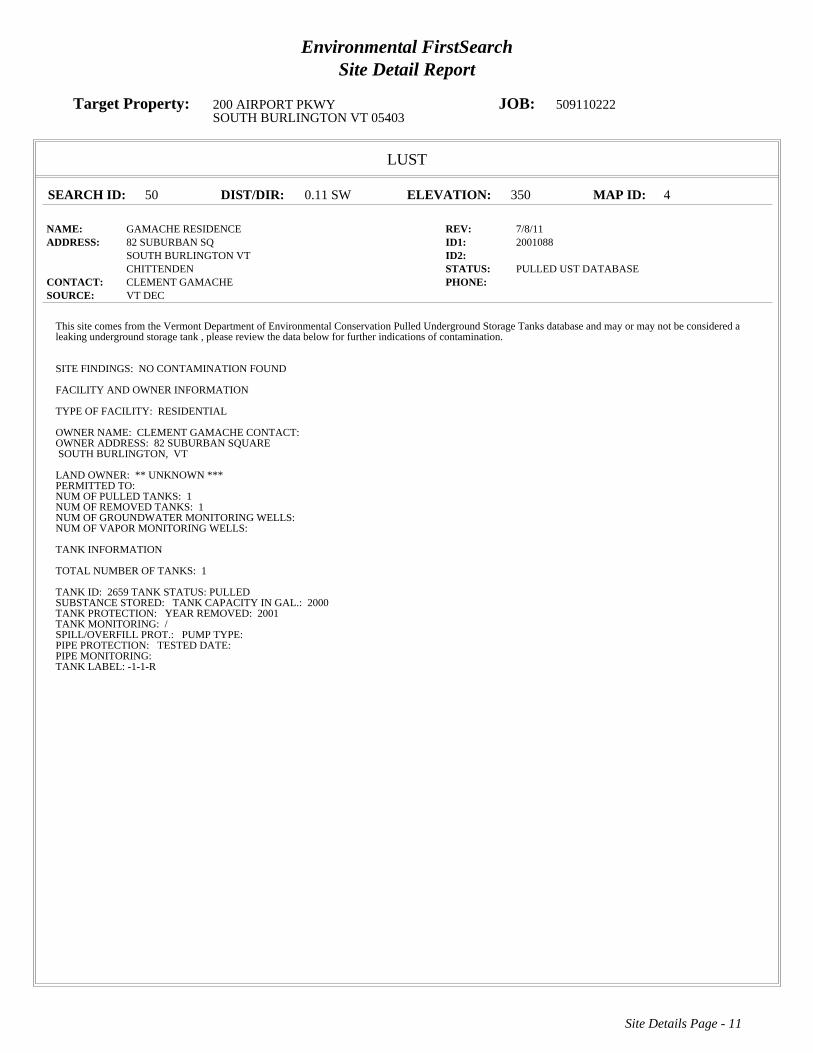
Environmental FirstSearchSite Detail Report
Target Property: 200 AIRPORT PKWY JOB: 509110222SOUTH BURLINGTON VT 05403
LUST
SEARCH ID: 50 DIST/DIR: 0.11 SW ELEVATION: 350 MAP ID: 4
NAME: GAMACHE RESIDENCE REV: 7/8/11ADDRESS: 82 SUBURBAN SQ ID1: 2001088
SOUTH BURLINGTON VT ID2: CHITTENDEN STATUS: PULLED UST DATABASE
CONTACT: CLEMENT GAMACHE PHONE: SOURCE: VT DEC
Site Details Page - 11
This site comes from the Vermont Department of Environmental Conservation Pulled Underground Storage Tanks database and may or may not be considered aleaking underground storage tank , please review the data below for further indications of contamination.
SITE FINDINGS: NO CONTAMINATION FOUND
FACILITY AND OWNER INFORMATION
TYPE OF FACILITY: RESIDENTIAL
OWNER NAME: CLEMENT GAMACHECONTACT:OWNER ADDRESS: 82 SUBURBAN SQUARESOUTH BURLINGTON, VT
LAND OWNER:** UNKNOWN ***PERMITTED TO:NUM OF PULLED TANKS:1NUM OF REMOVED TANKS:1NUM OF GROUNDWATER MONITORING WELLS:NUM OF VAPOR MONITORING WELLS:
TANK INFORMATION
TOTAL NUMBER OF TANKS: 1
TANK ID: 2659TANK STATUS:PULLEDSUBSTANCE STORED: TANK CAPACITY IN GAL.: 2000TANK PROTECTION: YEAR REMOVED: 2001TANK MONITORING: /SPILL/OVERFILL PROT.: PUMP TYPE:PIPE PROTECTION: TESTED DATE:PIPE MONITORING:TANK LABEL:-1-1-R

Environmental FirstSearchSite Detail Report
Target Property: 200 AIRPORT PKWY JOB: 509110222SOUTH BURLINGTON VT 05403
LUST
SEARCH ID: 46 DIST/DIR: 0.12 NW ELEVATION: 334 MAP ID: 5
NAME: CHAMBERLIN SCHOOL REV: 7/8/11ADDRESS: 262 WHITE ST ID1: 628
SOUTH BURLINGTON VT 05401 ID2: CHITTENDEN STATUS: PULLED UST DATABASE
CONTACT: SOUTH BURLINGTON SCHOOL DISTRICT PHONE: SOURCE: VT DEC
Site Details Page - 12
This site comes from the Vermont Department of Environmental Conservation Pulled Underground Storage Tanks database and may or may not be considered aleaking underground storage tank , please review the data below for further indications of contamination.
SITE FINDINGS: NO CONTAMINATION FOUND
FACILITY AND OWNER INFORMATION
TYPE OF FACILITY: TOWN
OWNER NAME: SOUTH BURLINGTON SCHOOL DISTRICTCONTACT:OWNER ADDRESS: 550 DORSET STREETSOUTH BURLINGTON, VT
LAND OWNER:** UNKNOWN ***PERMITTED TO:NUM OF PULLED TANKS:1NUM OF REMOVED TANKS:1NUM OF GROUNDWATER MONITORING WELLS:NUM OF VAPOR MONITORING WELLS:
TANK INFORMATION
TOTAL NUMBER OF TANKS: 1
TANK ID: 538TANK STATUS:PULLEDSUBSTANCE STORED: TANK CAPACITY IN GAL.: 10000TANK PROTECTION: UNPROTECTED STEELYEAR REMOVED: 1992TANK MONITORING: /SPILL/OVERFILL PROT.: PUMP TYPE:PIPE PROTECTION: TESTED DATE:PIPE MONITORING:TANK LABEL:1965-1
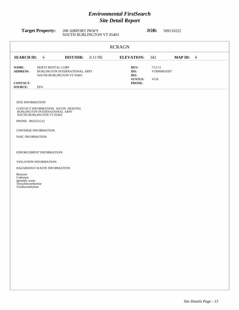
Environmental FirstSearchSite Detail Report
Target Property: 200 AIRPORT PKWY JOB: 509110222SOUTH BURLINGTON VT 05403
RCRAGN
SEARCH ID: 6 DIST/DIR: 0.13 NE ELEVATION: 342 MAP ID: 6
NAME: HERTZ RENTAL CORP REV: 7/11/11ADDRESS: BURLINGTON INTERNATIONAL ARPT ID1: VTR000010207
SOUTH BURLINGTON VT 05403 ID2: STATUS: VGN
CONTACT: PHONE: SOURCE: EPA
Site Details Page - 13
SITE INFORMATION
CONTACT INFORMATION: KEVIN DESOTELBURLINGTON INTERNATIONAL ARPTSOUTH BURLINGTON VT 05403
PHONE: 8025551212
UNIVERSE INFORMATION:
NAIC INFORMATION
ENFORCEMENT INFORMATION:
VIOLATION INFORMATION:
HAZARDOUS WASTE INFORMATION:
BenzeneCadmiumIgnitable wasteTetrachloroethyleneTrichloroethylene

Environmental FirstSearchSite Detail Report
Target Property: 200 AIRPORT PKWY JOB: 509110222SOUTH BURLINGTON VT 05403
STATE
SEARCH ID: 24 DIST/DIR: 0.13 NE ELEVATION: 342 MAP ID: 6
NAME: HERTZ RENT A CAR/NATIONAL CAR REV: 7/8/11ADDRESS: 0 BURLINGTON INTRNTNL AIRPORT ID1: 921313
SOUTH BURLINGTON VT ID2: STATUS: ACTIVE
CONTACT: PHONE: SOURCE: VT DEC
Site Details Page - 14
6900SITE INFORMATION
PRIORITY: NO SENSITIVE RECEPTOR IMPACT (VT SITE PRIORITY SCORE<30)PROJECT STATUS: ANNUAL GROUNDWATER MONITORING TO TRACK 1992 GASOLINE RELEASE FROM BOTH HERTZ AND NATIONAL CARRENTAL TANKS. MONITORING CONTINUES TO REVEAL GROUNDWATER ENFORCEMENT STANDARD EXCEEDANCES IN SEVERAL WELLS.NEXT ROUND SCHEDULED FOR OCTOBER 2010.DATE OF SITE DISCOVERY:DATE OF SITE CLOSURE:SOURCE: 6900 UST-GASOLINE, 6900
OWNER INFORMATION:
OWNER: THE HERTZ CORPOWNER ADDRESS: 225 BRAE BLVD.PARK RIDGE NJ 07656

Environmental FirstSearchSite Detail Report
Target Property: 200 AIRPORT PKWY JOB: 509110222SOUTH BURLINGTON VT 05403
UST
SEARCH ID: 42 DIST/DIR: 0.13 NE ELEVATION: 342 MAP ID: 6
NAME: HERTZ REV: 7/8/11ADDRESS: BURLINGTON AIRPORT ID1: 1182
SOUTH BURLINGTON VT 05403 ID2: 921313CHITTENDEN STATUS: ACTIVE
CONTACT: HERTZ CORPORATION PHONE: 802 865 4087SOURCE: VT DEC
Site Details Page - 15
FACILITY AND OWNER INFORMATION
TYPE OF FACILITY: INDUSTRIAL/COMMERCIAL
OWNER NAME: HERTZ CORPORATIONCONTACT: AREA MANAGEROWNER ADDRESS: 1200 AIRPORT DRIVES BURLINGTON, VT
TANK INFORMATION
TOTAL NUMBER OF TANKS: 2
TANK ID: 10287TANK STATUS:PULLEDSUBSTANCE STORED: TANK CAPACITY IN GAL.: 10000TANK PROTECTION: YEAR REMOVED: 1992TANK MONITORING: /SPILL/OVERFILL PROT.: PUMP TYPE:PIPE PROTECTION: TESTED DATE:PIPE MONITORING:TANK LABEL:1976-1-R
TANK ID: 10288TANK STATUS:ACTIVESUBSTANCE STORED: TANK CAPACITY IN GAL.: 10000TANK PROTECTION: FIBERGLASS REINFORCED PLASTICYEAR REMOVED:TANK MONITORING: /SPILL/OVERFILL PROT.: PUMP TYPE:PIPE PROTECTION: TESTED DATE:PIPE MONITORING: INTERSTITIAL ELECTRONICTANK LABEL:1992-1

Environmental FirstSearchSite Detail Report
Target Property: 200 AIRPORT PKWY JOB: 509110222SOUTH BURLINGTON VT 05403
RCRAGN
SEARCH ID: 1 DIST/DIR: 0.15 SE ELEVATION: 347 MAP ID: 7
NAME: ATLANTIC AVIATION SERVICES REV: 7/11/11ADDRESS: BURLINGTON INTERNATIONAL ARPT ID1: VTR000008227
SOUTH BURLINGTON VT 05403 ID2: CHITTENDEN STATUS: SGN
CONTACT: PHONE: SOURCE: EPA
Site Details Page - 16
SITE INFORMATION
CONTACT INFORMATION: GEORGE BACIGALUPOBURLINGTON INTERNATIONAL ARPTSOUTH BURLINGTON VT 05407
PHONE: 8028633626
UNIVERSE INFORMATION:
NAIC INFORMATION
ENFORCEMENT INFORMATION:
VIOLATION INFORMATION:
VIOLATION NUMBER: 0001RESPONSIBLE: S - STATEDETERMINED: 11/25/1997DETERMINED BY: S - STATECITATION: 7-303(3)(a)RESOLVED: 12/4/1997TYPE: GENERATOR-GENERAL REQUIREMENTS
HAZARDOUS WASTE INFORMATION:
VT08VT02BenzeneIgnitable waste
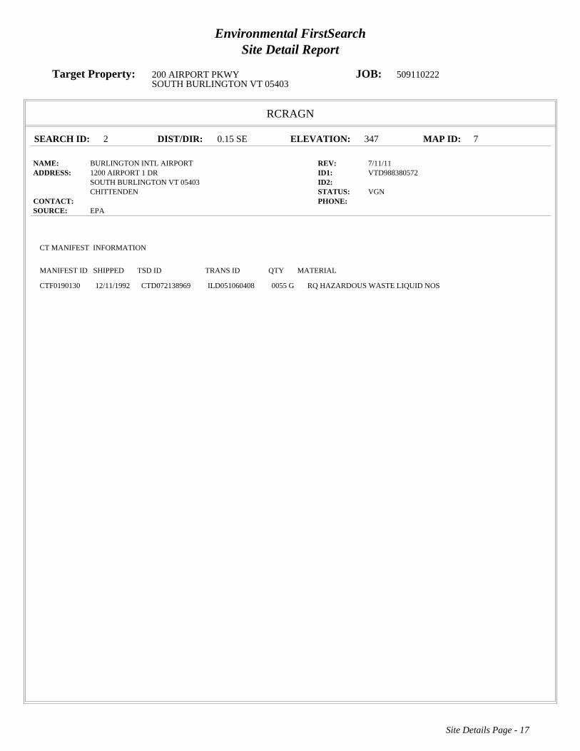
Environmental FirstSearchSite Detail Report
Target Property: 200 AIRPORT PKWY JOB: 509110222SOUTH BURLINGTON VT 05403
RCRAGN
SEARCH ID: 2 DIST/DIR: 0.15 SE ELEVATION: 347 MAP ID: 7
NAME: BURLINGTON INTL AIRPORT REV: 7/11/11ADDRESS: 1200 AIRPORT 1 DR ID1: VTD988380572
SOUTH BURLINGTON VT 05403 ID2: CHITTENDEN STATUS: VGN
CONTACT: PHONE: SOURCE: EPA
Site Details Page - 17
CT MANIFEST INFORMATION
MANIFEST ID SHIPPED TSD ID TRANS ID QTY MATERIAL
CTF0190130 12/11/1992 CTD072138969 ILD051060408 0055 G RQ HAZARDOUS WASTE LIQUID NOS

Environmental FirstSearchSite Detail Report
Target Property: 200 AIRPORT PKWY JOB: 509110222SOUTH BURLINGTON VT 05403
RCRAGN
SEARCH ID: 5 DIST/DIR: 0.15 SE ELEVATION: 347 MAP ID: 7
NAME: F B O AVCENTER REV: 2/16/10ADDRESS: 1200 AIRPORT DR ID1: VTR000011346
SOUTH BURLINGTON VT 05403 ID2: CHITTENDEN STATUS: SGN
CONTACT: PHONE: SOURCE: EPA
Site Details Page - 18
SITE INFORMATION
CONTACT INFORMATION: GEORGE BACIGALUPOAIRPORT DRSOUTH BURLINGTON VT 05403
PHONE: 8026573100
CONTACT INFORMATION: CHRIS HILL1200 AIRPORT DRSOUTH BURLINGTON VT 05403
PHONE: 8028633626
UNIVERSE INFORMATION:
NAIC INFORMATION
48819 - OTHER SUPPORT ACTIVITIES FOR AIR TRANSPORTATION
ENFORCEMENT INFORMATION:
VIOLATION INFORMATION:
HAZARDOUS WASTE INFORMATION:
VT02Ignitable wasteBenzeneVT08
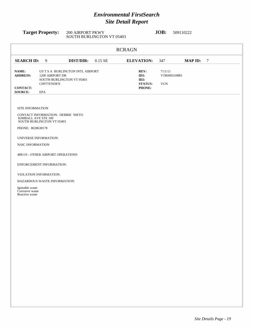
Environmental FirstSearchSite Detail Report
Target Property: 200 AIRPORT PKWY JOB: 509110222SOUTH BURLINGTON VT 05403
RCRAGN
SEARCH ID: 9 DIST/DIR: 0.15 SE ELEVATION: 347 MAP ID: 7
NAME: US T S A BURLINGTON INTL AIRPORT REV: 7/11/11ADDRESS: 1200 AIRPORT DR ID1: VTR000510883
SOUTH BURLINGTON VT 05403 ID2: CHITTENDEN STATUS: VGN
CONTACT: PHONE: SOURCE: EPA
Site Details Page - 19
SITE INFORMATION
CONTACT INFORMATION: DEBBIE NIETOKIMBALL AVE STE 100SOUTH BURLINGTON VT 05403
PHONE: 8028638178
UNIVERSE INFORMATION:
NAIC INFORMATION
488119 - OTHER AIRPORT OPERATIONS
ENFORCEMENT INFORMATION:
VIOLATION INFORMATION:
HAZARDOUS WASTE INFORMATION:
Ignitable wasteCorrosive wasteReactive waste

Environmental FirstSearchSite Detail Report
Target Property: 200 AIRPORT PKWY JOB: 509110222SOUTH BURLINGTON VT 05403
UST
SEARCH ID: 65 DIST/DIR: 0.15 SE ELEVATION: 347 MAP ID: 7
NAME: ATLANTIC AVIATION - EAST HANGER REV: 7/8/11ADDRESS: BURLINGTON INTERNATIONAL AIRPORT ID1: 6583662
SOUTH BURLINGTON VT 05403 ID2: CHITTENDEN STATUS: ACTIVE
CONTACT: BTV AVCENTER INC DBA ATLANTIC AVIATI PHONE: 802-657-3100SOURCE: VT DEC
Site Details Page - 20
FACILITY AND OWNER INFORMATION
TYPE OF FACILITY: INDUSTRIAL/COMMERCIAL
OWNER NAME: BTV AVCENTER INC DBA ATLANTIC AVIATICONTACT: GEORGE BACIGALUPOOWNER ADDRESS: 1130 AIRPORT DRIVESOUTH BURLINGTON, VT
TANK INFORMATION
TOTAL NUMBER OF TANKS: 2
TANK ID: 14712TANK STATUS:PULLEDSUBSTANCE STORED: TANK CAPACITY IN GAL.: 12000TANK PROTECTION: PsYEAR REMOVED: 2009TANK MONITORING: /SPILL/OVERFILL PROT.: PUMP TYPE:PIPE PROTECTION: TESTED DATE:PIPE MONITORING: IN TANK MONITORTANK LABEL:1986-1
TANK ID: 14713TANK STATUS:ACTIVESUBSTANCE STORED: TANK CAPACITY IN GAL.: 12000TANK PROTECTION: PsYEAR REMOVED:TANK MONITORING: /SPILL/OVERFILL PROT.: PUMP TYPE:PIPE PROTECTION: TESTED DATE:PIPE MONITORING: IN TANK MONITORTANK LABEL:1986-2
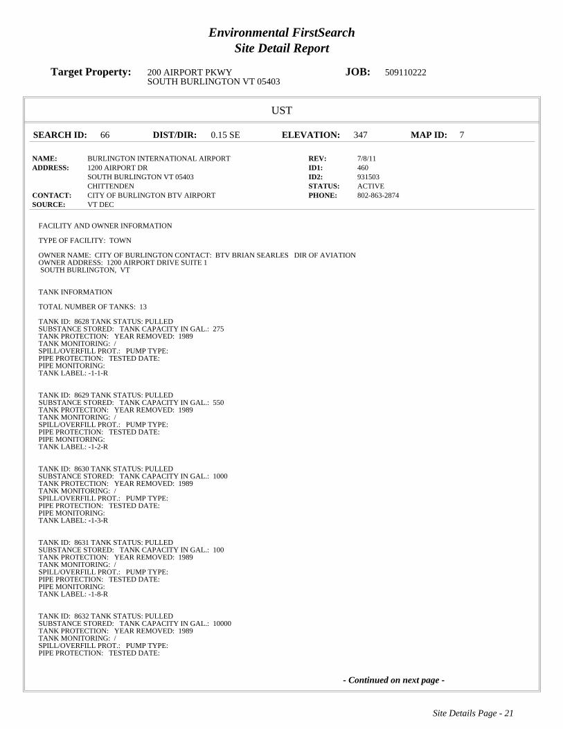
Environmental FirstSearchSite Detail Report
Target Property: 200 AIRPORT PKWY JOB: 509110222SOUTH BURLINGTON VT 05403
UST
SEARCH ID: 66 DIST/DIR: 0.15 SE ELEVATION: 347 MAP ID: 7
NAME: BURLINGTON INTERNATIONAL AIRPORT REV: 7/8/11ADDRESS: 1200 AIRPORT DR ID1: 460
SOUTH BURLINGTON VT 05403 ID2: 931503CHITTENDEN STATUS: ACTIVE
CONTACT: CITY OF BURLINGTON BTV AIRPORT PHONE: 802-863-2874SOURCE: VT DEC
Site Details Page - 21
- Continued on next page -
FACILITY AND OWNER INFORMATION
TYPE OF FACILITY: TOWN
OWNER NAME: CITY OF BURLINGTONCONTACT: BTV BRIAN SEARLES DIR OF AVIATIONOWNER ADDRESS: 1200 AIRPORT DRIVE SUITE 1SOUTH BURLINGTON, VT
TANK INFORMATION
TOTAL NUMBER OF TANKS: 13
TANK ID: 8628TANK STATUS:PULLEDSUBSTANCE STORED: TANK CAPACITY IN GAL.: 275TANK PROTECTION: YEAR REMOVED: 1989TANK MONITORING: /SPILL/OVERFILL PROT.: PUMP TYPE:PIPE PROTECTION: TESTED DATE:PIPE MONITORING:TANK LABEL:-1-1-R
TANK ID: 8629TANK STATUS:PULLEDSUBSTANCE STORED: TANK CAPACITY IN GAL.: 550TANK PROTECTION: YEAR REMOVED: 1989TANK MONITORING: /SPILL/OVERFILL PROT.: PUMP TYPE:PIPE PROTECTION: TESTED DATE:PIPE MONITORING:TANK LABEL:-1-2-R
TANK ID: 8630TANK STATUS:PULLEDSUBSTANCE STORED: TANK CAPACITY IN GAL.: 1000TANK PROTECTION: YEAR REMOVED: 1989TANK MONITORING: /SPILL/OVERFILL PROT.: PUMP TYPE:PIPE PROTECTION: TESTED DATE:PIPE MONITORING:TANK LABEL:-1-3-R
TANK ID: 8631TANK STATUS:PULLEDSUBSTANCE STORED: TANK CAPACITY IN GAL.: 100TANK PROTECTION: YEAR REMOVED: 1989TANK MONITORING: /SPILL/OVERFILL PROT.: PUMP TYPE:PIPE PROTECTION: TESTED DATE:PIPE MONITORING:TANK LABEL:-1-8-R
TANK ID: 8632TANK STATUS:PULLEDSUBSTANCE STORED: TANK CAPACITY IN GAL.: 10000TANK PROTECTION: YEAR REMOVED: 1989TANK MONITORING: /SPILL/OVERFILL PROT.: PUMP TYPE:PIPE PROTECTION: TESTED DATE:

Environmental FirstSearchSite Detail Report
Target Property: 200 AIRPORT PKWY JOB: 509110222SOUTH BURLINGTON VT 05403
UST
SEARCH ID: 66 DIST/DIR: 0.15 SE ELEVATION: 347 MAP ID: 7
NAME: BURLINGTON INTERNATIONAL AIRPORT REV: 7/8/11ADDRESS: 1200 AIRPORT DR ID1: 460
SOUTH BURLINGTON VT 05403 ID2: 931503CHITTENDEN STATUS: ACTIVE
CONTACT: CITY OF BURLINGTON BTV AIRPORT PHONE: 802-863-2874SOURCE: VT DEC
Site Details Page - 22
- Continued on next page -
PIPE MONITORING:TANK LABEL:1968-4-R
TANK ID: 8633TANK STATUS:PULLEDSUBSTANCE STORED: TANK CAPACITY IN GAL.: 4000TANK PROTECTION: YEAR REMOVED: 1989TANK MONITORING: /SPILL/OVERFILL PROT.: PUMP TYPE:PIPE PROTECTION: TESTED DATE:PIPE MONITORING:TANK LABEL:1968-5-R
TANK ID: 8634TANK STATUS:PULLEDSUBSTANCE STORED: TANK CAPACITY IN GAL.: 10000TANK PROTECTION: YEAR REMOVED: 1997TANK MONITORING: /SPILL/OVERFILL PROT.: PUMP TYPE:PIPE PROTECTION: TESTED DATE:PIPE MONITORING:TANK LABEL:1981-10-R
TANK ID: 8635TANK STATUS:PULLEDSUBSTANCE STORED: TANK CAPACITY IN GAL.: 10000TANK PROTECTION: YEAR REMOVED: 1989TANK MONITORING: /SPILL/OVERFILL PROT.: PUMP TYPE:PIPE PROTECTION: TESTED DATE:PIPE MONITORING:TANK LABEL:1981-6-R
TANK ID: 8636TANK STATUS:PULLEDSUBSTANCE STORED: TANK CAPACITY IN GAL.: 10000TANK PROTECTION: YEAR REMOVED: 1989TANK MONITORING: /SPILL/OVERFILL PROT.: PUMP TYPE:PIPE PROTECTION: TESTED DATE:PIPE MONITORING:TANK LABEL:1981-7-R
TANK ID: 8637TANK STATUS:PULLEDSUBSTANCE STORED: TANK CAPACITY IN GAL.: 10000TANK PROTECTION: YEAR REMOVED: 1997TANK MONITORING: /SPILL/OVERFILL PROT.: PUMP TYPE:PIPE PROTECTION: TESTED DATE:PIPE MONITORING:TANK LABEL:1981-9-R
TANK ID: 8638TANK STATUS:ACTIVESUBSTANCE STORED: TANK CAPACITY IN GAL.: 550TANK PROTECTION: FIBERGLASS REINFORCED PLASTICYEAR REMOVED:TANK MONITORING: /

Environmental FirstSearchSite Detail Report
Target Property: 200 AIRPORT PKWY JOB: 509110222SOUTH BURLINGTON VT 05403
UST
SEARCH ID: 66 DIST/DIR: 0.15 SE ELEVATION: 347 MAP ID: 7
NAME: BURLINGTON INTERNATIONAL AIRPORT REV: 7/8/11ADDRESS: 1200 AIRPORT DR ID1: 460
SOUTH BURLINGTON VT 05403 ID2: 931503CHITTENDEN STATUS: ACTIVE
CONTACT: CITY OF BURLINGTON BTV AIRPORT PHONE: 802-863-2874SOURCE: VT DEC
Site Details Page - 23
SPILL/OVERFILL PROT.: PUMP TYPE:PIPE PROTECTION: TESTED DATE:PIPE MONITORING: INTERSTITIAL ELECTRONICTANK LABEL:1988-1
TANK ID: 8639TANK STATUS:ACTIVESUBSTANCE STORED: TANK CAPACITY IN GAL.: 12000TANK PROTECTION: POLYETHYLENE JACKETED STEEL TANKYEAR REMOVED:TANK MONITORING: /SPILL/OVERFILL PROT.: PUMP TYPE:PIPE PROTECTION: TESTED DATE:PIPE MONITORING: INTERSTITIAL ELECTRONICTANK LABEL:1997-2-2
TANK ID: 8640TANK STATUS:PULLEDSUBSTANCE STORED: TANK CAPACITY IN GAL.: 10000TANK PROTECTION: UNPROTECTED STEELYEAR REMOVED: 2005TANK MONITORING: /SPILL/OVERFILL PROT.: PUMP TYPE:PIPE PROTECTION: TESTED DATE:PIPE MONITORING:TANK LABEL:-1-9-R

Environmental FirstSearchSite Detail Report
Target Property: 200 AIRPORT PKWY JOB: 509110222SOUTH BURLINGTON VT 05403
UST
SEARCH ID: 39 DIST/DIR: 0.15 SE ELEVATION: 347 MAP ID: 7
NAME: BURLINGTON INTERNATIONAL AIRPORT REV:ADDRESS: 0 NATIONAL WEATHER SERVICE ID1: 1001663
SOUTH BURLINGTON VT 05403 ID2: CHITTENDEN STATUS: INSTITUTIONAL
CONTACT: US DEPT OF COMM NAT PHONE: 802-951-6393SOURCE: VTDEC
Site Details Page - 24
Tanks Installed Capacity
CURRENT: 1 ??? 76 2000 REMOVED: 0 PERMANENT: 0 UNKNOWN: 0 TEMP: 0 CLOSED: 0
PRODUCTS: DIESELTANK MATERIAL: UNPROTECTEDPIPE MATERIAL:

Environmental FirstSearchSite Detail Report
Target Property: 200 AIRPORT PKWY JOB: 509110222SOUTH BURLINGTON VT 05403
UST
SEARCH ID: 41 DIST/DIR: 0.15 SE ELEVATION: 347 MAP ID: 7
NAME: FAA ASR REV: 3/8/10ADDRESS: BURLINGTON INTERNATIONAL AIRPORT ID1: 1663
SOUTH BURLINGTON VT 05403 ID2: CHITTENDEN STATUS: ACTIVE
CONTACT: FAA PHONE: SOURCE: VT DEC
Site Details Page - 25
FACILITY AND OWNER INFORMATION
TYPE OF FACILITY: FEDERAL
OWNER NAME: FAA SSC-86EBCONTACT: MICHAEL DAVIS MANAGEROWNER ADDRESS: 1250 AIRPORT DRIVESOUTH BURLINGTON, VT
TANK INFORMATION
TOTAL NUMBER OF TANKS: 4
TANK ID: 11481TANK STATUS:PULLEDSUBSTANCE STORED: DIESELTANK CAPACITY IN GAL.: 500TANK PROTECTION: YEAR REMOVED: 1998TANK MONITORING: /SPILL/OVERFILL PROT.: PUMP TYPE:PIPE PROTECTION: TESTED DATE:PIPE MONITORING:TANK LABEL:1979-4-R
TANK ID: 11482TANK STATUS:PULLEDSUBSTANCE STORED: DIESELTANK CAPACITY IN GAL.: 2000TANK PROTECTION: YEAR REMOVED: 1997TANK MONITORING: /SPILL/OVERFILL PROT.: PUMP TYPE:PIPE PROTECTION: TESTED DATE:PIPE MONITORING:TANK LABEL:1986-2-R
TANK ID: 11483TANK STATUS:PULLEDSUBSTANCE STORED: DIESELTANK CAPACITY IN GAL.: 2500TANK PROTECTION: FIBERGLASS REINFORCED PLASTICYEAR REMOVED: 2002TANK MONITORING: /SPILL/OVERFILL PROT.: OVERFILLPUMP TYPE:PIPE PROTECTION: TESTED DATE:PIPE MONITORING: INTERSTITIALTANK LABEL:1988-1-R
TANK ID: 11484TANK STATUS:ACTIVESUBSTANCE STORED: DIESELTANK CAPACITY IN GAL.: 1000TANK PROTECTION: FIBERGLASS REINFORCED PLASTICYEAR REMOVED:TANK MONITORING: /SPILL/OVERFILL PROT.: SPILL & OVERFILL ALARMPUMP TYPE:PIPE PROTECTION: TESTED DATE:PIPE MONITORING: INTERSTITIALTANK LABEL:1997-3

Environmental FirstSearchSite Detail Report
Target Property: 200 AIRPORT PKWY JOB: 509110222SOUTH BURLINGTON VT 05403
UST
SEARCH ID: 45 DIST/DIR: 0.15 SE ELEVATION: 347 MAP ID: 7
NAME: NATIONAL ALAMOENTERPRISE CAR RENTAL REV: 7/8/11ADDRESS: BURLINGTON INTERNATIONAL AIRPORT ID1: 1453
SOUTH BURLINGTON VT 05403 ID2: 921313CHITTENDEN STATUS: ACTIVE
CONTACT: ENTERPRISE CAR RENTALS PHONE: 802-864-7441SOURCE: VT DEC
Site Details Page - 26
FACILITY AND OWNER INFORMATION
TYPE OF FACILITY: INDUSTRIAL/COMMERCIAL
OWNER NAME: DESARNO ENTERPRISES INCCONTACT: STEVE DESARNOOWNER ADDRESS: PO BOX 1644WILLISTON, VT
TANK INFORMATION
TOTAL NUMBER OF TANKS: 2
TANK ID: 10866TANK STATUS:PULLEDSUBSTANCE STORED: TANK CAPACITY IN GAL.: 10000TANK PROTECTION: YEAR REMOVED: 1996TANK MONITORING: /SPILL/OVERFILL PROT.: PUMP TYPE:PIPE PROTECTION: TESTED DATE:PIPE MONITORING:TANK LABEL:1979-1-R
TANK ID: 10867TANK STATUS:ACTIVESUBSTANCE STORED: TANK CAPACITY IN GAL.: 10000TANK PROTECTION: FIBERGLASS JACKETED STEEL TANKYEAR REMOVED:TANK MONITORING: /SPILL/OVERFILL PROT.: PUMP TYPE:PIPE PROTECTION: TESTED DATE:PIPE MONITORING: INTERSTITIAL ELECTRONICTANK LABEL:1996-1

Environmental FirstSearchSite Detail Report
Target Property: 200 AIRPORT PKWY JOB: 509110222SOUTH BURLINGTON VT 05403
LUST
SEARCH ID: 67 DIST/DIR: 0.15 SE ELEVATION: 347 MAP ID: 7
NAME: BROCKWAY AIRCRAFT HANGER REV: 7/8/11ADDRESS: BURLINGTON INTERNATIONAL AIRPORT ID1: 6585071
SOUTH BURLINGTON VT 05401 ID2: CHITTENDEN STATUS: PULLED UST DATABASE
CONTACT: BROCKWAY AIR INC PHONE: SOURCE: VT DEC
Site Details Page - 27
This site comes from the Vermont Department of Environmental Conservation Pulled Underground Storage Tanks database and may or may not be considered aleaking underground storage tank , please review the data below for further indications of contamination.
SITE FINDINGS: NO CONTAMINATION FOUND
FACILITY AND OWNER INFORMATION
TYPE OF FACILITY: INDUSTRIAL/COMMERCIAL
OWNER NAME: BROCKWAY AIR INCCONTACT:OWNER ADDRESS: 1 CALKINS COURTSOUTH BURLINGTON, VT
LAND OWNER:** UNKNOWN ***PERMITTED TO:NUM OF PULLED TANKS:1NUM OF REMOVED TANKS:1NUM OF GROUNDWATER MONITORING WELLS:NUM OF VAPOR MONITORING WELLS:
TANK INFORMATION
TOTAL NUMBER OF TANKS: 1
TANK ID: 4762TANK STATUS:PULLEDSUBSTANCE STORED: TANK CAPACITY IN GAL.: 500TANK PROTECTION: UNPROTECTED STEELYEAR REMOVED: 1988TANK MONITORING: /SPILL/OVERFILL PROT.: PUMP TYPE:PIPE PROTECTION: TESTED DATE:PIPE MONITORING:TANK LABEL:1985-1

Environmental FirstSearchSite Detail Report
Target Property: 200 AIRPORT PKWY JOB: 509110222SOUTH BURLINGTON VT 05403
LUST
SEARCH ID: 69 DIST/DIR: 0.15 SE ELEVATION: 347 MAP ID: 7
NAME: BURLINGTON INTERNATIONAL AIRPORT REV: 7/8/11ADDRESS: NATIONAL WEATHER SERVICE ID1: 1001663
SOUTH BURLINGTON VT 05403 ID2: CHITTENDEN STATUS: PULLED UST DATABASE
CONTACT: US DEPT OF COMM NAT WEATHER PHONE: 802-951-6393SOURCE: VT DEC
Site Details Page - 28
This site comes from the Vermont Department of Environmental Conservation Pulled Underground Storage Tanks database and may or may not be considered aleaking underground storage tank , please review the data below for further indications of contamination.
SITE FINDINGS: NO CONTAMINATION FOUND
FACILITY AND OWNER INFORMATION
TYPE OF FACILITY: FEDERAL
OWNER NAME: US DEPT OF COMM NAT WEATHERCONTACT: ROBERT E BELLOWNER ADDRESS: BURLINGTON INTERNATIONAL AIRPORTSOUTH BURLINGTON, VT
LAND OWNER:** UNKNOWN ***PERMITTED TO:TANK OWNERNUM OF PULLED TANKS:1NUM OF REMOVED TANKS:1NUM OF GROUNDWATER MONITORING WELLS:NUM OF VAPOR MONITORING WELLS:
TANK INFORMATION
TOTAL NUMBER OF TANKS: 1
TANK ID: 2293TANK STATUS:PULLEDSUBSTANCE STORED: TANK CAPACITY IN GAL.: 2000TANK PROTECTION: UNPROTECTED STEELYEAR REMOVED: 1996TANK MONITORING: /SPILL/OVERFILL PROT.: PUMP TYPE:PIPE PROTECTION: TESTED DATE:PIPE MONITORING:TANK LABEL:1976-1
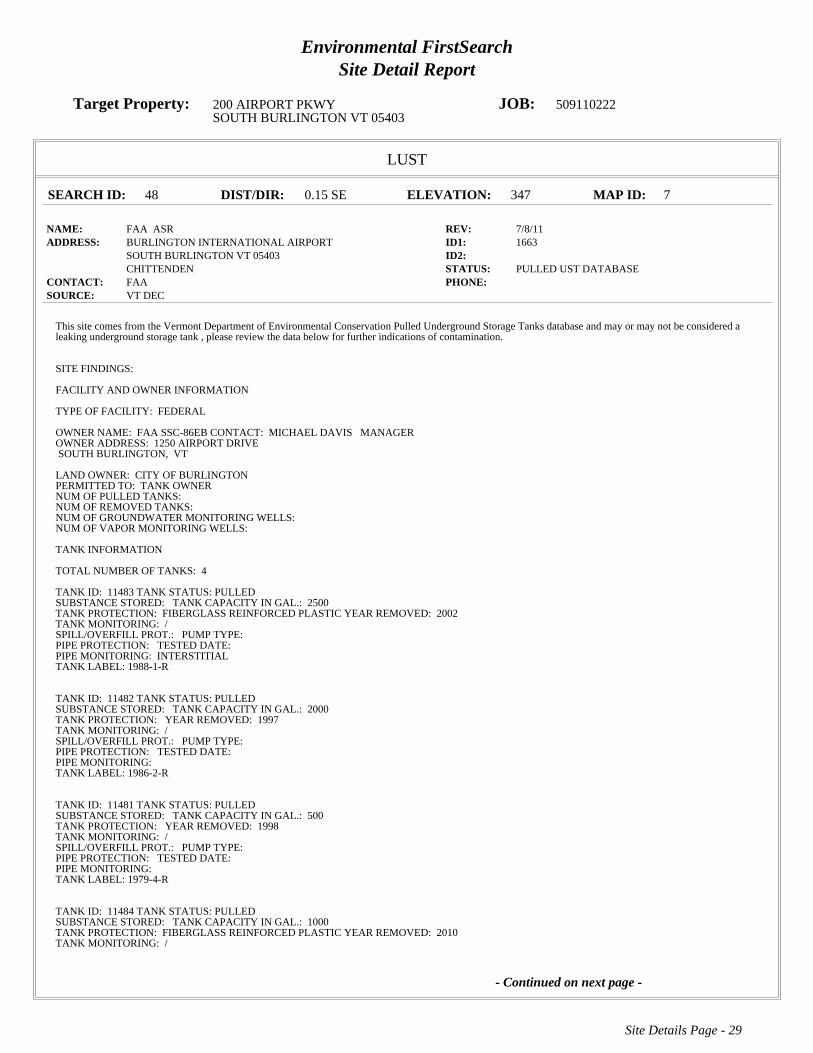
Environmental FirstSearchSite Detail Report
Target Property: 200 AIRPORT PKWY JOB: 509110222SOUTH BURLINGTON VT 05403
LUST
SEARCH ID: 48 DIST/DIR: 0.15 SE ELEVATION: 347 MAP ID: 7
NAME: FAA ASR REV: 7/8/11ADDRESS: BURLINGTON INTERNATIONAL AIRPORT ID1: 1663
SOUTH BURLINGTON VT 05403 ID2: CHITTENDEN STATUS: PULLED UST DATABASE
CONTACT: FAA PHONE: SOURCE: VT DEC
Site Details Page - 29
- Continued on next page -
This site comes from the Vermont Department of Environmental Conservation Pulled Underground Storage Tanks database and may or may not be considered aleaking underground storage tank , please review the data below for further indications of contamination.
SITE FINDINGS:
FACILITY AND OWNER INFORMATION
TYPE OF FACILITY: FEDERAL
OWNER NAME: FAA SSC-86EBCONTACT: MICHAEL DAVIS MANAGEROWNER ADDRESS: 1250 AIRPORT DRIVESOUTH BURLINGTON, VT
LAND OWNER:CITY OF BURLINGTONPERMITTED TO:TANK OWNERNUM OF PULLED TANKS:NUM OF REMOVED TANKS:NUM OF GROUNDWATER MONITORING WELLS:NUM OF VAPOR MONITORING WELLS:
TANK INFORMATION
TOTAL NUMBER OF TANKS: 4
TANK ID: 11483TANK STATUS:PULLEDSUBSTANCE STORED: TANK CAPACITY IN GAL.: 2500TANK PROTECTION: FIBERGLASS REINFORCED PLASTICYEAR REMOVED: 2002TANK MONITORING: /SPILL/OVERFILL PROT.: PUMP TYPE:PIPE PROTECTION: TESTED DATE:PIPE MONITORING: INTERSTITIALTANK LABEL:1988-1-R
TANK ID: 11482TANK STATUS:PULLEDSUBSTANCE STORED: TANK CAPACITY IN GAL.: 2000TANK PROTECTION: YEAR REMOVED: 1997TANK MONITORING: /SPILL/OVERFILL PROT.: PUMP TYPE:PIPE PROTECTION: TESTED DATE:PIPE MONITORING:TANK LABEL:1986-2-R
TANK ID: 11481TANK STATUS:PULLEDSUBSTANCE STORED: TANK CAPACITY IN GAL.: 500TANK PROTECTION: YEAR REMOVED: 1998TANK MONITORING: /SPILL/OVERFILL PROT.: PUMP TYPE:PIPE PROTECTION: TESTED DATE:PIPE MONITORING:TANK LABEL:1979-4-R
TANK ID: 11484TANK STATUS:PULLEDSUBSTANCE STORED: TANK CAPACITY IN GAL.: 1000TANK PROTECTION: FIBERGLASS REINFORCED PLASTICYEAR REMOVED: 2010TANK MONITORING: /

Environmental FirstSearchSite Detail Report
Target Property: 200 AIRPORT PKWY JOB: 509110222SOUTH BURLINGTON VT 05403
LUST
SEARCH ID: 48 DIST/DIR: 0.15 SE ELEVATION: 347 MAP ID: 7
NAME: FAA ASR REV: 7/8/11ADDRESS: BURLINGTON INTERNATIONAL AIRPORT ID1: 1663
SOUTH BURLINGTON VT 05403 ID2: CHITTENDEN STATUS: PULLED UST DATABASE
CONTACT: FAA PHONE: SOURCE: VT DEC
Site Details Page - 30
PIPE PROTECTION: TESTED DATE:PIPE MONITORING: INTERSTITIAL ELECTRONICTANK LABEL:1997-3-r

Environmental FirstSearchSite Detail Report
Target Property: 200 AIRPORT PKWY JOB: 509110222SOUTH BURLINGTON VT 05403
LUST
SEARCH ID: 51 DIST/DIR: 0.15 SE ELEVATION: 344 MAP ID: 8
NAME: POWER RESIDENCE REV: 7/8/11ADDRESS: 4 MILLS AVE ID1: 2005090
SOUTH BURLINGTON VT ID2: CHITTENDEN STATUS: PULLED UST DATABASE
CONTACT: JENNIFER POWER PHONE: SOURCE: VT DEC
Site Details Page - 31
This site comes from the Vermont Department of Environmental Conservation Pulled Underground Storage Tanks database and may or may not be considered aleaking underground storage tank , please review the data below for further indications of contamination.
SITE FINDINGS: NO CONTAMINATION FOUND
FACILITY AND OWNER INFORMATION
TYPE OF FACILITY: RESIDENTIAL
OWNER NAME: JENNIFER POWERCONTACT:OWNER ADDRESS: 4912 PARK AVE SOUTHMINNEAPOLIS, MN
LAND OWNER:** UNKNOWN ***PERMITTED TO:NUM OF PULLED TANKS:1NUM OF REMOVED TANKS:1NUM OF GROUNDWATER MONITORING WELLS:NUM OF VAPOR MONITORING WELLS:
TANK INFORMATION
TOTAL NUMBER OF TANKS: 1
TANK ID: 3006TANK STATUS:PULLEDSUBSTANCE STORED: TANK CAPACITY IN GAL.: 275TANK PROTECTION: YEAR REMOVED: 2004TANK MONITORING: /SPILL/OVERFILL PROT.: PUMP TYPE:PIPE PROTECTION: TESTED DATE:PIPE MONITORING:TANK LABEL:-1-1-R

Environmental FirstSearchSite Detail Report
Target Property: 200 AIRPORT PKWY JOB: 509110222SOUTH BURLINGTON VT 05403
LUST
SEARCH ID: 52 DIST/DIR: 0.15 SE ELEVATION: 344 MAP ID: 8
NAME: POWER RESIDENCE REV: 3/16/05ADDRESS: 4 MILLS AVE ID1: 5551796
SOUTH BURLINGTON VT 05403 ID2: CHITTENDEN STATUS:
CONTACT: PHONE: SOURCE: VTDEC
Site Details Page - 32
OWNER AND OPERATOR INFORMATION
OWNER NAME: JENNIFER POWEROWNER PERSON:4 MILLS AVENUEBURLINGTON VT,
OPERATOR NAME: JENNIFER POWEROPERATOR PERSON:
,
LANDOWNER:
FACILITY TYPE: RESIDENTIALPERMITTED TO:SITE FINDINGS:NO CONTAMINATION FOUND
NUMBER OF TANKS PULLED: 1NUMBER OF GROUNDWATER MONITORING WELLS:NUMBER OF VAPOR MONITORING WELLS:COMMENTS: 2004
TANK INFORMATIONTANK ID: -1-1-RYEAR REMOVED: 2004DATE OUT OF SERVICE:TANK CAPACITY IN GALL.: 275SUBSTANCE STORED: #2 OR #4 FUEL OILTANK PROTECTION:

Environmental FirstSearchSite Detail Report
Target Property: 200 AIRPORT PKWY JOB: 509110222SOUTH BURLINGTON VT 05403
LUST
SEARCH ID: 53 DIST/DIR: 0.19 SE ELEVATION: 334 MAP ID: 9
NAME: THRIFTY CAR RENTAL REV: 7/8/11ADDRESS: 1700 WILLISTON RD ID1: 236
SOUTH BURLINGTON VT 05401 ID2: CHITTENDEN STATUS: PULLED UST DATABASE
CONTACT: PECOR/NORDIC LEASING/SPILLANE PHONE: SOURCE: VT DEC
Site Details Page - 33
This site comes from the Vermont Department of Environmental Conservation Pulled Underground Storage Tanks database and may or may not be considered aleaking underground storage tank , please review the data below for further indications of contamination.
SITE FINDINGS: NO CONTAMINATION FOUND
FACILITY AND OWNER INFORMATION
TYPE OF FACILITY: RETAIL
OWNER NAME: PECOR/NORDIC LEASING/SPILLANECONTACT:OWNER ADDRESS: KING STREET DOCKBURLINGTON, VT
LAND OWNER:RAY PECORPERMITTED TO:NUM OF PULLED TANKS:3NUM OF REMOVED TANKS:3NUM OF GROUNDWATER MONITORING WELLS:NUM OF VAPOR MONITORING WELLS:
TANK INFORMATION
TOTAL NUMBER OF TANKS: 3
TANK ID: 244TANK STATUS:PULLEDSUBSTANCE STORED: TANK CAPACITY IN GAL.: 4000TANK PROTECTION: UNPROTECTED STEELYEAR REMOVED: 2002TANK MONITORING: /SPILL/OVERFILL PROT.: PUMP TYPE:PIPE PROTECTION: TESTED DATE:PIPE MONITORING:TANK LABEL:-1-1-R
TANK ID: 246TANK STATUS:PULLEDSUBSTANCE STORED: TANK CAPACITY IN GAL.: 3000TANK PROTECTION: YEAR REMOVED: 2002TANK MONITORING: /SPILL/OVERFILL PROT.: PUMP TYPE:PIPE PROTECTION: TESTED DATE:PIPE MONITORING:TANK LABEL:-1-3-R
TANK ID: 245TANK STATUS:PULLEDSUBSTANCE STORED: TANK CAPACITY IN GAL.: 4000TANK PROTECTION: UNPROTECTED STEELYEAR REMOVED: 2002TANK MONITORING: /SPILL/OVERFILL PROT.: PUMP TYPE:PIPE PROTECTION: TESTED DATE:PIPE MONITORING:TANK LABEL:-1-2-R
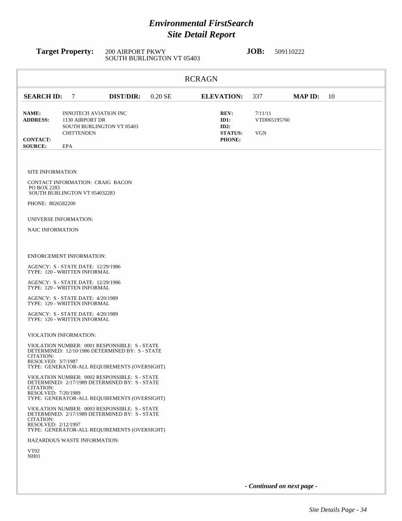
Environmental FirstSearchSite Detail Report
Target Property: 200 AIRPORT PKWY JOB: 509110222SOUTH BURLINGTON VT 05403
RCRAGN
SEARCH ID: 7 DIST/DIR: 0.20 SE ELEVATION: 337 MAP ID: 10
NAME: INNOTECH AVIATION INC REV: 7/11/11ADDRESS: 1130 AIRPORT DR ID1: VTD065195760
SOUTH BURLINGTON VT 05403 ID2: CHITTENDEN STATUS: VGN
CONTACT: PHONE: SOURCE: EPA
Site Details Page - 34
- Continued on next page -
SITE INFORMATION
CONTACT INFORMATION: CRAIG BACONPO BOX 2283SOUTH BURLINGTON VT 054032283
PHONE: 8026582200
UNIVERSE INFORMATION:
NAIC INFORMATION
ENFORCEMENT INFORMATION:
AGENCY: S - STATEDATE: 12/29/1986TYPE: 120 - WRITTEN INFORMAL
AGENCY: S - STATEDATE: 12/29/1986TYPE: 120 - WRITTEN INFORMAL
AGENCY: S - STATEDATE: 4/20/1989TYPE: 120 - WRITTEN INFORMAL
AGENCY: S - STATEDATE: 4/20/1989TYPE: 120 - WRITTEN INFORMAL
VIOLATION INFORMATION:
VIOLATION NUMBER: 0001RESPONSIBLE: S - STATEDETERMINED: 12/10/1986DETERMINED BY: S - STATECITATION:RESOLVED: 3/7/1987TYPE: GENERATOR-ALL REQUIREMENTS (OVERSIGHT)
VIOLATION NUMBER: 0002RESPONSIBLE: S - STATEDETERMINED: 2/17/1989DETERMINED BY: S - STATECITATION:RESOLVED: 7/20/1989TYPE: GENERATOR-ALL REQUIREMENTS (OVERSIGHT)
VIOLATION NUMBER: 0003RESPONSIBLE: S - STATEDETERMINED: 2/17/1989DETERMINED BY: S - STATECITATION:RESOLVED: 2/12/1997TYPE: GENERATOR-ALL REQUIREMENTS (OVERSIGHT)
HAZARDOUS WASTE INFORMATION:
VT02NH01

Environmental FirstSearchSite Detail Report
Target Property: 200 AIRPORT PKWY JOB: 509110222SOUTH BURLINGTON VT 05403
RCRAGN
SEARCH ID: 7 DIST/DIR: 0.20 SE ELEVATION: 337 MAP ID: 10
NAME: INNOTECH AVIATION INC REV: 7/11/11ADDRESS: 1130 AIRPORT DR ID1: VTD065195760
SOUTH BURLINGTON VT 05403 ID2: CHITTENDEN STATUS: VGN
CONTACT: PHONE: SOURCE: EPA
Site Details Page - 35
wasteVT08Benzene

Environmental FirstSearchSite Detail Report
Target Property: 200 AIRPORT PKWY JOB: 509110222SOUTH BURLINGTON VT 05403
LUST
SEARCH ID: 49 DIST/DIR: 0.20 SE ELEVATION: 337 MAP ID: 10
NAME: FBO AVCENTER NEW HANGER REV: 7/8/11ADDRESS: 1130 AIRPORT DR ID1: 5559028
SOUTH BURLINGTON VT 05403 ID2: 770122CHITTENDEN STATUS: PULLED UST DATABASE
CONTACT: UNKNOWN PHONE: SOURCE: VT DEC
Site Details Page - 36
This site comes from the Vermont Department of Environmental Conservation Pulled Underground Storage Tanks database and may or may not be considered aleaking underground storage tank , please review the data below for further indications of contamination.
SITE FINDINGS: CONTAMINATION FOUND BELOW STATE STANDARD, <20 PPM GAS OR 10 PPM DIESEL/HEATING OIL #2
FACILITY AND OWNER INFORMATION
TYPE OF FACILITY: TOWN
OWNER NAME: CITY OF BURLINGTONCONTACT: BTV BRIAN SEARLES DIR OF AVIATIONOWNER ADDRESS: 1200 AIRPORT DRIVE SUITE 1SOUTH BURLINGTON, VT
LAND OWNER:CITY OF BURLINGTONPERMITTED TO:NUM OF PULLED TANKS:1NUM OF REMOVED TANKS:1NUM OF GROUNDWATER MONITORING WELLS:NUM OF VAPOR MONITORING WELLS:
TANK INFORMATION
TOTAL NUMBER OF TANKS: 1
TANK ID: 16841TANK STATUS:PULLEDSUBSTANCE STORED: TANK CAPACITY IN GAL.: 1000TANK PROTECTION: UNPROTECTED STEELYEAR REMOVED: 2004TANK MONITORING: /SPILL/OVERFILL PROT.: PUMP TYPE:PIPE PROTECTION: TESTED DATE:PIPE MONITORING:TANK LABEL:-1-1-R

Environmental FirstSearchSite Detail Report
Target Property: 200 AIRPORT PKWY JOB: 509110222SOUTH BURLINGTON VT 05403
STATE
SEARCH ID: 30 DIST/DIR: 0.21 SE ELEVATION: 339 MAP ID: 11
NAME: NORTH/SOUTH HANGER B I A REV: 12/3/09ADDRESS: 0 AIRPORT DR ID1: 972200
SOUTH BURLINGTON VT ID2: CHITTENDEN STATUS: CLOSED
CONTACT: PHONE: SOURCE: VT DEC
Site Details Page - 37
6900SITE INFORMATION
PRIORITY: SITES MANAGEMENT ACTIVITY COMPLETEDPROJECT STATUS: SMAC EDDATE OF SITE DISCOVERY:DATE OF SITE CLOSURE: 11/23/1999 0:00:00SOURCE: 6900 OTHER, 6900 DRY WELL, 6900
OWNER INFORMATION:
OWNER: BURLINGTON INTERNATIONAL AIRPORTOWNER ADDRESS: 1200 AIRPORT DRIVESOUTH BURLINGTON VT 05403

Environmental FirstSearchSite Detail Report
Target Property: 200 AIRPORT PKWY JOB: 509110222SOUTH BURLINGTON VT 05403
RCRAGN
SEARCH ID: 3 DIST/DIR: 0.22 SE ELEVATION: 335 MAP ID: 12
NAME: DR JOHN L WOLFF DDS REV: 7/11/11ADDRESS: 1683 WILLISTON RD ID1: VTR000507350
SOUTH BURLINGTON VT 05403 ID2: CHITTENDEN STATUS: VGN
CONTACT: PHONE: SOURCE: EPA
Site Details Page - 38
SITE INFORMATION
CONTACT INFORMATION: KAREN WOLFFWILLISTON RD STE 1SOUTH BURLINGTON VT 05403
PHONE: 8028649111
UNIVERSE INFORMATION:
NAIC INFORMATION
62121 - OFFICES OF DENTISTS
ENFORCEMENT INFORMATION:
VIOLATION INFORMATION:
HAZARDOUS WASTE INFORMATION:
LeadMercurySilver

Environmental FirstSearchSite Detail Report
Target Property: 200 AIRPORT PKWY JOB: 509110222SOUTH BURLINGTON VT 05403
RCRAGN
SEARCH ID: 10 DIST/DIR: 0.23 SE ELEVATION: 322 MAP ID: 13
NAME: WESCO INC AIRPORT EXXON REV: 7/11/11ADDRESS: 1800 WILLISTON RD ID1: VTR000009993
SOUTH BURLINGTON VT 05403 ID2: CHITTENDEN STATUS: VGN
CONTACT: PHONE: SOURCE: EPA
Site Details Page - 39
SITE INFORMATION
CONTACT INFORMATION: DAVID SIMENDINGERPO BOX 2287SOUTH BURLINGTON VT 05407
PHONE: 8028645155
CONTACT INFORMATION: DAVID SIMENDINGERSAN REMO DRSOUTH BURLINGTON VT 05403
PHONE: 8028645155
UNIVERSE INFORMATION:
NAIC INFORMATION
ENFORCEMENT INFORMATION:
AGENCY: S - STATEDATE: 9/4/2000TYPE: 120 - WRITTEN INFORMAL
AGENCY: S - STATEDATE: 9/4/2000TYPE: 120 - WRITTEN INFORMAL
AGENCY: S - STATEDATE: 8/7/2002TYPE: 210 - INITIAL 3008(A) COMPLIANCE ORDER
AGENCY: S - STATEDATE: 8/7/2002TYPE: 210 - INITIAL 3008(A) COMPLIANCE ORDER
VIOLATION INFORMATION:
VIOLATION NUMBER: 0001RESPONSIBLE: S - STATEDETERMINED: 9/4/2000DETERMINED BY: S - STATECITATION: 7-306(c)(1)(D), 7-311(a)(2)RESOLVED:TYPE: CONTAINER MGT=SAT LITE ACCUMS/CONTAINER
HAZARDOUS WASTE INFORMATION:
VT02VT09Ignitable waste
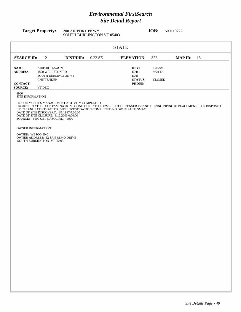
Environmental FirstSearchSite Detail Report
Target Property: 200 AIRPORT PKWY JOB: 509110222SOUTH BURLINGTON VT 05403
STATE
SEARCH ID: 12 DIST/DIR: 0.23 SE ELEVATION: 322 MAP ID: 13
NAME: AIRPORT EXXON REV: 12/3/09ADDRESS: 1800 WILLISTON RD ID1: 972140
SOUTH BURLINGTON VT ID2: CHITTENDEN STATUS: CLOSED
CONTACT: PHONE: SOURCE: VT DEC
Site Details Page - 40
6900SITE INFORMATION
PRIORITY: SITES MANAGEMENT ACTIVITY COMPLETEDPROJECT STATUS: CONTAMINATION FOUND BENEATH FORMER UST DISPENSER ISLAND DURING PIPING REPLACEMENT. PCS DISPOSEDBY CLEANUP CONTRACTOR, SITE INVESTIGATION COMPLETED.NO GW IMPACT. SMAC.DATE OF SITE DISCOVERY: 1/1/1997 0:00:00DATE OF SITE CLOSURE: 8/12/2003 0:00:00SOURCE: 6900 UST-GASOLINE, 6900
OWNER INFORMATION:
OWNER: WESCO, INCOWNER ADDRESS: 32 SAN REMO DRIVESOUTH BURLINGTON VT 05403
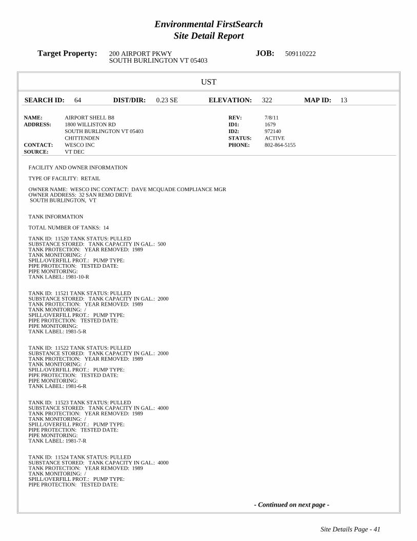
Environmental FirstSearchSite Detail Report
Target Property: 200 AIRPORT PKWY JOB: 509110222SOUTH BURLINGTON VT 05403
UST
SEARCH ID: 64 DIST/DIR: 0.23 SE ELEVATION: 322 MAP ID: 13
NAME: AIRPORT SHELL B8 REV: 7/8/11ADDRESS: 1800 WILLISTON RD ID1: 1679
SOUTH BURLINGTON VT 05403 ID2: 972140CHITTENDEN STATUS: ACTIVE
CONTACT: WESCO INC PHONE: 802-864-5155SOURCE: VT DEC
Site Details Page - 41
- Continued on next page -
FACILITY AND OWNER INFORMATION
TYPE OF FACILITY: RETAIL
OWNER NAME: WESCO INCCONTACT: DAVE MCQUADE COMPLIANCE MGROWNER ADDRESS: 32 SAN REMO DRIVESOUTH BURLINGTON, VT
TANK INFORMATION
TOTAL NUMBER OF TANKS: 14
TANK ID: 11520TANK STATUS:PULLEDSUBSTANCE STORED: TANK CAPACITY IN GAL.: 500TANK PROTECTION: YEAR REMOVED: 1989TANK MONITORING: /SPILL/OVERFILL PROT.: PUMP TYPE:PIPE PROTECTION: TESTED DATE:PIPE MONITORING:TANK LABEL:1981-10-R
TANK ID: 11521TANK STATUS:PULLEDSUBSTANCE STORED: TANK CAPACITY IN GAL.: 2000TANK PROTECTION: YEAR REMOVED: 1989TANK MONITORING: /SPILL/OVERFILL PROT.: PUMP TYPE:PIPE PROTECTION: TESTED DATE:PIPE MONITORING:TANK LABEL:1981-5-R
TANK ID: 11522TANK STATUS:PULLEDSUBSTANCE STORED: TANK CAPACITY IN GAL.: 2000TANK PROTECTION: YEAR REMOVED: 1989TANK MONITORING: /SPILL/OVERFILL PROT.: PUMP TYPE:PIPE PROTECTION: TESTED DATE:PIPE MONITORING:TANK LABEL:1981-6-R
TANK ID: 11523TANK STATUS:PULLEDSUBSTANCE STORED: TANK CAPACITY IN GAL.: 4000TANK PROTECTION: YEAR REMOVED: 1989TANK MONITORING: /SPILL/OVERFILL PROT.: PUMP TYPE:PIPE PROTECTION: TESTED DATE:PIPE MONITORING:TANK LABEL:1981-7-R
TANK ID: 11524TANK STATUS:PULLEDSUBSTANCE STORED: TANK CAPACITY IN GAL.: 4000TANK PROTECTION: YEAR REMOVED: 1989TANK MONITORING: /SPILL/OVERFILL PROT.: PUMP TYPE:PIPE PROTECTION: TESTED DATE:

Environmental FirstSearchSite Detail Report
Target Property: 200 AIRPORT PKWY JOB: 509110222SOUTH BURLINGTON VT 05403
UST
SEARCH ID: 64 DIST/DIR: 0.23 SE ELEVATION: 322 MAP ID: 13
NAME: AIRPORT SHELL B8 REV: 7/8/11ADDRESS: 1800 WILLISTON RD ID1: 1679
SOUTH BURLINGTON VT 05403 ID2: 972140CHITTENDEN STATUS: ACTIVE
CONTACT: WESCO INC PHONE: 802-864-5155SOURCE: VT DEC
Site Details Page - 42
- Continued on next page -
PIPE MONITORING:TANK LABEL:1981-8-R
TANK ID: 11525TANK STATUS:PULLEDSUBSTANCE STORED: TANK CAPACITY IN GAL.: 500TANK PROTECTION: YEAR REMOVED: 1989TANK MONITORING: /SPILL/OVERFILL PROT.: PUMP TYPE:PIPE PROTECTION: TESTED DATE:PIPE MONITORING:TANK LABEL:1981-9-R
TANK ID: 11526TANK STATUS:PULLEDSUBSTANCE STORED: TANK CAPACITY IN GAL.: 8000TANK PROTECTION: YEAR REMOVED: 1996TANK MONITORING: /SPILL/OVERFILL PROT.: PUMP TYPE:PIPE PROTECTION: TESTED DATE:PIPE MONITORING:TANK LABEL:1986-1-R
TANK ID: 11527TANK STATUS:PULLEDSUBSTANCE STORED: TANK CAPACITY IN GAL.: 6000TANK PROTECTION: YEAR REMOVED: 1996TANK MONITORING: /SPILL/OVERFILL PROT.: PUMP TYPE:PIPE PROTECTION: TESTED DATE:PIPE MONITORING:TANK LABEL:1986-2-R
TANK ID: 11528TANK STATUS:PULLEDSUBSTANCE STORED: TANK CAPACITY IN GAL.: 6000TANK PROTECTION: YEAR REMOVED: 1996TANK MONITORING: /SPILL/OVERFILL PROT.: PUMP TYPE:PIPE PROTECTION: TESTED DATE:PIPE MONITORING:TANK LABEL:1986-3-R
TANK ID: 11529TANK STATUS:PULLEDSUBSTANCE STORED: TANK CAPACITY IN GAL.: 4000TANK PROTECTION: YEAR REMOVED: 1996TANK MONITORING: /SPILL/OVERFILL PROT.: PUMP TYPE:PIPE PROTECTION: TESTED DATE:PIPE MONITORING:TANK LABEL:1986-4-R
TANK ID: 11530TANK STATUS:ACTIVESUBSTANCE STORED: TANK CAPACITY IN GAL.: 4000TANK PROTECTION: PROTECTED STEELYEAR REMOVED:TANK MONITORING: /

Environmental FirstSearchSite Detail Report
Target Property: 200 AIRPORT PKWY JOB: 509110222SOUTH BURLINGTON VT 05403
UST
SEARCH ID: 64 DIST/DIR: 0.23 SE ELEVATION: 322 MAP ID: 13
NAME: AIRPORT SHELL B8 REV: 7/8/11ADDRESS: 1800 WILLISTON RD ID1: 1679
SOUTH BURLINGTON VT 05403 ID2: 972140CHITTENDEN STATUS: ACTIVE
CONTACT: WESCO INC PHONE: 802-864-5155SOURCE: VT DEC
Site Details Page - 43
SPILL/OVERFILL PROT.: PUMP TYPE:PIPE PROTECTION: TESTED DATE:PIPE MONITORING: INTERSTITIAL ELECTRONICTANK LABEL:1989-1
TANK ID: 11531TANK STATUS:ACTIVESUBSTANCE STORED: TANK CAPACITY IN GAL.: 8000TANK PROTECTION: PROTECTED STEELYEAR REMOVED:TANK MONITORING: /SPILL/OVERFILL PROT.: PUMP TYPE:PIPE PROTECTION: TESTED DATE:PIPE MONITORING: INTERSTITIAL ELECTRONICTANK LABEL:1989-2-M
TANK ID: 11532TANK STATUS:ACTIVESUBSTANCE STORED: TANK CAPACITY IN GAL.: 6000TANK PROTECTION: PROTECTED STEELYEAR REMOVED:TANK MONITORING: /SPILL/OVERFILL PROT.: PUMP TYPE:PIPE PROTECTION: TESTED DATE:PIPE MONITORING: INTERSTITIAL ELECTRONICTANK LABEL:1989-3-M
TANK ID: 11533TANK STATUS:ACTIVESUBSTANCE STORED: TANK CAPACITY IN GAL.: 6000TANK PROTECTION: PROTECTED STEELYEAR REMOVED:TANK MONITORING: /SPILL/OVERFILL PROT.: PUMP TYPE:PIPE PROTECTION: TESTED DATE:PIPE MONITORING: INTERSTITIAL ELECTRONICTANK LABEL:1989-4

Environmental FirstSearchSite Detail Report
Target Property: 200 AIRPORT PKWY JOB: 509110222SOUTH BURLINGTON VT 05403
RCRAGN
SEARCH ID: 8 DIST/DIR: 0.24 SE ELEVATION: 326 MAP ID: 14
NAME: KINNEY DRUGS #55 REV: 7/11/11ADDRESS: 1653 WILLISTON RD ID1: VTR000514992
SOUTH BURLINGTON VT 05403 ID2: CHITTENDEN STATUS: VGN
CONTACT: PHONE: SOURCE: EPA
Site Details Page - 44
SITE INFORMATION
CONTACT INFORMATION: DAVID SIMPSON1653 WILLISTON RDSOUTH BURLINGTON VT 5403
PHONE: (802)860-0714
NAIC INFORMATION
44611 -812922 -
HAZARDOUS WASTE
D011 - Silver

Environmental FirstSearchSite Detail Report
Target Property: 200 AIRPORT PKWY JOB: 509110222SOUTH BURLINGTON VT 05403
LUST
SEARCH ID: 76 DIST/DIR: 0.24 SW ELEVATION: 338 MAP ID: 15
NAME: MERRIAM-GRAVES COMPANY REV: 7/8/11ADDRESS: 1550 WILLISTON RD ID1: 8636826
SOUTH BURLINGTON VT 05401 ID2: CHITTENDEN STATUS: PULLED UST DATABASE
CONTACT: MERRIAM-GRAVES CORPORATION PHONE: SOURCE: VT DEC
Site Details Page - 45
This site comes from the Vermont Department of Environmental Conservation Pulled Underground Storage Tanks database and may or may not be considered aleaking underground storage tank , please review the data below for further indications of contamination.
SITE FINDINGS: NO STATE INSPECTION OR SITE ASSESMENT
FACILITY AND OWNER INFORMATION
TYPE OF FACILITY: INDUSTRIAL/COMMERCIAL
OWNER NAME: MERRIAM-GRAVES CORPORATIONCONTACT:OWNER ADDRESS: 1550 WILLISTON ROADSOUTH BURLINGTON, VT
LAND OWNER:** UNKNOWN ***PERMITTED TO:NUM OF PULLED TANKS:3NUM OF REMOVED TANKS:3NUM OF GROUNDWATER MONITORING WELLS:NUM OF VAPOR MONITORING WELLS:
TANK INFORMATION
TOTAL NUMBER OF TANKS: 3
TANK ID: 5090TANK STATUS:PULLEDSUBSTANCE STORED: TANK CAPACITY IN GAL.: 3000TANK PROTECTION: UNPROTECTED STEELYEAR REMOVED: 1987TANK MONITORING: /SPILL/OVERFILL PROT.: PUMP TYPE:PIPE PROTECTION: TESTED DATE:PIPE MONITORING:TANK LABEL:1956-1
TANK ID: 5091TANK STATUS:PULLEDSUBSTANCE STORED: TANK CAPACITY IN GAL.: 10000TANK PROTECTION: UNPROTECTED STEELYEAR REMOVED: 1987TANK MONITORING: /SPILL/OVERFILL PROT.: PUMP TYPE:PIPE PROTECTION: TESTED DATE:PIPE MONITORING:TANK LABEL:1956-2
TANK ID: 5092TANK STATUS:PULLEDSUBSTANCE STORED: TANK CAPACITY IN GAL.: 550TANK PROTECTION: UNPROTECTED STEELYEAR REMOVED: 1987TANK MONITORING: /SPILL/OVERFILL PROT.: PUMP TYPE:PIPE PROTECTION: TESTED DATE:PIPE MONITORING:TANK LABEL:1956-3
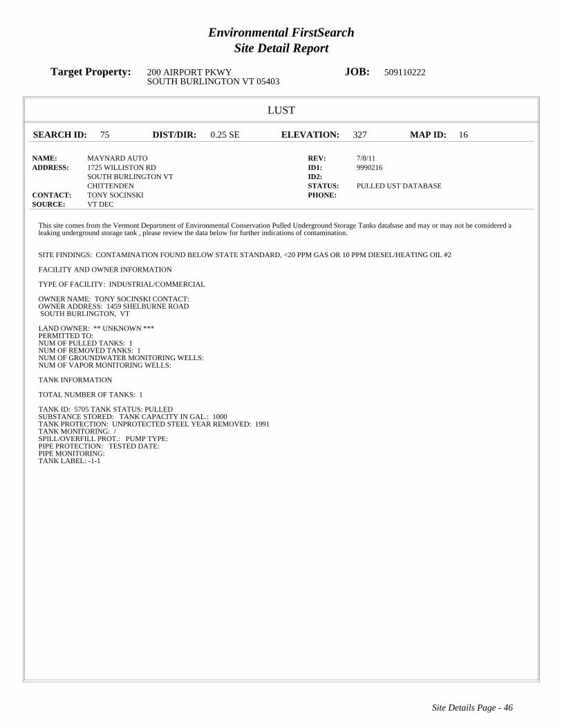
Environmental FirstSearchSite Detail Report
Target Property: 200 AIRPORT PKWY JOB: 509110222SOUTH BURLINGTON VT 05403
LUST
SEARCH ID: 75 DIST/DIR: 0.25 SE ELEVATION: 327 MAP ID: 16
NAME: MAYNARD AUTO REV: 7/8/11ADDRESS: 1725 WILLISTON RD ID1: 9990216
SOUTH BURLINGTON VT ID2: CHITTENDEN STATUS: PULLED UST DATABASE
CONTACT: TONY SOCINSKI PHONE: SOURCE: VT DEC
Site Details Page - 46
This site comes from the Vermont Department of Environmental Conservation Pulled Underground Storage Tanks database and may or may not be considered aleaking underground storage tank , please review the data below for further indications of contamination.
SITE FINDINGS: CONTAMINATION FOUND BELOW STATE STANDARD, <20 PPM GAS OR 10 PPM DIESEL/HEATING OIL #2
FACILITY AND OWNER INFORMATION
TYPE OF FACILITY: INDUSTRIAL/COMMERCIAL
OWNER NAME: TONY SOCINSKICONTACT:OWNER ADDRESS: 1459 SHELBURNE ROADSOUTH BURLINGTON, VT
LAND OWNER:** UNKNOWN ***PERMITTED TO:NUM OF PULLED TANKS:1NUM OF REMOVED TANKS:1NUM OF GROUNDWATER MONITORING WELLS:NUM OF VAPOR MONITORING WELLS:
TANK INFORMATION
TOTAL NUMBER OF TANKS: 1
TANK ID: 5705TANK STATUS:PULLEDSUBSTANCE STORED: TANK CAPACITY IN GAL.: 1000TANK PROTECTION: UNPROTECTED STEELYEAR REMOVED: 1991TANK MONITORING: /SPILL/OVERFILL PROT.: PUMP TYPE:PIPE PROTECTION: TESTED DATE:PIPE MONITORING:TANK LABEL:-1-1

Environmental FirstSearchSite Detail Report
Target Property: 200 AIRPORT PKWY JOB: 509110222SOUTH BURLINGTON VT 05403
STATE
SEARCH ID: 13 DIST/DIR: 0.32 SE ELEVATION: 306 MAP ID: 17
NAME: AIRPORT MOBIL REV: 7/8/11ADDRESS: 1801 WILLISTON RD ID1: 900632
SOUTH BURLINGTON VT ID2: CHITTENDEN STATUS: ACTIVE
CONTACT: PHONE: SOURCE: VT DEC
Site Details Page - 47
6900SITE INFORMATION
PRIORITY: NO SENSITIVE RECEPTOR IMPACT (VT SITE PRIORITY SCORE<30)PROJECT STATUS: MONITORING ONGOING FOLLOWING UST REMOVAL AND ASSESSMENT. DURING 2008 PIPING REPLACEMENT, PCSSREMOVED AND DISPOSED AND SVE PIPING OPERATED TO RECOVER VOCS. SYSTEM DISCONTINUED IN 1/2011.DATE OF SITE DISCOVERY: 1/1/1990 0:00:00DATE OF SITE CLOSURE:SOURCE: 6900 UST-GASOLINE, 6900
OWNER INFORMATION:
OWNER: MOBIL OIL CORPOWNER ADDRESS: 187 WOLF RDALBANY NY 12205
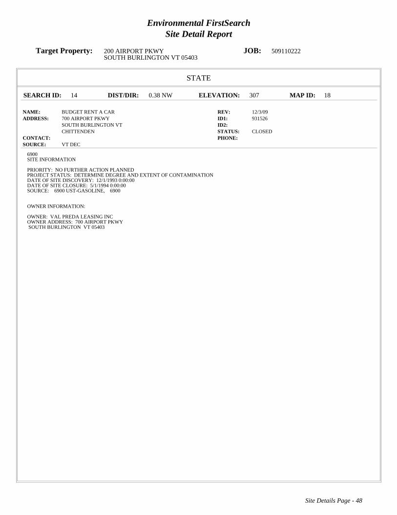
Environmental FirstSearchSite Detail Report
Target Property: 200 AIRPORT PKWY JOB: 509110222SOUTH BURLINGTON VT 05403
STATE
SEARCH ID: 14 DIST/DIR: 0.38 NW ELEVATION: 307 MAP ID: 18
NAME: BUDGET RENT A CAR REV: 12/3/09ADDRESS: 700 AIRPORT PKWY ID1: 931526
SOUTH BURLINGTON VT ID2: CHITTENDEN STATUS: CLOSED
CONTACT: PHONE: SOURCE: VT DEC
Site Details Page - 48
6900SITE INFORMATION
PRIORITY: NO FURTHER ACTION PLANNEDPROJECT STATUS: DETERMINE DEGREE AND EXTENT OF CONTAMINATIONDATE OF SITE DISCOVERY: 12/1/1993 0:00:00DATE OF SITE CLOSURE: 5/1/1994 0:00:00SOURCE: 6900 UST-GASOLINE, 6900
OWNER INFORMATION:
OWNER: VAL PREDA LEASING INCOWNER ADDRESS: 700 AIRPORT PKWYSOUTH BURLINGTON VT 05403

Environmental FirstSearchSite Detail Report
Target Property: 200 AIRPORT PKWY JOB: 509110222SOUTH BURLINGTON VT 05403
LUST
SEARCH ID: 68 DIST/DIR: 0.38 NW ELEVATION: 307 MAP ID: 18
NAME: BUDGET RENT A CAR REV: 7/8/11ADDRESS: 700 AIRPORT PKWY ID1: 621
SOUTH BURLINGTON VT 05403 ID2: 931526CHITTENDEN STATUS: PULLED UST DATABASE
CONTACT: VAL PREDA LEASING INC PHONE: 802-863-5512SOURCE: VT DEC
Site Details Page - 49
This site comes from the Vermont Department of Environmental Conservation Pulled Underground Storage Tanks database and may or may not be considered aleaking underground storage tank , please review the data below for further indications of contamination.
SITE FINDINGS: CONTAMINATION FOUND ABOVE STATE STANDARD. REFERRED TO SITE MANAGEMENT
FACILITY AND OWNER INFORMATION
TYPE OF FACILITY: INDUSTRIAL/COMMERCIAL
OWNER NAME: VAL PREDA LEASING INCCONTACT: PETER VAL PREDA, PRESIDENTOWNER ADDRESS: 700 AIRPORT PARKWAYSOUTH BURLINGTON, VT
LAND OWNER:** UNKNOWN ***PERMITTED TO:TANK OWNERNUM OF PULLED TANKS:2NUM OF REMOVED TANKS:2NUM OF GROUNDWATER MONITORING WELLS:NUM OF VAPOR MONITORING WELLS:
TANK INFORMATION
TOTAL NUMBER OF TANKS: 2
TANK ID: 529TANK STATUS:PULLEDSUBSTANCE STORED: TANK CAPACITY IN GAL.: 4000TANK PROTECTION: UNPROTECTED STEELYEAR REMOVED: 1993TANK MONITORING: /SPILL/OVERFILL PROT.: PUMP TYPE:PIPE PROTECTION: TESTED DATE:PIPE MONITORING:TANK LABEL:1981-1
TANK ID: 530TANK STATUS:PULLEDSUBSTANCE STORED: TANK CAPACITY IN GAL.: 500TANK PROTECTION: UNPROTECTED STEELYEAR REMOVED: UNKTANK MONITORING: /SPILL/OVERFILL PROT.: PUMP TYPE:PIPE PROTECTION: TESTED DATE:PIPE MONITORING:TANK LABEL:1981-2

Environmental FirstSearchSite Detail Report
Target Property: 200 AIRPORT PKWY JOB: 509110222SOUTH BURLINGTON VT 05403
STATE
SEARCH ID: 31 DIST/DIR: 0.40 SE ELEVATION: 292 MAP ID: 19
NAME: NORTHERN RENT A CAR REV: 12/3/09ADDRESS: 1890 WILLISTON RD ID1: 931406
SOUTH BURLINGTON VT ID2: CHITTENDEN STATUS: CLOSED
CONTACT: PHONE: SOURCE: VT DEC
Site Details Page - 50
6900SITE INFORMATION
PRIORITY: NO FURTHER ACTION PLANNEDPROJECT STATUS: SITE INVEST COMPLETE, SITE CLOSEDDATE OF SITE DISCOVERY:DATE OF SITE CLOSURE: 7/1/1994 0:00:00SOURCE: 6900 UST-GASOLINE, 6900
OWNER INFORMATION:
OWNER: NORTHERN RENT A CAROWNER ADDRESS: 1890 WILLISTON RDSOUTH BURLINGTON VT 05403

Environmental FirstSearchSite Detail Report
Target Property: 200 AIRPORT PKWY JOB: 509110222SOUTH BURLINGTON VT 05403
STATE
SEARCH ID: 25 DIST/DIR: 0.40 SE ELEVATION: 297 MAP ID: 20
NAME: HOWARD BANK-WILLISTON RD. REV: 12/3/09ADDRESS: 0 WILLISTON RD ID1: 911055
SOUTH BURLINGTON VT ID2: STATUS: CLOSED
CONTACT: PHONE: SOURCE: VT DEC
Site Details Page - 51
6900SITE INFORMATION
PRIORITY: NO FURTHER ACTION PLANNEDPROJECT STATUS: SITE ASSESSMENT FOUND CONTAMINATION. MONITORING TO CONTINUE.DATE OF SITE DISCOVERY:DATE OF SITE CLOSURE: 7/6/1992 0:00:00SOURCE: 6900
OWNER INFORMATION:
OWNER:OWNER ADDRESS:

Environmental FirstSearchSite Detail Report
Target Property: 200 AIRPORT PKWY JOB: 509110222SOUTH BURLINGTON VT 05403
STATE
SEARCH ID: 18 DIST/DIR: 0.42 SE ELEVATION: 300 MAP ID: 21
NAME: CRW CORP REV: 12/3/09ADDRESS: 1879 WILLISTON RD ID1: 20033139
SOUTH BURLINGTON VT ID2: CHITTENDEN STATUS: CLOSED
CONTACT: PHONE: SOURCE: VT DEC
Site Details Page - 52
6900SITE INFORMATION
PRIORITY: SITES MANAGEMENT ACTIVITY COMPLETEDPROJECT STATUS: 2800 GALLON WASTE OIL TANK REMOVED 8/14/03. 4 MONITORING WELLS INSTALLED; ONE WELL CONTAINS 124TMBAND 135TMB IN EXCESS OF STANDARDS. A NOTICE WAS PLACED IN THE LAND RECORD. ALL ONSITE MONITORING WELLS WEREPROPERLY CLOSED..DATE OF SITE DISCOVERY: 8/20/2003 0:00:00DATE OF SITE CLOSURE: 3/30/2004 0:00:00SOURCE: 6900 UST-WASTE OIL, 6900
OWNER INFORMATION:
OWNER: BOB WOODSOWNER ADDRESS: P.O. BOX 1099WILLISTON VT 05495

Environmental FirstSearchSite Detail Report
Target Property: 200 AIRPORT PKWY JOB: 509110222SOUTH BURLINGTON VT 05403
LUST
SEARCH ID: 47 DIST/DIR: 0.42 SE ELEVATION: 300 MAP ID: 21
NAME: CRW CORPORATION REV: 7/8/11ADDRESS: 1879 WILLISTON RD ID1: 5555758
SOUTH BURLINGTON VT ID2: 20033139CHITTENDEN STATUS: PULLED UST DATABASE
CONTACT: CRW CORPORATION PHONE: SOURCE: VT DEC
Site Details Page - 53
This site comes from the Vermont Department of Environmental Conservation Pulled Underground Storage Tanks database and may or may not be considered aleaking underground storage tank , please review the data below for further indications of contamination.
SITE FINDINGS: CONTAMINATION FOUND ABOVE STATE STANDARD. REFERRED TO SITE MANAGEMENT
FACILITY AND OWNER INFORMATION
TYPE OF FACILITY: INDUSTRIAL/COMMERICAL
OWNER NAME: CRW CORPORATIONCONTACT: BOB WOODOWNER ADDRESS: 795 MARSHALL AVENUEWILLISTON, VT
LAND OWNER:** UNKNOWN ***PERMITTED TO:NUM OF PULLED TANKS:1NUM OF REMOVED TANKS:1NUM OF GROUNDWATER MONITORING WELLS:NUM OF VAPOR MONITORING WELLS:
TANK INFORMATION
TOTAL NUMBER OF TANKS: 1
TANK ID: 4258TANK STATUS:PULLEDSUBSTANCE STORED: TANK CAPACITY IN GAL.: 2800TANK PROTECTION: YEAR REMOVED: 2003TANK MONITORING: /SPILL/OVERFILL PROT.: PUMP TYPE:PIPE PROTECTION: TESTED DATE:PIPE MONITORING:TANK LABEL:-1-1-R

Environmental FirstSearchSite Detail Report
Target Property: 200 AIRPORT PKWY JOB: 509110222SOUTH BURLINGTON VT 05403
LUST
SEARCH ID: 54 DIST/DIR: 0.46 NE ELEVATION: 308 MAP ID: 22
NAME: VERMONT AIR NATIONAL GUARD REV: 7/8/11ADDRESS: 105 NCO DRIVE/BURLINGTON AIRPORT ID1: 1995
SOUTH BURLINGTON VT 05403 ID2: 770043 STATUS: PULLED UST DATABASE
CONTACT: VERMONT AIR NATIONAL GUARD PHONE: 802-660-5966SOURCE: VT DEC
Site Details Page - 54
- Continued on next page -
This site comes from the Vermont Department of Environmental Conservation Pulled Underground Storage Tanks database and may or may not be considered aleaking underground storage tank , please review the data below for further indications of contamination.
SITE FINDINGS: CONTAMINATION FOUND ABOVE STATE STANDARD. REFERRED TO SITE MANAGEMENT
FACILITY AND OWNER INFORMATION
TYPE OF FACILITY: STATE
OWNER NAME: VERMONT AIR NATIONAL GUARDCONTACT: MATTHEW R COTE MAJOROWNER ADDRESS: 105 NCO DRIVESOUTH BURLINGTON, VT
LAND OWNER:** UNKNOWN ***PERMITTED TO:TANK OWNERNUM OF PULLED TANKS:61NUM OF REMOVED TANKS:61NUM OF GROUNDWATER MONITORING WELLS:NUM OF VAPOR MONITORING WELLS:
TANK INFORMATION
TOTAL NUMBER OF TANKS: 61
TANK ID: 1936TANK STATUS:PULLEDSUBSTANCE STORED: TANK CAPACITY IN GAL.: 550TANK PROTECTION: YEAR REMOVED: 1997TANK MONITORING: /SPILL/OVERFILL PROT.: PUMP TYPE:PIPE PROTECTION: TESTED DATE:PIPE MONITORING:TANK LABEL:1991-55
TANK ID: 1935TANK STATUS:PULLEDSUBSTANCE STORED: TANK CAPACITY IN GAL.: 1000TANK PROTECTION: YEAR REMOVED: 1995TANK MONITORING: /SPILL/OVERFILL PROT.: PUMP TYPE:PIPE PROTECTION: TESTED DATE:PIPE MONITORING:TANK LABEL:1987-40
TANK ID: 1934TANK STATUS:PULLEDSUBSTANCE STORED: TANK CAPACITY IN GAL.: 1000TANK PROTECTION: YEAR REMOVED: 1995TANK MONITORING: /SPILL/OVERFILL PROT.: PUMP TYPE:PIPE PROTECTION: TESTED DATE:PIPE MONITORING:TANK LABEL:1987-39
TANK ID: 1917TANK STATUS:PULLEDSUBSTANCE STORED: TANK CAPACITY IN GAL.: 2000TANK PROTECTION: YEAR REMOVED: 1994TANK MONITORING: /

Environmental FirstSearchSite Detail Report
Target Property: 200 AIRPORT PKWY JOB: 509110222SOUTH BURLINGTON VT 05403
LUST
SEARCH ID: 54 DIST/DIR: 0.46 NE ELEVATION: 308 MAP ID: 22
NAME: VERMONT AIR NATIONAL GUARD REV: 7/8/11ADDRESS: 105 NCO DRIVE/BURLINGTON AIRPORT ID1: 1995
SOUTH BURLINGTON VT 05403 ID2: 770043 STATUS: PULLED UST DATABASE
CONTACT: VERMONT AIR NATIONAL GUARD PHONE: 802-660-5966SOURCE: VT DEC
Site Details Page - 55
- Continued on next page -
PIPE PROTECTION: TESTED DATE:PIPE MONITORING:TANK LABEL:1979-15
TANK ID: 1937TANK STATUS:PULLEDSUBSTANCE STORED: TANK CAPACITY IN GAL.: 3000TANK PROTECTION: YEAR REMOVED: 1997TANK MONITORING: /SPILL/OVERFILL PROT.: PUMP TYPE:PIPE PROTECTION: TESTED DATE:PIPE MONITORING:TANK LABEL:1991-56
TANK ID: 1916TANK STATUS:PULLEDSUBSTANCE STORED: TANK CAPACITY IN GAL.: 4000TANK PROTECTION: YEAR REMOVED: 1994TANK MONITORING: /SPILL/OVERFILL PROT.: PUMP TYPE:PIPE PROTECTION: TESTED DATE:PIPE MONITORING:TANK LABEL:1978-10
TANK ID: 1933TANK STATUS:PULLEDSUBSTANCE STORED: TANK CAPACITY IN GAL.: 2000TANK PROTECTION: YEAR REMOVED: 1994TANK MONITORING: /SPILL/OVERFILL PROT.: PUMP TYPE:PIPE PROTECTION: TESTED DATE:PIPE MONITORING:TANK LABEL:1986-6
TANK ID: 1915TANK STATUS:PULLEDSUBSTANCE STORED: TANK CAPACITY IN GAL.: 275TANK PROTECTION: YEAR REMOVED: 1994TANK MONITORING: /SPILL/OVERFILL PROT.: PUMP TYPE:PIPE PROTECTION: TESTED DATE:PIPE MONITORING:TANK LABEL:1975-42
TANK ID: 1914TANK STATUS:PULLEDSUBSTANCE STORED: TANK CAPACITY IN GAL.: 1000TANK PROTECTION: YEAR REMOVED: 1994TANK MONITORING: /SPILL/OVERFILL PROT.: PUMP TYPE:PIPE PROTECTION: TESTED DATE:PIPE MONITORING:TANK LABEL:1975-28
TANK ID: 1913TANK STATUS:PULLEDSUBSTANCE STORED: TANK CAPACITY IN GAL.: 10000TANK PROTECTION: YEAR REMOVED: 1994

Environmental FirstSearchSite Detail Report
Target Property: 200 AIRPORT PKWY JOB: 509110222SOUTH BURLINGTON VT 05403
LUST
SEARCH ID: 54 DIST/DIR: 0.46 NE ELEVATION: 308 MAP ID: 22
NAME: VERMONT AIR NATIONAL GUARD REV: 7/8/11ADDRESS: 105 NCO DRIVE/BURLINGTON AIRPORT ID1: 1995
SOUTH BURLINGTON VT 05403 ID2: 770043 STATUS: PULLED UST DATABASE
CONTACT: VERMONT AIR NATIONAL GUARD PHONE: 802-660-5966SOURCE: VT DEC
Site Details Page - 56
- More Details Exist For This Site; Max Page Limit Reached -
TANK MONITORING: /SPILL/OVERFILL PROT.: PUMP TYPE:PIPE PROTECTION: TESTED DATE:PIPE MONITORING:TANK LABEL:1973-4
TANK ID: 1938TANK STATUS:PULLEDSUBSTANCE STORED: TANK CAPACITY IN GAL.: 500TANK PROTECTION: YEAR REMOVED: 1997TANK MONITORING: /SPILL/OVERFILL PROT.: PUMP TYPE:PIPE PROTECTION: TESTED DATE:PIPE MONITORING:TANK LABEL:1991-57
TANK ID: 1911TANK STATUS:PULLEDSUBSTANCE STORED: TANK CAPACITY IN GAL.: 5000TANK PROTECTION: YEAR REMOVED: 1994TANK MONITORING: /SPILL/OVERFILL PROT.: PUMP TYPE:PIPE PROTECTION: TESTED DATE:PIPE MONITORING:TANK LABEL:1971-13
TANK ID: 1929TANK STATUS:PULLEDSUBSTANCE STORED: TANK CAPACITY IN GAL.: 20000TANK PROTECTION: YEAR REMOVED: UNKTANK MONITORING: /SPILL/OVERFILL PROT.: PUMP TYPE:PIPE PROTECTION: TESTED DATE:PIPE MONITORING:TANK LABEL:1985-48
TANK ID: 1912TANK STATUS:PULLEDSUBSTANCE STORED: TANK CAPACITY IN GAL.: 5000TANK PROTECTION: YEAR REMOVED: 1994TANK MONITORING: /SPILL/OVERFILL PROT.: PUMP TYPE:PIPE PROTECTION: TESTED DATE:PIPE MONITORING:TANK LABEL:1971-38
TANK ID: 1924TANK STATUS:PULLEDSUBSTANCE STORED: TANK CAPACITY IN GAL.: 20000TANK PROTECTION: YEAR REMOVED: 1991TANK MONITORING: /SPILL/OVERFILL PROT.: PUMP TYPE:PIPE PROTECTION: TESTED DATE:PIPE MONITORING:TANK LABEL:1983-50
TANK ID: 1925TANK STATUS:PULLED

Environmental FirstSearchSite Detail Report
Target Property: 200 AIRPORT PKWY JOB: 509110222SOUTH BURLINGTON VT 05403
LUST
SEARCH ID: 73 DIST/DIR: 0.47 SE ELEVATION: 341 MAP ID: 23
NAME: KNEELAND FLIGHT FACILITY REV: 7/8/11ADDRESS: 0 BLDG 890 BURLINGTON AIRPORT ID1: 1037
SOUTH BURLINGTON VT 05402 ID2: CHITTENDEN STATUS: PULLED UST DATABASE
CONTACT: VERMONT MILITARY DEPARTMENT PHONE: 802-338-3041SOURCE: VT DEC
Site Details Page - 57
- Continued on next page -
This site comes from the Vermont Department of Environmental Conservation Pulled Underground Storage Tanks database and may or may not be considered aleaking underground storage tank , please review the data below for further indications of contamination.
SITE FINDINGS: CONTAMINATION FOUND BELOW STATE STANDARD, <20 PPM GAS OR 10 PPM DIESEL/HEATING OIL #2
FACILITY AND OWNER INFORMATION
TYPE OF FACILITY: STATE
OWNER NAME: VERMONT MILITARY DEPARTMENTCONTACT: LTC ROBERT J. GINGRASOWNER ADDRESS: BUILDING 14 CAMP JOHNSONCOLCHESTER, VT
LAND OWNER:VERMONT MILITARY DEPARTMENTPERMITTED TO:NUM OF PULLED TANKS:2/1/1NUM OF REMOVED TANKS:4NUM OF GROUNDWATER MONITORING WELLS:NUM OF VAPOR MONITORING WELLS:
TANK INFORMATION
TOTAL NUMBER OF TANKS: 4
TANK ID: 9900TANK STATUS:PULLEDSUBSTANCE STORED: TANK CAPACITY IN GAL.: 4450TANK PROTECTION: YEAR REMOVED: 1992TANK MONITORING: /SPILL/OVERFILL PROT.: PUMP TYPE:PIPE PROTECTION: TESTED DATE:PIPE MONITORING:TANK LABEL:1955-2-R
TANK ID: 9903TANK STATUS:PULLEDSUBSTANCE STORED: TANK CAPACITY IN GAL.: 10000TANK PROTECTION: PROTECTED STEELYEAR REMOVED: 2008TANK MONITORING: /SPILL/OVERFILL PROT.: PUMP TYPE:PIPE PROTECTION: TESTED DATE:PIPE MONITORING: INTERSTITIALTANK LABEL:1996-1
TANK ID: 9902TANK STATUS:PULLEDSUBSTANCE STORED: TANK CAPACITY IN GAL.: 10000TANK PROTECTION: YEAR REMOVED: 1996TANK MONITORING: /SPILL/OVERFILL PROT.: PUMP TYPE:PIPE PROTECTION: TESTED DATE:PIPE MONITORING:TANK LABEL:1972-1-R
TANK ID: 9901TANK STATUS:PULLEDSUBSTANCE STORED: TANK CAPACITY IN GAL.: 4450TANK PROTECTION: YEAR REMOVED: 1992TANK MONITORING: /

Environmental FirstSearchSite Detail Report
Target Property: 200 AIRPORT PKWY JOB: 509110222SOUTH BURLINGTON VT 05403
LUST
SEARCH ID: 73 DIST/DIR: 0.47 SE ELEVATION: 341 MAP ID: 23
NAME: KNEELAND FLIGHT FACILITY REV: 7/8/11ADDRESS: 0 BLDG 890 BURLINGTON AIRPORT ID1: 1037
SOUTH BURLINGTON VT 05402 ID2: CHITTENDEN STATUS: PULLED UST DATABASE
CONTACT: VERMONT MILITARY DEPARTMENT PHONE: 802-338-3041SOURCE: VT DEC
Site Details Page - 58
PIPE PROTECTION: TESTED DATE:PIPE MONITORING:TANK LABEL:1955-3-R

Environmental FirstSearchSite Detail Report
Target Property: 200 AIRPORT PKWY JOB: 509110222SOUTH BURLINGTON VT 05403
STATE
SEARCH ID: 29 DIST/DIR: 0.47 SE ELEVATION: 302 MAP ID: 24
NAME: NORTH COUNTRY RESTAURANT SERVICES PROPER REV: 12/3/09ADDRESS: 1891 WILLISTON RD ID1: 20033174
SOUTH BURLINGTON VT ID2: CHITTENDEN STATUS: CLOSED
CONTACT: PHONE: SOURCE: VT DEC
Site Details Page - 59
6900SITE INFORMATION
PRIORITY: SITES MANAGEMENT ACTIVITY COMPLETEDPROJECT STATUS: CONTAMINATION DISCOVERED DURING THE REMOVAL OF A GASOLINE UST. FOUR MONITORING WELLS SAMPLED ONADJACENT, DOWNGRADIENT PROPERTY THE MONTH BEFORE TANK WAS REMOVED, AND HAD NO SIGNIFICANT CONCENTRATIONS OFPETROLEUM CONTAMINATION. WATER AND SEWER SUPPLIED BY THE MUNICIPAL SYSTEM.DATE OF SITE DISCOVERY: 11/20/2003 0:00:00DATE OF SITE CLOSURE: 3/17/2010 0:00:00SOURCE: 6900 UST-GASOLINE, 6900
OWNER INFORMATION:
OWNER: LEE ZACHERYOWNER ADDRESS: 1891 WILLISTON RDSOUTH BURLINGTON VT 05403

Environmental FirstSearchSite Detail Report
Target Property: 200 AIRPORT PKWY JOB: 509110222SOUTH BURLINGTON VT 05403
LUST
SEARCH ID: 78 DIST/DIR: 0.47 SE ELEVATION: 302 MAP ID: 24
NAME: ZACHERY S REV: 7/8/11ADDRESS: 1891 WILLISTON RD ID1: 5559472
SOUTH BURLINGTON VT 05403 ID2: 20033177CHITTENDEN STATUS: PULLED UST DATABASE
CONTACT: NORTH COUNTRY RESTAURANT SERVICE PHONE: SOURCE: VT DEC
Site Details Page - 60
This site comes from the Vermont Department of Environmental Conservation Pulled Underground Storage Tanks database and may or may not be considered aleaking underground storage tank , please review the data below for further indications of contamination.
SITE FINDINGS: CONTAMINATION FOUND ABOVE STATE STANDARD. REFERRED TO SITE MANAGEMENT
FACILITY AND OWNER INFORMATION
TYPE OF FACILITY: INDUSTRIAL/COMMERICAL
OWNER NAME: NORTH COUNTRY RESTAURANT SERVICECONTACT: LEE ZACHERYOWNER ADDRESS: 1891 WILLISTON ROADSOUTH BURLINGTON, VT
LAND OWNER:** UNKNOWN ***PERMITTED TO:NUM OF PULLED TANKS:1NUM OF REMOVED TANKS:1NUM OF GROUNDWATER MONITORING WELLS:NUM OF VAPOR MONITORING WELLS:
TANK INFORMATION
TOTAL NUMBER OF TANKS: 1
TANK ID: 4583TANK STATUS:PULLEDSUBSTANCE STORED: TANK CAPACITY IN GAL.: 2000TANK PROTECTION: YEAR REMOVED: 2003TANK MONITORING: /SPILL/OVERFILL PROT.: PUMP TYPE:PIPE PROTECTION: TESTED DATE:PIPE MONITORING:TANK LABEL:-1-1-R
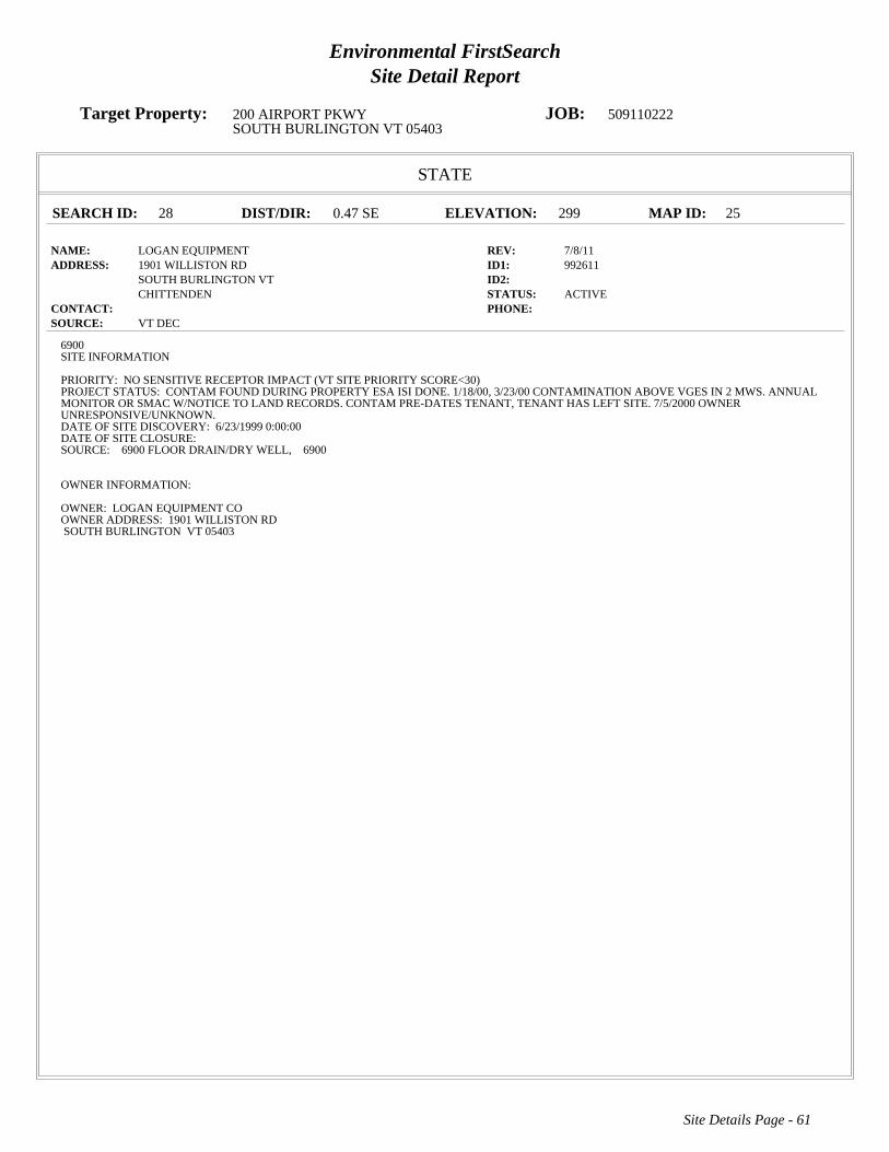
Environmental FirstSearchSite Detail Report
Target Property: 200 AIRPORT PKWY JOB: 509110222SOUTH BURLINGTON VT 05403
STATE
SEARCH ID: 28 DIST/DIR: 0.47 SE ELEVATION: 299 MAP ID: 25
NAME: LOGAN EQUIPMENT REV: 7/8/11ADDRESS: 1901 WILLISTON RD ID1: 992611
SOUTH BURLINGTON VT ID2: CHITTENDEN STATUS: ACTIVE
CONTACT: PHONE: SOURCE: VT DEC
Site Details Page - 61
6900SITE INFORMATION
PRIORITY: NO SENSITIVE RECEPTOR IMPACT (VT SITE PRIORITY SCORE<30)PROJECT STATUS: CONTAM FOUND DURING PROPERTY ESA ISI DONE. 1/18/00, 3/23/00 CONTAMINATION ABOVE VGES IN 2 MWS. ANNUALMONITOR OR SMAC W/NOTICE TO LAND RECORDS. CONTAM PRE-DATES TENANT, TENANT HAS LEFT SITE. 7/5/2000 OWNERUNRESPONSIVE/UNKNOWN.DATE OF SITE DISCOVERY: 6/23/1999 0:00:00DATE OF SITE CLOSURE:SOURCE: 6900 FLOOR DRAIN/DRY WELL, 6900
OWNER INFORMATION:
OWNER: LOGAN EQUIPMENT COOWNER ADDRESS: 1901 WILLISTON RDSOUTH BURLINGTON VT 05403

Environmental FirstSearchSite Detail Report
Target Property: 200 AIRPORT PKWY JOB: 509110222SOUTH BURLINGTON VT 05403
LUST
SEARCH ID: 74 DIST/DIR: 0.50 SE ELEVATION: 304 MAP ID: 26
NAME: LAKE CHAMPLAIN SUBARU REV: 7/8/11ADDRESS: 1907 WILLISTON RD ID1: 9990215
SOUTH BURLINGTON VT ID2: CHITTENDEN STATUS: PULLED UST DATABASE
CONTACT: DOROTHY MAYO PHONE: SOURCE: VT DEC
Site Details Page - 62
This site comes from the Vermont Department of Environmental Conservation Pulled Underground Storage Tanks database and may or may not be considered aleaking underground storage tank , please review the data below for further indications of contamination.
SITE FINDINGS: CONTAMINATION FOUND BELOW STATE STANDARD, <20 PPM GAS OR 10 PPM DIESEL/HEATING OIL #2
FACILITY AND OWNER INFORMATION
TYPE OF FACILITY: INDUSTRIAL/COMMERCIAL
OWNER NAME: DOROTHY MAYOCONTACT:OWNER ADDRESS: 1977 WILLISTON ROADSOUTH BURLINGTON, VT
LAND OWNER:** UNKNOWN ***PERMITTED TO:NUM OF PULLED TANKS:1NUM OF REMOVED TANKS:1NUM OF GROUNDWATER MONITORING WELLS:NUM OF VAPOR MONITORING WELLS:
TANK INFORMATION
TOTAL NUMBER OF TANKS: 1
TANK ID: 5704TANK STATUS:PULLEDSUBSTANCE STORED: TANK CAPACITY IN GAL.: 500TANK PROTECTION: UNPROTECTED STEELYEAR REMOVED: 1991TANK MONITORING: /SPILL/OVERFILL PROT.: PUMP TYPE:PIPE PROTECTION: TESTED DATE:PIPE MONITORING:TANK LABEL:-1-1

Environmental FirstSearchSite Detail Report
Target Property: 200 AIRPORT PKWY JOB: 509110222SOUTH BURLINGTON VT 05403
STATE
SEARCH ID: 57 DIST/DIR: 0.53 SW ELEVATION: 315 MAP ID: 27
NAME: U S POST OFFICE REV: 12/3/09ADDRESS: 60 WHITE ST ID1: 972299
SOUTH BURLINGTON VT ID2: CHITTENDEN STATUS: CLOSED
CONTACT: PHONE: SOURCE: VT DEC
Site Details Page - 63
6900SITE INFORMATION
PRIORITY: SITES MANAGEMENT ACTIVITY COMPLETEDPROJECT STATUS: UST REMOVED. CONTAMINATION FOUND. INVESTIGATION PERFORMED AND PCS EXCAVATED/DISPOSED OF AT ESMI.MWS HAVE BEEN PROPERLY ABANDONED. RONALD ROBBINS OF USPS IS OFFICIAL CONTACT.DATE OF SITE DISCOVERY: 11/1/1997 0:00:00DATE OF SITE CLOSURE: 1/12/2006 0:00:00SOURCE: 6900 UST-HEATING OIL, 6900
OWNER INFORMATION:
OWNER: M A PARSONS AND SONSOWNER ADDRESS: P O BOX 450YORK ME 03909
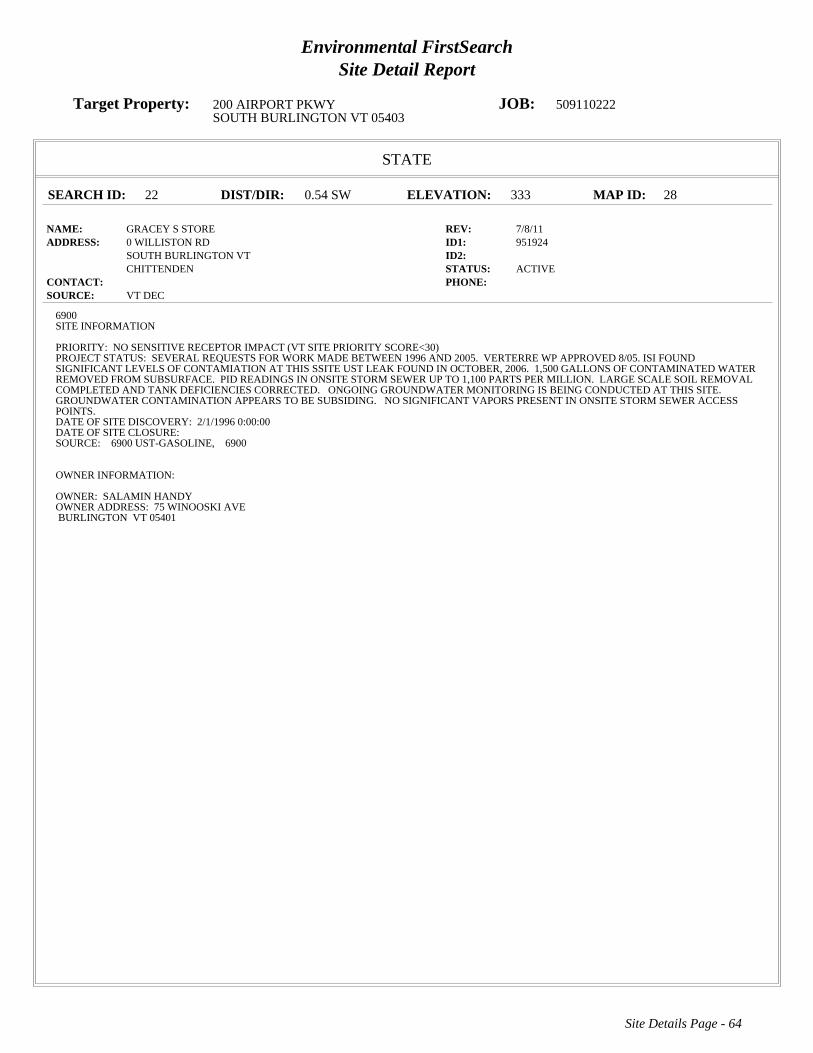
Environmental FirstSearchSite Detail Report
Target Property: 200 AIRPORT PKWY JOB: 509110222SOUTH BURLINGTON VT 05403
STATE
SEARCH ID: 22 DIST/DIR: 0.54 SW ELEVATION: 333 MAP ID: 28
NAME: GRACEY S STORE REV: 7/8/11ADDRESS: 0 WILLISTON RD ID1: 951924
SOUTH BURLINGTON VT ID2: CHITTENDEN STATUS: ACTIVE
CONTACT: PHONE: SOURCE: VT DEC
Site Details Page - 64
6900SITE INFORMATION
PRIORITY: NO SENSITIVE RECEPTOR IMPACT (VT SITE PRIORITY SCORE<30)PROJECT STATUS: SEVERAL REQUESTS FOR WORK MADE BETWEEN 1996 AND 2005. VERTERRE WP APPROVED 8/05. ISI FOUNDSIGNIFICANT LEVELS OF CONTAMIATION AT THIS SSITE UST LEAK FOUND IN OCTOBER, 2006. 1,500 GALLONS OF CONTAMINATED WATERREMOVED FROM SUBSURFACE. PID READINGS IN ONSITE STORM SEWER UP TO 1,100 PARTS PER MILLION. LARGE SCALE SOIL REMOVALCOMPLETED AND TANK DEFICIENCIES CORRECTED. ONGOING GROUNDWATER MONITORING IS BEING CONDUCTED AT THIS SITE.GROUNDWATER CONTAMINATION APPEARS TO BE SUBSIDING. NO SIGNIFICANT VAPORS PRESENT IN ONSITE STORM SEWER ACCESSPOINTS.DATE OF SITE DISCOVERY: 2/1/1996 0:00:00DATE OF SITE CLOSURE:SOURCE: 6900 UST-GASOLINE, 6900
OWNER INFORMATION:
OWNER: SALAMIN HANDYOWNER ADDRESS: 75 WINOOSKI AVEBURLINGTON VT 05401
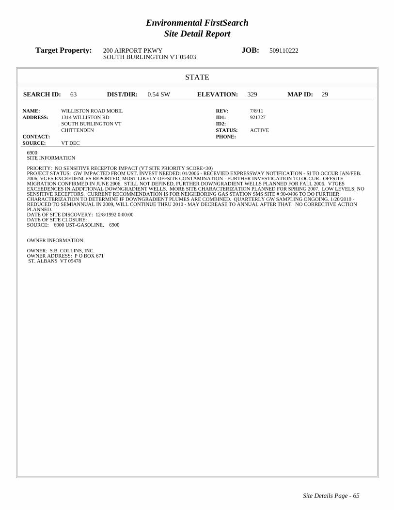
Environmental FirstSearchSite Detail Report
Target Property: 200 AIRPORT PKWY JOB: 509110222SOUTH BURLINGTON VT 05403
STATE
SEARCH ID: 63 DIST/DIR: 0.54 SW ELEVATION: 329 MAP ID: 29
NAME: WILLISTON ROAD MOBIL REV: 7/8/11ADDRESS: 1314 WILLISTON RD ID1: 921327
SOUTH BURLINGTON VT ID2: CHITTENDEN STATUS: ACTIVE
CONTACT: PHONE: SOURCE: VT DEC
Site Details Page - 65
6900SITE INFORMATION
PRIORITY: NO SENSITIVE RECEPTOR IMPACT (VT SITE PRIORITY SCORE<30)PROJECT STATUS: GW IMPACTED FROM UST. INVEST NEEDED; 01/2006 - RECEVIED EXPRESSWAY NOTIFICATION - SI TO OCCUR JAN/FEB.2006; VGES EXCEEDENCES REPORTED; MOST LIKELY OFFSITE CONTAMINATION - FURTHER INVESTIGATION TO OCCUR. OFFSITEMIGRATION CONFIRMED IN JUNE 2006. STILL NOT DEFINED, FURTHER DOWNGRADIENT WELLS PLANNED FOR FALL 2006. VTGESEXCEEDENCES IN ADDITIONAL DOWNGRADIENT WELLS. MORE SITE CHARACTERIZATION PLANNED FOR SPRING 2007. LOW LEVELS; NOSENSITIVE RECEPTORS. CURRENT RECOMMENDATION IS FOR NEIGHBORING GAS STATION SMS SITE # 90-0496 TO DO FURTHERCHARACTERIZATION TO DETERMINE IF DOWNGRADIENT PLUMES ARE COMBINED. QUARTERLY GW SAMPLING ONGOING. 1/20/2010 -REDUCED TO SEMIANNUAL IN 2009, WILL CONTINUE THRU 2010 - MAY DECREASE TO ANNUAL AFTER THAT. NO CORRECTIVE ACTIONPLANNED.DATE OF SITE DISCOVERY: 12/8/1992 0:00:00DATE OF SITE CLOSURE:SOURCE: 6900 UST-GASOLINE, 6900
OWNER INFORMATION:
OWNER: S.B. COLLINS, INC.OWNER ADDRESS: P O BOX 671ST. ALBANS VT 05478
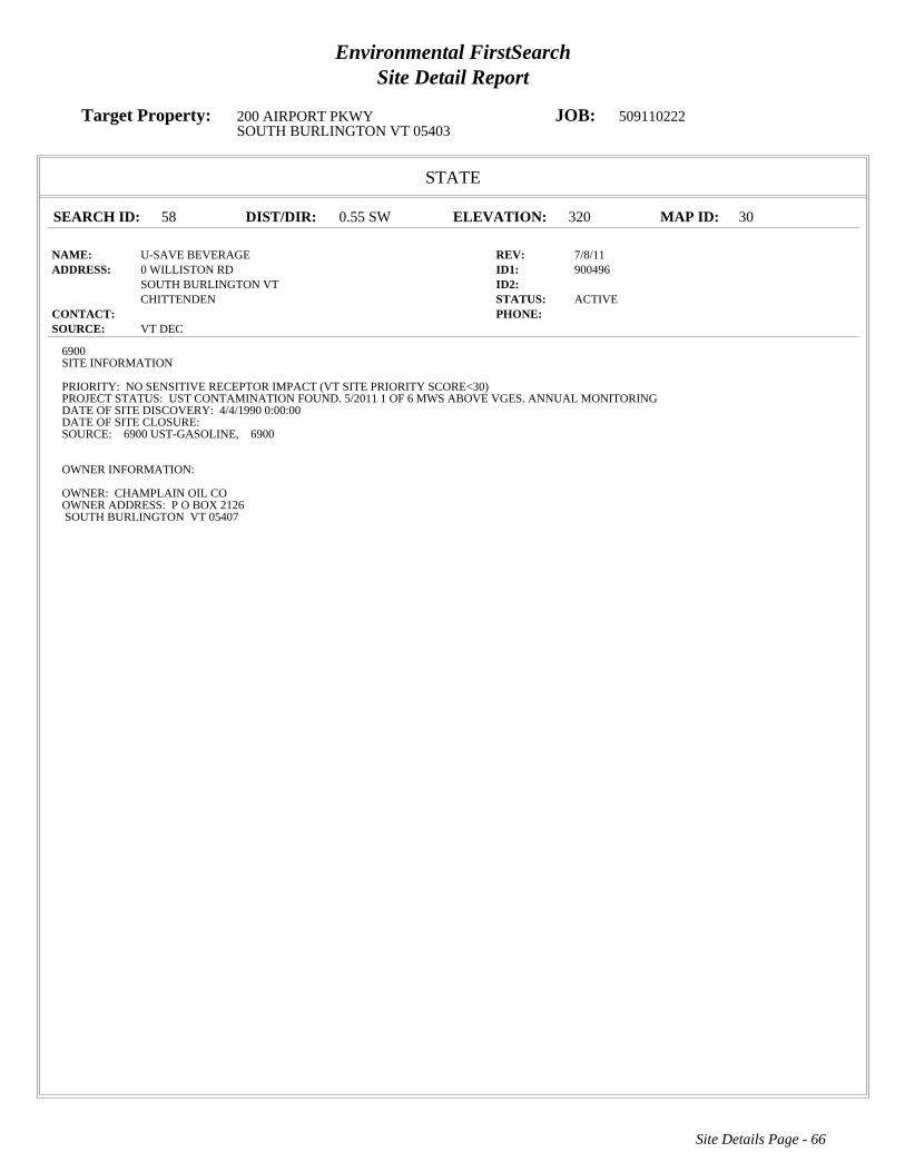
Environmental FirstSearchSite Detail Report
Target Property: 200 AIRPORT PKWY JOB: 509110222SOUTH BURLINGTON VT 05403
STATE
SEARCH ID: 58 DIST/DIR: 0.55 SW ELEVATION: 320 MAP ID: 30
NAME: U-SAVE BEVERAGE REV: 7/8/11ADDRESS: 0 WILLISTON RD ID1: 900496
SOUTH BURLINGTON VT ID2: CHITTENDEN STATUS: ACTIVE
CONTACT: PHONE: SOURCE: VT DEC
Site Details Page - 66
6900SITE INFORMATION
PRIORITY: NO SENSITIVE RECEPTOR IMPACT (VT SITE PRIORITY SCORE<30)PROJECT STATUS: UST CONTAMINATION FOUND. 5/2011 1 OF 6 MWS ABOVE VGES. ANNUAL MONITORINGDATE OF SITE DISCOVERY: 4/4/1990 0:00:00DATE OF SITE CLOSURE:SOURCE: 6900 UST-GASOLINE, 6900
OWNER INFORMATION:
OWNER: CHAMPLAIN OIL COOWNER ADDRESS: P O BOX 2126SOUTH BURLINGTON VT 05407

Environmental FirstSearchSite Detail Report
Target Property: 200 AIRPORT PKWY JOB: 509110222SOUTH BURLINGTON VT 05403
STATE
SEARCH ID: 16 DIST/DIR: 0.58 NE ELEVATION: 328 MAP ID: 31
NAME: BURLINGTON INTERNATIONAL AIRPORT REV: 7/8/11ADDRESS: 0 AIRPORT RD ID1: 931503
SOUTH BURLINGTON VT ID2: CHITTENDEN STATUS: ACTIVE
CONTACT: PHONE: SOURCE: VT DEC
Site Details Page - 67
6900SITE INFORMATION
PRIORITY: NO SENSITIVE RECEPTOR IMPACT (VT SITE PRIORITY SCORE<30)PROJECT STATUS: ANNUAL GROUNDWATER MONITORING ONGOING AND FREE PRODUCT MONITORING.DATE OF SITE DISCOVERY:DATE OF SITE CLOSURE:SOURCE: 6900 ABOVE GROUND STORAGE TANK, 6900 UST-HEATING OIL, 6900
OWNER INFORMATION:
OWNER: BURLINGTON INTERNATIONAL AIRPORTOWNER ADDRESS: 1200 AIRPORT DRIVESOUTH BURLINGTON VT 05403

Environmental FirstSearchSite Detail Report
Target Property: 200 AIRPORT PKWY JOB: 509110222SOUTH BURLINGTON VT 05403
STATE
SEARCH ID: 61 DIST/DIR: 0.58 NE ELEVATION: 307 MAP ID: 32
NAME: VERMONT AIR NATIONAL GUARD REV: 7/8/11ADDRESS: 0 AIRPORT RD ID1: 770043
SOUTH BURLINGTON VT ID2: STATUS: ACTIVE
CONTACT: PHONE: SOURCE: VT DEC
Site Details Page - 68
6900SITE INFORMATION
PRIORITY: DIRECTLY IMPACTED SENSITIVE RECEPTOR (VT SITE PRIORITY SCORE>60)PROJECT STATUS: BASEWIDE SUPPLEMENTAL REMEDIAL INVESTIGATION UNDERWAY SUMMER 04; REPORT BY EARLY 05. SITE 1GROUNDWATER INTERCEPTION TRENCH OPERATING AS DESIGNED. SITE 3 FREE PRODUCT RECOVERY SYSTEMS OPERATING ASDESIGNED.DATE OF SITE DISCOVERY:DATE OF SITE CLOSURE:SOURCE: 6900 ABOVE GROUND STORAGE TANK, 6900 UST-KEROSENE, 6900 SPILL, 6900 OTHER, 6900
OWNER INFORMATION:
OWNER: VERMONT AIR NATIONAL GUARDOWNER ADDRESS: AIRPORT ROADSOUTH BURLINGTON VT 05403

Environmental FirstSearchSite Detail Report
Target Property: 200 AIRPORT PKWY JOB: 509110222SOUTH BURLINGTON VT 05403
STATE
SEARCH ID: 26 DIST/DIR: 0.60 NE ELEVATION: 225 MAP ID: 33
NAME: KELCO FACILITY REV: 12/3/09ADDRESS: 73 ETHAN ALLEN DR ID1: 20002783
SOUTH BURLINGTON VT ID2: CHITTENDEN STATUS: CLOSED
CONTACT: PHONE: SOURCE: VT DEC
Site Details Page - 69
6900SITE INFORMATION
PRIORITY: SITES MANAGEMENT ACTIVITY COMPLETEDPROJECT STATUS: THREE USTS REMOVED JUNE 2000, LIMITED CONTAMINATION REMAINS IN THE VICINITY OF THE FORMER DIESEL UST.ETHYLBENZENE, 1,2,4- AND 1,3,5-TRIMETHYLBENZENE REMAIN, AT LEVELS BELOW VGES, IN THE DIESEL SOURCE AREA WELL. NOSENSITIVE RECEPTOS AFFECTED, RESIDUAL CONTAMINATION CONFINED TO BETWEEN 6 AND 9 FT BGS.DATE OF SITE DISCOVERY: 6/5/2000 0:00:00DATE OF SITE CLOSURE: 4/9/2009 0:00:00SOURCE: 6900 UST-WASTE OIL, 6900 OTHER, 6900 UST-DIESEL, 6900
OWNER INFORMATION:
OWNER: JEFF MYERS & MICHAEL CRETEOWNER ADDRESS: 73 ETHAN ALLEN DRIVESOUTH BURLINGTON VT 05403
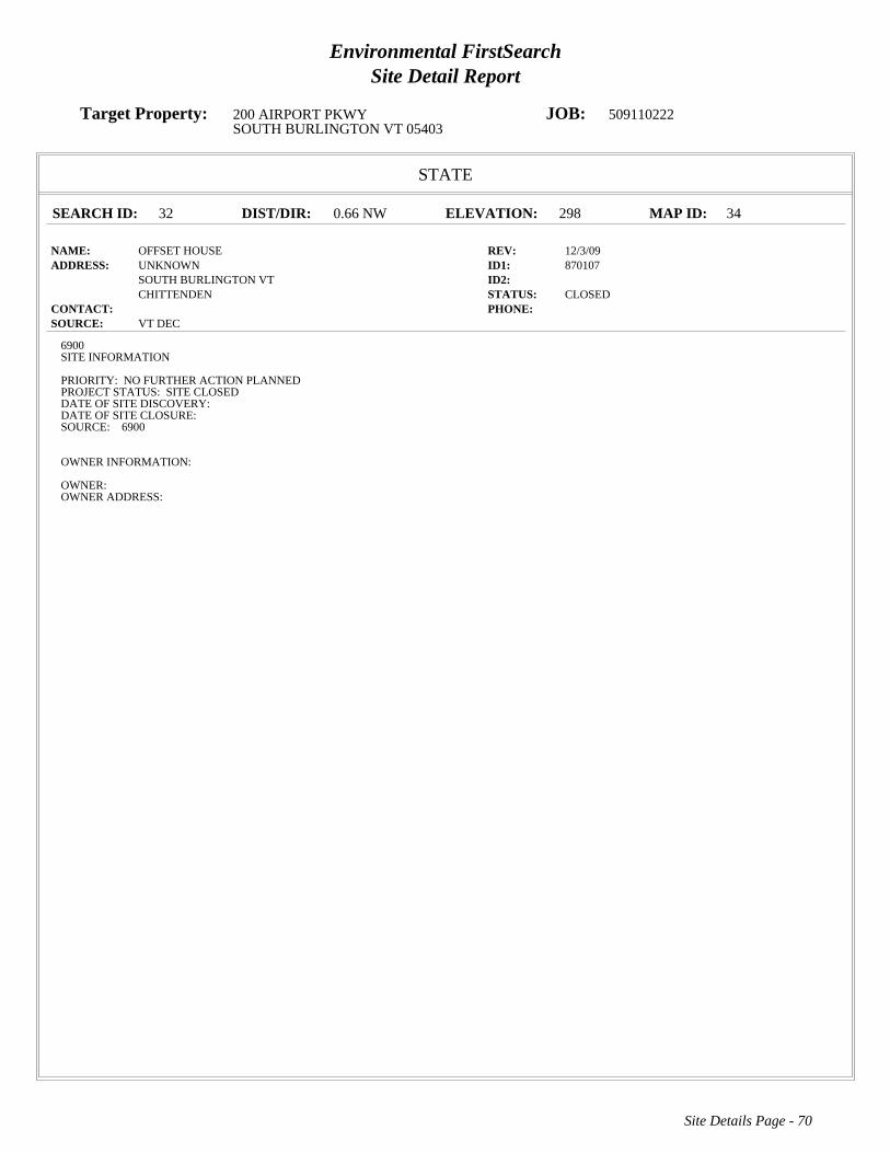
Environmental FirstSearchSite Detail Report
Target Property: 200 AIRPORT PKWY JOB: 509110222SOUTH BURLINGTON VT 05403
STATE
SEARCH ID: 32 DIST/DIR: 0.66 NW ELEVATION: 298 MAP ID: 34
NAME: OFFSET HOUSE REV: 12/3/09ADDRESS: UNKNOWN ID1: 870107
SOUTH BURLINGTON VT ID2: CHITTENDEN STATUS: CLOSED
CONTACT: PHONE: SOURCE: VT DEC
Site Details Page - 70
6900SITE INFORMATION
PRIORITY: NO FURTHER ACTION PLANNEDPROJECT STATUS: SITE CLOSEDDATE OF SITE DISCOVERY:DATE OF SITE CLOSURE:SOURCE: 6900
OWNER INFORMATION:
OWNER:OWNER ADDRESS:

Environmental FirstSearchSite Detail Report
Target Property: 200 AIRPORT PKWY JOB: 509110222SOUTH BURLINGTON VT 05403
STATE
SEARCH ID: 33 DIST/DIR: 0.66 NW ELEVATION: 298 MAP ID: 34
NAME: OFFSET HOUSE PROPERTY REV: 12/3/09ADDRESS: UNKNOWN ID1: 770075
SOUTH BURLINGTON VT ID2: CHITTENDEN STATUS: CLOSED
CONTACT: PHONE: SOURCE: VT DEC
Site Details Page - 71
6900SITE INFORMATION
PRIORITY: NO FURTHER ACTION PLANNEDPROJECT STATUS: CONTAMINATION BELOW ACTION LEVELS, SITE CLOSEDDATE OF SITE DISCOVERY:DATE OF SITE CLOSURE:SOURCE: 6900
OWNER INFORMATION:
OWNER:OWNER ADDRESS:
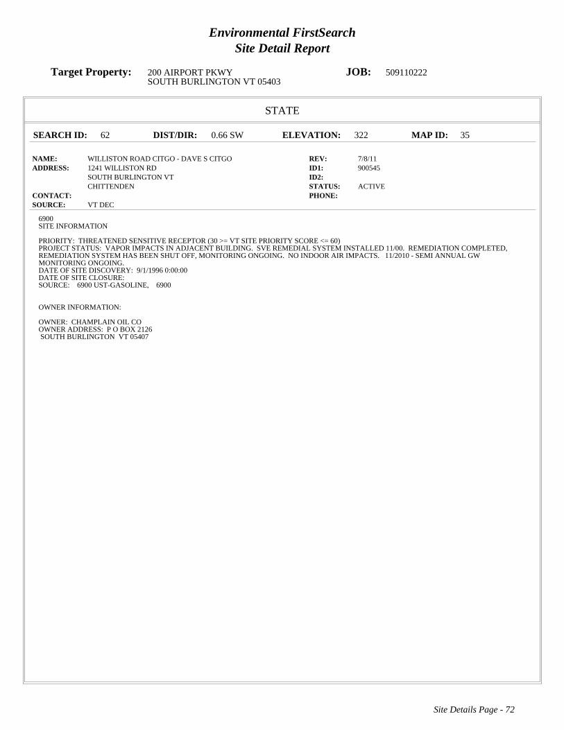
Environmental FirstSearchSite Detail Report
Target Property: 200 AIRPORT PKWY JOB: 509110222SOUTH BURLINGTON VT 05403
STATE
SEARCH ID: 62 DIST/DIR: 0.66 SW ELEVATION: 322 MAP ID: 35
NAME: WILLISTON ROAD CITGO - DAVE S CITGO REV: 7/8/11ADDRESS: 1241 WILLISTON RD ID1: 900545
SOUTH BURLINGTON VT ID2: CHITTENDEN STATUS: ACTIVE
CONTACT: PHONE: SOURCE: VT DEC
Site Details Page - 72
6900SITE INFORMATION
PRIORITY: THREATENED SENSITIVE RECEPTOR (30 >= VT SITE PRIORITY SCORE <= 60)PROJECT STATUS: VAPOR IMPACTS IN ADJACENT BUILDING. SVE REMEDIAL SYSTEM INSTALLED 11/00. REMEDIATION COMPLETED,REMEDIATION SYSTEM HAS BEEN SHUT OFF, MONITORING ONGOING. NO INDOOR AIR IMPACTS. 11/2010 - SEMI ANNUAL GWMONITORING ONGOING.DATE OF SITE DISCOVERY: 9/1/1996 0:00:00DATE OF SITE CLOSURE:SOURCE: 6900 UST-GASOLINE, 6900
OWNER INFORMATION:
OWNER: CHAMPLAIN OIL COOWNER ADDRESS: P O BOX 2126SOUTH BURLINGTON VT 05407

Environmental FirstSearchSite Detail Report
Target Property: 200 AIRPORT PKWY JOB: 509110222SOUTH BURLINGTON VT 05403
STATE
SEARCH ID: 20 DIST/DIR: 0.67 SE ELEVATION: 315 MAP ID: 36
NAME: ETHAN ALLEN AIR FORCE BASE REV: 12/3/09ADDRESS: 0 AIRPORT DR ID1: 941663
SOUTH BURLINGTON VT ID2: STATUS: CLOSED
CONTACT: PHONE: SOURCE: VT DEC
Site Details Page - 73
6900SITE INFORMATION
PRIORITY: SITES MANAGEMENT ACTIVITY COMPLETEDPROJECT STATUS: ALL CONTAMINATED SOIL FROM FUEL OIL UST REMOVED & DISPOSEDDATE OF SITE DISCOVERY: 8/1/1994 0:00:00DATE OF SITE CLOSURE: 6/1/1997 0:00:00SOURCE: 6900 UST-HEATING OIL, 6900
OWNER INFORMATION:
OWNER: CARL LAROEOWNER ADDRESS:

Environmental FirstSearchSite Detail Report
Target Property: 200 AIRPORT PKWY JOB: 509110222SOUTH BURLINGTON VT 05403
STATE
SEARCH ID: 38 DIST/DIR: 0.68 NW ELEVATION: 280 MAP ID: 37
NAME: SOUTH BURLINGTON STREET DEPT REV: 7/8/11ADDRESS: PATCHEN RD ID1: 931383
SOUTH BURLINGTON VT ID2: CHITTENDEN STATUS: ACTIVE
CONTACT: PHONE: SOURCE: VT DEC
Site Details Page - 74
6900SITE INFORMATION
PRIORITY: NO SENSITIVE RECEPTOR IMPACT (VT SITE PRIORITY SCORE<30)PROJECT STATUS: ANNUAL GW MONITORING OF GASOLINE UST RELEASE. NEXT ROUND MAY 2009. EVALUATING WAYS TO BETTERDEFINE DOWNGRADIENT EXTENT OF CONTAMINATION, E.G., USE LANDFILL WELLS.DATE OF SITE DISCOVERY:DATE OF SITE CLOSURE:SOURCE: 6900 UST-GASOLINE, 6900
OWNER INFORMATION:
OWNER: CITY OF BURLINGTONOWNER ADDRESS: 53 LAVALLEY LANEBURLINGTON VT 05401

Environmental FirstSearchSite Detail Report
Target Property: 200 AIRPORT PKWY JOB: 509110222SOUTH BURLINGTON VT 05403
STATE
SEARCH ID: 15 DIST/DIR: 0.70 NE ELEVATION: 340 MAP ID: 38
NAME: BURLINGTON AIRPORT REV: 12/3/09ADDRESS: 0 AIRPORT PKWY ID1: 921305
SOUTH BURLINGTON VT ID2: CHITTENDEN STATUS: CLOSED
CONTACT: PHONE: SOURCE: VT DEC
Site Details Page - 75
6900SITE INFORMATION
PRIORITY: NO FURTHER ACTION PLANNEDPROJECT STATUS: SITE ASSESS COMPLETE, NO IMPACT TO SENSITIVE RECEPTORSDATE OF SITE DISCOVERY:DATE OF SITE CLOSURE: 8/18/1993 0:00:00SOURCE: 6900 OTHER, 6900
OWNER INFORMATION:
OWNER: AIR B POWNER ADDRESS: CLEVELAND HOPKINS INTNL AIRPORCLEVELAND OH 44135

Environmental FirstSearchSite Detail Report
Target Property: 200 AIRPORT PKWY JOB: 509110222SOUTH BURLINGTON VT 05403
STATE
SEARCH ID: 34 DIST/DIR: 0.71 SE ELEVATION: 329 MAP ID: 39
NAME: P J S AUTOMOTIVE REV: 12/3/09ADDRESS: 2073 WILLISTON RD ID1: 982447
SOUTH BURLINGTON VT ID2: CHITTENDEN STATUS: CLOSED
CONTACT: PHONE: SOURCE: VT DEC
Site Details Page - 76
6900SITE INFORMATION
PRIORITY: SITES MANAGEMENT ACTIVITY COMPLETEDPROJECT STATUS: UNDRGROUND STORAGE TANK REMOVED. CONTAMINATION FOUND. INVESTIGATION COMPLETED. SITE CLOSED.DATE OF SITE DISCOVERY: 5/19/1998 0:00:00DATE OF SITE CLOSURE: 5/5/1999 0:00:00SOURCE: 6900 WASTE OIL, 6900
OWNER INFORMATION:
OWNER: PAUL CHOINIEREOWNER ADDRESS: 2073 ILLISTON RDSOUTH BURLINGTON VT 05403

Environmental FirstSearchSite Detail Report
Target Property: 200 AIRPORT PKWY JOB: 509110222SOUTH BURLINGTON VT 05403
STATE
SEARCH ID: 37 DIST/DIR: 0.71 SW ELEVATION: 319 MAP ID: 40
NAME: SOUTH BURLINGTON CENTRAL SCHOOL REV: 12/3/09ADDRESS: 1181 WILLISTON RD ID1: 921301
SOUTH BURLINGTON VT ID2: CHITTENDEN STATUS: CLOSED
CONTACT: PHONE: SOURCE: VT DEC
Site Details Page - 77
6900SITE INFORMATION
PRIORITY: NO FURTHER ACTION PLANNEDPROJECT STATUS: UST REMOVED. IDENTIFIED CONTAMINATION. FURTHER WORK PENDING.DATE OF SITE DISCOVERY:DATE OF SITE CLOSURE: 5/27/1993 0:00:00SOURCE: 6900 UST-GASOLINE, 6900
OWNER INFORMATION:
OWNER: BURLINGTON SCHOOL DISTRICTOWNER ADDRESS: 287 SHELBURNE RDBURLINGTON VT 05401

Environmental FirstSearchSite Detail Report
Target Property: 200 AIRPORT PKWY JOB: 509110222SOUTH BURLINGTON VT 05403
STATE
SEARCH ID: 19 DIST/DIR: 0.74 SW ELEVATION: 318 MAP ID: 41
NAME: DOLANS VARIETY REV: 7/8/11ADDRESS: 1160 WILLISTON RD ID1: 961956
SOUTH BURLINGTON VT ID2: CHITTENDEN STATUS: ACTIVE
CONTACT: PHONE: SOURCE: VT DEC
Site Details Page - 78
6900SITE INFORMATION
PRIORITY: NO SENSITIVE RECEPTOR IMPACT (VT SITE PRIORITY SCORE<30)PROJECT STATUS: 03/11: CONTAMINANT CONCENTRATIONS DECLINING OVER TIME. MONITORING ONCE EVERY OTHER YEAR. NEXTMONITORING ROUND SCHEDULED FOR SPRING 2011.DATE OF SITE DISCOVERY: 2/1/1996 0:00:00DATE OF SITE CLOSURE:SOURCE: 6900 UST-GASOLINE, 6900
OWNER INFORMATION:
OWNER: PRECOURT INVESTMENT COOWNER ADDRESS: 21 MAPLE LEAF LANESHELBURNE VT 05482

Environmental FirstSearchSite Detail Report
Target Property: 200 AIRPORT PKWY JOB: 509110222SOUTH BURLINGTON VT 05403
STATE
SEARCH ID: 36 DIST/DIR: 0.77 SW ELEVATION: 324 MAP ID: 42
NAME: SARVAK RESIDENCE REV: 12/3/09ADDRESS: 290 HINESBURG RD ID1: 20063578
SOUTH BURLINGTON VT ID2: CHITTENDEN STATUS: CLOSED
CONTACT: PHONE: SOURCE: VT DEC
Site Details Page - 79
6900SITE INFORMATION
PRIORITY: SITES MANAGEMENT ACTIVITY COMPLETEDPROJECT STATUS: UNDERGROUND STORAGE TANK REMOVED. CONTAMINATION FOUND. EPS VT REMOVED 6 TONS OF PETROLEUMCONTAMINATED SOIL FROM THE TANK AREA. CONFIRMATORY SOIL SAMPLES INDICATED THAT THE AREA HAS BEEN ADEQUATELYREMEDIATED. NO FURTHER INVESTIGATION REQUIRED.DATE OF SITE DISCOVERY: 4/10/2006 0:00:00DATE OF SITE CLOSURE: 10/9/2006 0:00:00SOURCE: 6900 UST-HEATING OIL, 6900
OWNER INFORMATION:
OWNER: CHRIS SARVAKOWNER ADDRESS: 290 HINESBURG RDSOUTH BURLINGTON VT 05403

Environmental FirstSearchSite Detail Report
Target Property: 200 AIRPORT PKWY JOB: 509110222SOUTH BURLINGTON VT 05403
STATE
SEARCH ID: 17 DIST/DIR: 0.78 SW ELEVATION: 312 MAP ID: 43
NAME: CHAMPLAIN VALLEY SUNOCO REV: 7/8/11ADDRESS: 1143 WILLISTON RD ID1: 982491
SOUTH BURLINGTON VT ID2: CHITTENDEN STATUS: ACTIVE
CONTACT: PHONE: SOURCE: VT DEC
Site Details Page - 80
6900SITE INFORMATION
PRIORITY: NO SENSITIVE RECEPTOR IMPACT (VT SITE PRIORITY SCORE<30)PROJECT STATUS: CONTAM SOIL AND GW. INVESTIGATION COMPLETED. 12/16/99 2 OF 4 MWS ABOVE VGES. 3/21, 9/5/00, 3/30, 9/19/01, 3/15/02,3/18/03 3 OF 4 MWS, 3/24/04 2 OF 3MWS ABOVE VGES, 9/09 2 OF 9 MWS ABOVE VGES, SITE REDEVELOPED AS NSB BANK, BIENNIAL MONITORDATE OF SITE DISCOVERY: 9/21/1998 0:00:00DATE OF SITE CLOSURE:SOURCE: 6900 UST-GASOLINE, 6900
OWNER INFORMATION:
OWNER: NSB SAVINGS BANKOWNER ADDRESS: PO BOX 347NORTHFIELD VT 05663

Environmental FirstSearchSite Detail Report
Target Property: 200 AIRPORT PKWY JOB: 509110222SOUTH BURLINGTON VT 05403
STATE
SEARCH ID: 59 DIST/DIR: 0.80 SW ELEVATION: 313 MAP ID: 44
NAME: UNIVERSITY GULF REV: 7/8/11ADDRESS: 0 WILLISTON RD ID1: 900646
SOUTH BURLINGTON VT ID2: STATUS: ACTIVE
CONTACT: PHONE: SOURCE: VT DEC
Site Details Page - 81
6900SITE INFORMATION
PRIORITY: THREATENED SENSITIVE RECEPTOR (30 >= VT SITE PRIORITY SCORE <= 60)PROJECT STATUS: MONITORING ONGOING FOLLOWING UST REMOVAL.DATE OF SITE DISCOVERY:DATE OF SITE CLOSURE:SOURCE: 6900 UST-GASOLINE, 6900
OWNER INFORMATION:
OWNER:OWNER ADDRESS:

Environmental FirstSearchSite Detail Report
Target Property: 200 AIRPORT PKWY JOB: 509110222SOUTH BURLINGTON VT 05403
STATE
SEARCH ID: 23 DIST/DIR: 0.91 SW ELEVATION: 320 MAP ID: 45
NAME: GREERS DRY CLEANING DORSET STREET REV: 7/8/11ADDRESS: UNKNOWN ID1: 20053395
SOUTH BURLINGTON VT ID2: CHITTENDEN STATUS: ACTIVE
CONTACT: PHONE: SOURCE: VT DEC
Site Details Page - 82
6900SITE INFORMATION
PRIORITY: THREATENED SENSITIVE RECEPTOR (30 >= VT SITE PRIORITY SCORE <= 60)PROJECT STATUS:DATE OF SITE DISCOVERY: 7/1/2005 0:00:00DATE OF SITE CLOSURE:SOURCE: 6900
OWNER INFORMATION:
OWNER:OWNER ADDRESS:
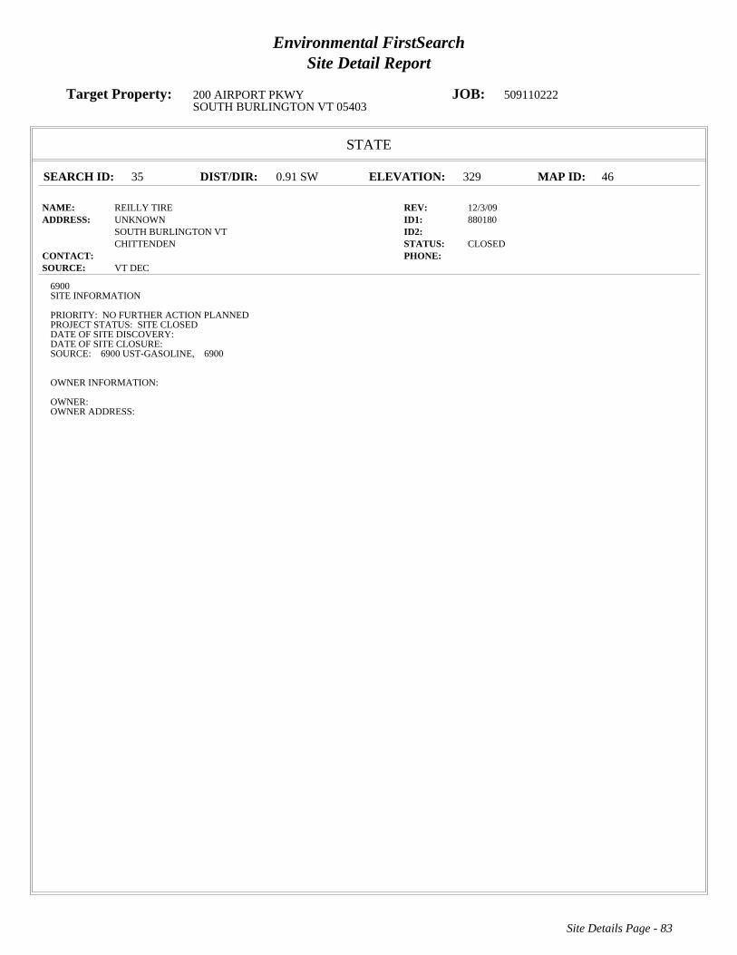
Environmental FirstSearchSite Detail Report
Target Property: 200 AIRPORT PKWY JOB: 509110222SOUTH BURLINGTON VT 05403
STATE
SEARCH ID: 35 DIST/DIR: 0.91 SW ELEVATION: 329 MAP ID: 46
NAME: REILLY TIRE REV: 12/3/09ADDRESS: UNKNOWN ID1: 880180
SOUTH BURLINGTON VT ID2: CHITTENDEN STATUS: CLOSED
CONTACT: PHONE: SOURCE: VT DEC
Site Details Page - 83
6900SITE INFORMATION
PRIORITY: NO FURTHER ACTION PLANNEDPROJECT STATUS: SITE CLOSEDDATE OF SITE DISCOVERY:DATE OF SITE CLOSURE:SOURCE: 6900 UST-GASOLINE, 6900
OWNER INFORMATION:
OWNER:OWNER ADDRESS:

Environmental FirstSearchSite Detail Report
Target Property: 200 AIRPORT PKWY JOB: 509110222SOUTH BURLINGTON VT 05403
STATE
SEARCH ID: 27 DIST/DIR: 0.93 SW ELEVATION: 327 MAP ID: 47
NAME: KENNEDY DRIVE MOBIL REV: 12/3/09ADDRESS: 110 KENNEDY DR ID1: 20033099
SOUTH BURLINGTON VT ID2: CHITTENDEN STATUS: CLOSED
CONTACT: PHONE: SOURCE: VT DEC
Site Details Page - 84
6900SITE INFORMATION
PRIORITY: SITES MANAGEMENT ACTIVITY COMPLETEDPROJECT STATUS: LOW LEVEL GROUNDWATER CONTAMINATION IDENTIFIED DURING PROPERTY DIVESTMENT. QUARTERLYMONITORING OF FIVE MWS FOR ONE YEAR BEFORE ADDITIONAL RECOMMENDATIONS. GWESS MET ON ENTIRE SITE. MWS CLOSED.DATE OF SITE DISCOVERY: 4/28/2003 0:00:00DATE OF SITE CLOSURE: 7/22/2009 0:00:00SOURCE: 6900 UST-GASOLINE, 6900
OWNER INFORMATION:
OWNER: EXXONMOBIL OIL CORPOWNER ADDRESS: 52 BEACHAM STREETEVERETT MA 02149

Environmental FirstSearchSite Detail Report
Target Property: 200 AIRPORT PKWY JOB: 509110222SOUTH BURLINGTON VT 05403
STATE
SEARCH ID: 21 DIST/DIR: 0.96 SW ELEVATION: 326 MAP ID: 48
NAME: FORMER GOODRICH BUILDING REV: 7/8/11ADDRESS: 625 HINESBURG RD ID1: 20114149
SOUTH BURLINGTON VT ID2: CHITTENDEN STATUS: ACTIVE
CONTACT: PHONE: SOURCE: VT DEC
Site Details Page - 85
6900SITE INFORMATION
PRIORITY: THREATENED SENSITIVE RECEPTOR (30 >= VT SITE PRIORITY SCORE <= 60)PROJECT STATUS: HIENDEL AND NOYES NOTIFIED THE SMS AFTER REPORTABLE LEVELS OF CONTAMINATION (TCE) WAS DISCOVERED INTHE FLOOR DRAINS OF THE GARAGE BUILDING LOCATED ONSITE. A PHASE 1 HAS BEEN COMPLETED AS WELL AS A PHASE 2.NAPTHELENE WAS ALSO NOTED IN THE GROUNDWATER, LIKELY IN RELATION TO A FORMER GASOLINE UST. REQUESTING THATCHLONATED BE DEALT WITH ACCORDINGLY AND MONITORING WELL ARRAY BE INSTALLED NEAR FORMER UST LOCATION.DATE OF SITE DISCOVERY: 11/1/2010 0:00:00DATE OF SITE CLOSURE:SOURCE: 6900 FLOOR DRAIN/DRY WELL, 6900 UST-GASOLINE, 6900 ABOVE GROUND STORAGE TANK, 6900
OWNER INFORMATION:
OWNER: SCOTT RIELEYOWNER ADDRESS: 1184 WILLISTON ROADSOUTH BURLINGTON VT 05401

Environmental FirstSearchSite Detail Report
Target Property: 200 AIRPORT PKWY JOB: 509110222SOUTH BURLINGTON VT 05403
STATE
SEARCH ID: 60 DIST/DIR: 0.96 SW ELEVATION: 312 MAP ID: 49
NAME: UNIVERSITY INN REV: 12/3/09ADDRESS: 5 DORSET ST ID1: 20002751
SOUTH BURLINGTON VT ID2: CHITTENDEN STATUS: CLOSED
CONTACT: PHONE: SOURCE: VT DEC
Site Details Page - 86
6900SITE INFORMATION
PRIORITY: SITES MANAGEMENT ACTIVITY COMPLETEDPROJECT STATUS: 2 FUEL OIL USTS CLOSED IN PLACE. CONTAM FOUND. 6/00, 3/01 4 OF 5 MWS, 7/03 2 OF 5 MWS ABOVE VGES, 1 FP, 5/04 3OF 5 ABOVE VGES.DATE OF SITE DISCOVERY: 2/29/2000 0:00:00DATE OF SITE CLOSURE: 1/27/2010 0:00:00SOURCE: 6900 UST-HEATING OIL, 6900 UST-GASOLINE, 6900 FREE PRODUCT PRESENT, 6900
OWNER INFORMATION:
OWNER: UNIVERSITY INNOWNER ADDRESS: P O BOX 993SOUTH BURLINGTON VT 05402

Environmental FirstSearchSite Detail Report
Target Property: 200 AIRPORT PKWY JOB: 509110222SOUTH BURLINGTON VT 05403
STATE
SEARCH ID: 11 DIST/DIR: 1.00 SE ELEVATION: 346 MAP ID: 50
NAME: ACTION EQUIPMENT REV: 12/3/09ADDRESS: UNKNOWN ID1: 770161
SOUTH BURLINGTON VT ID2: CHITTENDEN STATUS: CLOSED
CONTACT: PHONE: SOURCE: VT DEC
Site Details Page - 87
6900SITE INFORMATION
PRIORITY: NO FURTHER ACTION PLANNEDPROJECT STATUS: SITE INVESTIGATED, NO CONTAMINATION DETECTED, SITE CLOSEDDATE OF SITE DISCOVERY:DATE OF SITE CLOSURE:SOURCE: 6900
OWNER INFORMATION:
OWNER:OWNER ADDRESS:
Environmental FirstSearch Descriptions
NPL: EPA NATIONAL PRIORITY LIST - The National Priorities List is a list of the worst hazardous waste sites that
have been identified by Superfund. Sites are only put on the list after they have been scored using the Hazard Ranking
System (HRS), and have been subjected to public comment. Any site on the NPL is eligible for cleanup using Superfund
Trust money. A Superfund site is any land in the United States that has been contaminated by hazardous waste and
identified by the Environmental Protection Agency (EPA) as a candidate for cleanup because it poses a risk to human
health and/or the environment.FINAL - Currently on the Final NPLPROPOSED - Proposed for NPL
NPL DELISTED: EPA NATIONAL PRIORITY LIST Subset - Database of delisted NPL sites. The National Oil and
Hazardous Substances Pollution Contingency Plan (NCP) establishes the criteria that the EPA uses to delete sites from the
NPL. In accordance with 40 CFR 300.425.(e), sites may be deleted from the NPL where no further response is
appropriate.DELISTED - Deleted from the Final NPL
CERCLIS: EPA COMPREHENSIVE ENVIRONMENTAL RESPONSE COMPENSATION AND LIABILITY
INFORMATION SYSTEM (CERCLIS)- CERCLIS is a database of potential and confirmed hazardous waste sites at
which the EPA Superfund program has some involvement. It contains sites that are either proposed to be or are on the
National Priorities List (NPL) as well as sites that are in the screening and assessment phase for possible inclusion on the
NPL.PART OF NPL- Site is part of NPL siteDELETED - Deleted from the Final NPLFINAL - Currently on the Final
NPLNOT PROPOSED - Not on the NPLNOT VALID - Not Valid Site or IncidentPROPOSED - Proposed for
NPLREMOVED - Removed from Proposed NPLSCAN PLAN - Pre-proposal SiteWITHDRAWN - Withdrawn
NFRAP: EPA COMPREHENSIVE ENVIRONMENTAL RESPONSE COMPENSATION AND LIABILITY
INFORMATION SYSTEM ARCHIVED SITES - database of Archive designated CERCLA sites that, to the best of
EPA's knowledge, assessment has been completed and has determined no further steps will be taken to list this site on the
National Priorities List (NPL). This decision does not necessarily mean that there is no hazard associated with a given site;
it only means that, based upon available information, the location is not judged to be a potential NPL site.NFRAP – No
Further Remedial Action PlanP - Site is part of NPL siteD - Deleted from the Final NPLF - Currently on the Final NPLN -
Not on the NPLO - Not Valid Site or IncidentP - Proposed for NPLR - Removed from Proposed NPLS - Pre-proposal
SiteW – Withdrawn
RCRA COR ACT: EPA RESOURCE CONSERVATION AND RECOVERY INFORMATION SYSTEM SITES -
Database of hazardous waste information contained in the Resource Conservation and Recovery Act Information
(RCRAInfo), a national program management and inventory system about hazardous waste handlers. In general, all
generators, transporters, treaters, storers, and disposers of hazardous waste are required to provide information about their
activities to state environmental agencies. These agencies, in turn pass on the information to regional and national EPA
offices. This regulation is governed by the Resource Conservation and Recovery Act (RCRA), as amended by the
Hazardous and Solid Waste Amendments of 1984.RCRAInfo facilities that have reported violations and subject to
corrective actions.
RCRA TSD: EPA RESOURCE CONSERVATION AND RECOVERY INFORMATION SYSTEM TREATMENT,
STORAGE, and DISPOSAL FACILITIES. - Database of hazardous waste information contained in the Resource
Conservation and Recovery Act Information (RCRAInfo), a national program management and inventory system about
hazardous waste handlers. In general, all generators, transporters, treaters, storers, and disposers of hazardous waste are

required to provide information about their activities to state environmental agencies. These agencies, in turn pass on the
information to regional and national EPA offices. This regulation is governed by the Resource Conservation and Recovery
Act (RCRA), as amended by the Hazardous and Solid Waste Amendments of 1984.Facilities that treat, store, dispose, or
incinerate hazardous waste.
RCRA GEN: EPA/MA DEP/CT DEP RESOURCE CONSERVATION AND RECOVERY INFORMATION SYSTEM
GENERATORS - Database of hazardous waste information contained in the Resource Conservation and Recovery Act
Information (RCRAInfo), a national program management and inventory system about hazardous waste handlers. In
general, all generators, transporters, treaters, storers, and disposers of hazardous waste are required to provide information
about their activities to state environmental agencies. These agencies, in turn pass on the information to regional and
national EPA offices. This regulation is governed by the Resource Conservation and Recovery Act (RCRA), as amended
by the Hazardous and Solid Waste Amendments of 1984.Facilities that generate or transport hazardous waste or meet
other RCRA requirements.LGN - Large Quantity GeneratorsSGN - Small Quantity GeneratorsVGN – Conditionally
Exempt Generator.Included are RAATS (RCRA Administrative Action Tracking System) and CMEL (Compliance
Monitoring & Enforcement List) facilities. CONNECTICUT HAZARDOUS WASTE MANIFEST – Database of all
shipments of hazardous waste within, into or from Connecticut. The data includes date of shipment, transporter and TSD
info, and material shipped and quantity. This data is appended to the details of existing generator records.
MASSACHUSETTES HAZARDOUS WASTE GENERATOR – database of generators that are regulated under the MA
DEP. VQN-MA = generates less than 220 pounds or 27 gallons per month of hazardous waste or waste oil.SQN-MA =
generates 220 to 2,200 pounds or 27 to 270 gallons per month of waste oil.LQG-MA = generates greater than 2,200 lbs of
hazardous waste or waste oil per month.
Fed Brownfield: EPA BROWNFIELD MANAGEMENT SYSTEM (BMS) - database designed to assist EPA in
collecting, tracking, and updating information, as well as reporting on the major activities and accomplishments of the
various Brownfield grant Programs./n CLEANUPS IN MY COMMUNITY (subset) - Sites, facilities and properties that
have been contaminated by hazardous materials and are being, or have been, cleaned up under EPA's brownfield’s
program.
ERNS: EPA/NRC EMERGENCY RESPONSE NOTIFICATION SYSTEM (ERNS) - Database of incidents reported to
the National Response Center. These incidents include chemical spills, accidents involving chemicals (such as fires or
explosions), oil spills, transportation accidents that involve oil or chemicals, releases of radioactive materials, sightings of
oil sheens on bodies of water, terrorist incidents involving chemicals, incidents where illegally dumped chemicals have
been found, and drills intended to prepare responders to handle these kinds of incidents. Data since January 2001 has been
received from the National Response System database as the EPA no longer maintains this data.
Tribal Lands: DOI/BIA INDIAN LANDS OF THE UNITED STATES - Database of areas with boundaries established by
treaty, statute, and (or) executive or court order, recognized by the Federal Government as territory in which American
Indian tribes have primary governmental authority. The Indian Lands of the United States map layer shows areas of 640
acres or more, administered by the Bureau of Indian Affairs. Included are Federally-administered lands within a
reservation which may or may not be considered part of the reservation.BUREAU OF INDIAN AFFIARS CONTACT -
Regional contact information for the Bureau of Indian Affairs offices.
State/Tribal Sites: VT DEC ACTIVE AND CLOSED HAZARDOUS SITES LIST - database of active and closed
hazardous waste sites. The data includes priority, project status, source, date of site discovery, date of site closure, and
owner information.
State Spills 90: VT DEC VERMONT SPILLS DATABASE - database of spills reported to the Vermont Department of
Environmental Conservation. The data includes information regarding incident date, type of incident, reporter, responsible
party, and action taken.
State/Tribal SWL: VT DEC SOLID WASTE MANAGEMENT FACILITIES LIST - database of both landfills and
transfer stations for the state of Vermont. The list includes contact information for each site.
State/Tribal LUST: VT DEC PULLED UNDERGROUND STORAGE TANKS LIST - database of tanks that have been
pulled/removed due to a leak. Under state law any tank that has reported a leak must be pulled/removed. The data includes
owner and operator name, facility type, and tank information.
State/Tribal UST/AST: VT DEC REGISTERED UNDERGROUND STORAGE TANKS LIST - database of underground
storage tanks registered with the Vermont Department of Environmental Conservation. The data includes facility type,
owner contact information, and tank substance, protection, and capacity.
State/Tribal Brownfields: VT ANR BROWNFIELD SITE LIST SUBSET- database of sites that have been classified as
Brownfields and have Institutional Controls. Information regarding size, response action, cleanup type, and project
manager is included. Management System (BMS) - database designed to assist EPA in collecting, tracking, and updating
information, as well as reporting on the major activities and accomplishments of the various brownfield grant programs.
State/Tribal Brownfields: VT ANR BROWNFIELD SITE LIST - database of sites that have been classified as
Brownfields and/or have Institutional Controls. Information regarding size, response action, cleanup type, and project
manager is included. Management System (BMS) - database designed to assist EPA in collecting, tracking, and updating
information, as well as reporting on the major activities and accomplishments of the various brownfield grant programs.
Federal IC / EC: EPA FEDERAL ENGINEERING AND INSTITUTIONAL CONTROLS- Superfund sites that have
either engineering or an institutional control. The data includes the control and the media contaminated. RESOURCE
CONSERVATION AND RECOVERY INFORMATION SYSTEM SITES (RCRA) – RCRA site that have institutional
controls.
Environmental FirstSearch Database Sources
NPL: EPA Environmental Protection Agency
Updated quarterly
NPL DELISTED: EPA Environmental Protection Agency
Updated quarterly
CERCLIS: EPA Environmental Protection Agency
Updated quarterly
NFRAP: EPA Environmental Protection Agency.
Updated quarterly
RCRA COR ACT: EPA Environmental Protection Agency.
Updated quarterly
RCRA TSD: EPA Environmental Protection Agency.
Updated quarterly
RCRA GEN: EPA/MA DEP/CT DEP Environmental Protection Agency, Massachusetts Department of Environmental
Protection, Connecticut Department of Environmental Protection
Updated quarterly
Fed Brownfield: EPA Environmental Protection Agency
Updated quarterly
ERNS: EPA/NRC Environmental Protection AgencyNational Response Center.
Updated annually
Tribal Lands: DOI/BIA United States Department of the InteriorBureau of Indian Affairs
Updated annually

State/Tribal Sites: VT DEC Vermont Department of Environmental Conservation
Updated quarterly
State Spills 90: VT DEC Vermont Department of Environmental Conservation
Updated quarterly
State/Tribal SWL: VT DEC Vermont Department of Environmental Conservation, Solid Waste Management Division
Updated annually
State/Tribal LUST: VT DEC Vermont Department of Environmental Conservation, Hazardous Materials Management
Division
Updated quarterly
State/Tribal UST/AST: VT DEC Vermont Department of Environmental Conservation, Hazardous Materials Management
Division
Updated quarterly
State/Tribal Brownfields: VT ANR Vermont Agency of Natural Resources, Waste Management Division of Brownfields
Program
Updated quarterly
State/Tribal Brownfields: VT ANR Vermont Agency of Natural Resources, Waste Management Division of Brownfields
Program
Updated quarterly
Federal IC / EC: EPA Environmental Protection Agency
Updated quarterly

Environmental FirstSearchStreet Name Report for Streets within .25 Mile(s) of Target Property
Target Property: 200 AIRPORT PKWY JOB: 509110222SOUTH BURLINGTON VT 05403
Street Name Dist/Dir Street Name Dist/Dir
Airport Cir 0.01 SEAirport Dr 0.01 SEAirport Drive Ext 0.05 NEAIRPORT PKWY 0.00--Airport Rd 0.15 SEAirport Ter 0.12 NWBarber Ter 0.05 SWBerkeley St 0.18 NWBerkley St 0.18 NWClover St 0.15 NWDelaware St 0.00--Dumont Ave 0.00--Duval St 0.07 NWElizabeth St 0.00--Forest St 0.01 SEHanover St 0.02 NWHelen Ave 0.19 SWKirby Rd 0.1 NWLedoux Ter 0.00--Logwood St 0.00--Lynn Ave 0.05 SWMaryland St 0.00--Mills Ave 0.07 SWMyers Ct 0.2 SWN Henry Ct 0.00--Patrick St 0.00--Peterson Ter 0.00--Picard Cir 0.04 NWPine Tree Ter 0.23 SWPinetree Ter 0.23 SWPump Ln 0.00--Richard Ter 0.2 NWS Henry Ct 0.00--Suburban Sq 0.13 SWUS Hwy 2 0.19 SWVictoria Dr 0.23 SWVictory Dr 0.18 SWWhite St 0.00--Williston Rd 0.19 SW

HISTORICAL FIRE INSURANCE MAPS
NO MAPS AVAILABLE
09-20-11509110222
200 AIRPORT PKWYSOUTH BURLINGTON VT 05403
A search of FirstSearch Technology Corporation's proprietary database of historical fire insurancemap availability confirmed that there are NO MAPS AVAILABLE for the Subject Location asshown above.
FirstSearch Technology Corporation's proprietary database of historical fire insurance mapavailability represents abstracted information from the Sanborn® Map Company obtained throughonline access to the U.S. Library of Congress via local libraries.
Copyright Policy & Disclaimer
Certain Sanborn® Fire Insurance Maps are copyrighted material and may not be reproduced without theexpressed permission of the Sanborn Map Company. FirstSearch Technology Corporation warrants that it willemploy its best efforts to maintain and deliver its information in an efficient and timely manner. Customeracknowledges that it understands that FirstSearch Technology Corporation obtains the above information fromsources FirstSearch Technology Corporation considers reliable. However, THE WARRANTIES EXPRESSEDHEREIN ARE IN LIEU OF ALL OTHER WARRANTIES, either expressed or implied, including withoutlimitation any implied warranty of merchantability or fitness or suitability for a particular purpose (whether ornot FirstSearch Technology Corporation may know, have reason to know, or have been advised of suchpurpose), whether arising by law or by reason of industry custom or usage. ALL SUCH OTHERWARRANTIES ARE HEREBY EXPRESSLY DISCLAIMED.

Environmental FirstSearch1 Mile Radius from Area
ASTM Map: NPL, RCRACOR, STATE Sites
200 AIRPORT PKWY, SOUTH BURLINGTON VT 05403
Source: Tele Atlas
Area Polygon .......................................................................................................
Identified Site, Multiple Sites, Receptor .............................................................
NPL, DELNPL, Brownfield, Solid Waste Landfill (SWL), Hazardous Waste
Triballand.............................................................................................................
Black Rings Represent 1/4 Mile Radius; Red Ring Represents 500 ft. Radius
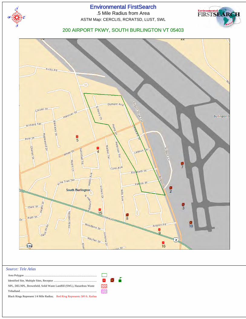
Environmental FirstSearch.5 Mile Radius from Area
ASTM Map: CERCLIS, RCRATSD, LUST, SWL
200 AIRPORT PKWY, SOUTH BURLINGTON VT 05403
Source: Tele Atlas
Area Polygon .......................................................................................................
Identified Site, Multiple Sites, Receptor .............................................................
NPL, DELNPL, Brownfield, Solid Waste Landfill (SWL), Hazardous Waste
Triballand.............................................................................................................
Black Rings Represent 1/4 Mile Radius; Red Ring Represents 500 ft. Radius
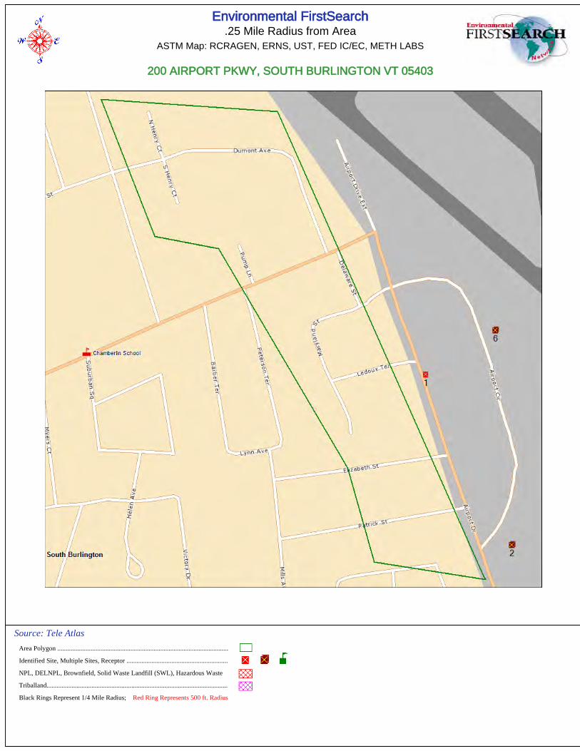
Environmental FirstSearch.25 Mile Radius from Area
ASTM Map: RCRAGEN, ERNS, UST, FED IC/EC, METH LABS
200 AIRPORT PKWY, SOUTH BURLINGTON VT 05403
Source: Tele Atlas
Area Polygon .......................................................................................................
Identified Site, Multiple Sites, Receptor .............................................................
NPL, DELNPL, Brownfield, Solid Waste Landfill (SWL), Hazardous Waste
Triballand.............................................................................................................
Black Rings Represent 1/4 Mile Radius; Red Ring Represents 500 ft. Radius

Environmental FirstSearch.12 Mile Radius from Area
Non-ASTM Map: Spills 90
200 AIRPORT PKWY, SOUTH BURLINGTON VT 05403
Source: Tele Atlas
Area Polygon .......................................................................................................
Identified Site, Multiple Sites, Receptor .............................................................
NPL, DELNPL, Brownfield, Solid Waste Landfill (SWL), Hazardous Waste
Triballand.............................................................................................................
National Historic Sites and Landmark Sites .......................................................
Black Rings Represent 1/4 Mile Radius; Red Ring Represents 500 ft. Radius
FirstSearch Technology Corporation
TM
Environmental FirstSearch Report
Target Property:
200 AIRPORT PKWY
SOUTH BURLINGTON VT 05403
Job Number: 509110222
PREPARED FOR:
KAS, Inc.
368 Avenue D, Suite 15
Williston, VT 05495
09-20-11
Tel: (781) 551-0470 Fax: (781) 551-0471
Environmental FirstSearch is a registered trademark of FirstSearch Technology Corporation. All rights reserved.
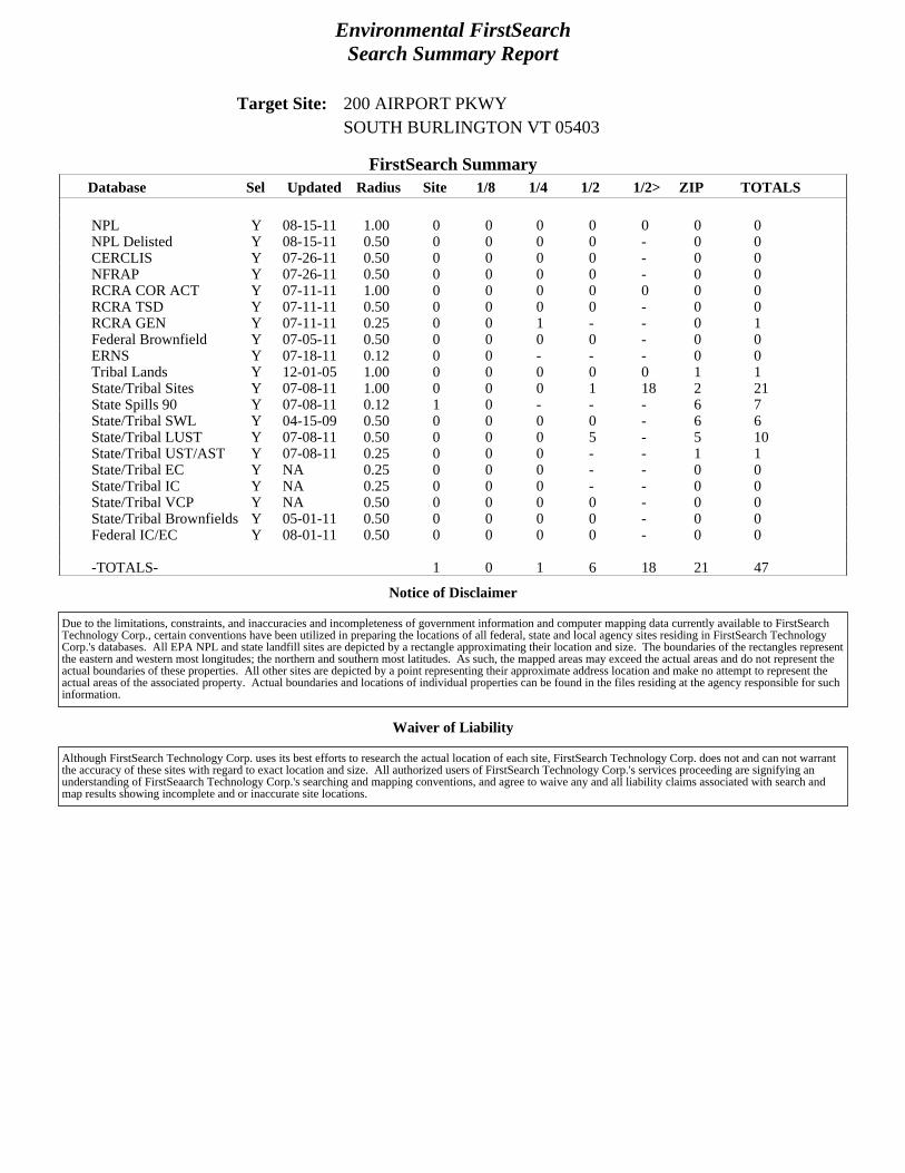
Environmental FirstSearchSearch Summary Report
Target Site: 200 AIRPORT PKWYSOUTH BURLINGTON VT 05403
FirstSearch Summary
Notice of Disclaimer
Waiver of Liability
Database Sel Updated Radius Site 1/8 1/4 1/2 1/2> ZIP TOTALS
NPL Y 08-15-11 1.00 0 0 0 0 0 0 0NPL Delisted Y 08-15-11 0.50 0 0 0 0 - 0 0CERCLIS Y 07-26-11 0.50 0 0 0 0 - 0 0NFRAP Y 07-26-11 0.50 0 0 0 0 - 0 0RCRA COR ACT Y 07-11-11 1.00 0 0 0 0 0 0 0RCRA TSD Y 07-11-11 0.50 0 0 0 0 - 0 0RCRA GEN Y 07-11-11 0.25 0 0 1 - - 0 1Federal Brownfield Y 07-05-11 0.50 0 0 0 0 - 0 0ERNS Y 07-18-11 0.12 0 0 - - - 0 0Tribal Lands Y 12-01-05 1.00 0 0 0 0 0 1 1State/Tribal Sites Y 07-08-11 1.00 0 0 0 1 18 2 21State Spills 90 Y 07-08-11 0.12 1 0 - - - 6 7State/Tribal SWL Y 04-15-09 0.50 0 0 0 0 - 6 6State/Tribal LUST Y 07-08-11 0.50 0 0 0 5 - 5 10State/Tribal UST/AST Y 07-08-11 0.25 0 0 0 - - 1 1State/Tribal EC Y NA 0.25 0 0 0 - - 0 0State/Tribal IC Y NA 0.25 0 0 0 - - 0 0State/Tribal VCP Y NA 0.50 0 0 0 0 - 0 0State/Tribal Brownfields Y 05-01-11 0.50 0 0 0 0 - 0 0Federal IC/EC Y 08-01-11 0.50 0 0 0 0 - 0 0
-TOTALS- 1 0 1 6 18 21 47
Due to the limitations, constraints, and inaccuracies and incompleteness of government information and computer mapping data currently available to FirstSearchTechnology Corp., certain conventions have been utilized in preparing the locations of all federal, state and local agency sites residing in FirstSearch TechnologyCorp.'s databases. All EPA NPL and state landfill sites are depicted by a rectangle approximating their location and size. The boundaries of the rectangles representthe eastern and western most longitudes; the northern and southern most latitudes. As such, the mapped areas may exceed the actual areas and do not represent theactual boundaries of these properties. All other sites are depicted by a point representing their approximate address location and make no attempt to represent theactual areas of the associated property. Actual boundaries and locations of individual properties can be found in the files residing at the agency responsible for suchinformation.
Although FirstSearch Technology Corp. uses its best efforts to research the actual location of each site, FirstSearch Technology Corp. does not and can not warrantthe accuracy of these sites with regard to exact location and size. All authorized users of FirstSearch Technology Corp.'s services proceeding are signifying anunderstanding of FirstSeaarch Technology Corp.'s searching and mapping conventions, and agree to waive any and all liability claims associated with search andmap results showing incomplete and or inaccurate site locations.

Environmental FirstSearchSite Information Report
Request Date: 09-20-11 Search Type: COORDRequestor Name: ALAN LIPTAK Job Number: 509110222Standard: ASTM-05 Filtered Report
Target Site: 200 AIRPORT PKWY
SOUTH BURLINGTON VT 05403
Demographics
Sites: 47 Non-Geocoded: 21 Population: NA
Radon: 0 - 6.6 PCI/L
Site Location
Degrees (Decimal) Degrees (Min/Sec) UTMs
Longitude: -73.165383 -73:9:55 Easting: 645911.753
Latitude: 44.476318 44:28:35 Northing: 4926198.906
Elevation: 326 Zone: 18
Comment
Comment:
Additional Requests/Services
Adjacent ZIP Codes: Services:
ZIPCode City Name ST Dist/Dir Sel Requested? Date
Fire Insurance Maps No
Aerial Photographs No
Historical Topos No
City Directories No
Title Search No
Municipal Reports No
Liens No
Historic Map Works No
Online Topos No
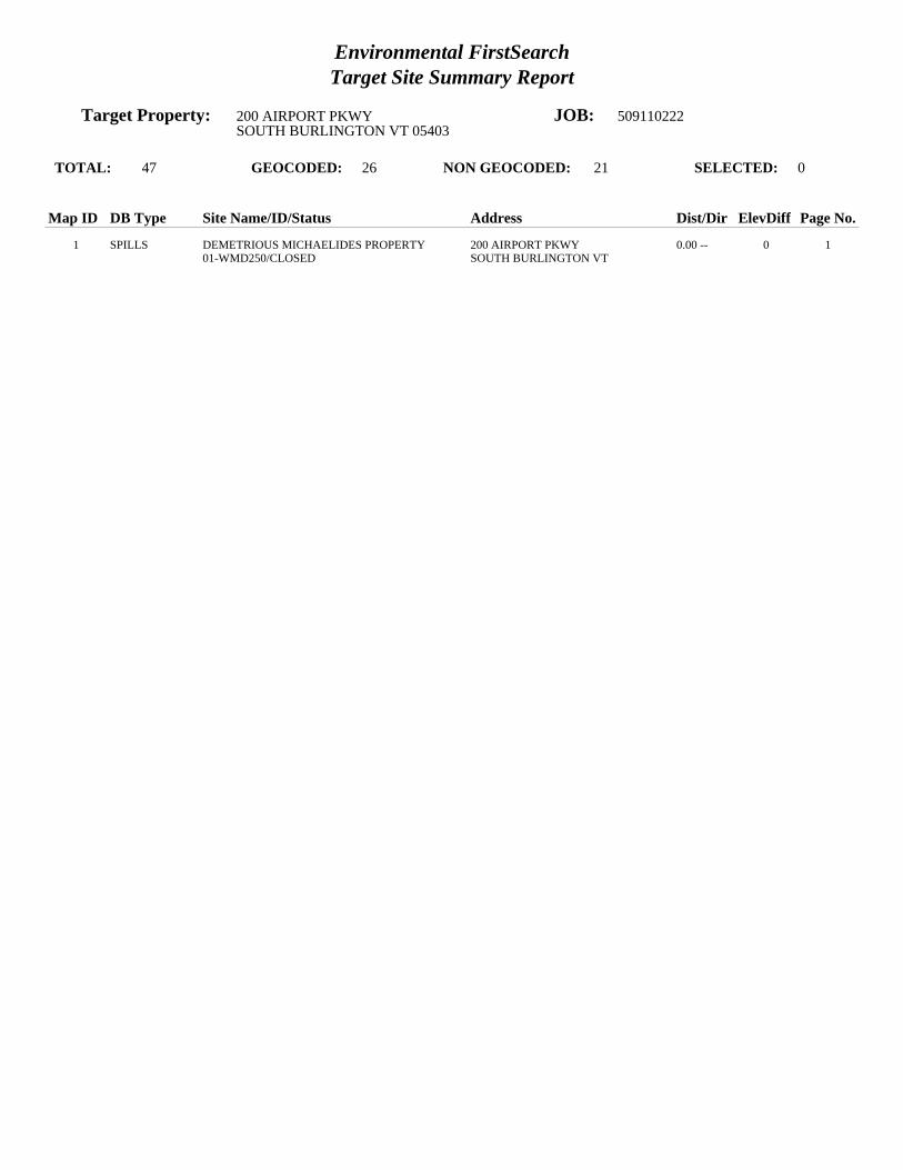
Environmental FirstSearchTarget Site Summary Report
Target Property: 200 AIRPORT PKWY JOB: 509110222SOUTH BURLINGTON VT 05403
TOTAL: 47 GEOCODED: 26 NON GEOCODED: 21 SELECTED: 0
Map ID DB Type Site Name/ID/Status Address Dist/Dir ElevDiff Page No.
1 SPILLS DEMETRIOUS MICHAELIDES PROPERTY 200 AIRPORT PKWY 0.00 -- 0 101-WMD250/CLOSED SOUTH BURLINGTON VT

Environmental FirstSearchSites Summary Report
Target Property: 200 AIRPORT PKWY JOB: 509110222SOUTH BURLINGTON VT 05403
TOTAL: 47 GEOCODED: 26 NON GEOCODED: 21 SELECTED: 0
Map ID DB Type Site Name/ID/Status Address Dist/Dir ElevDiff Page No.
1 SPILLS DEMETRIOUS MICHAELIDES PROPERTY 200 AIRPORT PKWY 0.00 -- 0 101-WMD250/CLOSED SOUTH BURLINGTON VT
2 RCRAGN EUROTECH SALES & SERVICE 615 AIRPORT PKWY 0.16 NW - 13 2VTD981207236/VGN SOUTH BURLINGTON VT 05403
3 STATE BUDGET RENT A CAR 700 AIRPORT PKWY 0.26 NW - 19 3931526/CLOSED SOUTH BURLINGTON VT
3 LUST BUDGET RENT A CAR 700 AIRPORT PKWY 0.26 NW - 19 4621/PULLED UST DATABASE SOUTH BURLINGTON VT 05403
4 LUST CHAMBERLIN SCHOOL 262 WHITE ST 0.36 SE + 8 5628/PULLED UST DATABASE SOUTH BURLINGTON VT 05401
5 LUST GAMACHE RESIDENCE 82 SUBURBAN SQ 0.43 SE + 24 62001088/PULLED UST DATABASE SOUTH BURLINGTON VT
6 LUST HARRINGTON BROTHERS 400 PATCHEN RD 0.46 NW - 17 79990213/PULLED UST DATABASE SOUTH BURLINGTON VT
7 LUST SCHOOL DISTRICT BUS GARAGE PATCHEN RD 0.49 NW - 23 8627/PULLED UST DATABASE SOUTH BURLINGTON VT 05401
8 STATE OFFSET HOUSE UNKNOWN 0.53 NW - 28 9870107/CLOSED SOUTH BURLINGTON VT
8 STATE OFFSET HOUSE PROPERTY UNKNOWN 0.53 NW - 28 10770075/CLOSED SOUTH BURLINGTON VT
9 STATE KELCO FACILITY 73 ETHAN ALLEN DR 0.56 NE - 101 1120002783/CLOSED SOUTH BURLINGTON VT
10 STATE SOUTH BURLINGTON STREET DEPT PATCHEN RD 0.60 NW - 46 12931383/ACTIVE SOUTH BURLINGTON VT
11 STATE HERTZ RENT A CAR/NATIONAL CAR 0 BURLINGTON INTRNTNL AIRPO 0.62 SE + 16 13921313/ACTIVE SOUTH BURLINGTON VT
12 STATE U S POST OFFICE 60 WHITE ST 0.66 SW - 11 14972299/CLOSED SOUTH BURLINGTON VT
13 STATE WILLISTON ROAD MOBIL 1314 WILLISTON RD 0.70 SW + 3 15921327/ACTIVE SOUTH BURLINGTON VT
14 STATE U-SAVE BEVERAGE 0 WILLISTON RD 0.71 SW - 6 16900496/ACTIVE SOUTH BURLINGTON VT
15 STATE GRACEY S STORE 0 WILLISTON RD 0.73 SW + 7 17951924/ACTIVE SOUTH BURLINGTON VT
16 STATE VERMONT AIR NATIONAL GUARD 0 AIRPORT RD 0.75 NE - 19 18770043/ACTIVE SOUTH BURLINGTON VT
17 STATE WILLISTON ROAD CITGO - DAVE S CITG 1241 WILLISTON RD 0.77 SW - 4 19900545/ACTIVE SOUTH BURLINGTON VT
18 STATE DOLANS VARIETY 1160 WILLISTON RD 0.80 SW - 8 20961956/ACTIVE SOUTH BURLINGTON VT

Environmental FirstSearchSites Summary Report
Target Property: 200 AIRPORT PKWY JOB: 509110222SOUTH BURLINGTON VT 05403
TOTAL: 47 GEOCODED: 26 NON GEOCODED: 21 SELECTED: 0
Map ID DB Type Site Name/ID/Status Address Dist/Dir ElevDiff Page No.
19 STATE SOUTH BURLINGTON CENTRAL SCHOOL 1181 WILLISTON RD 0.80 SW - 7 21921301/CLOSED SOUTH BURLINGTON VT
20 STATE UNIVERSITY GULF 0 WILLISTON RD 0.84 SW - 13 22900646/ACTIVE SOUTH BURLINGTON VT
21 STATE CHAMPLAIN VALLEY SUNOCO 1143 WILLISTON RD 0.85 SW - 14 23982491/ACTIVE SOUTH BURLINGTON VT
22 STATE BURLINGTON INTERNATIONAL AIRPORT 0 AIRPORT RD 0.93 SE + 2 24931503/ACTIVE SOUTH BURLINGTON VT
23 STATE GREERS DRY CLEANING DORSET STREET UNKNOWN 0.95 SW - 6 2520053395/ACTIVE SOUTH BURLINGTON VT
24 STATE UNIVERSITY INN 5 DORSET ST 1.00 SW - 14 2620002751/CLOSED SOUTH BURLINGTON VT

Environmental FirstSearchSites Summary Report
Target Property: 200 AIRPORT PKWY JOB: 509110222SOUTH BURLINGTON VT 05403
TOTAL: 47 GEOCODED: 26 NON GEOCODED: 21 SELECTED: 0
Map ID DB Type Site Name/ID/Status Address Dist/Dir ElevDiff Page No.
STATE GADUE DRY CLEANER DORSET STREET UNKNOWN NON GC N/A N/A20053295/ACTIVE SOUTH BURLINGTON VT
STATE GORDIES TEXACO UNKNOWN NON GC N/A N/A870020/CLOSED SOUTH BURLINGTON VT
SPILLS AIR GUARD BURLINGTON INTNL AIRPORT NON GC N/A N/A09-WMD239/CLOSED SOUTH BURLINGTON VT
SPILLS JAMES KNEELAND FLIGHT FACILITY AIRPORT RD NON GC N/A N/A06-WMD192/CLOSED SOUTH BURLINGTON VT
SPILLS MAINTENANCE BUILDING B 1 A AIRPORT RD NON GC N/A N/A02-WMD239/CLOSED SOUTH BURLINGTON VT
SPILLS N/A AIRPORT PKWY NON GC N/A N/A95-WMD116/CLOSED SOUTH BURLINGTON VT
SPILLS VT AIR NATIONAL GUARD AIRPORT DR NON GC N/A N/A10-WMD167/CLOSED BURLINGTON VT
SPILLS VT ANG AIRPORT DR NON GC N/A N/A11-WMD316/CLOSED SOUTH BURLINGTON VT
SWL A. MARCELINO AND COMPANY, INC. UNKNOWN NON GC N/A N/ACH772/RECYCLING SOUTH BURLINGTON VT 05495
SWL CHITTENDEN SWM DISTRICT DROP-OFF C PATCHEN ROAD NON GC N/A N/ACH771/DROP OFF CENTER SOUTH BURLINGTON VT 05495
SWL CHITTENDEN SWMD TRANS STATION PATCHEN ROAD NON GC N/A N/A11/A SOUTH BURLINGTON VT 05403
SWL CHITTENDEN SWMD TRANS STATION PATCHEN ROAD NON GC N/A N/A011/A SOUTH BURLINGTON VT 05403
SWL CSWD ENVIRONMENTAL DEPOT UNKNOWN NON GC N/A N/ACH080/HHW/CESQG SOUTH BURLINGTON VT 05495
SWL ENGINEERS CONSTRUCTION DISPOSAL SI UNKNOWN NON GC N/A N/ACH980/LANDFILL SOUTH BURLINGTON VT 05486
UST KNEELAND FLIGHT FACILITY AIRPORT BIAP RD NON GC N/A N/A1037/ACTIVE SOUTH BURLINGTON VT 05402
LUST AIRPORT PARKWAY SEWER PUMP STATION HINESBURGH RD NON GC N/A N/A2736/PULLED UST DATABASE SOUTH BURLINGTON VT
LUST MUNT RESIDENCE 85 SOUTH ST NON GC N/A N/A5557561/PULLED UST DATABASE BURLINGTON VT
LUST NEW ENGLAND TELEPHONE CENTRAL OFFI FARRELL ST NON GC N/A N/A895/PULLED UST DATABASE SOUTH BURLINGTON VT 05401
LUST STRATTON CORP GOLF MAINTENANCE ORCUTT MEADOW RD NON GC N/A N/A517/PULLED UST DATABASE WINHALL VT 05403
LUST VERMONT TIRE WILLISTON RD NON GC N/A N/A5555576/PULLED UST DATABASE SOUTH BURLINGTON VT

Environmental FirstSearchSites Summary Report
Target Property: 200 AIRPORT PKWY JOB: 509110222SOUTH BURLINGTON VT 05403
TOTAL: 47 GEOCODED: 26 NON GEOCODED: 21 SELECTED: 0
Map ID DB Type Site Name/ID/Status Address Dist/Dir ElevDiff Page No.
TRIBALLA BUREAU OF INDIAN AFFAIRS CONTACT I UNKNOWN NON GC N/A N/ABIA-05403/ VT 05403

Environmental FirstSearchSite Detail Report
Target Property: 200 AIRPORT PKWY JOB: 509110222SOUTH BURLINGTON VT 05403
SPILLS
SEARCH ID: 21 DIST/DIR: 0.00 -- ELEVATION: 326 MAP ID: 1
NAME: DEMETRIOUS MICHAELIDES PROPERTY REV: 7/8/11ADDRESS: 200 AIRPORT PKWY ID1: 01-WMD250
SOUTH BURLINGTON VT ID2: CHITTENDEN STATUS: CLOSED
CONTACT: PHONE: SOURCE: VT DEC
Site Details Page - 1
6900DATE OF INCIDENT: 7/5/2001 0:00:00TIME OF INCIDENT: 0DATE CLOSED: 9/4/2001 0:00:00UST FACILITY ID:DUTY OFFICER:REPORTED BY: MOE FORCIERREPORTER S ORGANIZATION: EM MGMNTREPORTER S WORK PHONE:
TYPE OF INCIDENT: ABOVE GROUND TANK RELEASEPRODUCT: #2QUANTITY: 5UNIT OF MEASURE: G
RESPONSIBLE PARTY: DEMETRIOUS MICHAELIDESADDRESS:
RESPONSIBLE PARTY S PHONE: 878-1008
6900SURFACE WATER AFFECTED:
CASE ASSIGNED TO: SPILLSACTIONS TAKEN: AGWAY RESPONSE. TENANTS TO CALL IF ODORS HAVEN T IMPROVED. 9/4/01 - CALLED TENANTS. AGWAY HADRETURNED AND DID ADDITIONAL CLEANING OF BASEMENT. TENANTS DISPOSED OIL SOAKED RUG. NO SIGNIFICANT ODORS REMAIN.
COMMENTS:

Environmental FirstSearchSite Detail Report
Target Property: 200 AIRPORT PKWY JOB: 509110222SOUTH BURLINGTON VT 05403
RCRAGN
SEARCH ID: 1 DIST/DIR: 0.16 NW ELEVATION: 313 MAP ID: 2
NAME: EUROTECH SALES & SERVICE REV: 7/11/11ADDRESS: 615 AIRPORT PKWY ID1: VTD981207236
SOUTH BURLINGTON VT 05403 ID2: CHITTENDEN STATUS: VGN
CONTACT: PHONE: SOURCE: EPA
Site Details Page - 2
SITE INFORMATION
CONTACT INFORMATION: FISHER BOB615 AIRPORT PKYSOUTH BURLINGTON VT 05403
PHONE: 8028625369
CONTACT INFORMATION: RUSSELL BERGER615 AIRPORT PKYSOUTH BURLINGTON VT 05403
PHONE: 8026601900
UNIVERSE INFORMATION:
NAIC INFORMATION
ENFORCEMENT INFORMATION:
VIOLATION INFORMATION:
HAZARDOUS WASTE INFORMATION:
The following spent non-halogenated solvents: toluene, methyl ethyl ketone, carbon disulfide, isobutanol, pyridine, benzene, 2-ethoxyethanol, and 2-nitropropane;all spent solvent mixtures/blends containing, before use, a total of ten percent or more (byTetrachloroethyleneMethyl ethyl ketoneIgnitable wasteBenzeneThe following spent non-halogenated solvents: Xylene, acetone, ethyl acetate, ethyl benzene, ethyl ether, methyl isobutyl ketone, n-butyl alcohol, cyclohexanone,and methanol; all spent solvent mixtures/ blends containing, before use, only the above spent

Environmental FirstSearchSite Detail Report
Target Property: 200 AIRPORT PKWY JOB: 509110222SOUTH BURLINGTON VT 05403
STATE
SEARCH ID: 2 DIST/DIR: 0.26 NW ELEVATION: 307 MAP ID: 3
NAME: BUDGET RENT A CAR REV: 12/3/09ADDRESS: 700 AIRPORT PKWY ID1: 931526
SOUTH BURLINGTON VT ID2: CHITTENDEN STATUS: CLOSED
CONTACT: PHONE: SOURCE: VT DEC
Site Details Page - 3
6900SITE INFORMATION
PRIORITY: NO FURTHER ACTION PLANNEDPROJECT STATUS: DETERMINE DEGREE AND EXTENT OF CONTAMINATIONDATE OF SITE DISCOVERY: 12/1/1993 0:00:00DATE OF SITE CLOSURE: 5/1/1994 0:00:00SOURCE: 6900 UST-GASOLINE, 6900
OWNER INFORMATION:
OWNER: VAL PREDA LEASING INCOWNER ADDRESS: 700 AIRPORT PKWYSOUTH BURLINGTON VT 05403

Environmental FirstSearchSite Detail Report
Target Property: 200 AIRPORT PKWY JOB: 509110222SOUTH BURLINGTON VT 05403
LUST
SEARCH ID: 22 DIST/DIR: 0.26 NW ELEVATION: 307 MAP ID: 3
NAME: BUDGET RENT A CAR REV: 7/8/11ADDRESS: 700 AIRPORT PKWY ID1: 621
SOUTH BURLINGTON VT 05403 ID2: 931526CHITTENDEN STATUS: PULLED UST DATABASE
CONTACT: VAL PREDA LEASING INC PHONE: 802-863-5512SOURCE: VT DEC
Site Details Page - 4
This site comes from the Vermont Department of Environmental Conservation Pulled Underground Storage Tanks database and may or may not be considered aleaking underground storage tank , please review the data below for further indications of contamination.
SITE FINDINGS: CONTAMINATION FOUND ABOVE STATE STANDARD. REFERRED TO SITE MANAGEMENT
FACILITY AND OWNER INFORMATION
TYPE OF FACILITY: INDUSTRIAL/COMMERCIAL
OWNER NAME: VAL PREDA LEASING INCCONTACT: PETER VAL PREDA, PRESIDENTOWNER ADDRESS: 700 AIRPORT PARKWAYSOUTH BURLINGTON, VT
LAND OWNER:** UNKNOWN ***PERMITTED TO:TANK OWNERNUM OF PULLED TANKS:2NUM OF REMOVED TANKS:2NUM OF GROUNDWATER MONITORING WELLS:NUM OF VAPOR MONITORING WELLS:
TANK INFORMATION
TOTAL NUMBER OF TANKS: 2
TANK ID: 529TANK STATUS:PULLEDSUBSTANCE STORED: TANK CAPACITY IN GAL.: 4000TANK PROTECTION: UNPROTECTED STEELYEAR REMOVED: 1993TANK MONITORING: /SPILL/OVERFILL PROT.: PUMP TYPE:PIPE PROTECTION: TESTED DATE:PIPE MONITORING:TANK LABEL:1981-1
TANK ID: 530TANK STATUS:PULLEDSUBSTANCE STORED: TANK CAPACITY IN GAL.: 500TANK PROTECTION: UNPROTECTED STEELYEAR REMOVED: UNKTANK MONITORING: /SPILL/OVERFILL PROT.: PUMP TYPE:PIPE PROTECTION: TESTED DATE:PIPE MONITORING:TANK LABEL:1981-2

Environmental FirstSearchSite Detail Report
Target Property: 200 AIRPORT PKWY JOB: 509110222SOUTH BURLINGTON VT 05403
LUST
SEARCH ID: 23 DIST/DIR: 0.36 SE ELEVATION: 334 MAP ID: 4
NAME: CHAMBERLIN SCHOOL REV: 7/8/11ADDRESS: 262 WHITE ST ID1: 628
SOUTH BURLINGTON VT 05401 ID2: CHITTENDEN STATUS: PULLED UST DATABASE
CONTACT: SOUTH BURLINGTON SCHOOL DISTRICT PHONE: SOURCE: VT DEC
Site Details Page - 5
This site comes from the Vermont Department of Environmental Conservation Pulled Underground Storage Tanks database and may or may not be considered aleaking underground storage tank , please review the data below for further indications of contamination.
SITE FINDINGS: NO CONTAMINATION FOUND
FACILITY AND OWNER INFORMATION
TYPE OF FACILITY: TOWN
OWNER NAME: SOUTH BURLINGTON SCHOOL DISTRICTCONTACT:OWNER ADDRESS: 550 DORSET STREETSOUTH BURLINGTON, VT
LAND OWNER:** UNKNOWN ***PERMITTED TO:NUM OF PULLED TANKS:1NUM OF REMOVED TANKS:1NUM OF GROUNDWATER MONITORING WELLS:NUM OF VAPOR MONITORING WELLS:
TANK INFORMATION
TOTAL NUMBER OF TANKS: 1
TANK ID: 538TANK STATUS:PULLEDSUBSTANCE STORED: TANK CAPACITY IN GAL.: 10000TANK PROTECTION: UNPROTECTED STEELYEAR REMOVED: 1992TANK MONITORING: /SPILL/OVERFILL PROT.: PUMP TYPE:PIPE PROTECTION: TESTED DATE:PIPE MONITORING:TANK LABEL:1965-1

Environmental FirstSearchSite Detail Report
Target Property: 200 AIRPORT PKWY JOB: 509110222SOUTH BURLINGTON VT 05403
LUST
SEARCH ID: 24 DIST/DIR: 0.43 SE ELEVATION: 350 MAP ID: 5
NAME: GAMACHE RESIDENCE REV: 7/8/11ADDRESS: 82 SUBURBAN SQ ID1: 2001088
SOUTH BURLINGTON VT ID2: CHITTENDEN STATUS: PULLED UST DATABASE
CONTACT: CLEMENT GAMACHE PHONE: SOURCE: VT DEC
Site Details Page - 6
This site comes from the Vermont Department of Environmental Conservation Pulled Underground Storage Tanks database and may or may not be considered aleaking underground storage tank , please review the data below for further indications of contamination.
SITE FINDINGS: NO CONTAMINATION FOUND
FACILITY AND OWNER INFORMATION
TYPE OF FACILITY: RESIDENTIAL
OWNER NAME: CLEMENT GAMACHECONTACT:OWNER ADDRESS: 82 SUBURBAN SQUARESOUTH BURLINGTON, VT
LAND OWNER:** UNKNOWN ***PERMITTED TO:NUM OF PULLED TANKS:1NUM OF REMOVED TANKS:1NUM OF GROUNDWATER MONITORING WELLS:NUM OF VAPOR MONITORING WELLS:
TANK INFORMATION
TOTAL NUMBER OF TANKS: 1
TANK ID: 2659TANK STATUS:PULLEDSUBSTANCE STORED: TANK CAPACITY IN GAL.: 2000TANK PROTECTION: YEAR REMOVED: 2001TANK MONITORING: /SPILL/OVERFILL PROT.: PUMP TYPE:PIPE PROTECTION: TESTED DATE:PIPE MONITORING:TANK LABEL:-1-1-R

Environmental FirstSearchSite Detail Report
Target Property: 200 AIRPORT PKWY JOB: 509110222SOUTH BURLINGTON VT 05403
LUST
SEARCH ID: 25 DIST/DIR: 0.46 NW ELEVATION: 309 MAP ID: 6
NAME: HARRINGTON BROTHERS REV: 7/8/11ADDRESS: 400 PATCHEN RD ID1: 9990213
SOUTH BURLINGTON VT ID2: CHITTENDEN STATUS: PULLED UST DATABASE
CONTACT: HARRINGTON BROTHERS PHONE: SOURCE: VT DEC
Site Details Page - 7
This site comes from the Vermont Department of Environmental Conservation Pulled Underground Storage Tanks database and may or may not be considered aleaking underground storage tank , please review the data below for further indications of contamination.
SITE FINDINGS: NO CONTAMINATION FOUND
FACILITY AND OWNER INFORMATION
TYPE OF FACILITY: INDUSTRIAL/COMMERCIAL
OWNER NAME: HARRINGTON BROTHERSCONTACT:OWNER ADDRESS:,
LAND OWNER:** UNKNOWN ***PERMITTED TO:NUM OF PULLED TANKS:1NUM OF REMOVED TANKS:1NUM OF GROUNDWATER MONITORING WELLS:NUM OF VAPOR MONITORING WELLS:
TANK INFORMATION
TOTAL NUMBER OF TANKS: 1
TANK ID: 5702TANK STATUS:PULLEDSUBSTANCE STORED: TANK CAPACITY IN GAL.: 2000TANK PROTECTION: UNPROTECTED STEELYEAR REMOVED: 1989TANK MONITORING: /SPILL/OVERFILL PROT.: PUMP TYPE:PIPE PROTECTION: TESTED DATE:PIPE MONITORING:TANK LABEL:-1-1

Environmental FirstSearchSite Detail Report
Target Property: 200 AIRPORT PKWY JOB: 509110222SOUTH BURLINGTON VT 05403
LUST
SEARCH ID: 26 DIST/DIR: 0.49 NW ELEVATION: 303 MAP ID: 7
NAME: SCHOOL DISTRICT BUS GARAGE REV: 7/8/11ADDRESS: PATCHEN RD ID1: 627
SOUTH BURLINGTON VT 05401 ID2: STATUS: PULLED UST DATABASE
CONTACT: SOUTH BURLINGTON SCHOOL DISTRICT PHONE: SOURCE: VT DEC
Site Details Page - 8
This site comes from the Vermont Department of Environmental Conservation Pulled Underground Storage Tanks database and may or may not be considered aleaking underground storage tank , please review the data below for further indications of contamination.
SITE FINDINGS: NO CONTAMINATION FOUND
FACILITY AND OWNER INFORMATION
TYPE OF FACILITY: TOWN
OWNER NAME: SOUTH BURLINGTON SCHOOL DISTRICTCONTACT:OWNER ADDRESS: 550 DORSET STREETSOUTH BURLINGTON, VT
LAND OWNER:** UNKNOWN ***PERMITTED TO:NUM OF PULLED TANKS:1NUM OF REMOVED TANKS:1NUM OF GROUNDWATER MONITORING WELLS:NUM OF VAPOR MONITORING WELLS:
TANK INFORMATION
TOTAL NUMBER OF TANKS: 1
TANK ID: 537TANK STATUS:PULLEDSUBSTANCE STORED: TANK CAPACITY IN GAL.: 4000TANK PROTECTION: UNPROTECTED STEELYEAR REMOVED: 1989TANK MONITORING: /SPILL/OVERFILL PROT.: PUMP TYPE:PIPE PROTECTION: TESTED DATE:PIPE MONITORING:TANK LABEL:1968-1

Environmental FirstSearchSite Detail Report
Target Property: 200 AIRPORT PKWY JOB: 509110222SOUTH BURLINGTON VT 05403
STATE
SEARCH ID: 10 DIST/DIR: 0.53 NW ELEVATION: 298 MAP ID: 8
NAME: OFFSET HOUSE REV: 12/3/09ADDRESS: UNKNOWN ID1: 870107
SOUTH BURLINGTON VT ID2: CHITTENDEN STATUS: CLOSED
CONTACT: PHONE: SOURCE: VT DEC
Site Details Page - 9
6900SITE INFORMATION
PRIORITY: NO FURTHER ACTION PLANNEDPROJECT STATUS: SITE CLOSEDDATE OF SITE DISCOVERY:DATE OF SITE CLOSURE:SOURCE: 6900
OWNER INFORMATION:
OWNER:OWNER ADDRESS:

Environmental FirstSearchSite Detail Report
Target Property: 200 AIRPORT PKWY JOB: 509110222SOUTH BURLINGTON VT 05403
STATE
SEARCH ID: 11 DIST/DIR: 0.53 NW ELEVATION: 298 MAP ID: 8
NAME: OFFSET HOUSE PROPERTY REV: 12/3/09ADDRESS: UNKNOWN ID1: 770075
SOUTH BURLINGTON VT ID2: CHITTENDEN STATUS: CLOSED
CONTACT: PHONE: SOURCE: VT DEC
Site Details Page - 10
6900SITE INFORMATION
PRIORITY: NO FURTHER ACTION PLANNEDPROJECT STATUS: CONTAMINATION BELOW ACTION LEVELS, SITE CLOSEDDATE OF SITE DISCOVERY:DATE OF SITE CLOSURE:SOURCE: 6900
OWNER INFORMATION:
OWNER:OWNER ADDRESS:

Environmental FirstSearchSite Detail Report
Target Property: 200 AIRPORT PKWY JOB: 509110222SOUTH BURLINGTON VT 05403
STATE
SEARCH ID: 9 DIST/DIR: 0.56 NE ELEVATION: 225 MAP ID: 9
NAME: KELCO FACILITY REV: 12/3/09ADDRESS: 73 ETHAN ALLEN DR ID1: 20002783
SOUTH BURLINGTON VT ID2: CHITTENDEN STATUS: CLOSED
CONTACT: PHONE: SOURCE: VT DEC
Site Details Page - 11
6900SITE INFORMATION
PRIORITY: SITES MANAGEMENT ACTIVITY COMPLETEDPROJECT STATUS: THREE USTS REMOVED JUNE 2000, LIMITED CONTAMINATION REMAINS IN THE VICINITY OF THE FORMER DIESEL UST.ETHYLBENZENE, 1,2,4- AND 1,3,5-TRIMETHYLBENZENE REMAIN, AT LEVELS BELOW VGES, IN THE DIESEL SOURCE AREA WELL. NOSENSITIVE RECEPTOS AFFECTED, RESIDUAL CONTAMINATION CONFINED TO BETWEEN 6 AND 9 FT BGS.DATE OF SITE DISCOVERY: 6/5/2000 0:00:00DATE OF SITE CLOSURE: 4/9/2009 0:00:00SOURCE: 6900 UST-WASTE OIL, 6900 OTHER, 6900 UST-DIESEL, 6900
OWNER INFORMATION:
OWNER: JEFF MYERS & MICHAEL CRETEOWNER ADDRESS: 73 ETHAN ALLEN DRIVESOUTH BURLINGTON VT 05403
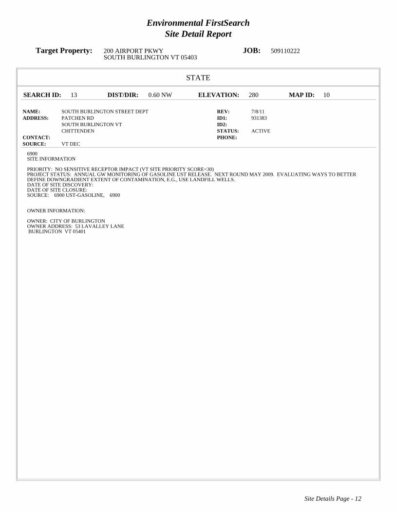
Environmental FirstSearchSite Detail Report
Target Property: 200 AIRPORT PKWY JOB: 509110222SOUTH BURLINGTON VT 05403
STATE
SEARCH ID: 13 DIST/DIR: 0.60 NW ELEVATION: 280 MAP ID: 10
NAME: SOUTH BURLINGTON STREET DEPT REV: 7/8/11ADDRESS: PATCHEN RD ID1: 931383
SOUTH BURLINGTON VT ID2: CHITTENDEN STATUS: ACTIVE
CONTACT: PHONE: SOURCE: VT DEC
Site Details Page - 12
6900SITE INFORMATION
PRIORITY: NO SENSITIVE RECEPTOR IMPACT (VT SITE PRIORITY SCORE<30)PROJECT STATUS: ANNUAL GW MONITORING OF GASOLINE UST RELEASE. NEXT ROUND MAY 2009. EVALUATING WAYS TO BETTERDEFINE DOWNGRADIENT EXTENT OF CONTAMINATION, E.G., USE LANDFILL WELLS.DATE OF SITE DISCOVERY:DATE OF SITE CLOSURE:SOURCE: 6900 UST-GASOLINE, 6900
OWNER INFORMATION:
OWNER: CITY OF BURLINGTONOWNER ADDRESS: 53 LAVALLEY LANEBURLINGTON VT 05401

Environmental FirstSearchSite Detail Report
Target Property: 200 AIRPORT PKWY JOB: 509110222SOUTH BURLINGTON VT 05403
STATE
SEARCH ID: 8 DIST/DIR: 0.62 SE ELEVATION: 342 MAP ID: 11
NAME: HERTZ RENT A CAR/NATIONAL CAR REV: 7/8/11ADDRESS: 0 BURLINGTON INTRNTNL AIRPORT ID1: 921313
SOUTH BURLINGTON VT ID2: STATUS: ACTIVE
CONTACT: PHONE: SOURCE: VT DEC
Site Details Page - 13
6900SITE INFORMATION
PRIORITY: NO SENSITIVE RECEPTOR IMPACT (VT SITE PRIORITY SCORE<30)PROJECT STATUS: ANNUAL GROUNDWATER MONITORING TO TRACK 1992 GASOLINE RELEASE FROM BOTH HERTZ AND NATIONAL CARRENTAL TANKS. MONITORING CONTINUES TO REVEAL GROUNDWATER ENFORCEMENT STANDARD EXCEEDANCES IN SEVERAL WELLS.NEXT ROUND SCHEDULED FOR OCTOBER 2010.DATE OF SITE DISCOVERY:DATE OF SITE CLOSURE:SOURCE: 6900 UST-GASOLINE, 6900
OWNER INFORMATION:
OWNER: THE HERTZ CORPOWNER ADDRESS: 225 BRAE BLVD.PARK RIDGE NJ 07656

Environmental FirstSearchSite Detail Report
Target Property: 200 AIRPORT PKWY JOB: 509110222SOUTH BURLINGTON VT 05403
STATE
SEARCH ID: 14 DIST/DIR: 0.66 SW ELEVATION: 315 MAP ID: 12
NAME: U S POST OFFICE REV: 12/3/09ADDRESS: 60 WHITE ST ID1: 972299
SOUTH BURLINGTON VT ID2: CHITTENDEN STATUS: CLOSED
CONTACT: PHONE: SOURCE: VT DEC
Site Details Page - 14
6900SITE INFORMATION
PRIORITY: SITES MANAGEMENT ACTIVITY COMPLETEDPROJECT STATUS: UST REMOVED. CONTAMINATION FOUND. INVESTIGATION PERFORMED AND PCS EXCAVATED/DISPOSED OF AT ESMI.MWS HAVE BEEN PROPERLY ABANDONED. RONALD ROBBINS OF USPS IS OFFICIAL CONTACT.DATE OF SITE DISCOVERY: 11/1/1997 0:00:00DATE OF SITE CLOSURE: 1/12/2006 0:00:00SOURCE: 6900 UST-HEATING OIL, 6900
OWNER INFORMATION:
OWNER: M A PARSONS AND SONSOWNER ADDRESS: P O BOX 450YORK ME 03909

Environmental FirstSearchSite Detail Report
Target Property: 200 AIRPORT PKWY JOB: 509110222SOUTH BURLINGTON VT 05403
STATE
SEARCH ID: 20 DIST/DIR: 0.70 SW ELEVATION: 329 MAP ID: 13
NAME: WILLISTON ROAD MOBIL REV: 7/8/11ADDRESS: 1314 WILLISTON RD ID1: 921327
SOUTH BURLINGTON VT ID2: CHITTENDEN STATUS: ACTIVE
CONTACT: PHONE: SOURCE: VT DEC
Site Details Page - 15
6900SITE INFORMATION
PRIORITY: NO SENSITIVE RECEPTOR IMPACT (VT SITE PRIORITY SCORE<30)PROJECT STATUS: GW IMPACTED FROM UST. INVEST NEEDED; 01/2006 - RECEVIED EXPRESSWAY NOTIFICATION - SI TO OCCUR JAN/FEB.2006; VGES EXCEEDENCES REPORTED; MOST LIKELY OFFSITE CONTAMINATION - FURTHER INVESTIGATION TO OCCUR. OFFSITEMIGRATION CONFIRMED IN JUNE 2006. STILL NOT DEFINED, FURTHER DOWNGRADIENT WELLS PLANNED FOR FALL 2006. VTGESEXCEEDENCES IN ADDITIONAL DOWNGRADIENT WELLS. MORE SITE CHARACTERIZATION PLANNED FOR SPRING 2007. LOW LEVELS; NOSENSITIVE RECEPTORS. CURRENT RECOMMENDATION IS FOR NEIGHBORING GAS STATION SMS SITE # 90-0496 TO DO FURTHERCHARACTERIZATION TO DETERMINE IF DOWNGRADIENT PLUMES ARE COMBINED. QUARTERLY GW SAMPLING ONGOING. 1/20/2010 -REDUCED TO SEMIANNUAL IN 2009, WILL CONTINUE THRU 2010 - MAY DECREASE TO ANNUAL AFTER THAT. NO CORRECTIVE ACTIONPLANNED.DATE OF SITE DISCOVERY: 12/8/1992 0:00:00DATE OF SITE CLOSURE:SOURCE: 6900 UST-GASOLINE, 6900
OWNER INFORMATION:
OWNER: S.B. COLLINS, INC.OWNER ADDRESS: P O BOX 671ST. ALBANS VT 05478

Environmental FirstSearchSite Detail Report
Target Property: 200 AIRPORT PKWY JOB: 509110222SOUTH BURLINGTON VT 05403
STATE
SEARCH ID: 15 DIST/DIR: 0.71 SW ELEVATION: 320 MAP ID: 14
NAME: U-SAVE BEVERAGE REV: 7/8/11ADDRESS: 0 WILLISTON RD ID1: 900496
SOUTH BURLINGTON VT ID2: CHITTENDEN STATUS: ACTIVE
CONTACT: PHONE: SOURCE: VT DEC
Site Details Page - 16
6900SITE INFORMATION
PRIORITY: NO SENSITIVE RECEPTOR IMPACT (VT SITE PRIORITY SCORE<30)PROJECT STATUS: UST CONTAMINATION FOUND. 5/2011 1 OF 6 MWS ABOVE VGES. ANNUAL MONITORINGDATE OF SITE DISCOVERY: 4/4/1990 0:00:00DATE OF SITE CLOSURE:SOURCE: 6900 UST-GASOLINE, 6900
OWNER INFORMATION:
OWNER: CHAMPLAIN OIL COOWNER ADDRESS: P O BOX 2126SOUTH BURLINGTON VT 05407

Environmental FirstSearchSite Detail Report
Target Property: 200 AIRPORT PKWY JOB: 509110222SOUTH BURLINGTON VT 05403
STATE
SEARCH ID: 6 DIST/DIR: 0.73 SW ELEVATION: 333 MAP ID: 15
NAME: GRACEY S STORE REV: 7/8/11ADDRESS: 0 WILLISTON RD ID1: 951924
SOUTH BURLINGTON VT ID2: CHITTENDEN STATUS: ACTIVE
CONTACT: PHONE: SOURCE: VT DEC
Site Details Page - 17
6900SITE INFORMATION
PRIORITY: NO SENSITIVE RECEPTOR IMPACT (VT SITE PRIORITY SCORE<30)PROJECT STATUS: SEVERAL REQUESTS FOR WORK MADE BETWEEN 1996 AND 2005. VERTERRE WP APPROVED 8/05. ISI FOUNDSIGNIFICANT LEVELS OF CONTAMIATION AT THIS SSITE UST LEAK FOUND IN OCTOBER, 2006. 1,500 GALLONS OF CONTAMINATED WATERREMOVED FROM SUBSURFACE. PID READINGS IN ONSITE STORM SEWER UP TO 1,100 PARTS PER MILLION. LARGE SCALE SOIL REMOVALCOMPLETED AND TANK DEFICIENCIES CORRECTED. ONGOING GROUNDWATER MONITORING IS BEING CONDUCTED AT THIS SITE.GROUNDWATER CONTAMINATION APPEARS TO BE SUBSIDING. NO SIGNIFICANT VAPORS PRESENT IN ONSITE STORM SEWER ACCESSPOINTS.DATE OF SITE DISCOVERY: 2/1/1996 0:00:00DATE OF SITE CLOSURE:SOURCE: 6900 UST-GASOLINE, 6900
OWNER INFORMATION:
OWNER: SALAMIN HANDYOWNER ADDRESS: 75 WINOOSKI AVEBURLINGTON VT 05401

Environmental FirstSearchSite Detail Report
Target Property: 200 AIRPORT PKWY JOB: 509110222SOUTH BURLINGTON VT 05403
STATE
SEARCH ID: 18 DIST/DIR: 0.75 NE ELEVATION: 307 MAP ID: 16
NAME: VERMONT AIR NATIONAL GUARD REV: 7/8/11ADDRESS: 0 AIRPORT RD ID1: 770043
SOUTH BURLINGTON VT ID2: STATUS: ACTIVE
CONTACT: PHONE: SOURCE: VT DEC
Site Details Page - 18
6900SITE INFORMATION
PRIORITY: DIRECTLY IMPACTED SENSITIVE RECEPTOR (VT SITE PRIORITY SCORE>60)PROJECT STATUS: BASEWIDE SUPPLEMENTAL REMEDIAL INVESTIGATION UNDERWAY SUMMER 04; REPORT BY EARLY 05. SITE 1GROUNDWATER INTERCEPTION TRENCH OPERATING AS DESIGNED. SITE 3 FREE PRODUCT RECOVERY SYSTEMS OPERATING ASDESIGNED.DATE OF SITE DISCOVERY:DATE OF SITE CLOSURE:SOURCE: 6900 ABOVE GROUND STORAGE TANK, 6900 UST-KEROSENE, 6900 SPILL, 6900 OTHER, 6900
OWNER INFORMATION:
OWNER: VERMONT AIR NATIONAL GUARDOWNER ADDRESS: AIRPORT ROADSOUTH BURLINGTON VT 05403

Environmental FirstSearchSite Detail Report
Target Property: 200 AIRPORT PKWY JOB: 509110222SOUTH BURLINGTON VT 05403
STATE
SEARCH ID: 19 DIST/DIR: 0.77 SW ELEVATION: 322 MAP ID: 17
NAME: WILLISTON ROAD CITGO - DAVE S CITGO REV: 7/8/11ADDRESS: 1241 WILLISTON RD ID1: 900545
SOUTH BURLINGTON VT ID2: CHITTENDEN STATUS: ACTIVE
CONTACT: PHONE: SOURCE: VT DEC
Site Details Page - 19
6900SITE INFORMATION
PRIORITY: THREATENED SENSITIVE RECEPTOR (30 >= VT SITE PRIORITY SCORE <= 60)PROJECT STATUS: VAPOR IMPACTS IN ADJACENT BUILDING. SVE REMEDIAL SYSTEM INSTALLED 11/00. REMEDIATION COMPLETED,REMEDIATION SYSTEM HAS BEEN SHUT OFF, MONITORING ONGOING. NO INDOOR AIR IMPACTS. 11/2010 - SEMI ANNUAL GWMONITORING ONGOING.DATE OF SITE DISCOVERY: 9/1/1996 0:00:00DATE OF SITE CLOSURE:SOURCE: 6900 UST-GASOLINE, 6900
OWNER INFORMATION:
OWNER: CHAMPLAIN OIL COOWNER ADDRESS: P O BOX 2126SOUTH BURLINGTON VT 05407
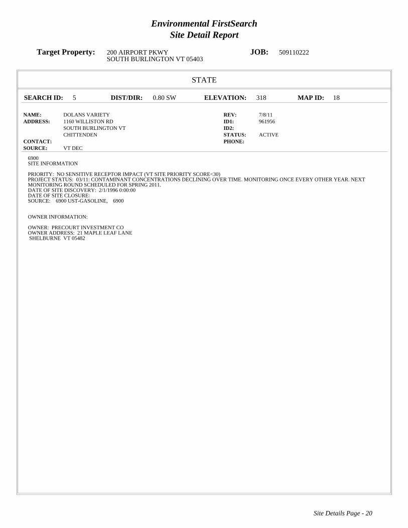
Environmental FirstSearchSite Detail Report
Target Property: 200 AIRPORT PKWY JOB: 509110222SOUTH BURLINGTON VT 05403
STATE
SEARCH ID: 5 DIST/DIR: 0.80 SW ELEVATION: 318 MAP ID: 18
NAME: DOLANS VARIETY REV: 7/8/11ADDRESS: 1160 WILLISTON RD ID1: 961956
SOUTH BURLINGTON VT ID2: CHITTENDEN STATUS: ACTIVE
CONTACT: PHONE: SOURCE: VT DEC
Site Details Page - 20
6900SITE INFORMATION
PRIORITY: NO SENSITIVE RECEPTOR IMPACT (VT SITE PRIORITY SCORE<30)PROJECT STATUS: 03/11: CONTAMINANT CONCENTRATIONS DECLINING OVER TIME. MONITORING ONCE EVERY OTHER YEAR. NEXTMONITORING ROUND SCHEDULED FOR SPRING 2011.DATE OF SITE DISCOVERY: 2/1/1996 0:00:00DATE OF SITE CLOSURE:SOURCE: 6900 UST-GASOLINE, 6900
OWNER INFORMATION:
OWNER: PRECOURT INVESTMENT COOWNER ADDRESS: 21 MAPLE LEAF LANESHELBURNE VT 05482

Environmental FirstSearchSite Detail Report
Target Property: 200 AIRPORT PKWY JOB: 509110222SOUTH BURLINGTON VT 05403
STATE
SEARCH ID: 12 DIST/DIR: 0.80 SW ELEVATION: 319 MAP ID: 19
NAME: SOUTH BURLINGTON CENTRAL SCHOOL REV: 12/3/09ADDRESS: 1181 WILLISTON RD ID1: 921301
SOUTH BURLINGTON VT ID2: CHITTENDEN STATUS: CLOSED
CONTACT: PHONE: SOURCE: VT DEC
Site Details Page - 21
6900SITE INFORMATION
PRIORITY: NO FURTHER ACTION PLANNEDPROJECT STATUS: UST REMOVED. IDENTIFIED CONTAMINATION. FURTHER WORK PENDING.DATE OF SITE DISCOVERY:DATE OF SITE CLOSURE: 5/27/1993 0:00:00SOURCE: 6900 UST-GASOLINE, 6900
OWNER INFORMATION:
OWNER: BURLINGTON SCHOOL DISTRICTOWNER ADDRESS: 287 SHELBURNE RDBURLINGTON VT 05401

Environmental FirstSearchSite Detail Report
Target Property: 200 AIRPORT PKWY JOB: 509110222SOUTH BURLINGTON VT 05403
STATE
SEARCH ID: 16 DIST/DIR: 0.84 SW ELEVATION: 313 MAP ID: 20
NAME: UNIVERSITY GULF REV: 7/8/11ADDRESS: 0 WILLISTON RD ID1: 900646
SOUTH BURLINGTON VT ID2: STATUS: ACTIVE
CONTACT: PHONE: SOURCE: VT DEC
Site Details Page - 22
6900SITE INFORMATION
PRIORITY: THREATENED SENSITIVE RECEPTOR (30 >= VT SITE PRIORITY SCORE <= 60)PROJECT STATUS: MONITORING ONGOING FOLLOWING UST REMOVAL.DATE OF SITE DISCOVERY:DATE OF SITE CLOSURE:SOURCE: 6900 UST-GASOLINE, 6900
OWNER INFORMATION:
OWNER:OWNER ADDRESS:

Environmental FirstSearchSite Detail Report
Target Property: 200 AIRPORT PKWY JOB: 509110222SOUTH BURLINGTON VT 05403
STATE
SEARCH ID: 4 DIST/DIR: 0.85 SW ELEVATION: 312 MAP ID: 21
NAME: CHAMPLAIN VALLEY SUNOCO REV: 7/8/11ADDRESS: 1143 WILLISTON RD ID1: 982491
SOUTH BURLINGTON VT ID2: CHITTENDEN STATUS: ACTIVE
CONTACT: PHONE: SOURCE: VT DEC
Site Details Page - 23
6900SITE INFORMATION
PRIORITY: NO SENSITIVE RECEPTOR IMPACT (VT SITE PRIORITY SCORE<30)PROJECT STATUS: CONTAM SOIL AND GW. INVESTIGATION COMPLETED. 12/16/99 2 OF 4 MWS ABOVE VGES. 3/21, 9/5/00, 3/30, 9/19/01, 3/15/02,3/18/03 3 OF 4 MWS, 3/24/04 2 OF 3MWS ABOVE VGES, 9/09 2 OF 9 MWS ABOVE VGES, SITE REDEVELOPED AS NSB BANK, BIENNIAL MONITORDATE OF SITE DISCOVERY: 9/21/1998 0:00:00DATE OF SITE CLOSURE:SOURCE: 6900 UST-GASOLINE, 6900
OWNER INFORMATION:
OWNER: NSB SAVINGS BANKOWNER ADDRESS: PO BOX 347NORTHFIELD VT 05663

Environmental FirstSearchSite Detail Report
Target Property: 200 AIRPORT PKWY JOB: 509110222SOUTH BURLINGTON VT 05403
STATE
SEARCH ID: 3 DIST/DIR: 0.93 SE ELEVATION: 328 MAP ID: 22
NAME: BURLINGTON INTERNATIONAL AIRPORT REV: 7/8/11ADDRESS: 0 AIRPORT RD ID1: 931503
SOUTH BURLINGTON VT ID2: CHITTENDEN STATUS: ACTIVE
CONTACT: PHONE: SOURCE: VT DEC
Site Details Page - 24
6900SITE INFORMATION
PRIORITY: NO SENSITIVE RECEPTOR IMPACT (VT SITE PRIORITY SCORE<30)PROJECT STATUS: ANNUAL GROUNDWATER MONITORING ONGOING AND FREE PRODUCT MONITORING.DATE OF SITE DISCOVERY:DATE OF SITE CLOSURE:SOURCE: 6900 ABOVE GROUND STORAGE TANK, 6900 UST-HEATING OIL, 6900
OWNER INFORMATION:
OWNER: BURLINGTON INTERNATIONAL AIRPORTOWNER ADDRESS: 1200 AIRPORT DRIVESOUTH BURLINGTON VT 05403

Environmental FirstSearchSite Detail Report
Target Property: 200 AIRPORT PKWY JOB: 509110222SOUTH BURLINGTON VT 05403
STATE
SEARCH ID: 7 DIST/DIR: 0.95 SW ELEVATION: 320 MAP ID: 23
NAME: GREERS DRY CLEANING DORSET STREET REV: 7/8/11ADDRESS: UNKNOWN ID1: 20053395
SOUTH BURLINGTON VT ID2: CHITTENDEN STATUS: ACTIVE
CONTACT: PHONE: SOURCE: VT DEC
Site Details Page - 25
6900SITE INFORMATION
PRIORITY: THREATENED SENSITIVE RECEPTOR (30 >= VT SITE PRIORITY SCORE <= 60)PROJECT STATUS:DATE OF SITE DISCOVERY: 7/1/2005 0:00:00DATE OF SITE CLOSURE:SOURCE: 6900
OWNER INFORMATION:
OWNER:OWNER ADDRESS:

Environmental FirstSearchSite Detail Report
Target Property: 200 AIRPORT PKWY JOB: 509110222SOUTH BURLINGTON VT 05403
STATE
SEARCH ID: 17 DIST/DIR: 1.00 SW ELEVATION: 312 MAP ID: 24
NAME: UNIVERSITY INN REV: 12/3/09ADDRESS: 5 DORSET ST ID1: 20002751
SOUTH BURLINGTON VT ID2: CHITTENDEN STATUS: CLOSED
CONTACT: PHONE: SOURCE: VT DEC
Site Details Page - 26
6900SITE INFORMATION
PRIORITY: SITES MANAGEMENT ACTIVITY COMPLETEDPROJECT STATUS: 2 FUEL OIL USTS CLOSED IN PLACE. CONTAM FOUND. 6/00, 3/01 4 OF 5 MWS, 7/03 2 OF 5 MWS ABOVE VGES, 1 FP, 5/04 3OF 5 ABOVE VGES.DATE OF SITE DISCOVERY: 2/29/2000 0:00:00DATE OF SITE CLOSURE: 1/27/2010 0:00:00SOURCE: 6900 UST-HEATING OIL, 6900 UST-GASOLINE, 6900 FREE PRODUCT PRESENT, 6900
OWNER INFORMATION:
OWNER: UNIVERSITY INNOWNER ADDRESS: P O BOX 993SOUTH BURLINGTON VT 05402

Environmental FirstSearch Descriptions
NPL: EPA NATIONAL PRIORITY LIST - The National Priorities List is a list of the worst hazardous waste sites that
have been identified by Superfund. Sites are only put on the list after they have been scored using the Hazard Ranking
System (HRS), and have been subjected to public comment. Any site on the NPL is eligible for cleanup using Superfund
Trust money. A Superfund site is any land in the United States that has been contaminated by hazardous waste and
identified by the Environmental Protection Agency (EPA) as a candidate for cleanup because it poses a risk to human
health and/or the environment.FINAL - Currently on the Final NPLPROPOSED - Proposed for NPL
NPL DELISTED: EPA NATIONAL PRIORITY LIST Subset - Database of delisted NPL sites. The National Oil and
Hazardous Substances Pollution Contingency Plan (NCP) establishes the criteria that the EPA uses to delete sites from the
NPL. In accordance with 40 CFR 300.425.(e), sites may be deleted from the NPL where no further response is
appropriate.DELISTED - Deleted from the Final NPL
CERCLIS: EPA COMPREHENSIVE ENVIRONMENTAL RESPONSE COMPENSATION AND LIABILITY
INFORMATION SYSTEM (CERCLIS)- CERCLIS is a database of potential and confirmed hazardous waste sites at
which the EPA Superfund program has some involvement. It contains sites that are either proposed to be or are on the
National Priorities List (NPL) as well as sites that are in the screening and assessment phase for possible inclusion on the
NPL.PART OF NPL- Site is part of NPL siteDELETED - Deleted from the Final NPLFINAL - Currently on the Final
NPLNOT PROPOSED - Not on the NPLNOT VALID - Not Valid Site or IncidentPROPOSED - Proposed for
NPLREMOVED - Removed from Proposed NPLSCAN PLAN - Pre-proposal SiteWITHDRAWN - Withdrawn
NFRAP: EPA COMPREHENSIVE ENVIRONMENTAL RESPONSE COMPENSATION AND LIABILITY
INFORMATION SYSTEM ARCHIVED SITES - database of Archive designated CERCLA sites that, to the best of
EPA's knowledge, assessment has been completed and has determined no further steps will be taken to list this site on the
National Priorities List (NPL). This decision does not necessarily mean that there is no hazard associated with a given site;
it only means that, based upon available information, the location is not judged to be a potential NPL site.NFRAP – No
Further Remedial Action PlanP - Site is part of NPL siteD - Deleted from the Final NPLF - Currently on the Final NPLN -
Not on the NPLO - Not Valid Site or IncidentP - Proposed for NPLR - Removed from Proposed NPLS - Pre-proposal
SiteW – Withdrawn
RCRA COR ACT: EPA RESOURCE CONSERVATION AND RECOVERY INFORMATION SYSTEM SITES -
Database of hazardous waste information contained in the Resource Conservation and Recovery Act Information
(RCRAInfo), a national program management and inventory system about hazardous waste handlers. In general, all
generators, transporters, treaters, storers, and disposers of hazardous waste are required to provide information about their
activities to state environmental agencies. These agencies, in turn pass on the information to regional and national EPA
offices. This regulation is governed by the Resource Conservation and Recovery Act (RCRA), as amended by the
Hazardous and Solid Waste Amendments of 1984.RCRAInfo facilities that have reported violations and subject to
corrective actions.
RCRA TSD: EPA RESOURCE CONSERVATION AND RECOVERY INFORMATION SYSTEM TREATMENT,
STORAGE, and DISPOSAL FACILITIES. - Database of hazardous waste information contained in the Resource
Conservation and Recovery Act Information (RCRAInfo), a national program management and inventory system about
hazardous waste handlers. In general, all generators, transporters, treaters, storers, and disposers of hazardous waste are

required to provide information about their activities to state environmental agencies. These agencies, in turn pass on the
information to regional and national EPA offices. This regulation is governed by the Resource Conservation and Recovery
Act (RCRA), as amended by the Hazardous and Solid Waste Amendments of 1984.Facilities that treat, store, dispose, or
incinerate hazardous waste.
RCRA GEN: EPA/MA DEP/CT DEP RESOURCE CONSERVATION AND RECOVERY INFORMATION SYSTEM
GENERATORS - Database of hazardous waste information contained in the Resource Conservation and Recovery Act
Information (RCRAInfo), a national program management and inventory system about hazardous waste handlers. In
general, all generators, transporters, treaters, storers, and disposers of hazardous waste are required to provide information
about their activities to state environmental agencies. These agencies, in turn pass on the information to regional and
national EPA offices. This regulation is governed by the Resource Conservation and Recovery Act (RCRA), as amended
by the Hazardous and Solid Waste Amendments of 1984.Facilities that generate or transport hazardous waste or meet
other RCRA requirements.LGN - Large Quantity GeneratorsSGN - Small Quantity GeneratorsVGN – Conditionally
Exempt Generator.Included are RAATS (RCRA Administrative Action Tracking System) and CMEL (Compliance
Monitoring & Enforcement List) facilities. CONNECTICUT HAZARDOUS WASTE MANIFEST – Database of all
shipments of hazardous waste within, into or from Connecticut. The data includes date of shipment, transporter and TSD
info, and material shipped and quantity. This data is appended to the details of existing generator records.
MASSACHUSETTES HAZARDOUS WASTE GENERATOR – database of generators that are regulated under the MA
DEP. VQN-MA = generates less than 220 pounds or 27 gallons per month of hazardous waste or waste oil.SQN-MA =
generates 220 to 2,200 pounds or 27 to 270 gallons per month of waste oil.LQG-MA = generates greater than 2,200 lbs of
hazardous waste or waste oil per month.
Fed Brownfield: EPA BROWNFIELD MANAGEMENT SYSTEM (BMS) - database designed to assist EPA in
collecting, tracking, and updating information, as well as reporting on the major activities and accomplishments of the
various Brownfield grant Programs./n CLEANUPS IN MY COMMUNITY (subset) - Sites, facilities and properties that
have been contaminated by hazardous materials and are being, or have been, cleaned up under EPA's brownfield’s
program.
ERNS: EPA/NRC EMERGENCY RESPONSE NOTIFICATION SYSTEM (ERNS) - Database of incidents reported to
the National Response Center. These incidents include chemical spills, accidents involving chemicals (such as fires or
explosions), oil spills, transportation accidents that involve oil or chemicals, releases of radioactive materials, sightings of
oil sheens on bodies of water, terrorist incidents involving chemicals, incidents where illegally dumped chemicals have
been found, and drills intended to prepare responders to handle these kinds of incidents. Data since January 2001 has been
received from the National Response System database as the EPA no longer maintains this data.
Tribal Lands: DOI/BIA INDIAN LANDS OF THE UNITED STATES - Database of areas with boundaries established by
treaty, statute, and (or) executive or court order, recognized by the Federal Government as territory in which American
Indian tribes have primary governmental authority. The Indian Lands of the United States map layer shows areas of 640
acres or more, administered by the Bureau of Indian Affairs. Included are Federally-administered lands within a
reservation which may or may not be considered part of the reservation.BUREAU OF INDIAN AFFIARS CONTACT -
Regional contact information for the Bureau of Indian Affairs offices.
State/Tribal Sites: VT DEC ACTIVE AND CLOSED HAZARDOUS SITES LIST - database of active and closed
hazardous waste sites. The data includes priority, project status, source, date of site discovery, date of site closure, and

owner information.
State Spills 90: VT DEC VERMONT SPILLS DATABASE - database of spills reported to the Vermont Department of
Environmental Conservation. The data includes information regarding incident date, type of incident, reporter, responsible
party, and action taken.
State/Tribal SWL: VT DEC SOLID WASTE MANAGEMENT FACILITIES LIST - database of both landfills and
transfer stations for the state of Vermont. The list includes contact information for each site.
State/Tribal LUST: VT DEC PULLED UNDERGROUND STORAGE TANKS LIST - database of tanks that have been
pulled/removed due to a leak. Under state law any tank that has reported a leak must be pulled/removed. The data includes
owner and operator name, facility type, and tank information.
State/Tribal UST/AST: VT DEC REGISTERED UNDERGROUND STORAGE TANKS LIST - database of underground
storage tanks registered with the Vermont Department of Environmental Conservation. The data includes facility type,
owner contact information, and tank substance, protection, and capacity.
State/Tribal Brownfields: VT ANR BROWNFIELD SITE LIST SUBSET- database of sites that have been classified as
Brownfields and have Institutional Controls. Information regarding size, response action, cleanup type, and project
manager is included. Management System (BMS) - database designed to assist EPA in collecting, tracking, and updating
information, as well as reporting on the major activities and accomplishments of the various brownfield grant programs.
State/Tribal Brownfields: VT ANR BROWNFIELD SITE LIST - database of sites that have been classified as
Brownfields and/or have Institutional Controls. Information regarding size, response action, cleanup type, and project
manager is included. Management System (BMS) - database designed to assist EPA in collecting, tracking, and updating
information, as well as reporting on the major activities and accomplishments of the various brownfield grant programs.
Federal IC / EC: EPA FEDERAL ENGINEERING AND INSTITUTIONAL CONTROLS- Superfund sites that have
either engineering or an institutional control. The data includes the control and the media contaminated. RESOURCE
CONSERVATION AND RECOVERY INFORMATION SYSTEM SITES (RCRA) – RCRA site that have institutional
controls.

Environmental FirstSearch Database Sources
NPL: EPA Environmental Protection Agency
Updated quarterly
NPL DELISTED: EPA Environmental Protection Agency
Updated quarterly
CERCLIS: EPA Environmental Protection Agency
Updated quarterly
NFRAP: EPA Environmental Protection Agency.
Updated quarterly
RCRA COR ACT: EPA Environmental Protection Agency.
Updated quarterly
RCRA TSD: EPA Environmental Protection Agency.
Updated quarterly
RCRA GEN: EPA/MA DEP/CT DEP Environmental Protection Agency, Massachusetts Department of Environmental
Protection, Connecticut Department of Environmental Protection
Updated quarterly
Fed Brownfield: EPA Environmental Protection Agency
Updated quarterly
ERNS: EPA/NRC Environmental Protection AgencyNational Response Center.
Updated annually
Tribal Lands: DOI/BIA United States Department of the InteriorBureau of Indian Affairs
Updated annually

State/Tribal Sites: VT DEC Vermont Department of Environmental Conservation
Updated quarterly
State Spills 90: VT DEC Vermont Department of Environmental Conservation
Updated quarterly
State/Tribal SWL: VT DEC Vermont Department of Environmental Conservation, Solid Waste Management Division
Updated annually
State/Tribal LUST: VT DEC Vermont Department of Environmental Conservation, Hazardous Materials Management
Division
Updated quarterly
State/Tribal UST/AST: VT DEC Vermont Department of Environmental Conservation, Hazardous Materials Management
Division
Updated quarterly
State/Tribal Brownfields: VT ANR Vermont Agency of Natural Resources, Waste Management Division of Brownfields
Program
Updated quarterly
State/Tribal Brownfields: VT ANR Vermont Agency of Natural Resources, Waste Management Division of Brownfields
Program
Updated quarterly
Federal IC / EC: EPA Environmental Protection Agency
Updated quarterly

Environmental FirstSearchStreet Name Report for Streets within .25 Mile(s) of Target Property
Target Property: 200 AIRPORT PKWY JOB: 509110222SOUTH BURLINGTON VT 05403
Street Name Dist/Dir Street Name Dist/Dir
AIRPORT PKWY 0.00--Airport Ter 0.02 NWBerkeley St 0.24 SWBerkley St 0.24 SWClover St 0.22 SWDumont Ave 0.21 SEDuval St 0.13 SWHanover St 0.21 SWKirby Rd 0.02 SWN Henry Ct 0.17 SEPicard Cir 0.08 SEQueensbury Rd 0.22 SWS Henry Ct 0.22 SE

Environmental FirstSearch1 Mile Radius
ASTM Map: NPL, RCRACOR, STATE Sites
200 AIRPORT PKWY, SOUTH BURLINGTON VT 05403
Source: Tele Atlas
Target Site (Latitude: 44.476318 Longitude: -73.165383) ..................................
Identified Site, Multiple Sites, Receptor .............................................................
NPL, DELNPL, Brownfield, Solid Waste Landfill (SWL), Hazardous Waste
Triballand.............................................................................................................
Black Rings Represent 1/4 Mile Radius; Red Ring Represents 500 ft. Radius
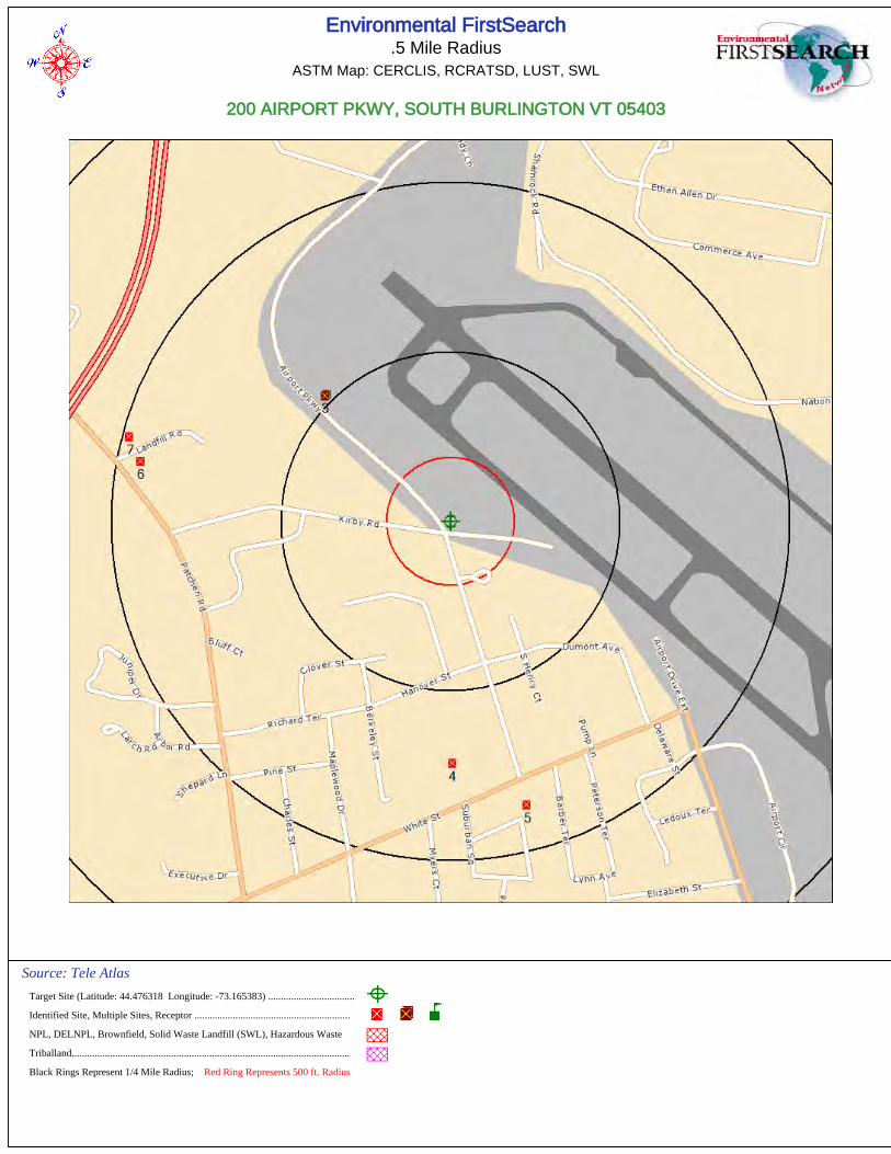
Environmental FirstSearch.5 Mile Radius
ASTM Map: CERCLIS, RCRATSD, LUST, SWL
200 AIRPORT PKWY, SOUTH BURLINGTON VT 05403
Source: Tele Atlas
Target Site (Latitude: 44.476318 Longitude: -73.165383) ..................................
Identified Site, Multiple Sites, Receptor .............................................................
NPL, DELNPL, Brownfield, Solid Waste Landfill (SWL), Hazardous Waste
Triballand.............................................................................................................
Black Rings Represent 1/4 Mile Radius; Red Ring Represents 500 ft. Radius

Environmental FirstSearch.25 Mile Radius
ASTM Map: RCRAGEN, ERNS, UST, FED IC/EC, METH LABS
200 AIRPORT PKWY, SOUTH BURLINGTON VT 05403
Source: Tele Atlas
Target Site (Latitude: 44.476318 Longitude: -73.165383) ..................................
Identified Site, Multiple Sites, Receptor .............................................................
NPL, DELNPL, Brownfield, Solid Waste Landfill (SWL), Hazardous Waste
Triballand.............................................................................................................
Black Rings Represent 1/4 Mile Radius; Red Ring Represents 500 ft. Radius

Environmental FirstSearch.12 Mile Radius
Non-ASTM Map: Spills 90
200 AIRPORT PKWY, SOUTH BURLINGTON VT 05403
Source: Tele Atlas
Target Site (Latitude: 44.476318 Longitude: -73.165383) ..................................
Identified Site, Multiple Sites, Receptor .............................................................
NPL, DELNPL, Brownfield, Solid Waste Landfill (SWL), Hazardous Waste
Triballand.............................................................................................................
National Historic Sites and Landmark Sites .......................................................
Black Rings Represent 1/4 Mile Radius; Red Ring Represents 500 ft. Radius

FirstSearch Technology Corporation
TM
Environmental FirstSearch Report
Target Property:
7 SHAMROCK RD
SOUTH BURLINGTON VT 05403
Job Number: 509110222
PREPARED FOR:
KAS, Inc.
368 Avenue D, Suite 15
Williston, VT 05495
09-20-11
Tel: (781) 551-0470 Fax: (781) 551-0471
Environmental FirstSearch is a registered trademark of FirstSearch Technology Corporation. All rights reserved.

Environmental FirstSearchSearch Summary Report
Target Site: 7 SHAMROCK RDSOUTH BURLINGTON VT 05403
FirstSearch Summary
Notice of Disclaimer
Waiver of Liability
Database Sel Updated Radius Site 1/8 1/4 1/2 1/2> ZIP TOTALS
NPL Y 08-15-11 1.00 0 0 0 0 0 0 0NPL Delisted Y 08-15-11 0.50 0 0 0 0 - 0 0CERCLIS Y 07-26-11 0.50 0 0 0 0 - 0 0NFRAP Y 07-26-11 0.50 0 0 1 0 - 0 1RCRA COR ACT Y 07-11-11 1.00 0 0 0 0 0 0 0RCRA TSD Y 07-11-11 0.50 0 0 0 0 - 0 0RCRA GEN Y 07-11-11 0.25 0 2 3 - - 1 6Federal Brownfield Y 07-05-11 0.50 0 0 0 0 - 0 0ERNS Y 07-18-11 0.12 0 0 - - - 0 0Tribal Lands Y 12-01-05 1.00 0 0 0 0 0 1 1State/Tribal Sites Y 07-08-11 1.00 0 0 3 1 14 2 20State Spills 90 Y 07-08-11 0.12 0 1 - - - 7 8State/Tribal SWL Y 04-15-09 0.50 0 0 0 0 - 6 6State/Tribal LUST Y 07-08-11 0.50 0 0 3 2 - 5 10State/Tribal UST/AST Y 07-08-11 0.25 0 0 2 - - 1 3State/Tribal EC Y NA 0.25 0 0 0 - - 0 0State/Tribal IC Y NA 0.25 0 0 0 - - 0 0State/Tribal VCP Y NA 0.50 0 0 0 0 - 0 0State/Tribal Brownfields Y 05-01-11 0.50 0 0 0 0 - 0 0Federal IC/EC Y 08-01-11 0.50 0 0 0 0 - 0 0
-TOTALS- 0 3 12 3 14 23 55
Due to the limitations, constraints, and inaccuracies and incompleteness of government information and computer mapping data currently available to FirstSearchTechnology Corp., certain conventions have been utilized in preparing the locations of all federal, state and local agency sites residing in FirstSearch TechnologyCorp.'s databases. All EPA NPL and state landfill sites are depicted by a rectangle approximating their location and size. The boundaries of the rectangles representthe eastern and western most longitudes; the northern and southern most latitudes. As such, the mapped areas may exceed the actual areas and do not represent theactual boundaries of these properties. All other sites are depicted by a point representing their approximate address location and make no attempt to represent theactual areas of the associated property. Actual boundaries and locations of individual properties can be found in the files residing at the agency responsible for suchinformation.
Although FirstSearch Technology Corp. uses its best efforts to research the actual location of each site, FirstSearch Technology Corp. does not and can not warrantthe accuracy of these sites with regard to exact location and size. All authorized users of FirstSearch Technology Corp.'s services proceeding are signifying anunderstanding of FirstSeaarch Technology Corp.'s searching and mapping conventions, and agree to waive any and all liability claims associated with search andmap results showing incomplete and or inaccurate site locations.

Environmental FirstSearchSite Information Report
Request Date: 09-20-11 Search Type: COORDRequestor Name: ALAN LIPTAK Job Number: 509110222Standard: ASTM-05 Filtered Report
Target Site: 7 SHAMROCK RD
SOUTH BURLINGTON VT 05403
Demographics
Sites: 55 Non-Geocoded: 23 Population: NA
Radon: 0 - 6.6 PCI/L
Site Location
Degrees (Decimal) Degrees (Min/Sec) UTMs
Longitude: -73.162691 -73:9:46 Easting: 646105.001
Latitude: 44.484671 44:29:5 Northing: 4927131.543
Elevation: 247 Zone: 18
Comment
Comment:
Additional Requests/Services
Adjacent ZIP Codes: Services:
ZIPCode City Name ST Dist/Dir Sel Requested? Date
Fire Insurance Maps No
Aerial Photographs No
Historical Topos No
City Directories No
Title Search No
Municipal Reports No
Liens No
Historic Map Works No
Online Topos No

Environmental FirstSearchTarget Site Summary Report
Target Property: 7 SHAMROCK RD JOB: 509110222SOUTH BURLINGTON VT 05403
TOTAL: 55 GEOCODED: 32 NON GEOCODED: 23 SELECTED: 0
No sites found for target address
Map ID DB Type Site Name/ID/Status Address Dist/Dir ElevDiff Page No.

Environmental FirstSearchSites Summary Report
Target Property: 7 SHAMROCK RD JOB: 509110222SOUTH BURLINGTON VT 05403
TOTAL: 55 GEOCODED: 32 NON GEOCODED: 23 SELECTED: 0
Map ID DB Type Site Name/ID/Status Address Dist/Dir ElevDiff Page No.
1 RCRAGN MODERN IMAGE AUTO WORKS 1910 AIRPORT PKWY 0.06 NE - 10 1VTR000005736/VGN SOUTH BURLINGTON VT 05403
2 RCRAGN FOURNIER AUTOMOTIVE SVC 9 ETHAN ALLEN DR 0.09 SE - 31 2VTR000509240/VGN SOUTH BURLINGTON VT 05403
3 SPILLS CARL LEBERGE RESIDENCE 464 LIME KILN RD 0.11 NE + 11 305-WMD126/CLOSED SOUTH BURLINGTON VT
4 RCRAGN 4 X 4 CENTER THE 63 ETHAN ALLEN DR 0.15 SE - 38 4VTR000512905/VGN SOUTH BURLINGTON VT 05403
5 RCRAGN RIVERSIDE AUTO BODY INC 3 COMMERCE AVE 0.15 SE - 37 5VTR000501122/VGN SOUTH BURLINGTON VT 05403
6 UST CHASTENAY FUELS 10 LIME ROCK RD 0.15 SE - 18 61992/ACTIVE SOUTH BURLINGTON VT 05403
7 LUST CANTEEN CORP. 1235 AIRPORT PKWY 0.16 NW + 53 78631106/PULLED UST DATABASE SOUTH BURLINGTON VT 05403
8 RCRAGN VT ARMY NATL GUARD AASF 141 SHAMROCK RD 0.21 SW + 26 8VTR000515940/SGN SOUTH BURLINGTON VT 05403
9 STATE KELCO FACILITY 73 ETHAN ALLEN DR 0.23 SE - 22 920002783/CLOSED SOUTH BURLINGTON VT
9 UST KELCO DISPOSAL INC 73 ETHAN ALLEN DR 0.23 SE - 22 10303/ SOUTH BURLINGTON VT 05403
9 LUST KELCO DISPOSAL INC ROUTE 14 0.23 SE - 22 11303/PULLED UST DATABASE SOUTH BURLINGTON VT 05403
10 NFRAP OFFSET HOUSE PROPERTY AIRPORT PKWY 0.24 SW + 51 12VTD981889835/NFRAP-N SOUTH BURLINGTON VT 05401
10 STATE OFFSET HOUSE UNKNOWN 0.24 SW + 51 13870107/CLOSED SOUTH BURLINGTON VT
10 STATE OFFSET HOUSE PROPERTY UNKNOWN 0.24 SW + 51 14770075/CLOSED SOUTH BURLINGTON VT
11 LUST BERARD CONSTRUCTION 75 ETHAN ALLEN DR 0.25 SE - 17 155551624/PULLED UST DATABASE SOUTH BURLINGTON VT
12 STATE BUDGET RENT A CAR 700 AIRPORT PKWY 0.50 SW + 60 16931526/CLOSED SOUTH BURLINGTON VT
12 LUST BUDGET RENT A CAR 700 AIRPORT PKWY 0.50 SW + 60 17621/PULLED UST DATABASE SOUTH BURLINGTON VT 05403
13 LUST FATHER SALMON HALL VT RT 15 0.50 NW + 64 18481/PULLED UST DATABASE COLCHESTER VT 05446
14 STATE ST MICHAELS COLLEGE - RESCUE GARAG LIME KILN RD 0.52 NW + 53 19962125/CLOSED COLCHESTER VT
15 STATE GMP PLANT #16, GORGE RD, COLCHESTE 154 GORGE RD 0.64 NW + 36 2020114148/ACTIVE COLCHESTER VT
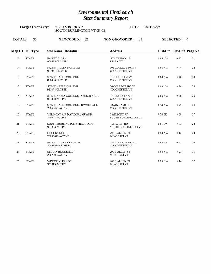
Environmental FirstSearchSites Summary Report
Target Property: 7 SHAMROCK RD JOB: 509110222SOUTH BURLINGTON VT 05403
TOTAL: 55 GEOCODED: 32 NON GEOCODED: 23 SELECTED: 0
Map ID DB Type Site Name/ID/Status Address Dist/Dir ElevDiff Page No.
16 STATE FANNY ALLEN STATE HWY 15 0.65 NW + 72 21900625/CLOSED ESSEX VT
17 STATE FANNY ALLEN HOSPITAL 101 COLLEGE PKWY 0.66 NW + 74 22961941/CLOSED COLCHESTER VT
18 STATE ST MICHAELS COLLEGE COLLEGE PKWY 0.68 NW + 76 23890436/CLOSED COLCHESTER VT
18 STATE ST MICHAELS COLLEGE 56 COLLEGE PKWY 0.68 NW + 76 24931378/CLOSED COLCHESTER VT
18 STATE ST MICHAELS COLLEGE - SENIOR HALL COLLEGE PKWY 0.68 NW + 76 25951868/ACTIVE COLCHESTER VT
19 STATE ST MICHAELS COLLEGE - JOYCE HALL MAIN CAMPUS 0.74 NW + 75 2620063473/ACTIVE COLCHESTER VT
20 STATE VERMONT AIR NATIONAL GUARD 0 AIRPORT RD 0.74 SE + 60 27770043/ACTIVE SOUTH BURLINGTON VT
21 STATE SOUTH BURLINGTON STREET DEPT PATCHEN RD 0.81 SW + 33 28931383/ACTIVE SOUTH BURLINGTON VT
22 STATE CHUCKS MOBIL 298 E ALLEN ST 0.83 NW + 12 2920083812/ACTIVE WINOOSKI VT
23 STATE FANNY ALLEN CONVENT 786 COLLEGE PKWY 0.84 NE + 77 3020063534/CLOSED COLCHESTER VT
24 STATE SEGUIN RESIDENCE 299 E ALLEN ST 0.84 NW + 21 3120022954/ACTIVE WINOOSKI VT
25 STATE WINOOSKI EXXON 280 E ALLEN ST 0.85 NW + 14 32951815/ACTIVE WINOOSKI VT

Environmental FirstSearchSites Summary Report
Target Property: 7 SHAMROCK RD JOB: 509110222SOUTH BURLINGTON VT 05403
TOTAL: 55 GEOCODED: 32 NON GEOCODED: 23 SELECTED: 0
Map ID DB Type Site Name/ID/Status Address Dist/Dir ElevDiff Page No.
RCRAGN CHASTENAY FUELS 10 LIME ROCK ROAD NON GC N/A N/AVTR000519140/VGN SOUTH BURLINGTON VT 05403
STATE GADUE DRY CLEANER DORSET STREET UNKNOWN NON GC N/A N/A20053295/ACTIVE SOUTH BURLINGTON VT
STATE GORDIES TEXACO UNKNOWN NON GC N/A N/A870020/CLOSED SOUTH BURLINGTON VT
SPILLS AIR GUARD BURLINGTON INTNL AIRPORT NON GC N/A N/A09-WMD239/CLOSED SOUTH BURLINGTON VT
SPILLS JAMES KNEELAND FLIGHT FACILITY AIRPORT RD NON GC N/A N/A06-WMD192/CLOSED SOUTH BURLINGTON VT
SPILLS MAINTENANCE BUILDING B 1 A AIRPORT RD NON GC N/A N/A02-WMD239/CLOSED SOUTH BURLINGTON VT
SPILLS N/A ETHAN ALLEN DR NON GC N/A N/A90-137/CLOSED SOUTH BURLINGTON VT
SPILLS N/A AIRPORT PKWY NON GC N/A N/A95-WMD116/CLOSED SOUTH BURLINGTON VT
SPILLS VT AIR NATIONAL GUARD AIRPORT DR NON GC N/A N/A10-WMD167/CLOSED BURLINGTON VT
SPILLS VT ANG AIRPORT DR NON GC N/A N/A11-WMD316/CLOSED SOUTH BURLINGTON VT
SWL A. MARCELINO AND COMPANY, INC. UNKNOWN NON GC N/A N/ACH772/RECYCLING SOUTH BURLINGTON VT 05495
SWL CHITTENDEN SWM DISTRICT DROP-OFF C PATCHEN ROAD NON GC N/A N/ACH771/DROP OFF CENTER SOUTH BURLINGTON VT 05495
SWL CHITTENDEN SWMD TRANS STATION PATCHEN ROAD NON GC N/A N/A11/A SOUTH BURLINGTON VT 05403
SWL CHITTENDEN SWMD TRANS STATION PATCHEN ROAD NON GC N/A N/A011/A SOUTH BURLINGTON VT 05403
SWL CSWD ENVIRONMENTAL DEPOT UNKNOWN NON GC N/A N/ACH080/HHW/CESQG SOUTH BURLINGTON VT 05495
SWL ENGINEERS CONSTRUCTION DISPOSAL SI UNKNOWN NON GC N/A N/ACH980/LANDFILL SOUTH BURLINGTON VT 05486
UST KNEELAND FLIGHT FACILITY AIRPORT BIAP RD NON GC N/A N/A1037/ACTIVE SOUTH BURLINGTON VT 05402
LUST AIRPORT PARKWAY SEWER PUMP STATION HINESBURGH RD NON GC N/A N/A2736/PULLED UST DATABASE SOUTH BURLINGTON VT
LUST MUNT RESIDENCE 85 SOUTH ST NON GC N/A N/A5557561/PULLED UST DATABASE BURLINGTON VT
LUST NEW ENGLAND TELEPHONE CENTRAL OFFI FARRELL ST NON GC N/A N/A895/PULLED UST DATABASE SOUTH BURLINGTON VT 05401

Environmental FirstSearchSites Summary Report
Target Property: 7 SHAMROCK RD JOB: 509110222SOUTH BURLINGTON VT 05403
TOTAL: 55 GEOCODED: 32 NON GEOCODED: 23 SELECTED: 0
Map ID DB Type Site Name/ID/Status Address Dist/Dir ElevDiff Page No.
LUST STRATTON CORP GOLF MAINTENANCE ORCUTT MEADOW RD NON GC N/A N/A517/PULLED UST DATABASE WINHALL VT 05403
LUST VERMONT TIRE WILLISTON RD NON GC N/A N/A5555576/PULLED UST DATABASE SOUTH BURLINGTON VT
TRIBALLA BUREAU OF INDIAN AFFAIRS CONTACT I UNKNOWN NON GC N/A N/ABIA-05403/ VT 05403

Environmental FirstSearchSite Detail Report
Target Property: 7 SHAMROCK RD JOB: 509110222SOUTH BURLINGTON VT 05403
RCRAGN
SEARCH ID: 4 DIST/DIR: 0.06 NE ELEVATION: 237 MAP ID: 1
NAME: MODERN IMAGE AUTO WORKS REV: 7/11/11ADDRESS: 1910 AIRPORT PKWY ID1: VTR000005736
SOUTH BURLINGTON VT 05403 ID2: CHITTENDEN STATUS: VGN
CONTACT: PHONE: SOURCE: EPA
Site Details Page - 1
SITE INFORMATION
CONTACT INFORMATION: JOE MAYNARD1910 AIRPORT PKYSOUTH BURLINGTON VT 05403
PHONE: 8028626777
UNIVERSE INFORMATION:
NAIC INFORMATION
ENFORCEMENT INFORMATION:
VIOLATION INFORMATION:
HAZARDOUS WASTE INFORMATION:
The following spent non-halogenated solvents: toluene, methyl ethyl ketone, carbon disulfide, isobutanol, pyridine, benzene, 2-ethoxyethanol, and 2-nitropropane;all spent solvent mixtures/blends containing, before use, a total of ten percent or more (byThe following spent non-halogenated solvents: Xylene, acetone, ethyl acetate, ethyl benzene, ethyl ether, methyl isobutyl ketone, n-butyl alcohol, cyclohexanone,and methanol; all spent solvent mixtures/ blends containing, before use, only the above spent

Environmental FirstSearchSite Detail Report
Target Property: 7 SHAMROCK RD JOB: 509110222SOUTH BURLINGTON VT 05403
RCRAGN
SEARCH ID: 3 DIST/DIR: 0.09 SE ELEVATION: 216 MAP ID: 2
NAME: FOURNIER AUTOMOTIVE SVC REV: 7/11/11ADDRESS: 9 ETHAN ALLEN DR ID1: VTR000509240
SOUTH BURLINGTON VT 05403 ID2: CHITTENDEN STATUS: VGN
CONTACT: PHONE: SOURCE: EPA
Site Details Page - 2
SITE INFORMATION
CONTACT INFORMATION: SHAWN FOURNIERETHAN ALLEN DRSOUTH BURLINGTON VT 05403
PHONE: 8028632100
UNIVERSE INFORMATION:
NAIC INFORMATION
811111 - GENERAL AUTOMOTIVE REPAIR
ENFORCEMENT INFORMATION:
VIOLATION INFORMATION:
HAZARDOUS WASTE INFORMATION:
VT02

Environmental FirstSearchSite Detail Report
Target Property: 7 SHAMROCK RD JOB: 509110222SOUTH BURLINGTON VT 05403
SPILLS
SEARCH ID: 25 DIST/DIR: 0.11 NE ELEVATION: 258 MAP ID: 3
NAME: CARL LEBERGE RESIDENCE REV: 7/8/11ADDRESS: 464 LIME KILN RD ID1: 05-WMD126
SOUTH BURLINGTON VT ID2: CHITTENDEN STATUS: CLOSED
CONTACT: PHONE: 343-8743SOURCE: VT DEC
Site Details Page - 3
6900DATE OF INCIDENT: 4/11/2005 0:00:00TIME OF INCIDENT: 1900DATE CLOSED: 4/12/2005 0:00:00UST FACILITY ID:DUTY OFFICER:REPORTED BY: CARL LEBERGEREPORTER S ORGANIZATION:REPORTER S WORK PHONE: 343-8743
TYPE OF INCIDENT: MARINE BATTERY SPILLPRODUCT: BATTERY ACIDQUANTITY:UNIT OF MEASURE:
RESPONSIBLE PARTY: N/AADDRESS:
RESPONSIBLE PARTY S PHONE:
6900SURFACE WATER AFFECTED:
CASE ASSIGNED TO:ACTIONS TAKEN: APPLIED BAKING SODA THEN FLUSHED.
COMMENTS: BOAT BATTERY DROPPED ON KITCHEN FLOOR. CLEANUP BY HOMEOWNER.

Environmental FirstSearchSite Detail Report
Target Property: 7 SHAMROCK RD JOB: 509110222SOUTH BURLINGTON VT 05403
RCRAGN
SEARCH ID: 2 DIST/DIR: 0.15 SE ELEVATION: 209 MAP ID: 4
NAME: 4 X 4 CENTER THE REV: 7/11/11ADDRESS: 63 ETHAN ALLEN DR ID1: VTR000512905
SOUTH BURLINGTON VT 05403 ID2: CHITTENDEN STATUS: VGN
CONTACT: PHONE: SOURCE: EPA
Site Details Page - 4
SITE INFORMATION
CONTACT INFORMATION: MARK HASTINGSETHAN ALLEN DRSOUTH BURLINGTON VT 05403
PHONE: 8028648565
UNIVERSE INFORMATION:
NAIC INFORMATION
44112 - USED CAR DEALERS811111 - GENERAL AUTOMOTIVE REPAIR811121 - AUTOMOTIVE BODY, PAINT, AND INTERIOR REPAIR AND MAINTENANCE
ENFORCEMENT INFORMATION:
VIOLATION INFORMATION:
HAZARDOUS WASTE INFORMATION:
BenzeneIgnitable waste

Environmental FirstSearchSite Detail Report
Target Property: 7 SHAMROCK RD JOB: 509110222SOUTH BURLINGTON VT 05403
RCRAGN
SEARCH ID: 5 DIST/DIR: 0.15 SE ELEVATION: 210 MAP ID: 5
NAME: RIVERSIDE AUTO BODY INC REV: 7/11/11ADDRESS: 3 COMMERCE AVE ID1: VTR000501122
SOUTH BURLINGTON VT 05403 ID2: CHITTENDEN STATUS: VGN
CONTACT: PHONE: SOURCE: EPA
Site Details Page - 5
SITE INFORMATION
CONTACT INFORMATION: WILLIAM HANF3 COMMERCE AVESOUTH BURLINGTON VT 05403
PHONE: 8028628539
UNIVERSE INFORMATION:
NAIC INFORMATION
ENFORCEMENT INFORMATION:
VIOLATION INFORMATION:
HAZARDOUS WASTE INFORMATION:
Ignitable wasteThe following spent non-halogenated solvents: toluene, methyl ethyl ketone, carbon disulfide, isobutanol, pyridine, benzene, 2-ethoxyethanol, and 2-nitropropane;all spent solvent mixtures/blends containing, before use, a total of ten percent or more (byThe following spent non-halogenated solvents: Xylene, acetone, ethyl acetate, ethyl benzene, ethyl ether, methyl isobutyl ketone, n-butyl alcohol, cyclohexanone,and methanol; all spent solvent mixtures/ blends containing, before use, only the above spent

Environmental FirstSearchSite Detail Report
Target Property: 7 SHAMROCK RD JOB: 509110222SOUTH BURLINGTON VT 05403
UST
SEARCH ID: 26 DIST/DIR: 0.15 SE ELEVATION: 229 MAP ID: 6
NAME: CHASTENAY FUELS REV: 7/8/11ADDRESS: 10 LIME ROCK RD ID1: 1992
SOUTH BURLINGTON VT 05403 ID2: CHITTENDEN STATUS: ACTIVE
CONTACT: CHASTENAY FUELS INC PHONE: SOURCE: VT DEC
Site Details Page - 6
FACILITY AND OWNER INFORMATION
TYPE OF FACILITY: BULK
OWNER NAME: THOMAS CHASTENAYCONTACT:OWNER ADDRESS: PO BOX 2261SOUTH BURLINGTON, VT
TANK INFORMATION
TOTAL NUMBER OF TANKS: 1
TANK ID: 12407TANK STATUS:ACTIVESUBSTANCE STORED: TANK CAPACITY IN GAL.: 20000TANK PROTECTION: PROTECTED STEELYEAR REMOVED:TANK MONITORING: /SPILL/OVERFILL PROT.: PUMP TYPE:PIPE PROTECTION: TESTED DATE:PIPE MONITORING: INTERSTITIAL ELECTRONICTANK LABEL:1990-1

Environmental FirstSearchSite Detail Report
Target Property: 7 SHAMROCK RD JOB: 509110222SOUTH BURLINGTON VT 05403
LUST
SEARCH ID: 30 DIST/DIR: 0.16 NW ELEVATION: 300 MAP ID: 7
NAME: CANTEEN CORP. REV: 7/8/11ADDRESS: 1235 AIRPORT PKWY ID1: 8631106
SOUTH BURLINGTON VT 05403 ID2: CHITTENDEN STATUS: PULLED UST DATABASE
CONTACT: ROBINSON S INC PHONE: 802-878-4275SOURCE: VT DEC
Site Details Page - 7
This site comes from the Vermont Department of Environmental Conservation Pulled Underground Storage Tanks database and may or may not be considered aleaking underground storage tank , please review the data below for further indications of contamination.
SITE FINDINGS: NO CONTAMINATION FOUND
FACILITY AND OWNER INFORMATION
TYPE OF FACILITY: INDUSTRIAL/COMMERCIAL
OWNER NAME: ROBINSON S INCCONTACT: JAMES A ROBINSON PRESIDENTOWNER ADDRESS: PO BOX 405ESSEX JUNCTION, VT
LAND OWNER:** UNKNOWN ***PERMITTED TO:TANK OWNERNUM OF PULLED TANKS:3NUM OF REMOVED TANKS:3NUM OF GROUNDWATER MONITORING WELLS:NUM OF VAPOR MONITORING WELLS:
TANK INFORMATION
TOTAL NUMBER OF TANKS: 3
TANK ID: 5059TANK STATUS:PULLEDSUBSTANCE STORED: TANK CAPACITY IN GAL.: 6000TANK PROTECTION: UNPROTECTED STEELYEAR REMOVED: 1989TANK MONITORING: /SPILL/OVERFILL PROT.: PUMP TYPE:PIPE PROTECTION: TESTED DATE:PIPE MONITORING:TANK LABEL:1968-1
TANK ID: 5060TANK STATUS:PULLEDSUBSTANCE STORED: TANK CAPACITY IN GAL.: 2000TANK PROTECTION: UNPROTECTED STEELYEAR REMOVED: 1989TANK MONITORING: /SPILL/OVERFILL PROT.: PUMP TYPE:PIPE PROTECTION: TESTED DATE:PIPE MONITORING:TANK LABEL:1968-2
TANK ID: 5061TANK STATUS:PULLEDSUBSTANCE STORED: TANK CAPACITY IN GAL.: 3000TANK PROTECTION: UNPROTECTED STEELYEAR REMOVED: 1989TANK MONITORING: /SPILL/OVERFILL PROT.: PUMP TYPE:PIPE PROTECTION: TESTED DATE:PIPE MONITORING:TANK LABEL:1968-3

Environmental FirstSearchSite Detail Report
Target Property: 7 SHAMROCK RD JOB: 509110222SOUTH BURLINGTON VT 05403
RCRAGN
SEARCH ID: 6 DIST/DIR: 0.21 SW ELEVATION: 273 MAP ID: 8
NAME: VT ARMY NATL GUARD AASF REV: 7/11/11ADDRESS: 141 SHAMROCK RD ID1: VTR000515940
SOUTH BURLINGTON VT 05403 ID2: CHITTENDEN STATUS: SGN
CONTACT: PHONE: SOURCE: EPA
Site Details Page - 8
SITE INFORMATION
CONTACT INFORMATION: LEE ANN BANKS789 VT NATL GUARD RD CAMP JOHNSON BLDG 5COLCHESTER VT 5446
PHONE: (802)338-3327
NAIC INFORMATION
48121 -92811 -
HAZARDOUS WASTE
D001 - Ignitable wasteD008 - LeadD018 - BenzeneVT02 - Waste containing greater than 5% by weight petroleum distillates with melting points of less than 100 degrees F, including but not limited to kerosene, fueloil, hydraulic oils, lubricating oils, penetrating oils, tramp oils, quenching oils, and crankcase and automotive oils which have not been exempted under Section 7-203(n), (o) and (p)

Environmental FirstSearchSite Detail Report
Target Property: 7 SHAMROCK RD JOB: 509110222SOUTH BURLINGTON VT 05403
STATE
SEARCH ID: 13 DIST/DIR: 0.23 SE ELEVATION: 225 MAP ID: 9
NAME: KELCO FACILITY REV: 12/3/09ADDRESS: 73 ETHAN ALLEN DR ID1: 20002783
SOUTH BURLINGTON VT ID2: CHITTENDEN STATUS: CLOSED
CONTACT: PHONE: SOURCE: VT DEC
Site Details Page - 9
6900SITE INFORMATION
PRIORITY: SITES MANAGEMENT ACTIVITY COMPLETEDPROJECT STATUS: THREE USTS REMOVED JUNE 2000, LIMITED CONTAMINATION REMAINS IN THE VICINITY OF THE FORMER DIESEL UST.ETHYLBENZENE, 1,2,4- AND 1,3,5-TRIMETHYLBENZENE REMAIN, AT LEVELS BELOW VGES, IN THE DIESEL SOURCE AREA WELL. NOSENSITIVE RECEPTOS AFFECTED, RESIDUAL CONTAMINATION CONFINED TO BETWEEN 6 AND 9 FT BGS.DATE OF SITE DISCOVERY: 6/5/2000 0:00:00DATE OF SITE CLOSURE: 4/9/2009 0:00:00SOURCE: 6900 UST-WASTE OIL, 6900 OTHER, 6900 UST-DIESEL, 6900
OWNER INFORMATION:
OWNER: JEFF MYERS & MICHAEL CRETEOWNER ADDRESS: 73 ETHAN ALLEN DRIVESOUTH BURLINGTON VT 05403

Environmental FirstSearchSite Detail Report
Target Property: 7 SHAMROCK RD JOB: 509110222SOUTH BURLINGTON VT 05403
UST
SEARCH ID: 27 DIST/DIR: 0.23 SE ELEVATION: 225 MAP ID: 9
NAME: KELCO DISPOSAL INC REV: 04/19/00ADDRESS: 73 ETHAN ALLEN DR ID1: 303
SOUTH BURLINGTON VT 05403 ID2: CHITTENDEN STATUS:
CONTACT: KELCO DISPOSAL INC PHONE: SOURCE: VTDEC
Site Details Page - 10
TOTAL NUMBER OF TANKS: 1
FACILITY AND OWNER INFORMATIONTYPE OF FACILITY: Industrial/Commercial
OWNER NAME: Kelco Disposal IncCONTACT: Sean KelleyOWNER ADDRESS: PO Box 2391South Burlington, VT 05407
TANK ID: 1987-1SUBSTANCE STORED: DIESELTANK CAPACITY IN GAL.: 6000TANK PROTECTION: PROTECTED STEELYEAR REMOVED:TANK MONITORING: INTERSTITIAL/SPILL/OVERFILL PROT.: OVERFILLPUMP TYPE: SUCTIONPIPE PROTECTION: FIBERGLASS REINFORCED PLASTICPIPE MONITORING: VERTICAL CHECK VALVE

Environmental FirstSearchSite Detail Report
Target Property: 7 SHAMROCK RD JOB: 509110222SOUTH BURLINGTON VT 05403
LUST
SEARCH ID: 32 DIST/DIR: 0.23 SE ELEVATION: 225 MAP ID: 9
NAME: KELCO DISPOSAL INC REV: 7/8/11ADDRESS: ROUTE 14 ID1: 303
SOUTH BURLINGTON VT 05403 ID2: 20002783CHITTENDEN STATUS: PULLED UST DATABASE
CONTACT: KELCO DISPOSAL INC PHONE: 802-863-2900SOURCE: VT DEC
Site Details Page - 11
This site comes from the Vermont Department of Environmental Conservation Pulled Underground Storage Tanks database and may or may not be considered aleaking underground storage tank , please review the data below for further indications of contamination.
SITE FINDINGS: CONTAMINATION FOUND ABOVE STATE STANDARD. REFERRED TO SITE MANAGEMENT
FACILITY AND OWNER INFORMATION
TYPE OF FACILITY: INDUSTRIAL/COMMERCIAL
OWNER NAME: KELCO DISPOSAL INCCONTACT: JOE KELLEY C/O TOM LOYEROWNER ADDRESS: 80 ETHAN ALLEN DRIVESOUTH BURLINGTON, VT
LAND OWNER:** UNKNOWN ***PERMITTED TO:TANK OWNERNUM OF PULLED TANKS:2NUM OF REMOVED TANKS:2NUM OF GROUNDWATER MONITORING WELLS:NUM OF VAPOR MONITORING WELLS:
TANK INFORMATION
TOTAL NUMBER OF TANKS: 2
TANK ID: 294TANK STATUS:PULLEDSUBSTANCE STORED: TANK CAPACITY IN GAL.: 275TANK PROTECTION: YEAR REMOVED: 2000TANK MONITORING: /SPILL/OVERFILL PROT.: PUMP TYPE:PIPE PROTECTION: TESTED DATE:PIPE MONITORING:TANK LABEL:-1-1-R
TANK ID: 295TANK STATUS:PULLEDSUBSTANCE STORED: TANK CAPACITY IN GAL.: 6000TANK PROTECTION: PROTECTED STEELYEAR REMOVED: 2000TANK MONITORING: /SPILL/OVERFILL PROT.: PUMP TYPE:PIPE PROTECTION: TESTED DATE:PIPE MONITORING: INTERSTITIALTANK LABEL:1987-1-R
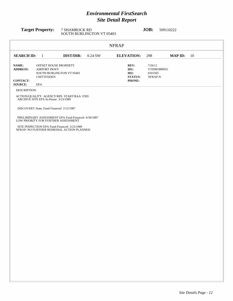
Environmental FirstSearchSite Detail Report
Target Property: 7 SHAMROCK RD JOB: 509110222SOUTH BURLINGTON VT 05403
NFRAP
SEARCH ID: 1 DIST/DIR: 0.24 SW ELEVATION: 298 MAP ID: 10
NAME: OFFSET HOUSE PROPERTY REV: 7/26/11ADDRESS: AIRPORT PKWY ID1: VTD981889835
SOUTH BURLINGTON VT 05401 ID2: 0101505CHITTENDEN STATUS: NFRAP-N
CONTACT: PHONE: SOURCE: EPA
Site Details Page - 12
DESCRIPTION:
ACTION/QUALITY AGENCY/RPS START/RAA END ARCHIVE SITEEPA In-House3/23/1989
DISCOVERYState, Fund Financed2/12/1987
PRELIMINARY ASSESSMENTEPA Fund-Financed6/30/1987LOW PRIORITY FOR FURTHER ASSESSMENT
SITE INSPECTIONEPA Fund-Financed3/23/1989NFRAP: NO FURTHER REMEDIAL ACTION PLANNED

Environmental FirstSearchSite Detail Report
Target Property: 7 SHAMROCK RD JOB: 509110222SOUTH BURLINGTON VT 05403
STATE
SEARCH ID: 14 DIST/DIR: 0.24 SW ELEVATION: 298 MAP ID: 10
NAME: OFFSET HOUSE REV: 12/3/09ADDRESS: UNKNOWN ID1: 870107
SOUTH BURLINGTON VT ID2: CHITTENDEN STATUS: CLOSED
CONTACT: PHONE: SOURCE: VT DEC
Site Details Page - 13
6900SITE INFORMATION
PRIORITY: NO FURTHER ACTION PLANNEDPROJECT STATUS: SITE CLOSEDDATE OF SITE DISCOVERY:DATE OF SITE CLOSURE:SOURCE: 6900
OWNER INFORMATION:
OWNER:OWNER ADDRESS:

Environmental FirstSearchSite Detail Report
Target Property: 7 SHAMROCK RD JOB: 509110222SOUTH BURLINGTON VT 05403
STATE
SEARCH ID: 15 DIST/DIR: 0.24 SW ELEVATION: 298 MAP ID: 10
NAME: OFFSET HOUSE PROPERTY REV: 12/3/09ADDRESS: UNKNOWN ID1: 770075
SOUTH BURLINGTON VT ID2: CHITTENDEN STATUS: CLOSED
CONTACT: PHONE: SOURCE: VT DEC
Site Details Page - 14
6900SITE INFORMATION
PRIORITY: NO FURTHER ACTION PLANNEDPROJECT STATUS: CONTAMINATION BELOW ACTION LEVELS, SITE CLOSEDDATE OF SITE DISCOVERY:DATE OF SITE CLOSURE:SOURCE: 6900
OWNER INFORMATION:
OWNER:OWNER ADDRESS:

Environmental FirstSearchSite Detail Report
Target Property: 7 SHAMROCK RD JOB: 509110222SOUTH BURLINGTON VT 05403
LUST
SEARCH ID: 28 DIST/DIR: 0.25 SE ELEVATION: 230 MAP ID: 11
NAME: BERARD CONSTRUCTION REV: 7/8/11ADDRESS: 75 ETHAN ALLEN DR ID1: 5551624
SOUTH BURLINGTON VT ID2: CHITTENDEN STATUS: PULLED UST DATABASE
CONTACT: BERARD CONSTRUCTION PHONE: SOURCE: VT DEC
Site Details Page - 15
This site comes from the Vermont Department of Environmental Conservation Pulled Underground Storage Tanks database and may or may not be considered aleaking underground storage tank , please review the data below for further indications of contamination.
SITE FINDINGS: NO CONTAMINATION FOUND
FACILITY AND OWNER INFORMATION
TYPE OF FACILITY: INDUSTRIAL/COMMERICAL
OWNER NAME: BERARD CONSTRUCTIONCONTACT: ALAN BERARDOWNER ADDRESS: PO BOX 2039SOUTH BURLINGTON, VT
LAND OWNER:** UNKNOWN ***PERMITTED TO:NUM OF PULLED TANKS:2NUM OF REMOVED TANKS:2NUM OF GROUNDWATER MONITORING WELLS:NUM OF VAPOR MONITORING WELLS:
TANK INFORMATION
TOTAL NUMBER OF TANKS: 2
TANK ID: 3854TANK STATUS:PULLEDSUBSTANCE STORED: TANK CAPACITY IN GAL.: 2000TANK PROTECTION: YEAR REMOVED: 1999TANK MONITORING: /SPILL/OVERFILL PROT.: PUMP TYPE:PIPE PROTECTION: TESTED DATE:PIPE MONITORING:TANK LABEL:1971-1-R
TANK ID: 3855TANK STATUS:PULLEDSUBSTANCE STORED: TANK CAPACITY IN GAL.: 2000TANK PROTECTION: YEAR REMOVED: 1999TANK MONITORING: /SPILL/OVERFILL PROT.: PUMP TYPE:PIPE PROTECTION: TESTED DATE:PIPE MONITORING:TANK LABEL:1971-2-R

Environmental FirstSearchSite Detail Report
Target Property: 7 SHAMROCK RD JOB: 509110222SOUTH BURLINGTON VT 05403
STATE
SEARCH ID: 7 DIST/DIR: 0.50 SW ELEVATION: 307 MAP ID: 12
NAME: BUDGET RENT A CAR REV: 12/3/09ADDRESS: 700 AIRPORT PKWY ID1: 931526
SOUTH BURLINGTON VT ID2: CHITTENDEN STATUS: CLOSED
CONTACT: PHONE: SOURCE: VT DEC
Site Details Page - 16
6900SITE INFORMATION
PRIORITY: NO FURTHER ACTION PLANNEDPROJECT STATUS: DETERMINE DEGREE AND EXTENT OF CONTAMINATIONDATE OF SITE DISCOVERY: 12/1/1993 0:00:00DATE OF SITE CLOSURE: 5/1/1994 0:00:00SOURCE: 6900 UST-GASOLINE, 6900
OWNER INFORMATION:
OWNER: VAL PREDA LEASING INCOWNER ADDRESS: 700 AIRPORT PKWYSOUTH BURLINGTON VT 05403

Environmental FirstSearchSite Detail Report
Target Property: 7 SHAMROCK RD JOB: 509110222SOUTH BURLINGTON VT 05403
LUST
SEARCH ID: 29 DIST/DIR: 0.50 SW ELEVATION: 307 MAP ID: 12
NAME: BUDGET RENT A CAR REV: 7/8/11ADDRESS: 700 AIRPORT PKWY ID1: 621
SOUTH BURLINGTON VT 05403 ID2: 931526CHITTENDEN STATUS: PULLED UST DATABASE
CONTACT: VAL PREDA LEASING INC PHONE: 802-863-5512SOURCE: VT DEC
Site Details Page - 17
This site comes from the Vermont Department of Environmental Conservation Pulled Underground Storage Tanks database and may or may not be considered aleaking underground storage tank , please review the data below for further indications of contamination.
SITE FINDINGS: CONTAMINATION FOUND ABOVE STATE STANDARD. REFERRED TO SITE MANAGEMENT
FACILITY AND OWNER INFORMATION
TYPE OF FACILITY: INDUSTRIAL/COMMERCIAL
OWNER NAME: VAL PREDA LEASING INCCONTACT: PETER VAL PREDA, PRESIDENTOWNER ADDRESS: 700 AIRPORT PARKWAYSOUTH BURLINGTON, VT
LAND OWNER:** UNKNOWN ***PERMITTED TO:TANK OWNERNUM OF PULLED TANKS:2NUM OF REMOVED TANKS:2NUM OF GROUNDWATER MONITORING WELLS:NUM OF VAPOR MONITORING WELLS:
TANK INFORMATION
TOTAL NUMBER OF TANKS: 2
TANK ID: 529TANK STATUS:PULLEDSUBSTANCE STORED: TANK CAPACITY IN GAL.: 4000TANK PROTECTION: UNPROTECTED STEELYEAR REMOVED: 1993TANK MONITORING: /SPILL/OVERFILL PROT.: PUMP TYPE:PIPE PROTECTION: TESTED DATE:PIPE MONITORING:TANK LABEL:1981-1
TANK ID: 530TANK STATUS:PULLEDSUBSTANCE STORED: TANK CAPACITY IN GAL.: 500TANK PROTECTION: UNPROTECTED STEELYEAR REMOVED: UNKTANK MONITORING: /SPILL/OVERFILL PROT.: PUMP TYPE:PIPE PROTECTION: TESTED DATE:PIPE MONITORING:TANK LABEL:1981-2

Environmental FirstSearchSite Detail Report
Target Property: 7 SHAMROCK RD JOB: 509110222SOUTH BURLINGTON VT 05403
LUST
SEARCH ID: 31 DIST/DIR: 0.50 NW ELEVATION: 311 MAP ID: 13
NAME: FATHER SALMON HALL REV: 7/8/11ADDRESS: VT RT 15 ID1: 481
COLCHESTER VT 05446 ID2: 9621225CHITTENDEN STATUS: PULLED UST DATABASE
CONTACT: SAINT MICHAEL S COLLEGE PHONE: 802-654-2425SOURCE: VT DEC
Site Details Page - 18
This site comes from the Vermont Department of Environmental Conservation Pulled Underground Storage Tanks database and may or may not be considered aleaking underground storage tank , please review the data below for further indications of contamination.
SITE FINDINGS: CONTAMINATION FOUND ABOVE STATE STANDARD. REFERRED TO SITE MANAGEMENT
FACILITY AND OWNER INFORMATION
TYPE OF FACILITY: INSTITUTIONAL
OWNER NAME: SAINT MICHAEL S COLLEGECONTACT:OWNER ADDRESS: 1 WINOOSKI PARK BOX 5COLCHESTER, VT
LAND OWNER:** UNKNOWN ***PERMITTED TO:NUM OF PULLED TANKS:2NUM OF REMOVED TANKS:2NUM OF GROUNDWATER MONITORING WELLS:NUM OF VAPOR MONITORING WELLS:
TANK INFORMATION
TOTAL NUMBER OF TANKS: 2
TANK ID: 428TANK STATUS:PULLEDSUBSTANCE STORED: TANK CAPACITY IN GAL.: 10000TANK PROTECTION: UNPROTECTED STEELYEAR REMOVED: 1996TANK MONITORING: /SPILL/OVERFILL PROT.: PUMP TYPE:PIPE PROTECTION: TESTED DATE:PIPE MONITORING:TANK LABEL:1980-1
TANK ID: 429TANK STATUS:PULLEDSUBSTANCE STORED: TANK CAPACITY IN GAL.: 10000TANK PROTECTION: UNPROTECTED STEELYEAR REMOVED: 1996TANK MONITORING: /SPILL/OVERFILL PROT.: PUMP TYPE:PIPE PROTECTION: TESTED DATE:PIPE MONITORING:TANK LABEL:1980-2
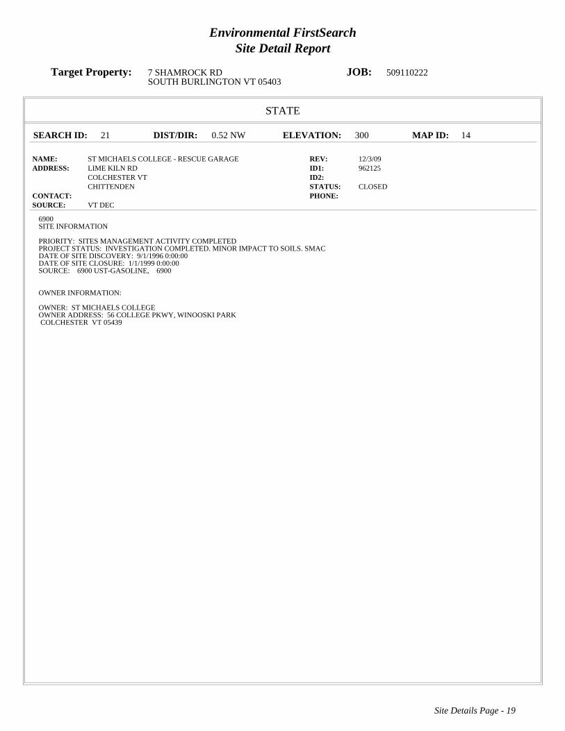
Environmental FirstSearchSite Detail Report
Target Property: 7 SHAMROCK RD JOB: 509110222SOUTH BURLINGTON VT 05403
STATE
SEARCH ID: 21 DIST/DIR: 0.52 NW ELEVATION: 300 MAP ID: 14
NAME: ST MICHAELS COLLEGE - RESCUE GARAGE REV: 12/3/09ADDRESS: LIME KILN RD ID1: 962125
COLCHESTER VT ID2: CHITTENDEN STATUS: CLOSED
CONTACT: PHONE: SOURCE: VT DEC
Site Details Page - 19
6900SITE INFORMATION
PRIORITY: SITES MANAGEMENT ACTIVITY COMPLETEDPROJECT STATUS: INVESTIGATION COMPLETED. MINOR IMPACT TO SOILS. SMACDATE OF SITE DISCOVERY: 9/1/1996 0:00:00DATE OF SITE CLOSURE: 1/1/1999 0:00:00SOURCE: 6900 UST-GASOLINE, 6900
OWNER INFORMATION:
OWNER: ST MICHAELS COLLEGEOWNER ADDRESS: 56 COLLEGE PKWY, WINOOSKI PARKCOLCHESTER VT 05439
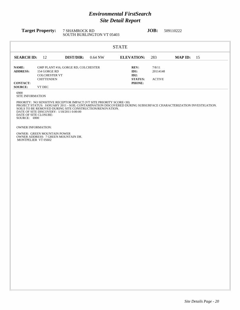
Environmental FirstSearchSite Detail Report
Target Property: 7 SHAMROCK RD JOB: 509110222SOUTH BURLINGTON VT 05403
STATE
SEARCH ID: 12 DIST/DIR: 0.64 NW ELEVATION: 283 MAP ID: 15
NAME: GMP PLANT #16, GORGE RD, COLCHESTER REV: 7/8/11ADDRESS: 154 GORGE RD ID1: 20114148
COLCHESTER VT ID2: CHITTENDEN STATUS: ACTIVE
CONTACT: PHONE: SOURCE: VT DEC
Site Details Page - 20
6900SITE INFORMATION
PRIORITY: NO SENSITIVE RECEPTOR IMPACT (VT SITE PRIORITY SCORE<30)PROJECT STATUS: JANUARY 2011 - SOIL CONTAMINATION DISCOVERED DURING SUBSURFACE CHARACTERIZATION INVESTIGATION.SOILS TO BE REMOVED DURING SITE CONSTRUCTION/RENOVATION.DATE OF SITE DISCOVERY: 1/18/2011 0:00:00DATE OF SITE CLOSURE:SOURCE: 6900
OWNER INFORMATION:
OWNER: GREEN MOUNTAIN POWEROWNER ADDRESS: 7 GREEN MOUNTAIN DR.MONTPELIER VT 05602

Environmental FirstSearchSite Detail Report
Target Property: 7 SHAMROCK RD JOB: 509110222SOUTH BURLINGTON VT 05403
STATE
SEARCH ID: 9 DIST/DIR: 0.65 NW ELEVATION: 319 MAP ID: 16
NAME: FANNY ALLEN REV: 12/3/09ADDRESS: STATE HWY 15 ID1: 900625
ESSEX VT ID2: CHITTENDEN STATUS: CLOSED
CONTACT: PHONE: SOURCE: VT DEC
Site Details Page - 21
6900SITE INFORMATION
PRIORITY: NO FURTHER ACTION PLANNEDPROJECT STATUS: GROUNDWATER MONITORING ONGOING.DATE OF SITE DISCOVERY:DATE OF SITE CLOSURE:SOURCE: 6900 UST-GASOLINE, 6900
OWNER INFORMATION:
OWNER:OWNER ADDRESS:

Environmental FirstSearchSite Detail Report
Target Property: 7 SHAMROCK RD JOB: 509110222SOUTH BURLINGTON VT 05403
STATE
SEARCH ID: 11 DIST/DIR: 0.66 NW ELEVATION: 321 MAP ID: 17
NAME: FANNY ALLEN HOSPITAL REV: 12/3/09ADDRESS: 101 COLLEGE PKWY ID1: 961941
COLCHESTER VT ID2: CHITTENDEN STATUS: CLOSED
CONTACT: PHONE: SOURCE: VT DEC
Site Details Page - 22
6900SITE INFORMATION
PRIORITY: SITES MANAGEMENT ACTIVITY COMPLETEDPROJECT STATUS: INVESTIGATION COMPLETEDATE OF SITE DISCOVERY:DATE OF SITE CLOSURE: 9/1/1996 0:00:00SOURCE: 6900 OTHER, 6900
OWNER INFORMATION:
OWNER: FANNY ALLEN HOSPITALOWNER ADDRESS: 101 COLLEGE PKWYCOLCHESTER VT 05446

Environmental FirstSearchSite Detail Report
Target Property: 7 SHAMROCK RD JOB: 509110222SOUTH BURLINGTON VT 05403
STATE
SEARCH ID: 18 DIST/DIR: 0.68 NW ELEVATION: 323 MAP ID: 18
NAME: ST MICHAELS COLLEGE REV: 12/3/09ADDRESS: COLLEGE PKWY ID1: 890436
COLCHESTER VT ID2: CHITTENDEN STATUS: CLOSED
CONTACT: PHONE: SOURCE: VT DEC
Site Details Page - 23
6900SITE INFORMATION
PRIORITY: NO FURTHER ACTION PLANNEDPROJECT STATUS: SITE CLOSEDDATE OF SITE DISCOVERY:DATE OF SITE CLOSURE:SOURCE: 6900 UST-GASOLINE, 6900
OWNER INFORMATION:
OWNER:OWNER ADDRESS:
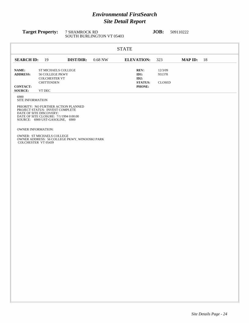
Environmental FirstSearchSite Detail Report
Target Property: 7 SHAMROCK RD JOB: 509110222SOUTH BURLINGTON VT 05403
STATE
SEARCH ID: 19 DIST/DIR: 0.68 NW ELEVATION: 323 MAP ID: 18
NAME: ST MICHAELS COLLEGE REV: 12/3/09ADDRESS: 56 COLLEGE PKWY ID1: 931378
COLCHESTER VT ID2: CHITTENDEN STATUS: CLOSED
CONTACT: PHONE: SOURCE: VT DEC
Site Details Page - 24
6900SITE INFORMATION
PRIORITY: NO FURTHER ACTION PLANNEDPROJECT STATUS: INVEST COMPLETEDATE OF SITE DISCOVERY:DATE OF SITE CLOSURE: 7/1/1994 0:00:00SOURCE: 6900 UST-GASOLINE, 6900
OWNER INFORMATION:
OWNER: ST MICHAELS COLLEGEOWNER ADDRESS: 56 COLLEGE PKWY, WINOOSKI PARKCOLCHESTER VT 05439

Environmental FirstSearchSite Detail Report
Target Property: 7 SHAMROCK RD JOB: 509110222SOUTH BURLINGTON VT 05403
STATE
SEARCH ID: 22 DIST/DIR: 0.68 NW ELEVATION: 323 MAP ID: 18
NAME: ST MICHAELS COLLEGE - SENIOR HALL REV: 7/8/11ADDRESS: COLLEGE PKWY ID1: 951868
COLCHESTER VT ID2: CHITTENDEN STATUS: ACTIVE
CONTACT: PHONE: SOURCE: VT DEC
Site Details Page - 25
6900SITE INFORMATION
PRIORITY: THREATENED SENSITIVE RECEPTOR (30 >= VT SITE PRIORITY SCORE <= 60)PROJECT STATUS: APPROXIMATELY 280 GAL. GASOLINE FROM UST RELEASE RECOVERED. ONGOING MONTHLY PRODUCT HAND BAILINGAND SEMIANNUAL MONITORING. CAFI WITH DETAILS ON SVE/AS COMPLETED SUMMER 2010. DEFERRING WORK CLEANUP DECISIONUNTIL SPRING 2011 - TO CONSIDER PAY-FOR-PERFORMANCE CLEANUP.DATE OF SITE DISCOVERY: 8/1/1995 0:00:00DATE OF SITE CLOSURE:SOURCE: 6900 UST-GASOLINE, 6900
OWNER INFORMATION:
OWNER: ST MICHAELS COLLEGEOWNER ADDRESS: 56 COLLEGE PKWY, WINOOSKI PARKCOLCHESTER VT 05439

Environmental FirstSearchSite Detail Report
Target Property: 7 SHAMROCK RD JOB: 509110222SOUTH BURLINGTON VT 05403
STATE
SEARCH ID: 20 DIST/DIR: 0.74 NW ELEVATION: 322 MAP ID: 19
NAME: ST MICHAELS COLLEGE - JOYCE HALL REV: 7/8/11ADDRESS: MAIN CAMPUS ID1: 20063473
COLCHESTER VT ID2: CHITTENDEN STATUS: ACTIVE
CONTACT: PHONE: SOURCE: VT DEC
Site Details Page - 26
6900SITE INFORMATION
PRIORITY: NO SENSITIVE RECEPTOR IMPACT (VT SITE PRIORITY SCORE<30)PROJECT STATUS: SOURCE OF OIL IN TOWN SEWERS FROM 10,000 GALLON HEATING OIL UST. DURING UST CLOSURE 37 GAL. OILREMOVED FROM PIT, AND 40 YDS SOIL REMOVED & TREATED AT ESMI. BIENNIAL MONITORING AND PRODUCT CHECK 2010.DATE OF SITE DISCOVERY: 1/13/2006 0:00:00DATE OF SITE CLOSURE:SOURCE: 6900 UST-HEATING OIL, 6900 FREE PRODUCT PRESENT, 6900
OWNER INFORMATION:
OWNER: ST MICHAELS COLLEGEOWNER ADDRESS: 56 COLLEGE PKWY, WINOOSKI PARKCOLCHESTER VT 05439

Environmental FirstSearchSite Detail Report
Target Property: 7 SHAMROCK RD JOB: 509110222SOUTH BURLINGTON VT 05403
STATE
SEARCH ID: 23 DIST/DIR: 0.74 SE ELEVATION: 307 MAP ID: 20
NAME: VERMONT AIR NATIONAL GUARD REV: 7/8/11ADDRESS: 0 AIRPORT RD ID1: 770043
SOUTH BURLINGTON VT ID2: STATUS: ACTIVE
CONTACT: PHONE: SOURCE: VT DEC
Site Details Page - 27
6900SITE INFORMATION
PRIORITY: DIRECTLY IMPACTED SENSITIVE RECEPTOR (VT SITE PRIORITY SCORE>60)PROJECT STATUS: BASEWIDE SUPPLEMENTAL REMEDIAL INVESTIGATION UNDERWAY SUMMER 04; REPORT BY EARLY 05. SITE 1GROUNDWATER INTERCEPTION TRENCH OPERATING AS DESIGNED. SITE 3 FREE PRODUCT RECOVERY SYSTEMS OPERATING ASDESIGNED.DATE OF SITE DISCOVERY:DATE OF SITE CLOSURE:SOURCE: 6900 ABOVE GROUND STORAGE TANK, 6900 UST-KEROSENE, 6900 SPILL, 6900 OTHER, 6900
OWNER INFORMATION:
OWNER: VERMONT AIR NATIONAL GUARDOWNER ADDRESS: AIRPORT ROADSOUTH BURLINGTON VT 05403

Environmental FirstSearchSite Detail Report
Target Property: 7 SHAMROCK RD JOB: 509110222SOUTH BURLINGTON VT 05403
STATE
SEARCH ID: 17 DIST/DIR: 0.81 SW ELEVATION: 280 MAP ID: 21
NAME: SOUTH BURLINGTON STREET DEPT REV: 7/8/11ADDRESS: PATCHEN RD ID1: 931383
SOUTH BURLINGTON VT ID2: CHITTENDEN STATUS: ACTIVE
CONTACT: PHONE: SOURCE: VT DEC
Site Details Page - 28
6900SITE INFORMATION
PRIORITY: NO SENSITIVE RECEPTOR IMPACT (VT SITE PRIORITY SCORE<30)PROJECT STATUS: ANNUAL GW MONITORING OF GASOLINE UST RELEASE. NEXT ROUND MAY 2009. EVALUATING WAYS TO BETTERDEFINE DOWNGRADIENT EXTENT OF CONTAMINATION, E.G., USE LANDFILL WELLS.DATE OF SITE DISCOVERY:DATE OF SITE CLOSURE:SOURCE: 6900 UST-GASOLINE, 6900
OWNER INFORMATION:
OWNER: CITY OF BURLINGTONOWNER ADDRESS: 53 LAVALLEY LANEBURLINGTON VT 05401

Environmental FirstSearchSite Detail Report
Target Property: 7 SHAMROCK RD JOB: 509110222SOUTH BURLINGTON VT 05403
STATE
SEARCH ID: 8 DIST/DIR: 0.83 NW ELEVATION: 259 MAP ID: 22
NAME: CHUCKS MOBIL REV: 7/8/11ADDRESS: 298 E ALLEN ST ID1: 20083812
WINOOSKI VT ID2: CHITTENDEN STATUS: ACTIVE
CONTACT: PHONE: SOURCE: VT DEC
Site Details Page - 29
6900SITE INFORMATION
PRIORITY: THREATENED SENSITIVE RECEPTOR (30 >= VT SITE PRIORITY SCORE <= 60)PROJECT STATUS: PIPING, SUMPS AND DISPENSERS REPLACED. CONTAMINATION FOUND,. INVESTIGATION NEEDED.DATE OF SITE DISCOVERY: 6/3/2008 0:00:00DATE OF SITE CLOSURE:SOURCE: 6900 UST-DIESEL, 6900 UST-GASOLINE, 6900
OWNER INFORMATION:
OWNER: R L VALLEE INCOWNER ADDRESS: P O BOX 1190, 282 S MAIN STST ALBANS VT 05478

Environmental FirstSearchSite Detail Report
Target Property: 7 SHAMROCK RD JOB: 509110222SOUTH BURLINGTON VT 05403
STATE
SEARCH ID: 10 DIST/DIR: 0.84 NE ELEVATION: 324 MAP ID: 23
NAME: FANNY ALLEN CONVENT REV: 12/3/09ADDRESS: 786 COLLEGE PKWY ID1: 20063534
COLCHESTER VT ID2: CHITTENDEN STATUS: CLOSED
CONTACT: PHONE: SOURCE: VT DEC
Site Details Page - 30
6900SITE INFORMATION
PRIORITY: SITES MANAGEMENT ACTIVITY COMPLETEDPROJECT STATUS: INVESTIGATION NEEDED. INVESTIGATION COMPLETE, NO IMPACT TO GW, SMACDATE OF SITE DISCOVERY: 5/15/2006 0:00:00DATE OF SITE CLOSURE: 7/13/2007 0:00:00SOURCE: 6900 UNKNOWN, 6900 OTHER, 6900 MERCURY, 6900
OWNER INFORMATION:
OWNER: RELIGIOUS HOSPITALLERS OF ST JOSEPHOWNER ADDRESS: 47 W SPRING STWINOOSKI VT 05404-1319

Environmental FirstSearchSite Detail Report
Target Property: 7 SHAMROCK RD JOB: 509110222SOUTH BURLINGTON VT 05403
STATE
SEARCH ID: 16 DIST/DIR: 0.84 NW ELEVATION: 268 MAP ID: 24
NAME: SEGUIN RESIDENCE REV: 7/8/11ADDRESS: 299 E ALLEN ST ID1: 20022954
WINOOSKI VT ID2: CHITTENDEN STATUS: ACTIVE
CONTACT: PHONE: SOURCE: VT DEC
Site Details Page - 31
6900SITE INFORMATION
PRIORITY: THREATENED SENSITIVE RECEPTOR (30 >= VT SITE PRIORITY SCORE <= 60)PROJECT STATUS: UNDERGROUND STORAGE TANK REMOVED. CONTAMINATION FOUND. INVESTIGATION NEEDEDDATE OF SITE DISCOVERY: 12/12/2001 0:00:00DATE OF SITE CLOSURE:SOURCE: 6900 UST-WASTE OIL, 6900 UST-GASOLINE, 6900 UST-HEATING OIL, 6900
OWNER INFORMATION:
OWNER: CLARA B SEGUINOWNER ADDRESS: 299 E ALLEN STWINOOSKI VT 05404

Environmental FirstSearchSite Detail Report
Target Property: 7 SHAMROCK RD JOB: 509110222SOUTH BURLINGTON VT 05403
STATE
SEARCH ID: 24 DIST/DIR: 0.85 NW ELEVATION: 261 MAP ID: 25
NAME: WINOOSKI EXXON REV: 7/8/11ADDRESS: 280 E ALLEN ST ID1: 951815
WINOOSKI VT ID2: CHITTENDEN STATUS: ACTIVE
CONTACT: PHONE: SOURCE: VT DEC
Site Details Page - 32
6900SITE INFORMATION
PRIORITY: THREATENED SENSITIVE RECEPTOR (30 >= VT SITE PRIORITY SCORE <= 60)PROJECT STATUS: 01/11: ACTIVE REMEDIATION COMPLETED AT SITE. MONITORING ONGOING TWICE A YEAR. SEVERAL MONITORINGWELLS MAY NEED REPLACING IN SPRING 11.DATE OF SITE DISCOVERY:DATE OF SITE CLOSURE:SOURCE: 6900 UST-GASOLINE, 6900
OWNER INFORMATION:
OWNER: WESCO, INCOWNER ADDRESS: 32 SAN REMO DRIVESOUTH BURLINGTON VT 05403

Environmental FirstSearch Descriptions
NPL: EPA NATIONAL PRIORITY LIST - The National Priorities List is a list of the worst hazardous waste sites that
have been identified by Superfund. Sites are only put on the list after they have been scored using the Hazard Ranking
System (HRS), and have been subjected to public comment. Any site on the NPL is eligible for cleanup using Superfund
Trust money. A Superfund site is any land in the United States that has been contaminated by hazardous waste and
identified by the Environmental Protection Agency (EPA) as a candidate for cleanup because it poses a risk to human
health and/or the environment.FINAL - Currently on the Final NPLPROPOSED - Proposed for NPL
NPL DELISTED: EPA NATIONAL PRIORITY LIST Subset - Database of delisted NPL sites. The National Oil and
Hazardous Substances Pollution Contingency Plan (NCP) establishes the criteria that the EPA uses to delete sites from the
NPL. In accordance with 40 CFR 300.425.(e), sites may be deleted from the NPL where no further response is
appropriate.DELISTED - Deleted from the Final NPL
CERCLIS: EPA COMPREHENSIVE ENVIRONMENTAL RESPONSE COMPENSATION AND LIABILITY
INFORMATION SYSTEM (CERCLIS)- CERCLIS is a database of potential and confirmed hazardous waste sites at
which the EPA Superfund program has some involvement. It contains sites that are either proposed to be or are on the
National Priorities List (NPL) as well as sites that are in the screening and assessment phase for possible inclusion on the
NPL.PART OF NPL- Site is part of NPL siteDELETED - Deleted from the Final NPLFINAL - Currently on the Final
NPLNOT PROPOSED - Not on the NPLNOT VALID - Not Valid Site or IncidentPROPOSED - Proposed for
NPLREMOVED - Removed from Proposed NPLSCAN PLAN - Pre-proposal SiteWITHDRAWN - Withdrawn
NFRAP: EPA COMPREHENSIVE ENVIRONMENTAL RESPONSE COMPENSATION AND LIABILITY
INFORMATION SYSTEM ARCHIVED SITES - database of Archive designated CERCLA sites that, to the best of
EPA's knowledge, assessment has been completed and has determined no further steps will be taken to list this site on the
National Priorities List (NPL). This decision does not necessarily mean that there is no hazard associated with a given site;
it only means that, based upon available information, the location is not judged to be a potential NPL site.NFRAP – No
Further Remedial Action PlanP - Site is part of NPL siteD - Deleted from the Final NPLF - Currently on the Final NPLN -
Not on the NPLO - Not Valid Site or IncidentP - Proposed for NPLR - Removed from Proposed NPLS - Pre-proposal
SiteW – Withdrawn
RCRA COR ACT: EPA RESOURCE CONSERVATION AND RECOVERY INFORMATION SYSTEM SITES -
Database of hazardous waste information contained in the Resource Conservation and Recovery Act Information
(RCRAInfo), a national program management and inventory system about hazardous waste handlers. In general, all
generators, transporters, treaters, storers, and disposers of hazardous waste are required to provide information about their
activities to state environmental agencies. These agencies, in turn pass on the information to regional and national EPA
offices. This regulation is governed by the Resource Conservation and Recovery Act (RCRA), as amended by the
Hazardous and Solid Waste Amendments of 1984.RCRAInfo facilities that have reported violations and subject to
corrective actions.
RCRA TSD: EPA RESOURCE CONSERVATION AND RECOVERY INFORMATION SYSTEM TREATMENT,
STORAGE, and DISPOSAL FACILITIES. - Database of hazardous waste information contained in the Resource
Conservation and Recovery Act Information (RCRAInfo), a national program management and inventory system about
hazardous waste handlers. In general, all generators, transporters, treaters, storers, and disposers of hazardous waste are

required to provide information about their activities to state environmental agencies. These agencies, in turn pass on the
information to regional and national EPA offices. This regulation is governed by the Resource Conservation and Recovery
Act (RCRA), as amended by the Hazardous and Solid Waste Amendments of 1984.Facilities that treat, store, dispose, or
incinerate hazardous waste.
RCRA GEN: EPA/MA DEP/CT DEP RESOURCE CONSERVATION AND RECOVERY INFORMATION SYSTEM
GENERATORS - Database of hazardous waste information contained in the Resource Conservation and Recovery Act
Information (RCRAInfo), a national program management and inventory system about hazardous waste handlers. In
general, all generators, transporters, treaters, storers, and disposers of hazardous waste are required to provide information
about their activities to state environmental agencies. These agencies, in turn pass on the information to regional and
national EPA offices. This regulation is governed by the Resource Conservation and Recovery Act (RCRA), as amended
by the Hazardous and Solid Waste Amendments of 1984.Facilities that generate or transport hazardous waste or meet
other RCRA requirements.LGN - Large Quantity GeneratorsSGN - Small Quantity GeneratorsVGN – Conditionally
Exempt Generator.Included are RAATS (RCRA Administrative Action Tracking System) and CMEL (Compliance
Monitoring & Enforcement List) facilities. CONNECTICUT HAZARDOUS WASTE MANIFEST – Database of all
shipments of hazardous waste within, into or from Connecticut. The data includes date of shipment, transporter and TSD
info, and material shipped and quantity. This data is appended to the details of existing generator records.
MASSACHUSETTES HAZARDOUS WASTE GENERATOR – database of generators that are regulated under the MA
DEP. VQN-MA = generates less than 220 pounds or 27 gallons per month of hazardous waste or waste oil.SQN-MA =
generates 220 to 2,200 pounds or 27 to 270 gallons per month of waste oil.LQG-MA = generates greater than 2,200 lbs of
hazardous waste or waste oil per month.
Fed Brownfield: EPA BROWNFIELD MANAGEMENT SYSTEM (BMS) - database designed to assist EPA in
collecting, tracking, and updating information, as well as reporting on the major activities and accomplishments of the
various Brownfield grant Programs./n CLEANUPS IN MY COMMUNITY (subset) - Sites, facilities and properties that
have been contaminated by hazardous materials and are being, or have been, cleaned up under EPA's brownfield’s
program.
ERNS: EPA/NRC EMERGENCY RESPONSE NOTIFICATION SYSTEM (ERNS) - Database of incidents reported to
the National Response Center. These incidents include chemical spills, accidents involving chemicals (such as fires or
explosions), oil spills, transportation accidents that involve oil or chemicals, releases of radioactive materials, sightings of
oil sheens on bodies of water, terrorist incidents involving chemicals, incidents where illegally dumped chemicals have
been found, and drills intended to prepare responders to handle these kinds of incidents. Data since January 2001 has been
received from the National Response System database as the EPA no longer maintains this data.
Tribal Lands: DOI/BIA INDIAN LANDS OF THE UNITED STATES - Database of areas with boundaries established by
treaty, statute, and (or) executive or court order, recognized by the Federal Government as territory in which American
Indian tribes have primary governmental authority. The Indian Lands of the United States map layer shows areas of 640
acres or more, administered by the Bureau of Indian Affairs. Included are Federally-administered lands within a
reservation which may or may not be considered part of the reservation.BUREAU OF INDIAN AFFIARS CONTACT -
Regional contact information for the Bureau of Indian Affairs offices.
State/Tribal Sites: VT DEC ACTIVE AND CLOSED HAZARDOUS SITES LIST - database of active and closed
hazardous waste sites. The data includes priority, project status, source, date of site discovery, date of site closure, and

owner information.
State Spills 90: VT DEC VERMONT SPILLS DATABASE - database of spills reported to the Vermont Department of
Environmental Conservation. The data includes information regarding incident date, type of incident, reporter, responsible
party, and action taken.
State/Tribal SWL: VT DEC SOLID WASTE MANAGEMENT FACILITIES LIST - database of both landfills and
transfer stations for the state of Vermont. The list includes contact information for each site.
State/Tribal LUST: VT DEC PULLED UNDERGROUND STORAGE TANKS LIST - database of tanks that have been
pulled/removed due to a leak. Under state law any tank that has reported a leak must be pulled/removed. The data includes
owner and operator name, facility type, and tank information.
State/Tribal UST/AST: VT DEC REGISTERED UNDERGROUND STORAGE TANKS LIST - database of underground
storage tanks registered with the Vermont Department of Environmental Conservation. The data includes facility type,
owner contact information, and tank substance, protection, and capacity.
State/Tribal Brownfields: VT ANR BROWNFIELD SITE LIST SUBSET- database of sites that have been classified as
Brownfields and have Institutional Controls. Information regarding size, response action, cleanup type, and project
manager is included. Management System (BMS) - database designed to assist EPA in collecting, tracking, and updating
information, as well as reporting on the major activities and accomplishments of the various brownfield grant programs.
State/Tribal Brownfields: VT ANR BROWNFIELD SITE LIST - database of sites that have been classified as
Brownfields and/or have Institutional Controls. Information regarding size, response action, cleanup type, and project
manager is included. Management System (BMS) - database designed to assist EPA in collecting, tracking, and updating
information, as well as reporting on the major activities and accomplishments of the various brownfield grant programs.
Federal IC / EC: EPA FEDERAL ENGINEERING AND INSTITUTIONAL CONTROLS- Superfund sites that have
either engineering or an institutional control. The data includes the control and the media contaminated. RESOURCE
CONSERVATION AND RECOVERY INFORMATION SYSTEM SITES (RCRA) – RCRA site that have institutional
controls.

Environmental FirstSearch Database Sources
NPL: EPA Environmental Protection Agency
Updated quarterly
NPL DELISTED: EPA Environmental Protection Agency
Updated quarterly
CERCLIS: EPA Environmental Protection Agency
Updated quarterly
NFRAP: EPA Environmental Protection Agency.
Updated quarterly
RCRA COR ACT: EPA Environmental Protection Agency.
Updated quarterly
RCRA TSD: EPA Environmental Protection Agency.
Updated quarterly
RCRA GEN: EPA/MA DEP/CT DEP Environmental Protection Agency, Massachusetts Department of Environmental
Protection, Connecticut Department of Environmental Protection
Updated quarterly
Fed Brownfield: EPA Environmental Protection Agency
Updated quarterly
ERNS: EPA/NRC Environmental Protection AgencyNational Response Center.
Updated annually
Tribal Lands: DOI/BIA United States Department of the InteriorBureau of Indian Affairs
Updated annually

State/Tribal Sites: VT DEC Vermont Department of Environmental Conservation
Updated quarterly
State Spills 90: VT DEC Vermont Department of Environmental Conservation
Updated quarterly
State/Tribal SWL: VT DEC Vermont Department of Environmental Conservation, Solid Waste Management Division
Updated annually
State/Tribal LUST: VT DEC Vermont Department of Environmental Conservation, Hazardous Materials Management
Division
Updated quarterly
State/Tribal UST/AST: VT DEC Vermont Department of Environmental Conservation, Hazardous Materials Management
Division
Updated quarterly
State/Tribal Brownfields: VT ANR Vermont Agency of Natural Resources, Waste Management Division of Brownfields
Program
Updated quarterly
State/Tribal Brownfields: VT ANR Vermont Agency of Natural Resources, Waste Management Division of Brownfields
Program
Updated quarterly
Federal IC / EC: EPA Environmental Protection Agency
Updated quarterly

Environmental FirstSearchStreet Name Report for Streets within .25 Mile(s) of Target Property
Target Property: 7 SHAMROCK RD JOB: 509110222SOUTH BURLINGTON VT 05403
Street Name Dist/Dir Street Name Dist/Dir
Airport Pkwy 0.04 SWAirport Ter 0.25 SWBerard Dr 0.25 NWBrady Ln 0.11 SWCommerce Ave 0.17 SEEthan Allen Dr 0.04 SELime Kiln Rd 0.07 NWLime Rock Rd 0.16 SENational Guard Ave 0.13 SENational Guard Rd 0.13 SEPoor Farm Rd 0.13 SESHAMROCK RD 0.00--

Environmental FirstSearch1 Mile Radius
ASTM Map: NPL, RCRACOR, STATE Sites
7 SHAMROCK RD, SOUTH BURLINGTON VT 05403
Source: Tele Atlas
Target Site (Latitude: 44.484671 Longitude: -73.162691) ..................................
Identified Site, Multiple Sites, Receptor .............................................................
NPL, DELNPL, Brownfield, Solid Waste Landfill (SWL), Hazardous Waste
Triballand.............................................................................................................
Black Rings Represent 1/4 Mile Radius; Red Ring Represents 500 ft. Radius

Environmental FirstSearch.5 Mile Radius
ASTM Map: CERCLIS, RCRATSD, LUST, SWL
7 SHAMROCK RD, SOUTH BURLINGTON VT 05403
Source: Tele Atlas
Target Site (Latitude: 44.484671 Longitude: -73.162691) ..................................
Identified Site, Multiple Sites, Receptor .............................................................
NPL, DELNPL, Brownfield, Solid Waste Landfill (SWL), Hazardous Waste
Triballand.............................................................................................................
Black Rings Represent 1/4 Mile Radius; Red Ring Represents 500 ft. Radius
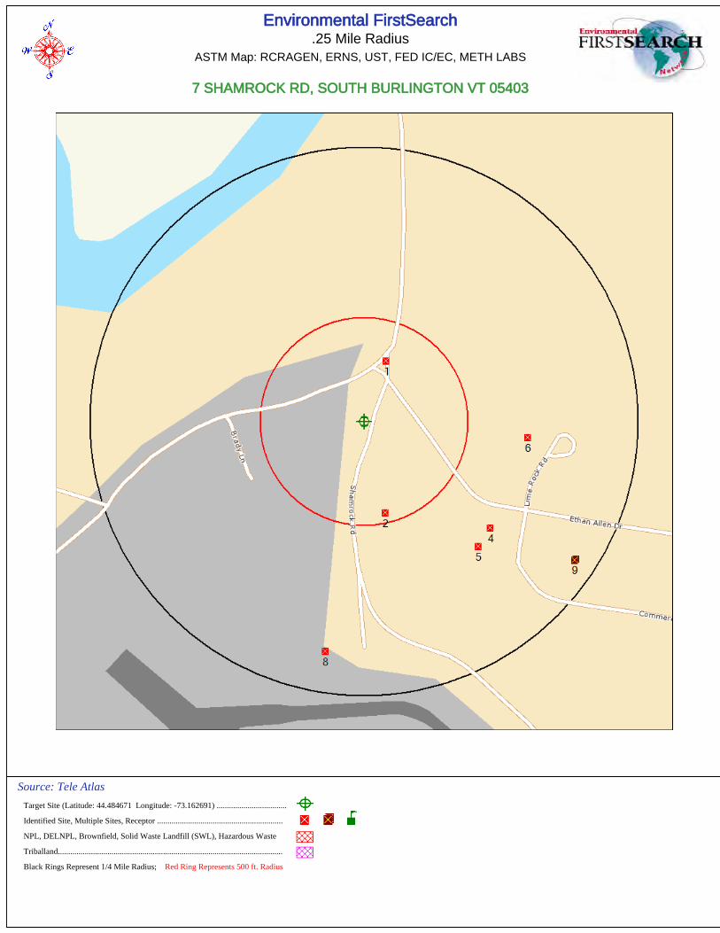
Environmental FirstSearch.25 Mile Radius
ASTM Map: RCRAGEN, ERNS, UST, FED IC/EC, METH LABS
7 SHAMROCK RD, SOUTH BURLINGTON VT 05403
Source: Tele Atlas
Target Site (Latitude: 44.484671 Longitude: -73.162691) ..................................
Identified Site, Multiple Sites, Receptor .............................................................
NPL, DELNPL, Brownfield, Solid Waste Landfill (SWL), Hazardous Waste
Triballand.............................................................................................................
Black Rings Represent 1/4 Mile Radius; Red Ring Represents 500 ft. Radius

Environmental FirstSearch.12 Mile Radius
Non-ASTM Map: Spills 90
7 SHAMROCK RD, SOUTH BURLINGTON VT 05403
Source: Tele Atlas
Target Site (Latitude: 44.484671 Longitude: -73.162691) ..................................
Identified Site, Multiple Sites, Receptor .............................................................
NPL, DELNPL, Brownfield, Solid Waste Landfill (SWL), Hazardous Waste
Triballand.............................................................................................................
National Historic Sites and Landmark Sites .......................................................
Black Rings Represent 1/4 Mile Radius; Red Ring Represents 500 ft. Radius
Phase I Environmental Site Assessment Report
AIP 74, South Burlington, Vermont
October 14, 2011 36 KAS Project #509110222
APPENDIX G
INTERVIEW DOCUMENTATION


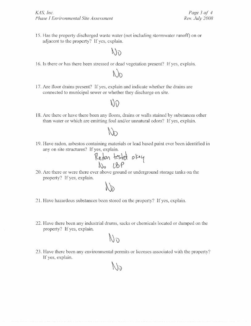

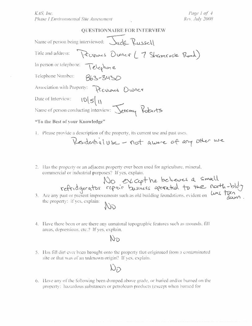


Phase I Environmental Site Assessment Report
AIP 74, South Burlington, Vermont
October 14, 2011 37 KAS Project #509110222
APPENDIX H
SITE RECONAISSANCE CHECKLIST


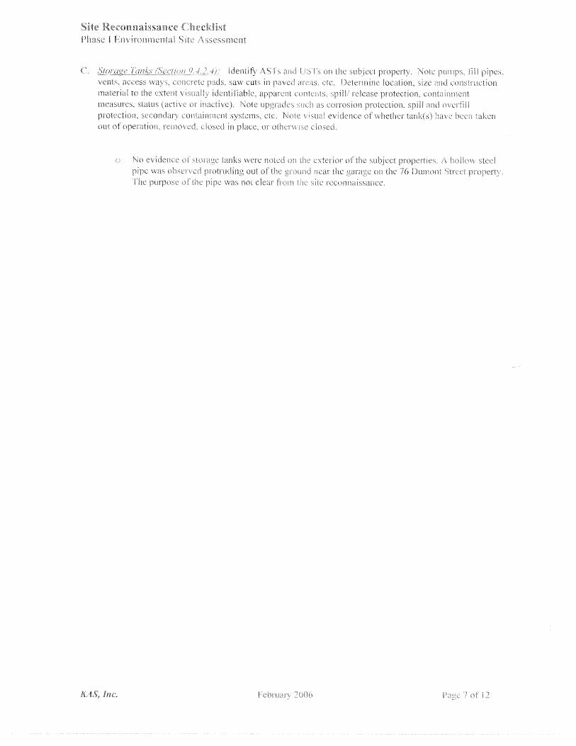


Phase I Environmental Site Assessment Report
AIP 74, South Burlington, Vermont
October 14, 2011 38 KAS Project #509110222
APPENDIX I
QUALIFICATIONS OF ENVIRONMENTAL PROFESSIONALS

KAS, INC. PROFESSIONAL PROFILE
ALAN R. LIPTAK, PG, CPG
TITLE Vice-President/Principal
EXPERTISE Environmental project management, solid waste site design, operations,
permitting, closure and post closure; contaminated site investigation and clean up, state and local permitting, innovative test methods.
EXPERIENCE KAS, Inc., Williston, Vermont. September 2004 – Present.
Management of KAS’s environmental projects/ programs, including environmental site assessments, UST removals, site investigations, and environmental clean up activities. Foster technical innovation, quality control and assurance on projects and written materials. Business development activities for environmental programs. Project Management.
Griffin International, Inc., Williston, Vermont May 1999 – September 2004.
Environmental Programs Manager June 2001-September 2004; Senior
Staff Geologist May 1999 –June 2001. Management and supervision of Griffin’s environmental programs. Supervised professional staff of scientists and engineers. Business development activities for environmental programs. Management of individual projects.
The Johnson Company, Inc., Montpelier, Vermont October 1990 –
May 1999.
Senior Scientist. Management of hazardous and solid waste projects and business development. Assisted with company administration including insurance and retirement planning.
State of Vermont Department of Environmental Conservation,
Waterbury, Vermont October 1984 – October 1990.
Progressively responsible positions included assistant regional wastewater engineer, solid waste engineer and supervisor of engineering and technical assistance for the Solid Waste Division.
ACADEMIC MBA, Norwich University, June 2005 BACKGROUND M.S. Geology, Chemistry Minor, University of Montana, 1984 B.A. Geology, State University of New York at Potsdam, 1982 PROFESSIONAL Certified Professional Geologist # 10166 QUALIFICATIONS American Institute of Professional Geologists, Arvada, CO New Hampshire Licensed Geologist #0142 ASTM/EPA Environmental Professional OTHER OSHA 1910.120 Hazardous Waste Site Worker President, Vermont Philharmonic Orchestra Board of Directors Williston-Richmond Rotary Club Member

KAS, INC.
PROFESSIONAL PROFILE
JEREMY P. ROBERTS TITLE Manager of State Regulated Programs, Soil Scientist EXPERTISE Environmental project management. Collection of environmental samples
and operation and maintenance of hazardous waste treatment systems. Project management, geological investigations, hazardous waste site assessments, water system monitoring and maintenance, groundwater and soil contamination, remedial system design, installation, and operation. Wetland delineation. Phase I and Phase II Environmental Site Assessments.
EXPERIENCE KAS, Inc., Williston, VT October 2004 – Present. Project management.
Technical report writing. Geological investigations. Hazardous waste site assessments. Phase I and Phase II environmental site assessments. Collection of groundwater, surface water, and soil samples, soil screening, and soil vapor extraction system monitoring and maintenance
Griffin International, Inc., Williston, VT January 2002 – October 2004.
Project management. Technical report writing. Geological investigations. Hazardous waste site assessments. Phase I and Phase II environmental site assessments. Collection of groundwater, surface water, and soil samples, soil screening, and soil vapor extraction system monitoring and maintenance.
ACADEMIC BACKGROUND BS, Plant and Soil Science, University of Vermont. May 1999. PROFESSIONAL QUALIFICATIONS 40 Hour OSHA 29CFR1910.120 Hazardous Worker Training 40 Hour Certification in Federal Wetland Delineation, Identification, and
Classification. Vermont Certified Asbestos Site Inspector ASTM/EPA Environmental Professional

Phase I Environmental Site Assessment Report
AIP 74, South Burlington, Vermont
October 14, 2011 39 KAS Project #509110222
APPENDIX J
ADDITIONAL ENVIRONMENTAL RECORDS