people, places, and environment - faculty site listing 1 help, ch. 1, intro to... · introduction...
TRANSCRIPT

Introduction to Geography
People, Places, and Environment
Chapter 1: Introduction to Geography
1

Objectives: after carefully studying this
chapter, students will be able to:
• Define some subfields of geography (such as physical, human, regional,
and systematic),
• Explain how various entities might diffuse and move across landscapes
and how such diffusion, might be analyzed,
• Describe the geographic grid,
• Review challenges in designing map projections,
• Define remote sensing, GIS, & GPS.
2

A Definition of Geography
The study of the interaction of all
physical and human phenomena at
individual places and of how
interactions among places form
patterns and organize space.
3

• Objective: define some subfields of geography
(such as physical, human, regional, and
systematic),
Physical geography
Human geography
– Cultural geography
4

Human-Environment Interaction
• Culture: Everything about the way people live, including language, food, religion, social ceremonies
5

Defining some subfields of geography, continued
• Regional geography
• Topical or systematic geography
• Environmental determinism
• Theory – a widely accepted view that has more or less endured the test of time, and that has been widely used as a frame upon which to add newly discovered facts and patterns. – Example: Integrated Ecosystem Theory
6

Some Considerations in Area Analysis
• Site: exact location of a place
• Situation, or relative location:
– Location of a place relative to other places
– Accessibility
– Constant change
– Globalization
– Lenses
7

Korea’s royal palace displayed a copy of a 13th century Chinese/Islamic map
Demonstrates increasing interconnectedness during that historical time.
8

The Concept of Regions
• Formal regions: essential uniformity in one or more physical or cultural features – Sometimes politically defined – May be bound by mountains or oceans – More concrete and less quick to change
• Functional regions: defined by interactions among places – E.g., trade linkages, communications, and religious
structures
• Vernacular regions: widespread popular perception of existence (“That’s the Midwest”)
9

Functional Regions, e.g. market region
10

Vernacular Regions
11

Spatial Analysis
• Distribution – Density
• E.g., Population
– Concentration • A descriptive
term, “Is this entity concetrated or dispersed.”
– Pattern • E.g., does the
entity stay close to streams, or is it ordered by streets?
12

• Objective: explain how various entities might
diffuse and move across landscapes and how such
diffusion, might be analyzed
• Distance
– Measurements
• Absolute (e.g., number of miles)
• Time (required to travel full distance)
• Cost (e.g., car, plane, train, or boat price)
– Friction of distance
• Distance decay: As distance increases, importance of the phenomenon decreases (for example, newspaper circulation)
13

Measuring Distance
14

Diffusion
• Hearth: Place where an idea begins
• Types of diffusion:
– Relocation (e.g., immigration and emigration)
– Contiguous, or contagious (direct contact, “And tell a friend”)
– Hierarchical (specific authorities organize [filter] and communicate)
• Barriers to diffusion:
– Distance and time
– Physical: oceans, deserts, topography
– Cultural:
• Political boundaries
• Misunderstanding, competition between groups
15

• Utility of a new
technology:
– Cars
– Planes
– TVs
– Various means of
diffusing
16

17
Objective: describe the geographic grid

The Geographic Grid
• Location on Earth
– Need an accurate location on Earth
to describe geographic features
– Use Earth’s rotation axis to base
location on the surface
– North Pole and South Pole
– Plane of the Equator—halfway
between poles and perpendicular to
Earth’s surface
18
© 2011 Pearson Education, Inc.
-Graticule (grid): the network of lines of latitude and longitude upon which a map is drawn

The Geographic Grid
• Great Circles
– Circles which bisect a sphere
and pass through the sphere’s
center
– Identify the shortest distance
between two points on a
sphere—great circle distance
– Circle of illumination
– Small circles
19
Figure 1-10
© 2011 Pearson Education, Inc.

The Geographic Grid
• Latitudes
– Parallels
– angle north or south of the equator
– 7 important latitudes:
– Tropic of Cancer and Capricorn
(23.5° N and S)
– Equator (0°)
– Poles (90° N and S)
– Arctic and Antarctic Circles
(66.5° N and S)
20

The Geographic Grid
• Longitudes
– Meridians
– Prime Meridian (0° longitude)
located at Greenwich, England
– Angle east or west of the
Prime Meridian
– Converge at the poles
21

The Geographic Grid
22

Map Making
• Cartography • Scale
– Fraction 1/24,000 – Ratio 1:24,000 – Written statement “1 inch = 1 mile” – Graphic scales bar→
• Detail and area – Small-scale map = less detail, large
denominator (1:1,000,000) – Large-scale map = more detail, small
denominator (1:100,000)
1/4 1/8
23
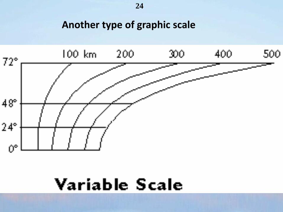
24
Another type of graphic scale

Map Scales: An Example
“Small detail → small map”
25

26

Objective: review challenges in designing map
projections,
Method of transferring locations on Earth’s surface to locations on a flat map
• Types of distortion
– Size (and distance, conformal)
– Shape (and orientation, equal-area)
27

Conformal and Equal-Area Projections
Conformal → size distortion, & Equal-Area → shape distortion
28

Tools for Cartography
Objective: define remote sensing, GIS, &
GPS
• Remote Sensing
• GIS—Geographic Information Systems
• GPS—Global Positioning System
29

30
An example of remote sensing

Remote Sensing Satellites
• Remote sensing (picking up spatial information without touching it, usually by high-flying aircraft or satellites orbiting Earth)
31

Remote Sensing
• Visible light and IR scanning
– Usually based off of visible
light and IR part of
electromagnetic spectrum
– Shows “false color”
32
Figure 2-23 Figure 2-22
To recognize and describe the functions of some of the newest tools

33

Infrared Scanning
Infrared Scanning
34
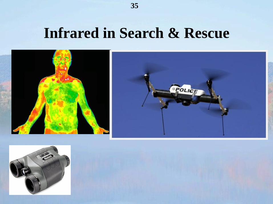
Infrared in Search & Rescue
35

Human trafficking across the
North Korean/Chinese Border
36

Infrared Remote Sensing
State of Hawaii
37

Satellite Data is Part of Remote Sensing & Reveals
• Weather
• History and archaeology
• Environmental impacts
• Farmland quality
• Stream flow
• Urban expansion
• Military intelligence
• Commercial information
38

NASA Photo
Egypt
39

• So far, passive systems (like a person’s eye)
• Active systems (similar to bats)
– Radar (electromagnetic waves, which include
visible light)
– Sonar (using sounds, like whales do)
– Many others
40
Remote Sensing, Active Systems

Remote Sensing
• Radar Imagery
– “Radio Detection and Ranging”
– Useful for identifying atmospheric moisture
• Sonar Imagery
– “Sound Navigation and Ranging”
– Permits underwater imaging
41

• Common types include:
– Aerial Photographs
– Orthophoto maps (digitally remove pilot-view
distortions)
– Visible Light and Infrared (IR) Scanning
• Scanning: using wavelengths which may or may not
include visible light
• e.g., x-rays
42
Remote Sensing

43
How to fix an oblique image

44 • Orthophoto maps
– Photographic maps that are multicolored and distortion free

GIS—Geographic
Information Systems
• Computer systems used to
analyze and display spatial
data
• Layers of data used in
mapping
• Requires high powered
computing to process
multiple maps
45
Figure 2-29
46
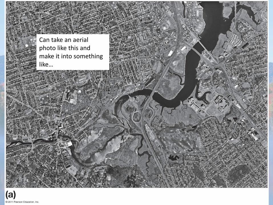
Can take an aerial photo like this and make it into something like…

…this.
47

Digital Elevation Model
48

GPS—Global Positioning System
• Global navigation satellite
system for determining
location on Earth’s surface
• Wide Area Augmentation
System (WAAS), ground-
based correctional stations
(approx. 1 per state), 1st for
airlines, “You (satel.) are out
of sink”
49
Figure 2-19
Cartographic tools

50
…24 working satellites, and 3 ‘spares’ orbiting just in case.

• Continuously Operating
GPS Reference Stations
(CORS), a ground-
based configuration of
GPS units
– E.g., detect plate
movements of less than
1 centimeter
51

End of Chapter 1
52