participatory rural appraisal · 2018-12-07 · participatory mapping (sketch maps drawn on site);...
TRANSCRIPT

Participatory Rural
Appraisal(PRA) as a Tools &
Techniques and Situation Analysis
Dr. Sandeep Kumar Raut
Town & Country Planning OrganisationMinistry of Housing & Urban Affairs
Mobile: 9818726997, [email protected]

What is PRA?Participatory method to gather/ collect information
by involvement of Rural/ local communities for
decision making and implementation of the Project.
“for the Rural community,
by the Rural community and
with the Rural Community”.
“ An approach and methods for learning about rural
life and conditions from, with and by rural people”.
(Chambers 1994)

WHY PRA?• Success of the Project is very high due to sense of
ownership and belongingness.
• Empowerment of people through participation
• Respect for human dignity.
• Community develop their own skills for decisionmaking.
• Creating the opportunity for individuals to exercisetheir right.
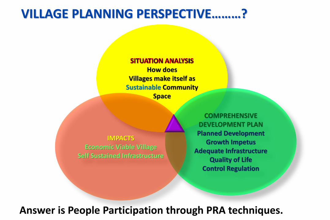
How does Villages make itself as
Sustainable Community Space
COMPREHENSIVEDEVELOPMENT PLANPlanned Development
Growth ImpetusAdequate Infrastructure
Quality of LifeControl Regulation
IMPACTSEconomic Viable Village
Self Sustained Infrastructure
Answer is People Participation through PRA techniques.
VILLAGE PLANNING PERSPECTIVE………?
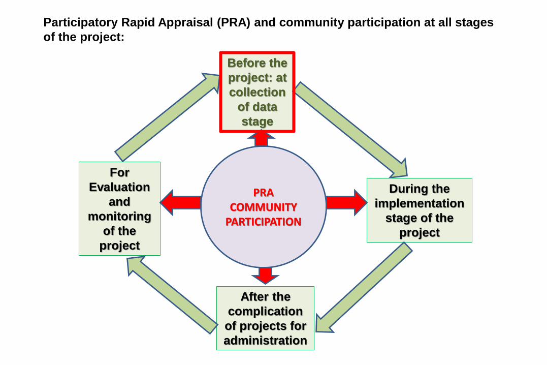
Before the
project: at
collection
of data
stage
During the
implementation
stage of the
project
After the
complication
of projects for
administration
For
Evaluation
and
monitoring
of the
project
PRACOMMUNITY
PARTICIPATION
Participatory Rapid Appraisal (PRA) and community participation at all stages
of the project:

POINTS TO REMEMBER….Principles of PRA
Before Going to Village

POINTS TO REMEMBER….Principles of PRA
✓ Reversal of learning
To learn from the local people
✓ Learning rapidly and progressively
Exploration, flexible methods, adaptable
✓ Offsetting bias
To be receptive rather than preconceived ideas
✓ Optimizing tradeoffs
Understanding the usefulness of information
✓ Triangulating
Crosschecking and approximation
✓ Sharing
To discuss and argue about ideas in open forum with all stakeholders.
Before Going to Village

ON THE FIELD/ VILLAGE ………..STEPS OF PRA
➢ Transect Walk (Systematic walks and observation);
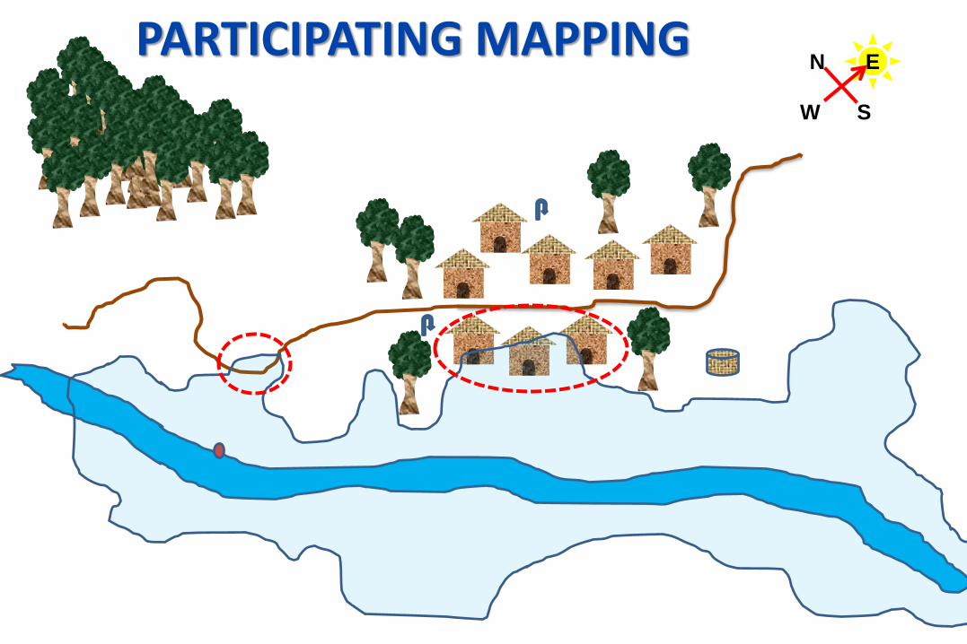
➢ Participatory Mapping (Sketch maps drawn on site);
➢ Diagramming (Seasonal Calendars, Venn diagrams, bar charts, chapati diagrams, Calendars)
➢ Innovation assessment (Matrices, scoring and ranking different actions)
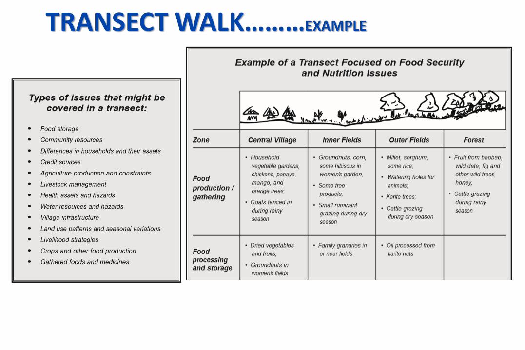
TRANSECT WALK………EXAMPLE

TRANSECT WALK

TRANSECT WALK……..EXAMPLE

TRANSECT WALK…….EXAMPLE

COMMUNITY MAPPING THROUGH JOINING
TRANSECT WALK
W
N
S
EPARTICIPATING MAPPING
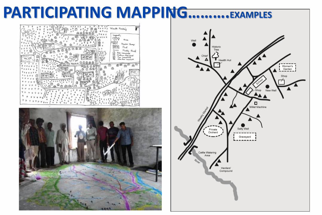
PARTICIPATING MAPPING……….EXAMPLES

RESOURCE MAPPING…….EXAMPLES

VENN DIAGRAM

VENN DIAGRAM

CALENDARS….EXAMPLES

CALENDARS….EXAMPLES
Historical Profile

CALENDARS….EXAMPLES
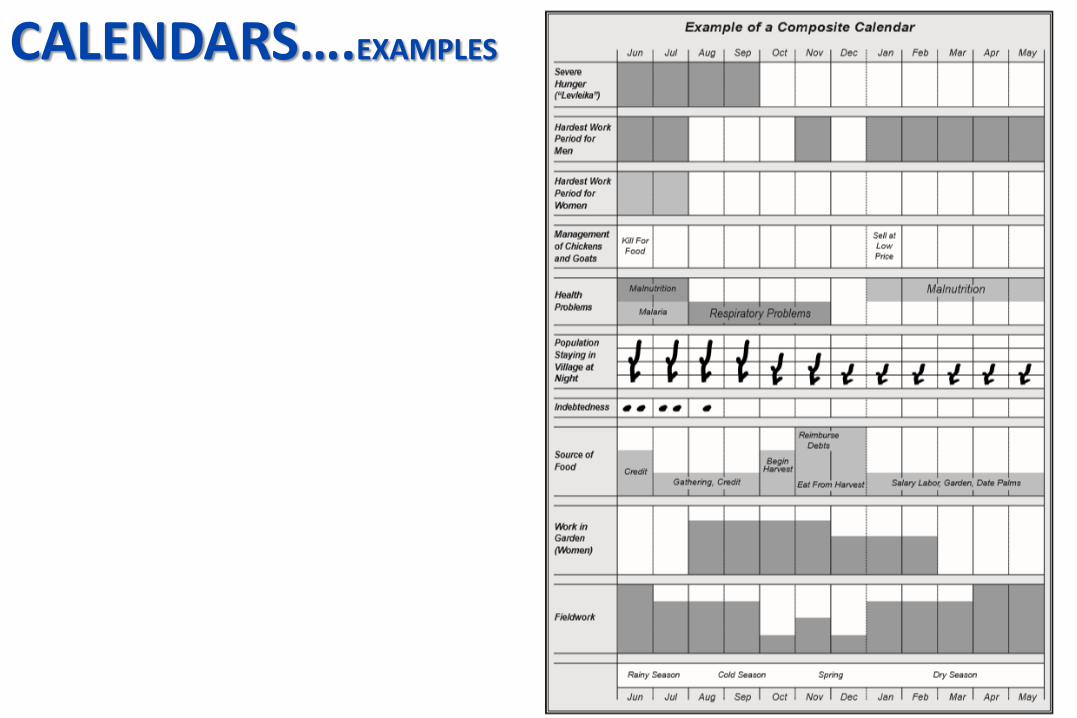
CALENDARS….EXAMPLES
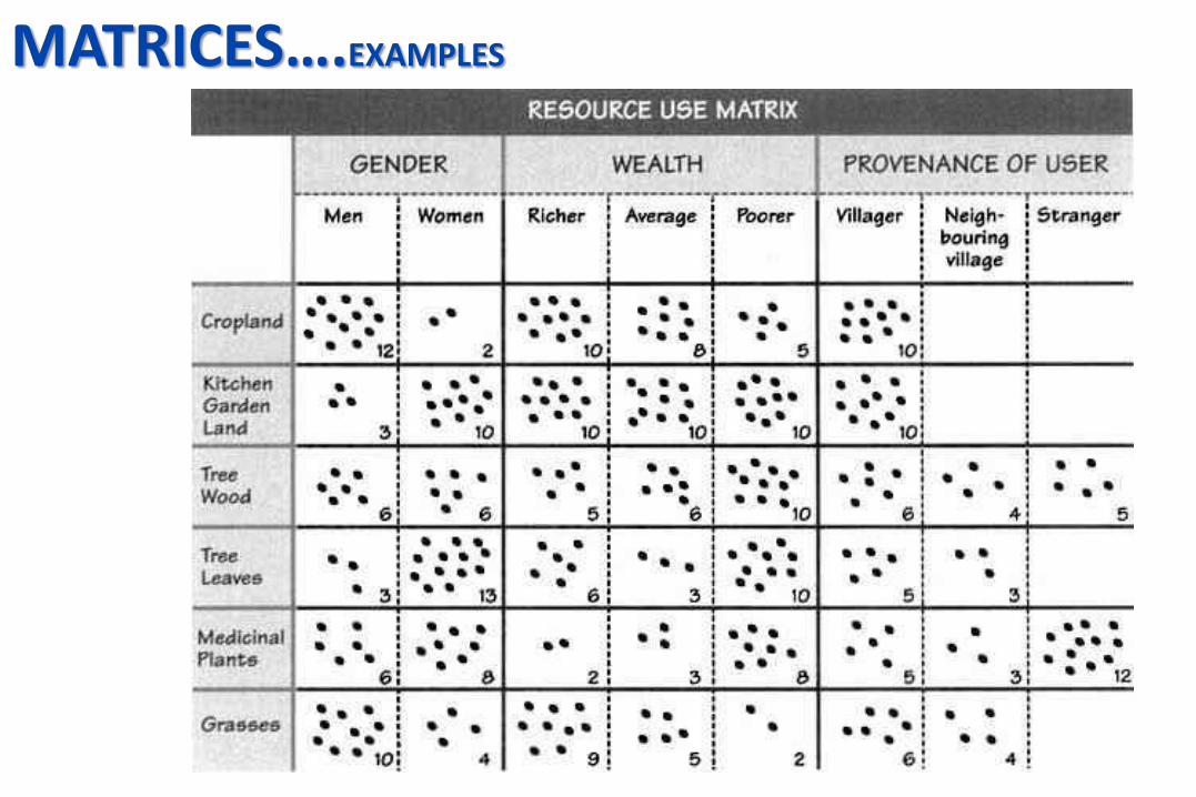
MATRICES….EXAMPLES

MATRICES….EXAMPLES

TYPES OF PRA MAPPING
PRA MAPPING
SPACE MAPPING
TIME MAPPING
RELATION ANALYSIS
• Social and Resource Mapping• Mobility map• Services and Opportunities
mapping• Transect Mapping
• Timeline / Calendars • Trend Analysis• Historical Profile• Seasonal Diagram
• Social Effects, Impact, network Diagram, Process Map, Well Being, Ranking, Venn Diagram, Ranking, Matrix, Pie, Livelihood analysis, Spider Diagram, Administrative System.
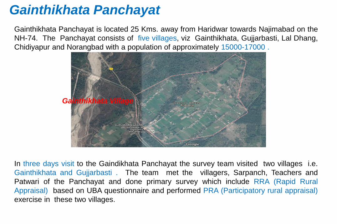
Gainthikhata Panchayat is located 25 Kms. away from Haridwar towards Najimabad on the
NH-74. The Panchayat consists of five villages, viz Gainthikhata, Gujjarbasti, Lal Dhang,
Chidiyapur and Norangbad with a population of approximately 15000-17000 .
Gainthikhata Village
In three days visit to the Gaindikhata Panchayat the survey team visited two villages i.e.
Gainthikhata and Gujjarbasti . The team met the villagers, Sarpanch, Teachers and
Patwari of the Panchayat and done primary survey which include RRA (Rapid Rural
Appraisal) based on UBA questionnaire and performed PRA (Participatory rural appraisal)
exercise in these two villages.
Gainthikhata Panchayat

Gainthikhata Village Participatory MappingInviting a meeting.
Brainstorming the issues
PM begin with sun rise
direction (for north)
Choose the respondent from
the community
Asking the respondent to
draw important landmarks of
village (for example his own
property)
With reference to objective of
the project PRA team ask
about the issues and
problems.
Various colours of pen should be use for different land uses or infrastructure (for
example, red for problems, green for forest, yellow for houses black for roads etc.

Gainthikhata Village Participatory Mapping
There are many ways that this
technique can be adapted to get at
specific types of information that may
be of interest to a particular project.
The territorial map would explore
the villages resources and potentials
A regional map give information of
neighboring villages for common
resources or other resources in large
areas like hospital, college etc.
Historical map, Family resource
map, Cultural map, disaster
management map, Flood map, soil
fertility map, connective map etc.
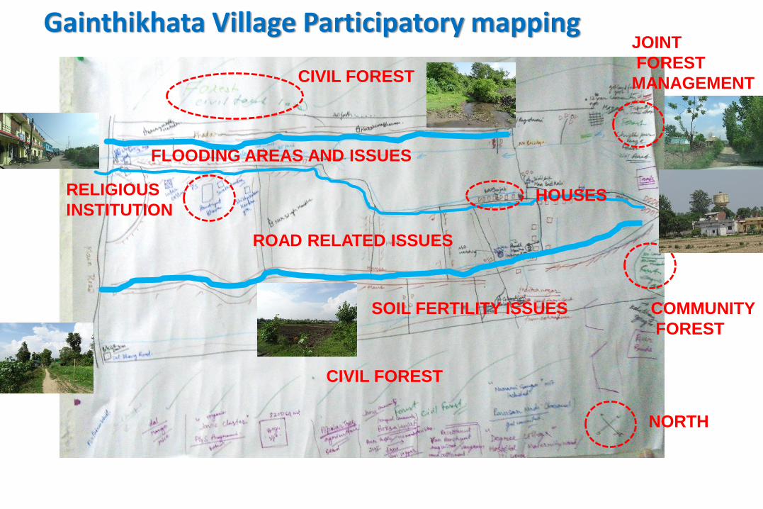
Gainthikhata Village Participatory mapping
NORTH
HOUSES
COMMUNITY
FOREST
CIVIL FOREST
JOINT
FOREST
MANAGEMENT
RELIGIOUS
INSTITUTION
FLOODING AREAS AND ISSUES
SOIL FERTILITY ISSUES
ROAD RELATED ISSUES
CIVIL FOREST
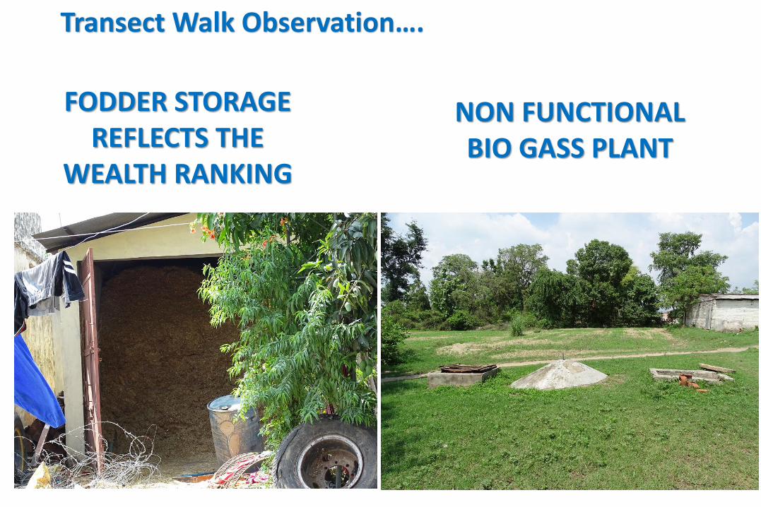
Transect Walk Observation….
FODDER STORAGE REFLECTS THE
WEALTH RANKING
NON FUNCTIONAL BIO GASS PLANT

Gainthikhata Village : Outcome
Total population is around 6000-7000 with apporimatley1500 household
Located 1.5-2 k.m from NH-74 (few household do live near the NH-74) with a pakka
road constructed in the year of 2006-2007 still in a good condition.
No conveyance (any public or private ) available to travel from village to NH-74
except own vehicle and some villagers go by walk to NH-74.
Six primary Government school and six private primary schools are running
successfully Six Anganwadi centers are also running successfully. No government
hospital, no veterinary hospital and no any training centre is located in the village
of Gainthikhata.
Solar street lights are installed by the new sarpanch of the village. The internal
road is constructed in 2010 but the present situation of the same is not good. The
width of the road is approximately 10ft.

Issues and solution desired by Gainthikhata Villagers
Issues
Problem of drinking and irrigation water
Slope and flood
Seed depot
Cold storage
Potential
Good production of Jamun,
Interventions
Check dam on Nala /jhor
Irrigation work
Drinking water
Cold storage
Approach Road
Condition of Interior Road
River join Ganges cause
Heavy floods
LOSSING SOIL FERTILITY

Gujjarbasti Village The village Gujjarbasti is located on the other side of the NH-74, opposite to the Gainthikhata
Village. Gujjarbasti consists of 821 households with a present population of 6000-7000 people.
The entire village follows a grid iron fashion with a 8 k.m link road which starts from starting of
the village to the end of the village.
This is a rehabilitated village. In 2002, when Rajaji National Park was in its initial stage of
forming, a community named Gujjar community who used to live in the forest, asked to leave
the forest peacefully. These jungle nomads were rehabilitated in this village after providing a
fixed area of land to the each household for agriculture and for a house to live and they were
provided an amount of Rs 2000/HH for travel and basic expenses.
Each household were provided an 8200 m2 area of land for agriculture/ fodder and household
purpose by the forest department in this village. But there are yet to get the patta of the land.
As a result that they can’t sell their crops directly into Mandi.
Most of the house in the village a hut type shape made by villager themselves and a few of
them constructed pukka house. Primary hospital and veterinary hospital are present in the
village, but doctors are still not appointed in the both the hospitals, Three primary schools, one
junior school and one Aanganwadi are present in the village but no any training centre neither
any secondary school established in the village. For secondary education student have to visit
Gainthikhata.

Gujjarbasti Village Participatory Mapping
Fodder
Houses
Layout designRELIGIOUS INSTITUTION
FLOODING
AREAS
AN ISSUES
RESERVED FOREST
RESERVED FOREST
HOUSES
SOCIAL INFRASTRUCTURE
Housing & Fodder land
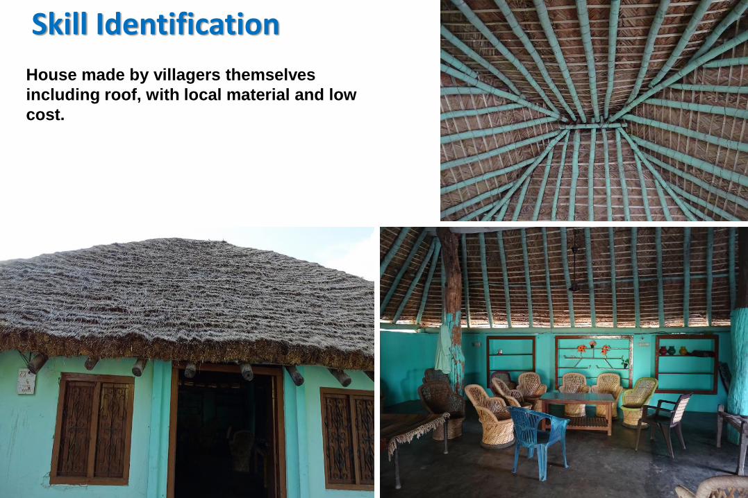
Skill Identification
House made by villagers themselves
including roof, with local material and low
cost.
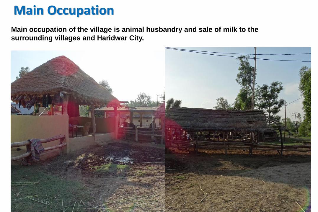
Main OccupationMain occupation of the village is animal husbandry and sale of milk to the
surrounding villages and Haridwar City.

Social Infrastructure and Religious Institution
As Gujjarbasti Village is rehabilitated villages nearly every new village settled here
have their own religious center but only one madrasa.
Madrasa Masjid
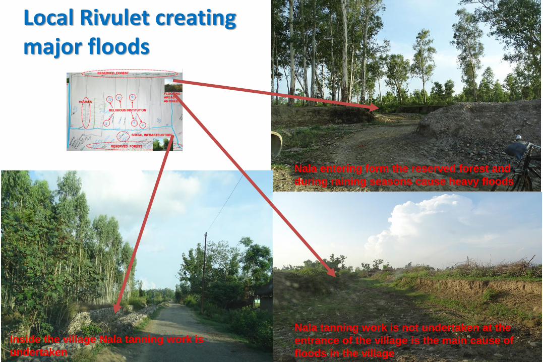
Local Rivulet creating major floods
Nala entering form the reserved forest and
during raining seasons cause heavy floods
Nala tanning work is not undertaken at the
entrance of the village is the main cause of
floods in the village
Inside the village Nala tanning work is
undertaken
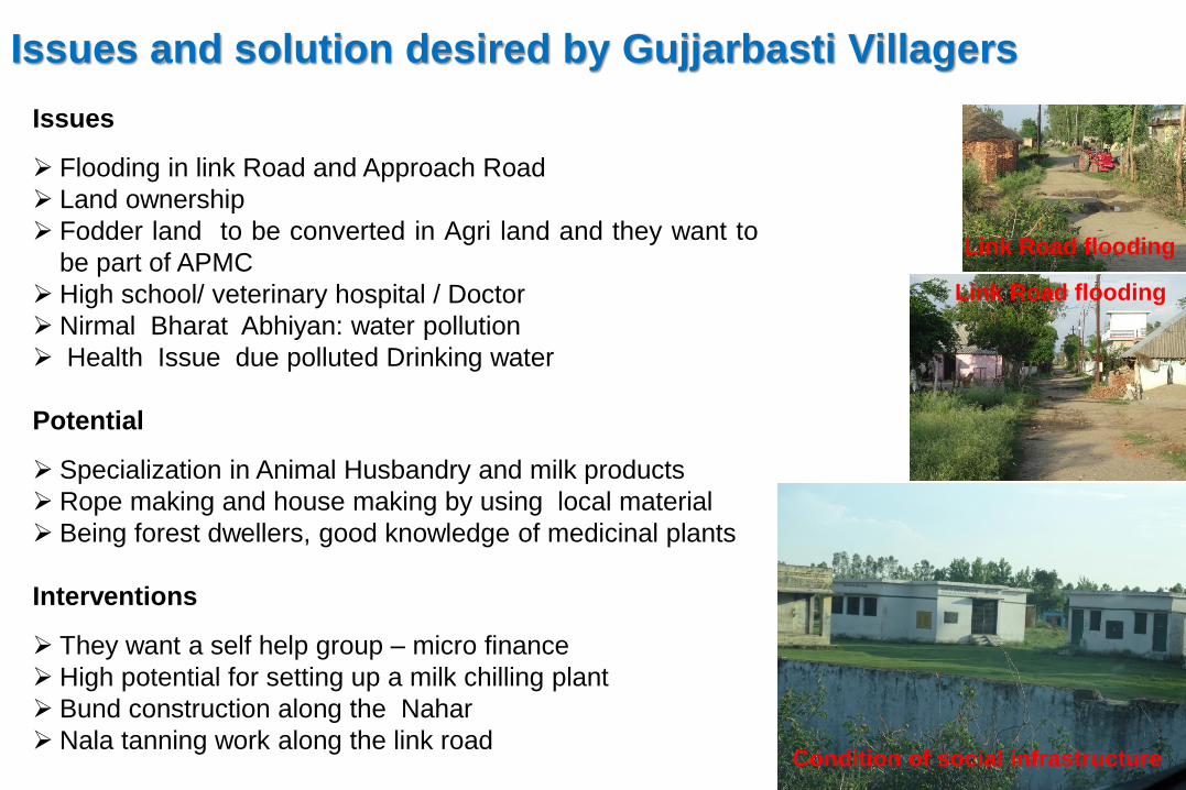
Issues and solution desired by Gujjarbasti Villagers
Issues
➢ Flooding in link Road and Approach Road
➢ Land ownership
➢ Fodder land to be converted in Agri land and they want to
be part of APMC
➢ High school/ veterinary hospital / Doctor
➢ Nirmal Bharat Abhiyan: water pollution
➢ Health Issue due polluted Drinking water
Potential
➢ Specialization in Animal Husbandry and milk products
➢ Rope making and house making by using local material
➢ Being forest dwellers, good knowledge of medicinal plants
Interventions
➢ They want a self help group – micro finance
➢ High potential for setting up a milk chilling plant
➢ Bund construction along the Nahar
➢ Nala tanning work along the link road
Link Road flooding
Link Road flooding
Condition of social infrastructure

A planning process has six basic stages:
GOLES AND OBJECTIVES
BASIC RESEARCH/ ANALYSIS
PLAN FORMULATION
PLAN IMPLEMENTATION
MONITORING AND EVALUATION
MID TERM REVIEW
RRA: Basic interaction with the
local community
PRA Mapping and Information collection
Community participation with stakeholder and
experts
Discussing Proposal with the Community
Making Management Group from the
representative of different village
community
