parks and reserves of the south-west kimberley · department of parks and wildlife 2016, parks and...
TRANSCRIPT
Parks and reserves of the south-west Kimberley and north-west Pilbara
Draft joint management plan 2016
Conservation and Parks Commission
Department of Parks and Wildlife

Department of Parks and Wildlife17 Dick Perry AvenueTechnology Park, Western PrecinctKENSINGTON WA 6151
Phone (08) 9219 9000Fax (08) 9334 0498www.dpaw.wa.gov.au
© State of Western Australia 2016
December 2016
ISBN 978-1-921703-77-5 (print)
ISBN 978-1-921703-78-2 (online)
WARNING: This plan may contain names and images of deceased Aboriginal people.
This work is copyright. All traditional and cultural knowledge in this draft joint management plan is the cultural and intellectual property of traditional owners and is published with the consent of the representative Aboriginal Corporation on their behalf. Written consent from Aboriginal Corporations must be obtained for use or reproduction of any such materials. Any unauthorised dealing is a serious breach of customary law and may also breach the Copyright Act 1968 (Cth).
All other non-traditional and cultural content in this draft plan may be downloaded, displayed, printed and reproduced in unaltered form for personal use, non-commercial use or use within your organisation. Apart from any use as permitted under the Copyright Act, all other rights are reserved. Requests and enquiries concerning reproduction and rights should be addressed to the Department of Parks and Wildlife.
This draft plan was prepared by the Conservation and Parks Commission, the Karajarri Traditional Lands Association, the Nyangumarta Warrarn Aboriginal Corporation, and the Wanparta Aboriginal Corporation through the agency of the Department of Parks and Wildlife.
Questions regarding this plan should be directed to: Planning Branch Department of Parks and Wildlife 17 Dick Perry Avenue Kensington WA 6151 Locked Bag 104 Bentley Delivery Centre WA 6983 Phone: (08) 9219 9000
The recommended reference for this publication is: Department of Parks and Wildlife 2016, Parks and reserves of the south-west Kimberley and north-west Pilbara draft joint management plan, Department of Parks and Wildlife, Perth.
Cover photographs:
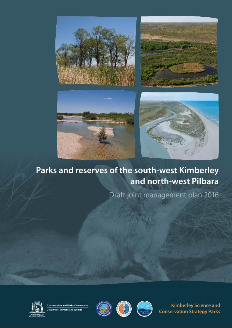
Top left: Dragon trees over bulrush at Dragon Tree Soak, Kurriji Pa Yajula Nature Reserve. Photo – Stephen Reynolds/Environs KimberleyTop right: Saunders Spring, Walyarta Conservation Park. Photo – Jan van de KamBottom right: Kujungurru-Warrarn Nature Reserve looking south from Waru Creek. Photo – Parks and WildlifeBottom left: Salt Creek, Walyarta Conservation Park. Photo – Jan van de KamMain: Greater bilby. Photo – Bert and Babs Wells/Parks and Wildlife
This document is available in alternative formats on request.

1
Invitation to commentThis draft joint management plan has been released for a three-month period to provide the public with an opportunity to comment on how the reserves covered by the plan are proposed to be managed over the next ten years.
To ensure your submission is as effective as possible:• be clear and concise• refer your points to the page numbers or specific sections in the plan• say whether you agree or disagree with any or all of the management arrangements – clearly state your reasons, particularly if
you disagree• give sources of information where possible• suggest alternatives for those aspects of the plan with which you disagree.
The draft plan will be reviewed in the light of the submissions, according to the criteria outlined below. A summary of public submissions will be made available along with the final management plan.
The draft plan may be amended if a submission:• provides additional information of direct relevance to management• indicates a change in (or clarifies) government legislation or management policy• proposes strategies that would better achieve management objectives• indicates omissions, inaccuracies or a lack of clarity.
The draft plan may not be amended if a submission:• clearly supports proposals in the plan or makes general or neutral statements• refers to issues beyond the scope of the plan• refers to issues that are already noted within the plan or already considered during its preparation• is one among several widely divergent viewpoints received on the topic but the approach in the plan is still considered the
best option• contributes options that are not feasible (generally due to conflict with legislation or government policy)• is based on unclear or factually incorrect information.
The draft plan can be viewed and submissions made online at:www.dpaw.wa.gov.au/parks/management-plans/draft-plans-open-for-public-comment.
Alternatively, you can write to:Planning BranchDepartment of Parks and WildlifeLocked Bag 104Bentley Delivery Centre WA 6983
2
SummaryThis draft joint management plan provides direction for the joint management of existing and proposed parks and reserves in the south-west Kimberley and north-west Pilbara regions; a coastal strip of conservation estate comprising nature reserves and conservation parks (Eighty Mile Beach coastal reserves), Walyarta Conservation Park and Kurriji Pa Yajula Nature Reserve.
The Kimberley Science and Conservation Strategy is a commitment by the State to recognise and conserve significant natural and cultural values of the region and to provide increased opportunities for Aboriginal involvement in land and sea management. A key objective of the strategy is to establish a representative system of jointly managed protected areas (Government of Western Australia 2011).
The creation of new parks and reserves in the south-west Kimberley and north-west Pilbara and the subsequent preparation and implementation of this plan contributes to the delivery of the strategy, and are key features of Indigenous Land Use Agreements (ILUAs) negotiated with the Karajarri, Nyangumarta and Ngarla people. Each traditional owner group has a special connection with, and responsibility for, the lands and waters within their native title determination areas.
The plan describes the cultural heritage, natural, recreation, tourism, community and resource use values of the planning area and analyses management issues. It identifies objectives, strategies and key performance indicators, to provide a robust framework to protect and manage the area’s values and support adaptive management.
The purpose of the plan is to ensure:• the planning area is managed in an ecologically sustainable and a culturally appropriate manner• management of relevant parts of the planning area is consistent with and complements management of the
Eighty Mile Beach Marine Park• management of relevant parts of the planning area is consistent with Australia’s obligations under the Ramsar
Convention.
Management needs to ensure that access to culturally sensitive and significant areas is appropriate. Access restrictions to a number of cultural sites will be given effect through the implementation of the plan. Traditional owners can continue to enjoy and maintain their customary activities in the planning area. Joint management of new and existing reserves will also result in better integration of traditional knowledge with contemporary science and land practices.
Maintaining the integrity of hydrological systems that provide critical ecosystem services, and maintaining the condition and extent of wetland habitats, are high priorities for management, along with the conservation of threatened species and communities.
Over the next 10 years, visitation is likely to remain focused on existing nodes along the coast and just outside of the planning area, such as Eighty Mile Beach Caravan Park and Cape Keraudren. These provide access to the adjacent Eighty Mile Beach Marine Park and offer the best options for managing visitor risk and safety. New cultural ecotourism opportunities may also be investigated.
The key management issues are introduced herbivores (including domestic stock) and inappropriate fire regimes. Walyarta Conservation Park and the Eighty Mile Beach coastal reserves have a long history of pastoralism. Destocking and fencing are important strategies to allow these areas to recover from grazing and to prevent adverse impacts on sensitive sites. Other land uses in the vicinity of the planning area have the potential to affect the hydrology and functioning of significant wetlands. These issues occur at a landscape-scale and, when considered with the fragmented nature of the planning area, it is essential to adopt a cooperative, integrated management approach involving all neighbouring land managers.
Developing an understanding of the key values of the planning area and collecting the relevant baseline data will be a strong focus in the early stages of implementation. It is a priority to increase understanding of the water requirements and regimes that are needed to sustain the groundwater dependent ecosystems of the planning area. It is essential to establish a long-term monitoring program to evaluate management effectiveness and inform adaptive management.
2

ContentsInvitation to comment ................................................................................................................1
Summary .........................................................................................................................................2
1 Introduction .........................................................................................................................5
1.1 The reserves and their values .....................................................................................................................................5
Names of the reserves ................................................................................................................................................6
1.2 Management context ....................................................................................................................................................6
Joint management partners ....................................................................................................................................6
Planning and decision making ................................................................................................................................7
Administration ..............................................................................................................................................................7
Legislative and policy framework ..........................................................................................................................7
International conservation agreements ..............................................................................................................8
1.3 Planning area ....................................................................................................................................................................8
Location ...........................................................................................................................................................................8
Tenure and proposed land arrangements .......................................................................................................13
Adjacent lands and off-reserve management ................................................................................................14
Other protected areas .............................................................................................................................................14
1.4 Term of the plan ...........................................................................................................................................................15
2. Vision and strategic goals .............................................................................................. 17
2.1 Vision ................................................................................................................................................................................17
2.2 Strategic goals...............................................................................................................................................................17
3. Connection to country (cultural heritage values) ..................................................... 18
3.1 Dreamtime and traditional law ...............................................................................................................................18
3.2 Traditional knowledge ...............................................................................................................................................16
3.3 Plants, animals and sites of significance ..............................................................................................................19
3.4 Enjoyment of country and customary practices ..............................................................................................20
4. Caring for country (natural values) .............................................................................. 23
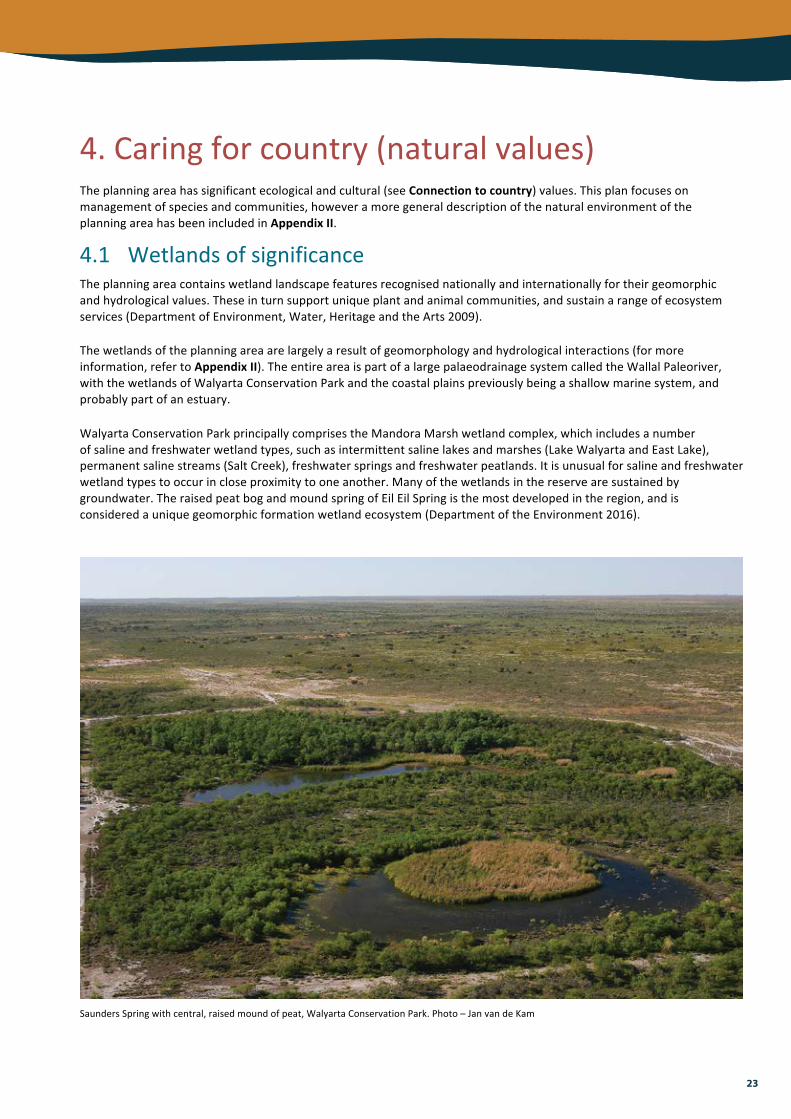
4.1 Wetlands of significance ............................................................................................................................................23
4.2 Flora, fauna and ecological communities ...........................................................................................................24
Priority flora .................................................................................................................................................................24
Threatened and other significant fauna ...........................................................................................................24
Ecological communities ..........................................................................................................................................26
4.3 Management issues ....................................................................................................................................................28
Weeds ............................................................................................................................................................................28
Introduced animals...................................................................................................................................................28
Fire ..................................................................................................................................................................................30
Climate change ..........................................................................................................................................................31
3

5. People on country (recreation, tourism and community values) ........................... 35
5.1 Planning for visitor use ..............................................................................................................................................35
5.2 Access ...............................................................................................................................................................................36
Access management ................................................................................................................................................36
5.3 Safety ................................................................................................................................................................................37
5.4 Visitor information, education and interpretation ...........................................................................................37
5.5 Commercial operations .............................................................................................................................................37
5.6 Community involvement ..........................................................................................................................................38
6. Using resources from the country (sustainable resource use) ................................ 40
6.1 Pastoralism .....................................................................................................................................................................40
6.2 Water abstraction .........................................................................................................................................................41
6.3 Mineral and petroleum exploration and development .................................................................................41
7. Performance Assessment ............................................................................................... 43
References ................................................................................................................................... 44Appendices .................................................................................................................................. 48
Appendix I: Eighty Mile Beach Ramsar site ................................................................................................................48
Ramsar listing criteria ..............................................................................................................................................49
Critical components and processes ....................................................................................................................50
Limits of acceptable change .................................................................................................................................50
Reporting .....................................................................................................................................................................50
Appendix II: Physical and biological environment .................................................................................................51
Climate ..........................................................................................................................................................................51
Geomorphology and landforms ..........................................................................................................................51
Hydrology ....................................................................................................................................................................52
Flora ...............................................................................................................................................................................53
Fauna .............................................................................................................................................................................54
Appendix III: Guiding principles for fire management in landscapes dominated by spinifex grasslands .............................................................................................................................................................56
Appendix IV: Climate change vulnerability assessment of mound spring communities, Walyarta Conservation Park ...........................................................................................................................................57
MapsMap 1 Overview of the planning area ............................................................................................................................9
Map 2 Eighty Mile Beach coastal reserves .................................................................................................................10
Map 3 Walyarta Conservation Park ...............................................................................................................................11
Map 4 Kurriji Pa Yajula Nature Reserve ........................................................................................................................12
TablesTable 1 Reserve names, origins and meanings ...........................................................................................................6
Table 2 Existing tenure of the planning area ............................................................................................................13
Table 3 Tenure of proposed additions to the planning area ...............................................................................13
Table 4 Fauna of conservation significance in the planning area ..................................................................... 25
Table 5 Ramsar listing criteria met by portions of the Ramsar site in the planning area ......................... 49
4

5
1.Introduction1.1ThereservesandtheirvaluesTheexistingandproposedparksandreservesofthesouth-westKimberleyandnorth-westPilbararegions(theplanningarea)includethelandsandwatersoftheKarajarri,NyangumartaandNgarlapeople,whohavecontinuingrightsandresponsibilitiesfortheseareas.Theregion’sgeomorphologyandhydrologygivesrisetoaspectacularandcomplexarrayoflandscapefeaturesandhabitats,fromthecoastaldunesalongEightyMileBeach,tofreshwatermoundspringsandinlandmangrovesthatemergealonganancientriverchannel,tothestrikingredsanddunesandsandplainsoftheGreatSandyDesert.TheplanningareacomprisestheEightyMileBeachcoastalreserves(JinmarnkurConservationPark,JinmarnkurKuljaNatureReserve,Kujungurru-WarrarnNatureReserve,Kujungurru-WarrarnConservationPark,unnamed‘Gap’naturereserve,JarrkunpunguNatureReserve,andaproposedunnamednaturereserve),WalyartaConservationParkandKurrijiPaYajulaNatureReserve.Thekeyvaluesoftheplanningareaaregroupedunderfourheadings.Culturalheritage–thereservesarelivingculturallandscapeswhichincludesacredsites,storiesandsonglinesthatcrossthebroaderregion,linkingplacesandpeople.Manysitesarebelievedtobecreatedandinhabitedbypulany(powerfulmythicalwatersnakes)andmustberespectedandapproachedintherightway.Thesesitesandtheassociatedknowledgeandtraditions,demonstratethelongandongoingconnectiontraditionalownershavewiththisarea.Natural–theplanningareaencompassesarangeofwetlandtypesandpartoftheinternationallysignificantEightyMileBeachRamsarsite.Thereservessupportlargenumbersofwildlife,aswellaspopulationsofthreatenedspecies,andprovidebreedinghabitatforwaterbirds,particularlywhenflooded.Moundspringsandpermanentwatersourcesmaintainuniquevegetationassociationsandhaveimportantrefugiavalueforbiodiversity.Theplanningareacontainsseveralthreatenedandpriorityecologicalcommunities.
WalyartaConservationPark.Photo–ChrisNutt/ParksandWildlife
Recreation,tourismandcommunity–EightyMileBeachMarineParkisadjacenttotheplanningarea,andaccessiblelocationsalongthecoastwillbethefocusforvisitation.Theyprovideopportunitiesfornature-basedtourismandrecreationfortravellersbetweenthePilbaraandtheKimberley.Traditionalownershaveexpressedinterestindevelopingnewculturalecotourismventures.Resourceuse–theexistingandpotentialactivitiesassociatedwiththeplanningareaarepastoralism,abstractionofgroundwaterandresourceexplorationanddevelopment.

6
NamesofthereservesTheKarajarri,NyangumartaandNgarlapeoplehavechosenthenamesofthereservesoftheplanningarea.Theoriginandmeaningofthenamesarelistedbelow.Table1Reservenames,originsandmeanings
Reservename Originandmeaning
KurrijiPaYajula Apukarrikarra(Dreaming)siteforKarajarripeople.Containstwojila(permanentwatersources),namelyKurrijiandYajula.
WalyartaNyangumartaplacenameassociatedwiththesaltandfreshwatermarshlandsthatstretchfromthedeserttothecoast.WalyartaisacommonnamefortheareausedbyboththeNyangumartaandtheKarajarripeople.
JinmarnkurKarajarriplacenamefortheareaknownasCapeMissiessy,thenorthernpointofEightyMileBeach.KarajarripeoplevisitedJinmarnkurtouseafishtrapcalledkunjunkuandoftencaughtpirala(whiskeredsalmon).
JinmarnkurKulja Jinmarnkur(jin-marn-goor)isthetraditionalKarajarriplacenamefortheareaknownasCapeMissiessy.Kuljameans‘south’inKarajarrilanguage.
KujungurruWarrarn Nyangumartaplacenamemeaning‘countryaroundtheoceanorseaaroundthecountry’.
Jarrkunpungu
NgarlaplacenameforSolitaryIsland.TheoriginforJarrkunpunguisaDreamingstory:Marnmulkura,anAncestralBeing(anoctopus)attemptedtostealafirestickfromthepeople.WhenMarnmulkurawasdescendingintotheocean,Winti-Wintithenankeenkestrelinterceptedhimandsnatchedthefirestickfromhim.Marnmulkurainstantlyturnedtostone,becomingSolitaryIsland(J.BrownSnrpers.comm.2016).
1.2ManagementcontextJointmanagementpartnersThelandsandwatersoftheplanningareaarehighlysignificanttothecultureandheritageoftheKarajarri,NyangumartaandNgarlapeople,whoarethedeterminednativetitleholdersovertheplanningarea.TheNyangumartaandKarajarripeoplealsohaveasharednativetitledeterminationwithintheplanningarea,andtheStateGovernmenthasrecentlynegotiatedanIndigenousLandUseAgreement(ILUA)withtheNyangumarta–KarajarriAboriginalCorporation(NKAC)forthisparticulardeterminationarea.JointmanagementwillprovidetheopportunityfortheDepartmentofParksandWildlife(ParksandWildlife)toworkinpartnershipwiththearea’straditionalowners,toachievetheobjectivessetoutinthisplan.Eachtraditionalownergrouphasjointmanagementresponsibilityforthereserves(orpartsofthereserves)locatedwithintheirnativetitledeterminationareas(seeTable2).TheCEOofParksandWildlifewilljointlymanagetherelevantpartsoftheplanningareawiththeKarajarriTraditionalLandsAssociation(KTLA),theNyangumartaWarrarnAboriginalCorporation(NWAC)andtheWanpartaAboriginalCorporation(WAC)peopleinaccordancewithJointManagementAgreements(JMAs)pursuanttosection56AoftheConservationandLandManagementAct1984(CALMAct).JointmanagementwillformallycommenceuponexecutionoftheJMAs(tobeattachedtothefinaljointmanagementplanandsignedassoonaspracticablefollowingitsapproval).
KarajarriculturaladvisorsReneHopigaandCeliaBennett.Photo–TomdeSouza

7
PlanninganddecisionmakingTheJMAswillestablishJointManagementBodies(JMBs)tooverseemanagementoftheplanningareainaccordancewiththeagreementsandtheCALMAct.TheJMBswillmakemanagementdecisions,providestrategicinputintohowmanagementstrategiesareimplemented,andstrategicallymonitortheimplementationoftheplan.
AdministrationUndertheguidanceoftheJMBs,theWestKimberleyDistrictofParksandWildlifewillberesponsibleforcoordinatingtheoperationalmanagementoftheplanningarea.TheregionalofficeinKununurraandanumberofotherspecialistbrancheswillprovidesupport,directionandassistance.Itmaybebeneficialforalljointmanagementpartnerstocometogetheronanannualbasistoshareexperiences,celebrateachievementsandparticipateinoperationalplanning.
NgarlaandNyangumartarangersAugustineBadal,JeffreyBrown,NathanHunterandStephenBrown.Traditionalownerrangerswillplayanimportantroleinimplementingthisplan.Photo–MiechaBradshaw/ParksandWildlife
LegislativeandpolicyframeworkAvarietyofActs,Regulations,policiesandagreementsapplyto,orhaverelevanceto,thisplanandtheplanningarea.TheKarajarri,NyangumartaandNgarlapeopleholdnativetitlerightsandinterestsovertheplanningarea.TheserightsandinterestsarerecognisedbythecommonlawofAustraliaandprotectedthroughtheNativeTitleAct1993(Cth).ThisisdiscussedfurtherinthesectionConnectiontocountry.TheplanningareawillbemanagedinaccordancewiththeCALMAct,whichprovidesfortheprotectionofnativefloraandfaunaandAboriginalcultureandheritageonlandsandwatersvestedintheConservationandParksCommission,andtheWildlifeConservationAct1950(WildlifeConservationAct),whichprovidesspecificprotectionfornativefloraandfaunawithintheState.TheAustralianGovernment’sEnvironmentProtectionandBiodiversityConservationAct1999(EPBCAct)relatestotheprotectionofnationallylistedspeciesandecologicalcommunities,heritage(includingRamsarwetlands)andmigratoryspeciesprotectedunderinternationalagreements.TheEPBCActalsoestablishesaframeworkformanagingRamsarsites,intheformoftheAustralianRamsarmanagementprinciples.NumerousParksandWildlifepoliciesarealsorelevanttothisplan.

8
InternationalconservationagreementsTheConventiononWetlands(knownastheRamsarConvention)isaninternationaltreatyconcernedwiththeconservationandwiseuseofwetlands.WalyartaConservationParkandtheEightyMileBeachcoastalreservesprotectportionsoftheEightyMileBeachRamsarsite1,whichwaslistedasawetlandofinternationalimportanceinJune1990(seeAppendixI).UndertheConvention,ContractingPartiesacceptanumberofresponsibilities,includingacommitmenttopreventchangestotheecologicalcharacteroflistedwetlands.TheEcologicalCharacterDescriptionoftheEightyMileBeachRamsarSite(HaleandButcher2009)isanimportantguidingdocumentfortheplanningarea.InadditiontotheRamsarConvention,AustraliaisasignatorytobilateralagreementswithChina(China–AustraliaMigratoryBirdAgreement),Japan(Japan–AustraliaMigratoryBirdAgreement)andtheRepublicofKorea(RepublicofKorea–AustraliaMigratoryBirdAgreement)toprovideacollaborativeframeworkfortheprotectionofhabitatsofmigratorybirdswithintheEastAsian–AustralasianFlyway.AnumberofspecieslistedintheseagreementsoccurintheplanningareaandsomearealsolistedundertheConventionontheConservationofMigratorySpeciesofWildAnimals(BonnConvention).
1.3PlanningareaLocationTheplanningarea(Map1)islocatedinnorth-westernAustraliaapproximately1700kmfromPerthandfallswithinboththeShireofEastPilbaraandShireofBroome.Coveringanareaof7,061ha,theEightyMileBeachcoastalreserves(Map2)runparalleltotheEightyMileBeachMarineParkstretchingalmost220kmfromCapeMissiessyinthenorthtoCootenbrandCreekinthesouth.UndertheclassificationschemeprovidedintheInterimBiogeographicRegionalisationofAustralia(IBRA7),theEightyMileBeachcoastalreservesarelocatedwithintheDampierland(Pindanlandsubregion)bioregion.WalyartaConservationPark(Map3)isonthewesternedgeoftheGreatSandyDesertandcoversanareaof231,358ha.Itextendseast-westforapproximately95km.ItislocatedatthejunctionoftheDampierland(Pindanlandsubregion)andGreatSandyDesert(McLartysubregion)bioregions,however,thelattercontainsthemainbodyofthereserve.KurrijiPaYajulaNatureReserve(Map4)islocatedafurther140kmtotheeast-north-east,coveringanareaof17,729ha.ItissituatedcompletelywithintheGreatSandyDesertbioregion(McLartysubregion).
EightyMileBeachcoastalreservesandadjacentmarinepark.Photo–ParksandWildlife
1TherestoftheRamsarsiteislargelycoveredbyEightyMileBeachMarineParkandmanagedinaccordancewiththeCALMAct,withsmallerareasalsooccurringonunallocatedCrownlandandpastoralleaseonsurroundinglands.

9
Kara
jarr
i Peo
ple
Nya
ngum
arta
-Kar
ajar
riO
verla
p P
roce
edin
g
Nga
rla a
nd N
garla
#2
Nat
ive
title
extin
guis
hed
PAR
DO
O
YEED
A
WA
LLA
LD
OW
NS
AN
NA
PLA
INS
DE
GR
EY
NIT
AD
OW
NS
KIL
TO
MA
ND
OR
A
123°
E
123°
E
122°
E
122°
E
121°
E
121°
E
120°
E
120°
E18°24'S
18°24'S
19°33'S
19°33'S
I N D
I A
NO
C E
A N
GR
EAT
NORTHERNHIGHWAY
BR
OO
ME !
BRO
OM
E R
OA
D
Roe
buck
Bay
Laga
nge
Bay
Cap
e M
issi
essy
Cap
e B
ossu
t
Cap
e Ke
raud
ren
Lege
nd Plan
ning
are
a bo
unda
ry
Land
s m
anag
ed b
y th
e D
epar
tmen
t of P
arks
and
Wild
life
Eigh
ty M
ile B
each
Mar
ine
Par
k
Nat
ive
Title
det
erm
ined
are
as
Kara
jarr
i Ind
igen
ous
Pro
tect
ed A
rea
Nya
ngum
arta
War
rarn
Indi
geno
us P
rote
cted
Are
a
Ram
sar s
ite
Cro
wn
rese
rve
Una
lloca
ted
Cro
wn
land
Loca
l gov
ernm
ent a
utho
ritie
s
Past
oral
leas
e
Seal
ed ro
ad (2
WD
)
!
!
!
PE
RTH
Exm
outh
Bro
ome
WA
LYA
RTA
CO
NSE
RVA
TIO
N P
AR
K
KU
RR
IJI P
A YA
JULA
NAT
UR
E R
ESER
VE
SH
IRE
OF
BR
OO
ME
SH
IRE
OF
DE
RB
Y-W
ES
TK
IMB
ER
LEY
SH
IRE
OF
EA
ST
PIL
BA
RA
EIG
HTY
MIL
EBE
ACH
COA
STAL
RESERVES
Lim
itof
coas
tal
wate
rsof
the
Stat
eof
Wes
ternAus
tralia
Map
1 O
verv
iew
of t
he p
lann
ing
area
¯
020
4060
8010
kmSc
ale
Loca
lity
Map
Nya
ngum
arta
Peo
ple
Map 1 Overview of the planning area

10
121°
30'E
121°
30'E
121°
E
121°
E
120°
30'E
120°
30'E
120°
E
120°
E19°S
19°S
19°30'S
19°30'S
20°S
20°S
Lege
nd Res
erve
bou
ndar
y
Nat
ure
Res
erve
Con
serv
atio
n pa
rk
Mar
ine
Park
Prop
osed
add
ition
Prop
osed
con
serv
atio
n pa
rk
Ram
sar s
ite
Nat
ive
Title
det
erm
ined
are
as
Seal
ed ro
ad (2
WD
)U
nsea
led
road
(2W
D)
Uns
eale
d ro
ad (4
WD
)
I N D
I A
NO
C E
A N
See
Inse
t 1
See
Inse
t 2
See
Inse
t 3
Inse
t 2
Inse
t 3Sc
ale
Hig
h
wat
er
mar
k
Hig
h w
ater
m
ark
NYA
NG
UM
AR
TA P
EO
PLE
(PA
RT
A)
NYA
NG
UM
AR
TA-K
ARA
JAR
RI
OV
ER
LAP
PR
OC
EED
ING
NG
AR
LA a
nd N
GA
RLA
#2
Lim
it o
f c
oast
alw
ater
sof
the
Stat
eof
Wes
tern
Austra
lia
KAR
AJA
RR
I PE
OP
LE
Cap
e Ke
raud
ren
Cap
e M
issi
essy
Eigh
ty M
ile B
each
Car
avan
Par
k!
Inse
t 1Sc
ale
01
20.
5Ki
lom
eter
s0
1.5
30.
75Ki
lom
eter
sSc
ale
01
20.
5Ki
lom
eter
s
GR
EAT
NORT
HERN
HIG
HW
AY
EIG
HTY
MIL
E
BEAC
H
MAR
INE
PARK
JIN
MA
RN
KU
RC
ON
SER
VATI
ON
PAR
KR
523
67
JIN
MA
RN
KU
R K
ULJ
AN
ATU
RE
RES
ERVE
R 5
2364
PRO
POSE
D U
NN
AM
EDN
ATU
RE
RES
ERVE
JAR
RK
UR
NPA
NG
NAT
UR
E R
ESER
VER
523
65
UN
NA
MED
'GA
P'N
ATU
RE
RES
ERVE
R 5
3266
KU
JUN
GU
RR
U W
AR
RA
RN
NAT
UR
E R
ESER
VER
523
63
KU
JUN
GU
RR
U W
AR
RA
RN
CO
NSE
RVA
TIO
N P
AR
KR
523
62
KU
JUN
GU
RR
U W
AR
RA
RN
NAT
UR
E R
ESER
VER
523
63
Map
2 E
ight
y M
ile B
each
coa
stal
rese
rves
JIN
MA
RN
KU
R K
ULJ
AN
ATU
RE
RES
ERVE
R 5
2364
JIN
MA
RN
KU
RC
ON
SER
VATI
ON
PA
RK
R 5
2367
KU
JUN
GU
RR
U W
AR
RA
RN
NAT
UR
E R
ESER
VER
523
63
¯010
2030
405
kmSc
ale
Highwatermark
Map 2 Eighty Mile Beach coastal reserves

11
Map 3 Walyarta Conservation Park
Karajarri People
Nyangum
arta-KarajarriO
verlap Proceeding
Nyangum
arta People
GREAT
NORTHERN
HIGHWAY
121°55'
121°55'
121°44'
121°44'
121°33'
121°33'
121°22'
121°22'
121°11'
121°11'
-19°37'
-19°37'
-19°48'
-19°48'
-19°59'
-19°59'
LegendReserve boundary
Conservation park
Proposed additionProposed conservation parkPriority ecological com
munity
!Threatened ecological com
munities
Nationally im
portant wetlands
Native Title determ
ined areas
Ram
sar siteLake
!W
ater pointW
atercourseSealed road (2W
D)
Unsealed road (2W
D)
Unsealed road (4W
D)
Map 3 W
alyarta Conservation Park
Eil Eil
Spring
Saunders Spring
Coolgardie
Well
Boulder Bore
Cardong B
iddySpring
TopSpring
Baramith
Spring
Bedaromal
Well
SaltC
reek
Grant
Spring
MelaleucaSpring
Fern Spring
Riverbend
Spring
Sporobilus Spring
LinearSpring
R 52383
R 52387
PRO
POSED
CO
NSER
VATION
PAR
K
Scale
05
1015
202.5
km
¯
Lake Walyarta
EastLake

12
Map 4 Kurriji Pa Yajula Nature Reserve
!!
!!
!!
!!
!!
!!
!!
!!
!!
!!
!!
!!
!!
!!
!!
!!
!!
!!
!!
!!
!!
!!
!!
!!
!!
!!
!!
!!
!!
!!
!!
!!
!!
!!
!!
!!
!!
!!
!!
!!
!!
!!
!!
!!
!!
!!
!!
!!
!!
!!
!!
!!
!!
!!
!!
!!
!!
!!
!!
!!
!!
!!
!!
!!
!!
!!
!!
!!
!!
!!
!!
!!
!!
!!
!!
!!
!!
!!
!!
!!
!!
!!
!!
!!
!!
!!
!!
!!
!!
!!
!!
!!
!!
!!
!!
!!
!!
!!
!!
!!
!!
!!
!!
!!
!!
!!
!!
!!
!!
!!
!!
!!
!!
!!
!!
!!
!!
!!
!!
!!
!!
!!
!!
!!
!!
!!
!!
!!
!!
!!
!!
!!
!!
!!
!!
!!
!!
!!
!!
!!
!!
!!
!!
!!
!!
!!
!!
!!
!!
!!
!!
!!
!!
!!
!!
!!
!!
!!
!!
!!
!!
!!
!!
!!
!!
!!
!!
!!
!!
!!
!!
!!
!!
!!
!!
!!
!!
!!
!!
!!
!!
!!
!!
!!
!!
!!
!!
!!
!!
!!
!!
!!
!!
!!
!!
!!
!!
!!
!!
!!
!!
!!
!!
!!
!!
!!
!!
!!
!!
!!
!!
!!
!!
!!
!!
!!
!!
!!
!!
!!
!!
!!
!!
!!
!!
!!
!!
!!
!!
!!
!!
!!
!!
!!
!!
!!
!!
!!
!!
!!
!!
!!
!!
!!
!!
!!
!!
!!
!!
!!
!!
!!
!!
!!
!!
!!
!!
!!
!!
!!
!!
!!
!!
!!
!!
!!
!!
!!
!!
!!
!!
!!
!!
!!
!!
!!
!!
!!
!!
!!
!!
!!
!!
!!
!!
!!
!!
!!
!!
!!
!!
!!
!!
!!
!!
!!
!!
!!
!!
!!
!!
!!
!!
!!
!!
!!
!!
!!
!!
!!
!!
!!
!!
!!
!!
!!
!!
!!
!!
!!
!!
!!
!!
!!
!!
!!
!!
!!
!!
!!
!!
!!
!!
!!
!!
!!
!!
!!
!!
!!
!!
!!
!!
!!
!!
!!
!!
!!
!!
!!
!!
!!
!!
!!
!!
!!
!!
!!
!!
!!
!!
!!
!!
!!
!!
!!
!!
!!
!!
!!
!!
!!
!!
!!
!!
!!
!!
!!
!!
!!
!!
!!
!!
!!
!!
!!
!!
!!
!!
!!
!!
!!
!!
!!
!!
!!
!!
!!
!!
!!
!!
!!
!!
!!
!!
!!
!!
!!
!!
!!
!!
!!
!!
!!
!!
!!
!!
!!
!!
!!
!!
!!
!!
!!
!!
!!
!!
!!
!!
!!
!!
!!
!!
!!
!!
!!
!!
!!
!!
!!
!!
!!
!!
!!
!!
!!
!!
!!
!!
!!
!!
!!
!!
!!
!!
!!
!!
!!
!!
!!
!!
!!
!!
!!
!!
!!
!!
!!
!!
!!
!!
!!
!!
!!
!!
!!
!!
!!
!!
!!
!!
!!
!!
!!
!!
!!
!!
!!
!!
!!
!!
!!
!!
!!
!!
!!
!!
!!
!!
!!
!!
!!
!!
!!
!!
!!
!!
!!
!!
!!
!!
!!
!!
!!
!!
!!
!!
!!
!!
!!
!!
!!
!!
!!
!!
!!
!!
!!
!!
!!
!!
!!
!!
!!
!!
!!
!!
!!
!!
!!
!!
!!
!!
!!
!!
!!
!!
!!
!!
!!
!!
!!
!!
!!
!!
!!
!!
!!
!!
!!
!!
!!
!!
!!
!!
!!
!!
!!
!!
!!
!!
!!
!!
!!
!!
!!
!!
!!
!!
!!
!!
!!
!!
!!
!!
!!
!!
!!
!!
!!
!!
!!
!!
!!
!!
!!
!!
!!
!!
!!
!!
!!
!!
!!
!!
!!
!!
!!
!!
!!
!!
!!
!!
!!
!!
!!
!!
!!
!!
!!
!!
!!
!!
!!
!!
!!
!!
!!
!!
!!
!!
!!
!!
!!
!!
!!
!!
!!
!!
!!
!!
!!
!!
!!
!!
!!
!!
!!
!!
!!
!!
!!
!!
!!
!!
!!
!!
!!
!!
!!
!!
!!
!!
!!
!!
!!
!!
!!
!!
!!
!!
!!
!!
!!
!!
!!
!!
!!
!!
!!
!!
!!
!!
!!
!!
!!
!!
!!
!!
!!
!!
!!
!!
!!
!!
!!
!!
!!
!!
!!
!!
!!
!!
!!
!!
!!
!!
!!
!!
!!
!!
!!
!!
!!
!!
!!
!!
!!
!!
!!
!!
!!
!!
!!
!!
!!
!!
!!
!!
!!
!!
!!
!!
!!
!!
!!
!!
!!
!!
!!
!!
!!
!!
!!
!!
!!
!!
!!
!!
!!
!!
!!
!!
!!
!!
!!
!!
!!
!!
!!
!!
!!
!!
!!
!!
!!
!!
!!
!!
!!
!!
!!
!!
!!
!!
!!
!!
!!
!!
!!
!!
!!
!!
!!
!!
!!
!!
!!
!!
!!
!!
!!
!!
!!
!!
!!
!!
!!
!!
!!
!!
!!
!!
!!
!!
!!
!!
!!
!!
!!
!!
!!
!!
!!
!!
!!
!!
!!
!!
!!
!!
!!
!!
!!
!!
!!
!!
!!
!!
!!
!!
!!
!!
!!
!!
!!
!!
!!
!!
!!
!!
!!
!!
!!
!!
!!
!!
!!
!!
!!
!!
!!
!!
!!
!!
!!
!!
!!
!!
!!
!!
!!
!!
!!
!!
!!
!!
!!
!!
!!
!!
!!
!!
!!
!!
!!
!!
!!
!!
!!
!!
!!
!!
!!
!!
!!
!!
!!
!!
!!
!!
!!
!!
!!
!!
!!
!!
!!
!!
!!
!!
!!
!!
!!
!!
!!
!!
!!
!!
!!
!!
!!
!!
!!
!!
!!
!!
!!
!!
!!
!!
!!
!!
!!
!!
!!
!!
!!
!!
!!
!!
!!
!!
!!
!!
!!
!!
!!
!!
!!
!!
!!
!!
!!
!!
!!
!!
!!
!!
!!
!!
!!
!!
!!
!!
!!
!!
!!
!!
!!
!!
!!
!!
!!
!!
!!
!!
!!
!!
!!
!!
!!
!!
!!
!!
!!
!!
!!
!!
!!
!
Kara
jarri
Peo
ple
Kara
jarri
Peo
ple
R 3
5918
123°
25'E
123°
25'E
123°
20'E
123°
20'E
123°
15'E
123°
15'E
19°40'S
19°40'S
Dra
gon
Tree
Soa
k !
Eliz
abet
h S
oak
Lege
nd Res
erve
bou
ndar
yN
atur
e re
serv
eTh
reat
ened
eco
logi
cal c
omm
unity
Nat
ive
Title
det
erm
ined
are
as
!!
!
!!
!N
ativ
e tit
le e
xtin
guis
hed
Lake
!W
ater
poin
t
Map
4 K
urrij
i Pa
Yaju
la N
atur
e R
eser
ve
¯
01
23
45
60.
5km
Scal
e
(Nat
iona
lly im
porta
nt w
etla
nd)

13
Appendices TenureandproposedlandarrangementsKurrijiPaYajula(formerlyDragonTreeSoak)NatureReservewasfirstgazettedinMarch1979withanareaof14,182ha.Anadditional3,547hawereaddedtothereserveinDecember1994.WalyartaConservationParkandtheEightyMileBeachcoastalreserveslistedinTable2arenewadditionstotheconservationreservesystem,gazettedon1September2016.Largeportionsofthesereserveswereheldunderpastoralleaseuntil30June2015,afterwhichtheywereexcisedasaresultoflongstandingarrangementswiththerespectivepastorallessees.Table2Existingtenureoftheplanningarea
Reservename Tenure Class Reserve
numberArea(ha)
Traditionalowners Vested
KurrijiPaYajula
Naturereserve
A 35918 17,729 Karajarri JointlywithConservationandParksCommissionandKTLA
Walyarta Conservationpark
Unclassified 52383 24,731 Karajarri JointlywithConservationandParksCommissionandKTLA
52387 206,627 Nyangumarta JointlywithConservationandParksCommissionandNWAC
EightyMileBeachcoastalreserves(fromnorthtosouth)Jinmarnkur Conservation
parkUnclassified 52367 268 Karajarri JointlywithConservationand
ParksCommissionandKTLAJinmarnkurKulja
Naturereserve*
A 52364 1,727
KujungurruWarrarn
Naturereserve*
A 52363 2,555 Nyangumarta JointlywithConservationandParksCommissionandNWAC
KujungurruWarrarn
Conservationpark
Unclassified 52362 1,139
Unnamed‘Gap’
Naturereserve*
A 52366 44 Undetermined ConservationandParksCommission
Jarrkunpungu Naturereserve*
A 52365 1,372 Ngarla JointlywithConservationandParksCommissionandWAC
*Toadepthlimitof200m.OncetheILUAforthesharedNyangumarta–Karajarrideterminationareaisregistered,theproposedportionofWalyartaConservationParkandtheproposedunnamednaturereservecanbeformallycreated(Table3).Table3Tenureofproposedadditionstotheplanningarea
Reservename Tenure Class Traditionalowners Vested
Walyarta Conservationpark Unclassified Nyangumarta–Karajarri JointlywithConservationandParks
CommissionandNKAC
Unnamed Naturereserve* A Nyangumarta–Karajarri JointlywithConservationandParks
CommissionandNKAC*Proposedtoadepthlimitof200m.NativetitlerightsexistoveralltenureintheplanningareaexceptthesouthernportionofKurrijiPaYajulaNatureReservewherenativetitlehasbeendeterminedtobeextinguished.Theunnamed‘Gap’naturereserveislocatedbetweentheNyangumartaandNgarladeterminationareasandissubjecttonativetitleapplicationsfrombothofthesetraditionalownergroups.ItissolelyvestedwiththeConservationandParksCommissionuntilthenativetitleapplicationsaboveareresolved.

14
Adjacentlandsandoff-reservemanagementKeyvaluesandmanagementissuesoccur,andareinfluencedbylanduseactivities,beyondtheboundaryoftheplanningarea.ThehighperimetertoarearatiooftheEightyMileBeachcoastalreservesmakethemparticularlyvulnerable.Theplanningareaisborderedbypastoralleases,unallocatedCrownlandandEightyMileBeachMarinePark(seeMap1).Aroadreserve,theDeGreyStockRouteandsomesmallerreservesofvaryingpurposealsooccurinthevicinity.SomeminingtenementsandpetroleumexplorationpermitsexistalongtheEightyMileBeachcoastalreserves(seeUsingresourcesfromcountry),andEightyMileBeachCaravanPark,Reserve39135atCapeKeraudren(CapeKeraudrenCoastalReserve)andPardooStationareimportantrecreationalnodeswithcaravanandcampingfacilitiesavailable(seePeopleoncountry).Effectivemanagementcannotbeachievedinisolation,butmustbeintegratedwithmanagementacrossthebroaderlandscape.ParksandWildlifeanditsjointmanagementpartnerswillneedtoworkcollaborativelywithadjacentlandmanagers(e.g.shiresofBroomeandEastPilbara,pastoralists2andcaravanparkowners)tomaintainanappropriatelevelofaccessandensurecross-boundaryissuessuchasweeds,feralanimals,fireandwaterabstractionareconsideredandaddressed.Thesemanagementissuesarefurtherdiscussedintherelevantsectionsofthisplan.Lessonsfromotherregionalworksprograms(e.g.NorthKimberleyLandscapeConservationInitiative)mayalsobeapplicable.Severalgovernmentagencieshaveresponsibilityfor,andprovideadviceon,landscape-scalemanagementissuessuchasdeclaredpestanimalsandplants(DepartmentofAgricultureandFood),waterresourceuse(DepartmentofWater)andfiremanagement(DepartmentofFireandEmergencyServices).AcloseworkingrelationshipmustalsobemaintainedwiththeCommonwealthDepartmentoftheEnvironmentwithregardtomanagementofkeyvaluesrelevanttotheEPBCAct,includingtheEightyMileBeachRamsarsite.Whereotherlandsareidentifiedashavingconservationsignificance,assupportingthelistingcriteriafortheRamsarConvention,orashavingthepotentialtostrengthenecologicalconnectivity(e.g.coastalplainsadjacenttoEightyMileBeach),theymaybeconsideredforadditiontotheconservationreservesystemortheRamsarsite.
OtherprotectedareasSeveralotherprotectedareasarerelevanttothemanagementoftheplanningarea.EightyMileBeachMarineParkabutstheEightyMileBeachcoastalreserves.ItwasgazettedinJanuary2013andcoversanareaofapproximately200,000ha,includingalloftheStatewaterswithintheEightyMileBeachmeso-scalebioregionandasmallportionofthePilbaraNearshoremeso-scalebioregion.ThemarineparkisaClassAreservejointlymanagedwiththeKarajarri,NyangumartaandNgarlatraditionalowners.EightyMileBeachMarineParkManagementPlanNo.802014-2024outlinesthevaluesandmanagementarrangementsforthemarinepark(ParksandWildlife2014).In2014,theKarajarripeopledeclaredanIndigenousProtectedArea(IPA)across24,797km2(morethan2.4millionha)ofKarajarricountry.ItincludesKurrijiPaYajulaNatureReserveandtheKarajarriportionofWalyartaConservationPark.Thepirra(inlanddesertarea)oftheIPAisanIUCNCategoryVIprotectedarea,withtheprimaryobjectivesofnatureconservationandsustainableresourceuse.TheKarajarritraditionalownerswouldliketoincreasetheareaoftheirIPAtoincludeseacountryadjacenttoandnorthoftheplanningarea.KarajarriHealthyCountryPlan2013-2023setsoutthelong-termconservationtargetsandmanagementstrategies(KTLA2014).TheNyangumartatraditionalownersdeclaredtheNyangumartaWarranIPAin2015across28,675km2(morethan2.8millionha)oftheircountry.TheIPAislistedasIUCNCategoryVIandincludestheNyangumartaportionofWalyartaConservationPark,KujungurruWarrarnNatureReserve,KujungurruWarrarnConservationParkandEightyMileBeachMarinePark(NyangumartaPart).NyangumartaWarrarnIndigenousProtectedAreaPlanofManagement2015-2020providesstrategicdirectionformanagementoftheIPA(NWACandYMAC2015).Whilethevariousreservesacrossthelandscapehavebeenplannedandestablishedindependentlyofeachother,theresultisamosaicofprotectedareasextendingfromtheGreatSandyDeserttothecoastalwatersofEightyMileBeach.
2Forexample,overmanyyearsthelesseeofAnnaPlainspastoralstationworkedwithParksandWildlifeanditspredecessorstomanageacoastalstripoftheirpastoralleasefortheprotectionofmigratoryshorebirds.TheareaisnowpartoftheEightyMileBeachcoastalreserves.

15
KarajarrieldersPhilipWildridgeandJoeEdgaratJinmarnkur(CapeMissiessy).Landsnorth-eastofthispointarepartofFrazierDownspastoralleaseandmanagedastheKarajarriIPAwhilecoastalwaterstothewestarepartofEightyMileBeachMarinePark.Photo–MattFossey/ParksandWildlife
1.4TermoftheplanThefinaljointmanagementplanwillguidemanagementoftheplanningareafor10years.Iftheplanisnotreviewedandreplacedbytheendofthe10-yearperiod,itwillremaininforceuntilanewplanisapproved.AmendmentstotheplanmaybemadeinaccordancewiththeCALMActandtheILUAsrelevanttotheplanningarea.Summaryofmanagementdirectionsforjointmanagement,legislativeandpolicyframework,tenurearrangementsandadjacentlands
Keypointsandconsiderations
• TheplanningareaandproposedadditionscompriseanumberofnaturereservesandconservationparkscollectivelyreferredtoastheEightyMileBeachcoastalreserves;theWalyartaConservationPark;andtheKurrijiPaYajulaNatureReserve.
• TheCEOofParksandWildlifewilljointlymanagetherelevantpartsoftheplanningareawiththeKarajarri,NyangumartaandNgarlatraditionalownersandwillformalisethisarrangementundertheCALMActthroughsection56AJMAs.
• TheStatehasrecentlynegotiatedanILUAwiththeNyangumarta–Karajarrinativetitleholdersforthesharednativetitledeterminationarea.
• TheJMAswillestablishJMBstooverseemanagementoftheplanningareainaccordancewiththeagreementsandtheCALMAct.
• OperationalmanagementwillbecoordinatedbytheWestKimberleyDistrictofParksandWildlife.• Largeportionsoftheplanningareawereheldunderpastoralleaseuntil30June2015.• Alandscape-scalemanagementapproachisneededfortheplanningarea,involvingadjacentlandmanagers,other
agenciesandthewidercommunity.TheEightyMileBeachcoastalreservesinparticularhaveaveryhighperimetertoarearatiowhichmakesmanagementchallengingandwillrequireacoordinatedapproachfromneighbouringlandmanagers.
• AvarietyofActs,Regulations,policies,agreements(e.g.RamsarConvention,migratorybirdagreements,ILUAsandJMAs)andmanagementdocumentsapplyto,orhaverelevanceto,thisplanandtheplanningarea.

16
Managementobjectives Strategies
1. Formallyprotectallpartsoftheplanningareathroughreservationwithintwoyearsofthereleaseofthisplan.
2. Maintaincloseworkingrelationshipsandregularandopencommunicationwithtraditionalowners.
3. Promoteeffectivecoordinatedcross-boundarymanagementoflandscape-scaleinfluences.
4. Ensurelegislativerequirementsandothercommitmentsaremetduringplanimplementation.
ContinuetoprogressreservationoftheproposedadditionsasoutlinedinTable3.ConductatleasttwomeetingsayearwitheachJMB.ProvideopportunitiesfortrainingandmentoringtraditionalownerrangersandcontinuetoprovideequitablesupporttotheKarajarriRangergrouponafee-for-servicebasis.Developandimplementamonitoringandevaluationframeworktoassessjointmanagementeffectivenessoftheplanningarea(i.e.howjointmanagementarrangementsworkforParksandWildlifeandtraditionalownersandwhetherthearrangementsthemselvesarefunctioningeffectively).Facilitatethetransferofinformationfromresearchandmonitoringtothejointmanagementpartners(e.g.throughresearchlicenceorotherapprovalconditions).Liaisewith,andprovideadviceandsupportto,relevantagencies,stakeholdersandneighbouringlandholderswithmanagementandmonitoringresponsibilities(e.g.DepartmentofAgricultureandFood,DepartmentofWater,ShireofBroomeandpastoralists)acrosstheplanningareaandonsurroundinglands,includingportionsoftheEightyMileBeachRamsarsitethatoccuroutsidetheformalconservationreservesystem.Ensurethatresearchandmonitoringintheplanningareaisintegratedwiththatbeingundertakeninadjacentprotectedareas.Adheretoand/ormaintainconsistencywithrelevantlegislativeandotherkeydocumentsasoutlinedabove.

17
2.Visionandstrategicgoals2.1 Vision
2.2 StrategicgoalsAsetofstrategicgoalshasbeendevelopedfortheplanningareathatprovidesalinkbetweenthevisionstatementandthedesiredoutcomesexpressedthroughtheobjectivesidentifiedinthisplan.Thestrategicgoalsareto:• upholdandrespectthecultureandtraditionalknowledgeoftheKarajarri,NyangumartaandNgarlatraditional
owners• protectandconservethevalueofthelandtothecultureandheritageofAboriginalpeople• provideforsustainabletraditionalandcustomaryAboriginaluseandenjoyment• conserveandrestorewetlandsofinternationalandnationalsignificance• conservebiodiversityandmaintainecosystemprocessesandfunction• increaseunderstandingoftheculturalheritage,naturalvalues,andmanagementissuestosupportadaptive
management• provideforrecreation,tourismandresourceusethatiscompatiblewithandrespectfultothearea’sculturalheritage
andnaturalvalues.
“Thelivingculturallandscapes,significantwetlands,anduniqueplantandanimalcommunitiesoftheplanningareaareprotectedandlookedafterforfuturegenerations,jointlywiththeKarajarri,NyangumartaandNgarlatraditionalownersandwithneighbouringlandmanagersandthewidercommunity.”
Spinifexsandplainandmelaleucathicket,WalyartaConservationPark.Photo–JanvandeKam
KarajarritraditionalownersatElizabethSoak,KurrijiPaYajulaNatureReserve.Photo–IlsePickerd/EnvironsKimberley

18
3.Connectiontocountry(culturalheritagevalues)ProtectingandconservingthevalueofthelandtothecultureandheritageofAboriginalpeopleisapriorityforalljointmanagementpartnersoftheplanningarea,aswellasanobjectiveundersection56(2)oftheCALMAct.
3.1 DreamtimeandtraditionallawThetraditionalownersoftheplanningareabelievethelandscape,itsfeaturesandallformsoflifewerecreatedbysupernaturalAncestralBeingsduringtheDreamtime(PukarrikarraorPukarrikarrajangka).TheseAncestralBeingsalsocreatedthesocialandculturalnormsanddifferentregionallanguagesandinscribedthecountrywithmeaning(KTLA2014;NWACandYMAC2015).Traditionallawisasetofrulesthatguidesthearea’straditionalownersinallaspectsoftheirlife.Thephysicalenvironment,plantsandanimalshavebeeninseparablefromtraditionallaw,culture,languageandknowledgesinceCreationTimeandthisisintegraltothemaintenanceandprotectionofcountry.Undertraditionallaw,theKarajarri,NyangumartaandNgarlapeoplehaveabindingresponsibilitytocareforcountryandkeepculturestrong.Countryisthesourceofspirit,cultureandlanguageandiswherespiritsreturnwhentheydie.
3.2 TraditionalknowledgeTraditionalowners,especiallytheelders,collectivelyholdanextensivebodyofculturalandecologicalknowledgethathasbeendevelopedovermillennia.Inaccordancewithtraditionallaw,theyareresponsibleandobligedtotransferknowledgetotheyoungergeneration.Thisistypicallyundertakenwhilespendingtimeoncountrycamping,tellingstories,performingsonganddance,participatinginceremoniesandrituals,makingspears,fishing,hunting,learningaboutbushtuckerandnaturalmedicine,andgenerallythrougheverydaylife(KTLA2014;NWACandYMAC2015).Traditionalecologicalknowledgeisunderpinnedbyseasonalcalendarsandthelifecyclesofindividualspecies,aswellasadeepspiritualattachmenttocountry(Willing2014).
Traditionalownersareincreasinglyconcernedaboutthedifficultiesinbeingabletopassontheirtraditionalknowledgebecauseoflimitedopportunitiestospendtimeoncountryduetodistance,costs,accessandhealthconditions;theyoungergenerationbeingdistractedbymoderninfluencesandbecominglessinterestedinlearningabouttheirowncultureandheritage;andelderspassingawaybeforealltheirknowledgecanbepassedon(NWACandYMAC2015).TheKarajarripeopleareparticularlykeentousemoderntechnologytodocument,andmakeavailableasappropriate,traditionalknowledge,includinglanguage,toensurethelongevityoftheircultureandheritage(KTLA2014).Managementofthisvaluewillfocusongainingabetterunderstandingoftraditionalknowledgeapplicabletotheplanningarea,andinvestigatingopportunitiesforintegrationwithcontemporaryconservationscienceandmanagement.Previouscollaborativeresearchprojectsintheplanningareahavebenefitedbothscientistsandtraditionalownergroups(e.g.Yu2000andSemeniukResearchGroup2000).Successfulintegrationrequiresanunderstandingandappreciationthattraditionalknowledgeispartofacomplementaryworldviewwithitsassociatedvalues,institutionsandmanagementsystems.
Karajarritraditionalowners,KurrijiPaYajulaNatureReserve.Beingoncountryisthebestplaceforoldpeopletopassontraditionalknowledgetotheyoungergeneration.Photo–IlsePickerd/EnvironsKimberley

19
3.3 Plants,animalsandsitesofsignificancePlantsandanimalshavesustainedAboriginalpeoplelivingoncountryformanyyears,providingthemwithfood,waterandmedicine.Elkin(1933)notedthatmanyplantsandanimalsaretotemsfortheKarajarripeople;specialceremoniesareperformed,“expressingdesireforthespiritsoftotemicspeciestogoforthandincrease”.Inaddition,knowingwhenplantsandanimalsareinseasonisanimportantpartofmaintaininggoodhealthandprovidesguidanceforsafetraveloverlandforlongperiodsoftime(KTLA2014).Establishingsustainableharveststrategiesforfavouredanimals,bushfoodsandmedicinesoncountryisnecessarytoensurethattheseresourcesmaintainahealthyconditionandpersistintothefutureingoodnumbers(KTLA2014).Appropriatefireregimes(‘right-wayfire’)arealsoakeyfactorintheirsuccessfulconservation.Theemu(Dromaiusnovaehollandiae)andtheAustralianbustardorbushturkey(Ardeotisaustralis)aretwospeciesthatareculturallyimportanttothearea’straditionalownersbut,basedonanecdotalevidence,maybeindeclinelocally.ThepathwaysofAncestralBeingstraversetheplanningareaandtheirtangibleformispresentinsacredsites.Asoutlinedabove,traditionalownersareresponsibleforandobligedtoprotect,preserveandmanagesitesandobjectsofsignificanceassociatedwiththeircountry.SevenAboriginalsiteswithintheplanningareaarerecordedontheDepartmentofAboriginalAffairs’RegisterofAboriginalSites,althoughthisprobablyonlyrepresentsasmallproportionoftheactualsitesthatoccurthere.Theseincludewatersourcesaswellasceremonial,mythological,andmen’sandwomen’ssites.KurrijiPaYajulawasalsonotedbyYu(2000)asanimportantplaceforKarajarripeopletoexchangetradingparcelsandobjectswiththenearbyMartupeopleandestablishfriendshipsandalliances,whichsometimesledtomarriages.Moregenerally,permanentandseasonal/temporarywatersources,especiallythewetlandsoftheplanningarea,holdgreatculturalandspiritualsignificance.Waterplaysakeyroleinculturalpracticesandstories,aswellasbeingusedbytraditionalownersforsurvivalastheytraversedcountryfollowingtheseasonalavailabilityofresourcesandinmoderntimeswhenjustspendingtimeoncountry(KTLA2014;Yu2000).Manyofthesesitesalsohavespiritualvalue,havingbeencreatedandinhabitedbypulany,snakebeingsorserpentswiththepowerstoproducerain,regenerateordamagecountryandtakepeople’slives(Yu2000).Acknowledgingandrespectingtheorigin,typeandhydrologicalintegrityofthesewatersourcesensuresthehealthofthengurrara(country)andallformsoflife,aswellasvisitorsafety,ismaintained.
Box1:Pulany
BoththeKarajarriandNyangumartapeopleregardpulanyaspowerfulbeingswhoaretoberespectedandapproachedinprescribedways.Theybelievethatpulanycanexhibithumanemotions,suchasanger,whichcanbemanifestedasviolentstorms,withlightningandwildwinds,andcyclones.
Thepresenceofpulanyatspringsisoftenindicatedbypanyjinreeds,whichgrowinthespringsandaresaidtobethewhiskersofthepulany.Itisconsidereddangerous,particularlyforchildren,toswimnearareaswherethepanyjingrow.Becauseoftheunpredictabilityofthepulany,traditionalownersnevercampintheimmediatevicinityofpermanentwatersources.
(Yu2000;NyangumartaPeoplepers.comm.2012)
Nyangumartaelderwithbushturkey.Thisisaculturallyimportantspeciesthatmaybenefitfromsustainableharveststrategiesandtargets.Photo–ChrisNutt/ParksandWildlife

20
Nyangumartatraditionalowners,WalyartaConservationPark.Photo–MattFossey/ParksandWildlife
Thereisastrongconnectiontotheadjacentcoastalpastoralstations,associatedwithlong-termemploymentdatingbacktothe1920s,birthplace,ceremonialareasandburialsites,thelatterofwhicharehighlyvulnerabletodisturbance(NWACandYMAC2015).Mostburialsitesareunfencedandtraditionalownerswouldliketofencethemtostopdamagebycattle.Aconsiderableproportionoftheplanningareawaspreviouslypartofthesepastoralleasesandmaycontainsomeofthesesignificantsites(e.g.burialsiteslocatedincoastaldunes).AllAboriginalsites,registeredorotherwise,areprotectedundertheAboriginalHeritageAct1972.Dependingontheculturalsensitivity,thesesitescanbevulnerabletoavarietyofmanagementissues(e.g.weeds,introducedanimals,inappropriatevisitationanddevelopment)thatarediscussedinmoredetailintherelevantsectionsofthisplan.Inmanycases,maintainingconfidentialityandrestrictingaccesstopeoplewhohavespecialculturalauthorityinculturallysensitiveareaswillbeimperativetoretainingsiteintegrity.Provisionsforspecialaccessrestrictionshavebeenincorporatedintothisplanaccordingly.
3.4 EnjoymentofcountryandcustomarypracticesAlthoughthemajorityofthetraditionalownersoftheplanningarealiveintownsandcommunitiessuchasPortHedland,BroomeandBidyadanga,familiesandindividualsretainclosepersonalconnections(social,spiritualandcultural)withtheircountry.Forexample,anumberofyirrau(anecdotalsongscomposedandsungforpleasure)illustratetheconnectiontheNgarlapeoplehavewiththeircoastalterritory(BrownandGeytenbeek2003).Thereisastrongdesiretocontinuelivingoncountryfromtimetotime,learningaboutandenjoyingimportantplacesandutilisingtheresourcesoftheland.Therefore,theabilitytoaccesspartsoftheplanningareaforcustomarypracticesiscrucial.ProvisionsoftheCALMActenabletraditionalownerstoaccesscountryforcustomarypurposes,suchaspreparingandconsumingfood,preparingorusingmedicine,andengaginginartistic,ceremonialorothercustomaryactivities.Thiswillassisttraditionalownersoftheplanningareatocontinuethesetraditions,transferknowledgetoyoungergenerationsandprotectandconservethesevalues.FurtherinformationisavailableintheGuidetoAboriginalcustomaryactivitiesonParksandWildlife-managedlandsandwaters(ParksandWildlife2014a).Asmuchoftheplanningareaisdifficulttoaccess,providinganappropriatelevelofvehicleaccesstositeswheretraditionalownerscancontinuetoundertakeculturalactivitiesandresponsibilitiesisthemainrequirementforthemanagementofthisvalue.InparticulartheKarajarripeoplehaveexpressedtheneedforimprovedaccesstoKurrijiPaYajulaNatureReserve,asittakesseveraldaysbyvehicletoreachthereservefromtheGreatNorthernHighway(Reynoldsetal.2015).
KarajarritraditionalownersfishingatSaltCreek,WalyartaConservationPark.Photo–MattFossey/ParksandWildlife

21
Appendices Summaryofmanagementdirectionsforculturalheritagevalues
Keypointsandconsiderations
• Undertraditionallaw,traditionalownershaveabindingresponsibilitytocareforcountryandkeeptheirculturestrong.
• Beingoncountryisthebestplacefortraditionalownerstoengagewiththeircultureandforelderstopassonknowledgeofcountrytoyoungergenerations.
• Establishingsomesustainableharveststrategieswillensurethatfavouredfoodanimalsandbushfoodsareavailableinhealthynumbers.
• Watersources,especiallythewetlandsoftheplanningarea,holdgreatculturalandspiritualsignificancetotraditionalowners.Manysitesarebelievedtobecreatedandinhabitedbypulany(mythicalwatersnakes)andmustberespectedandapproachedintherightway.
• Localpastoralstationsfeaturestronglyinthememoriesofmanytraditionalownersandareanimportantpartoftheirheritageandcontemporaryidentity.
• Accesstocertainculturallysensitiveareasmayberestrictedtopeoplewhohavespecialculturalauthority.• Traditionalownerscancontinuetoenjoyandmaintaintheircustomarypracticesintheplanningarea.• Traditionalownersareconcernedaboutdifficultiesinaccessingpartsoftheplanningareaandthuscarryingout
customaryactivitiesandpassingonknowledgeofcountry.
Managementobjectives Strategies
1. Recognise,protectandconservetheplanningareaasbeingpartoflivingculturallandscapes.
2. Supportretentionoftraditionalknowledgeanditsintegrationintomanagementoperations,researchprojectsandmonitoring.
3. Supporttraditionalownerstocarryouttheirrolesandresponsibilitiesasprotectorsandmanagersoftheircountryandculture.
4. Recogniseandsupporttherightsoftraditionalownerstocontinuecustomarypracticesintheplanningarea.
5. Monitorchangesofthekeyculturalheritagevaluesoftheplanningarea,toprovideabasistoassess,adaptandimprovemanagement.
Implementstrategiesinthisplantomaintainorimprovethehealthofcountry.Developasharedunderstandingandappreciationoftheculturalsignificanceoftheplanningareatotraditionalownergroups(e.g.throughculturalheritagemappingoncountryorothermeansasappropriate).Supportthecollationandrecordingoftraditionalknowledgefromseniortraditionalownersandothersources,andencourageitsuptakeformanagementoftheplanningarea.DevelopandobserveJMB-approvedprocessesandprotocolsforundertakingmanagementactivitiesand/orintegratingtraditionalknowledgewithcontemporaryscienceandmanagement(e.g.‘right-wayfire’toprotectimportantsitesandspeciesandpromotehabitatdiversity).Supporton-countrytripsbyyoungerandoldergenerationsoftraditionalownerstotheplanningareatomaintainpermanentwatersourcesandkeeppulanyalive,ensureknowledge,storiesandsongsaboutcountryarepassedon,andtoundertakeothercustomaryactivities.Liaisewithtraditionalownerstodeterminewhichsitesofhighculturalsensitivitymayrequirespecialaccessrestrictionsandimplementasappropriate.Ensureculturalandheritageplacesareprotectedandmaintained,inparticularhighlysignificantandsensitivesitesatimmediaterisk(e.g.fencingofburialsites).Inpartnershipwitheachtraditionalownergroup,identifyculturallyimportantspecies(e.g.availabilityandabundanceofbushmedicines,fruitsandfavouredfoodanimals)anddevelopandapplysustainableharveststrategiesandmanagementtargets. Assessfactorsthatmayinhibittherightsoftraditionalownerstoenjoycountryandmaintaintheircustomarypractices,andexplore/implementmanagementinterventionstoaddressissuesasnecessary.Ensurethattraditionalownershaveaprimaryandactiveroleincommunicationabouttheircultureandheritage.Monitortheconditionofculturallysignificantsitesandspeciesintheplanningareatodeterminewhetherthesearebeingadequatelyprotectedandmaintained.

22
KEYPERFORMANCEINDICATORS(KPIs)
Performancemeasures Targets Reportingrequirements
Leveloftraditionalownersatisfactionthattraditionalknowledgeisbeingconsultedandadoptedintomanagement.
Traditionalownersaresatisfiedthattraditionalknowledgeisbeingconsultedandadoptedasappropriateintomanagementoftheplanningarea.
Annually.
Conditionofsignificantculturalandheritageplaces.
• Allsitesandareaswithculturalandgenderaccessrestrictionsarecommunicatedandobserved.
• Nonewsignsofphysicaldisturbancetospecifiedsitesandareaswithinthreeyearsofthereleaseoftheplan.
Annually.
Conditionofculturallyimportantspecies.
Tobedevelopedby/witheachtraditionalownergroup. Annually.
Leveloftraditionalownersatisfactionthattheyhavebeenabletocontinuecustomarypracticesandremaincustodiansofcountryandculture.
Traditionalownersaresatisfiedthattheyareabletoaccesstheplanningareaforthepurposesofcarryingoutcustomarypractices,transferringknowledgetoyoungergenerationsandenjoyingcountry.
Annually.
23
4.Caringforcountry(naturalvalues)Theplanningareahassignificantecologicalandcultural(seeConnectiontocountry)values.Thisplanfocusesonmanagementofspeciesandcommunities,howeveramoregeneraldescriptionofthenaturalenvironmentoftheplanningareahasbeenincludedinAppendixII.
4.1 WetlandsofsignificanceTheplanningareacontainswetlandlandscapefeaturesrecognisednationallyandinternationallyfortheirgeomorphicandhydrologicalvalues.Theseinturnsupportuniqueplantandanimalcommunities,andsustainarangeofecosystemservices(DepartmentofEnvironment,Water,HeritageandtheArts2009).Thewetlandsoftheplanningareaarelargelyaresultofgeomorphologyandhydrologicalinteractions(formoreinformation,refertoAppendixII).TheentireareaispartofalargepalaeodrainagesystemcalledtheWallalPaleoriver,withthewetlandsofWalyartaConservationParkandthecoastalplainspreviouslybeingashallowmarinesystem,andprobablypartofanestuary.WalyartaConservationParkprincipallycomprisestheMandoraMarshwetlandcomplex,whichincludesanumberofsalineandfreshwaterwetlandtypes,suchasintermittentsalinelakesandmarshes(LakeWalyartaandEastLake),permanentsalinestreams(SaltCreek),freshwaterspringsandfreshwaterpeatlands.Itisunusualforsalineandfreshwaterwetlandtypestooccurincloseproximitytooneanother.Manyofthewetlandsinthereservearesustainedbygroundwater.TheraisedpeatbogandmoundspringofEilEilSpringisthemostdevelopedintheregion,andisconsideredauniquegeomorphicformationwetlandecosystem(DepartmentoftheEnvironment2016).
SaundersSpringwithcentral,raisedmoundofpeat,WalyartaConservationPark.Photo–JanvandeKam

24
KurrijiPaYajulaNatureReservecomprisestwopermanentmoundsprings(DragonTreeSoakandthesmallerElizabethSoak).ThesoaksandpeatlandsaresmallinsizebutareregardedasoaseswithintheGreatSandyDesert.LikethespringsofMandoraMarsh,theyarebelievedtobegroundwaterdependent.InadditiontobeingpartoftheinternationallysignificantEightyMileBeachRamsarwetlandsite(seeAppendixI),theMandoraMarshcomplexislistedontheDirectoryofImportantWetlandsinAustraliaasitisagoodexampleofawetlandtypeoccurringwithinabiogeographicregioninAustralia(criterion1);isimportantasthehabitatforanimaltaxaatavulnerablestageintheirlifecycles,orprovidesarefugewhenadverseconditionsprevail(criterion3)andisofoutstandinghistoricalorculturalsignificance(criterion6)(EnvironmentAustralia2001).DragonTreeSoakisalsorecognisedasbeingnationallyimportantbymeetingcriteria1and6(EnvironmentAustralia2001).Thewetlandsoftheplanningareaareimportantresearchsites,withthemoundspringsandgreymangrove(Avicenniamarina)communityofSaltCreekbeingofconsiderablescientificinterest.Animprovedunderstandingofsurfacewaterandgroundwaterrechargeandflowsisessentialtotheirconservationandmanagement.
4.2 Flora,faunaandecologicalcommunitiesPriorityfloraAtthetimeofpublication,twoPriority1specieswererecordedintheplanningarea:• Atriplexeremitis,arecentlydescribedsaltbushspecieswhichoccursontussockgrassland(Cranfield2008).
Recordsexistfromtwolocations,includingonefrominsidetheplanningarea.• Nicotianaheterantha,ashort-livedannualorperennialherboftenassociatedwithmelaleucathickets
onblackclayandseasonallywetflats.NinePriority3specieshavealsobeenrecorded:Acaciaglaucocaesia,Fimbristylissieberiana,Fuirenaincrassate,Gymnantheracunninghamii,Indigoferaammobia,Pterocaulonxenicum,Solanumoligandrum,TerminaliakumpajaandLawrenciasp.AnnaPlains(N.T.Burbidge1433).
ThreatenedandothersignificantfaunaLimitedfaunaresearchhasbeenconductedintheplanningareaandsurveyeffortstodatehavemainlyfocusedontheMandoraMarshwetlandcomplexinWalyartaConservationPark.Thisprovidesimportanthabitatforwaterbirds,particularlywheninundatedextensively.Duringlargefloodsin1999and2000,thesitesupportedaround480,000and490,000waterbirdsrespectively(Halseetal.2005),althoughtheareasurveyedincludedlandoutsidetheboundariesofthereserveandtheRamsarsite.Suchfloodeventsarealsosignificantinsupportingwaterbirdbreeding,withspeciesutilisingdifferenthabitatswithinthecomplex(HaleandButcher2009).MandoraMarshsupportsarelativelyrichaquaticinvertebratefauna,whichStoreyetal.(2011)attributedtothedifferenttypesofpermanentwetlandswithintheonelocation.Thesystemlikelyhasdiversegroundwaterfauna(stygofauna)communitiesthatarelocallytoregionallyendemic,butthesehavebeenpoorlysurveyedtodate.Alocallyendemicfishspecies(anundescribedgoby)hasbeenrecordedfromSaltCreek(HaleandButcher2009;Storeyetal.2011).
White-wingedblackterns,WalyartaConservationPark.Whenflooded,thelakesofthereservesupporthugenumbersofwaterbirds.Photo–JanvandeKam

25
AnumberoffaunaspeciesoccurringorpossiblyoccurringintheplanningareaarespeciallyprotectedundertheWildlifeConservationActorlistedundertheEPBCAct(Table4).TheEightyMileBeachcoastalreservesalsoprovidesomeofthesespecieswithasignificantbufferfromexternalinfluencesordisturbanceandisakeyreasonfortheirreservation.
ViewofKujungurru-WarrarnNatureReservelookingsouthfromWaruCreek.TheEightyMileBeachcoastalreservesbufferthevaluesoftheadjacentmarinepark.Photo–ParksandWildlife
Table4Faunaofconservationsignificanceintheplanningarea
Species WildlifeConservationAct EPBCAct IUCNRedList
Flatbackturtle(Natatordepressus) Vulnerable Vulnerable,Marine,Migratory Datadeficient
Greaterbilby(Macrotislagotis) Vulnerable Vulnerable Vulnerable
Australianpaintedsnipe(Rostratulabenghalensissubsp.australis)
Endangered Endangered,Marine Endangered
Bar-tailedgodwit(Limosalapponicasubsp.menzbieri)
Vulnerable,Migratory Marine,Migratory Leastconcern
Curlewsandpiper(Calidrisferruginea) Vulnerable,Migratory CriticallyEndangered,Marine,
Migratory Leastconcern
Greatersandplover(Charadriusleschenaultiisubsp.leschenaultii)
Vulnerable,Migratory Marine,Migratory Leastconcern
Greyfalcon(Falcohypoleucos) Vulnerable Notlisted Vulnerable

26
FlatbackturtlesareendemictonorthernAustraliaandnestintheEightyMileBeachcoastalreserves,withpeaknestingfromNovembertoDecemberandpeakhatchingfromJanuarytoMarch.ResearchindicatesthattheflatbackpopulationatEightyMileBeachmaybedifferentgeneticallytopopulationsfurtherwestinthePilbaraandnorthalongtheKimberleycoast(Pittard2010).Existingandpotentialmanagementissuesinthecoastalreservesincludehabitatdegradation,disturbancefromhumaninteractionandactivities,anddisturbanceorpredationbyferalanimals.Turtlesarerecognisedasakeyvalueoftheadjacentmarineparkandtheirmanagementandmonitoringisdealtwithinthemarineparkplan.Thegreaterbilbyhasbeenrecordedinanumberoflocationsacrosstheplanningareaandwillbeafocusformanagementandmonitoringoverthelifeoftheplan.Itoccursonrecentlyburntsandplains,interdunecorridors,hummockgrasslandsandattheedgesofsaltlakeswheresamphiresormelaleucasdominate(Pavey2006).Thespeciesishighlymobileandcanhavelargeforagingranges.AnindividualwasrecordedbyremotecamerainthenorthofMandoraMarshcomplexona2015surveyandsecondarysigns(tracks,scats,diggingsandburrows)werenotedonthesamesurveyandenroutetoDragonTreeSoakaspartofanexpeditionin2014.Predation,habitatdegradationbyintroducedherbivores,andunsuitablefireregimesareconsideredtobethemajorthreatstothespeciesintheplanningarea.Anationalrecoveryplanforthegreaterbilby(Pavey2006)providesaframeworktoguidetheconservationofthisspecies,whileagreaterbilbyinterimconservationplan(Bradleyetal.2015)waspreparedin2015.InadditiontothemigratorybirdslistedinTable4,atleast15othermigratorybirdspecieshavebeenrecordedatMandoraMarsh,allofwhicharelistedunderSchedule5oftheWildlifeConservationActandarethesubjectofinternationalagreements.ThepresenceofeightmigratoryspeciesduringasurveyinSeptember2015demonstratesthatthecomplexcontinuestoprovideimportanthabitatformigratorybirdsevenwhennotinflood(JackettandGraff2015).AsakeystagingareawithintheEast–AsianAustralasianFlyway,manymoremigratorybirdspeciesvisitEightyMileBeacheachyear.Theshorebirdsthatfeedonthebeach(androostinthecoastalreservesathightide)areakeyvalueofthemarineparkandtheirmanagementisprimarilydealtwithinthemarineparkplanandotherkeydocumentssuchastheWildlifeConservationPlanforMigratoryShorebirds(CommonwealthofAustralia2015).IntertidalhabitatlossintheYellowSeathreatensthelongtermprospectsofseveralmigratoryspecies(Piersmaetal.2016).TwoPriority4species,thekakarratulornorthernmarsupialmole(Notoryctescaurinus)andprincessparrot(Polytelisalexandrae),havealsobeenrecordedintheplanningarea.
EcologicalcommunitiesMuchoftheplanningareaismappedashummock(spinifex)grasslandwithhabitatsandspeciescommonlyassociatedwitharid,desertlandscapes(Beardetal.2013).Thewaterregime,however,isregardedasthesinglebiggestdeterminantoftheecologyofthereserves.Permanentwatersourceshavesignificantconservationvalueasrefugesfromthesurroundingdrylandscapeandmakeanimportantcontributiontotheregionaldiversityoffloraandfauna.ThecoexistenceofsalineandfreshwaterwetlandsinWalyartaConservationParkgivesrisetounusualvegetationassociations,withplantsabletotoleratesalineconditionsgrowinginproximitytospeciesreliantonfreshwater.
Thegreaterbilbyisathreatenedspeciesthatoccursatanumberoflocationsacrosstheplanningarea.Managementofintroducedherbivores,feralcatsandfireregimeswillhelpitssurvivalinthereserves.Photo–DamianKellyPhotography

27
TheinlandgreymangrovecommunityofSaltCreekisuniqueandrepresentsoneofonlytwosuchcommunitiesinAustralia.Locatedmorethan50kmfromthecoast,ithasbeensuggestedthatthisisarelictfromatimewhensealevelswerehigherandthesitewaspartofanestuary(WillingandHandasyde1999).ThesoaksofKurrijiPaYajulaNatureReservealsohaverelictpopulationsoffloranotfoundelsewhereintheGreatSandyDesert.Theplanningareacontainsthefollowingthreatenedecologicalcommunities(TECs)andpriorityecologicalcommunities:
• AssemblagesoftheorganicspringsandmoundspringsoftheMandoraMarsharea–state-listedTEC,classifiedasEndangered.Theecologicalcommunityisonlyknownfrom16occurrences,coveringatotalareaofabout52ha.
• AssemblagesofDragonTreeSoakorganicmoundspring–state-listedTEC,classifiedasEndangered.Thecommunityisknownfromonlyoneoccurrencecoveringapproximately7,940ha.
• Inlandmangrove(A.marina)communityofSaltCreek–Priority1(poorlyknown)ecologicalcommunity.Knownfromonlyoneoccurrencecoveringapproximately47ha.
DragontreesoverbulrushatDragonTreeSoak,KurrijiPaYajulaNatureReserve.Photo–StephenReynolds/EnvironsKimberley
InlandmangrovesofSaltCreek,WalyartaConservationPark.Photo–MattFossey/ParksandWildlife
28
4.3 ManagementissuesWeeds,introducedanimalsandinappropriatefireregimesalldirectlythreatenthekeyvaluesofthereserves.Thefragmentednatureoftheplanningareaandsurroundinglandusesincreasethevulnerabilityofthereservestothesemanagementissues,aswellasclimatechange.Relationshipsbetweentheseissuesareextremelycomplex,makingthemdifficulttoaddressinisolation.
WeedsRemotenesshelpstoprotecttheplanningareafromweedimpactstoanextent,thoughtheyhavestillenteredandspreadviapedestrianandvehicleaccess,introducedherbivoresandpastoralism,particularlywithinEightyMileBeachcoastalreservesandWalyartaConservationPark.Traditionalwaterresourcesarealsoatriskfromweedsdrawingonthewatersourceandrestrictingaccessfortraditionalowners(KTLA2014).Introducedperennialgrassessuchasbuffelgrass(Cenchrusciliaris)andbirdwoodgrass(Cenchrussetiger)havebeenactivelyspreadinthepastthroughpastoralismandreplacedmanyofthenativegrassspeciesofthecoastaldunesandthewetlandsofWalyartaConservationPark(seeUsingresourcesfromcountry).DuringflorasurveysinthewestofWalyartaConservationParkin2015,anumberofweedspecieswererecorded,includingkapokbush(Aervajavanica),speedyweed(Flaveriatrinervia),Panamaberry(Muntingiacalabura),couchgrass(Cynodondactylon),whorledpigeongrass(Setariaverticillata)andcarpetweed(Phylanodiflora)(Markey2016).Otherpotentiallyseriousweedsthatmayoccurintheplanningareaincludeindigo(Indigoferaoblongifolia),parkinsonia(Parkinsoniaaculleata),stinkingpassionflower(Passiflorafoetida)andStylosanthesspecies(especiallyS.hamata)(G.Keigherypers.comm.2015).Formostweeds,controlisexpensive.Preventingtheirintroductionandspreadisamorecosteffectiveoption.Whereweedspeciesaredetectedintheplanningarea,thecontrolofsmallmanageableoutbreaksisapriority.Buffelgrassappearstobewellestablishedacrosspartsoftheplanningareaandmaybedifficulttocontainanderadicate.Creationofthereservesshouldlimitstockmovements,thoughitisnotunderstoodhowtherecoverypotentialofthelandscapeisaffectedbythedensityordurationofbuffelcolonisation.Post-fireweedcontrolcanbeasignificantissueandfurtherinformationisrequiredtounderstandweedinvasivenessafterfire.Itshouldbenotedthatweedscanbebeneficialfordunestabilisationandreducingerosionintheabsenceofnativevegetation.Insuchinstances,weedsshouldonlyberemovedaspartofanintegratedweedmanagementprogramthatincludesrestorationofthesitewithnativespecies.
IntroducedanimalsFeralcamels(Camelusdromedarius)anddonkeys(Equusasinus)occurintheplanningarea,causinghabitatdegradationthroughtrampling,grazingandrubbingofvegetation,compactionanderosionofsoil,andsedimentationandeutrophicationofwatersources(Done1999).Bothspeciesthreatenbiodiversityandculturalheritagevalues,thoughcamelsareregardedasahigherpriorityformanagement.InWalyartaConservationPark,camelsmainlyoccuraroundspringsintheeasternpartofthesite,althoughtheextentofdamagecausedbythemhasnotbeenconfirmed.Between2009-13,anationalferalcamelmanagementprojectwascarriedout,whichfocusedonmanagingtheimpactsofcamelsonnominatedenvironmentalsitesincludingMandoraMarsh(NintiOneLimited2013).CameldamagetoDragonTreeSoakwasreportedfromsitevisitsduringthe1990sandfromatripin2014(Spurr1996;Reynoldsetal.2015).Theimpactsfromcamelsanddonkeyswouldvaryfromyeartoyear,basedonseasonalconditions(NintiOneLimited2013).Heavy-dutyexclusionfencinghaspreviouslybeensuggestedasamethodformanagingtheimpactsofcamelsanddonkeysonselectedwatersources.Disadvantagesincludethecostanddifficultyoftransportingfencingmaterials,riskofdamagetothefencingandongoingmaintenanceneeds.Aerialcullingisregardedasamoreappropriatemeansofcontrolintheplanningarea,wherecamelsareattheedgeoftheirdistributioninthenorthernGreatSandyDesertanddensitiesarestillrelativelylow.ResearchandpreviouscontroleffortssuggestthatusingaJudasanimalcontroltechnique(i.e.whereselectedfemalesarefittedwithradiocollars)canbeeffectiveinenhancinghelicoptershootingprogramsindesertcountry(e.g.Spenceretal.2015).

29
AgroupofferalcamelsinKurrijiPaYajulaNatureReserve.Camelsthreatenthenaturalandculturalvaluesoftheplanningarea.Photo–IlsePickerd/EnvironsKimberley
Feralcats(Feliscatus),foxes(Vulpesvulpes)andwilddogs(Canislupusfamiliaris)havebeenobservedthroughouttheplanningareaandthewiderregion.Theypreyonnativefaunaanddisruptwaterbirdbreeding(DepartmentofEnvironmentandConservation2009).Predationbycatsandfoxes,combinedwithchangedfireregimes,hasdrivenmammaldeclinesandlocalextinctionsinmanypartsofthecountry(Woinarskietal.2015).ParksandWildlifehasdevelopedanoperationalplanfortheeffectivecontrolofintroducedpredatorsintheEightyMileBeachcoastalreservesandtheadjacentmarinepark(T.Sonnemanpers.comm.2014).Itisproposedthatintroducedpredatorswillbecontrolledatsufficientlylowlevelsthroughregularstrategicbaitingwith1080,andbytrappingandshootingwherenecessary.Eradicationisnotpossibleasreinvasionfromadjacentlandwardareaswithnocontrolwillalwaysoccur.ParksandWildlifeisalsoinvestinginlandscape-scaleferalcatbaitingindifferentpartsoftheStateandthetrialofanewhybridbaitintheKimberley.Ifsuccessful,itmaybeappliedintheplanningareaoverthelifeoftheplan.Canetoads(Rhinellamarinus)havenotyetreachedtheplanningarea,butitislikelythattheycouldspreadintofreshwatersystemsofWalyartaConservationPark.Whiletheyhavethepotentialtoreducepopulationsofawiderangeofnativespeciesthroughpoisoning,predationandcompetition,thelong-termimpactsofcanetoadsarepoorlyunderstood(e.g.Shine2010).Managementprioritiesfortheplanningareaincludepreparingforthearrivalofcanetoadsandminimisingthechanceofnewcanetoadpopulationsestablishingaheadofthefrontline(ParksandWildlife2014b).Formanagementissuesfromdomesticlivestock,seethesectionUsingresourcesfromcountry.
Feralcatcapturedonremotecameraatanactivebilbyburrow,WalyartaConservationPark.Photo–ParksandWildlife

30
FireFireisanimportantnaturalcomponentofecosystemfunctionandisoneofanumberoffactorsthatinfluencesbiodiversityandecosystemcondition.Culturalburningisasustainablemeansoflookingaftercountryandculturalheritagevalues,whilecarbonabatementandsequestrationprojectsmaypresentfutureeconomicopportunitiesfortraditionalowners.Traditionally,Aboriginalpeoplemovedseasonallythroughoutthelandscapeandlitsmall,patchyfiresforhunting,regeneratingfoodandmedicinalplantsor‘cleaningupcountry’.Inrecentdecadesthesefirepatternshavebeenreplacedbylarge,hotanduncontrolledbushfires(‘wrong-wayfire’)occurringinthemid-latedryseason.WithintheKimberley,theincreasedintensityandfrequencyoffireshaveledtochangesinvegetationstructureandcomposition,soilerosionanddeclineinfaunapopulations,particularlysmallfaunawithlimitedhomeranges(Carwardineetal.2011;GovernmentofWA2011).Fireintheplanningareaandsurroundinglandswilltypicallyspreadoverlargeareasofgrassland,particularlyaftercyclonicrainfalleventsthatstimulatethegrowthofspinifexandannualgrasses(DepartmentofEnvironmentandConservation2008).Ignitionisusuallycausedbydrylightningstorms.Littlehasbeendocumentedabouttheimpactsoffireintheplanningarea,althoughitislikelythatlarge,hotfireswouldadverselyaffectkeyvegetationcommunitiesandhabitats,speciesdiversity,traditionalfoodresourcesandotherculturalheritage(KTLA2014).Inverygeneralterms,fire-sensitivespeciesandecosystemsaremosttypicallyassociatedwiththelessflammablepartsofthelandscapethatarenotregularlyexposedtofire,suchasmoisterareas(e.g.central,peatyareasofpermanentmoundsprings)andthosewithdiscontinuousvegetation.SaundersSpringinWalyartaConservationParkhaslongbeenisolatedfromfireduetothenon-flammablenatureofthesurroundingvegetationandthedampconditionsthatprevail(DepartmentofEnvironmentandConservation2009).Thepeatsoilsofthemoundspringcommunitiesgiverisetoparticularfiremanagementconsiderationsastheycanbeseriouslydamagedordestroyedbyfiresthatsmoulderforlongperiods.Addingfiretothelandscapebyprescribedburningdecreasestheextentandfrequencyofunmanagedbushfiresandcancreateamosaicofreducedfuellevelsaswellasareasofoldervegetation.Thismosaicpatternrepresentshabitatdiversityatalandscapescale,withpatchesofunburntvegetationprovidingrefugesfornativefauna.Avarietyofpost-firerecovery(seral)statesplayaroleinbiodiversityconservationindesertlandscapes(Haydonetal.2000),withspeciessuchasthegreaterbilbylikelytobenefitfromimprovedhabitatfavourability.Giventhelargefuelloadsandlimitedvehicleaccess,aerialburningmaybeanappropriateapproachforconductingprescribedburnsinpartsoftheplanningarea(e.g.KurrijiPaYajulaNatureReserve).Monitoringofpost-firesurvivalandrecruitmentsuccessisalsonecessarytodetermineifecologicalcommunitiesarebenefitingfromprescribedburns.IncollaborationwiththeNyangumartatraditionalowners,researchersfromLaTrobeUniversityareestablishingstudyareasintheNyangumartaWarrarnIPAtoassesstheecologicaleffectsoftraditionalfireregimesandidentifyregimesconducivetomaintainingculturalbeliefs,practicesandvalues(S.Leonardpers.comm.2016).Theirfindingswillbeapplicabletofiremanagementplanningforthereserves.
KarajarrirangerBraedonTaylorundertakingfuelreductionburning.Photo–EwanNoakes

31
Theinteractionoffirewithflammableweedspeciessuchasbuffelgrassremainsacomplicatingfactorforfiremanagementinpartsoftheplanningarea.Firemayenhanceweedinvasion,whichinturncanleadtomorefrequentorintensefiresorsuppresstheregenerationofnativespecies.Nonetheless,prescribedfire,whencoolandpatchyandappliedtoareasadjoiningbuffelinfestations,maymaintainnativegrassswardsandprovidesomecompetitiontolimittheexpansionofbuffelgrass(DepartmentofEnvironmentandConservation2008a).Wherebuffelgrassisinterspersedwithnativegrasses,careshouldbetakenwithprescribedfiretominimisethepotentialforsuchfireeventstofacilitatethespreadorintensificationofbuffelinfestations.Forlargepartsoftheplanningareadominatedbyspinifex,fireplanningandmanagementisalsoguidedby16managementprinciplesbasedonexistingknowledgeoffirebehaviourandeffects(seeAppendixIII).
ClimatechangeClimatechangeaddsanoverarchingpressuretotheplanningareaandthebroaderregion.Itinteractswithexistingstressors,leadingtocomplexandunpredictableoutcomes(Steffenetal.2009).Hennessyetal.(2006)predictedthatby20303theclimateofnorth-westernAustraliawillbeslightlywarmer,withasmalldecreaseinannualrainfall.However,projectionsindicatethathighnaturalrainfallvariabilitywillcontinueandmaymasktrendsinaveragerainfall(Davis2014).Morefrequentandseveredroughtsareexpected,aswellasincreasesinextremeweatherevents.PotentiallythiscouldresultinlongerdryphasesoftheephemeralwetlandsofWalyartaConservationPark,thoughthismaybeoffsetbytheincreasedincidenceand/orextentoffloodingfollowingcyclonicrainfall(HaleandButcher2009).Prolongeddroughtwillresultindepletionofshalloweraquifers,whichcontributetosustainingthefreshwatermoundspringsoftheplanningarea.ArapidclimatechangevulnerabilityassessmentforthemoundspringsofMandoraMarsh,basedontheframeworkbyGitayetal.(2011),isprovidedinAppendixIV.Somemoundspringcommunitiesprimarilydependondeepergroundwatersoarelessvulnerabletothedirectimpactsofclimatechange,astheaquifersarenotsustainedbylocalcontemporaryrainfall.Thesegroundwatersystemscanbeconsideredlessvulnerabletothermalandhydrologicalchangeoverthelifeofthisplan.Anincreaseinthefrequencyandintensityofcycloneswillincreasethevulnerabilityoftheinlandmangrovesandmelaleucaanddragontree(Sesbaniaformosa)communitiestowinddamage,andmayaffecttheirabilitytorecoverbetweendisturbanceevents.ThedunesoftheEightyMileBeachcoastalreservesareparticularlyvulnerabletoerosionfromsevereweatherifvegetationcoverisreduced.Fortraditionalowners,climatechangemayalsoaffectseasonalpatternsinresourceavailability,renderingsometraditionalknowledgeinaccurate(KTLA2014).Managementmustaimtoincreasetheresilienceandresistanceofspeciesandecosystems,anddecreasetheirvulnerabilitytoachangingclimate.Uncertaintyaboutappropriateresponsestotheeffectsofclimatechangemeansthatprotectingcriticalhabitatsintheplanningarea(e.g.wetlands)andmanagingotherissues(e.g.weeds,introducedanimals,fireandphysicaldisturbance)arelikelytobeamongthebestoptionstoconservebiodiversityintheimmediatefuture.Suchapproachesaresometimesreferredtoas‘no-regret’or‘low-regret’strategiesastheyaddressshort-termconservationchallengesundercurrentconditions,andprovidelargebenefitsunderarangeoffutureclimatescenarios(Grossetal.2016).Furtherresearchwillbeimportantinbetterunderstandingclimatechangeimpactsataspeciesandcommunitylevel,andmanagementshouldbeadaptedonthebasisofthesefindings.
3Relativeto1990.
ParksandWildliferesearchscientiststakeasedimentcorefromamoundspringinWalyartaConservationPark.Underachangingclimate,theresponsesofdifferentspringswillvary,withthosemorereliantonshallowaquiferdischargelikelytoshowmorerapidchanges.Photo–ValEnglish/ParksandWildlife

32
Summaryofmanagementdirectionsfornaturalvalues
Keypointsandconsiderations
• Theplanningareaincludesanumberofinternationally,nationallyandregionallysignificantwetlandsthatsupportunusualandrelictvegetationcommunitiesandhaveimportantrefugiavalue.Manyofthesearegroundwaterdependent,thoughthehydrologicalregimesrequirefurtherinvestigation.
• Severalfaunaspeciesofconservationinteresthavebeenrecordedintheplanningarea,includingthegreaterbilby,flatbackturtleandotherslistedunderinternationalagreements.RecordsoflargenumbersofwaterbirdsareassociatedwithfloodinginWalyartaConservationPark,thoughtheseeventsareinfrequent.
• TheplanningareacontainstwoTECsandaPriority1ecologicalcommunity.• Thefragmentednatureoftheplanningareaandsurroundinglandusesincreasethevulnerabilityofthereserves
toweeds,introducedanimals,‘wrong-wayfire’andclimatechange.Managementeffortsmustconsiderinteractionsbetweentheseissues,notingtheymayproducesynergisticeffects.
• AnumberofweedspeciesoccurintheEightyMileBeachcoastalreservesandWalyartaConservationParkandbuffelgrassiswidespread.Weedscanstabilisedunesintheabsenceofnativevegetationandshouldonlyberemovedaspartofanintegratedweedmanagementprogramthatincludesrestorationwithnativespecies.
• Controlofcamels,donkeys,catsandfoxesisneededacrosstheplanningarea.Camels,inparticular,threatentheintegrityoffreshwaterspringsandsoaks.Canetoadsmayreachthereservesoverthelifeofthisplan.
• Firemanagementwillrequireimplementationofstrategicburningandinputoftraditionalknowledge.Thepeatsoilsofthemoundspringcommunitiesandbuffelgrassinfestationshavespecificfiremanagementconsiderations.
• Protectingclimaterefugiasuchasthemoundspringsandreducingtheimpactofexistingstressorsareimportantclimatechangeadaptationapproaches.
• Researchshouldbeastrongfocusintheearlyyearsofimplementation.Fornewadditionstotheplanningarea,collectionofbaselinedataisneededtoallowtheconditionofvaluestobemonitoredoverandbeyondthelifeoftheplan.
• Additional,specificmonitoringandreportingrequirementsapplytoMandoraMarshandtheprimarycoastaldunesduetotheirdesignationasaRamsarwetland(seeAppendixI).
Managementobjectives Strategies
1. Sustainthehydrologicalregimesoftheplanningarea,withaparticularfocusongroundwaterdependentcommunitiesandspecies.
2. Conservenativeflora,faunaandecologicalcommunitiesoftheplanningarea,withpriorityonthegreaterbilbyandthoseassociatedwithsignificantwetlands.
3. Sustainorrestoreecosystemprocessesandfunctionintheplanningareabyaddressingkeymanagementissuesofintroducedherbivoresand‘wrong-wayfire’andtheimpactsofresourceuse(alsoseeUsingresourcesfromcountry).
Developandimplementacollaborativeandcost-effectiveresearchandmonitoringprogramthat:• mapsthelocationofallgroundwater-dependentwetlandsinWalyarta
ConservationPark• improvesunderstandingofthehydrologicalregimesandecologicalwater
requirements,inparticular,thedependenceofspringsandlakesonepisodicfloodingand/orgroundwaterfromdifferentaquifers
• characterisesthestygofaunaoftheplanningarea• establishesbaselinesforkeyspeciesandcommunities,including
vegetationboundaryandconditionmapping• addressesknowledgegapsforvaluesandthreatsforwhichperformance
measureshavebeenidentified,includingrisksandvulnerabilitiesassociatedwithclimatechange
• enableslimitsofacceptablechangeandoperationallimitstobesetforcriticalcomponentsandprocessesoftheMandoraMarshportionoftheEightyMileBeachRamsarsite
• establishesandmaintainspost-firemonitoringsites• evaluatestheconservationstatusoftheinlandmangrovecommunityof
SaltCreek• examinestheresponseofterrestrialvertebratefaunatodestockinginthe
WalyartaConservationPark(seeUsingresourcesfromcountry)• utilisesremotesensingtechnologies(e.g.formonitoringvegetationcover
andextentofsurfacewater)wherefeasible.

33
Managementobjectives Strategies
4. MaintainorimprovetheecologicalcharacteroftheEightyMileBeachRamsarsite(includingMandoraMarshinWalyartaConservationParkandtheareasprotectedbytheEightyMileBeachcoastalreserves).
5. Obtainanunderstandingofthekeynaturalvaluesoftheplanningareaandthefactorsaffectingthosevaluesthroughbaselineresearch,mappingandaddressingkeyknowledgegaps.
6. Monitorchangesinthekeynaturalvaluesoftheplanningarea,includingcriticalcomponentsandprocessesoftheEightyMileBeachRamsarsite,toprovideabasistoassess,adaptandimprovemanagement.
Ensurethatweedandferalanimalmanagementfortheplanningareaisconsideredandincorporatedintoaregionalmanagementprogramthat:• assessesandprioritisesthreatspresentedbyweedsandferalanimals(i.e.
newoccurrencesarelikelytobeahigherprioritythanthosethatareestablished)
• identifieskeyvalues(e.g.importantsprings,faunanestingandroostingsites)thataremostvulnerabletotheimpactsofweedsandferalanimalsandprioritisesthemforprotection
• maintainsdunevegetationcoverintheEightyMileBeachcoastalreservesandinvestigatesopportunitiestorevegetatedesignatedareasofweedcoverwithnativespecies
• maintainsorreducesthedensitiesofferalherbivores(e.g.regular,latedryseasonaerialcull,withafocusonthefreshwaterspringswherecamelsanddonkeyscongregate)
• outlineshygiene,quarantineandsurveillanceprocedures(e.g.cleandownofmachinery,vehiclesandequipmentusedinthereserves)toreduceintroductionandspreadofweedsandferalanimals.
Planandimplementfiremanagementfortheplanningareaaspartofalandscape-scaleprogramthat:• protectskeyvaluesincludingfiresensitiveecosystems(e.g.thecentral
peatyareasofmoundspringcommunities)• reducestheareaburntbylatedryseasonfires• createsafine-scalepatchmosaicofdifferentseralstages(fuelages)• integratesfiremanagementplanningwitheffortsinadjacentIPAs.Wherefeasible,establishandmaintainastrategicsystemofprotectivefirebreaksandaccesstracksforfiremanagement,withafocusonareasofhighconservationvalue,sitesofculturalsignificanceandothercommunityassets(e.g.boundaryfencesandneighbouringproperties).Identify,andwherepracticableprotect,corridors,microhabitatsandlandformfeaturessuitableforspeciesmigrationandrefugiainresponsetoextremeeventsandclimatechange.Developrecoveryplansforthreatenedandprioritycommunitiesintheplanningareaandimplementrecoveryactionsforlistedspeciesandcommunities(inaccordancewithapprovedrecoveryandconservationplanswheretheyexist).Workwiththeappropriatebodies(e.g.WetlandsandAquaticEcosystemsSub-Committee)andtechnicalexperts(e.g.AustralasianWaderStudiesGroup)tocoordinateaerialand/orgroundsurveysofwaterbirdsinWalyartaConservationParkduringepisodicfloodingevents.

34
KEYPERFORMANCEINDICATORS(KPIs)
Performancemeasures Targets Reportingrequirements
Waterqualityandquantitymeasures(e.g.nutrients,salinity,groundwaterlevels,flowrates,extentofsurfacewater).
Nosignificantchangeinwaterqualityandquantityparameters(i.e.beyondnaturalseasonalorothercyclicvariation)atselectedhighriskand/orhighvaluesites.
Annually.
Levelofunderstandingoftheecologicalwaterrequirementsofgroundwaterdependentcommunitiesandspecies.
TheecologicalwaterrequirementsofgroundwaterdependentcommunitiesandspeciesinWalyartaConservationParkandtheEightyMileBeachcoastalreservesaredefinedby2022.
Every2years.
Arealextent,conditionandnumberofoccurrencesofkeyvegetationassemblages(e.g.inlandmangrovesandmelaleucathicketsinWalyartaConservationPark,dragontreesinKurrijiPaYajulaNatureReserve).
• Atleast90percentofthearealextentofkeyvegetationassemblagesmaintainedatthesameorimprovedcondition(determinedusingBushForeverconditionscales)overthelifeoftheplan.
• Nolossinthenumberofoccurrencesofkeyvegetationassemblages.
Every3years.
Greaterbilbypresenceandabundance.
• Nodeclineinbilbyoccupancyratesandnumbersfrombaselinelevelsoversuitablehabitatinthefirstthreeyearsofimplementation.
• Anincreaseinbilbyoccupancyratesandnumbersoversuitablehabitatoverthenextfiveyearsofimplementation.
Annuallyforthefirst5years,thenreducedtoevery2yearsonceapositiveresponseisestablished.
Proportionofeachreservewithintheplanningareaburntbylatedryseasonfires.
Nomorethan20percentofeachreservewithintheplanningareatobeburntperannumbylatedryseasonfires.
Annually.
Extent(fireseason,frequencyandarea)towhichfiresensitiveecosystemsareburnt.
Centralpeatyareasofmoundspringcommunitiesremainunburnt(orfireintervalsof>20years).
Every3years.
Diversityanddistributionofseralstages.
Afine-scalemosaic(i.e.patches<6000ha)ofseralstagesincludingrecentlyburntandlongunburntpatchesthatprovidesuitablehabitatdiversityforbilbiesandotherfaunaoverthelifeoftheplan.
Every5years.

35
5.Peopleoncountry(recreation,tourismandcommunityvalues)ParksandWildlifeandtraditionalownerssupporttheconceptof‘healthyparks,healthypeople’andendeavourtosafelyfacilitatepeople’senjoymentandrecreationaluseofthelandsandwatersthattheymanagewhilestilllookingafterothervaluesthatoccurthere.Overthelifeoftheplan,recreationandtourismactivitieswilllikelybefocusedontheadjoiningEightyMileBeachMarinePark.Visitoropportunities,constraintsandmanagementintheplanningareaarediscussedinmoredetailbelow.
5.1 PlanningforvisitoruseTheplanningareaisinTourismWesternAustralia’s‘NorthWest’region.ItisdissectedbytheGreatNorthernHighway,howevervisitationislimitedduetotheisolationofKurrijiPaYajulaNatureReserve,coupledwithlargepartsoftheplanningareahistoricallybeingpastoralland.EightyMileBeachandCapeKeraudrenCoastalReservearepopularstopoversandholidaydestinationsfortravellersbetweenBroomeandPortHedland,providingsomeindicationofvisitoruseinthevicinity.Mostvisitorsarriveduringthedryseason(MaytoOctober)toenjoytheremoteatmosphereandpanoramicvistas,boating,recreationalfishing,camping,four-wheeldrivingandwildlifeviewing(DepartmentofParksandWildlife2014).Therecentestablishmentofthemarineparkislikelytoattractmorevisitorsandmaycreatedemandforvisitorfacilitiesandactivitiesintheplanningarea.Thecoastwillbethefocusforvisitation(especiallyaroundexistingnodesatCapeKeraudrenandEightyMileBeachCaravanPark).Thesepointsprovideaccesstothedistinctiveseascapesofthemarinepark,andofferthebestopportunitiesforvisitorstoexperienceandenjoythenaturalenvironment.Importantly,theexistingnodesprovidethesafestoptionsforvisitors.Withitsvaluepredominantlynature-based,anyrecreationactivitiesand/orfacilitieswithintheplanningareashouldbe:• lowimpactandcompatiblewiththearea’svalues• appropriatetovisitordemand• consistentwithPolicyStatementNo.18–Recreation,tourism,
andvisitorservices(DepartmentofEnvironmentandConservation2006).
Accessopportunitiesandconstraints,fundingandresourceavailability,andprovisionofvisitorfacilities/activitieselsewhereinthesurroundingareaareotherimportantfactorsinplanningforvisitoruse.EightyMileBeachCaravanPark,CapeKeraudrenCoastalReserveandPardooStation(locatednearthesouth-westernextentofthemarinepark)comfortablyaccommodateallovernightstays.Campingrequirementsarenotexpectedtoexceedcurrentprovisionsoverthelifeoftheplan.Dayusefacilitiesthatmaybesuitableintheplanningareaincludeboardwalks,lookoutsandbirdhides.
Beachspinifex,Kujungurru-WarrarnNatureReserve.Photo–ChrisNutt/ParksandWildlife

36
5.2 AccessTheremotenatureoftheplanningarea,togetherwithnumerousunsealedtracks,manyofwhichtraverseprivateproperty,restrictpublicaccesstothereserves.InthesouthernhalfoftheEightyMileBeachcoastalreserves,thereareonlytwomajorpublicroads(CapeKeraudrenRoadandEightyMileBeachRoad)thatleadfromGreatNorthernHighwaytothecoast,allowingaccesstothispartoftheplanningarea.Four-wheeldrivingispermittedonEightyMileBeach,thoughgenerallylimitedtotheareaadjacenttoEightyMileBeachCaravanPark(i.e.betweenabout6kmsouthand18kmnorthofthebeachaccesspoint).SomevisitorsdrivealongthebeachandaccesstheEightyMileBeachcoastalreservesbytraversingthecoastaldunes,however,vehiclesarenotpermittedinthesereserves(seeAccessmanagementbelow).
Tyretracksacrossasaltpan,KurrijiPaYajulaNatureReserve.IttakesseveraldaystoreachthereservefromtheGreatNorthernHighway.Photo–StephenReynolds/EnvironsKimberley
ThewesternboundaryofWalyartaConservationParkisdefinedbytheGreatNorthernHighway,theonlymajorsealedroadinthevicinity.Thereisnootherformalpublicaccesstotheplanningareaandattemptstoreachthereservescouldbedetrimentaltovisitorsafety.AccesstoKurrijiPaYajulaNatureReserve,inparticular,isextremelydifficultanddangerousduetoitsremotelocationintheGreatSandyDesert.Traditionalownershaveexpressedconcernaboutthedifficultiesinaccessingtheplanningareatoundertakecustomaryactivities(seethesectionConnectiontocountry).TheKarajarritraditionalownershavedevelopedapermitsystemtomanagevisitoraccesstocoastalrecreationsitesintheKarajarriIPA.Thesesitesarelocatedoutsidetheplanningarea.
AccessmanagementThelimitedaccesstoEightyMileBeachhasledtounauthorisedoff-roaddrivingandcampingintheEightyMileBeachcoastalreservestoreachselectedandisolatedfishingspotsorothersmallerpastoralstationtracksthatarenotopentothepublic.Thishasadverseimpactsonimportantculturalheritagesitesandpractices,whichareakeyconcernforthearea’straditionalowners.Thepracticecandestroyfragilecoastalvegetation,impactturtlenestingsites,disturbmigratoryshorebirds,andpotentiallyintroduceorspreadexoticspecies.Itcanalsodisturbstockanddisruptpastoraloperationsonsurroundinglands.Thereareno‘permittedareas’foroff-roadvehiclesundertheControlofVehicles(Off-roadAreas)Act1978intheEightyMileBeachcoastalreserves.Assuch,theuseofallvehicles(licensedandunlicensed),includingmotorbikes,quadbikesanddunebuggiesisnotpermittedinthereserves.Otherunauthorisedactivitiesthatcancausedisturbanceandrisktokeyvaluesandothervisitorsincludecampfires,littering,physicaldamagetoculturalheritagesitesandartefacts,andgeneralinappropriatebehaviour.

37
5.3 SafetyTheplanningareaexperiencesextremetemperatures,tropicalcyclonesandflooding,andhasremoteandchallengingterrainwithlimitedcommunicationsandemergencyassistance.VisitorsafetywillbemanagedinaccordancewithPolicyStatementNo.53–Visitorriskmanagement(ParksandWildlife2015)andwillincludedisseminationofinformationtovisitorsaboutsafetyrisksandpersonalpreparedness.Throughtheirlawsandcustoms,traditionalownersalsohavearesponsibilitytokeepvisitorssafeoncountry.
5.4 Visitorinformation,educationandinterpretationVisitorinformation,educationandinterpretationwillraiseawarenessabouttheplanningarea,engendersupportforitsmanagement,andencouragecommunityinvolvementandappropriatebehaviour.Visitorinformation,educationandinterpretationwithin,orinthevicinityof,theplanningareamaycover:• culturalheritage(placenames,storiesandlanguage)
andnatural(significantwetlands,floraandfauna,ecologicalcommunitiesandRamsar)values
• managementissuesandmanagementintent• relevantculturallawsandprotocols• appropriatevisitoruseandvisitorsafety• researchandmonitoringfindings• opportunitiesforcommunityinvolvement.Severalcommunicationandeducationmessagescouldbegivenpriority,including:• theculturalsignificanceoftheplanningareaand
thetraditionalownerassociationswiththearea’swetlands;
• theimportanceofthecoastformigratorybirdsandnestingturtles,theeffectsofdisturbance,andstepsthecommunitycantaketominimisedisturbancetomigratorybirdsandturtles;and
• theneedforacollaborativeapproachtoaddresskeyissuessuchasintroducedherbivoresandinappropriatefireregimes.
Inadditiontosignage,informationbays,publications,theParksandWildlifewebsiteandotherelectronicmedia,ParksandWildlifeencouragesitsownstaff,traditionalowners,neighbouringlandmanagers,commercialtouroperators,conservationgroupsandthewidercommunitytodisseminatethisinformation.
5.5 CommercialoperationsCommercialconcessions,suchaslicencesandleasesforcommercialoperations,provideopportunitiesforprivatebusinessestooffertourismandrecreationopportunities,facilitiesandservicestothepublic.LicencesallowcommercialoperatorstoenteranduselandsandwatersmanagedundertheCALMActtoconductactivitiessuchasguidedwalksandtours.Leasescanbegrantedforcommercialservicesthatoccupyland,requireexclusiverightsofaccessandrequiresubstantialinfrastructure.CommercialconcessionsaregrantedinconsultationwiththeConservationandParksCommissionandtraditionalownersthroughtheJMBs,andmustbeconsistentwiththepurposeoftheplanningarea,theprotectionofitsvalues,theconditionsofParksandWildlife’sCommercialoperatorhandbooksandtheobjectivesofthisplan.Mostimportantly,naturalvaluesmustbemaintainedandculturalheritageprotectedandrespectedincludingassociatedsiterestrictionsandprotocols.
NyangumartaelderMargaretRosewithsaltbush,WalyartaConservationPark.Theculturalsignificanceoftheplanningareaisakeycommunicationmessage.Photo–MattFossey/ParksandWildlife
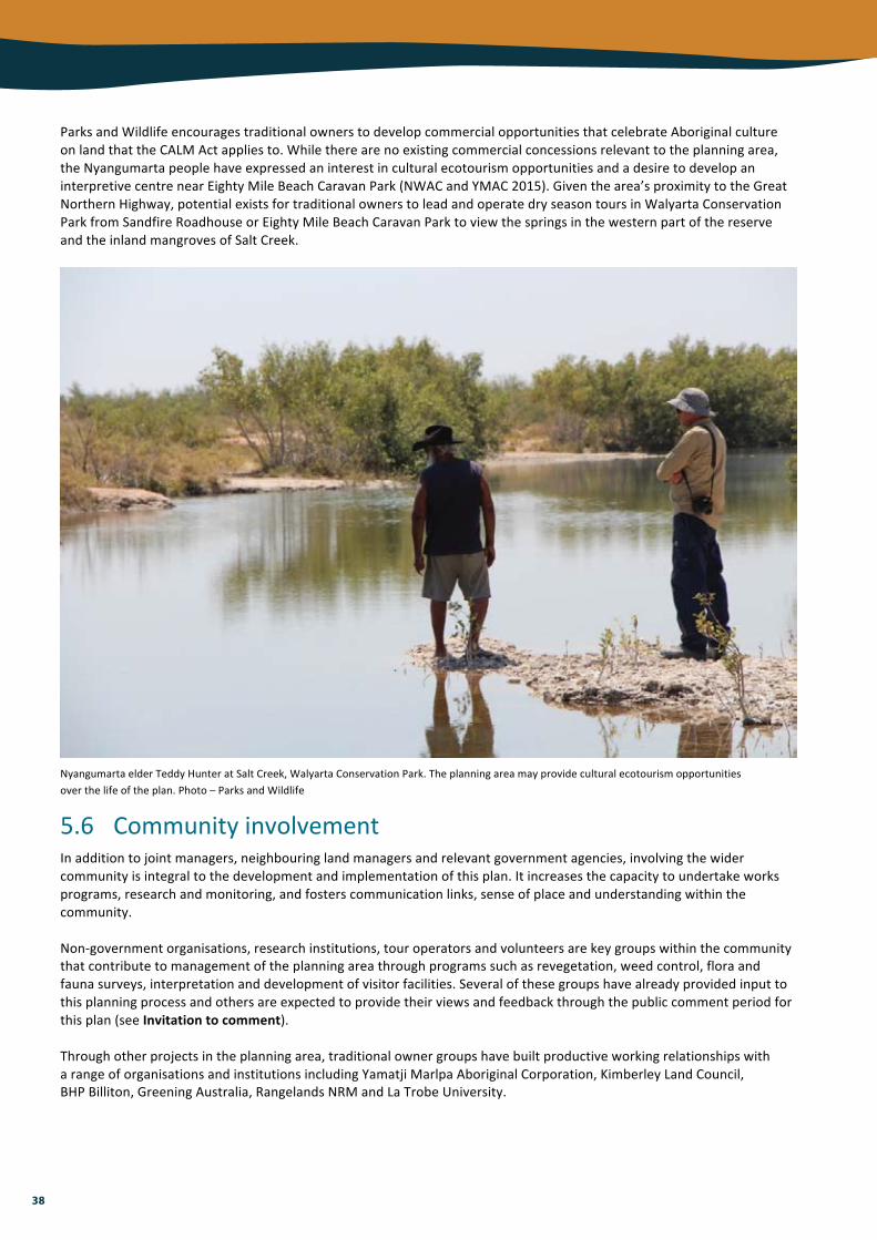
38
ParksandWildlifeencouragestraditionalownerstodevelopcommercialopportunitiesthatcelebrateAboriginalcultureonlandthattheCALMActappliesto.Whiletherearenoexistingcommercialconcessionsrelevanttotheplanningarea,theNyangumartapeoplehaveexpressedaninterestinculturalecotourismopportunitiesandadesiretodevelopaninterpretivecentrenearEightyMileBeachCaravanPark(NWACandYMAC2015).Giventhearea’sproximitytotheGreatNorthernHighway,potentialexistsfortraditionalownerstoleadandoperatedryseasontoursinWalyartaConservationParkfromSandfireRoadhouseorEightyMileBeachCaravanParktoviewthespringsinthewesternpartofthereserveandtheinlandmangrovesofSaltCreek.
NyangumartaelderTeddyHunteratSaltCreek,WalyartaConservationPark.Theplanningareamayprovideculturalecotourismopportunitiesoverthelifeoftheplan.Photo–ParksandWildlife
5.6 CommunityinvolvementInadditiontojointmanagers,neighbouringlandmanagersandrelevantgovernmentagencies,involvingthewidercommunityisintegraltothedevelopmentandimplementationofthisplan.Itincreasesthecapacitytoundertakeworksprograms,researchandmonitoring,andfosterscommunicationlinks,senseofplaceandunderstandingwithinthecommunity.Non-governmentorganisations,researchinstitutions,touroperatorsandvolunteersarekeygroupswithinthecommunitythatcontributetomanagementoftheplanningareathroughprogramssuchasrevegetation,weedcontrol,floraandfaunasurveys,interpretationanddevelopmentofvisitorfacilities.Severalofthesegroupshavealreadyprovidedinputtothisplanningprocessandothersareexpectedtoprovidetheirviewsandfeedbackthroughthepubliccommentperiodforthisplan(seeInvitationtocomment).Throughotherprojectsintheplanningarea,traditionalownergroupshavebuiltproductiveworkingrelationshipswitharangeoforganisationsandinstitutionsincludingYamatjiMarlpaAboriginalCorporation,KimberleyLandCouncil,BHPBilliton,GreeningAustralia,RangelandsNRMandLaTrobeUniversity.

39
Summaryofmanagementdirectionsforrecreation,tourismandcommunityvalues
Keypointsandconsiderations
• Thecreationofnewreservesmayresultinincreasedinterestinvisitingtheplanningarea.Visitationwillbefocusedontheadjacentmarineparkandaccessiblelocationsalongthecoast.
• Authorisedpublicaccesstotheplanningareaislimited.Mosttracksareunsealedandtraverseprivateproperty.ThereiscurrentlynovisitoraccesstoKurrijiPaYajulaNatureReserveorWalyartaConservationPark.
• Unauthorisedvehicleaccessalongthedunesystemisamanagementissueanddamagescoastalvegetationandlandforms,andimpactsfaunaandculturalheritagesites.Vehicles(includingmotorbikes,quadbikesanddunebuggies)arenotpermittedintheEightyMileBeachcoastalreserves.
• Theremotenatureoftheplanningarea,combinedwiththeharshterrain,highdaytimetemperaturesandtheoccurrenceoftropicalcyclones,posearisktothesafetyofvisitors.
• Appropriateeducationandinterpretationwillincreasepublicawarenessofthevaluesoftheplanningarea,andpromoteresponsiblebehaviour.Whereculturalinformationisavailable,visitorsshouldhavegreaterunderstandingofandrespectforculturalvalues,lawsandprotocols.
• Externalorganisationsandcommunitygroupsmaybeencouragedtoundertakeandsupporton-groundworks,researchandmonitoring.
Managementobjectives Strategies
1. Provideandpromoteappropriatevehicleaccessforcultural,recreationandmanagementpurposeswithoutimpactingonthevaluesoftheplanningarea.
2. Minimisesafetyriskstovisitorstotheplanningarea.
3. Enhancevisitorenjoymentandappreciationofthevaluesoftheplanningareaandencouragebehaviourthatassistswithmanagement.
4. Promoteandfacilitatecommunityinvolvementinthemanagementoftheplanningarea.
Maintainroadsandtracksthatprovidepublicandmanagementaccess.Closeandre-route(andwherefeasible,rehabilitate)unnecessaryorinappropriateaccessroutes(i.e.tracksnotneededforpublicaccessormanagementpurposesorwhereunauthorisedcampingisapparent)orapplyaccessrestrictionstoareaswherekeyvaluesarevulnerabletodisturbance(e.g.threatenedspeciesandcommunities,sitesofculturalsignificanceandmeasuresconsistentwiththemarineparkmanagementplan).Ensurethatvisitorriskmanagementfortheplanningareaisconsideredaspartofaregionalriskmanagementprogramthatincludes:• measurestomitigatethemainandmostserioussafetyissues• culturallawsandprotocolsregardingvisitorriskandsafety.Investigatetheneedfor,andprepareandimplementasappropriate,specificeducationandinterpretationstrategiesthatcommunicate:• theimportanceofthevaluesoftheplanningarea• appropriatebehaviourtoreducehumanimpactsandensurepublicsafety• thepurposeofaccessrestrictionsandotherregulations• keyresearchandmonitoringfindingswhereappropriate.Asvisitordemandrequiresandasresourcesallow,investigatethefeasibilityofprovidingsomebasicvisitorinfrastructure(e.g.installationofshelterandinterpretivefacilities)tocaterforactivitiessuchasculturalecotourismandwildlifeappreciation.SeeksupportfromEightyMileBeachCaravanPark,otherlandmanagersaccommodatingvisitors,andtouroperatorstodisseminateinformationonkeyvaluesoftheplanningareaandtopromoteappropriatevisitorbehaviour.Developspecificlicenceconditionsforcommercialoperatorswhooperateintheplanningareaandaccessimportantculturalsites,toensurevisitationtothesesitesisundertakeninaculturallyappropriateway.Investigate,andwherepossiblesupport,culturalecotourismopportunitiesintheplanningarea.Consideropportunitiesandprovidesupport(i.e.advice,financialand/orlogisticalassistance)forcommunityparticipationinmanagement(includingresearchandmonitoring)oftheplanningarea(e.g.universities,non-governmentorganisationsandcommunitygroups).MonitorvegetationcoverintheEightyMileBeachcoastalreservestoassessthenatureandlevelofvehicleuseandhumanimpactoncoastalcommunities,andtakeremedialactionwhereneeded.

40
6. Usingresourcesfromthecountry(sustainableresourceuse)Theresponsibleandsustainableuseofnaturalresourcesinandadjacenttotheplanningareaisrecognisedforitscontributiontolongandshort-termeconomic,environmentalandsocialoutcomes.Themainexistingandpotentialactivitiesassociatedwiththeplanningareaarepastoralism,abstractionofgroundwater,andresourceexplorationanddevelopment.
6.1 PastoralismGrazingofdomesticlivestockoutsidetheplanningareaisanacceptedeconomicactivitythatproducesfoodandfibreforthecommunityandgeneratesexportproducts.Priortomid-2015,theEightyMileBeachcoastalreservesandasignificantportionofWalyartaConservationParkwereheldunderpastorallease.Theseareasarestillsubjecttolivestockgrazingalthoughitisaprioritythatthecattleandassociatedinfrastructureberemovedassoonaspossible.Pastoraloperationscontinueonsurroundinglands,thereforeincursionoflivestockisbothanexistingandpotentialmanagementissue.Thepresenceofpermanentwater,densevegetationandshadehasmadethemoundspringcommunitiesofMandoraMarshparticularlyattractivetocattle.Fordecadestheyaccessedthefreshwaterspringsandimpactedthesitebytramplingvegetation,pugging(compacting)ofsoilandintroducingnutrients,andwereavectorfortheintroductionofexoticpasturegrassesandotherweeds.Grazingbylivestockaltershabitatstructure,negativelyaffectingspeciesthatdependonunderstoreyvegetationforforagingandnesting(MartinandPossingham2005).StockhavealonghistoryofgrazingthevegetationoftheprimarydunesalongEightyMileBeachandalongSaltCreek,contributingtoerosionanddamagetoculturalheritagesitesandvalues.Indirectimpactsincludealterationofthemovementandbehaviourofnativeandintroducedfaunaspeciesandalteredfire,nutrientandsurfacewaterflowregimes.Weedsandintroducedanimalsareoftenfavouredbyecologicalchangesarisingfromgrazing(e.g.nutrientavailability).Researchfromsiteswithahistoryofpastoralismelsewheresuggeststhatecologicalrecoverycanoccurreasonablyquicklyfollowingremovaloflivestock,however,thespeciesmostsusceptibletopastoralimpactsmayhavelongdisappearedfromthelandscapeandmaynotreturn(Leggeetal.2011;WoinarskiandAsh2002).Landscape-scaleexperimentsinvolvingtheremovalofstockarebeingundertakenacrossnorthernAustraliatoexploreinteractionsoffirepatternwithgrazingregimes.ResultsfromastudysiteinthecentralKimberleyindicatethatmammalrecoveryafterstockremovalwasonlypronouncedwhenfiresweresimultaneouslymanagedtobelowerinfrequency,sizeandintensity(Ziembickietal.2015).
Partsoftheplanningareahavelongbeensubjecttotheadverseeffectsofdomesticstock.Destockingisaprioritytoallowtheseareastorecover.Photo–DaveandFionaHarvey/NaturalistVolunteers
Soilpuggingbycattleataspring,WalyartaConservationPark.Photo–KarenBettink/ParksandWildlife

41
6.2 WaterabstractionPlansexistforfuturehorticulturaldevelopmentsinthewiderregionanddiversificationofcurrentpastoralusetoincludearangeofmorewaterintensivepracticesandactivitiessuchasirrigatedagricultureandaquaculture(HaleandButcher2009).AbstractionofgroundwaterforhorticultureorotherdevelopmentsposesasignificantpotentialthreattothehydrologyandfunctioningofgroundwaterdependentwetlandsinWalyartaConservationParkandtheirassociatedecologicalassemblages,includingTECMandoraMounds.AccordingtoStoreyetal.(2011),waterabstractionfromtheaquifersfeedingthefreshwaterspringsatMandoraMarshwouldbeextremelydetrimentalandcouldleadtotheirloss.ThiswouldalsothreatenstygofaunacommunitiesandwouldhavethepotentialtoaffecttheecologicalcharacteroftheRamsarsite(seeAppendixI).Partsoftheplanningareaareatriskofacidsulfatesoilsoccurringnearorbeyondthenaturalsoilsurface.Theeffectsofdewateringordisturbingthemincludecontaminationofgroundwaterandecologicaldamagetowetlandecosystems.Aportionoftheplanningarea,includingseveraloftheEightyMileBeachcoastalreservesandthemajorityofWalyartaConservationPark,lieswithintheLaGrangeManagementArea,inwhichgroundwaterallocationismanagedbytheDepartmentofWater.TheLaGrangeGroundwaterAllocationPlanincludesmanagementtriggersandspecificlocalareamanagementrules(e.g.nonewborescanbedrilledwithintheRamsarsiteboundaryatMandoraMarsh)toensurethatwaterabstractionwillbesustainableandsignificantvaluesprotected(DepartmentofWater2010).Intheallocationplan,theDepartmentofWatercommitstoidentifyingthelocalinvestigationsrequiredtodeterminetheecologicalwaterrequirementsforsitesofsignificance.Increasingthelevelofunderstandingaboutthehydrologyofthesepartsoftheplanningareaisanimportantmanagementoutcome.Currentabstractioniswellbelowtheannuallimit,witharound35percentofthewaterintheLaGrangeSouthsubarealicensedandcommittedasofDecember2014.Spatialdistributionofabstractionwellsmayalsobeanimportantconsiderationforpartsoftheplanningarea(J.Rutherfordpers.comm.2015).
6.3 MineralandpetroleumexplorationanddevelopmentTheregionhasidentified(andprospective)mineralandoilresourcesthatareimportanttotheeconomy.Atthetimeofpublication,largepartsoftheplanningareaareofinteresttotheminingandpetroleumindustries,withlivetenementscoveringportionsoftheEightyMileBeachcoastalreservesandpetroleumexplorationpermitsextendingoverKurrijiPaYajulaNatureReserve,thenorthernportionofWalyartaConservationParkandoneoftheEightyMileBeachcoastalreserves.ExplorationanddevelopmentproposalsrelevanttotheMiningAct1978andthePetroleumandGeothermalEnergyResourcesAct1967mustundergothenecessaryenvironmentalandheritageassessments.TheymaybespecificallyreferredtotheEnvironmentalProtectionAuthorityforenvironmentalimpactassessment,andapprovalundertheEPBCActmayalsoberequiredwherepotentialsignificantimpactsonmattersofnationalsignificance(e.g.Ramsarsitesorlistedspecies)areidentified.Althoughitisunlikelythatminingwouldbepermittedwithinenvironmentallysensitivepartsoftheplanningarea,miningandexplorationinthewiderregionhasthepotentialtoimpactonkeyvalues.Localandstategovernmentagenciesmayrequiretheextractionofbasicrawmaterials(suchasgravel,shale,clay,sand,limestoneandrock)foruseonroads,trailsandfoundationsforinfrastructure.Duetothearea’slandforms(wetlandsanddunesvulnerabletoerosion),conservationvalueandlowdemandforvisitorfacilities,basicrawmaterialextractionisunlikelytobesourcedfrom,orsupportedfor,thereserves.Wherebasicrawmaterialsaresourcedfromwithintheplanningarea,thematerialsshouldonlybeusedtocontributetotheprotectionormanagementofthereserves.

42
Summaryofmanagementdirectionsforsustainableresourceuse
Keypointsandconsiderations
• TheEightyMileBeachcoastalreservesandasignificantportionofWalyartaConservationParkhavelongbeensubjecttolivestockgrazing.Theplanningareawillsoonbedestockedbutgrazingwillcontinueonsurroundinglands.
• Accessbycattlehasimpactedthecoastaldunes,inlandmangrovesandmoundspringcommunities.ManagedandunmanagedstockarethemostsignificantthreattotheconditionofthemoundspringsatMandoraMarsh.
• Otherlandusesinthevicinityoftheplanningareaincludeintensivehorticulture,miningandpetroleumexploration.Anincreaseingroundwaterabstractionassociatedwiththeseactivitiesmayimpactthehydrologyoftheplanningareaandgroundwaterdependentecosystems.
Managementobjective Strategies
1. Protectkeyvaluesoftheplanningareafromadverseimpactsofresourceuse.
Facilitatetheremovaloflivestockandassociatedinfrastructurefromformerpastoralleaseareasoftheplanningarea.Investigatetheneedforandfeasibilityofinstallingandmaintainingcattle-prooffencingtoexcludelivestockfromsensitivesitesandlocations(e.g.moundspringsofWalyartaConservationPark).Undertakeregularsurveysofferalstockabundanceandtheintegrityoffencingaroundsensitivesiteswherecattlestilloccur.Considerrequirementsandopportunitiesforactivecontroloflivestock(e.g.musteringoffreservesandaerialculls)aspartofaregionalferalanimalcontrolprogram(alsoseeCaringforcountry).CollaboratewiththeDepartmentofWatertodefinetheecologicalwaterrequirementsforsignificantgroundwater-dependentwetlandsoftheEightyMileBeachcoastalreservesandWalyartaConservationPark(alsoseeCaringforcountry).Considerthepossibilityofencounteringacidsulfatesoilsandavoiddisturbing,compacting,dewateringanddisplacingsaturatedsoilsatrisk.Workwiththerelevantagenciestoevaluatelanduse,explorationanddevelopmentproposalsthatmayimpactonthekeyvaluesoftheplanningareaandseektoavoidorminimisetheseimpacts.Provideadvicetoensurethatanysitesdisturbedbyresourceexplorationanddevelopmentwithintheplanningareaarerehabilitatedinaccordancewiththeconditionsoftheminingorexplorationtenureorapprovaldocumentation,aswellasParksandWildliferehabilitationstandardsandguidelines.

43
7.PerformanceAssessmentTheConservationandParksCommissionhasresponsibilityforassessingtheimplementationofthisplaninaccordancewithsection19(1)(g)(iii)oftheCALMAct.Progresstowardsachievingtheobjectivesoftheplanisdemonstratedbyregularmonitoring,evaluationandreportingtoinvestigatetheeffectivenessofmanagementstrategiesandidentifyopportunitiesforimprovement.Thesearekeyelementsofanadaptivemanagementframework,enablingstrategiestoberevisedwhereneeded.Asetofkeyperformanceindicators(KPIs)willbeusedtoassesstheimplementationandsuccessofthisplan.TheKPIs(comprisingperformancemeasures,managementtargetsandreportingrequirements4)havebeenidentifiedforselectedvaluesandmanagementissuesandarepresentedintherelevantmanagementtablesthroughouttheplan.TheKPIsarelinkedtoobjectivesandstrategies,andreflectthehighestconservationandmanagementprioritiesoftheConservationandParksCommission,ParksandWildlife,jointmanagementpartnersandthecommunity.Anysustainedchange(e.g.acontinuousdecreaseorincrease)willtriggertheneedforfurtherinvestigationtodeterminethecauseofthatchangeandthereforetherequirementfor,andtypeof,managementintervention.Providingaccurateandrelevantdataandinformationasevidenceofplanimplementationisessentialtoensuretheassessmentprocessisperformedquicklyandeffectively.Aportfoliowillbemaintainedshowingevidenceofthoseareaswheretheplanisbeingsuccessfulandthosewherechangesareneeded.Someexamplesofevidencethatmaybeusedtoassessimplementationofthisplaninclude:• specific,quantitativemonitoringofsignificant
assetssuchasconservationsignificantfloraandfaunaandTECs
• seriesofphotographs,mappingorotherimagerythatshowwhetherspatialandtemporalchangeshaveoccurred
• checklists• surveys• incidentreportsorrecords• otherwrittendocumentsorcorrespondence.AssessmentbytheConservationandParksCommissionshouldalsobeinformedbymonitoringandreportingundertheKarajarriHealthyCountryPlanandtheNyangumartaWarrarnIPAplan.
4Whilereportingrequirementsmaybeannual(orother),determiningreliabletrendsmightnotbepossibleforanumberofyears.
Footprints,KujungurruWarrarnNatureReserve.Photo–MattFossey/ParksandWildlife

44
ReferencesAustralianNatureConservationAgency(1996).ADirectoryofImportantWetlandsinAustralia–SecondEdition.AustralianNatureConservationAgency,Canberra.
BamfordM.J.andDaviesS.J.J.F.(1996).ReportonFaunaStudies.In:Graham-TaylorC.andBamfordM.J.(eds)TheDiscoveryProject1996Report.
BeardJ.S.,BeetsonG.R.,HarbeyJ.M.,HopkinsA.J.M.andShepherdD.P.(2013).ThevegetationofWesternAustraliaatthe1:3000000scale.Explanatorymemoir.Secondedition.ConservationScienceWesternAustralia9(1),1-152.
BradleyK.,LeesC.,Lundie-JenkinsG.,CopleyP.,PaltridgeR.,DziminskiM.,SouthgateR.,NallyS.andKempL.(Eds.)(2015).2015GreaterBilbyConservationSummitandInterimConservationPlan:anInitiativeoftheSavetheBilbyFund.IUCNSSCConservationBreedingSpecialistGroup,AppleValley,MN.
BrownA.andGeytenbeekB.(2003).NgarlaSongs.FremantleArtsCentre,Fremantle,WesternAustralia.
BurbidgeA.A.,McKenzieN.L.andKenneallyK.F.(1991).NatureConservationReservesintheKimberley,WesternAustralia.DepartmentofConservationandLandManagement,Como,WesternAustralia.
CarwardineJ.,O’ConnorT.,LeggeS.,MackeyB.,PossinghamH.P.andMartinT.G.(2011).PrioritythreatmanagementtoprotectKimberleywildlife.CSIROEcosystemServices,Brisbane,Queensland.
Charles,S.(2004).VisittoDragonTreeSoakNatureReserve.DesertDiscoveryProject.
CommonwealthofAustralia(2015).WildlifeConservationPlanforMigratoryShorebirds.CommonwealthofAustralia.
CranfieldR.J.(2008).Atriplexeremitis(Chenopodiaceae),anewspeciesfromnorthernWesternAustralia.Nuytsia,18,49-52.
Davis,J.(2014).Australianrangelandsandclimatechange–aquaticrefugia.NintiOneLimitedandUniversityofCanberra,AliceSprings.
DepartmentofEnvironmentandConservation(2006).PolicyStatementNo.18RecreationTourismandVisitorServices.DepartmentofEnvironmentandConservation,WesternAustralia.
DepartmentofEnvironmentandConservation(2008).RegionalFireManagementPlanKimberley2008-2013.DepartmentofEnvironmentandConservation,WesternAustralia.
DepartmentofEnvironmentandConservation(2008a).FireManagementGuidelineNo.S12:BuffelGrassandFireManagement.DepartmentofEnvironmentandConservation,WesternAustralia.
DepartmentofEnvironmentandConservation(2009).ResourceConditionReportforaSignificantWesternAustralianWetland:SaundersSpring.PreparedforInlandAquaticIntegrityResourceConditionMonitoring(IAIRCM)Project.DepartmentofEnvironmentandConservation,WesternAustralia.
DepartmentofEnvironmentandConservation(2012).‘Wetlandhydrology’,inAguidetomanagingandrestoringwetlandsinWesternAustralia.PreparedbyCMykytiuk,JLawnandRLynch,DepartmentofEnvironmentandConservation,Perth,WesternAustralia.
DepartmentoftheEnvironment(2016).MandoraMarsh,GreatNorthernHwy,Goldsworthy,WA,Australia.AustralianHeritageDatabase.AccessedApril2016(http://www.environment.gov.au/cgi-bin/ahdb/search.pl?mode=place_detail;search=place_name%3Dmandora%3Bkeyword_PD%3Don%3Bkeyword_SS%3Don%3Bkeyword_PH%3Don%3Blatitude_1dir%3DS%3Blongitude_1dir%3DE%3Blongitude_2dir%3DE%3Blatitude_2dir%3DS%3Bin_region%3Dpart;place_id=19827)
DepartmentoftheEnvironment,Water,HeritageandtheArts(2009).EcosystemServices:KeyConceptsandApplications,OccasionalPaperNo1.DepartmentoftheEnvironment,Water,HeritageandtheArts,Canberra.
DepartmentofParksandWildlife(2014).EightyMileBeachMarineParkManagementPlan802014-2024.DepartmentofParksandWildlife,WesternAustralia.

45
DepartmentofParksandWildlife(2014a).AboriginalcustomaryactivitiesonParksandWildlifemanagedlandsandwaters.DepartmentofParksandWildlife,WesternAustralia.
DepartmentofParksandWildlife(2014b).CanetoadstrategyforWesternAustralia2014–2019.DepartmentofParksandWildlife,WesternAustralia.
DepartmentofParksandWildlife(2015).PolicyStatementNo.53VisitorRiskManagement.DepartmentofParksandWildlife,WesternAustralia.
DepartmentofParksandWildlife(2016).MandoraMarshFaunaSurveySeptember2015:DraftReport.DepartmentofParksandWildlife,WesternAustralia.
DepartmentofWater(2010).LaGrangegroundwaterallocationplan.Waterresourceallocationplanningseries,Reportno.25.DepartmentofWater,WesternAustralia.
Done,C.(1999)‘Managementissues’.In:Graham,G.(ed)AlandmanagementassessmentofMandoraMarshanditsimmediatesurrounds,pp.15-18.DepartmentofConservationandLandManagement,Perth,WesternAustralia.
EberhardS.M.,HalseS.A.andHumphreysW.F.(2005).StygofaunainthePilbararegion,north-westWesternAustralia:areview.JournaloftheRoyalSocietyofWesternAustralia88:167-176.
ElkinA.P.(1933).TotemisiminNorth-WestAustralia.Oceania,3(3),257-296.
EnvironmentAustralia(2001).ADirectoryofImportantWetlandsinAustralia–ThirdEdition.EnvironmentAustralia,Canberra.
HandleyM.(1996).AustralianWetlandsConservationProject:FinalReport.PreparedfortheAustralianHeritageCommission.
GitayH.,FinlaysonC.M.andDavidsonN.C.(2011).Aframeworkforassessingthevulnerabilityofwetlandstoclimatechange.RamsarTechnicalReportNo.5/CBDTechnicalSeriesNo.57.RamsarConventionSecretariat,Gland,Switzerland&SecretariatoftheConventiononBiologicalDiversity,Montreal,Canada.
GovernmentofWesternAustralia(2011).KimberleyScienceandConservationStrategy.GovernmentofWesternAustralia.
Graham,G.(1999)‘Introduction’.In:Graham,G.(ed)AlandmanagementassessmentofMandoraMarshanditsimmediatesurrounds,pp.8-14.DepartmentofConservationandLandManagement,Perth,WesternAustralia.
GrossJ.E.,WoodleyS.,WellingL.A.andWatsonJ.E.M.(2016).RespondingtoClimateChange:GuidanceforProtectedAreaManagersandPlanners.IUCN,Gland,Switzerland.
Hale,J.andButcher,R.(2009).EcologicalCharacterDescriptionoftheEighty-mileBeachRamsarsite.ReporttotheDepartmentofEnvironmentandConservation,Perth,WesternAustralia.
HalseS.A.,PearsonG.B.,HassellC.,CollinsP.,ScanlonM.D.andMintonC.D.T.(2005).MandoraMarsh,north-westernAustralia,anarid-zonewetlandmaintainingcontinentalpopulationsofwaterbirds.Emu,105,115-25.
HaydonD.T.,FriarJ.K.andPiankaE.(2000).Fire-drivendynamicmosaicsintheGreatVictoriaDesert,Australia.LandscapeEcology15:373-381.
HennessyK.,MacadamI.andWhettonP.(2006).Climatechangescenariosforinitialassessmentofriskinaccordancewithriskmanagement.PreparedfortheAustralianGreenhouseOffice,DepartmentofEnvironmentandHeritage.CSIROMarineandAtmosphericResearch,Aspendale,Victoria.
JackettN.andGraffJ.(2015).ParksandWildlifeFaunaSurvey:Birds.BroomeBirdObservatory,Broome,WesternAustralia.
JohnstoneR.E.(1990).MangrovesandMangroveBirdsofWesternAustralia.RecordsoftheWestAustralianMuseum,SupplementNo.32.WesternAustralianMuseum,Perth.
KarajarriTraditionalLandsAssociation(2014).KarajarriHealthyCountryPlan2013-2023:PalanapayanaTukjanaNgurra‘Everybodylookingaftercountryproperly’.KarajarriTraditionalLandsAssociation,Broome,WesternAustralia.

46
LeggeS.,KennedyM.S.,LloydR.,MurphyS.andFisherA.(2011).RapidrecoveryofmammalfaunainthecentralKimberley,northernAustralia,followingremovalofherbivores.AustralEcology36:791-799.
MarkeyA.(2016).MandoraMarsh/WalyartaFloraandFloristicVegetationSurvey:2015.Draftfinalreport.DepartmentofParksandWildlife,WesternAustralia.
MartinT.G.andPossinghamH.P.(2005).Predictingtheimpactoflivestockgrazingonbirdsusingforagingheightdata.JournalofAppliedEcology42:400-408.
NintiOneLimited(2013).ManagingtheimpactsofferalcamelsacrossremoteAustralia;FinalreportoftheAustralianFeralCamelManagementProject.NintiOneLimited,AliceSprings,NorthernTerritory.
NyangumartaWarrarnAboriginalCorporation&YamatjiMarlpaAboriginalCorporation(2015).NyangumartaWarrarnIndigenousProtectedArea,PlanofManagement,2015to2020.PreparedbyDrNicholasSmith,SouthHedland,WesternAustralia.
PaveyC.(2006).NationalRecoveryPlanfortheGreaterBilbyMacrotislagotis.NorthernTerritoryDepartmentofNaturalResources,EnvironmentandtheArts.
PearsonG.,HickeyR.andHonkoopP.J.C.(2005).Generaldescriptionofthestudyarea.In:PiersmaT.,PearsonG.B.,HickeyR.andLavaleyeM.(eds)TheLongMud:BenthosandshorebirdsoftheforeshoreofEighty-mileBeach,WesternAustralia,pp.207-213.NIOZ-Report2005-2,RoyalNetherlandsInstituteforSeaResearch(NIOZ),Texel,TheNetherlands.
PiersmaT.,LokT.,ChenY.,HassellC.J.,YangH.-Y.,BoyleA.,SlaymakerM.,ChanY.-C.,MelvilleD.S.,ZhangZ.-W.andMaZ.(2016).Simultaneousdeclinesinsummersurvivalofthreeshorebirdspeciessignalsaflywayatrisk.JournalofAppliedEcology53:479-490.
PittardS.D.(2010).GeneticPopulationStructureoftheFlatbackTurtle(Natatordepressus):AnuclearandmitochondrialDNAanalysis.HonoursThesis,UniversityofCanberra.
ReynoldsS.,PickerdI.andLindsayM.(2015).KurrijiPaYajulaExpedition2014:PlantsandanimalsofDragonTreeSoak.EnvironsKimberley,Broome,WesternAustralia.
SemeniukResearchGroupV.andC.(2000).WetlandsofthenorthwesternGreatSandyDesertintheLaGrangehydrologicalsub-basin.ReporttotheWaters&RiversCommissionofWesternAustralia.
SemeniukV.(2008).Holocenesedimentation,stratigraphy,biostratigraphy,andhistoryoftheCanningCoast,north-westernAustralia.JournalofRoyalSocietyofWesternAustralia,SupplementtoVolume91,Part1:53-148.
ShineR.(2010).Theecologicalimpactofinvasivecanetoads(Bufomarinus)inAustralia.TheQuarterlyReviewofBiology,85(3),253-91.
SpencerP.B.S.,HamptonJ.O.,PacioniC.,KennedyM.S.,SaalfeldK.,RoseK.andWoolnoughA.P.(2015).GeneticrelationshipswithinsocialgroupsinfluencetheapplicationoftheJudastechnique:Acasestudywithwilddromedarycamels.JournalofWildlifeManagement79:102-111.
SpurrC.(1996).LandManagementPlanforanAridZoneWetland.In:Graham-TaylorC.andBamfordM.J.(eds)TheDiscoveryProject1996Report.
SteffenW.,BurbidgeA.A.,HughesL.,KitchingR.,LindenmayerD.,MusgraveW.,StaffordSmithM.andWernerP.A.(2009).Australia’sbiodiversityandclimatechange:astrategicassessmentofthevulnerabilityofAustralia’sbiodiversitytoclimatechange.AreporttotheNaturalResourceManagementMinisterialCouncilcommissionedbytheAustralianGovernment.DepartmentofClimateChange,Canberra.
StoreyA.W.,HalseS.A.,ShielR.J.andCreaghS.(2011).AquaticfaunaandwaterchemistryofthemoundspringsandwetlandsofMandoraMarsh,north-westernAustralia.JournaloftheRoyalSocietyofWesternAustralia,94,419-37.
WatkinsD.,BrennanK.,LangeC.,JaenschR.andFinlaysonM.(1997).ManagementPlanningforRamsarSitesintheKimberleyRegionofWesternAustralia.ReporttotheDepartmentofConservationandLandManagement,Perth,WesternAustralia.

47
WillingT.(2014).TukujanaNganyjurrukuraNgurra‘Allofuslookingaftercountrytogether’:LiteratureReviewwithRecommendationsforTerrestrialandMarineEnvironmentsonKarajarriLandandSeaCountry.KarajarriTraditionalLandsAssociation,Broome,WesternAustralia.
WillingT.andHandasydeT.(1999).‘VegetationandFlora’.In:Graham,G.(ed)AlandmanagementassessmentofMandoraMarshanditsimmediatesurrounds,pp.19-24.DepartmentofConservationandLandManagement,Perth,WesternAustralia.
WoinarskiJ.C.Z.andAshA.J.(2002).Responsesofvertebratestopastoralism,militarylanduseandlandscapepositioninanAustraliantropicalsavanna.AustralEcology27:311-323.
WoinarskiJ.C.Z.,BurbidgeA.A.andHarrisonP.L.(2015).Ongoingunravellingofacontinentalfauna:DeclineandextinctionofAustralianmammalssinceEuropeansettlement.PNAS,112(6),1-10.
WyrwollK.H.,McKenzieN.L.,PedersonB.J.andTapleyI.J.(1986).TheGreatSandyDesertofnorth-westernAustralia:thelast7000years.Search,17,208-10.
Yu,S.(2000).NgapaKunangkul:LivingWater.ReportontheAboriginalculturalvaluesofgroundwaterintheLaGrangesub-basin.PreparedbytheCentreofAnthropologicalResearch,UniversityofWesternAustraliafortheWaterandRiversCommissionofWesternAustralia.Secondedition.
ZiembickiM.R.,WoinarskiJ.C.Z.,WebbJ.K.,Vanderduys,E.,TuftK.,SmithJ.,RitchieE.G.,ReardonT.B.,RadfordI.J.,PreeceN.,PerryJ.,MurphyB.P.,McGregorH.,LeggeS.,LeahyL.,LawesM.J.,KanowskiJ.,JohnsonC.N.,JamesA.,GriffithsA.D.,GillespieG.,FrankA.S.K.,FisherA.andBurbidgeA.A.(2015).Stemmingthetide:progresstowardsresolvingthecausesofdeclineandimplementingmanagementresponsesforthedisappearingmammalfaunaofnorthernAustralia.Therya,6(1),169-225.

48
AppendicesAppendixI:EightyMileBeachRamsarsiteTheEightyMileBeachRamsarsitewaslistedasawetlandofinternationalimportanceundertheRamsarConventionon7June1990.Thesitecoverstwoseparateanddistinctareas,totalling175,487ha:EightyMileBeachandassociatedintertidalflatsandprimarydunes(knownasthebeachsection)andMandoraMarsh.ThebeachsectionislargelyprotectedbytheEightyMileBeachcoastalreservesandtheadjacentmarineparkandWalyartaConservationParkcoversthemajorityofMandoraMarsh.SmallareasoftheRamsarsiteoccuronpastoralleaseoutsidetheformalconservationestate.
TheplanningareaformallyprotectsasignificantportionoftheEightyMileBeachRamsarsite.Photo–ParksandWildlife

49
RamsarlistingcriteriaToqualifyforlisting,awetlandmustmeetatleastoneofthenineRamsarcriteria.TheEightyMileBeachRamsarsitecurrentlymeetscriteria1-6.Table5ListingcriteriametbyportionsoftheRamsarsiteintheplanningarea
GroupAofthecriteria:Sitescontainingrepresentative,rareoruniquewetlandtypes
Criterion1:Awetlandshouldbeconsideredinternationallyimportantifitcontainsarepresentative,rare,oruniqueexampleofanaturalornear-naturalwetlandtypefoundwithintheappropriatebiogeographicregion.• MandoraMarsh,withintheGreatSandyDesertbioregion,containsanimportantandrare
groupofwetlands,includingperiodicallyinundatedlakes,apermanenthyper-salinecreek,freshwater,tree-dominatedwetlands,andfreshwaterandsalinemoundsprings.
GroupBofthecriteria:Sitesofinternationalimportanceforconservingbiodiversity
Speciesandecologicalcommunities
Criterion2:Awetlandshouldbeconsideredinternationallyimportantifitsupportsvulnerable,endangered,orcriticallyendangeredspeciesorthreatenedecologicalcommunities.• Thegreaterbilby,listedasVulnerableundertheWildlifeConservationActandtheEPBC
Act,hasbeenrecordedatMandoraMarsh.• Thecoastaldunesandinlandwetlandssupportseveralthreatenedshorebirdspecies
includingtheAustralianpaintedsnipe,bar-tailedgodwit,curlewsandpiperandgreatersandplover.
• ThedunesofEightyMileBeachprovidenestinghabitatfortheflatbackturtle,listedasVulnerableundertheWildlifeConservationActandtheEPBCAct.
• OnethreatenedecologicalcommunityandonepriorityecologicalcommunityarelocatedatMandoraMarsh.
Criterion3:Awetlandshouldbeconsideredinternationallyimportantifitsupportspopulationsofplantand/oranimalspeciesimportantformaintainingthebiologicaldiversityofaparticularbiogeographicregion.• MandoraMarshcontainstemporaryandpermanentwetlandsrecognisedasimportant
refugiaforbiodiversityinapredominantlyaridbioregion.Inparticular,themoundspringsmakeasignificantcontributiontotheregionaldiversityoffloraandfauna.
Criterion4:Awetlandshouldbeconsideredinternationallyimportantifitsupportsplantand/oranimalspeciesatacriticalstageintheirlifecycles,orprovidesrefugeduringadverseconditions.• Whenflooded,MandoraMarshsupportsthecriticallifestageofbreedingforatleast13
waterbirdspecies,includinglargenumbersofAustralianpelicans(Pelecanusconspicillatus)andblackswans(Cygnusatratus).
• EightyMileBeachisoneofthemajorstopoverandnon-breedingareasformigratoryshorebirdsvisitingAustralia.Manyofthesefeedalmostexclusivelyontheintertidalflatsofthemarinepark,butusethecoastalreservesforroostingathightide.
• Thecoastaldunesalsosupportflatbackturtlenesting.Waterbirds
Criterion5:Awetlandshouldbeconsideredinternationallyimportantifitregularlysupports20,000ormorewaterbirds.• Thebeachsection,includingthecoastalreserves,isconsideredtoregularlysupportin
excessof500,000birds.• Therearerecordsoflargenumbers(i.e.>20,000)ofwaterbirdsassociatedwithfloodingat
MandoraMarsh,thoughonaninfrequentbasis.Criterion6:Awetlandshouldbeconsideredinternationallyimportantifitregularlysupportsonepercentoftheindividualsinapopulationofonespeciesorsubspeciesofwaterbird.• Maximumcountsforatleasttworesidentwaterbirds–theblack-wingedstilt(Himantopus
himantopus)andEasterngreategret(Ardeamodesta)–atMandoraMarshexceedtheonepercentpopulationthresholds.
• Maximumcountsinthebeachsectionexceedonepercentoftheflywaypopulation(oronepercentoftheAustralianpopulationforresidentspecies)for21waterbirdspecies.

50
CriticalcomponentsandprocessesUndertheConvention,ContractingPartiescommittopromotingtheconservationoflistedwetlands,withtheaimofpreventingchangestotheirecologicalcharacter.Ecologicalcharacterisdeterminedbykeyphysical,chemicalandbiologicalcomponentsandprocesses.ThecriticalcomponentsandprocessesfortheEightyMileBeachRamsarsite,asidentifiedbyHaleandButcher(2009),arelistedbelow:Beachsection MandoraMarshHydrology HydrologyGeomorphology GeomorphologyPrimaryproduction WaterqualityInvertebrates PhytoplanktonandprimaryproductionFish VegetationWaterbirds InvertebratesTurtles WaterbirdsWhilethecomponentsandprocessesofthebeachsectionhaverelevancetotheEightyMileBeachcoastalreserves,theirmanagementandmonitoringisgenerallydealtwithbythemarineparkmanagementplan.
LimitsofacceptablechangeParksandWildlifeistheleadagencyforimplementationoftheRamsarConventioninWesternAustraliaandpartofthisresponsibilityinvolvesreportingtotheAustralianGovernmentiftheecologicalcharacteroftheRamsarsitehaschanged,ischangingorislikelytochange.Toassistwiththis,limitsofacceptablechangeandinterimlimitsofacceptablechangeweresetbyHaleandButcher(2009)butthesewillneedtobereviewedasinformationisgainedfromfuturemonitoring.Toensurethatlimitsofacceptablechangearenotexceeded,operationallimitsmayneedtobeidentifiedasearlywarningtriggers.Whereanoperationallimitisreached,managementshouldintervenetodeterminewhetherthechangeisdetrimentaland,ifrequired,preventfurtherdeterioration.ResearchandmonitoringinWalyartaConservationParkwillenablelimitsofacceptablechangeandoperationallimitstobesetandreviewedforthecriticalcomponentsandprocessesofMandoraMarsh.Ifitisnotpossibleorpracticaltosetlimitsforallcomponentsandprocesses,priorityshouldbegiventothosewhicharetheprimarydeterminantsofecologicalcharacter(e.g.hydrology)andthosewhichcanbemanagedandmonitored(e.g.waterqualityandvegetation).
ReportingParksandWildlifeisresponsibleforreportingontheconditionandstatusoftheecologicalcharacteroftheEightyMileBeachRamsarsiteeverythreeyears,aspartofarollingreview.Thedepartment’sWetlandsSectionwillcoordinatethetriennialreviewandreportingtotheAustralianGovernment.
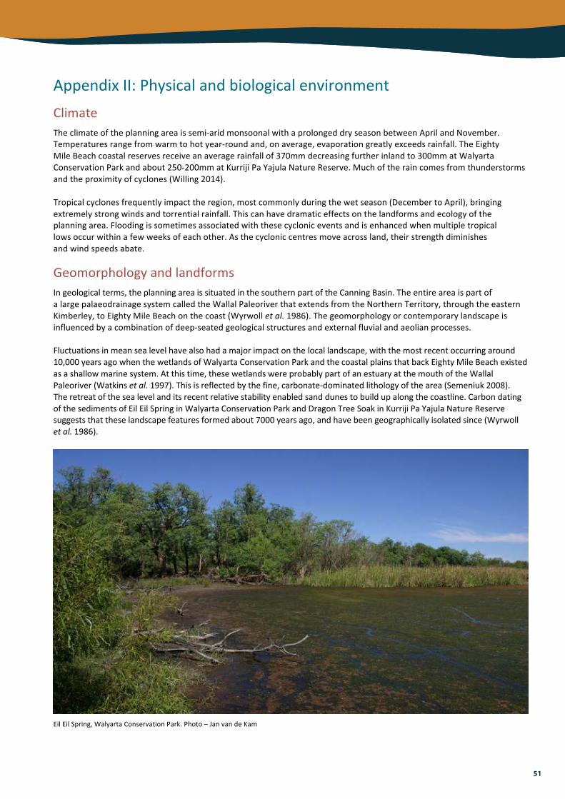
51
AppendixII:PhysicalandbiologicalenvironmentClimateTheclimateoftheplanningareaissemi-aridmonsoonalwithaprolongeddryseasonbetweenAprilandNovember.Temperaturesrangefromwarmtohotyear-roundand,onaverage,evaporationgreatlyexceedsrainfall.TheEightyMileBeachcoastalreservesreceiveanaveragerainfallof370mmdecreasingfurtherinlandto300mmatWalyartaConservationParkandabout250-200mmatKurrijiPaYajulaNatureReserve.Muchoftheraincomesfromthunderstormsandtheproximityofcyclones(Willing2014).Tropicalcyclonesfrequentlyimpacttheregion,mostcommonlyduringthewetseason(DecembertoApril),bringingextremelystrongwindsandtorrentialrainfall.Thiscanhavedramaticeffectsonthelandformsandecologyoftheplanningarea.Floodingissometimesassociatedwiththesecycloniceventsandisenhancedwhenmultipletropicallowsoccurwithinafewweeksofeachother.Asthecycloniccentresmoveacrossland,theirstrengthdiminishesandwindspeedsabate.
GeomorphologyandlandformsIngeologicalterms,theplanningareaissituatedinthesouthernpartoftheCanningBasin.TheentireareaispartofalargepalaeodrainagesystemcalledtheWallalPaleoriverthatextendsfromtheNorthernTerritory,throughtheeasternKimberley,toEightyMileBeachonthecoast(Wyrwolletal.1986).Thegeomorphologyorcontemporarylandscapeisinfluencedbyacombinationofdeep-seatedgeologicalstructuresandexternalfluvialandaeolianprocesses.Fluctuationsinmeansealevelhavealsohadamajorimpactonthelocallandscape,withthemostrecentoccurringaround10,000yearsagowhenthewetlandsofWalyartaConservationParkandthecoastalplainsthatbackEightyMileBeachexistedasashallowmarinesystem.Atthistime,thesewetlandswereprobablypartofanestuaryatthemouthoftheWallalPaleoriver(Watkinsetal.1997).Thisisreflectedbythefine,carbonate-dominatedlithologyofthearea(Semeniuk2008).Theretreatofthesealevelanditsrecentrelativestabilityenabledsanddunestobuildupalongthecoastline.CarbondatingofthesedimentsofEilEilSpringinWalyartaConservationParkandDragonTreeSoakinKurrijiPaYajulaNatureReservesuggeststhattheselandscapefeaturesformedabout7000yearsago,andhavebeengeographicallyisolatedsince(Wyrwolletal.1986).
EilEilSpring,WalyartaConservationPark.Photo–JanvandeKam

52
ThedunesoftheEightyMileBeachcoastalreservesarecomprisedofcoarsesand,dominatedbycalcareoussedimentsofmarineshellorigin(Pearsonetal.2005).Thesouthernsectionsoftheshorelinearecharacterisedbycalcarenitebluffs,3-5minheight.Therearealsoasmallnumberofshallowtidalcreeksthatdissectthedunesinthesouth.ThewetlandsofWalyartaConservationParkaresurroundedbylineardunesofredquartzsand.Thefloorofthetwolarge,periodicallyinundatedwetlandscomprisesand,siltandclayofalluvialorigin.Tothesouthandnorthofthese(butmoreextensiveinthesouth)areareasofclaysoilthatretainsurfacewaterforlongerthanthesurroundinglandscape.Therearealsosignificantrockyexposuresofcalcrete.Themoundspringscontainpeatsoils,accumulatedoverthousandsofyears.ThedominantlandformsofKurrijiPaYajulaNatureReservearethesandplainsanddunes,comprisinglongitudinaldunesofredquartzsandwithapredominanteast-westtrendandtheplainsbetweenthem.Thetwomoundsprings,DragonTreeSoakandthesmallerElizabethSoak,containblackpeatymudandaresituatedinaseriesofclaypans.
HydrologyWalyartaConservationParkprincipallycomprisestheMandoraMarshwetlandcomplex,whichincludesanumberofwetlandtypes.Thepredominantfeaturesaretwolarge,periodicallyinundatedwetlands,LakeWalyartaandEastLake.SaltCreekisabraidedsalinechannelsystembetweenthetwolakesthatispredominantlygroundwaterfed,butafterheavyraincarriessurfacewatereasttowestintoLakeWalyarta.Atothertimesthecreekexistsasaseriesofisolatedpools(HaleandButcher2009).TheMandoraMarshcomplexalsocontainsaseriesofpermanentlywetmoundspringsthatvaryinsizefrom0.1toseveralhectaresandarelocatedalongthesouthernsideofthetwomainwetlands.Thesearecharacterisedbyathickmoundofsaturatedpeat,toppedbydensevegetationandsurroundedbyeitheraninundatedmoatortail.ThediverserangeofwetlandsthatoccurinthereservereflectsthedifferentwaterbalancerequirementsthatoccurwithinthecomplexThemostimportanthydrologicalinputforLakeWalyartaandEastLakeissurfacerun-offflowduringperiodsofcyclonicactivity.Floodingeventsaresignificantindirectlyprovidinghabitatforaquaticorganismsandabreedingsiteformanywaterbirds(Halseetal.2005).However,inthemajorityofyearsthelakesareeitherdryorafterpartialinundationtheydrytoformbareclaybedssurroundedbysaltmarsh.Importantlyforthefreshwatersprings,floodingwithintheupgradientdunesandswalesystemsisalsolikelytobeimportantinencouraginggroundwaterrechargewithinaquifersbeneaththewetlands.GroundwaterisasignificantcomponentofthehydrologyofWalyartaConservationPark.TheBroomeSandstoneaquiferisbelievedtobeanimportantgroundwatersystemandisthoughttosustainmanyofthefreshwatermoundsprings,whileatsomespringstheWallalaquiferislikelytoalsoplayaroleinspringresilienceduetogroundwatermovementalonggeologicalfaults(J.Rutherfordpers.comm.2015).AlessercontributiontothehydrologyofthereserveistheinputofdiscretechannelisedflowfromSaltCreek(DepartmentofEnvironmentandConservation2012).Thiswaterwayappearstobefedthroughaseriesofspringsfromasalineaquifer(Graham1999).SaltCreekisanimportantwetlandinitsownrightasitsupportsauniquemangrovecommunity,whichisthoughttodependonspringsintheareaproducingwaterofsimilarsalinitytoseawater(Willing2014).KurrijiPaYajulaNatureReservecontainstwopermanentmoundsprings,whichlieabout2kmapart.ThesoaksandfringingpermanentswampsaresmallinsizebutareregardedasoaseswithintheGreatSandyDesert.HydrologyisbelievedtobedominatedbyshallowaquiferswithintheWallalPaleoriver,whichsuppliesacontinuoussupplyofgroundwater(Wywrolletal.1986).Themoundspringsoccurwherethegroundwaterdischargereachesthesurface(Spurr1996).Majorrainevents,suchasthoseassociatedwithcyclones,presumablyrechargeaquifersandfloodthesurroundingclaypansforshortperiods.
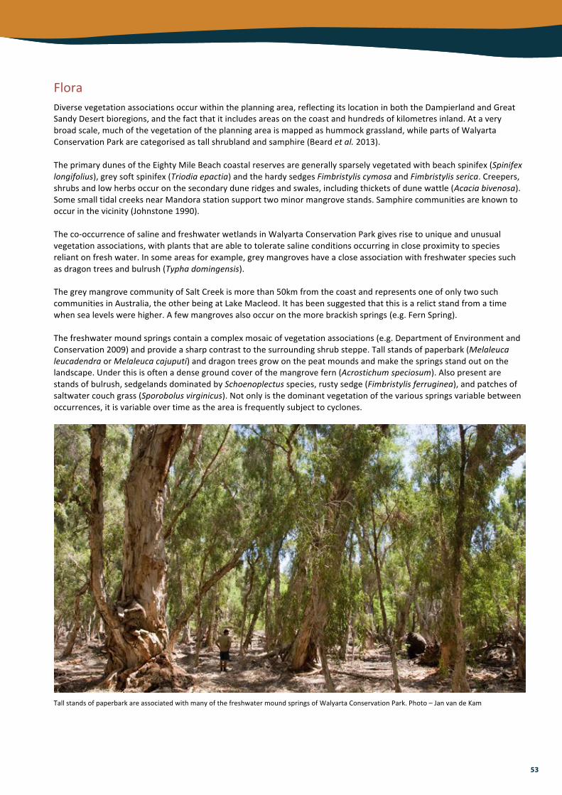
53
FloraDiversevegetationassociationsoccurwithintheplanningarea,reflectingitslocationinboththeDampierlandandGreatSandyDesertbioregions,andthefactthatitincludesareasonthecoastandhundredsofkilometresinland.Ataverybroadscale,muchofthevegetationoftheplanningareaismappedashummockgrassland,whilepartsofWalyartaConservationParkarecategorisedastallshrublandandsamphire(Beardetal.2013).TheprimarydunesoftheEightyMileBeachcoastalreservesaregenerallysparselyvegetatedwithbeachspinifex(Spinifexlongifolius),greysoftspinifex(Triodiaepactia)andthehardysedgesFimbristyliscymosaandFimbristylisserica.Creepers,shrubsandlowherbsoccuronthesecondaryduneridgesandswales,includingthicketsofdunewattle(Acaciabivenosa).SomesmalltidalcreeksnearMandorastationsupporttwominormangrovestands.Samphirecommunitiesareknowntooccurinthevicinity(Johnstone1990).Theco-occurrenceofsalineandfreshwaterwetlandsinWalyartaConservationParkgivesrisetouniqueandunusualvegetationassociations,withplantsthatareabletotoleratesalineconditionsoccurringincloseproximitytospeciesreliantonfreshwater.Insomeareasforexample,greymangroveshaveacloseassociationwithfreshwaterspeciessuchasdragontreesandbulrush(Typhadomingensis).ThegreymangrovecommunityofSaltCreekismorethan50kmfromthecoastandrepresentsoneofonlytwosuchcommunitiesinAustralia,theotherbeingatLakeMacleod.Ithasbeensuggestedthatthisisarelictstandfromatimewhensealevelswerehigher.Afewmangrovesalsooccuronthemorebrackishsprings(e.g.FernSpring).Thefreshwatermoundspringscontainacomplexmosaicofvegetationassociations(e.g.DepartmentofEnvironmentandConservation2009)andprovideasharpcontrasttothesurroundingshrubsteppe.Tallstandsofpaperbark(MelaleucaleucadendraorMelaleucacajuputi)anddragontreesgrowonthepeatmoundsandmakethespringsstandoutonthelandscape.Underthisisoftenadensegroundcoverofthemangrovefern(Acrostichumspeciosum).Alsopresentarestandsofbulrush,sedgelandsdominatedbySchoenoplectusspecies,rustysedge(Fimbristylisferruginea),andpatchesofsaltwatercouchgrass(Sporobolusvirginicus).Notonlyisthedominantvegetationofthevariousspringsvariablebetweenoccurrences,itisvariableovertimeastheareaisfrequentlysubjecttocyclones.
TallstandsofpaperbarkareassociatedwithmanyofthefreshwatermoundspringsofWalyartaConservationPark.Photo–JanvandeKam

54
LakeWalyartaandEastLakearegenerallybareofvegetation,orsupportlowopenshrublandsofsamphiresdominatedbyTecticorniaspp.Whenflooded,theycontainamixofsubmergedaquaticspeciesincludingribbonweed(Vallisneriaspiralis)andfreshwatermacroalgae(Graham1999).Theextensivealluvialplainstothenorthandsouthofthesewetlandssupportlowwoodlandsorshrubthicketsofsaltwaterpaperbark(Melaleucaalsophilia)andAcaciaampliceps,overlowshrubssuchasAcaciamonticola.Thesurroundingredsanddunesandsandplainssupportaselectionofpindananddesertplantspecies.KurrijiPaYajulaNatureReservehasrelictpopulationsoffloranotfoundelsewhereintheregion.ThecentreofDragonTreeSoakisdominatedbyT.domingensisandasmallpatchofjointedrush(Baumeaarticulata),whichisattheedgeofitsextent.TwomainclustersofdragontreesgrowasalowforestatthenorthernandsouthernendsandscatteredspecimensalsooccurintheB.articulata.AdensebandoftallergrassPaspalumvaginatumexistsaroundthesoakindampmudandamoreextensiveringofS.virginicussurroundsthisonhigher,drierground.ThenearbysmallerElizabethSoakhassimilarvegetationcommunities.Beyondthesoaks,thevegetationquicklyassumesthatofthedesertlandscape,dominatedbyspinifexgrasses,acaciaandmelaleucathickets,anddesertwalnut(Oweniareticulata).
Scatteredgroveofdesertwalnut,KurrijiPaYajulaNatureReserve.Whenroasted,thenutsareapopularfoodfortraditionalowners.Photo–StephenReynolds/EnvironsKimberley
FaunaLimitedfaunaresearchhasbeenconductedintheplanningarea,howevertherarityofaquatichabitatsuggeststhatthereservesaresignificantforarangeofspeciesandpopulations.Inparticular,thepermanentfreshwaterwetlandsprovidehabitatforaquaticfaunayearroundandasourceofdrinkingwaterforterrestrialanimals.TheEightyMileBeachcoastalreservesbordertheentirelengthofthebeachandprovidehabitatvalueforthenestingflatbackturtleandmanymigratoryshorebirds.Acaciaandmelaleucathicketssupporthighdensitiesofredkangaroo(Macropusrufus),euro(Macropusrobustus)andagilewallaby(Macropusagilis).ThereservesandadjacentcoastalplainsareregardedasastrongholdfortheAustralianbustard(Ardeotisaustralis).TerrestrialvertebratesurveysofMandoraMarshwereconductedin1999and2015(Graham1999;JackettandGraff2015;ParksandWildlife2016).Severalmajordifferenceswerefoundbetweenspeciesrecorded,abundancesanddistribution,highlightingtheneedforfurtherresearchandmonitoring.Ofparticularsignificanceisthepresenceofthegreaterbilby,recordednearSaltCreekasrecentlyasSeptember2015(ParksandWildlife2016). Breedingcolonyofpelicans,blackswansandstraw-neckedibisesin
2004,WalyartaConservationPark.Photo–JanvandeKam

55
LakeWalyartaandEastLakeinWalyartaConservationParkareimportantforwaterbirds,includingmigratoryspecies,wheninundatedextensively.WhenLakeWalyartafloodedin1999and2000,itwasfoundtobesupportingaround480,000and490,000waterbirdsrespectively(Halseetal.2005),althoughtheareasurveyedincludedinundatedlandoutsidetheboundariesofthereserveandtheRamsarsite.Thesiteisalsosignificantfortheroleitplaysinsupportingindividualwaterbirdspecies,withmaximumcountsexceedingtheonepercentpopulationthresholdsforseveralspecies(HaleandButcher2009).MandoraMarshalsosupportsarelativelyrichaquaticinvertebratefauna,whichStoreyetal.(2011)attributedtothedifferenttypesofpermanentwetlandswithintheonelocation.Whiletherewerefewendemicspecies,thespringsareregionallyimportantformaintainingvirtuallyallaquaticinvertebrates.Theyarebelievedtoprovideasourceofinvertebratestocolonisethemainlakebodieswheninflood(A.Pinderpers.comm.2016).GiventhestronglinkbetweencalcreteandstygofaunaalreadyknownfromthePilbara(Eberhardetal.2005),thearealikelysupportsdiverseandlocallytoregionallyendemicstygofaunacommunities,butthesehavebeenpoorlysurveyedtodate.TwonativefishspecieshavebeenrecordedfromtheSaltCreeksystem,includinganewendemicspecies(anundescribedgoby)(HaleandButcher2009;Storeyetal.2011).FaunasurveysinKurrijiPaYajulaNatureReservehavemainlyfocusedonDragonTreeSoakitself.BamfordandDavies(1996)notedthatthesitehadhighavianspeciesrichnessforanaridarea.WaterbirdspeciesnotrecordedelsewhereintheregionbutpresentinthedensevegetationofthecentralsedgelandincludetheAustraliancrake(Porzanafluminea),clamorousreed-warbler(Acrocephalusstentoreus)andlittlegrassbird(Megalurusgramineus)(AustralianNatureConservationAgency1996;Charles2004).Thegiantfrog(Cycloranaaustralis)andatleastthreebatspecieshavebeenrecordedatthesoak,alongwithgreaterbilbysign(Burbidgeetal.1991;Handley1996).
ThelittlegrassbirdisrareintheGreatSandyDesertbutinhabitsthethickreedbedsofDragonTreeSoak.Photo–CSIRO

56
AppendixIII:Guidingprinciplesforfiremanagementinlandscapesdominatedbyspinifexgrasslands1. Climateandvegetationmakelandscapesdominatedbyspinifexgrasslandshighlypronetofire.Forthousandsof
years,lightningandhumanignitionshaveensuredthatfireisanenvironmentalfactorthathasinfluencedthestructure,functionandbiodiversityofspinifexgrasslands.
2. Speciesandcommunitiesvaryintheiradaptationsto,andrelianceonfire.Knowledgeofthewaysinwhichspeciesandcommunitiesrespondtofire,andofthetemporalandspatialscalesoffiresinrelationtolifehistoriesoforganismsorcommunities,underpinstheuseoffire.
3. Rainfallisaprimarydriveroftherateoffuelaccumulationandsubsequentflammabilityofspinifexgrasslands,andlarge,extensivewildfiresareusuallyprecededbyseveralseasonsofaboveaveragerainfall.
4. Theresponseofspeciesandcommunitiestofirewillbeinfluencedbysubsequentrainfallandthefire’sscaleandpatchiness,whichcandrivesystemstowardsanewtransientstatewithrespecttospeciescompositionandstructure.
5. Firemanagementisrequiredprimarilytoconservebiodiversity.Insomecircumstances,itmaybenecessarytomanagefiretoprotectproperty,infrastructureandculturalvalues.
6. Firemanagementshouldbebothprecautionaryandadaptive,consideringtherequirementsofbothfiresensitive(habitatspecific)andfiremaintainedcommunitiesandspeciesinordertooptimizebiodiversityconservationoutcomes.
7. Landscapesdominatedbyspinifexgrasslandsarevast,remoteanddifficulttoaccess.Firemanagementresourcesarescarce,soactivefiremanagementincludingfiresuppressionandprescribedburning,shouldfocusonareasofhighconservationvalueandonhighvaluebuiltandculturalassets.Onmuchofthespinifexgrasslands,passivemanagement,includingallowingunplannedfirestoburn,isarealisticandacceptablemanagementoption.
8. Firediversitycansupportbiodiversitybothatlandscapeandlocalscales.Atthelandscapescale,afinegrainmosaicofpatchesofvegetationrepresentingarangeofinterlockingseral(post-fire)stageswillprovidediversityofhabitatsfororganismsthataremobileandcanmovethroughthelandscape.Atthelocalscale,appropriateintervalsbetweenfire,basedonvitalattributesofkeyspecies,arenecessarytoensurethepersistenceofsessileorlessmobileorganisms.
9. Avoidapplyingthesamefireregime(frequency,interval,seasonandscale)overlargeareasforlongperiodsandavoidseralandstructuralhomogenizationbynottreatinglargeareaswithextremeregimessuchassustainedfrequentburningorinfrequentburning.
10. Thescaleorgrainsizeofthemosaicshoulda)enablenataldispersal,b)optimizeboundaryhabitat(boundarybetweentwoormoreseralstages),andc)optimiseconnectivity(abilityofkeyspeciestomigratebetweenseralstages).
11. Twotothreeyearsormoreofaboveaveragerainfallwillresultinrapidgrowthofspinifexandflammablesoftgrasses,predisposinglandscapestolargewildfirescapableofburningthroughfiremosaics.Whilesucheventsareinfrequent,strategicallylocatedlowfuelbuffers500-1000mwidemayberequiredtocontainwildfiresundertheseconditions.
12. Allavailableknowledgeincludingscientific,localandindigenousknowledgeshouldbeutilizedtodevelopecologicallyappropriatefiremanagement.
13. Consultationandpartnershipswithneighbours,includingtraditionalcustodians,isaneffectivewayofmanagingfireformutualbenefit.
14. Firemanagementshouldbeplannedandimplementedinanadaptivemanagementframework.Useoftoolsincludingremotesensingandaircraft,willbeessentialforplanningandimplementingfireuseandformappingandmonitoringfiremosaicsandfirehistory.
15. Aspartofanadaptivemanagementframework,biodiversitymonitoringshouldfocuson;1)threatenedspeciesandcommunities,2)firesensitivespeciesandcommunitiesand3)theremainingbiota.Threatssuchasintroducedplantsandanimals,andabioticprocessesincludingweather(rainfall)andfirehistory,mustbemonitored/recordedtohelpinterpretchangesinbiodiversity.
16. Wherespinifexgrasslandshavebeeninvadedbyflammableweedspeciessuchasbuffelgrass,whichiscapableofadverselyalteringthefrequencyandintensityoffire,prescribedfireshouldbeusedconservativelyandstrategicallytobreakuptherunofmajorwildfires.

57
AppendixIV:Climatechangevulnerabilityassessmentofmoundspringcommunities,WalyartaConservationPark
Description:Suiteofapproximately15moundspringsintheMandoraMarshwetlandcomplex.RiskassessmentPresentstatus=GoodSpringsareclassifiedasevolutionaryrefugiabecausetheyarelikelytosupportshort-rangeendemicspecies.Biodiversityconservationvalueishigh.SpringsareprotectedwithinaRamsarsiteandconservationestate.Themostsignificantdriversofchangearelivestockgrazingandferalherbivores(camels).Recentsurveysindicatethatspringsacrossthesitehavebeenadverselyimpactedbycattle.Thesitewillsoonbedestocked;thethreatofferalanimalsremains.RiskperceptionSensitivityLowtodirectclimateimpactsbecausespringsaregroundwater-fed.Veryhightoindirectclimateimpacts(groundwaterabstraction)andotherstressors(e.g.degradationofhabitatandwaterqualityduetoimpactsoflivestockandferalherbivores).AdaptivecapacityHighforhabitat,lowforendemicbiotabecausealthoughsomespringsmaybemoreresilienttodirectclimateimpactsduetobeingsustainedbydeepergroundwater,endemicspringbiotahavelittlecapacitytorecoloniseifspringsrundry.Notetheresponsesofdifferentspringswillvary(e.g.thosewithahigherrelianceonshallowaquiferdischargearelikelytoshowmorerapidchanges).Theopenwaterareasofthespringsalsodryoutregularlyandalteredclimaticconditionsmaychangetheperiodicityofthisdrying.Riskminimisation/managementVulnerability=ModerateLowvulnerabilitytodirectclimateimpacts.Highvulnerabilitytoindirectclimateimpactsandotherstressors.RiskminimisationandadaptationstrategiesProtectaquifersandmonitorwaterlevelsinselectedsprings.Fencesectionsofthereserveadjacenttopastoraloperationsandundertakecullingofcamelsanddonkeystomaintainlowdensitypopulationsofferalherbivores.Assessdegradedhabitatsandrestoreifneeded.Assessnewdevelopmentsforpotentialimpactsonspringsandtheaquiferssupportingthem.

Conservation and Parks Commission
Department of Parks and Wildlife
2016
0400
121
6 PD
F