page 1© crown copyright 2004 from demeter to euro-sip: the european seasonal to inter-annual...
TRANSCRIPT

© Crown copyright 2004 Page 1
From DEMETER to EURO-SIP: The European Seasonal to Inter-annual Prediction project
Richard Graham
acknowledgements to DEMETER and EURO-SIP partners
(Francisco Doblas-Reyes, Laura Ferranti (ECMWF))
NOAA 30th Climate Annual Climate Diagnostics and Prediction Workshop, October 24-28th, State College, Pennsylvania

© Crown copyright 2004 Page 2
Talk Outline
DEMETER project (EU FP5) – completed September 2003European seasonal multi-model system (hindcasts)Application/impact models (crops, health)forecast system sensitivity studies
EURO-SIP operational real-time implementation of DEMETER
ENSEMBLES (EU FP6) prediction/impacts seasonal to decadal (and longer) timescales new representations of model and initial condition uncertainty 5 year project, now one year in
Met Office European winter forecast 2005/06

© Crown copyright 2004 Page 3
The DEMETER multi-model ensemble system
Partner Atmosphere Ocean
ECMWF IFS HOPE
LODYC IFS OPA
CNRM ARPEGE OPA
CERFACS ARPEGE OPA
INGV ECHAM-4 OPA
MPI ECHAM-5 MPI-OM1
UKMO HadCM3 HadCM3
DEMETER system: 7 coupled global circulation models
6 installed at ECMWF
Hindcast periods: 1980-2001 (22yrs) – all models 1959-2001 (43yrs) – 3 models
9 member ensembles ERA-40 initial conditions SST and wind perturbations 4 start dates per year 6 months hindcasts
(GloSea)

© Crown copyright 2004 Page 4
Multi-model ensemble system: hindcasts
Feb 87 May 87 Aug 87 Nov 87 Feb 88 ...
7 models x 9 ensemble members
63 member multi-model ensemble
DEMETER system: 7 coupled global circulation models
CNRM (FR) ECMWF (INT) INGV (IT) LODYC (FR) MPI (DE) UKMO (UK) CERFACS (FR)
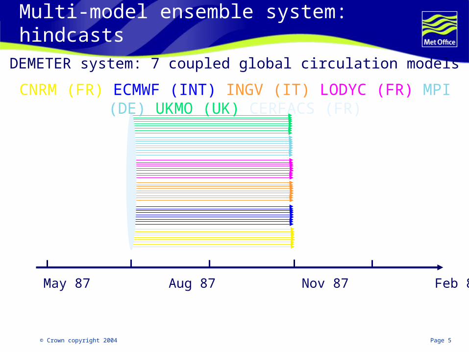
© Crown copyright 2004 Page 5
Multi-model ensemble system: hindcasts
Feb 87 May 87 Aug 87 Nov 87 Feb 88 ...
DEMETER system: 7 coupled global circulation models
CNRM (FR) ECMWF (INT) INGV (IT) LODYC (FR) MPI (DE) UKMO (UK) CERFACS (FR)

© Crown copyright 2004 Page 6
Multi-model ensemble system: hindcasts
Feb 87 May 87 Aug 87 Nov 87 Feb 88 ...
DEMETER system: 7 coupled global circulation models
CNRM (FR) ECMWF (INT) INGV (IT) LODYC (FR) MPI (DE) UKMO (UK) CERFACS (FR)
© Crown copyright 2004 Page 7
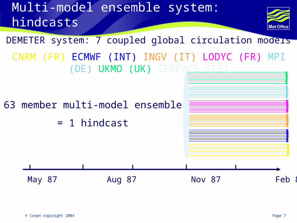
Multi-model ensemble system: hindcasts
Feb 87 May 87 Aug 87 Nov 87 Feb 88 ...
63 member multi-model ensemble
= 1 hindcast
DEMETER system: 7 coupled global circulation models
CNRM (FR) ECMWF (INT) INGV (IT) LODYC (FR) MPI (DE) UKMO (UK) CERFACS (FR)

© Crown copyright 2004 Page 8
Evaluation of DEMETER multi-model hindcast skill
Applications/impact models
Crop yield malaria
Downscaling studies Statistical & dynamical
Sensitivity studies e.g. CGCM Vs AGCM
Results
DEMETER Special Issue 2005
Tellus 57A, No. 3, 21 contributions

© Crown copyright 2004 Page 9
Brier skillscore
Single vs. multi-model: Brier skill score‘basket’ of regions, start dates and leadtimes
Resolution skill score=Res/BSc
Reliability skill score=1-Rel/BSc

© Crown copyright 2004 Page 10
Impact of number of models on multi-model skill:Tropics, JJA precip, 1m lead: RPSS
Multi-model realizationsSingle-model realizations

© Crown copyright 2004 Page 11
France Germany
Denmark Greece
Application models: wheat yield predictions for Europe
From P. Cantelaube and J.-M. Terres, JRC
SIMULATION WEIGHTED YIELD ERROR (%)
± STANDARD ERROR
JRC February 7.1 ± 0.9
JRC April 7.7 ± 0.5
JRC June 7.0 ± 0.6
JRC August 5.4 ± 0.5
DEMETER (Feb. start) 6.0 ± 0.4
DEMETER multi-model predictions (7 models, 63 members, Feb starts) of average wheat yield for four European countries (box-and-whiskers) compared to Eurostat
official yields (black horizontal lines) and crop results from a simulation forced with downscaled ERA40 data (red dots).

© Crown copyright 2004 Page 12
Summary
DEMETER: proof of multi-model benefit using 7 coupled ocean-atmosphere models
More than a multi-model exercise…encouraging results for integration with application models
Mutual understanding between prediction and application communities – ‘end-to-end’ approach
Infrastructure and standardisation developed coordination of model output content (with application partners) model output formats and units (archiving at ECMWF). downscaling techniques/experience centralised model diagnosis/verification system at ECMWF data download and plotting facility http://data.ecmwf.int/data/

© Crown copyright 2004 Page 13
EURO-SIP real-time multi-model ensemble
Three models running at ECMWF: Met Office: GloSea (version of HadCM3) (41-ensemble) ECMWF: system2 (40-ensemble) Météo-France – Arpège (41-ensemble)
Unified system with common development strategy Products in development:
2-model products available on Met Office website ECMWF release of web products is expected soon
© Crown copyright 2004 Page 14
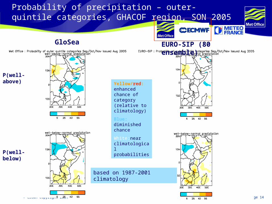
Probability of precipitation – outer-quintile categories, GHACOF region, SON 2005
P(well-above)
P(well-below)
Yellow/red: enhanced chance of category (relative to climatology)
Blue: diminished chance
White:near climatological probabilities
GloSea
based on 1987-2001 climatology
EURO-SIP (80 ensemble)

© Crown copyright 2004 Page 15
Meteo-France
ECMWFMet Office (GloSea)
Probability of lower temperature tercile category: NDJ 2005 (from September)
Forecast is made available on the 15th of each month.
EURO-SIP multi-model

© Crown copyright 2004 Page 16
Tropical Storms
80°S80°S
70°S 70°S
60°S60°S
50°S 50°S
40°S40°S
30°S 30°S
20°S20°S
10°S 10°S
0°0°
10°N 10°N
20°N20°N
30°N 30°N
40°N40°N
50°N 50°N
60°N60°N
70°N 70°N
80°N80°N
20°E
20°E 40°E
40°E 60°E
60°E 80°E
80°E 100°E
100°E 120°E
120°E 140°E
140°E 160°E
160°E 180°
180° 160°W
160°W 140°W
140°W 120°W
120°W 100°W
100°W 80°W
80°W 60°W
60°W 40°W
40°W 20°W
20°W
14.3 10.39.8 13.325.1 26.22 2.9
No Significance 90% Significance 95% Significance 99% Significance
Ensemble size = 40,climate size = 70Forecast start reference is 01/06/2005Tropical Storm FrequencyECMWF Seasonal Forecast
Significance level is 90%JASON
FORECAST CLIMATE
80°S80°S
70°S 70°S
60°S60°S
50°S 50°S
40°S40°S
30°S 30°S
20°S20°S
10°S 10°S
0°0°
10°N 10°N
20°N20°N
30°N 30°N
40°N40°N
50°N 50°N
60°N60°N
70°N 70°N
80°N80°N
20°E
20°E 40°E
40°E 60°E
60°E 80°E
80°E 100°E
100°E 120°E
120°E 140°E
140°E 160°E
160°E 180°
180° 160°W
160°W 140°W
140°W 120°W
120°W 100°W
100°W 80°W
80°W 60°W
60°W 40°W
40°W 20°W
20°W
15 10.38.8 13.327.4 26.23 2.9
No Significance 90% Significance 95% Significance 99% Significance
Ensemble size = 41,climate size =225Forecast start reference is 01/06/2005Tropical Storm FrequencyMet Office Seasonal Forecast
Significance level is 90%JASON
FORECAST CLIMATE
Forecasts starting on 1st June 2005: JASON
80°S80°S
70°S 70°S
60°S60°S
50°S 50°S
40°S40°S
30°S 30°S
20°S20°S
10°S 10°S
0°0°
10°N 10°N
20°N20°N
30°N 30°N
40°N40°N
50°N 50°N
60°N60°N
70°N 70°N
80°N80°N
20°E
20°E 40°E
40°E 60°E
60°E 80°E
80°E 100°E
100°E 120°E
120°E 140°E
140°E 160°E
160°E 180°
180° 160°W
160°W 140°W
140°W 120°W
120°W 100°W
100°W 80°W
80°W 60°W
60°W 40°W
40°W 20°W
20°W
20.4 11.67.8 12.516.6 21.22.5 2.5
No Significance 90% Significance 95% Significance 99% Significance
Ensemble size = 41,climate size = 55Forecast start reference is 01/06/2005Tropical Storm FrequencyMétéo-France Seasonal Forecast
Significance level is 90%JASON
FORECAST CLIMATE
ECMWF Met Office
Météo-France
0 1 2 3 40
5
10
15
20
20051993-2004
Obs 1st May- mid-Sep
AtlW-Pac E-Pac
80°S80°S
70°S 70°S
60°S60°S
50°S 50°S
40°S40°S
30°S 30°S
20°S20°S
10°S 10°S
0°0°
10°N 10°N
20°N20°N
30°N 30°N
40°N40°N
50°N 50°N
60°N60°N
70°N 70°N
80°N80°N
20°E
20°E 40°E
40°E 60°E
60°E 80°E
80°E 100°E
100°E 120°E
120°E 140°E
140°E 160°E
160°E 180°
180° 160°W
160°W 140°W
140°W 120°W
120°W 100°W
100°W 80°W
80°W 60°W
60°W 40°W
40°W 20°W
20°W
18 11.68.8 12.520.1 21.22.4 2.5
No Significance 90% Significance 95% Significance 99% Significance
Ensemble size =120,climate size =165Forecast start reference is 01/06/2005Tropical Storm FrequencyEUROSIP multi-model seasonal forecast
Significance level is 90%JASON
FORECAST CLIMATE
Multimodel
Forecast No. = 18
Climatology = 11.6

© Crown copyright 2004 Page 17
After DEMETER…ENACT: enhanced ocean assimilation
EN2 QC’d dataset and objective analysis, 1956-2004
http://www.hadobs.org
© Crown copyright 2004 Page 18
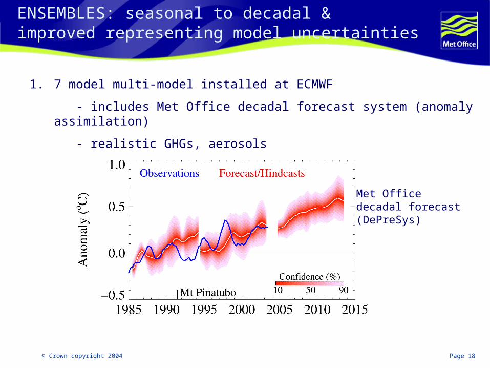
ENSEMBLES: seasonal to decadal &improved representing model uncertainties
1. 7 model multi-model installed at ECMWF
- includes Met Office decadal forecast system (anomaly assimilation)
- realistic GHGs, aerosols
Met Office decadal forecast (DePreSys)

© Crown copyright 2004 Page 19
ENSEMBLES: perturbed physics
From Murphy et al, Nature 2004
2. Many models from perturbing physics parameters, eg. RHcrit for cloud formation
(ref Murphy et al, 2004; and climateprediction.net)

© Crown copyright 2004 Page 20
ENSEMBLES: stochastic physics
E(n)
)(log10 n
3/5k
3k
n = spherical harmonic order
missing energy
3/5k
3k
3k
E(n)
)(log10 n
3k
3/5k
Stochastic physics experiment with ECMWF system:
Cellular Automaton Stochastic Backscatter Scheme (CASBS)
Without CASBS With CASBS
From Tim Palmer, ECMWF
3. Stochastic ‘backscatter’ experiment (ECMWF)
© Crown copyright 2004 Page 21
Summary and plans
EURO-SIP: Real-time follow up to DEMETER products becoming available Meteo-France model fully implemented early 2006 plans for model upgrades, convergence on the periods and
ensemble size of hindcasts
ENACT: enhanced ocean data assimilation – ocean ‘reanalyses’ QC’d ocean data and objective analyses
ENSEMBLES: builds on DEMETER and ENACT seasonal to decadal timescales (and longer) further investigations of model uncertainties calibrating and combining model ensembles

© Crown copyright 2004 Page 22
Met Office forecast: European winter 2005/06
NAO index: difference between normalised pressure anomaly Azores - Iceland
N. Atlantic May SST anomaly associated with +ve NAO
N. Atlantic May SST anomaly 2005
Predicts correct sign in 2 out of 3 winters
Empirical NAO prediction
Rodwell & Folland, 2002

© Crown copyright 2004 Page 23
September surface and sub-surface anomalies and GloSea prediction
GloSea prediction from September
60-90m anomalies
SST anomalies
normalised
actual

© Crown copyright 2004 Page 24
Thank you!
additional slides follow
© Crown copyright 2004 Page 25
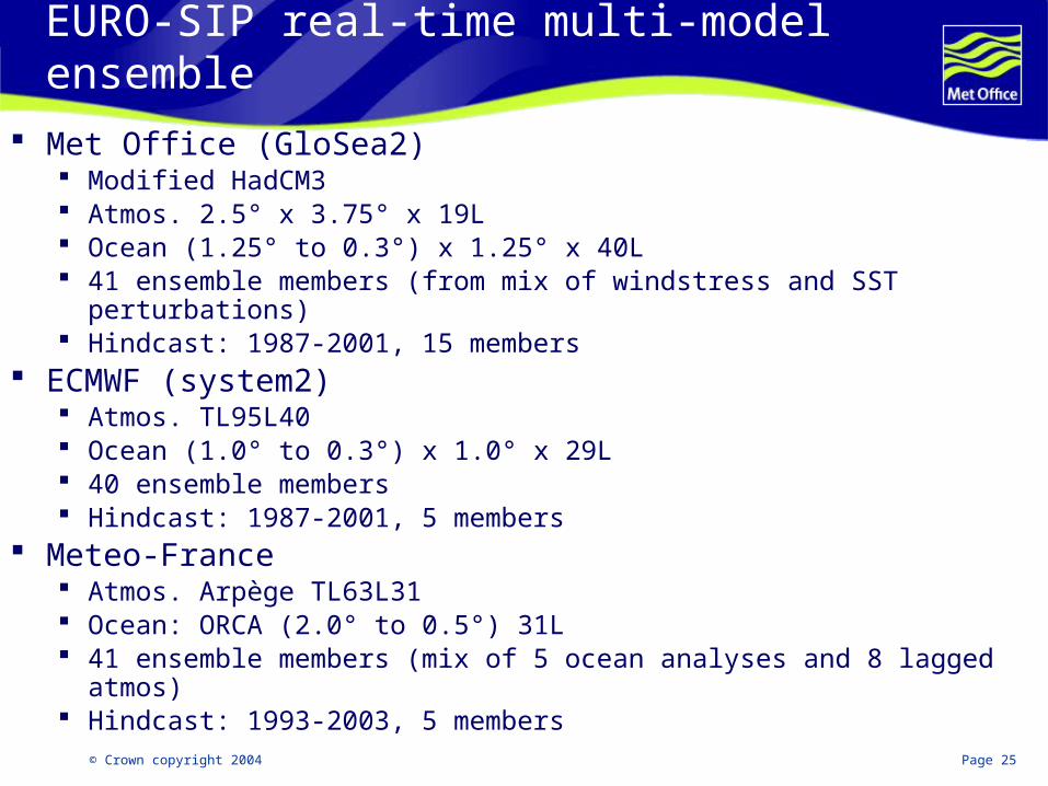
EURO-SIP real-time multi-model ensemble
Met Office (GloSea2) Modified HadCM3 Atmos. 2.5° x 3.75° x 19L Ocean (1.25° to 0.3°) x 1.25° x 40L 41 ensemble members (from mix of windstress and SST perturbations) Hindcast: 1987-2001, 15 members
ECMWF (system2) Atmos. TL95L40 Ocean (1.0° to 0.3°) x 1.0° x 29L 40 ensemble members Hindcast: 1987-2001, 5 members
Meteo-France Atmos. Arpège TL63L31 Ocean: ORCA (2.0° to 0.5°) 31L 41 ensemble members (mix of 5 ocean analyses and 8 lagged atmos) Hindcast: 1993-2003, 5 members

© Crown copyright 2004 Page 26
Parameter Perturbations
Convection• Entrainment rate• Intensity of mass flux • Shape of cloud (anvils) • Cloud water seen by radiation
Radiation• Ice particle size/shape• Sulphur cycle• Water vapour continuum absorption
Boundary layer• Turbulent mixing coefficients: stability-dependence, neutral mixing length
• Roughness length over sea: Charnock constant, free convective value
Dynamics• Diffusion: order and e-folding time
• Gravity wave drag: surface and trapped lee wave constants
• Gravity wave drag start level
Land surface processes• Root depths
• Forest roughness lengths
• Surface-canopy coupling
• CO2 dependence of stomatal conductance
Sea ice• Albedo dependence on temperature• Ocean-ice heat transfer
Large Scale Cloud• Ice fall speed• Critical relative humidity for formation• Cloud droplet to rain: conversion rate and threshold• Cloud fraction calculation

© Crown copyright 2004 Page 27
Met Office seasonal/multi-annual/decadal runs
ModelDePreSys(HadCM3)
Currentoper. range
decadal
assimilationmethod
GloSea(HadCM3*)
Seasonal(6months)
Conventional (OI type)
calibrated anomalies
9-ensembleexperiments1991-2001
pert. ODA
pert. phys.
lagged avge
pert. phys.
lagged avge
Hindcasts pre-production
period: 1991 - 2001
GloSea:->7m: 1st/15th May/Nov 1st June/Dec ->14m: 1st May/June/Nov/Dec-> 10y: 1st May 1964, 1994
DePreSys:
-> 10y: 1st May/Nov (all years)
*Later HadGEM

© Crown copyright 2004 Page 28
Multi-model evaluation:Niño3.4 SST anomaly: ASO at 3m lead:
http://www.ecmwf.int/research/demeter/d/charts/verification/
Correlation:Multi-model = 0.83
Best single model = 0.81

© Crown copyright 2004 Page 29
GloSea development and response to North Atlantic SST ‘tri-pole’ pattern: spring 1989
Jan 89
Feb 89
May 89
GloSeaHadISST
MAM 1989
HadAM3 (+ pers Jan SSTA)
GloSea
ERA40

© Crown copyright 2004 Page 30
ENSEMBLES: seasonal to interannual timescales (and longer); representing model uncertainties
Hindcast pre-production period: 1991-2001; later 1960-2001
9-member ensembles ERA-40 atmosphere and soil initial
conditions ENACT-based ocean initial conditions with
SST and wind perturbations 2 seasonal (7 months),1 annual (12-14
months) runs per year Two multi-annual runs (1965, 1994) except
2 per year for DePreSys) Realistic boundary forcings: GHGs,
aerosols, solar forcing, etc.
ENSEMBLES system: 7 coupled GCMs running at ECMWF
upgraded models from DEMETER (eg. using ENACT developments etc)
Partner Atmosphere Ocean
ECMWF IFS HOPE
ECMWF IFS OPA
CNRM ARPEGE OPA
CERFACS ARPEGE OPA
UKMO GloSea
UKMO DePreSys
IfM ECHAM5 MPI-OM1

© Crown copyright 2004 Page 31
Sensitivity studies: AGCM Vs CGCMNov. start for FMA (3-month lead)
HadAM3 (2-tier) GloSea (1-tier)
Much improved GloSea skill in tropical (south) Atlantic and Indian ocean, from representation of lagged responses to ENSO.
ROC Skill for 2m temperature, upper tercile

© Crown copyright 2004 Page 32
Met Office decadal forecast system (DePreSys):Forecast of global annual mean Ts
Predict 0.36+/-0.23o C (5-95%) warming for the coming decade
Unless a major volcanic eruption occurs!
Uses ‘anomaly assimilation’ (seasonal-range skill very competitive!)