padang area flood control project (i) - jica · padang city is in a pluvial area with an average...
TRANSCRIPT

Indonesia
Padang Area Flood Control Project (I)
Report Date:October, 2002
Field Survey:August, 2001
1.Project Profile and Japan’s ODA Loan
Location Map of the Project Diverging Point of Arau River and Flood Relief Channel
1.1 Background
Padang City is in a pluvial area with an average annual precipitation of approximately 4,000 mm and, consequently, experienced perennial flooding in the lower basin of the rapid-flowing Arau, Krunge and Airdingin rivers.
70% of the total population in Padang City was concentrated in the project area1. The area had a population of 407,000 (as of 1985), and had experienced high population growth as a result of various urbanization factors. The increase in population, in general, was a consequence of overpopulation in rural areas; many rural dwellers converged on urban areas in search of job opportunities, particularly since commercial and economic activities in Padang City had been growing. With such activities on the increase, the number of opportunities was likely to increase as well.
There was a plan to construct factories in Padang City, one of the major cities in Sumatera Island, while the maintenance of roads and coastal areas was to be pursued under the Padang City Master Plan, aimed at realizing urban development targets by 2003. It was, therefore, expected that economic activities in the city would be further activated, and that urbanization would spread even more quickly than before.
In light of these factors, implementation of flood and drainage controls was needed to mitigate the increasing incidence of flood damage in the area.
1.2 Objectives
To prevent flooding damage in the Padang City area by improving drainage and flood prevention on rivers and drainage channels.
1 1 The Padang City area is 695 km2, while the project area is 200 km2 (cf. Tokyo 23-wards is 577 km2).
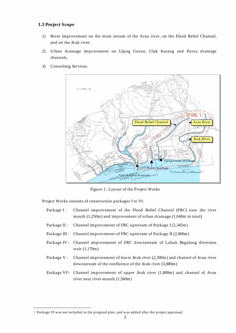
1.3 Project Scope
1) River improvement on the main stream of the Arau river, on the Flood Relief Channel, and on the Jirak river.
2) Urban drainage improvement on Ujung Gurun, Ulak Karang and Purus drainage channels.
3) Consulting Services.
urus drainage
e
Ujung Gurun drainage
Flood Relief Channel Arau River
Jirak River
Figure 1 : Layo
Project Works consists of construction pa
Package I : Channel improvementmouth (1,250m) and im
Package II : Channel improvement
Package III : Channel improvement
Package IV : Channel improvementweir (1,170m)
Package V : Channel improvement downstream of the conf
Package VI2: Channel improvementriver near river-mouth
2 Package VI was not included in the proginal plan,
P
Ulak Karang drainag
ut of the Project Works
ckages I to VI.
of the Flood Relief Channel (FRC) near the river provement of urban drainage (1,040m in total)
of FRC upstream of Package I (2,345m)
of FRC upstream of Package II (2,060m)
of FRC downstream of Lubuk Begalung diversion
of lower Jirak river (2,300m) and channel of Arau river luence of the Jirak river (3,880m)
of upper Jirak river (1,800m) and channel of Arau (1,560m)
2 and was added after the project appraisal.

1.4 Borrower / Executing Agency
The Government of the Republic of Indonesia / Directorate General of Water Resources
(DGWR), Ministry of Settlement and Regional Infrastructure
※ Project Implementation Unit is “Padang Area Flood Control Project” of West Sumatera
Water Resources Management and Flood Control Project
1.5 Outline of Loan Agreement
Loan Amount
Loan Disbursed Amount
8,063 million yen
7,630 million yen
Exchange of Notes
Loan Agreement
December, 1990
December, 1990
Terms and Conditions
-Interest Rate
-Repayment Period (Grace Period)
-Procurement
2.5 % p.a.
30 years (10 years)
General Untied
Final Disbursement Date December, 1996
3

2.Results and Evaluation
2.1 Relevance
The purpose of the project was to protect Padang City from perennial flood damage. Padang City is the Capital of West Sumatra Province, where the population and economy have continued to grow. The socio-economic damage caused by flood has been increasing, so that the flood control was urgently needed. The project was a government priority and is still relevant, as seen from the growth in population and economic activity (number of enterprises) in the Project Area, as shown in Figure 2 below.
9.0 9.0
11.5 12.1 12.8
9.410.9
19.1 19.020.0
637,263 647,686 666,590 684,987 703,893 723,321 743,285 763,799 784,849 786,044
0.0
5.0
10.0
15.0
20.0
25.0
1990Year of
Appraisal
1991 1992 1993 1994 1995 1996Year of
Completion
1997 1998 19990
100,000
200,000
300,000
400,000
500,000
600,000
700,000
800,000
900,000
Nos. of Enterprises (×1,000)Population
Figure 2 : Population and Enterprises in Padang City
Source : National Statistics Office in Padang
2.2 Efficiency
2.2.1 Project Scope
During project implementation, additional river improvement work, designated Package VI, was completed, since the upper Jirak River’s surroundings had been developed after the project appraisal in 1990, and since the Local Government had eagerly requested that the project include the additional package in its overall scope. Package VI was expected to be effective in reducing possible flooding and in reducing the chances of flooding damage.
2.2.2 Implementation Schedule
Land acquisition posed difficulties throughout project implementation. It took longer to negotiate with land/house owners than expected because the unit prices of land and compensation under governmental guidance were much lower than the people’s actual requests. Also, the annual budget for land acquisition/house compensation was insufficient at that time. Other items such as selection of contractor, construction work and consulting services were delayed mainly as a result of the incorporation of Package VI.
4
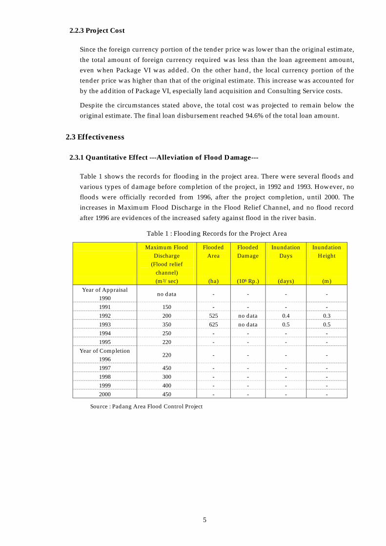
2.2.3 Project Cost
Since the foreign currency portion of the tender price was lower than the original estimate, the total amount of foreign currency required was less than the loan agreement amount, even when Package VI was added. On the other hand, the local currency portion of the tender price was higher than that of the original estimate. This increase was accounted for by the addition of Package VI, especially land acquisition and Consulting Service costs.
Despite the circumstances stated above, the total cost was projected to remain below the original estimate. The final loan disbursement reached 94.6% of the total loan amount.
2.3 Effectiveness
2.3.1 Quantitative Effect ---Alleviation of Flood Damage---
Table 1 shows the records for flooding in the project area. There were several floods and various types of damage before completion of the project, in 1992 and 1993. However, no floods were officially recorded from 1996, after the project completion, until 2000. The increases in Maximum Flood Discharge in the Flood Relief Channel, and no flood record after 1996 are evidences of the increased safety against flood in the river basin.
Table 1 : Flooding Records for the Project Area
Maximum Flood Discharge
(Flood relief channel)
Flooded Area
Flooded Damage
Inundation Days
Inundation Height
(m3/sec) (ha) (106 Rp.) (days) (m) Year of Appraisal
1990 no data - - - -
1991 150 - - - - 1992 200 525 no data 0.4 0.3 1993 350 625 no data 0.5 0.5 1994 250 - - - - 1995 220 - - - -
Year of Completion 1996
220 - - - -
1997 450 - - - - 1998 300 - - - - 1999 400 - - - - 2000 450 - - - -
Source : Padang Area Flood Control Project
5

2.3.2 Assessment by the Beneficiaries ---Results of Interview Survey---
A questionnaire-based Interview Survey of beneficiaries was carried out in order to examine the effects/impact of the project after project completion. A hundred (100) interviewees 3 were selected randomly from the area surrounding the Arau River (Palinngam, Pemancungan), the Jirak River (Mata Air Timur) and the Flood Relief Channel (Parak Kopi), with the cooperation of the Project Office. The major interview items in the questionnaire are as shown below:
1) Suffering record and people’s assessment of security, sanitation and socio-economic benefit before and after the project
2) Impact/indirect effects of the project
3) Further requirements and recommendations
Major results related to the direct effects, i.e. flood alleviation effects, are described below.
Figure 3 summarizes the answers to the question asking beneficiaries to compare the extent of flood damage before and after project completion. These data indicate that beneficiaries believe the project contributed to reducing the extent of flood damage.
Figure 3 : Comparison of the extent of flood damage
before and after project completion
Figure 4 illustrates the beneficiaries’ assessment of how regional safety/security was
improved by the project. Few of the respondents feared floods, although they had been
afraid of floods before project completion.
6 3 The population of the project area was estimated at around 650,000 as of 1998.
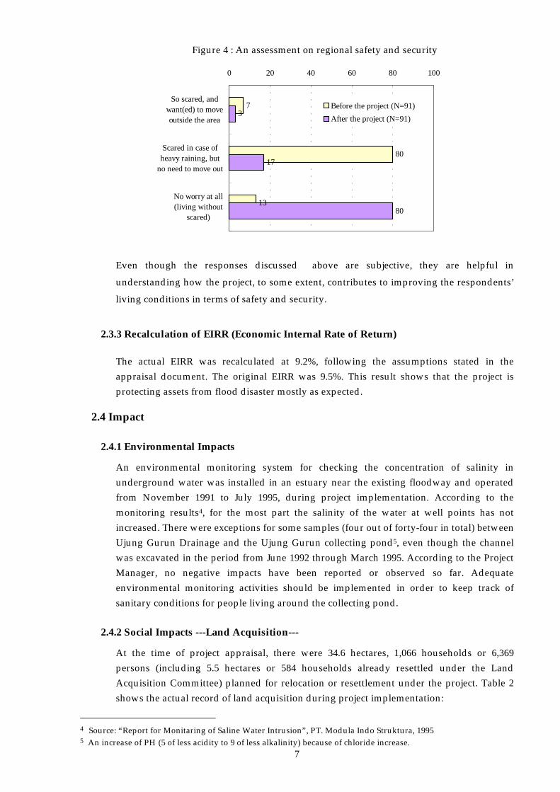
Figure 4 : An assessment on regional safety and security
7
80
13
3
17
80
0 20 40 60 80 100
So scared, andwant(ed) to moveoutside the area
Scared in case ofheavy raining, but
no need to move out
No worry at all(living without
scared)
Before the project (N=91)After the project (N=91)
Even though the responses discussed above are subjective, they are helpful in
understanding how the project, to some extent, contributes to improving the respondents’
living conditions in terms of safety and security.
2.3.3 Recalculation of EIRR (Economic Internal Rate of Return)
The actual EIRR was recalculated at 9.2%, following the assumptions stated in the appraisal document. The original EIRR was 9.5%. This result shows that the project is protecting assets from flood disaster mostly as expected.
2.4 Impact
2.4.1 Environmental Impacts
An environmental monitoring system for checking the concentration of salinity in underground water was installed in an estuary near the existing floodway and operated from November 1991 to July 1995, during project implementation. According to the monitoring results4, for the most part the salinity of the water at well points has not increased. There were exceptions for some samples (four out of forty-four in total) between Ujung Gurun Drainage and the Ujung Gurun collecting pond5, even though the channel was excavated in the period from June 1992 through March 1995. According to the Project Manager, no negative impacts have been reported or observed so far. Adequate environmental monitoring activities should be implemented in order to keep track of sanitary conditions for people living around the collecting pond.
2.4.2 Social Impacts ---Land Acquisition---
At the time of project appraisal, there were 34.6 hectares, 1,066 households or 6,369 persons (including 5.5 hectares or 584 households already resettled under the Land Acquisition Committee) planned for relocation or resettlement under the project. Table 2 shows the actual record of land acquisition during project implementation:
4 Source: “Report for Monitaring of Saline Water Intrusion”, PT. Modula Indo Struktura, 1995
7 5 An increase of PH (5 of less acidity to 9 of less alkalinity) because of chloride increase.

Table 2 : Actual Land Acquisition
Area (ha) Households (houses) Annual Cumulative Annual Cumulative
Original Plan n.a. 34.6 n.a. 1,066 Before Appraisal
(after 1988) - 5.5 - 584
Year of Appraisal 1990 / 1991
4.0 9.5 140 724
1991 / 1992 9.2 18.7 398 1,122 1992 / 1993 16.3 35.0 447 1,569 1993 / 1994 4.0 39.0 121 1,690 1994 / 1995 12.7 51.7 467 2,157
Total 51.7 2,157
Source : Padang Area Flood Control Project
Due mainly to the addition of Package VI, the total area and total number of households increased. Most of the inhabitants in the land acquisition area resettled in Sieba, a new residential area about 5 km from the heart of Padang City.
Land was acquired by the local government under the procedure shown below :
(a) Establishment of committee for land acquisition / house compensation (b) Inventory Survey (land owner, area, quantity of asset, etc.) (c) Evaluation of assets (d) Information and explanation to inhabitants (e) Negotiation (f) Conclusion/agreement and payment, and (g) Resettlement
During the implementation of land acquisition, the claims from landowners for demanding higher compensation rate were observed, but all the landowners finally agreed the government’s offers without serious confrontation. The committee and landowner had the option of requesting arbitration by a higher authority in the event of a failure to reach a conclusion, but such serious steps were not required.
2.4.3 Other Impacts
1) Impacts on Economy
It is difficult to analyze quantitatively how the project affects improvement of the regional economy. To gain an insight of the contribution by the project, results of the Interview Survey should be quoted. Most respondents, 85 out of 100, responded the project supports economic activities in the region, with selecting specific reasons shown in Figure 5. Fifty-three selected “Improvement of land use”, forty-six selected “Increase of job opportunity” and forty-nine selected “Improvement of the living standards”. These are surely based on the beneficiaries’ feeling or subjectivity. Nonetheless, these responses suggest the project has certainly had positive impacts on the regional economy.
8

Figure 5 : Specification of the economic activity (N=100, MA)
53
46
49
0 20 40 60 80 100
Improvement ofland use
Increase of jobopportunity
Improvement ofliving standards
2) Impacts on Living Environment
During the field survey, impacts of the inspection roads (Figure 6), and asphalt pavement on the dike or river channel for river maintenance, were evaluated positively. That information is also reflected in the Interview Survey to the beneficiaries. 85% of the respondents answered “Yes” to the question “Do you think the project has brought any convenience to your life, such as improved access to areas outside your community?”. The major reason given was that “transportation between villages became more convenient” and “direct approaches from house to road were set up”.
This Project has achieved its original objective, flood alleviation, and contributes to improving the community’s living standards in terms of transportation access, which was facilitated by construction of an asphalt-paved inspection road.
Figure 6 : Inspection road in Upper Jirak River
9

2.5 Sustainability
2.5.1 Operation and Maintenance
1) O&M Organization
The Padang Area Flood Control Project, the project implementation body under West Sumatra Province, is currently responsible for the O&M of all Project facilities (See Figure 7). This body plans to transfer responsibility and authority for operation and maintenance to the Local Government of Padang City, after completion of the on-going Stage II6.
Figure 7 : Organization of West Sumatra Water Resources Management
and Flood Control Project
Land Acquisition
Section O&M Section (Temporary)
Survey & Design Section
Implementation Section
Padang Area Flood Control Project
Water Resources Management and Flood Control Project
Water Resources Services
Governor of Province
Source : Padang Area Flood Control Project
2) Current Status of Project Facilities
The Mission on Project Evaluation visited the project site in July, 2001, to inspect the current status of the project facilities constructed under the Project, Stage I, as well as those of the on-going project, Stage II.
The facilities, including the Flood Relief Channel, Revetment (protection), Collecting Pond, and Drainage, are still in good condition. The mission did, however note the following problems, which currently are minor, yet merit attention to ensure the project’s sustainability:
(a) Insufficient capacity of city drainage
--- There are some areas in the project site that suffer inundation from city drainage. The Jati Drainage area and its surroundings is one case where the
10
6 Stage II is also funded by Japanese ODA loan, under implementation from 1997 to 2001 with a total amount of 4,859 million Yen. Stage II consists of five construction packages and consulting services, and the major purpose is to improve the river channel of Kuranji river, Balimbing river, Tabing river and Air Dingin river as well as to protect coastal area from seawater erosion.

overflowing of drain water seems to occur easily, the result of insufficient maintenance of the facility.
(b) Sand mining in the upstream of rivers causing damage to structures
--- In the past there has been intensive sand-mining by private companies or individuals in the upper reaches of the rivers, since the quality of sand is suitable for glass manufacture. Although the local government had officially prohibited sand-mining in consideration of negative impacts on river structures, some parties still continue to extract sand from river beds, possibly causing downstream damage, especially to bridge foundations.
2.5.2 Technical Capacity
According to the Project Manager, through the daily construction work on Stage I and Stage II, O&M staff are supposed to learn certain technical skills/knowledge provided by the Project Consultant. In addition, the staff have periodical training seminars provided by the Central Government, so that they are supposed to keep a certain level of technical skill. However, their skill cannot be measured due to lack of objective indicators set to compare the skill levels among them.
2.5.3 Toward Sustainability
The mission finds that chronic flood damage was significantly reduced after project completion. At the time of this evaluation, Stage II of the project was on-going, to be completed by the end of 2001. While the two projects are expected to further enhance flood control capability in the Padang City area, whether or not a sound budget for the operation and maintenance activity can be secured is a point of concern. When the local government of Padang City handed over the project , funding may become a major constraint to project sustainability.
11
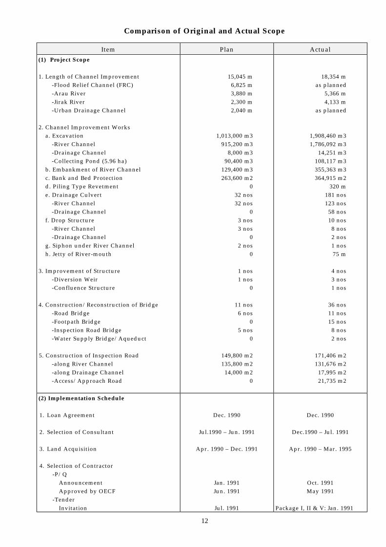
Comparison of Original and Actual Scope
Item Plan Actual (1) Project Scope 1. Length of Channel Improvement
-Flood Relief Channel (FRC) -Arau River -Jirak River -Urban Drainage Channel
2. Channel Improvement Works a. Excavation
-River Channel -Drainage Channel -Collecting Pond (5.96 ha)
b. Embankment of River Channel c. Bank and Bed Protection d. Piling Type Revetment e. Drainage Culvert
-River Channel -Drainage Channel
f. Drop Structure -River Channel -Drainage Channel
g. Siphon under River Channel h. Jetty of River-mouth
3. Improvement of Structure
-Diversion Weir -Confluence Structure
4. Construction/Reconstruction of Bridge -Road Bridge -Footpath Bridge -Inspection Road Bridge -Water Supply Bridge/Aqueduct
5. Construction of Inspection Road -along River Channel -along Drainage Channel -Access/Approach Road
15,045 m 6,825 m 3,880 m 2,300 m 2,040 m
1,013,000 m3 915,200 m3
8,000 m3 90,400 m3
129,400 m3 263,600 m2
0 32 nos 32 nos
0 3 nos 3 nos
0 2 nos
0
1 nos 1 nos
0
11 nos 6 nos
0 5 nos
0
149,800 m2 135,800 m2
14,000 m2 0
18,354 m as planned
5,366 m 4,133 m
as planned
1,908,460 m3 1,786,092 m3
14,251 m3 108,117 m3 355,363 m3 364,915 m2
320 m 181 nos 123 nos
58 nos 10 nos
8 nos 2 nos 1 nos 75 m
4 nos 3 nos 1 nos
36 nos 11 nos 15 nos
8 nos 2 nos
171,406 m2 131,676 m2
17,995 m2 21,735 m2
(2) Implementation Schedule 1. Loan Agreement 2. Selection of Consultant 3. Land Acquisition 4. Selection of Contractor
-P/Q Announcement Approved by OECF
-Tender Invitation
Dec. 1990
Jul.1990 – Jun. 1991
Apr. 1990 – Dec. 1991
Jan. 1991 Jun. 1991
Jul. 1991
Dec. 1990
Dec.1990 – Jul. 1991
Apr. 1990 – Mar. 1995
Oct. 1991 May 1991
Package I, II & V: Jan. 1991
12
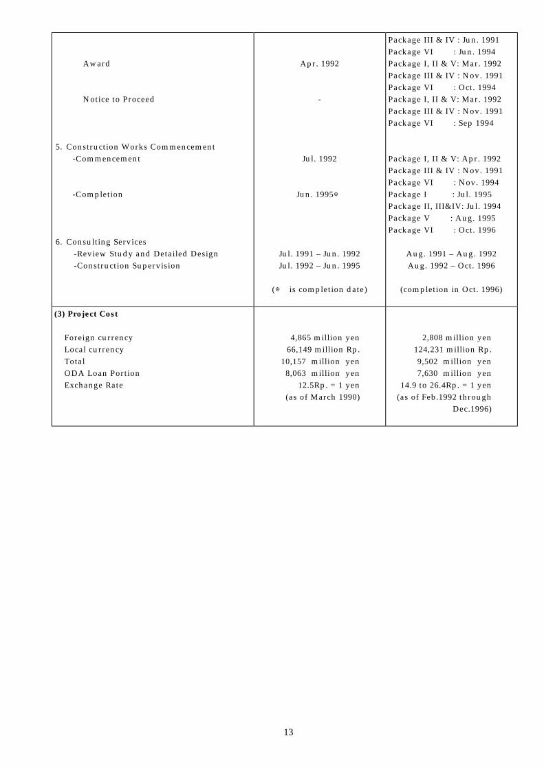
Award Notice to Proceed
5. Construction Works Commencement -Commencement -Completion
6. Consulting Services -Review Study and Detailed Design -Construction Supervision
Apr. 1992 -
Jul. 1992
Jun. 1995◎
Jul. 1991 – Jun. 1992 Jul. 1992 – Jun. 1995
(◎ is completion date)
Package III & IV : Jun. 1991 Package VI : Jun. 1994 Package I, II & V: Mar. 1992 Package III & IV : Nov. 1991 Package VI : Oct. 1994 Package I, II & V: Mar. 1992 Package III & IV : Nov. 1991 Package VI : Sep 1994
Package I, II & V: Apr. 1992 Package III & IV : Nov. 1991 Package VI : Nov. 1994 Package I : Jul. 1995 Package II, III&IV: Jul. 1994 Package V : Aug. 1995 Package VI : Oct. 1996
Aug. 1991 – Aug. 1992 Aug. 1992 – Oct. 1996
(completion in Oct. 1996)
(3) Project Cost Foreign currency Local currency Total ODA Loan Portion Exchange Rate
4,865 million yen 66,149 million Rp.
10,157 million yen 8,063 million yen
12.5Rp. = 1 yen (as of March 1990)
2,808 million yen 124,231 million Rp. 9,502 million yen 7,630 million yen
14.9 to 26.4Rp. = 1 yen (as of Feb.1992 through
Dec.1996)
13

Independent Evaluator’s Opinion on
Padang Area Flood Control Project (I)
Professor of Economics and Accountancy, Gadjah Mada University Revrisond Baswir
The project has met the needs of Padang city people. However, from development policy point of view, there is a big question about the priority of the project. Considering that most of Indonesian people live as a farmer in rural areas, it is questionable whether the project is not a part of an urban biased development policy. In addition, learning from the currency crisis that hit Indonesia in 1997, it is also questionable whether the project is not a part of a loan driven development policy of the past.
Increasing number of population can not be stated as a reason to measure the relevant of a project. Since most of economic development activities in Indonesia was concentrated in capital cities, there is a possibility that the project itself has become a pull factor for the increasing number of population in Padang city. Reducing rural and urban economic disparity is an important element of Indonesia middle and long term development plans.
The involvement of the Project Office in evaluating the direct and/or indirect impact of the project is questionable. While the report stated that the responses on the impact of the project is subjective, the involement of the Project Office in the evaluation process can make the end result of the evaluation biased to the benefit of the Project Office.
Special attention need to be put on the efficiency of the project. While the scope of the project is broader than the proposed plan, it is questionable why the foreign currency portion and the overall costs of the project is less than it should be. There is a possibility that the proposed budget is overstated, and/or part of the project costs is actually pay by the people that is resettled in Siteba. If the project is really a part of a loan driven development policy of the past, the sustainability of the project is also questionable.
JBIC Comment
The project cost under-run occurs mainly due to the appropriate competition of bidding and, in case of that of the foreign currency portion, also due to changeable foreign exchange rate.
14