overview of ogc a n d s t r a t e g i c a c t i v i t i e s george percivall ogc chief architect...
TRANSCRIPT
OOvveerrvviieeww
ooff
OOGGCC
aanndd
SSttrraatteeggiicc
AAccttiivviittiieess
George PercivallOGC Chief Architect
Executive Director, Interoperability [email protected]
Copyright © 2009, Open Geospatial Consortium, Inc.,Copyright © 2009, Open Geospatial Consortium, Inc.,
– Grid-based Geoprocessing Strategy Session –

Helping the World to CommunicateGeographically
OGC activitiesOGC activities
• The OGC Interoperability Program
• OWS-6 Testbed with focus on Grid Processing
• OWS-7 Planning
• Additional topics: G-OWS, GEOSS, INSPIRE, GMES
Copyright © 2009, Open Geospatial Consortium, Inc.,

Helping the World to CommunicateGeographically
3
What is the OGC?What is the OGC?
• Open Geospatial Consortium, Inc. (OGC)
– Not-for-profit, international voluntary consensus standards organization
– Founded in 1994, Incorporated in US, UK, Australia
– 385 industry, government, research and university members
OGC MissionOGC Mission
To lead in the development, promotion and To lead in the development, promotion and harmonization of open geospatial standards harmonization of open geospatial standards
……

Helping the World to CommunicateGeographically
© 2009 Open Geospatial Consortium, Inc.
What Drives OGC Standards Development?What Drives OGC Standards Development?
OGC members are tackling major interoperability challenges of next-generation data / service sharing and collaboration….
Developing new specifications for location-based services interoperability and spatially enabling the systems and enterprises
OGCWeb
Services
Earth Science / Earth Observation
Sustainable Development
E-Government
Disaster / Emergency Management
Defense & Intelligence
Sensor Webs
Location-BasedServices
Web Mapping
Modeling &Simulation
Decision Support
Multi-SourceOperations
Critical Infrastructure Protection
Mobile Enterprise
Insurance/Re-Insurance
Research Validation
Regional Planning
Logistics / Asset Management
Digital Rights Management
Urban Planning
Aviation / Telematics
Helping the World to CommunicateGeographically
Copyright © 2009, Open Geospatial Consortium, Inc.,
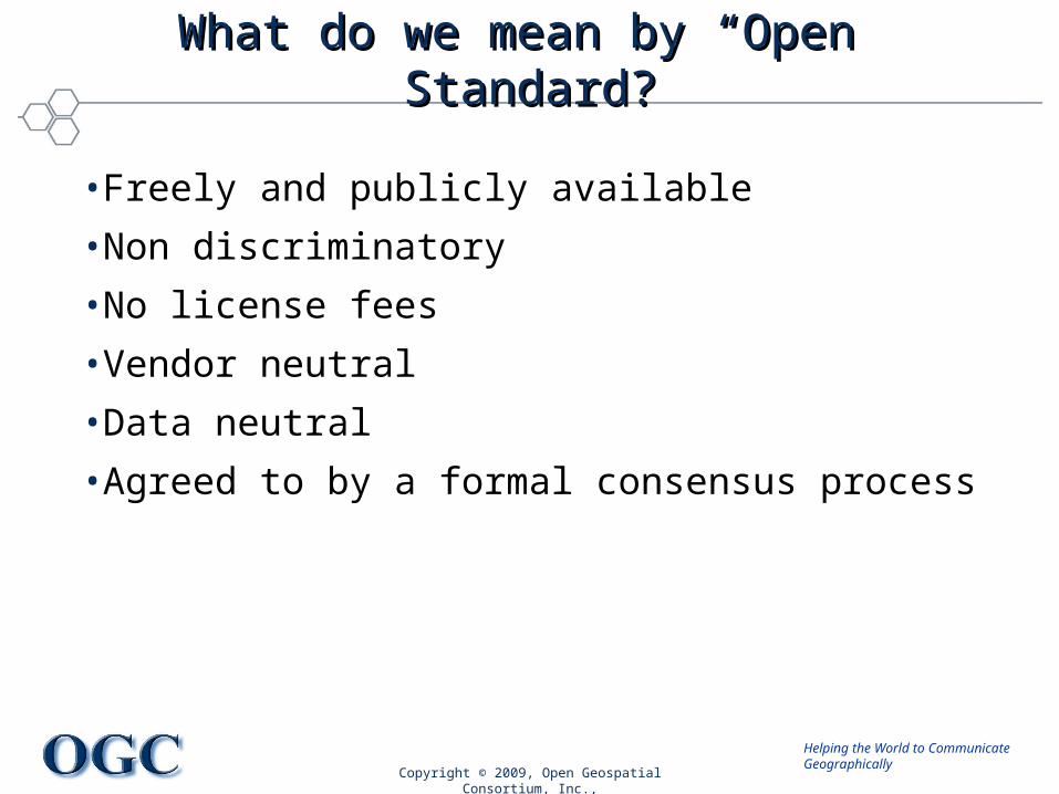
What do we mean by “Open” Standard?What do we mean by “Open” Standard?
• Freely and publicly available
• Non discriminatory
• No license fees
• Vendor neutral
• Data neutral
• Agreed to by a formal consensus process

Helping the World to CommunicateGeographically
Copyright © 2009, Open Geospatial Consortium, Inc.,
Return on InvestmentReturn on Investment
Multiple studies confirm the value and advantage of open standards based solutions:
– NASA Geospatial Interoperability: Return on Investment Study: http://gio.gsfc.nasa.gov/docs/ROI%20Study.pdf
– Value of Standards, Delphi Report: http://www.delphigroup.com/research/whitepapers/20030728-standards.pdf
– Economic Benefits of Standardization, DIN German Institute for Standardization: http://www.sis.se/upload/632248898159687500.pdf

Helping the World to CommunicateGeographically
Copyright © 2009, Open Geospatial Consortium, Inc.,
Where does OGC fit in the ‘standards’ world?Where does OGC fit in the ‘standards’ world?
IETF/OGF/OASIS/W3C
Infrastructure: JSDL, WSDL, UDDI, SOAP,
XMLISODomains: Object / Abstract Models,
Content, Vocabulary
OGCSoftware Interfaces:
Instantiate Domain and Dejure into
Infrastructure
De
Fact
oD
e Ju
re
Domain Infrastructure

Helping the World to CommunicateGeographically
8
The OGC-OGF CollaborationThe OGC-OGF Collaboration
• Promote best practices and international standardization for distributed geospatial data processing capabilities that is:– TransparentTransparent -- users is not aware of the infrastructure– InteroperableInteroperable -- the resources work together– ScalableScalable -- small local, to massive distributed platforms

Helping the World to CommunicateGeographically
9
OGF/OGC Collaboration Described inOGF/OGC Collaboration Described inIEEE Computer, Nov. 08IEEE Computer, Nov. 08
Helping the World to CommunicateGeographically
Copyright © 2009, Open Geospatial Consortium, Inc.,
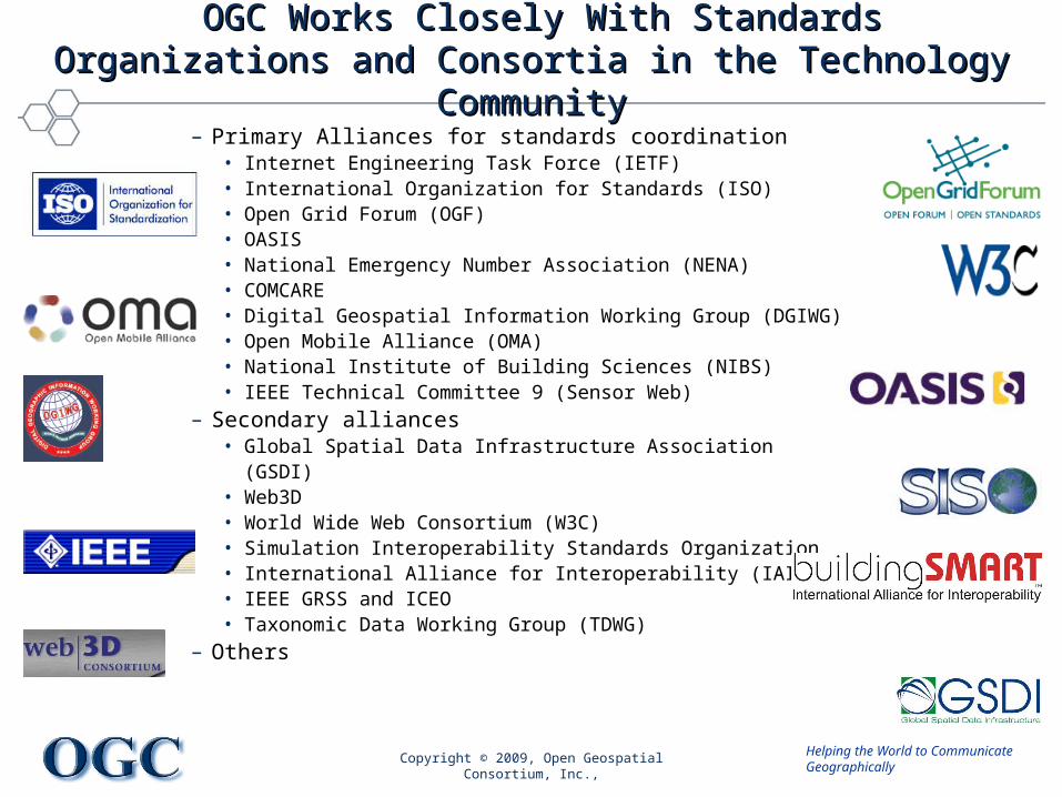
OGC Works Closely With Standards Organizations and OGC Works Closely With Standards Organizations and Consortia in the Technology CommunityConsortia in the Technology Community
– Primary Alliances for standards coordination• Internet Engineering Task Force (IETF)• International Organization for Standards (ISO)• Open Grid Forum (OGF)• OASIS• National Emergency Number Association (NENA)• COMCARE• Digital Geospatial Information Working Group (DGIWG)• Open Mobile Alliance (OMA) • National Institute of Building Sciences (NIBS)• IEEE Technical Committee 9 (Sensor Web)
– Secondary alliances• Global Spatial Data Infrastructure Association (GSDI)• Web3D• World Wide Web Consortium (W3C)• Simulation Interoperability Standards Organization• International Alliance for Interoperability (IAI) • IEEE GRSS and ICEO• Taxonomic Data Working Group (TDWG)
– Others

Helping the World to CommunicateGeographically
Copyright © 2009, Open Geospatial Consortium, Inc.,
Market AvailabilityMarket Availabilitysee http://www.opengeospatial.org/resource/products see http://www.opengeospatial.org/resource/products
• Free availability of standards stimulates market
• Hundreds of Products Implementing OGC Standards
• Compliance Test & Certification Program

Helping the World to CommunicateGeographically
Copyright © 2009, Open Geospatial Consortium, Inc.,
OGC’s Approach for Advancing InteroperabilityOGC’s Approach for Advancing Interoperability
• Interoperability Program (IP) - a global, innovative, hands-on prototyping and testing program designed to accelerate interface development and validation, and bring interoperability to the market
• Specification Development Program –Consensus processes similar to other Industry consortia (World Wide Web Consortium, OMA, OMG, etc.).
• Outreach and Community Adoption Program – education and training, encourage take up of OGC specifications, business development, communications programs
Rapid InterfaceDevelopment
StandardsSetting
MarketAdoption
Helping the World to CommunicateGeographically
Copyright © 2009, Open Geospatial Consortium, Inc.
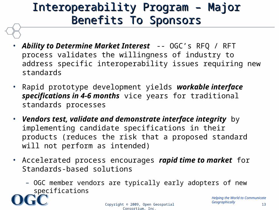
Interoperability Program – Major Benefits To SponsorsInteroperability Program – Major Benefits To Sponsors
• Ability to Determine Market Interest -- OGC’s RFQ / RFT process validates the willingness of industry to address specific interoperability issues requiring new standards
• Rapid prototype development yields workable interface specifications in 4-6 months vice years for traditional standards processes
• Vendors test, validate and demonstrate interface integrity by implementing candidate specifications in their products (reduces the risk that a proposed standard will not perform as intended)
• Accelerated process encourages rapid time to market for Standards-based solutions
– OGC member vendors are typically early adopters of new specifications
13

Helping the World to CommunicateGeographically
OGC Interoperability Program Initiative OGC Interoperability Program Initiative Return on InvestmentReturn on Investment
• Participants in OGC testbeds and pilot initiatives contribute more in in-kind contributions (labor, software, infrastructure etc.) than is provided in Sponsor funding.
• For every one Euro or Dollar in sponsorship funding, the following initiatives have yielded:– Web Mapping Testbed I 4 times– Open location Services 1.5 times– OGC Web Services 3 Testbed 3 times– OGC Web Services 4 Testbed 3.5 times– OGC Web Services 5 Testbed 3.3 times
• Why? Vendors want early influence in specification development, early skill building, visibility, and opportunity for early market deployment of standards.
Copyright © 2009, Open Geospatial Consortium, Inc. 14

Helping the World to CommunicateGeographically
Copyright © 2009, Open Geospatial Consortium, Inc.
OGC Initiative ProcessOGC Initiative Process
*RFQ/CFP = Request for Quotation/Call for Participation*RFQ/CFP = Request for Quotation/Call for Participation
Develop & Develop & TestTest
Task DTask D
Selection & Selection & Kick-offKick-off
Task CTask C
RFQ/CFP*RFQ/CFP*DevelopmentDevelopment
Task BTask B
ConceptConceptDevelopmentDevelopment
Task ATask A
Deploy & Deploy & PersistPersist
Task ETask EOGC Interoperability Program Policy and ProceduresOGC Interoperability Program Policy and Procedureshttp://www.opengeospatial.org/ogc/policies/ippp
15

OGC Web Services, Phase 6 OWS-6 OGC Web Services, Phase 6 OWS-6 TestbedTestbed
Copyright © 2009, Open Geospatial Consortium, Inc.,Copyright © 2009, Open Geospatial Consortium, Inc.,

Helping the World to CommunicateGeographically
OWS-6 Testbed StatisticsOWS-6 Testbed Statistics
• 10 Sponsoring Organizations
• Budget– Sponsorship total $1.8M– Total In-kind: $4M
• Participation– 31 organizations with
substantial participation – ~80 orgs involved or
commenting
• Schedule– Call for Sponsors: 2/08– RFQ/CFP issued: 7/08– Kickoff: 10/08– Demonstrations: 04/09– Final Reports: 6/09
• Deliverables– 47 Components– 14 Demonstrations– 30 Engineering Reports
Copyright © 2009, Open Geospatial Consortium, Inc. 17

Helping the World to CommunicateGeographically
OWS-6 SponsorsOWS-6 Sponsors
• U.S. National Geospatial Intelligence Agency (NGA)• U.S. Dept of Defense - Joint Program Executive Office –
Chemical & Biological Defense (JPEO-CBD) • Natural Resources Canada (NRCan) GeoConnections• U.S. Federal Aviation Administration (FAA)• EUROCONTROL - The European Organization for the
Safety of Air Navigation• EADS Defence and Communications Systems (DCS)• U.S. Geological Survey (USGS)• BAE Systems• ERDAS, Inc.• Lockheed Martin Corporation
© 2009 Open Geospatial Consortium, Inc. 18

Helping the World to CommunicateGeographically
OWS-6 ParticipantsOWS-6 Participants• 52North• AM Consult• Carbon Project• Compusult• con terra• CubeWerx• ESRI• FedEx• Galdos• Geomatys• GIS.FCU, Taiwan• GMU CSISS• Hitachi• iGSI, GmbH• interactive instruments• lat/lon, GmbH
• LISAsoft• Luciad• Lufthansa• NOAA MDL• Northrop Grumman TASC• OSS Nokalva• PCAvionics• Snowflake• Spot Image/ESA/Spacebel• STFC, UK• UAB CREAF• Univ Bonn Karto• Univ Bonn IGG• Univ Bunderswehr• Univ Muenster IfGI• Vightel• Yumetech
19© 2009 Open Geospatial Consortium, Inc.

Helping the World to CommunicateGeographically
OWS-6 ThreadsOWS-6 Threads
• SWE (Sensor Web Enablement)– Imagery services, information models, CCSI, catalog
• GPW (Geo-Processing Workflow)– Asynchronous workflow, WPS grid processing, GML schema
development
• DSS (Decision Support Services)– WMTS, 3D indoor-outdoor routing / tracking, W3DS, flythrough
client, integrated client, ISO 19117/SLD portrayal
• AIM (Aeronautical Information Management – new thread)– Service orientation, AIXM, notifications, and flight operations
• CITE (Conformance and Interoperability Test & Evaluation)– Complete WMS 1.3, and DGIWG Profile of WMS
20© 2009 Open Geospatial Consortium, Inc.
Helping the World to CommunicateGeographically
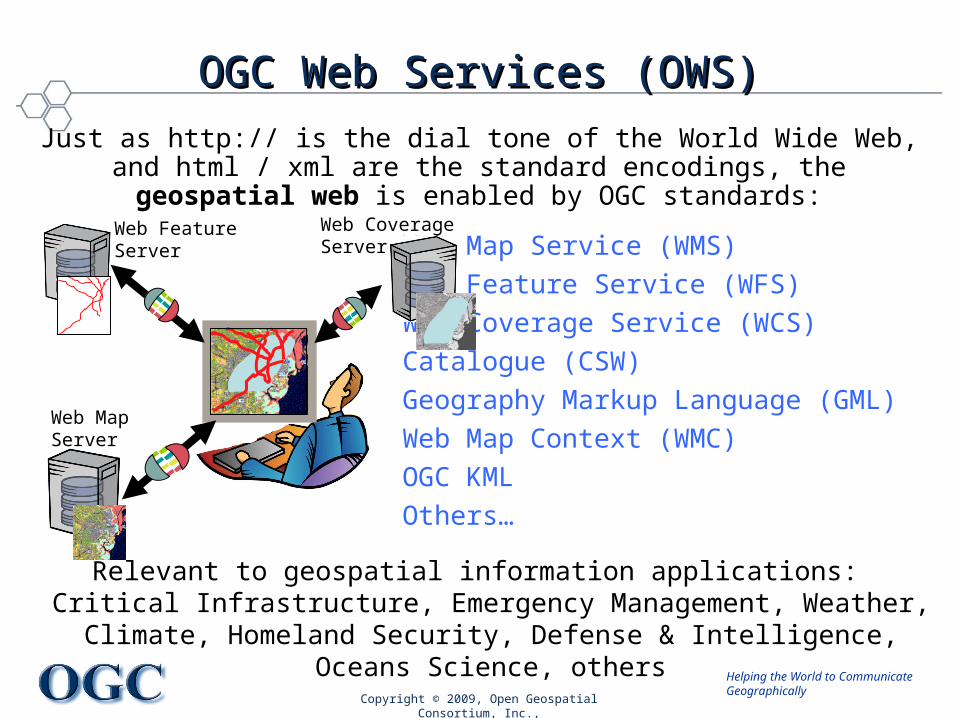
OGC Web Services (OWS)OGC Web Services (OWS)
Copyright © 2009, Open Geospatial Consortium, Inc.,
Web Map Service (WMS)
Web Feature Service (WFS)
Web Coverage Service (WCS)
Catalogue (CSW)
Geography Markup Language (GML)
Web Map Context (WMC)
OGC KML
Others…
Just as http:// is the dial tone of the World Wide Web, and html / xml are the standard encodings, the geospatial web is enabled by OGC standards:
Relevant to geospatial information applications: Critical Infrastructure, Emergency Management, Weather, Climate,
Homeland Security, Defense & Intelligence, Oceans Science, others
Web MapServer
Web CoverageServer
Web FeatureServer

Helping the World to CommunicateGeographically
OGC Reference Model (ORM)OGC Reference Model (ORM) www.opengeospatial.org/standards/ormwww.opengeospatial.org/standards/orm
• What is the purpose of the ORM?– Overview of OGC Standards Baseline– Insight into the current state of the work of the OGC– Basis for coordination and understanding of the OGC documents– Resource for defining architectures for specific applications
• Why Read This Document?– Better understand the OGC Standards Baseline– Better understand the ongoing work of the OGC– Gain an understanding necessary to contribute to OGC process– Aid in implementing one or more of the OpenGIS Standards
Copyright © 2009, Open Geospatial Consortium, Inc.,

Helping the World to CommunicateGeographically
OGC aims for Simple Service Architecture OGC aims for Simple Service Architecture
• Message-operations: request and response.
• Separation of control and data.
• Stateless services are desired
• Service types known before run time
• Service has adequate hardware, i.e. hardware assignment is transparent to user.
Copyright © 2009, Open Geospatial Consortium, Inc.,
Simple service architecture as defined in ISO 19119

Helping the World to CommunicateGeographically
Geospatial Interoperability Geospatial Interoperability from sensing to decision supportfrom sensing to decision support
SWE GPW DSS
OGC Web Services
SWE = Sensor Web EnablementGPW = Geo-Processing WorkflowDSS = Decision Support Services
Measurements Observations Features Recommendations
24Copyright © 2009, Open Geospatial Consortium, Inc.

Helping the World to CommunicateGeographically
Sensor Web Enablement (SWE)Sensor Web Enablement (SWE)
Copyright © 2009, Open Geospatial Consortium, Inc.,

Helping the World to CommunicateGeographically
Decision Support Services (DSS)Decision Support Services (DSS)
© 2008, Open Geospatial Consortium, Inc. 26

Helping the World to CommunicateGeographically
OWS Geo-Processing Workflow OWS Geo-Processing Workflow
© 2009 Open Geospatial Consortium, Inc.
…
WCS WPSWCTS WFS
Internet
Web Servers
Decision Support Client
WCS = Web Coverage ServiceWCTS = Web Coordinate Transform. ServiceWPS = Web Processing ServiceWFS = Web Feature Service

Helping the World to CommunicateGeographically
Web Processing ServiceWeb Processing Service
© 2009 Open Geospatial Consortium, Inc.
WPSGetCapabilities ExecuteDescribeProcess
Algorithms Repository
…
…
Algorithm 1
Data Handler Repository
…
…
Data Handler A
Communication over the web using HTTP
WPS-client
Web Processing Service

Helping the World to CommunicateGeographically
Developing WPS interface to GridDeveloping WPS interface to Grid
• Development on-going in OWS-5 Testbed. Results in May 2008 include demonstration and specification profile
– Bastian.Baranski, Univ Muenster and Andrew Woolf, STFC
Copyright © 2009 Open Geospatial Consortium, Inc. 29
GridWPS
some Grid appJS
DL
•process description
•process execution
•data input/output
•inbuilt web service binding
•lightweight
•‘geo’-compatible
•resource requirements
•data staging
WPS JSDL

Helping the World to CommunicateGeographically
30
GPW Scope for OWS-6
• Security for OGC web services• GML Application Schema Development• Asynchronous Workflow • WPS Profile for Grid processing

OWS-6 WPS Grid ProcessingOWS-6 WPS Grid Processing
• Bastian Baranski and Bastian Schäffer, Univ. Muenster Institute for Geoinformatics (IfGI) and 52° North, Germany
• Andrew Woolf, Science and Technology Facilities Council (STFC), UK
• Lan-Kun Chung, GIS Center, Feng Chia University, Taiwan
Copyright © 2008, Open Geospatial Consortium, Inc., All Copyright © 2008, Open Geospatial Consortium, Inc., All Rights Reserved.Rights Reserved.
Helping the World to CommunicateGeographically
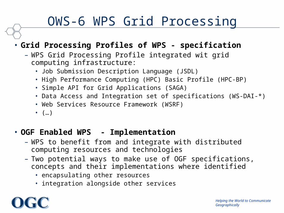
OWS-6 WPS Grid Processing
• Grid Processing Profiles of WPS - specification– WPS Grid Processing Profile integrated wit grid computing infrastructure:
• Job Submission Description Language (JSDL)• High Performance Computing (HPC) Basic Profile (HPC-BP)• Simple API for Grid Applications (SAGA)• Data Access and Integration set of specifications (WS-DAI-*)• Web Services Resource Framework (WSRF)• (…)
• OGF Enabled WPS - Implementation– WPS to benefit from and integrate with distributed computing resources and
technologies– Two potential ways to make use of OGF specifications, concepts and their
implementations where identified• encapsulating other resources• integration alongside other services

Helping the World to CommunicateGeographically
Grid-enabled WPS ImplementationsGrid-enabled WPS Implementations
• Airport Scenario– Trajectory Service (WPS JSDL Profile)
• Science and Technology Facilities Council (STFC), UK
– Plume Rendering Service (WPS JSDL Profile)• Institute for Geoinformatics (IfGI), University of Münster, Germany
• Debris Flow Scenario– Rainfall Data Interpolation (WPS HPC Basic Profile)
• Institute for Geoinformatics (IfGI), University of Münster, Germany
• Geographic Information Systems (GIS) Research Center, Feng Chia University (FCU), Taiwan
– Geophone Data Analysis (WPS HPC Basic Profile)• Institute for Geoinformatics (IfGI), University of Münster, Germany
• Geographic Information Systems (GIS) Research Center, Feng Chia University (FCU), Taiwan

Helping the World to CommunicateGeographically
Debris Flow Monitoring System

Helping the World to CommunicateGeographically
GPW: Debris Flow GPW: Debris Flow Sensors and GeoprocessingSensors and Geoprocessing
• Landslides and flooding are a frequent threat on the mountainous island of Taiwan, due to typhoons and earthquakes
• The Geographic Information Systems Research Center, Feng Chia University (GIS.FCU) in Taiwan has implemented OGC services for use in the workflow of detecting and analyzing sensor data for emergency response
• The following demonstration shows the working network of debris flow sensors, and examples of distributed services performing analysis and processing of the sensor data
© 2009 Open Geospatial Consortium, Inc. 36

Helping the World to CommunicateGeographically
OWS-6 Debris Flow Demo Scenario

Helping the World to CommunicateGeographically
Encapsulation vs. IntegrationEncapsulation vs. Integration
Integration requires a WSRF binding for WPS

Grid-enabled WPS from IfGI

Helping the World to CommunicateGeographically
Architecture of Grid-enabled WPS

Helping the World to CommunicateGeographically
Mapping between JSDL and WPS

Grid-enabled WPS from STFC

Helping the World to CommunicateGeographically
WPS JSDL Profile
• WPS JSDL Profile– Science and Technology Facilities Council (STFC), UK– WPS as interface to Grid Computing resources– passed-through’ by WPS from user to Grid environment (“Full”)– generated by WPS on basis of resource/staging parameters (“Lite”)
http://foo.bar.1/wps?version=1.0.0&request=Execute&service=WPS&Identifier=WeatherGenerator&DataInput=JSDL=http://www.domain.com/jsdl.xml@Format=text/xml@Encoding=utf-8@Schema=http://www.domain.com/jsdl.xsd&storeExecuteResponse=true&status=true
Full
http://foo.bar.1/wps?version=1.0.0&request=Execute&service=WPS&Identifier=WeatherGenerator&DataInput=other_inputs=xxx;JSDL=[TotalDiskSpace=5@uom=GB;TotalCPUCount=1;
DataStaging=target@url=ftp://domain.com/file]&storeExecuteRepose=true&status=true
Lite

Helping the World to CommunicateGeographically
WPS JSDL Profile
• WPS JSDL Profile– Trajectory Service (WPS)
• uses atmospheric model forecast to trace particle trajectories
• provides advection of particles, but not dispersion
– Deployment on UK National Grid Service– Use GridSAM as NGS JSDL interface– MyProxy for authentication, no sophisticated authorisation
• standardised username / password parameters to WPS
– Configuration file for• mapping WPS ‘Process’ to NGS executable
• (…)

Helping the World to CommunicateGeographically
WPS JSDL Profile
Grid-enabled
WPS
Pylons Framework
GridSAM Client
UK NGS
GridSAM Service
Grid
WPS SOAP/Proxy Layer
MyProxy Server
Execute Process (SOAP)
Verify Cert.
Job Id
Query/Response
Response
WPS Response

Recommendations for WPS and Grid-Processing
based on OWS-6

Helping the World to CommunicateGeographically
Items for discussion from OWS-6 WPS
• Merge of WPS JSDL Profile (STFC) and JSDL-WPS Mapping mechanism– Discussion Paper / Appendix in next WPS specification
• Web Service Resource Framework (WSRF) – The "real" integration of OGC Web Services in a Grid environment – Not only the Grid resource usage from within the service backend– WSRF bindings for OGC Web Services (mainly the WPS) required
• Service Level Agreements (SLA)– The integration of Service Level Agreements (SLA) (as just another type of licenses)
into (OGC-based) SDI– The enforcement of negotiated service quality goals (QoS) with Grid Computing
technologies or with Cloud Computing infrastructures
• Cloud Computing – This is an emerging trend in the mainstream IT while not yet addressd by the OGC– Is promising for geospatial applications in order to enable new and promising
business models for building up, operating and utilizing SDIs

OWS-7 IdeasOWS-7 Ideas
Copyright © 2009, Open Geospatial Consortium, Inc.Copyright © 2009, Open Geospatial Consortium, Inc.

Helping the World to CommunicateGeographically
OWS-7 Schedule and MilestonesOWS-7 Schedule and Milestones
• Call for Sponsors Press Release May 2009
• Strategy Session at OGF-26 May 26, 2009
• Strategy Session at OGC TC June 23, 2009
• Sponsor requirement meetings June-August 2009
• RFQ/CFP Issued September 2009
• RFQ/CFP Responses Due November 2009
• Kickoff Meeting January 2010
• Final Delivery June 2010
Copyright © 2009, Open Geospatial Consortium, Inc. 56

Helping the World to CommunicateGeographically
What’s Next: OWS-7 PlanningWhat’s Next: OWS-7 Planning
• Planning has begun, suggestions are welcome• Please consider sponsoring and participating• The next OWS-7 sponsor planning meeting will be at the
OGC TC meeting in Boston• Timeline
– RFP to be released in September 2009– Kickoff in January 2010
• Contact: – David Arctur, darctur at opengeospatial.org
– George Percivall, gpercivall at opengeospatial.org
57© 2009 Open Geospatial Consortium, Inc.

Helping the World to CommunicateGeographically
OWS-6 Continuing WorkOWS-6 Continuing Work
• Secure web services– SWE, GPW, DSS
– Aviation
• Event architecture– SWE
– Aviation
• 3D information• Weather• Geophysical• Climate change
• GeoBI• Temporally enabled Gazetteer• Wireless security• Integrated client• UAV video• Digital Rights, access control• ROA vs SOA Best Practice• Mass market• Fusion• NGA Profile Plugfest
Copyright © 2009, Open Geospatial Consortium, Inc. 58

Helping the World to CommunicateGeographically
Potential OWS-7 TopicsPotential OWS-7 Topics
• Finalize WPS JSDL Profile;
– consider other OWS services with JSDL, e.g., WCS and WFS
• Utilize WSRF for OWS in a Grid environment
• Relate OWS to emerging Cloud Computing
• Apply OGF/OGC collaborations to geosciences
• Address NSF Cyberinfrastructure and European objectives
Copyright © 2009, Open Geospatial Consortium, Inc. 59
Achieve interoperability through joint specification and implementation

Helping the World to CommunicateGeographically
OGC activitiesOGC activities
• The OGC Interoperability Program
• OWS-6 Testbed with focus on Grid Processing
• OWS-7 Planning
• Additional topics: G-OWS, GEOSS, INSPIRE, GMES
Copyright © 2009, Open Geospatial Consortium, Inc.,
GEOSS Architecture Implementation GEOSS Architecture Implementation PilotPilot
Copyright © 2009, Open Geospatial Consortium, Inc.,Copyright © 2009, Open Geospatial Consortium, Inc.,

Helping the World to CommunicateGeographically
Processing Earth Observation Data in Processing Earth Observation Data in Computational CloudsComputational Clouds
• Explore cloud computing to support processing and analysis of earth observation data in environmental scientific workflows.
• Investigate how cloud computing can be applied in the architecture of the Global Earth Observation System of Systems (GEOSS)
• GEOSS is an international programme aiming to integrate space-based and terrestrial sensors from over 70 countries (http://www.earthobservations.org).
• A prototype application will be implemented to demonstrate the potential resource offered by cloud computing for geospatial data processing.
Copyright © 2009, Open Geospatial Consortium, Inc.,
Slide courtesy of G. Hobona, University of Nottingham
Helping the World to CommunicateGeographically
Grid-based Geoprocessing Grid-based Geoprocessing Strategy SessionsStrategy Sessions
• Strategy sessions will be convened at the following venues:– The 26th Open Grid Forum - OGF26 - May 26-29, 2009– The OGC Technical Committee Meeting, June 22-26
• Invitation to attend the next OGF/OGC Strategy Session at OGC Technical Committee meeting June 23rd at MIT in Cambridge, MA, USA. http://www.opengeospatial.org/event/0906tc

Helping the World to CommunicateGeographically
Questions & CommentsQuestions & Comments
George [email protected]
Open Geospatial Consortium, Inc
www.opengeospatial.org
Copyright © 2009, Open Geospatial Consortium, Inc.,