overview of bridge proposals - wsdot
TRANSCRIPT

�
INTRODUCTIONOregon and Washington initiated the Columbia River Crossing project to improve both vehicle travel efficiency and safety for people and goods between Vancouver and Portland. The project includes a five-mile stretch of Interstate 5 between SR 500 in Vancouver and Columbia Boulevard in Portland, as well as the Interstate Bridge.
The Interstate Bridge – actually two bridges side by side – clogs traffic and increases safety risks due to the number of cars it can carry, its design and its lift span.
Currently, 12 “preliminary alternative packages” are being studied to determine how well they help meet the project’s goals. Within those packages, three types of bridge proposals are being evaluated: a new downstream bridge to supplement the existing I-5 bridges; a new downstream bridge to replace the existing I-5 bridges; and a new upstream bridge to replace the existing I-5 bridges. Study results are expected before the end of 2006.
The U.S. Coast Guard is holding a preliminary public hearing Sept. 21, 2006, on the bridge proposals because the chosen option may impact to marine navigation on the Columbia River. The U.S. Coast Guard may hold another hearing after the bridge proposals have been narrowed to one in mid-2008. Any new bridge will require a permit from the Coast Guard.
BACKGROUND INFORMATION FOR BRIDGE DESIGN When developing proposals for a new bridge that either supplements or replaces the existing I-5 bridges, engineers have had to work within a fairly narrow window to avoid the airspace of nearby airports and provide for marine traffic clearance. Additional complexities relate to the existing navigation channels and the seasonal fluctuating river levels.
U.S. Coast Guard Preliminary Public Hearing on Bridge Alignment and Pier PlacementFact Sheet
September 21, 2006
OVERVIEW OF BRIDGE PROPOSALS

�
AIRSPACEBoth Pearson Field and Portland International Airport airspace boundaries place constraints on the potential height of a new bridge. Because Pearson is closer to the project area, its airspace has more influence on the design height than Portland International Airport. The existing 230-foot towers on the I-5 bridges intrude into Pearson’s airspace.
EARTHQUAKE PROTECTIONCurrently, the existing I-5 bridges do not meet modern seismic standards, which puts the structures at risk of failure during an earthquake. If they remain in use for vehicle or public transit use, it is likely they will need to be upgraded to meet minimum seismic retrofit standards. Any new bridge would be constructed to higher standards.
WATER LEVEL AFFECTS NUMBER OF BRIDGE LIFTS
VERTICAL CONTRAINTS ON EXISTING I-5 BRIDGE

�
MARINE NAVIGATIONThe Coast Guard recognizes this stretch of the Columbia River as one of the more difficult areas to navigate. Generally, downriver travel is more challenging than going upriver because of the river current. The primary navigation channel runs along the north shore of the Columbia River and is in line with the lift spans on the existing I-5 bridges and the swing span on the Burlington Northern Sante Fe Railroad Bridge. Two other recognized channels are used for marine traffic: The barge channel, also known as the wide span, and the alternate barge channel, also known as the high span. Under ideal
weather and river conditions the towboat operators usually will elect to use these channels to avoid a bridge lift. If conditions are less than ideal, such as during high spring river flows, a bridge lift will be requested.
In the closed position, the lift spans provide approximately 40 feet of vertical clearance. In the open position, they provide approximately 180 feet of vertical clearance. The wide span provides approximately 60 feet of vertical clearance at mid-span and the high span provides approximately 70 feet of vertical clearance at mid-span.
VESSEL HEIGHT VS. ANNUAL FREQUENCY
Data based on 2004 averages
BARGE PATHS: NORMAL AND HIGH RIVER FLOWS

�
Downstream Replacement BridgeThis option replaces the existing bridges with a new bridge, located downstream, or west, of the current alignment. A replacement bridge would carry I-5 traffic, local traffic, public transit, bicyclists and pedestrians. Design Keeps the Highway MovingThe new bridge would be built on a curve, which takes the kinks out of the highway alignment and keeps traffic flowing at freeway speeds. In addition, the bridge would be built high enough to not need a lift span. Surveys have indicated that a height of 95 feet over the water will allow nearly all vessels to pass.
Enhancing Navigation A bridge span length of about 600 feet is being considered, which is an increase over the current “main channel” of 278 feet and the “barge channel” of 531 feet. (A bridge “span” is the space between piers) Longer span lengths will reduce the number of piers in the water (from
nine to about five) and would provide more room for ship captains to maneuver between the piers.
Seismic StandardsModern seismic standards would be met with a replacement bridge.
Flexibility in Bridge Types Although the type of bridge has not yet been determined, the downstream bridge location moves away from Pearson Field and would reduce conflicts with airspace requirements. This location provides more flexibility in the types and styles of bridges that can be considered.
Minimizing the Project FootprintBecause the new bridge would replace the existing bridges, it will be located as close as possible to the existing bridge alignment. This placement reduces the amount of right-of-way space needed.
Disclaimer These maps and descriptions are for discussion purposes only and are subject to change
CURRENT BRIDGE PROPOSALS
5
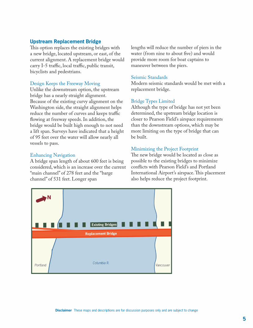
Upstream Replacement BridgeThis option replaces the existing bridges with a new bridge, located upstream, or east, of the current alignment. A replacement bridge would carry I-5 traffic, local traffic, public transit, bicyclists and pedestrians.
Design Keeps the Freeway MovingUnlike the downstream option, the upstream bridge has a nearly straight alignment. Because of the existing curvy alignment on the Washington side, the straight alignment helps reduce the number of curves and keeps traffic flowing at freeway speeds. In addition, the bridge would be built high enough to not need a lift span. Surveys have indicated that a height of 95 feet over the water will allow nearly all vessels to pass.
Enhancing Navigation A bridge span length of about 600 feet is being considered, which is an increase over the current “main channel” of 278 feet and the “barge channel” of 531 feet. Longer span
lengths will reduce the number of piers in the water (from nine to about five) and would provide more room for boat captains to maneuver between the piers.
Seismic StandardsModern seismic standards would be met with a replacement bridge.
Bridge Types LimitedAlthough the type of bridge has not yet been determined, the upstream bridge location is closer to Pearson Field’s airspace requirements than the downstream options, which may be more limiting on the type of bridge that can be built.
Minimizing the Project FootprintThe new bridge would be located as close as possible to the existing bridges to minimize conflicts with Pearson Field’s and Portland International Airport’s airspace. This placement also helps reduce the project footprint.
Disclaimer These maps and descriptions are for discussion purposes only and are subject to change

�
Downstream Supplemental BridgeThis option would add a new bridge downstream, or west, and would continue to use the existing bridges. One alternative currently under consideration would keep I-5 traffic on the existing bridges, while building a new bridge for transit and local traffic. Other supplemental options would build a new bridge for I-5 traffic and would convert the existing bridges to pedestrian, local traffic and/or transit use. Possible Traffic Interruptions on the Existing Bridge SpansWith the existing bridge spans carrying I-5 traffic, bridge lifts are currently avoided during morning and evening rush hour. If I-5 was placed on a new (non-lift) bridge, it is likely that the lift restrictions could be removed and the existing bridge spans could be lifted any time of the day.
Navigation ConsiderationsA bridge span length of about 600 feet is being considered, which is an increase over the current “main channel” of 278 feet, the “barge channel” of 531 feet and the 265 foot “alternate channel.” The longer span lengths associated with the new bridge would provide more room for boat captains to maneuver between the piers. However, with the existing piers still present, a supplemental bridge would introduce more obstacles for a boat captain to maneuver around. The current navigational channel would be unchanged, and the piers for the new bridge would encroach on the alternate barge channel, thus diminishing its functionality.
Disclaimer These maps and descriptions are for discussion purposes only and are subject to change

�Disclaimer These maps and descriptions are for discussion purposes only and are subject to change
SUPPLEMENTAL BRIDGE DOWNSTREAM: PIER LOCATIONS, BRIDGE AND BARGE CHANNELS
SUPPLEMENTAL BRIDGE DOWNSTREAM: PIER LOCATIONS, AERIAL VIEW
SUPPLEMENTAL BRIDGE DOWNSTREAM: PIER LOCATIONS, PROFILE VIEW

�
Flexibility in Bridge Types This option would locate the new bridge location farther from Pearson Field’s airspace requirements and would provide more flexibility in the type of bridges that can be considered. The type of bridge has not been determined yet.
Larger Project Footprint than Replacement OptionBecause the new bridge would be an addition to the existing bridge spans, it would need to be located some distance from the existing bridges. This increases the amount of new right-of-way that is needed over that of a replacement option.
Seismic Retrofit NeededFor the continued use of the existing bridge spans, an expert panel of bridge engineers was asked to evaluate them and determine how they could be strengthened for an earthquake. The panel recommended that the existing piers be fully encased and reinforced with stronger material to avoid collapse. The exact shapes and sizes have not been determined, but the strengthening concept considered would protrude somewhat into the navigation channels, thus reducing the horizontal clearances for all three channels.
Disclaimer These maps and descriptions are for discussion purposes only and are subject to change
MORE INFORMATIONWeb www.ColumbiaRiverCrossing.orgPhone 866-396-2726 (toll-free)
SUBMIT A COMMENTComments and questions about the Columbia River Crossing project may be submitted at any time through the following channels:
E-Mail [email protected] 700 Washington St., Suite 300 Vancouver, WA 98660Fax 360-737-0294Phone 866-396-2726 (toll-free)
Sponsored by the Oregon Department of Transportation and the Washington State Department of Transportation.
Downstream Supplemental Bridge (continued)
EFFECTS OF SEISMIC UPGRADES TO EXISTING I-5 BRIDGES
Americans with Disabilities Act (ADA) Information: Individuals requiring reasonable accommodations may request written material in alternative formats by calling the Columbia River Crossing Project Office (360-737-2726 or 503-256-2726). For individual needs in Oregon call the Oregon Department of Transportation (503-986-3700). For individuals who are deaf or hard of hearing call the Washington State TTY (1-800-833-6388) or the Oregon State TTY (1-800-735-2900).
Title VI: The project ensures full compliance with Title VI of the Civil Rights Act of 1964 by prohibiting discrimination against any person on the basis of race, color, national origin or sex in the provision of benefits and services resulting from its federally assisted programs and activities. For questions regarding the Title VI Program, you may contact WSDOT’s Title VI Coordinator at 360-705-7098.