ot services - world banksiteresources.worldbank.org/.../eap-open-transport-services.pdf · as well...
TRANSCRIPT

AN OVERVIEW OF OPEN TRANSPORT IN EAST AND SOUTHEAST ASIA
>>>>>>>>>>>>>
>>>>>>>>>>>>>>>>>WORLD BANK OPEN TRANSPORT TEAM

Nearly everything we do in transport begins with data. Planning, opera ons, traffi c management, and service informa on provi-
sion are dependent on many kinds of regularly collected data, such as:
The quality of transport planning, opera ons, and management de-pends largely on the quality and availability of these underlying data, as well as a transport agency’s capacity to manage and analyze them. But very o en, transport agencies do not have the fi nancial resourc-es or technical capacity to collect, manage or analyze these data, impeding their ability to make evidece-based planning, policy and investment decisions.
Open TransportOpen Transport empowers resource-constrained transport agencies to collect high-quality transport data with minimal eff ort and cost, as well as to conduct robust data analyses with minimal formal training in transport engineering and planning.
Road network mapTransit route mapsLand use and censusVehicle-loca on dataOrigin-des na on surveys
Traffi c countsFare schedules Transit service plan
Accident loca onsTravel speeds and journey mesPassenger counts
Household surveys
The Role of the World BankThe World Bank can provide the training and tools necessary to technical staff in transport agencies to collect, manage, and ana-lyze transport data, as well as to use these analyses to make ra o-nal investment, opera ons, and planning decisions. The Bank can also provide procurement guidance and fi nancing for suppor ng ICT investments.
The Bank seeks to begin building a culture of evidence-based de-cision-making in transport agencies, which, over me, may evolve into standard best prac ces in transport system planning and man-agement.
This FolioThe following document has been prepared to provide an overview of open transport principles and how they can and have been ap-plied in the East Asia and Pacifi c Region.
>>>FORWARD

WHAT IS OPEN TRANSPORT?Open Transport defi nes the next-genera on of tools and
methodologies for managing and planning transport sys-tems in resource-constrained environments. Open Transport is defi ned by three principles:
OPEN DATA STANDARDSOpen data standards are freely and publically available, with no required use agremeements (e.g., .xml, .csv, .html, .png). Data that are collected and stored using open standards are compa ble with mul ple sofware applica ons, both proprietary and open source. Some open standards, such as the general transit feed specifi ca on (GTFS) for public transit
service data, are supported by global communi es of prac oners, con-tribu ng the the standards’ evolu on.
OPEN SOURCE SOFTWAREOpen source so ware features universal access and redistribu on rights via free licenses to a product’s design, code, or blueprint. There are now
established open source versions of tradi onally very expensive data analysis packages, such as Quantum GIS, R, OpenOffi ce, and in more re-cent years, emerging open source alterna ves for transport data collec-
on, management, visualiza on, and analysis.
OPEN DATAOpen data refers to data that anyone is free to use, reuse and restribute -- subject only, at most, to the requirement to a ribute the data source.
While not all transport data lends itself to be open, there are benefi ts to releasing some data, such as public transit service informa on, to
acheive economies of scale in genera on of third-party applica ons to support wider and more effi cient use of a transit network.
Opportuni es to apply Open Transport principles fall un-der three cri cial processes for evidence-based transport planning and management:
DATA COLLECTION
Tradi onal manual transport data collec on methodologies – household surveys, fi eld traffi c counts, etc. – can be eff ec ve, but tend to be me-consuming and labor-intensive. Newer, dedicated sensor-based ITS systems are faster and result in higher-quality data, but these systems can be costly and have high technical re-quirements. Open Transport focuses on crea ng low cost op ons for data collec on that are less resource intensive than manual methods, yet produce high-quality data on par with modern ITS methods. These solu ons leverage crowd-sourcing techniques, ci es’ exis ng ICT systems – cellular networks and Internet con-nec vity – and open-source, license-free applica ons.
DATA STORAGE,
MANAGEMENT & SHARING
To maximize the value of collected data, they need to be made accessible to everyone who needs (and is authorized) to use them. Open Transport solu ons support centrally-managed serv-ers that are accessible by many diff erent staff and departments (i.e., cloud-based), and data that are in open/standard formats that may be used across mul ple pla orms and applica ons. Further, where economies of scale can be acheived, Open Trans-port solu ons focus on making select data open to third-party developers -- for example, public transit route and service infor-ma on -- so that through minimal investment, a wide variety of services can be provided to system users.
DATA ANALYSIS &
VIEWING
There are a wide variety of highly eff ec ve applica ons avail-able to transport agencies for data visualiza on and analysis – tools for travel demand modeling, transit scheduling and dispatch, transit route planning, traffi c speed monitoring, etc.; however high licensing fees and technical requirements can place these tools out of reach of resource-constrained agen-cies. Open Transport solu ons focus on developing license-free, expandable and translatable basic so ware tools for transport data analysis. Agencies can start with these entry-level tools and build a culture around data use before inves ng in the more robust packages.
1
2
3

GIS Route and Sta on/Stop
Loca ons
Passenger Volumes by Loca on and Time
of Day
TRADITIONAL METHOD FOR TRANSIT DATA COLLECTION OPEN TRANSPORT METHOD
• Using dedicated GPS devices, staff ride each transit route in the city (most ci es do not have accurate base maps for informal transit routes)
• Staff manually upload data from each device to a desktop computer.• Staff use specialized GIS so ware to: snap collected data to the city’s GIS
road network data, enter specifi c details about the route, including route name and code, and manually input and adjust key stop and sta on details.
• Staff manually enter route meta-data, including route direc ons, me stamp, etc.cUnless uploaded to a central server, fi le is not accessible to other agencies, and even if uploaded, can only be viewed or manipulated by staff with GIS licenses. Route upda ng can only be done by a GIS specialist.
• Using mobile app, staff ride each transit route in the city.• Staff enter route and stop details using the app as they ride.• Data and meta-data are automa cally uploaded to a central
server, immediately assessable by all relevant agencies, and if desired, even the public. Data is automa cally linked to city’s OpenStreetMap-road network fi les.
• Any authorized staff can view and update data using a free, web-based graphical user interface.
• Using GIS fi les prepared in fi rst step, staff print individual route maps for fi eld data collectors.
• Staff ride select transit routes and, at each “stop”, mark loca on on the route map and manually record boardings and aligh ngs on a clipboard.
• Using a GIS pla orm, staff manually plot survey loca ons along route shapefi les developed in fi rst step. For hop-on-hop-off systems, there could be hundreds of “stops” for a single route.
• Using paper survey details for reference, staff use GIS to manually enter passenger counts for each surveyed loca on. Unless uploaded to a central server, fi le is not accessible to other agencies, and even if uploaded, can only be viewed or manipulated by staff with GIS licenses.
• While using mobile app, staff can record boardings and aligh ngs along en re route. Data is saved with route infor-ma on and automa cally uploaded to a central server.
• Using GIS fi les prepared in fi rst step, staff print individual route maps for fi eld data collectors.
• Staff ride transit routes with watch, clipboard, and paper map. • Staff record travel me between pre-determined points on the paper route
map.• Using GIS, staff manually enter collected travel me data for each route
segment.
• While using mobile app, travel me is automa cally re-corded and linked to the route fi le, which is automa cally uploaded to a central server. Average Travel and
Dwell Times
Total Time Needed to Collect and Record Data for 1 Route
(2 hrs travel me)
Example: Total Time and Cost for Metro Manila
(900+ routes)
Data Sustainability and Accessibility
On route: 2 hours x 3 = 6 hoursAddi onal required data entry: 1 hour x 3 = 3
Total: 9 hours
On route: 2 hours Addi onal required data entry: 0 hours
Total: 2 hours
9 hours x 900 routes = 8,100 hours (1,012.5 man-days)Assuming US$400 per man-day:
US$405,000 plus
GIS licensing fee (US$1,500 per user) and consultant fees
2 hours x 900 routes = 1,800 hours (225 man-days)Assuming US$400 per man-day:
US$90,000
Given the high-level of specialized skills needed to manipulate and analyze GIS fi les, data are typically either: held by consultants and city must pay consultants for further analysis, or data sits on an offi ce desktop computer and is neither shared nor updated. So, while data collec on cost is very high, its long-term value is low.
Data is in an open format that can be used by mul ple applica ons, including GIS (open-source and propri-etary), and stored on a central server, so that any agency using the data will always be working with the most up-to-date data set. Specialized web-based open-source tools are designed for staff with rela vely low technical capacity to manipulate, analyze, and use collected data. So, while data collec on costs are much lower than conven onal prac ce, the long-term value of the data is very high.
Example
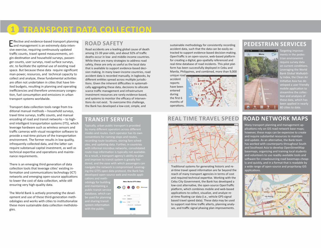
TRANSPORT DATA COLLECTIONEff ec ve and evidence-based transport planning
and management is an extremely data-inten-sive exercise, requiring con nuously updated traffi c counts, travel speed measurements, ori-gin-des na on and household surveys, passen-ger counts, user surveys, road surface surveys, etc. to facilitate the op mal use of exis ng road space. But because these data require signifi cant man-power, resources, and technical capacity to collect and analyze, these fundamental ac vi es are o en not undertaken in ci es that have lim-ited budgets, resul ng in planning and opera ng ineffi ciencies and therefore unnecessary conges- on, fuel consump on and emissions in urban
transport systems worldwide.
Transport data collec on tools range from tra-di onal manual methods – household surveys, travel me surveys, traffi c counts, and manual encoding of road and transit networks – to high-end intelligent transporta on systems (ITS), which leverage hardware such as wireless sensors and traffi c cameras with visual recogn on so ware to provide a real- me picture of the transporta on environment. The former results in low quality, infrequently collected data, and the la er can require substanual capital investment, as well as technical exper se and opera ons and mainte-nance requirements.
There is an emerging third genera on of data collec on tools that leverage ci es’ exis ng in-forma on and communica ons technology (ICT) networks and emerging open-source applica ons to lower the cost of data collec on, while s ll ensuring very high-quality data.
The World Bank is ac vely promo ng the devel-opment and use of these third-genera on meth-odologies and works with ci es to ins tu onalize these more sustainable data collec on methdolo-gies.
PEDESTRIAN SERVICES
ROAD NETWORK MAPSTRANSIT SERVICE REAL TIME TRAVEL SPEED
ROAD SAFETY
1
Road accidents are a leading global cause of death among 15-39 year-olds, and about 92% of traffi c deaths occur in low- and middle-income countries. While there are many strategies to address road safety, these are only as useful as the local data that is available to support evidence-based deci-sion making. In many lower-income countries, road accident data is recorded manually, in logbooks, by diff erent en es spread across mul ple jurisdic- ons. Given the inherent diffi cul es in systema -
cally aggrega ng these data, decisions to allocate scarce traffi c management and infrastructure investment resources are rarely evidence-based, and systems to monitor the effi cacy of interven- ons do not exist. To overcome this challenge,
the Bank has developed a low-cost, simple, and
sustainable methodology for consistently recording accident data, such that the data can be easily ex-tracted to support evidence-based decision-making. OpenTraffi c is an open-source, web-based pla orm for crea ng a digital, geo-spa ally referenced and real- me database of road incidents. This pilot plat-form has been successfully deployed in Cebu and Manila, Philippines, and combined, more than 9,000 unique road accident reports have been entered during the fi rst 6 months of opera ons.
Typically, urban public transport is provided by many diff erent operators across diff erent modes and routes. Each operator has its own conven ons for naming stops and routes, recording route loca ons, storing fare sched-ules, and upda ng data. Further, in countries with informal microbus networks, consolidated route map informa on is typically not available. As a result, a transport agency’s ability to plan and improve its transit system is greatly hin-dered, and the ease with which passengers can navigate the network is compromised. Leverag-ing the GTFS open data protocol, the Bank has developed open-source web and movile appli-ca ons and meth-odology for building and maintaining a public transit service database, which can be used for planning and sharing transit system informa on with the public.
Tradi onal systems for genera ng historic and re-al- me travel speed informa on are far beyond the reach of many transport agencies in terms of cost and required technical exper se. Working with the Cebu City Government, the Bank has developed a low-cost alterna ve, the open-source OpenTraffi c pla orm, which combines mobile and web-based applica ons to collect, visualize, and analyze re-al- me fl oa ng car data (i.e., vehicle GPS-signal based travel speed data). These data may be used to support real- me traffi c alterts, planning analy-ses, and traffi c signal phasing plan improvements.
Targe ng improve-ments in the pedes-trian environemnt require survey data on current condi ons. Leveraging the World Bank Global Walkabili-ty Index, the Clean Air Ini a ve Asia has de-veloped a user friendly mobile applica on to streamline the collec- on and analyses of
these data, which has been applied in nearly 80 ci es to date.
Many transport planning and management ap-plica ons rely on GIS road network base maps; however, these maps can be expensive to create and require substan al resources to maintain and update. As an alterna ve, the Bank team has worked with counterparts throughout South and Southeast Asia to develop OpenStreetMap basemaps, organizing and training local students and volunteers to use readily available tools and so ware for crowdsourcing road basemaps cheap-ly and quickly, and in a format that is readable by a wide range of open-source and propritaray GIS applica ons.

TRANSPORT DATA MANAGEMENT, STORAGE, AND SHARINGTo maximize the value of collected transport
data, they must be:
1. Stored in a machine-readable format;2. Maintained in a loca on that is accessible to
diff erent staff , departments, and agencies; 3. Saved in a format that is compa ble with a
variety of so ware packages; and4. Supported by a budget and ins tu onal ar-
rangements for regular upda ng and main-tenance.
These four requirements are not necessarily easy to acheive. Many transport agencies that tradi- onally store their data in hardcopy do not have
the equipement or technical capacity to maintain a centralized server for their data, nor may they have experience se ng up web-based interfac-es for their staff to enter, edit, and export their data. To overcome these technical barriers, some agencies will outsource their data management and hos ng ac vi es to third par es, typically at great expense, and at risk of being placed in a diffi cult posi on when third-party contracts need to be renewed.
Fortunately, ith the advent of rentable cloud-storage space, license-free open-source tools for data management, and declining costs of Internet connec vity, acheiving a centrally managed repository for transport data is now within reach of many transport agencies. The World Bank has experience helping agencies establish these systems and procedures.
With centrally stored and managed data, agen-cies can ensure all planning and analyses are conducted using the same datasets, data collec- on reduendency is minimized, and data updat-
ing is consistent.
TRAINING
ADVISORY OPEN SOURCE TOOLS
ICT PROCUREMENT
OPEN DATA AND APP COMPETITIONS
Open Transport systems rely on informa on and communica ons technology (ICT) -- Internet con-nec vty, computers, and server hos ng arrange-ments (at a minimum), as well as GPS-enabled mobile devices for use by staff members to collect fi eld data. Understanding the hardware require-ments and technical specifi ca ons, ensuring equip-ment compa bility, and budge ng for on-going use and maintenance can be a challenge. The Bank provides procurement and techncial advisory on se ng up these systems, as well as fi nacning support.
Just as cri cal as the technology for acheiving Open Transport outcomes is the underlying in-s tu onal and policy framwework. Successful outcomes in evidence-based decisionmaking are dependent on:
1. Collabora on between the diff erent agencies responsible for management of the transport network;2. Suffi cient resource alloca on to staff me, data management, and equipment maintenance; and 3. Poli cal will to act on data-driven conclusions.
The Bank provides advisory on all aspects of transport data man-agement -- ins tu onal, policy, technical, re-source requirements for devleoping and main-taining data, procure-ment guidelines, and public communica ons.
2
The goal of all Open Transport programs is to empower transport agencies to collect, manage, and analyze their own data for use in making evi-dence-based decisions for transport planning, pol-icy and investment. To this end, the Bank provides one-on-one technical training to transport agency staff , as well as regional workshops, to enable agencies to set up and maintain Open Transport systems themselves, as well as to procure addi- onal services that support these systems.
Some transport data, such as public transit service informa on, can be made publically available, so that transport agencies can benefi t from private sector par cipa on in building applica ons that support planning and use of transport systems. The Bank provides advisory to transport agencies on all aspects of open data -- dissemina on, legal implica ons, policy and documenta on, monitoring, and risk mi ga on. One increas-ingly leveraged mechanism for making data “open” is an applica on development compe on, where open datasets are publically announced and developers are invi ed to build the more eff ec ve applica ons using thes data, based on pre-determined criteria. The objec ve of such compe ons is to increase the value and
sustainability of the transport agency’s data by making it open to developers and building a cri cal mass of people who will con nue to rely on the data and hold the gov-ernment accountable for its maintenance. The Bank has successfully launched a na onal transit app compe on in the Philippines (drawing upon the experience of the Bank’s Middle East and North Africa team with the fi rst transit app compe on in Cairo), with par cipa on of more than 480 local developers.
There are an increasing number of license-free, open source tools available to transport agencies to support data management and upda ng, with-out the need for extensive training or technical exper se. For example, the Bank team, working with the Philippines Department of Transport ad Communica ons (DOTC), has developed the GTFS-Editor, a prototype web-based interface for viewing and upda ng public transit service infor-ma on, which does not require the need for prior GIS or database management training. The Bank helps link transport agencies to exis ng applica- ons, or, as needed will provide support on the
development of new ones.

TRANSPORT DATA VISUALIZATION AND ANALYSISA er data is collected and stored in an open
format, and in a centralized and accessible loca on, the last cri cal step is to visualize and analyze these data for use in planning and opera- ons decision-making. However, many available
so ware packages for transport data anlaysis: (a) require substan al technical training and exper- se to use; and/or (b) are prohibi vely expensive.
For example, a tradi onal travel demand model-ing package may cost more than US$10,000 per license -- a considerable sum in countries where the GDP per capita is less than US$3,000, such as in Vietnam or the Philippines -- and require an advanced degree in transport engineering to use. Similarly, a geographic informa on systems (GIS) license may cost nearly $2,000, and the required suppor ng database or spreadsheet package another $1,000. While these packages have their important place in transport agency opera ons, not every transport agency necessarily needs these advanced packages to perform basic analyt-ical func ons.
Open source so ware is increasingly fi lling the gap between tradi onal analy cal packages and not performing in-house analysese at all. For example, there are now widely used open-source alterna ves to propritary GIS, sta s cal, spreadsheet, and word-processing packages -- QuantumGIS, R and OpenOffi ce. Also, there are a growing number of transport-specifi c applica- ons, some which have been developed through
Bank projects, such as OpenTraffi c, for real- me accident and travel speed analysis, as well as GTFS-Editor, for public transit network visualiza- on. The Bank places strong empahsis on intro-
ducing and training transport agencies to these tools, as well as providing advisory on so ware procurement. As long as a transport agency is successfully managing a centralized data reposito-ry, external consultants may be hired to perform more complex analyses, while transport agencies can leverage open-source tools to increase their capacity for more rou ne analy cal work.
OPEN SOURCE TRAINING OPEN SOURCE SOFTWARE DEVELOPMENT
ANALYTICAL WORK
3
An increasing number of government agencies are switching from proprietary so ware pla orms to open-source, to leverage the following benefi ts:
Flexibility. Can customize and change without go-ing through the original so ware developer.
Cost-savings. When changes are needed, any de-veloper can bid to support the pla orm – not just one company. Also open-source code itself is free!
Ownership. Government agency will own and manage its own data, not a third-party company.
Security. So ware code can be reviewed by third par es to ensure security (i.e., not a black box)
Opportunity for Improvements and Add-Ins. If pla orm is adopted by other countries, improve-ments and updates could be easily transferred
Popular pla orms include: Quantum GIS for geo-spa al analysis, R for sta s cal analysis, and Open Offi ce for basic wordprocessing and spread-sheet work.
The Bank supports adop on of these tools in re-source-constrained environments through intro-duc on and training, as well as procurement advi-sory. A er agencies build a culture of data analysis around these pla orms, at a later date, they may graduate to more advanced propritary pla orms.
Where exis ng open-source pla orms do not exist to meet a specifi c analy cal need for a transport agency, the Bank can provide advisory and procurement support for hiring developers to create the necessary tools. The Bank has a growing library of supported tools, including: GTFS-Editor for edi ng public transit service data; TransitWand, a mobile app for collec ng fi eld public transit data; Traffi cProbe, a mobile app for col-lec ng fl oa ng car data; and OpenTraffi c, a web-based pla orm for visualizing and analyzing real me traffi c speed and incident data; and INASAFE, an award-winning GIS pla orm for disaster risk management.
Since the development of open-source tools for transport agencies in resource-constrained environments is s ll a nascent fi eld, there are many occasions where addi onal support for more complex analysis of transport data may be necessary. For example, while the open-source OpenTraffi c pla orm currently provides funcitonality for recording and visualizing traffi c incidents, it does not provide automated data analyses for iden fying highest-probability incident intersec ons by me of day and day of week, or iden- fying accident-prone intesec ons with the highest annual economic costs to a city. Un l the automated
open-source tools for specifi c transport analyses are made available, the Bank team can provide illustrat-ed step-by-step training manuals on how these analyses can be performed using only readily available, open-source tools, such as Quantum GIS and R.
CASE STUDIES* Public Transit Service Database* Philippine Transit App Compe on* Real-Time Conges on Mapping* Road Safety Management* Crowd-Sourced Repor ng* Open Street Mapping

TOOLS TRAINING ADVISORY
CHALLENGEPhilippine transport agencies and commuters tradi onally have not had access to public transit route maps or service data, making transit use very ineffi cient and long-term planning and opera ons improve-ment nearly impossible.
SOLUTIONThe Philippines Transit Informa on Service is a na onally-hosted open database of public transit route and service informa on, which is based on an interna onal open data standard, the General Transit Feed Spec-ifi ca on (GTFS). The Service is supported by a suite of open-source web and mobile-based applica ons designed to simplify database updates and maintenance.
OUTCOMESRoute and service informa on for more than 900 unique bus, jeepney, and rail lines in Metro Manila have been added to the database, and these data are presently being applied to the planning of the Manila BRT and a citywide bus route restructuring program – both of which are cri cal to the longer term green growth of the city. Also, local developers have begun building consumer-based route planning applica ons using the database, substan ally improving the a rac veness and accessibility of the public transit sys-tem.
SUSTAINABILITYThe database is centrally hosted by the Na onal Compu ng Center, and the Department of Transport and Communica ons (DOTC) is organizing training ac vi es in Cebu and Davao to add their data to the na on-al database. The mobile and web-based open-source tools developed under the program have since been adopted in China, Mexico, and Vietnam for use in crea ng their own public transit databases.
GTFS-Editorh ps://github.com/World-Bank-Transport/g s-editorTransitWandh ps://github.com/World-Bank-Transport/transit-wand
GTFS Training Materialsbit.ly/GTFS_TrainingGTFS Workshoph p://www.g sforth-erestofus.net/Hands-On Training60+ staff
• Program resource re-quirements
• Ins tu onal arrange-ments
• Open data policy
PHILIPPINE TRANSIT APP COMPETITION
TOOLS TRAINING ADVISORY
CHALLENGEThe sustainability of the Philippines Transit Informa on Service is dependent on poli cal will and public demand for up-to-date transit service data.
SOLUTIONThe DOTC leveraged an app compe on as a low cost means to increase the value and sustainability of its transport data by making it open to developers and building a cri cal mass of people who will con nue to rely on the data and hold the government accountable for its maintenance The Philippine Transit App Compe on was a four-month hack-a-thon, where local developers were invited to use the open datasets made available by the DOTC the Metro Manila Development Authority, and the Cebu City Government, to create useful applcia ons for both transit users and government agencies.
OUTCOMESMoretha 200 people par cipated in the live opening and closing events, and more than 480 loval develop-ers registered for the compe on. The compe on a racted substan al media a en on and par cipa on from local tech communi es -- the launch event was followed by 11 subsequent viral events sponsored by volunteer organiza ons. Judges included high level offi cials from public and private sector agencies, and the winning applica ons provided new services to public transit users that have never before been available in the Philippines. The DOTC has since formed partnerships with winning developers to provide longer term support for their open data ini aitves
SUSTAINABILITYThe compe on and the tech commun es created through it resulted in public and poli cal support for maintaining the government’s open transport data.
Winning Applica ons• h p://sakay.ph/• h p://www.tripbarker.com/• h p://trainguide.ph/• h p://www.youtube.com/
watch?v=Xir9uFjWWBI• h p://transit.com.ph/
• App compe on design and implementa on
• Open data policy and terms of use advisory
• Organizing an app com-pe on and crea ng sustaining results
PUBLIC TRANST SERVICE DATABASE

REAL TIME CONGESTION MAPPING
TOOLS TRAINING ADVISORY
CHALLENGEIn the Philippines, traffi c management and road investments are not typically based on observed con-ges on or travel me, because these data tend to be too costly to collect on a regular basis, resul ng in sub-op mal investment decisions and losses in terms of poten al emissions and travel me savings.
SOLUTIONOpenTraffi c Real Time Conges on Mapping: An open-source mobile and web-based pla orm for collect-ing, visualizing, and analyzing real me travel speed condi ons in a city.
OUTCOMESMore than 20 million unique data points have been collected since project incep on, and now the city has very accurate travel me data for all corridors in the city, elimina ng future need to implement targeted travel me surveys and crea ng a valuable input for all future traffi c management and planning ac vi es, resul ng in be er, evidence-based decisions.
SUSTAINABILITYOpenTraffi c has won fi rst-prize for the 2013 Philippines E-Governeance Compe on. The pla orm is hosted by the Na onal Compu ng Center under the Advanced Science and Technology Ins tue, which provides free hos ng and technical support services to the Cebu City Government. As long as par cipa ng taxi companies see the vaue proposi on in having a low-cost system for dispatch and driver communi-ca on, the Cebu City Government will con nue to benefi t from the genera on of this rich dataset. The pla orm is equipment-neutral and open-source, thereby suppor ng easy replicability in other ci es.
OpenTraffi ch ps://github.com/WorldBank-Trans-port/traffi c-toolsTraffi c Probeh ps://github.com/WorldBank-Trans-port/traffi c-tools/tree/master/Traf-fi cProbe
• OpenStreetMap train-ing to improve the basemaps
• Hands-on taxi company and driver training
• Hands-on traffi c and ICT departnment training
• Organizing an app com-pe on and crea ng sustaining results
TOOLS TRAINING ADVISORY
CHALLENGEIn the Philippines, although traffi c accident rates are high rela ve to the region – causing substan al con-ges on and resource loses -- to date, no cohesive ac on has been taken to overcome the systemic issues causing these accidents.
SOLUTIONOpenTraffi c Incidence Repor ng: An open-source web-based pla orm for maintaining and sharing a geo-spa ally-referenced, real- me digital record of all traffi c incident data, including accidents, fl ood infor-ma on, road closures, broken traffi c lights, etc.
OUTCOMESMore than 8,000 unique reports have been entered into the system. In Cebu, using these data, the city has ranked all urban intersec ons by accident likelihood by day of week and me of day and has, accordingly, redesigned its traffi c enforcer deployment assignments to support accident preven on. Also, based on the database injury and fatality data, the city has ranked every intersec on by economic cost and has iden- fi ed the top ten “most expensive” intersec ons. These will be presented to City Council in October for
a budget request to improve these intersec ons. By using data, Cebu can leverage its scare resources to make targeted, evidence-based decisions that will result in fewer accidents.
SUSTAINABILITYThis open-source pla orm module has since been adopted in MetroManila and is hosted by the Na on-al Compu ng Center. The DOTC plans on scaling up the pla orm across all ci es, but requires addi onal technical support for refi ning the applica on’s analy cal func ons.
OpenTraffi ch ps://github.com/World-Bank-Transport/traffi c-tools
• Hands-on traffi c depart-ment training (train the trainer)
• Guidebook on prepar-ing data anlyses using open-source tools
• Addi onal analy cial work conducted to den fy high-probabiity incident zones by me of day and day of week, as well as high-econom-ic cost intersec ons.
ROAD ACCIDENT MITIGATION

TOOLS TRAINING ADVISORY
CHALLENGECebu City government agencies have limited resources to regularly inspect and monitor infrastructure maintenance and repair needs, especially roads and street lights.
SOLUTIONTFixMyBarangay (FMB) -- an SMS-based crowd-sourcing tool to provide infrastructure maintenance re-ports directly to relevant agencies. The tool includes a web-based pla orm for mapping reports, and SMS gateway for communica ng directly with the original reporters, and a simple database management in-terface to track repairs, engineer asisgnments, and expenditures. To adver se the program, local children par cipated in a poster-deisgn compe on, and formal launches and trainings were held in par cipa ng barangays, with par cipa on from the mayor and city council members.
OUTCOMESThe program has been formally endorsed by the mayor and city council and is being implemented in two pilot barangays -- Luz anf Basak San Nicolas. FixMyBarangay won 3rd place in the 2013 Na onal E-Gover-nance Compe on in the Philippines.
SUSTAINABILITYFMB is based on the Open 311 standard and its code is open-source, on github. The end-point manage-ment module has been downloaded by the New South Wales government in Australia.
FMB Pla orm and Management• h p://www.fi xmybarangay.
com/my• h p://dps.endpoint.fi xmyba-
rangay.com/index.php/admin• h ps://message-manager.
fi xmybarangay.com/
• Hands-on training with barangay staff and com-munity members and relevant government departments
• MoAs between gov-ernment agencies to support program sus-tainability
• Survey work to inform pilot design
CROWD SOURCED REPORTING OPEN STREET MAPPING
TOOLS TRAINING ADVISORY
CHALLENGEAll of the Open Transport solu ons developed to date rely heavily on the Open Street Map (OSM) -- but the OSM is incomplete or inccurate in some places.
SOLUTIONThe Bank worked with local barangay communi es to host “mapping par es”, mobilizing volunteers to use borrowed GPS devices to improve the OSM. The Bank also sponsored training for 20 government staff from the Cebu City GIS and traffi c management departments on how to update the OSM.
OUTCOMESThe OSM now includes new roads and points of interest for two barangays in Cebu -- Luz and Basak San Nicolas. Since the OSM training to government offi cials, the number of changes and improvements to the OSM in Cebu have increased exponen ally. With be er basemaps, the Open Transport tools employed in Cebu now func on more accurately.
SUSTAINABILITYBy empowering local communi es and government staff to update and improve the OSM themselves, as they city grows and changes, adjustments to the OSM can be made accordingly.
• OSM Mapping Party guidebook and training materials.
• Classroom and fi eld in-struc on on OSM data collec on, entry, and management.
• Role of OSM in support-ing open-source appli-ca ons and barangay mapping
Exis ng OSM edi ng pla orms -- JOSM and iDh ps://www.openstreetmap.org/login?referer=%2Fed-it%3Feditor%3Did#-map=14/10.3027/123.9113
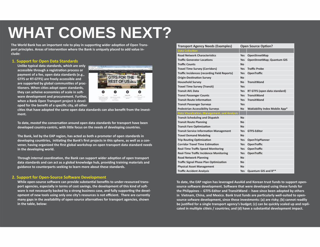
WHAT COMES NEXT?The World Bank has an important role to play in suppor ng wider adop on of Open Trans-port principles. Areas of interven on where the Bank is uniquely placed to add value in-clude:
1. Support for Open Data StandardsUnlike typical data standards, which are only accessible through a registra on process or payment of a fee, open data standards (e.g., GTFS or RT-GTFS) are freely accessible and are supported by global communi es of prac- ioners. When ci es adopt open standards,
they can acheive economies of scale in so -ware development and procurement. Further, when a Bank Open Transport project is devel-oped for the benefi t of a specifi c city, all other ci es that have adopted the same open data standards can also benefi t from the invest-ment.
To date, mostof the conversa on around open data standards for transport have been developed country-centric, with li le focus on the needs of developing countries.
The Bank, led by the EAP region, has acted as both a promoter of open standards in developing coun ries, ini a ng the Bank’s fi rst projects in this sphere, as well as a con-vener, having organized the fi rst global workshop on open transport data standard needs in the developing world.
Through internal coordina on, the Bank can support wider adop on of open transport data standards and can act as a global knowledge hub, providing training materials and guidance to counterparts seeking to learn more about these standards.
2. Support for Open-Source So ware DevelopmentWhile open-source so ware can provide substan al benefi ts to under-resourced trans-port agencies, especially in terms of cost savings, the development of this kind of so -ware is not necessarily backed by a strong business case, and fully suppor ng the devel-opment of new tools using only one city’s resources is not effi cient. There are currently many gaps in the availability of open-source alterna ves for transport agencies, shown in the table, below:
Transport Agency Needs (Examples) Open Source Op on?Data Collec onRoad Network Characteris cs Yes OpenStreetMapTraffi c Generator Loca ons Yes OpenStreetMap; Quantum GISTraffi c Counts NoTravel Time Survey (Corridors) Yes Traffi c ProbeTraffi c Incidences (recording Field Reports) Yes OpenTraffi cOrigin-Des na on Survey NoHousehold Survey No TransitWandTravel Time Survey (Transit) YesTransit AVL Data Yes RT GTFS (open data standard)Transt Passenger Counts Yes TransitWandTransit Route Informa on Yes TransitWandTransit Passenger Surveys YesPedestrian Accessibility Surveys No Waklability Index Mobile App*Data Visualiza on, Management, and AnalysisTransit Scheduling and Dispatch NoTransit Route Planning NoTransit Fare Op miza on NoTransit Service Informa on Management Yes GTFS-EditorTravel Demand Modeling NoTrip Rou ng Op miza on Yes OpenTripPlannerCorridor Travel Time Es ma on Yes OpenTraffi cReal-Time Traffi c Speed Monitoring Yes OpenTraffi cReal-Time Traffi c Incidence Monitoring Yes OpenTraffi cRoad Network Planning NoTraffi c Signal Phase Plan Op miza on NoPhysical Asset Management NoTraffi c Accident Analysis Yes Quantum GIS and R**
To date, the EAP region has leveraged AusAid and Korean trust funds to support open-source so ware development. So ware that were developed using these funds for the Philippines -- GTFS-Editor and TransitWand -- have since been adopted by others in Vietnam, China, and Mexico. Bank trust funds are par cularly well-suited to open-source sofware development, since these investments: (a) are risky; (b) cannot readily be jus fi ed for a single transport agency’s budget; (c) can be quickly scaled up and repli-cated in mul ple ci eis / countries; and (d) have a substan al development impact.
Moving forward, the Open Transport team can develop a repository for terms of refer-ence and technical specifi ca ons guidance for procuring this type of service, as well as case studies to communicate with donors the value of this type of virtual “infrastructure” development.
3. Standardized Procurement Guidance for Open Transport Solu onsIn addi on to providing procurement guidance to counterparts, the Bank can also coordi-nate procurement guidelines and procedures internally, to facilitate open-source so ware development and adop on of open data standards across all applicable transport proj-ects.
4. Management of Crowd-Sourced Repository for Open Transport Data LinksAs a trusted global partner at the forefront of Open Data, the Bank can moderate a crowd-sourced global repository for Open Transport related training materials, code, and data standards. Such a repository would support crea on of a community of prac oners that spans both developed and developing countries and encourage more rapid develop-ment.
5. ICT Financing and AdvisoryMost Open Transport solu ons are heavily reliant on exis ng ICT infrastructure -- Inter-nect connec vity, servers, computer hardware, and mobile devices. The Bank can provide procurement advisory and fl exible fi nancing to support investment in these cri cal un-derpinning infrastructure.
6. Support for Start-Ups Using Open Transport DataThe more robust the Open Transport developer communi es are, the more robust the open-source pla orms become, and the more cost-eff ec ve bidding processes become for local and na onal transport agencies. Through an IFC-IBRD collabora on, the Bank may consider developing web-based kick-starter pla orm (possibly even partnering with www.kickstarter.com) that would link Open Transport developer ideas to interested indi-vidual and ins tu onal investors and donors.
7. Partnerships with On-Line Educa on Portals for Technical TrainingThe objec ve of the Open Transport program is to build the capacity of resource-con-strained transport agencies to use data to support be er transport planning, manage-
ment, and investment decisions. However, while adop ng data standards, leveraging open-source technology, and adop ng best prac ces in data management will lower the barriers to achieving this capacity, these ac vi es are not suffi cient on their own.
The Bank may support development of a series of training courses on data collec on and survey design, data management best prac ces, best prac ces in ins tu onal frame-works and agreements for suppor ng sustained Open Transport programs, and data anal-ysis and interpreta on. The courses would have the following features:
• Learning-by-Doing. Students complete course exercises using readily available open-source tools, so that upon comple on of the course, they can con nue to use these tools as part of their du es with transport agencies.
• Readily Translatable. Materials and website text would be designed such that they can be effi ciently translated, and all videos would include transcripts for transla on of sub tles. Transport agencies in diff erent countries would be invited to cover the costs of transla on, in exchange for free course enrollments for their teams.
• Curriculum Design Inputs from a Wide Array of Experts. Since course can rely on re-corded lectures with sub- tles, in addi on to KOTI experts, the course can also include inputs from renowned transport professors and prac oners from around the world.
• Managed by a Reputable E-Learning Course Provider. The Team proposes off ering the course through an exis ng, well-established e-learning portal with a large global reach, such as EdX, Coursera, or the KhanAcademy. This would ensure reaching the largest possible audience, quality, and technical sustainability. Partnership, however, would be pending agreements with the World Bank Ins tute.
Being the creator and provider of cri cal cu ng-edge training in this nascent fi eld, and providing this training through an established partner to ensure the widest possible reach, complements the Bank’s role as a strategic knowledge partner in interna onal development.

<<<<<<<<<<<<<<<
THE OPEN TRANSPORT TEAMHolly Krambeck, Transport Economist & Open Transport Focal Point; [email protected]
Arturo Ardila Gomez, Lead Transport Specialist; [email protected]
Natasha Beschorner, Senior ICT Specialist; Singapore [email protected]
Gerald Ollivier, Senior Infrastructure Specialist; Beijing [email protected]
Victor Nonong Dato, Infrastructure Specialist; Manila [email protected]
Om Prakesh Agarwal, Senior Urban Transport Specialist; [email protected]
Christopher De Serio, Transport Specialist; [email protected]
Liana Razzafi ndrazay, GIS Specialist; Washingtonlrazzafi [email protected]
Li Qu, Transport Data Specialist; [email protected]