organization by form: applying systems theory to urbanization
TRANSCRIPT

UNLV Theses, Dissertations, Professional Papers, and Capstones
5-2009
Organization by form: Applying systems theory to urbanization Organization by form: Applying systems theory to urbanization
Michael Patrick Howe University of Nevada, Las Vegas
Follow this and additional works at: https://digitalscholarship.unlv.edu/thesesdissertations
Part of the Urban, Community and Regional Planning Commons, and the Urban Studies and Planning
Commons
Repository Citation Repository Citation Howe, Michael Patrick, "Organization by form: Applying systems theory to urbanization" (2009). UNLV Theses, Dissertations, Professional Papers, and Capstones. 1181. http://dx.doi.org/10.34917/2596432
This Thesis is protected by copyright and/or related rights. It has been brought to you by Digital Scholarship@UNLV with permission from the rights-holder(s). You are free to use this Thesis in any way that is permitted by the copyright and related rights legislation that applies to your use. For other uses you need to obtain permission from the rights-holder(s) directly, unless additional rights are indicated by a Creative Commons license in the record and/or on the work itself. This Thesis has been accepted for inclusion in UNLV Theses, Dissertations, Professional Papers, and Capstones by an authorized administrator of Digital Scholarship@UNLV. For more information, please contact [email protected].
ORGANIZATION BY FORM: APPLYING SYSTEMS
THEORY TO URBANIZATION
by
Michael Patrick Howe
Bachelor of Arts University of Nevada, Las Vegas
1999
A thesis submitted in partial fulfillment of the requirements for the
Master of Architecture School of Architecture
College of Fine Arts
Graduate College University of Nevada, Las Vegas
May 2009
UMI Number: 1472416
INFORMATION TO USERS
The quality of this reproduction is dependent upon the quality of the copy
submitted. Broken or indistinct print, colored or poor quality illustrations
and photographs, print bleed-through, substandard margins, and improper
alignment can adversely affect reproduction.
In the unlikely event that the author did not send a complete manuscript
and there are missing pages, these will be noted. Also, if unauthorized
copyright material had to be removed, a note will indicate the deletion.
®
UMI UMI Microform 1472416
Copyright 2009 by ProQuest LLC All rights reserved. This microform edition is protected against
unauthorized copying under Title 17, United States Code.
ProQuest LLC 789 East Eisenhower Parkway
P.O. Box 1346 Ann Arbor, Ml 48106-1346
Thesis Approval The Graduate College University of Nevada, Las Vegas
0 4 / 2 7 , 2 0 09
The Thesis prepared by
M i c h a e l P . Howe
Entitled
O r g a n i z a t i o n By F o r m : A p p l y i n g S y s t e m s T h e o r y To
U r b a n i z a t i o n
is approved in partial fulfillment of the requirements for the degree of
M a s t e r o f A r c h i t e c t u r e
mttee i Examination Committee Chair
Examination pommittee Member
Examination Committee Member
Graduate College Faculty Representative
Dean of the Graduate College
1017-53 11

ABSTRACT
Organization by Form: Applying Systems Theory to Urbanization
By
Michael Howe
Prof. Robert Dorgan, Examination Committee Chair
Associate Professor of Architecture
University of Nevada, Las Vegas
I have come to believe that the core of our declining physical, mental and community
health dwells in the current practice of land use based development. Although today's
land use codes began as a legitimate response to protect people's health and welfare it has
since devolved into an unsustainable process. The failure of land-use zoning is rooted in
an informational disconnect created by the segregation of land into distinct uses while
offering generic design standards. Whereas the current mode of land use-based zoning
results in an unpredictable physical form, Form-Based Codes foster a connection between
the individual to the available networks of public space and circulation in a language that
is commonly understood. The urban process has gone from prescriptive traditional
responses to proscriptive regulations.
The solution may well in an evolving development process exemplified by the recent
discoveries made in self-organizing systems and emergent networks. I propose that we
iii
pick up the discussion where Jane Jacobs's left off more than forty years ago in the final
chapter her book, The Death and Life of Great American Cities, and look at the type of
problem that urban development poses. It is my belief that there is a regulatory process
available that can exceed the expectations of a sustainable urban environment. The core
of this thesis is to explain how the Form-Based Code process is founded upon a self-
organizing cycle of self-educating individuals who make positive contributions to urban
development.
My chosen methodology begins with a general explanation of the typical Form-Based
Code and the ways in which this regulatory process is adopted. This is followed by a
brief examination of what constitutes a complex system and the common techniques of
analyzing how it works. The tools for complex systems analyses are then applied the
Form-Based Code process to illustrate its inherent self-organizing strength.
IV
TABLE OF CONTENTS
ABSTRACT .iii
LIST OF FIGURES vii
ACKNOWLEDGMENTS viii
CHAPTER 1 INTRODUCTION 1 Statement of the Problem 1 Significance 3 Research Methodology 3 Thesis Focus 6 Definitions of Common Terms 7
CHAPTER 2 FROM THE PRESCRIPTIVE TO THE PROSCRIPTIVE 10 Beginning with Buildings 11 Law of the Indies 14 The Jeffersonian Grid 15 1901 Tenement House Act of New York State 18 The 1909 Plan of Chicago 19 NYC 1916 Zoning Ordinance 20 The Standard Enabling Acts 22 The Village of Euclid, Ohio v. Ambler Realty Co 23 Economic Impact on Form 24 New Urbanism's link to Form-Based Coding 25
CHAPTER 3 HOW A FORM-BASED CODE WORKS 27 The Regulating Plan ...29 Public Space Standards 30 Building Standards 31 Administrative Standards 32 Glossary 33 Methods of Implementation 33 Mandatory Codes 34 Optional or Parallel Codes 34 Floating-Zone Codes or the PUD Process 34
v
CHAPTER 4 THE NEW SCIENCES? 36 Communication Theory 39 Logarithms and Networks 41 Scale 41 Fractals 42 Scale-Free Networks and Power Laws 43 Algorithmic Process 46
CHAPTER 5 ORGANIZING BY FORM 49 The Fractal Nature of Tectonics 51 The Fractal Nature of Typology 53 The Fractal Nature of Borders 54 The Nature of Urban Networks 55
CHAPTER 6 SUMMARY, CONCLUSIONS, AND RECOMMENDATIONS 57 Administrative Review Process 58 Generalize the Land Use 58 Streamline Community Feedback 59 Grow Incrementally ...60
BIBLIOGRAPHY 62
VITA 70
VI

LIST OF FIGURES
Figure 1 Mixed Use Diagram 4 Figure 2 Hillside Dwellings of Santorini, Greece 12 Figure 3 Township Diagram 17 Figure 4 Hotel New York 21 Figure 5 The Urban Transect 30 Figure 6 Types of Urban Patterns 44 Figure 7 Types of Street Patterns 45
vu
ACKNOWLEDGMENTS
First and foremost, I wish to thank my committee members, Professor Robert Dorgan
(Chair) and Professors Kevin Kemner, Glen NP Nowak, and Robert Futrell. I would also
like to extend my thanks to the Graduate Coordinator, Professor Alfredo Fernandez-
Gonzalez and the UNLV School of Architecture for providing an invaluable experience.
I would also like to thank the City of Las Vegas, which has been a patient and
gracious employer, and the Department of Planning and Development, who has provided
plenty of experience to witness urban development in action.
Finally, I would like to thank the important thing in my life, my family. Without my
wife's unending love and my two sons' enthusiasm my constant pursuit for a better city
would only be half-hearted.
vm
CHAPTER 1
INTRODUCTION
Statement of the Problem
What is the problem with our contemporary building culture? There has been a
measurable decline1 in our social, mental, and physical health that is linked to the current
suburban development pattern. Although this thesis is based upon this premise, I would
offer that the overall decline in our societal health is the symptom of a larger problem.
For the past eight decades there has been a steady transformation in the development
culture from a prescriptive self-regulating process built on tradition to proscriptive
protocols of institutionalized knowledge guarded by specialists. It has been this
transformation of delivering hyper-accountability within given thresholds that has
distracted the attention of delivering buildings with longstanding public benefit, or what I
would call the decline in civitas -our ability to collectively create a livable environment
that outlives each generation.
There is a paradox when you consider that some of the oldest buildings still used
today -think of any cathedral older than a 100-years- would not be authorized by today's
development standards. But these churches will likely outlive their newer counterparts. It
has become common practice to witness a mortgage outlive the building it is financing.
1 Understanding the Relationship Between Public Health and the Built Environment, completed in 2006 by Dr. Reid Ewing and Dr. Richard Kruetzer.
1

The end product is the decline of individuals who trust in the future of their own habitat.
The focus of this research looks at the regulatory structure of the Form-Based Code
process by analyzing it as a complex process.
Land Use Zoning, hereafter referred to as Euclidean Zoning from its seminal
Supreme Court ruling2, has been categorizing the building blocks of a functional city -
residences, shops and offices, schools and parks - into their own distinct geographic
areas. Euclidean Zoning seeks to control the detrimental effects that made the industrial
cities of the late 19l and early 20l century that were notoriously inhospitable. This is
accomplished by requiring an increase of light and air, restricting uses and controlling
building boundaries. Manufacturing is placed away from commerce, which is then placed
away from schools and homes. The hierarchy of use places the single-family home at the
top of a pyramid resulting in a net reduction of overall urban density. A side effect of
restricting density is that the required connections to all of these separate zones rely on a
transportation system that emphasizes private auto ownership and wide freeways as a
compromise to keep the time required to transverse these segregated areas within a
manageable timeframe.
Euclidean Zoning seeks to protect the financial investment of personal property by
allowing for relative development predictability. Current use-based zoning regulations
deliver public accountability through a process of administrative objectivity that
describes the parameters for land development and requesting that future projects
conform to these parameters. The process appears democratic and objective as the
planner is provided little discretion in determining if a building is in compliance with the
2 The City of Euclid vs Ambler Realty Company 1926.
2
zoning code; this decision for entitlement is typically held at the jurisdictional level of a
planning commission or board.
Significance
There are design standards within Euclidean Zoning, but they are too general to meet
the fundamental purpose of design, which is to create a livable environment of
measurable quality through site-specific solutions. In Euclidean Zoning, heights are listed
as maximums, setbacks as minimums, and floor-area-ratios (FARs) attempt to control
massing.
The first rule of a regulatory policy is to maintain the enforceability of its rules; if that
becomes problematic then it has the ability to make the necessary adjustments through
deviations -rather than policy adjustments. Because Euclidean Zoning design standards
operate within a limited design vocabulary, builders often request to deviate from rules
that do not adequately address a physical issue from the unique nature of a specific site.
A policy inundated with requests for exemptions becomes burdened to justify its own
existence. If the foundation of a process of development regulation is based primarily
upon the intangibles of land use, it will drown under a constantly growing number of
deviations and exemptions. The first obstacle required of all urban development
regulation is that it must be calibrated to an anticipated physical outcome.
Research Methodology
The conventional suburban development model used under Euclidean zoning is based
on statistical quantities that do not describe or foster quality spatial design. By describing
3
urban morphology in terms of fractals and grid-connected network identifiers we create a
set of rules that are aligned to these algorithmic processes. These rules trump all other
issues such as style, density and use intensity, focusing on the levels of urban intensity.
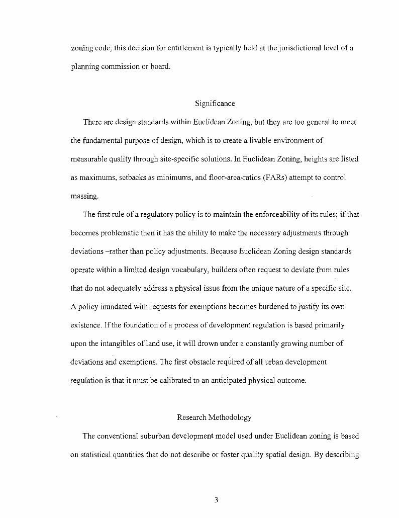
As in Leon Krier's drawing below from Architecture: Choice or Fate (1998), successful
urbanism demonstrates a mixture of complementary uses that make for an enjoyable
experience. As the drawing illustrates, it makes more sense to eat a pizza rather than a
pile of pizza ingredients.
Figure 1. L. Krier's diagram demonstrating the appeal of mixed-uses
For this thesis I have chosen to look at the gains made in network sciences rather than
the trends commonly discussed in urban sustainability. Sustainability is typically defined
as the ability to meet one's needs today without compromising the needs of future
generations. However, because of its relative vagueness, it provides little use for a
establishing the quality of a given system's health. My fundamental reason for avoiding
4
the common definition of sustainability as a benchmark for system survivability in
regards to this thesis is because according to the Second Law of Thermodynamics, 100%
sustainabihty is not achievable. The sustainability of a given environment is a noble goal,
much like the perpetual motion machine and the free-energy generator. If we are to make
an argument for using the discoveries of complexity and emergence taken from the
physical sciences, it is appropriate to demonstrate the limitations of sustainability within
those same limitations.
The Second Law of Thermodynamics states that heat flows spontaneously from hot to
cold and does not flow in the opposite direction (Cutnell and Johnson, 1998) illustrates
that sustainability is ultimately impossible. To add to this, all spontaneous processes are
irreversible, meaning that you can use available energy but you cannot create new
energy. The universe is continuously expanding and our physical world is constantly
working towards a state of entropy, or working towards a state of equilibrium (Cutnell
and Johnson 1998).
In order to provide clarity to how sustainability is addresses by this thesis, I propose
that we look at the sustainability of communication or how information is transmitted,
rather than trying to focus our efforts on the ever-changing status of a given environment.
At the root of organizational sciences and systems theory is the transference of
information within a given space and time. This information is the coding of instruction
that, in the scope of this thesis, results in the production of an urban environment.
5

Thesis Focus
As a focal point of this thesis, I have chosen to continue where Jane Jacobs left off in
the final chapter of her book, The Death and Life of Great American Cities (1992). In
describing the type of problem a city is, Jacob's makes a recommendation that we should
look at our present concerns of urban growth as a system of organized complexity. The
most appropriate and capable mechanism that can deliver what is expected from
sustainable growth today is the Form-Based Code, as it regulates the physical aspects that
have the most bearing on establishing a self-organizing system.
The purpose of this thesis is to shed light on a more effective manner of guiding
development towards a robust urban environment -rather than one that is just sustainable-
and to present the core principles that seek to maintain that environment. Ultimately, a
self-organizing cycle of self-educating individuals begins to actively contribute in their
future development. This is what I would consider to be an emergent urban environment,
and the ultimate idealistic societal quality.
The following chapters examine the nature of identifying and categorizing the
problems in regulating urban design. I begin with a brief historical overview of urban
planning and how cities have gone from a process of prescriptive tradition to proscriptive
regulation that has limited the effectiveness of design in addressing urban issues. Chapter
Three gives an explanation of what constitutes a Form-Based Code process and the
minimum requirements to regulate by form. Chapter Four provides brief description of
complexity, self-organizing systems, and complexity and their common methods for
assessment and analysis. This chapter ends with an explanation of the algorithmic process
and adapting that to the work of James Carse regarding finite and infinite games (1986).
6
Chapter Five synthesizes chapters three and four, giving an analysis on the effectiveness
of the Form-Based Code process by demonstrating its ability to comply with the rules of
organizing systems. Chapter six is a summary of the opportunities and constraints found
within current Form-Based Codes and provides suggestions to ensure a successful
development code.
Definitions of Common Terms
The following definitions of terms frequently used are provided to offer clarity in the
discussion of this thesis. The first, "urban", is a term that shall mean "the process and/or
completion of a physical development that is bound by any anticipated affects it may
have on its adjacent neighbors". The term "urban" describes a qualitative condition of
place and is also a directional process in that a new project will cede to the contextual
nature of its surroundings. This is a broad term but is given to clarify a pre-condition to
this thesis. "Urban" is not the opposite of "rural" but rather its refinement. There is no
urban without its start from the rural condition. For example, a single tent in the woods
can be a rural construction, but will become an urban condition when the occupant of the
tent begins to make accommodations to other campers. These accommodations can be a
how the tent is situated, where the cooking occurs, the creation of a latrine, or any other
factor to be accounted for that may have an impact on existing or future neighbors. The
reason that "urban" definition appears general and contains no reference to "city" is that
it is a primary condition from which a hierarchy of human development is based.
Urbanism is a measurable gradient that implies an increase of conditional requirements
with the increase of the density and intensity of the built area.
7
The next commonly used term is "Euclidean Zoning". The term gets its name not
from the Greek mathematician Euclid or geometry, but from a landmark U.S. Supreme
Court ruling that gave local jurisdictions police powers to use planning regulation to
protect the public health, safety, and welfare. This term is relatively interchangeable with
land-use planning, and is synonymous with conventional suburban development, as they
all operate from a hierarchical pyramid of protected uses with the single-family home
having the most protection from other uses.
The term used in this thesis as the counterpoint to Euclidean Zoning is "Form-Based
Code". This term represents a process that has other names such as "Context-Based
Zoning", "Smartcode", or "Transect-Based Code". The key difference from Euclidean
Zoning's regulation of the intensity of use is that a Form-Based Code operates from a
gradient of urban intensity known as a "transect". Within a transect are levels of scale
that establish the typologies of buildings, streets and streetscapes, and public spaces.
"Complexity", "Self-Organizing" and "Emergence" are the three terms that represent
a collective term often referred to as the "New Sciences". The reason for the "New-ness"
is that these three terms are utilized in the physical sciences and mathematical theory. For
this paper simplified working definitions are given in consideration of the limited scope
of this thesis. "Complexity" is the first stage of organizational thought and analysis that
deals with identifiable problems of multiple variables within a defined parameter. With
the addition of a time component to complex problems we now begin to deal with "self-
organizing" systems. The reason time is used to distinguish complexity from self-
organization is that self-organizing systems demonstrate synchronicity. The complex
variables in a self-organizing system begin to synchronize, coalescing into a unit with
8

defined boundaries. At the point that the self-organizing system begins to regulate itself
in response to its surroundings it begins to develop "emergent" qualities. Emergent
systems are networks of self-organized, complex variables that act as a single unit with
the ability to strive for self-preservation.
9
CHAPTER 2
FROM THE PRESCRIPTIVE TO THE PROSCRIPTIVE
According to the City of Las Vegas Title 19 Zoning Code, a single-family home
situated on a one-acre lot could not build an accessory structure that exceeds the gross
floor area of the primary residence by fifty-percent without seeking a variance to operate
outside of the parameters of the code. Oddly enough, the property owner could build a
structure that would fill the entire lot as long as it met the general setback standards. So in
this instance, a property owner could build a two-story 60,000 square-foot house without
any reviews but would have to obtain approval via discretionary review process for a
simple shed that may be slightly bigger than half the size than the house. The code
creates an absurd requirement that a barn must be fifty-percent smaller than the
farmhouse but a farmhouse can practically cover the entire lot.
Proscriptive limitations for an accessory structure, when regulated as a use, do not
provide the flexibility found in the prescriptive regulations provided by building typology
(a component of Form-Based Codes). In the context of a semi-rural neighborhood it is
not uncommon to see some type of large shed or accessory structure that is larger than the
primary residence. There are numerous examples in various municipal codes of where
proscriptive requirements hinder contextual development. When the sole nature of a
proscriptive code is to prevent development from adversely affecting its neighbors, you
fail to acknowledge any positive contributions that a proposal may add to the
10
neighborhood. In terms of urban analysis, you are always starting off on a weak point and
continue to work your ways backwards.
The core of this chapter outlines how an implicit form-based prescriptive process of
urban development has developed into an explicit use-based proscriptive process. By
"proscriptive" I mean a restriction to only allow what is explicitly expressed in the code.
Form-based Codes works proscriptively as the flexibility for design-based solutions are
available and uses are much more diverse. A Form-Based Code can allow taller buildings
of greater densities if the proposed design can demonstrate that it can operate within the
context of the neighborhood it is placed in.
Beginning with Buildings
The history of the urban environment has been predominately a history of urban form
up until the last 83 years. As such, the issue now is that the past 8 decades of increasing
regulation have made a substantial effort to trump the past 6,000 years of traditional city
building. Historically, our urban environments evolved under a growing knowledge base
founded upon a collection of adaptations to the physical environment and the provisions
made for the social needs of the community. These adaptations and provisions are what
developed into generalized knowledge that became traditions.
Carpenters, masons, stonebuilders, and others regulated the development of their
crafts with guilds and unions. These building cultures were established to ensure a
consistency in practice, a protection of their livelihood, and as a means of ensuring a
living for future generations. Amongst these specialists were generalists who would be
the equivalent of what we expect from today's architects. An excellent example of this is
11
the Renaissance genius Filippo Brunelleschi, who is known for the construction of the
Santa Maria del Fiore. Brunelleschi acted as sculptor, structural engineer, mason, and
architect of the Florentine Cathedral completed in 1436, which is still in use to this day
(King, 2000).
Even in pre-building code times, a builder was obligated to deliver a safe structure.
One of the first legal areas established in Hammurabi's Code of Laws were the rules for
the builder. In early times the builder was ultimately responsible for the construction of
the building and its performance. This meant that if a house collapsed and killed the
occupants the builder's would lose his life (Ching 2003).
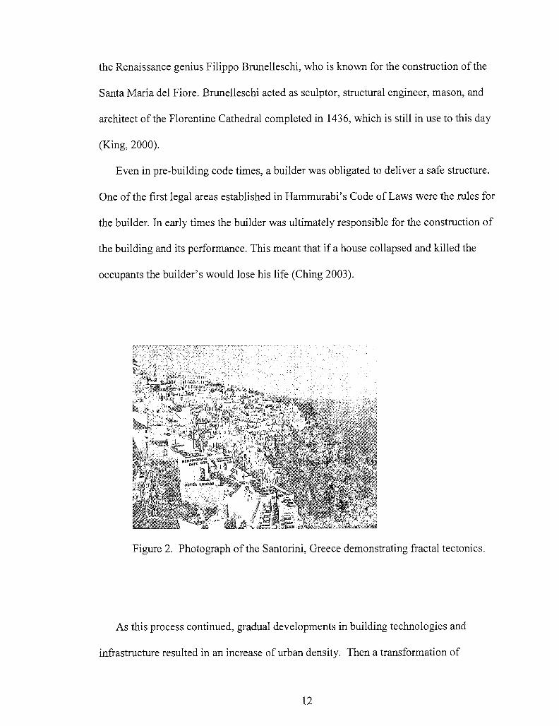
Figure 2. Photograph of the Santorini, Greece demonstrating fractal tectonics.
As this process continued, gradual developments in building technologies and
infrastructure resulted in an increase of urban density. Then a transformation of
12
knowledge regarding public safety placed regulatory power into the hands of specialists
in order to deliver greater assurances of safety to the individual and to protect those who
could not grasp such detailed knowledge. Codification of safety and welfare began to
replace the common sense of urban design traditions that transformed the requirements
for life safety and sanitation into land use and density regulations. Although undoubtedly
necessary, a casualty in this process was that problems that could be dealt with using
practical methods for design deferred to more rigid procedural solutions. This is where
further splintering of the development process occurs; building codes, zoning codes and
subdivision laws (platting) that do not allow for adaptability in the way that a
monoculture can produce greater yields, but of lesser quality and at risk of rapid
downturns.
Like zoning ordinances, the basis for building codes emanated from historic fires
beginning with Chicago in 1871. The first building codes began as a consolidated effort
by private groups to address the conflicts encountered between various cities' codes. The
National Board of Fire Underwriters had threatened not to insure any businesses until
Chicago developed a building code in 1875 that dealt with fire hazards (Ching 2003).
Despite common misconceptions, building codes are newer than many prevalent zoning
codes.
The difference between the authority of building codes and zoning codes is that
construction follows after entitlements have been granted. In some cases the mandatory
fire setbacks stemming from building codes, based on the materials and type of
occupancy are not in line with zoning setbacks. This often can be the cause of large
delays in development in that the entitlement process is not closely linked to the
13
permitting process. Despite the multiple levels of specialized oversight, there is still little
in the conventional suburban development process that prevents the individual from
obtaining entitlements for a project that may not be in compliance with the adopted
building codes.
Construction permits for buildings that cannot meet code are requested frequently
enough that many jurisdictions adopt a clause that allows the local governing body to
have the ultimate approval. While this can be argued as a means of providing flexibility,
it also draws attention to the inconsistencies that surface when going from the use-based
entitlement process to the construction-phase of the permitting process. This has become
another opportunity for specialists that assure a proposal's fire safety, code-analysis, or
even fire-sprinkler installation. The specialization of safety regulations cause further
splintering in the development process; building codes, zoning codes and subdivision
laws (platting) that do not allow for adaptability in the way that a monoculture can
produce greater yields, but of lesser quality and at risk of rapid downturns.
The Law of the Indies
The following events serve as snapshots of the emphasis of land use in regulating the
functions of a city over urban design. I begin by investigating the early common urban
patterns with a particular focus on events that lead to the regulation of urban development
in the United States.
In 1573 the Law of the Indies had a great effect on the urban form of the "The New
World". King Phillip's royal decree had an area of influence covering Latin America and
many of the southern North American cities with its effects still visible today (Kostof,
14
1992). This is the first recognized lawful requirement that emphasized form and
placement, thus creating the first known development regulation in North America3. The
Law of the Indies regulated Spanish settlements that reached into what is now the United
States and included detailed criteria regarding the design and location of a central plaza,
the organization of civic buildings, the allowance for communal open space, and the
separation of incompatible uses. There were even distinctions in the placement of the
central plaza if the town was located on the coast (near the shore) or if it was located
inland (centralized) (Duany, 2003). You can still see the mark of these plans on cities
such as San Antonio, Texas and Saint Augustine, Florida to name a few cities in the U.S.
Although there were some specific requirements in the Law of Indies, in general the rules
provided could be best described as parametric, as it called out proportional requirements
for the town size and shape, so as to allow for future growth that would continue from the
initial settlement (Kostoff, 1993).
The Jeffersonian Grid
The gridiron layout, the orthogonal pattern most people have come to familiarize an
urban core, is originally credited to Hippodamus, the famous Greek town planner who
brought straight and parallel streets to Piraeus around 450 BC (Jackson, 1985). Although
it was an arguably effective pattern, it was basically shelved for 1500 hundred years, as
the organic mediaeval plans developed around a royal piecemeal land distribution
process. The early U.S grid plans showed up in cities such as Philadelphia, Savannah,
and Washington D.C. whose radial plan is superimposed on a grid (Jackson, 1985).
3 The Taos Pueblo, arguably predates the Law of the Indies, but continues to be inhabited sans any explicit regulation of form.
15
These cities were modeled after Sir Christopher Wren's success in London. Under
Thomas Jefferson's direction, the U.S. was subdivided into one-mile squares, set within
36-square mile Townships, by the Continental Survey in 1803 (Duany, 2003). But it was
not until the Homestead Act of 1862 that the nationwide grid was utilized in order to
accommodate frontier expansion. As Kenneth Jackson states in Crabgrass Frontier the
nationwide platting provided "at least the illusion of orderliness and prosperity that
settlers associated with the big cities of the east" (1985).
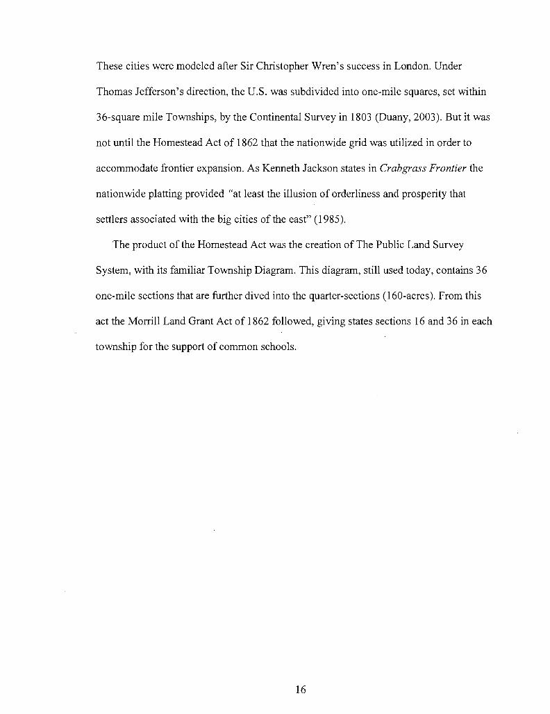
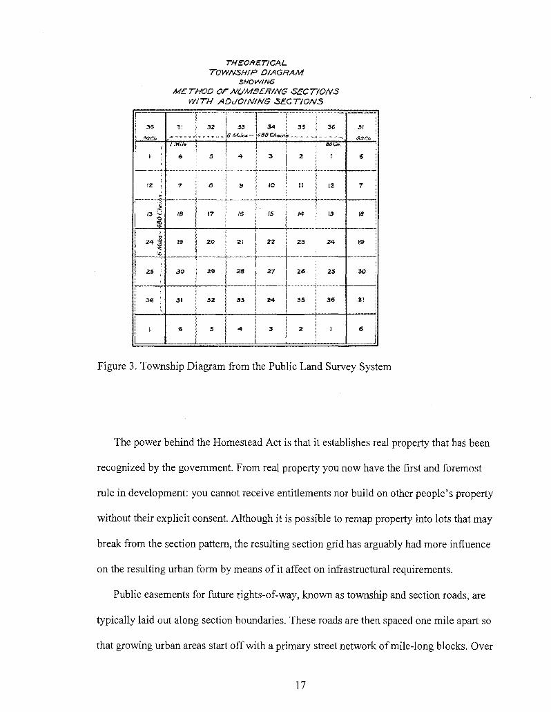
The product of the Homestead Act was the creation of The Public Land Survey
System, with its familiar Township Diagram. This diagram, still used today, contains 36
one-mile sections that are further dived into the quarter-sections (160-acres). From this
act the Morrill Land Grant Act of 1862 followed, giving states sections 16 and 36 in each
township for the support of common schools.
16
THEORETICAL TOWNSHIP DIAGRAM
SHOWING
METHOD OF NUMBERING SECTIONS WITH ADJOINING SECTIONS
I
[ 3 6
> aach
E-1 ;
IS i
•i
( 3 u
as It-
'-C
2 5 •
3 6 !
1
| 3( j 3 2
/ Mite
6
7
IS
19
30
3 t
6
s
3
17
2 0
2 9
3 2
S
3 3
<? AAA* —
4-
9
IS
2 1
2 8
3 3
• *
3 4 3 S
\tS0 O W > ?
3
_ - „
. 0
IS
2 2
27
3 4
3
2
n
J 4
2 3
2 6
3 5
2
3 6
~ ^ ae>c*.
1
12
13
24-
2 5
3 S
I
31
HOCh.
€ j
7 j
| 18 !
19
3 0
3 1
6
Figure 3. Township Diagram from the Public Land Survey System
The power behind the Homestead Act is that it establishes real property that has been
recognized by the government. From real property you now have the first and foremost
rule in development: you cannot receive entitlements nor build on other people's property
without their explicit consent. Although it is possible to remap property into lots that may
break from the section pattern, the resulting section grid has arguably had more influence
on the resulting urban form by means of it affect on infrastructural requirements.
Public easements for future rights-of-way, known as township and section roads, are
typically laid out along section boundaries. These roads are then spaced one mile apart so
that growing urban areas start off with a primary street network of mile-long blocks. Over
17

time, and due to the distances covered, these roads have become the arterials or section
line roads that today are primarily designed for auto-oriented transportation. In Euclidean
Zoning, commercial development typically fronts along arterials and at intersections. The
remainder of the square-mile section is then filled in with residential development,
schools, churches, and parks. This regimented urban structure coincides with the
similarly strict practice of Euclidean zoning, in which use of a property is dictated and
regulated by zoning district, the boundaries of which often being derived from locations
of arterials.
Congress granted land to the states for transportation systems and for public
buildings. The largest grants went to railroads to encourage construction of the
transcontinental lines. Between 1850 and 1871 when the railroad land grant policy ended,
railroads received 175,350,000 acres from the public domain, although they later had to
forfeit some 35 million acres for failure to meet construction agreements (Gates, 1968).
The grid was the stepping point for land use to launch from.
The 1901 Tenement House Act of New York State
The first land use regulations seen in the U.S were the early tenement laws created in
response to the unhealthy living conditions of 19th century industrialized New York City.
With the large immigrant population, not enough housing, and plentiful low-paying
manufacturing jobs came overcrowded tenements under a constant risk of fire. In 1901
the Tenement House Act of New York State required that no tenements be built on less
than 25-foot wide lots and required improved sewage conveyance and ventilation be
installed (Jackson, 1985). Although there were requirements affecting a building's
18
general form, the act was largely unsuccessful in improving living conditions, hence the
development of zoning laws in 1916 to control land use.
The 1909 Plan of Chicago
One of the most notable products that came from the 1893 Columbian Exposition in
Chicago, besides the City Beautiful movement, was the 1909 Plan of Chicago. The
Chicago Plan was the first comprehensive plan for an American city created by Daniel
Burnham and Edward Bennett with a broad scope that reached beyond the city limits and
a thirty-year vision. A famous line attributed to Burnham was, "Make no little plans.
They have no magic to stir men's blood..." This phrase is repeated to this day in many
planning departments, whether in jest or seriousness. Today's version of the Chicago
Plan still harks back to the call for planning action opening with, "This is no little plan.
This is a plan for urban greatness" (Chicago Plan 2008).
One important component missing in the initial Chicago Plan was the restriction of
plan amendments and lack of public participation during the creation of the plan. The
Plan was presented and approved by the general public as a finished document. Another
oversight in the original Chicago Plan was the lack of regulation over privately owned
lands. At the time of the plan, municipal governments had little legal authority to control
development on private property, as their right to use the police power was yet
established. Constitutionally the state was the ruling authority in regulating the activity
on private property in order to protect the public health, safety, and welfare.
19
1916 NYC Zoning Ordinance
Following the Chicago Plan of 1909 some states began legislating their own zoning
enabling acts in order empower municipal governments. In 1916, under Attorney
Edward M. Bassett, New York City adopted the first modern zoning ordinance in the
United States based upon the state's right to police powers. Bassett sought to link each
provision of the ordinance matter so that it fell within the scope of police powers,
commonly phrased as "public health, safety, and welfare". This was done to frame the
debate in determining a potential use as an entitlement endowed by the public rather than
a prerogative of the landowner.
Unlike the visionary Plan of Chicago, the 1916 NYC Zoning Ordinance came in
response to the pressures arising from a new concept: skyscrapers. The decreasing
amount of land available for a rapidly industrializing city combined with a new subway
system carrying thousands of workers pressured commercial construction to build
vertically. Although the skyscraper was a natural response to the pressures of high
density growth, some projects were reducing the amount of available sunlight and fresh
air by taking up entire city blocks with building heights of up to fifty stories. Bassett's
plan was to create an overlay district that regulated building height in proportion to street
width as a remedy to reducing congestion while increasing available light and air. The
entire city was divided into ten districts.
20

•••—-Vr* • S i *
l<* • • • T I * • • J • * ••••••
*i - - • • « • • • * * r f 3 4
I - M i d - i ; ; ^ | |
ft&
I! I l|f • • # *
* « * •
Figure 4. A postcard showing The Hotel New Yorker (NYC Library)
Nine of theses districts were given distinct uses: a residential district, four retail
districts, two business districts, one manufacturing district, with the tenth district
allowing for the mixture of uses. Five of these use districts were regulated by lot
coverage and minimum lot sizes. This mandated increased setbacks for skyscrapers as the
building height increased. This portion of the ordinance is responsible for the distinct
Manhattan skyline of ziggurat-like skyscrapers (see figure 4). The New York zoning
ordinance failed to regulate physical design beyond basic setbacks and density
restrictions to permit light and air and to reduce congestion. The provisions also served to
"prevent the intrusion of improper uses into homogenous areas" (Nolan, 2006). Almost
immediately, communities across the country enacted similar regulations.
21
The Standard Enabling Acts
Following the success in New York with the 1916 Zoning Act, the U.S. Department
of Commerce published the Standard Zoning Enabling Act in 1922. This provided model
legislation on which states could base their enabling legislation, essentially standardizing
the practice of zoning in the country. The resulting Standard State Zoning Enabling Act
(today referred to as the Standard Enabling Act) extended the authority given to the states
by the Department of Commerce, under the direction of Secretary Herbert Hoover in
1924. Edward Bassett was brought in to write the Standard Enabling Act after the success
of New York City's 1916 zoning ordinance. The New York City ordinance, which was
developed in response to the problems of early 20th century industrialization, became the
template for land use regulation across the United States (Nolon, 2006).
The Standard City Planning Enabling Act of 1928, a refinement of empowerment
given to local jurisdictions and municipalities, followed the Standard Enabling Act of
1926 upon the ruling of the Supreme Court in 1926 (see below). The results of the
Standard City Planning Enabling Act are seen today in the provisions for Planning
Commissions that regulate and restrict development by creating master local plans and
the controlling subdivision of land. The Standard City Planning Enabling Act assured
states that their new zoning regulations would be upheld against any legal challenges
sought to prevent overcrowding by reducing density for the purpose of promoting health,
safety and welfare (Nolon, 2006).
22
The Village of Euclid, Ohio v. Ambler Realty Co.
Two years after the adoption of the Standard Enabling Act, Zoning was officially
endorsed as legal process when, in 1926, the U.S. Supreme Court ruled on The Village of
Euclid, Ohio v. Ambler Realty Co. The issue began when The Ambler Realty Company
filed suit arguing that the zoning ordinance had deprived the company of property
without due process (5th and 14th Amendments) after the City of Euclid forbade the
developer from building all industrial warehouses where a mixture of industrial,
apartments, and duplexes were anticipated. The trial court concurred and held that
Euclid's zoning ordinance was an improper use of the police power and was appealed to
the Supreme Court.
The Supreme Court Justices agreed that in the Euclid case it is permissible for a
jurisdiction to control land use through the police power, and concluded that it could be
just as improper to place an apartment building in a single-family residential district as it
would be to place a polluting factory there (Nolon, 2006). Where the Standard Enabling
Act police powers could prevent a factory from being built in a neighborhood, it could
not prevent an apartment building from being built in a single-family neighborhood.
Zoning extended the arm of the nuisance laws and the Euclid case paved the way for
more widespread use. The Supreme Court's decision places the single-family home at the
top of a pyramid, with increasing residential density, then increasing commercial
intensity, and finally industrial uses placed at the bottom. The primary purpose of
Euclidean is to protect the single-family residential district from encroachment by
unwanted uses.
23

Planners continue to utilize zoning regulations to separate noxious uses and promote
compatible uses of land. While Euclidean Zoning has delivered some observable benefits,
it is now incapable of evolving with the changes in today's urban landscape. Problems
arise when the protection of uses are dealt with by means of design constraints, rather
than use constraints. This becomes greatly exacerbated with the struggles of coping with
increases in residential density. In the case of residential use, the language is limited by a
generalized description of dwelling units per acre (D.U.A), which handicaps the ability of
design to act as the mitigating factor for urban development progression.
The Economic Influence on Form:
Hidden with the proscriptive nature of land use regulation is its close relationship to
the financial process of development. Since the United States Supreme Court's decision
in Euclid, zoning has placed the single family home at the highest level of protection
guaranteeing these homes property values. Because the Euclid ruling is really not that
old, we must consider the effect the zoning process has had on neighborhoods that were
constructed prior to 1926. There are still many homes -typically within in lower-income
neighborhoods- that were owner-built or have had a significant amount of additional
construction over its lifespan. The result has been buildings that do not entirely meet
today's zoning or building code requirements as they came in under the law (or, more
frequently than recognized, illegally). The character of older neighborhoods matured
from a relaxed process of self-building over generations largely absent of longstanding
financial obligations debt. These neighborhoods of debt-free homeowners have structured
their lives around activities of their choosing.
24
One only needs to consider the irony in the losses in New Orleans. Many of the
neighborhoods that literally typified the laissez-faire attitude of the "Big Easy" cannot be
rebuilt to today's standards. Even if an outlandish fantasy were to occur where
"imagineers" would reproduce the lost neighborhoods of Bourbon Street in prime
Disneyland fashion, the costs of doing so would be so high that the demographics of the
previous neighborhood would likely change. The non-conformance of these houses make
them impossible to mortgage, placing them outside the system that requires a contract of
debt, since the new building standards cannot be met without commercial intervention.
An excellent summary of how the standardized development process can kill the source
of neighborhood character by removing it from its cultural origins from Andres Duany:
"The hurdle of drawings, permitting, contractors, inspections — the professionalism of it all — eliminates self-building. Somehow there must be a process whereupon people can build simple, functional houses for themselves, either by themselves or by barter with professionals. There must be free house designs that can be built in small stages and that do not require an architect, complicated permits, or inspections; there must be common-sense technical standards. Without this there will be the pall of debt for everyone. And debt in the Caribbean doesn't mean just owing money — it is the elimination of the culture that arises from leisure." (2007)
The Rise of the New Urbanism and its Link to Form-Based Codes
The past several years have seen the emergence of the Form-Based Code as an
alternative means for regulating development. What is considered the first Form-Based
Code to be used in the U.S emanated as a byproduct of a private development subdivision
known as Seaside, FL. Referred to as The Seaside Code, it established eight building
types, regulates yards, building heights and parking much like zoning, but also provides
requirements for architectural elements such as front porches and white picket fences
(Mohney and Easterling 1991).
25
Since Seaside, Form-Based Codes have been applied in numerous locations across the
country and have become an integral component to the New Urbanist movement. A
common criticism for Form-Based Codes is that it typically succeeds under the auspices
of a single owner or as a private master planned community. Although it would appear
difficult to adopt a Form-Based Code in developed areas with multiple property owners,
there are numerous public entities that have done just that, allowing for an alternative that
encourages design-based solutions before use-based restrictions.
26
CHAPTER 3
HOW A FORM-BASED CODE WORKS
First and foremost, I would like to address the terminology used in describing a
"Form-Based Code". Form-Based Codes often lead the reader to assume that it is a
derivative of the common adage "form follows function"; that Form-Based Codes replace
land-use as the regulative component with the appearance of a building. This is not
accurate as land-use regulation is still included within a Form-Based Code and the level
of detail of how a building looks can vary. When looking at what effective Form-Based
Codes regulate, other common descriptions that have not caught on such as Context-
Based or Transect-Based Code seem be more appropriate.
Form-Based Code is a commonly used term in the planning literature. As such,
finding a firm definition of the term is difficult. The Form Based Code Institute, a non
profit corporation that seeks to standardize the practice of form based coding, provides
the following definition from their website, www.formbasedcodes.org:
"[A Form-Based Code is] A method of regulating development to achieve a specific urban form. Form-Based Codes create a predictable public realm primarily by controlling physical form, with a lesser focus on land use, through city or county regulations.
Form-Based Codes address the relationship between building facades and the public realm, the form and mass of buildings in relation to one another, and the scale and types of streets and blocks. The regulations and standards in Form-Based Codes, presented in both diagrams and words, are keyed to a regulating plan that designates the appropriate form and scale (and therefore, character) of development rather than only distinctions in land-use types. This
27
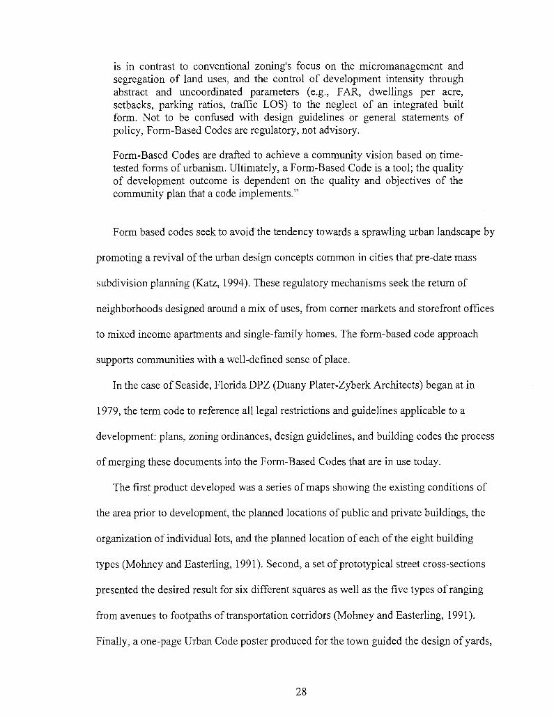
is in contrast to conventional zoning's focus on the micromanagement and segregation of land uses, and the control of development intensity through abstract and uncoordinated parameters (e.g., FAR, dwellings per acre, setbacks, parking ratios, traffic LOS) to the neglect of an integrated built form. Not to be confused with design guidelines or general statements of policy, Form-Based Codes are regulatory, not advisory.
Form-Based Codes are drafted to achieve a community vision based on time-tested forms of urbanism. Ultimately, a Form-Based Code is a tool; the quality of development outcome is dependent on the quality and objectives of the community plan that a code implements."
Form based codes seek to avoid the tendency towards a sprawling urban landscape by
promoting a revival of the urban design concepts common in cities that pre-date mass
subdivision planning (Katz, 1994). These regulatory mechanisms seek the return of
neighborhoods designed around a mix of uses, from corner markets and storefront offices
to mixed income apartments and single-family homes. The form-based code approach
supports communities with a well-defined sense of place.
In the case of Seaside, Florida DPZ (Duany Plater-Zyberk Architects) began at in
1979, the term code to reference all legal restrictions and guidelines applicable to a
development: plans, zoning ordinances, design guidelines, and building codes the process
of merging these documents into the Form-Based Codes that are in use today.
The first product developed was a series of maps showing the existing conditions of
the area prior to development, the planned locations of public and private buildings, the
organization of individual lots, and the planned location of each of the eight building
types (Mohney and Easterling, 1991). Second, a set of prototypical street cross-sections
presented the desired result for six different squares as well as the five types of ranging
from avenues to footpaths of transportation corridors (Mohney and Easterling, 1991).
Finally, a one-page Urban Code poster produced for the town guided the design of yards,
28

porches, outbuildings, parking, and building heights for each of eight different building
types
In the years since the Seaside code, other Form-Based Codes have taken these
elements and created a set of documents that typically consist of five common elements:
1) the regulating plan, 2) public space standards, 3) building form standards, 4)
administrative or procedural standards and 5) glossary (Parolek, Parolek and Crawford,
2008). It is generally agreed that the minimum requirement for a Form-Based Code is the
Regulating Plan. Without unifying the subdivision laws, providing building typology and
a public space plan that standardizes street a Form-Based Code becomes nothing more
than just detailed Euclidean Zoning design standards.
The Regulating Plan
The first and foremost role of the Regulating Plan is to communicate to the public the
process to follow in the urban development of the local community. By "urban' I refer to
the definition provided earlier to mean the appropriate level of development that remains
sensitive to the context of its surroundings. The regulating plan begins first by identifying
the location of existing building and street types as the starting point to find what should
be preserved and what may evolve. Then the regulating plan continues with the
establishment of boundaries between zones of varying urban intensity. These boundaries
are applied to a network of streets and blocks (Parolek, 2008).
The most common method for establishing the zones of urban intensity has been the
rural-to-urban transect method popularized by the Smartcode, a Form-Based Code tool
developed by DPZ Architects and Placemakers, LLC. Where Euclidean Zoning utilizes
29
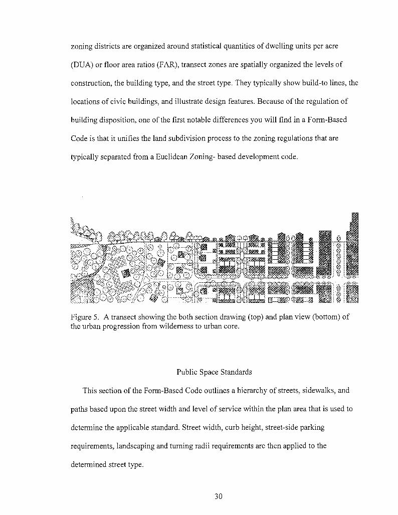
zoning districts are organized around statistical quantities of dwelling units per acre
(DUA) or floor area ratios (FAR), transect zones are spatially organized the levels of
construction, the building type, and the street type. They typically show build-to lines, the
locations of civic buildings, and illustrate design features. Because of the regulation of
building disposition, one of the first notable differences you will find in a Form-Based
Code is that it unifies the land subdivision process to the zoning regulations that are
typically separated from a Euclidean Zoning- based development code.
Figure 5. A transect showing the both section drawing (top) and plan view (bottom) of the urban progression from wilderness to urban core.
Public Space Standards
This section of the Form-Based Code outlines a hierarchy of streets, sidewalks, and
paths based upon the street width and level of service within the plan area that is used to
determine the applicable standard. Street width, curb height, street-side parking
requirements, landscaping and turning radii requirements are then applied to the
determined street type.
30
In addition to the streetscapes, are regulations that address public spaces such as
plazas, public parks, and other spaces that qualify as civic spaces (Parolek, 2008). The
inclusion of a civic space development standard addresses a common weakness to
Euclidean Zoning's qualitative requirements. Park space is generally addressed as an
afterthought, since the developer is only required to dedicate open space based on a net
calculation. What typically results are "pocket parks" located on leftover lots deemed too
unattractive for selling or unfit for development.
Although the locations of trees and other landscaping details related to the streetscape
are typically specified in this section, some Form-Based Codes have created separate
landscape standards addressing planting requirements separately (Parolek, 2008).
Building Standards
At the finest scale of Form-Based Code regulation is the portion that deals with the
building styles and materials. The building standards provide parameters that are
typically illustrated by cross section to specify key dimensions (Katz, 2003). The design
standards regarding building height, disposition, elements, and uses are described in the
building standards (Katz, 2003) that are permitted and the ways in which they can be
incorporated into various building elements such as walls, windows, fences, and roofs. It
also describes the ways in which these building elements can be incorporated into
different structures. There are other optional standards that may be included such as
landscape plans and architectural standards.
Building height is commonly expressed as a maximum height-to-the-eave dimension,
or as a range of acceptable number of stories. When building heights are expressed in
31
terms of one single dimension as they are in traditional zoning, developers attempt to
reduce floor-to-ceiling heights to a minimum in order to maximize the number of floors
they may build. The minimum number of stories reflects the number of floors required to
maintain an appropriate "street wall" (Katz, 2003). A height range is provided to allow
for design leeway before it appears overwhelming and out of context in relation to the
surrounding community. Height specifications are expressed in terms of two dimensions
when using Form-Based Codes (maximum-height-to-the-eave dimension; range of
acceptable number of stories). Additionally, building standards may specify minimum
above-grade dimensions as they relate to a given typology. For example, a townhome is
typically outfitted with a stoop to ensure privacy at the streetfront. This requires the
structure to sit several feet above street grade. Disposition regulates the placement of a
building in relation to fronting streets and neighboring building lots.
Administrative Standards
A key part of a Form-Based Code is the portion that regulates its operation. The
administrative standards provide a protocol of how a development proceeds through
entitlements to permitting. These regulations are coordinated so as to provide quick
approvals for compliant proposals and to also allow an appeal process for proposals that
are deemed non-compliant at the administrative or staff level.
One of Euclidean Zonings weaknesses is the over reliance on the discretionary review
process. For instance, a new development may comply with the allowable use and exceed
all minimal requirements of the proscriptive standards but it still requires to be approved
by a discretionary review.
32

Glossary
A picture may be worth a thousand words, but a word can generate a million pictures.
Since a Form-Based Code deals heavily with street and building typologies, a glossary of
clear and precise definitions is a critical component. Recall that the original purpose of
the code is to communicate the community's process for urban development. The code
must provide very specific language accompanied by illustrations for even the most
common terms. Confusion often arises from the different meanings interpreted to a
common usage whereas the glossary can provide a consistent interpretation.
Methods of Implementation
Just as important as the Form-Based Code is the means for implementation. Having
the best rulebook in the world will not mean much if you do not have a way to enforce it.
The ideal condition would be for a local government to adopt a Form-Based Code for its
entire jurisdiction. The obvious challenge however, is that it would be overly ambitious
to expect the professional development industry to adjust to a reworking of the entire
process and it would be cost-prohibitive for the local jurisdiction to completely change
over to a very different process. Instead the code may be adopted for a smaller area or
corridor and then phased into other areas using similar approaches as needed. The other
option is what is known as a floating or optional code that is adopted for large areas. This
is usually done over largely undeveloped areas waiting for the public resources to allow
the local government to draft its own regulating plans.
33
Mandatory Codes
This is the most common adoption approach is where compliance is mandatory. It is
also the most ambitious of the approaches as it requires the complete replacement for the
existing zoning ordinance. The Form-Based Code can be adopted as a new zoning district
or as an overlay district. Some states allow Form-Based Codes to be contained within a
planning document called a "specific plan," which completely overrides the zoning
ordinance for a given geographic area. Since it stands apart from the zoning ordinance, it
tends to vary in its format, allowing for some freedom in designing document's layout.
Also, the urban design plan and the implementing regulations are bundled together,
greatly improving user comprehension (Parolek, 2008).
Optional or Parallel Codes
An optional or parallel Form-Based Code gives the developer the choice of the Form-
Based Code or the zoning ordinance, but it must be one or the other. The developer has
the option of following a Form-Based Code that will streamline and simplify his
development process. The challenge then comes from maintaining two different
development regulations for one area. Depending on the area being regulated, if some
developers are choosing the form-based may lead to a compromised process for
integrated place-making (Parolek, 2008).
Floating-Zone Codes or the PUD Process
Floating zones are most often written to facilitate master-planned suburban
communities called PUDs (planned unit developments). However, floating-zone codes
34
are now being written as Form-Based Codes to facilitate urban development. A floating-
zone Form-Based Code does not contain a regulating plan but includes instructions and
standards for developers to follow when they prepare a regulating plan for their property
(e.g. maximum block dimensions, street types, building types, open space accessibility,
and sidewalk widths.) This distinguishes floating-zone codes from the other two
approaches-developers rather than the local governments create the regulating plans and
the urban designs that they facilitate, but the local government sets the standards.
Floating-zone codes allow local governments to establish urban form standards for
development without incurring the expense of developing urban design and regulating
plans. Developers are given the freedom, within clear parameters, to prepare regulating
plans for their property that are likely to meet government approval. A developer submits
his or her regulating plan for approval through the rezoning process. Upon rezoning, the
floating zone replaces the prior zoning for that property and the regulating plan becomes
binding.
35
CHAPTER 4
THE NEW SCIENCES
One of the challenges of this thesis is to aptly reduce the field of New Sciences within
manageable parameters. Therefore, the point of this following chapter is to give an
explanation of some of the concepts within the field of the New Sciences. There are
various strains of thought, systems theory, emergent theory, complexity, evolving
systems, and others that all revolve around a common image of a defined system within a
given parameter that continuously develops its own organizational structure as a means of
adapting to its surrounding environment. An excellent resource in following the
developments of the complexity community is the Santa Fe Institute, which was
established to offer complex analysis techniques to practical applications. How these
concepts specifically relate to the regulation of urban development will be addressed in
chapter five. I am limiting the scope of what is often discussed in the field of the New
Sciences to three interdependent concepts of system organization that maintain a
hierarchical relationship.
Complexity, as the first stage of organization, is treated as the idea of analyzing the
amount of order within a given system. Complexity arises when there are multiple
processes occurring together. If the processes are disorganized, the processes are defined
as chaotic. According to Nikos Salingaros (2006), the complexity of a system can be
36

measured by the ratio between the number of connections and the number of nodes.
Complexity therefore, is a preliminary measurement for quantifying the level of
organization. This process is difficult to measure as it and can easily be confused for
visual purity (Salingaros, 2005).
From the stage of complexity or a system demonstrating measurable complexity,
self-organization can emerge. This would be seen as a complex system that operates
under an algorithmic process, a crucial component to understanding and guiding ordered
systems towards emergence. Suppose there is a system with N nodes laid out on a single
plane that incrementally distributes random pairs of nodes between each link. Even
though the placement of the nodes may be random in relation to each other node, there
still remains the potential non-random relationship to systems operating at larger scales or
other systems present within the same space. In determining the randomness or intention
of the node distribution, eventually every node will be connected by at least one path
(Salingaros, 2006). There are two available outcomes in this system: a random network,
or a scale-free network. In terms of complexity, systems that exhibit a bell curve or
Gaussian distribution demonstrate a random-hub network. Contrary to perception, it is
less likely that a randomly distributed network of nodes will occur. This is because we do
not live in a static, non-interactive environment. We are naturally inclined to favor some
nodes over others creating what is known as scale-free networks which behave according
to the principles of power law distribution (Barabasi, 2003).
It is important to note the importance of power laws in the description of complex
systems as it relates back to the reference made about the algorithmic process. A common
explanation for a system with a power law distribution is Pareto's Law, also known as the
37
80/20 rule. The 80/20 rule stems from Vilfredo Paredo's theory of how the top 20% of
individuals hold 80% of the wealth. This rule has been used for various applications,
from value engineering to political polling. The key to understanding the meaning of a
scale-free system is best offered by Lazlo Barabasi's following rule, "No matter how
large and complex a network becomes, as long as preferential attachment and growth are
present it will maintain its hub-dominated scale-free topology" (Barabasi, 2003). Because
of the nature of the algorithmic process, a self-organizing system makes preferences in its
evolution through reiterative and recursive adjustments.
The final stage, emergence, is achieved when the constant reworking of simple
solutions within feedback cycles create a complex system that autonomously staves off
chaos. Steven Johnson lists the five principle conditions found within systems
demonstrating ground-up emergence (Johnson, 2001). The first characteristic is a higher
variety in the presence of higher numbers. In other words, in volume comes variety. The
next trait is a presence of micromotive and macromotive behaviors. Whether you are
looking at the cellular level or you are observing the entire system, a global behavior is
apparent. The third feature is the ability to not over-process problems and to leave them
at simple algorithms. At the core of highly complex systems are dense interconnections
of simple elements making low-level decisions. The fourth condition of an emergent
system is the ability to encourage random encounters through decentralizing systems that
rely on random interactions (Johnson, 2001). This correlates to the information value of
"surprises" as defined by Shannon's Theory of Information (Farmelo, 2002) and also
works in conjunction with discovering meta-information displayed in reoccurring
38
information that develops into patterns. Finally, an emergent system utilizes local
information to provide global wisdom.
An important goal of this paper is to make the distinction in culturing a self-
organizing system, as there has been great confusion regarding complexity theory and its
eventual physical expression in architecture. There have been past experiments in
extrapolating these scientific theories into a physical representation or the blobs of
architecture created using highly complex computer programs that are uniquely distanced
from traditional patterns of human activity. Think of an ordered system within an ordered
system within an ordered system, ad infinitum much like matryoshka dolls. These
Russian nesting dolls fit snuggly within each other but each can each be enjoyed at its
own unique scale.
Communication Theory
For a starting point of the available tools for analyzing complex systems, I offer a
discovery that is inextricably linked to the explosive development of the electronic age.
In 1948, Claude Shannon published his Theory of Information, using a logarithmic
formula to predict the quantity of transferable information. Another formula was
provided to rate the quality of the transferable information medium. Shannon's work
spawned the technological terms we see today, such as the BIT (binary unit), the modem
(modulator/demodulator) and was tied to Warren Weaver, whose essay captured Jane
Jacobs' attention in the final chapter of The Death and Life of Great American Cities
(1992). This relates to the requirement that free-agents have access to information that
gives notice to the influence of larger outcomes. Jacobs summarized this with a plea for
39
planners to seek out the "unaverage" when determining the given qualities of a
neighborhood (Jacobs, 1992). The formula, expressed as I=-p log2 p tells us that the
amount of information communicated in a message has a measurement of quantity, I,
with a unit of measurement known as the bit. Despite the enormous impact this formula
has had on the world of digital computer processes, this is such an invaluable formula
because it is not restricted to just digital processes. The statement made by the equation is
that the amount of information depends on the surprise the message holds, or/?, the
probability of a change in the message. For example, you are carrying on a conversation
at a party with a friend but your friend is droning on and on. You tune out the familiar
until you hear a key phrase -he's going to pay you the $50 he owes you. Surprise
represents the unexpected or unaverage events (Farmelo, 2002). The less probable the
event the more unique or surprising the event and thus the more information the event
holds (Salingaros, 2006)
Another formula that goes with the amount of information communicated is one that
reflects the quality of the transmission medium. This formula is expressed as C=W log2
(1+S/N), where C represents the amount of information transmitted in bits per second. W
represents the amount of available bandwidth and S/N represents the signal-to-noise ratio.
Again, we return to our party but this time it's noisy. Your friend not only owes you
money but is partially deaf (his bandwidth, W, is restricted). You now must increase your
signal by shouting at your friend to overcome the background noise and reduced
bandwidth (Farmelo, 2002). What this formula provides is a general application for
determining the quality of a transmission of information. Nikos Salingaros, and other
mathematicians have begun applying these formulas for determining the amount of
40
available information that a building can transmit through the expression of ornament,
tectonic features, and scale.
Logarithms and Networks
The next step is to address the application of the new sciences to "inform a process of
city-making, and the role within it of methodology, pattern, and precedent -all those
things related to Jacobs" (Mehaffey, 2006). The most beneficial contribution that the new
sciences have made to architecture and urbanism is the progress towards integrating
mathematical qualifications. We have formulas that can provide results reflecting given
quality and resolution. These formulas can be adapted to policy recommendations that
help planners clear the hurdle of quantifying data into ratios that describe no special
occurrence or relay no quality. The most important habits of thought, according to Jacobs
(1992), are to remain cognizant about the process and to work inductively, reasoning
from particulars to the general, rather than making deductive generalizations. Jacobs
encourages to seek "unaverage" (or unique conditions/events) clues involving very small
quantities, which reveal the way larger and more "average" quantities are operating
(p440). This correlates to Shannon's Theory of Information, that the unaverage conveys
information by the probability of surprise (Farmelo, 2002).
Scale
Scale is best defined as all elemental components having a relatively similar size
within a given parameter. Smallest scales should link their way to the largest scales. A
mathematical formula for verifying scalar dimension is p=c/xm where p denotes the
multiplicity of elements. Mis an empirically determined value between \>m>2 and c
41
represents a constant. The more levels of scale, the more structural entropy -or the
increase in the average amount of information (bits) needed to quantify the amount of
uncertainty of a given variable (Salingaros, 2006). In other words, the more scalar levels,
exhibited, the more information provided.
Fractals
A method that combines the concepts of scale and the medium of information
transmission into a tangible process can be done with fractal geometry, a popular method
in understanding organized complexity. In producing fractal geometry you are provided
two options, composition or decomposition. Both of these represent an opposite process
of order hierarchy. Decomposition is the application of an algorithm that continuously
divides up a given geometry into smaller parts and continues this reiteration until the
complexity limit has been reached at the smallest scale of object we can possibly make
(Eglash, 1999).
The other method, composition, continuously multiplies the initial geometry by
applying a reiterative algorithm that grows the fractal outwards. If we look at this
compositional fractal we see that the scale of the structure composed to the initial
geometry increases exponentially with the largest structure coming last. A new line is
written for each reiteration of the algorithm on the previous line (Eglash, 1999). The
complexity of the structure only becomes visible when the time dimension is displayed.
At their local scale, the cells are not able to "see" how their actions create the system, but
their actions do in fact make something bigger than themselves. They are creating a
structure by emergence and this emergence is visible only in a dimension larger than their
42
actions: the emergent dimension. The difficulty stems from an established reasoning for
emergent systems to be based on a compositional system.
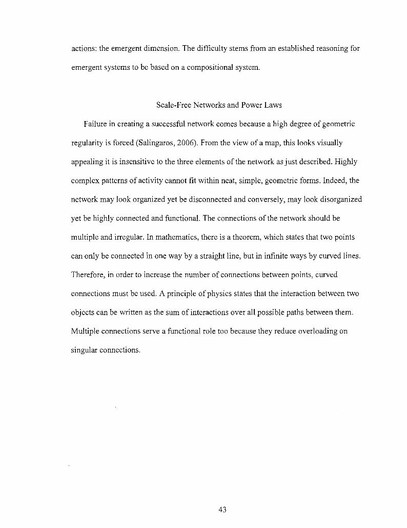
Scale-Free Networks and Power Laws
Failure in creating a successful network comes because a high degree of geometric
regularity is forced (Salingaros, 2006). From the view of a map, this looks visually
appealing it is insensitive to the three elements of the network as just described. Highly
complex patterns of activity cannot fit within neat, simple, geometric forms. Indeed, the
network may look organized yet be disconnected and conversely, may look disorganized
yet be highly connected and functional. The connections of the network should be
multiple and irregular. In mathematics, there is a theorem, which states that two points
can only be connected in one way by a straight line, but in infinite ways by curved lines.
Therefore, in order to increase the number of connections between points, curved
connections must be used. A principle of physics states that the interaction between two
objects can be written as the sum of interactions over all possible paths between them.
Multiple connections serve a functional role too because they reduce overloading on
singular connections.
43
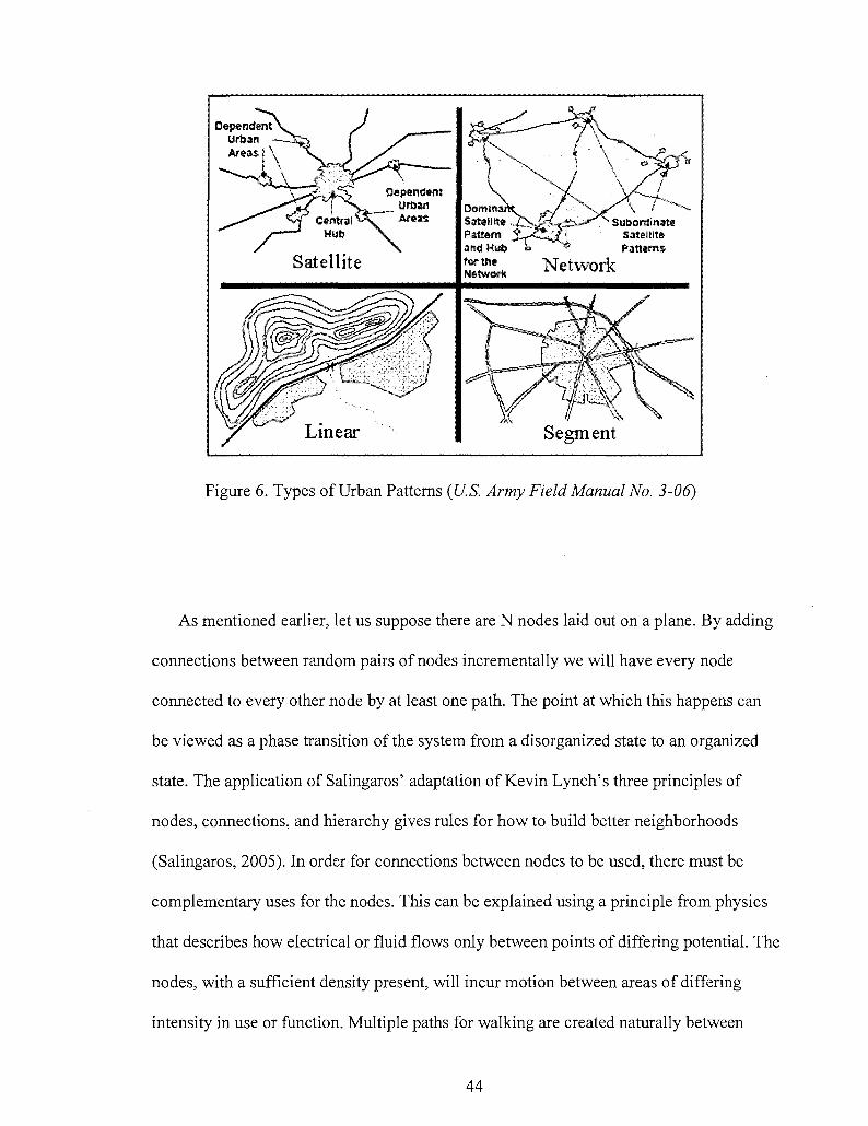
Figure 6. Types of Urban Patterns (U.S. Army Field Manual No. 3-06)
As mentioned earlier, let us suppose there are N nodes laid out on a plane. By adding
connections between random pairs of nodes incrementally we will have every node
connected to every other node by at least one path. The point at which this happens can
be viewed as a phase transition of the system from a disorganized state to an organized
state. The application of Salingaros' adaptation of Kevin Lynch's three principles of
nodes, connections, and hierarchy gives rules for how to build better neighborhoods
(Salingaros, 2005). In order for connections between nodes to be used, there must be
complementary uses for the nodes. This can be explained using a principle from physics
that describes how electrical or fluid flows only between points of differing potential. The
nodes, with a sufficient density present, will incur motion between areas of differing
intensity in use or function. Multiple paths for walking are created naturally between
44
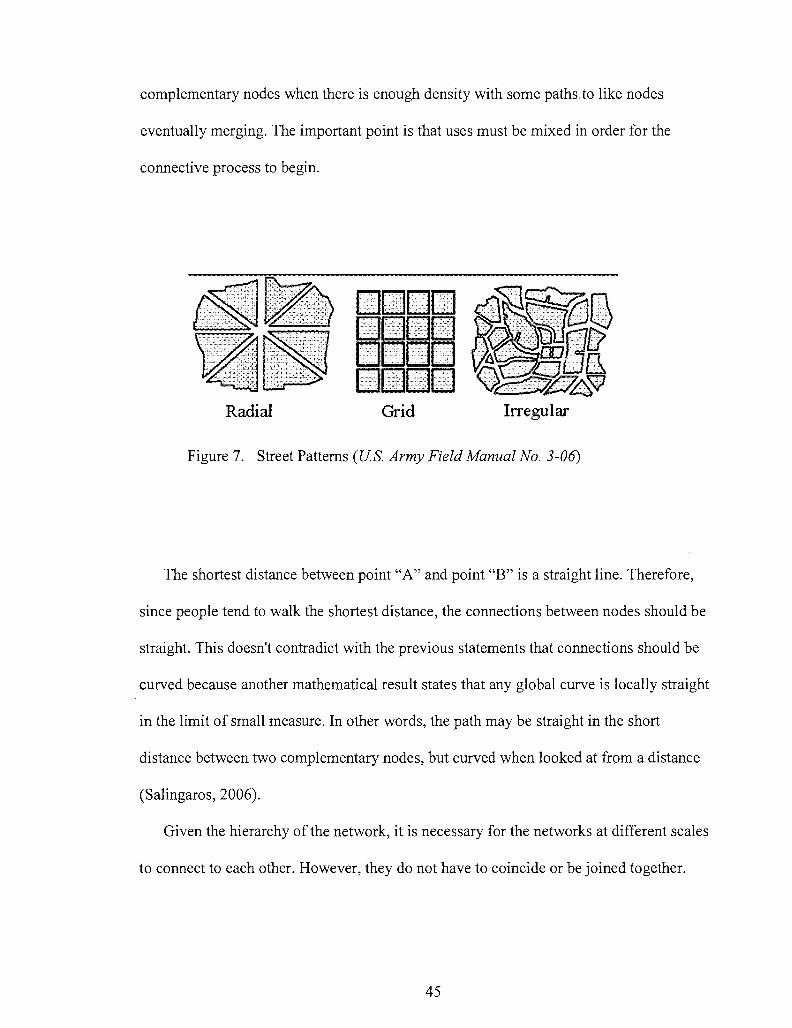
complementary nodes when there is enough density with some paths to like nodes
eventually merging. The important point is that uses must be mixed in order for the
connective process to begin.
a n 11 11
Radial Grid Irregular
Figure 7. Street Patterns (U.S. Army Field Manual No. 3-06)
The shortest distance between point "A" and point "B" is a straight line. Therefore,
since people tend to walk the shortest distance, the connections between nodes should be
straight. This doesn't contradict with the previous statements that connections should be
curved because another mathematical result states that any global curve is locally straight
in the limit of small measure. In other words, the path may be straight in the short
distance between two complementary nodes, but curved when looked at from a distance
(Salingaros, 2006).
Given the hierarchy of the network, it is necessary for the networks at different scales
to connect to each other. However, they do not have to coincide or be joined together.
45

Cross-connectivity results in a stronger web and also eases congestion when compared to
a system with only one network.
The theory of the network is organized around the principles of nodes, connections,
and hierarchy. These principles, coupled with mathematical theories, give guidelines for
good urban design with the ultimate goal of organized complexity. One way of measuring
organized complexity is the pattern measure, a technique used by Nikos Salingaros that
gives an idea of the liveliness of the pattern as perceived by people. The pattern measure
can be extended to determine the organized complexity of larger grids and can also be
applied to architectural forms. It captures the information inherent in a pattern and
expresses it in a way that corresponds to our intuitive notion of life or complexity in a
pattern.
The Algorithmic Process
A starting point in applying the algorithmic process is to begin by looking at the types
of problems there are and how they address different aspects of the issue. From the
understanding of the types of problems there are we will make a large leap into how the
problems may be addressed in an ongoing fashion by means of rule making and defining
problems in the context of game playing. I begin by looking at the types of algorithmic
problems presented by Gregory Wetzel and William Bulgren in The Algorithmic Process
(1985). For this paper, the nature of an algorithm includes the process of recursion so
that is takes a problem, provides a solution, and incorporates that solution into the next
problem -for as long you wish to continue that cycle. By "problem" I mean when a
46
desired goal is not immediately achievable or the means for obtaining that goal is not
obvious.
According to Wetzel, there are two ways of categorizing problems. There are
informal problems, where the solution is not found by precisely specifying the initial
conditions, the desired results, or the actions by which we achieve those results. Informal
problems may not even appear as problems and are not within the scope of this paper. My
focus is on formal problems, which are characterized by thorough specifications and
precisely defined initial conditions that lead towards a solution of a specified form. The
distinction between informal and formal problems is between the procedure used to solve
the problem and the actual results obtained by using the given procedure to solve a
specific instance of the problem (Wetzel, 1985). For instance, X is a problem because we
desire Y as a result, without knowing how to get Y with any certainty. The result is that
you essentially put faith in a system that you believe will deliver certain results without
having a full understanding in the operation of that system. The goal is a general
understanding of the system so as to deliver predictable results; to reduce faith and
increase certainty. From problems classified as formal, there is the further distinction
between problems of analysis and problems of synthesis.
Problems of analysis are those in which we know the starting point and the ending
point, but we do not know how we get there. That means that the problem really deals
with creating a process to get us from the initial condition to the final results. This is best
understood with the space program sending men to the moon. These are what I would call
garden problems; the challenge is to discover the rules that guide toward ongoing
additions and manipulations. The continuous act of urbanism fits within this purview.
47

Conversely, problems of synthesis offer specific initial conditions and specified plans of
action, but only specify a general form of the result. I equate these to the mechanical
problems that try to solve two-variable problems. This compares to Jane Jacobs'
description of Warren Weaver's two-variable problem of disorganized complexity (1992)
or what we see today in conventional suburban development. A singular act of
architecture fits within this purview.
By comparing these two types of problems to James Carse's work described in his
text, Finite and Infinite Games (1986), there is a strong similarity. Problems of synthesis
are similar to the requirements for classifying game as finite and the rules based upon
such game. Finite games seek a resolution of problems in a strategic manner that
advances the game player. In this case, an act of architecture is the resolution of a
problem, a singular event. The act of adaptation -by means of adding, removing, or any
alteration -of that initial architectural move becomes a problem of analysis. For example,
when a building is completed, it represents a turn taken in a game that other players must
respond to in order for that game to continue. If the players choose to ignore this move,
the context, and thus the game, grows weaker. And within that break in context is the
introduction of more "noise" that inhibits the clear communication of informational
network displayed in the physical representation of the block or neighborhood.
48
CHAPTER FIVE:
ORGANIZING BY FORM
Building upon a general understanding of what the New Sciences offer and how the
Form-Based Code works, I begin this chapter by looking at my earlier proposal of
adapting the synthetic and analytic algorithmic processes to finite and infinite games
(problems = games). When we look at urban problems as games then the development
codes become the rules (Carse, 1986). This allows building proposals at various scales to
be handled as strategic moves towards creating a coherent city as an ordered form. The
idea is that informational cues that establish the context of a given area are always kept in
play when determining the approval of a building proposal.
The purpose of this argument is to demonstrate the philosophical disconnect that
land-use based planning has, by definition, to the concept oftelos, something with an end
purpose. Compare this to how a Form-Based Code is structured to coordinate the
construction of a building, a neighborhood, and eventually a city as its final purpose. The
action of realizing a teleological purpose is through the production of an object or
accomplishing a goal or method known as techne. From an ontological perspective of
dealing with physical things, Form-Based Code regulate the creation of physical things -
albeit with qualities that transcend physical existence- developed by rational means, or
techne. The Form-Based Code provides rules for the development of the urban
49
environment by staying within a context of tangible elements or the nature a city. The
parts that are effectively regulated are the parts that communicate the information of the
environment. The streetfronts, the building placement, the accepted ranges of building
typology all frame the urban conversation to what is currently accepted and what are the
acceptable levels of change. Every neighborhood or block will go through a phase
transition from one transect to another. What becomes important is that the dialogue
remains consistent with the general expectations of the local residents.
Euclidean Zoning fails to adequately describe the nature of a given environment at
the finer scales of buildings and neighborhoods. At best, land-use operates from a
generalized quality that may describe a type of district, but functions poorly when used
without a language that regulates the type of building within a type of neighborhood.
Rather than placing emphasis on the uses of a given building or district, the idea is to
explain how the city is a scale-free system by, ironically, looking at the various scales of
the urban environment. By scale-free, I mean a system that can be identified by the
reoccurring patterns of fractal joints described as follows: tectonics define a building;
building type makes the block; the streetfronts of the blocks make up the neighborhood;
and the neighborhoods make the districts and/or city. At any scale, these are all singularly
operable components, but they also work as coherent whole.
For example, beginning at the scale of the individual building and how it relates to the
larger scale, we can take the systems approach in demonstrating the association that the
sidewalk has at multiple levels of urban development. From the sidewalk level, the detail
in building construction is best understood by the passerby to a level of interpreting the
local construction methods and materials, which in turn supports the heritage of a given
50
building. This is done from a public right-of-way that is utilized by all people, from those
in strollers to those in wheelchairs, from those who want to window-shop to those whose
only means of transportation is a pair of shoes. The sidewalks have multiple roles in the
success of a neighborhood from the civic, to the private, to the public.
There is an important aspect when discussing whether cities are actually emergent
systems and that is the hierarchy of the process of self-preservation. The emphasis of
bottom-up emergent systems is that there is more adaptability, as there is no focus of
centralized directives (Johnson, 2004). There is a trade-off in that one may encourage
insurgent actions in order to maintain lower level survivability. Cities develop from
different layers -two specifically. First, you start at the local jurisdiction's authority for
recognizing the subdivision of property that a constructed project occupies. The second
layer represents the private individual whose development proposal occupies the
regulated land. It is the government that establishes real property and in effect, creates the
boundaries of the project. The regulating plan within a standard Form-Based Code
requires that the subdivision process be carefully integrated within the establishment of
the code. The plat-sections will still remain as the initial organizing component of a city,
but can now act more as a lattice work for urban structures to "crystallize" upon.
The Fractal Nature of Tectonics
The first level of architectural exposure, referred to here as the tectonic, is where the
enthusiast and the specialist can hold a discussion in absentia. As the enthusiast begins to
look around he generates questions in his head as to how or why the building was
formulated in its given manner. The specialist's work in a good project will respond for
51
itself. Even in our contemporary collective short attention span, a good building will
demonstrate how it operates thus providing a positive cultural contribution to be
followed. This is because the building will first be used, then enjoyed, and finally
protected, thus becoming an integral piece of urbanism. This connection is best explained
by Kenneth Frampton and his view to include an evaluation of construction method in
addition to spatial qualities, "...the unavoidable earthbound nature of building is as
tectonic and tactile in character as it is scenographic and visual, although none of these
attributes deny its spatiality. Nevertheless we may assert that the built is first and
foremost a construction..." (Frampton, 2001, p. 2) We can enjoy the building for its
every day utility while also enjoying some poetic moments that it may offer. Oddly
enough, the areas where the building is connected, either to itself or to its site,
communicates information that one derives cultural meaning from.
However, meanings do change over time; today the word threshold seems to have
more to do with some sort of regulatory trigger than with the bottom of a doorway. In an
effort to avoid the loss of tectonic meaning we look at the preservation of traditional
building craft through the constant rebuilding of the Ise Jingu Temple in Japan. Because
of the complexity of the Jingu Shrine's construction, the Japanese created a devout
carpentry culture, known as kiwari, that selectively hands down from generation to
generation the knowledge of 400-plus different types of joints known as, kigumi, seen in
the construction of roof trusses and frames (Seike, 1997). One reason for rebuilding is to
guard the collections of kigumi from other carpentry guilds while keeping future
generations informed on how to carry on the craft. By creating a process that teaches the
special techniques to a new generation every twenty years, a social connection is rooted
52

in these kigumi. These joints of the Ise Temple are the cultural signatures -or what
Richard Dawkins calls "memes"- that connect an individual to a larger community. The
physical connections and separations of the kigumi not only carry information on how the
building is constructed, but also provides a view into who was the builder (Seike, 1997).
The relationship of kiwari to kigumi calls out a common struggle in the preservation of
tradition: on one hand there is the desire to preserve the artifact by avoiding any potential
degradation. On the other hand is the sacrifice of artifact at the hands of understanding its
construction through rebuilding.
The Fractal Nature of Typology
Just as the tectonics of a structure presents itself to the individual who experiences it,
so too does the disposition establish the character of its typology and its relationship to
the neighborhood. The key benefit of building typology to urban design regulation is its
ability to adapt to changes in context where land use cannot. For example, a block of two-
story brownstones would be equivalent to a block of garden apartments in the eyes of
land use.
Typology is situated in a regulatory class between tectonics and borders and acts as
the second stage of an ordered system that is bound by neighborhood or district defining
borders. With regards to the form-based code process, typology covers not only the
general form of a structure but also provides a functional range of uses that may occur
within the building class. There are three consistent items to a well-defined building
typology: its function, its configuration, and its disposition. These three items are at the
core of a typology that transcends style and in general vernacular. For example, imagine
53
the typology of a "firehouse" and then picture it being finished in a Southwest
Contemporary, Cape Cod, or Colonial style. Each of the styles represents the same
building but is finished in a vernacular that controls its suitability to a given context.
In order to establish an effective building type, the function should be declared within
a range of general activities that can occur within the given building type. The
configuration of the building type is the normative three-dimensional arrangement of
spaces that are customary to the building type. The disposition is the crux of the building
type and the part that keys into the characteristics of neighborhood's borders and a
building's joinery. Disposition, like a tectonics, has a double acting nature that is best
described with the verb "to cleave". "Cleaving" describes something that is both being
cut apart and being pushed together (Duany, Morissey, Pinnel, 2006). By viewing the
disposition of a building as an action that both separates and adheres, this important
aspect of typology serves a feasible method for addressing the concerns a building and its
anticipated use will have on its future neighbors.
The Fractal Nature of Borders
Euclidean zoning, when applied at a large scale, can create a border by creating an
obstacle to the traveler. What is hard to distinguish is that there is an inherently
destructive result in this large expanse of blocked passageway. Jane Jacobs offers a two-
sided, interrelated rule of land-type division to not only to identify a border, but also
recognize hindrances and catalysts to foot traffic. As stated by Jacobs, ".. .general land is
used for general public circulation by people on foot... special land, is not commonly
used as a common thoroughfare by people on foot" (Jacobs, 1992) This is important as a
54
beautiful subdivision with thick, lush landscaping can be just as much an obstacle to the
pedestrian as a wall of warehouses or a waterfront. The idea is to recognize the scale of
the obstacle. If one is stuck running alongside a perimeter wall like a rat, making it
glamorous does satisfy the initial condition of feeling trapped.
The Nature of Urban Networks
Kevin Lynch's The Image of the City (1960) is a good resource for establishing the
awareness of an obstacle that can be hard to distinguish. For instance, a lead paint factory
and a schoolyard would obviously need some type of barrier. But there is also the need, at
times, to provide a border in order to distinguish similar items. In the creation of districts,
a border may be used to create neighborhood identity not out of the need to protect itself
from other neighborhoods, but as a means for staying sensitive to nature of contextual
development. It is also important to note that connections are strongest between
complementary nodes such as home and work and weakest between similar nodes such as
home and neighbor (Salingaros, 2006). When borders are established, they should still
remain sensitive to the networking requirements and allow pedestrians to go through,
otherwise connections will be severed. Connections cannot be supported when nodes are
too far apart on the landscape. Good urban places meet the general conditions for what is
pleasing, healthful, and harmonious and follow the rules and patterns that are
mathematical in nature (Salingaros, 2006).
Since I am validating the potential structure within the Form-Based Code regulatory
method using the principles of the New Sciences, I will review the concept of a
networked system in terms of an urban grid. First, some background on the components
55
of an urban network as described. Although there are distinct differences between a dense
city like Tokyo and a sprawled out city such as Atlanta, all urban areas can be
categorized under a general urban pattern and a network pattern. The network patterns of
streets historically are a resultant of the urban pattern. The general practice was that the
streets would navigate around the buildings so that the resulting pattern would be
described as "all roads lead to Rome" - not through Rome. However, the issue is not
whether it was the streets that brought the buildings or the buildings that required the
streets. In both instances, the result is still limited within the parameters of form. Street
widths and the establishment of rights-of-way operate within the given urban pattern as a
means of supporting its future growth and/or refinement. A city cannot exist without its
streets but a road can continue on without a city.
The easiest method for establishing a healthy urban network can be done under a
simple process that is aligns neatly with the typical quarter-section layout mentioned
earlier. This process is accomplished by scaling the neighborhood block, the secondary
scale of regulation in a Form-Based Code after the building, and the first scale of urban
development, at a size no greater than a five-minute walk. This time-distance calculates
to a quarter mile, as this give a generous average walking speed of three-miles per hour.
The resulting block size, when adjusted for public right-of-way, equates to approximately
300 to 400 feet in length. An interesting side note is that the five-minute walk adjusts
perfectly to the township diagram established by the Continental Survey in 1803
(Duany,Plater-Zyberk, Alminana, 2003).
56

CHAPTER SIX
SUMMARY OF ARGUMENT AND RECOMMENDATIONS
There are flaws that become apparent when trying to resolve detrimental urban issues
in terms of sustainability. For example, currently there are many problems that are being
discovered from a hydrocarbon-based transportation system (gasoline-powered cars). If a
no-cost petroleum replacement garnished with the ability of zero emissions was
discovered we could sustain our fleet of private motor vehicles. But would sustaining the
dependence on cars resolve the health issues from too much driving, the inequity in
accessibility to those who cannot drive, or the inefficient land use patterns based on car-
enabled sprawl? Trying to put a shrunken bed sheet on a mattress illustrates the
difficulties in dealing with problems of complexity. For instance, if you continue with
making your bed accustomed to a sheet that used to fit, you will become frustrated by the
sheet's ability of covering a few of the corners of the mattress. The bed sheet, in its
shrunken, no longer works. Between making an adaptation (e.g. stretching the sheet) or a
reworking of the process (e.g. making your bed with a new sheet) are the measurements
of efficiency -with the utilization of the smaller sheet being highly efficient and replacing
the sheet indicating low efficiency. Additional variables surface over time and must have
a way of being worked into the process of solving a problem.
57
Administrative Review Process
The Form-Based Code process represents an adaptable method. The change in the
form of the sheet requires it to be reworked in order to fit the mattress; our use-based
approach no longer recognizes the resource of the shrunken sheet -as a use, it is now a
sheet that accommodates a smaller mattress.
Probably the first and foremost requirement to a Form-Based Code process that must
be included is the requirement of a streamlined administrative review process. The
greatest advantage of a Form-Based Code and its use of building and street typology is
that the bulk of publicly contentious issues have already been resolved. A proposed
building must be in significant compliance with the regulating plan of the code in order to
submit for the administrative review, so there would be no beneficial purpose in wasting
time with a the public hearing process. If the proposed building could not comply with
the code requirements, it would still move forward in a request for entitlements at the
public hearing level.
Generalize the Land Use
The next obstacle to an effective Form-Based Code is inclusion of permissible uses.
/ Land use regulation is not abandoned in a Form-Based Code, but it is relegated to broader
categories. The reason is that the form of a building can more aptly govern the use of a
building than use-restrictions alone. If a property owner were to own a 2,000 square-foot
corner market, its typology would prohibit him from trying to operate a movie theater. In
the eyes of land use, they're both the same. So what must be avoided is an overloading of
specified land uses that restrict the flexibility of the building form.
58
A Form-Based Code does not have to operate as a top-down mandate with little
enforceability. Rather, it can be a locally-adopted regulation with the same police powers
used by the land use regulations to undermine urban form. It is crucial that the ground-
level component of the urban engine -the community at large- partake in the creation of
its own rules. The community has the potential to play a greater role in shaping its
physical future than it does with the Euclidean Zoning in two ways. First, the street and
building types are determined in a charrette-led public process to establish the context of
the neighborhood and to create a vision of what residents want their neighborhood to be.
This is the chance to eliminate the constant surprises, as nothing can really be anticipated
in Euclidean Zoning other than the function of the building. This initial hurdle may
burdensome, but it is nothing compared to the constant revisiting of non-compliant
requests heard at every planning commission. And as these requests become approved, it
continues to be challenge the identity of what the neighborhood is trying to be. Because
the public hearing process is reduced from hearing all compliant requests, the public can
provide more focus on the requests for deviations from the code.
Streamline Community Feedback
I would suggest looking to the recent development of web-based community
design businesses as a possible resource in the organization of low-level feedback for
building proposals. One such company, at www.Threadless.com, creates t-shirts based on
online submissions that win the online popular vote. Another similar company,
www.Ryz.com, follows a similar process but with sneakers. Both companies provide the
template that an aspiring designer downloads, decorates, and then uploads the design to
59
be displayed along with other choices to be chosen by online-pollers. When the t-shirt or
sneaker design is chosen, the winner then receives a cash prize/reimbursement. It would
be interesting to an adaptation of this process so that opposed building plan and
elevations were provided in some way that the neighbors of the local community could
have input included and documented during the administrative review period.
Grow Incrementally
One of the last recommendations that I feel is a necessary component to an effective
Form-Based Code is the ability to development incrementally. Just as it is important that
a Form-Based Code quickly deliver construction entitlements, it must also be able to
regulate the speed of actual construction. An important aspect of an organizing system is
synchronization. The timing of a system's growth cannot outpace the maturation of the
newly developing portions.
One of the Christopher Alexander's key requirements listed out in his New Theory of
Urban Design (1987) is a step for incremental development. I have yet to see this called
out specifically in any Form-Based Code, and would need to be included in order to
operate under the auspices of a strong systems generator. If we were to base the
maximum size of a development to the minimum practical scale of the code, the block, I
would recommend that the ideal block size fall within the 300-400 foot length (or at least
a 1200-foot perimeter) as dictated by scaling of the five-minute walk, commonly
calculated out to a quarter-mile. This equals, roughly, a 2-acre maximum development
size. An interesting note for those that insist that a 2-acre development cap as completely
impractical: The Sears Tower occupies just one 300-foot block in the City of Chicago.
60

Large-scale projects could still receive entitlements for a forty-acre development but it
would not receive permits until each 2-acre phase reaches a stage of completion. A
certificate of occupancy would not be issued prior to the next 2-acre development
receiving permits to start grading.
61
BIBLIOGRAPHY
Alexander, C , Ishikawa, S., Silverstein, M., Jacobson, M., Fiksdahl-King, I., & Angel, S. (1977). A Pattern Language. London: Oxford University Press.
Alexander, C, with Neis, H., Anninou, A., & King, I. A New Theory of Urban Design. (1987). New York: Oxford University Press.
Arendt, R. (1994). Rural By Design: Maintaining Small Town Character. Chicago: Planners Press.
Attoe,W., & Logan, D. (1989). American Urban Architecture: Catalysts in the Design of Cities. Berkeley: The University of California Press.
Bachelard, G. (1994). The Poetics of Space: The Classic Look at How We Experience Intimate Places. Boston: Beacon Press.
Bacon, E. (1976). Design of Cities. New York: Viking Penguin.
Barabasi, A. (2003). Linked: How Everything is Connected to Everything Else and What It Means for Business, Science, and Everyday Life. New York: Plume.
Beckman, R. & Ackerknecht, D. (1993). "Growth as Tradition: Bern, A Traditional Settlement in Change" Traditional Dwellings and Settlements Review. Vol. 5, No. l.Fall.
Brand, S. (1994). How Buildings Learn: What Happens After They 're Built. New York: Penguin Books.
62
Buchanan, M. (2003). Nexus: Small Worlds and the Groundbreaking Theory of Networks. New York: W.W. Norton & Company.
Calthorpe, P. (1993) The Next American Metropolis: Ecology, Community, and the American Dream. Hoboken: Princeton Architectural Press.
Campoli, J & MacLean, A. (2007). Visualizing Density. Concord: Capital Offset Company.
Carse, J. (1986). Finite and Infinite Games: A Vision of Life as Play and Possibility. New York: Ballantine Books.
City of Chicago. (2003). The Chicago Central Area Plan: Preparing the Central City for the 21st Century. A Draft Final Report to the Chicago Plan Commission.
City of Portland. (2007). Central Portland Plan: Urban Design Assessment. Assessment of Portland's 1988 Central City Plan.
Clark, R. & Pause, M. (2005). Precedents in Architecture: Analytic Diagrams, Formative Ideas, and Partis. Hoboken: John Wiley & Sons.
Ching, F. (2003). Building Codes Illustrated. Hoboken: John Wiley & Sons.
Crowe, N., Economakis, R., & Lykoudis, M. Eds. (1999). Building Cities: Towards a Civil Society and Sustainable Environment. London: Artmedia Press.
Cullen, G. (1965). Townscape. London: The Architectural Press.
Cuthbert, A. (2006). The Form of Cities: Political Economy and Urban Design. Maiden, MA: Blackwell Publishing.
Diamond, J. (2004). Collapse: How Societies Choose to Fail or Succeed. New York: Random House.
63
De Botton, A. (2006). The Architecture of Happiness. New York: Pantheon Books.
Duany, A., Plater-Zyberk, E., & Alminana, R. (2003) The New Civic Art: Elements of Town Planning. New York: Rizzoli International Publications.
Duany, A. (2007, February 14) How do we save the Crescent City? Recreate the unique building culture that spawned it, Metropolis.
Duany, A., Morissey, M. & Pinnel, P. (2006, Dec. 12). Typology and Urbanism: The Disposition of Types. New Urban News. (Vol. 11, No. 8).Ithaca: New Urban Publications, Inc.
Dutton, J. (2000). The New American Urbanism: Re-forming the Suburban Metropolis. Milano: Skira Editore.
Easterling, K. (1993). American Town Plans: A Comparative Time Line. Hoboken: Princeton Architectural Press.
Easterling, K. (1999). Organization Space: Landscapes, Highways, and Houses in America. Cambridge, MA: The MIT Press.
Eglash, R. (1999). African Fractals: Modern Computing and Indigenous Design. New Brunswick: Rutgers University Press.
Ewing, R., & Kreutzer, R. (2006) Understanding the Relationship Between Public Health and the Built Environment: A Report for the LEED-ND Core Committee.
Farmelo, I. Ed. (2002). It Must Be Beautiful: Great Equations of Modern Science. London, Granta Books.
Farr, D. (2008). Sustainable Urbanism: Urban Design with Nature. Hoboken, John Wiley & Sons, Inc.
Frampton, K. (2001). Studies in Tectonic Culture: The Poetics of Construction in Nineteenth and Twentieth Century Architecture. Cambridge, MA, The MIT Press.
64
Frampton, K. (2002). Labour, Work, and Architecture: Collected Essays on Architecture and Design. London: Phaidon Press Ltd., (pg 77-89).
Gates, P. (1968). History of Public Land Law Development. Princeton, NJ: Zenger Publishing.
Gosling, D. & Maitland, B. (1984). Concepts of Urban Design. New York: St. Martin's Press.
Hays, M., Ed. Architectural Theory Since 1968. Cambridge, MA: The MIT Press, 2000.
Headquarters, Department of the Army. Field Manual No. 3-06: Urban Operations. Washington, DC, 2003.
Hegemann, W. & Peets, E. The American Vitruvius: An Architects' Handbook of Civic Art. New York: Princeton Architectural Press, 1988.
Hough, M. City Form and Natural Process: Towards a New Urban Vernacular. New York: Routledge, 1993.
Irazabal, C. City Making and Urban Governance in the Americas: Curitiba and Portland. Burlington: Ashgate Publishing Co., 2005.
The Institute for Small Town Studies: A Resource for Small Towns and Those Who Serve Them. (2008, April 16). Online, http://www.ists.org/.
Institute of Transportation Engineers. (2006). ITE Proposed Recommended Practice: Context Sensitive Solutions in Designing Major Urban Thoroughfares for Walkable Communities. Washington, DC: GPO, 2006.
Jacobs, J. (1985). Cities and the Wealth of Nations: Principles of Economic Life. New York: First Vintage Books Ed.
Jacobs, J. (1992). The Death and Life of Great American Cities. New York: Random House.
65

Jeavons, J. (2002). How to Grow More Vegetables (andfruits, nuts, berries, grains, and other crops): *than you ever thought possible on less land than you can imagine. Berkeley: Ten Speed Press.
Jencks, C , & Kropf, K. (1997). Theories and Manifestoes of Contemporary Architecture. London: Academy Editions.
Jencks, M., Burton, E., & Williams, K. (2000). The Compact City: A Sustainable Urban Form? Oxford: Alden Press.
Johnson, S. (2001). Emergence: The Connected Lives of Ants, Brains, Cities, and Software. New York: Scribner.
Katz, P. (1994). The New Urbanism. New York: McGraw-Hill, Inc.
Katz, P. (2003). An Introduction to Form-Based Regulation. Proceedings of Shaping the American City: New Approaches to Development Regulation. Chicago: Brookings Institution & American Planning Association.
Kelbaugh, D. (2002). Repairing the American Metropolis: Common Place Revisited. Seattle, University of Washington UP.
Kelbaugh, D. (2004). "Seven Fallacies in Architectural Culture" Journal of Architectural Education, p 66-68.
Koolhaas, R. (1998). S,M,L,XXL. New York: The Monacelli Press.
Koolhaas, R. (2000). Mutations. Bordeaux: ACTAR.
Kostof, S., (1992). The City Assembled: The Elements of Urban Form Through History. London: Thames & Hudson.
Kostof, S., (1993). The City Shaped: Urban Patterns and Meanings Throughout History. New York: Bulfinch.
66

Krier, L. (1998). Architecture: Choice or Fate. Berks: Andreas Papadakis Publisher,
Krier, R. (2006). Town Spaces: Contemporary Interpretations in Traditional Urbanism. Basel, Switzerland: Birkhauser - Publishers for Architecture.
Lefaivre, L., & Tzonis, A. (2003). Critical Regionalism: Architecture and Identity in a Globalized World. New York: Prestel.
Lynch, K. (1981). A Theory of Good City Form, Cambridge, Mass: The MIT Press, 1981.
Lynch, K. (1960). The Image of the City, Cambridge Mass: The MIT Press.
Lyotard, J. (1984). The Postmodern Condition: A Report on Knowledge. Theory and History of Literature, Vol. 10, Transl. Geoff Benington and Brian Massumi. Oxford: Manchester UP.
Marshall, A. (2003). How Cities Work: Suburbs, Sprawl, and the Roads Not Taken. Austin: The University of Texas Press.
Mehaffy, M. (2006). New Science, New Urbanism, New Architecture? Conference proceedings from of the 2004 Prince's Foundation for the Built Environment, London, England. Available: www.katarxis3.com/NewUrbanismNewArchitectureDRAFT.pdf
Morris, A. (1994). History of Urban Form: Before the Industrial Revolution. New York: Longman Scientific & Technical.
Mohney, D & Easterling, K., Eds. (1991). Seaside: Making a Town in America. New York: Princeton Architectural Press.
Parolek, D., Parolek, K., & Crawford, P. (2008). Form-Based Codes: A Guide for Planners, Urban Designers, Municipalities, and Developers. Hoboken: John Wiley & Sons, Inc.
Portugali, J. (2000). Self-Organization and the City. Berlin: Springer.
67

Rossi, A. The Architecture of the City. Cambridge, MA: The MIT Press: Oppositions Books, 1984.
Saarinen, E. (1965). The City: Its Growth, Its Decay, Its Future. Cambridge, MA: The MIT Press.
Saarinen, E. (1985). The Search for Form in Art and Architecture. New York: Dover Publications.
Salingaros, N. (2005). Principles of Urban Structure. Amsterdam: Techne Press.
Salingaros, N. (2006), A Theory of Architecture. Solingen: UMBAU-VERKAG.
Sendich, E., Ed. (2006). Planning and Urban Design Standards. Hoboken: John Wiley & Sons, Inc.
Sorkin, M. (2003). Local Code: The Constitution of a City at 42° N Latitude. New York: Princeton Architectural Press.
Southern California Association of Governments. (2008, April 16). White Paper on Smart Growth Policy in California. Online. Available: www.scag.ca.gov/rcp/pdf/publications/WhitePaperSmartGrowthPolicyinCA.pdf.
Stinchecombe, A. (2001). When Formality Works: Authority and Abstraction in Law and Organizations. Chicago, University of Chicago Press.
Strogatz, S. (2003). Sync: The Emerging Science of Spontaneous Order. New York: Hyperion Books.
Thompson, D. (1990). On Growth and Form. New York: Cambridge UP.
United States Green Building Council. (2006). LEEDfor New Construction Version 2.2 Reference Guide. Washington, DC: USGBC.
68

United States Green Building Council. (2007). LEED for Neighborhood Development Reference Guide - DRAFT. Washington, DC: USGBC.
Vitruvius. (1960). The Ten Books on Architecture. Morgan, Morris Ricky, Transl. New York: Dover Publications.
69
VITA
Graduate College, University of Nevada Las Vegas
Michael Howe
Local Address: 1313 South 15th Street Las Vegas, NV 89104
Degree: Bachelor of Arts, Political Science, Cum Laude, 1999
Special Honors: Graduated with Department Honors Phi Kappa Phi Golden Key National Honor Society
Thesis Title: Organization by Form: Applying Systems Theory to Urbanization.
Thesis Examination Committee: Chairperson, Robert Dorgan, Associate Professor Committee Member, Kevin Kemner, Assistant Professor Committee Member, Glen NP Nowak, Assistant Professor Graduate Faculty Representative, Dr. Robert Futrell, Ph. D., Associate Professor
70