open plate 1 open plate 2 - connecticut · robert m. gates university of ... ( barrack, sharon,...
TRANSCRIPT

Open Plate 1Open Plate 2

STATE GEOLOGICAL AND NATURAL HISTORY SURVEY OF CONNECTICUT
DEPARTMENT OF ENVIRONMENTAL PROTECTION
The Bedrock Geology
of the
South Canaan Quadrangle
WITH MAP
ROBERT M. GATES
University of Wisconsin-Madison
1975
QUADRANGLE REPORT NO. 32

STATE GEOLOGICAL AND NATURAL HISTORY SURVEY
OF CONNECTICUT
DEPARTMENT OF ENVIRONMENTAL PROTECTION
Honorable Ella T. Grasso, Governor of Connecticut
Joseph N. Gill, Commissioner of the Department of Environmental Protection
ST ATE GEOLOGIST
DIRECTOR, NATURAL RESOURCES CENTER
Hugo F. Thomas, Ph.D.
Hartford, Connecticut
EDITOR
Lou Williams Page, Ph.D.
DISTRIBUTION AND EXCHANGE AGENT
Walter Brahm, State Librarian
State Library, Hartford
ii

TABLE OF CONTENTS
Abstract -----------------------------------------------------------------------------------···--···-- --··-·········------····--Introduction
Location ---------------------------------------------------------------------------------------··-----------------·-··---·
Physical features ------------------------------------------------------------------------------------------------··----
Acknowledgments ----------------------------------------------------------------------------------------------------
Previous work ---------------------------------------------------------------------------------------------------------
General geology ------------------------------------------------------------------------------------------------------------Housatonic Highlands massif -------------------------------------------------------------------------------------
General statement ----------------------------------------------------------------------------------------------------
Lithology -----------------------------------------------------------------------------------------------------------------
Discussion -----------------------------------------------------------------------------------------------··-----------
Dalton Formation --------------------------------------------------------------------------------------------------------
General statement ------------------------------------------------------------------------------------------------·--·
Lithology ------------------------------------------------------------------------------------------------··----------------
Discussion ---------------------------------------------------------------------------------------------------- __________ _
Canaan Mountain Formation --------------------------------------------
Page
1
3 3 3
3 4
4
5
5
6
7
8
8
9 9
10
General statement ---------------------------------------------------------------------------------------------------- 10
Lithology -------------------------------------------------------------------------------------------------------- 11
Discussion ---------------------------------------------------------------------------------------------------------------- 13
Waramaug Formation -------------------- ------------------------------------------------ ----------------------------
General statement ------------------------------------------------ ----------------------Lithology ____________ _
Discussion --------------------------------------------------------------------------------------------------
Stockbridge Formation _______________ -----------------------·-- -----------------------------------------------
General statement ---------------------------------------------------------------------------------
Lithology ------------------------------------------------------------------------------------------------
Discussion -------------------------------------------------- ______ _ Walloomsac Formation --------------------------------------------------- ____________________________________ _
General statement
Lithology
Young granites Structure ________ _
General statement _____________________________________ -----------------------------------
Housatonic Highlands massif __ _ ____________ _
14
14
15
15 16
16
16
18
18
18
19
21 22 22 22
Canaan Mountain Formation __ ____________________ _________________ 23
Stockbridge and Walloomsac formations __ ____________ __ ___________ __ __ ______________________ 23
Metamorphism -------------------------------------------------------------- --------------------------------- 24 Economic and environmental geology __ __ ___________ _ _____________________ 25
References ---------------------------------------------------------------------------·----------------------------------------- 27
Appendix --------------------------------------------------------------------------------------------------------------- 29
iii

-------------------- --------- -- - ----- -
ILLUSTRATIONS
Page
Plate 1. Geologic map of the South Canaan quadrangle _________ _ ________ (in pocket)
2. Cross sections for plate 1 --------------------------------------------- _ _ ___________ (in pocket)
Figure 1. Map of Connecticut showing location of the South Canaan quadrangle and other published quadrangle maps ----------------------------------------------------- 2
TABLES
Table 1. Modal analyses of the Housatonic massif ________________________ ----------------- ___ _ 6
2. Modal analyses of the Dalton Formation ------------------------------------------------ 9
3. Chemical analyses of dolomite from the Charles Pfizer Company quarry at Canaan, Connecticut ------------------------------ --------------- ___________________ 25
iv

The Bedrock Geology of the Sou th Canaan Quadrangle
by Robert M. Gates
ABSTRACT The South Canaan quadrangle comprises three areas, each underlain by rocks of a
different age and structural setting. The Precambrian rocks of the Housatonic Highlands massif, underlying the southern and southwestern areas, are a southern extension of the Precambrian rocks of the Green Mountains and Berkshire Highlands massifs and are related to the Hudson Highlands. The allochthonous Canaan Mountain Formation of uncertain, but probably Cambrian, age underlies the northeastern part of the quadrangle. The northwestern area is a part of a marble valley extending southward through western Vermont and Massachusetts and is underlain by autochthonous rocks of the Cambrian Dalton Formation, the Cambro-Ordovician Stockbridge Formation, and the Ordovician Walloomsac Formation.
The Precambrian rocks of the Housatonic Highlands are an assemblage of predominantly granitic and quartz-plagioclase gneisses with subordinate mafic to amphibolitic gneisses. It and the overlying Dalton Formation have been thrust westward over the Stockbridge and Walloomsac formations.
The Stockbridge Formation is unconformably overlain by the Walloomsac Formation and they form an overturned fold. It seems likely that the Stockbridge Formation was folded before the deposition of the Walloomsac Formation and that subsequently both were folded.
The Walloomsac Formation is divided into two parts in this area: a lower unit composed of interlayered calcitic marble, diopsidic marbles, and dark quartzose granulites and schists and an upper unit composed largely of brittle, black to darkgray, quartzose schist.
The Canaan Mountain Formation is here divided into five lithic units, two of which may be variants of a single unit. The formation is allochthonous and is in fault contact with all rocks from the Precambrian to the Walloomsac Formation.
Structurally the area is marked by high-angle thrust slices of the Precambrian basement into the autochthonous Stockbridge-Walloomsac sequence and low-angle thrusting of the Canaan Mountain Formation over the Walloomsac Formation.
1

M A s S 73• A c H u s E T
42°1 ---r-___j~!---· ~====j~
::w::
0:::
0
>-
:t
I I \I Iv l~~~l~6 ~ ~~· .,.. · ·•~·.·.·J.'!w? rt r7L 'f?7XI :===3 0
! ~·r (.i s , *'" ZI ~o; "~' ~~~
¢:. ~ oo'I:-... ,'¢'v -<!'-<!'
4~~ I I
N E 13• W
Poblished Surficial Maps
y Ii 0 R
Quadrangle of This Report
Published Bedrock Maps
K
T 12° S
72°
Fig. 1. Index map of Connecticut showing tlie location of the Soutli Canaan quadrangle and the other published quadrangle maps.
41°

INTRODUCTION
Location The South Canaan quadrangle is in the northwestern comer of Con
necticut (fig. 1), near the western edge of the W estem Connecticut Highlands. Falls Village is the only population center. Access to the area is by Highway 7 which trends north-south along the western side of the quadrangle and by Highway 63 which cuts diagonally across the quadrangle from the southeast to its intersection with Highway 7.
Physical features The topography is dominated by Canaan Mountain (located in the
northeastern quarter of the quadrangle), which has a steep scarp facing west to southwest and rises 1,300 ft above the valley floor, and by the slightly lower and less rugged assemblage of mountains and rounded hills ( Barrack, Sharon, Titus, and Sedgwick mountains) that comprise the major part of the Housatonic Highlands in this quadrangle. The highest point in the quadrangle is Bradford Mountain, elevation 1,962 ft, in the northeastern comer, and the lowest point, where the Housatonic River leaves the quadrangle in the southwestern comer, is 510 ft above sea level.
The Housatonic River is incised in the Highlands and, with its tributary, the Hollenbeck River, provides the major drainage of the region.
Acknowledgments The quadrangle was mapped during the summers of 1964 and 1966-
1971 under the sponsorship of the Connecticut Geological and Natural History Survey. Grants from the Wisconsin Alumni Research Foundation were received to support this project in 1966, 1968, and 1971. The writer was assisted during the summer of 1966 by Dennis Luchterhand and in 1968 by Michael Brauner, both supported by a grant from the Wisconsin Alumni Research Foundation. Joseph Cohen in 1968 and Catherine Tuttle in 1970 and 1971 assisted in the field under a National Science Foundation grant for Undergraduate Research Participation. While a National Science Foundation Fellow at the University of Wisconsin-Madison, William Riehl made a special structural study of the Canaan Mountain area, published in 1972.
The writer gratefully acknowledges the assistance and contributions of these students and the continuing interest of the supporting organizations.
N. M. Ratcliffe's unpublished field map of the adjoining Ashley Falls quadrangle materially helped us in recognizing the subdivisions of the Stockbridge and Walloomsac formations. D. S. Harwood provided his unpublished field map of the adjoining Norfolk quadrangle. Field con-
3
---------------------------- ---------
ferences with these men were most productive. Their critical reviews of the manuscript, as well as that by Robert Schnabel, are responsible for many improvements in the report.
Previous work
The earliest work in this area was that of Percival ( 1842). It was followed over half a century later by the summaries of Rice and Gregory (1906) and Gregory and Robinson (1907), whose information on the crystalline rocks of northwestern Connecticut was based largely on the unpublished Litchfield Folio of W. H. Hobbs. Agar ( 1929, 1932, 1933) laid the foundations for the studies of the area done since World War II. Luchterhand ( 1967) and Brauner ( 1969) wrote Masters theses under the writer's supervision on some stratigraphic aspects of the Housatonic Highlands massif in this quadrangle. William Riehl ( 1972) made a structural comparison of the Canaan Mountain Formation and the Housatonic Highlands massif. N. M. Ratcliffe, H. R. Burger and D. S. Harwood have added materially to the geology of the area by their recent (as yet unpublished) mapping in the adjoining Ashley Falls and Norfolk quadrangles. Zen and Hartshorn ( 1966) and Zen and Ratcliffe ( 1971) have mapped quadrangles immediately northwest of the South Canaan quadrangle. Rodgers ( 1970) and Zen ( 1967) have contributed significantly to an understanding of the regional geology, as have the studies of northern Appalachian geology collected by Zen and his collaborators ( 1968).
Ratcliffe ( 1969) compiled a map of the area north of the South Canaan quadrangle and contributed new ideas on the nature of the Berkshire massif. Harwood ( 1972) proposed a chronology for the tectonic events in the southwestern part of the Berkshire anticlinorium. Harwood and Zietz ( 1973) suggested that magnetic anomalies indicate buried highly magnetic masses that may be Precambrian. They further suggest that these buried masses are different from the exposed Green Mountains, Berkshire Highlands, and Housatonic Highlands.
GENERAL GEOLOGY
The South Canaan quadrangle lies along the axis of a series of Precambrian (?) crystalline massifs and includes rocks of the Taconic autochthonous and allochthonous sequences. It includes the area between the southern end of the Precambrian rocks of the Berkshire Highlands and the northern part of the Housatonic Highlands. The quadrangle is conveniently divided in three parts: 1 ) the southern half is largely underlain by the Precambrian rocks of the Housatonic Highlands, 2) the northwestern quarter is the site of the Cambrian and Ordovician autochthonous sequence of the Dalton-Stockbridge-Walloomsac formations, and 3) the northeastern quarter contains most of the Canaan Mountain Formation, an allochthonous Cambrian (?) eugeosynclinal equivalent of the autochthonous rocks which it structurally overlies.
4

The Housatonic Highlands are one part of a belt of Precambrian rocks· extending from Vermont to southeastern New York that includes the Green Mountains, the Berkshire Highlands, and the Hudson Highlands. In a general way, this Precambrian ridge separates the Taconic rocks west of it from the eugeosynclinal rocks east of it. The Housatonic Highlands in this area are composed largely of granitic and felsic metavolcanic rocks.
The Dalton-Stockbridge-Walloomsac formations in the South Canaan quadrangle represent the miogeosynclinal series of sandstone-carbonateshale extending from Vermont along the western side of the Precambrian massifs. The Walloomsac Formation unconformably overlies the carbonates of the Stockbridge Formation in this area.
The Canaan Mountain Formation, which truncates all older formations from the Precambrian gneisses to the "Valloomsac, is allochthonous and correlated with the Waramaug Formation. The Waramaug is correlated with the Cambrian Hoosac Formation (Hatch, Schnabel, and Norton, 1968 ).
In an Appendix to this report are the logs of drill holes which penetrated into the Canaan Mountain, Stockbridge, and Walloomsac formations and the Housatonic Highlands massif.
HOUSATONIC HIGHLANDS MASSIF
General statement The Housatonic Highlands massif is offset to the west and separated
from the Berkshire Highlands massif by less than 4 mi. The rocks of the Housatonic Highlands massif are composed largely of metavolcanic granitic to granodioritic gneisses, muscovite-biotite-quartz-plagioclase gneisses1, mafic gneisses and amphibolites, and subordinate calcsilicate rocks. The granitic and biotite-quartz-plagioclase gneisses, by far the most abundant rocks, are typically layered and fine grained to medium grained. The amphibolites and mafic ( biotite-hornblende-rich) gneisses are ubiquituous but relatively subordinate in volume. Large masses of amphibolite are mapped separately (pl. 1).
The rocks of the Housatonic Highlands massif in this quadrangle are similar in most respects to those in the Cornwall quadrangle to the south (Gates, 1961) and to those in the southern end of the Berkshire massif in the Torrington (Martin, 1970) and West Torrington quadrangles (Gates and Christensen, 1965). Rocks similar to the Washington and Tyringham gneisses in the Beartown slice of the Berkshire massif ( Ratcliffe, 1969) to the north have not been identified.
The five subdivisions of the Housatonic Highlands massif mapped in
1 Throughout this report, minerals are given in order of increasing abundance in the rock.
5
-------··-----

the Cornwall quadrangle have been traced for only a short distance in the South Canaan quadrangle, where critical horizons have been faulted out, thinned out, or covered by glacial material (Gates, 1961; Vogel, 1961). The lithologically distinctive rock type (light- and dark-gray, banded, fine-grained granitic gneiss) that marks the lower boundary of Unit I, constitutes all of Unit III, and marks the upper boundary of Unit V, is found in only six outcrops in the area of Rattlesnake Hill and Pond Hill in the south-central part of the South Canaan quadrangle. Unit II, which contains a distinctive, very graphitic, very rusty-weathering, quartzfeldspathic gneiss, with lenses of a graphitic diopside-bearing quartzite, occurs in only two outcrops. For this reason, these subdivisions are not used in this quadrangle.
Lithology In the South Canaan quadrangle the Housatonic massif is composed of
a heterogeneously interlayered and intergradational assemblage of a) granitic gneisses, b) gray and white, banded granitic gneisses, c) biotitequartz-feldspar ( felsic) gneisses with subordinate potash feldspar, d) rusty-weathering, biotite-quartz-plagioclase gneisses with minor sillimanite locally and with sparse muscovite-sillimanite knots, and e) dark-gray to black, fine- to medium-grained, biotite-hornblende-rich mafic to amphibolitic gneisses (table 1). The individual layers range from less than 1 in. to several tens of feet in thickness. Calcsilicate layers are subordinate in number and generally thin. Small pegmatites and massive granite are sparsely present.
I. 2. 3.
Table 1.-Modal analyses of the Housatonic massifl Quartz Microcline Plagioclase Biotite Muscovite
36 24 212 10 3 30 2 402 18 1 15 2 343 15 trace
1 Rock types:
1 = granitic gneisses ( 32 samples from South Canaan quadrangle).
2 = biotite-quartz-plagioclase gneisses ( 12 samples).
3 = mafic gneisses and amphibolites ( 43 samples ) .
Hornblende
2 4
31
2 Plagiocl3"e composition ranges from An 10 to An 30 and averages An 20.
Accessories
4 5 3
8 Plagioclase composition ranges from An 15 to An 45. Plagioclase is more anorthitic in the
hornblende-rich samples.
The megascopic differences between the granitic gneisses and the biotite-quartz-feldspar gneisses are not great. The biotite content of the biotite-quartz-feldspar gneiss is generally significantly greater than that in the granitic gneiss resulting in a more obvious gneissic fabric. The granitic gneisses tend to be more granular, with the biotite disseminated rather than in discontinuous or continuous folia. In thin section, streaking of
6
quartz and quartz-feldspar is readily seen; the quartz laminae are commonly coarser grained than the quartz-feldspar layers. This is reflected subtly on weathered surfaces. The mafic gneisses and amphibolites are recognized by their darker color, which is due to the abundance of biotite and hornblende.
The characteristic accessory minerals in all Housatonic Highlands rocks are epidote, sphene, apatite, and magnetite. Allanite is commonly present in the granitic rocks. Myrmekite is ubiquituous in the microcline-bearing gneisses.
The textures of the rocks are characteristically fine- to medium-grained, inequigranular, and moderately well foliated. Locally, as in the area of Music Mountain, the micas are clotted, giving the rock a spindled texture. The granular minerals have a granoblastic texture, with smooth to sutured intermineral boundaries. Again, locally, there is some cataclasis, giving the rocks a poorly developed mortar structure.
Discussion The difficulty of extending the lithological assemblages mapped in the
Cornwall quadrangle emphasizes the questionable value of subdividing the Housatonic massif in the South Canaan quadrangle. It seems clear that most of the granitic metavolcanic rocks of the Housatonic massif are of limited lateral extent. However, distinctive rock types or assemblages that are traceable from the Cornwall quadrangle. and all mappable assemblages are shown on plate 1. A large mass of amphibolite that appears to outline a NE-trending fold (pChma) is mapped separately. Some amphibolites are exposed for 200 ft across the trend of layering but are not traceable for any significant distance and are presumed to be lensoid. The gray and white, banded granitic gneiss, pChrnbg (Unit III in the Cornwall quadrangle), is indicated separately where it extends into the South Canaan quadrangle. A narrow belt of light, rusty-weathering, biotitequartz-plagioclase gneisses, with sparse muscovite-sillimanite knots, extends from Rattlesnake Hill to Titus Mountain ( pChmrfg). This belt also has numerous thin amphibolitic layers. The scarcity of outcrops makes the continuity of this belt questionable but the rocks on either side are characteristically gray rather than weathered to a rusty color.
Rocks on Cobble Hill and in the area between the Waramaug and Canaan Mountain formations are an assemblage of interlayered, finegrained, banded granitic: gneisses, biotite-streaked quartz-feldspar gneisses and mafic to amphibolitic gneisses. In the Cobble Hill slice and in the area south of it toward Titus Mountain there are layers of gray, banded granitic gneiss in which magnetite crystals or aggregates have white halos free of biotite. Ratcliffe ( 1969) also mentions "magnetite spotted granitic gneisses" in the biotite gneisses of the Beartown Mountain slice. The mafic to amphibolitic gneisses are in beds 1-18 in. thick and do not constitute mappable areas or stratigraphically usable horizons. The granitic
7
----·------------------------ --------

gneisses probably predominate over the microcline-poor biotite-quartzfeldspar gneiss but, due to their fine grain, the type of feldspar is seldom identifiable positively in the field.
The Housatonic Highlands massif ( pChm), which underlies the major part of the southwestern quarter of the quadrangle, is a heterogeneous assemblage of granitic to granodioritic, and biotite-quartz-feldspar gneisses. Sparse outcrops of the banded granitic gneiss occur along the contact with the rusty-weathering quartz-feldspar gneisses ( pChmrfg). The fineto medium-grained banded granitic gneiss is also found repeatedly on Tarradiddle, Waller Hill, and Sharon Mountain between Highway 7 and the western quadrangle boundary. Interlayered with it are biotite-rich granitic to trondhjemitic ( biotite-quartz-plagioclase) gneisses that are somewhat coarser grained and to which the biotite folia give a black and white, streaked aspect. Northwest of the large amphibolite mass the gneisses tend to be more biotite rich than elsewhere; this persuaded Brauner ( 1969) to consider them a separate unit. However, the interlayering of biotite-rich and biotite-poor gneisses and of microcline-rich and microcline-poor gneisses on a scale seldom exceeding 30-40 ft makes further subdivision of questionable value.
The Housatonic Highlands massif in this quadrangle is considered to consist predominantly of metamorphosed acid to intermediate volcanigenic sediments intermixed with subordinate basic volcanic material.
DALTON FORMATION
General statement The Dalton Formation unconformably overlies the Housatonic High
lands massif in several areas of scattered and discontinuous outcrops. Its major occurrence is on Barrack Mountain, where it mantles the Housatonic Highlands massif on the north, east, and south. Isolated occurrences are on Titus Mountain and Cobble Hill.
Although it is a heterogeneous formation ranging from quartzite to schist, it has several characteristics which separate it with reasonable certainty from other formations. It is characteristically a buff- to rustyweathering, very fine-grained, thinly laminated, quartz-microcline granulite or granulitic gneiss. It commonly has tourmaline crystals, up to ~ in. in length, on the thin mica folia or clustered around quartz pods or streaks. The muscovite and biotite combined range from a trace to 50 percent and impart a fine layering or fissility to the rocks, which tends to distinguish them from the underlying Housatonic Highlands massif.
The heterogeneity, rapid vertical and lateral changes in lithology, and isolated outcrop areas prevented the establishment of a stratigraphic section.
8

Lithology The Dalton Formation is composed of an interlayered assemblage of
rocks ranging from nearly pure quartzite to schist. The essential minerals in order of decreasing abundance are microcline, quartz, muscovite, biotite, and plagioclase. Minor minerals are tourmaline, clinozoisite, epidote, diopside, sphene, magnetite, and zircon. The presence of megascopic tourmaline on the micaceous folia and around quartz pods is commonly used as a particularly diagnostic feature of this formation. In overlying formations tourmaline is present but generally seen only in thin section.
The rocks can be divided into three types: quartzites, quartz-microcline granulites or granulitic gneisses, and muscovite-biotite-microcline schists (see table 2). Although these classifications are somewhat arbitrary because the gradation between types is complete, they are useful in the field. The quartzites and the quartz-microcline granulitic gneisses weather to buff or somewhat orange, the schists are darker and rusty weathering. The most common rocks of the Dalton Formation in this area are granulitic quartz-microcline rocks containing less than 15 percent micas and less than 10 percent plagioclase. Microcline everywhere predominates over plagioclase.
1. 2.
3.
Table 2.-Modal analyses of the Dalton Fonnationl Quartz Microcline Plagioclase Biotite Muscovite Diopside Accessories'
83 10 2 1 trace 2 2 32 46 5 11 4 2
23 31 4 16 20 3 3 1 Rock types:
1. Quartzites ( 12 samples).
2. Quartz-microcline granulitic gneisses ( 15 samples).
3. Two-mica, quartz-microcline schists ( 8 samples). 2 Tourmaline, magnetite, clinozoisite, epidote, sphene, zircon. Calcite is present in some of the
quartzites.
Where exposed on the southeastern side of Barrack Mountain, the lowest lithology of the Dalton Formation in this area is a fine-grained, well foliated, biotite-quartz-microcline granulitic gneiss with accessory magnetite and tourmaline. It is about 20 ft thick. Overlying it is an impure quartzite, less than 80 ft thick, with subordinate magnetite, microcline, and diopside. Quartzitic layers are found in thin beds throughout the formation but there is no indication that the uppermost layers grade into the typical Cheshire quartzite, which commonly overlies the Dalton Formation elsewhere to the north. The total thickness in this area is approximately 500-700 ft.
Discussion
The abundance of microcline and tourmaline, the very fine-grained
9
------ ------ ~------
texture, and the lithologic heterogeneity of the Dalton Formation pose problems in ascertaining the sedimentary environment of deposition. Presumably the detritus for the formation was derived from the underlying Precambrian crystalline massifs. The fine-grained nature of the parent rock can readily provide fine-grained detritus to account for the muscovite-biotite-quartz-feldspar schist, originally graywackes. However, the selective depletion of plagioclase in the quartz-microcline granulitic gneisses requires chemical weathering of the parent rock and a high degree of sifting and winnowing of the detritus. The heterogeneity in rock type and distribution may reflect variable source areas and local accumulations on an irregular Precambrian platform.
CANAAN MOUNTAIN FORMATION
General statement The Canaan Mountain Formation is composed of a variety of lithic
types which are mappable in some areas but heterogeneously mixed in others. The rocks seem to form a continuum from quartz-plagioclase granulites at one end to micaceous garnet-sillimanite-plagioclase-quartz gneisses at the other (that is, from feldspathic sands or graywackes to aluminous shales). The granulitic rocks are slabby, due to thin mica folia, whereas the sillimanite-garnet gneisses are commonly massive, because of very convoluted mica folia. The formation is here subdivided into five units, some with a single lithology and others a lithological assemblage.
The Canaan Mountain Formation is an allochthonous formation in fault contact with the Walloomsac schist (Ows), the Walloomsac marble (Owm), and gneisses of the Housatonic Highlands (pChm) on the western and southwestern borders. The mapped units also show its discordant relations with other formations. Its contact relations with the Housatonic Highlands massif on its southeastern side are ambiguous. This is perhaps also a fault contact, although the writer and others (Gates, Martin, and Schnabel, 1973) believe that the possibility of a normal sedimentary contact should be given serious consideration. A similar contact between the Housatonic Highlands massif and the Waramaug Formation can be seen on Roberts Hill in the southeastern corner of the quadrangle. The Canaan Mountain Formation occupies the northeastern quarter of the quadrangle, in a NW-trending, broadly synformal structure, with the lithologic units retaining, in part, a general NE trend.
In many ways the Canaan Mountain Formation is lithically similar to the Waramaug Formation and is probably correlative. However, D. S. Harwood (personal communication) and the writer prefer to consider them as separate formations because Harwood found them in fault contact in the contiguous Norfolk quadrangle.
10
---·------

Lithology The lithologic subdivisions of the Canaan Mountain Formation are dis
cussed in sequence from the contact with the Precambrian on the south east near Bear Swamp to the northwestern border near Keep Swamp. If the contact with the Precambrian is a sedimentary one, the sequence is from oldest to youngest. However, if it is a fault contact, the relative ages are not known, since bedding tops could not be determined consistently.
Unit Ccmfg: This unit is a tan- to gray-weathering, biotite-muscoviteplagioclase-quartz gneiss with minor microcline, sparse knots of muscovite-sillimanite-quartz, and }4-~ in. megacrysts of muscovite. D. S. Harwood (personal communication) found the muscovite-sillimanite knots more abundant in the Norfolk quadrangle. In the South Canaan quadrangle, outcrops along this contact are very limited. This rock type correlates with a similar one (Cwfg) in the Waramaug Formation. D. S. Harwood (personal communication) has connected these units in the Norfolk quadrangle.
Unit Ccmgs1: This unit is a light, rusty-weathering, nubbly, muscovitebiotite-plagioclase-quartz gneiss, with sillimanite as a ubiquitous associate of the biotite, and with variable amounts of garnet, staurolite, and magnetite. It makes marked positive anomalies ( U.S.G.S., 1969). The variability in thickness and the irregular distribution suggest that this rock type occurs in thin, discontinuous lenses rather than as a single stratigraphic unit. Rock types adjacent to it (other than that described as unit Ccmfg) include a fine- to medium-grained, gray granulitic gneiss, a light-tan or rusty-colored mica-plagioclase-quartz gneiss, and a slightly nubbly micaplagioclase-quartz gneiss with very subordinate garnet and sillimanite. It occurs in four narrow NE-trending belts toward the eastern side of the quadrangle.
Unit Ccmmg: This lithologic assemblage encompasses a wide variety of rock types, not readily separable into mappable units. Almost all the rock types of the Canaan Mountain Formation are found in this interlayered mixture of 1) rusty-weathering plagioclase-quartz granulitic gneisses, 2) two-mica, plagioclase-quartz gneisses, 3) garnet-sillimanite, two-mica, plagioclase-quartz gneisses, and 4) gray, fine-grained, biotitequartz-plagioclase granulitic gneiss. All these gneisses intergrade and are thinly to thickly interlayered and do not constitute distinctive rock types. Although generally they weather to a light-rusty color, locally some are very rusty. The weathered surfaces range from smooth, to ribbed and corrugated, to warty or nubbly. The surface type is directly correlated with the presence of sillimanite and garnet. In some of the rocks the ribbing is related to thin quartz seams. Sillimanite is characteristically in fibrolitic masses in biotite but also occurs abundantly in short, stubby crystals between quartz and plagioclase grains. The textures range from fine grained to coarse grained and from lepidoblastic to nearly massive. Magnetite is particularly abundant in the garnet-sillimanite gneisses and megascopically apparent.
11
--. ---·---------------------------

The fine-grained, biotite-quartz-plagioclase granulitic gneiss commonly occurs adjacent to both belts of the garnet-sillimanite gneisses ( Ccmgs1 and Ccmgs2 ). It is also in small isolated lenses. For example, there is a thick lens of this rock type on the southeastern side of Wangum Lake Brook and it makes up most of the outcrops along the narrow belt from Wapato Pond to Seldom Seen Pond. Major outcrop areas of this granulitic gneiss are designated gg on plate 1.
Unit Ccmgs2 : The major rock type in this unit is a coarse-grained, massive, rusty- to gray-weathering, garnet-sillimanite-muscovite-biotite-plagioclase-quartz gneiss similar in many respects to Ccmgs1. Staurolite is also present in minor amounts. The weathered surface is characteristically a rough, nubbly or warty, "boot grabbing" surface. The micaceous folia are commonly intricately convoluted, which made the rock rather homogeneous in its reaction to glacial abrasion. The sillimanite, which produces many of the positive-weathering nubs, is commonly associated with biotite or quartz. In some rocks the garnets have weathered out, producing a pitted surface mantled by fibrolitic micas.
Magnetite is a very abundant accessory mineral and probably accounts for the high positive magnetic anomaly over much of this unit, particularly along the western edge of Canaan Mountain (U.S.G.S., 1969).
White quartz pods, 3-18 in. in length, transverse to the foliation, are common in this rock type.
Subordinate rock types in this unit include gray- and/or rusty-weathering, granulitic gneisses and muscovite-biotite-plagioclase-quartz gneisses with minor garnet and sillimanite. They are interlayered on a scale ranging from a few inches to several feet.
The contact between this unit and Ccmmg is commonly marked by a discontinuous layer, variable in thickness, of a gray, slabby, biotitestreaked, quartz-plagioclase granulitic gneiss ( gg on pl. 1). Its contact with unit Ccmbg to the west is gradational, as the amount of mica, garnet, and sillimanite decreases. This decrease is accompanied by a marked change in weathering characteristics, the weathered surfaces becoming smoother. Int,erlaying of the garnet-sillimanite-bearing gneisses and the two-mica, plagioclase-quartz gneiss is common near this contact. Also, several small amphibolite lenses are present, particularly along the northern slope of Canaan Mountain.
This unit structurally overlies unit Ccmbg along much of the west-facing cliffs of Canaan Mountain and forms the resistant top of the cliffs. North of Wangum Lake Brook, it comes into contact with the Walloomsac schist for 3,000 ft. It also crops out in a belt along the northern slope of Canaan Mountain where unit C cmg is missing. There it is in contact with the W alloomsac schist ( Ows) and, farther east, the W alloomsac marble (Owm).
Unit Ccmbg: This unit forms the contact with the Walloomsac schist
12

( Ows) for the northern half of the contact between the Walloomsac and Canaan Mountain formations. The principal rock type, which weathers light rust to gray, is a medium-grained, micaceous granulitic gneiss. The essential minerals, in order of increasing abundance, are muscovite, biotite, plagioclase, and quartz. Microcline is in minor or accessory amounts, as are magnetite, tourmaline, and apatite. The gneiss is a hard, coherent, smooth-weathering rock, reflecting in part the lack of continuity of the mica folia. Quartz seams, stringers, and knots are typically present. There is no obvious megascopic garnet and sillimanite.
Unit Ccmbg grades into unit Ccmgs2 as it becomes more micaceous and thin layers of the garnet- and sillimanite-bearing gneiss appear. Approaching the nubbly garnet-sillimanite gneiss ( €cmgs2 ), the first change is to a rock with layers normally less than 1 in. thick, the alternate layers containing small garnet crystals that weather positive. This rock grades into Ccmgs2 as the garnet-sillimanite-bearing layers become thicker and the nubs larger.
A major section of this unit from the fault to unit Ccmgs2 is exposed in the cliff faces approximately ~ mi. south of the northern boundary of the quadrangle and east of Highway 63. In this section there is a rather abrupt gradation from the plain, smooth-weathering, two-mica gneiss to the coarse nubbly-weathering garnet-sillimanite gneiss of unit.Ccmgs2• The gradation is marked by a thinly layered rock of alternating quartz-plagioclase layers and garnet-sillimanite-bearing micaceous layers showing a finely ribbed weathered surface.
Near the fault the micas are in irregular clots with the individual mica Hakes lacking a common orientation, in contrast to the prevailing lepidoblastic texture farther from the fault. Normally the quartz is unstrained and forms a polygonal mosaic with the plagioclase, in contrast to the strained quartz with intricately lobate borders near the fault.
Discussion The Canaan Mountain Formation is an isolated allochthonous unit that
can be correlated with other formations in the region only by a combination of structure, stratigraphy, and lithology. The allochthonous nature is well shown by the truncation of the various units of the Canaan Mountain Formation against the Walloomsac and Stockbridge formations and the Housatonic Highlands massif. Unit Ccmgs2 is found in contact with both the Walloomsac marble and the \Valloomsac schist; unit Ccmbg is in contact with \Valloomsac schist; unit Ccmmg in contact with the Housatonic Highlands massif. Unit Ccmfg is considered in sedimentary contact with another block of the Housatonic massif east of the fault. The contacts are marked by sharp lithic contrasts and commonly by a marked topographic break; the Canaan Mountain Formation commonly forms bold cliffs and the Walloomsac Formation is either a highly fractured, slabby schist or a friable, impure marble and schist. The fault between the
13
----------------------- ------

Canaan Mountain Formation and the Walloomsac Formation is further accentuated by a granite lens, 2 mi. long, that lies in the W alloomsac schist only 30-100 ft below the Canaan Mountain Formation.
Lithologically the Canaan Mountain most nearly resembles the Waramaug Formation and is of the same metamorphic grade. Both have megascopic magnetite and tend to underlie high magnetic anomalies ( U.S.G.S., 1969). All lithic types described for the Canaan Mountain Formation are found in the Waramaug Formation with some minor, but perhaps significant, exceptions. The gray, granulitic gneiss found mainly in the mixed gneisses (Ccmmg) and in Ccmfg is not a significant rock type in the Waramaug Formation and is found mainly in Unit Cwfg in the Waramaug Formation of this report near the contact with the underlying Housatonic Highlands massif (Gates, 1961). The Canaan Mountain Formation has very few amphibolites; those seen in this quadrangle reach a maximum of 10 ft thick. In contrast, the Waramaug Formation has abundant amphibolites, particularly in certain areas (Gates, 1961, 1967). There has been no recognition of a stratigraphic sequence in the Waramaug Formation, in contrast to at least a semblance of one in the Canaan Mountain Formation. It seems most probable that the two formations are slightly different facies of a sedimentary unit changing from interlayered sands and shales (Canaan Mountain) to shale with lenses of sand (Waramaug). D. S. Harwood (personal communication) suggests that the Canaan Mountain Formation may be transitional between the Dalton miogeosynclinal facies to the west and the eugeosynclinal Waramaug facies to the east. The Waramaug Formation on the eastern side of the Berkshire Highlands massif was correlated with the Hoosac Formation by Hatch and his co-workers ( 1968). Harwood (personal communication) found the Waramaug Formation in fault contact with the Canaan Mountain Formation in the Nodolk quadrangle.
Agar ( 1932) separated the Canaan Mountain schist from the Salisbury schist, which now includes the Everett, Egremont, and the Walloomsac schist (Zen, 1966b). The writer agrees that it is most unlikely that the Canaan Mountain Formation is a correlative of any part of the Walloomsac Formation. Only the garnet-staurolite-schist lithology in the Walloomsac west of the Housatonic River is equivalent in a lower metamorphic grade to the garnet-sillimanite gneisses of the Canaan Mountain Formation. The possibility of correlation, in part at least, of the Canaan Mountain Formation with the Everett Formation cannot be dismissed.
WARAMAUG FORMATION
General statement The Waramaug Formation extends from the southwestern corner of
Connecticut northeastward to Massachusetts. In the central and northern part of its extent it is bounded on the west by the Housatonic and Berkshire massifs and on the east by a major tectonic break (Cameron's Line,
14
Rodgers, 1970) that separates it from the Hartland Formation. It is correlated with the Cambrian Hoosac Formation of Massachusetts (Hatch and others, 1968 ). The Waramaug Formation underlies the southeastern comer of the South Canaan quadrangle and is in contact with the Housatonic Highlands massif of Roberts Hill. In many respects, this contact appears gradational, as in the Cornwall quadrangle (Gates, 1961). Agar ( 1932, p. 32) also noted the gradational contact between the Berkshire Schist and older composite gneisses (here Waramaug Formation and Housatonic massif) and stated that it seems in places "to grade into them [rocks of the Housatonic massif] without any perceptible break." Gates, Martin, and Schnabel ( 1973) suggested that "deposition was continuous across this boundary."
The two major rock types in the Waramaug Formation here are 1) a muscovite-biotite-plagioclase-quartz gneiss ( Cwfg) and. 2) a garnet- and sillimanite-bearing muscovite-biotite-plagioclase quartz gneiss ( Cwgs). The rock types are similar to those of units Ccmfg and Ccmgs respectively, of the Canaan Mountain Formation. D. S. Harwood (personal communication), working in the Norfolk quadrangle, has traced unit Ccmfg of the Canaan Mountain Formation to unit Cwfg of the Waramaug formation and has established this correlation. Modal analyses and calculated chemical compositions given for the Waramaug Formation in the West Torrington and Cornwall quadrangles (Gates and Christensen, 1965; Gates, 1961) are representative of the limited exposures in this quadrangle.
Lithology Gamet-sillimanite-mica-plagioclase-quartz gneiss is the predominant
Waramaug rock type in the South Canaan quadrangle. It is characterized by accessory garnet and sillimanite that cause the nubbly weathered surface described for units Ccmgs1 and Ccmgs2 of the Canaan Mountain Formation. Magnetite is another ubiquitous minor constituent; other accessories are tourmaline, apatite, chlorite, and staurolite. Plagioclase is mainly in equant grains but is locally coarsely poikiloblastic; it averages sodic andesine in composition. The texture is granoblastic to lepidoblastic.
The muscovite-biotite-plagioclase quartz gneiss in this quadrangle occurs mainly as a narrow layer near the contact with the Housatonic Highlands massif on Roberts Hill (Cwfg). The contact here appears gradational but a small granite lens separates the Waramaug from the typical Housatonic massif lithologies. ·Discontinuous layers 5-20 ft long are present in the sillimanitic gneiss elsewhere. It is a gray- to light-rusty weathering, fine- to medium-grained rock, lepidoblastic in texture. The biotite-to-muscovite ratio is greater than 2. Plagioclase ranges from calcic oligoclase to sodic andesine.
Discussion The Waramaug Formation has been correlated with the Cambrian
15

Hoosac Formation of Massachusetts (Hatch and others, 1968) and is here correlated with the Canaan Mountain Formation. The Waramaug Formation lacks the bedding features and stratigraphic subdivisions of the Canaan Mountain Formation and is probably a deeper water facies of it. The writer favors the suggestion of D. S. Harwood (personal communication) that part of the Canaan Mountain Formation may be a transitional facies between the Dalton and the Waramaug formations.
STOCKBRIDGE FORMATION
General statement The Stockbridge Formation was divided by Zen ( 1966a) into seven
units designated A to G from bottom to top. It conformably overlies the Dalton and/ or the Cheshire formations and is overlain unconformably by the Walloomsac Formation. Units A to C comprise the bulk of the Stockbridge Formation in this quadrangle, although unit A crops out in only a few places. It is presumed to underlie Robbin Swamp and was penetrated in a drill hole in the valley of Wangum Lake Brook a few feet north of Barnes Road. Small areas of units D and E are present below the falls of the Housatonic River at Falls Village.
Lithology With increasing metamorphic grade, the lithology of the Stockbridge is
changed in some respects, making correlations with areas to the north and west somewhat uncertain. Brief descriptions of the units as mapped in this quadrangle are given below.
Unit A (OCsa): The major outcrops of this unit are the quarries along the eastern side of the ridge on the western side of Robbin Swamp. Unit A was penetrated in a drill hole at a depth of 75 ft in the valley of Wangum Lake Brook just north of Barnes Road, which verifies its extent at least that far south. Its thickness is given as 700 ft by Zen and Hartshorn ( 1966). The rock is a gray- to-white weathering, medium- to coarse grained dolomite marble. It contains many minor minerals, the most abundant being tremolite in sunbursts and ubiquitous phlogopite. Iron sulfides, pyrite, and pyrrhotite are less abundant and produce rust spots in the otherwise pure-white marble. The least abundant accessory minerals are quartz, epidote, and tourmaline.
Unit B (OCsb): This unit comprises the major outcrops of the Stockbridge Formation in the quadrangle. The rock is predominantly a finegrained, white to gray, calcite-cemented, dolomite marble (or dolostone) with fine partings of schist or phyllite. Typically, the brownish schist partings are a fraction of an inch thick but locally they are thicker, producing a thinly interlayered schist and dolostone. Also locally there are beds of impure quartzite containing calcite, muscovite, phlogopite, diop-
16
---------------------------------

side, and tremolite, ranging from a few inches to several feet thick. The schistose, calcareous layers weather positive, producing a craggy surface. Buff-colored, hard or punky-weathering, impure quartzites are common. This unit is distinguished from the overlying and underlying rather pure marbles partly by its abundant schist and quartzite beds. It is 600 ft thick, according to Zen and Hartshorn ( 1966).
Sub-unit Bq (OCsbq): Within Unit Bis a very distinctive rock, composed of quartz, tremolite, and calcite. The distribution of these three essential minerals is very irregular, with the quartz forming an interlocking matrix and the calcite and tremolite in amoeboid-shaped pockets. The differential solubilities of the quartz and calcite produce an exceptionally craggy rock. In outcrop it is an "anklebreaker." The tremolite crystals are typically coarse grained, in some places more than 6 in. long.
The sub-unit is discontinuous in lateral distribution and varies from 0-800 ft in thickness. A belt of it forms the crest of the long N-S trending ridge west of Robbins Swamp. Two isolated masses of it are found east of Robbins Swamp and southwest of Under Mountain Road. Boulders of this very durable rock, 10-30 ft in diameter, were carried by the Pleistocene glaciers for at least 30 mi. southward.
The extensive development of this craggy-weathering quartz-calcitetremolite sub-unit is of some interest. It has been mapped by N. M. Ratcliffe (personal communication). in the Ashley Falls quadrangle to the north. Its stratigraphic position within unit B is not certain but is generally near the lower contact with unit A. In one place in the ridge extending southward west of Robbin Swamp the sub-unit comes in contact with unit A. N. M. Ratcliffe and H. R. Burger (personal communication) find it near the upper part of unit B in the Ashley Falls quadrangle.
Unit C (OCsc): This unit is a massive to sheared, almost fissile irongray to white, fine-grained dolomite marble with minor calcite cement. Where massive, it weathers gray, with rounded surfaces and, where more sheared, into soft, crumbly masses. Some layers are characterized by milky-white knots and irregular masses of quartz, generally only a few inches long. Other beds contain much larger rusty quartz pods and discontinuous streaks or beds of quartz. Both these quartz-bearing horizons are considered to be near the top of the unit (Zen, 1969). Coarse dolomite crystals up to ~ in. long stud the fine-grained dolomite marble locally at about the same stratigraphic level. In some of the more massive white marbles, diopside tablets an inch or more in length weather out of the disintegrated stone. Tremolite is also present locally. The unit is 700 ft thick, according to Zen and Hartshorn ( 1966).
Unit D (OCsd): According to Zen ( 1969) this unit is discontinuous, 0-150 ft thick, and interdigitates with both units C and E. Only one small lens occurs in the quadrangle; it can be seen at the base of the falls in the Housatonic River below the power dam at Falls Village. This heterogeneous unit is recognized because of its position between the fine-grained
17

gray dolomite marble below it and the overlying coarse-grained calcite marble above. It has an assemblage of beds, each generally only a few inches thick, of 1) rusty, craggy-weathering quartzite, 2) sheared, lightgray, fine-grained dolomite marble, 3) brownish, micaceous calcitic marble, 4) calcitic dolomite marble with white quartz knots and irregular coarse calcite pods. It also contains rock types similar to the overlying and underlying units.
Unit E (OCse): This unit is one of the most readily recognized rock types in the quadrangle because it is coarse-grained and calcitic, in contrast to the underlying predominantly dolomitic rocks. It is mottled white and gray or salmon on fresh surfaces. A few rusty-weathering, schistose quartzitic beds are present. Unit E is particularly well exposed in the falls at Falls Village. It is approximately 500 ft thick.
Discussion The Stockbridge Formation constitutes a large overturned fold in the
northwestern section of the quadrangle, essentially an extension of the Foley fold (Zen and Hartshorn, 1966) in the Bashbish Falls quadrangle to the northwest. The fold is truncated by the thrust blocks of Barrack Mountain and Cobble Hill of the Precambrian Housatonic Highlands massif. The Stockbridge Formation is overlain unconformably by the Walloomsac Formation. Angular discordance between them cannot be demonstrated here, although an angular unconformity is visible in Wild Cat Hollow in the northeastern corner of the contiguous Sharon quadrangle (Zen, 1969) and at No Bottom Pond in the State Line quadrangle, Massachusetts (Ratcliffe, 1969). No relations with the underlying Dalton Formation were seen in the South Canaan quadrangle.
WALLOOMSAC FORMATION
General statement The Walloomsac Formation is divided into three mappable units (Zen
and Harshorn, 1966). The lowest unit ( Owm). is an interlayered assemblage of alternating calcitic marbles and impure marbles, with diopside, plagioclase, quartz, microcline, muscovite, phlogopite, biotite, scapolite, and sphene. There are two upper units which perhaps are interlayered: one is dark, quartzose, Baggy schist, ( Ows) well exposed on the eastern side of the quadrangle, underlying Canaan Mountain and the other is a staurolite-garnet-muscovite-quartz schist ( Owsg) that was seen only on the western side of the Housatonic River. They appear to be interlayered farther west in the Sharon quadrangle. Within the upper unit (Ows), underlying Canaan Mountain, is a gray, rather massive granitic rock (gr) that probably is an intrusive granite but may be a elastic lens. The Walloomsac Formation unconformably overlies the Stockbridge Formation and structurally underlies the Canaan Mountain Formation.
18

The major exposures of the Walloomsac Formation are found along the lower slopes of the western face of Canaan Mountain and on the E-trending ridge north of Falls Village. The narrow strip of the Walloomsac marble mapped (pl. 1) in Cornwall Hollow is based on three isolated outcrops along Highway 43 north of the quadrangle boundary.
Lithology Lower Walloomsac (Owm): The lower part of the Walloomsac Forma
tion is composed of alternating thick and thin layers of gray to white or orange-brown-weathering calcite marble and rusty to dark-gray or black granulitic to schistose marbles. The amount of silicates normally increases upward. However, the base of the Walloomsac Formation is variable and, in the area of Under Mountain Road, is composed of a tough, grayweathering, fine-grained diopside-calcite-quartz granulite, which forms the narrow ridge between Under Mountain Road and the valley. This rock type makes up many of the thin layers in the calcitic marble northeast to Under Mountain Road.
The Walloomsac marble is tightly folded and its thickness is not readily determined. Zen and Hartshorn ( 1966) indicate it as 0-200 ft but locally in this area it is perhaps more than 800 ft thick.
The marble layers are mottled gray to white or orange brown, are fine grained to coarse grained and composed largely of calcite with subordinate diopside, quartz, plagioclase, and microcline. Muscovite, biotite, phlogopite, scapolite, and sphene are present in minor quantities.
The silicate-bearing layers have rough, weathered surfaces, are granulitic to schistose or gneissic, gray to black or rusty, and range in thickness from an inch or two to several feet. The principal silicates are the same as those in the calcite-marble layers. Microcline and scapolite are commonly poikiloblastic. The diopside is in granular masses. The quartz commonly has lobate borders and wavy extinction.
Upper Walloomsac (Ows): This unit is characteristically a dark-gray to black, irregularly Baggy, rusty-weathering, granulitic schist. The micas are not particularly abundant but are present in discrete folia that cause the rock to break into thin lensoid plates. The brittle, Baggy plates are composed mainly of muscovite-biotite-quartz-plagioclase, with lessor amounts of microcline and diopside. Common accessory minerals are sphene, garnet, tourmaline, and, locally, scapolite. The rocks are peppered with small to large specks of graphite or carbonaceous material.
Megascopically much of the rock contains black clots of biotite that are commonly transverse to the foliation. In thin section these clots are isolated, rounded to irregular masses of relatively coarse grain size. The explanation for this feature is not known.
The microtexture of the schist shows a wide range of grain sizes and in
19

some ways resembles a blastomylonite. There are irregular streaks and areas of very fine-grained to nearly cryptocrystalline graphite-dusted aggregates of quartz together with plagioclase with fuzzy grain boundaries. Some irregular poikiloblastic crystals of plagioclase are developed in these areas. Coarser grained streaks of strained quartz, with lobate borders, and biotite encompass the fine-grained granular minerals. Although this unit may merely be crystallized shaley material, it could have been a coarser elastic that, during final metamorphism, was partially mylonitized before recrystallization. It is also possible that the carbonaceous material present in the original sediment has differentially inhibited the crystallization, producing the inequigranular texture. Graphite (or carbonaceous material) is not peppered through the coarser quartz and biotite as it is in the granular quartz-plagioclase aggregates.
In this area the Walloomsac schist is at least 750 ft thick. Zen and Hartshorn ( 1966) indicate a thickness of 1,500 ft in the Bash bish quadrangle to the north.
The two major divisions of the \Valloomsac Formation are readily recognized on the flanks of Canaan Mountain. The transition from interlayered calcite marble to schisty or granulitic marble is quite abrupt and is commonly marked by an abrupt change in slope. Calcite is a minor constituent in the black Baggy schist ( Ows) at the contact with the Walloomsac marble ( Owm) and is essentially absent a few feet above the contact. The Walloomsac marble makes smoothly rounded or ribbed and craggy outcrops, in contrast to the slab by or Baggy outcrops of the Walloomsac schist.
The granitic lens (or sill) in the Walloomsac schist (further described in the section on Young granites) is also marked by topographic expression. It forms a very steep slope between narrow shelves of Walloomsac schist. The origin of this lens is not certain. It may be a lens of metavolcanic material originating as a elastic wedge or, more likely, a granite sill with some protoclastic textures. Its location near, but not at, the contact with the Canaan Mountain Formation may be fortuitous. Agar ( 1932) interpreted it as an intrusive granite and attributed the silicates in the Walloomsac marble to its contact effects. The writer also favors an intrusive origin for the granite.
On the western side of the Housatonic River the Walloomsac marble ( Owm) is not well developed and in places the Walloomsac schist ( Ows) directly overlies the Stockbridge Formation. It appears that the Walloomsac marble can abruptly grade laterally into the schist, as Zen ( 1966) suggested.
Garnet-staurolite schist (Owsg): West of the Housatonic River a garnetstaurolite schist appears to occupy the same position above the Walloomsac Formation as does the Canaan Mountain Formation east of the river. However, farther west, in the Sharon quadrangle, the black granulitic schist ( Ows) appears to be interlayered with this gamet-staurolite schist.
20
--------------------------- -- --

Owsg is a lustrous, muscovite-biotite-quartz schist containing abundant porphyroblasts of garnet and staurolite. The porphyroblasts are commonly euhedral and generally less than ~ in. across. Sillimanite is present as fibrolite in minor amounts. Lithically the rock is quite different from the gamet-sillimanite gneiss of the Canaan Mountain Formation, which it most resembles chemically.
The gamet-staurolite schist appears to overlie the black schist ( Ows) but the contact between them is not sharp. Preliminary mapping in the Sharon quadrangle indicates that the gamet-staurolite schist is repeated in the black schist, either by structural duplication or by interlayering of the two lithologies.
YOUNG GRANITES
There are three discrete granite bodies in this quadrangle and, in addition, many small unmappable granites and pegmatites in the Housatonic Highlands massif. Pegmatites are found in the Stockbridge and Walloomsac formations (Agar, 1935) and in the Canaan Mountain and Waramaug formations. However, some of the pegmatites referred to by Agar are probably lenses of sedimentary silicate impurities in the marble, rather than intrusive pegmatite.
In the southeastern comer of the quadrangle, on Roberts Hill, is a small pluton of a massive, gray to white, fine- to medium-grained granite, lying between the Waramaug Formation and the Housatonic Highlands massif, with contact unexposed.
Another mappable granite body, discussed in the preceding section, lies within the W alloomsac schist ( Ows) just below the contact with the Canaan Mountain Formation. Its outcrop is I0,000 ft long and up to 750 ft wide. There are scattered, poor outcrops of the black, Baggy Walloomsac schist between the top of the granitic gneiss and the overlying Canaan Mountain Formation. The granitic gneiss contrasts sharply with th~ normal lithology of the Walloomsac schist in color, texture, and nature of the outcrops. It is gray, massive to gneissic, and forms cliffs with bold outcrops. It is composed principally of quartz, microcline, and biotite with subordinate plagioclase and muscovite. The texture ranges from massive granitic to, where micas are abundant, strongly gneissic. It is fine grained. The strong foliation appears to be present mainly near the borders of the lens. In many places the foliations are nearly vertical, in contrast to the much lower dips of the Canaan Mountain Formation and, in part, of the Walloomsac Formation.
A small irregular body of granite occurs near the southern end of the Canaan Mountain Formation. It is a fine-grained, gray, gneissic granite, characterized by positive weathering, ~4-1 in. knots of muscovite-sillimanite-quartz. The knots are abundant to sparse and euhedral to rounded. Similar muscovite-sillimanite-quartz knots are found in the Canaan Mountain Formation and in parts of the Housatonic Highlands massif.
21
STRUCTURE
General statement The quadrangle can be divided into three structurally different areas:
1) the Housatonic Highlands massif, 2) the Canaan Mountain allochthon, and 3) the Housatonic and Hollenbeck Valley area.
The Housatonic Highlands massif is thrust NE over the W alloomsac and Stockbridge formations in at least three fault slices. The Canaan Mountain allochthon, a SE-plunging, broadly synformal structure, has been thrust W over the Housatonic Highlands massif, the Stockbridge Formation, and the Walloomsac Formation. The Housatonic and Hollenbeck Valley areas are underlain by an anticline in the Stockbridge and Walloomsac formations overturned to the west.
An old NE-trending fold system was recognized in the Housatonic Highlands and in the rocks of the Canaan Mountain allochthon. These folds were later refolded by a NW-trending fold system that produced the synform of Canaan Mountain, the anticline in the Stockbridge and Walloomsac formations, and probably rotated some of the fault blocks in the Housatonic Highlands massif into their present NW-trending positions.
H ousatonic Highlands massif
The structure of the Housatonic Highlands massif is dominated by three major fault slices; it probably has many more unrecognized minor ones. Agar ( 1932) concluded that the Precambrian gneisses had been thrust NW over the Dalton and Stockbridge formations. The Housatonic Highlands massif overlies the Dalton Formation at the western end of Cobble Hill at South Canaan and on the northern side of Lookout Point, l~ mi. south of Falls Village and is thrust over the Stockbridge and Walloomsac formations.
The time of emplacement of the fault slices is not clear, although there are indications that they were not emplaced at the same time. Harwood ( 1972) suggests a late Ordovician age for the thrusting. NW-trending high-angle faulting followed the fold-thrust slicing. Two foliation trends are apparent in the Housatonic Highlands massif: 1) NE, as seen in the area from Tarradiddle to Titus Mountain and 2) NNW, as seen on the Cobble Hill slice and the small fault block of Music Mountain. Most fault slices show two fold systems, one strong and one weak, that vary from block to block. In a detailed structural analysis of selected areas in the South Canaan quadrangle, Riehl ( 1972) showed different fold systems for two blocks of the Housatonic Highlands massif. In the Cobble Hill slice a stereographic plot of 84 foliation surfaces defines a. fold axis trep.ding S 70° E at 20° and a plot of 42 axes of the minor folds define a weak horizontal fold axis at N 25° E. On a selected area in the Precambrian near Titus Mountain a stereographic plot of the foliations de-
22
fines a horizontal fold axis at N 55° E and a stereographic plot of minor folds shows that they are folded about a horizontal axis, N 15° W. The fold systems of Cobble Hill are almost identical to those of the Canaan Mountain Formation on the northern part of Canaan Mountain. Presumably these two thrust slices were emplaced before the last deformation. The last deformation is probably the one that produced the NNW fold system. This concurs with Ratcliffe's conclusion ( 1969) reached in the area immediately north from Ashley Falls to the State Line quadrangle, Massachusetts.
The Dalton Formation on the eastern side and the western end of the Cobble Hill slice also reflects the same deformation as Cobble Hill. However, the carapace of Dalton Formation on the northern and eastern sides of the Barrack Mountain area shows a slightly different orientation. Its prominent foliation defines a fold axis N 60° E at 25°.
The conclusion drawn is that some of the Housatonic Highlands massif thrust slices were only slightly affected by the late NW-trending folding and may have been thrust into their present position after that event.
Canaan Mountain Formation The Canaan Mountain Formation was thrust into its present position
over the Housatonic Highlands massif and the Stockbridge and Walloomsac formations after the deposition of the Walloomsac and before the last deformation and metamorphism. It shows at least two deformations, an early fold system trending NE and a later one, trending NW, that produced the broadly synformal structure of the allochthon. The southeastern half of the Canaan Mountain Formation area shows the stratigraphic units trending NNE and the prominent foliation plotted on an equal-area net shows a poorly defined fold axis plunging 30° -50° SE. The axes of the minor folds also indicate this fold system. In the northwestern half of the formation, Riehl ( 1972) showed that the prominent foliation, like the stratigraphic units, define a fold axis plunging gently S 65° E. A stereographic plot of the axes of minor folds defines a horizontal fold axis N 20° E. These two fold systems are nearly identical to those of the Cobble Hill slice. However, the fold systems on Canaan Mountain Formation diverge from the fold systems in the Housatonic Highlands massif near Titus mountain by about 45°. The poorly defined NE fold system of the Canaan Mountain Formation diverges about 40° from the well defined fold system of the Housatonic Highlands massif near Titus Mountain and the well defined S 65° E fold system of Canaan Mountain diverges about 50° from the NNW-trending weak fold system of the Housatonic Highlands massif.
Stockbridge and W alloomsac formations
The valleys of the Housatonic, Hollenbeck, and Wangum Lake Brook
23

in the northwestern part of the quadrangle are underlain by Stockbridge and W alloomsac formations that form an anticline overturned to the west. This fold is truncated by the Cobble Hill fault slice and is overridden in part by the Housatonic Highlands massif and the Dalton Formation on Barrack Mountain. The bedding and foliations of the W alloomsac and Stockbridge formations on the eastern side of Robbins Swamp and in the valley of Wangum Lake Brook define a fold axis that follows the curve of Canaan Mountain from a N-S trend to a NW-SE trend similar to the synform of the Canaan Mountain Formation. This fold system appears to have obscured any previous folding.
METAMORPHISM
All rocks in the South Canaan quadrangle have been regionally metamorphosed to the amphibolite facies. The highest grade within this facies is sillimanite-muscovite and the lowest is staurolite. A tremolite-calcitequartz assemblage appears to be restricted to a sub-unit of Stockbridge unit B. Porphyroblasts of garnet, staurolite, and plagioclase indicate that the last metamorphic event partly, at least, postdated the last major tectonic event. Undeformed plagioclase porphyroblasts are commonly found in the cataclastic textures of the Walloomsac schist ( Ows). An Acadian age for the last metamorphism is inferred from Rb/Sr and K/ Ar dates obtained from biotite and muscovite, respectively, in the contiguous Bashbish Falls quadrangle (Zen and Hartshorn, 1966). A potassiumargon age of 390 ± 19 million years was obtained from Walloomsac Formation muscovite in the Sharon quadrangle (Zartman and others, 1970). The assemblages of lowest metamorphic rank occur in the Walloomsac Formation in the northwestern corner of the quadrangle, confirming the regional increase in metamorphic grade from northwest to southeast.
The Housatonic Highlands massif has ubiquitous layers of mafic gneiss with hornblende-biotite-andesine-quartz as essential minerals, testifying to amphibolite-facies metamorphism of the whole unit. Locally, sparse sillimanite-muscovite-quartz knots are found in the granitic gneiss from the central part of the Cornwall quadrangle to Barrack Mountain, indicating that the sillimanite-muscovite zone of the amphibolite facies was attained. It is unlikely that these represent the sillimanite-orthoclase zone, as there is no noticeable change in the proportions of muscovite and microcline.
In the Canaan Mountain Formation the pelitic rocks characteristically contain sillimanite and almandine in addition to the essential mineral assemblage of muscovite-biotite-oligoclase-quartz. Microcline is rare. The sillimanite-muscovite zone of the amphibolite facies is indicated for this entire formation also.
The Stockbridge Formation carbonate assemblages typically contain diopside in association with quartz and dolomite. Tremolite is present in the rather pure dolomite marble of Stockbridge unit B. The assemblage
24

tremolite-calcite-quartz is characteristic of the sub-unit ( OCsbq) of the Stockbridge.
ECONOMIC AND ENVIRONMENT AL GEOLOGY
The dolomite marbles of unit A of the Stockbridge Formation are quarried in two places in the South Canaan quadrangle for lime and magnesium compounds and for metaliic calcium and sometimes magnesium. Two quarries are located on the eastern side of the ridge west of Robbins Swamp. Numerous small abandoned quarries in other units of the Stockbridge Formation are found elsewhere along this ridge, along the eastern side of Robbins Swamp, and on the southern side of Battle Hill (Moore, 1935).
Unit A, approximately 700 ft thick (Zen and Hartshorn, 1966), underlies much of Robbins Swamp and crops out along the northern side of Canaan Mountain in the Ashley Falls quadrangle. Holmes and his coworkers ( 1970) report 150 ft of cover in the Robbins Swamp area. The Charles Pfizer Company operates a large quarry in unit A on the northern side of Canaan Mountain. An analysis of the dolomite from this quarry is given in table 3.
Table 3.-Chemical analysis of dolomite from the Charles Pfizer Company quarry at Canaan, Connecticut
Calcium carbonate ( CaC03 )
Magnesium carbonate ( MgC03 )
Silicon dioxide ( Si02 )
Aluminum dioxide ( Al20 3 )
Ferric oxide ( Fe20 3 )
Water (H20)
percent
55.00 43.00
1.25
0.10 0.30
0.00-0.50
Unit A of the Stockbridge Formation is a major reserve of high-quality dolomite. The silicate impurities, tremolite, diopside, and phlogopite are minor in quantity.
Sand and gravel deposits and quarries are abundant along the sides of the Housatonic Valley, Wangum Lake Brook, and the Hollenbeck River.
Selected areas in the Housatonic Highlands massif have been quarried for foundation stone. The fine-grained, gray and white, layered granitic gneiss is most suitable for this purpose because it is readily split into slabs about 12 in. thick. The massive granite on Roberts Hill was also quarried for dimension stone. No quarries are currently active and most have been abandoned for more than 40 years.
The following tabulation of lithologies and structural characteristics of the formations in this quadrangle may be helpful to land-use planners and developers.
25
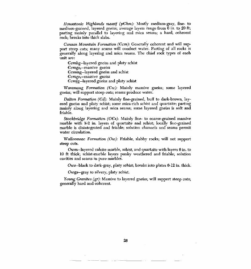
Housatonic Highwnds massif (pChm): Mostly medium-gray, fine- to medium-grained, layered gneiss; average layers range from 6 in. to 20 ft; parting mainly parallel to layering and mica seams; a hard, coherent rock; breaks into thick slabs.
Canaan Mountain Formation (Ccm): Generally coherent and will support steep cuts; many seams will conduct water. Parting of all rocks is generally along layering and mica seams. The chief rock types of each unit are:
Ccmbg-layered gneiss and platy schist Ccmgs2-massive gneiss Ccmmg-layered gneiss and schist Ccmgs1-massive gneiss Ccmfg-layered gneiss and platy schist
Waramaug Formation (Cw): Mainly massive gneiss; some layered gneiss; will support steep cuts; seams produce water.
Dalton Formation (Cd): Mainly fine-grained, buff to dark-brown, layered gneiss and platy schist; some mica-rich schist and quartzite; parting mainly along layering and mica seams; some layered gneiss is soft and friable.
Stockbridge Formation (OCs): Mainly fine- to coarse-grained massive marble with ~-2 in. layers of quartzite and schist; locally fine-grained marble is disintegrated and friable; solution channels and seams permit water circulation.
Walloomsac Formation (Ow): Friable, slabby rocks; will not support steep cuts.
Owm-layered calcite marble, schist, and quartzite with layers 6 in. to 10 ft thick; schist-marble layers punky weathered and friable; solution cavities and seams in pure marbles.
Ows-black to dark-gray, platy schist; breaks into plates 6-12 in. thick.
Owgs-gray to silvery, platy schist.
Young Granites (gr): Massive to layered gneiss; will support steep cuts; generally hard and coherent.
26

REFERENCES
Agar, W. M., 1929, Proposed subdivisions of the Becket Gneiss of northwest Connecticut and their relation to the surrounding formations: Am. Jour. Sci., v. 17, p. 197-238.
-----, 1932, The petrology and structure of the Salisbury-Canaan district of Connecticut: Am. Jour. Sci., v. 23, p. 31-48.
-----, 1933, Further notes on the Salisbury district of Connecticut: Am. Jour. Sci., v. 25, p. 385-389.
-----, 1935, Pegmatite minerals in the marble at Falls Village, Connecticut: Am. Jour. Sci., v. 29, p. 56-57.
Brauner, M. B., 1969, A petrological study of the Housatonic Highlands gneiss and the Dalton Formation of the South Canaan quadrangle, Connecticut: unpub. M. S. thesis, Univ. Wisconsin, 54 p.
Gates, R. M., 1961, The bedrock geology of the Cornwall quadrangle: Connecticut Geol. Nat. History Survey Quad. Rept. 11, 35 p.
-----, 1967, Amphibolites: syntectonic intrusives?: Am. Jour. Sci., v. 265, p. 118-131.
Gates, R. M. and Christensen, N. I., 1965, The bedrock geology of the West Torrington quadrangle: Connecticut Geol. Nat. History Survey Quad. Rept. 17, 38 p.
Gates, R. M., Martin, C. W., and Schnabel, R. W., 1973, The Cambrian-Precambrian contact in northwestern Connecticut and west-central Massachusetts: Geol. Soc. America, Abstracts, Northeastern Sect., 8th Ann. Meeting, v. 5, no. 2, p. 165.
Gregory, H. E., and Robinson, H. H., 1907, Preliminary geological map of Connecticut: Connecticut Geol. Nat. History Survey Bull. 7, 39 p.
Harwood, D. S., 1972, Tectonic events in the southwestern part of the Berkshire anticlinorium, Massachusetts and Connecticut: Geol. Soc. America, Abstracts, Northeastern Sect., 7th Ann. Meeting, v. 4, no. 1, p. 19.
Harwood, D. S., and Zietz, Isidore, 1973, Highly magnetic subsurface rocks in southern New York and their possible relationship to Precambrian rocks in western New England: Geol. Soc. America, Abstracts, Northeastern Sect., 8th Ann. Meeting, v. 5, no. 2, p. 175.
Hatch, N. L., Schnabel, R. W., and Norton, S. A., 1968, Stratigraphy and correlation of the rocks on the east limb of the Berkshire anticlinorium in western Massachusetts and north-central Connecticut in Zen, E-An, White, W. S., Hadley, J.B., and Thompson, J. B., Jr., Studies of Appalachian geology: N.Y., Wiley-Interscience, p. 177-184.
Holmes, G. W., Newman, W. S., and Melvin, R. L., 1970, Preliminary surficial geologic map of the South Canaan quadrangle, Connecticut: Open File, U.S. Geol. Survey.
Luchterhand, Dennis, 1967, The origin of the Housatonic Highlands gneiss complex in the southern part of the South Canaan quadrangle, Connecticut: unpub. Masters thesis, Univ. Wisconsin, 53 p.
Martin, C. W., 1970, The bedrock geology of the Torrington quadrangle: Connecticut Geol. Nat. History Survey Quad. Rept. 25, 53 p.
Moore, F. H., 1935, Marbles and limestones of Connecticut: Connecticut Geol. Nat. History Survey Bull. 56, 56 p. ·
Percival, J. G., 1842, Report on the geology of the state of Connecticut: New Haven, Osborn and Baldwin, 495 p.
Ratcliffe, N. M., 1969, Structural and stratigraphic relations along the Precambrian front in southwestern Massachusetts: New England Intercoll. Geol. Conf., 6lst Ann. Meeting, Gdbk, Trip 1, 21 p.
27

Rice, W. N., and Gregory, H. C., 1906, Manual of the geology of Connecticut: Connecticut Geol. Nat. History Survey Bull. 6, 273 p.
Rielif, W. G., 1972, Structural analysis in determination of the origin of the Canaan Mountain Formation: unpub. Masters thesis, Univ. Wisconsin, 60 p.
Rodgers, John, 1970, The tectonics of the Appalachians: N.Y., Wiley-lnterscience, 271 p.
U.S. Geological Survey, 1969, Aeromagnetic map of the South Canaan quadrangle and parts of the Cornwall and Ashley Falls quadrangles, Litchfield County, Connecticut: Geophys. Invest. Map GP-641.
Vogel, T. A., 1961, The sedimentary origin of the Housatonic Highlands gneiss complex in the Cornwall quadrangle, Connecticut: unpub. Masters thesis, Univ. Wisconsin, 70 p.
Zartman, R. E., Harley, P. M., Krueger, H. W., and Giletti, B. J., 1970, A Permian disturbance of K-Ar radiometric ages in New England: its occurrence and cause: Bull. Geo!. Soc. America, v. 81, p. 3359-3374.
Zen, E-An, 1966a, The Stockbridge Formation in Cohee, G. V., and West, W. S., Changes in stratigraphic nomenclature by the U.S. Geological Survey, 1965: U.S. Geol. Survey Bull. 1244, p. 30. .
-----, 1966b, Walloomsac Formation in Cohee; G. V., and West, W. S., Changes in stratigraphic nomenclature by the U.S. Geological Survey, 1965: U.S. Geol. Survey Bull. 1244, p. 31.
-----, 1967, Time and space relationships of the Taconic allochthon and autochthon: Geol. Soc. America Spec. Paper 97, 101 p.
-----, 1969, Stratigraphy, structure, and metamorphism of the Taconic allochthon and surrounding autochthon in Bashbish Falls and Egremont quadrangles and adjacent areas: New England lntercoll. Geol. Conf., 6lst Ann. Meeting, Gdbk, trip 3, 41 p.
Zen, E-An, and Hartshorn, J. H., 1966, Geologic map of the Bashbish Falls quadrangle, Massachusetts, Connecticut, and New York: U.S. Geol. Survey Geol. Quad. Map GQ-507, 7 p.
Zen, E-An, and Ratcliffe, N. M., 1971, Geologic map of the Egremont quadrangle, Massachusetts and New York: U.S. Geol. Survey Geol. Quad. Map GQ 1-628.
Zen, E-An, White, W. S., Hadley, J. B., and Thompson, J. B., Jr., eds, 1968, Studies of Appalachian geology: N.Y. Wiley-lnterscience, 475 p.
28

APPENDIX
During the summer of 1970, Stone and Webster Engineering Corporation conducted a feasibility study, for Northeast Utilities Service Company, of Canaan Mountain as the site of an electrical-generating facility based on a pumped-storage principle. The drilling logs, test data, and a geologic: report by John R. Rand, Consulting Geologist, were made available to the Connecticut Geological and Natural History Survey.
The locations of the 24 drill holes are shown on plate 1 and cross section C-C' -C" is modified from Rand's report. A brief summary of the bedrock data on these drill holes from his report is given below, with the permission of Northeast Utilities Service Corporation.
DRILL HOLE 1. Orientation vertical; elevation 651.4 ft; overburden 77 ft OCsa 77-105 ft White, nearly massive, locally friable dolo-
mite to calcareous sandstone. OCsa 105-150 ft White, fine- to medium-grained, massive
dolomite marble; local thin micaceous laminae.
DRILL HOLE 2. Orientation vertical; elevation 750.8 ft; overburden 8 ft p€hm 8-205 ft Interlayered, medium- to light-gray, fine-
to medium-grained, quartz-feldspar gneisses with variable amounts of biotite; locally thin biotite schist and hornblende-bearing layers.
DRILL HOLE 3. Orientation vertical; elevation 665.3 ft; overburden 30 ft
DRILL HOLE 4.
DRILL HOLE 5.
DRILL HOLE 6.
p£hm 30-250 ft lnterlayered, medium- to light-gray, fineto medium-grained, micaceous quartz-feldspar gneiss, quartz-feldspar gneiss, biotitequartz-feldspar gneiss, and quartzitic gneiss. Most layers have quartz-feldspar knots and stringers subparallel to foliation; local thin layers of dark biotite schist and gneiss.
Orientation: inclined 30° NE; elevation 730.7 ft; no overburden Owm 0-250 ft Massive, light-gray, medium-grained, diop-
side dolomite marble with disseminated phlogopite and some calcite; rare thin phlogopitic laminae.
Orientation: inclined 45°, N 26° E; elevation 726.8 ft; overbur-den 8 ft Owm
Owm
8-38 ft Brown, schistose, fine-grained calcitic marble with disseminated ph_logopite.
38-150 ft lnterlayered, fine- to medium-grained, brown to light-gray, schistose calcareous marble and calcareous schist; phlogopite in streaks and thin layers.
Orientation vertical; elevation 726.4 ft; overburden 10 ft Owm 10-150 ft Light-gray, medium-grained, calcareous
marble with varying amounts of phlogopite streaks and layers.
29

Owm 150-200 ft Light-gray, massive, calcareous marble with minor phlogopite streaks.
nmLL HOLE 7. Orientation vertical; elevation 1070.7 ft; no overburden £cmbg 0-280 ft Gray, medium-grained, biotite-quartz-pla-
gioclase gneiss and schist or quartzite with subordinate pegmatite streaks and quartz seams or quartzitic layers.
nruLL HOLE 8. Orientation vertical; elevation 1451.9 fr; overburden 4 fr £cmgs2 4-210 ft Gray, medium-grained, muscovite-biotite-
feldspar-quartz gneiss with pegmatite seams, thin quartz and quartz-feldspar streaks, *-~ in. thick, and quartzitic biotite schist and biotitic quartzite.
£cmgs2 210-470 ft Medium- to coarse-grained garnetiferous biotite-feldspar-quartz schist and gneiss; magnetite disseminated throughout; thin quartz-feldspar layers common; pegmatite lenses sparsely present; locally gray, medium-grained biotite-feldspar-quartz schist or gneiss without garnet.
£cmgs2 470-730 ft Medium-grained quartz-feldspar gneiss with variable biotite content and without garnet or with minor garnet; subordinate thin layers of quartzite, garnetiferous schists with magnetite, pegmatite, and biotitic schists.
730-950 ft lnterlayered garnetiferous quartz-feldspar schist with disseminated magnetite and quartz-feldspar schist and gneisses with no garnet or subordinate garnet; thin layers of pegmatite, quartzite, biotite quartzite, and biotitic schist.
nmLL HOLE 11. Orientation vertical; elevation 1698.6 ft; overburden 2 fr £cmmg 2-26 ft Gray, medium-grained, garnetiferous bio-
tite schist with thin quartzitic seams. £cmmg 26-50 ft Gray, medium-grained quartz-plagioclase
£cmmg 50-100 ft
£cmmg 100-150 ft
£cmmg 150-180 ft
£cmmg 180-210 ft
£cmmg 210-250 ft
biotite schist. Gray, medium-grained, garnetiferous biotite schist with minor magnetite; quartzitic layers minor. Gray, medium-grained, quartz-plagioclasebiotite schist to gneiss with quartzite layers and lenses. Gray, medium-grained, garnetiferous biotite schist with quartzitic layers and local layers of quartzite with minor garnet. Gray, medium-grained quartz-plagioclase schist with quartzite layers and garnetbiotite schist layers subordinate. Garnetiferous biotite schist with local biotite-rich and quartz-rich layers.
30

DRILL HOLE 12. Orientation vertical; elevation 1582.l ft; overburden 6 ft
DRILL HOLE 13.
DRILL HOLE 14.
DRILL HOLE 17.
DRILL HOLE 18.
£cmmg 6-40 ft Biotite schist with garnet and small mag-netite crystals disseminated throughout; locally garnet and magnetite are prominent; thin quartzite and pegmatite lenses present.
£cmmg 40-70 ft Biotitic quartz-feldspar schist with and without garnet.
£cmmg 70-90 ft Biotite schist with garnet and magnetite disseminated throughout.
£cmmg 90-100 ft Gray, quartz-feldspar granulite and pegma-tite with whorls of biotite schist.
£cmmg 100-120 ft Quartzose biotite schist with disseminated
Orientation: burden £cmmg
£cmmg
£cmmg
£cmmg
Orientation: den 47 ft £cmgs2
Orientation: den 8 ft £cm mg
£cmmg
Orientation: den 15 ft £cmgs2
garnet and magnetite crystals; some pegmatite lenses.
inclined 45°, N 22° W; elevation 1492.9 ft; no over-
0-60 ft Quartzose biotite schist with quartz-feldspar layers and lenses; some disseminated minor garnet and magnetite; local biotiterich and garnetiferous streaks.
60-80 ft Gray, medium-grained, garnetiferous quartzitic biotite schist with disseminated magnetite; thin quartz-rich streaks and lenses throughout.
80-100 ft Light-gray, medium-grained, quartzitic biotite schist and quartzite with local garnet crystals and minor disseminated magnetite.
100-150 ft Medium- to dark-gray, medium-grained garnetiferous biotite schist with local quartz lenses and layers.
inclined 45°, N 47° W; elevation 1469.2 ft; overbur-
47-197 ft Medium-gray, medium- to coarse-grained, garnetiferous biotite schist; local disseminated magnetite; thin quartzitic layers and lenses throughout.
inclined 60°, N 51° W; elevation 1551.7 ft; overbur-
8-170 ft Medium-gray, medium-grained quartz-feldspar schist with minor disseminated garnet crystals locally and with thin, sparsely distributed quartzitic layers.
170-200 ft Medium-grained, garnetifern_us quartz-biotite schist with sparse, thin, quartzitic layers.
inclined 45°, N 49° W; elevation 1479.8 ft; overbur-
15-20 ft Medium- to dark-gray, fine- to mediumgrained, quartz-plagioclase granulite with minor disseminated magnetite.
31

DRILL HOLE 19. Orientation: den 12 ft £cmgs2
20-200 ft Garnetiferous biotite schist with prominent black magnetite crystals; thin lenses and layers of quartz-plagioclase granulite and pegmatite.
inclined 43°, N 44° W; elevation 1568.3 ft; overbur-
12-150 ft Medium-gray, medium-grained, garnetifer-ous biotite schist with irregularly distributed· magnetite; thin quartzitic biotiteschis~ and impure-quartzite layers and lenses sparsely distributed.
DmLL HOLE 20. Orientation vertical; elevation 1594.4 ft; no overburden £cmmg 0-60 ft Medium-gray, medium-grained, quartz-pla-
gioclase granulite with streaks and knots of quartz.
£cmmg 60-90 ft Fine-grained, garnetiferous biotite schist with quartz layers and lenses.
£cmmg 90-150 ft Medium- to medium-fine-grained quartz-plagioclase granulite.
DruLL HOLE 21. Orientation: inclined 45°, S 72° W; no overburden £cmmg 21-200 ft lnterlayered gray, medium-grained quartz-
ose biotite gneiss and schist and biotitequartz-feldspar granulitic gneiss.
DruLL HOLE 22. Orientation: inclined 44°, N 44° W; elevation 1583.2 ft; overburden 9 ft £cmmg 9-55 ft Gray, medium-grained, well foliated quartz-
feldspar granulitic gneiss. £cmmg 55-140 ft As above, with layers of garnetiferous
schist abundant; some disseminated magnetite.
DruLL HOLE 23. Orientation vertical; elevation 1633.6 ft; overburden 2 ft £cmmg 2-32 ft Gray, medium-grained quartz-feldspar
granulitic gneiss with irregular foliation; minor disseminated magnetite.
£cmmg 32-100 ft Gray, medium-grained garnetiferous bio-tite-quartz-feldspar gneiss or schist; quartz lenses and streaks common.
DRILL HOLE 24. Orientation: inclined 45°, N 64° W; elevation 1556.0 ft; overburden 27 ft £cmmg 27-48 ft Gray, medium-grained biotite-quartz-pla-
£cmmg
£cmmg
gioclase schist and granulitic gneiss; well foliated.
48-56 ft Biotite-quartz schist or gneiss with disseminated, small, red garnet crystals.
56-150 ft Gray, medium-grained, thinly foliated biotite-quartz-plagioclase granulitic gneiss; sparse, small garnet crystals disseminated in some layers.
32
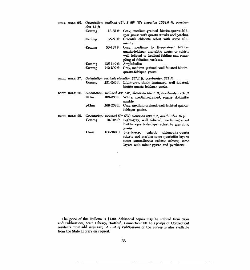
DRILL HOLE 25. Orientation: inclined 45°, S BB• W; elevation 1564.6 ft; overbur· den 13 ft €cmmg 13-35 ft Gray, medium-grained biotite-quartz-feld-
spar gneiss with quartz streaks and patches. €cmmg 35-50 ft Greenish chloritic schist with some silli-
€cmmg
€cmmg €cmmg
manite. 50-135 ft Gray, medium- to fine-grained biotite
quartz-feldspar granulitic gneiss or schist; well foliated to isoclinal folding and crumpling of foliation surfaces.
135-140 ft Amphibolite. 140-200 ft Gray, medium-grained, well foliated biotite
quartz-feldspar gneiss.
DRILL HOLE 27. Orientation vertical; elevation B57.1 ft; overburden 221 ft €cmmg 221-240 ft Light-gray, thinly laminated, well foliated,
biotite-quartz-feldspar gneiss.
DRILL HOLE 28. Orientation: inclined 43° SW; elevation 651.B ft; overburden 100 ft 0€sa 100-266 ft White, medium-grained, sugary dolomitic
marble. p€hm 266-268 ft Gray, medium-grained, well foliated quartz-
feldspar gneiss.
DRILL HOLE 29. Orientation: inclined 50° SW; elevation 999.6 ft; overburden 16 ft €cmmg 16-106 ft Light-gray, well foliated, medium-grained
biotite -quartz-feldspar schist to granulitic gneiss.
Owm 106-380 ft Interlayered calcitic phlogopite-quartz schists and marble; some quartzitic layers; some garnetiferous calcitic schists; some layers with minor pyrite and pyrrhotite.
The price of this Bulletin is $1.00. Additional copies may be ordered from Sales and Publications, State Library, Hartford, Connecticut 06115 (postpaid; Connecticut residents must add sales tax). A List of Publications of the Survey is also available from the State Library on request.
33