opa-locka community redevelopment plan - miami-dade · opa-locka community redevelopment plan a...
TRANSCRIPT

Opa-locka Community Redevelopment PlanA Blueprint for Economic Development and Empowerment


Opa-locka Community Redevelopment Plan
Produced for the CITY OF OPA-LOCKA and the OPA-LOCKA COMMUNITY REDEVELOPMENT AGENCYby CARRAS COMMUNITY INVESTMENT, INC.
in conjunction with URBAN REVITALIZATION SOLUTIONS.
Completed May 2011.
MAYOR & CITY COMMISSION
Mayor Myra TaylorVice Mayor Dorothy JohnsonCommissioner Rose TydusCommissioner Timothy HolmesCommissioner Gail Miller
CITY OF OPA-LOCKA
780 Fisherman Street4th Floor
Opa-locka, Florida 33054(305) 953-2868
www.opalockafl.org

City of Opa-locka, 2010 Google Inc.
LegendOpa-Locka Municipal Boundary
0 0.5 10.25Miles

Table of Contents
EXECUTIVE SUMMARY A-1
SECTION A: BACKGROUND
City history A-3 The community redevelopment process A-4 General conditions in the City and the CRA A-7 Specific conditions in the four redevelopment districts of the CRA A-13 Stakeholder input A-21
SECTION B: REDEVELOPMENT PLAN
A new way forward B-1 Plan values B-2 Goals, objectives, and blueprints for the four redevelopment districts B-3 to B-31
APPENDICES A. Objectives and blueprints table C-1B. Redevelopment financing C-8C. Proposed capital improvements C-11D. Existing land uses in Opa-locka C-14E. Zoning designations in Opa-locka C-15F. Vacant properties in Opa-locka C-16G. 2009 assessed property values in Opa-locka C-17H. Legal boundary of the CRA C-18
iii

Opa-locka City Hall, c. 1920s Opa-locka Historical Society

Section A: BACKGROUND
A-1OPA-LOCKA COMMUNITY REDEVELOPMENT PLAN
FOR DECADES, THE CITY OF OPA-LOCKA, TEN MILES northwest of Miami, has underperformed relative to Miami-Dade County on a number of indicators. During the South Florida economic boom, the City witnessed slow business development despite a growing population. Through the late-2000s recession, the City suffered a deeper slump than the county overall despite significant regional advantages.
City officials are renewing their efforts to spur investment in Opa-locka and improve conditions for residents. One of their primary initiatives has been to establish an agency to direct official redevelopment efforts; a process that entails a specific sequence of activities (see Section A). Toward this goal, the City commissioned a Finding of Necessity study in 2009 from Carras Community Investment, Inc. The study was completed in April 2010 and confirmed the presence of conditions allowing the City’s first community redevelopment area (CRA) and community redevelopment agency.
At approximately one-fifth of Opa-locka’s total area, the new CRA comprises a substantial part of the City and contains important neighborhoods and destinations. Working with City officials over a period of seven
months, a team of consultants engaged stakeholders and researched extensively to uncover the CRA’s (and the City’s) assets and create a redevelopment plan. A strong focus on economic development is contained in this plan, considering the long-standing hardship of the City’s residents and business owners and the weak post-recession recovery. Particular attention is paid to the feasibility of redevelopment activities in light of the City’s projected fiscal position over the next few years.
City officials are particularly interested in social and economic growth strategies that will build a foundation capable of enduring future economic downturns. Specifically, the City wishes to create a community vision and understand the unique needs of the CRA. The City wants a community plan that focuses on leveraging private investment and public/private partnerships as a means for economic development and empowerment.
The plan will be an important and relevant blueprint strategy for the new community redevelopment agency and the CRA, but it is also meant to serve as a model for economic and social redevelopment in all areas of Opa-locka. Thus, what is called for in the
CRA will apply in similar neighborhoods and districts throughout Opa-locka and it is intended that the City uses the plan in this manner.
PRIMARY GOALS OF THE PLAN
There are a number of goals this plan is intended to achieve:
• Provide feasible and sensible strategies to improve the Opa-locka CRA
• Emphasize the role of sound social and economic initiatives in community redevelopment
• Guide the activities of the new community redevelopment agency
• Present a vision of the future of the CRA if this plan is executed
• Encourage the people who live and work in Opa-locka to believe that the best days are not only ahead of them but well within reach
EXECUTIVE SUMMARY

SECTION A:BACKGROUND
OPA-LOCKA COMMUNITY REDEVELOPMENT PLAN

Section A: BACKGROUND
A-3OPA-LOCKA COMMUNITY REDEVELOPMENT PLAN
THE CITY OF OPA-LOCKA, 85 YEARS OLD IN 2011, originated under unique circumstances. The aviation pioneer and founder of the City, Glenn Hammond Curtiss, born in Hammondsport, New York, moved to Florida after a successful career designing airplanes for the U.S. Navy. Curtiss contributed significantly to South Florida’s development during the 1920s; alongside Hialeah and Miami Springs, Opa-locka was one of three cities Curtiss developed or co-developed from the ground up.
Curtiss incorporated Opa-locka in 1926. It was his intention that Opa-locka be the best possible example of city planning and feature some of the most beautiful architecture that could be made at the time. The City was built as an “Arabian fantasy,’’ inspired by the traditional stories in 1001 Arabian Tales. By 1928, Curtiss and his architect, Bernhardt Mueller, had erected 105 buildings with an array of domes, minarets, and other Arabic elements. Today, the remaining buildings from that initial build-out represent the largest collection of Moorish Revival architecture in the Western hemisphere.
True to his aviation roots, Curtiss also built an airfield and an aviation school. Today known as the Opa-locka Executive Airport, this airfield would become a mainstay of the City’s evolution through the decades — the U.S. Navy operated a base at the airfield to train pilots for World War II and maintained a presence until the 1950s. Some of the original barracks still
stand today. Amelia Earhart even launched her 1937 attempt to circumnavigate the world from this airfield.
In its early years, Opa-locka was an all-white, non-Hispanic community that attracted middle-class home buyers. However, the 1929 stock market crash and Curtiss’s sudden death a year later sapped the strength of the City and put it onto a long path of economic decline. By the 1980s, the white middle class had been replaced by African-American middle class and working poor families. Illegal drug activity became prominent in Opa-locka, particularly in a nine-block working class neighborhood in the eastern end of the City named Magnolia North but more infamously referred to as the “Triangle”.
Opa-locka, and the Triangle especially, soon developed a reputation as one of the most violent and crime-affected communities in South Florida. Crack cocaine and heroin trafficking surged, creating tense and deadly conflicts between competing gangs. Dade County statistics in 1986 revealed a one-in-four chance of being assaulted, and a one-in-60 chance of being murdered, in Magnolia North; in fact, half of the City’s 18 homicides that year occurred in this one neighborhood.
Drastic efforts undertaken the following year to physically isolate the Triangle did little to reduce crime, yet reinforced the perception of Opa-locka as unsafe. Economic and population growth stalled, leaving the
City with a weak tax base and a burdensome public image that has lasted to this day, despite marked improvements in public safety.
Opa-locka’s persistent structural, social, and economic deficiencies have been exacerbated by the 2008 recession and real estate collapse. A lack of business activity, slow job creation, and low tax revenue limit the City’s ability to invest in capital improvements and prolong its characterization as an unfavorable location to raise a family or start a business.
Miami-Dade County recognizes the challenges facing Opa-locka and has subsequently designated the City in its entirety as a special economic Brownfield Area. The U.S. Department of Housing and Urban Development has also assigned the majority of the City as a Neighborhood Stabilization Program Priority Area. These designations are valuable foundations for a growth strategy shaped by redevelopment strategies appropriate for the City’s unique economic and demographic profile.
Additionally, the City's efforts to strengthen Opa-locka’s socioeconomic conditions are being assisted by the Opa-locka Community Development Corporation (CDC), a 30-year-old nongovernmental and nonprofit organization active in affordable housing and local business development. The CRA plan recognizes the work of the Opa-locka CDC and has been written to leverage this particular advantage in Section B.
CITY HISTORY

Section A: BACKGROUND
A-4 OPA-LOCKA COMMUNITY REDEVELOPMENT PLAN
AUTHORITY TO CREATE A COMMUNITY REDEVELOPMENT AGENCY
THE FLORIDA LEGISLATURE MAKES PROVISIONS for redevelopment through the Community Redevelopment Act of 1969. Chapter 163, Part III, of the Florida Statutes provides the regulatory framework through which a Florida municipality may authorize a community redevelopment area and agency after a due diligence study (“Finding of Necessity”) has confirmed their appropriateness. The Finding of Necessity is a prerequisite step prior to establishing a community redevelopment authority. The finding must demonstrate the existence of conditions unfavorable to public health, housing affordability, or economic growth (see sidebar, this page).
The Finding of Necessity received by the City in early 2010 confirmed the presence of unfavorable conditions and recommended the designation of a 514-acre redevelopment area in central and northeastern Opa-locka. It prompted the City Commission, on the advice of its planning and city management staff, to move forward on forming a community redevelopment agency and designate the boundaries of the CRA as identified in the report (see Fig. A.2, next page).
City Commission determined, by Resolution 10-8043
on April 14, 2010, that the proposed CRA met the necessary conditions for redevelopment.
POWERS OF A CRA
A community redevelopment agency has a range of statutory powers at its disposal to administer a CRA.
A redevelopment agency is authorized to grant approval to a redevelopment plan; to authorize the issuance of revenue bonds; to approve the acquisition, demolition, or disposal of property; to obtain property through eminent domain; and to raise and allocate funds for activities described in an adopted community redevelopment plan.
This last power is important because a redevelopment agency is allowed special taxing and financial tools for local redevelopment, including tax increment financing, whereby tax revenue from future growth in a CRA’s property values (known as the increment) is used to amortize the public debt issued to fund improvements in that CRA. Redevelopment agencies and municipalities across Florida have used tax increments to raise hundreds of millions of dollars for street and infrastructure improvement, building repair, small business credits, and other incentives.
Although a reliable source of funding, it often takes years before tax increment revenue accumulates significantly. Because of the desire for rapid progress in the CRA, this plan recommends tax increment financing as just one option in a range of funding tools.
REQUIRED CONDITIONS FOR A CRA
A community redevelopment area is defined by Florida statute as “a slum area, a blighted area, or an area in which there is a shortage of housing that is affordable to residents of low or moderate income, including the elderly.” (Title XI, Chapter 163.335 F.S.)
A slum area has physical or economic conditions conducive to disease, infant mortality, juvenile delinquency, poverty, or crime because of a predominance of residential or nonresidential buildings impaired by dilapidation, deterioration, age, or obsolescence. A blighted area contains numerous deteriorated or deteriorating structures in which conditions, as indicated by government statistics or other studies, are leading to economic distress or endangering life or property.
A CRA can be designated in the presence of either or both.
Finding of Necessity City of Opa-Locka Page 1=
F I N D I N G O F N E C E S S I T YCity of Opa-Locka, Flo!da
Mayor Joseph L. Kelly
Vice Mayor Myra Taylor
Commissioner Dorothy Johnson
Commissioner Rose Tydus
Commissioner Timothy Holmes
City Commission
Ap!l 2010
THE COMMUNITY REDEVELOPMENT PROCESS
Fig. A.1: Opa-locka's Finding of Necessity Study.

Section A: BACKGROUND
A-5OPA-LOCKA COMMUNITY REDEVELOPMENT PLAN
Proposed Boundaries
LegendOpa-Locka Municipal Boundary
Proposed Boundaries
Data Source: Miami Dade CountyPCS:NAD_1983_StatePlane_Florida_East_FIPS_0901_FeetProjection:Transverse_MercatorDate Created: 4/2/2010
µ0 0.5 10.25
Miles
BOUNDARY AND DISTRICTS OF THE CRA
The City’s new CRA is generally bounded on the north by NW 151st Street, on the west by the Opa-locka Executive Airport, on the south by the Tri-Rail corridor, and on the east by a constructed stormwater lake managed by the South Florida Water Management District. The 514-acre CRA will cover approximately 18 percent of the City’s total area. A legal description of the boundary is in Appendix A.
The CRA’s boundary was finalized according to
important considerations involving zoning, land use, and redevelopment opportunity. Some of the economically weakest parts of Opa-locka (e.g., Magnolia North in the City’s northeast end) were included along with an important commerce area and downtown Opa-locka.
The areas included in the CRA range in economic strength to ensure that redevelopment strategies will be implemented at a reasonably steady and deliberate manner.
Veterans Way was selected to connect all major parts of the CRA because of its significance as an arterial corridor, its link to the downtown, and its redevelopment potential (including especially that part of the corridor around the Opa-locka Tri-Rail Station). The inclusion in the CRA of particular blocks and parcels along the northern boundary edge was rationalized by the need to maintain contiguous zones of residential and commercial land use.
Defining the CRA was an iterative process; three rounds of revision were needed before the boundary was finalized. The consulting team did not wish to negatively affect the City’s share of property tax revenue by including too much of Opa-locka’s total area in the CRA. It strove to ensure an appropriate balance between underperforming and adequately performing areas.
Contiguity was an important consideration; wherever possible, complete neighborhoods and districts were incorporated into the boundary to avoid splitting character zones (e.g., the Opa-locka Boulevard and NW 27th Avenue corridors). Lastly, large pieces of idle land were brought into the boundary because of the improved fiscal feasibility of their commercial and/or residential redevelopment.
As a result of these considerations, the CRA contains a range of geographically distinct land uses. In effect, it may be seen as a group of four primary districts:
• Magnolia North (Fig. A.3)• Magnolia Gardens (Fig. A.3)• City Center (Fig. A.4)• Opa-locka and LeJeune commerce areas (Figs.
A.5 and A.6)
Magnolia North and Magnolia Gardens, on the eastern end of the CRA, are residential neighborhoods bounded
Fig. A.2: The new CRA (in green) shown within the Opa-locka city boundary and redevelopment districts identified:
1. Magnolia North 2. Magnolia Gardens 3. Opa-locka commerce area4. City Center5. LeJeune commerce area
N
0 0.25 0.5 mi

Section A: BACKGROUND
A-6 OPA-LOCKA COMMUNITY REDEVELOPMENT PLAN
22nd Avenue and NW 27th Avenue, is a light industrial hub with a large concentration of auto and engine repair, boat and plane maintenance, scrap handling, and similar activities. A retail commerce segment is located along NW 27th Avenue. LeJeune commerce area, meanwhile, is a smaller zone on the western end of the CRA containing heavier industrial uses and large vacant properties. The two commerce areas are considered a single district in this plan, despite being physically separated by City Center, since they share the same primary land uses.
City Center is a mixed residential, commercial, and institutional district incorporating Opa-locka’s downtown core and many of the City’s historic structures. It contains the most widely varied land uses of the four CRA districts.
CONSISTENCY WITH OPA-LOCKA'S COMPREHENSIVE PLAN
By Florida statute, CRA plans must be consistent with the parent municipality’s comprehensive plan. Opa-locka is in a unique situation since it currently operates by an outdated version of its comprehensive plan (the last approved version was written in 1990). An evaluation and appraisal report from 2007 by Florida International University represents the latest update to the Opa-locka comprehensive plan. Currently, the report is in the approval process with the South Florida Regional Planning Council and State of Florida.
Clockwise from top left (not to scale):
Fig. A.3: Magnolia North (1) and Magnolia Gardens (2)Fig. A.4: Opa-locka commerce area (3)Fig. A.5: City Center (4)Fig. A.6: LeJeune commerce area (5)
on the west by NW 22nd Avenue and separated from each other by State Road 9 and the Tri-Rail corridor. A small amount of commercial activity exists along NW 22nd Avenue in both neighborhoods.
The Opa-locka commerce area, contained between NW

Section A: BACKGROUND
A-7OPA-LOCKA COMMUNITY REDEVELOPMENT PLAN
DEMOGRAPHICS
IN A COUNTY THAT IS 82 PERCENT MINORITY, OPA-locka is a city with an almost completely non-Caucasian population — data from the 2009 American Community Survey state that 64.7 percent of residents are Black and an additional 33.9 percent are Hispanic. The City’s population was estimated at 16,497 in 2009 — an increase of 10.3 percent from the 2000 census figure of 14,951 and approaching the 2030 projected population of 20,475, as calculated by the Miami-Dade County Planning and Zoning Department1.
Opa-locka’s population is younger and less educated than the Miami-Dade County (MDC) average. Opa-locka’s under-25 sector represents approximately 40 percent of total residents, compared with approximately 33 percent in the County overall, and the share of the over-25 sector with a college degree in the City is less than one
third of the County’s, at 6.6 and 25.9 percent, respectively.
Opa-locka is also a family oriented city; approximately 70 percent of households in Opa-locka are family households and the average family size is 3.44 persons, similar to Miami-Dade County.
The CRA exhibits similar trends to the City in racial proportions, educational attainment, and family households, but a contrasting trend in total population. While Opa-locka grew by approximately one tenth from 2000 to 2009, the CRA lost an estimated
11 percent of its population over the same period (from 3,392 residents to 3,022). The largest decline occurred in the eastern end of the CRA, where Magnolia North and Magnolia Gardens lost approximately 15 percent of their resident base.
JOBS AND HOUSEHOLD INCOME
In September 2010, 55.8 percent of the City’s population was in the labor force and unemployment was at 17.6 percent, almost five percentage points higher than MDC’s rate of 12.7 percent. Unemployment rates in Opa-locka have trended higher than in MDC for years2.
Household income is also lower in Opa-locka than in Miami-Dade County. The median household income was $19,061 in 2009 (inflation-adjusted dollars), compared to $42,969 for MDC. Per capita income in the City was $12,080 in 2009, a little more than half the MDC per capita of $22,619. This is attributable to the types of employment available in the City; the majority of employed adults in Opa-locka are in low paying service jobs and, to a lesser extent, moderate income public service jobs. Sales and office occupations currently comprise the majority of employment positions at 30 percent, followed by service occupations (21.2 percent) and retail trade (13.3 percent). Opa-locka CDC and other sources project that
THE FINDING OF NECESSITY ADDRESSED CONDITIONS across Opa-locka, and in the proposed CRA in particular, that met the requirements for redevelopment. These conditions are summarized in this section and describe a CRA, and City, that is weaker than the Miami-Dade County average in a number of metrics, including education, income, basic services, property values and homeownership. Thirteen categories of conditions are summarized.Black
HispanicOther
64.733.91.4
64.7%
33.9%
1.4%
BlackHispanicOther
Opa-locka population by race, 2009
44%
Median income in Opa-locka compared to
MDC's median income, 2009
MDC Opa-locka
-11%
CRA population decline
2000 2009
2000 2009
+10%
City population growth
GENERAL CONDITIONS IN THE CITY AND CRA

Section A: BACKGROUND
A-8 OPA-LOCKA COMMUNITY REDEVELOPMENT PLAN
the City’s labor force will remain service oriented and high wage professional jobs will remain scarce.
Families and individuals below the poverty level in Opa-locka comprise 29.4 and 31 percent of their respective sectors. This is approximately double the County's rates, where 13.5 percent of families and 16.9 percent of individuals are below the poverty line as of 2009. Of children under age 18 in Opa-locka, 39.3 percent lived below the poverty threshold in 2009.
HOMEOWNERSHIP
Homeownership is a concern in Opa-locka because the City’s lower than average household income challenges families’ ability to find (or maintain) affordable and decent housing and results in a larger proportion of renters. In the CRA, renter-occupied units outnumber owner-occupied units almost 2 to 1 (63.9 percent to 36.1 percent, respectively). These numbers are similar to figures for
the City overall and reflect a homeownership rate that is markedly lower in Opa-locka than in Miami-Dade County overall. In 2009, owner-occupied housing units represented 58.3 percent of total occupied units in the county, compared with 31.8 percent in Opa-locka. (Unoccupied housing units represent 14 percent of all housing in the county and 12 percent in Opa-locka.)
Low household incomes and job scarcity have contributed to foreclosures in Opa-locka, but the rate of foreclosure does not appear to be significantly different from elsewhere in MDC or South Florida. In the first quarter of 2011, a housing occupancy review of Magnolia North and Magnolia Gardens (the two most residential districts of the CRA) indicated only 12 homes in the process of foreclosure.
HOUSING
Opa-locka’s residential stock is aging. A majority (59.3 percent) of the City’s housing units were constructed between 1940 and 1969 in subdivisions laid out in typical postwar patterns. (This means single-family homes laid out on a repeating grid of 1/10-acre lots with deep setbacks, no garages, and single-vehicle driveways.) As outdated and monotonous as this development pattern is today, it will not be easily changed — particularly in neighborhoods such as Magnolia Gardens where the houses are passed down from one generation to the next and the idea of change is regarded with suspicion.
Most of housing structures in the CRA are single-family homes. Multi-family buildings
represent only a small proportion of housing stock, although they represent the largest share of total housing units. Of the 1,644 housing units in the CRA, 1,108 are multi-family units, 447 are single family homes, 72 are duplexes, and 17 are mixed-use units. The majority of multi-family units and structures have fallen into poor to derelict condition by absentee or unscrupulous owners.
Until this year, little residential construction was taking place. In 2009, no single-family homes were built in the CRA; in fact, through 2010, the CRA had only seen three single family homes built in the last ten years. However, 2011 is ushering in a renewed interest in homebuilding in Opa-locka; Habitat for Humanity is constructing and/or renovating 35 housing units in Magnolia North (most of them single family homes) with assistance from the Opa-locka CDC.
CRIME
Opa-locka has long been prone to crime, particularly involving drug trafficking and gang violence. In 2003 and 2004, Opa-locka was ranked by the FBI as having the highest violent crime rate in the country for any city of its size. Despite trends indicating a reduction in crime, the City remains in the 99th percentile rank in Florida as well as the U.S. for violent and property crime. This means that 99 percent of Florida and U.S. cities have lower crime rates than Opa-locka.
Data from the FBI Uniform Crime Database in 2008, extrapolated for ratios per 100,000 people, show that for every 100,000 people, 2,834 acts of violent crime were committed in Opa-locka, compared to 805 in Florida and 676 nationally. This includes:
• 85.3 homicides — more than 11 times the state or national rate
RentOwn
63.936.1
63.9%
36.1%
RentOwn
Proportion of renters and homeowners in the CRA, 2009
Owner-occupied
Renter-occupiedVacant
28
60
12
28%
60%
12%
Owner-occupiedRenter-occupiedVacant
Use of all housing units in the CRA, 2009
OccupiedVacant
8812
88.0%
12.0%
OccupiedVacant
Occupation of all housing units in the CRA, 2009
1 Miami-Dade County projects Opa-locka's population to be 20,475 in the year 2030, but other sources differ; University of Florida's Shimberg Center projects a population of 16,211 by 2030. 2 In 2000, U.S. census data showed that unemployment in Opa-locka was twice Miami-Dade County's rate (10% vs. 5%, respectively).

Section A: BACKGROUND
A-9OPA-LOCKA COMMUNITY REDEVELOPMENT PLAN
• 1331.8 aggravated assaults — more than twice the state rate and almost four times the national rate
• 1351.4 robberies — almost five times the state rate and seven times the national rate
For every 100,000 people, 11,257 acts of property crime occur in Opa-locka, more than twice the state rate and three times the national rate. Motor vehicle thefts are notably common in the City; at 2,152 thefts per 100,000 people, the rate is more than five times the state or national rates.
Despite these figures, the City takes crime reduction seriously and has made significant progress in lowering incidence rates in formerly violent neighborhoods such as Magnolia North (where, for instance, no homicides have occurred since 2008 and only one person has been shot in the last three years).
BASIC SERVICES
Opa-locka features a limited selection of private-sector basic services (see Fig. A.7). Basic services, defined as important consumer services accessed on a regular basis, include grocery stores, financial institutions, restaurants, coffee shops, laundromats, pharmacies, and medical clinics. Many of these are located outside of Opa-locka city limits, resulting in a significant amount of Opa-locka residents’ consumer activity taking place outside of the city.
The general concern regarding basic services in Opa-locka is the lack of comprehensive systems — for instance, a consumer finance system composed of retail banks, credit unions, and professional accountants, or a food and eatery system composed of supermarkets, delis, cafés, family restaurants, and farmers markets. Such systems are found in most cities in South Florida
and they help to circulate consumer dollars locally.
COMMUNITY ASSETS
Community assets, defined here as low- or no-charge facilities available to the public and provided for the benefit of the community, can be grouped into three primary categories: civic assets, such as public libraries, town squares, Social Security Administration offices, food banks, and temporary shelters; recreational assets, such as parks, sports fields, and community centers; and educational assets, such as public schools and job training centers.
While the CRA contains relatively few community assets on a per capita basis, those that are available offer important services to residents and are generally easily accessible. Civic assets include the Opa-locka Municipal Building on Fisherman Street (in City Center), which contains a library and municipal offices. Elsewhere in City Center, the Opa-locka Regional Service Center provides programs for residents and the Opa-locka Tri-Rail Station serves an important role for the City's commuters. A cultural center and Veterans of Foreign Wars post in Magnolia North are two important civic assets in the CRA’s eastern end.
Recreational assets are scarce in the CRA; in fact, recreation and open space standards are not presently met in Opa-locka overall. The MDC Comprehensive Plan calls for a level-of-service standard of 4.75 acres of recreational or open space per 1,000 residents. The City would need to add approximately 48 acres to its existing 24.4 acres of green park to meet this target. However, the CRA is fortunate in that it already contains two of Opa-locka’s largest and most actively used parks — the 15.7-acre Ingram Park in Magnolia Gardens, and the 5.7-acre Sherbondy Park in City Center. Both are open to the public and provide
a range of active and passive recreational uses. Additionally, the city is readying a new community center in the downtown that will feature indoor sports and a swimming pool. This new facility is expected to open to the public in July 2011.
Educational assets are limited in the CRA. Only one public school, the Opa-locka Elementary School, and one job training center are contained in the CRA. Students in middle and high school attend institutions outside of the City. Postsecondary institutions are accessible from the CRA only by car or indirectly by public transit.
An additional group of assets may be defined by the City’s collection of unique Moorish Revival-style buildings in the downtown. These historic
Basic services in the CRA (as of 2011):
12 food/convenience stores3 government services2 professional services3 retail stores7 consumer businesses
Community assets in the CRA (select):
•Opa-locka Municipal Building (City Center)
•Opa-locka Regional Service Complex (City Center)
•Opa-locka Tri-Rail Station (City Center)
• Ingram Park (Magnolia Gardens)
•Sherbondy Park (City Center)•Opa-locka Community Center (City Center)
Fig. A.7: Basic services and community assets in the CRA.

Section A: BACKGROUND
A-10 OPA-LOCKA COMMUNITY REDEVELOPMENT PLAN
buildings, dating back to the City’s earliest years, are a community asset collection that has made preservation an important goal of the City government and the Opa-locka CDC. A campaign launched in 1989 to preserve approximately 75 structures built in the 1920s has helped maintain these historic buildings as an architectural collection that could serve as a tourism attraction.
Today, twenty of the City’s preserved buildings are listed on the National Register of Historic Places. Eight of those are located in the CRA (all within the City Center district), and four of those represent historic structures with distinctive Moorish Revival architecture.
STREETS AND ROADS
The City’s street and road grid presently meets the necessary levels of service. Five arterial roads in the CRA were given C and D grades for their level of service by the Florida Department of Transportation and Miami-Dade County in 2008, indicating that they adequately support current volumes of traffic.
It is not known what consequence population growth in the CRA will have on traffic volumes or levels of service, but Miami-Dade Transit is aware of the demand for public transit in Opa-locka and recently increased Metrobus service along major corridors. The City is also aware that MDC is considering transportation improvement projects for Opa-locka over the next ten years.
Notable about Opa-locka’s streets is the unusual way they were laid out during the City’s expansion. Street grids at various orientations are joined at awkward angles that are inconsistent with current traffic engineering best practices. When these different grids
meet, streets terminate in dead ends and dangerous intersections. Two districts in the CRA, Magnolia North and City Center, contain this kind of grid. The challenging logistics of corrective roadwork means it is unlikely that realignments of awkward intersections will occur in the future. Maintenance of streets and roads is variable throughout Opa-locka and the CRA. Certain areas (Magnolia North and Opa-locka commerce area in particular) appear to have gone unmaintained for years — storm drains are clogged with debris, streets and soft shoulders flood after every rainstorm, sidewalks and pavement are crumbling, and street lights are burned out.
Conversely, other streets feature new sidewalks and fresh paving, newly planted medians and well-kept streetscape elements. Sharazad Boulevard, in City Center, is one of the most pleasant environments in the City; the wide central median is landscaped, crosswalks are distinguished by colorful pavers, trees are neatly maintained, and the pavement is smooth and clean. Most streets in the City, however, do not match Sharazad Boulevard in condition or character.
INFRASTRUCTURE AND CAPITAL IMPROVEMENTS
The City generally does not have adequate facilities to manage potable water, sewage, solid waste, or recyclables, and it consequently outsources these services to MDC public works departments at a cost of millions of dollars each year. At existing level-of-service standards for these services, MDC will be able to meet projected demands for solid waste through 2016 and potable water through 2030. Other utility services are deficient in Opa-locka, and the City is working with MDC to address those level-of-service shortcomings.
The City’s Five Year Improvement Plan identifies 16 capital improvement projects for fiscal year 2010/11 with a cost of approximately $10.4 million. Approximately half of these are located in the CRA. They are to be paid for using a range of funding tools, from Community Development Block Grants to capital improvement bonds and the City’s general revenues. Please see Appendix F for the list.
VACANT LAND
In mid-2010, vacant land — representing properties devoid of development and properties containing unused structures — accounted for 14.5 percent of the City’s total area. In the CRA, it accounted for approximately 45 acres, constituting almost nine percent of the CRA’s total area. Municipal and county governments own almost two-fifths (18.1 acres) of this land.
The majority of vacant parcels in the CRA are under one acre in size and contain unoccupied structures such as foreclosed homes and abandoned buildings. Approximately a dozen properties, mostly in the commerce areas, are larger than one acre. Vacant parcels are located across the entire CRA but groups of them are found especially in City Center, the Opa-locka commerce area, and Magnolia North. Along both sides of the Veterans Way corridor, approximately one third of the properties are vacant.
Vacant lots cleared of structures and sitting adjacent to each other are suitable for amalgamation into a single redevelopable site. This is known as land assemblage and is considered a useful strategy to entice redevelopment investment. The benefit of assemblage derives from the increased economic value of unified development on a single large property over a series of lower-value projects on smaller properties.
Section A: BACKGROUND
A-11OPA-LOCKA COMMUNITY REDEVELOPMENT PLAN
In the CRA, numerous vacant properties along Opa-locka Boulevard and Veterans Way are candidates for assemblage and large-scale redevelopment.
LAND USE
The City and CRA contain all the primary land use types and are governed by 25 zoning categories assigned by the MDC Planning and Zoning Department. As with most jurisdictions, the County’s zoning regulations are inflexible about permitting land uses that depart from given designations. This tends to result in broad tracts of land with uniform development patterns.
Mixed use patterns of development, recognized for their ability to increase business activity, social relationships, and healthy lifestyles in a single, contained area, are not allowable in Opa-locka under existing zoning regulations. The strict separation between commercial and residential uses results in residential neighborhoods without walkable access to basic services. This puts residents at a disadvantage, particularly in a City with limited public transit and a lower-than-average rate of vehicle ownership.
PROPERTY VALUES
Property values and rental rates in Opa-locka are below MDC's, and market values within the CRA are decreasing. In 2010,
according to MDC property appraiser data, the total market value of properties in the CRA decreased by more than 5 percent, with the largest drops in residential and commercial properties (15 and 17 percent respectively).
The 2004-2008 real estate bubble grossly inflated property values in Opa-locka and led to a severe and rapid deflation by the end of 2008. In Quarter 3 2008, the median single-family home value in Opa-locka was $180,290, according to city-data.com, but in Quarter 4 it dropped by $100,000, or 55 percent. By Quarter 3 2010, the median value had fallen to $50,000.
Variability is pronounced in CRA properties; in Magnolia Gardens, for instance, single family homes were valued
in June 2010 at an average of $58,078 while in Magnolia North they were valued at $84,323. Commercial property values also varied greatly by location, from approximately $45,000 in Magnolia Gardens (along NW 22nd Avenue) to more than $1 million in the Opa-locka commerce area.
VISUAL IMPRESSION
Visual impression represents the perceptual character of the built environment. This impression has a powerful influence on a person’s judgment of the quality, safety, friendliness, and value of a place. Opa-locka is similar to other South Florida inland cities in the impression it imparts
from major streets and roads (e.g., NW 22nd Avenue and NW 27th Avenue) — one of low density sprawl, substandard urban design, and limited human activity in the public realm.
From the smaller streets, blocks, and neighborhoods throughout the CRA, however, a closer look reveals the presence of a deeper visual blight in which a broad spectrum of the urban fabric is visibly damaged, incomplete, inconsistent, unmaintained, out of date, improperly used, or unattractive. Visual blight is commonly encountered in South Florida cities, but the intensity of it in the CRA sets it apart.
Areas of greatest blight include the Opa-locka commerce area and Magnolia North districts. Both contain deteriorating buildings, unmaintained streets, improperly parked cars, trash and debris, untrimmed trees and landscaping, safety hazards and code violations. The tendency of homeowners to fence their properties for privacy and protection degrades visual character as well.
House and property conditions in residential neighborhoods are inconsistent; from street to street and even from house to house, the condition of roofs, cladding, and windows is highly variable. Front yards tend to be more poorly maintained than houses, owing to the tendency (by convenience or lack of choice) to use front yards as driveways, storage space, or dog runs.
However, certain parts of the CRA are visually pleasing. A large number of individual homes and buildings in Magnolia Gardens, the LeJeune commerce area, and City Center have lesser evidence of blight, and parts of the downtown core of City Center (such as Sharazad Boulevard and Perviz Avenue) have almost none at all. (See the next page for a photographic assessment of CRA conditions.)
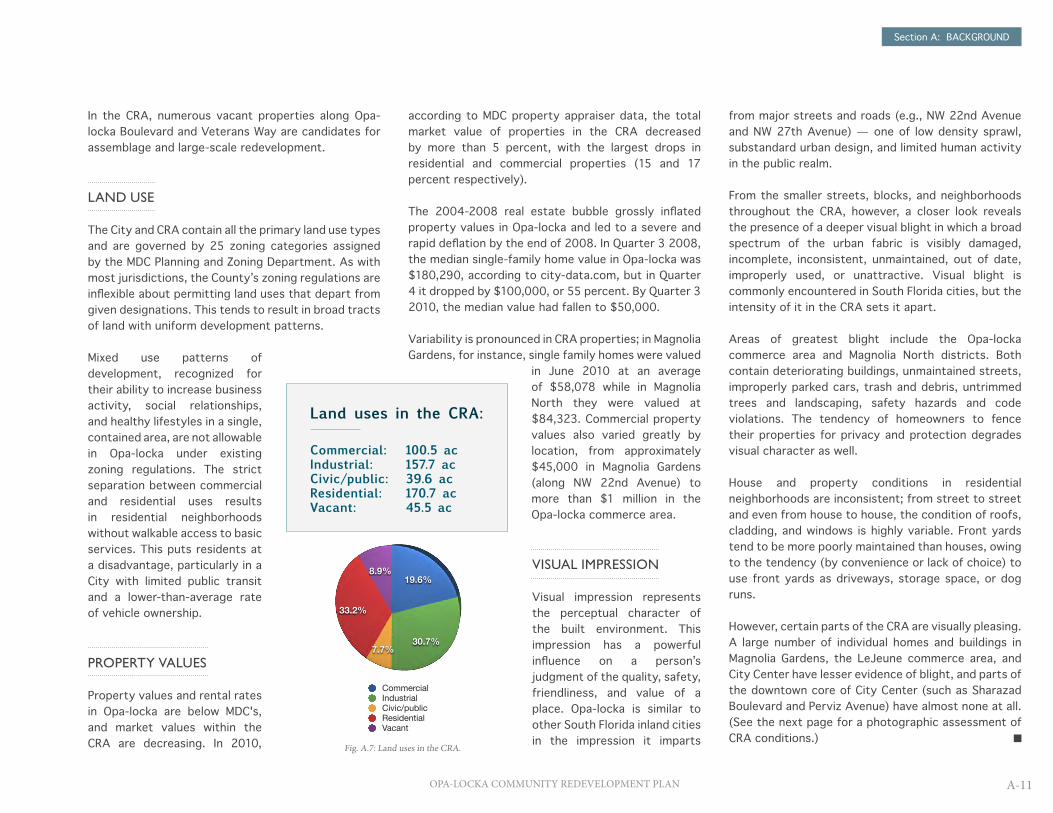
Land uses in the CRA:
Commercial: 100.5 acIndustrial: 157.7 acCivic/public: 39.6 acResidential: 170.7 acVacant: 45.5 ac
Fig. A.7: Land uses in the CRA.
CommercialIndustrialCivic/publicResidentialVacant
100.5157.739.6
170.745.5
19.6%
30.7%7.7%
33.2%
8.9%
CommercialIndustrialCivic/publicResidentialVacant

Section A: BACKGROUND
A-12 OPA-LOCKA COMMUNITY REDEVELOPMENT PLAN
Fig. A.8: Visual clutter takes many forms in the CRA, including sagging overhead lines and poorly defined parking spaces. (Service Road)
Fig. A.11: Downtown Opa-locka's architectural heritage is epitomized by civic structures such as the old City Hall. (Sharazad Boulevard)
Fig. A.14: Landscaped medians along Sharazad Boulevard are offset by vacant, unmaintained lots and structures.
Fig. A.9: Littering is a common occurrence along streets and medians in the CRA. (NW 21st Court)
Fig. A.12: Deteriorating pavement and poor drainage are typical of streets in the Opa-locka commerce area. (NW 147th Street)
Fig. A.15: Opa-locka CDC is investing heavily in purchasing foreclosed homes and renovating them for new residents. (Wilmington Street)
Fig. A.10: A shortage of parking in all the CRA's residential neighborhoods results in degraded planting strips serving as parking lanes. (Rutland Street)
Fig. A.13: A number of warehouses are vacant in the commerce areas but continue to be well maintained by their owners. (NW 150th Street)
Fig. A.16: Vacant land along the stormwater lake is kept mowed and allows for clear views of the water while it awaits a future use. (Wilmington Street)

Section A: BACKGROUND
A-13OPA-LOCKA COMMUNITY REDEVELOPMENT PLAN
BUILT ENVIRONMENT
MAGNOLIA NORTH HAS BEEN HARD-HIT BY VACANCIES, foreclosures, and abandonment, which have harmed the physical condition of the district. Approximately 95 percent of residential structures in the area are absentee-owned rental properties and a large number are unoccupied or abandoned — including 17 boarded-up apartment complexes, five abandoned homes, and two shuttered corner stores.
The neighborhood is marked by a visually jarring mix of building types and styles that do not relate either to each other or to the street. Almost all buildings are in disrepair, some of them seriously so, by way of maintenance, owner abandonment, or fire. Many
Magnolia North
Population (estimate): 429Number of households: 175
Vacant buildings: 24Vacant lots: 73
Residential land: 12.2 acCommercial land: 3.1 acCivic/public land: 4.1 acIndustrial land: 7.0 ac
Bounding streets: NW 151st Street (north, east) NW 22nd Avenue (west) Veterans Way (south, east)
of these are located in the blocks between NW 22nd Avenue, Duval Street, Washington Avenue, and Grant Avenue. Some are also found along Veterans Way. Up to three dozen of these structures, including two former apartment buildings, are sufficiently deteriorated as to warrant their demolition.
Magnolia North’s streets are in poor condition. Potholes remain unfilled, weeds grow through the pavement, and cracks and gouges are pervasive. Old automobiles, forgotten furniture, and trash can be found throughout the neighborhood. More than 500 citations were issued for blight code violations in the last quarter of 2009 alone.
PHYSICAL AND CHARACTER CONDITIONS specific to Magnolia North, Magnolia Gardens, City Center, and the two commerce areas, in that order, are reviewed in this segment.
SPECIFIC CONDITIONS IN THE FOUR REDEVELOPMENT DISTRICTS OF THE CRA
OVER THE YEARS, RESIDENTS AND BUSINESSES have left Magnolia North, leaving behind a neighborhood of physical blight and severely depressed economic activity. The City Commission and Opa-locka CDC recognize this and have chosen to invest substantial effort and millions of dollars in funding in bringing back Magnolia North as a "neighborhood of choice".

Section A: BACKGROUND
A-14 OPA-LOCKA COMMUNITY REDEVELOPMENT PLAN
The east-west streets (Grant, Lincoln, and Washington Avenues and Veterans Way) were designed to handle much more traffic than they currently carry. The barricades that continue to block access to NW 151 Street from all of the east-west streets have almost eliminated all nonlocal traffic and given Magnolia North a quiet and forlorn character. On Veterans Way, for instance, the barricade at NW 151st Street has changed the street's character from a commercially zoned corridor to one largely given over to faith based institutions and multi-family complexes. The extra-wide corridor, made so by on-street parking lanes, lends an additional dimension of desolation that is highly incongruous to the corridor's original design.
The smaller, non-arterial Washington, Lincoln, and Grant avenues share similar attributes caused by their dead-end nature and made worse by lack of upkeep. Sidewalks are cracked, buckled, and uneven. Storm drains are clogged. Pavement and striping show their age. Canopy trees are few in number and mostly located on private properties as opposed to the public right-of-way. In all streets in this neighborhood, flooding can occur even after low intensity rains.
NEIGHBORHOOD QUALITY OF LIFE
Quality of life in Magnolia Gardens is hindered by a lack of basic services and community amenities in local range. Within a reasonable walking distance of Magnolia North’s residential blocks, basic services are limited to just two convenience stores (one at either end of Veterans Way). No green parks or public recreational facilities are available in the district; even the one pocket park (the Washington Avenue Tot Lot, dedicated only a decade ago) has been closed.
The degraded areawide character deters nonlocal residents from walking through this neighborhood. A
dearth of shade trees, benches, shelters, and other pedestrian amenities makes walking an uncomfortable activity.
Public transit is provided to Magnolia North, however, by three bus routes, including a night route, along NW 22nd Avenue. Bike lanes are provided along Veterans Way, but few cyclists make use of them.
COMMUNITY ASSETS
Community assets are limited in Magnolia North but they carry great potential to reconnect local residents and rebuild the neighborhood's image.
Magnolia North
Ê0 600300
Feet
Data Source: MDC Property Appraiser's Office 2009PCS:NAD_1983_StatePlane_Florida_East_FIPS_0901_Feet
Projection:Transverse_MercatorDate Created: 1/20/2011
Magnolia North District Boundaries
Commercial & Industrial Assets
Habitat for Humanity Property Lots
Vacant Property Lots/Buildings
Public Institutional Assets
Magnolia North Property Lots
Tri-Rail Corridor
Parks
Water
Map 1: Magnolia NorthThis diagram indicates the distribution of land uses and vacant parcels. Residential properties being improved by Habitat for Humanity and Opa-locka CDC are shown in yellow.
Magnolia North has more than twenty churches, which represent an important part of the social fabric and network within the neighborhood. Many area pastors have indicated their willingness to be part of the redevelopment effort and have sought technical and financial assistance to renovate their facilities.
A series of properties vacated by the Miami-Dade Housing Authority several years ago have transferred ownership to Habitat for Humanity and are currently being rehabilitated for future homesteaders. The Veterans of Foreign Wars post and cultural center on Veterans Way and the Washington Avenue Tot Lot are existing assets of a civic nature whose facilities can be improved and activities widened.
District Boundary
Commercial Use
Residential Use
Civic Use
Vacant Lots and Buildings
Former Park
Water
Habitat for Humanity Properties
N0 100 200 300 ft
VETERANS WAY
STATE RD 9
WASHINGTON AVE
DUVAL ST
JOHN
SON ST
JAMES ST
LINCOLN AVEGRANT AVE

Section A: BACKGROUND
A-15OPA-LOCKA COMMUNITY REDEVELOPMENT PLAN
BUILT ENVIRONMENT
THE MAGNOLIA GARDENS NEIGHBORHOOD IS COMPOSED almost entirely of single family homes. These homes are in average physical condition; many of them need minor repairs and some need major upgrades (especially to roofs, windows, and cladding). However, there are a number of well-maintained properties along York and Wilmington Streets especially that help raise the overall perception of the neighborhood.
The majority of the housing stock reflects early postwar era attitudes to suburban housing development, including house footprints between 600 and 1,400 square feet (one bedroom/one bathroom and two bedroom/one bathroom) on 1/10-acre lots, carport-forward lot layouts, and single story construction. Their small footprints remain generally unchanged from their original construction six decades ago.
Magnolia Gardens’ lots were designed to accommodate only one vehicle per house. Most do not have enclosed garages. These standards have since become outdated and today result in a shortage of parking. Residents and visitors are often forced to park on sidewalks, medians, and front yards, undermining the orderliness of the neighborhood and creating an environment in which the automobile is a dominating visual element. Improperly parked cars are additionally causing extensive damage to the sidewalks and grass medians throughout the neighborhood.
On the west end of Magnolia Gardens is an unusual residential situation. A row of multi-family apartment buildings along the east side of NW 22nd Avenue (14324 22nd Apartments) are egregiously nonconforming to either the property’s zoning classification or lot layout best practices. These buildings are situated too close to the street, creating a safety hazard for children and pedestrians and a shortage of parking space. (Vehicles are parked along the side of the road and in a rudimentary lot next to the north building.) The presence of trash, dangerous alleys, incomplete sidewalks, and marginal landscaping contribute to a strong perception of blight. All four buildings are candidates for removal so that the land can be repurposed for a commercial or other use.
Blighted conditions exist in much of Magnolia Gardens. Trash is visible throughout the neighborhood along sidewalks and fences and in some homeowners’ front yards. This debris creates a potential pedestrian risk as well as blight. Fences marking property lines are found at almost all single family homes, but without enforced regulation about type and upkeep the fences have become a blight of their own.
Service Road is the northern boundary for Magnolia Gardens. On its north side, a chain link fence demarcates the neighborhood from the wide and empty buffer zone along State Road 9. The fence offers no visual or noise relief to homeowners on the south side of the road from the traffic on SR 9.
Magnolia Gardens
Population (estimate): 685Number of households: 250
Vacant buildings: 19Vacant lots: 13
Residential land: 29.4 acCommercial land: 0.3 acCivic/public land: 2.3 acIndustrial land: 7.1 ac
Bounding streets: Service Road (north) NW 22nd Avenue (west) Burlington Street (south) NW 18th Avenue (east)
MAGNOLIA GARDENS IS AN AFRICAN-AMERICAN NEIGHBORHOOD WITH A SMALL additional Hispanic population. It is a stable and almost uniformly residential district somewhat isolated from the rest of the City by being bounded on the south by a constructed stormwater lake, on the east by a large vacant parcel, and on the north by State Road 9.
Figs. A.17 and A.18: Conditions in Magnolia Gardens.
Section A: BACKGROUND
A-16 OPA-LOCKA COMMUNITY REDEVELOPMENT PLAN
Rutland and Wilmington streets, on the other hand, are in better condition than Service Road. With houses on both sides, they add a more complete look and feel to Magnolia Gardens.
NEIGHBORHOOD QUALITY OF LIFE
Property crime is an ongoing problem for area residents. Break-ins and theft are commonplace. Most homeowners in Magnolia Gardens fence their properties along the lot line, creating a contiguous barrier between the street and the front yard that does not present a welcoming demeanor. A crime watch group exists in the area.
Recreational opportunities are limited in this neighborhood, Ingram Park notwithstanding. The single-point access of Ingram Park on Burlington Street and its location between a stormwater canal and a row of private properties make the park surprisingly difficult to access. The park does nevertheless contain sports fields and passive recreational amenities that are in high demand across the CRA.
COMMUNITY ASSETS
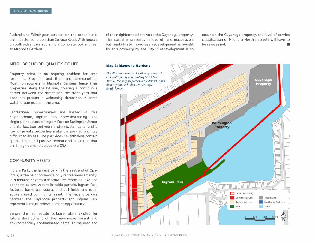
Ingram Park, the largest park in the east end of Opa-locka, is the neighborhood’s only recreational amenity. It is located next to a stormwater retention lake and connects to two vacant lakeside parcels. Ingram Park features basketball courts and ball fields and is an actively used community asset. The vacant parcels between the Cuyahoga property and Ingram Park represent a major redevelopment opportunity.
Before the real estate collapse, plans existed for future development of the seven-acre vacant and environmentally contaminated parcel at the east end
Magnolia Gardens
Magnolia Gardens District Boundaries
Vacant Properties
Commercial & Industrial Assets
Magnolia Gardens Property Lots
Parks
Tri-Rail Corridor
Water
Data Source: MDC Property Appraiser's Office 2009NAD_1983_StatePlane_Florida_East_FIPS_0901_Feet
Projection: Transverse_MercatorDate Created: 1/20/2011Ê
0 830415Feet
Ingram Park
Cuyahoga Property
WilmingtonProperty
of the neighborhood known as the Cuyahoga property. This parcel is presently fenced off and inaccessible but market-rate mixed use redevelopment is sought for this property by the City. If redevelopment is to
occur on the Cuyahoga property, the level-of-service classification of Magnolia North's streets will have to be reassessed.
Map 2: Magnolia Gardens
This diagram shows the location of commercial and multi-family parcels along NW 22nd Avenue; the only properties in the district (other than Ingram Park) that are not single family homes.
N0 100 200 300 ft
District Boundary
Commercial Use
Residential Use
Park
Vacant Lots
Multifamily Buildings
Water
RUTLAND ST
WILMINGTON ST
YORK ST
STATE RD 9
SERVICE RD
NW
20TH AV
E
NW
18T
H A
VE
NW
21ST CT
NW
22ND
AVE

Section A: BACKGROUND
A-17OPA-LOCKA COMMUNITY REDEVELOPMENT PLAN
City Center
Population (estimate): 1,908Number of households: 684
Vacant lots: 62
Residential land: 55.4 acCommercial land: 8.6 acCivic/public land: 22.5 acIndustrial land: 21.3 ac
Bounding streets: Service Road (north) NW 22nd Avenue (west) Burlington Street (south) NW 18th Avenue (east)
THE CITY CENTER DISTRICT CONTAINS THE CRA'S MOST DIVERSE LAND USES and numerous community assets, ranging from the Opa-locka Municipal Building and Regional Service Center to the new community center opening in July 2011. It covers much of Opa-locka's downtown region and features great redevelopment potential as a commercial, residential, and mixed-use center of activity.
BUILT ENVIRONMENT
OPA-LOCKA'S CITY CENTER DISTRICT IS DIVIDED into three general parts — a primarily multi-family residential area on the west known as the Barracks, a single-family residential area with an elementary school on the east, and a commercial and institutional downtown core between the two.
In the residential areas on either side of the downtown core, street conditions are variable but generally substandard. Sidewalks are almost nonexistent, weeds are commonly seen growing in cracks and along curbs, and crosswalks are poorly marked. Pavement damage is extensive and similar in character to all other districts of the CRA.
The multi-family apartment complexes in the Barracks are in average condition and the area's character is compromised by a lack of proper parking areas, a low level of privacy, and minimal landscaping.
Although the homes are larger and sit on larger lots, the conditions of houses in the east residential neighborhood resemble those of Magnolia Gardens. Evidence of neighborhood neglect is everywhere, including uncollected trash and debris, cracked pavement, rusting fences, and old vehicles.
Buildings in the downtown core are in variable physical condition. While government and municipal structures are in good condition, commercial businesses are
typically in poor to average condition, with decaying façades, unnecessarily evident crime-prevention metal grilles and locks, peeling paint, and almost no lighted or manufactured signs. Vacant properties are found throughout the district and especially in the downtown core. These properties contain some visual blight in the form of trash or unmaintained building exteriors.
NEIGHBORHOOD QUALITY OF LIFE
Throughout the downtown, pedestrian accessibility is provided by sidewalks. Basic services are limited in number but include convenience stores, grocery stores, family restaurants, and governmental services. A post office is centrally located on Sharazad Boulevard and the Opa-locka Municipal Complex on Opa-locka Boulevard features a library, restaurant, and bill payment center. The City’s Tri-Rail station is located nearby and bus service is provided by Miami-Dade Transit along Opa-locka Boulevard.
City Center does not receive a volume of traffic that can support a thriving commercial zone, although more than two dozen businesses currently operate in the downtown. Opa-locka Boulevard, the “Main Street” of the City’s historic core, is several blocks from the nearest arterial street (NW 22nd Avenue).Figs. A.19 and A.20: Barracks neighborhood (top); new
community center (bottom).

Section A: BACKGROUND
A-18 OPA-LOCKA COMMUNITY REDEVELOPMENT PLAN
Map 3: City CenterThis diagram indicates the distribution of land uses and vacant parcels in City Center, including the Barracks neighborhood on the western end.
Downtown Opa-locka, as with the rest of the City overall, has a low presence of discretionary shopping opportunities and is underrepresented by grocery stores and restaurants. Almost no national chains or franchises are found in the CRA, indicating that Opa-locka is a highly localized and entrepreneurial, albeit low income, market.
Parking availability varies across the district; the downtown core features most of the City’s public parking lots, particularly along Opa-locka Boulevard, and accessibility is good. Parking is scarce, however, across the residential parts of City Center, and especially in the Barracks area; cars are frequently double-parked on gravel shoulders and pull-off areas. Even in the east residential area, vehicles are found parked on medians and in yards.
COMMUNITY ASSETS
The most attractive physical assets in the CRA are primarily located in the City Center district. They include the Opa-locka Tri-Rail Station, the Opa-locka Regional Service Center, the Opa-locka Municipal Complex, and the Dr. Robert Ingram Elementary School.
City Center features a large institutional use in the Dr. Robert Ingram Elementary School, which is in good condition and provides a welcome stability in the neighborhood’s sense of community, safety, and family friendliness. The school is a large, two-story structure set back on a deep lot. The building and surrounding land are properly maintained.
Streets in the downtown core are in similar condition to those of the adjacent residential
areas, although Sharazad Boulevard is notable for its well-kept condition, wide landscaped center median, and attractive paving materials at certain intersections.
Resident uses and services make up some of City
Center's most important community assets: the municipal complex, the regional service center, Diaz Supermarket, Opa-locka Tri-Rail Station, and the soon-to-be-completed community center that will offer a range of indoor recreational sports to the City's residents.
DO
UG
LAS RD
City Center
Ê0 1,300650
Feet
Data Source: MDC Property Appraiser's Office 2009PCS:NAD_1983_StatePlane_Florida_East_FIPS_0901_Feet
Projection:Transverse_MercatorDate Created: 1/20/2011
City Center District BoundariesCommercial & Industrial AssetsCity Center Property LotsPublic Institutional Assets
Vacant PropertiesHistoric PropertiesTri-Rail CorridorParks
Water
N0 0.1 0.2 mi
District Boundary
Commercial Use
Residential Use
Civic/Public Use
Vacant Lots and Buildings
Park
Historic Properties
SHARAZAD BLVD
FISHERMAN ST
FISHERMAN ST
SABUR LN
CALIPH ST
SALIH ST
VETERANS WAY
RUTLAND STBURLINGTON ST
OPA-LOCKA BLVDPERVIZ AVE
SHARAZAD BLVDALADDIN ST
SESAME ST
DU
NA
D AV
E
SHA
RAR AV
E
BAHM
AN AVE
CODADAD AVESINBAD AVE
AHM
AD AVE

Section A: BACKGROUND
A-19OPA-LOCKA COMMUNITY REDEVELOPMENT PLAN
BUILT ENVIRONMENT
THE 96.6-ACRE OPA-LOCKA COMMERCE AREA IS RIGIDLY bounded by arterial streets (NW 22nd Avenue and NW 27th Avenue), which keep incompatible land uses away from residential neighborhoods. Primary uses include engine repair and rebuilding; waste management, metalworking, and chemical manufacturing. Scrap and recycling yards have a large presence. While the area has poor visual conditions, these are caused by the utilitarian nature of the local businesses.
LeJeune commerce area comprises 16 properties, many of them irregular in shape because of the presence of the LeJeune Expressway and Tri-Rail corridors and a drainage canal. Six of these properties are vacant, representing approximately 45 percent of the total area of the LeJeune district.
There are few evident examples of noxious uses or activities in either commerce area but code enforcement appears lax. Metal fences frequently attempt to hide vacant structures and unsightly collections of scrap, trash, or equipment, creating visual blight. The overall appearance of the Opa-locka commerce area is one of desolation, abandonment, and minimal investment — even on blocks with active businesses. In the LeJeune area, the built character is better, even with approximately half of district vacant.
There are notable concerns for trucks in Opa-locka commerce area caused by a street pattern that was
not designed for heavy and large vehicles. NW 147th Street, NW 149th Street, and NW 150th Street in particular show evidence of damage caused by heavy vehicles buckling and tearing up the asphalt pavement. Additionally, the street grid north of NW 147th Street does not line up properly with blocks on the south, making wayfinding and navigation challenging for people unfamiliar with the area.
Streets throughout the Opa-locka commerce area are strewn with trash, debris, and old equipment. Sharp objects, including broken glass, are common and driving off the main travel lanes increases the risk of puncturing a tire. The incidence of trash blight increases around vacant parcels and buildings.
Stormwater drainage is substandard throughout the Opa-locka commerce area; large puddles form after almost every rainfall at intersections and along the sides of the street. Driving through puddles is a hazard because of debris.
As with other parts of Opa-locka, there is insufficient parking throughout the commerce areas, resulting in numerous improperly parked vehicles and excessive back-out parking along building frontages. Abandoned machinery, equipment, and scrap are commonly found in parking spaces and lots.
LeJeune commerce area’s streets are in generally
THE CRA'S TWO COMMERCE AREAS ARE NOT DIRECTLY CONNECTED to each other but represent Opa-locka’s economic character. Whereas Opa-locka commerce area is the larger of the two and focused on the engine, automotive, and scrap uses symbolic of the City’s postwar economic strengths, the LeJeune area contains a few logistic and non-manufacturing businesses that reflect a trending shift away from traditional manufacturing.
Opa-locka and LeJeune commerce areas
Number of active businesses: 107Number of vacant businesses: 37
Vacant lots: 35
Residential land: 2.3 acCommercial land: 23.3 acCivic/public land: 7.7 acIndustrial land: 75.4 ac
Figs. A.21 and A.22: Typical industrial property (top); auto-related business in Opa-locka commerce area (bottom).

Section A: BACKGROUND
A-20 OPA-LOCKA COMMUNITY REDEVELOPMENT PLAN
Opa-locka Industrial
Opa-locka Industrial District Boundaries
Public Institutional Assets
Commercial & Industrial Assets
Opa-Locka Industrial Property Lots
Vacant Properties
Tri-Rail Corridor
Water
Data Source: MDC Property Appraiser's Office 2009NAD_1983_StatePlane_Florida_East_FIPS_0901_Feet
Projection: Transverse_MercatorDate Created: 1/20/2011Ê
0 800400Feet
Le Jeune Industrial
Ê0 660330
Feet
Data Source: MDC Property Appraiser's Office 2009PCS:NAD_1983_StatePlane_Florida_East_FIPS_0901_Feet
Projection:Transverse_MercatorDate Created: 1/20/2011
Le Jeune Industrial District BoundariesVacant PropertiesLe Jeune Industrial Property Lots
Tri-Rail CorridorWater
Map 4: Commerce Areas (Opa-locka commerce area, main; LeJeune commerce area, inset)
These diagrams show the distribution of land uses and vacant parcels in the CRA's commerce areas. With few exceptions, land uses are exclusively industrial or commercial in type. Opa-locka Police Station (at NW 25th Avenue and Veterans Way) is the primary active institutional use in the district.
better condition. The overall character of the area is improved by the wide right-of-way of the LeJeune-Douglas Expressway and its neatly maintained landscaped medians.
Building façades in the two commerce areas are not well maintained. Decaying walls and paint, rusting fences and gates, and broken fixtures all contribute to an overall impression of marginal structural quality. Business signs, especially, are deficient. Most are simply words and logos painted on the building walls, which lend a sense of untrustworthiness to the quality
or legitimacy of the industrial enterprise.
Particularly in the Opa-locka c o m m e r c e area, property lines are hard to discern and buildings appear to be jammed up against each other. Lots are
typically fenced off and it is often difficult to know which parking or storage lots belong with which property.
Except for the two rows of properties along both sides of NW 27th Avenue, the commerce areas are occupied primarily by industrial uses or vacant lots zoned for industrial uses.
Land uses in the commerce areas:
Retail: 13Commercial mixed use: 14Light manufacturing: 24Heavy manufacturing: 14Warehouse/storage: 23Vacant: 41
Total parcels: 129
Fig. A.23: Land uses in the commerce areas by category.
RetailCommercial Mixed-useLight ManufacturingHeavy ManufacturingWarehouse/StorageVacant
131424142341
10%
11%
19%
11%18%
32%
RetailCommercial Mixed-useLight ManufacturingHeavy ManufacturingWarehouse/StorageVacant
N0 100 200 300 ft
N0 200 400 600 ft
District Boundary
Commercial Use
Industrial Use
Institutional Use
Vacant Lots and Buildings
NW 147TH ST
VETERANS WAY
NW 135TH ST
LEJE
UN
E-D
OU
GLAS
EXP
Y
STATE RD 9
NW 150TH ST
NW 151ST ST
NW 149TH ST
NW
24TH C
TN
W 24TH
CT
NW
25TH AV
E
NW
26TH AV
E
NW
22ND
CT
NW
22ND
AVE
NW
25TH C
T
NW
27TH AV
E
Section A: BACKGROUND
A-21OPA-LOCKA COMMUNITY REDEVELOPMENT PLAN
THE INPUT OF RESIDENTS, BUSINESS OWNERS AND community stakeholders affected by future activities in a CRA is mandated by the community redevelopment process in Florida. For this plan, community input also yielded valuable insights into the long-standing concerns of the community about Opa-locka's key vulnerabilities.
The consulting team held conducted two community forums on February 25 and 26, 2011, as well as door-to-door conversations in January and February 2011. Common themes were revealed regarding the need for higher standards in housing and the public realm and a wider range of activities and basic services for residents. Some respondents indicated that many of the deficiencies in Opa-locka and the CRA, including visual blight and low rates of educational attainment, would resolve themselves once improvements were made in employment and household income.
Respondents were not apt to place blame on government alone; a number of individuals in fact noted that community improvement is just as importantly driven at the individual level as at the governmental level. Some respondents’ frustration was attributed to the lack of economic opportunity in the community — a condition that many attributed to the recession but, regardless of its cause, did not foresee ending in the near future.
The following is a summary of the recommendations received during the two community forums.
Overall CRA
• Creation of business incubators and job training programs for low-income residents
• Wider provision of basic services (e.g., grocery stores, medical clinics) so that residents do not leave Opa-locka to run their errands or shop
• A more comprehensive education system so that students can remain in Opa-locka from elementary school to college
• New offerings for day care, English as a Second Language courses, and financial literacy and entrepreneurship training
• Improved delivery of information to residents about available City services
• Expanded relationships with area colleges to deliver programs and opportunities to the community
• Creation of a museum or cultural facility that celebrates Opa-locka’s history
• A wider range of after-school activities for children and youth
• Incentives for business owners• Solutions to transportation issues and better
public transit options• Improved enforcement of code violations
Magnolia Gardens
• A home repair program for low-income residents• Improvements and expansion to Ingram Park• Construction of jogging and bicycle paths along
the stormwater retention lake • Expansion of the neighborhood crime watch• Improved lighting at the entrance to Ingram Park
and minor repairs to park infrastructure• Construction of a multipurpose community
center on the vacant land by Ingram Park
Magnolia North
• Renovation of the tot lot• Construction of a library, community center,
and/or community garden• Establishment of a fund for landowners to
redevelop their properties• An effort to create a balance of commercial and
residential uses in the neighborhood• Redevelopment of the commercial corridor along
NW 22nd Avenue• Remediation of streets and sidewalks• Enhancement of the public realm
City Center
• Marketing and promotion campaigns for festivals, live music, and outdoor events
• Improvements to streets and sidewalks, particularly in the neighborhood around Opa-locka Elementary School
• Creation of community gardens and additional parks
• Construction of a transit-oriented, mixed use development around the Tri-Rail Station, using the station as a hub
• Redevelopment of Opa-locka Boulevard as a traditional “Main Street” featuring mixed uses aimed at residents and visitors
• Development of a tourism strategy incorporating the City’s preserved Moorish Revival buildings
Commerce areas
• Improvement of property access and parking• Rehabilitation of vacated structures• Improved lighting, street and road repair• Building façade upgrades
STAKEHOLDER INPUT

OPA-LOCKA COMMUNITY REDEVELOPMENT PLAN
SECTION B:REDEVELOPMENT PLAN

Section B: REDEVELOPMENT PLAN
B-1OPA-LOCKA COMMUNITY REDEVELOPMENT PLAN
THE PURPOSE OF COMMUNITY REDEVELOPMENT IS less about replacing what once existed in a place with more of the same and more about promoting something new — i.e., reconfiguring a place for new social and economic circumstances — or something better. Redevelopment is ultimately about fostering an appropriate fit between a place and the people who live and work in it and, in so doing, helping a community meet its fullest potential.
With its demographic profile and unique economic opportunities, Opa-locka needs a redevelopment plan that speaks not only to physical improvement of the community but also economic development and empowerment of its residents. Community redevelopment planning in Florida over the past decade has greatly increased the role of physical improvement as a redevelopment strategy — and not without reason. Studies show that the physical condition of a place is a highly valued part of community pride and a major part of a community’s genius loci (the character or personality of a place)1. Indeed, this plan calls attention to a number of valuable capital and physical improvement activities that should be undertaken by Opa-locka's new redevelopment agency.
However, while physical redevelopment is appropriately used to address blighted conditions and infrastructure deficiencies, it is much less able to resolve the social and economic deficits found in many CRAs. These deficits tend to be the result of years of inadequate policies, negative attitudes, prejudices, and, perhaps most especially, insufficient opportunities for individuals to improve their personal, family, or community situations.
Opa-locka's redevelopment plan should address improving the built environment while directing activities that alleviate perpetuating problems in the CRA such as household poverty or low educational attainment. What is needed is a set of direct strategies and initiatives to inform residents about existing and future opportunities that lead to empowerment and self-sufficiency. It is hoped that this may be accomplished by organizing the plan as a framework of economic development and resident empowerment strategies.
ECONOMIC DEVELOPMENT AND RESIDENT EMPOWERMENT IN THE REDEVELOPMENT CONTEXT
Economic development strategies for the Opa-locka CRA promote two key objectives: a local capacity to create wealth through small business, and job growth aiming at full employment (often defined as an unemployment rate of approximately 4 or 5 percent).
The ability to generate wealth in Opa-locka will be an important consideration for anyone looking to invest in a business in the City or — if they already live in Opa-locka — deciding whether they can continue to live there. Creating wealth through small business can be done in myriad ways and the City must be able to articulate the unique advantages it has to do so.
Growth in small business will lead to growth in jobs, the second key objective for economic development. Jobs are a critical factor because gainful employment gives people more than an income; it gives them a sense of purpose. It contributes to an individual’s self worth, and this value is the base from which a healthy family life and community pride are built.
Resident empowerment strategies for the CRA lead directly from this line of reasoning by promoting its own pair of key objectives: providing residents with the resources and opportunities to build the lives they want for themselves and their families, and engendering a sense of communality — the idea that they belong to a greater whole and that in pursuing their own individual goals in life they are at the same time helping to make Opa-locka a better place for everyone.
This redevelopment plan encourages a new way forward in Opa-locka’s redevelopment and should result in the kind of change that is more feasible today than ever before and results in an enduringly improved community.
A NEW WAY FORWARD
1 Genius loci has a long history in architecture and design, going as far back as the English playwright Alexander Pope. The people, streets, and structures of a community come together to create a sense of place that is unique and a source of community pride.

Section B: REDEVELOPMENT PLAN
B-2 OPA-LOCKA COMMUNITY REDEVELOPMENT PLAN
FOUR PLAN VALUES JUSTIFY THE ECONOMIC development and resident empowerment strategies in this plan. They represent the four spheres of sustainable development — economy, environment, equity, and well-being — and, when applied all at once, will lead towards long-term community sustainability.
The redevelopment plan’s economic values support financial stability for residents and wealth creation through investment and small business. Financial stability is the path to planning for the future; helping people move away from living paycheck to paycheck is a necessary step before educating them about how to plan for a family or save for their child’s education. Financial stability can be achieved through employment and financial literacy.
Wealth building, on the other hand, follows after financial stability. For investors and small business owners, assistance can take the form of technical advice to leverage existing resources and funding opportunities such as loans or grants. Wealth building is an essential part of economic development because personal and business wealth can be invested in enterprises that produce jobs and reduce poverty in a community.
Environmental values promote initiatives, directly and indirectly, that result in the more efficient use of energy and material resources and greater sensitivity in the way the built environment interacts
with the natural environment. From individual choices in the home to long-range initiatives that affect the whole community, unnecessary consumption of energy and resources can be curbed at every scale and by everyone.
In a redevelopment plan, environmental values are significant even when the need for economic and investment opportunities may be seen at first as a greater priority. This is because environmental values are also
fundamentally economic values. They provide immediate financial benefits and build foundations for long-term economic strength. Whether it is an initiative to save homeowners money through free home energy audits or capital improvement programs to build accessible and mixed-use neighborhoods, the result is a more rewarding lifestyle at a lower environmental (and economic) cost.
Equity values address resident empowerment objectives by promoting equal opportunity for everyone. Regardless of socioeconomic status, race, age, or ethnicity, offering the means to achieve one’s goals is the purpose of social equity. It is not
an effort to create economic equality across a community; communities must remain responsible to their residents as they build their circumstances for success. Social equity encourages ethical treatment of all residents, workers, and stakeholders. It ensures equal access to education, resources, and assistive programs.
Lastly, well-being values promote objectives that may be considered the summation of the previous three plan values, and by extension the overall purpose of a CRA plan — an individual’s overall health, happiness, and quality of life. In a community lacking opportunities to earn a reasonable living and wanting to believe that the future will be better than the past, a redevelopment plan that succeeds in deploying economic, environmental, and equity strategies will help transform that community and its people. Well-being strategies, at this point, serve to reaffirm and continue the early successes and promote initiatives that reinforce community pride.
These are the four plan values to support the economic development and resident empowerment strategies of this plan. They are incorporated into the goals, objectives, and blueprints in the pages that follow.
The 4 Plan Values:
1. Economic2. Environmental3. Equity4. Well-being
PLAN VALUES
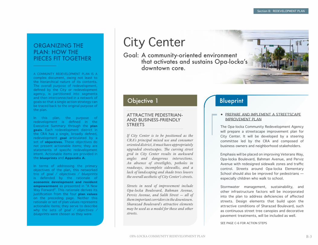
Section B: REDEVELOPMENT PLAN
B-3OPA-LOCKA COMMUNITY REDEVELOPMENT PLAN
• PREPARE AND IMPLEMENT A STREETSCAPE IMPROVEMENT PLAN
The Opa-locka Community Redevelopment Agency will prepare a streetscape improvement plan for City Center. It will be developed by a steering committee led by the CRA and composed of business owners and neighborhood stakeholders.
Emphasis will be placed on improving Veterans Way, Opa-locka Boulevard, Bahman Avenue, and Perviz Avenue with redesigned sidewalk zones and traffic control. Streets around Opa-locka Elementary School should also be improved for pedestrians — especially children who walk to school.
Stormwater management, sustainability, and other infrastructure factors will be incorporated into the plan to address deficiencies of affected streets. Design elements that build upon the attractive conditions of Sharazad Boulevard, such as continuous street tree canopies and decorative pavement treatments, will be included as well.
SEE PAGE C-6 FOR ACTION STEPS
Blueprint
City CenterGoal: A community-oriented environment
that activates and sustains Opa-locka’s downtown core.
Objective 1
ATTRACTIVE PEDESTRIAN- AND BUSINESS-FRIENDLY STREETS
If City Center is to be positioned as the CRA's principal mixed use and consumer oriented district, it must have appropriately upgraded streetscapes. The curving street grid in City Center results in awkward angles and dangerous intersections. An absence of streetlights, potholes in roadways, incomplete sidewalks, and a lack of landscaping and shade trees lowers the overall aesthetic of City Center's streets.
Streets in need of improvement include Opa-locka Boulevard, Bahman Avenue, Perviz Avenue, and Salih Street — all of them important corridors in the downtown. Sharazad Boulevard's attractive elements may be used as a model for these and other streets.
ORGANIZING THE PLAN: HOW THE PIECES FIT TOGETHER
A COMMUNITY REDEVELOPMENT PLAN IS A complex document, owing not least to the hierarchical nature of its contents. The overall purpose of redevelopment, defined by the City or redevelopment agency, is partitioned into segments and then interconnected in a network of goals so that a single action strategy can be traced back to the original purpose of the plan.
In this plan, the purpose of redevelopment is defined in the Executive Summary through the plan goals. Each redevelopment district in the CRA has a single, broadly defined, redevelopment goal articulated by a set of objectives. These objectives do not present actionable items; they are statements of specific redevelopment intent. Actionable items are provided in the blueprints and Appendix A.
In terms of addressing the primary objectives of the plan, this networked trio of goal / objectives / blueprints is defended by the rationale of economic development and resident empowerment as presented in "A New Way Forward". This rationale derives its justification from the four plan values on the preceding page. Neither this rationale or set of plan values represents actionable items; they serve to describe why the sets of goal / objectives / blueprints were chosen as they were.

Section B: REDEVELOPMENT PLAN
B-4 OPA-LOCKA COMMUNITY REDEVELOPMENT PLAN
• ARRANGE A DOWNTOWN FACADE IMPROVEMENT PROGRAM
The Opa-locka Community Redevelopment Agency will arrange a program for property owners in City Center to improve their storefront and building façades, eliminate blight, and establish a standard for physical appearance. Applicant eligibility will be based on the length of time the business has been in operation in Opa-locka, the design and specifications of the improvement, and how well aligned the business and improvements are with the overall redevelopment goals of the downtown. The program will aim to offer financial incentives that fund physical improvements and related architectural, landscape, and engineering costs.
• DEVELOP ARCHITECTURAL DESIGN STANDARDS FOR DOWNTOWN BUSINESSES
The Opa-locka CRA will develop a simple set of design standards to which all downtown businesses must adhere. It is recommended that the City, as discussed frequently over the last year, convene a committee to develop the new guidelines, themes, and future urban design approach for new architectural standards. These standards will be coordinated with the streetscape improvement plan of Objective 1.
BlueprintObjective 2
FACADE IMPROVEMENTS IN THE DOWNTOWN
There is no urban design standard in the built environment in downtown Opa-locka. Often the diversity of structures contributes to the character of a community but too much diversity or a lack of design consistency can result in poorly arranged or visually displeasing urban space. The character of Opa-locka’s downtown can be enhanced through the application of design standards, especially for façade improvements.
Façade improvement programs help to create a distinguishable and consistent character, abate the deterioration of structures, and augment the natural assets of a downtown by restoring its uniqueness and character.
Façade improvement programs are also useful in stimulating local economic growth. Improved shopping streets attract customers and business owners benefit from increased sales. Property owners witness stabilizing and increased property values and the community at large enjoys a more vibrant identity.

Section B: REDEVELOPMENT PLAN
B-5OPA-LOCKA COMMUNITY REDEVELOPMENT PLAN
• UNDERTAKE A DOWNTOWN RETAIL ACTIVITY ANALYSIS
The Opa-locka Community Redevelopment Agency will conduct an analysis of retail and commercial opportunities in City Center by measuring the undersupply, oversupply, and market demand for consumer goods and services. The CRA will also explore how to reinforce the Opa-locka Boulevard commercial corridor north and south of the Tri-Rail tracks and rebuild a contiguous retail zone in the downtown.
The CRA will need to assess key barriers to private investment in the City and focus on enhancing credit and capital opportunities to small business owners and entrepreneurs.
• PARTICIPATE IN "MAIN STREET" PROGRAMS
Opa-locka should work to participate in the National Trust for Historic Preservation's Main Street® program and the Florida Department of Historical Resources' Florida Main Street program to re-establish an appealing identity for City Center and create a hospitable zone for consumer and cultural activity. (Benefits of the NTHP's Main Street® program include access to national best practices from the NTHP, technical assistance to build a volunteer base and launch new programs, and professional training for local leaders and practitioners.)
• COORDINATE WITH THE VACANT INFILL DEVELOPMENT PROGRAM
The CRA will undertake Main Street improvement activities in coordination with the vacant infill development program of Objective 8 (City Center). The CRA will request proposals from developers that promote missing services, such as banking institutions, medical offices, laundromats, pharmacies, restaurants, and entertainment venues, on vacant lots acquired for redevelopment purposes in City Center.
BlueprintObjective 3
VIBRANT COMMERCIAL AND RETAIL ACTIVITY THAT CREATES DOWNTOWN DESTINATIONS
There are a limited number of financial institutions, restaurants, retail stores, coffee shops, laundromats, pharmacies, or medical clinics within the City Center district. Residents must often even leave Opa-locka itself to get to these basic services, resulting in reduced consumer activity in the one district of the CRA where it should be strongest. Residents within walking distance will sometimes frequent the local convenience stores, thrift shops, and restaurants, but these businesses draw few customers from outside the immediate neighborhood.
In addition, there are no entertainment destinations, such as a cinema or performing arts theater, to attract people to downtown Opa-locka. Opportunities abound to have new local businesses fill these deficiencies as long as a strong customer base can be sustained.

Section B: REDEVELOPMENT PLAN
B-6 OPA-LOCKA COMMUNITY REDEVELOPMENT PLAN
Objective 4 Blueprint
HIGHER DENSITY OF HOUSING, RETAIL, AND COMMERCIAL USES AROUND THE OPA-LOCKA TRI-RAIL STATION
The South Florida Regional Planning Council forecasts future transit demands that the existing street and road grid will be unable to support. The Regional Planning Council, alongside Miami-Dade County and local planning organizations, are keen to expand development along Tri-Rail corridors and create transit oriented developments (TODs) at Tri-Rail stations to accommodate future transit needs. (TODs are walkable mixed-use centers that provide live/work opportunities at high densities. They are often designed as half-mile-wide walkable "urban villages" centered around multimodal transit and featuring innovative green spaces.)
Five years ago, the Opa-locka Tri-Rail Station was considered a candidate for a future TOD by Miami-Dade County’s Planning and Zoning Department. (A charrette was conducted in April 2006 by MDC for the future TOD.) Although no progress on the project has been made since the charrette, present-day wishes for more compact development in City Center suggest this project should be revisited.
Diagrammatic arrangement of proposed TOD development incorporating the Opa-locka Tri-Rail Station (asterisk at left), drawn April 2006.
• RE-EXAMINE THE FEASIBILITY OF THE OPA-LOCKA TRI-RAIL STATION TOD
The Opa-locka Community Redevelopment Agency will assess all plans and documentation for the proposed Opa-locka Tri-Rail Station TOD and contact the organizations involved in the project in 2006 for additional information. Working with City staff and local stakeholders, the CRA can then update the earlier plans for the TOD at in accordance with post-recession economic realities and developer interest.
Several challenges must be addressed by the CRA and City staff during the assessment. For instance, existing zoning designations disallow mixed use redevelopment; an overlay district extending one-quarter to one-half of a mile around the station and allowing flexibility in redevelopment may be an appropriate solution. Additionally, although there are several individual redevelopable vacant lots around the Tri-Rail station, land assembly may be necessary to achieve the spatial requirements for TOD build-out.
Accessibility to the station from the surrounding neighborhood must also be examined. Currently, there are no designated routes to the station from the south. Instead, residents cut through private properties to access the station. Similarly, Veterans Way is not pedestrian friendly between Opa-locka Boulevard and Douglas Road and will need to be redesigned to accommodate increased numbers of pedestrians and cyclists.

Section B: REDEVELOPMENT PLAN
B-7OPA-LOCKA COMMUNITY REDEVELOPMENT PLAN
• ESTABLISH AN ARTS COUNCIL
The Opa-locka Community Redevelopment Agency will establish an arts council to coordinate arts and cultural programs in the City and develop an official arts management plan with funding strategies. As done in other industrial neighborhoods in South Florida, such as the Wynwood Art District in Miami, the arts council will evaluate the feasibility of converting old warehouses into artists' studios and create an annual cultural event to bring together multiple aspects of the arts.
• DEVELOP AND PROMOTE AN EVENTS CALENDAR
The CRA will organize a roster of cultural and family entertainment events themed around locally significant activities, holidays, and venues that puts Opa-locka ‘on the map’. These events can focus on the City's heritage, such as the music, film, and aviation history of the City. Events similar to the African Heritage/Fish Fry Gospel and Blues Festival, sponsored by the Youth Crime Prevention Program and City's Parks and Recreation Department and held during the Opa-locka Black History Festival, may be planned with the support of local organizations.
BlueprintObjective 5
CULTURE AND ENTERTAINMENT ACTIVITIES THAT CREATE AN IDENTITY FOR OPA-LOCKA
Cultural activities inspire creativity, inform people about how to inventively overcome obstacles, and strengthen families. They are an essential part of any community.
City Center has many underutilized assets that can to be activated to draw tourists and residents from neighboring cities. Residents have expressed interest in attending festivals, jazz concerts, and outdoor events. Community venues can host volunteering activities. Sherbondy Park provides an excellent venue for cultural and entertainment events. Located in the heart of City Center, this park is large enough to host a wide range of outdoor events.

Section B: REDEVELOPMENT PLAN
B-8 OPA-LOCKA COMMUNITY REDEVELOPMENT PLAN
• IDENTIFY FAMILY FRIENDLY ACTIVITIES TO BRING TO THE COMMUNITY
The Opa-locka Community Redevelopment Agency, in partnership with the City's Parks and Recreation Department, will work to increase the availability and frequency of family activities that activate the downtown core. Possible activities include music festivals, a farmer’s market, sporting events, educational seminars, and movies in the park. After-school activities that promote youth empowerment, life skills training, and self-sufficiency will also be made available.
• FORM STRATEGIC PARTNERSHIPS WITH ACTIVITY PROVIDERS
The CRA will form partnerships with local providers to leverage resources and strengthen the quality of services provided to Opa-locka families. For instance, the CRA may consider partnering with the University of Florida, located nearby in Hialeah, and the Family and Consumer Sciences Office of Miami-Dade County to provide educational programs to families addressing topics on nutrition, health, food safety, and economic security. St. Thomas University has shown an interest in providing assistance to Opa-locka residents, and the Florida Department of State's Division of Cultural Affairs has competitive grant programs for cultural event support. The CRA may also consider partnering with organizations such as the Miami Art Museum, the YMCA, Miami Museum of Science, Miami Children’s Museum, the Miami Metrozoo, and Miami Seaquarium to bring youth and family programs to Opa-locka.
BlueprintObjective 6
FAMILY FRIENDLY AMENITIES AND ACTIVITIES TO EMPOWER RESIDENTS
The City’s Parks and Recreation Department has a number of efforts underway to provide amenities and activities to local families. One such effort is the Sherbondy Park Community Center scheduled to open in summer 2011 that will provide a place for community gatherings and sports such as basketball, baseball, and swimming.
Residents have repeatedly requested more family events to be held outdoors in the downtown area and this should be accommodated. Family leisure activities are associated with greater emotional well being, positive social network ties, and academic success in children.

Section B: REDEVELOPMENT PLAN
B-9OPA-LOCKA COMMUNITY REDEVELOPMENT PLAN
Objective 7
CELEBRATION OF OPA-LOCKA'S RICH HISTORY AND DIVERSE CULTURE
Opa-locka’s unique history and Moorish Revival architecture provides an exclusive opportunity for the Community Redevelopment Agency. Currently, the City does not have exhibits or museums to document its cultural history or historic events. (The Opa-locka Executive Airport alone has a unique and interesting history worth preserving and sharing.) Residents have expressed an interest in a museum that would capture the City's heritage and create distinct historic neighborhoods with tourism appeal.
• AUGMENT HISTORIC PRESERVATION AND RESTORATION ACTIVITIES
The Opa-locka Community Redevelopment Agency will apply for grants for historic preservation and restoration to assist in the upkeep of the eight properties in the CRA currently listed on the National Register of Historic Places. Other historic buildings that may qualify for preservation will be researched and possibly submitted for inclusion in the National Register.
• ESTABLISH A HERITAGE EXHIBIT
The CRA will work to establish an exhibit at the Cultural Arts Center, City Commission Chambers, or other designated site in the CRA highlighting the cultural assets and history of the City. The CRA may also consider creating a self-guided walking tour of National Register sites and partnering with local agencies that provide tours, such as GoToBus.com, which offers historic trolley tours throughout Miami-Dade County.
Blueprint

Section B: REDEVELOPMENT PLAN
B-10 OPA-LOCKA COMMUNITY REDEVELOPMENT PLAN
• ASSEMBLE A STAKEHOLDER COMMITTEE TO ORGANIZE THE INFILL PROGRAM
The first step in establishing a vacant lot infill development program is assembling local stakeholders — such as property owners, business owners, lenders, the Opa-locka CDC, neighborhood organizations, developers, and real estate professionals — to determine program goals and the types of infill appropriate for City Center.
• COMPILE A PROPERTY DATABASE
Once the stakeholder committee is established, vacant lots and underutilized properties will be identified in a database. This database will collect pertinent information, including lot size and ownership; land use, zoning, and flood zone categories; existing liens; environmental conditions; surrounding amenities and support services; stormwater drainage conditions; and public facilities accessibility. Potential barriers to infill development will be identified, including costs of development, zoning restrictions, and accessibility deficiencies.
• CREATE AND PROMOTE THE PROGRAM
After the database is compiled, the stakeholder committee will develop an infill program that addresses how to reduce redevelopment costs, identifies developer partners, and encourages public/private participation. The program will be guided by "smart growth" principles, including compact building and walkable neighborhood requirements. It will encourage commercial and retail development addressing basic service needs in the community that are presently lacking (e.g., financial institutions, medical clinics, pharmacies). It will promote the creation of open space on lots that are not conducive to other forms of redevelopment. It should incorporate design standards, funding sources, and layered financing options that are tied to each program element. Once the program is vetted by the stakeholder committee and the City, the program can be adopted and an ordinance presented to the City Commission that states the goals, objectives and strategy of the program.
The adopted program will need to be promoted to local developers, real estate agents, and lenders. The progress of the program will be tracked and the stakeholder committee reconvened on a regular basis to evaluate the effectiveness of the program. The stakeholder committee will work to include local residents and stakeholders in the redevelopment process through job training and U.S. HUD Section 3 requirements for developers and contractors.
BlueprintObjective 8
VACANT LOT INFILL DEVELOPMENT PROGRAM
City Center contains numerous vacant parcels, especially in the Barracks neighborhood and along Opa-locka Boulevard, Sharazad Boulevard, and neighboring streets. Parcel vacancy contributes to blight in the City Center district, decreases surrounding property values, and accelerates community disinvestment. The infill of vacant lots can reverse these negative conditions and increase municipal tax revenue.
City Center's vacant lots already have the necessary public infrastructure in place to support a range of redevelopment solutions but may require local government intervention to stimulate redevelopment interest. A vacant lot infill development program, undertaken by the Opa-locka Community Redevelopment Agency, would encourage new construction.

Section B: REDEVELOPMENT PLAN
B-11OPA-LOCKA COMMUNITY REDEVELOPMENT PLAN
• ASSESS UNDERUTILIZED LAND IN THE CITY CENTER DISTRICT
The Opa-locka Community Redevelopment Agency will review all underutilized areas for their appropriateness as public spaces. For instance, there are two large surface parking lots on Opa-locka Boulevard, at Diaz Supermarket and between the municipal and state buildings. They provide more parking capacity in the downtown than strictly necessary and could be reorganized so that they are partly annexed for conversion into public space. Additional vacant lots along Sharazad Boulevard offer prime opportunities for expanded open space, including pocket parks that link to Sherbondy Park.
• DEVELOP A RECREATION AND OPEN SPACE PLAN
The CRA will classify those properties that may be better used as public space. Areas that promote walkability and connectivity to existing public amenities will be identified. An approach will be developed to direct the future arrangement of downtown public space and guide their design with consideration to connectivity, user comfort, signage, active frontages, and accessibility. Assistance may be sought from Florida Communities Trust's Parks and Open Space Florida Forever program.
BlueprintObjective 9
EXPANDED PEDESTRIAN AND VISITOR ACCESSIBLE PUBLIC SPACES
The City is not currently meeting the recreation and open space requirements established in the Miami-Dade County Comprehensive Plan. The City needs to add approximately 48 acres to meet this target.
Expanding public open space in Opa-locka can encourage healthy lifestyles while meeting the City's comprehensive plan obligations. Such spaces are an important component of sustainable communities. They provide places for active recreation and social interaction and give youth places to expend energy. Public spaces enhance the built environment, increase the perception of safety (by attracting activity into the public realm), and improve the local economy through increased user spending.

Section B: REDEVELOPMENT PLAN
B-12 OPA-LOCKA COMMUNITY REDEVELOPMENT PLAN
• DEVELOP NEW AND VARIED HOUSING OPPORTUNITIES
The Opa-locka Community Redevelopment Agency will work with City and County agencies to develop new housing opportunities in City Center. Affordable housing developers and non-profit organizations will be encouraged to expand their multi-family housing construction activities in City Center as they are currently doing elsewhere in Opa-locka. Vacant lots around the Barracks neighborhood and the Opa-locka Tri-Rail Station will be promoted for multi-family housing and mixed-income developments. U.S. HUD Section 3 requirements will be expected of developers to provide skills training opportunities to low-income residents.
• PROVIDE HOMEOWNER ASSISTANCE PROGRAMS
The CRA can collaborate on down payment assistance programs available in Miami-Dade County, such as Florida Housing Finance Corporation's First Time Homebuyer Program or the Metro-Miami Action Plan Homeownership Assistance Program. The CRA may consider offering its own first-time homebuyer program as well if financially feasible.
Homebuyer education programs will be an essential component of the homeownership strategy as well. The CRA should partner with organizations such as the Miami-Dade County Housing Finance Authority and Miami-Dade Affordable Housing Foundation, Inc. to offer courses on home borrowing, the mortgage and closing process, predatory lending, budgeting and saving, and the responsibilities of homeownership.
• UPHOLD CODE ENFORCEMENT
The CRA will collaborate with the City to improve code enforcement. Upkeep of private properties and housing stock is essential to maintaining a high level of neighborhood character and preserve property values. Financial assistance programs may be established to help property owners meet the costs of bringing properties up to code and reduce the risk of buildings falling into disrepair.
Since many homes in City Center are aging, a rehabilitation funding program for owner-occupied properties in the form of a grant or a low-interest loan may benefit the community. A home repair and weatherization program, for instance, can assist residents in alleviating the health and safety risks of structurally unsafe buildings. Emergency repair of damaged roofs and mold remediation should receive priority, but deferrable maintenance items (e.g., air conditioning, foundation slabs, landscaping, exterior paint) should be allowed under the program as funding permits.
BlueprintObjective 10
EXPANSION OF HOUSING OPPORTUNITIES
Opa-locka’s residential housing stock is aging; more than half of it was built between 1940 and 1969. The condition of existing units and the demand for affordable units demonstrate a need for safe and decent rental and homeownership options in the CRA.
The City’s vision for the downtown requires resident density to be increased. Multi-family housing options (townhouses and low-rise condos) are possible means to accomplish this, particularly in the City Center district and tied to future TOD development activity in the vicinity of the Opa-locka Tri-Rail Station.

Section B: REDEVELOPMENT PLAN
B-13OPA-LOCKA COMMUNITY REDEVELOPMENT PLAN
• COLLABORATE WITH THE OPA-LOCKA POLICE DEPARTMENT ON NEW INITIATIVES
The Opa-locka Community Redevelopment Agency will partner with the Opa-locka Police Department to augment crime prevention efforts. It will also work with volunteer groups of residents to build trust in the community and encourage neighborhoods to participate in crime prevention programs. By working directly with the Opa-locka Police Department and residents, the CRA will be able to leverage their resources to keep Opa-locka streets safe.
The CRA will also assist in developing a safety ambassador program that can increase public safety by the presence of volunteers in uniform with the means to offer aid or summon police or emergency assistance. The program will create a friendlier environment for all individuals out of doors in the City at night.
• PROMOTE CPTED PRINCIPLES
The CRA will prepare easy-to-use guidelines for promoting crime prevention through environmental design (CPTED) principles. CPTED is a body of best practices that engineer physical environments in ways that deter the feasibility or execution of criminal activity. Examples include heightening natural surveillance (e.g., windows that look out onto sidewalks and parking lots; streets designed to increase pedestrian traffic; fences that do not restrict lines of sight), strengthening natural access controls (e.g., clearly identifying single points of entry; plantings of thorny bushes beneath ground windows; locking gates between front and back yards), and reinforcing property boundaries (e.g., restricting private activities to identifiable private areas and displaying security system signs).
CPTED practices will be strongly encouraged by the CRA as an important part of all physical redevelopment or improvement activities across the community redevelopment area.
BlueprintObjective 11
AN INCREASE IN PUBLIC SAFETY
Public safety is an ongoing concern across the entire CRA. The FBI ranks Opa-locka as one of the most crime-affected cities of its size in the country and the City remains in the 99th percentile in Florida for occurrences of violent and property crime even though criminal activity has been substantially reduced in recent years. The perception of Opa-locka as an unsafe place persists.
In addition, there is a lack of trust and partnership between City residents and the Opa-locka Police Department. In order for City Center to become a family-friendly and community-oriented environment, public safety must be addressed and stronger relations forged between the Opa-locka Police Department and the residents of the City.

Section B: REDEVELOPMENT PLAN
B-14 OPA-LOCKA COMMUNITY REDEVELOPMENT PLAN
Magnolia NorthGoal: A reactivated, productive, mixed use neighborhood that
enjoys a new identity.
Objective 1
A REDEVELOPMENT OVERLAY DISTRICT FOR MAGNOLIA NORTH
Existing zoning regulations do not allow for any mixture of land uses in Magnolia North. An overlay district designed specifically for Magnolia North can help facilitate the kind of redevelopment that would expedite the neighborhood's renaissance. This new overlay district would promote mixed-use development and innovative land uses and feature urban design standards that encourage complete streets and pedestrian activity. It would remove barriers to redevelopment, and hasten the reconnection between the neighborhood and the rest of the community redevelopment area.
• DEVELOP THE SPECIFIC ALLOWANCES FOR THE OVERLAY DISTRICT
The Opa-locka Community Redevelopment Agency will work with the City, Magnolia North residents and business owners, the Opa-locka Community Development Corporation, and other important stakeholders in determining the allowances and exemptions that a new overlay district would permit. These allowances and exemptions should be sufficiently detailed as to clearly convey the manner of desired redevelopment in the district, the density and form of new structures, and any minimum standards that must be met regarding sustainability best practices, user amenity, and urban design.
• WORK WITH THE MIAMI-DADE COUNTY TO IMPLEMENT THE ZONING OVERLAY
Upon determining the parameters of the proposed redevelopment overlay district, the City, with support of the CRA will petition the Miami-Dade County Planning and Zoning Department for approval and implementation. The approval of the overlay designation may depend on the modification of parameters to satisfy any legal or other concerns of the County.
Blueprint

Section B: REDEVELOPMENT PLAN
B-15OPA-LOCKA COMMUNITY REDEVELOPMENT PLAN
• DEVELOP A CAPITAL IMPROVEMENT PROGRAM
The Opa-locka Community Redevelopment Agency will collaborate with the City's Public Works Department to create a capital improvement plan specifically for Magnolia North. The plan may be developed with the assistance of the steering committee formed for City Center's streetscape improvement plan. Prioritized improvements must address stormwater management, sidewalk completion, urban greening, street repair, and building renovation.
• IDENTIFY SUSTAINABILITY AND URBAN DESIGN OPPORTUNITIES
Redevelopment efforts in the public realm should adhere to sustainability and urban design best practices. Providing sidewalks and bicycle lanes throughout the neighborhood will create safer streets that encourage outdoor activity. Green alleys can be used to increase tree canopy coverage and mitigate the heat island effect. Interactive public art can be installed throughout the neighborhood to enliven the street and attract visitors, similar to what has been done in Chicago’s Millennium Park with Cloud Gate and the Crown Fountain.
BlueprintObjective 2
CAPITAL IMPROVEMENTS AND A WELL MAINTAINED PUBLIC REALM
In almost any neighborhood, the most visually dominant elements are the streets, automobiles, homes, and trees. Their physical condition greatly determines the overall impression of the neighborhood.
Magnolia North today lacks good physical conditions for these visually dominant elements. Streets are in deteriorating condition and flooding is a major problem even after light rains. More streetlights are required, potholes need to be filled, and sidewalks inexplicably stop short. The neighborhood lacks benches, landscaping, and shade trees. There is strong support from the community and the City to remove the barricades that are currently isolating the neighborhood from its surrounds.

Section B: REDEVELOPMENT PLAN
B-16 OPA-LOCKA COMMUNITY REDEVELOPMENT PLAN
• REPLACE AND/OR RENOVATE SUBSTANDARD DWELLING UNITS
The Opa-locka Community Redevelopment Agency will support the reinvestment efforts of Habitat for Humanity and the Opa-locka CDC by replacing unsafe housing structures, particularly unsafe apartment complexes, in Magnolia North. Substandard dwelling units that do not justify replacement will be renovated. The renovation of the existing multi-family housing stock is essential to maintaining safe and decent housing for area residents. Low-interest loans targeted at multi-family structures may be offered to help property owners invest in repairs, landscaping, and weatherization.
The CRA will partner with non-profits and private developers who are interested in investing in Magnolia North to build new housing. This especially includes the Opa-locka CDC, which received NSP2 funds to improve housing. (NSP2 is authorized by the 2009 American Recovery and Reinvestment Act and is a component of the Community Development Block Grant program of the U.S. Department of Housing and Urban Development. NSP2 grantees must use at least 25 percent of appropriated funds for the purchase and redevelopment of abandoned or foreclosed homes to be used to house families whose incomes do not exceed 50 percent of the area median income.) Opa-locka CDC's strategic planning goals through 2015 include real estate development leveraging NSP funds, and their initial target area is Magnolia North — a district identified as a "highest priority" area within the Miami-Dade County CDBG jurisdictional area.
Compliance with Section 3 of U.S. HUD's Department of Housing and Community Development will be required by developers and contractors during the construction phase to provide opportunities for low-income residents of Opa-locka to gain new job skills.
• UNDERTAKE HOMEBUYER EDUCATION AND FINANCIAL ASSISTANCE PROGRAMS
The CRA will assist in developing an assistance program to help cost burdened borrowers with closing costs and mortgage down payments. Eligible borrowers will include low-income first-time homebuyers purchasing a home in Magnolia North. Homebuyers who do not qualify for the program may receive other assistance from the CRA to access homeownership resources available in Miami-Dade County.
Homebuyer education programs will be an essential component of the homeownership program. Eligible borrowers will need to attend homeownership training and the CRA will partner with organizations such as the Miami-Dade County Housing Finance Authority and the Miami-Dade Affordable Housing Foundation, Inc. to provide the courses.
BlueprintObjective 3
EXPANSION OF HOUSING AND SINGLE FAMILY HOMEOWNERSHIP OPPORTUNITIES
Magnolia North is a neighborhood of renters. Approximately 95 percent of residential structures in the neighborhood are absentee-owned rental properties. One of the keys to improving the Magnolia North community will be in increasing the rate of local homeownership among cost-burdened families.
Efforts to achieve this are already underway. For instance, several residential properties in Magnolia North vacated by the Miami-Dade Housing Authority were transferred to Habitat for Humanity, which began rehabilitation on the homes in February 2011 for subsequent sale to their participating families. The Opa-locka CDC has received funds through the U.S. Department of Housing and Urban Development's Neighborhood Stabilization Program 2 (NSP2) to purchase and rehabilitate single-family and multi-family properties in Magnolia North. These efforts can and should be expanded.

Section B: REDEVELOPMENT PLAN
B-17OPA-LOCKA COMMUNITY REDEVELOPMENT PLAN
Objective 4
VACANT LOT INFILL DEVELOPMENT
The physical condition of Magnolia North has suffered from endemic crime, foreclosures, vacancies, and abandonment. There are 17 boarded-up apartment complexes, five abandoned homes, and two shuttered corner stores, plus many vacant lots along Veterans Way. A vacant lot infill development program is necessary to reconstruct the urban fabric in this neighborhood.
Redeveloping Magnolia North will be a complex exercise due to the nature of its deficiencies. However, because the district has come to be representative of the City in the eyes of many South Florida residents, Magnolia North's revitalization will be an exceptionally meaningful success story for all of Opa-locka.
• DEVELOP AN INFILL REDEVELOPMENT PROGRAM
As with City Center's program, the Magnolia North vacant lot infill development program will encourage redevelopment of underutilized properties and eliminate visual blight. However, the Magnolia North version of the program will also emphasize the replacement of unsafe structures. Boarded-up and abandoned buildings not only contribute to the persistent blight in the neighborhood but also create unsafe and hazardous conditions. The program may focus initially on the replacement of unsafe structures and then concentrate on site readiness and infill development activities.
The greatest redevelopment opportunities in Magnolia North exist at the intersection of Grant Avenue and Duval Street, the intersection at Lincoln Avenue and Duval Street, and along both sides of Veterans Way. The infill development program should be directed to these areas first.
• ESTABLISH A PROGRAM FOR DEVELOPER INCENTIVES
Magnolia North's redevelopment may require additional incentives to encourage developer participation. Such incentives may include financial assistance for professional services or construction costs. The CRA may need to become involved in acquiring land, removing existing structures, performing environmental analyses, and addressing due diligence tasks normally undertaken by developers to make redevelopment of properties in Magnolia North more fiscally attractive.
Public-private partnerships will be of particular value for the infill program. Potential partners include the Opa-locka CDC, Habitat for Humanity, local businesses owners, lending institutions, property owners, non-profit organizations, and developers.
Blueprint

Section B: REDEVELOPMENT PLAN
B-18 OPA-LOCKA COMMUNITY REDEVELOPMENT PLAN
• IDENTIFY LAND FOR PUBLIC USE REDEVELOPMENT
To meet the call for recreational public space and help transform Magnolia North into a family-oriented neighborhood, publicly-owned properties will be examined by the Opa-locka Community Redevelopment Agency for redevelopment as parks and similar amenities. Lots that are not conducive to conventional redevelopment will be identified.
If neighborhood residents show interest, the CRA may consider setting aside land for a community garden or implement an urban decentralized farming concept within the community. (Decentralized farming creates a sustainable network of scattered lots throughout a neighborhood for the local production of fruit and vegetables).
• DEVELOP AN OPEN SPACE EXPANSION PLAN
The CRA will initiate the creation of a public open space network by restoring the abandoned tot lot on the corner of Washington Avenue and James Street. The CRA will then work with church leaders in the community to enhance the landscaping on church properties. Areas that may temporarily be converted to green space, such as properties with unsafe structures may be included in a plan for temporary green space. Assistance may be sought from Florida Communities Trust's Parks and Open Space Florida Forever program and the Florida Department of Environmental Protection's Florida Recreation Development Assistance Program.
BlueprintObjective 5
ACTIVATION OF PUBLIC SPACES FOR COMMUNITY USE
The Magnolia North neighborhood lacks public spaces. Numerous vacant properties offer opportunities for the creation of such space, including a presently-vacant lot on the corner of Washington Avenue and James Street, owned by the City, that was once a tot lot. (Built only a decade ago, the tot lot shows evidence of extended abandonment.) Additional vacant lots owned by the City along Veterans Way and throughout Magnolia North may be appropriate for conversion into public recreational spaces.

Section B: REDEVELOPMENT PLAN
B-19OPA-LOCKA COMMUNITY REDEVELOPMENT PLAN
• COORDINATE WITH EXISTING COMMUNITY ORIENTED FACILITIES
The Opa-locka Community Redevelopment Agency will partner with community organizations to develop the potential of existing community assets to bring enhanced benefits directly to the neighborhood. As an example, the CRA could work with faith-based institutions to organize a community clean-up event followed by a barbecue after Sunday mass, so that an event normally arranged to reduce visual blight becomes a social activity that reinforces neighborliness and provides a reason for people to stay in Magnolia North longer than they usually would.
The VFW post offers a unique opportunity to provide exercise classes, recreational activities, and outings for seniors. Youth and teen educational programs and activities can be held in the Cultural Arts Center.
The CRA will reach out to local social service providers to offer referrals to empowerment and self improvement programs, including continuing education, legal services, financial education, employment assistance, and health services to low-income residents. Possible partners may include Legal Services of Greater Miami, Inc., Human Services Coalition, Camillus House, and War on Poverty Florida.
BlueprintObjective 6
LEVERAGING OF COMMUNITY ASSETS FOR RESIDENT USE
There is a small number of community assets in Magnolia North, including numerous churches, a VFW post, a food bank, and a thrift store. These assets can be leveraged to provide activities and events that contribute to Magnolia North’s new identity.

Section B: REDEVELOPMENT PLAN
B-20 OPA-LOCKA COMMUNITY REDEVELOPMENT PLAN
• ORGANIZE RESIDENTS TO PROMOTE A NEW IDENTITY FOR MAGNOLIA NORTH
The Opa-locka Community Redevelopment Agency, City of Opa-locka, and Opa-locka CDC envision a family-oriented residential community throughout Magnolia North with a mix of consumer-oriented uses and dwelling options along Veterans Way and NW 22nd Avenue. The CRA will solicit local residents to actively participate in embellishing the district's positive qualities and creating new community assets. Over time, the cumulative effect of neighborhood improvements will negate any prevailing attitudes about Magnolia North. Support for these activities will be explored with the Florida Department of Community Affairs' Front Porch Florida initiative, which has already designated much of the CRA (including all of Magnolia North) as part of an Opa-locka/North Dade Front Porch Community.
At an appropriate time, a local resident committee in partnership with the CRA may offer workshops to create a series of family activities and events that reinforce Magnolia North's positive new identity. The committee may emphasize the involvement of young adults and college students in an affiliated marketing campaign that portrays Magnolia North’s new identity through design and artwork contests.
BlueprintObjective 7
LOCAL PARTICIPATION IN REDEVELOPMENT EFFORTS
Reversing the reputation of the Magnolia North neighborhood is a paramount goal of the City, the Opa-locka CDC, and the Opa-locka Community Redevelopment Agency. Opa-locka CDC and Habitat for Humanity have made early progress in transforming the neighborhood's physical character, but additional efforts must be led by the local community to ensure that Magnolia North is shaped into the kind of neighborhood that existing residents are comfortable with and will genuinely support.

Section B: REDEVELOPMENT PLAN
B-21OPA-LOCKA COMMUNITY REDEVELOPMENT PLAN
• DEVELOP AN IMPROVEMENT PLAN FOR INGRAM PARK
The Opa-locka Parks and Recreation Department is in possession of a grant from the Florida Department of Environmental Protection for improvements to the Ingram Park lakefront. The Opa-locka Community Redevelopment Agency will work with the department to prioritize improvements recommended by the residents and consider additional improvements.
Improving accessibility to the park would facilitate its use. Currently, there is only one entry point: a narrow lane barely capable of allowing two vehicles to pass. The entry is a danger to pedestrians and cyclists, who do not have a separate path to use and must share the lane with vehicles. A second entrance should be considered.
The CRA will explore new programming to further activate Ingram Park, including water-based activities. Kayaking, a fishing derby for children, and miniature boat sailing might attract more users to the park, as would providing picnic areas, benches and pavilions for group gatherings. The senior center on NW 21st Court should be reconnected to Ingram Park and expanded for a wider range of recreational activities. The hours of the park should be extended so residents can enjoy the park in the evenings and on weekends.
• EXPLORE ANNEXING THE TWO ADJACENT VACANT PARCELS TO EXPAND THE PARK
The vacant frontage along Wilmington Street is public property and should be incorporated into an expanded Ingram Park. The CRA will work with the City to explore this opportunity. If these properties can be added to the park, a second entry point can be created on Wilmington Street.
Blueprint
Magnolia GardensGoal: A stable, cohesive, neighborly community
with a strong sense of place.
Objective 1
EXPANSION AND IMPROVEMENTS TO INGRAM PARK
Ingram Park is the largest public asset in the Magnolia Gardens community. It can be leveraged to provide residents with even greater recreation opportunities. Recommendations were received from the public for minor improvements and major renovations to the park, from enhancing overhead lighting and fence repair to the construction of a running and cycling path around the lake.
Expanding the park and improving its accessibility will result in greater use of the park and positive consequences for community strength.

Section B: REDEVELOPMENT PLAN
B-22 OPA-LOCKA COMMUNITY REDEVELOPMENT PLAN
• DEVELOP A STREETSCAPE IMPROVEMENT PLAN
The Opa-locka Community Redevelopment Agency will work with Magnolia Gardens residents to create a plan for more attractive and functional streets. This includes evaluating traffic calming and overflow parking solutions. The CRA will collaborate with the City's Public Works Department to widen and repave Rutland, Wilmington, and York streets and remove the planting strips that have been damaged by parked vehicles. Stormwater management best practices will be incorporated. Residents can identify several areas that may be appropriate for cutouts where residents can converse or carpools can wait without blocking the street.
Collaboration for streetscape improvement activities may be forged between the CRA, the City, the U.S. Forest Service and the Florida Department of Agriculture and Consumer Services. The latter two have funds matching programs targeted at urban greening activities.
BlueprintObjective 2
CAPITAL IMPROVEMENTS FOR SAFE AND INVITING STREETS
A shortage of parking in Magnolia Gardens forces residents and visitors to park on sidewalks, medians, and front yards. Improperly parked cars cause a great deal of damage to sidewalks and grass medians over time, while a lack of traffic calming allows vehicles to speed through the neighborhood and create a pedestrian hazard. Motorists often stop in the middle of the street and block traffic, as noted by local residents.
A comprehensive review of these conditions will allow the Opa-locka Community Redevelopment Agency to develop a streetscape improvement program that addresses these concerns in a simple and cost effective manner.

Section B: REDEVELOPMENT PLAN
B-23OPA-LOCKA COMMUNITY REDEVELOPMENT PLAN
• EXPLORE MIXED USE REDEVELOPMENT OF THE CUYAHOGA PROPERTY
The City has expressed an interest in developing town homes and providing a public boardwalk along the lake. A hotel, lakefront restaurant, public plaza, and town homes are planned for this property. (The diagrams at right depict potential build-out solutions.)
The Opa-locka Community Redevelopment Agency will work with the property owner and City to evaluate site readiness needs of the Cuyahoga property and increased level-of-service demands on Magnolia Garden's streets that will occur from redevelopment. Brownfield remediation funds and other financing solutions will likely need to be organized if the Cuyahoga property will be fully redeveloped as envisioned by the City.
BlueprintObjective 3
A PRODUCTIVE USE FOR THE VACANT CUYAHOGA PROPERTY
Before the collapse of the real estate market in 2008, development was planned for the vacant seven-acre lot east of NW 18th Avenue known as the Cuyahoga property. An environmentally contaminated parcel, it is presently fenced off and inaccessible. The City and the CRA would like to see redevelopment of this and other vacant lands pursued as the economic recovery strengthens.
Potential redevelopment options for the Cuyahoga property (Carras Community Investment, Inc.)

Section B: REDEVELOPMENT PLAN
B-24 OPA-LOCKA COMMUNITY REDEVELOPMENT PLAN
• OFFER ASSISTANCE PROGRAMS TO HOMEOWNERS
The Opa-locka Community Redevelopment Agency will establish a program that provides low-income residents in Magnolia Gardens with financial assistance to undertake home renovations. Qualifying renovations would improve the structural integrity of the home or increase energy efficiency and include tasks such as weather-stripping, caulking, and installation of central air systems, water efficient fixtures, or energy-efficient appliances.
In addition to financial assistance, the CRA will also partner with community development programs, such as the nationwide YouthBuild program, to offer homeowner assistance in yard cleanup, landscaping, and house painting.
• OFFER PERSONAL FINANCE PROGRAMS TO HOMEOWNERS
The CRA will partner with agencies that offer Individual Development Accounts to residents to encourage savings and build assets. Individual Development Accounts provide low-income families with matching funds to save for college, mortgage, or other major life expenses. Potential partners for this initiative may include Miami-Dade County, Partners for Self Employment, Inc., and the YWCA of Greater Miami.
BlueprintObjective 4
PROSPERING HOMEOWNERS AND FAMILIES THROUGH THE EXPANSION OF PROGRAMS
Magnolia Gardens is a relatively stable neighborhood, although many of its homes and lots need minor repairs and upgrades (e.g., painting, landscaping, and fencing) and some need major repairs (e.g., roofs, windows, and cladding). Many homeowners, however, cannot afford the cost of such repairs and the risk of foreclosure is elevated for some of the lower income residents.
The enhanced stability of Magnolia Gardens will depend on families being capable of preserving their ability to maintain their homes and build personal wealth. The CRA should be actively engaged in attaining this goal.

Section B: REDEVELOPMENT PLAN
B-25OPA-LOCKA COMMUNITY REDEVELOPMENT PLAN
• SUPPORT THE EXISTING NEIGHBORHOOD CRIME WATCH PROGRAM
The Opa-locka Community Redevelopment Agency will support the neighborhood’s crime watch efforts and explore additional activities, including security walkabouts to improve the overall safety of the neighborhood. The CRA will work to establish stronger ties between Magnolia Gardens residents and the Opa-locka Police Department so crime prevention can be organized as a joint effort.
• INCORPORATE CPTED PRINCIPLES TO STREET AND PROPERTY IMPROVEMENTS
The CRA will prepare easy-to-use guidelines for promoting crime prevention through environmental design (CPTED) principles. CPTED is a body of best practices that engineer physical environments in ways that deter the feasibility or execution of criminal activity. Examples include heightening natural surveillance (e.g., windows that look out onto sidewalks and parking lots; streets designed to increase pedestrian traffic; fences that do not restrict lines of sight), strengthening natural access controls (e.g., clearly identifying single points of entry; plantings of thorny bushes beneath ground windows; locking gates between front and back yards), and reinforcing property boundaries (e.g., restricting private activities to identifiable private areas and displaying security system signs).
CPTED practices will be strongly encouraged by the CRA as an important part of all physical redevelopment or improvement activities across the community redevelopment area.
BlueprintObjective 5
A SAFE NEIGHBORHOOD THROUGH COMMUNITY PARTNERSHIPS
Personal safety is a concern of residents in Magnolia Gardens. Home invasions are a regular occurrence and, as a result, many homeowners have secured their lots with fencing, security systems, aggressive dogs, and warning signs. Residents have also established a neighborhood watch group, which receives support from the City. The CRA should collaborate with community organizations on additional efforts to improve safety and security across Magnolia Gardens.

Section B: REDEVELOPMENT PLAN
B-26 OPA-LOCKA COMMUNITY REDEVELOPMENT PLAN
Opa-locka & LeJeune commerce areasGoal: Thriving wealth- and job-generating business centers with regional strength.
Objective 1
REGIONAL DOMINANCE IN NICHE MARKETS
The commerce areas in the Opa-locka CRA focus on engine repair, scrap handling, storage, and related activities. Although the repair market dominates the commerce activity, there are unique products and services in the commerce areas that could be expanded regionally.
These businesses have not yet attempted to collectively market their services to the region. The CRA may be able to assist in promoting the role of the commerce areas' specializations to a wider regional market.
• UNDERTAKE A REVIEW OF EXISTING BUSINESS ACTIVITIES AND STRENGTHS
The Opa-locka Community Redevelopment Agency can play a role in connecting these businesses to each other and establishing a plan to widely promote their specializations and increase their customer base. The CRA will assess all existing businesses (licensed or not) and the local and regional demand for their products and services. A committee composed of local business owners will be established to help with the assessment.
• DEVELOP PROGRAMS TO GROW NICHE BUSINESSES
Once the markets in the commerce areas have been studied, the CRA will coordinate with the local chamber of commerce and economic development organizations to develop a comprehensive industrial development policy and affiliated marketing plan. The CRA will also offer assistance to enterprises that require it to obtain legal operating status by City and state requirement.
Blueprint

Section B: REDEVELOPMENT PLAN
B-27OPA-LOCKA COMMUNITY REDEVELOPMENT PLAN
• OFFER BUSINESS EXPANSION INCENTIVES
The Opa-locka Community Redevelopment Agency will provide incentives for existing business owners in the commerce areas of the CRA and extend them to all redevelopment areas. Financial assistance will be provided for the rehabilitation or replacement of storefronts, equipment acquisition, hiring incentives, and activities that encourage revitalization and support commercial and industrial development.
• PROVIDE TECHNICAL AND LOGISTIC ASSISTANCE FOR BUSINESS EXPANSION
In addition to financial assistance, the CRA will provide existing business owners with technical assistance. Given the range of business activity within the City, the CRA will establish contact with a wide range of providers to ensure that the assistance offered is valuable for a variety of trades. Creating linkages with sources of capital through community development financial institutions, microenterprises, and other business assistance programs is a key strategy the CRA will facilitate. Cooperative activities with the U.S. Small Business Administration and Miami-Dade County Department of Small Business Development may also be explored.
Additionally, and importantly, the CRA will collaborate with the City to bring into compliance the estimated 60% of Opa-locka's small businesses that are not officially reported or licensed.
BlueprintObjective 2
EXPANSION OF EXISTING BUSINESSES
Many existing businesses in the CRA lack the resources to expand. Business owners have expressed a need for better access to capital that would facilitate growth and expansion. Retaining and expanding existing businesses is a vital community economic development strategy since the majority of new jobs created come from existing business and retaining existing jobs is less costly than creating new jobs.
Improving competitiveness of local employers adds to the stability of the market. Financial and technical assistance programs for existing businesses can prevent a small business from closing its doors or moving to a different location.

Section B: REDEVELOPMENT PLAN
B-28 OPA-LOCKA COMMUNITY REDEVELOPMENT PLAN
• PERFORM AN INDUSTRY STUDY TO IDENTIFY NEW BUSINESS AND ENTERPRISE OPPORTUNITIES
A targeted industry study will be undertaken to provide the Opa-locka Community Redevelopment Agency and the City with a better understanding of how to enhance and diversify the economic base in the Opa-locka and LeJeune commerce areas. This study will identify businesses willing to expand or relocate to the area and those industries that bring value to the community in the form of investment, local hires, and local purchasing.
The methodology employed in the targeted industry analysis should involve quantitative and qualitative screens in the form of a three-step drill-down approach. First, an initial screening collects secondary data to identify those business with the best potential for future growth. Next, a leveraging of targets determines which industries are the best fit for the commerce areas. Lastly, a compatibility screening through a corporate location assessment evaluates the commerce areas from the perspective of a site location consultant. The outcome of this drill-down approach will properly determine targets compatible with the CRA.
• ORGANIZE A PACKAGE OF FINANCIAL INCENTIVES
Once the target industry study is complete, the CRA can develop a program that offers financial incentives or tax exemptions for new businesses to rehabilitate and occupy vacant spaces in the commerce areas. Program guidelines for these incentives will be designed to encourage businesses to stay in the City for an extended period of time. Priority will be given to the types of businesses identified in the targeted industry study.
The CRA should also work with the City and County to introduce a brownfield redevelopment program that restores urban sites into economically productive properties and creates jobs. The ultimate goal of such a program would be to bring each targeted property to its highest and best use.
BlueprintObjective 3
NEW BUSINESS DEVELOPMENT
The commerce areas have idle storage capacity in warehouses that could be used by new businesses. These vacancies create an appearance that the area is not safe. Business development can attract new businesses and jobs to the commerce areas to fill these vacancies and expand their market potential.

Section B: REDEVELOPMENT PLAN
B-29OPA-LOCKA COMMUNITY REDEVELOPMENT PLAN
• DEVELOP BUSINESS INCUBATOR STRATEGIES
A business incubator program will be developed by the Opa-locka Community Redevelopment Agency to encourage local entrepreneurship activity. The program will be based on the traditional small business development center model, which assists local entrepreneurs with start-up costs and typically provides counseling services free of charge for business planning, business registration, financing, and licensing requirements. Close cooperation will be sought between the City, the CRA, and the Florida Economic Gardening Institute's GrowFL program. Enterprise Florida may also offer excellent partnering opportunities for the provision of business financing solutions.
A non-traditional business incubator approach may also be developed. As done in New York City, for instance, the CRA can use existing flea markets as an affordable alternative to assist entrepreneurs. Under this model, the CRA identifies entrepreneurs in the community and provides guidance to obtain a stall at a local flea market. Vendors would be face-to-face with their customers and can tailor their goods by the feedback they receive. The Opa-locka Hialeah Flea Market, which is open every day and receives 100,000 visitors a week, is less than two miles away from downtown Opa-locka. Since this market is already well established and has a strong customer base, the CRA could establish a partnership with the flea market at a relatively low cost to incubate business in a nontraditional manner.
BlueprintObjective 4
CREATION OF BUSINESS INCUBATION PROGRAMS
Currently, there are limited opportunities in Opa-locka to motivate and cultivate entrepreneurial talent. Since the majority of jobs in Florida are created from small businesses and many people are turning to self-employment during this time of economic hardship, business incubators are a necessary component to jumpstart the local economy.

Section B: REDEVELOPMENT PLAN
B-30 OPA-LOCKA COMMUNITY REDEVELOPMENT PLAN
• EXPAND SKILLS TRAINING PROGRAMS
The Opa-locka Community Redevelopment Agency will leverage existing resources in the City to expand job skills training programs. There are two South Florida Workforce One-Stop Career Centers within five miles, and a Miami Job Corps center less than three miles, from downtown Opa-locka; the CRA can partner with these agencies. A workforce training center administered at City Hall has already expressed interest in working with the CRA. In addition, local colleges such as St. Thomas University are interested in a partnership with the CRA. The CRA will reach out to these existing resources to build comprehensive training programs for Opa-locka residents.
The job training component of the comprehensive training program will be key to assisting low-income residents in Opa-locka work their way out of poverty. Many training programs do not pay participants during the course of their training. At best, stipends are offered. However, the CRA can implement a training program that connects low-income residents with employment where they receive on-the-job training.
An example of a program that the CRA can emulate is the U.S. HUD-sponsored Step-Up Apprenticeship Initiative. Step-Up provides access to education, job skills, and employment opportunities to low-income residents in exchange for their labor rehabilitating the housing stock in the community. As a registered two-year apprenticeship program, Step-Up provides a technical curriculum and on-the-job training experience for all participants, preparing them to compete in the public and private job sectors as well as enabling them to become self-employed.
BlueprintObjective 5
A WELL TRAINED AND SKILLED WORKFORCE
Workforce development is the base of economic development since many aspects of the economy are tied to employment (e.g., housing, consumer activity).
Residents of Opa-locka have expressed an interest in additional job training opportunities, especially for low-income earners who lack education and basic job skills. Recommendations were made during stakeholder input for financial literacy training, English language classes, computer and soft skills training, and job skills programs that prepare residents for emerging workforce opportunities.

Section B: REDEVELOPMENT PLAN
B-31OPA-LOCKA COMMUNITY REDEVELOPMENT PLAN
• DEVELOP A CAPITAL IMPROVEMENTS PLAN
The Opa-locka Community Redevelopment Agency will work with the City's Public Works Department and property owners to create a master list of capital improvement projects for the two commerce areas. Projects will be prioritized by the extent to which they eliminate hazardous conditions and improve the overall built environment. Projects may include street widening and soft shoulder paving, business signage upgrades, establishment of adequate customer parking, and additional street lighting.
A civil engineering assessment of stormwater management efficiency will be undertaken and improvements to runoff conveyance and retention identified in a separate stormwater improvement plan. An oversight committee can be formed to monitor the physical conditions of the commerce areas and watch for illegal dumping and other hazardous conditions. The CRA will also identify gateway nodes along Veterans Way and NW 27th Avenue that can be redesigned to create a distinct identity for the Opa-locka commerce area.
BlueprintObjective 6
A SAFE, CLEAN, ACCESSIBLE BUILT ENVIRONMENT THAT ENCOURAGES CONSUMER ACTIVITY
Patrons of businesses in the CRA's commerce areas indicate that their current physical state is uninviting and accessibility can be hindered by deficient business signage, poor street layout, lack of adequate customer parking, and the presence of activities that block driveways and business entrances.

APPENDICES
OPA-LOCKA COMMUNITY REDEVELOPMENT PLAN

Appendices
C-1OPA-LOCKA COMMUNITY REDEVELOPMENT PLAN
APPENDIX A: OBJECTIVES AND BLUEPRINTS TABLE
OBJECTIVE
City Center Redevelopment District
ATTRACTIVE PEDESTRIAN- AND BUSINESS-FRIENDLY STREETS
BLUEPRINT ACTION STEPS
• Determine which streets in City Center should be prioritized for improvement
• Determine the type and extent of improvements each street should receive, including stormwater, lighting, civic infrastructure, and sustainability best practices
• Prepare a streetscape improvement plan that prioritizes street improvements, scopes of work, urban design standards, and phasing schedules
TIMEFR AME
FACADE IMPROVEMENTS IN THE DOWNTOWN
• Develop a building and storefront façade improvement program that sets design standards and compliance measures, including financial assistance for eligible building owners, and is consistent with the City Center streetscape plan
• Determine building owner eligibility criteria
VIBRANT COMMERCIAL AND RETAIL ACTIVITY THAT CREATES DOWNTOWN DESTINATIONS
• Conduct an analysis of retail and commercial activities opportunities in City Center
• Assess solutions to barriers to private investment
• Join the National Trust for Historic Preservation’s Main Street® program and the Florida Main Street Program

Appendices
C-2 OPA-LOCKA COMMUNITY REDEVELOPMENT PLAN
FAMILY FRIENDLY AMENITIES AND ACTIVITIES TO EMPOWER RESIDENTS
CULTURE AND ENTERTAINMENT ACTIVITIES THAT CREATE AN IDENTITY FOR OPA-LOCKA
• Identify a new roster of family friendly activities and amenities for the downtown core
• Form strategic partnerships with local providers to leverage resources and strengthen the quality of new amenities and activities
• Establish an arts council to coordinate arts and culture programs in Opa-locka
• Develop an official cultural plan that organizes the integration of all arts activities in the City
HIGHER DENSITY OF HOUSING, RETAIL, AND COMMERCIAL USES AROUND THE OPA-LOCKA TRI-RAIL STATION
• Review previous efforts to build a transit oriented development at the Tri-Rail station
• Determine the boundaries for an overlay district that will permit TOD redevelopment and obtain the necessary rezoning from the County
• Explore land assembly options to achieve the densities required for TOD consideration
• Develop local mobility and accessibility patterns for the future TOD
CELEBRATION OF OPA-LOCKA'S RICH HISTORY AND DIVERSE CULTURE
• Apply for grants to continue preservation and restoration efforts for historic structures
• Establish an exhibit and walking tour that showcase Opa-locka’s historic assets
PEDESTRIAN AND VISITOR ACCESSIBLE PUBLIC SPACES
• Review underutilized parcels throughout City Center for their suitability as public open space
• Develop a strategy for converting appropriate properties to public space
OBJECTIVE BLUEPRINT ACTION STEPS TIMEFR AME

Appendices
C-3OPA-LOCKA COMMUNITY REDEVELOPMENT PLAN
EXPANSION OF HOUSING OPPORTUNITIES
AN INCREASE IN PUBLIC SAFETY
• Partner with local affordable housing developers and non-profit organizations to construct multi-family housing in City Center
• Collaborate on homeownership assistance programs that provide technical, legal, or financial assistance to future homebuyers
• Work with the City to enhance code enforcement
• Create a home rehabilitation funding program for owner-occupied properties
• Partner with the Opa-locka Police Department to augment crime prevention efforts
• Establish a safety ambassador program for City Center operated by a volunteer security corps
• Develop CPTED guidelines for use in physical redevelopment undertakings
VACANT LOT INFILL DEVELOPMENT PROGRAM
• Organize a committee to develop a vacant parcel infill program
• Develop a database of vacant lots and underutilized properties suitable for participation in the program
• Assess physical and financial barriers to infill development
• Create an infill development program that incentivizes redevelopment and incorporates local resident participation and is coordinated with the City Center streetscape improvement plan
• Promote the program to developers, real estate professionals, and lenders
OBJECTIVE BLUEPRINT ACTION STEPS TIMEFR AME

Appendices
C-4 OPA-LOCKA COMMUNITY REDEVELOPMENT PLAN
VACANT LOT INFILL DEVELOPMENT
ACTIVATION OF PUBLIC SPACES FOR COMMUNITY USE
EXPANSION OF HOUSING AND SINGLE FAMILY HOMEOWNERSHIP OPPORTUNITIES
• Develop an infill development program that focuses first on removing or replacing unsafe structures and promotes mixed-use commercial and residential infill
• Create a developer incentive program to facilitate redevelopment in Magnolia North
• Identify lots that would be appropriately redevelopment as public space, community gardens, or similar uses
• Restore the tot lot on Washington Avenue
• Develop a landscape plan for unredevelopable lots
• Undertake a program that replaces or thoroughly renovates unsafe housing structures throughout Magnolia North
• Partner with non-profit organizations and private developers to build multi- and single-family housing
• Provide homebuyer education and assistance programs
A REDEVELOPMENT OVERLAY DISTRICT FOR MAGNOLIA NORTH
• Develop the specific allowances and exemptions that would apply under the new overlay district
• Petition Miami-Dade County for approval
CAPITAL IMPROVEMENTS AND A WELL MAINTAINED PUBLIC REALM
• Collaborate with the City on a capital improvement and streetscape improvement plan specifically designed for Magnolia North
• Develop guidelines for sustainability and urban design best practices applicable to redevelopment activities
OBJECTIVE BLUEPRINT ACTION STEPS TIMEFR AME
Magnolia North Redevelopment District

Appendices
C-5OPA-LOCKA COMMUNITY REDEVELOPMENT PLAN
OBJECTIVE BLUEPRINT ACTION STEPS TIMEFR AME
LEVERAGING OF COMMUNITY ASSETS FOR RESIDENT USE
EXPANSION AND IMPROVEMENTS TO INGRAM PARK
• Partner with community organizations to bring services directly to neighborhood residents
• Work with faith-based organizations to provide activities that give reason for people to stay in the neighborhood
• Develop educational and recreational activities for residents, particularly seniors and youth
• Reach out to local service providers and higher education institutions to develop targeted community programs
• Develop a capital improvement and expansion plan for the park
• Improve the existing entrance to the park
• Broaden event and activity programming and increase the park’s operating hours
• Reactivate the adjacent senior center on NW 21st Court
LOCAL PARTICIPATION IN REDEVELOPMENT EFFORTS
• Develop community-based improvement activities that over time will help rebuild Magnolia North’s image as a family-friendly neighborhood of choice
• Create a resident committee that will organize family events to maintain the neighborhood’s positive new identity
OBJECTIVE BLUEPRINT ACTION STEPS TIMEFR AME
Magnolia Gardens Redevelopment District

Appendices
C-6 OPA-LOCKA COMMUNITY REDEVELOPMENT PLAN
PROSPERING HOMEOWNERS AND FAMILIES THROUGH THE EXPANSION OF PROGRAMS
CAPITAL IMPROVEMENTS FOR SAFE AND INVITING STREETS
A SAFE NEIGHBORHOOD THROUGH COMMUNITY PARTNERSHIPS
A PRODUCTIVE USE FOR THE VACANT CUYAHOGA PROPERTY
• Establish a program that provides low-income residents with financial assistance for home renovations
• Partner with local programs to help elderly residents with yard work, house painting, and other labor intensive tasks
• Partner with agencies that offer Individual Development Accounts to promote asset building
• Develop with local residents a plan for improving streets throughout Magnolia Gardens
• Develop solutions to address parking shortages and stormwater management deficiencies
• Support the existing neighborhood watch group and explore additional methods to maintain neighborhood safety
• Establish stronger ties between Magnolia Gardens residents and the Opa-locka Police Department
• Encourage the use of CPTED principles in redevelopment activities
• Collaborate with the City and the Cuyahoga property owner to explore redevelopment of the 17-acre parcel on NW 18th Avenue
OBJECTIVE BLUEPRINT ACTION STEPS TIMEFR AME

Appendices
C-7OPA-LOCKA COMMUNITY REDEVELOPMENT PLAN
REGIONAL DOMINANCE IN NICHE MARKETS
EXPANSION OF EXISTING BUSINESSES
NEW BUSINESS DEVELOPMENT
CREATION OF BUSINESS INCUBATOR PROGRAMS
A WELL TRAINED AND SKILLED WORKFORCE
A SAFE, CLEAN, ACCESSIBLE BUILT ENVIRONMENT THAT ENCOURAGES CONSUMER ACTIVITY
• Review all businesses in the commerce areas to understand the existing business mix and the demand for products and services
• Coordinate with the local chamber of commerce and economic development organizations to develop an industrial development policy and marketing plan
• Develop a business expansion incentive program
• Provide technical and logistic assistance to local business owners looking to expand their operations
• Conduct an industry study and develop financial incentives for new businesses considering a move into the commerce areas
• Develop a brownfield redevelopment program
• Develop traditional and nontraditional business incubator programs that innovatively encourage entrepreneurship activity
• Leverage existing resources in Opa-locka to expand job and skills training programs
• Build a comprehensive training program with the help of employment training organizations
• Work with the City and local property owners to identify capital improvement projects for the commerce areas and monitor physical conditions
OBJECTIVE BLUEPRINT ACTION STEPS TIMEFR AME
Commerce Areas Redevelopment District

Appendices
C-8 OPA-LOCKA COMMUNITY REDEVELOPMENT PLAN
APPENDIX B: REDEVELOPMENT FINANCING
THE PRIMARY FINANCING TOOL OF A CRA IS ITS ABILITY to generate funding through tax increment revenue. The projected “tax increment”, or difference between the current taxes generated under blighted conditions and future taxes anticipated after improvements, can be used to finance public investments in a community redevelopment area.
Tax increment is dependent upon a year-over-year increase in property value. In Florida, a CRA can accumulate tax increment revenue over a 40-year period. If there is no increase in property value from one year to the next, no tax increment revenue is generated for that year. This is important to note in the post-recession economy, as decreases in property value, coupled with reductions in municipal millage rates, result in a loss in tax revenue for taxing authorities such as counties, cities, and CRAs.
However, a down economy can also be an appropriate time to start a CRA. The CRA may not be able to capture immediate tax increment, but, by freezing property values at historic lows, the CRA can take full advantage of any rise in values in the future, maximizing the amount of tax increment that can be generated over time.
PROPERTY TAXES
Several factors determine the amount of property taxes owed to a taxing authority, including property values, exemptions, and millage rates. Each year, the local property appraiser determines the total property
value for every parcel of land in its jurisdiction and exemptions (such as homestead, non-profit, and historic property) are subtracted to determine the taxable value. The taxable value is then multiplied by the millage rate (the rate by which property taxes are levied) to determine total property tax for that year.
PROPERTY VALUES
It is difficult to accurately forecast property values in a community redevelopment area over a 40-year period. Even the smallest fluctuations in the real estate market could, over time, vastly alter the projections. The volatility in the current market makes it even
more difficult to forecast values; an in-depth review of values over time is needed instead to produce a reasonable projection.
Over the past 15 years, real property values grew in Miami-Dade County from $75 billion to almost $350 billion, representing market appreciation and new development. From 1995 to 2000, total real property values appreciated an average of five percent each year. Double-digit growth began a few years later and quickly accelerated to an annual growth of 25 percent between 2006 and 2007. Total taxable value grew substantially during this decade and only recently began to decline; overall, the average annual
Source: values from Miami-Dade County Property Appraiser numbers; report: Tax Related Statistics published annually by Miami-Dade County
Over the past fifteen years, real property values grew from $75 billion to over $300
billion in Miami-Dade County. The growth represents both market appreciation and new development. From 1995-2000, total real property values appreciated on average
5 percent each year. Double digit growth began a few years later and quickly
accelerated to an annual growth of 25 percent between 2006-2007. The total taxable value grew substantially during the decade and only recently began to decline.
Overall, the average annual appreciation was 9 percent during the entire fifteen year cycle. The average may be slightly skewed by the housing boom but is still
representative of typical growth in a thriving market and economy.
According to Miami-Dade County’s Five-Year Financial Outlook, modest growth in
property taxes is anticipated over the next five years. Tax revenues (calculated by the taxable value x millage rate) are expected to decrease by 5% in 2011, remain flat in
2012, and increase by 3% thereafter.
The CRA has historically illustrated a pattern of decline or stagnancy in comparison
with the rest of the County. Both property values and appreciation rates are lower. Within the CRA, total property values decreased by 5% in 2009 and 22% in 2010.
Growth in the community will be dependent upon the redevelopment efforts of the
CRA. If successful, property values should grow on par with or even exceed that of surrounding communities.
Improvements
The historical context is critical in determining future market appreciation, but should not be the sole consideration. A number of public improvements and private
developments are planned for the CRA. Over the next 5 years, the Opa-Locka CDC is planning to construct or rehabilitate 466 housing units and add 65,000 square feet of
commercial real estate. Habitat for Humanity is also working to build and rehabilitate
Source: Miami-Dade County Property Appraiser.TOTAL REAL PROPERTY VALUE, MIAMI-DADE COUNTY (1995-2010)

Appendices
C-9OPA-LOCKA COMMUNITY REDEVELOPMENT PLAN
appreciation was nine percent during the 15-year period. (The average may be slightly inflated by the mid-2000s housing boom but is still representative of typical growth in a thriving market and economy.)
According to Miami-Dade County’s Five-Year Financial Outlook, modest growth in property taxes is anticipated over the next five years. Tax revenues (calculated by multiplying taxable value by millage rate) are expected to decrease by five percent in 2011, remain flat in 2012, and increase by three percent thereafter.
Properties in the Opa-locka community redevelopment area have historically illustrated a pattern of decline or stagnancy in comparison with the rest of the County. Both property values and appreciation rates are lower (within the CRA, total property values decreased by five percent in 2009 and 22 percent in 2010). Growth will depend on redevelopment activities in the CRA; property values should increase on par with or even exceed that of surrounding communities if redevelopment efforts are successful.
CAPITAL IMPROVEMENTS
The historic context is essential in determining future market appreciation but should not be the sole consideration. A number of public improvements and private developments, for instance, are planned for the CRA, which should boost property values. In the next five years, the Opa-locka Community Development Corporation plans to construct or rehabilitate 466 housing units and add 65,000 square feet of commercial real estate in the City. Habitat for Humanity is also working to build and rehabilitate homes in the CRA and the City is planning streetscape improvements.
Vacant sites in the redevelopment area are
opportunities for development. Over the next 10 to 15 years, most such properties are anticipated to be built out, including the vacant Cuyahoga and Wilmington sites in Magnolia Gardens, which could be redeveloped with mixed use commerce and medium density housing.
Catalytic projects such as this should substantially increase property values, along with other improvements that become self-actuating. As grassroots efforts develop and opportunities for residents and businesses increase, Opa-locka will become a more desirable community to live, work and play, and this will result in higher property values.
ANALYSIS
The tax increment revenue formula for the Opa-locka CRA has taken the entire context into consideration. The analysis took current economic conditions into account by presuming no net growth in the first three years and only moderate annual growth (three percent) through Year 5. Appreciation rates are expected to increase by five percent in 2016 with the addition of new housing and the implementation of CRA programs. Growth should excel between 2020 and 2025 when larger vacant parcels, including industrial and commercial sites, begin to be built out. Thereafter, appreciation is anticipated at a more conventional three to five percent each year.
These assumptions provide a feasible redevelopment scenario for the Opa-locka CRA. However, updates to this redevelopment plan and to tax increment revenue projections will need to take place over the CRA’s 40-year existence to maintain an accurate picture of the market.
In addition to fluctuations in property values, millage rates adopted annually by the City and County are expected to change over time. The State of Florida also enforces some restrictions: before an increase can be made, counties and municipalities must first “roll back” rates so that the growth in property taxes does not exceed the growth in new construction and per capita income. Taxing authorities must note increases in revenues collected, even if the millage rate remains the same.
CALCULATIONS
Tax increment projections for the Opa-locka CRA were calculated by establishing taxable property values of
schedule, and a historical analysis of taxable values. The increased property value for
the district is then multiplied by the combined millage rate. A mill equals 1:1000, or $1 for every $1000 in taxable value. Finally, the future property taxes are subtracted
from the base year revenues to determine the annual tax increment. Florida statutes
allow the CRA district to utilize 95% of that increment.
A summary of the projected tax increment can be found in the table below. According to the analysis, it is estimated that over a half a billion in TIF will be generated over
the next 40 years. At 95%, the CRA can anticipate $513 million.
Summary of TIF Analysis
Year Opa-locka Miami-Dade County Total Increment
1 - 5 years $518,673 $319,900 $838,573
5 - 10 years $6,738,985 $4,156,348 $10,895,333
10 - 15 years $20,825,640 $12,844,453 $33,670,093
15 - 20 years $32,038,820 $19,760,309 $51,799,129
20 - 25 years $46,786,424 $28,856,062 $75,642,486
25 - 30 years $60,717,774 $37,448,380 $98,166,154
30 - 35 years $74,932,612 $46,215,542 $121,148,154
35 - 40 years $91,411,504 $56,379,087 $147,790,591
TOTAL $333,970,432 $205,980,081 $539,950,513
As illustrated in the previous table, the majority of TIF is achieved in the final years of the CRA. This is expected. After all, redevelopment does not occur overnight; rather,
it is a long term process which requires both careful forethought and consistent action.
It can take many years to reinvigorate a stagnant real estate market, improve deteriorating physical conditions, and rebuild community connections. TIF is able to
jumpstart the process by investing future revenues in projects today. Any additional revenue derived from the improvements is then redirected to the CRA for their
targeted use and investment in the area.
SUMMARY OF OPA-LOCKA CRA TAX INCREMENT PROJECTIONS

Appendices
C-10 OPA-LOCKA COMMUNITY REDEVELOPMENT PLAN
Year Taxable Value Opa-locka Miami-Dade County Total Increment
Base Year (2010)Base Year (2010)Base Year (2010)Base Year (2010)Base Year (2010)Base Year (2010)
2011 $648,406,351 $0 $0 $0
2012 $648,406,351 $0 $0 $0
2013 $648,406,351 $0 $0 $0
2014 $667,858,542 $171,179 $105,577 $276,756
2015 $687,894,298 $347,494 $214,321 $561,815
2016 $722,289,013 $650,167 $400,999 $1,051,166
2017 $758,403,463 $967,974 $597,010 $1,564,984
2018 $796,323,636 $1,301,672 $802,822 $2,104,494
2019 $836,139,818 $1,652,054 $1,018,924 $2,670,978
2020 $894,669,606 $2,167,117 $1,336,594 $3,503,711
2021 $957,296,478 $2,718,233 $1,676,502 $4,394,735
2022 $1,043,453,161 $3,476,412 $2,144,117 $5,620,529
2023 $1,137,363,945 $4,302,827 $2,653,818 $6,956,645
2024 $1,216,979,422 $5,003,443 $3,085,931 $8,089,374
2025 $1,253,488,804 $5,324,725 $3,284,085 $8,608,811
2026 $1,291,093,468 $5,655,647 $3,488,185 $9,143,831
2027 $1,329,826,272 $5,996,495 $3,698,407 $9,694,902
2028 $1,369,721,061 $6,347,569 $3,914,936 $10,262,505
2029 $1,410,812,692 $6,709,176 $4,137,961 $10,847,137
2030 $1,481,353,327 $7,329,933 $4,520,820 $11,850,753
2031 $1,555,420,993 $7,981,729 $4,922,822 $12,904,551
2032 $1,633,192,043 $8,666,114 $5,344,925 $14,011,039
2033 $1,714,851,645 $9,384,718 $5,788,132 $15,172,851
2034 $1,800,594,228 $10,139,253 $6,253,500 $16,392,753
2035 $1,854,612,054 $10,614,610 $6,546,682 $17,161,292
2036 $1,910,250,416 $11,104,228 $6,848,659 $17,952,887
2037 $1,967,557,928 $11,608,534 $7,159,696 $18,768,229
2038 $2,026,584,666 $12,127,969 $7,480,063 $19,608,032
2039 $2,087,382,206 $12,662,987 $7,810,042 $20,473,029
2040 $2,150,003,673 $13,214,056 $8,149,920 $21,363,976
2041 $2,214,503,783 $13,781,657 $8,499,994 $22,281,652
2042 $2,280,938,896 $14,366,286 $8,860,571 $23,226,857
2043 $2,349,367,063 $14,968,454 $9,231,965 $24,200,419
2044 $2,419,848,075 $15,588,687 $9,614,500 $25,203,187
2045 $2,492,443,517 $16,227,527 $10,008,512 $26,236,039
2046 $2,567,216,823 $16,885,532 $10,414,344 $27,299,876
2047 $2,644,233,327 $17,563,277 $10,832,351 $28,395,629
2048 $2,723,560,327 $18,261,355 $11,262,899 $29,524,254
2049 $2,805,267,137 $18,980,375 $11,706,362 $30,686,737
2050 $2,889,425,151 $19,720,965 $12,163,130 $31,884,095
TOTAL $333,970,432 $205,980,081 $539,950,513
$648 million for the 2010 base year and using current millage rates for the City (8.3 mills) and County (4.8379 mills). (The taxing authorities’ revenues are frozen at base year levels for the entirety of the CRA’s existence.) Next, the calculation determined future growth in the community redevelopment area, taking into consideration proposed capital improvements and an analysis of recent taxable values. The forecast increase in property value for the CRA was then multiplied by the combined millage rate. Finally, the future property tax sums were subtracted from base year revenues to determine the annual tax increment.
A summary of projected tax increments is shown in the table on the preceding page. According to the analysis, almost $540 million in tax increment may be generable over the next 40 years. Florida Statutes allow a CRA to utilize 95 percent of tax increment revenue for redevelopment activities, which in this case means approximately $513 million may be available for use by the Opa-locka CRA by 2050.
However, as shown in the detailed table at right, the majority of tax increment revenue will be earned in the latter half of the CRA's existence. This is to be expected. Property value growth in a CRA is generally a long term process that requires coordinated and consistent redevelopment activities. It can take years to reinvigorate a stagnant real estate market, improve deteriorating physical conditions, and rebuild community connections in a CRA.
The financing of redevelopment efforts with tax increment revenue can at least jumpstart the process by investing future revenues in immediate projects —providing, thus, the justification for accumulating a tax increment in the first place.
DETAILED TAX INCREMENT PROJECTIONS, OPA-LOCKA CRA, 2011-2050

Appendices
C-11OPA-LOCKA COMMUNITY REDEVELOPMENT PLAN
APPENDIX C: PROPOSED CAPITAL IMPROVEMENTS
NW 147th Street improvements, from NW 22nd Ave. to NW 27th Ave. (Opa-locka commerce area)
Expansion of Ingram Park lakeside recreational areas (Magnolia Gardens)
FY 13/14: $1.6 million (local option gas tax)
FY 11/12: $30,000FY 12/13: $1,025,000FY 13/14: $990,000
Improvements* to Veterans Way from NW 27th Ave. to Sharar Ave.
Improvements to Opa-locka Blvd from Sharazad Blvd to Sinbad Ave.
Improvements to Bahman Ave. from Sharazad Blvd to Veterans Way
Improvements to Perviz Ave. from Sharazad Blvd to Veterans Way
Removal of unsafe structures
Expansion and improvements to Sherbondy Park
Elimination of visual blight** from private and public properties through removal, restoration, repair, or replacement of offending element
Proposed Improvements for City Center
Already Committed or Planned in the City of Opa-locka Five-Year Capital Improvements Program
Preliminary Cost Estimates
Projected Funding

Appendices
C-12 OPA-LOCKA COMMUNITY REDEVELOPMENT PLAN
Improvements to Grant Ave., from NW 22nd Ave. to NW 151st Street
Improvements to Lincoln Ave., from NW 22nd Ave. to NW 151st Street
Improvements to Washington Ave., from NW 22nd Ave. to NW 151st Street
Improvements to Veterans Way, from NW 22nd Ave. to NW 151st Street
Improvements to Duval Street, from NW 151st Street to Veterans Way
Improvements to Johnson Street, from NW 151st Street to Veterans Way
Improvements to James Street, from NW 151st St to Veterans Way
Renovation of tot lot at corner of James Street and Washington Ave.
Removal or replacement of unsafe homes and structures
Construction of new open space on vacant parcels
Removal of visual blight
Elimination of visual blight** from private and public properties, either through removal, restoration, repair, or replacement of offending element
Improvements to Service Road, from NW 22nd Ave. to NW 18th Ave.
Improvements to Rutland Street, from NW 22nd Ave. to NW 18th Ave.
Improvements to Wilmington Street, from NW 22nd Ave. to NW 18th Ave.
Improvements to York Street, from NW 22nd Ave. to NW 20th Ave.
Preliminary Cost Estimates
Preliminary Cost Estimates
Proposed Improvements for Magnolia North
Proposed Improvements for Magnolia Gardens

Appendices
C-13OPA-LOCKA COMMUNITY REDEVELOPMENT PLAN
Improvements to Burlington Street, from NW 22nd Ave. to Ingram Park entrance
Improvements to NW 21st Court
Improvements to NW 20th Ave.
Improvements to NW 18th Ave.
Environmental remediation of Cuyahoga property
Replacement of NW 22nd Ave. multifamily buildings
Construction of second vehicular entrance to Ingram Park from Wilmington Street
Elimination of visual blight** from private and public properties, either through removal, restoration, repair, or replacement of offending element
Improvements to Veterans Way from NW 22nd Ave. to NW 27th Ave.
Improvements to NW 150th St from NW 25th Court to NW 22nd Ave.
Improvements to NW 149th Street, NW 25th Court, NW 24th Ct, NW 22nd Court, NW 26th Ave., NW 25th Ave., and NW 24th Ave.
Removal or replacement of unsafe structures
Elimination of visual blight** from private and public properties, either through removal, restoration, repair, or replacement of offending element
* Note that improvements may include any or all the following: concrete or asphalt resurfacing and repainting, sidewalk completion and/or repair, stormwater drainage improvement, crosswalk installation, curb installation, curb cut removal, street light installation, median strip repair or replacement, and landscape beautification up to edge of right-of-way. Applies to all street and road improvements across the CRA.
** Note that visual blight may include any or all the following: trash and debris in view of the street; unrepaired or unmaintained fencing; overgrown trees and shrubs; junked automobiles, appliances, and furniture; unpaved driveways; rutted or torn up lawns; unmaintained building exteriors and roofs; unmaintained ancillary structures such as carports, sheds, and patios.
Proposed Improvements for Magnolia Gardens
Proposed Improvements for Commerce Areas
Preliminary Cost Estimates
Preliminary Cost Estimates

Appendices
C-14 OPA-LOCKA COMMUNITY REDEVELOPMENT PLAN
Existing Land Use
LegendCRA Boundaries
Opa-locka Municipal Boundary
Airport
Commercial
Industrial
Institutional-Community Facili
Institutional-Government
Office
Parking Lot
Parks & Recreation
Rail
Residential
Roads-Expressways-Ramps
Utility
Vacant Land
Water
Data Source: Miami Dade County 2009PCS:NAD_1983_StatePlane_Florida_East_FIPS_0901_FeetProjection:Transverse_MercatorDate Created: 3/31/2011
µ0 0.5 10.25
Miles
APPENDIX D: EXISTING LAND USES IN OPA-LOCKA
City Boundary
CRA Boundary
Commercial Use
Residential Use
Industrial UseInstitutional Use
Community Facilities
Office Use
Utility Use
Water
Parks and Recreation
Vacant Properties
N0 0.25 0.5 mi

Appendices
C-15OPA-LOCKA COMMUNITY REDEVELOPMENT PLAN
Zoning DistrictsLegend
CRA Boundaries
Opa-locka Municipal Boundary
A
B-1
B-2
B-3
B-O
I-1
I-2
I-2A
I-3
NONE
P
R-1
R-2
R-3
R-4
R-TH
Data Source: Miami Dade CountyPCS:NAD1983StatePlaneFloridaEastFIPS0901FeetProjection:Transverse_MercatorDate Created: 3/31/2011
APPENDIX E: ZONING DESIGNATIONS IN OPA-LOCKA
District Boundary
A
City Boundary
B-1
B-2B-3
B-O
I-1
I-2
I-2AI-3
P
R-1
R-2
R-3R-4
R-TH
NONE
Under review
Neighborhood business
Liberal business
Intensive business
Business office
Limited industrial
Liberal industrial
Liberal industrial
Industrial planned development
Public
Residential single family
Two-family duplex
Multi-family residential
Multiple family residential
Residential townhouse
No zoning determinedN0 0.25 0.5 mi

Appendices
C-16 OPA-LOCKA COMMUNITY REDEVELOPMENT PLAN
Vacant Land
LegendCRA Boundaries
Opa-locka Municipal Boundary
Vacant LandData Source: Miami Dade County 2009PCS:NAD_1983_StatePlane_Florida_East_FIPS_0901_FeetProjection:Transverse_MercatorDate Created: 3/31/2011
µ0 0.5 10.25
Miles
APPENDIX F: VACANT PROPERTIES IN OPA-LOCKA (2010)
N0 0.25 0.5 mi
City Boundary
CRA Boundary
Vacant Properties

Appendices
C-17OPA-LOCKA COMMUNITY REDEVELOPMENT PLAN
2009 Assessed Property Values
LegendCRA Boundaries
Opa-locka Municipal Boundary
$0.00 - $49,999.99
$50,000.00 - $149,999.99
$150,000.00 - $299,999.99
$300,000.00 - $499,999.99
$500,000.00 - $999,999.99
$1,000,000.00 - $57,614,080.00
Data Source: Miami Dade County 2009PCS:NAD_1983_StatePlane_Florida_East_FIPS_0901_FeetProjection:Transverse_MercatorDate Created: 3/31/2011
µ0 0.5 10.25
Miles
APPENDIX G: 2009 ASSESSED PROPERTY VALUES IN OPA-LOCKA
City Boundary
CRA Boundary
$0 - $49,999
$50,000 - $149,999
$150,000 - $299,999$300,000 - $499,999
$500,000 - $999,999
$1M >
N0 0.25 0.5 mi

Appendices
C-18 OPA-LOCKA COMMUNITY REDEVELOPMENT PLAN
APPENDIX H: LEGAL BOUNDARY OF THE CRA
COMMENCING AT THE INTERSECTION OF VETERANS Way and Northwest 151st Street, the CRA boundaries extend east approximately 0.12 miles to the Opa-locka city limits, then south approximately 0.25 miles following the northeast city border, then southwest on a 230 degree angle 0.35 miles to Burlington Street, then southwest on Burlington Street to Northwest 22nd Avenue, then north to the north side of State Road 9, then southwest to Burlington Street, then southwest to Sinbad Avenue, then southeast to Opa-locka Boulevard, then south for approximately 0.3 miles, then west to Perviz Avenue, then north to West Drive, then northwest for approximately 0.7 miles to Burlington Street, then southwest to Sesame Street, then south to Northwest 135th Street, then southwest along the railroad tracks for approximately 0.23 miles, then southwest for approximately 0.05 miles to the intersection of Northwest 38th Avenue and Northwest 132nd Street, then west on Northwest 132nd Street to Northwest 38th Court, then northeast to Northwest 135th Street, then east to Northwest 37th Avenue, then northeast to Veterans Way, then west to Northwest 37th Avenue, then north to Golf Course Boulevard, then east to Jann Avenue, then southwest approximately 0.05 miles, then southeast on a 295 degree angle approximately 0.03 miles, then southwest to Beder Street, then west to Sharar Avenue, then south to Curtiss Street, then west for approximately 0.03 miles, then south to Sabur Lane, then west to Sharazad Boulevard, then northeast to Bagdad Avenue, then northwest approximately 0.06 miles, then northeast at a 215 degree angle for approximately 0.03 miles, then northwest at a 314 degree angle for approximately 0.03 miles, then northeast to Perviz Avenue, then northwest for approximately 0.07 miles, then northeast to Banu Avenue, then southeast to Dunad Avenue,
then northeast to Bahman Avenue, then southeast to Sharazad Boulevard, then west to Codadad Street, then north to Sesame Street, then west to Kalandar Street, then south approximately
0.03 miles, then west approximately 0.1 miles, then north following the property boundaries to Northwest 151st Street, then west to the point of commencement.
Proposed Boundaries
LegendOpa-Locka Municipal Boundary
Proposed Boundaries
Data Source: Miami Dade CountyPCS:NAD_1983_StatePlane_Florida_East_FIPS_0901_FeetProjection:Transverse_MercatorDate Created: 4/2/2010
µ0 0.5 10.25
Miles
The Opa-locka CRA (in green) shown within the Opa-locka city boundary (red outline).
N0 0.25 0.5 mi

Appendices
C-19OPA-LOCKA COMMUNITY REDEVELOPMENT PLAN


Commencing at the Northeast corner of Section 22, Township 52 South, Range 41 East, for the point or place of beginning; thence run West along the North line of said Section 22 to a point being the intersection with the northerly extension of the East boundary line of Lot 7 of Block 1 of “Plat No. One Opa-Locka” according to the plat thereof as recorded in Plat Book 25 at Page 44 of the public records of Miami-Dade County, Florida; thence run South to a point being the intersection with the southerly extension of the East boundary line of Lot 18 of Block 1 of “Plat No. One Opa-Locka” according to the plat thereof as recorded in Plat Book 25 at Page 44 of the public records of Miami-Dade County, Florida and the centerline of the public roadway known as Kasim Street; thence run East along the centerline of Kasim Street to a point being the intersection with the northerly extension of the East boundary line of Lot 10 of Block 2 of “Plat No. One Opa-Locka” according to the plat thereof as recorded in Plat Book 25 at Page 44 of the public records of Miami-Dade County, Florida; thence run South along the Easterly line of said lot 10 to a point being the intersection with the centerline of the public alley of Block 2 of “Plat No. One Opa-Locka” according to the plat thereof as recorded in Plat Book 25 at Page 44 of the public records of Miami-Dade County, Florida; thence run West along the centerline of the public alley of Block 2 of “Plat No. One Opa-Locka” according to the plat thereof as recorded in Plat Book 25 at Page 44 of the public records of Miami-Dade County, Florida to a point being the intersection with the northerly extension of East boundary line of Lot 16 of Block 2 of “Plat No. One Opa-Locka” according to the plat thereof as recorded in Plat Book 25 at Page 44 of the public records of Miami-Dade County, Florida; thence run South along the Easterly line of said lot 16 to a point being the Northwest corner of Lot 10 of Block 3 of “Plat No. One Opa-Locka” according to the plat thereof as recorded in Plat Book 25 at Page 44 of the public records of Miami-Dade County, Florida; thence run East to the Northeast corner of Lot 10 of Block 3 of “Plat No. One Opa-Locka” according to the plat thereof as recorded in Plat Book 25 at Page 44 of the public records of Miami-Dade County, Florida; thence run South to a point being the intersection with the southerly extension of the East boundary line of Lot 15 of Block 4 of “Plat No. One Opa-Locka” according to the plat thereof as recorded in Plat Book 25 at Page 44 of the public records of Miami-Dade County, Florida and the centerline of the public roadway known as Sharar Avenue; thence West along the centerline of Sharar Avenue to a point being the intersection with the northerly extension of the East boundary line of Lot 9 of Block 5 of “Plat No. One Opa-Locka” according to the plat thereof as recorded in Plat Book 25 at Page 44 of the public records of Miami-Dade County, Florida; thence run South along the Easterly line of Lot 9 of Block 5 of “Plat No. One Opa-Locka” according to the plat thereof as recorded in Plat Book 25 at Page 44 of the public records of Miami-Dade County, Florida to a point being the intersection with the centerline of the public alley of Block 5 of “Plat No. One Opa-Locka” according to the plat thereof as recorded in Plat Book 25 at Page 44 of the public records of Miami-Dade County, Florida; thence run East along the centerline of the public alley of Block 5 of “Plat No. One Opa-Locka” according to the plat thereof as recorded in Plat Book 25 at Page 44 of the public records of Miami-Dade County, Florida to a point being the intersection with the northerly extension of the West boundary line of Lot 13 of Block 5 of “Plat No. One Opa-Locka” according to the plat thereof as recorded in Plat Book 25 at Page 44 of the public records of Miami-Dade County, Florida; thence run South along the West boundary line of Lot 13 of Block 5 of “Plat No. One Opa-Locka” according to the plat thereof as recorded in Plat Book 25 at Page 44 of the public records of Miami-Dade County to a point being the intersection with the centerline of the public roadway known as Dunad Avenue; thence run West along the centerline of Dunad Avenue to a point being the intersection with the northerly extension of the West boundary line of Lot 11 of Block 6 of “Plat No. One Opa-Locka” according to the plat thereof as recorded in Plat Book 25 at Page 44 of the public records of Miami-Dade County, Florida; thence run South to a point being the intersection of the southerly extension of West boundary line of Lot 11 of Block 7 of “Plat No. One Opa-Locka” according to the plat thereof as recorded in Plat Book 25 at Page 44 of the public records of Miami-Dade County, Florida and the centerline of the public alley of Block 7 of “Plat No. One Opa-Locka” according to the plat thereof as recorded in Plat Book 25 at Page 44 of the public records of Miami-Dade County, Florida; thence run West along the centerline of the public alley of Block 7 to a point being the intersection with the centerline of the public roadway known as Kalandar Street; thence run North along the centerline of Kalandar Street to a point being the intersection with the centerline of Sesame Street; thence run West along the centerline of Sesame Street to a point being the intersection of the centerline of Codadad Street; thence run South along the centerline of Codadad Street to a point being the intersection of the centerline of Sharazad Blvd.; thence run West along the centerline of Sharazad Blvd. to a point being the intersection with the centerline of Bahman Avenue; thence run northwesterly along the centerline of Bahman Avenue to a point being the intersection with the centerline of Dunad Avenue; thence run southwesterly along the centerline of Dunad Avenue to a point being the intersection with the centerline of Banu Street; thence run northwesterly along the centerline of Banu Street to a point being the intersection with the easterly extension of the public alley of Block 75 of “Second Revised Plat No. Two Opa-Locka” according to the plat thereof as recorded in Plat Book 34 at Page 76 of the public records of Miami-Dade County, Florida; thence run southwesterly along the centerline of the public alley of Block 75 of “Second Revised Plat No. Two Opa-Locka” according to the plat thereof as recorded in Plat Book 34 at Page 76 of the public records of Miami-Dade County, Florida to a point being the intersection with the centerline of the public roadway known as Perviz Avenue; thence run southeasterly along the centerline of Perviz Avenue to a point being the intersection with the extension northeasterly of the centerline of the public alley lying between Lots A and B of Block 86 of “Second Revised Plat No. Two Opa-Locka” according to the plat thereof as recorded in Plat Book 34 at Page 76 of the public records of Miami-Dade County, Florida; thence run southwesterly along the centerline of the public alley lying between Lots A and B of Block 86 of “Second Revised Plat No. Two Opa-Locka” according to the plat thereof as recorded in Plat Book 34 at Page 76 of the public records of Miami-Dade County, Florida to a point being the intersection with the centerline of the public alley lying between Lots B and C of Block 86 of “Second Revised Plat No. Two Opa-Locka” according to the plat thereof as recorded in Plat Book 34 at Page 76 of the public records of Miami-Dade County, Florida; thence run southeasterly along the centerline of the public alley lying between Lots B and C of Block 86 of “Second Revised Plat No. Two Opa-Locka” according to the plat thereof as recorded in Plat Book 34 at Page 76 of the public records of Miami-Dade County, Florida to a point being the intersection with the centerline of the public alley lying between Lots C and D of Block 86 of “Second Revised Plat No. Two Opa-Locka” according to the plat thereof as recorded in Plat Book 34 at Page 76 of the public records of Miami-Dade County, Florida; thence run southwesterly along the centerline of the public alley lying between Lots C and D of Block 86 of “Second Revised Plat No. Two Opa-Locka” according to the plat thereof as recorded in Plat Book 34 at Page 76 of the public records of Miami-Dade County, Florida to a point being the intersection with the centerline of the public roadway known as Bagdad Avenue; thence run southeasterly along the centerline of Bagdad Avenue to a point being the intersection with the centerline of the public

roadway known as Sharazad Blvd.; thence run southwesterly, southerly along the centerline of Sharazad Blvd. to a point being the intersection with the public roadway known as Sabur Lane; thence run northwesterly, westerly along the centerline of Sabur Lane to a point being the intersection with the southerly extension of the public alley of Block 102 of “Second Revised Plat No. Two Opa-Locka” according to the plat thereof as recorded in Plat Book 34 at Page 76 of the public records of Miami-Dade County, Florida; thence run northerly along the centerline of the public alley of Block 102 of “Second Revised Plat No. Two Opa-Locka” according to the plat thereof as recorded in Plat Book 34 at Page 76 of the public records of Miami-Dade County, Florida to a point of intersection with the centerline of the public road way known as Aladdin Street; thence run westerly along the centerline of Aladdin Street to a point of intersection with the centerline of Sharar Avenue; thence run northeasterly along the centerline of Sharar Avenue to a point of intersection with the centerline of Beder Avenue; thence run northwesterly along the centerline of Beder Avenue to a point of intersection with the southwesterly extension of the centerline of the public alley of Block 89 of “Second Revised Plat No. Two Opa-Locka” according to the plat thereof as recorded in Plat Book 34 at Page 76 of the public records of Miami-Dade County, Florida; thence run northeasterly along the centerline of the public alley of Block 89 of “Second Revised Plat No. Two Opa-Locka” according to the plat thereof as recorded in Plat Book 34 at Page 76 of the public records of Miami-Dade County, Florida to a point of intersection with the southeasterly extension of the northernmost boundary line of Lot A of Block 89 of “Second Revised Plat No. Two Opa-Locka” according to the plat thereof as recorded in Plat Book 34 at Page 76 of the public records of Miami-Dade County, Florida; thence run northwesterly along the northernmost boundary line of Lot A of Block 89 of “Second Revised Plat No. Two Opa-Locka” according to the plat thereof as recorded in Plat Book 34 at Page 76 of the public records of Miami-Dade County, Florida to a point of intersection with the centerline of the public roadway known as Jann Avenue; thence run northeasterly along the centerline of Jann Avenue to a point of intersection with the centerline of Golf Course Blvd.; thence run West along the centerline of Golf Course Blvd. to a point of intersection with the centerline of the Douglas Road Extension; thence South, southwesterly along the centerline of the Douglas Road Extension to a point of intersection with the centerline of the public roadway known as N.W. 135
th Street; thence run
West along the centerline of N.W. 135th
Street to the point of intersection with the centerline of N.W. 38th
Court; thence run southwesterly, southerly to a point of intersection with the centerline of the public roadway known as N.W. 132
nd Street; thence run easterly,
southeasterly along the centerline of N.W. 132nd
Street to a point of intersection with the southwesterly extension of the northernmost boundary line of Lot 2 of Block 2 of “Lejeune-Douglas Industrial Park” according to the plat thereof as recorded in Plat Book 115 at Page 99 of the public records of Miami-Dade County, Florida; thence northeasterly along the northernmost boundary line of Lot 2 of Block 2 of “Lejeune-Douglas Industrial Park” according to the plat thereof as recorded in Plat Book 115 at Page 99 of the public records of Miami-Dade County, Florida to a point of intersection with the westerly right of way line of the Seaboard Coast Line Railroad; thence northeasterly along the westerly right of way line of the Seaboard Coast Line Railroad to a point of intersection with the centerline of the public roadway known as N.W. 135
th Street; thence run East along the centerline of N.W. 135
th Street to a point of intersection with the centerline of the public
roadway known as Sesame Street; thence run North along the centerline of Sesame Street to a point of intersection with the centerline of the public roadway known as Burlington Street; thence run Northeasterly along the centerline of Burlington Street to a point of intersection with the northwesterly extension of the centerline of the public alley of Block 121 of “Plat No. Three Opa-Locka” according to the plat thereof as recorded in Plat Book 31 at Page 14 of the public records of Miami-Dade County, Florida; thence run southeasterly along the centerline of the public alley of Block 121 of “Plat No. Three Opa-Locka” according to the plat thereof as recorded in Plat Book 31 at Page 14 of the public records of Miami-Dade County, Florida to a point of intersection with the centerline of the public roadway known as West Drive; thence run East along the centerline of West Drive to a point of intersection with the centerline of Perviz Avenue; thence run South along the centerline of Perviz Avenue to a point of intersection with the westerly extension of the centerline of the public alley of Block 126 of “Plat No. Three Opa-Locka” according to the plat thereof as recorded in Plat Book 31 at Page 14 of the public records of Miami-Dade County, Florida; thence run East along the centerline of the public alley of Block 126 of “Plat No. Three Opa-Locka” according to the plat thereof as recorded in Plat Book 31 at Page 14 of the public records of Miami-Dade County, Florida to a point of intersection with the centerline of the public roadway known as Sinbad Avenue; thence run North along the centerline of Sinbad Avenue to a point of intersection with the centerline of the public roadway known as West Drive; thence run East to a point of intersection with the centerline of the public roadway known as Sinbad Avenue; thence run northwesterly along the centerline of Sinbad Avenue to a point of intersection with the centerline of the public roadway known as Burlington Street; thence run northeasterly along the centerline of Burlington Street to a point of intersection with the easterly right of way line of N.W. 27
th Avenue as shown on the State of Florida State Road Department Right
of Way Map as recorded in Plat Book 46, at page 62 of the public records of Miami-Dade County, Florida; thence run North along the easterly right of way line of N.W. 27
th Avenue to a point being 55.96 feet South of the intersection of the centerline of Grantor’s tracks and
the easterly right of way line of N.W. 27th
Avenue as shown on the State of Florida State Road Department Right of Way Map as recorded in Plat Book 46, at page 62 of the public records of Miami-Dade County, Florida; thence run N 63 20’00” E along a line parallel with and 50.00 feet southeasterly of, as measured at right angles, to the said centerline of Grantor’s tracks for 844.77 feet; thence run S 26 40’00” E for 40.10 feet to a point, said point being coincident with the northwesterly right of way line of State Road No. 9, according to the aforesaid State of Florida State Road Department Right of Way Map; thence continue northeasterly along the northwesterly right of way line of State Road No. 9, according to the aforesaid State of Florida State Road Department Right of Way Map to a point of intersection with the northerly extension of the centerline of N.W. 22
nd Avenue; thence run South along the centerline of N.W. 22
nd Avenue to a point of
intersection with the northerly boundary line of Opa Locka Canal; thence continue northeasterly along the north boundary line of said canal to a point intersecting with the East line of Section 22, Township 52 South, Range 41 East; thence run North along the East line of Section 22, Township 52 South, Range 41 East to the point of beginning. All of said land being more particularly described as Section(s) 21, 22, 28 and 29 of Township 52 South, Range 41 East, Miami-Dade County, Florida.