on thetopographical origin of some remaining...
TRANSCRIPT

On the Topographical Origin of some Remaining Snow Patterns, "Yukigata"Yutaka Yamada
Institute of Snow and Ice Studies, NIEO, 940 Japane-mail: [email protected]
Mountain Weather and Snowpack
Key Words: Yukigata, Snowpack, Avalanche, Landslide, Topography, OEM
ABSTRACTYukigatas are complex patterns on mountainsides formedby combinations of bright domains covered with remaining snow and dark domains of ground or trees. A positivetype (bright) yukigata shows its pattern on the hillside asremaining snow and a negative type (dark) yukigata showsits pattern as ground or trees. The formation mechanismof yukigatas is closely related to snowpack, snowmelt andtopography.
In this paper, I analyze two representative yukigatas,one positive and one negative, with aerial photographsand a Digital Elevation Model (DEM). Then, I examine therelation between the origin of yukigatas and topography.
The positive type yukigata called "Nichirin" (the sun)forms on landslide terrain that has an abrupt change inslope. Avalanche debris piles up below the steep slope inan area that is circular in shape. The negative type yukigatacalled "Hane-uma" (galloping horse) forms under a cliffon steep slopes of 35 degrees or more. Full-depth avalanches are apt to take place these denuding that slope.Thus, the formation of these two yukigatas is mainly dueto topography that causes avalanche release.
1 INTRODUCTIONWhen seasonal snow retreats on a mountain, complex patterns appear in spring. Combinations of bright domainscovered with snow and dark domains of ground or treesform these patterns. We Japanese, have looked upon someof these patterns as shapes of old farmers, animals such as'oxen and horses, agricultural utensils, Chinese charactersand others, and have called them "yukigata", which literally means "snow shape" (Japanese Society of Snow andIce, 1990; Nohguchi et a1., in print). Yukigatas are classified into two types depending on whether the shape is
Fig 1. Yukigata, "Nichirin" (the sun) in Shimizu. Photographed byMr. Kastuhisa Kawashima from the Uonuma Sky Line, June 6 1995.
94
bright or dark; the former are the positive type and thelatter are the negative type.
Long ago, yukigatas were broadly and practically usedas agricultural calendars in the snowy regions. Nowyukigatas are mostly forgotten, because modern technolfl~gies, especially weather forecasting have replaced the roleof yukigatas. In Japan over three hundreds famousyukigatas have been handed down from generation to generation by oral tradition (Tabuchi, 1981) of which morethan eighty are in Uuonuma County, Niigta Prefecture(Endo, private letter). Tabuchi's study ofyukigatas is Cflmparable to Wilson A. Bentley's pioneering study of snowcrystals (Bentley and Humphreys, 1931). However, wecannot identify and delineate most of them. This is because, few yukigata inventories have been accumulatedby natural scientist, except Tabuchi.
The formation mechanism of yukigatas is closely related to snowpack, snowmelt and topography. In this paper, I analyze two representative yukigatas, one positiveand one negative, with aerial photographs and a DigitalElevation Model (DEM). Then, I examine the relation between the origin of yukigatas and topography.
2 TWO YUKIGATAS
2.1 Yukigata, "Nichirin" (the sun)
This yukigata is located on the west slope of Nomiokashira Mt. (1,843 m) south of the famous Ushiga-take Mt.(1,961.5 m) in Shimizu, Shiozawa Town, Minami-uonumaCounty, NiigataPrefecture (Hayashi, 1985; Yamada, 1995a;Yamada,1995b). As is expressed in its name, it is a circleshaped, positive type yukigata (Fig. 1).
From distant views of this yukigata, I conclude that itoriginates because of landslide topography. By deciphering fall and winter aerial photographs and by terrain analysis, I determined the topographical origin ofthis yukigataand related it to snowpack phenomenon.
Fig 2. Yukigata, "Hane-uma" (galloping horse) in Myoukou. Photographed by Dr. Yasuaki Nohguchi from the Matsuga-mine GolfCourse, May 10, 1995.
. "Hane-uma (galloping horse)"2.2 Yuki~ata,. I cated on the west slope of Kanna-san Mt.Tbis yukigatalsth° fthe volcano, Hiuchi-yamaMt. (2,461.8(1,9~0.0 Ul~~~u ~llage, Naka-kubiki Co.un.ty, Niigat~ ~rem) ill My d 1996). As is expressed lilts name, It IS afeetur~ (y::s~ shaped, negative type yukigata (Fig. 2~.galloPillg uk "Hane-uma" had been used as an agrlcul-
In Myod o~ parti'cular a yardstick for rice-planting. The~_~1 calen er ill ' .., k{UHU • w this yukigata IS ill Sekiyama, Myou oub t place to Vle . f (S .~s d the best time to see it is the nnddle 0 May al~O,
village, an d' tant views of this yukigata, I assume that ItS1988) FrOID IS ., d... is also avalanche topography. By declpherill~groun
ongm hs taken in the thawing season and by terralll analyP?otod
grap. ed its topographical origin and its relation toSIS, I etennID
avalanches.
METHOD OF TERRAIN ANALYSIS3 . f aerial photographs around yukigata, "Nichirin" wereA parr 0 D' . al 1 li'b d with a portable stereoscope. Iglt e eva on maps
o serve f "N' bir' "adefromreducedscalemaps; 1:10,000 or lC illwere ID " . th di 'taland 1:25,000 for "Hane-uma . Usmg ese gl IDaps, con-t lines and bird's-eye views were drawn and slope and·~U;ate of change were calculated using a Digital Elevation~odel (DEM) (Okimura, 1991; Richards, 1993; .I~ahashi,1994' Iwahashi and Kallliya, 1995). Then, the dIStinct features' of the slopes, where these two yukigatas appear weredetermined from the view point of slope and its rate ofchangeand their distribution.
3.1 Digital Elevation MapI determined elevations on a 12.5 m grid in a 400 m x 400 mthat included the yukigata, "Nichirin". For the yukigata,"Hane-uma", I determined elevations on a 10 ID grid in a600 ID x 350 ID area.
3.2 Digital Elevation Model (DEM)
In this DEM, I adopt the 3-dimensional equation of plane asan approximation of a local slope of grids. Then, I determined the regression plane by the method of least squareswith two different grid systems. S Language and its graphicsfunction (S-PLUS for Windows ver. 3.2) were used for calculating and drawirlg figures.
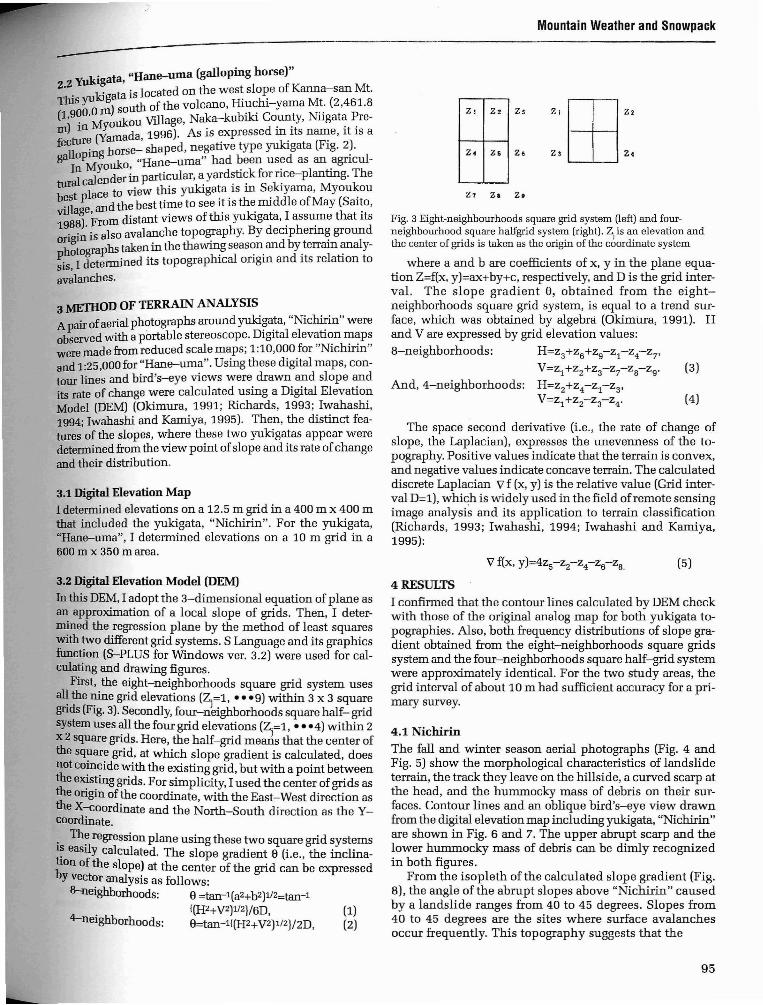
First, the eight-neighborhoods square grid system usesall the nine grid elevations (Z.=l, - - -9) within 3 x 3 squaregrids (Fig. 3). Secondly, four-nJeighborhoods square half- gridsystem uses all the four grid elevations (Z.=l, - - -4) within 2x 2 square grids. Here, the half-grid meads that the center ofthe square grid, at which slope gradient is calculated, doesnot coincide with the existing grid, but with a point betweenthe existing grids. For simplicity, I used the center of grids asthe origin of the coordinate, with the East-West direction asthe X-coordinate and the North-South direction as the Ycoordinate.
. Th~ regression plane using these two square grid systemsl~ easily calculated. The slope gradient e (Le., the inclination of the slope) at the center of the grid can be expressedby vector analysis as follows:
8-neighborhoods: e =tan-1(aZ+b2)1/Z=tan-1!(Hz+VZ)1/Z}/6D, (1)
4-neighborhoods: e=tan-1{(Hz+VZ)1/Z}/2D, (2)
Mountain Weather and Snowpack
21 2. 2s 2, ttl'24 Z6 2. 23 2.
21 Z. z.
Fig. 3 Eight-neighbourhoods square grid system (left) and fourneighbourhood square halfgrid system (right). Z. is an elevation andthe center of grids is taken as the origin of the c60rdinate system
where a and b are coefficients of x, y in the plane equation Z=f(x, y)=ax+by+c, respectively, and D is the grid interval. The slope gradient e, obtained from the eightneighborhoods square grid system, is equal to a trend surface, which was obtained by algebra (Okimtrra, 1991). Hand V are expressed by grid elevation values:
8-neighborhoods: H=Z3+Z6+Zg-Z1-Z4-Z7'
V=z1+zZ+z3-z7-Za-Zg' (3)And, 4-neighborhoods: H=ZZ+Z4-Z1-Z3'
V=Z1+ZZ-Z3-Z4' (4)
The space second derivative (Le., the rate of change ofslope, the Laplacian), expresses the unevenness of the topography. Positive values indicate that the terrain is convex,and negative values indicate concave terrain. The calculateddiscrete Laplacian Vf (x, y) is the relative value (Grid interval D=l), which is widely used in the field ofremote sensingimage analysis and its application to terrain classification(Richards, 1993; Iwahashi, 1994; Iwahashi and Karniya,1995):
4 RESULTS
I confirmed that the contour lines calculated by DEM checkwith those of the original analog map for both yukigata topographies. Also, both frequency distributions of slope gradient obtained from the eight-neighborhoods square gridssystem and the four-neighborhoods square half-grid systemwere approximately identical. For the two study areas, thegrid interval of about 10 m had sufficient accuracy for a primary survey.
4.1 Nichirin
The fall and winter season aerial photographs (Fig. 4 andFig. 5) show the morphological characteristics of landslideterrain, the track they leave on the hillside, a curved scarp atthe head, and the hummocky mass of debris on their surfaces. Contour lines and an oblique bird's-eye view drawnfrom the digital elevation map including yukigata, "Nic1ririn"are shown in Fig. 6 and 7. The upper abrupt scarp and thelower hummocky mass of debris can be dimly recognizedin both figures.
From the isopleth of the calculated slope gradient (Fig.8), the angle of the abrupt slopes above "Nichirin" causedby a landslide ranges from 40 to 45 degrees. Slopes from40 to 45 degrees are the sites where surface avalanchesoccur frequently. This topography suggests that the
95

Mountain Weather and Snowpack
yukigata, "Nichirin" is mainly formed by the accumulation of debris piled up on a circle by avalanches. The circle-shaped remaining snow persists longer than the surrounding snowpack. Therefore, I conclude that the topographical origin of this positive type yukigata is landslideterrain where avalanches are apt to occur.
For such complex topography a graphic display of theslope gradient (i.e., the derivative of elevation), especiallyits bird's-eye view (Fig.8b) is more informative than a display of elevations. The area between the scarp and thehummocky mass of debreis is arc-shaped. The rate ofchange of slope (i.e., the Laplacian) was negative here andthus it is concave terrain.
A cross section of "Nichirin" was made from 1:10,000scale. Elevations were determined every 10m along theWNW-direction fall line that goes through the center ofthe landslide with the origin of x-axis chosen at elevation1,600 m. The top elevation of the scarp of the landslidewas about 1,750 m and its length was about 80 m.
Comparing the ground photograph (Fig. 1) and aerialphotographs (Figs. 4, 5) with the contour lines, slopes andcross section in Figures 6-9, the radius of "Nichirin" isabout 150 m and the topmost edge of "Nichirin" (1,700m) coincided with the hummocky mass of debris of pastlandslides. Furthermore, the lowest border of the landslide was estimated to be at least 1,650 m from the rate ofchange of the cross section.
Fig. 4 Winter aerial photograph of the Yukigata, "Nichirin" (the sun)in Shimizu. Photographed by National Research Institute for EarthScience and Disaster Prevention, March 1 1964. A curved scarp is at(a) and hummocky mass of debris is at (b).
96
4.2 Hane-uma
From the photograph of yukigata, "Hane-uma" taken inthe spring (Fig. 2), we can recognize many tracks of remaining snow at his mane, where snow blocks spilled anddropped down, and several slipover tracks on the remain_ing snow below his abdomen. On the contour map drawnfrom the digital elevation map (Fig. 10), there is a blankarea at the cliff that correspond to the mane of the horse.
From the bird's-eye view of slope gradient near "Haneuma" (Fig. 11), the body ofthe horse is on slopes of morethan 35 degrees, and in the circumference gentle slopespreads. This topography suggests that the yukigata"Hane-uma" is mainly formed by the denudation of snowpack by avalanches. Small amounts of remaining snowmelt away earlier than the surrounding snowpack.
Combining slope contour lines ofmore than 35 degreesand the cliff, the resulted outline (Fig.12) is similar to thatof yukigata "Hane-uma" (Fig.13). Therefore, I conclUdethat the topographical origin of this negative type yukigatais cliff terrain and steep slopes where full-depth avalanches are apt to take place. The total length of Haneuama was about 600 m and its width was about 200 m.
The white part between the tail and the rear leg (Fig.13) is a gentle inclination ranging from 20 to 25 degrees(Fig. 12). Dotted lines in Fig. 12 do not follow the drawingrule stated above. This is because, in addition to slopes ofthe avalanche site, plants, trees and runout distances ofavalanches are important.issues.
5 CONCLUDING REMARKSYukigatas are strongly associated with accumulation andmelting of snowpack and micro topography. In the case ofthe positive type yukigata, "Nichirin", land slide terrainand avalanche release due to abrupt terrain created by
Fig. 5 Fall Aerial photograph of the Yukigata, "Nichirin" (the s~) inShimizu. Photographed by Agriculture and Forestry Section, ShiowaTown Office, Fall, 1994. Trucks and curved scarp are at (A) andhummocky mass of debis is at (B).

Mountain Weather and Snowpack
F· 6 Contour lines around, "Nichirin" in Shimizu. PositiveIg. th d .. dir ti' fYdirection of X-coordinate is sou an posItive ec on 0 -
coordinate is East. All units are meters.
100 1CO
X300 400
o ()Fig. 7 Bird's-eye view around, "Nichirin" in Shimizu. Coordinatedirection and units are the same as Fig. 6
~~---------------------;
y~
100 200
xJOO 400 o 0
a. Contour Lines b. Obique, "bird's-eye view"
Fig. 8 Isopleth of slope gradient ( left figure) and its bird's-eye view (right figure) around, "Nichirin" in Shimizu.
Fig. 10 Contour lines near trhe yukigata "(Hane-uma)." Positivedirection of X-coordinate is north and positive direction of Ycoordinate is East. All units are meters.
SOIl500400300
hor:sex
200100
Fig. 9 Cross section around the yukigata, "Nichirin" in Shimizu
97

98
Fig 13 Sketch of the yukigata, "Hane-uma" (galloping horse). Realistically designed from Fig.12 by Ms. Kanae Hirama.
500400200 X 300100
Fig. 12 Domain combining contour lines of more than 35 degrees anthe cliff near "Hane-uma". The slope gradient was calculated by thefour-neighbourhoods square half grid system.
Survey Institute, Ministry of Construction for her considerable guidance on the Digital Elevation Model. Ideeply indebted to Senior researcher Takashi InokuchiNational Research Institute for Earth Science and DisastePrevention for his. comments on mapping of landslide topography.
I wish to thank to Mr. Tom Endo, Shiozawa Anti-snowTesting Station, Railway Technical Research Institute anAgriculture and Forestry Section, Shiozawa Town Officefor providing the precious aerial photographs. Also, I wisto thank Miss Yukiko Itaya for her assistance with makindetailed Digital Elevation Maps.
Fig. 11 Bird's-eye view of slope gradient by the eight-neighbourhoodssquare grid system near the yukigata, "Hane-uma".
ACKNOWLEDGMENTSI am grateful to the members of the yukigata research group,Hokushinetu Branch of the Japanese Society of Snow andIce, who discussed and encouraged the present paper. Iam also grateful to Mis. Junko Iwahashi, the Geographical
landslides caused huge snow accumulations. In the caseof the negative type yukigata, "Hane-uma", cliffs and steepslopes and full-depth avalanches caused denudation.
In order to confirm the formation mechanism, on-thespot investigations and more detailed terrain analysisshould be done by experts. The occurrence and disappearance of yukigatas should be observed and the mechanismof accumulation, melt and reaccumulation by avalancheand snow drift investigated.
Yukigatas, which had been valuable as the agriculturalcalenders in the past, will be useful not only for avalancheeducation but for better understanding of the avalanchephenomenon. Further, yukigatas are one of the best teaching materials for understanding nature and the connection of nature and human beings.
Mountain Weather and Snowpack

REfERENCES
tl WA and w.J. Humphreys, 1931, Snow Crystals. rep.
Ben ey, ..New York: Dover, 1962
d y. Private letter, On the Yukigatas in the Uonuma Destrict.
En 0, .,
hiA 1985 Uonuma no gou Yuki Kotoba Syuu (Snow
Rayas ,.,' . J ) Sh' O'Words in Uonuma County, III apanese. lOzawa, oglya
Syoten, pp.132.Iwahashi J, 1994, Developm~nt of Landfo~Clas~ificationus. Digital Elevation Model (ID Japanese WIth EnglIsh Abstract).:nuals of the Disaster Pre~ention Research Institute, KyotoUniversity. No. 37, B-1, Apn11994, 141-156.Iwahashi, J and I. Kamiya,1995, Landform Classification UsingDigital Elaevation Model-~ainly ~sing the Digital Land Information -(in Japanese). Geoinfomatics. Vol.6, No.2, 97-108.
Japanese Society of Snow and Ice, 1990, Seppyou Jiten (Dictionary of Snow and Ice, in Japanese), Kokon Syoin, pp.196.Nohguchi, Y., KawashimaK., Kobayshi T., Yamada Y, Endo, Y.,and K. Izumi, in print, Remaining Snow Patterns in Mountain,Yukigata, as a Scene in Spring, Proceedings of InternationalSnow Engineering Conference, 1996, Sendai.Okimura, T., 1991, On the Relation between Land Characteristics and Land ClassificationlDepth ofSurface Soil-A Case Studyin Iri-sugaya, Sendai (in Japanese). Tochi Zousei KougakuKenkyuu Shisetsu Houkoku. No.9, 1991,119-39.Richards, J. A., 1993, Remote Sensing Digital Inlage AnalysisAn Introduction. Springer-Vedaag. pp.340.Saito, Y., 1988, Yukigata in Niigata, History and Folklore inNiigata (in Japanese). Edited by Komagata Sensei Taisyoku KinenJigyou no Kai, 284-304.Tabuchi, Y., 1981, YamanoMonsho (Mountain Emblem, inJapanese), Gakusyuu Kenkyuu sya, Tokyo, pp.371.
Yamada, Y.,1995a," Nichirin" in Shimizu (in Japanese). J. Japanese Soc. of Snow and Ice, 57, No.4, k.
y~~~, ~;, ~995b, On the Topographical Origin of the Yukigata,"Nlchirin (m Japanese). Cold Region Technology Conference'95. 269-275.
;amada, Y., ~9.96, On the Topographical Origin of the Yukigata,'Hane-uma (mJapanese) 12 thAnnual Meeting ofJapan Society for Snow Engineering. January 1996. 71-76.Keywords: snowmechanics, slab avalanche, avalanche formation, dynamic loads
Mountain Weather and Snowpack
99