oman nwp forecast during phet tropicaal cyclone
TRANSCRIPT

IOTCCC-2012, 14-17 Feb 2012, New Delhi, India

Introduction (Tropical Cyclone Phet ) NWP Models at DGMAN DGMAN’s NWP forecast during Phet:
Intensity Tracks Rainfall
How was DGMAN’s NWP forecast compared to others
Remarks
IOTCCC-2012, 14-17 Feb 2012, New Delhi, India

31/5/2010 2:30 UTC 1/6/2010 19:30 UTC
2/6/2010 8:00 UTC 3/6/2010 0:00 UTC
3/6/2010 15:00 UTC 4/6/2010 11:30 UTC
Date:time (UTC) 1:18 2:2 3:00 3:12 4:00 4:4 4:18
classification TC (phet) TC TC TC TC TC TS
Wind speed 75 90 120 90 90 80 55
Note CAT2 CAT3 CAT2 Landfall CAT1
IOTCCC-2012, 14-17 Feb 2012, New Delhi, India

Characterized by: Followed a rare track in Arabian Sea
(1877-2009) Longest tracks in recent years Long life period Two landfall and affected three countries
IOTCCC-2012, 14-17 Feb 2012, New Delhi, India

Total precipitation and maximum wind speed recorded during 1-5 June 2010IOTCCC-2012, 14-17 Feb 2012, New Delhi, India

IOTCCC-2012, 14-17 Feb 2012, New Delhi, India

Prognostic variablesSurface pressure ps
Temperature TWater vapour qv
Cloud water qc
Cloud ice qi
Horizontal wind u, vSeveral surface/soil
parameters
Diagnostic variables
Vertical velocity Geopotential Cloud cover clcDiffusion coefficients
tkvm/h
Operational Forecasting Model
IOTCCC-2012, 14-17 Feb 2012, New Delhi, India

Prognostic variablespressure perturbation p‘Temperature Tspecific humidity qvCloud water qcCloud ice qiHorizontal/virtical wind
u, v,w
Diagnostic variables
Total air densityprecipitation fluxes of
rain and snow.
Operational Forecasting Model
IOTCCC-2012, 14-17 Feb 2012, New Delhi, India

Vertical Layers: 40
FCT Hours:78-120
FCT times: 00,12 UTC
7 – 35.25 N
30 – 78 E
Initial/LBC: GME
IOTCCC-2012, 14-17 Feb 2012, New Delhi, India
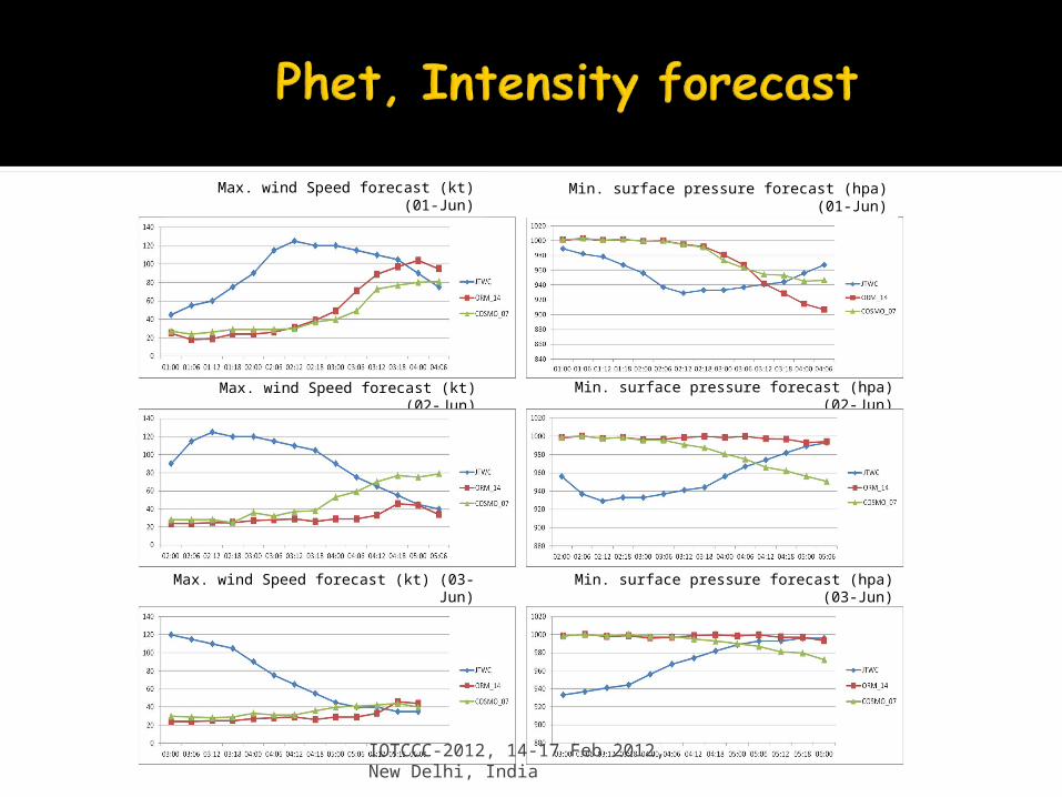
Min. surface pressure forecast (hpa) (02-Jun)
Min. surface pressure forecast (hpa) (03-Jun)Max. wind Speed forecast (kt) (03-Jun)
Max. wind Speed forecast (kt) (02-Jun)
Max. wind Speed forecast (kt) (01-Jun) Min. surface pressure forecast (hpa) (01-Jun)
IOTCCC-2012, 14-17 Feb 2012, New Delhi, India

IOTCCC-2012, 14-17 Feb 2012, New Delhi, India
IOTCCC-2012, 14-17 Feb 2012, New Delhi, India

IOTCCC-2012, 14-17 Feb 2012, New Delhi, India

IOTCCC-2012, 14-17 Feb 2012, New Delhi, India

IOTCCC-2012, 14-17 Feb 2012, New Delhi, India
IOTCCC-2012, 14-17 Feb 2012, New Delhi, India

IOTCCC-2012, 14-17 Feb 2012, New Delhi, India
IOTCCC-2012, 14-17 Feb 2012, New Delhi, India
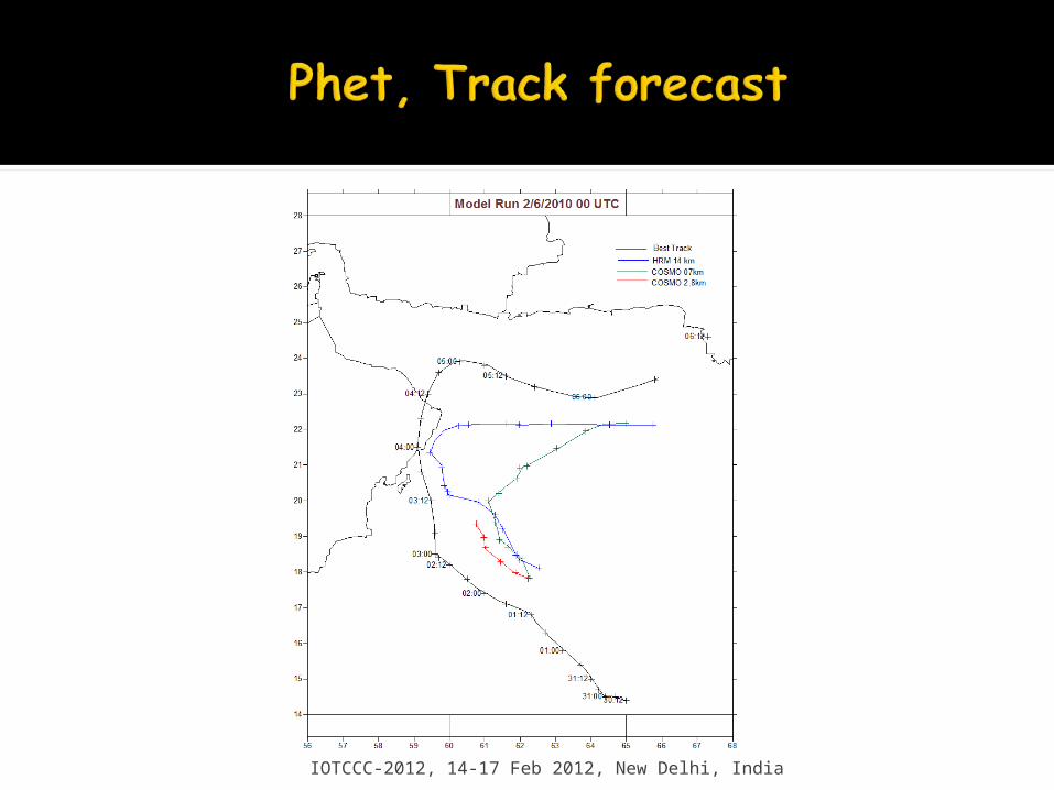
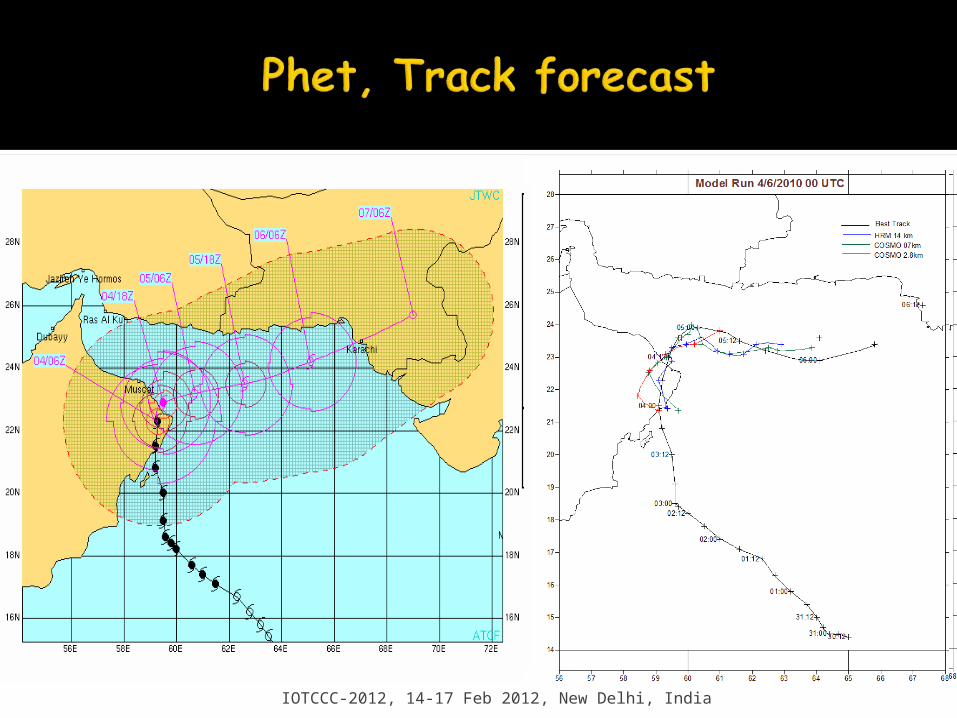
Even though HRM/COSMO are not TC specialized models, both have given the signal for Phet.
All model underestimated the intensity of the tropical cyclone
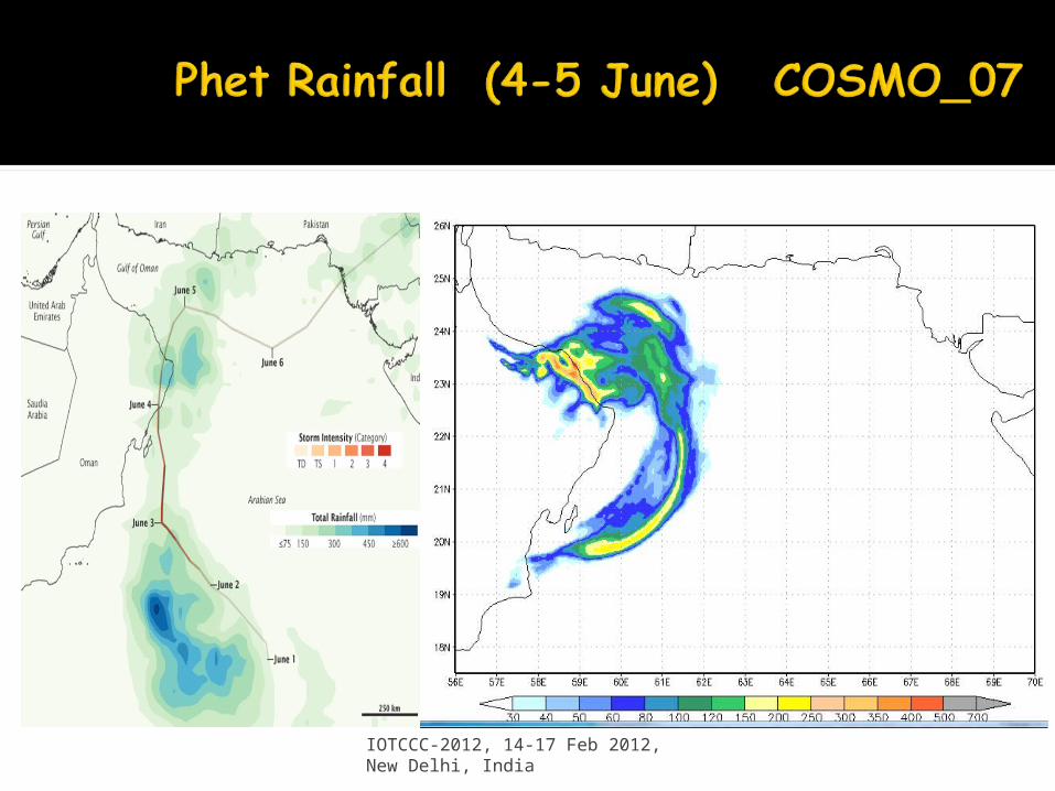
Both 14_07 and COSMO_07 have signaled 48h rainfall of more than 400mm with reasonable spatial and good amount agreement with the satellite estimated precipitation.
2.8km resolution clearly indicated landfall in Oman 24h prior to the landfall while other model resolution did not forecast the landfall correctly
The intensity underestimation is believed due to the initialization problem
There is a need for detailed investigate to understand why all models failed to forecast Phet??
IOTCCC-2012, 14-17 Feb 2012, New Delhi, India

IOTCCC-2012, 14-17 Feb 2012, New Delhi, India