offshore renewable resources in europe · offshore renewable resources in europe. 2 orecca project...
TRANSCRIPT

L. Serri, RSE S.p.A., Italy
Prot.RSE 11001207
EWEA2011 March 16, 2011ORECCA SIDE EVENTS
OFFSHORE RENEWABLE RESOURCES IN EUROPE

2
ORECCA PROJECT WP2
2
WP2: Resource characterization, environmental impact, financial and legislative framework for the target areas
(Leader: K. Lynch, HMRC, Ireland)
Different levels: macroarea, county/region, site
Information to be collected: • wind statistics, wave spectra, ocean currents, temperatures,• bathymetry, seabed morphology and geology• existing and planned use - marine spatial planning• environmental conditions (marine life, habitats, ecosystems)• competing other uses such as navigation routes…….
Estimating the resources for differenttechnologies and structures and also for the combined use (multi purpose platforms)

3
ORECCA: THREE GEOGRAPHICAL AREAS
3
Task 3: Mediterranean & Black Sea(Leader: L: Serri, RSE)
Task 2: Atlantic Ocean(Leader: T. Pontes, LNEG)
Task 1: North & Baltic Sea(Leader: A.M. Sempreviva, Risoe)

4
Authors: Risoe-DTU: Karagali & Sempreviva, Task 2
Offshore Wind Map

5
QuikScat mean wind speed (m s−1) (2000–2007) and mean wind direction. The wind speeds are reduced using the correction of the ECMWF for winds above 19 m s−1
B.R. Furevik, A. M. Sempreviva, L. Cavaleri., J.M. Lefèvre, C. Transerici, “Eight years of wind measurements from scatterometer for wind resource mapping in the Mediterranean Sea”, Wind Energ. (2010), DOI: 10.1002/we
Offshore Wind Map

6
WERATLAS (source INETI)

7
WORLD WAVE ATLAS (source OCEANOR)

8
CURRENT-TIDAL
http://www.emec.org.uk/marine_renewables.asp Atlas of UK Marine Renewable Energy Resources
9
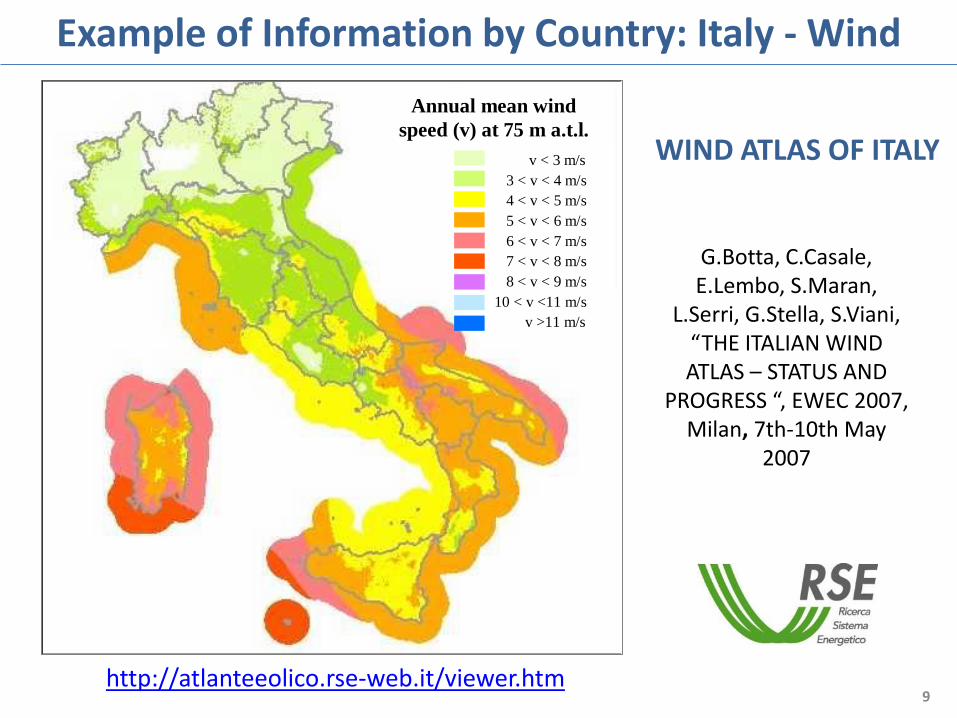
Example of Information by Country: Italy - Wind
http://atlanteeolico.rse-web.it/viewer.htm
Annual mean wind
speed (v) at 75 m a.t.l.
v < 3 m/s
3 < v < 4 m/s
4 < v < 5 m/s
5 < v < 6 m/s
6 < v < 7 m/s
7 < v < 8 m/s
8 < v < 9 m/s
10 < v <11 m/s
v >11 m/s
G.Botta, C.Casale, E.Lembo, S.Maran,
L.Serri, G.Stella, S.Viani, “THE ITALIAN WIND ATLAS – STATUS AND
PROGRESS “, EWEC 2007, Milan, 7th-10th May
2007
WIND ATLAS OF ITALY

10
0-25 m
25-60 m
Fixed Foundations Systems
Sea-Depth Classification for Wind Power Installation
North Sea wind farms
Beatrice, UK
60-200 m
200-500 m
Floating Systems (Prototypal stage)
Hywind BlueH Principle Power

11
Sea Depth Classification
11

12
OTHER COLLECTED INFORMATION
12
Countries: classification for EU-countries; EFTA countries; other countries
Cities: classification for population
EEZ: Exclusive Economic Zone
Distance from Shore: 50 and 90 km
Ports: classification for draft and for installed issues
Offshore wind farms: operational, non operational, under consideration
Offshore wave,tidal,OWC converters: operational, non
operational
Natura2000 sitesMPA (Marine Protected Areas)

13
NORTH & BALTIC SEA AREA: COMBINED MAP
13

14
information about offshore renewable resources, bathymetry, environmental and infrastructural issues in all European waters at different level (macroarea, country, site) has been collected
Work in Progress & Conclusions
In the frame of ORECCA Project (WP2):
by combining collected and implemented information:
*analysis of geographical distribution of resources in each geographical area as a function of parameters such as water depth and distance from shore will be carried out
* indications of the more promising marine areas for installation of offshore renewable energy converters (also for combined use –multipurpose platforms) will be obtained
implementation in ORECCA GIS project of resource maps is ongoing

1515
THANK YOU FOR YOUR ATTENTION