oceanwaves wamos ii - wave and current monitoring system wamosii 2014.pdf · oceanwaves wamos® ii...
TRANSCRIPT

Real-time decision suppoRt
oceanwavesWaMoS® II - Wave and Current MonItorIngSySteM

MaxIMIzeoperatIonalWIndoWSWaMoS® II is a proven radar-based wave and surface current monitoring system developed by oceanWaveS gmbH. In comparison to conventional wave rider buoys and current profiling devices that generate single point measurements, WaMoS® II offers the advantages of presenting this information for a broad area, and in a richer context.
WaMoS® II’s measurements are constantly refreshed while a vessel is underway, providing real time data relevant to the local operational area as compared to conditions reported at a closest available point of reference. High definition images of wave fields combined with numerical data and intuitive graphical reporting keep the operator well informed in assessing environmental risk and identifying safe operational windows.
as a complement to an existing sensor or as a primary system, WaMoS® II provides higher fidelity information with comparable accuracy, at lower lifecycle costs.
pRoven accuRacy & Reliability In industry-sponsored trials, data comparisons between WaMoS® II and wave rider buoys have independently verified its accuracy as well as the additional value provided in monitoring a full 360° range. WaMoS® II is presently supporting operational decision making applications including: offshore construction, diver support, safe helideck operations, and navigation in extreme current and sea states. Long-term deployments on several unmanned, remote coastal installations monitoring wave action and coastal erosion attest to its reliability.
WaMoS® II earnS InternatIonal
reCognItIon
OceanWaveS and WaMoS® II have a large and diverse reference list. As the acceptance of X-band radar as a wave and current measuring device gains international reference and citation, the reference list of applications of WaMoS® II continues to grow. Installations of WaMoS® II are found around the world. A partial list of installation sites includes Norway, Denmark, Germany, Thailand, China, Canada and the USA.
Fig:3 – A corresponding 2D frequency-direction spectrum indicating two wave systems, one coming from the North-North-West and one from the West.
Fig:2 – 1D Frequency spectrum graph showing two clear energy peaks from two wave systems.
Fig:1 – Three month time series data comparing wave height measurements obtained by WaMoS® II and a wave rider buoy.

Wave and suRFace cuRRent paRameteRs
WaMoS® II measures and displays all the essential wave field parameters including significant wave height (Hs), Peak wave period (Tp), Peak wave length (λp) Peak wave direction (θp) as well as surface current speed (U ) and surface current direction (θU).
peRFoRmance and opeRating Range
The operating range of WaMoS® II extends to 4.0 km depending on X-Band radar type and installation geometry. The average range for vessel-based installations is approximately 3.0 km. Requiring a minimum wind speed of 3 m/s and a minimum wave height of 0.5 m – 0.75 m, the system easily detects wave lengths from 15 m – 600 m and covers periods from 3 sec – 18 sec.
sea state alaRming
Sea state alarms can be set to trigger for three different conditions:
• when significant wave height exceeds a specified value;
• if peak wave lengths fall outside a specified range; or
• if the encounter angle between the wave system and the ship’s course moves outside a specified range.
data shaRing and RecoRding
Advanced recording capability enables operators to review and confirm conditions in the event of an incident or regulatory enquiry. WaMoS® II can be exported for integration in other data base, meteorological and environmental systems. It can also provide NMEA output to conning and decision support systems.
high Resolution cuRRent and bathymetRy imaging
This optional functionality displays high resolution current (HRC) for deep and shallow waters, bathymetric measurements are available for water depths to 30 m. Surface current and bathymetry maps are generated in a grid structure by the HRC software.
Fig:7
WAMOS® II HIGH RESOLUTION CURRENT DISPLAyShowing an eddy in the current field at a harbour entrance Fig:4 – Mean radar backscatter image overlaid by the surface currents. Fig:5 – Corresponding bathymetry image.
Fig:5
Fig:4
Fig:6
Fig:7 – WAMOS® II WAVE RADAR IMAGEWaMoS® II radar image containing an ambiguous stripe-like wave pattern. Arrows indicate two wave systems were detected, one coming from the North-Northwest and one from the West.
Fig:6 – WAMOS® II DATA COMPARISON Time series graph for significant wave height, current speed and current direction obtained by WaMoS® II (red) and ADCP (blue).
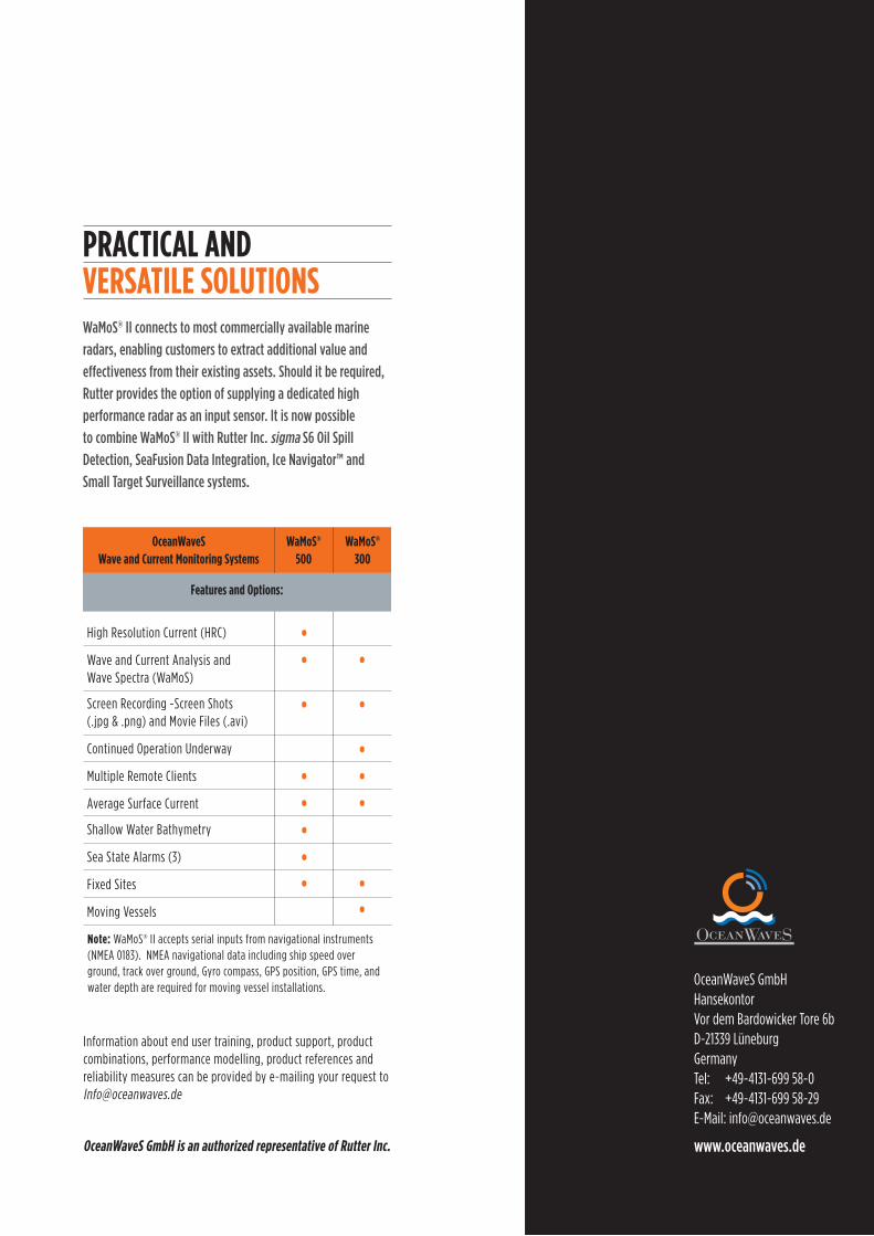
Wamos® ii connects to most commercially available marine
radars, enabling customers to extract additional value and
effectiveness from their existing assets. should it be required,
Rutter provides the option of supplying a dedicated high
performance radar as an input sensor. it is now possible
to combine Wamos® ii with Rutter inc. sigma s6 oil spill
detection, seaFusion data integration, ice navigator™ and
small target surveillance systems.
oceanWaveS Wave and Current Monitoring Systems
WaMoS® 500
WaMoS® 300
Features and options:
High Resolution Current (HRC) •
Wave and Current Analysis and Wave Spectra (WaMoS)
• •
Screen Recording -Screen Shots (.jpg & .png) and Movie Files (.avi)
• •
Continued Operation Underway •Multiple Remote Clients • •Average Surface Current • •Shallow Water Bathymetry •
Sea State Alarms (3) • •note: WaMoS® II accepts serial inputs from navigational instruments (NMEA 0183). NMEA navigational data including ship speed over ground, track over ground, Gyro compass, GPS position, GPS time, and water depth are required for moving vessel installations.
Information about end user training, product support, product combinations, performance modelling, product references and reliability measures can be provided by e-mailing your request to [email protected]
oceanWaveS gmbH is an authorized representative of rutter Inc.
Wamos® ii connects to most commercially available marine
radars, enabling customers to extract additional value and
effectiveness from their existing assets. should it be required,
Rutter provides the option of supplying a dedicated high
performance radar as an input sensor. it is now possible
to combine Wamos® ii with Rutter inc. sigma s6 oil spill
detection, seaFusion data integration, ice navigator™ and
small target surveillance systems.
OceanWaveS GmbHHansekontor Vor dem Bardowicker Tore 6bD-21339 Lüneburg GermanyTel: +49-4131-699 58-0Fax: +49-4131-699 58-29E-Mail: [email protected]
www.oceanwaves.de
praCtICal andverSatIle SolutIonS
oceanWaveS Wave and Current Monitoring Systems
WaMoS® 500
WaMoS® 300
High Resolution Current (HRC)
Wave and Current Analysis and Wave Spectra (WaMoS)
Screen Recording -Screen Shots (.jpg & .png) and Movie Files (.avi)
Continued Operation Underway
Multiple Remote Clients
Average Surface Current
Shallow Water Bathymetry
Sea State Alarms (3)
Fixed Sites
Moving Vessels
•• •
• •
• ••
••••
Features and options:
•••