ocean resources management plan 2013
TRANSCRIPT

Hawai‘i Ocean Resources Management Plan
July 2013

A publication of the Hawaii Office of Planning, Coastal Zone Management Program, pursuant to National Oceanic and Atmospheric Administration Award Nos. NA09NOS4190120, NA11NOS4190095 and NA12NOS4190097, funded in part by the Coastal Zone Management Act of 1972, as amended, administered by the Office of Ocean and Coastal Resource Management, National Ocean Service, National Oceanic and Atmospheric Administration, United States Department of Commerce. The views expressed herein are those of the author(s) and do not necessarily reflect the views of NOAA or any of its sub-agencies.


ii
Ocean Resources Management Plan 2013
FEDERAL AGENCY ACKNOWLEDGEMENTS The following federal agencies participated in the development of the ORMP and through their participation acknowledge and recognize the importance of ocean resource management in Hawai‘i.
NOAA Pacific Services Center
NOAA Office of National Marine Sanctuaries, Pacific Islands Regional Office
NOAA Office of Ocean and Coastal Resource Management
United States Army Corps of Engineers, Honolulu District, Civil and Public Works Branch
United States Navy, Hawai‘i Region
United States Coast Guard, 14th District
United States Environmental Protection Agency, Pacific Island Contact Office

N E I L A B E R C R O M B I E
G O V E R N O R
E X E C U T I V E C H A M B E R S
H O N O L U L U
iii
Governor’s Message Aloha, Where there is water, there is life. From rainfall in Hawai‘i’s mountains, through streams, rivers, and underground geological networks, to the ocean surrounding Hawai‘i, water influences all aspects of our lives. The Hawai‘i Ocean Resources Management Plan (ORMP) is a comprehensive state plan that provides a framework for ocean and coastal resource management in Hawai‘i. It strives to achieve the delicate balance between economic, ecological, and cultural needs. The ORMP coordinates the actions of various county, state, and federal agencies and the input from interested communities to achieve the sustainable use of Hawai‘i’s ocean and coastal resources for current and future generations. I am pleased to see the endorsement of a wide range of government entities with resources and authority to implement the ORMP. I support their efforts, and the goals and objectives they have identified for action. Imua Hawai‘i!
NEIL ABERCROMBIE Governor, State of Hawai‘i

iv
NEIL ABERCROMBIE GOVERNOR
JESSE K. SOUKI
DIRECTOR OFFICE OF PLANNING
OFFICE OF PLANNING STATE OF HAWAII
235 South Beretania Street, 6th Floor, Honolulu, Hawaii 96813 Mailing Address: P.O. Box 2359, Honolulu, Hawaii 96804
Telephone: (808) 587-2846 Fax: (808) 587-2824 Web: http:/planning.hawaii.gov/
July 2013 Aloha, Hawaii’s unique coastal and marine resources enable industry and commerce, support cultural traditions that connect us to our past and future, and provide sustenance to Hawaii’s families. Ensuring that our coastal and marine resources are available for current and future generations requires a multi-jurisdictional, multi-disciplined approach. The 2013 Ocean Resources Management Plan (ORMP) identifies a collective vision of Hawaii’s preferred future and State actions that will get us there. More importantly, it identifies public, private, and community partners that are needed to execute short-term and long-term actions. This ORMP update is the fourth in a series dating back to 1985, and the Office of Planning (OP) is the designated lead for its update and tracking implementation. This planning effort would not have been possible without the support and participation of county, state, and federal agencies with resource responsibilities and the communities that benefit from resource management that is efficient, effective, and accountable. With the help of these participants, we were able to produce a plan that includes meaningful benchmarks, targets, and metrics that will ensure implementation. The overarching framework for implementing the ORMP is Hawaii’s Coastal Zone Management (CZM) Act of 1977. The purpose of the Act is to “provide for the effective management, beneficial use, protection, and development of the coastal zone [which includes the entire State and its territorial waters].” The ORMP is a primary means for achieving these objectives across jurisdictions, disciplines, and communities. The ORMP identifies eleven management priorities for the next 5-years. It addresses the challenges of our time and the future, such as increasing land use and ocean resource development, competing human uses, the impacts from climate change, and the health of our natural environments. Hawaii is not alone in these efforts. In 2010, President Obama announced the National Ocean Policy (NOP). Like the vision of the NOP, the ORMP seeks to achieve a Hawaii where “…stewardship ensures that the ocean [and] our coasts…are healthy and resilient, safe and productive, and understood and treasured so as to promote the well-being, prosperity, and security of present and future generations.” The ORMP brings us closer to realizing this larger vision for the greater good of the people of Hawaii. Mahalo, Jesse K. Souki, Director

v
Ocean Resources Management Plan 2013
TABLE OF CONTENTS
Cover ORMP Policy Group Endorsement .......................................................................................... i Federal Agency Acknowledgements ....................................................................................... ii Letter from Governor Neil Abercrombie ................................................................................. iii Letter from Jesse Souki, Director of the State of Hawai‘i Office of Planning ........................ iv Table of Contents ..................................................................................................................... v Acronyms ................................................................................................................................. vii Chapter I: Introduction and Vision .......................................................................................... 1
Vision ....................................................................................................................................... 1 Importance of Ocean Resource Management to the Economy ................................................ 2 ORMP Three Perspectives ....................................................................................................... 3 ORMP Phasing Approach ........................................................................................................ 3 Approach for Adaptation Phase ............................................................................................... 4 Management Priorities and Perspectives ................................................................................. 5 How This Plan Was Prepared .................................................................................................. 6 What Has Changed in the 2013 Ocean Resources Management Plan ..................................... 6 National Priority Objectives .................................................................................................... 7
Chapter II: Pressures on the Ocean and Critical Issues That Need to be Addressed ............... 9
Urbanization ............................................................................................................................. 10 Impacts from Tourism.............................................................................................................. 10 Military Use of Lands .............................................................................................................. 11 Commercial and Recreational Ocean Uses .............................................................................. 11 Shoreline Access and Conflicting Uses ................................................................................... 11 Coastal Hazards, Sea Level Rise, and Coastal Erosion ........................................................... 12 Climate Change Adaptation: Disaster Preparedness and Community Resilience ................... 13 Marine Debris .......................................................................................................................... 14 Watershed Management: Water Quality and Water Quantity ................................................. 14 Agricultural Lands ................................................................................................................... 15 Damage to Coral Reefs ............................................................................................................ 15 Endangered Species ................................................................................................................. 16 Aquatic Invasive Species ......................................................................................................... 16 Terrestrial Invasive Species ..................................................................................................... 17 Food Security ........................................................................................................................... 17 Alternative Energy ................................................................................................................... 18
Chapter III: Management Priorities for The Adaptation Phase ............................................... 20
Management Priorities and Perspectives ................................................................................. 20 Criteria ..................................................................................................................................... 20 Implementation ........................................................................................................................ 21 References and Background .................................................................................................... 22 Measurement ............................................................................................................................ 22 Tracking and Reporting Progress ............................................................................................. 22 Management Priorities Summary Matrix Explanation ............................................................ 22 Management Priority #1: Appropriate Coastal Development .................................................. 23

vi
Ocean Resources Management Plan 2013
Management Priority #2: Management of Coastal Hazards .................................................... 25 Management Priority #3: Watershed Management ................................................................. 27 Management Priority #4: Marine Resources ........................................................................... 30 Management Priority #5: Coral Reef ....................................................................................... 33 Management Priority #6: Ocean Economy .............................................................................. 35 Management Priority #7: Cultural Heritage of the Ocean ....................................................... 38 Management Priority #8: Training, Education, and Awareness .............................................. 40 Management Priority #9: Collaboration and Conflict Resolution ........................................... 42 Management Priority #10: Community and Place-Based Ocean Management Projects ......... 44 Management Priority #11: National Ocean Policy and Pacific Regional Ocean Initiatives .... 46 Management Priorities Summary Matrix ................................................................................. 49
Chapter IV: Integrated and Coordinated Approach to Management of Ocean Resources........ 59
Introduction .............................................................................................................................. 59 ORMP Governance Framework .............................................................................................. 60
Office of Planning Coastal Zone Management Program ........................................................ 60 Policy Group and Working Group .......................................................................................... 60 Marine & Coastal Zone Advocacy Council ............................................................................ 61
National Ocean Policy Framework .......................................................................................... 62 National Priority Objectives .................................................................................................... 63 Pacific Regional Ocean Partnership (PROP) .......................................................................... 64 Hawaii Sub-Regional Ocean Partnership (Hawaii Sub-ROP) ................................................. 64 Coastal and Marine Spatial Planning ...................................................................................... 65
Current Framework for Traditional Resource Management .................................................... 66 ‘Aha Moku Resource Management ........................................................................................ 66
Key Hawaiian Terms ............................................................................................................... 67 Framework of Marine Management Areas .............................................................................. 68
Marine Life Conservation Districts ......................................................................................... 69 Fishery Management Areas..................................................................................................... 70 Bottomfish Restricted Fishing Areas ...................................................................................... 70 Wildlife Sanctuaries/Research Refuges .................................................................................. 70 Natural Area Reserves for Oceans .......................................................................................... 70 Hawaiian Islands Humpback Whale National Marine Sanctuary ........................................... 70 Papahānaumokuākea Marine National Monument & World Heritage Site ............................ 71
Western Pacific Regional Fishery Management Council ........................................................ 74
References ................................................................................................................................ 75 Appendices Appendix A: Background and Previous Ocean Resource Management Plans ............... Appendix Page 1 Appendix B: Accomplishments during the First Phase: Demonstration......................... Appendix Page 4 Appendix C: Ocean Resource Management Issues and Related Plans ......................... Appendix Page 20 Appendix D: Agency Roles .......................................................................................... Appendix Page 41 Appendix E: Scientific and Ocean Research Activities Taking Place in Hawai‘i ........ Appendix Page 47 Appendix F: Community and Place-Based Ocean Management Projects .................... Appendix Page 50 Appendix G: Resources for Communities in Coastal and Marine Stewardship ........... Appendix Page 54

Acronyms vii
Ocean Resources Management Plan 2013
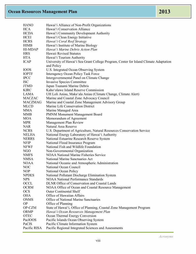
Acronyms AIS Aquatic Invasive Species AIST Aquatic Invasive Species Response Team BLNR Board of Land and Natural Resources BMP Best Management Practices BVR Beach Vulnerability Rating Project BWS Honolulu Board of Water Supply CBSFA Community-Based Subsistence Fishing Area CEC Commission on Environmental Cooperation CEQ Council on Environmental Quality C-MORE Center for Microbial Oceanography: Research and Education CMSP Coastal and Marine Spatial Planning CNMI Commonwealth of the Northern Mariana Islands CNPCP Coastal Nonpoint Pollution Control Program COEMAP DLNR Coastal Erosion Management Plan CRest NOAA Coastal Resilience Networks CRCP NOAA Coral Reef Conservation Program CRP NOAA Community-based Restoration Program CSP NOAA Coastal Storms Program CWRM DLNR Commission on Water Resource Management CZARA Coastal Zone Act Reauthorization Amendments CZM Coastal Zone Management CZMA Coastal Zone Management Act DAR DLNR Division of Aquatic Resources DBEDT Department of Business, Economic Development & Tourism DLNR Department of Land and Natural Resources DOA Department of Agriculture DOBOR DLNR Division of Boating and Ocean Recreation DOCARE DLNR Division of Conservation and Resource Enforcement DOFAW DLNR Division of Forestry and Wildlife DOH Department of Health DOI U.S. Department of Interior DOT Department of Transportation DP Development Plan DPP City & County of Honolulu Department of Planning and Permitting EEZ Exclusive Economic Zone ENSO El Niño/La Niña – Southern Oscillation EPA U.S. Environmental Protection Agency EPICS Climate Extremes in the Pacific Integrated Case Studies ESA Endangered Species Act FAO Food and Agriculture Organization of the United Nations FDA U.S. Food and Drug Administration FEMA Federal Emergency Management Agency FMA Fishery Management Areas GIS Geographic Information System GMO Genetically Modified Organism GPS Global Positioning Satellite
Acronyms viii
Ocean Resources Management Plan 2013
HANO Hawai‘i Alliance of Non-Profit Organizations HCA Hawai‘i Conservation Alliance HCDA Hawai‘i Community Development Authority HCEI Hawai‘i Clean Energy Initiative HCRS Hawai‘i Coral Reef Strategy HIMB Hawai‘i Institute of Marine Biology HI-MDAP Hawai‘i Marine Debris Action Plan HRS Hawaii Revised Statutes HTA Hawai‘i Tourism Authority ICAP University of Hawai‘i Sea Grant College Program, Center for Island Climate Adaptation
and Policy IOOS U.S. Integrated Ocean Observing System IOPTF Interagency Ocean Policy Task Force IPCC Intergovernmental Panel on Climate Change ISC Invasive Species Committee JTMD Japan Tsunami Marine Debris KIRC Kaho‘olawe Island Reserve Commission LAMA UH Loli Aniau, Maka‘ala Aniau (Climate Change, Climate Alert) MACZAC Marine and Coastal Zone Advocacy Council MACZMAG Marine and Coastal Zone Management Advisory Group MLCD Marine Life Conservation District MMA Marine Managed Area MMB PMNM Monument Management Board MOA Memorandum of Agreement MPR Management Plan Review NAR Natural Area Reserve NCRS U.S. Department of Agriculture, Natural Resources Conservation Service NELHA National Energy Laboratory of Hawai‘i Authority NERRS National Estuarine Research Reserve System NFIP National Flood Insurance Program NFWF National Fish and Wildlife Foundation NGO Non-Governmental Organization NMFS NOAA National Marine Fisheries Service NMSA National Marine Sanctuaries Act NOAA National Oceanic and Atmospheric Administration NOC National Ocean Council NOP National Ocean Policy NPDES National Pollutant Discharge Elimination System NPS NOAA National Performance Standards OCCL DLNR Office of Conservation and Coastal Lands OCRM NOAA Office of Ocean and Coastal Resource Management OCS Outer Continental Shelf OHA Office of Hawaiian Affairs ONMS Office of National Marine Sanctuaries OP Office of Planning OP-CZM State of Hawai‘i, Office of Planning, Coastal Zone Management Program ORMP Hawai‘i Ocean Resources Management Plan OTEC Ocean Thermal Energy Conversion PacIOOS Pacific Islands Ocean Observing System PaCIS Pacific Climate Information System Pacific RISA Pacific Regional Integrated Sciences and Assessments
Acronyms ix
Ocean Resources Management Plan 2013
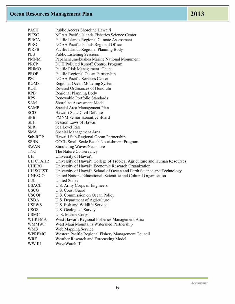
PASH Public Access Shoreline Hawai‘i PIFSC NOAA Pacific Islands Fisheries Science Center PIRCA Pacific Islands Regional Climate Assessment PIRO NOAA Pacific Islands Regional Office PIRPB Pacific Islands Regional Planning Body PLS Public Listening Sessions PMNM Papahānaumokuākea Marine National Monument PRCP DOH Polluted Runoff Control Program PRiMO Pacific Risk Management ‘Ohana PROP Pacific Regional Ocean Partnership PSC NOAA Pacific Services Center ROMS Regional Ocean Modeling System ROH Revised Ordinances of Honolulu RPB Regional Planning Body RPS Renewable Portfolio Standards SAM Shoreline Assessment Model SAMP Special Area Management Plan SCD Hawai‘i State Civil Defense SEB PMNM Senior Executive Board SLH Session Laws of Hawaii SLR Sea Level Rise SMA Special Management Area Sub-ROP Hawai‘i Sub-Regional Ocean Partnership SSBN OCCL Small Scale Beach Nourishment Program SWAN Simulating Waves Nearshore TNC The Nature Conservancy UH University of Hawai‘i UH CTAHR University of Hawai‘i College of Tropical Agriculture and Human Resources UHERO University of Hawai‘i Economic Research Organization UH SOEST University of Hawai‘i School of Ocean and Earth Science and Technology UNESCO United Nations Educational, Scientific and Cultural Organization U.S. United States USACE U.S. Army Corps of Engineers USCG U.S. Coast Guard USCOP U.S. Commission on Ocean Policy USDA U.S. Department of Agriculture USFWS U.S. Fish and Wildlife Service USGS U.S. Geological Survey USMC U. S. Marine Corps WHRFMA West Hawai‘i Regional Fisheries Management Area WMMWP West Maui Mountains Watershed Partnership WMS Web Mapping Service WPRFMC Western Pacific Regional Fishery Management Council WRF Weather Research and Forecasting Model WW III WaveWatch III
Chapter I: Introduction and Vision 1
Ocean Resources Management Plan 2013
The vision for Hawaii’s ocean resources is for a healthy, productive, and sustainable ocean ecosystem that fosters economic growth while preserving and protecting Hawaii’s values and needs.
I. Introduction and Vision
The Hawaiian Archipelago sits in the Pacific Ocean, 2,000 miles from the nearest land mass. The Hawaiian chain includes the eight inhabited islands of the State of Hawai‘i and the Northwestern Hawaiian Islands. Completely surrounded by ocean water, all land mass is classified as within the coastal zone; Hawai‘i is the only state with this characteristic. It makes ocean resource protection an acute and life-sustaining necessity for people, for marine species, and for their habitat. When Hawaiians speak of water, they are referring to a life source. Aia ke ola i ka wai: With water, there is life. Rainfall water falls onto the top of the mountains, feeds the waterfalls, the streams and rivers, and ultimately runs into the ocean that surrounds Hawai‘i. Therefore, resource management includes both ocean and coastal resources, and the water that feeds the ocean surrounding the islands. The Ocean Resources Management Plan (ORMP) is a comprehensive plan mandated by Hawaii Revised Statutes (HRS) Chapters 205A and 225M. The ORMP is prepared to address activities by agencies and entities in the State of Hawai‘i. As a state plan, the first audience is state agencies with responsibilities for the land, coast, and ocean. But since jurisdiction for these activities also includes federal and local entities, they are considered partners in state activities. Furthermore, as citizen stewards of the land and the ocean, every person present in Hawai‘i, resident and visitor alike, plays an important role in the protection and preservation of ocean and coastal resources. The purpose of the ORMP as required in HRS Section 205A-4 is to provide a framework and implementation strategy for state agencies and others working with state agencies. The framework considers ecological, cultural, historic, aesthetic, recreational, scenic, and open space values. The framework considers coastal hazards and it balances protection with economic development in marine and coastal areas. The ORMP is updated every five years through a process that includes extensive government feedback and statewide public input as required by HRS Section 205A-62. This is the fourth Hawai‘i ORMP since the first plan was written in 1985. Addressing pressures on Hawaii’s ocean and coastal ecosystems, competing uses and overuse, sustainability, and preserving these assets for future generations are all critical in this plan, just as they are in the Hawai‘i 2050 Sustainability Plan.
Vision
This vision is adapted from the statutory language for ocean resource management found in HRS Chapter 205A. Public and private interests acknowledge the interconnection between land practices and the ocean, and seek to practice sustainable living. Agriculture, development, military, and visitor industry activities cooperate and coordinate with each other to resolve conflicts in a manner which is pono or fair to all parties, a central theme in management. Each person carries a kuleana or responsibility for using
Chapter I: Introduction and Vision 2
Ocean Resources Management Plan 2013
sustainable practices on the land and the ocean, and for supporting the health and well-being of the ocean by all users, enhancing the quality of life for all who live, work, and visit Hawai‘i. In this vision, cooperation and collaboration are important among agencies at all levels: state, county, and federal. In this vision, government agencies interact with the community and with non-profit organizations to further the vision, perspectives, and goals of ocean protection.
Importance of Ocean Resource Management to the Economy A vibrant and healthy ocean environment is essential to the quality of life in Hawai‘i. The ocean is Hawaii’s greatest natural resource, providing both economic vitality and spiritual renewal to residents and visitors alike. The State of Hawaii's 1,052 miles of coastline includes world famous sandy beaches, remote sea cliffs, estuaries, and newly formed lava (The State of Hawai‘i Data Book 2011, Department of Economic Development & Tourism (DBEDT)). Hawaii’s landscape is being transformed from working agricultural lands to suburban and urban areas. According to Population and Economic Projections for the State of Hawai‘i by DBEDT (2012), the population in Hawai‘i is expected to increase 17.5% in the next 20 years from 1.36 million in 2010 to 1.60 million in 2030. In addition, with nearly 8 million visitors per year (DBEDT 2012), there will be increased pressure on marine and coastal resources, existing infrastructure, and water and land use. Direct marine-related industries including fishing, aquaculture, tourism, recreation, and shipping provide approximately 15% of Hawaii’s 649,150 civilian jobs. According to the National Oceanic Atmospheric Administration (NOAA) Report on the Ocean and Great Lakes Economy of the United States (2012) prepared by Booz Allen Hamilton for NOAA’s Coastal Services Center, Hawaii’s ocean economy accounted for 92,160 jobs and over $2.5 billion in wages. Nearly 98% of the imported goods come through the state’s harbor system as their point of entry. The value of aquaculture shellfish and finfish is $2,000,000 annually, and is expected to increase. The microalgae industry, used mainly in nutritional supplements, contributed $25 million in sales to Hawaii’s economy (Hawai‘i Farm Facts, October 2012). Seafood is critically important to Hawaii’s food security and economy. A 2012 University of Hawai‘i College of Tropical Agriculture and Human Resources (UH CTAHR) study stated that Hawai‘i residents spend more on seafood per capita than the rest of the United States. In 2010, Hawai‘i residents spent $330.68 per capita or 11.4% of their total food consumption at home and in restaurants. This is over twice as much as the U.S. per capita of $143.68. These figures do not take into account all of the seafood consumed from subsistence fishing some communities call “ohana fishing,” or fishing to feed one’s family. DBEDT statistics show that visitor expenditures were $11.2 billion in 2010, which was approximately 17% of the state’s Gross Domestic Product. In 2010, nearly 7 million visitors arrived by air; approximately 70% from the U.S. and 30% from other countries. (DBEDT, 2011) The recreational value of the state’s oceans and waterways to the tourism industry and to those that live in Hawai‘i has not been formally measured, however, the University of Hawai‘i Economic Research Organization (UHERO) will complete a study in 2013 and provide some economic data. One study on just the economic importance of Hawaii’s coral reefs, when considering recreational, amenity, fishery, and biodiversity values, estimated the value at $360 million per year of direct economic benefits (Cesar, et.al, 2002). In order to enjoy the economic benefits described here, the State must commit to preserve and to enhance Hawaii’s ocean resources. There must be regular, meaningful, and significant investments of financial and human capital dedicated to the ORMP management priorities. By giving serious attention, and

Chapter I: Introduction and Vision 3
Ocean Resources Management Plan 2013
ORMP Three Perspectives Perspective 1: Connecting Land and Sea Careful and appropriate use of the land is required to maintain the diverse array of ecological, social, cultural, and economic benefits we derive from the sea. Perspective 2: Preserving our Ocean Heritage A vibrant and healthy ocean environment is the foundation for the quality of life valued in Hawaii and the well-being of its people, now and for generations to come. Perspective 3: Promoting Collaboration and Stewardship Working together and sharing knowledge, experience, and resources will improve and sustain our efforts to care for the land and the sea.
investing now in effective ocean management, there is an opportunity to protect the public health, promote public recreation, respect traditional practices, advance food security, enhance tourist activity, and grow Hawaii’s economy as a whole.
ORMP Three Perspectives The 2006 ORMP charted a new course of action. The pinnacle of the approach was the Three Perspectives. The Three Perspectives are a way to integrate ocean resource management and to provide guidance for all of the actions that the ORMP agencies and partners do to manage Hawaii’s ocean resources. The ORMP Three Perspectives are neither priorities nor goals, but they provide an overall statement of broad outcomes.
ORMP Phasing Approach The 2006 ORMP moved from a sector-based approach implemented by jurisdictional entities to a place-based approach implemented by a broad base of stakeholders. Realizing that resource protection would take many years, a phased approach was initiated as shown in Figure 1-1. Experiences and lessons learned from each phase were to be documented to inform the next phase. A review of accomplishments from the Demonstration Phase is contained in Appendix B. The second phase, termed Adaptation, is when Demonstration Phase strategies start being applied more broadly. This 2013 ORMP addresses priorities for the Adaptation Phase. The third phase, termed Institutionalization, will more firmly implant the perspectives in agency work plans. The final phase, termed Mainstreaming, comes when the perspectives are practiced as standard, without the need to consider them for priority attention. Each phase will build upon lessons learned from the previous phase while recognizing and addressing new threats and forces.

Chapter I: Introduction and Vision 4
Ocean Resources Management Plan 2013
Figure 1-1: ORMP Phases and Expected Outcomes
Source: Adapted from 2006 ORMP and Updated
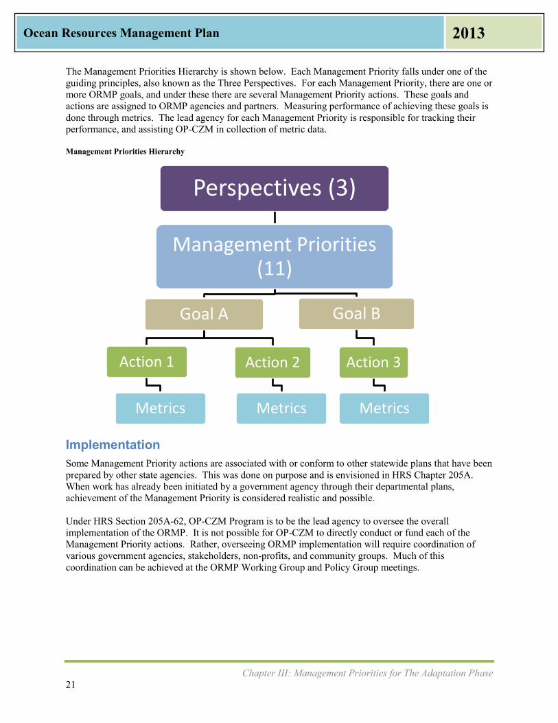
Approach for Adaptation Phase The high-level structure of the Adaptation Phase plan is shown in Figure 1-2. The plan identifies eleven Management Priorities for ocean resource management. Each management priority has at least two goals, actions to address these goals, and metrics for measuring where we are, where we would like to be, and indicates what will be measured and reported.
Figure 1-2: Management Priorities Hierarchy
Perspectives (3)
Management Priorities (11)
Goal A
Action 1
Metrics
Action 2
Metrics
Goal B
Action 3
Metrics

Chapter I: Introduction and Vision 5
Ocean Resources Management Plan 2013
The ORMP works by identifying eleven Management Priorities for the next five-year planning period, by identifying responsible agencies and resources, and by providing a method for performance measures and reporting. This responsibility can be found in HRS Section 205A-62. This plan seeks to advance the area of measurement in the plan’s goals, management priorities, actions, and metrics. Implementation of this plan will set baseline and benchmark measures, monitor progress, and address the results. This will create a continuous feedback loop, inform decision making, and help to adjust priorities for staffing and funding in ocean resource management. These 2013 ORMP Management Priorities replace the 2006 ORMP Management Goals and Strategic Actions. The 2008 ORMP Consolidated Work Plan recognized that not all of the 2006 ORMP Management Goals and Strategic Actions were being implemented. It was determined that the full list of activities and strategic actions, while important, were too numerous for effective and meaningful monitoring. Many activities were simply reported as “Ongoing” or “In Progress.” While these activities are no longer being used or tracked, a list of the 2006 ORMP activities (updated and amended) is shown in Appendix B. While all activities are important to get a complete picture of ocean resource management, the activities in 2006 ORMP Appendix B will no longer be monitored by the Office of Planning (OP). Actions that will be monitored are those that are listed as Management Priorities for the Adaptation Phase and shown in Chapter III.
Management Priorities and Perspectives The ORMP Management Priorities are the goals and actions which agencies of the State of Hawai‘i have committed to address and to make substantial and measurable progress during the period of 2013 to 2018. They are not listed in order of importance. Collectively they contribute to resource protection. Perspective 1: Connecting Land and Sea
Management Priority #1 Appropriate Coastal Development
Management Priority #2 Management of Coastal Hazards
Management Priority #3 Watershed Management
Perspective 2: Preserving our Ocean Heritage
Management Priority #4 Marine Resources
Management Priority #5 Coral Reef
Management Priority #6 Ocean Economy
Management Priority #7 Cultural Heritage of the Ocean
Perspective 3: Promoting Collaboration and Stewardship
Management Priority #8 Training, Education, and Awareness
Management Priority #9 Collaboration and Conflict Resolution
Management Priority #10 Community and Place-Based Ocean Management Projects
Management Priority #11 National Ocean Policy and Pacific Regional Ocean Initiatives

Chapter I: Introduction and Vision 6
Ocean Resources Management Plan 2013
ORMP Terminology Three Perspectives = Broad Outcomes Management Priorities = Eleven areas of focus which involve one or more state agencies, working with county, federal, non-governmental organizations, or private multiple parties, and those comprising actions which will be closely tracked and monitored during the Adaptation Period. Goals = Each of the eleven Management Priorities has at least one or more goals. These goals are linked to metrics. Actions (formerly Strategic Actions) = projects and activities to achieve the Management Priorities Metrics = Indicators or measures of performance and progress
How This Plan Was Prepared Work towards preparation of an updated ORMP began in 2011, when the OP received a grant from NOAA to begin the update process. After contracting with a consultant, work began in earnest during 2012 with a series of in-depth interviews with state and county agency participants in the ORMP Policy Group, comprised of cabinet-level directors of agencies that manage the ocean, and the ORMP Working Group, consisting of ocean and coastal resource planners from state, county and federal agencies. Previous documents and related plans prepared by the participating agencies were reviewed to identify coordination and integration issues. A series of eight statewide Public Listening Sessions (PLS) were held from April to June 2012. These were attended by over three hundred individuals who described issues and problems on their island. Summaries of both the interviews and the PLS were prepared and discussed with the ORMP Working Group as part of working meetings to determine the appropriate areas of emphasis and priority for the ORMP Update. A Public Review Draft 2013 ORMP was made available in October 2012. It was widely circulated and became the basis for a second round of nine statewide PLS held from October to November 2012. A comment period was held open until the end of January 2013. Comments from individuals, government agencies, businesses, and community groups were solicited at both rounds of the PLS, through the ORMP website, and on public access television. These comments are incorporated in the ORMP. Meetings with state agency directors were conducted to ensure they were willing and able to make commitments to the Management Priorities.
What Has Changed in the 2013 Ocean Resources Management Plan This 2013 Ocean Resources Management Plan is considered an update of the 2006 ORMP. It continues the new direction and course of action. It is the fourth ORMP for Hawai‘i. The 2013 ORMP uses new terms that more closely mirror the way terms are used in other state plans such as the Hawai‘i 2050 Sustainability Plan and the New Day Plan. New graphics have been added and editing has been done to make the plan more reader- and user-friendly. Issues and drivers are identified, explained, and incorporated in Chapter II and Appendix C. The Management Priorities for the upcoming Adaptation Phase of the ORMP are detailed in Chapter III. They are new or newly characterized. Each Management Priority has one or more goals. The goals are accomplished by actions. Management Priorities are linked to the policies and objectives in HRS Chapter 205A. The Management Priorities are also linked to the National Ocean Policy (NOP), which is explained later in this chapter.

Chapter I: Introduction and Vision 7
Ocean Resources Management Plan 2013
Also new in the 2013 ORMP are measures of implementation of the ORMP. Benchmarks (“Where we are now”), targets (“Where we want to be”), and quantifiable indicators or metrics are provided for monitoring and reporting progress. Because this is the first effort to include measurements, emphasis was made to find metrics that are already collected by agencies and reported elsewhere. By consolidating ocean resource metrics, a picture begins to emerge regarding status and, later, progress. This is a first attempt at performance measurement. It is expected to change and evolve, and by the time of the next ORMP Update, it is expected to improve as a useful and meaningful tool for decision-makers.
National Priority Objectives The National Ocean Council (NOC) and the NOP were established in July 2010 by the President’s Executive Order 12547 and are discussed in more detail in Chapter IV. The Executive Order was established based on the Final Recommendations of the Interagency Ocean Policy Task Force (2010). This groundbreaking policy provides the framework for federal agencies to work together to pursue the NOP’s Vision. The Final Recommendations contain nine National Priority Objectives that describe various approaches to ocean and coastal resource management as shown in Table 1-1 along with how they relate to the Three ORMP Perspectives. Table 1-1: National Priority Objectives and ORMP Perspectives
ORMP Perspective National Priority Objective
Perspective 1: Connecting Land and Sea ORMP adopts place-based management as a
foundational principal, which applies to nearshore fisheries, coral reefs, sea grasses, and other resources.
This goal addresses soil erosion and pollutant loads.
Ecosystem-Based Management Regional Ecosystem Protection and Restoration
Perspective 2: Preserving Our Ocean Heritage ORMP recognizes marine resources, coral reefs,
the ocean economy, and the cultural heritage of the ocean as ways to promote a sustainable Hawai‘i
Changing Conditions in the Arctic Water Quality and Sustainable Practices on Land
Perspective 3: Promoting Collaboration and Stewardship ORMP aims to build capacity for community
participation in resource management through education and outreach
ORMP includes Pacific Regional Ocean Partnership (PROP) and Hawai‘i Sub-Regional Ocean Partnership (Sub-ROP)
Climate change adaptation is included
Coastal and Marine Spatial Planning Inform Decisions and Improve Understanding Coordinate and Support Resiliency and Adaptation to Climate Change and
Ocean Acidification Ocean, Coastal, and Great Lakes Observations,
Mapping and Infrastructure
All of the NOP National Priority Objectives are important to Hawaii’s ocean resources. Even the National Priority Objective of “Changing Conditions in the Arctic,” while geographically distant, is important. Changing conditions in the Arctic are linked to climate change and the warming of the oceans, which in turn contributes to ocean acidification, coral bleaching, and the degradation and habitat loss of

Chapter I: Introduction and Vision 8
Ocean Resources Management Plan 2013
entire reefs. The changing conditions in the Arctic are being monitored by the U.S. Integrated Ocean Observing System (IOOS) in collaboration with the Pacific Islands Ocean Observing System (PacIOOS). The critical ocean resources management issues described in the next chapter track closely to the National Priority Objectives. During the Adaptation Phase, new institutional frameworks for Pacific region collaboration will be put into effect. New tools will be developed for coastal and marine spatial planning (CMSP). These are part of the Management Priorities addressed in Chapter III.
Chapter II: Pressures on The Ocean and Critical Issues That Need to Be Addressed 9
Ocean Resources Management Plan 2013
II. Pressures On The Ocean and Critical Issues
That Need To Be Addressed
This chapter examines pressures on the ocean and coastal resources and associated issues that need to be addressed. This chapter references other statewide plans and policies that discuss these critical, ocean-related issues. This chapter was informed by feedback that the State of Hawai‘i, Office of Planning, Coastal Zone Management Program (OP-CZM) received at two rounds of Public Listening Sessions (PLS) during 2012, which were held on the islands of Kaua‘i; east, west, and central parts of O‘ahu; west and central parts of Maui; Moloka‘i; Lāna‘i; and the east and west sides of Hawai‘i Island. A longer version of this Chapter, with additional information such as key ocean-related plans from other state and federal agencies, can be found in Appendix C, Ocean Resource Management Issues and Related Plans. Future economic growth and activities of the population are expected to place great demands on Hawaii’s ocean and coastal resources. Increased urbanization, tourism, recreation, and commercial uses utilize the ocean resources in different ways. While economic growth is vital to Hawai‘i, its impacts must be properly managed to preserve our natural resources and reduce conflicts among resource users. This chapter discusses several issues that affect ocean and coastal resource management:
Urbanization Impacts from Tourism Military Use of Lands Commercial and Recreational Ocean Uses Shoreline Access and Conflicting Uses Coastal Hazards, Sea Level Rise, and Coastal Erosion Climate Change Adaptation: Disaster Preparedness and Community Resilience Marine Debris Watershed Management: Water Quality and Water Quantity Agricultural Lands Damage to Coral Reefs Endangered Species Aquatic Invasive Species Terrestrial Invasive Species Food Security Alternative Energy
Chapter II: Pressures on The Ocean and Critical Issues That Need to Be Addressed 10
Ocean Resources Management Plan 2013
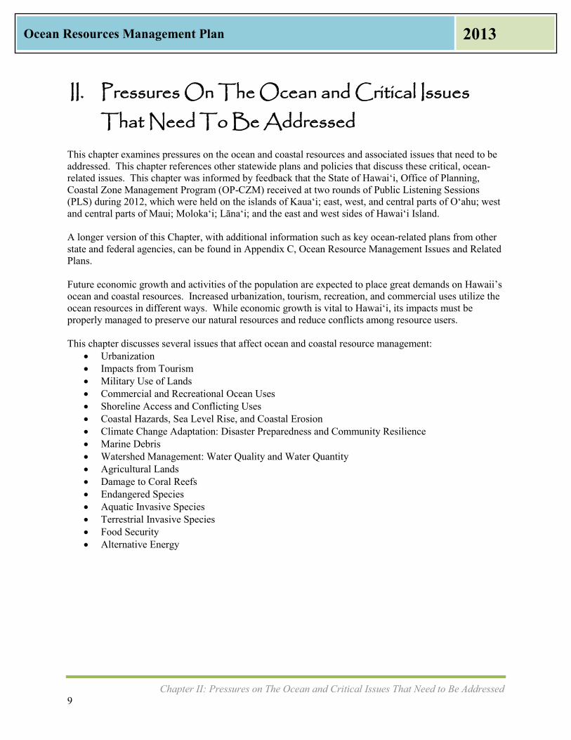
Urbanization The 2010 U.S. Census shows the State of Hawaii’s total population at 1,360,301 people, with 455,338 households. According to the Department of Business, Economic Development, and Tourism (DBEDT) forecasts, the state’s population is expected to increase by 140,000 persons every ten years. Future population growth and accompanying growth in urbanization need to be properly managed to preserve the state’s natural resources while allowing necessary economic growth. The updated management priorities in this ORMP outline actions to minimize impacts to the coastal environment through support of appropriate coastal development. Figure 2-1 illustrates a balance between social, economic, and environmental needs, showing how they are all interdependent. This is a diagram based on the definition of sustainability in Hawai‘i from the Hawai‘i 2050 Sustainability Plan:
(1) Respect of the culture, character, beauty, and history of the state's island communities;
(2) Striking a balance between economic, social, community, and environmental priorities; and
(3) Meeting the needs of the present without compromising the ability of future generations to meet their own needs.
Balancing the need to protect the environment can be done while driving the economy and providing social benefits to society. In other words, acquiring balance in one sector does not need to be at the expense of another.
Impacts from Tourism The UH Economic Research Organization (UHERO) reports that Hawaii’s tourism industry is the largest sector of the state’s economy, providing 22% of Hawaii’s gross domestic product in 2010 (UHERO, 2011). While most tourists arrive via plane, the ocean plays an important entry point for some. The number of visitors arriving to Hawai‘i aboard cruise ships increased 23% to 124,650 visitors between 2010 and 2011, and even more visitors boarded cruise ships in Hawai‘i after flying to the islands, bringing total cruise visitors to 246,236 (Hawai‘i Tourism Authority, 2012). The cruise ship industry is just one facet of tourism that impacts the ocean. Fishing tours, ecotourism, water sports and recreation, and the shipping of supplies to support nearly 8 million annual visitors all impact the ocean. Aside from the economic impact of tourism on the ocean resources, additional impacts such as environmental and social are also considered. While the recreational value of the ocean for both tourism and residents has not been formally measured, UHERO will complete a study sometime in 2013 that will provide data for policy makers. New visitor destinations and activities such as increased international visitors, the cruise ship industry, coastal-dependent resort development, increased marketing of the neighbor islands, and ecotourism alternatives can all be made aware of how to exist while protecting Hawaii’s most sensitive and unique natural resources.
Figure 2-1: Striking a Balance
Chapter II: Pressures on The Ocean and Critical Issues That Need to Be Addressed 11
Ocean Resources Management Plan 2013
Military Use of Lands The military is an integral part of Hawaii’s past and present, as well as a major driver of the state’s economy. National and homeland security requires that access to certain shorelines be off limits to the general public, such as at Pearl Harbor. On occasion, the military will allow access to certain beaches, such as at Bellows Air Force Station Beach in Waimānalo. The military often supports the community by participating in beach clean-ups. Further collaboration between the State and the military may help to open up more shorelines, even on a limited basis, for recreation and fishing. Ordnance left from World War II and training exercises in the ocean and along the coastline is a concern in some areas of Hawai‘i. The most extreme example of this would be the uninhabited island of Kaho‘olawe, which was used as a U.S. Navy practice bomb target area for several decades. Military ordnance has also been reported by community members off the Wai‘anae Coast on O‘ahu and north of Kailua-Kona on Hawai‘i Island. Continued collaboration between the State of Hawai‘i and assigned military liaisons can assist in removal of ordnance.
Commercial and Recreational Ocean Uses Hawaii’s oceans are used for commerce, recreation, cultural practices, and transportation. Approximately 80% of all goods consumed in Hawai‘i are imported from out of state, and of those, 98% arrive by sea. With approximately 8 million visitors arriving in the islands annually and projected to rise, the recreation sector of jobs has also increased by nearly 2% year over year (DBEDT, 2013). Because the islands are surrounded by the Pacific Ocean, many of the recreational jobs are centered on ocean uses, which may include a variety of uses from kayak rentals to recreational fishing tours to whale watching. All of these uses of ocean and coastal resources need to co-exist.
Shoreline Access and Conflicting Uses The State has long recognized a policy of supporting public use of the shoreline area. The landmark 1995 Hawai‘i State Supreme Court case, referred to as PASH or Public Access Shoreline Hawai‘i, reaffirmed these rights. Hawai‘i courts have consistently held that nearly all State submerged lands, including shoreline areas, are considered public lands held in trust for the benefit of its people. Accordingly, the State may not dispose of these lands, or encumber these lands to the detriment of public access and other public interests. In terms of shoreline areas, except for very specific circumstances, submerged lands extend to the highest wash of the waves during the season when the waves are highest. For example, HRS Section 46-6.5 states that the counties, in the subdivision process, must ensure public access to land below the high-water mark. Shoreline setback areas, Coastal Zone Management Act (CZMA) statutes and rules, and other state and county land use laws further recognize the importance of public access to the shoreline and coastal areas. Access to the shoreline for Native Hawaiian traditional and customary gathering practices is guaranteed in the Hawai‘i State Constitution, statutes, and case law. As such, agency decisions affecting the shoreline must make specific findings relating to potential impacts to traditional and customary practices and cultural, historical, or natural resources, and take feasible actions to reasonably protect cultural rights. Cultural impacts of applicable projects in or affecting the shoreline area must also be assessed via the environmental review process embodied in HRS Chapter 343, as well as through federal and state laws which may also require consultation with Native Hawaiian Organizations and practitioners. HRS Chapter 6E Relating to Historic Preservation recognizes the “value of conserving and developing the historic and cultural property within the State for the public good.” It is similar to Section 106 of the National Historic Preservation Act (1966), which includes a federal requirement for consultation with Native Hawaiian Organizations whenever federal agencies determine that there is an undertaking that

Chapter II: Pressures on The Ocean and Critical Issues That Need to Be Addressed 12
Ocean Resources Management Plan 2013
could affect historic properties. State and federal laws recognize that there could be historic and cultural properties in submerged lands as well as at the coastline and that government agencies must consider the Native Hawaiian perspective in order to preserve these historic and cultural properties. Despite having laws in place, many people expressed during the statewide ORMP PLS that access is sometimes limited, either through restricted parking, non-availability of public access in areas that are land locked, or other restrictions of protected Native Hawaiian gathering places. New resorts constructed on undeveloped shorelines may reduce public access to ocean resources and may degrade scenic views. Increased marine-related tourist attractions, including whale and dolphin watching, shark feeding, charter fishing, parasailing, jet skiing, swimming, snorkeling and diving, can result in resource use conflicts and threaten the condition of ocean and coastal resources. How shorelines are developed and the way coastal water quality, beaches, and coral reefs are managed are fundamental to the growth and sustainability of Hawai‘i.
Coastal Hazards, Sea Level Rise, and Coastal Erosion Coastal hazards that affect ocean resources include beach erosion, inundation of land, increased flood and storm damage, saltwater intrusion into the freshwater lens aquifer, the rising of the water table, and more frequent or more powerful weather events. Proper coastal development, watershed management, and disaster preparedness in coastal regions are necessary tools to deal with the effects of sea level rise and coastal hazards. According to the 2012 U.S. Geological Survey National Assessment of Shoreline Change: Historical Shoreline Change in the Hawaiian Islands, 70% of beaches on Kaua‘i, O‘ahu, and Maui are eroding with an average long-term rate of -0.11 meters per year. Twenty-two kilometers or 9% of beaches on the three islands were completely lost to erosion over the past century—in nearly all of these locations, the shoreline is now characterized by coastal armoring such as seawalls. Seawalls and other hardened shoreline structures to protect coastal properties exacerbate coastal erosion and beach loss (Fletcher, et. al., 1997). Currently, only the islands of Oʻahu, Kauaʻi, and Maui have documented erosion rates, and the University of Hawai‘i School of Ocean and Earth Science and Technology (UH SOEST) plans to document erosion rates for the other islands in the near future. Sea level rise is defined as when the mean high tide level increases year after year. Figure 2-2 on the following page illustrates the coastal hazards that can develop from sea level rise.
Chapter II: Pressures on The Ocean and Critical Issues That Need to Be Addressed 13
Ocean Resources Management Plan 2013
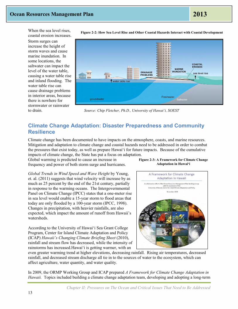
When the sea level rises, coastal erosion increases. Storm surges can increase the height of storm waves and cause marine inundation. In some locations, the saltwater can impact the level of the water table, causing a water table rise and inland flooding. The water table rise can cause drainage problems in interior areas, because there is nowhere for stormwater or rainwater to drain. Source: Chip Fletcher, Ph.D., University of Hawaiʻi, SOEST
Climate Change Adaptation: Disaster Preparedness and Community Resilience Climate change has been documented to have impacts on the atmosphere, coasts, and marine resources. Mitigation and adaptation to climate change and coastal hazards need to be addressed in order to combat the pressures that exist today, as well as prepare Hawai‘i for future impacts. Because of the cumulative impacts of climate change, the State has put a focus on adaptation. Global warming is predicted to cause an increase in frequency and power of both storm surge and hurricanes.
Global Trends in Wind Speed and Wave Height by Young, et. al. (2011) suggests that wind velocity will increase by as much as 25 percent by the end of the 21st century, partially in response to the warming oceans. The Intergovernmental Panel on Climate Change (IPCC) states that a one-meter rise in sea level would enable a 15-year storm to flood areas that today are only flooded by a 100-year storm (IPCC, 1998). Changes in precipitation, with heavier rainfalls, are also expected, which impact the amount of runoff from Hawaii’s watersheds. According to the University of Hawai‘i Sea Grant College Program, Center for Island Climate Adaptation and Policy (ICAP) Hawaii’s Changing Climate Briefing Sheet (2010), rainfall and stream flow has decreased, while the intensity of rainstorms has increased.Hawai‘i is getting warmer, with an even greater warming trend at higher elevations, decreasing rainfall. Rising air temperatures, decreased rainfall, and decreased stream discharge all tie in to the sources of water to the ecosystem, which can affect agriculture, water quantity, and water quality. In 2009, the ORMP Working Group and ICAP prepared A Framework for Climate Change Adaptation in Hawaii. Topics included building a climate change adaptation team, developing and adopting a long-term
Figure 2-3: A Framework for Climate Change Adaptation in Hawai‘i
Figure 2-2: How Sea Level Rise and Other Coastal Hazards Interact with Coastal Development

Chapter II: Pressures on The Ocean and Critical Issues That Need to Be Addressed 14
Ocean Resources Management Plan 2013
vision, identifying planning areas and opportunities relevant to climate change, scoping climate change impacts to major planning sectors, conducting a vulnerability assessment, and conducting a risk assessment. Such planning efforts aid in disaster preparedness and build resilient communities. A core group of ORMP partners drafted climate change policy legislation that became part of the Governor’s 2012 Legislative Packet as Senate Bill 2745. This climate change adaptation bill passed the 2012 Legislature and was signed by Governor Neil Abercrombie as Act 286 (2012).
Marine Debris Marine debris is defined as any solid material that is manufactured or processed and directly or indirectly disposed of or abandoned into the marine environment. Debris may enter directly from a ship, or indirectly when washed out to sea from rivers, streams, or storm drains. Marine debris includes a wide variety of items, including plastic bags, glass bottles, rubber slippers, derelict fishing gear, and abandoned or derelict vessels. Activities that create marine debris occur both on land and in the ocean. Marine debris can be categorized as chronic such as derelict fishing gear or episodic such as the Japan Tsunami Marine Debris (JTMD). The debris ranges in size from microscopic, such as broken pieces of plastic, to items weighing many tons, such as abandoned fishing vessels. According to the Hawai‘i Marine Debris Action Plan (HI-MDAP) (NOAA, 2013), there is a role for everyone, including federal, state, and county agencies, as well as community members and academia, in preventing and dealing with marine debris. Beach clean ups are just one way of addressing marine debris, as pictured in Figure 2-4.
Source: Kaho‘olawe Island Reserve Commission, Kanapou Cleanup
Watershed Management: Water Quality and Water Quantity There are over 500 watersheds in the State of Hawaiʻi, according to the Hawai‘i Watershed Guidance (Office of Planning 2010). The Department of Land and Natural Resources (DLNR), the Department of Health (DOH), the Office of Planning (OP), and the various county water supply agencies manage most of the state’s watersheds. However, many of the watersheds are private property. Because of their vast
Figure 2-4: Marine Debris Removed from Kanapou, Kaho‘olawe, Before and After Photos
Chapter II: Pressures on The Ocean and Critical Issues That Need to Be Addressed 15
Ocean Resources Management Plan 2013
size and limited accessibility, many stakeholders need to partner in order to manage and improve functionality of the watersheds. Watershed management must take into account the quality as well as quantity of water within a given watershed. Freshwater from streams, estuaries, and anchialine ponds flows into nearshore waters. Irrigation ditches, many left over from the sugar cane plantations, were constructed over one hundred years ago to provide millions of gallons of water per day for irrigation across the state. Many of these irrigation ditches remain and are also a source of fresh water flowing into the ocean, increasing water quantity as well as runoff from former agricultural lands. The amount of water flow (quantity) is as important as water quality. Polluted surface water runoff, combined with an aging sewage system incapable of handling system overloads, is threatening coastal water quality. According to the U.S. Environmental Protection Agency (EPA), 64% of Hawaii’s streams are considered “impaired” by pollutants. As population density increases along shoreline areas, landscape hardening to protect property continues as a serious coastal issue. Channelized streambeds for floodwater control exacerbate water quality problems and contribute to stream and estuarine habitat loss. Urban and agricultural lands are major sources of nonpoint source pollution. Pharmaceutical contamination, injection wells, and cesspools were raised at the ORMP PLS as anecdotal examples of pollution that is occurring. Stream diversions such as the irrigation ditches and wells that affect surface waters have changed the water flow to wetlands, streams, estuaries and nearshore waters. Careful and appropriate use of the land and freshwater is required to maintain the diverse array of ecological, social, cultural, and economic benefits we derive from the sea.
Agricultural Lands While much of Hawaii’s agriculture is beyond the shoreline, agricultural lands throughout the state directly impact the coast and the ocean. Much of Hawaii’s agricultural lands at the turn of the 20th century were used for sugar cane and pineapple production. As these uses cease, diversified agriculture has been planted on some of the former plantation lands. Other lands have been converted to urban use. As discussed in the previous section on Watershed Management, runoff from agricultural lands is seen to affect the coast and ocean. The designation of important agricultural lands as called for in Act 233 of 2008, Act 183 of 2005, and Article XI, Section 3 of the Hawai‘i State Constitution has been taking place over the past several years. The Hawai‘i Department of Agriculture (DOA), working with the Department of Taxation and various stakeholders as well as the OP, has been trying to identify incentives for agricultural lands to stay in agricultural use. The 2007 DOA Final Report to the State Legislature lists permits, tax credits, administrative rules, and transfers of land as steps in this process. The designation of lands as important agricultural lands provides an opportunity for agencies to make the connections between land and sea.
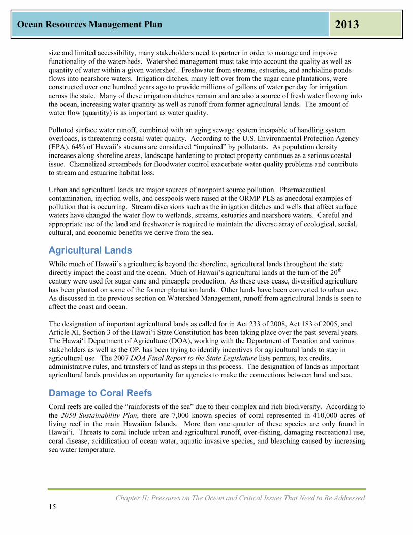
Damage to Coral Reefs Coral reefs are called the “rainforests of the sea” due to their complex and rich biodiversity. According to the 2050 Sustainability Plan, there are 7,000 known species of coral represented in 410,000 acres of living reef in the main Hawaiian Islands. More than one quarter of these species are only found in Hawai‘i. Threats to coral include urban and agricultural runoff, over-fishing, damaging recreational use, coral disease, acidification of ocean water, aquatic invasive species, and bleaching caused by increasing sea water temperature.
Chapter II: Pressures on The Ocean and Critical Issues That Need to Be Addressed 16
Ocean Resources Management Plan 2013
The depletion of coral reefs decreases biodiversity, which impacts not only the island population’s ability to recreate and subsist, but is a loss to the state’s chief income producer, tourism. The Makai Watch Program was developed to enhance the management of nearshore marine resources by providing community members opportunities for direct involvement in management activities. This program builds community awareness and encourages compliance through observation, identification, and reporting of illegal activities to the Source: The Nature Conservancy DLNR Division of Conservation and Resources Enforcement (DLNR-DOCARE). Climate change is a threat to coral. Increased levels of carbon dioxide emissions, a greenhouse gas, are changing the ocean’s chemistry. The added carbon dioxide causes a decrease in the pH of the water; in turn, the ocean becomes more acidic, which decreases the rate of calcium carbonate production by coral polyps. Additionally, increasing sea water temperature causes coral bleaching. While corals can recover from bleaching if other conditions are good and the high temperatures do not persist over many weeks, climate scientists agree that bleaching conditions will be widespread and regular by the end of the century. Coral cover throughout the Pacific is expected to decline 15% to 35% by 2035. (Britt Parker, NOAA Coral Reef Conservation Program (CRCP), Case Studies from the 2012 Pacific Islands Regional Climate Assessment (PIRCA), 2012). Without healthy coral reefs, entire ecosystems are at risk.
Endangered Species One-third of all endangered species in the United States are found in Hawai‘i. Examples of endangered species in the ocean and coastline areas are the Humpback Whale, the Green Sea Turtle, the False Killer Whale, and the Hawaiian Monk Seal. With increasing frequency, other marine species found in Hawai‘i are also being considered for listing. There are critical estuaries where fresh and salt water mix and serve as habitat for endangered birds such as the Hawaiian Moorhen, Hawaiian Stilt, Hawaiian Coot, and Kōloa Duck. Balancing protection of endangered species with other priorities of ocean resource management is critical. The Hawaiian Islands Humpback Whale National Marine Sanctuary (National Marine Sanctuary) is managed as a partnership between NOAA and the State of Hawai‘i. The National Marine Sanctuary is discussed in Chapter IV as an example of a coordinated approach to the management of ocean resources.
Aquatic Invasive Species Aquatic invasive species (AIS) are plants or animals introduced into a water body that have the potential to harm the ecosystem, people, and/or the economy. The Hawaiian Archipelago is home to 85% of the country’s coral reefs, and these ecosystems include a variety of corals, fish, seaweed, and other marine
Figure 2-5: Hawai‘i Coral Reef
Chapter II: Pressures on The Ocean and Critical Issues That Need to Be Addressed 17
Ocean Resources Management Plan 2013
life, some seen nowhere else in the world. Protecting the fragile ecosystems as well as keeping waterways clear and preserving the environment that commerce and tourism are both dependent upon are all important to the State of Hawai‘i. Prevention and early detection are essential in the control of aquatic invasive species. AIS can be introduced accidentally by sea faring vessels. Ballast water discharges from vessels and biofouling of submerged areas are the major means by which vessels act as a pathway for introduction of marine invasive species. The National Invasive Species Act of 1996 amended the Nonindigenous Aquatic Nuisance Prevention and Control Act of 1990. The U.S. Coast Guard (USCG) Ballast Water Management program addresses AIS introduction from ballast water.
Terrestrial Invasive Species Terrestrial invasive species are non-native plants or animals introduced on land. The introduction of a non-native species can interrupt and damage the land ecosystem. This is important to ocean and coast resource management, because what happens at the top of the ridge can affect water quantity and the ocean’s water quality. An example is damage that hoofed animals cause to the watershed through erosion and by promoting the spread of invasive plant species. Ungulate barriers such as fencing have been used in forests and watersheds to conserve the ecosystems. Other terrestrial invasive species such as the brown tree snake are important to keep out of the islands because their introduction could wipe out native bird populations, and affect the biodiversity of the forests. Invasive Species Committees (ISCs) on O‘ahu, Maui, Moloka‘i, Kaua‘i, and Hawai‘i Island seek to identify and implement appropriate management strategies.
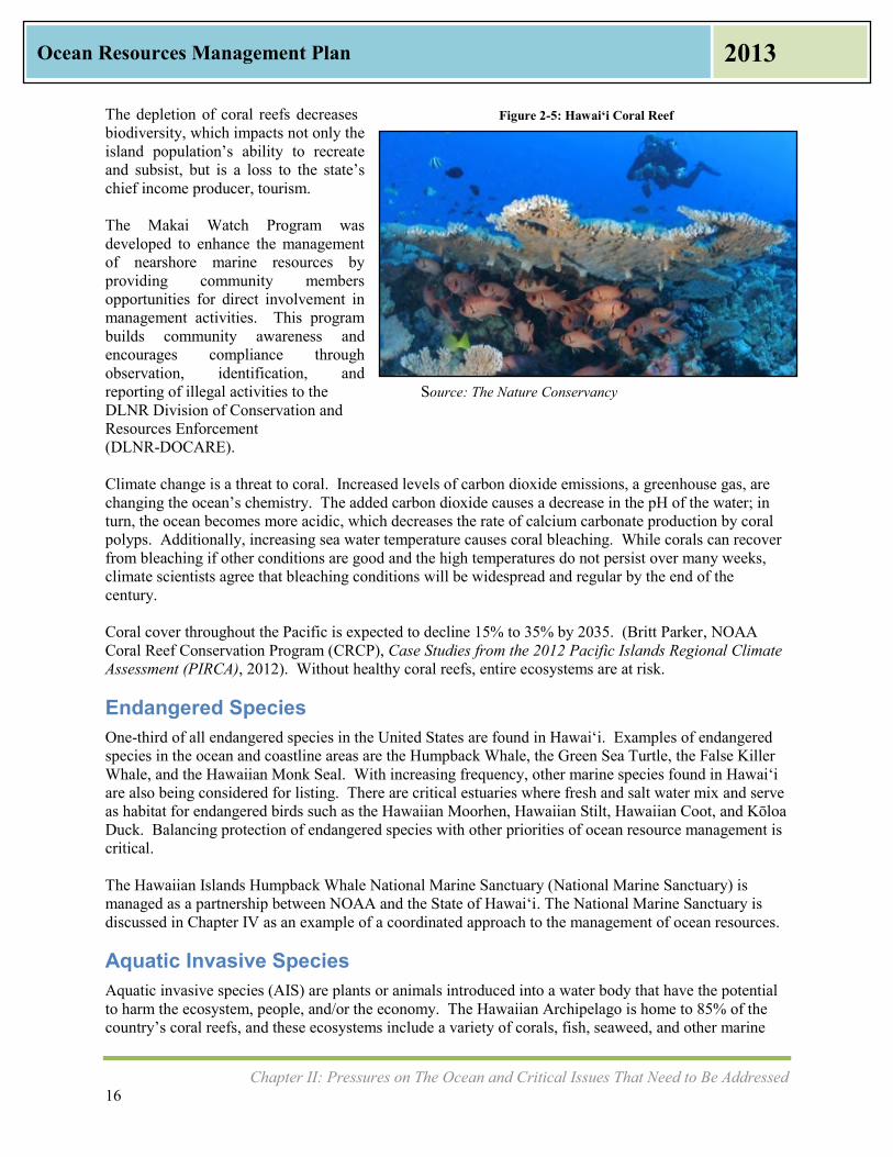
Food Security Approximately 85-90% of Hawaii’s food is imported into the state, mostly on ships. This makes Hawaii’s food security vulnerable to natural disasters and global events that could disrupt the food supply. In 2012, the OP in cooperation with the DOA prepared the Increased Food Security and Food Self-Sufficiency Strategy. Source: Hawaii Oceanic Technology, Inc. The three objectives of the strategy are to: increase demand for and access to locally grown foods; increase production of locally grown foods; and provide policy and organizational support to meet food self-sufficiency needs. Supporting restoration of fishponds, providing access to the coastline for gathering, proactively managing near shore fishing, and sustainable aquaculture are all ways to increase food security. Collaboration among agencies and community groups to increase access to the shoreline and improve ocean water
Figure 2-6: Open Ocean Fish Cage

Chapter II: Pressures on The Ocean and Critical Issues That Need to Be Addressed 18
Ocean Resources Management Plan 2013
quality for subsistence or “‘ohana fishing” helps support the state’s goal. Working with commercial fishers, open ocean aquaculture businesses, and agencies in a cooperative manner will assist in this effort.
Alternative Energy The Hawaiʻi Clean Energy Initiative (HCEI) set ambitious but critical goals for increased energy self-sufficiency and for increased use of clean technologies. The near term goal is to produce at least 15% of the electricity sold from clean energy technologies by 2015. With the projects currently under development or planning, Hawai‘i is on target to meet this goal. However, the goals of 25% renewable generation by 2020 and 40% renewable generation by 2030 leave much work to be done. Hawaii’s renewable electricity generation as a percentage of total generation is approximately 13.9%, according to annual Renewable Portfolio Standards (RPS) reports submitted by the electric utilities to the Hawai‘i Public Utilities Commission in 2013. In 2010, Hawai‘i was at 9.5% of renewable electricity generation, which at the time was approximately 1.8% higher than the rest of the United States as shown in Figure 2-7.
Source: State of Hawai‘i Energy Resource Coordinator’s Annual Report 2011 According to Governor Abercrombie’s A New Day in Hawai‘i Plan (2010), Hawaii’s most important economic enterprise is to pursue energy independence. Alternate energy for Hawai‘i includes wind, solar, hydro, ocean thermal, marine hydrokinetic, biomass, and geothermal sources. To increase the state’s RPS percentage and lower the state’s dependence on foreign oil imports, over 40 renewable energy projects have been constructed and another 40 utility-scale projects are currently proposed throughout Hawai‘i. Many of these projects will impact the ocean and coastal resources in various ways, including but not limited to: ecologic impacts from marine infrastructure, effluent discharges (tempered and/or processed),
Figure 2-7: Hawai‘i Renewable Energy Generation 2005-2010
Chapter II: Pressures on The Ocean and Critical Issues That Need to Be Addressed 19
Ocean Resources Management Plan 2013
visual impacts, and recreational and commercial impacts. Coupled with the newly formed Hawai‘i Outer Continental Shelf (OCS) Renewable Energy Task Force, the sustainable development of Hawaii’s marine resources is a major component of HCEI. Proper siting and cumulative impact mitigation of renewable energy projects are critical to the sustainable use of the state’s ocean resources. The Hawaiʻi State Energy Office within DBEDT works with stakeholders and regulatory agencies to help ensure individual projects are developed with consideration of local and statewide impacts, both short term and long. Some renewable energy power plants, such as wave energy devices, interisland cables, or offshore wind, could directly impact marine resources because of their location. Even land-based renewable projects, such as geothermal and bioenergy, could affect the ocean if they produce effluent or run-off into the nearby ocean. If the Hawaiian Islands’ electricity grids are linked by an undersea cable, other impacts to the ocean need to be considered. Hawaii’s present reliance on shipped fossil fuels such as oil and coal have the potential to significantly impact the ocean through spills or other accidents. The Pacific Ocean is an integral part of Hawaii’s environment, culture, and economy, and has vast potential to support the production of renewable energy. Sustainable management of Hawaii’s energy resources will help to protect our unique ocean resources.
Chapter III: Management Priorities for The Adaptation Phase 20
Ocean Resources Management Plan 2013
III. Management Priorities for the Adaptation Phase
With this ORMP Update, the ORMP moves into the Adaptation Phase, and this is scheduled to run approximately from 2013 to 2018. This phase will implement and track actions to measure progress on eleven Management Priorities that were identified through the ORMP Update process. This chapter outlines and discusses the Management Priorities along with their goals, benchmarks, targets, actions, and metrics, which will be the focus of the Adaptation Phase. Each Management Priority has a lead state agency or agencies, names other state and county agencies involved, and names partners from federal, university, and non-profit or community organizations.
Management Priorities and Perspectives Perspective 1: Connecting Land and Sea Management Priority #1 Appropriate Coastal Development Management Priority #2 Management of Coastal Hazards Management Priority #3 Watershed Management Perspective 2: Preserving our Ocean Heritage Management Priority #4 Marine Resources Management Priority #5 Coral Reef Management Priority #6 Ocean Economy Management Priority #7 Cultural Heritage of the Ocean Perspective 3: Promoting Collaboration and Stewardship Management Priority #8 Training, Education, and Awareness Management Priority #9 Collaboration and Conflict Resolution Management Priority #10 Community and Place-Based Ocean Management Projects Management Priority #11 National Ocean Policy and Pacific Regional Ocean Initiatives The ORMP Management Priorities are not listed in order of importance. They do identify issues which agencies of the State of Hawai‘i have committed to address and to make substantial and measurable progress during the period from 2013 to 2018.
Criteria The Management Priorities for ocean resource management were selected because they met one or more of the following criteria:
Present an immediate and urgent threat Present a long term threat, which can lead to irretrievable harm if not addressed sooner Work has been initiated by a government agency that requires several years of effort Work has been initiated by a community group and place-based progress has been demonstrated The work could be completed during the Adaptation Phase The Management Priority fits within HRS Chapter 205A The Management Priority fits within one of the nine objectives in the National Ocean Policy
Chapter III: Management Priorities for The Adaptation Phase 21
Ocean Resources Management Plan 2013
The Management Priorities Hierarchy is shown below. Each Management Priority falls under one of the guiding principles, also known as the Three Perspectives. For each Management Priority, there are one or more ORMP goals, and under these there are several Management Priority actions. These goals and actions are assigned to ORMP agencies and partners. Measuring performance of achieving these goals is done through metrics. The lead agency for each Management Priority is responsible for tracking their performance, and assisting OP-CZM in collection of metric data. Management Priorities Hierarchy
Implementation Some Management Priority actions are associated with or conform to other statewide plans that have been prepared by other state agencies. This was done on purpose and is envisioned in HRS Chapter 205A. When work has already been initiated by a government agency through their departmental plans, achievement of the Management Priority is considered realistic and possible. Under HRS Section 205A-62, OP-CZM Program is to be the lead agency to oversee the overall implementation of the ORMP. It is not possible for OP-CZM to directly conduct or fund each of the Management Priority actions. Rather, overseeing ORMP implementation will require coordination of various government agencies, stakeholders, non-profits, and community groups. Much of this coordination can be achieved at the ORMP Working Group and Policy Group meetings.
Perspectives (3)
Management Priorities (11)
Goal A
Action 1
Metrics
Action 2
Metrics
Goal B
Action 3
Metrics

Chapter III: Management Priorities for The Adaptation Phase 22
Ocean Resources Management Plan 2013
References and Background Each Management Priority references at least one ORMP Perspective, applicable sections of the Hawaii Revised Statutes (HRS), the National Ocean Policy (NOP) objectives referenced in the Final Recommendations of the Interagency Ocean Policy Task Force (IOPTF) (2010), and any other applicable federal, state, or county laws, including Hawaii Administrative Rules and the state constitution. The NOP Objectives can be found in Chapter IV. Background information on each Management Priority came from different sections of this ORMP as well as input from ORMP coordinating agencies.
Measurement Each Management Priority contains information on what is being measured. This starts with “Where we are now” to present a snapshot of current conditions. This is followed by “Where we want to be,” which explains targets for improving ocean and coastal resources in this Management Priority. The initial measure will become the ORMP baseline, and future measures will be compared to that point.
Tracking and Reporting on Progress Responsible lead agencies will report to the Office of Planning, Coastal Zone Management Program (OP-CZM) on a twice yearly basis using the metrics described. On an annual basis, OP-CZM will consolidate the performance metrics and report to both the Legislature and the public on progress made. Written reports are expected, but may also be posted on the OP-CZM website. Statewide meetings are encouraged as resources permit.
Management Priorities Summary Matrix Explanation A Management Priorities Summary Matrix listing the goals, lead agencies, partner agencies, and metrics is included at the end of this Chapter.

Chapter III: Management Priorities for The Adaptation Phase 23
Ocean Resources Management Plan 2013
Appropriate Coastal Development Goals: Goal A: Adoption of county plans which specify guidance on coastal development. Goal B: Strengthen and integrate data management to ensure appropriate coastal development. Goal C: Expand options to protect existing developments from further coastal erosion.
Management Priority # 1 Appropriate Coastal Development
References Perspective 1: Connecting Land and Sea HRS Sections 205A-2(b) [Objectives]: (3), (5), (6), (7), and (9); and 205A-2(c) [Policies]: (3)(D), (5)(A), (5)( C), (6)(A through D), (7) (A), (7)(B), (9)(A), and (9)(C) HRS Section 226-109, Climate change adaptation priority guidelines HRS Chapters 321 (partial), 322 (partial), 340E, 340F, 342D, 342E, Hawaii Administrative Rules (HAR) Title 11 National Ocean Policy Objectives 3 & 5 Background One of the goals of the CZM Program is to ensure that appropriate setbacks and protections are put into place to ensure appropriate development and structures along the coastal areas. Appropriate coastal development addresses the issues identified under the CZM Act, including coastal hazards (including sea-level rise), historic resources, coastal ecosystems, and Hawaii’s economy for current and future generations. The most difficult issues to address are coastal development issues that stem from development that already exists. While great strides have been made, there are many structures “grandfathered” under old codes, and continued pressure from landowners for legislative exemptions from regulatory review. This pressure can be very contentious and stressful for county and state permitting agencies. Benchmark – Where we are now The County of Kauaʻi is considering amendments to its Comprehensive Zoning Ordinance, based on
new sea level rise mapping. There are unsettled legal issues regarding permits for shoreline armoring or other protections for
existing threatened structures. PacIOOS has upgraded its Ocean Observation System, incorporating data layers that could assist in
appropriate coastal development. OP manages the Geographical Information System (GIS) layers for the State of Hawai‘i, which can
also assist in appropriate coastal development Target – Where we want to be Manage Retreat. Develop long-term planning and strategies to support managed retreat, which would
include location-specific adaptation strategies such as retreat zones, prohibition of shoreline armoring, and assessment of impacts on underground infrastructure and utilities. Public and private property owners may be encouraged to relocate structures inland, with incentives that may include tax-based incentives and third-party acquisition of threatened parcels in fee or by easement.
Site Appropriately. Proposed projects/actions are evaluated during the land use entitlement process to determine the sufficiency of proposed adaptation measures and infrastructure durability over the lifetime of the project, taking into account individual and public economic impacts. This includes considering additional shoreline access, where appropriate.
Plan for Passive Survivability. Communities should be resilient to extended power outages, interruptions of fuel supply, or loss of water and sewer services.

Chapter III: Management Priorities for The Adaptation Phase 24
Ocean Resources Management Plan 2013
Enhance Natural Infrastructure to Build Coastal Resilience. Cost-effective beach nourishment is implemented and streamlined for offshore permitting.
Allow Flexibility in Retrofitting Existing Structures. Allow for retrofitting of existing structures that also accounts for long-term conservation of coastal resources and shoreline ecosystems, including beaches and reefs.
Example Actions to Accomplish the Appropriate Coastal Development Goals OP continues to review projects during land use entitlement process to determine the sufficiency of
proposed adaptation measures and infrastructure durability over the lifetime of the project, taking into account individual and public economic impacts.
OP to support additional shoreline access in its land use reviews. ORMP Working Group collaborates on supporting legislation for appropriate coastal development. ORMP Working Group collaborates on ways to work with state and county agencies and departments
on appropriate coastal development. County planning departments incorporate coastal impacts into their General Plans, Development
Plans, Sustainable Community Plans, and land use regulations. Department of Land and Natural Resources Office of Coastal and Conservation Lands (DLNR-
OCCL) works on ways to support appropriate coastal development on public and private projects. Hawai‘i Department of Transportation (DOT) works on ways to support appropriate coastal
development of their Capital Improvement Program projects for highways, harbors, and airports. PacIOOS continues to work on strengthening and integrating data management to ensure appropriate
coastal development. UH SOEST continues to work on strengthening and integrating data management to ensure
appropriate coastal development. DBEDT continues to work on strengthening and integrating data management to ensure appropriate
coastal development. Hawai‘i Department of Health (DOH) to continue to review and comment on Environmental
Assessments and Environmental Impact Statements from environment and health perspectives. Metrics – Indicator Measures GOAL A: Increase in number of additional shoreline access (OP-CZM) Increase in number of counties implementing planning practices that include adaptation strategies
when planning for coastal areas (OP-CZM) Increase in number of state agencies implementing capital improvement plan projects that include
adaptation strategies for coastal areas (OP-CZM) GOAL B: Layers added to the statewide GIS that address coastal measures (OP GIS) GOAL C: Number of projects reviewed by OP during land use entitlement process that include coastal impact
risk assessments (OP-CZM) Number of projects reviewed by DOH during land use entitlement process that include coastal impact
risk assessments (DOH) Agencies Lead Agency: OP-CZM Other State and County Agencies: County planning departments, DLNR-OCCL, DOT (Harbors, Airports,
and Highways), DOH, Partners: Federal Emergency Management Agency (FEMA)/National Flood Insurance Program (NFIP),
UH Sea Grant College Program, PacIOOS, UH SOEST Coastal Geology Group, NOAA Office of Ocean and Coastal Resource Management (OCRM) and Pacific Services Center (PSC)
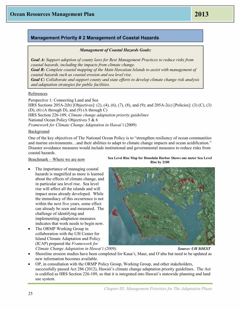
Chapter III: Management Priorities for The Adaptation Phase 25
Ocean Resources Management Plan 2013
Management of Coastal Hazards Goals: Goal A: Support adoption of county laws for Best Management Practices to reduce risks from coastal hazards, including the impacts from climate change. Goal B: Complete coastal mapping of the Main Hawaiian Islands to assist with management of coastal hazards such as coastal erosion and sea level rise. Goal C: Collaborate and support county and state efforts to develop climate change risk analysis and adaptation strategies for public facilities.
Management Priority # 2 Management of Coastal Hazards
References Perspective 1: Connecting Land and Sea HRS Sections 205A-2(b) [Objectives]: (2), (4), (6), (7), (8), and (9); and 205A-2(c) [Policies]: (3) (C), (3) (D), (6) (A through D), and (9) (A through C) HRS Section 226-109, Climate change adaptation priority guidelines National Ocean Policy Objectives 5 & 6 Framework for Climate Change Adaptation in Hawaiʻi (2009) Background One of the key objectives of The National Ocean Policy is to “strengthen resiliency of ocean communities and marine environments…and their abilities to adapt to climate change impacts and ocean acidification.” Disaster avoidance measures would include institutional and governmental measures to reduce risks from coastal hazards. Benchmark – Where we are now
The importance of managing coastal hazards is magnified as more is learned about the effects of climate change, and in particular sea level rise. Sea level rise will affect all the islands and will impact areas already developed. While the immediacy of this occurrence is not within the next five years, some effect can already be seen and measured. The challenge of identifying and implementing adaptation measures indicates that work needs to begin now.
The ORMP Working Group in collaboration with the UH Center for Island Climate Adaptation and Policy (ICAP) prepared the Framework for Climate Change Adaptation in Hawaiʻi (2009).
Shoreline erosion studies have been completed for Kauaʻi, Maui, and Oʻahu but need to be updated as new information becomes available.
OP, in consultation with the ORMP Policy Group, Working Group, and other stakeholders, successfully passed Act 286 (2012), Hawaii’s climate change adaptation priority guidelines. The Act is codified as HRS Section 226-109, so that it is integrated into Hawaii’s statewide planning and land use system.
Sea Level Rise Map for Honolulu Harbor Shows one meter Sea Level Rise by 2100
Source: UH SOEST

Chapter III: Management Priorities for The Adaptation Phase 26
Ocean Resources Management Plan 2013
Target – Where we want to be Build Capacity. Develop best management practices and guidance that integrate HRS Section 226-
109, Climate Change Adaptation Priority Guidelines, into county and state decision-making. Additional information on the science and mapping of sea level rise exists and complete sea level rise
maps, shoreline erosion studies, and erosion risk maps are completed for every island. A comprehensive and integrated shoreline policy is adopted that addresses the impacts of chronic and
episodic coastal hazards. This may or may not involve new or amended state law. Adaptation strategies are identified, which may include retreat zones, prohibition of shoreline
armoring, and assessment of impacts on underground infrastructure and utilities. Example Actions to Accomplish the Management of Coastal Hazards Goals Adoption of land use regulations with climate change adaptation elements. Completion of shoreline erosion studies and preparation of erosion risk maps for Hawaiʻi Island,
Lāna‘i and Moloka‘i. Calculation of shoreline change at the parcel-level scale in maps for Kaua‘i, O‘ahu, and Maui. Preparation of mapping of shoreline hazards including wave inundation, storm surge, and beach
erosion due to sea level rise and climate change. Seek funding for further studies, research, and mapping. Conduct annual training at fundamental and advanced levels for state and county planners on climate
change risk assessment and adaptation. DLNR-OCCL works on ways to mitigate coastal hazards. Metrics – Indicator Measures GOAL A: Develop guidance on how to integrate climate change policy into County Development
Plans/Sustainable Community Plans and regulatory permits (OP-CZM) Increase in number of state departments completing coastal hazards risk analysis for their facilities
(OP-CZM) Increase in number of county general and community/development plans that include a climate
change adaptation component (County planning departments) Creation of greenhouse gas emissions rules (DOH) GOAL B: Shoreline erosion studies and maps completed for Hawai‘i Island, Lāna‘i, and Moloka‘i (UH-SOEST) Review and update shoreline erosion maps for Kaua‘i, Maui, and O‘ahu (UH-SOEST) GOAL C: Increase in number of climate change adaptation training sessions held (OP-CZM) Increase in number of state departments adopting climate change adaptation strategies in their
maintenance plans and capital improvement program plans (OP-CZM) Agencies Lead Agency: OP-CZM Other State and County Agencies: County planning departments, DLNR-OCCL, County and State Civil
Defense (SCD), DOT, DOH Partners: FEMA/NFIP, UH Sea Grant College Program, PacIOOS, UH SOEST Coastal Geology Group,
NOAA OCRM, NOAA PSC, Papahānaumokuākea Marine National Monument (PMNM,co-managed by NOAA, USFWS, OHA, and the State of Hawai‘i)

Chapter III: Management Priorities for The Adaptation Phase 27
Ocean Resources Management Plan 2013
Watershed Management Goals: Goal A: Increase the amount of protected watershed priority areas based on climatic conditions (elevation and moisture zones) and land cover types that provide higher recharge and fog capture as stated in the “Rain Follows the Forest Plan” (2011). Goal B: Improve coastal and stream water quality.
Management Priority # 3 Watershed Management
Source: DLNR-DOFAW
References Perspective 1: Connecting Land and Sea HRS Section 205A-2(b) [Objectives]: (1), (5), and (7); and 205A-2(c) [Policies]: (4) (A through C & E) HRS Section 183-31, Watershed areas and HRS Chapter 174C, State Water Code National Ocean Policy Objectives 1, 5, & 7 The Rain Follows the Forest: A Plan to Replenish Hawaii’s Source of Water (2011) Hawai‘i Watershed Guidance (2010) Background The State of Hawai‘i has approximately 580 watersheds as listed in the Hawai‘i Watershed Guidance (2010). The DLNR Division of Forestry and Wildlife (DLNR-DOFAW) defines Watershed Partnerships statewide, which include both public and private land. There are currently eleven Watershed Partnerships as shown in the figure at right. The ORMP addresses watersheds from two different viewpoints, the mauka watersheds that provide the water quantity and the watersheds moving makai that affect the ocean water quality. Ensuring the health of the water supply, allowing for water recharge, and preserving good water quantity entails taking care of the watersheds. Water flows from mauka to makai and ends in the ocean, filling the streams, providing species habitat, and improving coastal and nearshore water quality. Good quality and sufficient quantity of water is needed to feed the island’s reef systems.
Watershed Partnerships in Hawai‘i are shown in green

Chapter III: Management Priorities for The Adaptation Phase 28
Ocean Resources Management Plan 2013
Benchmark Where we are now DLNR-DOFAW works with the eleven established Watershed Partnerships made up of large public
and private land owners. These partnerships work closely with managers and the five island-based Invasive Species Committees, which are made up of private, public, and nonprofit partners.
The Polluted Runoff Control Program (PRCP), also known as the Section 319 Program and administered by DOH, provides funding to reduce nonpoint source pollution in priority watersheds. The purpose of the DOH-PRCP is to address water quality problems (impairments) through the development and implementation of watershed plans.
Coastal Zone Act Reauthorization Amendments (CZARA) Section 6217 requires Hawai‘i to develop a Coastal Nonpoint Pollution Control Plan (CNPCP). The CNPCP is the responsibility of the State DOH and OP-CZM Program, and it is jointly administered by the Environmental Protection Agency (EPA) and NOAA. The Hawai‘i Watershed Guidance (2010) is a streamlined version of EPA’s Handbook for Developing Watershed Plans to Restore and Protect our Waters (2008). Hawai‘i is working towards submittal of final draft management measures to EPA and NOAA.
There are 840,000 acres of the Priority I and II Watersheds statewide, which contain native forests. Currently only 10% of the priority watershed areas are protected and this level of management has taken 40 years to achieve.
DLNR’s The Rain Follows the Forest plan outlines seven watershed protection and restoration actions, which are listed below as targets for the Management Priority.
Target Where we would like to be Remove all invasive hooved animals from Priority I and II areas. Remove or contain damaging invasive weeds that threaten Priority I and II areas. Monitor and control other forest threats including fires, predators, and plant diseases. Restore and plant native species in priority areas and buffer areas. Establish benchmarks and monitor success of the on-the-ground actions. Educate Hawaii’s residents and visitors about the cultural, economic, and environmental importance
of conserving native forests. Promote consistent and informed land use decision-making that protects watersheds. EPA and NOAA approval of CNPCP. Example Actions to Accomplish the Watershed Management Goals Develop collaborative arrangements among stakeholders, such as the voluntary Watershed
Partnerships and Invasive Species Committees (ISCs) which include large landowners and other partners, to protect forest lands, water recharge, and conservation, and habitat.
Work with EPA and NOAA to resolve issues and obtain final acceptance of CNPCP. Pursue funding to support continued community stewardship in partnership with government
agencies. As recommended in DLNR’s Rain Follows the Forest Plan (2011), there is a continuing need for a stable funding source of $11 million per year for the next ten years. This funding would support native forest restoration and protective fencing installation.
DOH will continue outreach to wastewater treatment plant operators to increase wastewater recycling. This includes outreach to the Department of Defense.
Chapter III: Management Priorities for The Adaptation Phase 29
Ocean Resources Management Plan 2013
Metrics – Indicator Measures GOAL A: Increase in acreage of land protected from invasive plant and animal species as well as wildfires
through invasive species removal, fencing, integrated pest management, or other strategies (DLNR-DOFAW)
GOAL B: Decrease in the number of impaired streams (DOH) Increase in percentage of wastewater recycled annually (DOH) Implementation of Section 319 Projects (DOH) Increase in number of outreach activities conducted for wastewater recycling (DOH) EPA and NOAA approval of CNPCP Agencies Lead Agency: DLNR-DOFAW Other State and County Agencies: OP-CZM, DLNR Commission on Water Resource Management
(CWRM), County water departments, County planning departments, DOH PRCP, DOH Wastewater Branch, DLNR Division of Aquatic Resources (DLNR-DAR)
Partners: Watershed Partnerships, ISCs, The Nature Conservancy (TNC), EPA, NOAA

Chapter III: Management Priorities for The Adaptation Phase 30
Ocean Resources Management Plan 2013
Marine Resources Goals: Goal A: Promote protection and sustainable use of marine resources. Goal B: Reduce and remove accumulated marine debris on all islands and shores. Goal C: Minimize the spread of aquatic invasive species from bays where there is coral or water quality degradation. Goal D: Minimize the likelihood of aquatic invasive species introductions and spread into and within Hawai‘i from sources associated with vessels. Goal E: Promote fishing practices that increase fish stocks.
Management Priority # 4 Marine Resources
References Perspective 2: Preserving our Ocean Heritage HRS Sections 205A-2(b) [Objectives]: (9) and (10); and 205A-2(c) [Policies]: (10) (A through E) National Ocean Policy Objectives 2 & 3 Hawai‘i Marine Debris Action Plan (2013) Hawaiʻi Aquatic Invasive Species Plan (2003) Background Marine debris is defined as any solid material disposed of or abandoned in the marine environment. It is a chronic problem for Hawaiʻi that can be introduced by ships, arrive as wash from rivers, streams, and storm drains, or reach Hawaii’s shores from ocean currents. Depending on its origin, marine debris also has the potential to introduce invasive species. Examples vary greatly, but include plastic bags, bottles, rubber slippers, derelict fishing gear, equipment, and nets, and abandoned or derelict vessels. Causes may be accidental, natural disaster, illegal dumping, or abandonment of vessels. Land activities that can end up in the ocean include littering, dumping, improper waste management, and industrial losses. Also included are stormwater runoff, materials washed down storm drains, or trash deposited during storms, high winds, or waves. A special case of marine debris is the materials adrift in the ocean or washing ashore that originated in the Japanese earthquake and tsunami of March 2011. These are referred to as Japan Tsunami Marine Debris (JTMD). Aquatic invasive species (AIS) may be introduced in other ways through shipping activity, typically arriving through biofouling (previously referred to as hull fouling) or ballast water, or through purposeful introduction such as dumping. The majority of non-indigenous aquatic species seen in Hawai‘i today arrived on vessels as biofouling or in their ballasts. Many of these species cause negative impacts to important ecosystems. Aquatic invasive species pose significant threat to Hawaii’s native plants, animals, ecosystems, economy as well as the human population. While most island ecosystems in the world are highly vulnerable, Hawaii’s isolation makes its ecosystems even more vulnerable than others. Hawaiʻi contains 40% of the threatened and endangered species in the U.S. But as a major transportation hub and tourist destination, the threat of invasion can never be completely eradicated and requires constant vigilance.

Chapter III: Management Priorities for The Adaptation Phase 31
Ocean Resources Management Plan 2013
According to the National Marine Fisheries Service (NMFS), Hawai‘i has the highest per capita non-commercial fisheries catch in the nation at 1.4 million fishing trips for a total near 2.7 million fish in 2011. For commercial fishing, the port of Honolulu ranks among the top ten fishing ports in the nation with $83 million dollars of fish landed in Honolulu Harbor in 2011. Benchmark Where we are now Hawaii’s position in the North Pacific Gyre makes it a hotspot for the aggregation of marine debris.
Large floating debris impacts marine life such as seabirds, Hawaiian monk seals, green sea turtles, and other species which ingest the debris or become entangled.
Concern over marine debris has received heightened attention recently as the world tracks JTMD. The Governor appointed DLNR as the lead agency for JTMD, and they are preparing a response plan. The DOH assesses and tests all JTMD for radiation.
The Hawai‘i Marine Debris Action Plan (HI-MDAP) (2013) preparation was facilitated by NOAA and U.S. EPA with the active participation of the marine debris community, government agencies, non-governmental organizations, academic, and private interests.
DOH Compliance Assistance Office works with businesses to ensure compliance with DOH rules, regulations, and permits. This office held 24 workshops with businesses and other permit holders in 2012.
DOH Solid and Hazardous Waste Branch enforces illegal dumping in state waters and issues fines. Fisheries – Both commercial and non-commercial fishing contribute to Hawaii’s food security.
Commercial fishing contributes directly to food security as well as to jobs in ways such as through fish auction, fish dealers, and grocers. Commercial fishers include bottomfish and pelagic fisheries, deepwater coral and coral reef fisheries, and crustacean fishing. Charter fishers are included in this category.
Recreational fishing is motivated by sport or pleasure. Fishermen often sell their catch through informal networks. Sport fishermen participate in several dozen fishing tournaments across the State of Hawai‘i annually. A 2006 UH SOEST report estimates the economic impact of direct fishing tournament spending at $6.2 million annually, with non-tournament expenses such as airfare and hotel accounting for an additional $5.1 million annually. Others fish for reasons beyond sport or pleasure, such as for subsistence, sustenance, and tradition. Some call this “ohana fishing.”
Target – Where we would like to be Through implementation of strategic actions in the 2013 HI-MDAP , the State reduces and prevents
the impacts of marine debris. Through implementation of strategic actions in the Hawaiʻi Aquatic Invasive Species Plan (2003)
there is reduction of existing invasive species and further introductions can be avoided or eliminated shortly after they are discovered.
A permanent statewide AIS Coordinator is hired. Education and awareness are increased as a major management strategy to more effectively control
and prevent degradation of the ocean and coastal resources. Research and development of new, innovative technologies for exploring, using, or protecting marine
and coastal resources exists. Example Actions to Accomplish the Marine Resources Goals Actions as contained in the 2013 HI-MDAP. The four goals of the HI-MDAP are to:
o Reduce the backlog of accumulated marine debris; o Decrease the introduction of solid waste and fishing gear at sea and coastal areas; o Decrease the number of abandoned and derelict vessels; and o Reduce land-based debris in waterways.
Chapter III: Management Priorities for The Adaptation Phase 32
Ocean Resources Management Plan 2013
Actions as contained in the Hawaiʻi Aquatic Invasive Species Plan (2003). The objectives are coordination and collaboration; prevention; monitoring and early detection; response, control, and eradication; education and outreach; research; and policy.
Ongoing funding for the Ballast Water and Hull Fouling Prevention Program in DLNR Division of Boating and Ocean Recreation (DLNR-DOBOR).
Establish and fund a permanent state position for an AIS Coordinator. PacIOOS provides mapping and data management services. A Marine and Coastal Zone Advocacy Council (MACZAC) fishing industry working group is created
to analyze the fishing industry’s impact on Hawai‘i. Metrics – Indicator Measures GOAL A: Increase in number of educational workshops and programs conducted on marine debris for state and
county agencies (OP-CZM) Increase in number of Makai Watch Training provided to community groups (DLNR-DAR) GOAL B: Increase in number of community marine debris clean ups (Hawai‘i Interagency Marine Debris
Group, including DLNR and DOH) Decrease in number of abandoned and derelict vessels (DLNR-DOBOR) Number of enforcement actions taken by DOH Solid and Hazardous Waste Branch for illegal
dumping in state waters (DOH) Increase in number of educational workshops held by DOH Compliance Assistance Office (DOH) for
public Number of JTMD items tracked, assessed for contamination, and disposed (NOAA) GOAL C: Increase number of urchins introduced to control invasive algae (DLNR-DAR) Increase in number of pounds of invasive algae removed (DLNR-DAR) A permanent state position for the AIS Program is established, funded, and filled (DLNR-DAR) GOAL D: Increase in number of ballast water reports processed (DLNR-DAR) Rules for managing biofouling on vessels are developed and adopted (DLNR-DAR) Ongoing funding is created for the Ballast Water and Hull Fouling Prevention Program (DLNR) GOAL E: Increase in percent compliance with commercial fisheries reporting requirements (DLNR-DAR) Increase in number of enforcement officers assigned exclusively to enforce fishing rules (DLNR
Division of Conservation and Resources Enforcement (DLNR-DOCARE)) Increase in number of targeted reef fish species that show an increase in size and/or abundance on at
least one island (DLNR-DAR) Agencies Lead Agency: DLNR-DAR Other State and County Agencies: DOH, DOT-Harbors, Kaho‘olawe Island Reserve Commission,
DLNR-DOCARE, DLNR-DOBOR, County Public Works and Environmental Services Departments Partners: U.S. Coast Guard (USCG), U.S. Fish & Wildlife Service (USFWS), U.S. EPA, NOAA, Bishop
Museum, TNC, UH, PacIOOS, Hawaiian Islands Humpback Whale National Marine Sanctuary (National Marine Sanctuary, co-managed by NOAA and the State of Hawai‘i), PMNM, Western Pacific Regional Fishery Management Council (WPRFMC), MACZAC Agency members of the Hawai‘i Interagency Marine Debris Working Group (includes federal, state, and county agencies), Community Work Day Program on Maui, and Trilogy, which operates on Maui, Lāna‘i, and Moloka‘i.
Chapter III: Management Priorities for The Adaptation Phase 33
Ocean Resources Management Plan 2013
Coral Reef Goals: Goal A: Improve the health and productivity of coral reef ecosystems at priority sites identified by the Hawaii Coral Reef Program. Goal B: Implement place-based projects that demonstrate effective stewardship practices that can be applied to other areas. Goal C: Implement an effective day-use moorings program that minimizes impacts to coral reef ecosystems and user conflicts.
Management Priority # 5 Coral Reef
References Perspective 2: Preserving our Ocean Heritage HRS Sections 205A-2(b) [Objectives]: (4); and 205A-2(c) [Policies]: (4) (A through D) National Ocean Policy Objective 6 Hawai‘i Coral Reef Strategy: 2010-2020 (2010) Background Many of the greatest threats to the reefs come from land-based sources of pollution, including sediment, nutrients, cesspools, sewer treatment plant overflow, and road run-off. Excess nutrients promote the growth of algae that compete for space on the benthic reef surfaces and affect the ability of coral to establish and grow. Another threat to the health of reefs is grounded vessels. Climate change impacts on coral include effects from ocean warming, coral bleaching, and ocean acidification. Coral bleaching is becoming more frequent as the oceans warm, with predictions that by 2050 many of the reefs of the Pacific will bleach annually. Increased acidification of the ocean is caused by rising levels of carbon dioxide absorbed by sea water. With ocean acidification, less carbonate is available for coral reefs to build their calcium carbonate skeletons, causing coral loss. Coral cover throughout the Pacific is expected to decline 15% to 35% by 2035. Benchmark Where we are now DLNR-DAR finalized the Hawai‘i Coral Reef Strategy: 2010-2020 (2010) and has begun
implementing place-based management in two selected priority sites: in South Kohala on the Island of Hawai‘i, utilizing The South Kohala Conservation Action
Plan (2012) that was developed by local experts and stakeholders to address impacts to coastal resources; and
on the Island of Maui, using both the West Maui Ridge to Reef Initiative to begin watershed planning in 2012 and the Kahekili Conservation Action Plan (2013).
DLNR-DAR, with support from partners, is developing and expanding community-based stewardship and co-management efforts.
DOT-Harbors Division is working with federal agencies to improve and streamline mitigation efforts for planned impacts, such as harbor improvements, necessary for the state’s economy.
Target Where we would like to be As pilot projects are implemented, they are evaluated so that the most effective ones can be applied,
as appropriate, in additional areas. Education is a key strategy to address coral threats as residents and visitors are aware of the
significance of the coral reefs and how easily they can be damaged. An effective day use mooring program is in place, which reduces boating impacts to reef ecosystems,
improves public access to resources, and helps to reduce user conflicts.

Chapter III: Management Priorities for The Adaptation Phase 34
Ocean Resources Management Plan 2013
Example Actions to Accomplish the Coral Reef Goals Implement Hawai‘i Coral Reef Strategy 2010-2020 (2010) prepared by DLNR-DAR. NOAA CRCP Plan to leverage additional funding. DOH to improve water quality metrics that affect coral reefs and nearshore waters. Coral Reef Alliance installation of additional reef etiquette signs through partnership with industry,
community groups, counties, and DLNR-DAR. DLNR-DOBOR and DLNR-DAR work with commercial and recreational vessels as well as other
stakeholders to identify appropriate locations for new Day Use Moorings. This program will be improved by increased collaboration between DLNR-DAR, DLNR-DOBOR, and users along with implementation of strategic management and reliable funding for maintenance.
Metrics – Indicator Measures GOAL A: Decrease in number of impaired coastal waters listed (DOH) Decrease in number of shoreline postings due to sewage or other water pollution (DOH) GOAL B: Increase in number of projects or Best Management Practices (BMPs) implemented and evaluated at
priority coral reef sites (DLNR-DAR) GOAL C: Day use mooring program funded and implemented in consultation with communities (DLNR-
DOBOR) Increase in percent of day use moorings maintained and managed by the state (DLNR-DOBOR) Increase in number of classes/educational efforts completed to educate boaters on day use moorings
and the importance of mooring maintenance (DLNR-DOBOR) Agencies Lead Agency: DLNR-DAR Other State and County Agencies: DLNR -DOCARE, DLNR-DOBOR, DOT-Harbors, DOH Partners: U.S. Army Corps of Engineers (USACE), Hawai‘i Coral Reef Working Group, National Marine
Sanctuary, PMNM, TNC, NOAA CRCP, U.S. Department of Agriculture (USDA) Natural Resources Conservation Service (NRCS), Hawai‘i Tourism Authority (HTA), Coral Reef Alliance

Chapter III: Management Priorities for The Adaptation Phase 35
Ocean Resources Management Plan 2013
Ocean Economy Goals: Goal A: Develop aquaculture standards, based on current scientific data, to support culturally, environmentally, and economically sustainable operations which increase production for local consumption. Goal B: Encourage use of ocean-based energy to contribute towards achieving Hawai‘i Clean Energy Initiative while balancing the need to protect ocean resources. Goal C: Ensure a healthy shipping industry that uses ocean and coastal resources sustainably. Goal D: Ensure a healthy tourism industry that uses ocean and coastal resources sustainably.
Management Priority # 6 Ocean Economy
References Perspective 2: Preserving our Ocean Heritage HRS Sections 205A-2(b) [Objectives]: (5); and 205A-2(c) [Policies]: (7) (B) HAR Title 11, Chapter 35, Shellfish Sanitation 2009 National Shellfish Sanitation Program Model Ordinance National Ocean Policy Objectives 1 & 8 Permits and Regulatory Requirements for Aquaculture in Hawaiʻi (2011) Background Hawaii’s economy is dependent on the health of the ocean. The marine-related industries of fishing, aquaculture, tourism, recreation, and shipping provide approximately 15% of Hawaii’s civilian jobs. According to the National Ocean Economics Program (NOEP), in 2010 Hawaii’s ocean economy accounted for 100,215 jobs and over $3.1 billion in wages. According to UH College of Tropical Agriculture and Human Resources (UH CTAHR), Hawai‘i residents eat more seafood per capita than the rest of the United States. In 2010, Hawai‘i residents spent $330.68 per capita or 11.4% of their total food consumption at home and in restaurants. This is over twice as much as the U.S. per capita of $143.68. Hawaii’s aquaculture value of shellfish and finfish is $2,000,000 annually, and expected to increase. Shellfish rules were created in the early 1980s to accommodate a fledgling shellfish industry, and because the industry did not survive, the DOH lab lost its U.S. Food and Drug Administration (FDA) certification to analyze shellfish growing waters and shellfish meat samples. In recent years, there has been a concerted effort to create a viable shellfish industry, and the DOH Food Safety Program and DOH lab have revived the shellfish sanitation program. Benchmark Where we are now Aquaculture – Many believe that aquaculture is one of the major potential sources for achieving food
security and sustainability in the State of Hawaiʻi. A single commercial fish farm exists off the Kona coast, producing over ten thousand pounds of kampachi every week.
The Hawaiʻi Department of Agriculture (DOA) has prepared an Aquaculture Guidebook, Permits and Regulatory Requirements for Aquaculture in Hawaiʻi (2011).
The DOH labs on O‘ahu and Hawai‘i Island are now FDA certified to analyze shellfish waters and shellfish samples. Three applications were received by the DOH Food Safety Program to classify shellfish growing waters, and DOH Environmental Health & Safety Division has completed their assessments for two areas on O‘ahu (Moli‘i and He‘eia Kea ponds) and one artificial growing area on Kaua‘i. Growing water sampling has commenced for permit approvals.

Chapter III: Management Priorities for The Adaptation Phase 36
Ocean Resources Management Plan 2013
NOAA Pacific Islands Regional Office (PIRO) has facilitated development of an aquaculture permitting process with DLNR-OCCL and USACE. NOAA Pacific Islands Fisheries Science Center (PIFSC) has developed a mapping portal to aid in siting open ocean aquaculture.
Shipping – The state’s economy is completely dependent on the state’s harbors. Hawai‘i imports 80% of its required goods, and nearly 99% of these come through the harbor system as their point of entry. With ten commercial harbors on six islands, the health of this state asset is important to the overall economy.
Energy – The Hawai‘i Clean Energy Initiative (HCEI) goal is to achieve 70% clean energy by 2030. This includes 30% from energy efficiency measures and 40% from locally generated renewable sources. Several companies are looking at harnessing ocean-based energy such as Ocean Thermal Energy Conversion (OTEC), deep seawater air conditioning, and electricity from wave and wind to achieve this goal. In addition, the interconnection of separate island electrical grids via undersea cable has been identified as one of the keys to achieving Hawaii’s energy goals.
Target Where we would like to be Suitable aquaculture standards are developed and implemented, based on current scientific data, to
support culturally, environmentally, and economically sustainable operations, with the goal to increase local food production.
Aquaculture standards are integrated into the existing permitting process to facilitate new aquaculture development and improve ongoing industry oversight.
Development of the permitting process for aquaculture is completed. DOH completes its environmental assessments and classification of all three proposed shellfish
growing areas. Interstate (export) of shellfish. Tons of cargo arriving at Hawai‘i ports is increased. Clean energy goals of the HCEI are met while balancing the need to protect the ocean and coastal
resources. Example Actions to Accomplish the Ocean Economy Goals Work with DOA Aquaculture Development Program to develop an operational plan for aquaculture
standards. DOH Environmental Health Sanitation Branch completes environmental assessments of all three
proposed shellfish growing areas. DOH labs complete sampling frequency and classification of all three shellfish growing areas. DOH approves depuration facilities needed to process shellfish. DOH continues collaboration with FDA and the Interstate Shellfish Sanitation Conference to allow
for future exports of shellfish to the rest of the U.S. Continued funding for the Environmental Health & Safety Division and O‘ahu and Hilo laboratories
to maintain the Shellfish Program. Investment in small boat harbors, for example, a dry dock facility on Maui. DOT-Harbors Division to improve capacity and efficiency at Hawai‘i ports. DBEDT Energy Office to increase percentage of alternate energy coming from ocean sources while
balancing the need to preserve our ocean heritage. Metrics – Indicator Measures GOAL A: Increase in pounds of commercially raised fish sold (DOA) Increase in dollar value of commercially raised fish (DOA) Increase in number of viable classified shellfish growing waters (DOH) Increase in number of permitted commercial shellfish operators (DOH)

Chapter III: Management Priorities for The Adaptation Phase 37
Ocean Resources Management Plan 2013
Increase in number of pounds of shellfish sold to local markets/restaurants in Hawai‘i (DOH) Increase in number of pounds of shellfish exported out of state (DOH)
GOAL B: Increase in percentage of alternate energy coming from ocean sources, as measured in megawatt-
hours (DBEDT Energy Office)
GOAL C: Increase in tons of cargo arriving at Hawai‘i ports, until ports reach full capacity (DOT-Harbors)
GOAL D: Improved beach water quality monitoring data (DOH) Increase in number of hotels with recognized sustainability certifications or program affiliations
(DBEDT-Energy Office-Hawai‘i Green Business Program) Increase in number of tour operators who are recognized as Dolphin SMART (DLNR)
Agencies Lead Agencies: Department of Agriculture (DOA) Aquaculture Development Program, DOH, OP-CZM,
DOT-Harbors, DBEDT-Energy Office Other State and County Agencies: DLNR-DAR, DLNR-DOBOR, OHA Partners: National Energy Laboratory of Hawaii Authority (NELHA), NOAA NMFS, National Marine
Sanctuary, WPRFMC, Coral Reef Alliance, Hawai‘i Ecotourism Association, HTA

Chapter III: Management Priorities for The Adaptation Phase 38
Ocean Resources Management Plan 2013
Cultural Heritage of the Ocean Goals:
Goal A: Preserve cultural heritage of the ocean and protect Native Hawaiian rights for access and gathering in ocean and on coastline, and protect ocean and coastal resources upon which Native Hawaiian cultural practices depend. Goal B: Support restoration of Hawaiian fishponds through permitting, community projects, and technical assistance.
Management Priority # 7 Cultural Heritage of the Ocean .
References Perspective 2: Preserving our Ocean Heritage HRS Sections 205A-2(b) [Objectives]: (2) and 10; and 205A-2(c) [Policies]: (2) (A through C) National Ocean Policy Objective 1 HRS Chapter 1-1 HRS Chapter 7-1 HRS Section 46-6.5 HRS Section 115-2 Hawai‘i State Constitution, Article XII, Section 7 Background
Native Hawaiian access and gathering rights are protected by state laws and by the State of Hawai‘i constitution. These laws also require all state and county agencies to affirmatively protect and enforce these rights. The Constitution of the State of Hawai‘i, Article XII, Section 7, “Traditional and Customary Rights,” protects certain rights to shoreline access. HRS Chapters 1-1 and 7-1 protect public access that has been fixed by Hawaiian judicial precedent or established by Hawaiian usage, including Native Hawaiian gathering rights. HRS Section 46-6.5 states that the counties, in the subdivision process, must ensure public access to land below the high-water mark on any coastal shoreline. When this statute is not applicable, HRS Section 115-2 requires counties to acquire public rights-of way. Food is still traditionally gathered on the shoreline and in the water. The shoreline contains pa‘akai (salt) and limu (seaweed). In addition, the shoreline and ocean are used for religious and spiritual ceremonies. Hawaiians built rock-walled enclosures in near shore waters to raise fish, an integral part of the ahupuaʻa. Fish entered through a wooden gate or sluice in the stone wall on the seaward side and as they grew, they became too large to return to the open ocean. In ancient Hawai‘i, it was estimated that there were 488 fishponds statewide, and more than 75 fishponds were in production on Molokaʻi alone. Yet the fishponds went out of use, became contaminated, and most disappeared. Benchmark Where we are now Fishponds –A revival of fishponds has occurred in recent years, and thirteen have been restored to
some level. Six are in use, including three on Molokaʻi, one on Maui (Aoʻao Na Loko Iʻa o Maui at Koʻieʻie Fishpond), one on Hawaiʻi Island, and one on Oʻahu (Heʻeia). Project Loko Iʻa at the
Keawanui Fishpond, Molokaʻi, part of EPA Project Loko I‘a
Limu
Chapter III: Management Priorities for The Adaptation Phase 39
Ocean Resources Management Plan 2013
Keawanui fishpond on Molokaʻi provides learning and demonstration lessons. Restoration is very labor intensive and difficult work.
In 2012, the State Legislature passed Senate Resolution No. 86, urging DLNR, DOH, and OP to streamline the permitting process for the restoration of Hawaiian fishponds.
OP, through its CZM Program, developed a General Concurrence for fishpond restoration activities under Coastal Zone Management Act (CZMA) federal consistency regulations. The federal approval process through NOAA has been approved.
The Koʻolauloa Watershed Management Plan estimates a restoration cost of $100,000 and annual management costs of $30,000-40,000 for each fishpond within the Koʻolauloa district of O‘ahu.
NOAA PIRO is coordinating an effort to streamline permitting of fishpond restoration through a State Programmatic General Permit working with DLNR-OCCL, USACE, and the National Marine Sanctuary.
On the island of Lāna‘i, a group of community members has begun the Lāna‘i Limu Restoration Project with support of NOAA.
Target Where we would like to be Involved agencies work to support restoration of fishponds with an eye towards increasing fish stocks
and opportunities for gathering. Community groups and Non-Governmental Organizations (NGOs) collaborate to restore fishponds by
streamlining the permitting process, providing technical assistance, and providing guidance on best practices.
The streamlined permitting process for fish pond restoration is complete. Shoreline and coastal access for Native Hawaiian gathering is protected. Example Actions to Accomplish the Cultural Heritage of the Ocean Goals OP and OHA to provide technical assistance to community groups for assistance with fishpond
restoration and restoration of traditional gathering areas. OP to support additional shoreline access in its land use reviews. Collaboration with USACE on fishpond restoration permitting issues. DOA Aquaculture Development Program to continue to provide technical support for permitting and
fishpond activities. DLNR to work with ‘Aha Moku Council on recommendations for improving Native Hawaiian access,
gathering rights, and the resources upon which these rights depend. Metrics – Indicator Measures GOAL A: Increase in number of moorings for Native Hawaiian canoes that are operated exclusively for
educational purposes (DLNR-DOBOR) GOAL B: Decrease in average number of months to obtain all permits necessary for fishpond restoration
(DLNR-OCCL and DOH) Increase in number of fishpond restoration projects given technical assistance and support for
permitting processes (OP-CZM) Agencies Lead Agency: DLNR-OCCL Other State and County Agencies: OP, DOA Aquaculture Development Program, DOH, DLNR, OHA Partners: USACE, NOAA, National Marine Sanctuary, PMNM, Community groups
Chapter III: Management Priorities for The Adaptation Phase 40
Ocean Resources Management Plan 2013
Training, Education, and Awareness Goals: Goal A: Develop training curriculum, at the fundamental and advanced levels, for state and county agency staff as well as boards and commissions working on ocean and coastal protection and begin annual training. Goal B: Partner to expand existing citizen stewardship awareness and active engagement curriculum for widespread dissemination through various community outlets.
Management Priority # 8 Training, Education, and Awareness
References Perspective 3: Promoting Collaboration and Stewardship HRS Sections 205A-2(b) [Objectives]: (8); and 205A-2(c) [Policies]: (8) (B), and (8) (C) National Ocean Policy Objectives 2, 3, & 4 Background The science and information on the ocean ecosystems and climate change are rapidly changing. Data collection and monitoring both yield new information. Institutional responsibilities, rules, and regulations need to be understood by state and county agency staff so that they can make informed decisions. While networking such as in the ORMP Working Group provides a valuable exchange of knowledge, there is a need for a more systematic way for staff to receive basic and advanced training. Benchmark Where we are now There are strong community partnerships in place, for example with the Hawai‘i Conservation
Alliance, Mālama Maunalua, Koke‘e Resource Conservation Program, Hanalei Bay Watershed Alliance, Coral Reef Alliance, and others form an excellent foundation for citizen stewardship. Many of these have public awareness and education as a core function.
There is no organized systematic program for in-service training in the sciences of ocean resource management and climate change. State and county planners and officials ask for training in the science, law, and good management practices for climate change and other topics.
Community groups on all islands have expressed a desire to involve youth in both ocean resources management and in preserving the ocean’s cultural heritage.
Target Where we would like to be State and county agency staff are offered classes in environmental literacy and in advanced
environmental science. A regulatory and science-based curriculum, that provides knowledge for increasingly technical duties of the staff agencies, enhances communication between government and the public. This curriculum may be developed through public-private-non-profit partnerships.
As government agency personnel are trained, public education and outreach materials and programs are developed and implemented. These outreach materials reduce the number of requests that have to be denied while propagating a wider understanding and appreciation for new regulations.
Community outreach includes spreading awareness of PacIOOS and their app-based system for ocean water quality monitoring and alert system.
There is expanded awareness of DLNR-DAR and Coral Reef Alliance web database for Herbivore Enhancement Area Surveys.
Youth are involved in ocean resource management including at the school level.
Chapter III: Management Priorities for The Adaptation Phase 41
Ocean Resources Management Plan 2013
Example Actions to Accomplish the Training, Education, and Awareness Goals OP-CZM to coordinate training of agency staff based on curricula developed with partners. A regulatory and science-based curricula informs staff agencies on their technical duties. Develop
curriculum for staff training through public-private-non-profit partnerships. Include training on applicable laws in the curricula. MACZAC to work on community outreach on ocean resource management and provide educational
opportunities with the public. The ORMP Policy Group to assist with networking between non-governmental organizations, private
schools, the Department of Education and UH system. ORMP Working Group to add the Department of Education as a partner for cooperation and
collaboration on training. OP-CZM to work with HTA for visitor training on ocean resources. Coral Reef Alliance installs additional reef etiquette signs through partnership with industry,
community groups, counties, and DLNR-DAR. PacIOOS provides informational tools and services. Metrics – Indicator Measures GOAL A: Curricula on fundamentals of ocean resource management and on advanced environmental science is
developed (OP-CZM) Increase in number of agency employees attending environmental science training (OP-CZM) GOAL B: Increase in number of community outreach and awareness events held and/or participants reached
(OP-CZM, DLNR-DAR, and National Marine Sanctuary) Inclusion of Hawai‘i marine resource module as part of required boater education certification
requirement (DLNR-DOBOR)
Agencies Lead Agency: Office of Planning, CZM Program Other State and County Agencies: DLNR, DOH Partners: MACZAC, PacIOOS, UH Sea Grant College Program, National Marine Sanctuary, PMNM,
HTA, Coral Reef Alliance, TNC
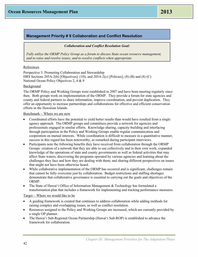
Chapter III: Management Priorities for The Adaptation Phase 42
Ocean Resources Management Plan 2013
Collaboration and Conflict Resolution Goal: Fully utilize the ORMP Policy Group as a forum to discuss State ocean resource management, and to raise and resolve issues, and to resolve conflicts when appropriate.
Management Priority # 9 Collaboration and Conflict Resolution
References Perspective 3: Promoting Collaboration and Stewardship HRS Sections 205A-2(b) [Objectives]: (10); and 205A-2(c) [Policies]; (8) (B) and (8) (C) National Ocean Policy Objectives 2, 4 & 9 Background The ORMP Policy and Working Groups were established in 2007 and have been meeting regularly since then. Both groups work on implementation of the ORMP. They provide a forum for state agencies and county and federal partners to share information, improve coordination, and prevent duplication. They offer an opportunity to increase partnerships and collaborations for effective and efficient conservation efforts in the Hawaiian Islands. Benchmark Where we are now Coordinated efforts have the potential to yield better results than would have resulted from a single
agency approach. The ORMP groups and committees provide a network for agencies and professionals engaged in similar efforts. Knowledge sharing, capacity-building and interfacing through participation in the Policy and Working Groups enable regular communication and cooperation on mutual interests. While coordination is difficult to measure in a quantitative manner, success in this regard has been noteworthy, as remarked during participant interviews.
Participants note the following benefits they have received from collaboration through the ORMP Groups: creation of a network that they are able to use collectively and in their own work; expanded knowledge of the operations of state and county governments as well as federal activities that may affect State waters; discovering the programs operated by various agencies and learning about the challenges they face and how they are dealing with them; and sharing different perspectives on issues that might not have been otherwise heard.
While collaborative implementation of the ORMP has occurred and is significant, challenges remain that cannot be fully overcome just by collaboration. Budget restrictions and staffing shortages demonstrate that collaborative governance is essential to carrying out the goals and objectives of the ORMP.
The State of Hawai‘i Office of Information Management & Technology has formulated a transformation plan that includes a framework for implementing and tracking performance measures.
Target Where we would like to be A guiding framework is created that continues to address collaboration while adding methods for
raising complex and overlapping issues, as well as conflict resolution. Resources assigned to the Policy and Working Groups are increased, which are currently provided by
a single OP planner. The Hawai‘i Sub-Regional Ocean Partnership (Hawai‘i Sub-ROP) is established to advance the
framework for collaboration.

Chapter III: Management Priorities for The Adaptation Phase 43
Ocean Resources Management Plan 2013
Example Actions to Accomplish the Collaboration and Conflict Resolution Goal Following completion of the 2013 ORMP, the Policy Group meets more regularly, bi-monthly or
quarterly, to work toward implementation of the Adaptation Phase Management Priorities. Policy Group and Working Group develop baseline for metrics and track progress on the
Management Priorities and ORMP implementation. Move the ORMP Policy and Working Groups towards a formalized Hawai‘i Sub-ROP. Through meetings of the Policy Group, examine various governance models with the goal of
developing a collaborative governance framework for the Policy Group, and eventually of the Hawai‘i Sub-ROP.
Metrics – Indicator Measures Work with the State of Hawai‘i Office of Information Management & Technology to create a state
performance measures website for the ORMP metrics (OP-CZM) Increase in number and range of issues handled by ORMP Policy Group and/or Hawai‘i Sub-ROP
(OP-CZM) Increase in number of Management Priority issues that receive state funding and where needed,
legislative attention (OP-CZM) Increase in number of obstacles to ORMP implementation identified and resolved by Sub-ROP (OP-
CZM)
Agencies Lead Agency: OP-CZM Other State and County Agencies: DLNR, DOH, DOA, DOT, SCD, OHA, County planning departments,
Board of Water Supply (BWS) Partners: MACZAC, PacIOOS, UH Sea Grant College Program, UH SOEST, UH ICAP, National Marine
Sanctuary, PMNM, USACE, U.S. Navy, USCG, NOAA, EPA, TNC

Chapter III: Management Priorities for The Adaptation Phase 44
Ocean Resources Management Plan 2013
Community and Place-Based Ocean Management Projects Goals: Goal A: Advance community level eco-based, place-based ocean management projects currently in place. Goal B: When funding becomes available, assist in the creation of additional community level eco-based, place-based ocean management projects. Goal C: Partner with communities to better manage Hawaii’s marine resources.
Management Priority #10 Community and Place-Based Ocean Management Projects
References Perspective 3: Promoting Collaboration and Stewardship HRS Sections 205A-2(b) [Objectives]: (8); and 205A-2(c) [Policies]: (8) (A) HRS Sections 188-22.6-22.9 National Ocean Policy Objective 6 Background During the Demonstration Phase a variety of place-based initiatives and models for integrated government and community emerged. Many projects involve active involvement of community members who worked to restore part of an ecosystem and began to monitor and watch that ecosystem. As projects continue forward and results are seen, they attract additional interest and resources. Benchmark Where we are now The Demonstration Phase yielded over a dozen examples of place-based community projects and
stewardship: OP-CZM financially supported and provided technical assistance to the following projects that are outlined in Appendix E: Heʻeia Kea (Oʻahu), Ala Wai Watershed Project (O‘ahu), Hanalei (Kauaʻi), Honuʻapo Estuary (Hawaiʻi Island), Hilo Bay (Hawaiʻi Island), Puʻu O Umi Natural Reserve and Kohala Natural Reserve (Hawaiʻi Island), Maunalua Bay (Oʻahu), West Maui Ridge to Reef Initiative, and West Maui Watershed (Maui). Lessons learned from communities could be posted as references for others.
The agencies recognize that in areas where people still use traditional practices, there are frequent conflicts, especially over access.
Modern day application of ahupuaʻa management is no longer strictly practiced, although there are attempts at restoring this practice in several locations. Conversations about restoring this practice began in earnest with the WPRFMC puwalu series, which was initiated statewide in August 2006. These workshops focused on engaging the Native Hawaiian community in a dialogue to inform the WPRFMC Fisheries Ecosystem Management Plans for Hawaiʻi.
Target Where we would like to be Established place-based projects are supported to continue their work in ocean resource management.
Where applicable, they are assisted in navigating the permit process associated with their restoration efforts, and in developing BMPs for restoration work through information and expertise sharing.
Additional projects are identified by working with the community and supported in their efforts. Example Actions to Accomplish the Community and Place-Based Ocean Management Projects Goals OP Annual Reports are sent to the Legislature and posted on OP website. OP updates its website with community-based efforts and outcomes, including funding opportunities
for community groups.
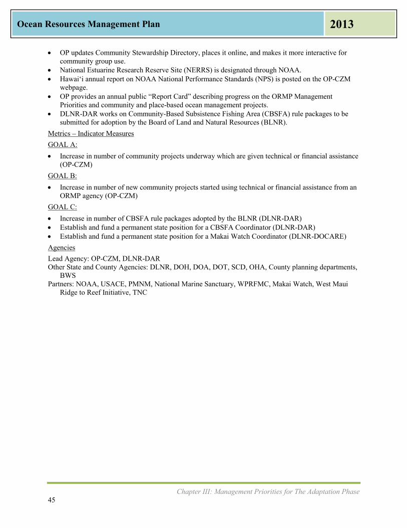
Chapter III: Management Priorities for The Adaptation Phase 45
Ocean Resources Management Plan 2013
OP updates Community Stewardship Directory, places it online, and makes it more interactive for community group use.
National Estuarine Research Reserve Site (NERRS) is designated through NOAA. Hawai‘i annual report on NOAA National Performance Standards (NPS) is posted on the OP-CZM
webpage. OP provides an annual public “Report Card” describing progress on the ORMP Management
Priorities and community and place-based ocean management projects. DLNR-DAR works on Community-Based Subsistence Fishing Area (CBSFA) rule packages to be
submitted for adoption by the Board of Land and Natural Resources (BLNR). Metrics – Indicator Measures GOAL A: Increase in number of community projects underway which are given technical or financial assistance
(OP-CZM) GOAL B: Increase in number of new community projects started using technical or financial assistance from an
ORMP agency (OP-CZM) GOAL C: Increase in number of CBSFA rule packages adopted by the BLNR (DLNR-DAR) Establish and fund a permanent state position for a CBSFA Coordinator (DLNR-DAR) Establish and fund a permanent state position for a Makai Watch Coordinator (DLNR-DOCARE) Agencies Lead Agency: OP-CZM, DLNR-DAR Other State and County Agencies: DLNR, DOH, DOA, DOT, SCD, OHA, County planning departments,
BWS Partners: NOAA, USACE, PMNM, National Marine Sanctuary, WPRFMC, Makai Watch, West Maui
Ridge to Reef Initiative, TNC

Chapter III: Management Priorities for The Adaptation Phase 46
Ocean Resources Management Plan 2013
National Ocean Policy and Pacific Regional Ocean Initiatives Goals: Goal A: Contribute to the Pacific Regional Priorities for Pacific Regional Ocean Partnership, which include, but are not limited to, climate change adaptation and the support of Coastal and Marine Spatial Planning. Goal B: Formalize Hawai‘i Sub-Regional Ocean Partnership using existing partnerships and focus on ORMP implementation. Goal C: Through the Regional Planning Body, establish a coastal and marine spatial plan to be used throughout the Pacific Region.
Management Priority # 11 National Ocean Policy and Pacific Regional Ocean Initiatives
References Perspective 3: Promoting Collaboration and Stewardship HRS Sections 205A-2(b) [Objectives]: (1), (2), (4), (7), (8), and (9); and 205A-2(c) [Policies]: (9) (D), (9) (E), and 10 (E) National Ocean Policy Objectives 1, 2, 4, 5 & 9 Background The National Ocean Policy (NOP) was created in 2010 by President’s Executive Order 13547, which was based on the Final Recommendations of the Interagency Ocean Policy Task Force (IOPTF). The NOP creates a framework for collaboration to enhance the country’s ability to maintain healthy, resilient, and sustainable oceans, coast and Great Lakes resources. The framework developed calls for nine regional planning bodies (RPB). Hawai‘i is a member of the Pacific Island Regional Planning Body (PIRPB). The framework also supports regional ocean partnership initiatives. The State is a member of the Pacific Regional Ocean Partnership (PROP) and is recognized as a sub-region of the Pacific Islands Region. The ORMP is the sub-region's resource management plan. One objective of the NOP is to improve spatial information on the condition of the oceans. This information is meant to aid the development of public policy and decision making. The goal of the PIRPB is to complete a coastal and marine spatial plan for the Pacific Islands Region. The state also desires to develop a coastal and marine spatial tool, a mapping tool that is GIS based and tied to the state’s GIS system. In the long term, the State will develop a coastal and marine plan for Hawai‘i. Benchmark Where we are now PROP was formed in 2012 and a Memorandum of Agreement (MOA) to formalize working
relationships was signed in August 2012. Members include: State of Hawaiʻi, Commonwealth of the Northern Mariana Islands (CNMI), Guam, and American Samoa. The PROP highlights the importance of gathering rights, cultural sensitivities, and unique island geographies in the management of ocean resources.
The State of Hawaiʻi currently convenes two inter-agency (federal, state, and county) groups for the purposes of coordinating ocean resource management. These groups formed in 2007 and are referred to as the ORMP Policy and Working Groups. These groups have been meeting regularly (Policy Group, twice a year; Working Group, monthly) since their creation. Both groups have partnered to accomplish a number of items, most recently developing a framework for climate change adaptation, which led to the passage of Act 286 in 2012 - the State's Climate Change Adaptation Policy. This

Chapter III: Management Priorities for The Adaptation Phase 47
Ocean Resources Management Plan 2013
policy adds climate change adaptation as a priority guideline to Part III of the Hawaii State Planning Act, HRS Chapter 226.
DOH is working on developing Administrative Rules for the greenhouse gas bill. The State of Hawaiʻi has initiated a project to establish the Hawaiʻi Sub-ROP. Once formalized, the
Hawaiʻi Sub-ROP will strengthen the partnerships created by the ORMP Policy and Working Groups. The group will also examine possible collaborative governance structures that the Hawaiʻi Sub-ROP will adopt. It is anticipated that the Hawaiʻi Sub-ROP will be established by June 2014.
The PIRPB, along with the other eight regional planning bodies nationwide, was formed to address coastal and marine spatial planning at a regional level. The State of Hawaiʻi, represented by OP and DLNR, is a member of the PIRPB, which was officially established in April 2013.
Target Where we would like to be Regional priorities are coordinated with and contribute to PROP objectives. Hawai‘i Sub-ROP formalizes and provides structure to existing partnerships. A coastal and marine spatial tool within the State of Hawai‘i, for use by state and county agencies and
the public, is operational. A coastal and marine plan for the State of Hawaiʻi (similar to Oregon's Territorial Sea Plan or Rhode
Island's Special Area Management Plan (SAMP)) is developed. Example Actions to Accomplish the National Ocean Policy and Pacific Regional Ocean Initiatives Goals Hawai‘i contributes to the development of a PROP Action Plan to advance PROP initiatives. Schedule Hawai‘i Sub-ROP meetings and prepare agendas for 2013. Establish Hawai‘i Sub-ROP as a mechanism for ORMP implementation. Hawai‘i contributes to the PIRPB draft charter, work plan, and actions. Hawai‘i collaborates with PIRPB and PROP development of a coastal and marine spatial planning
tool for the Pacific Islands Region. Hawai‘i develops a state coastal and marine GIS tool. Hawai‘i develops a coastal and marine plan utilizing the state coastal and marine GIS tool. PacIOOS provides data services. Metrics – Indicator Measures (OP-CZM) GOAL A: Increase in number of issues raised and information exchanged at PROP meetings Completion of a PROP Action Plan that contains regional priorities relevant to Hawai‘i Increase in number of collaborative initiatives undertaken by the PROP that are coordinated with
Hawai‘i Hawai‘i participation in the implementation of PROP regional priorities GOAL B: High attendance rates of state agencies at meetings of the Hawai‘i Sub-ROP each year Increase in number of ORMP implementation projects sanctioned and initiated by Sub-ROP Increase in number of work plans developed for the eleven management priorities Increase in number of collaborative initiatives undertaken at Sub-ROP Increase in number of meetings of the RPB attended by Hawai‘i representation Drafting of the RPB charter and work plan GOAL C: Hawaiʻi coastal and marine spatial GIS tool developed Number of times Hawaiʻi coastal and marine spatial GIS tool used for decision making by state and
county agencies

Chapter III: Management Priorities for The Adaptation Phase 48
Ocean Resources Management Plan 2013
Agencies Agencies Involved in the PIRPB Agencies Involved in the PROP Agencies Involved in ORMP Policy
and Working Groups Federal: U.S. Dept. of Commerce/NOAA Joint Chiefs of Staff (U.S. Navy) U.S. Dept. of Defense/USMC U.S. Dept. of Agriculture/NRCS U.S. Dept. of Homeland
Security/USCG U.S. Environmental Protection
Agency U.S. Dept. of Transportation/Maritime
Administration U.S. Dept. of Interior/USFWS Non-Federal: Territory of American Samoa Commonwealth of the Northern
Mariana Islands Territory of Guam State of Hawai‘i (represented by OP
and DLNR) WPRFMC
State of Hawai‘i (represented by OP and DLNR)
Territory of American Samoa Commonwealth of the Northern
Mariana Islands Territory of Guam
OP-CZM DLNR DOH DOA DOE DOT DPS SCD OHA County planning departments BWS MACZAC PacIOOS UH Sea Grant College Program UH SOEST UH ICAP National Marine Sanctuary PMNM USACE U.S. Navy USCG NOAA EPA TNC

Chapter III: Management Priorities for The Adaptation Phase 49
Ocean Resources Management Plan 2013
Management Priorities Summary Matrix The following matrix of Management Priorities, Goals, Involved Agencies, and Metrics may be used as a guide for the eleven ORMP Management Priorities.
Management Priority Goal(s)
Lead State Agency
Other State and County Agencies
Partners Metrics
1 Appropriate Coastal Development Goal A: Adoption of county plans which specify guidance on coastal development. Goal B: Strengthen and integrate data management to ensure appropriate coastal development. Goal C: Expand options to protect existing developments from further coastal erosion.
OP-CZM County planning departments,
DLNR-OCCL, DOT (Harbors, Airports, and Highways),
DOH
FEMA/NFIP, UH Sea Grant
College Program, PacIOOS,
UH SOEST Coastal Geology Group, NOAA OCRM,
NOAA PSC
GOAL A: Increase in number of additional
shoreline access (OP-CZM) Increase in number of counties
implementing planning practices that include adaptation strategies when planning for coastal areas (OP-CZM)
Increase in number of state agencies implementing capital improvement plan projects that include adaptation strategies for coastal areas (OP-CZM) GOAL B:
Layers added to the statewide GIS that address coastal measures (OP GIS) GOAL C:
Number of projects reviewed by OP during land use entitlement process that include coastal impact risk assessments(OP-CZM)
Number of projects reviewed by DOH during land use entitlement process that include coastal impact risk assessments (DOH)
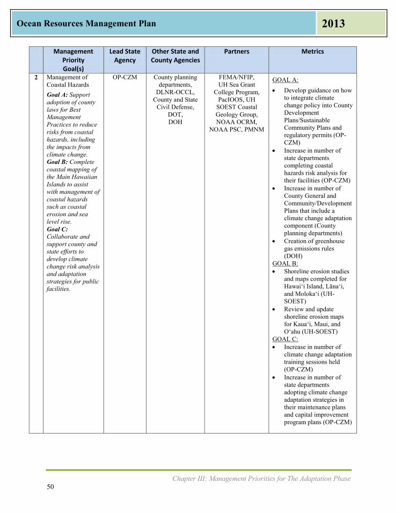
Chapter III: Management Priorities for The Adaptation Phase 50
Ocean Resources Management Plan 2013
Management Priority Goal(s)
Lead State Agency
Other State and County Agencies
Partners Metrics
2 Management of Coastal Hazards Goal A: Support adoption of county laws for Best Management Practices to reduce risks from coastal hazards, including the impacts from climate change. Goal B: Complete coastal mapping of the Main Hawaiian Islands to assist with management of coastal hazards such as coastal erosion and sea level rise. Goal C: Collaborate and support county and state efforts to develop climate change risk analysis and adaptation strategies for public facilities.
OP-CZM County planning departments,
DLNR-OCCL, County and State
Civil Defense, DOT, DOH
FEMA/NFIP, UH Sea Grant
College Program, PacIOOS, UH
SOEST Coastal Geology Group, NOAA OCRM,
NOAA PSC, PMNM
GOAL A: Develop guidance on how
to integrate climate change policy into County Development Plans/Sustainable Community Plans and regulatory permits (OP-CZM)
Increase in number of state departments completing coastal hazards risk analysis for their facilities (OP-CZM)
Increase in number of County General and Community/Development Plans that include a climate change adaptation component (County planning departments)
Creation of greenhouse gas emissions rules (DOH)
GOAL B: Shoreline erosion studies
and maps completed for Hawai‘i Island, Lāna‘i, and Moloka‘i (UH-SOEST)
Review and update shoreline erosion maps for Kaua‘i, Maui, and O‘ahu (UH-SOEST)
GOAL C: Increase in number of
climate change adaptation training sessions held (OP-CZM)
Increase in number of state departments adopting climate change adaptation strategies in their maintenance plans and capital improvement program plans (OP-CZM)
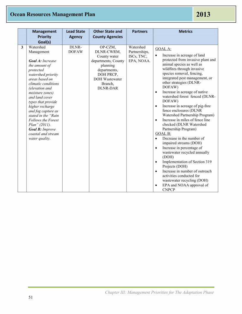
Chapter III: Management Priorities for The Adaptation Phase 51
Ocean Resources Management Plan 2013
Management Priority Goal(s)
Lead State Agency
Other State and County Agencies
Partners Metrics
3 Watershed Management Goal A: Increase the amount of protected watershed priority areas based on climatic conditions (elevation and moisture zones) and land cover types that provide higher recharge and fog capture as stated in the “Rain Follows the Forest Plan” (2011). Goal B: Improve coastal and stream water quality.
DLNR-DOFAW
OP-CZM, DLNR-CWRM,
County water departments, County
planning departments, DOH PRCP,
DOH Wastewater Branch,
DLNR-DAR
Watershed Partnerships, ISCs, TNC, EPA, NOAA.
GOAL A: Increase in acreage of land
protected from invasive plant and animal species as well as wildfires through invasive species removal, fencing, integrated pest management, or other strategies (DLNR-DOFAW)
Increase in acreage of native watershed forest fenced (DLNR-DOFAW)
Increase in acreage of pig-free fence enclosures (DLNR Watershed Partnership Program)
Increase in miles of fence line checked (DLNR Watershed Partnership Program)
GOAL B: Decrease in the number of
impaired streams (DOH) Increase in percentage of
wastewater recycled annually (DOH)
Implementation of Section 319 Projects (DOH)
Increase in number of outreach activities conducted for wastewater recycling (DOH)
EPA and NOAA approval of CNPCP

Chapter III: Management Priorities for The Adaptation Phase 52
Ocean Resources Management Plan 2013
Management Priority Goal(s)
Lead State
Agency
Other State and County
Agencies
Partners Metrics
4 Marine Resources Goal A: Promote protection, and sustainable use of marine resources. Goal B: Reduce and remove accumulated marine debris on all islands and shores. Goal C: Minimize the spread of aquatic invasive species from bays where there is coral or water quality degradation. Goal D: Minimize the likelihood of aquatic invasive species introductions and spread into and within Hawai‘i from sources associated with vessels. Goal E: Promote fishing practices that increase fish stocks.
DLNR-DAR
DOH, DOT-Harbors,
Kaho‘olawe Island Reserve Commission,
DLNR-DOCARE,
DLNR-DOBOR,
County Public Works and
Environmental Services
Departments
USCG, USFWS, EPA, NOAA, Bishop Museum, TNC, UH, PacIOOS,
National Marine
Sanctuary, PMNM,
WPRFMC, MACZAC,
Agency members of the
Hawai‘i Interagency
Marine Debris Working Group
, Community Work Day
Program on Maui, and
Trilogy, which operates on
Maui, Lāna‘i, and Moloka‘i
GOAL A: Increase in number of educational workshops
and programs conducted on marine debris for state and county agencies (OP-CZM)
Increase in number of Makai Watch Trainings provided to community groups (DLNR-DAR)
GOAL B: Increase in number of community marine
debris clean ups (Hawai‘i Interagency Marine Debris Group, including DLNR and DOH)
Decrease in number of abandoned and derelict vessels (DLNR-DOBOR)
Number of enforcement actions taken by DOH Solid and Hazardous Waste Branch for illegal dumping in state waters (DOH)
Increase in number of educational workshops held by DOH Compliance Assistance Office for public (DOH)
Number of JTMD items tracked, assessed for contamination, and disposed (NOAA)
GOAL C: Increase number of urchins introduced to
control invasive algae (DLNR-DAR) Increase in number of pounds of invasive
algae removed (DLNR-DAR) A permanent state position for the AIS
Program is established, funded, and filled (DLNR-DAR)
GOAL D: Increase in number of ballast water reports
processed (DLNR-DAR) Rules for managing biofouling on vessels are
developed and adopted (DLNR-DAR) Ongoing funding is created for the Ballast
Water and Hull Fouling Prevention Program (DLNR)
GOAL E: Increase in percent compliance with
commercial fisheries reporting requirements (DLNR-DAR)
Increase in number of enforcement officers assigned exclusively to enforce fishing rules (DLNR-DOCARE)
Increase in number of targeted reef fish species that show an increase in size and/or abundance on at least one island (DLNR-DAR)

Chapter III: Management Priorities for The Adaptation Phase 53
Ocean Resources Management Plan 2013
Management
Priority Goal(s)
Lead State
Agency
Other State and County
Agencies
Partners Metrics
5 Coral Reef Goal A: Improve the health and productivity of coral reef ecosystems at priority sites identified by the Hawaii Coral Reef Program. Goal B: Implement place-based projects that demonstrate effective stewardship practices that can be applied to other areas. Goal C: Implement an effective day-use moorings program that minimizes impacts to coral reef ecosystems and user conflicts.
DLNR-DAR
DLNR-DOCARE,
DLNR-DOBOR, DOT-Harbors,
DOH
USACE, Hawai‘i Coral Reef Working
Group, National Marine
Sanctuary, PMNM,
TNC, NOAA CRCP,
USDA/NRCS, HTA, Coral
Reef Alliance
GOAL A: Decrease in number of impaired coastal
waters listed (DOH) Decrease in number of shoreline postings
due to sewage or other water pollution (DOH)
GOAL B: Increase in number of projects or BMPs
implemented and evaluated at priority coral reef sites (DLNR-DAR)
GOAL C: Day use mooring program funded and
implemented in consultation with communities (DLNR-DOBOR)
Increase in percent of day use moorings maintained and managed by the State (DLNR-DOBOR)
Increase in number of classes/educational efforts completed to educate boaters on day use moorings and the importance of mooring maintenance (DLNR-DOBOR)

Chapter III: Management Priorities for The Adaptation Phase 54
Ocean Resources Management Plan 2013
Management Priority Goal(s)
Lead State Agencies
Other State and County
Agencies
Partners Metrics
6 Ocean Economy Goal A: Develop aquaculture standards, based on current scientific data, to support culturally, environmentally, and economically sustainable operations which increase production for local consumption. Goal B: Encourage use of ocean-based energy to contribute towards achieving Hawai‘i Clean Energy Initiative while balancing the need to protect ocean resources. Goal C: Ensure a healthy shipping industry that uses ocean and coastal resources sustainably. Goal D: Ensure a healthy tourism industry that uses ocean and coastal resources sustainably.
DOA Aquaculture Development
Program, DOH, OP-CZM,
DOT-Harbors, DBEDT-
Energy Office
OP, DLNR, OHA
NELHA, NMFS,
National Marine Sanctuary, WPRFMC, Coral Reef Alliance, Hawai‘i
Ecotourism Association,
HTA
GOAL A: Increase in pounds of
commercially raised fish sold (DOA)
Increase in dollar value of commercially raised fish (DOA)
Increase in number of viable classified shellfish growing waters (DOH)
Increase in number of permitted commercial shellfish operators (DOH)
Increase in number of pounds of shellfish sold to local markets/restaurants in Hawai‘i (DOH)
Increase in number of pounds of shellfish exported out of state (DOH)
GOAL B: Increase in percentage of
alternate energy coming from ocean sources, as measured in megawatt-hours (DBEDT-Energy Office)
GOAL C: Increase in tons of cargo
arriving at Hawai‘i ports, until ports reach full capacity (DOT-Harbors)
GOAL D: Improved beach water quality
monitoring data (DOH) Increase in number of hotels
with recognized sustainability certifications or program affiliations (DBEDT-Energy Office-Hawai‘i Green Business Program)
Increase in number of tour operators who are recognized as Dolphin SMART (DLNR)

Chapter III: Management Priorities for The Adaptation Phase 55
Ocean Resources Management Plan 2013
Management Priority Goal(s)
Lead State Agency
Other State and County Agencies
Partners Metrics
7 Cultural Heritage of the Ocean Goal A: Preserve cultural heritage of the ocean and protect Native Hawaiian rights for access and gathering in ocean and on coastline, and protect ocean and coastal resources upon which Native Hawaiian cultural practices depend. Goal B: Support restoration of Hawaiian fishponds through permitting, community projects, and technical assistance.
DLNR-OCCL
OP, DOA Aquaculture Development
Program, DOH, DLNR,
OHA
USACE, NOAA, National Marine
Sanctuary, PMNM,
Community Groups
GOAL A: Increase in number of moorings for
Native Hawaiian canoes that are operated exclusively for educational purposes (DLNR-DOBOR)
GOAL B: Decrease in average number of months
to obtain all permits necessary for fishpond restoration (DLNR-OCCL and DOH)
Increase in number of fishpond restoration projects given technical assistance and support for permitting processes (OP-CZM)

Chapter III: Management Priorities for The Adaptation Phase 56
Ocean Resources Management Plan 2013
Management Priority Goal(s)
Lead State
Agency
Other State and County Agencies
Partners Metrics
8 Training, Education, and Awareness Goal A: Develop training curriculum, at the fundamental and advanced levels, for state and county agency staff as well as boards and commissions working on ocean and coastal protection and begin annual training. Goal B: Partner to expand existing citizen stewardship awareness and active engagement curriculum for widespread dissemination through various community outlets.
OP-CZM DLNR, DOH
MACZAC, PacIOOS,
UH Sea Grant College Program, National Marine
Sanctuary, PMNM, HTA, Coral Reef
Alliance, TNC
GOAL A: Curricula on fundamentals of ocean
resource management on advanced environmental science is developed (OP-CZM)
Increase in number of agency employees attending environmental science training (OP-CZM)
GOAL B: Increase in number of community
outreach and awareness events held and/or participants reached (OP-CZM, DLNR-DAR, and National Marine Sanctuary)
Inclusion of Hawai‘i marine resource module as part of required boater education certification requirement (DLNR-DOBOR)

Chapter III: Management Priorities for The Adaptation Phase 57
Ocean Resources Management Plan 2013
Management Priority Goal(s)
Lead State
Agency
Other State and County
Agencies
Partners Metrics
9 Collaboration and Conflict Resolution Goal: Fully utilize the ORMP Policy Group as a forum to discuss State ocean resource management, and to raise and resolve issues, and to resolve conflicts when appropriate.
OP-CZM DLNR, DOH, DOA, DOT, SCD, OHA,
County planning departments,
BWS
MACZAC, PacIOOS, UH
Sea Grant College
Program, UH SOEST, UH
ICAP, National Marine
Sanctuary, PMNM,
USACE, U.S. Navy, USCG, NOAA, EPA,
TNC
Work with the State of Hawai‘i Office of Information Management & Technology to create a state performance measures website for the ORMP metrics (OP-CZM)
Increase in number and range of issues handled by ORMP Policy Group and/or Hawai‘i Sub-ROP (OP-CZM)
Increase in number of Management Priority issues that receive state funding and where needed, legislative attention (OP-CZM)
Increase in number of obstacles to ORMP implementation identified and resolved by Sub-ROP (OP-CZM)
Management Priority Goal(s)
Lead State
Agency
Other State and County
Agencies
Partners Metrics
10 Community and Place-Based Ocean Management Projects Goal A: Advance community level eco-based, place-based ocean management projects currently in place. Goal B: When funding becomes available, assist in the creation of additional community level eco-based, place-based ocean management projects. Goal C: Partner with communities to better manage Hawaii’s marine resources.
OP-CZM, DLNR-DAR
DLNR, DOH, DOA, DOT, SCD, OHA,
County planning departments,
BWS
NOAA, USACE, PMNM,
National Marine Sanctuary
WPRFMC, Makai Watch,
West Maui Ridge to Reef
Initiative, TNC
GOAL A: Increase in number of community projects
underway which are given technical or financial assistance (OP-CZM)
GOAL B: Increase in number of new community
projects started using technical or financial assistance from an ORMP agency (OP-CZM)
GOAL C: Increase in number of Community-Based
Subsistence Fishing Area (CBSFA) rule packages adopted by the BLNR (DLNR-DAR)
Establish and fund a permanent state position for a CBSFA Coordinator (DLNR-DAR)
Establish and fund a permanent state position for a Makai Watch Coordinator (DLNR-DOCARE)
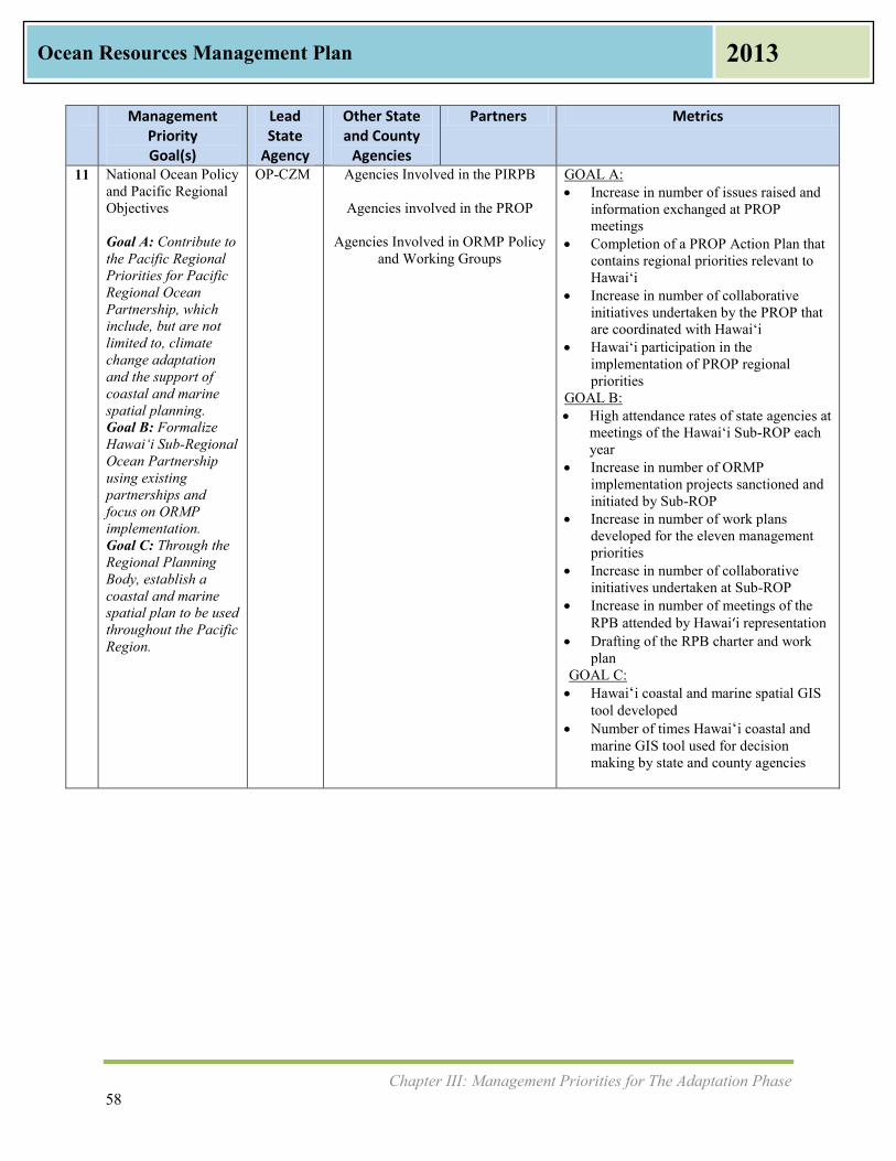
Chapter III: Management Priorities for The Adaptation Phase 58
Ocean Resources Management Plan 2013
Management Priority Goal(s)
Lead State
Agency
Other State and County
Agencies
Partners Metrics
11 National Ocean Policy and Pacific Regional Objectives Goal A: Contribute to the Pacific Regional Priorities for Pacific Regional Ocean Partnership, which include, but are not limited to, climate change adaptation and the support of coastal and marine spatial planning. Goal B: Formalize Hawai‘i Sub-Regional Ocean Partnership using existing partnerships and focus on ORMP implementation. Goal C: Through the Regional Planning Body, establish a coastal and marine spatial plan to be used throughout the Pacific Region.
OP-CZM Agencies Involved in the PIRPB
Agencies involved in the PROP
Agencies Involved in ORMP Policy and Working Groups
GOAL A: Increase in number of issues raised and
information exchanged at PROP meetings
Completion of a PROP Action Plan that contains regional priorities relevant to Hawai‘i
Increase in number of collaborative initiatives undertaken by the PROP that are coordinated with Hawai‘i
Hawai‘i participation in the implementation of PROP regional priorities
GOAL B: High attendance rates of state agencies at
meetings of the Hawai‘i Sub-ROP each year
Increase in number of ORMP implementation projects sanctioned and initiated by Sub-ROP
Increase in number of work plans developed for the eleven management priorities
Increase in number of collaborative initiatives undertaken at Sub-ROP
Increase in number of meetings of the RPB attended by Hawai‘i representation
Drafting of the RPB charter and work plan
GOAL C: Hawaiʻi coastal and marine spatial GIS
tool developed Number of times Hawaiʻi coastal and
marine GIS tool used for decision making by state and county agencies

Chapter IV: Integrated and Coordinated Approach to Management of Ocean Resources 59
Ocean Resources Management Plan 2013
IV. Integrated and Coordinated Approach to Management of Ocean Resources
Introduction This chapter discusses multiple approaches to the management of ocean resources, underscoring the importance of integration and coordination. Management approaches covered include:
• ORMP Governance Framework • The National Ocean Policy Framework • Current Framework for Traditional Resource Management • Marine Management Areas and Sanctuaries • Community Place-Based Management
In Hawai‘i, many government agencies and authorities participate in the management of ocean and coastal resources. While there are overlaps in interest, each governmental agency has its own roles and responsibilities. The Office of Planning, Coastal Zone Management Program (OP-CZM) recently issued Sustainable Management of the Islands (December 2011), which describes the network of resource agencies for coastal zone management and ocean resource protection. Agencies involved in ocean resource and coastal zone management are shown in Appendix D at the end of this plan. State agency and partner coordination is achieved through the ORMP Policy Group and Working Group and with an advisory group, Marine & Coastal Zone Advocacy Council (MACZAC). MACZAC is composed of twelve advisory members who are recruited statewide and who have diverse backgrounds in business, environment, Native Hawaiian practices, terrestrial and marine commerce, recreation, research, and tourism. The National Ocean Policy (NOP) is new since the 2006 ORMP. The National Priority Objectives can be found in Chapter I and later in this chapter. The NOP calls for a framework for implementation including the Pacific Regional Ocean Partnership (PROP) and the Hawai‘i Sub-Regional Ocean Partnership (Hawai‘i Sub-ROP). These are both in the initial stages of formation, and the value of this new framework is just starting to be explored. Ocean Resource Management includes entities conducting science and research. Several schools and divisions within the University of Hawai‘i system are involved with scientific and research activities in a number of fields. These schools and their science and research are listed in Appendix E. Place-based management involves government and the community working in alliance. Appendix F lists several recent community and place-based ocean management projects. Appendix G provides selective resources and references for community organizations seeking funding and further involvement as stewards of the ocean.
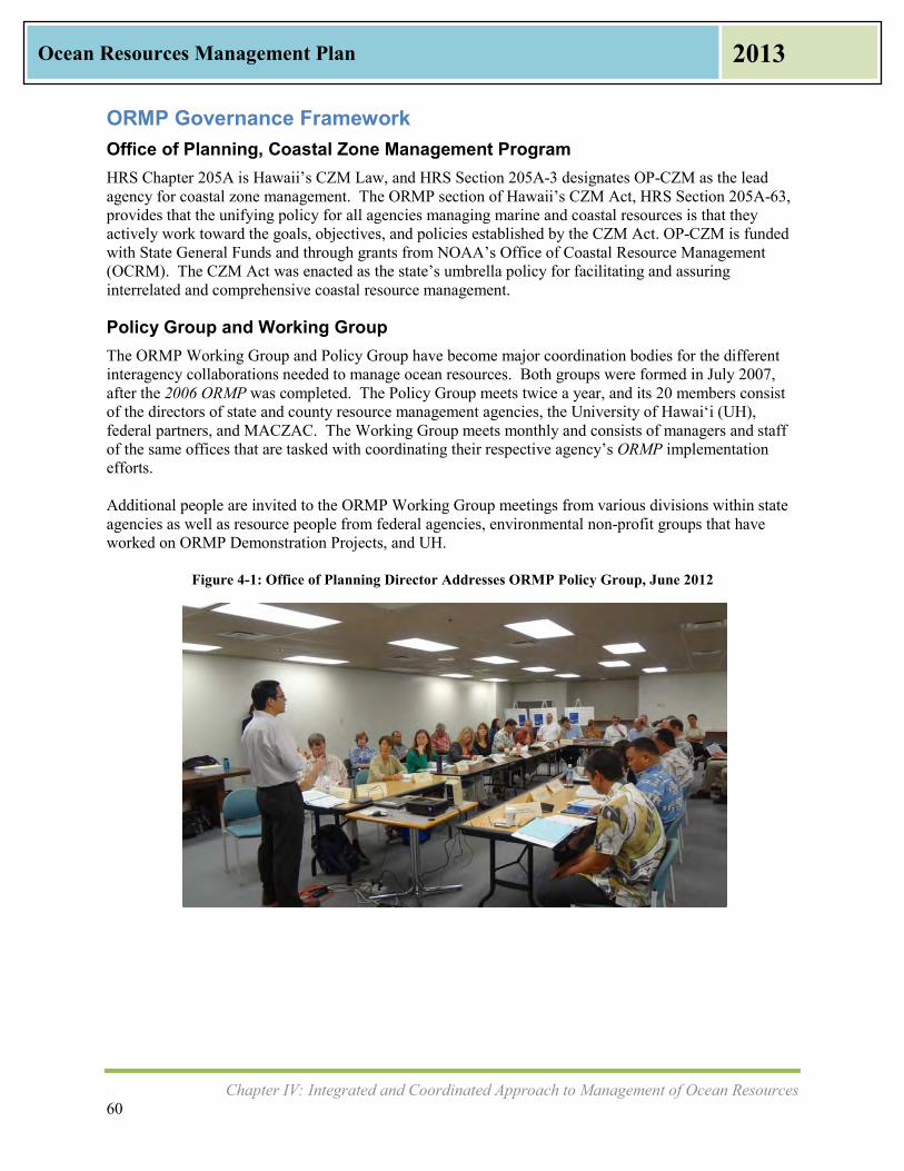
Chapter IV: Integrated and Coordinated Approach to Management of Ocean Resources 60
Ocean Resources Management Plan 2013
ORMP Governance Framework Office of Planning, Coastal Zone Management Program HRS Chapter 205A is Hawaii’s CZM Law, and HRS Section 205A-3 designates OP-CZM as the lead agency for coastal zone management. The ORMP section of Hawaii’s CZM Act, HRS Section 205A-63, provides that the unifying policy for all agencies managing marine and coastal resources is that they actively work toward the goals, objectives, and policies established by the CZM Act. OP-CZM is funded with State General Funds and through grants from NOAA’s Office of Coastal Resource Management (OCRM). The CZM Act was enacted as the state’s umbrella policy for facilitating and assuring interrelated and comprehensive coastal resource management.
Policy Group and Working Group The ORMP Working Group and Policy Group have become major coordination bodies for the different interagency collaborations needed to manage ocean resources. Both groups were formed in July 2007, after the 2006 ORMP was completed. The Policy Group meets twice a year, and its 20 members consist of the directors of state and county resource management agencies, the University of Hawai‘i (UH), federal partners, and MACZAC. The Working Group meets monthly and consists of managers and staff of the same offices that are tasked with coordinating their respective agency’s ORMP implementation efforts. Additional people are invited to the ORMP Working Group meetings from various divisions within state agencies as well as resource people from federal agencies, environmental non-profit groups that have worked on ORMP Demonstration Projects, and UH.
Figure 4-1: Office of Planning Director Addresses ORMP Policy Group, June 2012

Chapter IV: Integrated and Coordinated Approach to Management of Ocean Resources 61
Ocean Resources Management Plan 2013
Figure 4-2: ORMP Working Group Discussion, July 2012
The full list of agencies and groups represented and participating in the ORMP groups to date are: Federal Partners include NOAA Office of National Marine Sanctuaries, Pacific Islands Region (ONMS); NOAA Office of Ocean & Coastal Resource Management (OCRM); NOAA Pacific Services Center (PSC); United States Army Corps of Engineers (USACE); United States Coast Guard (USCG); United States Navy, and United States Environmental Protection Agency (EPA). State Partners include State of Hawai‘i Departments of Agriculture (DOA), Civil Defense (SCD), Health (DOH), Land & Natural Resources (DLNR), Transportation (DOT), and Office of Hawaiian Affairs (OHA). University Partners include University of Hawai‘i, School of Ocean & Earth Science & Technology (SOEST); University of Hawai‘i, Sea Grant College Program (UH Sea Grant); University of Hawai‘i Sea Grant College Program, Center for Island Climate Adaptation & Policy (ICAP); and Pacific Islands Ocean Observing System (PacIOOS). County Partners include City and County of Honolulu, Department of Planning and Permitting (DPP); County of Hawai‘i, Planning Department; County of Kaua‘i, Department of Planning; County of Maui, Department of Planning; and Honolulu Board of Water Supply (BWS). Community Partners include the Marine & Coastal Zone Advocacy Council (MACZAC).
Marine & Coastal Zone Advocacy Council In 2001, the State Legislature passed Act 169, which became HRS Section 205A-3.5. This law clarifies OP’s responsibility to maintain a public advisory body, named the Marine & Coastal Zone Advocacy Council (MACZAC), and defines its membership. The twelve MACZAC members are advisory to OP, are recruited from the islands of Kaua‘i, O‘ahu, Maui, Moloka‘i, Lāna‘i, and Hawai‘i, and have diverse professional and community backgrounds. MACZAC’s mission statement is, “Advocate for a comprehensive management system which restores, preserves, and protects Hawaii’s marine and coastal environment.” The MACZAC meets quarterly. They have worked on mapping coastal parking access; provided recommendations regarding shoreline certification, commercial boating regulations, and harbor facilities; discussed integrated ocean resource management, cultural resources management, coastal water quality, coastal carrying capacity, and marine managed areas; and have provided advice to OP on regulatory review, legislative advocacy, public

Chapter IV: Integrated and Coordinated Approach to Management of Ocean Resources 62
Ocean Resources Management Plan 2013
National Ocean Policy Vision
“To achieve an America whose stewardship ensures that the ocean, our coasts, and the Great Lakes are healthy and resilient, safe and productive, and understood and treasured so as to promote the well-being, prosperity, and security of present and future generations.”
education and outreach. MACZAC has reached out to community and user groups including the Ocean Tourism Coalition, Maui Visitors and Convention Bureau, and the Maui Hotel and Lodging Association.
National Ocean Policy Framework The U.S. Commission on Ocean Policy (USCOP) published An Ocean Blueprint for the 21st Century in 2004, identifying needed actions for coastal and ocean areas. A key recommendation was to create a strong role for states in the management of their coasts and oceans and provide opportunities for them to contribute to an integrated national policy. Towards that end, the USCOP recommended creation of regional ocean councils “to help coordinate federal, state, tribal, and local planning and action.” Another key recommendation was to create a National Ocean Council (NOC), which would be a multiagency body to create an integrated national ocean policy. The NOC should “provide high-level attention to ocean and coastal issues, develop appropriate national policies, and coordinate their implementation by the many federal departments and agencies with ocean and coastal responsibilities.” The Interagency Ocean Policy Task Force (IOPTF) was established in 2009, and it is comprised of senior-level officials from 24 executive departments, agencies, and offices across the federal government. The IOPTF is led by the Chair of the Council on Environmental Quality (CEQ). The mission of the IOPTF is to develop recommendations to enhance national stewardship of the ocean, coasts, and Great Lakes, and promote their long-term conservation and use. Six years after the USCOP recommendation, the NOC and the National Ocean Policy (NOP) were established in July 2010 by the President’s Executive Order 12547 “to ensure the protection, maintenance, and restoration of the health of ocean, coastal, and Great Lakes ecosystems and resources, enhance the sustainability of ocean and coastal economies, preserve our maritime heritage, support sustainable uses and access, provide for adaptive management to enhance our understanding of and capacity to respond to climate change and ocean acidification, and coordinate with our national security and foreign policy interests.” The NOP was established based on the Final Recommendations of the Interagency Ocean Policy Task Force (2010). This groundbreaking policy provides the framework for federal agencies to work together to pursue the NOP’s Vision while engaging the states, native people, local authorities, regional governance structures, non-governmental organizations, the public, and the private sector. Such a broad framework for federal ocean resources policy collaboration has never been done before. The Final Recommendations contain nine National Priority Objectives that call for adoption of ecosystem-based management; implementation of coastal and marine spatial planning (CMSP); inform decisions and improve understanding; and increased coordination and support to address resiliency and adaptation to climate change and ocean acidification, regional ecosystem protection and restoration, water quality and sustainability on land, and ocean and coastal observations, mapping, and infrastructure. The eleven ORMP Management Priorities are closely related to these objectives.

Chapter IV: Integrated and Coordinated Approach to Management of Ocean Resources 63
Ocean Resources Management Plan 2013
National Priority Objectives HOW WE DO BUSINESS
1. Ecosystem-Based Management: Adopt ecosystem-based management as a foundational principle for the comprehensive management of the ocean, our coasts, and the Great Lakes.
2. Coastal and Marine Spatial Planning: Implement comprehensive, integrated, ecosystem-based coastal and marine spatial planning and management in the United States.
3. Inform Decisions and Improve Understanding: Increase knowledge to continually inform and improve management and policy decisions and the capacity to respond to change and challenges. Better educate the public through formal and informal programs about the ocean, our coasts, and the Great Lakes.
4. Coordinate and Support: Better coordinate and support federal, state, tribal, local, and regional management of the ocean, our coasts, and the Great Lakes. Improve coordination and integration across the Federal Government and, as appropriate, engage with the international community.
AREAS OF SPECIAL EMPHASIS
5. Resiliency and Adaptation to Climate Change and Ocean Acidification: Strengthen resiliency of coastal communities and marine and Great Lakes environments and their abilities to adapt to climate change impacts and ocean acidification.
6. Regional Ecosystem Protection and Restoration: Establish and implement an integrated
ecosystem protection and restoration strategy that is science-based and aligns conservation and restoration goals at the federal, state, tribal, local, and regional levels.
7. Water Quality and Sustainable Practices on Land: Enhance water quality in the ocean, along our coasts, and in the Great Lakes by promoting and implementing sustainable practices on land.
8. Changing Conditions in the Arctic: Address environmental stewardship needs in the Arctic Ocean and adjacent coastal areas in the face of climate-induced and other environmental changes.
9. Ocean, Coastal, and Great Lakes Observations, Mapping and Infrastructure: Strengthen and integrate federal and non-federal ocean observing systems, sensors, data collection platforms, data management, and mapping capabilities into a national system and integrate that system into international observation efforts.
Source: Final Recommendations of the Interagency Ocean Policy Task Force (2010)
The Final Recommendations include developing coastal and marine spatial planning (CMSP) as a comprehensive, integrated, and regionally-based tool for planning and managing coastal and marine uses. It established nine regional planning bodies to develop the coastal and marine spatial plans. The Pacific Islands Regional Planning Body (PIRPB) was officially established in April 2013. The intent of the

Chapter IV: Integrated and Coordinated Approach to Management of Ocean Resources 64
Ocean Resources Management Plan 2013
PIRPB is to develop a coastal and marine spatial plan that includes sub-plans for Hawaii and the territories of the Pacific Islands region. Regional Planning Body (RPB) membership consists of authorities relevant to CMSP for that area. Hawai‘i has two representatives to the PIRPB: OP and DLNR. The National Ocean Council’s National Ocean Policy Implementation Plan (Implementation Plan) (April 2013) describes the actions the Federal Government will take to improve ocean and coastal ecosystem health. The recommendations of the Implementation Plan are viewed as opportunities for the ORMP to contribute toward and build upon at a state level. The Implementation Plan includes federal actions to strengthen existing regional ocean governance partnerships and establish new partnerships. These partnerships share regional priorities and often include non-governmental agencies. The existing ORMP Policy and Working Group will serve as a sub-regional ocean governance partnership. The Hawai‘i Sub-Regional Ocean Partnership (Hawai‘i Sub-ROP) encompasses all islands in the Hawaiian chain and is discussed later in this chapter. In addition, Hawaiʻi, American Samoa, Guam, and the Commonwealth of the Northern Mariana Islands (CNMI) have formed a larger Pacific Regional Ocean Partnership (PROP), formalized in August 2012. The Hawai‘i representative to the PROP is the Governor’s office, who has delegated authority to the OP and the DLNR Chair.
Pacific Regional Ocean Partnership The Pacific Regional Ocean Partnership (PROP) is a voluntary partnership between the Governors of the U.S. Pacific Islands Region, and consists of the State of Hawai‘i, and the Territories of the CNMI and Guam, and American Samoa. Unlike most of the other regional ocean partnerships, this region does not share physical boundaries. A Governor’s Agreement to formalize the working relationships between the four jurisdictions in the PROP was signed on August 22, 2012 by Governor Neil Abercrombie and the governors of American Samoa, CNMI, and Guam. The mission of the PROP is to “assist the U.S. Pacific Islands Region Governors of American Samoa, CNMI, Guam, and Hawai‘i to identify coastal and ocean management priorities that require a coordinated regional response and increased collaboration to effectively address these issues.” The actions of the PROP will complement, and take advantage of, other ongoing regional efforts while respecting individual state policy making requirements. While just formed in the summer of 2012, the structure will include an Executive Group, a Steering Group, Action Coordination Teams, and Supporting Partners. The PROP will help to implement the NOP, using the National Ocean Policy Implementation Plan (April 2013) as a resource for action, being mindful of the traditional gathering rights, cultural sensitivities, and unique geographic considerations. The Implementation Plan is guided by four themes: 1) adopt ecosystem-based management; 2) obtain, use, and share the best science and data; (3) promote efficiency and collaboration; and 4) strengthen regional efforts.
Hawai‘i Sub-Regional Ocean Partnership The Office of Planning received funding from NOAA to support the existing ORMP partnerships. In November 2012, the OP hired a coordinator to formalize the Hawai‘i Sub-Regional Ocean Partnership

Chapter IV: Integrated and Coordinated Approach to Management of Ocean Resources 65
Ocean Resources Management Plan 2013
(Hawai‘i Sub-ROP). The Hawai‘i Sub-ROP is intended to support the implementation of the ORMP in the State of Hawai‘i and organize state resources behind shared management objectives. The OP anticipates that the formalized partnership will include many, if not all, of the ORMP partners. The ORMP partners met in January 2013 in a joint Policy and Working Group to discuss the progress of the updated ORMP and development of the Hawai‘i Sub-ROP. The Hawai‘i Sub-ROP encompasses the Main Hawaiian Islands as well as the Northwestern Hawaiian Islands, a span of 1,523 miles. This area includes the 12 nautical mile Territorial Sea and the 200 nautical mile Exclusive Economic Zone (EEZ). The ocean area covered by the Hawai‘i Sub-ROP includes waters under the jurisdiction of state and federal agencies. The State of Hawai‘i waters are defined as any shores or water between the three nautical mile limit and the mean high tide mark on the shores of the islands of the State of Hawai‘i, and enforcement in this area is the responsibility of the DLNR-DOCARE. Federal waters under the jurisdiction of the United States are patrolled by the USCG up to the U.S. EEZ, which is any water within 200 nautical miles of shore. The Hawai‘i Sub-ROP is meant to ensure meaningful engagement and coordination of partners and the public through natural and cultural resource management processes in Hawai‘i, with the goals and objectives of the ORMP forming the basis. It will also ensure consistency with federal objectives. While many engaged stakeholders and informal partnerships have formed as a result of implementing the ORMP, a major objective of the Hawai‘i Sub-ROP is to formalize these partnerships. ORMPstakeholders who manage and protect Hawaii’s coastal and ocean resources are members of the ORMP Policy and Working Groups. Additional stakeholder groups such as coastal communities, recreational users, Native Hawaiian cultural practitioners, tourists and commercial interests will also have opportunities to participate in the Hawai‘i Sub-ROP.
Coastal and Marine Spatial Planning Coastal and marine spatial planning (CMSP) is one of the National Priority Objectives. CMSP is defined as “a comprehensive adaptive, integrated, ecosystem-based, and transparent planning process, based on sound science, for analyzing current and anticipated uses of the ocean and coastal…areas.” CMSP for the Pacific Islands Region is expected to help inform policies and guide management decisions from the various agencies involved in the coastal and marine environment, including but not limited to the Office of Planning, DLNR, and the U.S. Department of Interior, U.S. Department of Defense, and NOAA (for purposes of the ORMP, Territorial agencies were excluded from this list). For example, CMSP can help guide permitting for offshore renewable energy and offshore aquaculture, as well as identify which areas should or should not be closed to certain uses such as fishing, shipping, or recreation. CMSP provides an avenue by which agencies can coordinate to help mitigate conflict in the coastal and ocean areas. CMSP provides “a public policy process for society to better determine how the ocean and coasts…are sustainably used and protected – now and in future generations” (Final Recommendations of the Interagency Ocean Policy Task Force). In Hawai‘i, CMSP will be an important part of collaborative management. The CMSP plan that will be developed by PIRPB will be built on the extensive and widely used GIS, as well as best scientific data available (some of which will not be spatially-based in a GIS format). Best scientific data will include current oceanographic conditions, habitat data, human use data, and jurisdictional boundaries, as well as predicted future conditions due to sea level rise, ocean acidification, and other climate variables. The OP houses the metadata for GIS for the State of Hawai‘i, and adding the metadata for the state’s coastlines and up to 3 miles out into the ocean is a natural expansion of its GIS capabilities. Other GIS mapping

Chapter IV: Integrated and Coordinated Approach to Management of Ocean Resources 66
Ocean Resources Management Plan 2013
platforms also exist, such as PacIOOS Voyager, which also includes data to 200 nautical miles and current ocean observations. An integral part of CMSP will be a robust online information management system that allows easy access to and transparency of data and information necessary for planning, and mechanisms for frequent stakeholder and public input. CMSP is a useful public policy tool that can be used to coordinate across multiple sectors and jurisdictions. Examples might include enhancing public beach access; improving ocean user compatibility and reducing user conflicts; reducing environmental impacts to the ocean; supporting sustainable, safe, secure, efficient and productive uses of the ocean; and enhancing collaboration. An example of CMSP is the Rhode Island Special Area Management Plan (SAMP) that helps agencies coordinate actions in their ocean and coastal zones by providing biophysical information as well as human use information, and detailing agencies involved in the multiple activities. The impetus for designing the Rhode Island SAMP was offshore renewable energy development. CMSP enabled fishermen to define important areas for their fishing, utility companies to detail where cables were laid, and the U.S. Department of Defense to delineate their shipping lanes. Now renewable energy companies have an idea about where renewable energy can be sited without creating user conflict.
Current Framework for Traditional Resource Management Natural resources were managed traditionally in Hawai‘i using kuleana (responsibility) principles, assigned at the ahupua‘a and moku levels. An ahupuaʻa is a unit of land, which contains a mostly self-sufficient amount of natural resources necessary for all of its tenants to survive and thrive. Native Hawaiians marked these land divisions, which normally follow existing contours of land and begin in the mountains, mauka, and end in the ocean, makai. Several ahupuaʻa adjoining one another were delineated as a moku. Like the ahupuaʻa, the moku varied in size. The kapu system governed codes of conduct, social rules, and resource management, making certain actions kapu or forbidden. Hawaiian fishing was regulated through this kapu system in order to maintain its long-term viability. Certain fish were kapu during times of spawning or low fish counts. Designated fishing areas were also kapu during certain times when overfishing could damage the ecosystem. A konohiki, or manager, would be the enforcer of the kapu system.
‘Aha Moku Resource Management Modern day application of ahupuaʻa management is no longer strictly practiced, although there are attempts at restoring this practice in several locations. Conversations about restoring this practice began in earnest with the WPRFMC puwalu series, which was initiated statewide in August 2006. These workshops focused on engaging the Native Hawaiian community in a dialogue to inform the WPRFMC Fisheries Ecosystem Management Plans for Hawaiʻi. Ahupuaʻa management was practiced by ‘Aha Councils, which were composed of a diverse group of practitioners and acknowledged experts in agriculture, fishing, water resources, and cultural skills who lived within each ahupua‘a and served together as the governing board.

Chapter IV: Integrated and Coordinated Approach to Management of Ocean Resources 67
Ocean Resources Management Plan 2013
Key Hawaiian Terms Sources: (1) HRS Section 226-2 (2) Pukui/Elbert Dictionary, 2003, University of Hawai‘i Press (3) Act 288, SLH 2012 (4) HRS Section 5-7.5
‘Aha Moku Council—Diverse group of practitioners from a moku serving as an advisory board. (4) Ahupuaʻa—in Hawai‘i, a subdivision of the land. Normally, it extends like a slice of the island from the mountains to the ocean so that resources from both the uplands and the sea are available to the inhabitants. Ahupuaʻa boundaries often divide along natural features such as mountain lines or streams. Ahupuaʻa management is Hawaiian culture embracing both resource protection and behavioral management, which ensures respect for the air, land, water, and other scarce natural resources that make life sustainable from the mountains to the sea. Adapted from (1) Kai—sea, sea water; area near the sea, seaside, lowlands; tide, current in the sea. (2) Kanaka Maoli—means Native Hawaiians. The indigenous people of the Hawaiian Islands or their descendants, which may be pure or part Native Hawaiian. (1) Kapu—taboo, prohibited, forbidden, sacred, holy, consecrated; no trespassing, keep out. (2) Keiki—child, offspring, descendant, progeny, youngster. (2) Ko‘a—fishing grounds, usually identified by lining up with marks on shore. (2) Konohiki—headman of an ahupuaʻa land division under the chief, land or fishing rights under control of the konohiki. (2) Kumu wai—source of a stream, spring, could also be source of wealth. (2) Lo‘i—irrigated terrace, especially for taro. (2) Kuleana—A right or privilege, which entails responsibility. May also mean title, business, property, jurisdiction, authority, liability, interest, claim, ownership, tenure, affair, or province. (2) Lokahi—meaning unity, to be expressed in harmony. (2) Makai—towards the sea; in the direction of the sea; seaward; of the lowland. (2) Mālama —to take care of, tend, care for, preserve, protect, maintain. (2) Mauka— towards the mountain; inland; upland; shoreward (if at sea); shore, uplands. (2) Moku—district, island, islet, section, fragment. (2) (3) ‘Ohana Fishing—fishing for consumption by family; ‘ohana is defined as family. (2) Pa‘akai—salt harvested from the ocean. (2) Pono—proper, righteous, upright, just, doing the right thing. (2) Wai—fresh water. (2)
Act 288, Session Laws of Hawai‘i (SLH) 2012, sets forth an ‘Aha Moku Advisory Committee within the DLNR. The ‘Aha Moku Advisory Committee will consist of eight members appointed by the governor and confirmed by the State Senate from a list of nominations submitted by the ‘Aha Moku Councils on each of the eight Main Hawaiian Islands. Ni‘ihau, Kaua‘i, O‘ahu, Moloka‘i, Lāna‘i, Kaho‘olawe, Maui, and Hawai‘i Island are each represented by one committee member. Act 288 states that the ‘Aha Moku Advisory Committee may provide advice to the chairperson of the Board of Land and Natural Resources (BLNR) on issues related to land and natural resources management such as:
• Integration of indigenous resource management practices with western practices in each moku;
• Identification of a comprehensive set of indigenous practices for natural resource management;
• Foster understanding of Native Hawaiian resource knowledge;
• Sustain the state’s marine, land, cultural, agricultural, and natural resources;
• Provide community education and foster cultural awareness on benefits of the ‘Aha Moku system;
Chapter IV: Integrated and Coordinated Approach to Management of Ocean Resources 68
Ocean Resources Management Plan 2013
• Foster protection and conservation of the state’s natural resources; and • Develop an administrative structure to oversee the ‘Aha Moku system.
Act 288 recognizes 43 moku around the state. Prior to the formation of the ‘Aha Moku Advisory Committee within DLNR, the ‘Aha Kiole Advisory Committee held several statewide meetings and submitted reports to the State Legislature on their findings on best practices and structure for the management of natural and cultural resources in Hawai‘i. The ‘Aha Kiole had one representative from each of the eight Main Hawaiian Islands, but they are not necessarily the same eight people to be appointed by the Governor to the newly formed ‘Aha Moku Advisory Committee in DLNR. During the Public Listening Sessions (PLS) for this ORMP Update, community members gave input on what modern day ahupuaʻa management means to them. An ahupuaʻa encompasses a “slice” of land from the mountains to the sea, and the Native Hawaiian view is that the entire land division is integrated. People spoke of kumuwai, which means both the source of wealth as well as the source of a stream, and in this instance the source comes from the rain above to the tip of the mountain, traveling through the ahupuaʻa as a stream to the ocean. There is a reverence and acknowledgement that all is connected and that it is a higher power’s will that brings all water from its starting point in the heavens above to the ocean that surrounds the islands. Managing an ahupuaʻa, while similar to the term conservation, incorporates sustainability principles. The loʻi that feeds poi to the people of an ahupuaʻa also functions as a place where non-point source sedimentation occurs, slowing down the flow of water so that it can recharge the water table below the soil. Community members expressed a need to feed their community, especially the kupuna (elders) and keiki (children) who were unable to catch or grow food for themselves. They saw traditional ahupuaʻa land management as a way to ensure food for now and sustain it for the future. A community working together can plant and maintain loʻi, reconstruct their shoreline Native Hawaiian fishponds, gather their own paʻakai (salt), and keep their stream inflows to ensure a recharging of water in the entire water cycle. Many felt that they could do this without waiting for government assistance and without a statewide plan to tell them how to manage their own land. Others were organized for their entire island’s natural resources, such as on Moloka‘i, and wanted the ‘Aha Moku system to be mandatory.
Framework for Marine Managed Areas Since Statehood in 1959, the Hawai‘i State Government has assumed most of the functions once performed by the konohiki. Place-based management refers to designating appropriate uses for a particular geographic area to reduce user conflicts and protect the area from some or all preventable harm. Place-based management of ocean areas can take many forms. Marine Managed Areas (MMA) are one form of place-based management. There are also other forms of this type of resource management. This will take different forms on each island, and even in each community. There are seven types of MMAs. These are the responsibility of DLNR, alone or in partnership.
1) Marine Life Conservation Districts 2) Fishery Management Areas 3) Bottomfish Restricted Fishing Areas 4) Wildlife Sanctuaries/Research Refuges 5) Natural Area Reserves 6) Hawaiian Islands Humpback Whale National Marine Sanctuary (co-managed with NOAA) 7) Papahānaumokuākea Marine National Monument (co-managed with NOAA, U.S. Fish and
Wildlife Service (USFWS), and OHA)

Chapter IV: Integrated and Coordinated Approach to Management of Ocean Resources 69
Ocean Resources Management Plan 2013
MLCD in Hawai‘i O‘ahu Hanauma Bay Pupukea Waikīkī Hawai‘i Island Kealakekua Bay Lapakahi Old Kona Airport Waialea Bay Waiopae Tidepools Maui County Honolua-Mokuleʻia Bay Manele Hulopoʻe Molokini Shoal Source: DLNR-DAR
A map of Marine Managed Areas is shown below as Figure 4-3.
Figure 4-3: Marine Managed Areas in the State of Hawai‘i
Source: DLNR-DAR, Map by K.M., NOAA Fisheries
Marine Life Conservation Districts Marine Life Conservation Districts (MLCD) are designed to conserve and replenish marine resources, with limited fishing and other consumptive uses. This gives a protected area for fish and other aquatic life to grow and reproduce. There are 11 MLCD throughout the state as listed in the text box at right. The first MLCD designated in the state was Hanauma Bay in east O‘ahu.

Chapter IV: Integrated and Coordinated Approach to Management of Ocean Resources 70
Ocean Resources Management Plan 2013
Fishery Management Areas There are 21 Fishery Management Areas (FMAs) on the islands of Kaua‘i, O‘ahu, Moloka‘i, Lāna‘i, Maui, and Hawai‘i and an additional nine FMAs in west Hawai‘i. Each FMA has different permitted and prohibited activities with different “takes” and different fishing methodologies. In June 2013, the BLNR approved Hawaii Administrative Rules (HAR) for the West Hawai‘i Regional Fisheries Management Area (WHRFMA). Ten years of community discussions and several public hearings resulted in the implementation of these new rules. The DLNR Division of Aquatic Resources (DLNR-DAR) has posted the latest HAR on their website, which includes a spearfishing ban and a 40 species “white list.”
Bottomfish Restricted Fishing Areas Bottomfish Restricted Fishing Areas are defined by latitude and longitudes in twelve places throughout the state. There are seven fish covered, otherwise referred to as the “Deep 7,” and these include onaga, ehu, kalekale, ‘ōpakapaka, ukikiki, hapuʻupuʻu, and lehi. There are regulations for fishing, gear restrictions, commercial fisher reporting, minimum size, and non-commercial bag limits. The commercial fisheries for the Deep 7 open and close with a Western Pacific Regional Fishery Management Council (WPRFMC) established Annual Catch Limit, based on a fishing year from September to August of the following year. This management regime is a coordinated state and federal effort, where the state conducts the commercial trip reporting and the National Marine Fisheries Service (NMFS) conducts the non-commercial trip reporting.
Wildlife Sanctuaries/Research Refuges The Coconut Island Hawai‘i Marine Laboratory Refuge in Kāne‘ohe Bay and the Paiko Lagoon Wildlife Sanctuary in east Honolulu are both off the island of O‘ahu. UH uses the Hawai‘i Marine Laboratory Refuge for scientific studies, and it is illegal for anyone else to take any aquatic life from within the boundaries of the refuge. The Paiko Lagoon Wildlife Sanctuary does not allow taking of any aquatic life.
Natural Area Reserves for Oceans The Kaho‘olawe Island Reserve is managed by the Kaho‘olawe Island Reserve Commission (KIRC), which was placed within DLNR for administrative purposes. This includes the island of Kaho‘olawe and the marine waters two miles from its shore. The KIRC is responsible for the restoration of Kaho‘olawe, which was transferred to the State of Hawai‘i by the U.S. Navy after its use as a bombing range. There are no residents on Kaho‘olawe, and anyone visiting the island must be cleared by the KIRC. The ʻĀhihi-Kīnaʻu Natural Area Reserve (NAR) on the south shore of Maui is managed by DLNR Division of Forestry and Wildlife Natural Area Reserve System and was the first reserve in the State Natural Area Reserve System. This NAR is part of Makai Watch, which is a Community-Based Resource Management project. The Hawai‘i Wildlife Foundation partnered with DLNR through the Makai Watch program to restore and sustain this resource. It includes a marine protected area, which is home to a rich coral reef ecosystem and many protected species. Portions of the ʻĀhihi-Kīnaʻu NAR are closed until July 31, 2014, and access to the northern and most visited portions is allowed only during the daytime.
Hawaiian Islands Humpback Whale National Marine Sanctuary The Hawaiian Islands Humpback Whale National Marine Sanctuary (National Marine Sanctuary) is jointly managed in a cooperative partnership between NOAA and DLNR. The National Marine Sanctuary surrounds the waters around the island of Lāna‘i, parts of Moloka‘i, and Maui as one contiguous area. Non-contiguous areas include waters off the north shore of Kaua‘i, the southeast and
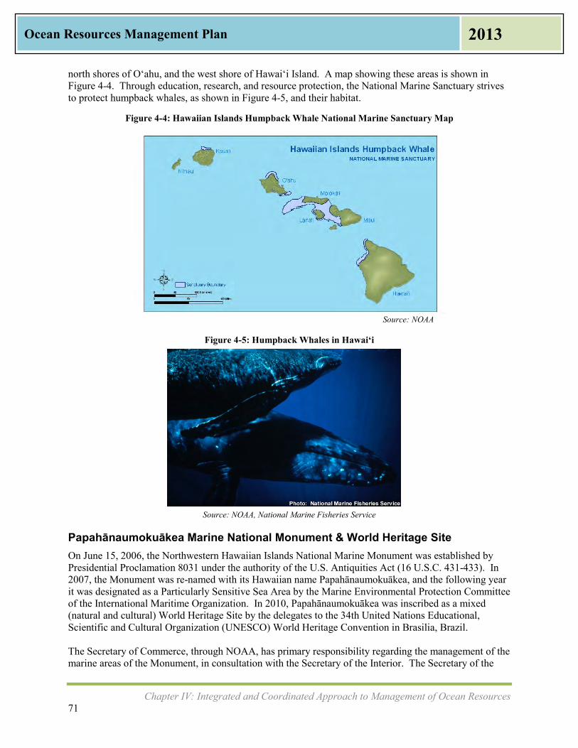
Chapter IV: Integrated and Coordinated Approach to Management of Ocean Resources 71
Ocean Resources Management Plan 2013
north shores of O‘ahu, and the west shore of Hawai‘i Island. A map showing these areas is shown in Figure 4-4. Through education, research, and resource protection, the National Marine Sanctuary strives to protect humpback whales, as shown in Figure 4-5, and their habitat.
Figure 4-4: Hawaiian Islands Humpback Whale National Marine Sanctuary Map
Source: NOAA
Figure 4-5: Humpback Whales in Hawai‘i
Source: NOAA, National Marine Fisheries Service
Papahānaumokuākea Marine National Monument & World Heritage Site On June 15, 2006, the Northwestern Hawaiian Islands National Marine Monument was established by Presidential Proclamation 8031 under the authority of the U.S. Antiquities Act (16 U.S.C. 431-433). In 2007, the Monument was re-named with its Hawaiian name Papahānaumokuākea, and the following year it was designated as a Particularly Sensitive Sea Area by the Marine Environmental Protection Committee of the International Maritime Organization. In 2010, Papahānaumokuākea was inscribed as a mixed (natural and cultural) World Heritage Site by the delegates to the 34th United Nations Educational, Scientific and Cultural Organization (UNESCO) World Heritage Convention in Brasilia, Brazil. The Secretary of Commerce, through NOAA, has primary responsibility regarding the management of the marine areas of the Monument, in consultation with the Secretary of the Interior. The Secretary of the

Chapter IV: Integrated and Coordinated Approach to Management of Ocean Resources 72
Ocean Resources Management Plan 2013
Interior, through the United States Fish and Wildlife Service (USFWS), has sole responsibility for the areas of the Monument that overlay the Midway Atoll National Wildlife Refuge, the Battle of Midway National Memorial, and the Hawaiian Islands National Wildlife Refuge, in consultation with the Secretary of Commerce. Nothing in the Proclamation diminishes or enlarges the jurisdiction of the State of Hawai‘i. The State of Hawai‘i has primary responsibility for managing the State waters of the Monument. The State of Hawai'i through DLNR has primary responsibility for the Kure Atoll portion of the Hawai‘i State Seabird Sanctuary. The State of Hawai‘i holds the State submerged and ceded lands of the Northwestern Hawaiian Islands in trust. DLNR will collaborate with OHA in the perpetuation of Hawaiian cultural resources in the Monument, including the customary and traditional rights and practices of Native Hawaiians exercised for subsistence, cultural, and religious purposes under the Constitution of the State of Hawai‘i, Article XII, Section 7. The 2006 Memorandum of Agreement (MOA 2006) establishing the PMNM was signed by three agency Co-Trustees agreeing to share responsibility for managing PMNM resources. These three agencies are the State of Hawai‘i, USFWS, and NOAA. Their senior representatives provide policy guidance to agency staff assigned to carry out Monument management activities. They also review and amend their joint MOA at least annually. The MOA 2006 establishes the Senior Executive Board (SEB) to provide policy guidance to their respective agency staff assigned to carry out Monument management activities. SEB members are senior level designees appointed by the Co-Trustees. The DLNR Chairperson represents the State of Hawai‘i on the SEB. The Monument Management Board (MMB) was established by MOA 2006 to coordinate management of the Monument at the field level. The seven members of the MMB are representatives from:
• Division of Aquatic Resources (DAR), DLNR • Division of Forestry & Wildlife (DOFAW), DLNR • National Wildlife Refuge System – Honolulu, USFWS • Pacific Islands Fish & Wildlife Office – Honolulu, USFWS • National Marine Sanctuary Program (ONMS) – Honolulu, NOAA • National Marine Fisheries Service (NMFS) – Honolulu, NOAA • Office of Hawaiian Affairs (OHA), State of Hawai‘i
Major MMB responsibilities include management planning; regular review of implementation; adjustments to management framework; shared enforcement; coordinated research and monitoring; information management; identification and protocols for sensitive, significant sites; manage public use; facilitate multi-sector partnerships; collaborative educational projects; resource sharing; monitoring Monument activities; coordinated response to threats; joint permitting; and US Coast Guard coordination. The Monument agencies together produced a Papahānaumokuākea Marine National Monument Management Plan (2008). This plan covers a 15 year horizon while meeting the planning requirements for USFWS, NOAA & State of Hawai‘i. The plan identifies six priority needs, which are addressed with 22 Action Plans for this geographic region.

Chapter IV: Integrated and Coordinated Approach to Management of Ocean Resources 73
Ocean Resources Management Plan 2013
There are several established conservation areas that are included within the PMNM, and each of these areas has a different agency managing it as shown in Table 4-1 below.
Table 4-1: PMNM Established Conservation Areas
State of Hawai‘i NOAA USFWS Kure State Wildlife Sanctuary NWHI Coral Reef Ecosystem
Reserve Hawaiian Islands National Wildlife Refuge
NWHI State Marine Refuge Midway Atoll National Wildlife Refuge/ Battle of Midway National Memorial
Numerous archaeological artifacts can be found on the islands of Nihoa and Mokumanamana, both of which are on the National and State Historical Register for Historic Places. Figure 4-6 at right is a photo from the Monument website, showing upright rock formations on the island of Mokumanamana, also known as Necker Island. A map of PMNM is shown in Figure 4-7. The map shows the Marine National Monument Boundary as well as State of Hawai‘i Waters, Special Preservation Areas, Ecological Reserves, and Special Management Areas.
Source: NOAA
Figure 4-7: Papahānaumokuākea Marine National Monument
Source: NOAA
Figure 4-6: Mokumanamana within Papahānaumokuākea
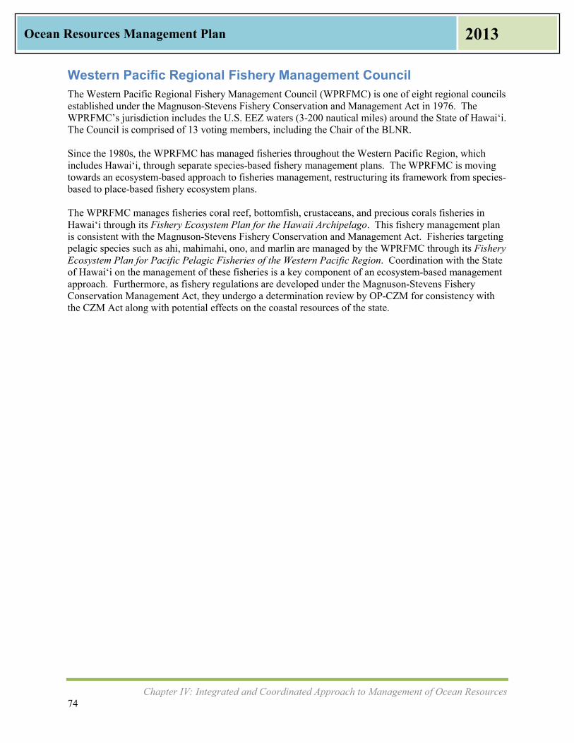
Chapter IV: Integrated and Coordinated Approach to Management of Ocean Resources 74
Ocean Resources Management Plan 2013
Western Pacific Regional Fishery Management Council The Western Pacific Regional Fishery Management Council (WPRFMC) is one of eight regional councils established under the Magnuson-Stevens Fishery Conservation and Management Act in 1976. The WPRFMC’s jurisdiction includes the U.S. EEZ waters (3-200 nautical miles) around the State of Hawai‘i. The Council is comprised of 13 voting members, including the Chair of the BLNR. Since the 1980s, the WPRFMC has managed fisheries throughout the Western Pacific Region, which includes Hawai‘i, through separate species-based fishery management plans. The WPRFMC is moving towards an ecosystem-based approach to fisheries management, restructuring its framework from species-based to place-based fishery ecosystem plans. The WPRFMC manages fisheries coral reef, bottomfish, crustaceans, and precious corals fisheries in Hawai‘i through its Fishery Ecosystem Plan for the Hawaii Archipelago. This fishery management plan is consistent with the Magnuson-Stevens Fishery Conservation and Management Act. Fisheries targeting pelagic species such as ahi, mahimahi, ono, and marlin are managed by the WPRFMC through its Fishery Ecosystem Plan for Pacific Pelagic Fisheries of the Western Pacific Region. Coordination with the State of Hawai‘i on the management of these fisheries is a key component of an ecosystem-based management approach. Furthermore, as fishery regulations are developed under the Magnuson-Stevens Fishery Conservation Management Act, they undergo a determination review by OP-CZM for consistency with the CZM Act along with potential effects on the coastal resources of the state.

References 75
Ocean Resources Management Plan 2013
References and Resources
References Cited in This Plan Abercrombie, Neil. A New Day in Hawaii Plan: A Comprehensive Plan. 2010. Alexandra, K., Cain, J., Iwasaki, P. Tsunami Education: A Blueprint for coastal communities. 2009. Barnett, Tim, Pierce, D.W., AchutaRao K., Gleckler, P. J., Santer, B.D. “Penetration of Human-Induced
Warming into the World’s Oceans.” Science, Vol. 309 (5732): 284-287. 2005. doi:10.1126/science. 1112418
Brammer, Christine and F. Langenberger, Eds. “State of the Sanctuary: Management Plan Review
Special Edition.” Koholā Connection: The Voice of the Hawaiian Islands Humpback Whale National Marine Sanctuary. Summer 2010.
Booz Allen Hamilton. NOAA Report on the Ocean and Great Lakes Economy of the United States:
ENOW Final Economic Report. Prepared for the NOAA Coastal Services Center. 2012. Cesar, H., van Beukering, P., Pintz, S., and Dierking, J. Economic valuation of Hawaiian reefs. Arnham,
The Netherlands: Cesar Environment Economics Consulting. 2002. Cox, G.W., Alien Species in North America and Hawai‘i: Impacts on Natural Ecosystems. 1999. Fletcher, C. H. Hawaii’s Changing Climate Briefing Sheet, 2010. University of Hawai‘i Sea Grant
College Program, Center for Island Climate Adaptation and Policy, School of Ocean and Earth Science and Technology. 2010.
Fletcher, C. H., Romine, B., Genz, A., Barbee, M., Dyer, M., Anderson, T., Chyn Lim, S., Vitousek, S.,
Bochicchio, C., and Richmond, B. National Assessment of Shoreline Change: Historical Shoreline Change in the Hawaiian Islands. U.S. Department of the Interior, U.S. Geological Survey. Reston, Virginia: 2012.
Friedlander, A. G. Aeby, R. Brainard, E. Brown, K. Chaston, A. Clark, P. McGowan, T. Montgomery, W.
Walsh, I. Williams, and W. Wiltse. “The State of Coral Reef Ecosystems of the Main Hawaiian Islands.” In The State of Coral Reef Ecosystems of the United States and Pacific Freely Associated States: 2008, edited by Waddell, J.E. and A.M. Clarke, 219-261. Silver Spring, MD: NOAA/NCCOS, 2008.
Honolulu Board of Water Supply. Koʻolau Loa Watershed Management Plan: O‘ahu Water
Management Plan. 2009. Loke, Matthew, Geslani, Cheryl, Takenaka, Brooks, and Leung, PingSun. An Overview of Seafood
Consumption and Supply Sources: Hawai‘i Versus U.S. University of Hawaii at Mānoa, College of Tropical Agriculture and Human Resources. March 2012.

References 76
Ocean Resources Management Plan 2013
Lowry, Kem, Hamnett, M., Anderson, C., and LeMaitre, M.A. 1998 Review of the Hawaii Ocean Resources Management Plan. Department of Business, Economic Development and Tourism, Office of Planning. 1998.
MACZAC Evaluation Working Group. Findings from the 2009 Evaluation Interviews. Department of
Business, Economic Development and Tourism, Office of Planning. 2009. Malama Kai Foundation, O’Hallorian, T., Bourdon, K. Hawai‘i Day-use Mooring Buoy 10 Year Strategic
Plan. Department of Land and Natural Resources. April 2010. Meehl, Gerald A. “How much more global warming and sea level rise?” Science, Vol. 307 (5716): 1769-
1772. 2005. National Ocean Council. National Ocean Policy Implementation Plan. April 2013. The Nature Conservancy, Hawai‘i Marine Program. Kahekili Conservation Action Plan Draft. Prepared
for Hawaii’s Division of Aquatic Resources, Department of Land and Natural Resources. 2013. The Nature Conservancy, Hawai‘i Marine Program. South Kohala Action Plan Final Report. Prepared
for Hawaii’s Division of Aquatic Resources, Department of Land and Natural Resources. September 2012.
Office of Hawaiian Affairs. 2010-1016 Strategic Plan. Office of Hawaiian Affairs. 2010. ORMP Policy and Working Groups and Office of Planning. Joint Ocean Resources Management Plan
(ORMP) Policy and Working Group: Appreciative Inquiry Strategic Planning Session. 2010. ORMP Working Group. Hawaii Ocean Resources Management Plan: Consolidated Work Plan July
2007- June 2009. 2008. ORMP Working Group and University of Hawai‘i Center for Island Climate Adaptation and Policy. A
Framework for Climate Change Adaptation in Hawai‘i. 2009. ‛Ōiwi, K. Māhuahua ‘Ai o Hoi He‘eia Wetland Restoration Plan: Strategic Plan 2012-2015. 2010. Papahānaumokuākea Marine National Monument. Papahānaumokuākea Marine National Monument
Management Plan. 2008. http://www.papahanaumokuakea.gov/management/mp.html Richmond, L., and A. Levine. Institutional analysis of community-based marine resource management
initiatives in Hawaii and American Samoa. U.S. Department of Commerce, NOAA Technical Memo, NOAA-TM-NMFS-PIFSC-35. 2012.
State of Hawai‘i. 2011 Annual Visitor Research Report. Hawai‘i Tourism Authority. 2012. State of Hawai‘i. COEMAP – The Coastal Erosion Management Plan for the State of Hawai‘i. Board of
Land and Natural Resources. Adopted by the Board of Land and Natural Resources, 2000. State of Hawai‘i. Division of Conservation and Resources Enforcement: Strategic Plan, 2009-2014.
Department of Land and Natural Resources, Division of Conservation and Resources Enforcement. 2008.

References 77
Ocean Resources Management Plan 2013
State of Hawai‘i. Fiscal Year 2009-2011 Office of Planning Report to the Twenty-Sixth Legislature, Regular Session of 2012. Department of Business, Economic Development and Tourism, Office of Planning, Hawai‘i Coastal Zone Management Program. 2011.
State of Hawai‘i. Hawai’i Coral Reef Strategy: Priorities for Management in the Main Hawaiian Islands
2010-2020. Department of Land and Natural Resources, Division of Aquatic Resources. 2010. State of Hawai‘i. Hawai‘i Facts & Figures. Department of Business, Economic Development &
Tourism. September 2011. State of Hawai‘i. Hawai‘i Farm Facts. Department of Agriculture, Aquaculture Division. October 2012. State of Hawai‘i. Hawai‘i Ocean Resources Management Plan. Department of Business, Economic
Development and Tourism, Office of Planning, Hawai‘i Coastal Zone Management Program. 2006. State of Hawai‘i. Hawaii Ocean Resources Management Plan: Technical Supplement. Department of
Business, Economic Development and Tourism, Hawaii Ocean and Marine Resources Council. 1991.
State of Hawai‘i. Hawai‘i Ocean Resources Management Plan 2010 Report to the Twenty-Sixth
Legislature, Regular Session of 2011. Department of Business, Economic Development and Tourism, Office of Planning, Hawai‘i Coastal Zone Management Program. 2010.
State of Hawai‘i. Hawaii Statewide Transportation Plan: Hawaii’s Multi-Modal and Inter-Modal
Network. Department of Transportation, Statewide Transportation Office. 2011. State of Hawai‘i. Hawai‘i Tourism Strategic Plan: 2005-2015. Hawai‘i Tourism Authority. 2005. State of Hawai‘i. Hawai‘i Watershed Guidance. Department of Business, Economic Development and
Tourism, Office of Planning, Hawai‘i Coastal Zone Management Program. 2010. State of Hawai‘i. Increased Food Security and Food Self-Sufficiency Strategy. Department of Business,
Economic Development and Tourism, Office of Planning. 2012. State of Hawai‘i. Orientation Packet: Hawaiʻi Ocean Resources Management Plan (ORMP) Policy and
Working Groups. Department of Business, Economic Development and Tourism, Office of Planning, Hawai‘i Coastal Zone Management Program. 2007
State of Hawai‘i. Report to the Twenty-Fourth State Legislature, State of Hawai‘i: Final Report on the
Incentive for Important Agricultural Lands, Act 183, SLH 2005. Department of Agriculture. 2007.
State of Hawai‘i. Permits and Regulatory Requirements for Aquaculture in Hawaii. Department of
Agriculture, Aquaculture and Livestock Support Services Program. 2011. State of Hawai‘i. Planning for Sustainable Tourism: Project Summary Report. Department of Business,
Economic Development and Tourism. 2006. State of Hawai‘i. Population and Economic Projections for the State of Hawaii to 2040 DBEDT 2040
Series. Department of Business, Economic Development and Tourism. 2012.

References 78
Ocean Resources Management Plan 2013
State of Hawai‘i. State of Hawai‘i Aquatic Invasive Species Management Plan. Department of Land and Natural Resources, Division of Aquatic Resources and The Nature Conservancy of Hawai‘i. 2003.
State of Hawai‘i. State of Hawai‘i Energy Resource Coordinator’s Annual Report 2011. Department of
Business, Economic Development and Tourism, Hawai‘i State Energy Office. 2011. State of Hawai‘i. State of Hawai‘i Multi-Hazard Mitigation Plan Update 2010. Hawai‘i State Civil
Defense. 2010. State of Hawai‘i. State of Hawai‘i Ocean Management Plan. Department of Planning and Economic
Development, Hawaii Coastal Zone Management Program. 1985. State of Hawai‘i. Sustainable Management of the Islands. Department of Business, Economic
Development and Tourism, Office of Planning, Hawai‘i Coastal Zone Management Program. 2011. State of Hawai‘i. The Hawaii State Plan: Agriculture. Honolulu, HI: Department of Agriculture. 1991. State of Hawai‘i. The Hawaii State Plan: Conservation Lands. Department of Land and Natural
Resources. 1991. State of Hawai‘i. The Hawai‘i State Plan: Recreation. Department of Land and Natural Resources.
1991. State of Hawai‘i. The Hawai‘i State Plan: Tourism. Department of Business, Economic Development
and Tourism. 1991. State of Hawai‘i. The Rain Follows the Forest: Hahai no ka ua i ka ululā. A Plan to Replenish Hawaii’s
Source of Water. Department of Land and Natural Resources. November 2011. State of Hawai‘i. The State of Hawai‘i Data Book 2011. Department of Business, Economic
Development and Tourism. 2012. State of Hawai‘i, Hawai‘i 2050 Sustainability Task Force. Hawai‘i 2050 Sustainability Plan. 2008. State of Hawai‘i. 2006 State of Hawai‘i Water Quality Monitoring and Assessment Report. Department of
Health, Safe Drinking Water Branch. 2008. Tian, Eugene, Mak, James, and Leung, PingSun. The Direct and Indirect Contributions of Tourism to
Regional GDP: Hawai‘i. University of Hawai‘i at Mānoa, UHERO. July 28, 2011. The White House Council on Environmental Quality. Final Recommendations of the Interagency Ocean
Policy Task Force. 2010. University of Hawai‘i Sea Grant College Program. UH Sea Grant Strategic Plan, 2009-2013. UH
School of Ocean and Science and Technology, UH Sea Grant. 2010. U.S. Bureau of the Census. Census of Population and Housing, 2010: Summary Hawai‘i. Washington:
The Bureau, 2010.
References 79
Ocean Resources Management Plan 2013
U.S. Department of Commerce. Case Studies from the 2012 PIRCA. National Oceanic and Atmospheric Administration, National Ocean Service, Coral Reef Conservation Program. 2012.
U.S. Department of Commerce. Final Evaluation Findings: Hawai‘i Coastal Zone Management
Program, September 2004 – July 2008. , National Oceanic and Atmospheric Administration, National Ocean Service, Office of Ocean and Coastal Resource Management. 2010.
U.S. Department of Commerce. Fisheries of the United States, 2011. National Oceanic and Atmospheric
Administration, National Marine Fisheries Service Office of Science and Technology. 2012. U.S. Department of Commerce. Marine Aquaculture Policy. National Oceanic and Atmospheric
Administration, National Marine Fisheries Service. 2011. U.S. Department of Commerce. Hawaiian Islands Humpback Whale National Marine Sanctuary
Management Plan Review: 2002 Management Plan Assessment. National Oceanic and Atmospheric Administration, Office of National Marine Sanctuaries. 2011.
U.S. Department of Commerce. Hawaiian Islands Humpback Whale National Marine Sanctuary
Management Plan Review: Public Scoping Report, Community Engagement in the Management Plan Review. National Oceanic and Atmospheric Administration, Office of National Marine Sanctuaries. 2011.
U.S. Department of Commerce. Hawai‘i Marine Debris Action Plan. National Oceanic and Atmospheric
Administration, Office of Response and Restoration, Marine Debris Program. 2010. U.S. Environmental Protection Agency. Handbook for Developing Watershed Plans to Restore and
Protect our Waters. EPA, Office of Water. March 2008. Western Pacific Regional Fishery Management Council. Fishery Ecosystem Plan for the Hawaii
Archipelago. 2009. Western Pacific Regional Fishery Management Council. Fishery Ecosystem Plan for Pacific Pelagic
Fisheries of the Western Pacific Region. 2008. Young, I.R., Zieger, S., Babanin, A.V. (2011). Global trends in wind speed and wave height. Science.
Published Online 24 March 2011. Science DOI: 10.1126/science.1197219. http://www.sciencemag.org/content/332/6028/451.abstract?sid=acdfca77‐ed06‐4153‐bb76‐fec9663a79b1

References 80
Ocean Resources Management Plan 2013
Website References Department of Agriculture. “Apple Snail.” Accessed October 2012. http://hawaii.gov/hdoa/pi/ppc/cm_as Department of Agriculture. “Open Ocean Fish Farming.” Accessed April 2013.
http://hdoa.hawaii.gov/ai/aquaculture-and-livestock-support-services-branch/open-ocean-fish-farming/
Department of Agriculture. “Important Agricultural Lands Update.” Accessed April 2013.
http://hdoa.hawaii.gov/chairpersons-office/new-agriculture-initiatives/important-ag-lands-ial/ Department of Land and Natural Resources, Division of Forestry and Wildlife. “Hawaii’s Most Invasive
Horticultural Plants: An Introduction.” Accessed October 2012. http://www.state.hi.us/dlnr/dofaw/hortweeds/
Department of Land and Natural Resources, Division of Aquatic Resources. “Getting Involved in Caring
for Hawaii’s Coastal Resources,” Accessed October 2012. http://coralreef.noaa.gov/education/educators/resourcecd/guides/resources/hi_resources_g.pd
Hanalei Watershed Hui. “Hanalei Watershed Hui.” Accessed October 2012.
www.hanaleiwatershedhui.org/ HANO: Hawai‘i Alliance of Nonprofit Organizations. “Links to Online Resources.” Accessed October
2012. http://hanohawaii.org/newhano/index.php?option=com_content&view=article&id=57&Itemid=207/
Harold K.L. Castle Foundation. “Resources for Grant Seekers.” Accessed October 2012.
http://www.castlefoundation.org/grantseeker-resources.htm Hawai‘i Coral Reef Strategy. “How to Participate, Makai Watch.” Accessed October 2012.
http://www.hawaiicoralreefstrategy.com/index.php/makai-watch-on-going Hawai‘i Clean Energy Initiative. “Hawai‘i is the Most Fossil Fuel Dependent State in the Nation.”
Accessed October 2012. http://www.hawaiicleanenergyinitiative.org/index.html Hawai‘i Conservation Alliance. “Grants and Funding Sources.” Accessed October 2012.
http://hawaiiconservation.org/resources/grants Hawai‘i CZM Program. “A Framework for Climate Change Adaptation in Hawai‘i.” Accessed July
2013. http://files.hawaii.gov/dbedt/op/czm/ormp/reports/climate_change_adaptation_framework_final.pdf
Hawai‘i CZM Program. “Hawai‘i Community Stewardship Directory.” Accessed July 2013.
http://files.hawaii.gov/dbedt/op/czm/initiative/community_based/May2010_HawaiiCommunityStewardshipDirectory.pdf
Hawai‘i CZM Program. “Marine and Coastal Zone Advocacy Council (MACZAC) Ke Kahu O Na Kumu
Wai.” Accessed July 2013. http://planning.hawaii.gov/czm/maczac/

References 81
Ocean Resources Management Plan 2013
Hawai‘i CZM Program. “Updating the 2006 Ocean Resources Management Plan.” Accessed July 2013. http://planning.hawaii.gov/czm/ocean-resources-management-plan-ormp/2012-ormp-update/
Hawai‘i Division of Aquatic Resources and Bishop Museum. “Atlas of Hawaiian Watershed and Their
Aquatic Resources,” Accessed October 2012. http://hawaiiwatershedatlas.com/ Hawai‘i Invasive Species Council. “Aquatic Invasive Species Issues.” Accessed October 2012.
http://www.hawaiiinvasivespecies.org/cgaps/aquatic.html Hawai‘i Invasive Species Council. “Invasive Species Committees of Hawai‘i (ISCs).” Accessed October
2012. http://www.hawaiianinvasivespecies.org/iscs/ Hilo Bay Watershed Advisory Group. “Hilo Bay Watershed Advisory Group.” Accessed October 2012.
http://hilobaywatershed.org/ Intergovernmental Panel on Climate Change. “Home Page.” Accessed October 2012.
http://www.ipcc.ch/ NOAA Habitat Conservation National Marine Fisheries Service. “Southwest Region Funding
Opportunities.” Accessed October 2012. http://www.habitat.noaa.gov/funding/southwest.html NOAA National Ocean Service, Office of Response and Restoration. “Marine Debris Funding
Opportunities.” Accessed October 2012. http://marinedebris.noaa.gov/funding/welcome.html Paepae O He‘eia. “Friends of He‘eia Fishpond.” Accessed October 2012. http://www.paepaeoheeia.org/ Papahānaumokuākea. “Papahānaumokuākea Marine National Monument and World Heritage Site,”
Accessed October 2012. http://www.papahanaumokuakea.gov/welcome.html Project Sea-Link. “Welcome page.” Accessed October 2012. http://projectsealink.org/index.html Sea Grant University of Hawai‘i. “UH Sea Grant’s Center for Sustainable Coastal Tourism.” Accessed
October 2012. http://sct.seagrant.soest.hawaii.edu/ State of Hawai‘i, DBEDT. “Economic Data and Reports.” Accessed February 2013.
http://hawaii.gov/dbedt/info/economic/data_reports/ State of Hawai‘i, DBEDT. “Visitor Statistics.” Accessed February 2013.
http://hawaii.gov/dbedt/info/visitor-stats/ The White House Council on Environmental Quality. “The Interagency Ocean Policy Task Force,”
Accessed October 2012. http://www.whitehouse.gov/administration/eop/ceq/initiatives/oceans/ The White House National Ocean Council. “National Ocean Policy.” Accessed October 2012.
http://www.whitehouse.gov/administration/eop/oceans/policy United States Coast Guard. “USCG Ballast Water Management.” Accessed October 2012.
http://www.uscg.mil/hq/cg5/cg522/cg5224/bwm.asp

References 82
Ocean Resources Management Plan 2013
United States Department of Commerce, National Ocean Service, Office of National Marine Sanctuaries, National Oceanic and Atmospheric Administration. “Hawaiian Islands Humpback Whale National Marine Sanctuary.” Accessed April 2013. http://hawaiihumpbackwhale.noaa.gov/
United States Environmental Protection Agency. “Project Loko ‘Ia: Restoring Hawaii’s Traditional Fish
Ponds.” Accessed October 2012. http://www.epa.gov/region9/water/lokoia.html West Maui Mountains Watershed Partnership. “Welcome Page.” Accessed October 2012.
http://westmauiwatershed.org/
References 83
Ocean Resources Management Plan 2013
Resources Used As Background Commission for Environmental Cooperation (CEC). Closing the Pathways of Aquatic Invasive Species
across North America: Overview and Resource Guide. 2003. Eldredge, L.G. and J.T. Carlton. “Hawaiian marine bioinvasions: a preliminary assessment.” Pacific
Science. 56: 211-212. 2002. FAO Fisheries and Aquaculture Department. Environmental impact assessment and monitoring in
aquaculture: requirements, practices, effectiveness and improvements. Rome: Food and Agriculture Organization (FAO) of the United Nations. 2009.
Fletcher, C.H., Mullane, R.A., and Richmond, B.M. “Beach loss along armored shorelines of Oahu,
Hawaiian Islands.” Journal of Coastal Research, v. 13, p. 209-215. 1997. Kagawa, A., Sack, L., Duarte, k., James, S. Ecohydrology: Interactions Between Water and Ecosystems.
2009. Rignot, E., Velicogna, I., van den Broeke, M.R., Monaghan, A., and Lenaerts, J. “Acceleration of the
contribution of the Greenland and Antarctic ice sheets to sea level rise.” Geophysical Research Letters, Vol. 38. 2011. doi:10.1029/2011GL046583. http://europa.agu.org/?view=article&uri=/journals/gl/gl1105/2011GL046583/2011GL046583.xml&t=2011,Rignot
Telfer, T.C., Atkin, H. and Corner, R.A. “Review of environmental impact assessment and monitoring in
aquaculture in Europe and North America.” FAO Fisheries and Aquaculture Technical Paper No. 527. Rome: FAO. 2009.

Appendix A Appendix Page 1
Ocean Resources Management Plan 2013
Appendix A: Background and Previous Ocean
Resource Management Plans
Background and Previous Ocean Resource Management Plans The State of Hawaiʻi has been formally addressing ocean management for nearly three decades. The first Ocean Management Plan for Hawai‘i was completed in April 1985, prepared under a grant from the NOAA Office of Ocean and Coastal Resource Management (OCRM). That version of the plan set forth policies to guide the direction and coordination of state agencies responsible for the conservation of marine resources. Topics of concern at the time included nearshore recreation, marine conservation and preservation, ocean waste disposal and accidental spills, beach erosion, fisheries, harbor development, coastal energy facilities, mariculture, ocean thermal energy conversion, and manganese nodules. Most of these sector topics remain important today.
In the period from 1989-1991, Hawaiʻi embarked on its first statewide planning effort ever, which became known as the Hawaii State Plan. It was adopted in June 1989 and codified as HRS Chapter 226. Part I of the State Plan listed overall themes and goals; Part II established a statewide planning system to coordinate implementation; and Part III established priority guidelines in five major areas: economic development, population growth and land resource management, affordable housing, crime and criminal justice, and quality education. The twelve State Functional Plans fell under Part II. While ocean resource management was not one of the twelve Functional Plans, elements concerning ocean protection and conservation can be found in the Functional Plans for Agriculture, Conservation Land, Recreation, and Tourism, which were all adopted in 1991. At the same time as Functional Plans were being prepared, the State prepared the 199l Hawai‘i Ocean Resources Management Plan as required under HRS Chapter 228. The Hawai‘i Ocean and Marine Resources Council, which was a multi-agency cabinet level council, evaluated published materials and expertise from government, industry, and research to review sector-based management issues in: ocean research and education, ocean recreation, harbors, fisheries, marine ecosystem protection, beaches and coastal erosion, waste management, aquaculture, energy, and marine minerals. The 1991 ORMP called for a central authority for planning and policy making, inter-agency coordination, communications facilitation, and conflict resolution. The central office was never established; instead, the coordination function has been carried out by the Office of Planning and the Coastal Zone Management Program (OP-CZM). After much discussion on governance and the role of an advisory group, the 1991 ORMP was adopted by the State Legislature in 1994. The following year, the State Legislature named OP-CZM as the lead for implementing the ORMP and established the Marine and Coastal Zone Management Advisory Group (MACZMAG). The group’s membership of twenty was comprised of representatives from the four County Planning Departments, eight from the Governor’s cabinet, the Dean of UH SOEST, a member of the Kaho‘olawe Reserve Commission, and six non-governmental members. MACZMAG would serve as a forum to facilitate implementation and to discuss coastal zone and ocean issues. In 2001, the State Legislature passed Act 169, clarifying OP-CZM’s responsibility to maintain a public advisory body, now named the Marine & Coastal Zone Advocacy Council (MACZAC), and providing for its membership. The twelve MACZAC members must represent statewide geographic distribution in the

Appendix A Appendix Page 2
Ocean Resources Management Plan 2013
ORMP New Course of Action Perspective 1: Connecting Land and Sea Careful and appropriate use of the land is required to maintain the diverse array of ecological, social, cultural, and economic benefits we derive from the sea. Perspective 2: Preserving our Ocean Heritage A vibrant and healthy ocean environment is the foundation for the quality of life valued in Hawaii and the well-being of its people, now and for generations to come. Perspective 3: Promoting Collaboration and Stewardship Working together and sharing knowledge, experience, and resources will improve and sustain our efforts to care for the land and the sea.
areas of business, environment, practitioners of Native Hawaiian culture, terrestrial and marine commerce, recreation, research, and tourism. A review of the 1991 ORMP was conducted in 1998. The review examined the sector-specific activities and recommended actions for improvement. The review also identified management issues that seemed to hamper implementation:
lack of strategic planning; inadequate enforcement; lack of recognition of the ecological and economic importance of ocean and coastal issues; inadequate access to information; outdated management regimes for ocean and coastal management; inadequate management capabilities; lack of administrative efficiency; and inadequate administrative flexibility for resource managers.
In the 1998 review, the most common criticism of the 1991 ORMP was that it no longer reflected current political and economic realities. Declining government resources, changes in government priorities and programs, and declining support for resource management had undermined specific actions in the plan. Because the context for management had changed so dramatically, some argued, what was needed was a more strategic approach to ocean resource management, with a focus on a few key issues and priorities. The 2006 Ocean Resources Management Plan charted a new course of action. The pinnacle of this new approach was the Three Guiding Perspectives. The Three Guiding Perspectives are a way to integrate ocean resource management and to provide guidance for all of the actions that the ORMP agencies and partners do to manage Hawaii’s ocean resources. The ORMP Three Perspectives are neither priorities nor goals, but provide an overall statement of broad outcomes.

Appendix A Appendix Page 3
Ocean Resources Management Plan 2013
The foundation for an integrated approach to natural resource management looked to communities to help assess the health and vulnerability of their surrounding environment and to formulate best management practices for sustainable, long-term land and natural resource management alternatives. The integrated concepts bore similarities to the traditional Hawaiian practice of ahupuaʻa management. The 2006 ORMP laid out a phased implementation approach, describing expected outcomes for each of the phases defined through the year 2030. Because change takes time, four phases of implementation were recognized in the 2006 ORMP. The first phase, termed Demonstration, looks at how the guiding perspectives can be adopted in select communities in the State. The 2006 ORMP is the plan for the Demonstration Phase. The 2013 ORMP is the plan to guide state agency activities during the Adaptation Phase. This 2013 ORMP identifies eleven Management Priorities and corresponding metrics to measure performance.
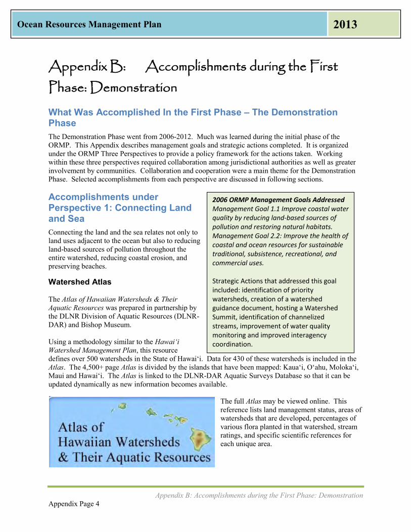
Appendix B: Accomplishments during the First Phase: Demonstration Appendix Page 4
Ocean Resources Management Plan 2013
2006 ORMP Management Goals Addressed Management Goal 1.1 Improve coastal water quality by reducing land-based sources of pollution and restoring natural habitats. Management Goal 2.2: Improve the health of coastal and ocean resources for sustainable traditional, subsistence, recreational, and commercial uses. Strategic Actions that addressed this goal included: identification of priority watersheds, creation of a watershed guidance document, hosting a Watershed Summit, identification of channelized streams, improvement of water quality monitoring and improved interagency coordination.
Appendix B: Accomplishments during the First
Phase: Demonstration
What Was Accomplished In the First Phase – The Demonstration Phase The Demonstration Phase went from 2006-2012. Much was learned during the initial phase of the ORMP. This Appendix describes management goals and strategic actions completed. It is organized under the ORMP Three Perspectives to provide a policy framework for the actions taken. Working within these three perspectives required collaboration among jurisdictional authorities as well as greater involvement by communities. Collaboration and cooperation were a main theme for the Demonstration Phase. Selected accomplishments from each perspective are discussed in following sections.
Accomplishments under Perspective 1: Connecting Land and Sea Connecting the land and the sea relates not only to land uses adjacent to the ocean but also to reducing land-based sources of pollution throughout the entire watershed, reducing coastal erosion, and preserving beaches.
Watershed Atlas The Atlas of Hawaiian Watersheds & Their Aquatic Resources was prepared in partnership by the DLNR Division of Aquatic Resources (DLNR-DAR) and Bishop Museum. Using a methodology similar to the Hawai‘i Watershed Management Plan, this resource defines over 500 watersheds in the State of Hawai‘i. Data for 430 of these watersheds is included in the Atlas. The 4,500+ page Atlas is divided by the islands that have been mapped: Kaua‘i, O‘ahu, Moloka‘i, Maui and Hawai‘i. The Atlas is linked to the DLNR-DAR Aquatic Surveys Database so that it can be updated dynamically as new information becomes available.
The full Atlas may be viewed online. This reference lists land management status, areas of watersheds that are developed, percentages of various flora planted in that watershed, stream ratings, and specific scientific references for each unique area.

Appendix B: Accomplishments during the First Phase: Demonstration Appendix Page 5
Ocean Resources Management Plan 2013
2009 Watershed Summit The State of Hawai‘i is required under the Federal Coastal Zone Management Act (CZMA) of 1990 to develop and submit to the EPA and NOAA a Coastal Nonpoint Pollution Control Program (CNPCP). DOH and OP-CZM are responsible for developing the state’s CNPCP. Hawai‘i submitted its first CNPCP for federal approval in 1996, covering 70 management measures and administrative elements. In 1998, the State received conditional approval of its program, subject to conditions on 46 of the management measures and administrative elements that must be met for Hawai‘i to receive final approval of its CNPCP. The 70 Management Measures for the CNPCP are defined for six main sources of pollutants:
Agriculture Forestry Urban Areas Marinas and Recreational Boating Hydromodifications (for example, impacts as a result of stream channelization) Wetlands, Riparian Areas, and vegetated Treatment Systems
As of 2009, there were 14 management measures or administrative elements that have not received approval from EPA and NOAA. These include management measures for:
Roads (Urban) Highways (Urban) Bridges (Urban) Multiple other urban measures (Urban) Watershed Protection (Forestry) Hydromodifications Protection of wetlands and riparian areas
In June 2009, OP hosted a Watershed Summit to discuss the State of Hawaii’s CNPCP. The workshop took each of the management measures that needed to be addressed and discussed them. Following this summit came the Hawai‘i Watershed Guidance (August 2010). This guidance report is intended to help those who are involved in managing watersheds in the state and it is a streamlined version of EPA’s Handbook for Developing Watershed Plans to Restore and Protect Our Waters (March 2008). Since the 2009 Watershed Summit and publication of the Hawai‘i Watershed Guidance, OP and DOH have continued to work towards obtaining NOAA and EPA approval of the remaining 14 management measures. On March 27, 2012, NOAA and EPA approved management measures for Urban (Watershed Protection and Existing Development, Site Development); Hydromodifications; and Wetlands, Riparian Areas, and Vegetated Treatment Systems. The remaining management measures that require approval are all in the Urban Management Area: (New Development, New and Operating Onsite Disposal Systems, and Roads, Highways and Bridges); and Monitoring and Tracking.
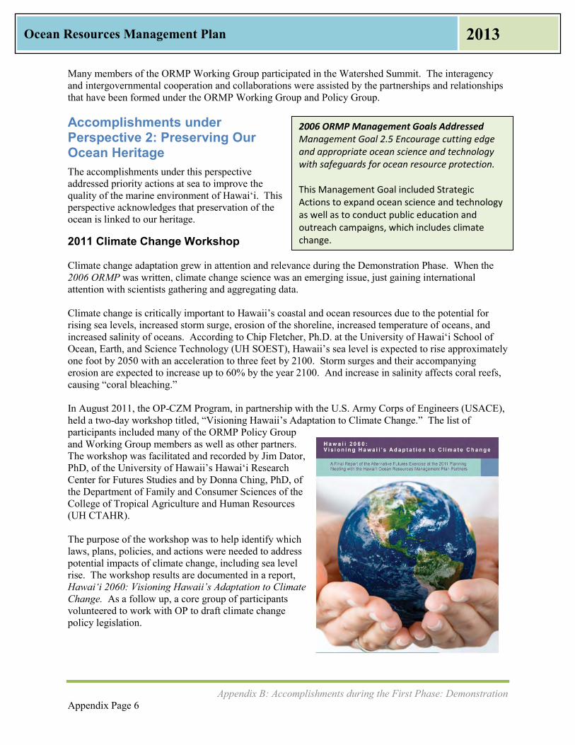
Appendix B: Accomplishments during the First Phase: Demonstration Appendix Page 6
Ocean Resources Management Plan 2013
2006 ORMP Management Goals Addressed Management Goal 2.5 Encourage cutting edge and appropriate ocean science and technology with safeguards for ocean resource protection. This Management Goal included Strategic Actions to expand ocean science and technology as well as to conduct public education and outreach campaigns, which includes climate change.
Many members of the ORMP Working Group participated in the Watershed Summit. The interagency and intergovernmental cooperation and collaborations were assisted by the partnerships and relationships that have been formed under the ORMP Working Group and Policy Group.
Accomplishments under Perspective 2: Preserving Our Ocean Heritage The accomplishments under this perspective addressed priority actions at sea to improve the quality of the marine environment of Hawai‘i. This perspective acknowledges that preservation of the ocean is linked to our heritage.
2011 Climate Change Workshop Climate change adaptation grew in attention and relevance during the Demonstration Phase. When the 2006 ORMP was written, climate change science was an emerging issue, just gaining international attention with scientists gathering and aggregating data. Climate change is critically important to Hawaii’s coastal and ocean resources due to the potential for rising sea levels, increased storm surge, erosion of the shoreline, increased temperature of oceans, and increased salinity of oceans. According to Chip Fletcher, Ph.D. at the University of Hawai‘i School of Ocean, Earth, and Science Technology (UH SOEST), Hawaii’s sea level is expected to rise approximately one foot by 2050 with an acceleration to three feet by 2100. Storm surges and their accompanying erosion are expected to increase up to 60% by the year 2100. And increase in salinity affects coral reefs, causing “coral bleaching.” In August 2011, the OP-CZM Program, in partnership with the U.S. Army Corps of Engineers (USACE), held a two-day workshop titled, “Visioning Hawaii’s Adaptation to Climate Change.” The list of participants included many of the ORMP Policy Group and Working Group members as well as other partners. The workshop was facilitated and recorded by Jim Dator, PhD, of the University of Hawaii’s Hawai‘i Research Center for Futures Studies and by Donna Ching, PhD, of the Department of Family and Consumer Sciences of the College of Tropical Agriculture and Human Resources (UH CTAHR). The purpose of the workshop was to help identify which laws, plans, policies, and actions were needed to address potential impacts of climate change, including sea level rise. The workshop results are documented in a report, Hawai‘i 2060: Visioning Hawaii’s Adaptation to Climate Change. As a follow up, a core group of participants volunteered to work with OP to draft climate change policy legislation.

Appendix B: Accomplishments during the First Phase: Demonstration Appendix Page 7
Ocean Resources Management Plan 2013
2006 ORMP Management Goals Addressed Management Goal 3.1 Apply integrated and place-based approaches to the management of natural and cultural resources. Management Goal 3.2 Institutionalize integrated natural and cultural resources management. Strategic Actions included the development of integrated planning processes and legislative proposals to improve the management of natural resources as well as monitoring ORMP implementation.
2012 Climate Change Adaptation Law The ORMP Climate Change Working Group briefed legislators on the climate change adaptation bill prior to the 2012 Legislative Session. The climate change adaptation bill, Senate Bill 2745, passed the 2012 Legislature and was signed by Governor Neil Abercrombie to become Act 286. This was a management priority success. The program identified an issue, formed a partnership with a federal agency and various stakeholders, held a workshop, developed an approach, and then was able to affect change to public policy by getting the State Legislature to adopt a bill.
Accomplishments under Perspective 3: Promoting Collaboration and Stewardship The interagency and intergovernmental collaboration achieved in the first five years not only represented a new approach to ocean resources management in Hawai‘i, but it is a collaboration that has led to achievement of many of the management priorities and strategic actions and has helped to strengthen ongoing efforts to manage ocean resources.
Formation of the ORMP Policy Group and ORMP Working Group for Agency Coordination The OP-CZM Program formed the ORMP Policy Group and ORMP Working Group in 2007 just after completion of the 2006 ORMP. The Policy Group consists of the directors of state and county resource management agencies, the University of Hawai‘i, federal partners, and the Marine and Coastal Zone Advocacy Council (MACZAC). The Working Group consists of managers and staff of the same offices that are tasked with coordinating their respective agency’s implementation efforts. Coordination lessons learned during the Demonstration Phase were that the ORMP Policy and Working Groups are an integral part to implementation of the ORMP. The 2006 ORMP had already been written at the time of the Working Group’s formation, however, the group still needed to go through the process of finding the group’s common goals and working styles in order to perform as a group. The Policy Group met approximately twice a year to sanction staff time and resources for the Working Group. The Working Group met nearly every month. Agency status reports were given and special topical presentations were scheduled as needed. The Working Group typically had a professional facilitator. Several of its monthly meetings in 2012 were dedicated to input and feedback on the ORMP Update.

Appendix B: Accomplishments during the First Phase: Demonstration Appendix Page 8
Ocean Resources Management Plan 2013
Mission Statement of the Policy and Working Groups “In support of a healthy and thriving ocean for today and future generations, we are committed to adopting integrated approaches to manage our ocean’s resources by: connecting land and sea; preserving our ocean heritage; and promoting collaboration and stewardship.”
July 2010
There was a substantial amount turnover of members in the Policy Group due to change in administrations. Therefore, an orientation package was developed to assist members in their duties and roles. The Orientation Packet included key reference materials:
Background of the CZM Program; Summary of the National CZMA of 1972; Summary of Hawaii’s CZM law (HRS Chapter 205A); Summary of the 2006 ORMP; Listing of federal, state, university, county, and community partners; Coordination/communication process showing CZM Staff, Policy Group, and Working Group
roles and responsibilities; and ORMP implementation projects underway.
2010 Joint ORMP Policy & Working Group Appreciative Inquiry Strategic Planning Session
ORMP Policy and Working Group members both requested that the Policy Group meet more frequently and increase their engagement with the Working Group. As a result, the OP-CZM Program developed a two-day strategic planning session for the Policy Group and the Working Group. The Joint ORMP Policy & Working Group Appreciative Inquiry Strategic Planning Meeting was held at the Waikiki Beach Marriott in July 2010. A written record was kept of discussions at the meeting. A group memory was taken; aspirations or visions for the future and strategic issues were listed for each breakout group. Visions for the future included more collaboration, education, and sustainability. Changes or transformations to the process identified as necessary to achieve the vision included: education of participants, buy-in, and political will. Root causes of success included: communication, resources, and leadership. Core values included: malama (stewardship), leadership, and unity expressed with lokahi (harmony). With a mission statement in place, the ORMP Groups brainstormed and prioritized their strengths, identified and prioritized opportunities, imagined a future to work toward, and developed action plans on how to achieve success. This exercise was called SOAR: Strengths, Opportunities, Aspirations, and Results.
Strengths included: partnerships and collaboration, resources, framework/plan itself, people capacity.
Opportunities included: ocean planning and governance (opportunity for ORMP Policy Group) and purposeful collaboration (opportunity for ORMP Working Group).
Aspirations included: all members of ORMP work together efficiently, the ORMP has become a living document, and adequate funding exists to implement the plan.

Appendix B: Accomplishments during the First Phase: Demonstration Appendix Page 9
Ocean Resources Management Plan 2013
Results included: Action plans to achieve the vision, such as educating the next generation on the ocean through influencing change in standards-based curriculum and developing a Succession Strategy/Plan for the upcoming transition in membership within the ORMP Group.
ORMP Consolidated Work Plan The ORMP Working Group developed a two-year 2008 ORMP Consolidated Work Plan, which contained 137 activities associated with ten management goals and 28 strategic actions. The 2008 ORMP Consolidated Work Plan recognized that not all of the 2006 ORMP management goals and strategic actions were being implemented in 2008. The 2008 Work Plan identified that 69 of the ORMP strategic actions, or 61%, were in some stage of implementation by agency Working Group members. The 2008 ORMP Consolidated Work Plan provided a summary listing of the management goals and strategic actions being implemented through 2009 by the following agencies: County planning departments (Hawaiʻi, Kauaʻi, and Maui), Department of Agriculture Aquaculture Development Program, Department of Health, Department of Land and Natural Resources, Department of Transportation Harbors Division, OP, UH SOEST, and U.S. Coast Guard. Since agencies could not be expected to implement all strategic actions all at once, Working Group members with responsibility to implement these actions went through the ORMP Strategic Action Matrix and identified which actions their respective agency were actively implementing or intending to implement between July 2007 and June 2009. They also identified which actions were deferred, and which should be dropped or modified. The intent was for the 2008 ORMP Consolidated Work Plan to be updated as needed. Lessons learned from the activity of the 2008 ORMP Consolidated Work Plan were that it needed to be simplified, and the number of strategic actions reduced to a manageable and measurable number. In 2012, the Working Group reviewed the 2008 ORMP Consolidated Work Plan as part of this ORMP Update. This review further found that while some of the activities were accomplished, many other activities were under the purview of agencies that were not involved in the Working Group or Policy Group, such as the Department of Education. The 2012 review also found that there needed to be a lead agency associated with each action, or there would not be any leadership or accountability to measure performance. Finally, the review again found that there were too many strategic actions and activities, and that the perspectives, management goals, strategic actions, and activities needed to be simplified.

Appendix B: Accomplishments during the First Phase: Demonstration Appendix Page 10
Ocean Resources Management Plan 2013
2012 Status of Strategic Actions from 2006 ORMP and 2008 ORMP Consolidated Work Plan The 2006 ORMP contained 10 Management Goals and 28 Strategic Actions. In order to accomplish each of these goals, a list of 113 sub-actions was developed. Tables 1, 2, and 3 show each of the Strategies, Actions, Sub-Actions, and Agencies, which are organized by the ORMP Three Perspectives. Progress was measured twice: in 2009 through the ORMP Work Plan as an interim review and again in 2012. The 2012 status of the 2006 ORMP Strategic Actions is shown in the following tables, and it will cease to be updated beginning in 2013. This list of Management Goals, Strategic Actions, and sub-actions is only a tool to look back on the ORMP Demonstration Phase. With the adoption of this 2013 ORMP, the Office of Planning and the ORMP Working Group are no longer using this list of Strategic Actions from the 2006 ORMP as a way to evaluate ORMP implementation. Going forward, the ORMP’s success will be measured by the Management Priorities discussed earlier in Chapter III of this 2013 ORMP.
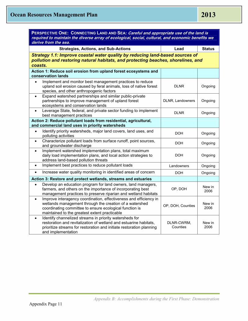
Appendix B: Accomplishments during the First Phase: Demonstration Appendix Page 11
Ocean Resources Management Plan 2013
PERSPECTIVE ONE: CONNECTING LAND AND SEA: Careful and appropriate use of the land is required to maintain the diverse array of ecological, social, cultural, and economic benefits we derive from the sea.
Strategies, Actions, and Sub-Actions Lead Status Strategy 1.1: Improve coastal water quality by reducing land-based sources of pollution and restoring natural habitats, and protecting beaches, shorelines, and coasts. Action 1: Reduce soil erosion from upland forest ecosystems and conservation lands
Implement and monitor best management practices to reduce upland soil erosion caused by feral animals, loss of native forest species, and other anthropogenic factors
DLNR Ongoing
Expand watershed partnerships and similar public-private partnerships to improve management of upland forest ecosystems and conservation lands
DLNR, Landowners Ongoing
Leverage State, federal, and private sector funding to implement best management practices DLNR Ongoing
Action 2: Reduce pollutant loads from residential, agricultural, and commercial land uses in priority watersheds
Identify priority watersheds, major land covers, land uses, and polluting activities DOH Ongoing
Characterize pollutant loads from surface runoff, point sources, and groundwater discharge DOH Ongoing
Implement watershed implementation plans, total maximum daily load implementation plans, and local action strategies to address land-based pollution threats
DOH Ongoing
Implement best practices to reduce pollutant loads Landowners Ongoing
Increase water quality monitoring in identified areas of concern DOH Ongoing
Action 3: Restore and protect wetlands, streams and estuaries Develop an education program for land owners, land managers,
farmers, and others on the importance of incorporating best management practices to preserve riparian and wetland habitats
OP, DOH New in 2006
Improve interagency coordination, effectiveness and efficiency in wetlands management through the creation of a watershed coordinating committee to ensure ecological function is maintained to the greatest extent practicable
OP, DOH, Counties New in 2006
Identify channelized streams in priority watersheds for restoration and revitalization of wetland and estuarine habitats, prioritize streams for restoration and initiate restoration planning and implementation
DLNR-CWRM, Counties
New in 2006

Appendix B: Accomplishments during the First Phase: Demonstration Appendix Page 12
Ocean Resources Management Plan 2013
PERSPECTIVE ONE: CONNECTING LAND AND SEA: Careful and appropriate use of the land is required to maintain the diverse array of ecological, social, cultural, and economic benefits we derive from the sea.
Strategies, Actions, and Sub-Actions Lead Status Strategy 1.2: Improve conservation and management of beaches, dunes, and wetlands to protect communities from shoreline erosion and other coastal hazards Action 4: Develop and implement a comprehensive and integrated shoreline management plan to address coastal development and the reduction of coastal erosion and other chronic and episodic coastal hazards
Establish a consensus on policies, management strategies and remedial actions to address shoreline erosion, beach loss, and mitigation of other coastal hazards
DLNR, OP, SOEST Ongoing
Develop comprehensive policies adopted through interagency agreements that treat shoreline management as a single integrated administrative unit and provide agencies with practical tools and skills necessary to improve management, minimize shoreline erosion and protect communities from coastal hazards
DLNR, OP, Counties Ongoing
Develop and implement policy and management strategies that account for projected sea level rise of 1 meter by 2050 Counties NEW
Establish adaptation strategies such as retreat zones, prohibiting shoreline armoring, and develop incentives to relocate structures inland
Counties NEW
Encourage permitting authorities to analyze coastal hazards, risks, and threats to beach protection prior to any zoning changes, Special Management Area/Shoreline setback variance permits or building permits
OP Ongoing
Conduct training programs utilizing practical tools to build capacity of government agencies and private sector to plan for and implement integrated shoreline management
DLNR, OP, Counties, SOEST Ongoing
Conduct statewide beach and shoreline assessment to identify high risk/erosion prone areas based on risk of coastal erosion, hazards, vulnerability of coastal communities, threats to beach protection, and presence of coastal resources and recreational areas
SOEST, DLNR, Counties Ongoing
Develop and implement coastal erosion and hazard mitigation management measures in priority areas
DLNR, OP Counties Ongoing
Identify and implement innovative mechanisms for coastal land acquisition and funding as an effective measure to preserve beaches and other coastal assets
DLNR, Counties Ongoing
Prepare an integrated management plan to prioritize areas for active management DLNR New
Conduct coastal hazard and resource assessment and risk analysis for any proposed coastal development SOEST, Counties Ongoing
Require all new coastal development projects and plans as part of permit process to identify specific measures to mitigate risks associated with coastal hazards, protect sensitive coastal and cultural resources, and ensure public access
OP, DLNR, Counties Ongoing
Develop an on-line statewide shoreline information management system on coastal hazards and risks, and beach protection in coastal areas
DLNR, SOEST Ongoing

Appendix B: Accomplishments during the First Phase: Demonstration Appendix Page 13
Ocean Resources Management Plan 2013
PERSPECTIVE ONE: CONNECTING LAND AND SEA: Careful and appropriate use of the land is required to maintain the diverse array of ecological, social, cultural, and economic benefits we derive from the sea.
Strategies, Actions, and Sub-Actions Lead Status Research, develop and institutionalize a methodology for
assessing what proportion of a region’s surface water runoff and erosion impacts are generated by any given development project
OP New in 2006
Strategy 1.3: Improve and ensure maintenance and appropriate use of environmental infrastructure Action 5: Reduce the number of individual wastewater systems and illegal stormwater discharges to the wastewater system while inspecting and maintaining sewer collections systems, especially in the coastal environment.
Repair leaking sewers in priority watersheds Counties Ongoing
Develop appropriate incentive system to ensure funding for sewer upgrades are prioritized in County budgets Counties Ongoing
Develop long-term infrastructure plan to ensure complete hookup to and adequate capacity and maintenance of wastewater systems
Counties Ongoing
Conduct an inventory of individual wastewater disposal systems in coastal areas DOH, Counties Ongoing
Encourage the elimination of cesspools by providing incentives for private upgrades DOH Ongoing
Develop appropriately scaled wastewater treatment systems in coastal areas with planned growth Counties Ongoing
Conduct public education campaign explaining the impacts of illegal storm-water discharges to public sewers on coastal water quality
DOH Ongoing
Conduct neighborhood reconnaissance to remind and warn residents about impacts of illegal storm-water hookups DOH Ongoing
Develop new rules establishing penalties for noncompliance DOH Ongoing Action 6: Through integrated policies and plans, ensure fresh water quantity is maintained in aquifers and streams to assist with restoration of flows to wetlands, streams, estuaries, and near shore waters.
Establish inflow stream standards DLNR-CWRM, County Water
Agencies
New and Ongoing
Strategy 1.4: Resiliency and Adaptation to Climate Change and Ocean Acidification
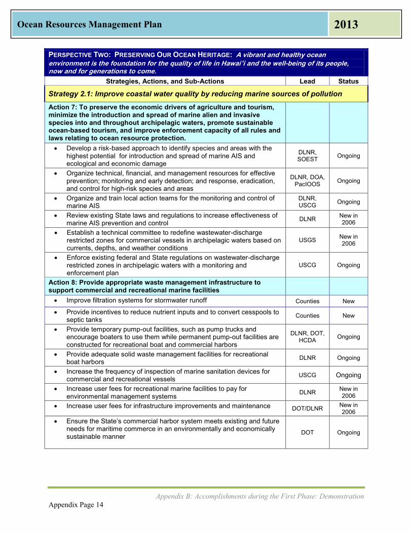
Appendix B: Accomplishments during the First Phase: Demonstration Appendix Page 14
Ocean Resources Management Plan 2013
PERSPECTIVE TWO: PRESERVING OUR OCEAN HERITAGE: A vibrant and healthy ocean
environment is the foundation for the quality of life in Hawai‘i and the well-being of its people, now and for generations to come.
Strategies, Actions, and Sub-Actions Lead Status
Strategy 2.1: Improve coastal water quality by reducing marine sources of pollution
Action 7: To preserve the economic drivers of agriculture and tourism, minimize the introduction and spread of marine alien and invasive species into and throughout archipelagic waters, promote sustainable ocean-based tourism, and improve enforcement capacity of all rules and laws relating to ocean resource protection.
Develop a risk-based approach to identify species and areas with the highest potential for introduction and spread of marine AIS and ecological and economic damage
DLNR, SOEST Ongoing
Organize technical, financial, and management resources for effective prevention; monitoring and early detection; and response, eradication, and control for high-risk species and areas
DLNR, DOA, PacIOOS Ongoing
Organize and train local action teams for the monitoring and control of marine AIS
DLNR, USCG Ongoing
Review existing State laws and regulations to increase effectiveness of marine AIS prevention and control DLNR New in
2006
Establish a technical committee to redefine wastewater-discharge restricted zones for commercial vessels in archipelagic waters based on currents, depths, and weather conditions
USGS New in 2006
Enforce existing federal and State regulations on wastewater-discharge restricted zones in archipelagic waters with a monitoring and enforcement plan
USCG Ongoing
Action 8: Provide appropriate waste management infrastructure to support commercial and recreational marine facilities
Improve filtration systems for stormwater runoff Counties New
Provide incentives to reduce nutrient inputs and to convert cesspools to septic tanks Counties New
Provide temporary pump-out facilities, such as pump trucks and encourage boaters to use them while permanent pump-out facilities are constructed for recreational boat and commercial harbors
DLNR, DOT, HCDA Ongoing
Provide adequate solid waste management facilities for recreational boat harbors DLNR Ongoing
Increase the frequency of inspection of marine sanitation devices for commercial and recreational vessels USCG Ongoing
Increase user fees for recreational marine facilities to pay for environmental management systems DLNR New in
2006 Increase user fees for infrastructure improvements and maintenance DOT/DLNR New in
2006 Ensure the State’s commercial harbor system meets existing and future
needs for maritime commerce in an environmentally and economically sustainable manner
DOT Ongoing
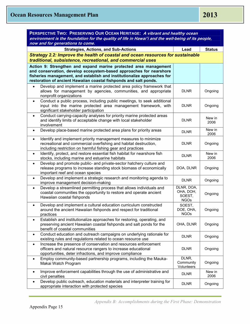
Appendix B: Accomplishments during the First Phase: Demonstration Appendix Page 15
Ocean Resources Management Plan 2013
PERSPECTIVE TWO: PRESERVING OUR OCEAN HERITAGE: A vibrant and healthy ocean
environment is the foundation for the quality of life in Hawai‘i and the well-being of its people, now and for generations to come.
Strategies, Actions, and Sub-Actions Lead Status Strategy 2.2: Improve the health of coastal and ocean resources for sustainable traditional, subsistence, recreational, and commercial uses Action 9: Strengthen and expand marine protected area management and conservation, develop ecosystem-based approaches for nearshore fisheries management, and establish and institutionalize approaches for restoration of ancient Hawaiian coastal fishponds and salt ponds.
Develop and implement a marine protected area policy framework that allows for management by agencies, communities, and appropriate nonprofit organizations
DLNR Ongoing
Conduct a public process, including public meetings, to seek additional input into the marine protected area management framework, with significant stakeholder participation
DLNR Ongoing
Conduct carrying-capacity analyses for priority marine protected areas and identify limits of acceptable change with local stakeholder involvement
DLNR New in 2006
Develop place-based marine protected area plans for priority areas DLNR New in 2006
Identify and implement priority management measures to minimize recreational and commercial overfishing and habitat destruction, including restriction on harmful fishing gear and practices
DLNR Ongoing
Identify, protect, and restore essential fish habitat for nearshore fish stocks, including marine and estuarine habitats DLNR New in
2006 Develop and promote public- and private-sector hatchery culture and
release programs to increase standing stock biomass of economically important reef and ocean species
DOA, DLNR Ongoing
Develop and implement a strategic research and monitoring agenda to improve management decision-making DLNR Ongoing
Develop a streamlined permitting process that allows individuals and coastal communities the opportunity to restore and operate ancient Hawaiian coastal fishponds
DLNR, DOA, OHA, DOH,
SOEST, NGOs
Ongoing
Develop and implement a cultural education curriculum constructed around the ancient Hawaiian fishponds and respect for traditional practices
SOEST, DOE, OHA,
NGOs Ongoing
Establish and institutionalize approaches for restoring, operating, and preserving ancient Hawaiian coastal fishponds and salt ponds for the benefit of coastal communities
OHA, DLNR Ongoing
Conduct education and outreach campaigns on underlying rationale for existing rules and regulations related to ocean resource use DLNR Ongoing
Increase the presence of conservation and resources enforcement officers and natural resource rangers to increase educational opportunities, deter infractions, and improve compliance
DLNR Ongoing
Employ community-based partnership programs, including the Mauka-Makai Watch Program
DLNR, Community Volunteers
Ongoing
Improve enforcement capabilities through the use of administrative and civil penalties DLNR New in
2006 Develop public outreach, education materials and interpreter training for
appropriate interaction with protected species DLNR Ongoing

Appendix B: Accomplishments during the First Phase: Demonstration Appendix Page 16
Ocean Resources Management Plan 2013
PERSPECTIVE TWO: PRESERVING OUR OCEAN HERITAGE: A vibrant and healthy ocean
environment is the foundation for the quality of life in Hawai‘i and the well-being of its people, now and for generations to come.
Strategies, Actions, and Sub-Actions Lead Status Develop recreational management areas for waters with high tour
vessel activity to limit overall impacts to protected species DLNR Ongoing
Develop a framework to manage and protect anchialine ponds; Incorporate information on location of anchialine ponds into parcel information and integrate protection measures into SMA permits
DLNR New
Amend interim stream flow standards to ensure protection and enhancement of stream environments as they effect coastal communities.
DLNR New
Strategy 2.3: Establish sustainable commercial aquaculture in coastal areas and ocean waters to diversify and expand Hawaii’s economy and to provide locally produced sources of seafood.
Promote ecosystem-based fisheries management DLNR, Ongoing
Strategy 2.4: Enhance public access and appropriate coastal dependent uses of the shoreline Action 10: Establish, enhance, and restore public access to the shoreline and scenic vistas
Develop enhancement and restoration plans to increase public access and restore priority beaches and scenic vistas
DLNR, Counties Ongoing
Establish funding priorities for priority beach restoration projects. DLNR, Counties Ongoing
Develop interagency agreements and public-private partnerships to implement enhancement plans
DLNR, Counties
New in 2006
Implement shoreline enhancement and restoration plans in priority areas
DLNR, Counties,
Landowners
New in 2006
Develop public education programs to build stewardship ethic toward the coastline and ocean
DLNR, OP, MACZAC Ongoing
Identify and implement innovative mechanisms for coastal land acquisition and funding as an effective measure to preserve beaches and other coastal assets
DLNR, Counties
New in 2006
Conduct an inventory of beaches, shoreline areas and scenic vistas requiring protection as open space
DLNR, Counties, SOEST
Ongoing
Develop interagency agreements and public-private partnerships to acquire, preserve, and restore priority watershed areas
DLNR, Counties
New in 2006
Establish criteria for identifying priority coastal areas for public acquisition and appropriate coastal dependent uses
DLNR, Counties, SOEST
New in 2006
Establish new beach and shoreline areas, and scenic vistas as open space for public access
DLNR, Counties Expansion
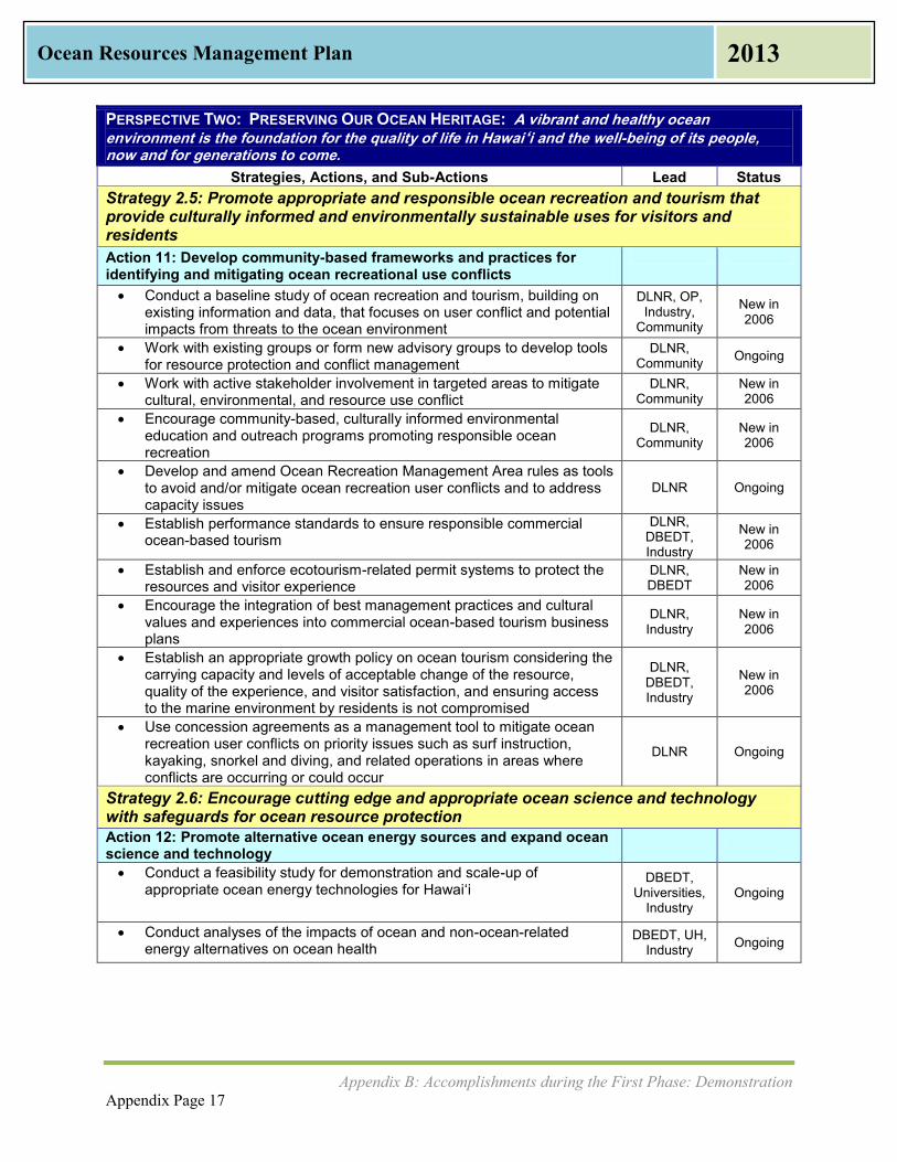
Appendix B: Accomplishments during the First Phase: Demonstration Appendix Page 17
Ocean Resources Management Plan 2013
PERSPECTIVE TWO: PRESERVING OUR OCEAN HERITAGE: A vibrant and healthy ocean
environment is the foundation for the quality of life in Hawai‘i and the well-being of its people, now and for generations to come.
Strategies, Actions, and Sub-Actions Lead Status Strategy 2.5: Promote appropriate and responsible ocean recreation and tourism that provide culturally informed and environmentally sustainable uses for visitors and residents Action 11: Develop community-based frameworks and practices for identifying and mitigating ocean recreational use conflicts
Conduct a baseline study of ocean recreation and tourism, building on existing information and data, that focuses on user conflict and potential impacts from threats to the ocean environment
DLNR, OP, Industry,
Community
New in 2006
Work with existing groups or form new advisory groups to develop tools for resource protection and conflict management
DLNR, Community Ongoing
Work with active stakeholder involvement in targeted areas to mitigate cultural, environmental, and resource use conflict
DLNR, Community
New in 2006
Encourage community-based, culturally informed environmental education and outreach programs promoting responsible ocean recreation
DLNR, Community
New in 2006
Develop and amend Ocean Recreation Management Area rules as tools to avoid and/or mitigate ocean recreation user conflicts and to address capacity issues
DLNR Ongoing
Establish performance standards to ensure responsible commercial ocean-based tourism
DLNR, DBEDT, Industry
New in 2006
Establish and enforce ecotourism-related permit systems to protect the resources and visitor experience
DLNR, DBEDT
New in 2006
Encourage the integration of best management practices and cultural values and experiences into commercial ocean-based tourism business plans
DLNR, Industry
New in 2006
Establish an appropriate growth policy on ocean tourism considering the carrying capacity and levels of acceptable change of the resource, quality of the experience, and visitor satisfaction, and ensuring access to the marine environment by residents is not compromised
DLNR, DBEDT, Industry
New in 2006
Use concession agreements as a management tool to mitigate ocean recreation user conflicts on priority issues such as surf instruction, kayaking, snorkel and diving, and related operations in areas where conflicts are occurring or could occur
DLNR Ongoing
Strategy 2.6: Encourage cutting edge and appropriate ocean science and technology with safeguards for ocean resource protection Action 12: Promote alternative ocean energy sources and expand ocean science and technology
Conduct a feasibility study for demonstration and scale-up of appropriate ocean energy technologies for Hawai‘i
DBEDT, Universities,
Industry Ongoing
Conduct analyses of the impacts of ocean and non-ocean-related energy alternatives on ocean health
DBEDT, UH, Industry Ongoing
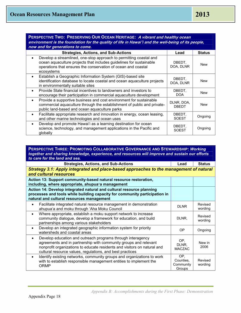
Appendix B: Accomplishments during the First Phase: Demonstration Appendix Page 18
Ocean Resources Management Plan 2013
PERSPECTIVE TWO: PRESERVING OUR OCEAN HERITAGE: A vibrant and healthy ocean
environment is the foundation for the quality of life in Hawai‘i and the well-being of its people, now and for generations to come.
Strategies, Actions, and Sub-Actions Lead Status Develop a streamlined, one-stop approach to permitting coastal and
ocean aquaculture projects that includes guidelines for sustainable operations that ensures the conservation of ocean and coastal ecosystems
DBEDT, DOA, DLNR New
Establish a Geographic Information System (GIS)-based site identification database to locate coastal and ocean aquaculture projects in environmentally suitable sites
DBEDT, DOA, DLNR New
Provide State financial incentives to landowners and investors to encourage their participation in commercial aquaculture development
DBEDT, DOA New
Provide a supportive business and cost environment for sustainable commercial aquaculture through the establishment of public and private-public land-based and ocean aquaculture parks
DLNR, DOA, DBEDT New
Facilitate appropriate research and innovation in energy, ocean leasing, and other marine technologies and ocean uses
DBEDT, SOEST Ongoing
Develop and promote Hawai‘i as a learning destination for ocean science, technology, and management applications in the Pacific and globally
DBEDT, SOEST Ongoing
PERSPECTIVE THREE: PROMOTING COLLABORATIVE GOVERNANCE AND STEWARDSHIP: Working together and sharing knowledge, experience, and resources will improve and sustain our efforts to care for the land and sea.
Strategies, Actions, and Sub-Actions Lead Status Strategy 3.1: Apply integrated and place-based approaches to the management of natural and cultural resources Action 13: Support community-based natural resource restoration, including, where appropriate, ahupuaʻa management
Action 14: Develop integrated natural and cultural resource planning processes and tools while building capacity for community participation in natural and cultural resources management
Facilitate integrated natural resource management in demonstration ahupua‘a and moku through ‘Aha Moku Council DLNR Revised
wording Where appropriate, establish a moku support network to increase
community dialogue, develop a framework for education, and build partnerships among various stakeholders
DLNR, Revised wording
Develop an integrated geographic information system for priority watersheds and coastal areas OP Ongoing
Develop education and outreach programs through interagency agreements and in partnership with community groups and relevant nonprofit organizations to educate residents and visitors on natural and cultural resource values, regulations, and best practices
OP, DLNR,
MACZAC
New in 2006
Identify existing networks, community groups and organizations to work with to establish responsible management entities to implement the ORMP
OP, Counties,
Community Groups
Revised wording
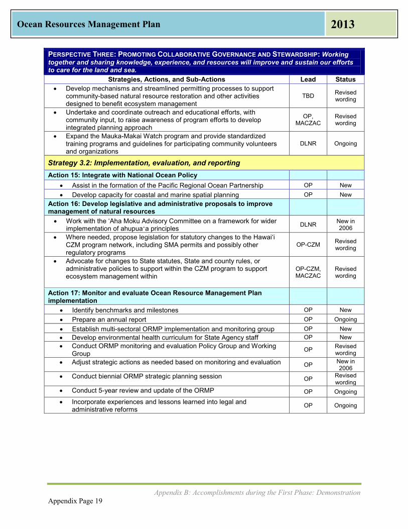
Appendix B: Accomplishments during the First Phase: Demonstration Appendix Page 19
Ocean Resources Management Plan 2013
PERSPECTIVE THREE: PROMOTING COLLABORATIVE GOVERNANCE AND STEWARDSHIP: Working together and sharing knowledge, experience, and resources will improve and sustain our efforts to care for the land and sea.
Strategies, Actions, and Sub-Actions Lead Status Develop mechanisms and streamlined permitting processes to support
community-based natural resource restoration and other activities designed to benefit ecosystem management
TBD Revised wording
Undertake and coordinate outreach and educational efforts, with community input, to raise awareness of program efforts to develop integrated planning approach
OP, MACZAC
Revised wording
Expand the Mauka-Makai Watch program and provide standardized training programs and guidelines for participating community volunteers and organizations
DLNR Ongoing
Strategy 3.2: Implementation, evaluation, and reporting Action 15: Integrate with National Ocean Policy
Assist in the formation of the Pacific Regional Ocean Partnership OP New Develop capacity for coastal and marine spatial planning OP New
Action 16: Develop legislative and administrative proposals to improve management of natural resources
Work with the ‘Aha Moku Advisory Committee on a framework for wider implementation of ahupuaʻa principles DLNR New in
2006
Where needed, propose legislation for statutory changes to the Hawai‘i CZM program network, including SMA permits and possibly other regulatory programs
OP-CZM Revised wording
Advocate for changes to State statutes, State and county rules, or administrative policies to support within the CZM program to support ecosystem management within
OP-CZM, MACZAC
Revised wording
Action 17: Monitor and evaluate Ocean Resource Management Plan implementation
Identify benchmarks and milestones OP New Prepare an annual report OP Ongoing Establish multi-sectoral ORMP implementation and monitoring group OP New Develop environmental health curriculum for State Agency staff OP New Conduct ORMP monitoring and evaluation Policy Group and Working
Group OP Revised wording
Adjust strategic actions as needed based on monitoring and evaluation OP New in 2006
Conduct biennial ORMP strategic planning session OP Revised wording
Conduct 5-year review and update of the ORMP OP Ongoing
Incorporate experiences and lessons learned into legal and administrative reforms OP Ongoing

Appendix C: Ocean Resource Management Issues and Related Plans Appendix Page 20
Ocean Resources Management Plan 2013
Appendix C: Ocean Resource Management Issues
and Related Plans
This Appendix looks further at pressures on the ocean and coastal resources and critical issues. Community groups play an important role in protecting ocean and coastal resources. This Appendix was informed by feedback that OP-CZM received at two rounds of Public Listening Sessions (PLS) during 2012, which were held on the islands of Kaua‘i; east, west , and central parts of O‘ahu; west and central parts of Maui; Moloka‘i; Lāna‘i; and the east and west sides of Hawai‘i Island. This Appendix also describes key ocean resource related plans from state and federal agencies. Future economic growth and activities of the population are expected to place great demands on Hawaii’s ocean and coastal resources. Increased urbanization, tourism, recreation, and commercial uses utilize the ocean resources in different ways. While economic growth is vital to Hawai‘i, its impacts must be properly managed to preserve our natural resources and reduce conflicts among resource users. According to Population and Economic Projections for the State of Hawai‘i (DBEDT, 2013), the population in Hawai‘i is expected to increase 17.5% in the next 20 years from 1.36 million in 2010 to 1.60 million in 2030. Even though the population increase is down from a projected 30% increase predicted in the 2006 ORMP, there will still be increased pressure on marine and coastal resources, existing infrastructure, and water and land use. Academia, agencies, and communities have looked at ways to address these issues, and they remain of critical concern in all parts of the state. Lack of enforcement, insufficient funding, lack of resources to address the issues, and lack of political will have all slowed progress. This Appendix discusses several issues that affect ocean and coastal resource management:
Urbanization Impacts from Tourism Military Use of Lands Commercial and Recreational Ocean Uses Shoreline Access and Conflicting Uses Coastal Hazards, Sea Level Rise, and Coastal Erosion Climate Change Adaptation: Disaster Preparedness and Community Resilience Marine Debris Watershed Management: Water Quality and Water Quantity Agricultural Lands Damage to Coral Reefs Endangered Species Aquatic Invasive Species Terrestrial Invasive Species Food Security Alternative Energy
Abbreviated descriptions of these issues are discussed in Chapter II.

Appendix C: Ocean Resource Management Issues and Related Plans Appendix Page 21
Ocean Resources Management Plan 2013
Urbanization The 2010 U.S. Census shows the State of Hawaii’s total population is 1,360,301 people, with 455,338 households. According to DBEDT forecasts, the population is expected to increase 140,000 persons every ten years. With this population increase will come an increasing need for additional housing, services, and urbanization. Future population growth and accompanying growth in urbanization can be properly managed to preserve the state’s natural resources while allowing necessary economic growth. The updated management priorities in this ORMP outline actions to minimize impacts to the coastal environment through support of appropriate coastal development. Figure C-1: Striking a Balance
Figure C-1 shows how a balance between social needs, economic needs, and needs of the environment are interdependent. This is a diagram based on the definition of sustainability in Hawai‘i as defined in the Hawai‘i 2050 Sustainability Plan. Balancing the need to protect the environment can be done while driving the economy and providing social benefits to society. In other words, acquiring balance in one sector does not need to be at the expense of another.
Impacts from Tourism Hawaii’s tourism industry is the largest sector of the state’s economy, providing 22% of Hawaii’s gross domestic product in 2010 (UHERO, 2011). New visitor destinations and activities such as increased international visitors, the cruise ship industry, coastal-dependent resort development, increased marketing of the neighbor islands, and ecotourism alternatives can be made aware of how to exist while protecting Hawaii’s most sensitive and unique natural resources. The Hawai‘i 2050 Sustainability Plan notes that tourism generates a quarter of the state’s tax revenue. The Sustainability Plan also notes that the State must provide incentives for industries to operate in more sustainable ways, recognizing that the visitor industry is a strong component of the state’s economy. Nearly 8 million visitors arrive in Hawai‘i annually. The number of visitor arrivals is projected to grow as shown in Table C-1, magnifying impacts to Hawaii’s natural resources.

Appendix C: Ocean Resource Management Issues and Related Plans Appendix Page 22
Ocean Resources Management Plan 2013
Table C-1: Visitor Forecasts to 2015
Source: DBEDT (February 2013) While most tourists arrive via plane, the ocean plays an important entry point for some. The number of visitors arriving to Hawai‘i aboard cruise ships increased 23% to 124,650 visitors between 2010 and 2011, and even more visitors boarded cruise ships in Hawai‘i after flying to the islands, bringing total cruise visitors to 246,236 (Hawai‘i Tourism Authority, 2012). The cruise ship industry is just one facet of tourism that impacts the ocean. During the ORMP PLS and outreach conducted for this plan, community members voiced concerns about what they saw as negative impacts from tourism including damage to coral reefs, harassment of endangered species, and increase in recreational user conflicts. The key to turning these into a positive and balanced visitor experience is through education and outreach, which is a Management Priority #8, Training, Education, and Awareness in this ORMP. UH Sea Grant College Program administers the Hanauma Bay Education Program, which educates more than 800,000 visitors annually on the value of marine resources and reef etiquette. Each visitor to Hanauma Bay in east O‘ahu is required to watch an educational film about preserving the reef by not walking on it, preserving the abundant marine life by not feeding it, and keeping trash and litter off the beaches and out of the water. There are many other non-profit, community, research, and government groups on all islands that provide education and outreach to visitors and residents alike on Hawaii’s coastal and ocean resources.
Appendix C: Ocean Resource Management Issues and Related Plans Appendix Page 23
Ocean Resources Management Plan 2013
Military Use of Lands The military presence is an integral part of Hawaii’s past and present as well as a major driver of the state’s economy. National and homeland security requires that access to certain shorelines be off limits to the general public while pre-empting state laws, such as at Pearl Harbor. On occasion, the military will allow access to certain beaches, such as at Bellows Air Force Station Beach in Waimānalo. Further collaboration between the State and the military may help to open up more shoreline, even on a limited basis, for recreation and fishing. On Marine Corps Base Hawai‘i in Kāne‘ohe, the U.S. Marines care for the Nuʻupia Ponds Wildlife Management Area. These eight interconnected ponds and wetlands cover 517 acres, and are home to the endangered Hawaiian Black-necked Stilt, the Hawaiian Coot, Hawaiian Moorhen, and the Kōloa Duck. Each year, the Marines prepare this site for the endangered Hawaiian Stilt breeding season between March and September by breaking up invasive pickleweed so that the Hawaiian Stilt can nest. Ordnance left from WWII and training exercises in the ocean and along the coastline is a concern in some areas of Hawai‘i. The most extreme example of this would be the uninhabited island of Kaho‘olawe, which was used as a U.S. Navy practice bomb target area for several decades. Military ordnance has also been reported by community members off the Wai‘anae Coast on O‘ahu and north of Kailua-Kona on Hawai‘i Island. Continued collaboration between the State of Hawai‘i and assigned military liaisons can assist in removal of ordnance. The Kaho‘olawe Island Reserve Council’s work to restore Kaho‘olawe should also continue.
Commercial and Recreational Ocean Uses Hawaii’s oceans are used for commerce, recreation, cultural practices, and transportation. Approximately 80% of all goods consumed in Hawai‘i are imported from out of state, and of those, 98% arrive by sea. The recreational value of the state’s oceans and waterways to the tourism industry and to those that live here has not been formally measured, however a study on Sustainable Coastal Tourism undertaken by the University of Hawai‘i Economic Research Organization (UHERO) in conjunction with UH Sea Grant will be completed in the next year. Because Hawai‘i is completely surrounded by the Pacific Ocean, everyone in Hawai‘i has some way to value the ocean commercially or recreationally, whether it is stand up paddling, fishing, or simply picnicking beside the ocean. Cultural practices, such as limu (seaweed) gathering, salt farming, and fishponds are all connected to the ocean and water. All of these uses of ocean and coastal resources can and do co-exist. Management Priority #9, Collaboration and Conflict Resolution encourages addressing conflicting uses through non-judicial means. Management Priority #11, National Ocean Policy and Pacific Regional Ocean Initiatives contains a goal to create a coastal and marine spatial planning program which can identify and map uses of coastal and marine resources.
Shoreline Access & Conflicting Uses The state has long recognized a policy of supporting public use of the shoreline area. The landmark 1995 Hawai‘i State Supreme Court case, referred to as PASH or Public Access Shoreline Hawai‘i, reaffirmed these rights. Hawai‘i courts have consistently held that nearly all state submerged lands, including shoreline areas, are considered public lands held in trust for the benefit of its people. Accordingly, the State may not dispose of these lands, or encumber these lands to the detriment of public access and other public interests. In terms of shoreline areas, except for very specific circumstances, submerged lands extend to the highest wash of the waves during the season when the waves are highest. For example,

Appendix C: Ocean Resource Management Issues and Related Plans Appendix Page 24
Ocean Resources Management Plan 2013
HRS Section 46-6.5 states that the counties, in the subdivision process, must ensure public access to land below the high-water mark. Shoreline setback areas, Coastal Zone Management Act statutes and rules, and other state and county land use laws further recognize the importance of public access to the shoreline and coastal areas. Access to the shoreline for Native Hawaiian traditional and customary gathering practices is guaranteed in the Hawai‘i State Constitution, statutes, and case law. As such, agency decisions affecting the shoreline must make specific findings relating to potential impacts to traditional and customary practices and cultural, historical, or natural resources, and take feasible actions to reasonably protect cultural rights. Cultural impacts of applicable projects in or affecting the shoreline area must also be assessed via the environmental review process embodied in HRS Chapter 343, as well as through federal and state laws which may also require consultation with Native Hawaiian Organizations and practitioners. HRS Chapter 6E Relating to Historic Preservation recognizes the “value of conserving and developing the historic and cultural property within the State for the public good.” It is similar to Section 106 of the National Historic Preservation Act (1966), which includes a federal requirement for consultation with Native Hawaiian Organizations whenever federal agencies determine that there is an undertaking that could affect historic properties. State and federal laws recognize that there could be historic and cultural properties in submerged lands or the coastline and government agencies must consider the Native Hawaiian perspective in order to preserve these historic and cultural properties. Despite having laws in place, many people expressed during the statewide ORMP PLS that access is sometimes limited, either through restriction of parking, unavailability of public access in areas that are land locked, or the restriction of protected Native Hawaiian gathering places. New resorts constructed on undeveloped shorelines may reduce public access to ocean resources and degrade scenic vistas. Increased marine-related tourist attractions, including whale and dolphin watching, shark feeding, charter fishing, parasailing, jet skiing, swimming, snorkeling and diving, can result in resource use conflicts and threaten the condition of ocean and coastal resources. How shorelines are developed and the way coastal water quality, beaches, and coral reefs are managed are fundamental to the growth and sustainability of Hawai‘i. Figure C-2: Recreation at Hanalei Bay, Kaua‘i
Source: Office of Planning

Appendix C: Ocean Resource Management Issues and Related Plans Appendix Page 25
Ocean Resources Management Plan 2013
Coastal Hazards, Sea Level Rise, and Coastal Erosion Since the publication of the 2006 ORMP, much scientific research and attention has been given to global climate change, including sea level rise. Sea level rise is defined as when the mean high tide level increases year after year. While many acknowledge that the sea level is rising, how much it rises is different in Hawai‘i than in other areas of the world. Factors such as the El Niño/La Niña-Southern Oscillation (ENSO), which is an occasional shift in winds and ocean currents centered in the South Pacific region, add to the variability of how much sea level rise one coastal location will see in comparison to another. Figure C-3 from UH SOEST, illustrates the coastal hazards that can develop from sea level rise. Figure C-3: How Sea Level Rise and Other Coastal Hazards Interact with Coastal Development
Source: Chip Fletcher, Ph.D., University of Hawaiʻi, SOEST When the sea level rises, coastal erosion increases. When there are storm surges, this can increase the height of storm waves and cause marine inundation. In some locations, the saltwater can impact the level of the water table, causing a water table rise and inland flooding. The water table rise can cause drainage problems in interior areas, because there isn’t anywhere for stormwater or rainwater to drain. Coastal hazards such as beach erosion, inundation of land, increased flood and storm damage, saltwater intrusion into the freshwater lens aquifer, the rising of the water table, and more frequent or more powerful weather events all affect ocean resources. Proper coastal development, watershed management, and disaster preparedness in coastal regions are all tools to deal with the effects of sea level rise and coastal hazards.
Climate Change Adaptation: Disaster Preparedness & Community Resilience Climate change has been documented to have impacts on the atmosphere, coasts, and marine resources. Mitigation and adaptation to climate change and coastal hazards need to be addressed in order to combat the pressure that exist today, as well as prepare Hawai‘i for future impacts. Because of the cumulative impacts of climate change, the State has put a focus on adaptation. Public awareness of this issue has grown since the 2006 ORMP making climate change adaptation a primary issue. Global warming is predicted to cause an increase in frequency and power of both storm surge and hurricanes. One study suggests that peak hurricane wind speeds will increase by 5 to 10 percent by the end of the 21st century. A 1-meter rise in sea level would enable a 15-year storm to flood areas that today
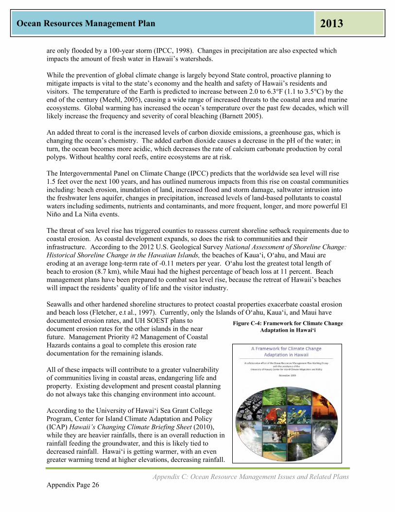
Appendix C: Ocean Resource Management Issues and Related Plans Appendix Page 26
Ocean Resources Management Plan 2013
are only flooded by a 100-year storm (IPCC, 1998). Changes in precipitation are also expected which impacts the amount of fresh water in Hawaii’s watersheds. While the prevention of global climate change is largely beyond State control, proactive planning to mitigate impacts is vital to the state’s economy and the health and safety of Hawaii’s residents and visitors. The temperature of the Earth is predicted to increase between 2.0 to 6.3°F (1.1 to 3.5°C) by the end of the century (Meehl, 2005), causing a wide range of increased threats to the coastal area and marine ecosystems. Global warming has increased the ocean’s temperature over the past few decades, which will likely increase the frequency and severity of coral bleaching (Barnett 2005). An added threat to coral is the increased levels of carbon dioxide emissions, a greenhouse gas, which is changing the ocean’s chemistry. The added carbon dioxide causes a decrease in the pH of the water; in turn, the ocean becomes more acidic, which decreases the rate of calcium carbonate production by coral polyps. Without healthy coral reefs, entire ecosystems are at risk. The Intergovernmental Panel on Climate Change (IPCC) predicts that the worldwide sea level will rise 1.5 feet over the next 100 years, and has outlined numerous impacts from this rise on coastal communities including: beach erosion, inundation of land, increased flood and storm damage, saltwater intrusion into the freshwater lens aquifer, changes in precipitation, increased levels of land-based pollutants to coastal waters including sediments, nutrients and contaminants, and more frequent, longer, and more powerful El Niño and La Niña events. The threat of sea level rise has triggered counties to reassess current shoreline setback requirements due to coastal erosion. As coastal development expands, so does the risk to communities and their infrastructure. According to the 2012 U.S. Geological Survey National Assessment of Shoreline Change: Historical Shoreline Change in the Hawaiian Islands, the beaches of Kaua‘i, O‘ahu, and Maui are eroding at an average long-term rate of -0.11 meters per year. O‘ahu lost the greatest total length of beach to erosion (8.7 km), while Maui had the highest percentage of beach loss at 11 percent. Beach management plans have been prepared to combat sea level rise, because the retreat of Hawaii’s beaches will impact the residents’ quality of life and the visitor industry. Seawalls and other hardened shoreline structures to protect coastal properties exacerbate coastal erosion and beach loss (Fletcher, e.t al., 1997). Currently, only the Islands of Oʻahu, Kauaʻi, and Maui have documented erosion rates, and UH SOEST plans to document erosion rates for the other islands in the near future. Management Priority #2 Management of Coastal Hazards contains a goal to complete this erosion rate documentation for the remaining islands. All of these impacts will contribute to a greater vulnerability of communities living in coastal areas, endangering life and property. Existing development and present coastal planning do not always take this changing environment into account. According to the University of Hawai‘i Sea Grant College Program, Center for Island Climate Adaptation and Policy (ICAP) Hawaii’s Changing Climate Briefing Sheet (2010), while they are heavier rainfalls, there is an overall reduction in rainfall feeding the groundwater, and this is likely tied to decreased rainfall. Hawai‘i is getting warmer, with an even greater warming trend at higher elevations, decreasing rainfall.
Figure C-4: Framework for Climate Change Adaptation in Hawai‘i
Appendix C: Ocean Resource Management Issues and Related Plans Appendix Page 27
Ocean Resources Management Plan 2013
Rising air temperatures, decreased rainfall, and decreased stream discharge all tie in to the sources of water to the ecosystem, which can affect agriculture, water quantity, and water quality. In 2009, the ORMP Working Group and ICAP prepared A Framework for Climate Change Adaptation in Hawaii. Topics included building a climate change adaptation team, developing and adopting a long-term vision, identifying planning areas and opportunities relevant to climate change, scoping climate change impacts to major planning sectors, conducting a vulnerability assessment, and conducting a risk assessment. Such planning efforts aid in disaster preparedness and build resilient communities. A core group of ORMP partners drafted climate change policy legislation that became part of the Governor’s 2012 Legislative Packet as Senate Bill 2745. This climate change adaptation bill passed the 2012 Legislature and was signed by Governor Neil Abercrombie as Act 286.
Marine Debris Marine debris is defined as any solid material that is manufactured or processed and directly or indirectly disposed of or abandoned into the marine environment. Debris may enter directly from a ship, or indirectly when washed out to sea from rivers, streams, or storm drains. Marine debris includes a wide variety of items, including plastic bags, glass bottles, rubber slippers, derelict fishing gear, and abandoned or derelict vessels. Activities that create marine debris occur both on land and on the ocean. Marine debris can be categorized as chronic such as derelict fishing gear or episodic such as the Japan Tsunami Marine Debris. The debris ranges in size from microscopic, such as broken pieces of plastic, to items weighing many tons, such as abandoned fishing vessels. Marine debris is an ongoing problem worldwide, and Hawaii’s position in the Pacific Ocean makes it no stranger to the multitude of marine debris washing up on the island’s shores, much of it generated from distant shores. Because Hawai‘i is at the center of the North Pacific Gyre, the islands become a hotspot for the aggregation of marine debris from across the Pacific. Marine debris causes habitat damage such as to coral reefs, can transport invasive species, and can cause harm to seabirds and other wildlife that accidentally digest it or become entangled in it. Marine debris can also lower the quality of life for residents and the satisfaction of visitors, as well as impose an economic cost. According to the National Oceanic and Atmospheric Administration (NOAA), many efforts are underway to prevent, reduce, and research marine debris. NOAA and other federal agencies are working with states and counties to develop protocols for a variety of scenarios to address marine debris hazards to navigation, threat of pollution, and adverse impacts to public safety and health.” Invasive species are also a concern, as they can be transported from other areas of the world to Hawaiʻi by attaching themselves to floating debris or as part of lost cargo. Another threat to the ocean is illegal dumping of solid waste at sea. According to the Hawai‘i Marine Debris Action Plan (HI-MDAP) (NOAA, 2013), there is a role for everyone, including federal, state, and county agencies, as well as community members and academia, in preventing and dealing with marine debris. Beach clean ups are just one way of addressing marine debris, as pictured in Figure C-5.

Appendix C: Ocean Resource Management Issues and Related Plans Appendix Page 28
Ocean Resources Management Plan 2013
Figure C-5: Marine Debris Removed from Kanapou, Kaho‘olawe, Before and After Photos
Source: Kaho‘olawe Island Reserve Commission, Kanapou Cleanup
Watershed Management: Water Quality and Water Quantity There are over 500 watersheds in the State of Hawaiʻi, according to the Hawai‘i Watershed Guidance (Office of Planning 2010). The Department of Land and Natural Resources (DLNR), the Department of Health (DOH), the Office of Planning (OP), and the various county Boards of Water Supply (BWS) manage most of the state’s watersheds; however, many of the watersheds are also in private property. In addition, because of their vast size and limited accessibility, a variety of stakeholders partner in order to manage and improve functionality of the watersheds. Watershed management takes into account the quality as well as quantity of water within a given watershed; furthermore, freshwater flow into streams, estuaries, anchialine ponds, and nearshore waters is as important as the quality of the water. Sedimentation from rivers, streams, and other runoff can cause changes in water depth and water quality in Hawaii’s coastal areas. Large sediment load in some of Hawaii’s bays such as Hanalei Bay, Kaua`i has been attributed to removal of ground cover and surface disturbances by animals and humans in watersheds, which accelerate erosion rates and sediment generation. The Hanalei Watershed Hui has worked to improve the watershed through various partnerships, education, and stakeholder involvement. The Hawai‘i Watershed Guidance defines impaired waterbodies as those which do not meet Hawaii’s water quality standards that support the designated use. Watersheds of particular concern are high-quality waters threatened by changing land uses. Threats to healthy watersheds may be local (new development or change in land use), regional (spread of invasive species), and global (drought or flooding caused by climate change). While there is always going to be a naturally deposited element of high islands in torrential tropic environments eroding to low islands, the human impacts are the greatest (with construction and agriculture as the main culprits). Part of the answer for addressing watershed issues is education.
Appendix C: Ocean Resource Management Issues and Related Plans Appendix Page 29
Ocean Resources Management Plan 2013
While land-based pollution from agricultural runoff may be declining, urban storm-water runoff from construction activities and increased impervious surface cover has taken its place. Polluted surface water runoff, combined with an aging sewage system incapable of handling system overloads, is threatening coastal water quality. According to the U.S. Environmental Protection Agency (EPA), 64% of Hawaii’s streams are considered “impaired” by pollutants. Furthermore, as population density increases along shoreline areas, landscape hardening to protect property has become a serious coastal issue. Channelized streambeds for floodwater control exacerbate water quality problems and contribute to stream and estuarine habitat loss. Urban and agricultural lands are major sources of nonpoint source pollution. Genetically modified organism (GMO) crops, pharmaceutical contamination, injection wells, and cesspools were raised at the ORMP PLS as anecdotal examples of pollution that is occurring. Stream diversions such as irrigation ditches and wells that affect surface waters have changed the water flow to wetlands, streams, estuaries and nearshore waters. Careful and appropriate use of the land and freshwater is required to maintain the diverse array of ecological, social, cultural, and economic benefits we derive from the sea.
Agricultural Lands While much of Hawaii’s agriculture is beyond the shoreline, agricultural lands throughout the state directly impact the coast and the ocean. Much of Hawaii’s agricultural lands at the turn of the 20th century were used for sugar cane and pineapple production. As these uses cease, diversified agriculture has been planted in some of the former plantations. Other lands have been converted to urban use. And much of the public discussion has been centered around GMO crops and their effects on the environment, from possible cross-contamination of nearby crops to labeling of food that has been modified through biotechnology. As discussed in the previous section on Watershed Management, runoff from agricultural lands is seen to affect the coast and ocean. Irrigation ditches, many left over from the sugar cane plantations, were constructed over one hundred years ago to provide millions of gallons of water per day for irrigation across the state. Many of these irrigation ditches remain and are also a source of fresh water flowing into the ocean, increasing water quantity as well as runoff from former agricultural lands. The designation of important agricultural lands could slow the conversion of agricultural lands into urban uses. Act 233 of 2008, Act 183 of 2005, and Article XI, Section 3 of the Hawai‘i State Constitution allow such definitions. The Hawai‘i Department of Agriculture (DOA), working with the Department of Taxation and various stakeholders as well as OP has been trying to identify incentives for agricultural lands to stay in agricultural use. The 2007 DOA Final Report to the State Legislature lists permits, tax credits, administrative rules, and transfers of land as steps in this process. The designation of lands as important agricultural lands provides an opportunity for agencies to make the connections between land and sea.
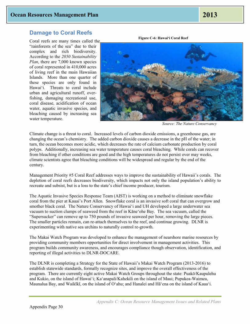
Appendix C: Ocean Resource Management Issues and Related Plans Appendix Page 30
Ocean Resources Management Plan 2013
Damage to Coral Reefs Coral reefs are many times called the “rainforests of the sea” due to their complex and rich biodiversity. According to the 2050 Sustainability Plan, there are 7,000 known species of coral represented in 410,000 acres of living reef in the main Hawaiian Islands. More than one quarter of these species are only found in Hawai‘i. Threats to coral include urban and agricultural runoff, over-fishing, damaging recreational use, coral disease, acidification of ocean water, aquatic invasive species, and bleaching caused by increasing sea water temperature. Source: The Nature Conservancy Climate change is a threat to coral. Increased levels of carbon dioxide emissions, a greenhouse gas, are changing the ocean’s chemistry. The added carbon dioxide causes a decrease in the pH of the water; in turn, the ocean becomes more acidic, which decreases the rate of calcium carbonate production by coral polyps. Additionally, increasing sea water temperature causes coral bleaching. While corals can recover from bleaching if other conditions are good and the high temperatures do not persist over may weeks, climate scientists agree that bleaching conditions will be widespread and regular by the end of the century. Management Priority #5 Coral Reef addresses ways to improve the sustainability of Hawaii’s corals. The depletion of coral reefs decreases biodiversity, which impacts not only the island population’s ability to recreate and subsist, but is a loss to the state’s chief income producer, tourism. The Aquatic Invasive Species Response Team (AIST) is working on a method to eliminate snowflake coral from the pier at Kauai’s Port Allen. Snowflake coral is an invasive soft coral that can overgrow and smother black coral. The Nature Conservancy of Hawai‘i and UH developed a large underwater sea vacuum to suction clumps of seaweed from the reef in Kāne‘ohe Bay. The sea vacuum, called the “Supersucker” can remove up to 750 pounds of invasive seaweed per hour, removing the large pieces. The smaller particles remain, can re-attach themselves to the reef, and continue growing. DLNR is experimenting with native sea urchins to naturally control re-growth. The Makai Watch Program was developed to enhance the management of nearshore marine resources by providing community members opportunities for direct involvement in management activities. This program builds community awareness, and encourages compliance though observation, identification, and reporting of illegal activities to DLNR-DOCARE. The DLNR is completing a Strategy for the State of Hawaii’s Makai Watch Program (2013-2016) to establish statewide standards, formally recognize sites, and improve the overall effectiveness of the program. There are currently eight active Makai Watch Groups throughout the state: Puakō/Kaupulehu and Kukio, on the island of Hawaiʻi; Kaʻanapali/Kahekili on the island of Maui; Pupukea-Waimea, Maunalua Bay, and Waikīkī, on the island of Oʻahu; and Hanalei and Hā‘ena on the island of Kauaʻi.
Figure C-6: Hawai‘i Coral Reef

Appendix C: Ocean Resource Management Issues and Related Plans Appendix Page 31
Ocean Resources Management Plan 2013
Endangered Species One-third of all endangered species in the United States are found in Hawai‘i. Examples of endangered species in the ocean and coastline areas are the Humpback Whale, the Green Sea Turtle, the False Killer Whale, and the Hawaiian Monk Seal. With increasing frequency, other marine species found in Hawai‘i are also being considered for listing. There are also critical estuaries, where fresh and salt water mix together and serve as habitat for endangered birds such as the Hawaiian Moorhen, Hawaiian Stilt, Hawaiian Coot, and Kōloa Duck. Balancing protection of endangered species with other aspects of ocean resource management is critical. The Hawaiian Islands Humpback Whale National Marine Sanctuary (National Marine Sanctuary) is managed as a partnership between NOAA and the State of Hawai‘i. The National Marine Sanctuary is discussed in Chapter IV as an example of a coordinated approach to the management of ocean resources.
Aquatic Invasive Species Aquatic invasive species (AIS) are plants and animals introduced into a water body that have the potential to harm the ecosystem, people, and/or the economy. The Hawaiian Archipelago is home to 85% of the country’s coral reefs, and these ecosystems include a multitude of corals, fish, seaweeds, and other marine life, some found nowhere else in the world. Protecting the fragile ecosystems as well as keeping waterways clear and preserving the environment that commerce and tourism are both dependent upon are all important to the State of Hawai‘i. Prevention and early detection are essential in the control of aquatic invasive species. Aquatic invasive species can be introduced accidentally by sea faring vessels. Ballast water discharges from vessels and biofouling of submerged areas are the major means by which vessels act as a pathway for introduction of marine invasive species. In response to national concerns, the National Invasive Species Act of 1996 amended the Nonindigenous Aquatic Nuisance Prevention and Control Act of 1990. The U.S. Coast Guard (USCG) has established both regulations and guidelines to prevent the introduction and spread of AIS. Other ways of introduction of AIS are people dumping their non-native aquarium fish or plants into a neighborhood stream or river or AIS could be hitchhikers on marine debris. Not all non-native or introduced species become invasive species as some do not reproduce quickly, spread, or cause harm. An example of an invasive species that clogged a waterway is the floating water fern Salvinia molesta, pictured in Figure C-7, which covered Lake Wilson and other waterways on O‘ahu in 2003 and cost over $1 million dollars to eradicate.
Source: Department of Land and Natural Resources
The AIST was established in 2005 as part of the 2003 State of Hawai‘i Aquatic Invasive Species Management Plan. The AIST participates in certain cleanup events such as the “Habitattitude Campaign,” which asks the public to turn in unwanted aquarium pets and pond plants to participating pet stores and other drop off locations statewide. This helps to prevent the introduction of non-native species into the state’s waterways.
Figure C-7: Salvinia molesta

Appendix C: Ocean Resource Management Issues and Related Plans Appendix Page 32
Ocean Resources Management Plan 2013
The AIST also had to respond to the apple snail, which is an international invasive species that first originated in South America and pictured at right. It was first documented on the island of Maui in 1989, and there is now an international alert for apple snails. Apple snails present a serious threat to food security for anywhere there is a water-based food producing economy, such as taro cultivation in Hawai‘i. In some lo‘i (taro fields), crop loss can be as high as 20%, and if not controlled, these snails can consume an entire crop including corms, stems, and leaves in just one day. Outreach education to a broad sector of the state’s population, in multiple languages and approaches, is key to limiting further spread of this invasive species.
Source: Department of Agriculture
Terrestrial Invasive Species Terrestrial invasive species are similar to AIS, except they occur on land. The introduction of a non-native species can interrupt and damage the land ecosystem. This is important to ocean and coast resource management because what happens at the top of the ridge can affect water quantity and the ocean’s water quality. Management Priority #3 Watershed Management looks at the damage that hoofed animals can do to the watershed. Hoofed animals are also referred to as ungulates and include pigs, goats, deer, and sheep. Some were introduced the islands in the late 1700s, and many became feral. The wild populations graze and root around the native forests, destroying ground cover and causing large swaths of land to erode. These feral ungulates may also promote the spread of invasive plant species while foraging. Ungulate barriers such as fencing have been used in forests and watersheds to conserve the ecosystems. Other terrestrial invasive species such as the brown tree snake are important to keep out of the islands because their introduction would wipe out native bird populations, and affect the biodiversity of the forests. There are Invasive Species Committees (ISCs) on O‘ahu, Maui, Moloka‘i, Kaua‘i, and Hawai‘i Island that seek to identify and implement appropriate management strategies.
Food Security: Subsistence Fishing, Fisheries, Aquaculture, and Fishpond Restoration Close to 85-90% of Hawaii’s food is imported into the state, mostly as ship cargo. This makes Hawaii’s food security particularly vulnerable to natural disasters and global events that could disrupt the food supply. In 2012, OP, in cooperation with DOA, prepared the, Increased Food Security and Food Self-Sufficiency Strategy. The three objectives of the strategy are: to increase demand for and access to locally grown foods; increase production of locally grown foods; and provide policy and organizational support to meet food self-sufficiency needs. The ORMP supports the state’s goal of increased food security with goals, actions, and metrics for food that comes from the ocean. Supporting restoration of fishponds, providing access to the coastline for gathering and near shore fishing, and working with agencies to increase responsible and sustainable aquaculture are all ways to increase food security. Collaborating with agencies and community groups to increase access to the shoreline and improve ocean water quality for subsistence or “‘ohana” fishing also
Figure C-8: Apple Snail

Appendix C: Ocean Resource Management Issues and Related Plans Appendix Page 33
Ocean Resources Management Plan 2013
helps support the state’s goal. Working with commercial fishermen and agencies in a cooperative manner will also assist in this effort. Challenges for food security were expressed by residents during two rounds of ORMP Public Listening Sessions held across the State of Hawai‘i in 2012. People on all islands expressed frustration about depleting fishstocks and the inability to access fishing areas due to pollution, runoff, national security, or land development. Some commercial fishers attributed the increase in the invasive species ta’ape to declines in their bottomfish catch, and some residents who rely on coral reef species perceived declines in certain species. Those involved in the aquaculture industry would like to see an increase in aquaculture as a way to provide food security to Hawai‘i. Their projects in coastal and offshore areas have a 2011 industry value of $40 million annually. Since Hawai‘i imports 70% of its seafood, this could be reduced through the expansion of commercial aquaculture. Open ocean fish farming, or offshore aquaculture, is an emerging approach to raising fish in open ocean waters by utilizing submersible cages or net pens (see Figure C-9). Hawai‘i is the first state to have a successfully operating commercial open ocean aquaculture cage in the U.S. The Hawai‘i Department of Agriculture believes that this type of aquaculture is sustainable and lowers the risk of disease, provides a more humane and natural growing environment for fish, and greatly reduces environmental impacts due to strong ocean currents that can sweep away feed residues. Open ocean aquaculture technologies will continue to evolve, providing more opportunities for farmers to farm the sea.
One method to diversify food production is to restore Native Hawaiian fishponds. Ongoing efforts to restore existing fishponds are occurring, such as in Heʻeia, on the island of Oʻahu and Project Loko Iʻa on the island of Molokaʻi. These efforts are perceived as an opportunity to address food security, as well as to practice the Native Hawaiian culture for generations to come. The sentiment expressed at the ORMP Public Listening Sessions is that Native Hawaiians thrived using such methods, so carrying on the approach to food production would be a sustainable way of living. Source: Hawaii Oceanic Technology, Inc.
Figure C-9: Open Ocean Fish Cage
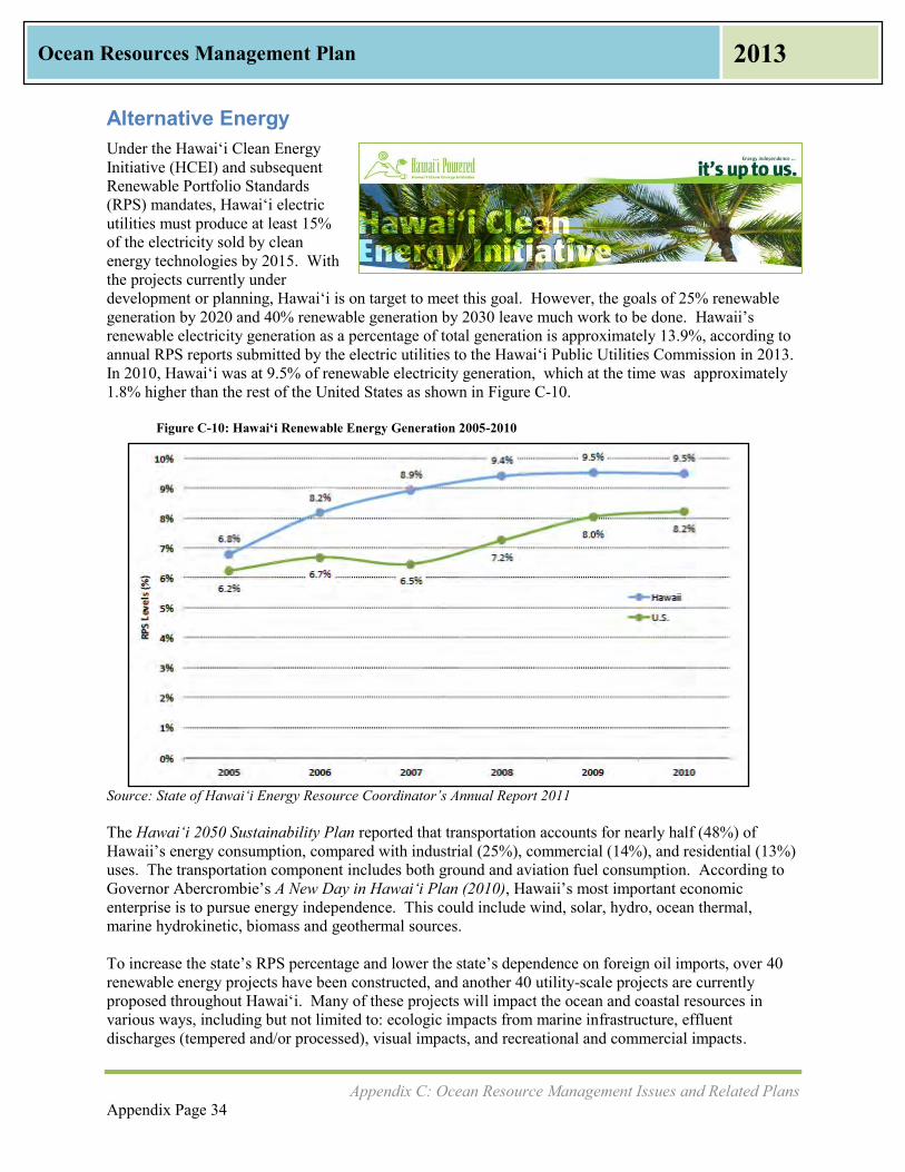
Appendix C: Ocean Resource Management Issues and Related Plans Appendix Page 34
Ocean Resources Management Plan 2013
Alternative Energy Under the Hawaiʻi Clean Energy Initiative (HCEI) and subsequent Renewable Portfolio Standards (RPS) mandates, Hawai‘i electric utilities must produce at least 15% of the electricity sold by clean energy technologies by 2015. With the projects currently under development or planning, Hawai‘i is on target to meet this goal. However, the goals of 25% renewable generation by 2020 and 40% renewable generation by 2030 leave much work to be done. Hawaii’s renewable electricity generation as a percentage of total generation is approximately 13.9%, according to annual RPS reports submitted by the electric utilities to the Hawai‘i Public Utilities Commission in 2013. In 2010, Hawai‘i was at 9.5% of renewable electricity generation, which at the time was approximately 1.8% higher than the rest of the United States as shown in Figure C-10.
Figure C-10: Hawai‘i Renewable Energy Generation 2005-2010
Source: State of Hawai‘i Energy Resource Coordinator’s Annual Report 2011 The Hawai‘i 2050 Sustainability Plan reported that transportation accounts for nearly half (48%) of Hawaii’s energy consumption, compared with industrial (25%), commercial (14%), and residential (13%) uses. The transportation component includes both ground and aviation fuel consumption. According to Governor Abercrombie’s A New Day in Hawai‘i Plan (2010), Hawaii’s most important economic enterprise is to pursue energy independence. This could include wind, solar, hydro, ocean thermal, marine hydrokinetic, biomass and geothermal sources. To increase the state’s RPS percentage and lower the state’s dependence on foreign oil imports, over 40 renewable energy projects have been constructed, and another 40 utility-scale projects are currently proposed throughout Hawai‘i. Many of these projects will impact the ocean and coastal resources in various ways, including but not limited to: ecologic impacts from marine infrastructure, effluent discharges (tempered and/or processed), visual impacts, and recreational and commercial impacts.

Appendix C: Ocean Resource Management Issues and Related Plans Appendix Page 35
Ocean Resources Management Plan 2013
Coupled with the newly formed Hawai‘i Outer Continental Shelf (OCS) Renewable Energy Task Force, the sustainable development of Hawaii’s marine resources is a major component of HCEI. Proper siting and cumulative planning of renewable energy projects are critical to the sustainable use of our indigenous ocean resources. The Hawaiʻi State Energy Office within DBEDT works with impacted stakeholders and regulatory agencies to help ensure individual projects are developed in consideration of local and statewide impacts, both short term and long. Some renewable energy power plants—such as wave energy devices, interisland cables, or offshore wind—would directly impact marine resources because of their location. Even land-based renewable projects, such as geothermal and bioenergy, could affect the ocean through effluent or run-off discharges or if the Hawaiian Islands’ electricity grids are linked by an undersea cable. Hawaii’s present reliance on imported fossil fuels—oil and coal—also can significantly impact the ocean since these fuels are shipped overseas, making the ocean and coasts susceptible to spills and other accidents. The Pacific Ocean is an integral part of Hawaii’s environment, culture, and economy, and has vast potential to support the production of renewable energy. Managing our energy resources sustainably will, at the same time, help to protect our unique ocean resources.
Policy Plans from Other State and Federal Agencies that Impact Ocean Resource Management There is an interwoven web of plans that create layers of policy in Hawai‘i. Collectively, they play a major role in identifying and addressing pressures and important issues. Many of the Management Priorities in Chapter III use the goals and objectives of these other plans as the ORMP performance measures. In this way, work already being done by an agency can be used to implement the ORMP.
Hawai‘i 2050 Sustainability Plan, 2008 The State Legislature mandated the preparation of a State Sustainability Plan, and it was completed in 2008. One of the significant contributions of the Hawai‘i 2050 Sustainability Plan is that it provides the State’s first definition of sustainability, a Hawai‘i that achieves the following:
Respects the culture, character, beauty, and history of our state’s island communities
Strikes a balance among economic, social and community, and environmental priorities
Meets the needs of the present without compromising the ability of future generations to meet their own needs
The Hawai‘i 2050 Sustainability Plan has five goals: A Way of Life – Living sustainably is part of our daily
practice in Hawai‘i; The Economy – Our diversified and globally competitive
economy enables us to meaningfully live, work , and play in Hawai‘i;
Environment and Natural resources – Our natural resources are responsibly and respectfully used, replenished, and preserved for our future generations;
Community and Social Well-Being – Our Community is strong, healthy, vibrant, and nurturing, providing safety nets for those in need;
Kanaka Maoli and Island Values – Our Kanaka Maoli and island cultures and values are thriving and perpetuated.

Appendix C: Ocean Resource Management Issues and Related Plans Appendix Page 36
Ocean Resources Management Plan 2013
A New Day in Hawai‘i, 2010 The New Day Plan is a policy document serves as the public policy roadmap for the current State Administration. The New Day Plan is a policy document that guides actions on: Economy, Education, Energy, Environment and Natural Resources, Food and Agriculture, and Technology and Innovation. Ocean resources management crosses several if not all of these activity areas. The New Day Plan stresses making improvements through collaboration and cooperation. This parallels the ORMP’s Perspective 3: Promoting Collaborative Governance and Stewardship. The State Office of Planning participates in and assists with implementation of the New Day Plan in the areas of Climate Change, Agricultural Renaissance, Energy Independent Hawai‘i, and Sustainability. These responsibilities connect with the Management Priorities in the 2013 ORMP that involve improving coastal water quality, ocean sustainability, ocean resource protection, and addressing invasive species.
2014-2017 University of Hawai‘i Sea Grant Strategic Plan, 2013 The University of Hawai‘i Sea Grant College Program (Sea Grant) supports and conducts an innovative program of research, education, and extension services toward the improved understanding of coastal and marine resources of the state, region, and nation. UH Sea Grant College Program is one of 33 Sea Grant programs nationwide that comprise a functional network within our nation’s universities and colleges promoting enhanced understanding, conservation, and use of coastal and marine resources. Sea Grant was designated as one of five founding Sea Grant College Programs in 1972. As part of the University of Hawaii’s School of Ocean and Earth Science and Technology (UH SOEST), UH Sea Grant College Program partners with NOAA to provide links among academia, federal, state, and local government, industry, and the community.
Sea Grant strategies will concentrate on: Healthy coastal ecosystems Sustainable coastal development Safe and sustainable seafood supply Hazard resilience in coastal
communities Sustainable coastal tourism
Source: UH Sea Grant College Program Center for Sustainable Coastal Tourism
Hawai‘i Marine Debris Action Plan, 2013 The Hawai‘i Marine Debris Action Plan (HI-MDAP) was prepared in 2010 by the NOAA Office of Response and Restoration, Marine Debris Program in 2010 and updated in 2013. This is the nation’s first State Marine Debris Action Plan. While published by a federal agency, it is not a Federal plan. Rather, it is a cooperative effort for agencies in Hawai‘i, encompassing Hawaii’s marine debris community, which
Figure C-11: Instilling Principles of Coastal Tourism at Hanauma Bay Education Center
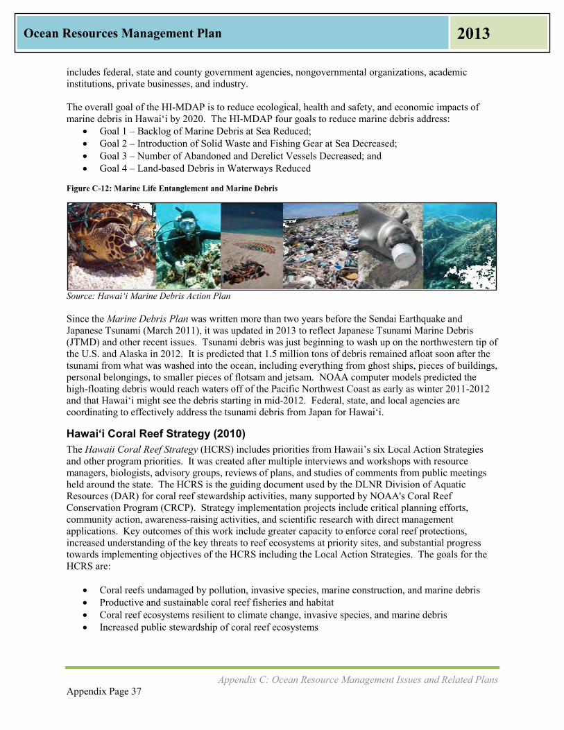
Appendix C: Ocean Resource Management Issues and Related Plans Appendix Page 37
Ocean Resources Management Plan 2013
includes federal, state and county government agencies, nongovernmental organizations, academic institutions, private businesses, and industry. The overall goal of the HI-MDAP is to reduce ecological, health and safety, and economic impacts of marine debris in Hawai‘i by 2020. The HI-MDAP four goals to reduce marine debris address:
Goal 1 – Backlog of Marine Debris at Sea Reduced; Goal 2 – Introduction of Solid Waste and Fishing Gear at Sea Decreased; Goal 3 – Number of Abandoned and Derelict Vessels Decreased; and Goal 4 – Land-based Debris in Waterways Reduced
Figure C-12: Marine Life Entanglement and Marine Debris
Source: Hawai‘i Marine Debris Action Plan Since the Marine Debris Plan was written more than two years before the Sendai Earthquake and Japanese Tsunami (March 2011), it was updated in 2013 to reflect Japanese Tsunami Marine Debris (JTMD) and other recent issues. Tsunami debris was just beginning to wash up on the northwestern tip of the U.S. and Alaska in 2012. It is predicted that 1.5 million tons of debris remained afloat soon after the tsunami from what was washed into the ocean, including everything from ghost ships, pieces of buildings, personal belongings, to smaller pieces of flotsam and jetsam. NOAA computer models predicted the high-floating debris would reach waters off of the Pacific Northwest Coast as early as winter 2011-2012 and that Hawai‘i might see the debris starting in mid-2012. Federal, state, and local agencies are coordinating to effectively address the tsunami debris from Japan for Hawai‘i.
Hawai‘i Coral Reef Strategy (2010) The Hawaii Coral Reef Strategy (HCRS) includes priorities from Hawaii’s six Local Action Strategies and other program priorities. It was created after multiple interviews and workshops with resource managers, biologists, advisory groups, reviews of plans, and studies of comments from public meetings held around the state. The HCRS is the guiding document used by the DLNR Division of Aquatic Resources (DAR) for coral reef stewardship activities, many supported by NOAA's Coral Reef Conservation Program (CRCP). Strategy implementation projects include critical planning efforts, community action, awareness-raising activities, and scientific research with direct management applications. Key outcomes of this work include greater capacity to enforce coral reef protections, increased understanding of the key threats to reef ecosystems at priority sites, and substantial progress towards implementing objectives of the HCRS including the Local Action Strategies. The goals for the HCRS are:
Coral reefs undamaged by pollution, invasive species, marine construction, and marine debris Productive and sustainable coral reef fisheries and habitat Coral reef ecosystems resilient to climate change, invasive species, and marine debris Increased public stewardship of coral reef ecosystems

Appendix C: Ocean Resource Management Issues and Related Plans Appendix Page 38
Ocean Resources Management Plan 2013
Hawaiian Islands Humpback Whale National Marine Sanctuary Management Plan The Hawaiian Islands Humpback Whale National Marine Sanctuary (National Marine Sanctuary) was designated by Congress in 1992 for the following purposes:
1) protect humpback whales and their habitat in the area described in section 2305(b) of the Act; 2) educate and interpret for the public the relationship of humpback whales to the Hawaiian Islands
marine environment; 3) manage such human uses of the Sanctuary consistent with this subtitle and title III of the Marine
Protection, Research, and Sanctuaries Act of 1972, as amended by this Act; and 4) provide for the identification of marine resources and ecosystems of national significance for
possible inclusion in the Sanctuary designated in section 2305(a). As stipulated in a compact agreement (1998), NOAA and the State of Hawai’i “shall manage the Sanctuary through a cooperative partnership and consult on all management activities throughout the Sanctuary.” In accordance with the agreement, the Governor designated a State Co-Manager to work in consultation with the Sanctuary Superintendent as an equal partner in the oversight of National Marine Sanctuary operations. NOAA and the State of Hawai‘i determined that co-managing a National Marine Sanctuary would provide additional resources and expertise to enhance the protection of humpback whales and their habitat. The National Marine Sanctuary is the only state-federal partnership that co-manages areas of the marine environment in the main Hawaiian Islands with twenty three percent of state waters being included within the National Marine Sanctuary. National Marine Sanctuary staff work to improve upon existing marine conservation and management efforts of state and federal agencies by providing inter-agency coordination and comprehensive protection through education, science, and outreach support. The National Marine Sanctuaries Act requires periodic updating of sanctuary management plans to reevaluate site-specific goals and to develop management activities to ensure that the National Marine Sanctuary properly conserves Hawaii’s natural, cultural, and historic resources. At the time of publication, the National Marine Sanctuary was in the process of updating the 2002 Management Plan to address priority issues raised during the 2010 public comment period. OP-CZM coordinated with the National Marine Sanctuary during the public scoping meetings to ensure that the comments received could also be used to inform the update of the ORMP. Priority issues that were raised during the 2010 comment period include:
Climate Change Ecosystem Protections – Species and Habitats Enforcement Humpback Whale Protections Management Effectiveness Marine Animal Assessment and Response Maritime Heritage Native Hawaiian Culture Ocean Literacy Offshore Development Water Quality
Working groups were formed by the community-based Sanctuary Advisory Council to address the priority issues. As part of this process, working group participants also took into account several
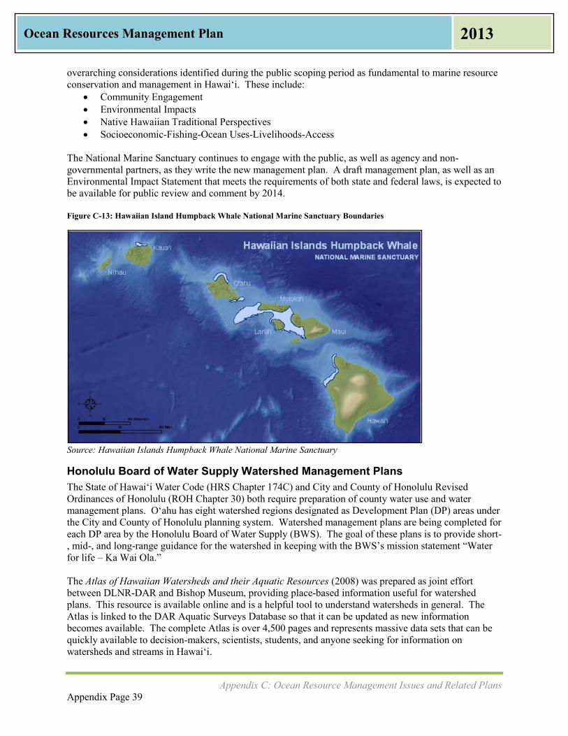
Appendix C: Ocean Resource Management Issues and Related Plans Appendix Page 39
Ocean Resources Management Plan 2013
overarching considerations identified during the public scoping period as fundamental to marine resource conservation and management in Hawai‘i. These include:
Community Engagement Environmental Impacts Native Hawaiian Traditional Perspectives Socioeconomic-Fishing-Ocean Uses-Livelihoods-Access
The National Marine Sanctuary continues to engage with the public, as well as agency and non-governmental partners, as they write the new management plan. A draft management plan, as well as an Environmental Impact Statement that meets the requirements of both state and federal laws, is expected to be available for public review and comment by 2014. Figure C-13: Hawaiian Island Humpback Whale National Marine Sanctuary Boundaries
Source: Hawaiian Islands Humpback Whale National Marine Sanctuary
Honolulu Board of Water Supply Watershed Management Plans The State of Hawai‘i Water Code (HRS Chapter 174C) and City and County of Honolulu Revised Ordinances of Honolulu (ROH Chapter 30) both require preparation of county water use and water management plans. Oʻahu has eight watershed regions designated as Development Plan (DP) areas under the City and County of Honolulu planning system. Watershed management plans are being completed for each DP area by the Honolulu Board of Water Supply (BWS). The goal of these plans is to provide short-, mid-, and long-range guidance for the watershed in keeping with the BWS’s mission statement “Water for life – Ka Wai Ola.” The Atlas of Hawaiian Watersheds and their Aquatic Resources (2008) was prepared as joint effort between DLNR-DAR and Bishop Museum, providing place-based information useful for watershed plans. This resource is available online and is a helpful tool to understand watersheds in general. The Atlas is linked to the DAR Aquatic Surveys Database so that it can be updated as new information becomes available. The complete Atlas is over 4,500 pages and represents massive data sets that can be quickly available to decision-makers, scientists, students, and anyone seeking for information on watersheds and streams in Hawai‘i.

Appendix C: Ocean Resource Management Issues and Related Plans Appendix Page 40
Ocean Resources Management Plan 2013
2005-2015 Hawai‘i Tourism Strategic Plan, 2003
Hawaii’s economy is dependent on tourism, which in turn depends on the state’s ocean resources. The Hawai‘i Tourism Strategic Plan vision is to move towards a sustainable and responsible tourism industry for the State. The implementation framework for tourism includes the overall management plan, development of action plans, implementation of action plans, and county tourism strategic plans. Measures of success are based on resident sentiments, state and county tax receipts, visitor spending, and visitor satisfaction.
Source: 2005-2015 Hawai‘i Tourism Strategic Plan
Figure C-14: Cruise Ship at Honolulu Harbor

Appendix D: Agency Roles Appendix Page 41
Ocean Resources Management Plan 2013
Appendix D: Agency Roles
State, Local and Federal Agencies: Who Does What? Many government agencies and authorities participate in the management of ocean and coastal resources. While there are overlaps in interest, each governmental agency has its own roles and responsibilities. The OP-CZM Program recently published Sustainable Management of the Islands (December 2011), which describes the network of resource agencies for coastal zone management and ocean resource protection. Agencies involved in ocean resource and coastal zone management are shown in Table D-1 for State government, Table D-2 for local agencies, and Table D-3 for Federal agencies.
Table D-1: State Agencies involved in ocean resource and coastal zone management
State Agency Responsibilities for Ocean Resource and Coastal Zone Management Office of Planning, Coastal Zone Management Program (OP-CZM)
CZM Program
Build capacity for community participation in natural and cultural resources management
Develop community-based frameworks and practices for identifying and mitigating ocean recreational use conflicts
Develop legislative and administrative proposals to improve management of natural resources
Monitor and evaluate Ocean Resource Management Plan implementation
Conduct a baseline study of ocean recreation and tourism
Coastal Nonpoint Pollution Control Program (CNPCP) in partnership with DOH
Coastal Access
Development of a territorial sea plan
Identify channelized streams within DLNR Watershed Partnerships for restoration and revitalization of wetland and estuarine habitats
Training on CZM and Special Management Area (SMA) laws and regulations for County Planning Department Staff and Planning Commissions
Department of Health (DOH), Environmental Health, Clean Water Branch
Improve coastal water quality
Reduce pollutant loads from resident, agricultural, and commercial land uses
National Pollutant Discharge Elimination System (NPDES) permits
Implement watershed implementation plans, total maximum daily load implementation plans
Department of Agriculture (DOA), Aquaculture Development Program
Minimize the spread of marine alien and invasive species into and throughout archipelagic waters through inspection and enforcement
Develop ecosystem-based approaches for nearshore fisheries management
Establish and institutionalize approaches for restoring, operating, and preserving ancient Hawaiian coastal fishponds and salt ponds
Plan and develop sustainable commercial aquaculture
Enhance the conservation of Hawaii’s marine protected species, unique habitats and biological diversity
Department of Transportation (DOT), Harbors Division
Improve coastal water quality by reducing marine sources of pollution
Provide appropriate waste management infrastructure to support commercial marine facilities
Minimize introduction and spread of alien species

Appendix D: Agency Roles Appendix Page 42
Ocean Resources Management Plan 2013
State Agency Responsibilities for Ocean Resource and Coastal Zone Management Office of Hawaiian Affairs (OHA)
Assess the policies and practices of other agencies impacting native Hawaiians and Hawaiians, including impacts on traditional and customary practices as well as on natural and cultural resources as they relate to the ocean and shoreline area
Conduct advocacy efforts for native Hawaiians and Hawaiians, including their interests in the natural and cultural resources of the ocean and shoreline area
Facilitate the performance, development, and coordination of programs and activities relating to native Hawaiians and Hawaiians, such as fishpond restoration and maintenance activities
Hawaii Department of Land and Natural Resources (DLNR)
Jointly manage the Hawaiian Islands Humpback Whale National Marine Sanctuary with National Oceanic and Atmospheric Administration (NOAA)
Jointly manage the Papahānaumokuākea Marine National Monument with NOAA, U.S. Fish and Wildlife Service (FWS), and the Office of Hawaiian Affairs (OHA) in the Northwestern Hawaiian Islands
DLNR, Division of Aquatic Resources (DAR)
Manage the marine, estuarine or anchialine resources in Marine Managed Areas that have been established by statute or administrative rule
Protect coral reefs through implementation of the Coral Reef Strategy through work with the Coral Reef Working Group
Regulate certain marine and freshwater fishing areas of the state through state laws and Hawaii Administrative Rules, and work with DOCARE on enforcement
Issue various licenses and permits for fishing, selling aquatic life, and other activities involving aquatic resources
Protect the state from the impacts of aquatic invasive species, which includes prevention, ongoing management and control, and emergency response activities.
DLNR, Division of Ocean Boating and Ocean Recreation (DOBOR)
Perform facility development, management, operation, and repair of small boat harbors, ramps, moorings, landings, public shorelines, wharves, and deep draft harbors
Regulate and enforce state legislation and administrative rules regarding boating facilities and recreational use of waters of the state
Provide appropriate waste management infrastructure to support recreational marine facilities
Issue permits for commercial and recreational use of DOBOR facilities
Manage vessel registration for 15,000 recreation and small commercial vessels in the State
Perform boating accident investigation and reporting
Provide boating safety education
DLNR, Commission on Water Resource Management (CWRM)
Administer State Water Code (HRS Chapter 174C, 1987) through the Commission on Water Resource Management
Implement and enforce CWRM policies, procedures, and rules on water development and usage established in conformance with the State Water Code.
Designate water management areas
Permit water uses
Establish criteria to determine water availability and sustainable yield analyses for aquifers and watersheds
Develop comprehensive and long-range plans for the protection, conservation, and management of the state’s water resources
Develop and adopt drought management plans
Implement Commission policies, procedures, and rules on stream protection and instream flow standards, water development, and usage established in conformance with the State Water Code

Appendix D: Agency Roles Appendix Page 43
Ocean Resources Management Plan 2013
State Agency Responsibilities for Ocean Resource and Coastal Zone Management DLNR, Division of Conservation and Resources Enforcement (DOCARE)
Improve enforcement capacity and voluntary compliance with existing rules and regulations for ocean resource protection
Develop community-based frameworks and practices for identifying ocean recreational use conflicts
DLNR, Division of Forestry and Wildlife (DOFAW)
Reduce soil erosion from upland forest ecosystems and conservation lands
Perpetuate programs that enhance the conservation of Hawaii’s marine protected species, unique habitats and biological diversity
Support the Natural Area Reserves System
Formalize Watershed Partnerships
DLNR, Office of Conservation and Coastal Lands (OCCL)
Oversee approximately 2 million acres of private and public lands that lie within the State Land Use Conservation District
Oversee beach and marine lands within State’s jurisdiction
Develop public education programs and distribute information and guidelines on the best management, erosion control, and construction practices for Hawaii’s coastal areas
Develop programs for beach nourishment
Streamline the beach nourishment regulatory process
Beach Access
Public-private partnerships for beach restoration Hawaiian fishpond reconstruction and fishpond repair programmatic permit
OCCL aquaculture permitting, including management guidelines
Administer Conservation District Use Applications
Hawai‘i Shoreline Management Plan
DLNR Coastal Erosion Management Plan (COEMAP)
OCCL Small Scale Beach Nourishment Program (SSBN)
DLNR Comprehensive Coastal Policy
Coastal Hazard Mitigation Guidebook
Beach Vulnerability Rating Project (BVR)
Historical Shoreline Erosion Studies (Kaua‘i, O‘ahu, Maui)
Enforce removal of unauthorized coastal structures
Enforce Act 160 (encroaching vegetation)
University of Hawai‘i
UH Economic Research Organization (UHERO)
School of Ocean and Earth Science and Technology (SOEST)
Pacific Islands Ocean Observation System (PacIOOS)
Sea Grant
Sea Grant College Program, Center for Island Climate Adaptation & Policy (ICAP)/Loli Aniau, Makaala Aniau (Climate Change, Climate Alert) (LAMA)
Richardson School of Law, Coastal Resilience Networks Project (CRest)
East-West Center, Pacific Regional Integrated Sciences and Assessments (Pacific RISA)
Work with OP-CZM on economic studies
Work with OP-CZM on water quality monitoring, climate change, shoreline erosion, beach loss mitigation, marine invasive species, educational curriculum on coastal and ocean resources
Coastal Hazard Mitigation Guidebook
Historical Shoreline Erosion Studies (Kaua‘i, O‘ahu, Maui)
Implement National ocean observation network
Data management, data archive, and data visualization
Provide decision-making support tools
Support Pacific island and coastal communities to mitigate and adapt to the impacts of climate variability and climate change.
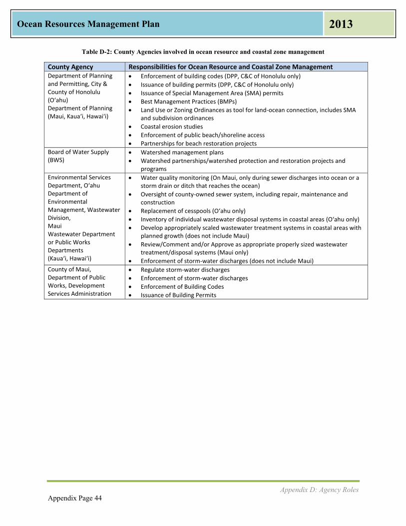
Appendix D: Agency Roles Appendix Page 44
Ocean Resources Management Plan 2013
Table D-2: County Agencies involved in ocean resource and coastal zone management
County Agency Responsibilities for Ocean Resource and Coastal Zone Management Department of Planning and Permitting, City & County of Honolulu (O‘ahu) Department of Planning (Maui, Kaua‘i, Hawai‘i)
Enforcement of building codes (DPP, C&C of Honolulu only)
Issuance of building permits (DPP, C&C of Honolulu only)
Issuance of Special Management Area (SMA) permits
Best Management Practices (BMPs)
Land Use or Zoning Ordinances as tool for land-ocean connection, includes SMA and subdivision ordinances
Coastal erosion studies
Enforcement of public beach/shoreline access
Partnerships for beach restoration projects
Board of Water Supply (BWS)
Watershed management plans
Watershed partnerships/watershed protection and restoration projects and programs
Environmental Services Department, O‘ahu Department of Environmental Management, Wastewater Division, Maui Wastewater Department or Public Works Departments (Kaua‘i, Hawai‘i)
Water quality monitoring (On Maui, only during sewer discharges into ocean or a storm drain or ditch that reaches the ocean)
Oversight of county-owned sewer system, including repair, maintenance and construction
Replacement of cesspools (O‘ahu only)
Inventory of individual wastewater disposal systems in coastal areas (O‘ahu only)
Develop appropriately scaled wastewater treatment systems in coastal areas with planned growth (does not include Maui)
Review/Comment and/or Approve as appropriate properly sized wastewater treatment/disposal systems (Maui only)
Enforcement of storm-water discharges (does not include Maui)
County of Maui, Department of Public Works, Development Services Administration
Regulate storm-water discharges
Enforcement of storm-water discharges
Enforcement of Building Codes
Issuance of Building Permits
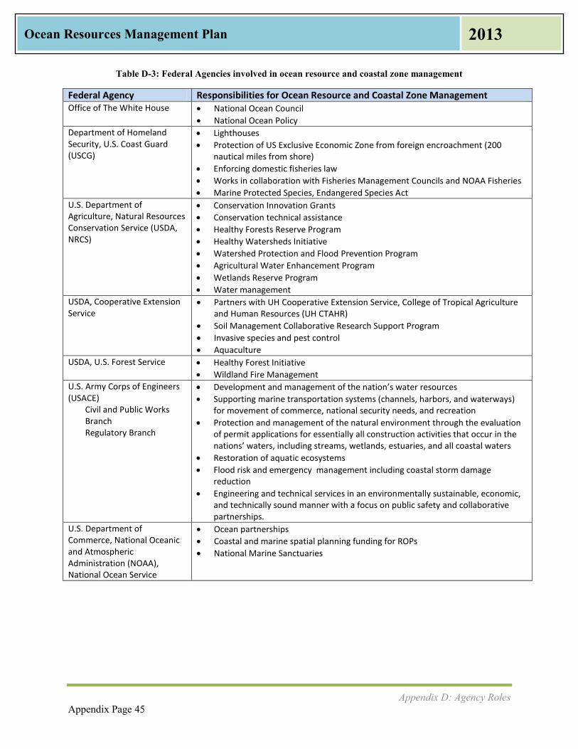
Appendix D: Agency Roles Appendix Page 45
Ocean Resources Management Plan 2013
Table D-3: Federal Agencies involved in ocean resource and coastal zone management
Federal Agency Responsibilities for Ocean Resource and Coastal Zone Management Office of The White House National Ocean Council
National Ocean Policy
Department of Homeland Security, U.S. Coast Guard (USCG)
Lighthouses
Protection of US Exclusive Economic Zone from foreign encroachment (200 nautical miles from shore)
Enforcing domestic fisheries law
Works in collaboration with Fisheries Management Councils and NOAA Fisheries
Marine Protected Species, Endangered Species Act
U.S. Department of Agriculture, Natural Resources Conservation Service (USDA, NRCS)
Conservation Innovation Grants
Conservation technical assistance
Healthy Forests Reserve Program
Healthy Watersheds Initiative
Watershed Protection and Flood Prevention Program
Agricultural Water Enhancement Program
Wetlands Reserve Program
Water management
USDA, Cooperative Extension Service
Partners with UH Cooperative Extension Service, College of Tropical Agriculture and Human Resources (UH CTAHR)
Soil Management Collaborative Research Support Program
Invasive species and pest control
Aquaculture
USDA, U.S. Forest Service Healthy Forest Initiative
Wildland Fire Management
U.S. Army Corps of Engineers (USACE)
Civil and Public Works Branch Regulatory Branch
Development and management of the nation’s water resources
Supporting marine transportation systems (channels, harbors, and waterways) for movement of commerce, national security needs, and recreation
Protection and management of the natural environment through the evaluation of permit applications for essentially all construction activities that occur in the nations’ waters, including streams, wetlands, estuaries, and all coastal waters
Restoration of aquatic ecosystems
Flood risk and emergency management including coastal storm damage reduction
Engineering and technical services in an environmentally sustainable, economic, and technically sound manner with a focus on public safety and collaborative partnerships.
U.S. Department of Commerce, National Oceanic and Atmospheric Administration (NOAA), National Ocean Service
Ocean partnerships
Coastal and marine spatial planning funding for ROPs
National Marine Sanctuaries
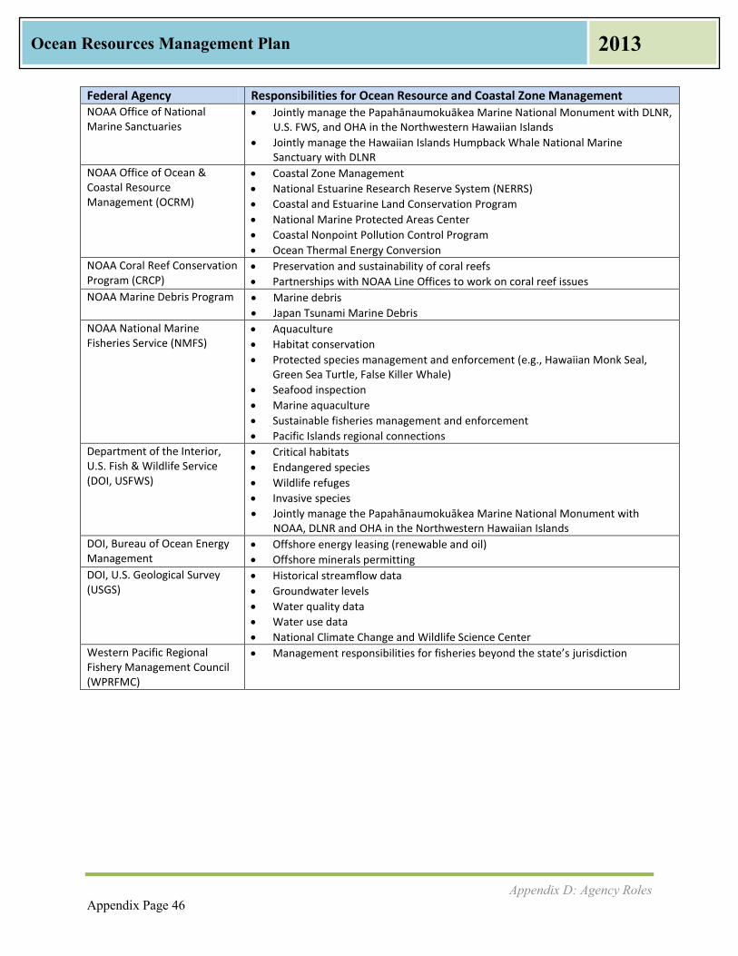
Appendix D: Agency Roles Appendix Page 46
Ocean Resources Management Plan 2013
Federal Agency Responsibilities for Ocean Resource and Coastal Zone Management NOAA Office of National Marine Sanctuaries
Jointly manage the Papahānaumokuākea Marine National Monument with DLNR, U.S. FWS, and OHA in the Northwestern Hawaiian Islands
Jointly manage the Hawaiian Islands Humpback Whale National Marine Sanctuary with DLNR
NOAA Office of Ocean & Coastal Resource Management (OCRM)
Coastal Zone Management
National Estuarine Research Reserve System (NERRS)
Coastal and Estuarine Land Conservation Program
National Marine Protected Areas Center
Coastal Nonpoint Pollution Control Program
Ocean Thermal Energy Conversion
NOAA Coral Reef Conservation Program (CRCP)
Preservation and sustainability of coral reefs
Partnerships with NOAA Line Offices to work on coral reef issues
NOAA Marine Debris Program Marine debris
Japan Tsunami Marine Debris
NOAA National Marine Fisheries Service (NMFS)
Aquaculture
Habitat conservation
Protected species management and enforcement (e.g., Hawaiian Monk Seal, Green Sea Turtle, False Killer Whale)
Seafood inspection
Marine aquaculture
Sustainable fisheries management and enforcement
Pacific Islands regional connections
Department of the Interior, U.S. Fish & Wildlife Service (DOI, USFWS)
Critical habitats
Endangered species
Wildlife refuges
Invasive species
Jointly manage the Papahānaumokuākea Marine National Monument with NOAA, DLNR and OHA in the Northwestern Hawaiian Islands
DOI, Bureau of Ocean Energy Management
Offshore energy leasing (renewable and oil)
Offshore minerals permitting
DOI, U.S. Geological Survey (USGS)
Historical streamflow data
Groundwater levels
Water quality data
Water use data
National Climate Change and Wildlife Science Center
Western Pacific Regional Fishery Management Council (WPRFMC)
Management responsibilities for fisheries beyond the state’s jurisdiction

Appendix E: Scientific and Ocean Research Activities Taking Place in Hawai‘i Appendix Page 47
Ocean Resources Management Plan 2013
Appendix E: Scientific and Ocean Research
Activities Taking Place in Hawai‘i
The University of Hawai‘i is currently involved with scientific and research activities in a number of fields.
University of Hawai‘i, School of Ocean & Earth Science & Technology (SOEST) at UH Mānoa is one of the nation's premier academic institutions for ocean-related research. SOEST faculty and staff conduct research in a broad disciplinary range, including but not limited to:
The Hawai‘i Institute of Marine Biology (HIMB) situated on Coconut Island in Kāneʻohe Bay;
Hawai‘i Undersea Research Laboratory, established by National Oceanic Atmospheric Administration (NOAA) and UH to study deep water marine processes in the Pacific Ocean;
International Pacific Research Center, conceived under US-Japan Common Agenda for Cooperation in Global Perspective, focuses on understanding climate variation and predictability in the Asia-Pacific region, including regional aspects of global environmental change. The Asia-Pacific Data Research Center provides easy access to climate data and research products. Specific projects include oceanic modeling, Hawai‘i Regional Forecast, monsoon monitoring, precipitation prediction, and other research;
Joint Institute for Marine and Atmospheric Research was established to pursue the common research interest of NOAA and the UH in oceanic, atmospheric, and geophysical research, including climate and global change, equatorial oceanography, tsunamis and fishers oceanography; and
Center for Microbial Oceanography: Research and Education (C-MORE) facilitates a greater understanding of microorganisms in the sea, ranging from the genetic basis of marine microbial life to their ecological place in the marine environment.
Pacific Islands Ocean Observing System (PacIOOS) is based within SOEST and is the Pacific Islands regional component of the U.S. Integrated Ocean Observing System (IOOS). PacIOOS is a partnership of data providers and users working together to enhance ocean observations and develop, disseminate, evaluate, and apply ocean data and information products designed to address the environmental, economic and public safety needs of stakeholders who call the Pacific Islands home. The organization's major goal is to generate and serve ocean and coastal data in a user-friendly manner for researchers, resource managers, and the public. Within Hawai‘i, PacIOOS research and development includes:
A system of models that assimilate direct observations in order to produce a comprehensive ocean state prediction for the main Hawaiian Islands:
o Circulation Models: Ocean circulation and current forecasts are made daily using the Regional Ocean Modeling System (ROMS) for the Main Hawaiian Islands, with increased resolution for O‘ahu.
o Wave Modeling: Ocean waves are forecast daily using WaveWatch III (WW III) and Simulating Waves Nearshore (SWAN) models with domains that extend throughout the entire Pacific with increasing resolution for each of the main Hawaiian Islands, the Mariana Islands, and the Samoan Islands.
o Atmospheric Modeling: The Weather Research and Forecasting (WRF) model produces daily atmospheric forecasts covering all of the Hawaiian Islands as well as detailed forecasts for each of the main Hawaiian Islands.

Appendix E: Scientific and Ocean Research Activities Taking Place in Hawai‘i Appendix Page 48
Ocean Resources Management Plan 2013
A sensor network measuring water quality (conductivity/salinity, temperature, pressure, chlorophyll, turbidity and in some locations, also pH, dissolved oxygen, CO2).
An array of wave buoys measuring height, direction and period throughout Hawai‘i. An array of sensors conducting biological monitoring (satellite tags and passive and acoustic
instrumentation) to track the behavior, movement and population dynamics of marine mammals, reef fish, and pelagics such as sharks and tuna.
An array of High Frequency Radio systems to monitor surface currents real-time along the south shore of O‘ahu. Expanding to include the leeward coast of O‘ahu and Hilo on Hawai‘i Island as well.
Operational products that forecast wave inundation, high sea levels, coastal erosion, nearshore wave and current hazards, and impacts of sea-level rise in low-lying communities.
Integration projects that present data and information collected through the system above into user-friendly tools and services:
o PacIOOS Website (www.pacioos.org) includes data servers where users can access and download data for free and store data long term.
o PacIOOS Voyager (www.pacioos.org/voyager) is an interactive online mapping platform that uses Google Maps as a foundation for data overlays. Data are incorporated directly from PacIOOS servers as well as from other data providers. Historical, current, and forecast data are available, as are dynamic and static data layers. Users can access Voyager for free to visualize, save, embed, download, and combine thousands of data layers in an easy-to-use platform.
o PacIOOS Explorer (www.pacioos.org/geoexplorer) is a free data service providing GIS or map-based information. This web mapping service (WMS) and geospatial database is a unique service of PacIOOS and acts to fulfill a more robust demand for geospatial cataloging, computations, and analysis. The WMS allows users to directly query the database, then make, save, and print maps and overlays as well as conduct geospatial analyses.
University of Hawai‘i, Sea Grant College Program (UH Sea Grant) works in collaboration with SOEST and NOAA. Sea Grant is dedicated to improving the understanding and stewardship of marine and coastal resources in the state and region. UH Sea Grant includes centers for Sustainable Aquaculture, Marine Science Education, and Island Climate Adaptation and Policy. Recent publications include “Research Priorities in the Insular Pacific: Transforming Research into Regional Management.” UH Sea Grant is hosting the NOAA Coastal Storms Program (CSP) to foster community resilience to coastal hazards. The CSP utilizes funds and resources in the US Pacific Island coastal communities to help reduce and mitigate the risk from coastal storm and weather hazards and climate change. To enhance community resilience, the program provides an array of tools, products and services, including improved observing systems, forecast models, decision support tools, assessments, community best practices and guidance, socioeconomic information, training and outreach/extension activities. Specific programs include:
Coastal inundation mapping, including storm surge and hurricane inundation mapping Developing Pacific storms climatology, Pacific Climate Information System (PaCIS),
Climate Extremes in the Pacific Integrated Case Studies (EPICS) to support vulnerability assessment and adaptation planning
Developing a Pacific Region Global Positioning Satellite (GPS) Met Network Improving the national spatial reference system in the Pacific Islands Assessing land-based toxic runoff and coral reef ecosystem resilience in the Pacific Islands
Appendix E: Scientific and Ocean Research Activities Taking Place in Hawai‘i Appendix Page 49
Ocean Resources Management Plan 2013
The Pacific Regional Integrated Sciences and Assessments (Pacific RISA) program supports Pacific Island and coastal communities to mitigate and adapt to the impacts of climate variability and change. The agency conducts research in water resources, management, coastal impacts and disaster risk management. The Pacific Islands Regional Climate Assessment (PIRCA) is a collaborative effort aimed at assessing the state of climate knowledge, impacts, and adaptive capacity in Hawai‘i and the U.S. affiliated Pacific Islands. PIRCA provides information to federal, state and local government agencies, non-governmental agencies, businesses, and community groups. Their priority focus is on preserving freshwater resources and minimizing the impacts of drought, fostering community resilience to the impacts of sea-level rise, coastal inundation and extreme weather, and sustaining marine, freshwater, and terrestrial ecosystems. Research topics involve:
Climate variability and change science, including historical observations, trends, and climatology,
Freshwater resource sustainability, flow trends, groundwater recharge, demographic stresses Sea level rise (SLR) and coastal inundation projections and scenarios, current and projected
coastal hazards and impacts, Ecosystem assessments including climate effects on ocean acidification and coral health,
SLR impacts on ecosystems, saltwater intrusion, and species/habitat responses to precipitation and temperature changes.
The University of Hawai‘i has recently committed to a collaborative Sustainability Initiative for the campus, involving new staff clustered around the statewide program. UH Sea Grant competed with other departments across the University of Hawai‘i system and won funding for this important and groundbreaking initiative. The cluster includes five new tenured staff in the fields and schools of economy, engineering, oceanography, architecture, planning, Hawaiian Studies, and ocean agriculture. The program will be focused on the three areas of water, energy and transportation, and while each staff member is housed in one of the five schools, they are also required to dedicate 25% of their time to collaborative work in the Sustainability Initiative.

Appendix F: Community and Place-Based Ocean Management Projects Appendix Page 50
Ocean Resources Management Plan 2013
Appendix F: Community and Place-Based Ocean
Management Projects
A primary mission of OP-CZM is to coordinate the implementation of the ORMP by promoting collaborative governance and stewardship. During the ORMP Demonstration Phase, several community groups were able to implement projects with the assistance of funds from OP-CZM. Six ORMP implementation projects were funded that involved state or county government partners working with a community-based organization partner. Six other community projects were funded through the leveraging of other funds. The twelve projects described provide important information and lessons from the ORMP Demonstration Phase.
OP-CZM Direct Funded Partnership Projects Māhuahua ʻAi o Hoi (O‘ahu)
The Hawai‘i Community Development Authority (HDCA) worked with community partners Kāko‘o ‘Ōiwi and the Ko‘olaupoko Hawaiian Civic Club and received $96,395.00 of OP-CZM funds to support Māhuahua ‘Ai o Hoi. The project site is on Oʻahu’s windward coast at the He‘eia wetlands (Hoi), which currently lay fallow and are covered with dense vegetation. Mangrove overgrowth that was hampering the flow of the Heʻeia Stream was removed. In order to restore the He‘eia wetlands and reduce non-point source pollution at the shoreline, the partners are incorporating a traditional Hawaiian ahupua‘a concept of land management through the interconnections of the He‘eia wetlands to the He‘eia
shoreline. The He‘eia Wetland Restoration Strategic Plan 2010-2015 outlines plans, partnerships, and actions to be undertaken in the next few years. The planning and training phase of the project embodies all three perspectives of the ORMP and serves as a model demonstration project. This project is considered highly successful and has since been chosen as a NOAA Sentinel Site. A NOAA Sentinel Site must be place-based, issue-driven, and collaborative, and in a coastal and marine environment that has the capacity for intensive study and sustained observations. NOAA chose this site based on its unique blend of characteristics: a dynamic physical setting, an ecologically diverse environment, and a rich culture of historical significance.
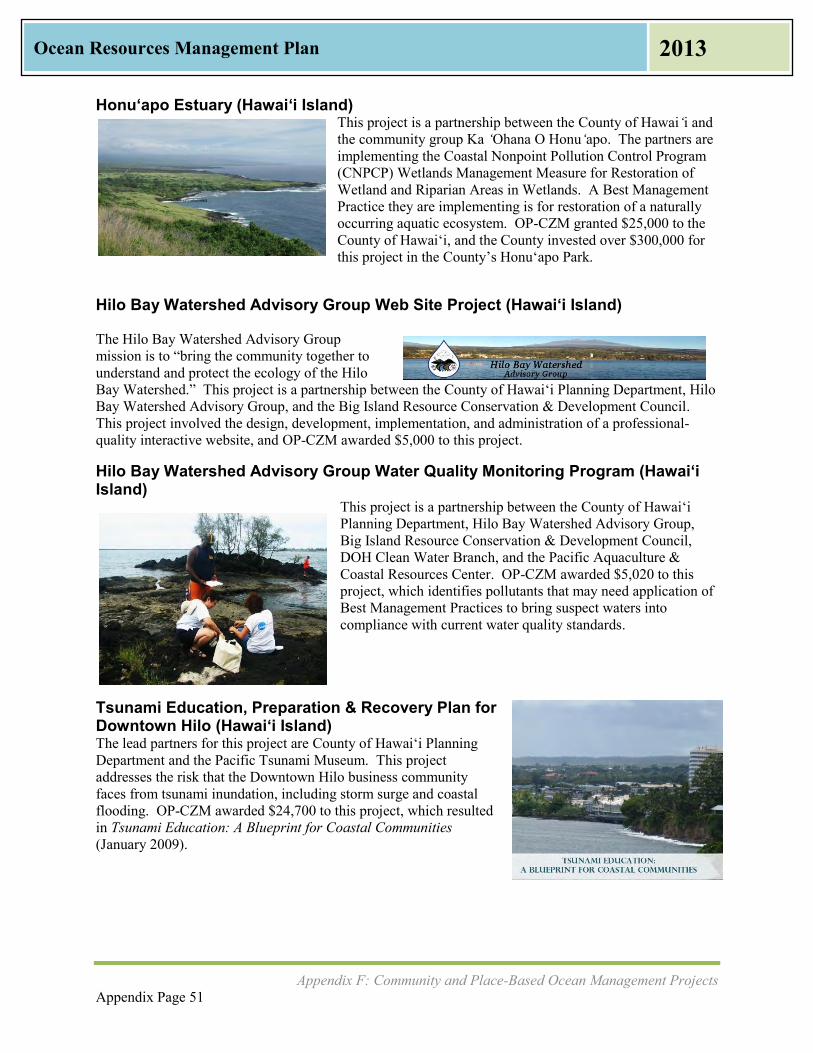
Appendix F: Community and Place-Based Ocean Management Projects Appendix Page 51
Ocean Resources Management Plan 2013
Honu‘apo Estuary (Hawaiʻi Island) This project is a partnership between the County of Hawai‘i and the community group Ka ‘Ohana O Honu‘apo. The partners are implementing the Coastal Nonpoint Pollution Control Program (CNPCP) Wetlands Management Measure for Restoration of Wetland and Riparian Areas in Wetlands. A Best Management Practice they are implementing is for restoration of a naturally occurring aquatic ecosystem. OP-CZM granted $25,000 to the County of Hawai‘i, and the County invested over $300,000 for this project in the County’s Honu‘apo Park.
Hilo Bay Watershed Advisory Group Web Site Project (Hawaiʻi Island) The Hilo Bay Watershed Advisory Group mission is to “bring the community together to understand and protect the ecology of the Hilo Bay Watershed.” This project is a partnership between the County of Hawai‘i Planning Department, Hilo Bay Watershed Advisory Group, and the Big Island Resource Conservation & Development Council. This project involved the design, development, implementation, and administration of a professional-quality interactive website, and OP-CZM awarded $5,000 to this project.
Hilo Bay Watershed Advisory Group Water Quality Monitoring Program (Hawai‘i Island)
This project is a partnership between the County of Hawai‘i Planning Department, Hilo Bay Watershed Advisory Group, Big Island Resource Conservation & Development Council, DOH Clean Water Branch, and the Pacific Aquaculture & Coastal Resources Center. OP-CZM awarded $5,020 to this project, which identifies pollutants that may need application of Best Management Practices to bring suspect waters into compliance with current water quality standards.
Tsunami Education, Preparation & Recovery Plan for Downtown Hilo (Hawaiʻi Island) The lead partners for this project are County of Hawai‘i Planning Department and the Pacific Tsunami Museum. This project addresses the risk that the Downtown Hilo business community faces from tsunami inundation, including storm surge and coastal flooding. OP-CZM awarded $24,700 to this project, which resulted in Tsunami Education: A Blueprint for Coastal Communities (January 2009).
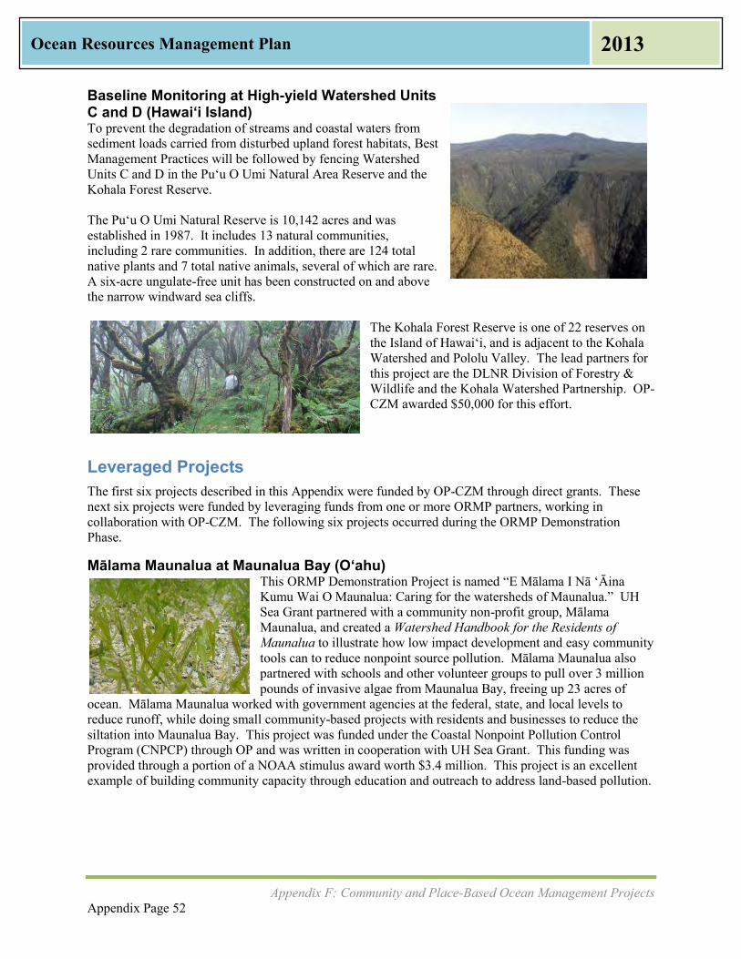
Appendix F: Community and Place-Based Ocean Management Projects Appendix Page 52
Ocean Resources Management Plan 2013
Baseline Monitoring at High-yield Watershed Units C and D (Hawaiʻi Island) To prevent the degradation of streams and coastal waters from sediment loads carried from disturbed upland forest habitats, Best Management Practices will be followed by fencing Watershed Units C and D in the Pu‘u O Umi Natural Area Reserve and the Kohala Forest Reserve. The Puʻu O Umi Natural Reserve is 10,142 acres and was established in 1987. It includes 13 natural communities, including 2 rare communities. In addition, there are 124 total native plants and 7 total native animals, several of which are rare. A six-acre ungulate-free unit has been constructed on and above the narrow windward sea cliffs.
The Kohala Forest Reserve is one of 22 reserves on the Island of Hawai‘i, and is adjacent to the Kohala Watershed and Pololu Valley. The lead partners for this project are the DLNR Division of Forestry & Wildlife and the Kohala Watershed Partnership. OP-CZM awarded $50,000 for this effort.
Leveraged Projects The first six projects described in this Appendix were funded by OP-CZM through direct grants. These next six projects were funded by leveraging funds from one or more ORMP partners, working in collaboration with OP-CZM. The following six projects occurred during the ORMP Demonstration Phase.
Mālama Maunalua at Maunalua Bay (Oʻahu) This ORMP Demonstration Project is named “E Mālama I Nā ‘Āina Kumu Wai O Maunalua: Caring for the watersheds of Maunalua.” UH Sea Grant partnered with a community non-profit group, Mālama Maunalua, and created a Watershed Handbook for the Residents of Maunalua to illustrate how low impact development and easy community tools can to reduce nonpoint source pollution. Mālama Maunalua also partnered with schools and other volunteer groups to pull over 3 million pounds of invasive algae from Maunalua Bay, freeing up 23 acres of
ocean. Mālama Maunalua worked with government agencies at the federal, state, and local levels to reduce runoff, while doing small community-based projects with residents and businesses to reduce the siltation into Maunalua Bay. This project was funded under the Coastal Nonpoint Pollution Control Program (CNPCP) through OP and was written in cooperation with UH Sea Grant. This funding was provided through a portion of a NOAA stimulus award worth $3.4 million. This project is an excellent example of building community capacity through education and outreach to address land-based pollution.

Appendix F: Community and Place-Based Ocean Management Projects Appendix Page 53
Ocean Resources Management Plan 2013
Kawainui Marsh Levee Certification Project (O‘ahu) OP-CZM contracted with the City and County of Honolulu to assist in the certification of the Kawainui Marsh Levee. The U.S. Army Corps of Engineers (USACE) had constructed the original Kawainui Flood Control Project in 1966, with modifications made in 1997. The project protects the town of Kailua against flood events while perpetuating the 830-acre Kawainui Marsh as the largest wetland in the State of Hawai‘i. The Kawainui Marsh Environmental Restoration Project broke ground in June 2012 and is in the process of creating 11 wetland pond cells within 37 acres at the mauka end of Kawainui Marsh. The project restores wetland habitat for several endangered birds: Ae‘o Kukuluao (Hawaiian Stilt), ‘Alae ‘Ula (Hawaiian Gallinule), ‘Alae Ke‘oke‘o (Hawaiian Coot), and Kōloa (Hawaiian Duck). The project will provide increased public access to Kawainui Marsh while helping to protect the neighboring urban area, Coconut Grove, from flooding.
West Maui Mountains Watershed Partnership (Maui) The West Maui Mountains Watershed Partnership (WMMWP) is a voluntary collaboration of public and private landowners to preserve and protect nearly 50,000 acres of the forested core of West Maui or 10% of the island of Maui. The WMMWP's efforts are concentrated in the West Maui Mountains, also known as Mauna Kahalawai, where elevations range from the summit at 5,788 feet to near sea level. The WMMWP includes several private landowners and DLNR. WMMWP crews have installed fences to protect against Axis Deer in the watershed while also monitoring and controlling weeds. Since 1998, they have built 17 miles of fences to protect 17,989 acres of land.
West Maui Ridge 2 Reef Initiative The West Maui Ridge 2 Reef Initiative is an all-encompassing approach across multiple agencies and organizations to address adverse impacts to coral reefs in West Maui. This initiative covers covers five watersheds: Wahikuli, Honokowai, Kahana, Honokohua, and Honolua.
Many individuals from the community are working closely with lead agencies including: DLNR, DOH, NOAA, EPA, National Fish and Wildlife Foundation (NFWF), USDA-NRCS, DOI-FWS, United States Geological Survey (USGS), and USACE.
US Army Corps of Engineers (USACE) Silver Jackets Initiative (Statewide) Through its Silver Jackets Initiative, the USACE Honolulu District funded a collaborative project to reduce risk in the Pacific that could affect or impair holistic water management. The ORMP Policy and Working Groups were invited to partner with the USACE and the Pacific Risk Management Ohana (PRiMO) to support the continued development of synergies between agencies to help reduce risk associated with an array of issues, including environmental degradation, natural disasters, and climate
change. One of these projects was the Hawai‘i 2060: Visioning Hawaii’s Adaptation to Climate Change, which is a report of the Alternative Futures Exercise at the 2011 Planning Meeting with ORMP partners.

Appendix G: Resources for Communities in Coastal and Marine Stewardship Appendix Page 54
Ocean Resources Management Plan 2013
Appendix G: Resources for Communities in Coastal and
Marine Stewardship
Throughout the process of updating the ORMP, communities across the island state have asked how they can access more assistance for their projects. From Anahola, Kaua‘i where community members are rebuilding the ancient Hawaiian fishpond at their shoreline to the fishponds of Moloka‘i, from water quality monitoring concerns at Hulupoe Bay on Lāna‘i to runoff issues at Kawaihae Harbor on Hawai‘i Island, communities wanted to sustain their ocean resources, but they needed assistance. Some knew what had to be done but needed help with Federal and State permitting processes. Others had a vision for how their group could improve their resource but needed technical assistance for grant applications. And others had worked for decades on projects that had not come to fruition and could not prevail over their years of frustration. There are many funding opportunities for communities doing work that matches the framework in the ORMP Three Perspectives: Connecting Land and Sea; Preserving Our Ocean Heritage; and Promoting Collaboration and Stewardship. These include:
National Oceanic and Atmospheric Administration Community-based Restoration Program NOAA’s Community-Based Restoration Program (CRP), which is part of the Habitat Conservation of the National Marine Fisheries Service, supports priority projects in Hawai‘i that can address threats to the coastal ecosystem. CRP partners with grassroots organizations to encourage hands-on community participation in restoration projects. CRP delivers technical support along with funds for projects in order to help ensure restoration success. Examples of funded programs are the Okelehao Trail Erosion Control Restoration and the Waipa Fishpond and Estuarine Habitat Restoration Project, both located in Hanalei on the island of Kaua‘i and both implemented by The Hanalei Watershed Hui. Funding opportunities, guidelines, and proposal applications can be accessed here: http://www.habitat.noaa.gov/funding/southwest.html
NOAA Marine Debris Program NOAA supports several grant opportunities for removal of marine debris. The first is in partnership with NOAA CRP mentioned above, and the second is a public-private partnership called Fishing for Energy. The NOAA CRP grants typically open each summer with proposals due in either late October or early November. Funding of up to $2,000,000 is expected to be available for Community-based Marine Debris Removal Project Grants in fiscal year 2012. The Fishing for Energy Small Grants Fund is administered in partnership with the NOAA Marine Debris Program, Covanta Energy Corporation, Schnitzer Steel Industries, and the National Fish and Wildlife Foundation. This grant provides funding to Fishing for Energy Partnership ports, their partners, or other commercial fishing ports for disposal of old, abandoned, or derelict fishing gear. Funding opportunities, guidelines, and proposal applications can be accessed here: http://marinedebris.noaa.gov/funding/welcome.html

Appendix G: Resources for Communities in Coastal and Marine Stewardship Appendix Page 55
Ocean Resources Management Plan 2013
Hawai‘i Conservation Alliance The Hawai‘i Conservation Alliance is a cooperative collaboration of conservation leaders representing government, education, and non-profit organizations. The purpose of the HCA is to work together to continue stewardship and promote preservation, to increase diversity of native species, and to ensure continued maintenance of Hawaii’s biodiversity. The nineteen organizations currently in HCA are many of the same organizations represented formally in the ORMP Working Group, and will be many of the same organizations represented in the Hawai‘i Sub-ROP. This alliance fits within all Three Perspectives. HCA holds an Annual Hawai‘i Conservation Conference, which celebrated its 20th Anniversary in 2012. HCA also aggregates many different funding opportunities on its website. Further information can be accessed here: http://hawaiiconservation.org/resources/grants
Harold K. L. Castle Foundation The Castle Foundation provides annual grants to nonprofit organizations serving Hawai‘i if they have been approved as Internal Revenue Service Code Sections 501(c) (3) and 509(a) public charity status. The Castle Foundation also provides grants to Hawai‘i public schools. The funding cannot be used for ongoing operating expenses unless it is a new project or new organization seeking start-up funding. The categories for funding include: Public Education Redesign and Enhancement; Nearshore Marine Resource Conservation; Strengthening the Communities of Windward O‘ahu; and Other Investments. The grants relating to Nearshore Marine Resource Conservation fit with Perspective Two: Preserving Our Ocean Heritage and Perspective Three: Promoting Collaboration and Stewardship. Information about the Castle Foundation grants and resources for grant seekers is available here: http://www.castlefoundation.org/grantseeker-resources.htm
Hawai‘i Alliance of Nonprofit Organizations The Hawai‘i Alliance of Nonprofit Organizations (HANO) provides leadership, advocacy, research information, communications, professional development, and products and services for the nonprofit sector in Hawai‘i. For community organizations seeking to become a formal non-profit, HANO provides several website links in Hawai‘i and in the Unites States to complete this process. Links to resources for nonprofits and those starting a nonprofit can be found here: http://hano-hawaii.org/resources/
Hawai‘i Tourism Authority Natural Resources Program The Hawai‘i Tourism Authority (HTA) developed the Hawai‘i Tourism Strategic Plan: 2005-2015, and one of the nine tourism strategic initiatives identified as necessary to achieve the vision of the plan is the Natural Resources Initiative. Funding is applied for annually via a Request for Proposals process. In the past, a variety of projects have been funded including efforts to remove alien species, re-planting of native plants, trash removal from natural resources areas, and installation of interpretative signage to educate visitors about environmental assets. Links to resources and the annual application can be found at: www.hawaiitourismauthority.org

Appendix G: Resources for Communities in Coastal and Marine Stewardship Appendix Page 56
Ocean Resources Management Plan 2013
Makai Watch
DLNR partners with community groups and Non-Government Organizations as part of the Makai Watch Program. Makai Watch focuses on near-shore marine resources and community-based participation. The Makai Watch Program consists of three main components: 1) Building Community Awareness and Outreach; 2) Biological and Human Use Monitoring; and 3) Incident Observation and Encouraging Compliance
The nine DLNR-recognized Makai Watch groups operating are: 1) Puakō, Hawai‘i 2) Kaʻūpūlehu and Kūkio, Hawai‘i 3) Kāʻanapali/Kahekili, Maui 4) ʻĀhihi-Kīnaʻu Natural Area Reserve, Maui 5) Pūpūkea-Waimea, O‘ahu 6) Maunalua Bay, O‘ahu 7) Waikīkī, O‘ahu 8) Hanalei, Kaua‘i 9) Hā‘ena, Kaua‘i
Anyone can get involved by contacting the Makai Watch Coordinator on their island: http://www.hawaiicoralreefstrategy.com/index.php/makai-watch-on-going
Getting Involved in Caring for Hawaii’s Coastal Resources DLNR’s Division of Aquatic Resources distributes a community guidebook with support from NOAA’s Coral Reef Management Grant. The guide gives advice on how to start a community-based project, develop an action plan, prioritize projects, and find funding. Related activities, additional resources, and contact information is also provided. http://coralreef.noaa.gov/education/educators/resourcecd/guides/resources/hi_resources_g.pdf
Project S.E.A.-Link
Project S.E.A.-Link is a nonprofit organization based on Maui and founded in 1999. This nonprofit works with volunteers on all islands to implement community-based coral reef monitoring. A volunteer can conduct reef fish surveys or participate in the ReefWatchers program to collect information on the impact humans have on the reef itself. There are also educational, science, and awareness links available. http://projectsealink.org/index.html

Appendix G: Resources for Communities in Coastal and Marine Stewardship Appendix Page 57
Ocean Resources Management Plan 2013
Making a Difference Action Guide OP-CZM Program, in cooperation with Project S.E.A.-Link and NOAA, distributes an Action Guide to Marine Conservation in Hawai‘i. The guide was designed as a tool to provide communities with key information, guidelines, and contact information for ocean users to participate in marine conservation. Included in the contact information are the myriad of agencies at all levels of government in a handy marine enforcement phone book. http://www.hawaiicoralreefstrategy.com/PDFs/14_Makai_Watch_On-going/EntireGuideBook.pdf
Hawai‘i Community Stewardship Directory
The OP-CZM Program developed the Hawai‘i Community Stewardship Directory to help community groups and organizations involved in natural and cultural resources management connect with each other, share their experiences, and exchange lessons learned. OP-CZM updates this directory periodically as one element of the ORMP. To date, 114 organizations across Hawai‘i have requested inclusion in this directory.
http://files.hawaii.gov/dbedt/op/czm/initiative/community_based/May2010_HawaiiCommunityStewardshipDirectory.pdf
Marine and Coastal Zone Advocacy Council (MACZAC) Chapter 205A-3.5 of the Hawaii Revised Statutes clarifies the Office of Planning’s responsibility to maintain a public advisory body (MACZAC). The body is composed of twelve advisory members recruited from the Islands of Kaua‘i, O‘ahu, Maui, Moloka‘i, Lāna‘i, and Hawai‘i, who have diverse backgrounds in business, environment, native Hawaiian practices, terrestrial and marine commerce, recreation, research, and tourism. MACZAC’s mission statement is: “Advocate for a comprehensive management system which restores, preserves, and protects Hawaii’s marine and coastal environment.” MACZAC is an integral part of the ORMP. http://planning.hawaii.gov/czm/maczac/

- This page is intentionally left blank -