o historic columbia river highway - home · pdf filethe historic columbia river highway is a...
TRANSCRIPT
HistoricColumbia
RiverHighway
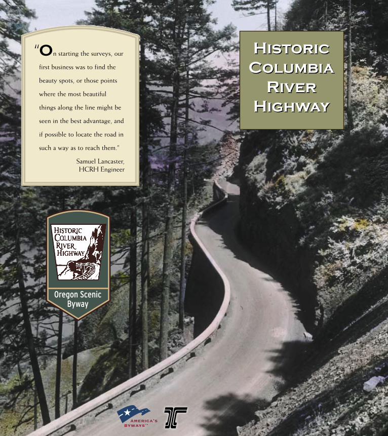
“On starting the surveys, our
first business was to find the
beauty spots, or those points
where the most beautiful
things along the line might be
seen in the best advantage, and
if possible to locate the road in
such a way as to reach them.”
Samuel Lancaster, HCRH Engineer
Oregon ScenicByway
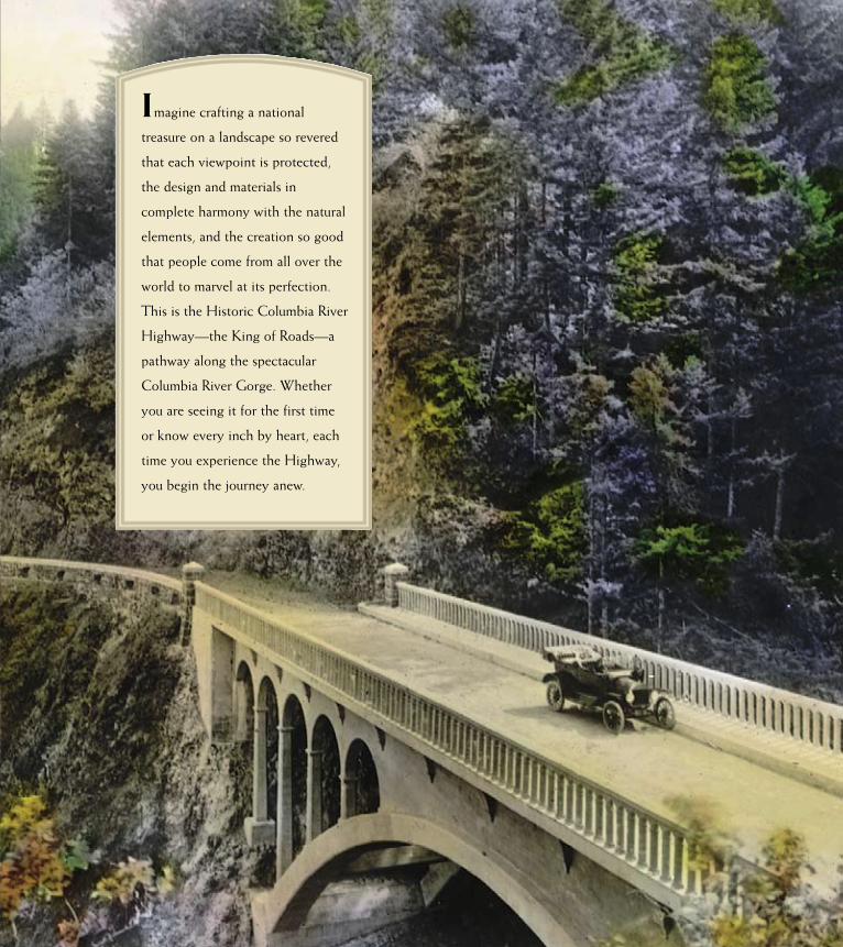
Imagine crafting a national
treasure on a landscape so revered
that each viewpoint is protected,
the design and materials in
complete harmony with the natural
elements, and the creation so good
that people come from all over the
world to marvel at its perfection.
This is the Historic Columbia River
Highway—the King of Roads—a
pathway along the spectacular
Columbia River Gorge. Whether
you are seeing it for the first time
or know every inch by heart, each
time you experience the Highway,
you begin the journey anew.
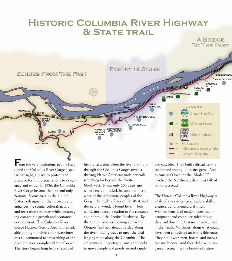
Historic Columbia River Highway& State trail
From the very beginning, people have found the Columbia River Gorge a spec-tacular sight, a place to protect and preserve for future generations to experi-ence and enjoy. In 1986, the Columbia River Gorge became the first and only National Scenic Area in the United States, a designation that protects and enhances the scenic, cultural, natural, and recreation resources while encourag-ing compatible growth and economic development. The Columbia River Gorge National Scenic Area is a remark-able joining of public and private inter-ests all committed to stewardship of the place the locals simply call “the Gorge.”The story begins long before recorded
history, at a time when the river and trails through the Columbia Gorge served a thriving Native American trade network stretching far beyond the Pacific Northwest. It was only 200 years ago when Lewis and Clark became the first to write of the indigenous peoples of the Gorge, the mighty River of the West, and the natural wonders found here. Their words introduced a nation to the romance and riches of the Pacific Northwest. By the 1850s, pioneers coming across the Oregon Trail had already settled along the river, finding ways to meet the chal-lenging route along the Columbia. The emigrants built portages, canals and locks to move people and goods around rapids
and cascades. They built railroads as the timber and fishing industries grew. And as America’s love for the Model “T” reached the Northwest, there was talk of building a road.
The Historic Columbia River Highway is a tale of visionaries, civic leaders, skilled engineers and talented craftsmen. Without benefit of modern construction equipment and computer-aided design, they laid down the first major paved road in the Pacific Northwest along what could have been considered an impossible route. They did it with men, horses, and innova-tive machinery. And they did it with ele-gance, reconciling the beauty of nature
Echoes From The PastEchoes From The PastPoetry In StonePoetry In Stone
A Bridge To The Past
A Bridge To The Past
TROUTDALE
MULTNOMAH FALLS
EXIT 18
SANDY RIVER
DODSON/AINSWORTH – EXIT 35
EXIT 28BRIDAL VEIL
CROWN POINT/ VISTA HOUSE
CORBETT
C O L UM
BI
A
R
I VE R ONEONTA
GORGE
HORSETAIL FALLS
WAHKEENA
SHEPPERD’S DELL
LATOURELL FALLS
PORTLAND WOMEN’S
FORUMDABNEY
LEWIS & CLARK
Oregon State Park–
US Forest Service–
Fee Required–
L e g e n d
HCRH open to motor vehicles–Hiking & biking only–
3
AINSWORTH STATE PARK
Historic Highway–HISTORIC
ROUTE

Land Of Contrast
Restoration & Reconnection
with the needs of civilization. Lawyer, “good roads” advocate and entrepreneur Sam Hill envisioned more than a route through the Columbia River Gorge. He inspired the construction of a highway to rival the great roads of Europe. Together with engineer Samuel Lancaster, Hill championed his vision for a road winding high above the Columbia to Portland civic leaders John B. Yeon, Simon Benson, Julius Meier, Henry L. Pittock, C.S. Jackson, and others. In 1913, construction began,
and by 1922 Portland was connected to The Dalles by a paved road. Over the years, this grand road was replaced by a modern highway and many of its trea-sures lost. Tunnels were filled and bridges destroyed, but thanks to the efforts of many dedicated advocates, the Highway is being restored. Today, you can still drive segments of the Historic Columbia River Highway and walk or bicycle along once-abandoned sections that have been restored as the Historic Columbia River Highway State Trail.
Traveling the Historic Highway and State Trail
A tour of the Historic Highway can take a few hours or a few days, depending on the time you have to spend enjoying each site along the way. Take a look at the map and you’ll see the segments that can be driven and those which have been re-opened for hiking and biking. You’ll be able to follow the US 30 signs marking the motorized route of the Historic Highway.
Original parts of the road are still narrow and winding, and not rec-ommended for large motorhomes. When stopping along the highway, you’ll want to make sure that you have secured your valuables. Keep an eye out for bicyclists and hikers who often share this route. And remember you are out in nature.
A Bridge To The Past
A Bridge To The Past CASCADE
LOCKS
HOOD RIVER
THE DALLES
MOSIER
EAGLE CREEK
BONNEVILLE DAM
DODSON/AINSWORTH – EXIT 35
35
MOSIERTWIN TUNNELS
WARRENDALE
HO
OD
RI
VE
R
STATE TRAILHIKING
& BIKINGONLY
STATE TRAILHIKING
& BIKINGONLY
ROWENA CREST
GORGEDISCOVERY
CENTER
STARVATION CREEK
VIENTOMEMALOOSE OVERLOOK
Arched railings along the Multnomah Falls viaducts.
TOM MCCALL PRESERVE
4
AINSWORTH STATE PARK
HISTORIC
ROUTE

Stark Street Bridge over the Sandy River is one of the two
western gateways onto the Historic Columbia River Highway.
“We will cash in, year after year, on our crop of scenic beauty, without depleting it in any way.”
Sam Hill

Echoes From The Past
Beginning on the banks of the Sandy River, the Historic
Columbia River Highway winds gen-tly past a tree-lined shore not far from where Lewis and Clark camped in 1805. They called it the “Quicksand River” for in those days it ran with a gritty and murky look. Majestic Mt. Hood to the east—an icon of Oregon’s landscape—had recently erupted, spilling ash into the headwa-ters of the Sandy high in the Cascades. You’ll see the snow-capped mountain as you meander your way past upland orchards and blueberry fields through the historic communi-ties of Springdale and Corbett. No
longer the bustling farm towns they once were, they stand now as quiet neighbors along the Highway, a place for folks to enjoy country liv-ing not far from the city.
At Portland Women’s Forum State Park at Chanticleer Point you get your first look at the Columbia River and the Columbia River Gorge—the vista that inspired Sam Hill to create the Highway. In the distance you catch sight of the next major view-point at Crown Point. On your way there, you’ll see more of the struc-tures associated with the Historic Highway: stone guard walls with
graceful arches and “guard rocks” laid out by skilled craftsman. One of the most distinctive features of the Historic Columbia River Highway is its masonry. Look for the differences in masonry and see if you can tell which work is original and which is new. Look, too, for the reconstructed concrete mile markers and the white wooden guardrails, both efforts to replace the original elements of the highway and recall the visual reminders of a time when motoring through the Gorge was done at a slower pace.
VistaHouse
CORBETT
EXIT 22
HISTORIC COLUMBIA RIVER HWY
NE CORBETT HILL RD.
NE
CO
RBE
TT HILL RD.I-84
HCRHOTHER ROADS
RAILROAD
LEWIS & CLARKSTATE PARK
TROUTDALE
SA
ND
YR
IV
ER
EXIT 18
EXIT 17
JOR
DA
N R
D.
HIS
TOR
IC
COLUMBIARIVER
HW
Y
257T
H D
R
I-84HCRH
OTHER ROADSRAILROAD
You will find the beginning of the Historic Columbia River Highway in Troutdale on the east side of the Sandy River near Lewis and Clark State Park.
The community of Corbett is located on the old highway and can be reached from I-84, exit 22 via Corbett Hill Road.
6
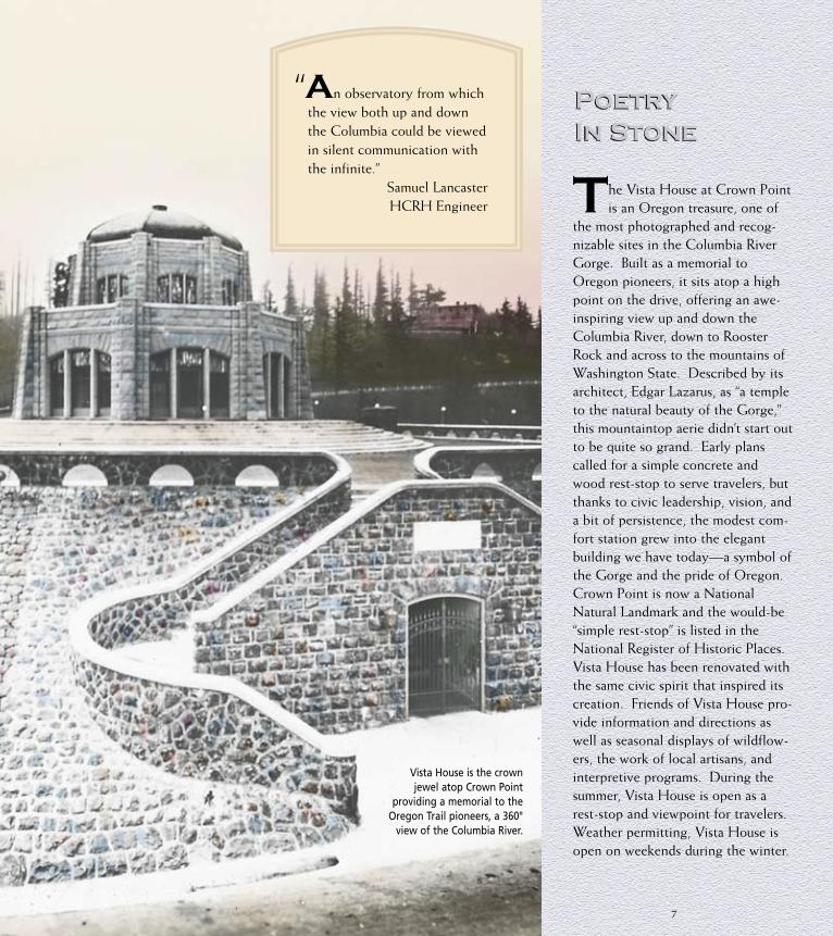
PoetryIn Stone
The Vista House at Crown Point is an Oregon treasure, one of
the most photographed and recog-nizable sites in the Columbia River Gorge. Built as a memorial to Oregon pioneers, it sits atop a high point on the drive, offering an awe-inspiring view up and down the Columbia River, down to Rooster Rock and across to the mountains of Washington State. Described by its architect, Edgar Lazarus, as “a temple to the natural beauty of the Gorge,” this mountaintop aerie didn’t start out to be quite so grand. Early plans called for a simple concrete and wood rest-stop to serve travelers, but thanks to civic leadership, vision, and a bit of persistence, the modest com-fort station grew into the elegant building we have today—a symbol of the Gorge and the pride of Oregon. Crown Point is now a National Natural Landmark and the would-be “simple rest-stop” is listed in the National Register of Historic Places. Vista House has been renovated with the same civic spirit that inspired its creation. Friends of Vista House pro-vide information and directions as well as seasonal displays of wildflow-ers, the work of local artisans, and interpretive programs. During the summer, Vista House is open as a rest-stop and viewpoint for travelers. Weather permitting, Vista House is open on weekends during the winter.
Vista House is the crown jewel atop Crown Point
providing a memorial to the Oregon Trail pioneers, a 360°
view of the Columbia River.
“An observatory from which the view both up and down the Columbia could be viewed in silent communication with the infinite.”
Samuel LancasterHCRH Engineer
7

Highway engineer Samuel Lancaster had to figure out how to get motor-ists from the top of Crown Point to the bottom of the hill, a drop of some 600 feet. Being sensitive to the landscape and aware of the limita-tions of the “modern” automobile, Lancaster designed the “figure-eight loops” that gracefully wind down toward the river. The gentle grade and expansive curves make it easy for both motorists and bicyclists to drift down the mountainside. Lancaster’s lasting legacy to us is this peaceful, easy ride through a Cascade forest. Here the drive con-tinues to surprise and delight as you weave through a series of remarkable waterfalls . . . Latourell, Shepperd’s Dell, Bridal Veil, and Wahkeena. The “beauty spots” that Samuel Lancaster wanted to show travelers are enhanced by the structures he
designed around them: the graceful arches of the bridges and rock barri-ers, the way the highway hugs basalt towers, the quiet trails to the falls. Even the architectural landmarks on this part of the drive add to the feel-ing of the place: the three-hipped barn, the rustic English cottage style home, and the historic “road houses” Forest Hall and Bridal Veil Inn. Forest Hall is a private residence now, but some establishments along the Highway are serving travelers as they did in the 1920s.
TO BRIDAL VEILSTATE PARK
AND VISTA HOUSE
TOMULTNOMAH
FALLS
EXIT 28
HISTO
RICCOLU
MBIARIV
ERHW
Y
BRIDAL VEILPOST OFFICE
It is an Oregon tradition for brides to bring their wedding invitations to the Bridal Veil post office to buy stamps and to get the postmark. Established in 1887, it is one of the oldest in the state, but now is open Monday – Saturday, 8:00 am – 2:00 pm. It’s still worth a stop to photograph.
Wahkeena Falls was purchased by Simon Benson and donat-ed to the City of Portland as a park. It is now managed by the Forest Service.
8
HISTORIC HIGHWAYI-84
HCRHOTHER ROADS
RAILROAD

A Bridge ToThe Past
It won’t take you long to see why Multnomah Falls is the most-visit-
ed natural setting in Oregon. The Falls have been popular with travelers since the 1880s when steamboat excursions and the Oregon Railway and Navigation Company brought tourists to enjoy the natural land-scape. Today, millions of visitors come to thrill at the sight and sound of water rushing over the basalt ledge some 600 feet above, and sent crash-ing to the bubbling pool below. All around you—blending with the damp and mossy natural landscape—are the good works of the road- builders: the gently arched bridge above the falls, the half-viaducts as you enter and leave the area, the rock guardrails protecting your drive toward Oneonta Gorge and Horsetail Falls. Multnomah Falls is a memory of Oregon carried through-out the world, an image of the Northwest found on photographs and postcards and in the words of poets and wordsmiths. Linger an hour, linger a day, lift your spirits, and fill your cup. Stop in at the Multnomah Falls Lodge, constructed in 1925 by the City of Portland and listed in the National Register of Historic Places. This is a place to explore, relax, get something to eat, and to experience an international gathering of folks before exploring other sites along the Highway.
Spray from Horsetail Falls often drifts across the Highway. For a second damp adventure, explore the trail behind Pony Tail Falls—just above Horsetail Falls, of course. This is a little-known but treasured spot along the Highway.
9

As you arrive at Oneonta and stand on the old bridge, you can see one of the tunnels lost to progress and filled when the route of the original highway was changed. This tunnel was reopened in 2009 and provides access to a parking area. Oneonta Gorge is a magical place along the highway—a botanical paradise, with more than fifty species of plants flourishing in the damp cool gorge where the falling water stirs the air and keeps the temperature cool even on the hottest of days. A hike to Oneonta Falls promises to be a wet one since you have to wade in-stream to find it tucked back in the gorge, but it is well worth the effort. An old pair of tennis shoes and tow-els will come in handy.
JOHN B. YEONSTATE PARK
EXIT 35
WARRENDALE
DODSON
EXIT 37
HISTORIC COLUMBIA RIVER HWY
CO
L U M B I AR I V E R
To MultnomahFalls
Not all of the Historic Highway can be driven, but that doesn’t mean it can’t be experienced and enjoyed. The keystone signs guide you from Troutdale to Ainsworth. From Ainsworth exit 35, take the Interstate east to exit 40, where you can park in the Toothrock Trailhead and walk or bicycle on the Historic Columbia River Highway State Trail. This part of the trail is currently open from Moffett Creek east to Cascade Locks. Along the trail, you’ll see restored rock walls and viaduct railings. The Benson Footbridge carries hikers across the
lower portion of Multnomah Falls, providing access to the top of the falls.
10
TO MULTNOMAH FALLS
HISTORIC HIGHWAYI-84
HCRHOTHER ROADS
RAILROAD

Restoration &Reconnection
A little more than ten years after the Historic Highway was fin-
ished, the face of the Gorge began to change dramatically. Bonneville Dam was started in 1933 and when it was completed, it raised the level of the water to a point four miles east of The Dalles, submerging many of the river’s natural and scenic sites forever. While the Northwest gained a pow-erful supply of electricity and flood control, it also lost significant histori-cal resources and traditional Native American fishing sites so much a part of their culture and lifeways. Fishing platforms can still be seen, as can the remnants of the restored Toothrock and Eagle Creek viaducts if you are traveling westbound on Interstate 84. Completed in 1937, Toothrock Tunnel was constructed as part of a realignment of the Historic Highway from Bonneville Dam to Cascade Locks. Today it ably handles higher speed traffic and wide trucks east-bound on Interstate 84.
Also in the 1930s, the Eagle Creek Campground—the first USDA Forest Service Campground in the nation—was improved with “modern con-veniences” for the motoring public, including the first flush toilet in a Forest Service facility. Young men from all over the country left their homes and the depression behind to work for the Civilian Conservation Corps (CCC) on projects in the great Pacific Northwest. The rustic archi-
V iento—a lovely Spanish word that translates to “windy”—a word aptly describing this spot on the Columbia River. You might wonder how this Spanish word came to be used when so many named sites along the river have a Native American origin. Well, truth be told, Viento is actually an acronym created from the last names of three railroad men who had a connection to this spot, Villiard, Endicott, and Tolman—not quite as roman-tic, but creative nonetheless. Re-created “Eagles Nest”
overlooking Bonneville Dam.11
challenged the future of the two-lane Historic Highway. By 1949, a new water-level route was under construc-tion, much of it built on fill but also using some of the original highway. By 1969, a four-lane Interstate high-way to The Dalles was built. Much of the section of the Historic Highway between Ainsworth and Mosier was paved over or bypassed and the Highway itself lost prominence and identity in the minds of the traveling public. Today it is WaNaPa Street and Forest Lane through the town of Cascade Locks, the site of geological events and the Cascades of the Columbia. These white-water rapids forced Lewis and Clark to portage rather than face a certain wet and dangerous fate. Those same rapids became a hazard to early pioneers and inspired the development of the Barlow Road across Mt. Hood. Sternwheelers still leave from this
lively port in the summertime, taking passengers up the Columbia River to dams, locks, and Indian fishing plat-forms.
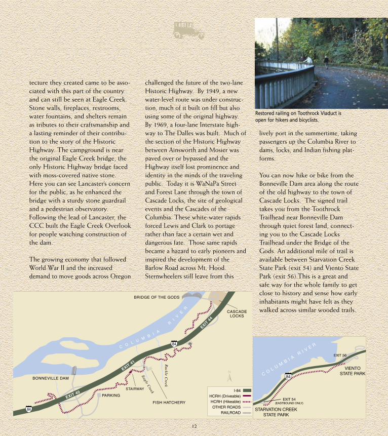
You can now hike or bike from the Bonneville Dam area along the route of the old highway to the town of Cascade Locks. The signed trail takes you from the Toothrock Trailhead near Bonneville Dam through quiet forest land, connect-ing you to the Cascade Locks Trailhead under the Bridge of the Gods. An additional mile of trail is available between Starvation Creek State Park (exit 54) and Viento State Park (exit 56).This is a great and safe way for the whole family to get close to history and sense how early inhabitants might have felt as they walked across similar wooded trails.
tecture they created came to be asso-ciated with this part of the country and can still be seen at Eagle Creek. Stone walls, fireplaces, restrooms, water fountains, and shelters remain as tributes to their craftsmanship and a lasting reminder of their contribu-tion to the story of the Historic Highway. The campground is near the original Eagle Creek bridge, the only Historic Highway bridge faced with moss-covered native stone. Here you can see Lancaster’s concern for the public, as he enhanced the bridge with a sturdy stone guardrail and a pedestrian observatory. Following the lead of Lancaster, the CCC built the Eagle Creek Overlook for people watching construction of the dam.
The growing economy that followed World War II and the increased demand to move goods across Oregon
PARKING
BONNEVILLE DAM
BRIDGE OF THE GODS
CASCADELOCKS
FISH HATCHERY
Ruckle C
reek
Eagle C
reek
C O L U MB
I A
RI
VE
R
EXIT 40
EXIT 41
EXIT 4
4
STAIRWAY
I-84
HCRH (Driveable)HCRH (Hikeable)OTHER ROADS
RAILROAD
Restored railing on Toothrock Viaduct is open for hikers and bicyclists.
12
VIENTOSTATE PARK
STARVATION CREEKSTATE PARK
EXIT 56
EXIT 54(EASTBOUND ONLY)
C OL U M
B I A R I V E R

Land Of Contrast
Hood RiverJust before you rejoin the Historic Highway to pass through the town of Hood River, you’ll want to sample the elegance and comfort of the Columbia Gorge Hotel (north of I-84 at exit 62). The elegant structure was built by Highway promoter and Portland civic leader Simon Benson. In the National Register of Historic Places, the hotel reminds us of a time when travel was a bit more leisurely and destinations catered to those who motored through the Gorge as a form of relaxation and an escape from the hustle and bustle of city life. Taking Cascade Avenue east back toward town, you are once again on the route of the Historic Highway.
Historic Hood River sits on the bluff overlooking the mighty Columbia River. It won’t take you long to find the late Victorian houses, English cot-tage homes, and weatherbeaten stairs reminiscent of the days when Hood River was a thriving city of the early 1900s. In the lower part of town, you get a view of Mt. Adams to the north; from the heights, Mt. Hood is seen in full grandeur to the south. Over the years, the town of Hood River has cap-tured the best the Gorge has to offer: a thriving timber economy, world-renowned orchards and fields bearing the famous fruit of Hood River Valley, an outdoor ethic that permeates the town, and even a cultural history boasting the state’s first outdoor com-munity music festival. Hood River has
Hood River was known as “Dog River” in pioneer days. The name was changed to reflect the source of the river. The Historic Highway crosses Highway 35 and the Mt. Hood Loop near the river, taking you on a drive through the riches of the Hood River Valley to the snow-covered slopes of Mt. Hood and Timberline Lodge.
13
A model “A” roadsterphotographed during
restoration of theMosier Twin Tunnels,
November 4, 1996
TO MT. HOOD
EXIT 69
HOODRIVER
PARKING
EXIT 64
HISTORIC COLUMBIARIVER HWY STATE TRAIL
C O L U M B I A R I V E R
HO
OD
RIVER
HOODRIVERBRIDGE
ROCK CREEK R
D35
MOSIER
Mark O. HatfieldTRAILHEAD EAST
PARKING
MOSIERTWIN
TUNNELS
Mark O. HatfieldTRAILHEAD WEST
I-84
HCRH (Driveable)HCRH (Hikeable)OTHER ROADS
RAILROAD
a history of reinventing itself for the future while preserving the best of the past. The last time the economy here was becalmed, the wind came to the rescue. Today, you’ll see a town alive with activity—the home of windsurf-ing in Oregon. If the wind isn’t blow-ing, wait a day or two—you’ve never seen anything to compare with the color, speed, and sheer energy generat-ed by hundreds of windsurfers and kite boarders answering the call of the winds in the Gorge.
The Mosier Twin Tunnels The two tunnels between Hood River and Mosier were filled with rock in the mid-1950s when the new water-level route was opened, but fortunately they were not destroyed. Thanks to the work of many dedicated Highway advocates, the Mosier Twin Tunnels are once again open for the public to enjoy. Too narrow for today’s cars, the Tunnels now welcome travelers taking
a hike or a bicycle ride. For everyone who travels this cliffhanging roadway, the reward is a spectacular view down to the Interstate and the great Columbia River. Long a curiosi-ty to passers-by, the Tunnels connect Hood River to Mosier . . . linking the wet western end of the Gorge with the dry eastern Columbia River plateau. It’s hard to imagine any other place in the world where the cli-mate changes so much in such a short distance, where in a matter of minutes you can walk between two so very dif-ferent ecosystems. On the western end of the Twin Tunnels, rockfalls have always been a hazard, damaging cars and injuring people. So in the tradi-tion of Sam Hill and Samuel Lancaster, the newest engineering structure to
grace the Historic Highway has been installed to protect visitors. Take a look at the rock catchment. True to
the legacy of the Historic Highway, it is the first of its kind, a never-been-done-before structure! The HCRH State Trail continues a tra-dition of visitor ser-vices at trailheads on the east and west ends, both named to honor the steward-
ship and leadership of Oregon’s Senator Mark O. Hatfield.
Mosier/Rowena CrestFrom the east end of the Mosier Twin Tunnels, the Historic Columbia River Highway once again becomes a scenic drive, connecting the city of Mosier to The Dalles along a scenic 15-mile driving segment lined with white
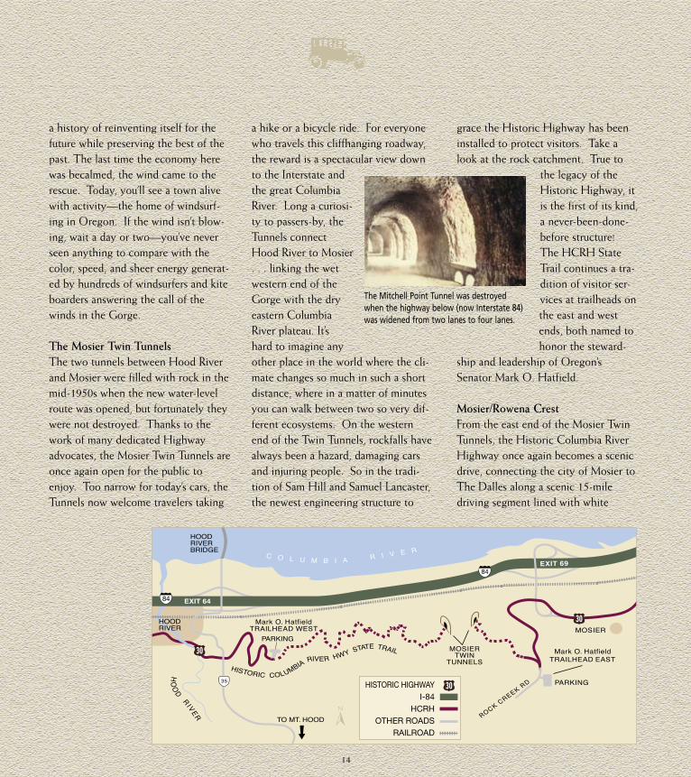
The Mitchell Point Tunnel was destroyed when the highway below (now Interstate 84) was widened from two lanes to four lanes.
14
HISTORIC HIGHWAYI-84
HCRHOTHER ROADS
RAILROAD
wooden guardrails remembered from long-ago drives in the country. Once a booming trade center, Mosier is still famous for its springtime blossoms, fat juicy cherries, and the community’s unrivaled passion for native plants. Each year, people from the Mosier Grange set up their cherry booth on Second Street for residents and visitors alike to enjoy.
Leaving Mosier on the Historic Highway, you are struck by the dra-matic change in land-scape and the visual reminders of the people who once lived near this place: the orchards where fortunes were made and lost, the ele-gant Mayerdale estate so unexpected on this rural stretch of the road, and the Memaloose Overlook to the burial grounds on Memaloose Island in the wide river below. This lonely island takes its name from the Chinook word memalust which means “to die.” Once a traditional burial site of Native Americans, the island now holds only the grave of the one white man who asked to be placed to rest with his Indian friends, to be buried “among honest men.” Leaving the inspirational view of Memaloose behind, the Historic Highway gently climbs again, this time toward the Rowena Plateau and the viewpoint at Rowena Crest, a year-round wonder rivaling the view from Crown Point. From this spot you get an unobstructed view of the Klickitat River in Washington and the “other” Northwest, the dry eastern hills of Oregon and Washington rolling toward the wheat country of the great Columbia Basin Plateau. At first
glance, they may seem barren and desolate, but the longer you search those great gentle contours, the more you see and sense the subtle color and graceful movement that gives them their grandeur.
For several months each spring, the Rowena Plateau is bursting with the bounty of wildflowers and native plants. Thanks to the Gorge’s wide range of
elevation and precipita-tion, a diverse collection of wildflowers thrives here, many endemic to the region. Among the showiest are balsamroot, a yellow sunflower, and the deep blue-violet broadleaf lupine. The wildflowers of the Gorge are a source of
pride for those who live in the area and a source of wonder for all who happen upon them. You can take an organized tour or leisurely roam through the Tom McCall Preserve. Two words of advice: don’t pick the flowers and watch out for poison oak!
Leaving the Rowena Plateau, the vision of Sam Lancaster is once again fulfilled as the road loops down in a series of wide easy turns to the bottom of the hill, giving you the best view and the easiest ride. Once down the Rowena Loops nearing the community of Rowena, you can look across Interstate 84 to two favored and windy sailboard sites along the river, East Mayer State Park and across the river, Doug’s Beach..
The Dalles The Historic Columbia River Highway spans the extremes of Oregon’s land-scape. From the damp and mossy west-ern beginning along the banks of the Sandy River to the dry oak savannahs skirting Chenoweth Creek, the two ”Oregons” are linked. Just before you leave the Historic Highway on your way into The Dalles, you’ll find the Columbia Gorge Discovery Center and Wasco County Historical Museum. Built as the interpretive center for the National Scenic Area, the Discovery Center and Museum has answers to all your questions about how the Gorge was formed by geologic forces and floods, leaving the land almost without soil. You’ll learn about the first people to live along the river, hear tales of traders and settlers, listen to the voices of ranchers and fishermen, and you’ll see a history of transportation and com-merce throughout the Gorge. As your tour over the Historic Columbia River
Highway comes to an end, begin a new journey on the road to the Lewis and Clark campsite at Rock Fort, tour the murals and his-toric landmarks in The Dalles, look for the basalt rock formations around town, and travel on
to Celilo Village, the site of the now submerged falls, the ancient fishing grounds and trading center at the heart of the Columbia River . . . all reminders of a time and the people who were here long before this story began.
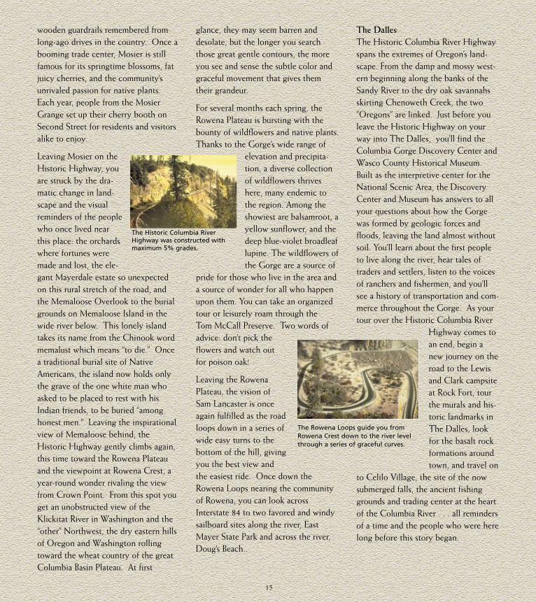
The Rowena Loops guide you from Rowena Crest down to the river level through a series of graceful curves.
The Historic Columbia River Highway was constructed with maximum 5% grades.
15

Travel Tips
As you travel the Highway, look for interpretive signs and markers. They are there to help you enjoy your adventure on the Historic Columbia River Highway.
The Columbia River Gorge is a national treasure—help keep it clean and please don’t remove plants or materials from the area.
The road is narrow, so be careful of people on bikes or enjoying the Highway on foot. Remember, trail surfaces may vary.
Some of the bridges—including the viaducts on either side of Multnomah Falls—are only 18 feet wide, making it diffi-cult for oversized vehicles.
Parking can be a problem at some of the more popular sites in the summer—especially at Multnomah Falls. Try visiting early in the morning, on weekdays, or in the off-seasons.
Much of the Gorge is private prop-erty. Please respect the privacy of local residents.
Restrooms are available at Lewis and Clark State Park, Dabney State Park, Vista House, Latourell Falls, Bridal Veil Falls State Park, Wahkeena Falls, Multnomah Falls, Bonneville Dam, Eagle Creek Campground, Starvation Creek State Park, Viento State Park, Mitchell Point and East and West Senator Mark O. Hatfield Trailheads.
Watch out for poison oak and ticks, especially around the Mosier Twin Tunnels.
Restoration work on the Historic Highway continues. You might encounter construction.
Follow the signs to visitor infor-mation centers in Troutdale, Cascade Locks, Hood River, and The Dalles.
Some trails and parks charge a day-use fee. Please refer to the large map for specific information on which sites charge fees.
For more information, please contact:
Oregon Tourism Commission775 Summer St. NESalem, Oregon 97301800/547-7842 www.traveloregon.com
Oregon Parks and Recreation Department725 Summer St. NE, Suite CSalem, Oregon 97301-1002Information only: 800-551-6949 Reservations Northwest 800-452-5687www.oregonstateparks.org
Oregon Department of TransportationPortland, Oregon503/731-4957www.oregon.gov/odot/hwy/hcrh/
Columbia River Gorge National Scenic AreaUSDA Forest ServiceHood River, Oregon541/308-1700www.fs.fed.us/r6/Columbia/Forest
Columbia River Gorge CommissionWhite Salmon, Washington509/493-3323
Columbia Gorge Visitors AssociationThe Dalles, Oregon800/98/GORGEwww.crgva.org
Friends of Vista HouseCorbett, Oregon503/695-2230www.vistahouse.com
Friends of the Historic Columbia River Highwaywww.hcrh.org
Columbia Gorge Discovery Center and MuseumThe Dalles, Oregon541/296-8600www.gorgediscovery.org
Wind and Weather InformationHood River, Oregon541/386-3300This publication is available in alternative formats upon request to Oregon Department of Transportation, 503/731-8200.
All photographs are property of Oregon Department of Transportation. The vintage photos are hand-painted glass slides.
16