nuclear - 25 years of satellite imagery over chernobyl
TRANSCRIPT
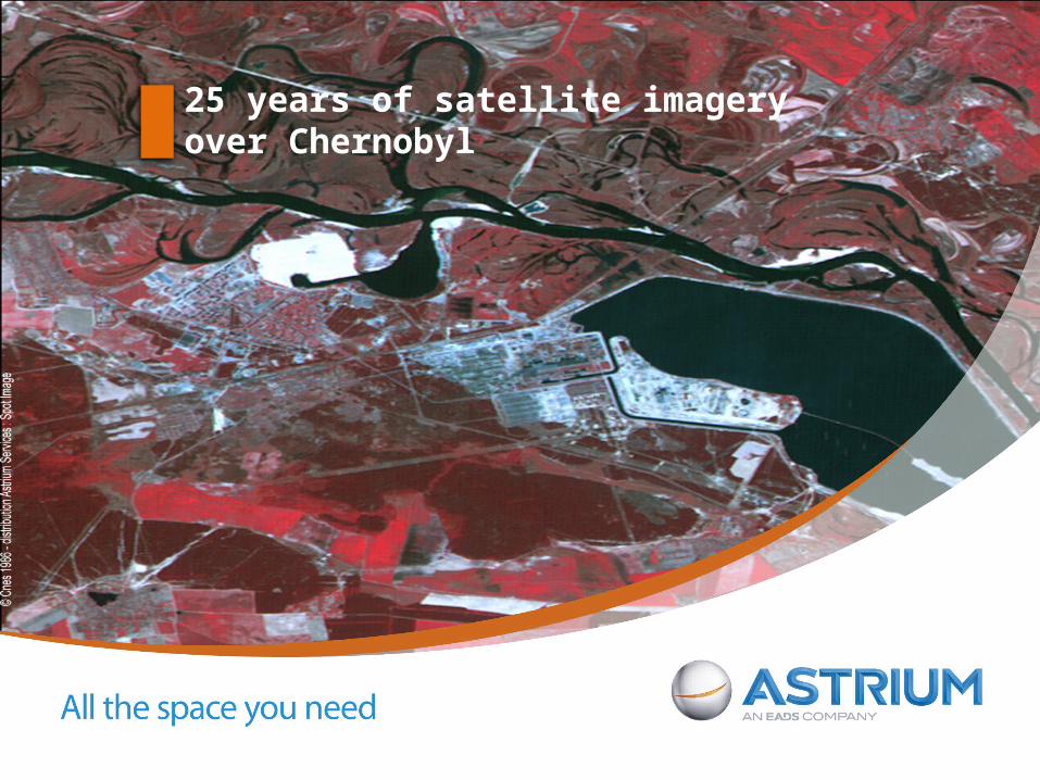
25 years of satellite imagery over Chernobyl
Page2
25 years of satellite imagery over Chernobyl
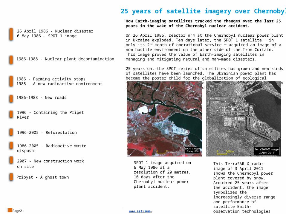
How Earth-imaging satellites tracked the changes over the last 25 years in the wake of the Chernobyl nuclear accident.
On 26 April 1986, reactor n°4 at the Chernobyl nuclear power plant in Ukraine exploded. Ten days later, the SPOT 1 satellite ─ in only its 2nd month of operational service ─ acquired an image of a now hostile environment on the other side of the Iron Curtain. This image proved the value of Earth-imaging satellites in managing and mitigating natural and man-made disasters.
25 years on, the SPOT series of satellites has grown and new kinds of satellites have been launched. The Ukrainian power plant has become the poster child for the globalization of ecological issues. Work has continued in the radioactive area, spotlighted by increasingly precise and detailed satellite Earth imagery.
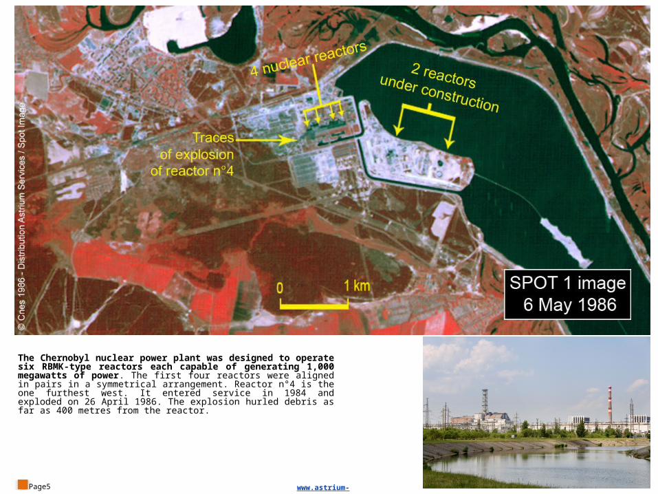
SPOT 1 image acquired on 6 May 1986 at a resolution of 20 metres, 10 days after the Chernobyl nuclear power plant accident.
This TerraSAR-X radar image of 3 April 2011 shows the Chernobyl power plant covered by snow. Acquired 25 years after the accident, the image symbolizes the increasingly diverse range and performance of satellite Earth-observation technologies and applications.
26 April 1986 - Nuclear disaster6 May 1986 - SPOT 1 image
1986-1988 - Nuclear plant decontamination
1986 - Farming activity stops1988 - A new radioactive environment
1986-1988 - New roads
1996 - Containing the Pripet River
1996-2005 - Reforestation
1986-2005 - Radioactive waste disposal
2007 - New construction work on site
Pripyat - A ghost town
www.astrium-geo.com
Page3 www.astrium-geo.com
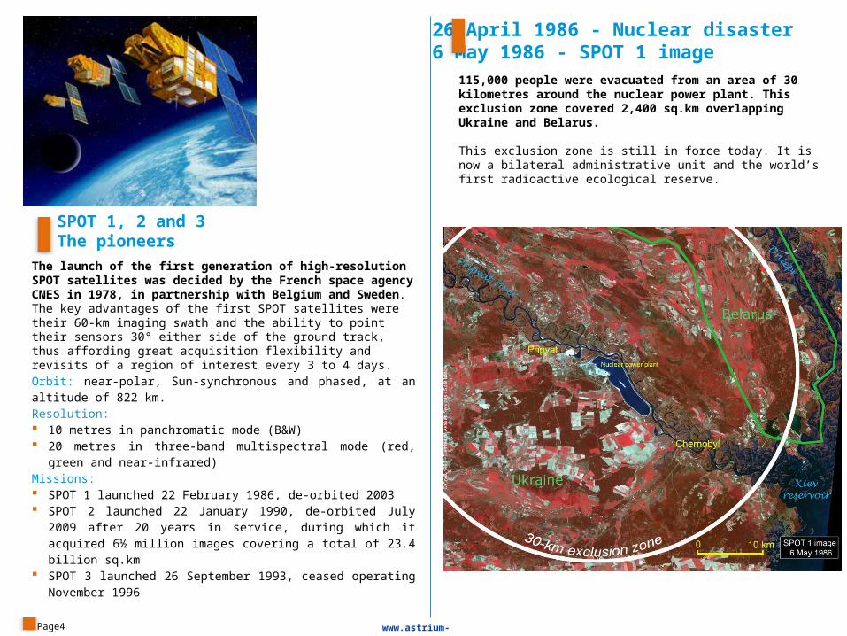
115,000 people were evacuated from an area of 30 kilometres around the nuclear power plant. This exclusion zone covered 2,400 sq.km overlapping Ukraine and Belarus.
This exclusion zone is still in force today. It is now a bilateral administrative unit and the world’s first radioactive ecological reserve.
SPOT 1, 2 and 3The pioneers
The launch of the first generation of high-resolution SPOT satellites was decided by the French space agency CNES in 1978, in partnership with Belgium and Sweden. The key advantages of the first SPOT satellites were their 60-km imaging swath and the ability to point their sensors 30° either side of the ground track, thus affording great acquisition flexibility and revisits of a region of interest every 3 to 4 days.Orbit: near-polar, Sun-synchronous and phased, at an altitude of 822 km.Resolution: 10 metres in panchromatic mode (B&W) 20 metres in three-band multispectral mode (red, green and near-
infrared)Missions: SPOT 1 launched 22 February 1986, de-orbited 2003 SPOT 2 launched 22 January 1990, de-orbited July 2009 after 20
years in service, during which it acquired 6½ million images covering a total of 23.4 billion sq.km
SPOT 3 launched 26 September 1993, ceased operating November 1996
Page4
26 April 1986 - Nuclear disaster6 May 1986 - SPOT 1 image
www.astrium-geo.com
Page5
The Chernobyl nuclear power plant was designed to operate six RBMK-type reactors each capable of generating 1,000 megawatts of power. The first four reactors were aligned in pairs in a symmetrical arrangement. Reactor n°4 is the one furthest west. It entered service in 1984 and exploded on 26 April 1986. The explosion hurled debris as far as 400 metres from the reactor.
www.astrium-geo.com
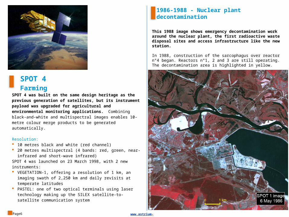
This 1988 image shows emergency decontamination work around the nuclear plant, the first radioactive waste disposal sites and access infrastructure like the new station.
In 1988, construction of the sarcophagus over reactor n°4 began. Reactors n°1, 2 and 3 are still operating. The decontamination area is highlighted in yellow.
SPOT 4 Farming
SPOT 4 was built on the same design heritage as the previous generation of satellites, but its instrument payload was upgraded for agricultural and environmental monitoring applications. Combining black-and-white and multispectral images enables 10-metre colour merge products to be generated automatically.
Resolution: 10 metres black and white (red channel) 20 metres multispectral (4 bands: red, green, near-infrared and short-
wave infrared)SPOT 4 was launched on 23 March 1998, with 2 new instruments: VEGETATION-1, offering a resolution of 1 km, an imaging swath of
2,250 km and daily revisits at temperate latitudes PASTEL: one of two optical terminals using laser technology making
up the SILEX satellite-to-satellite communication system
Page6
1986-1988 - Nuclear plant decontamination
www.astrium-geo.com
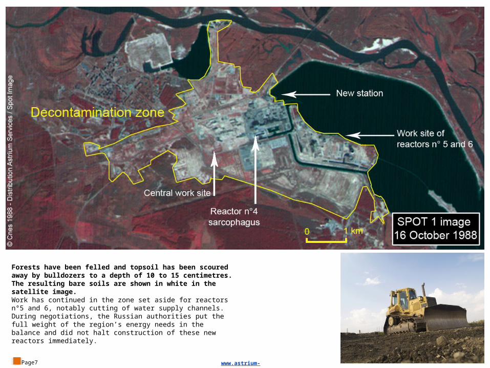
Forests have been felled and topsoil has been scoured away by bulldozers to a depth of 10 to 15 centimetres. The resulting bare soils are shown in white in the satellite image.Work has continued in the zone set aside for reactors n°5 and 6, notably cutting of water supply channels. During negotiations, the Russian authorities put the full weight of the region’s energy needs in the balance and did not halt construction of these new reactors immediately.
Page7 www.astrium-geo.com
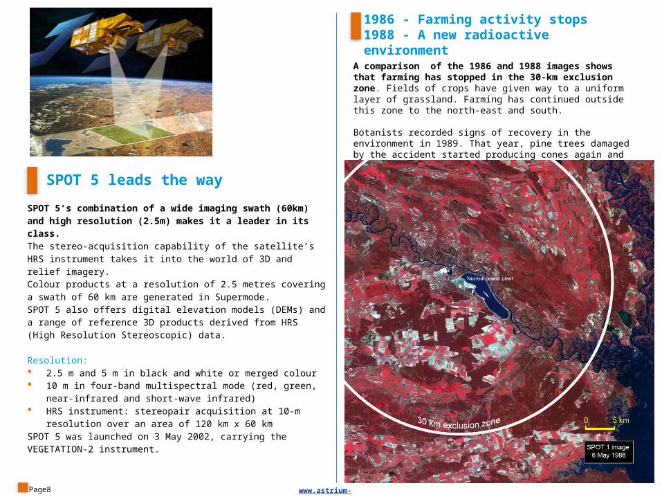
A comparison of the 1986 and 1988 images shows that farming has stopped in the 30-km exclusion zone. Fields of crops have given way to a uniform layer of grassland. Farming has continued outside this zone to the north-east and south.
Botanists recorded signs of recovery in the environment in 1989. That year, pine trees damaged by the accident started producing cones again and the population of rodents, which had disappeared, was proliferating.
SPOT 5 leads the way
SPOT 5’s combination of a wide imaging swath (60km) and high resolution (2.5m) makes it a leader in its class. The stereo-acquisition capability of the satellite’s HRS instrument takes it into the world of 3D and relief imagery.Colour products at a resolution of 2.5 metres covering a swath of 60 km are generated in Supermode. SPOT 5 also offers digital elevation models (DEMs) and a range of reference 3D products derived from HRS (High Resolution Stereoscopic) data.
Resolution: 2.5 m and 5 m in black and white or merged colour 10 m in four-band multispectral mode (red, green, near-infrared and
short-wave infrared) HRS instrument: stereopair acquisition at 10-m resolution over an
area of 120 km x 60 kmSPOT 5 was launched on 3 May 2002, carrying the VEGETATION-2 instrument.
Page8
1986 - Farming activity stops1988 - A new radioactive environment
www.astrium-geo.com
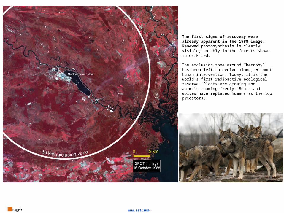
The first signs of recovery were already apparent in the 1988 image. Renewed photosynthesis is clearly visible, notably in the forests shown in dark red.
The exclusion zone around Chernobyl has been left to evolve alone, without human intervention. Today, it is the world’s first radioactive ecological reserve. Plants are growing and animals roaming freely. Bears and wolves have replaced humans as the top predators.
Page9 www.astrium-geo.com
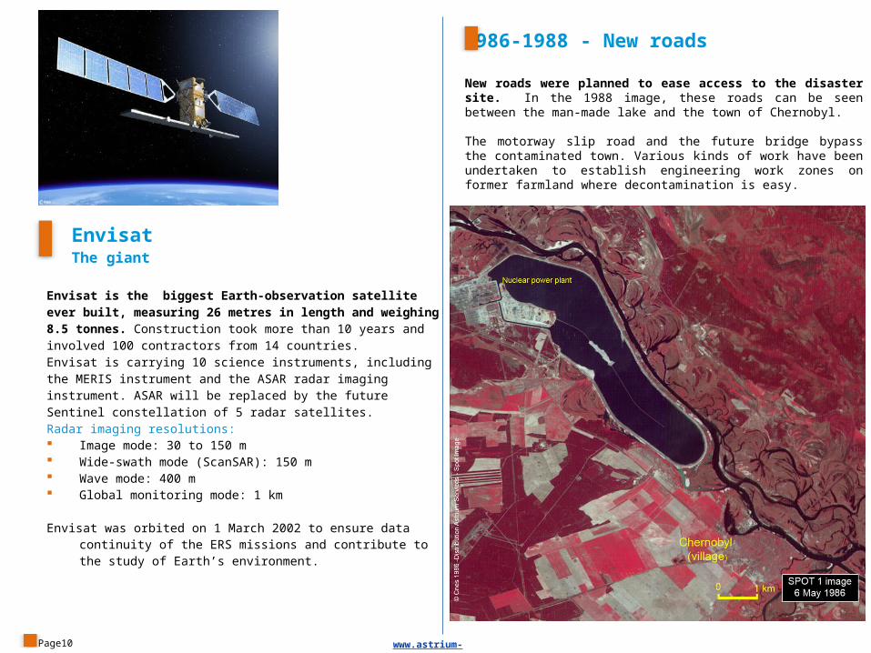
New roads were planned to ease access to the disaster site. In the 1988 image, these roads can be seen between the man-made lake and the town of Chernobyl.
The motorway slip road and the future bridge bypass the contaminated town. Various kinds of work have been undertaken to establish engineering work zones on former farmland where decontamination is easy.
EnvisatThe giant
Envisat is the biggest Earth-observation satellite ever built, measuring 26 metres in length and weighing 8.5 tonnes. Construction took more than 10 years and involved 100 contractors from 14 countries.Envisat is carrying 10 science instruments, including the MERIS instrument and the ASAR radar imaging instrument. ASAR will be replaced by the future Sentinel constellation of 5 radar satellites.Radar imaging resolutions: Image mode: 30 to 150 m Wide-swath mode (ScanSAR): 150 m Wave mode: 400 m Global monitoring mode: 1 km
Envisat was orbited on 1 March 2002 to ensure data continuity of the ERS missions and contribute to the study of Earth’s environment.
Page10
1986-1988 - New roads
www.astrium-geo.com
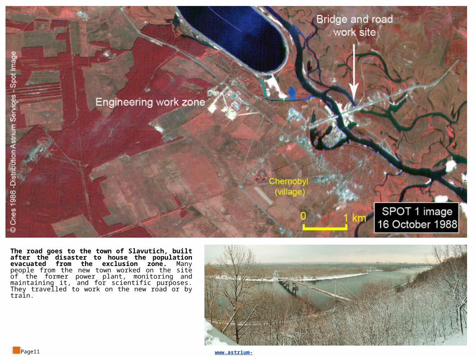
The road goes to the town of Slavutich, built after the disaster to house the population evacuated from the exclusion zone. Many people from the new town worked on the site of the former power plant, monitoring and maintaining it, and for scientific purposes. They travelled to work on the new road or by train.
Page11 www.astrium-geo.com
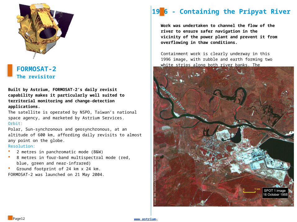
Work was undertaken to channel the flow of the river to ensure safer navigation in the vicinity of the power plant and prevent it from overflowing in thaw conditions.
Containment work is clearly underway in this 1996 image, with rubble and earth forming two white strips along both river banks. The northern levee is 11.3 kilometres long.
FORMOSAT-2The revisitor
Built by Astrium, FORMOSAT-2’s daily revisit capability makes it particularly well suited to territorial monitoring and change-detection applications.The satellite is operated by NSPO, Taiwan’s national space agency, and marketed by Astrium Services.Orbit: Polar, Sun-synchronous and geosynchronous, at an altitude of 600 km, affording daily revisits to almost any point on the globe.Resolution: 2 metres in panchromatic mode (B&W) 8 metres in four-band multispectral mode (red, blue, green and near-
infrared) Ground footprint of 24 km x 24 km.FORMOSAT-2 was launched on 21 May 2004.
Page12
1996 - Containing the Pripyat River
www.astrium-geo.com
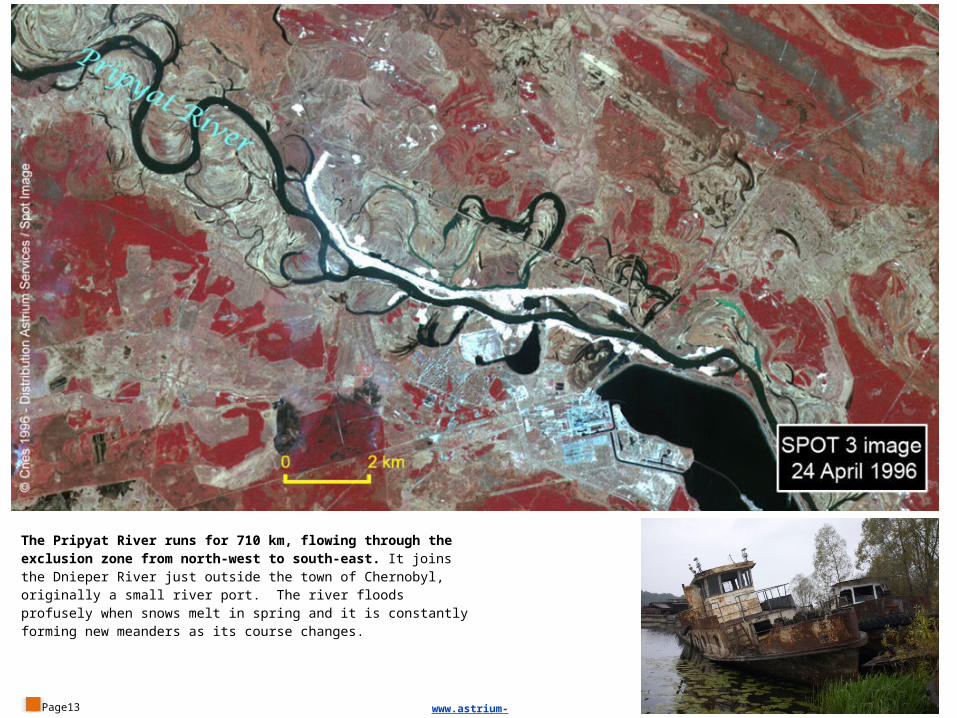
The Pripyat River runs for 710 km, flowing through the exclusion zone from north-west to south-east. It joins the Dnieper River just outside the town of Chernobyl, originally a small river port. The river floods profusely when snows melt in spring and it is constantly forming new meanders as its course changes.
Page13 www.astrium-geo.com
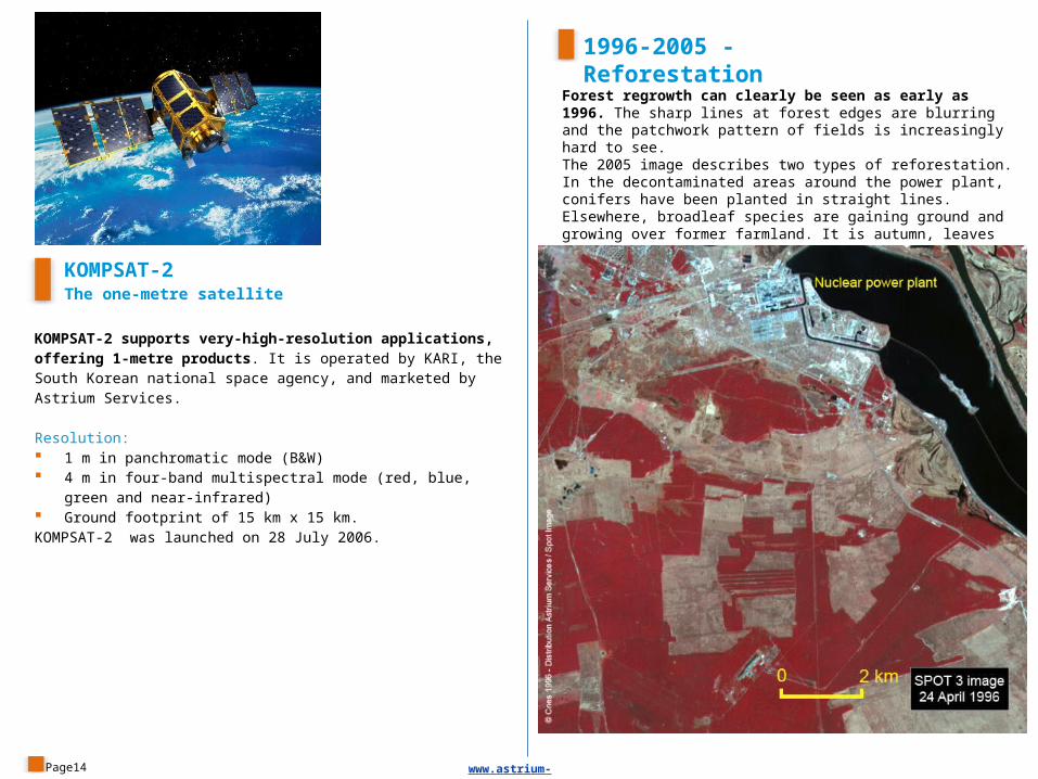
Forest regrowth can clearly be seen as early as 1996. The sharp lines at forest edges are blurring and the patchwork pattern of fields is increasingly hard to see. The 2005 image describes two types of reforestation. In the decontaminated areas around the power plant, conifers have been planted in straight lines. Elsewhere, broadleaf species are gaining ground and growing over former farmland. It is autumn, leaves have fallen and trees are an ochre colour in the image.
KOMPSAT-2The one-metre satellite
KOMPSAT-2 supports very-high-resolution applications, offering 1-metre products. It is operated by KARI, the South Korean national space agency, and marketed by Astrium Services.
Resolution: 1 m in panchromatic mode (B&W) 4 m in four-band multispectral mode (red, blue, green and near-
infrared) Ground footprint of 15 km x 15 km.KOMPSAT-2 was launched on 28 July 2006.
Page14
1996-2005 - Reforestation
www.astrium-geo.com
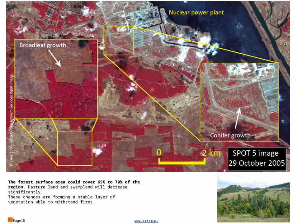
The forest surface area could cover 65% to 70% of the region. Pasture land and swampland will decrease significantly. These changes are forming a stable layer of vegetation able to withstand fires.
Page15 www.astrium-geo.com
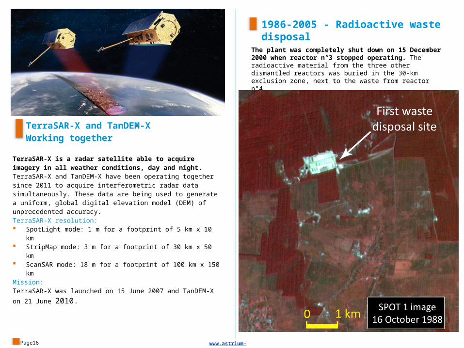
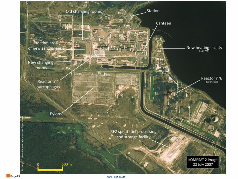
The plant was completely shut down on 15 December 2000 when reactor n°3 stopped operating. The radioactive material from the three other dismantled reactors was buried in the 30-km exclusion zone, next to the waste from reactor n°4.
TerraSAR-X and TanDEM-XWorking together
TerraSAR-X is a radar satellite able to acquire imagery in all weather conditions, day and night. TerraSAR-X and TanDEM-X have been operating together since 2011 to acquire interferometric radar data simultaneously. These data are being used to generate a uniform, global digital elevation model (DEM) of unprecedented accuracy.TerraSAR-X resolution: SpotLight mode: 1 m for a footprint of 5 km x 10 km StripMap mode: 3 m for a footprint of 30 km x 50 km ScanSAR mode: 18 m for a footprint of 100 km x 150 kmMission:TerraSAR-X was launched on 15 June 2007 and TanDEM-X on 21 June
2010.
Page16
1986-2005 - Radioactive waste disposal
www.astrium-geo.com
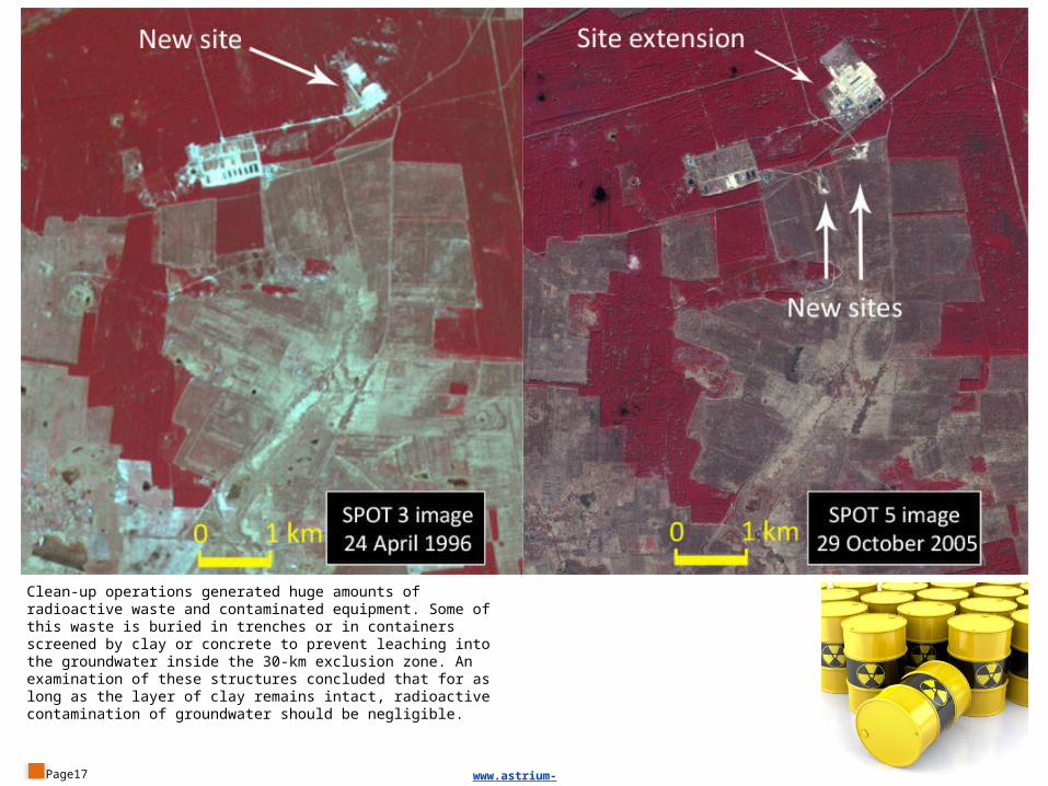
Clean-up operations generated huge amounts of radioactive waste and contaminated equipment. Some of this waste is buried in trenches or in containers screened by clay or concrete to prevent leaching into the groundwater inside the 30-km exclusion zone. An examination of these structures concluded that for as long as the layer of clay remains intact, radioactive contamination of groundwater should be negligible.
Page17 www.astrium-geo.com
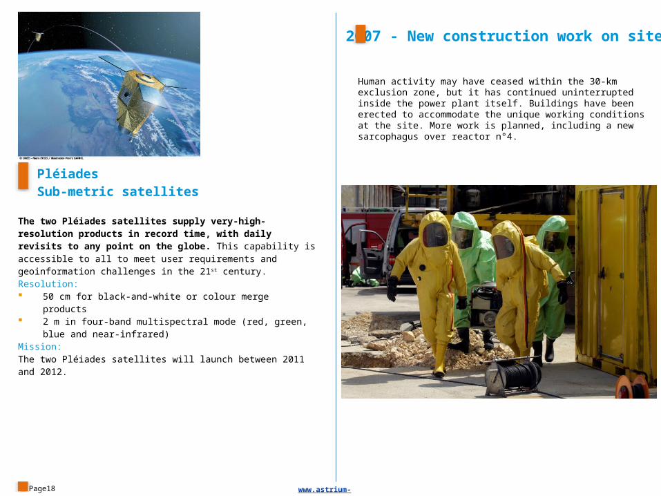
Human activity may have ceased within the 30-km exclusion zone, but it has continued uninterrupted inside the power plant itself. Buildings have been erected to accommodate the unique working conditions at the site. More work is planned, including a new sarcophagus over reactor n°4.
Page18
PléiadesSub-metric satellites
The two Pléiades satellites supply very-high-resolution products in record time, with daily revisits to any point on the globe. This capability is accessible to all to meet user requirements and geoinformation challenges in the 21st century. Resolution: 50 cm for black-and-white or colour merge products 2 m in four-band multispectral mode (red, green, blue and near-
infrared)Mission:The two Pléiades satellites will launch between 2011 and 2012.
2007 - New construction work on site
www.astrium-geo.com
Page19 www.astrium-geo.com
SPOT 6 & 7The new kids on the block
Financed and built by Astrium, SPOT 6 and SPOT 7 form a constellation of Earth-imaging satellites designed to provide continuity of high-resolution, wide-swath data up to 2023, drawing on the technological and operational innovations implemented for the Pléaides constellation.Resolution: 1.5 m black-and-white or merged colour 6 m in four-band multispectral mode (red, green, blue and near-
infrared) Imaging swath: 60 km at nadirMission:SPOT 6 and SPOT 7 will be launched between 2012 and 2013.
Page20
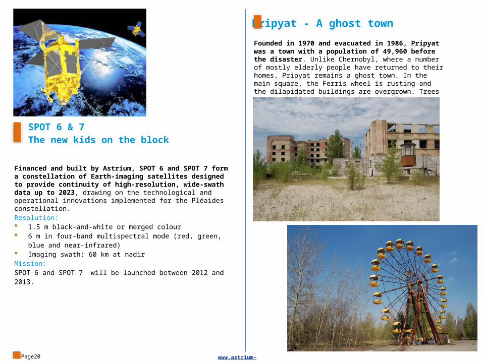
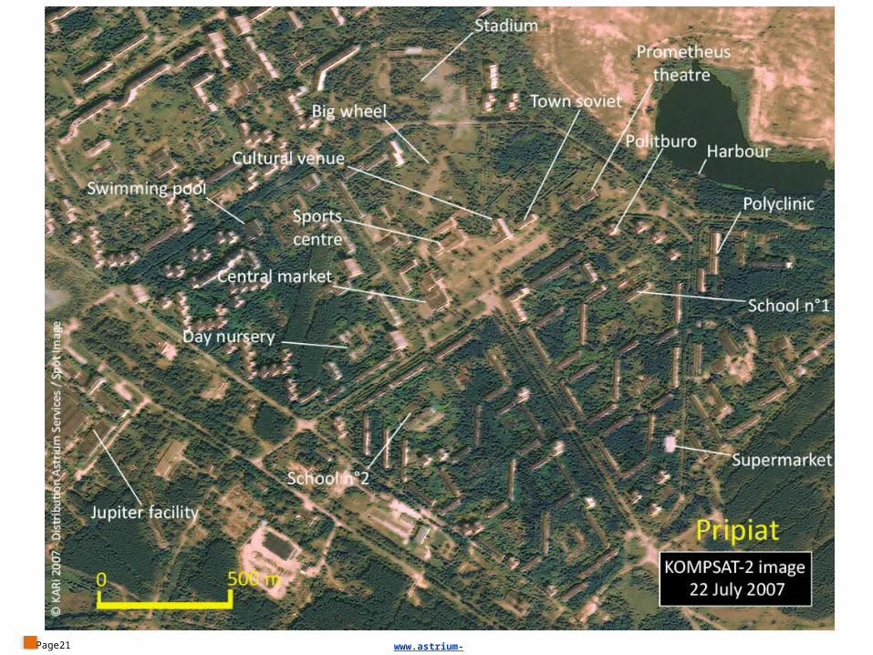
Founded in 1970 and evacuated in 1986, Pripyat was a town with a population of 49,960 before the disaster. Unlike Chernobyl, where a number of mostly elderly people have returned to their homes, Pripyat remains a ghost town. In the main square, the Ferris wheel is rusting and the dilapidated buildings are overgrown. Trees are gradually reclaiming the urban landscape.
Pripyat - A ghost town
www.astrium-geo.com
Page21 www.astrium-geo.com