notice of preparation final - scvhistory.com · lyons canyon ranch 1 july 2005 ... report (eir) for...
TRANSCRIPT
Lyons Canyon Ranch 1 July 2005
Los Angeles County Department of Regional Planning
Planning for the Challenges Ahead
NOTICE OF PREPARATION
“The Lyons Canyon Ranch Project”
County Project No.TR53653 Tentative Tract Map No. RTM TR53653
Conditional Use Permit No. RCUP200500088 Oak Tree Permit No. ROAK200500039
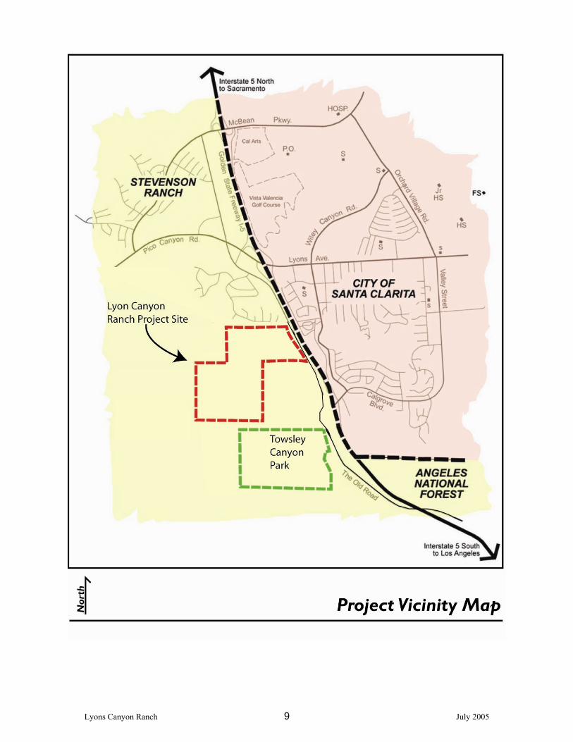
The County of Los Angeles will be the Lead Agency and will prepare an Environmental Impact Report (EIR) for the project identified above, pursuant to the California Environmental Quality Act (CEQA). In compliance with Section 15082 of the State CEQA Guidelines, the County of Los Angeles is sending this Notice of Preparation (NOP) to responsible agencies, interested parties, and other public agencies, which may be involved in approving or permitting the project. Within 30 days after receiving the NOP, each agency shall provide the County of Los Angeles with specific details about the scope and content of the environmental information to be contained in the EIR related to that agency’s area of statutory responsibilities. The purpose of this NOP is to solicit the views of your agency as to the scope and content of the environmental information germane to your agency’s statutory responsibility in connection with the proposed project. Your agency may need to use the EIR prepared by our agency when considering your permit or other approval for the project. BACKGROUND The Lyons Canyon Ranch project was originally submitted to the City of Santa Clarita for review and possible annexation in 2002. Pursuant to the provision of Section 15082 of the State CEQA Guidelines, the City of Santa Clarita first circulated a NOP in March 2003. Due to change in project description, another NOP was circulated for a 30-day period commencing December 15, 2003 and ending January 14, 2004 (State Clearinghouse No. 2003031086). Subsequently, the project was withdrawn from the City of Santa Clarita in May 2005. The applicant revised the project design and filed entitlement applications with the County of Los Angeles in June 2005. This Notice of Preparation reflects changes in the project currently proposed to the County. PROJECT LOCATION The Lyons Canyon Ranch project site encompasses approximately 232-acre of land located in unincorporated Los Angeles County. Lyons Canyon Ranch is adjacent to The Old Road, west of Interstate 5, just south of Sagecrest Circle and north of Calgrove Road near Towsley Canyon Park (please refer to Regional Location Map, Project Vicinity Map).

Lyons Canyon Ranch 2 July 2005
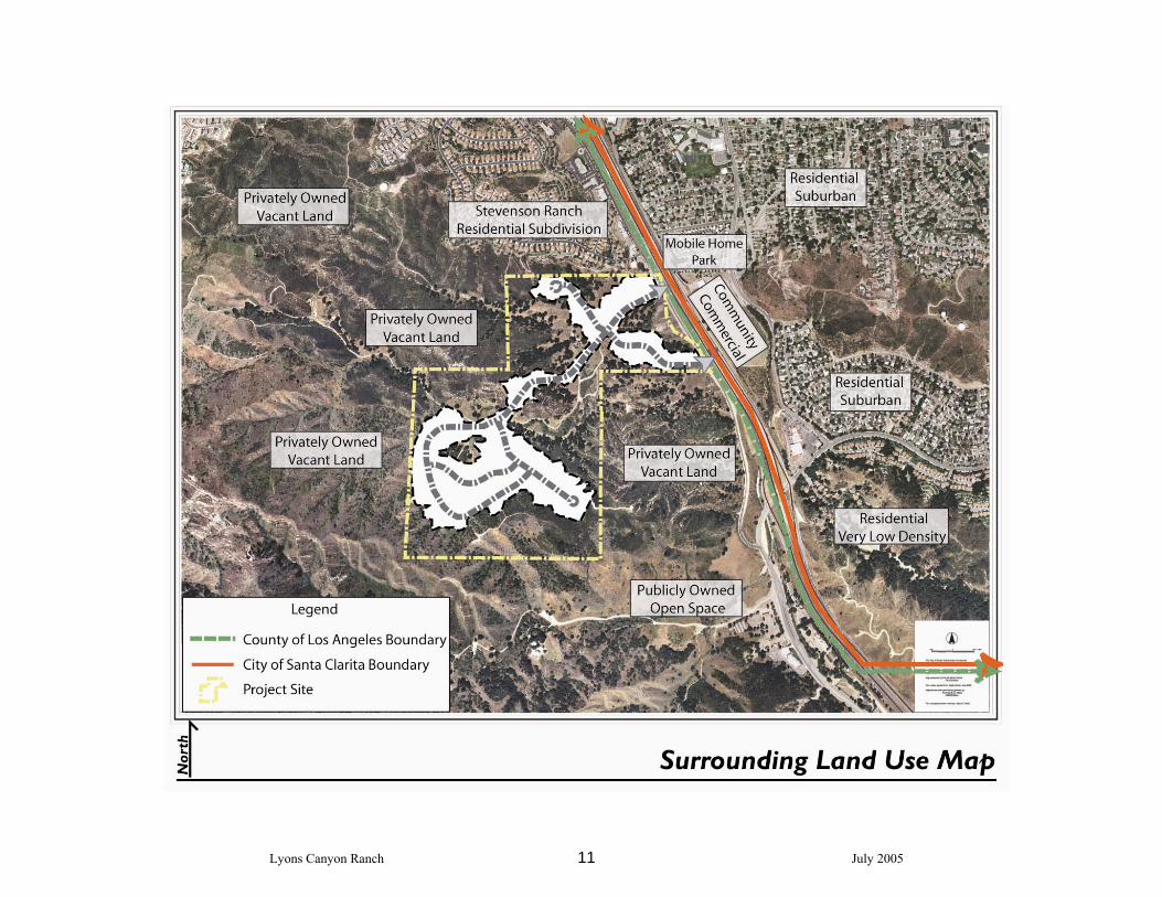
PROJECT SETTING The project site is bounded to the north by residential uses on Sagecrest Circle and the Stevenson Ranch opposite of Sagecrest Circle, to the south by Towsley Canyon Park and vacant land, to the east by The Old Road, Interstate 5 and residential uses and on the west by vacant land and open space. Two natural features dominate the project site: oak trees and steep slope areas. Approximately 1,735 oak trees have been inventoried on the project site. Of these, approximately 170 are Heritage Oaks as defined by the County of Los Angeles. Site topography is defined by primary and secondary ridgelines, which are visually prominent, as well as watercourses and associated riparian vegetation in the canyons. The project site is vacant with current on-site structures such as fencing and an abandoned water tank, water wells, and irrigation lines. Other utility structures, such as Southern California Edison electrical distribution lines, are adjacent to or traverse portions of the site. The project site is currently located within unincorporated Los Angeles County, and is designated as Non-Urban 2 (N2) and Hillside Management (HM) in the Santa Clarita Valley Areawide General Plan, and Non-urban (R) and Significant Ecological Area (SEA) in the County General Plan. The subject property is zoned as Heavy Agricultural (A-2-2/A-2-1). PROJECT CHARACTERISTICS The project consists of a mix of single-family residential, senior housing, public facility uses, and open space. The table below provides a summary breakdown of the proposed uses in terms of acreage, the number and type of dwelling units, and parks/open space area associated with implementation of Lyons Canyon Ranch. The project includes the development of 112 lots comprised of 95 single-family detached single-family lots, 5 senior housing lots, 1 condominium lot proposed for development with approximately 90 senior condominium units, 4 open space lots, 5 debris/detention basin lots, and 1 park lot. A new fire station lot is proposed at the northeast corner of the development boundary and will consist of approximately 8,000 square feet on 1.26 acres.
Lyons Canyon Ranch Land Use Summary
Development
Phase Land Use Gross Acres
Number of Lots
Dwelling Units
Residential 1 Single-Family Residential/Senior
Detached 58.61 100 100
2 Senior Condominiums 10.25 1 90 Total Residential 68.86 101 190 Parks and Open Space
1 Open Space Lot A 34.25 1 1 Open Space Lot B 76.50 1 1 Open Space Lot C 6.50 1 1 Open Space Lot D 10.50 1
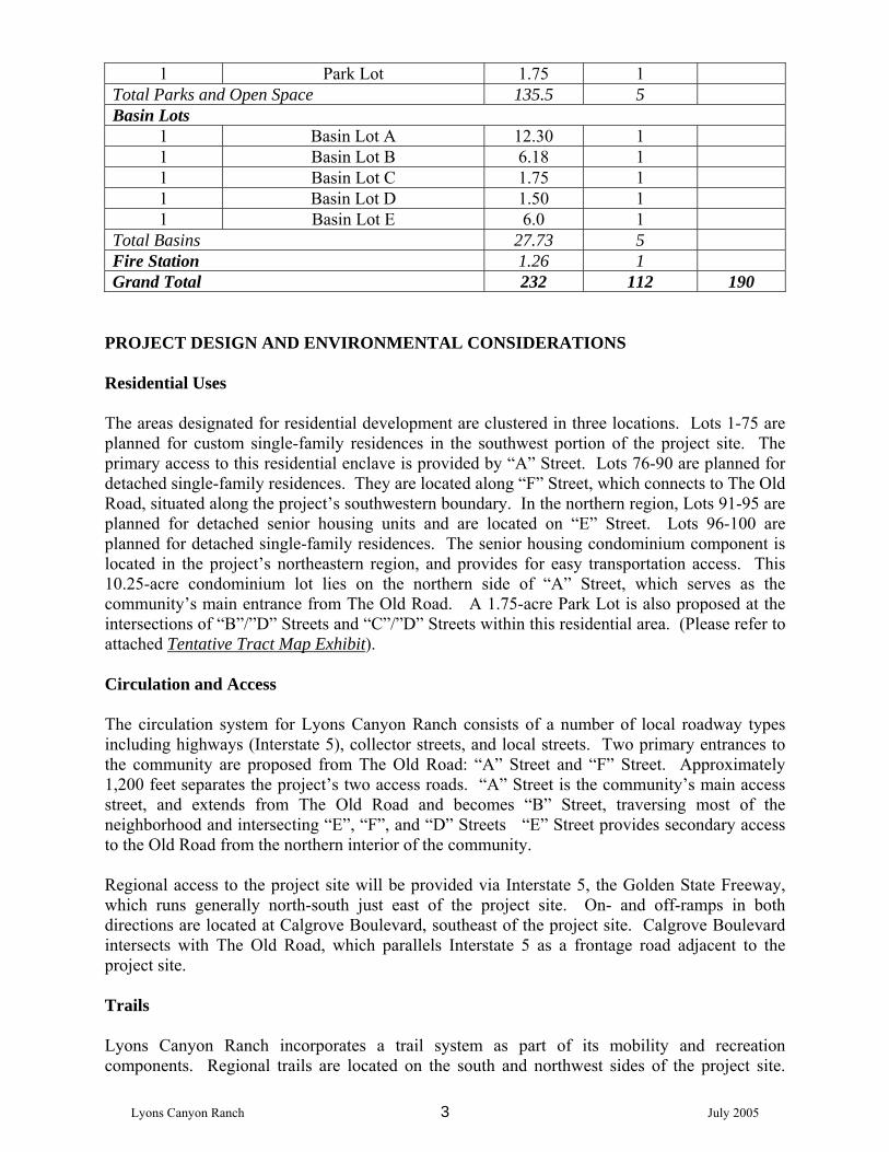
Lyons Canyon Ranch 3 July 2005
1 Park Lot 1.75 1 Total Parks and Open Space 135.5 5 Basin Lots
1 Basin Lot A 12.30 1 1 Basin Lot B 6.18 1 1 Basin Lot C 1.75 1 1 Basin Lot D 1.50 1 1 Basin Lot E 6.0 1
Total Basins 27.73 5 Fire Station 1.26 1 Grand Total 232 112 190
PROJECT DESIGN AND ENVIRONMENTAL CONSIDERATIONS Residential Uses The areas designated for residential development are clustered in three locations. Lots 1-75 are planned for custom single-family residences in the southwest portion of the project site. The primary access to this residential enclave is provided by “A” Street. Lots 76-90 are planned for detached single-family residences. They are located along “F” Street, which connects to The Old Road, situated along the project’s southwestern boundary. In the northern region, Lots 91-95 are planned for detached senior housing units and are located on “E” Street. Lots 96-100 are planned for detached single-family residences. The senior housing condominium component is located in the project’s northeastern region, and provides for easy transportation access. This 10.25-acre condominium lot lies on the northern side of “A” Street, which serves as the community’s main entrance from The Old Road. A 1.75-acre Park Lot is also proposed at the intersections of “B”/”D” Streets and “C”/”D” Streets within this residential area. (Please refer to attached Tentative Tract Map Exhibit). Circulation and Access The circulation system for Lyons Canyon Ranch consists of a number of local roadway types including highways (Interstate 5), collector streets, and local streets. Two primary entrances to the community are proposed from The Old Road: “A” Street and “F” Street. Approximately 1,200 feet separates the project’s two access roads. “A” Street is the community’s main access street, and extends from The Old Road and becomes “B” Street, traversing most of the neighborhood and intersecting “E”, “F”, and “D” Streets “E” Street provides secondary access to the Old Road from the northern interior of the community. Regional access to the project site will be provided via Interstate 5, the Golden State Freeway, which runs generally north-south just east of the project site. On- and off-ramps in both directions are located at Calgrove Boulevard, southeast of the project site. Calgrove Boulevard intersects with The Old Road, which parallels Interstate 5 as a frontage road adjacent to the project site. Trails Lyons Canyon Ranch incorporates a trail system as part of its mobility and recreation components. Regional trails are located on the south and northwest sides of the project site.
Lyons Canyon Ranch 4 July 2005
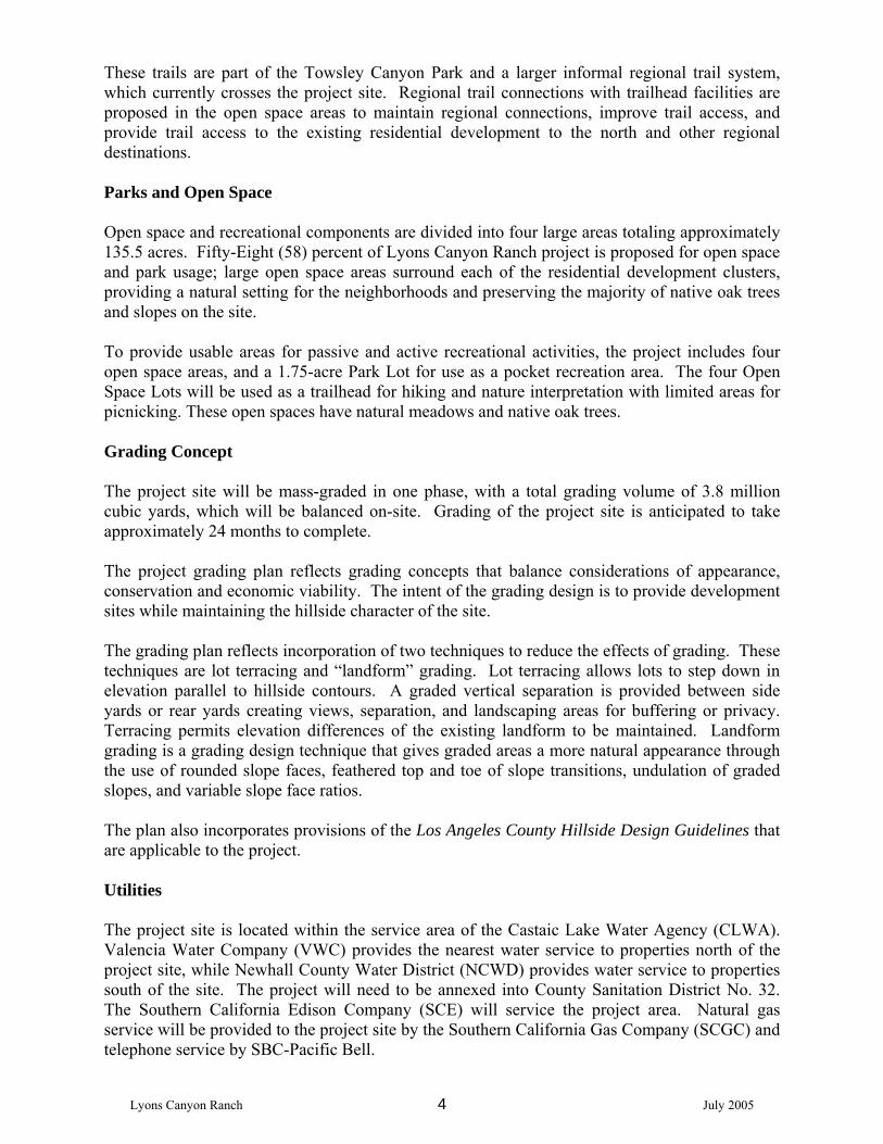
These trails are part of the Towsley Canyon Park and a larger informal regional trail system, which currently crosses the project site. Regional trail connections with trailhead facilities are proposed in the open space areas to maintain regional connections, improve trail access, and provide trail access to the existing residential development to the north and other regional destinations. Parks and Open Space Open space and recreational components are divided into four large areas totaling approximately 135.5 acres. Fifty-Eight (58) percent of Lyons Canyon Ranch project is proposed for open space and park usage; large open space areas surround each of the residential development clusters, providing a natural setting for the neighborhoods and preserving the majority of native oak trees and slopes on the site. To provide usable areas for passive and active recreational activities, the project includes four open space areas, and a 1.75-acre Park Lot for use as a pocket recreation area. The four Open Space Lots will be used as a trailhead for hiking and nature interpretation with limited areas for picnicking. These open spaces have natural meadows and native oak trees. Grading Concept The project site will be mass-graded in one phase, with a total grading volume of 3.8 million cubic yards, which will be balanced on-site. Grading of the project site is anticipated to take approximately 24 months to complete. The project grading plan reflects grading concepts that balance considerations of appearance, conservation and economic viability. The intent of the grading design is to provide development sites while maintaining the hillside character of the site. The grading plan reflects incorporation of two techniques to reduce the effects of grading. These techniques are lot terracing and “landform” grading. Lot terracing allows lots to step down in elevation parallel to hillside contours. A graded vertical separation is provided between side yards or rear yards creating views, separation, and landscaping areas for buffering or privacy. Terracing permits elevation differences of the existing landform to be maintained. Landform grading is a grading design technique that gives graded areas a more natural appearance through the use of rounded slope faces, feathered top and toe of slope transitions, undulation of graded slopes, and variable slope face ratios. The plan also incorporates provisions of the Los Angeles County Hillside Design Guidelines that are applicable to the project. Utilities The project site is located within the service area of the Castaic Lake Water Agency (CLWA). Valencia Water Company (VWC) provides the nearest water service to properties north of the project site, while Newhall County Water District (NCWD) provides water service to properties south of the site. The project will need to be annexed into County Sanitation District No. 32. The Southern California Edison Company (SCE) will service the project area. Natural gas service will be provided to the project site by the Southern California Gas Company (SCGC) and telephone service by SBC-Pacific Bell.

Lyons Canyon Ranch 5 July 2005
Stormwater and Drainage The project site is located within the Santa Clara River basin. Storm flows from the proposed development will follow the existing drainage patterns. Runoff will be collected into improved drainage systems fitted with water quality filters or deflection devices. Project drainage improvements will conform to the project’s Standard Urban Stormwater Mitigation Plan (SUSMP) and Drainage Concept Plan) and the LACDPW Flood Control Division will accept maintenance authority over the project’s storm drain facilities where constructed to the County’s standards. Other flood control or storm drainage facilities such as outlet structures, debris/detention basins, continuous deflective devices or buried bank stabilization will also be maintained by LACDPW. Public Services The project will include construction of a new fire station, per Los Angeles County Fire Department requirements. The new 8,000-square-foot fire station will be located on a 1.26-acre site, located north of “A” Street adjacent to The Old Road, and will serve the project and surrounding communities, as necessary. The Los Angeles County Sheriff’s Department and California Highway Patrol together provide law and traffic enforcement and protection services to the City of Santa Clarita under contract. Students generated by the project will be served by schools within the Newhall School District (grades K-6) and the William S. Hart Union High School District (grades 7-12). The three closest schools to the project site are Pico Canyon Elementary School, Placerita Junior High School, and Hart High School. Library services for the project will be provided by the Los Angeles County Public Library system. ENTITLEMENT REQUESTS The project applicant is requesting approval of the following entitlement applications, which govern the development activities on the project site as described above and in more detail later in this section:
♦ Tentative Tract Map. Approval of the Tentative Tract Map is required to subdivide the site into 112 lots.
♦ Conditional Use Permit. A Conditional Use Permit (CUP) is required for development
within Hillside Management (HM) area and the County’s designated Significant Ecological Areas (SEAs). Although the CUP procedure provides flexibility in some development code regulations to account for the widely varying needs of certain uses, developments within SEAs must demonstrate compatibility with the biotic resources inherent.
The Conditional Use Permit also includes a density bonus request pursuant to County Code Section 22.56.202. Under the County’s Zoning Code, a project may request a density bonus of up to 50% provided that at least 50% of the dwelling units in the development are provided for income-qualifying residents or senior citizens. The Lyons Canyon Ranch project is requesting a 45% density bonus and proposes to designate 50% of the total units as seniors housing.
Lyons Canyon Ranch 6 July 2005
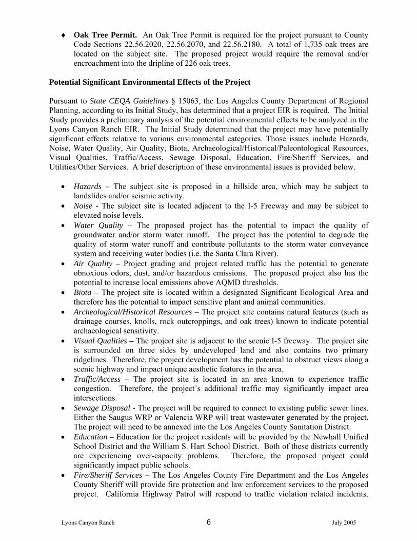
♦ Oak Tree Permit. An Oak Tree Permit is required for the project pursuant to County Code Sections 22.56.2020, 22.56.2070, and 22.56.2180. A total of 1,735 oak trees are located on the subject site. The proposed project would require the removal and/or encroachment into the dripline of 226 oak trees.
Potential Significant Environmental Effects of the Project Pursuant to State CEQA Guidelines § 15063, the Los Angeles County Department of Regional Planning, according to its Initial Study, has determined that a project EIR is required. The Initial Study provides a preliminary analysis of the potential environmental effects to be analyzed in the Lyons Canyon Ranch EIR. The Initial Study determined that the project may have potentially significant effects relative to various environmental categories. Those issues include Hazards, Noise, Water Quality, Air Quality, Biota, Archaeological/Historical/Paleontological Resources, Visual Qualities, Traffic/Access, Sewage Disposal, Education, Fire/Sheriff Services, and Utilities/Other Services. A brief description of these environmental issues is provided below.
• Hazards – The subject site is proposed in a hillside area, which may be subject to landslides and/or seismic activity.
• Noise - The subject site is located adjacent to the I-5 Freeway and may be subject to elevated noise levels.
• Water Quality – The proposed project has the potential to impact the quality of groundwater and/or storm water runoff. The project has the potential to degrade the quality of storm water runoff and contribute pollutants to the storm water conveyance system and receiving water bodies (i.e. the Santa Clara River).
• Air Quality – Project grading and project related traffic has the potential to generate obnoxious odors, dust, and/or hazardous emissions. The proposed project also has the potential to increase local emissions above AQMD thresholds.
• Biota – The project site is located within a designated Significant Ecological Area and therefore has the potential to impact sensitive plant and animal communities.
• Archeological/Historical Resources – The project site contains natural features (such as drainage courses, knolls, rock outcroppings, and oak trees) known to indicate potential archaeological sensitivity.
• Visual Qualities – The project site is adjacent to the scenic I-5 freeway. The project site is surrounded on three sides by undeveloped land and also contains two primary ridgelines. Therefore, the project development has the potential to obstruct views along a scenic highway and impact unique aesthetic features in the area.
• Traffic/Access – The project site is located in an area known to experience traffic congestion. Therefore, the project’s additional traffic may significantly impact area intersections.
• Sewage Disposal - The project will be required to connect to existing public sewer lines. Either the Saugus WRP or Valencia WRP will treat wastewater generated by the project. The project will need to be annexed into the Los Angeles County Sanitation District.
• Education – Education for the project residents will be provided by the Newhall Unified School District and the William S. Hart School District. Both of these districts currently are experiencing over-capacity problems. Therefore, the proposed project could significantly impact public schools.
• Fire/Sheriff Services – The Los Angeles County Fire Department and the Los Angeles County Sheriff will provide fire protection and law enforcement services to the proposed project. California Highway Patrol will respond to traffic violation related incidents.

Lyons Canyon Ranch 7 July 2005
Law enforcement and fire response times could be significantly impacted by the proposed project.
• Utilities/Other Services – The project will be required to demonstrate that adequate water, sewer, refuse, and public utility services can be provided to the subject site.
Notice of Preparation Review and Comments The official review period for the Notice of Preparation will be from July 11 to August 9, 2005 (30 days). To facilitate your review, the following materials are attached in addition to the above descriptions: ● Regional Vicinity Map ● Project Location Map ● Tentative Tract Map ● Surrounding Land Use map ● Los Angeles County Initial Study Copies of the Notice of Preparation are available at Canyon Country Jo Anne Darcy Library located at 18601 Soledad Canyon Road, Santa Clarita, California 91351; Valencia County Library at 23743 West Valencia Boulevard, Santa Clarita, California 91355; Newhall County Library at 22704 West 9th Street, Santa Clarita, California 91321; as well as on the Department of Regional Planning website http//planning.co.la.ca.us/drp_agnd.html under “Tentative Tract Map No. 53653 Lyons Canyon Ranch Project.” Due to the time limits mandated by state law, your comments must be sent at the earliest possible date, but not later than August 18, 2005. Please direct all written responses to the Notice of Preparation to the following address: Dr. Hsiao-ching Chen, AICP County of Los Angeles Regional Planning Department Impact Analysis Section
320 W. Temple Street, Room 1348 Los Angeles, CA 90012 Tel (213) 974-6461 Fax (213) 626-0434
In your written response, please include the name of a contact person in your agency.

Lyons Canyon Ranch 8 July 2005
Lyons Canyon Ranch 9 July 2005

Lyons Canyon Ranch 10 July 2005
Lyons Canyon Ranch 11 July 2005