notice of preparation - county of fresno
TRANSCRIPT
Notice of Preparation
Reference: California Code of Regulations, Title 14, (CEQA Guidelines) Sections 15082(a), 15103, 15375.
To: Responsible and Trustee Agencies, Other Interested Agencies, and Members of the Public
From: County of Fresno Department of Public Works and Planning Development Services and Capital Projects Division 2220 Tulare Street, Sixth Floor Fresno, CA 93721
Subject: Notice of Preparation of a Draft Environmental Impact Report
Project Title: Rockfield Quarry Modification Project Environmental Impact Report No. 7763 and Unclassified Conditional Use Permit Application Nos. 3666 and 3667
Project Applicant: CEMEX Construction Materials Pacific, LLC
The County of Fresno (County) will be the Lead Agency and will prepare an Environmental Impact Report (EIR) for the project identified below. We need to know the views of your agency as to the scope and content of the environmental information that is germane to your agency's statutory responsibilities in connection with the proposed project. Your agency will need to use the EIR prepared by our agency when considering your permit or other approval for the project.
The project description, location, and the potential environmental effects are contained in the attached materials (Attachment A). A copy of the Initial Study ( is is not) attached. The Applicant’s Project Description and site plans, as well as a location maps and the Surface Mining and Reclamation Plan are available for review on the County website at http://www.co.fresno.ca.us/EIR. Technical studies will also be available on the County website when peer review and revisions are complete. This project modifies previously approved CUP Nos. 367, 2032, 2235, 3034, 3063, 3093, and 3094.
Due to the time limits mandated by State law, your response must be sent at the earliest possible date but not later than 30 days after receipt of this notice.
Please send your response to Christina Monfette, Planner, at the address shown above or by email at [email protected]. We will need the name for a contact person in your agency.
Date: ___________________ Signature: _________________________________________________
Title: _____________________________________________________
Telephone: ________________________________________________
June 3, 2020
Marianne Mollring, Senior Planner
(559) 600-4540
Marianne MollringDigitally signed by Marianne MollringDate: 2020.06.03 14:08:38 -07'00'
Page 1 of 3
ATTACHMENT A PROJECT DESCRIPTION
CEMEX Construction Materials Pacific LLC (the “Applicant”) has applied to the County of Fresno Department of Public Works and Planning (County) for two Unclassified Conditional Use Permits (CUP Application Nos. 3666 and 3667) to allow the Rockfield Quarry a continuation and modification of its current aggregate (rock, sand, and gravel) mining and processing operations. The project is generally located at two separate sites approximately two miles apart, The first, the Plant Site, is located on the west side of North Friant Road between North Willow Avenue and Little Dry Creek, and the second, the Quarry Site, is located on the west side of North Friant Road between Bluff View Avenue and Lost Lake Road. The County is the lead agency for preparation of the Environmental Impact Report (EIR No. 7763) for this project and is issuing this Notice of Preparation pursuant to Section 15082 of the CEQA Guidelines.
PROJECT LOCATION The project site is located at two sites: 13475 N. Friant Road and 14765 North Friant Road, Fresno, CA 93636, between North Friant Road and the San Joaquin River, in an unincorporated portion of Fresno County. See attached Figure 1, “Vicinity Map.” Continued surface mining disturbances are planned on the two locations, the Plant Site and the Quarry Site, as described below:
Plant Site (CUP 3666): CEMEX’s current Plant Site is located on approximately 122 acres on the west side of N. Friant Road (Assessor Parcel Numbers (APNs) 300-070-56S, 57S, 58S, 59S, & 60S), approximately 1.5 miles north of the City of Fresno and approximately 0.7 mile north of the intersection of N. Willow Avenue and N. Friant Road.
Quarry Site (CUP 3667): CEMEX’s current Quarry Site is located on approximately 349 acres on the west side of N. Friant Road (APNs 300-040-19 & 20, 300-080-01S, 300-250-12 & portion of 300-310-01) approximately 2.0 miles north of CEMEX’s current Plant Site and approximately 2.0 miles south of the unincorporated community of Friant.
Figure 2, “Plant Site and Quarry Site Aerials,” shows the location and existing configuration of the Plant and Quarry sites.
PROJECT DESCRIPTION The Applicant is requesting a continuation and modification of its current aggregate (rock, sand, and gravel) mining and processing operations. The Project includes the following two project life stages that are estimated to span 100 years:
Stage 1: − Continue concurrent operations at both the Quarry Site and the Plant Site for up to 30 years. − At the Plant Site, the existing aggregate processing plant would continue to be used to wash,
screen, crush and sort aggregate mined on site. − At the Quarry Site the hard rock deposit that lies beneath the alluvial deposit currently being
mined, would be mined. Excavation of the hard rock would require drilling and blasting and would occur to a depth of approximately 600-feet below ground surface (bgs).
− An aggregate processing plant would be added to the Quarry Site to wash, screen, crush, and sort the hard rock to be mined on site.
− Aggregate products produced at the Quarry Site used at the asphalt and ready-mix plants at the Plant Site would be transported approximately 2 miles south to the Plant Site via Friant Road in the same manner as the raw aggregate currently being transported from the Quarry Site to the Plant Site for the existing operations.
Rockfield Quarry Modification Project Notice of Preparation Attachment A
Page 2 of 3
− Other aggregate products produced at the Quarry site not used by the asphalt and ready-mix plants at the Plant Site would be sold directly from the quarry.
− The existing asphalt plant at the Plant Site would be replaced with a modern Hot Mix Asphalt (HMA) plant.
− Periodic use of a portable crushing plant to recycle come-back concrete would continue with the addition of asphalt recycling and import of concrete debris to recycle into crushed miscellaneous base (CMB) and asphalt debris to be recycled asphalt product (RAP).
− Mine the remaining alluvial deposit at the Plant Site to a depth of approximately 85-feet below ground surface (bgs).
− Relocation of the plant operations at the Plant Site to the Quarry Site in less than 30 years to recover the deposit beneath the plants.
− Upon approval of project permits, the combined annual sales of aggregate from both sites are estimated to ramp up from the 1.4 MT allowed under the current permits to 2.0 MT in approximately five years and up to 3.0 MT in approximately 10 years.
− When mining is completed at the Plant Site, reclamation would consist of approximately 122 acres of open space, riparian and open water wildlife habitat.
Stage 2: − Continue hard rock mining and processing operations only at the Quarry Site for approximately
70 more years. The ready-mix concrete plant and the hot-mix asphalt plant would be relocated from the Plant Site to the Quarry Site.
− The periodic use of a portable plant to recycle concrete and asphalt debris (including imported) into CMB and RAP would be added to the Quarry Site.
− All aggregate products produced at the Quarry site would be used by the on-site asphalt and ready-mix plants or sold directly from the Quarry Site. The interplant haul would cease.
− Stage 2 operations are estimated to have annual aggregate sales of 3.0 MT. − Reclamation of the Quarry Site would create approximately 349 acres of open space, riparian
and open water wildlife habitat.
ANTICIPATED IMPACTS Pursuant to CEQA Guidelines Section 15060(d), the County will not prepare an Initial Study before beginning work on the EIR. Based on knowledge of the project site and nearby uses, we anticipate that the project may result in potentially significant impacts in the following CEQA topic areas:
Aesthetics: Reclaiming the project site to open space and riparian and open water wildlife habitat would alter the aesthetics of a site.
Air Quality and Greenhouse Gas Emissions: Mining and reclamation-related activities may cause an increase in emissions of criteria pollutants and greenhouse gases.
Biological Resources: Mining and reclamation-related activities may result in impacts to a variety of protected plant and animal species and their habitats.
Geology and Soils: Mining, including blasting, and reclamation-related activities may result in impacts to soil conditions and slope stability at the project site.
Hydrology and Water Quality: The proposed deeper mining, including blasting, at the Quarry Site may result in impacts to hydrology and water quality.
Noise: Ambient noise levels would increase during the extension of mining, including blasting, and reclamation-related activities.

Rockfield Quarry Modification Project Notice of Preparation Attachment A
Page 3 of 3
Land Use and Planning: Mining, blasting, and reclaiming the project site to open space would have potential land use compatibility issues with surrounding land uses.
Transportation: Off-site transportation of material resulting from increased production would generate additional truck trips, vending and employee trips to and from the two separate sites of the project.
The EIR will include a discussion of all CEQA topics, including aesthetics, air quality, biological resources, cultural resources, energy, geology and soils, greenhouse gas, hazards and hazardous materials, hydrology and water quality, land use and planning, mineral resources, noise, population and housing, public services, recreation, transportation, tribal cultural resources, utilities and service systems, and wildfire.
PUBLIC COMMENTS All responsible and trustee agencies, and interested agencies, organizations, and individuals are invited to submit comments that address environmental concerns resulting from the implementation of the proposed project.
Please reference “EIR 7763” in your correspondence and include your name, address, and phone number and/or email address so that we may contact you for clarification, if necessary.
Comments will be accepted through 5:00 p.m. on July 6, 2020.
SCOPING MEETINGS A scoping meeting will be held on June 24, 2020 from 6:00 p.m. to 8:00 p.m. using the Zoom webinar format. At this meeting, interested agencies, organizations, and individuals may submit oral and written comments pertaining to environmental concerns related to the proposed project using several platforms, including phone call-in, Zoom turn-based written and voice participation, and email. Written comments may be submitted in lieu of attendance. Please follow the link below to join the meeting:
https://us02web.zoom.us/j/84376983828
Or dial in by phone using any of the following numbers: +1 (669) 900 6833, +1 (253) 215 8782, +1 (346) 248 7799, +1 (301) 715 8592, +1 (312) 626 6799, or +1 929 205 6099
Webinar ID: 843 7698 3828
International numbers available: https://us02web.zoom.us/u/kdoVkqp4G3
The County will also conduct an additional virtual scoping meeting with interested public agencies on June 22, 2020 from 9:00 a.m. to 12:00 p.m. At this meeting, interested agencies may submit oral and written comments pertaining to environmental concerns related to the proposed project. Agencies interested in attending the agency scoping meeting should obtain attendance information from County by calling Chrissy Monfette, Planner, at (559) 600-4245 or by emailing [email protected]. Written comments may be submitted in lieu of attendance.
SUPPORTING DOCUMENTS The Applicant’s Project Description and site plans as well as a location maps, technical studies, and the Surface Mining and Reclamation Plan are available for review at the following locations:
CEQAnet Web Portal: https://ceqanet.opr.ca.gov/ Fresno County website: http://www.co.fresno.ca.us/EIR

FIGURES
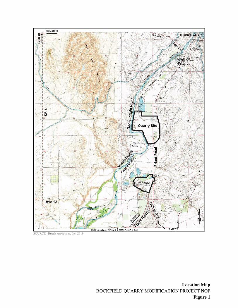
Location Map
ROCKFIELD QUARRY MODIFICATION PROJECT NOP
Figure 1
SOURCE: Buada Associates, Inc. 2019

Plant Site and Quarry Site Aerials
ROCKFIELD QUARRY MODIFICATION PROJECT NOP
Figure 2
Image not printed to scale.
SOURCE: Buada Associates, Inc. 2019