not final and binding
TRANSCRIPT

Authority: Item 4, Planning CommitteeReport: 13-009(PED13099/PW13040)CM: June 12, 2013
Bill No. 175
CITY OF HAMILTON
BY-LAW NO. 13-175
To Adopt:
Amendment No. 46 to the former Region of Hamilton-Wentworth Official Plan; and
Amendment No. 177 to the City of Stoney Creek Official Plan
Respecting:
The Fruitland-Winona Secondary Plan
NOW THEREFORE the Council of the City of Hamilton enacts as follows:
, Amendment No. 46 to the former Region of Hamilton-Wentworth Official Planconsisting of Schedule "1", hereto annexed and forming part of this by-law, ishereby adopted.
, Amendment No. 177 to the former City of Stoney Creek Official Plan consisting ofSchedule "1", hereto annexed and forming part of this by-law, is hereby adopted.
PASSED this 26th day of June, 2013.
R°
MayorR°
Cil
Not Final and Binding

Schedule “1”
Page 2 of 98
Amendment No. 46 to the former Region of Hamilton-Wentworth Official Plan;
and
Amendment No. 177 to the City of Stoney Creek Official Plan
The following text, together with the following maps/schedules: Region of Hamilton-Wentworth Schedule “A-1” (Map No. 1-Regional Development Pattern); Schedule “A-2” (Map No. 6-Transportation); City of Stoney Creek Schedule “B-2” (Schedule A - General Land Use Plan); Schedule “B-3” (Schedule A2 – Secondary Plan Winona Urban Community); Schedule “B-4” (Schedule A2-1 - Fruitland-Winona Secondary Plan - Land Use Plan); Schedule “B-5” (Schedule A2-2 - Fruitland-Winona Secondary Plan - Natural Heritage
System); Schedule “B-6” (Schedule A2-3 - Fruitland-Winona Secondary Plan - Transportation
Classification Plan); Schedule “B-7” (Schedule A2-4 - Fruitland-Winona Secondary Plan – Block Servicing
Strategy Area Delineation); Schedule “B-8” (Schedule B – Stoney Creek Open Spaces & Natural Environment System); Schedule “B-9” (Schedule C – Staging of Development); and, Schedule “B-10” (Schedule E – Planning Districts). attached hereto, constitutes: 1. Official Plan Amendment No. 46 to the former Region of Hamilton-Wentworth Official Plan;
and, 2. Official Plan Amendment No.177 to the former City of Stoney Creek Official Plan. 1.0 Purpose: The purpose of the Amendment to the former City of Stoney Creek Official Plan is to: Incorporate the Fruitland-Winona Secondary Plan into the former City of Stoney Creek Official
Plan, identifying land uses, densities, development forms, cultural heritage resources, and development standards, and provide for the protection of existing natural features in the Fruitland Winona area.
Delete the existing policies for the Winona Urban Community in response to the adoption of the Fruitland-Winona Secondary Plan; and,
Not Final and Binding

Schedule “1”
Page 3 of 98
Amend several policies and schedules of the Hamilton-Wentworth and Stoney Creek Official Plans to reflect the Fruitland-Winona Secondary Plan.
The effect of the Amendment is to establish a policy framework to guide the development and redevelopment of lands within the Fruitland-Winona planning area. 2.0 Location: The lands affected by this amendment are generally located south of Barton Street, north of Highway 8, east of Fruitland Road, and west of the City boundary, within the former City of Stoney Creek, as illustrated on Schedule “B-2” to this amendment. Most of the lands between Glover Road and McNeilly Road are not within the area affected by the amendment. 3.0 Basis: The basis for permitting these Amendments to adopt the proposed Fruitland-Winona Secondary Plan is as follows. The proposed amendment including the Fruitland-Winona Secondary Plan: Is consistent with the Provincial Policy Statement and the Growth Plan for the Greater
Golden Horseshoe. Is consistent with the Hamilton-Wentworth Official Plan, the Provincial Policy Statement, and
the Growth Plan for the Greater Golden Horseshoe, planning for a range of densities and a mix of uses to meet residents’ long-term needs, and park and open space areas for active and passive use.
Is in conformity with the general intent and objectives of the former City of Stoney Creek
Official Plan. Is in conformity with the general intent and objectives of the City’s new Urban Hamilton
Official Plan (appealed to the Ontario Municipal Board). Implements the direction of Ontario Municipal Board Order #1202, issued April 30, 2007, as
well as the subsequent Orders regarding PL031256 issued September 3, 2009, and September 9, 2010.
4.0 Actual Text Changes: 4.1 Region of Hamilton-Wentworth There are no proposed text changes to the Region of Hamilton-Wentworth Official Plan. 4.2 City of Stoney Creek
4.2.1 Delete the entirety of Section A.6 – The Winona Urban Community.
Not Final and Binding

Schedule “1”
Page 4 of 98
4.2.2 Delete the entirety of Section A.12.6 – Special Policy Area “F”. 4.2.3 Amend Section A.13.2 – The Winona Urban Community – Secondary Plan, by deleting
it in its entirety and replacing the following: A.13.2 Fruitland-Winona Secondary Plan The Fruitland-Winona Secondary Plan area is located at the eastern edge of the City of Hamilton, formerly known as lower Stoney Creek. The Fruitland-Winona Secondary Plan area consists of the lands east of Fruitland Road, north of Highway No. 8, south of Barton Street (including Winona); and the lands east of Winona, north of Highway No. 8, south of the QEW, and west of the City limits, as illustrated on Schedule A2-1– Fruitland-Winona Secondary Plan – Land Use Plan. The Secondary Plan area comprises 370 hectares, including the existing community of Winona, and is planned to accommodate an estimated population of approximately 15,500 people, at a density of 70 persons/jobs per hectare. The Fruitland-Winona Secondary Plan establishes land uses and development standards that guide the development of lands located within the Fruitland-Winona Secondary Plan area. Map Schedule A2-1 - Fruitland-Winona Secondary Plan - Land Use Plan, Map Schedule A2-2 – Fruitland-Winona Secondary Plan - Natural Heritage System, Schedule A2-3 – Fruitland-Winona Secondary Plan – Transportation Classification Plan and Schedule A2-4– Fruitland-Winona Secondary Plan – Block Servicing Strategy Area Delineation constitute the Fruitland-Winona Secondary Plan. 13.2.1 Vision
Fruitland-Winona is a community that recognizes the character of two distinct areas that will together strive for a safe, clean community with green canopy neighbourhoods connected by safe transportation corridors. The heritage community of Fruitland-Winona will accommodate people of all ages within a variety of housing choices that will be supported by excellent schools, parks and trail systems. Within the heart of the community, people oriented focal points will provide for activities such as a farmers market, recreation centre and other community activities. This generally low density community will support neighbourhood commercial and other higher density housing at appropriate locations. The Fruitland-Winona community provides a balance between a forward-looking community and a small town place to live.
13.2.2 Objectives The following objectives shall apply to development within the Fruitland-Winona Secondary Plan area:
13.2.2.1 Strengthen Existing Neighbourhoods
a) Ensure new development maintains a balance of residential uses, commercial uses,
open space, and community facilities/services that interface well with existing communities;
Not Final and Binding

Schedule “1”
Page 5 of 98
b) Ensure new development respects and enhances the character of existing neighbourhoods;
c) Encourage new commercial uses that cater to the existing and proposed local
neighbourhoods; and,
d) Ensure existing and future neighbourhoods are well served by community facilities/services such as schools, health care, libraries, emergency services, public transportation, and community recreation facilities.
13.2.2.2 Transportation, Transit and Active Transportation Linkages
a) Address and develop solutions to transportation issues within the Fruitland-Winona
Secondary Plan and beyond, including:
i) Truck traffic on Fruitland Road between Barton Street and Highway No, 8;
ii) Truck Routes, relocation, signage, and enforcement including areas such as Fruitland Road between Barton Street and Highway No. 8;
iii) Safety;
v) Provide traffic calming measures such as roundabouts where warranted and
appropriate; and, vi) Ensure opportunities for transit and active transportation. b) Encourage and support energy-efficient transportation such as walking, cycling and
transit, to reduce the dependency on the automobile; c) Ensure Highway No. 8 maintains an important connection to the Escarpment visually and
through trail access; d) Provide opportunities for improved public transit service to the Fruitland-Winona area; e) Provide an efficient, interconnected, easily accessible transportation system and pattern
of streets, creating safe pedestrian, bicycle and vehicular movement throughout the community;
f) Provide an opportunity for an inter-modal transportation hub generally located on the CN
Railway line at Fifty Road, including bus, train and car-pooling services; g) Focus on journeys to and from existing and proposed schools and parks, to ensure direct
safe walking and bicycling routes; and,
Not Final and Binding

Schedule “1”
Page 6 of 98
h) Consider the needs of children and youth when planning for transportation and active transportation.
13.2.2.3 Safe Community
a) Ensure that areas around public spaces are located and landscaped with public safety as
a priority; and, b) Design streets and built form that promote personal safety through natural surveillance by
providing “eyes on the street”, and improve accessibility through features such as Urban Braille.
13.2.2.4 Open Space and Parks a) Promote community health and neighbourhood connection through a system of
pedestrian trails;
b) Provide opportunities for outdoor recreation where they do not impact natural heritage features;
c) Provide appropriate recreational opportunities for existing and future residents; and, d) Ensure parks and open space areas are lit when deemed appropriate.
13.2.2.5 Natural Heritage
a) Ensure natural heritage features, such as environmentally significant areas, valley lands,
streams, significant woodlands and wetlands are protected and enhanced;
b) Prohibit development on lands with natural hazards such as flood plains; and,
c) Ensure that the natural beauty and distinctive landscape character created/ provided by the Niagara Escarpment and the adjacent agricultural areas are considered and protected as development proceeds.
13.2.2.6 Residential a) Create a community that provides for safe, functional, attractive and distinguishable
residential neighbourhoods; b) Encourage a mix of uses and housing types that meet the housing needs of residents
throughout their life cycles and allow them to remain within the community; and, c) Provide a compact urban form, with higher densities located closer to arterial roads that
may serve as future transit corridors, while maintaining views to the Escarpment and other natural features.
Not Final and Binding
Schedule “1”
Page 7 of 98
13.2.2.7 Institutional
a) Accommodate facilities for public use, including health, education, recreation, social or cultural activities, and safety; and,
b) Locate institutional uses within or adjacent to the communities they will serve.
13.2.2.8 Commercial
a) Provide for the development of small scale neighbourhood commercial areas that serve
the local community; b) Provide for the development of larger scale commercial areas that serve the daily and
weekly need of residents in the neighbourhood and surrounding area;
c) Require the provision of appropriate amenities for commercial areas, including parking, signage, landscaping, streetscaping and buffering;
d) Ensure that any new commercial uses respect and do not negatively impact adjacent
residential or institutional uses;
e) Encourage new commercial uses to reflect the character and cultural heritage of the communities of Fruitland and Winona through building design; and,
f) Provide a public open space that can accommodate a farmer’s market.
13.2.2.9 Urban Design
a) Ensure the development of an attractive, safe, and pedestrian oriented community
environment; b) Promote a high quality of design for public parks, open spaces, and buildings;
c) Ensure compatibility between areas of different land use or development intensity;
d) Establish gateway features at appropriate locations to function as entranceways to the
City, and the communities of Fruitland and Winona;
e) Provide integrated community design that coordinates land use, open space, street network, and built form elements to achieve the community vision;
f) Protect views of the Niagara Escarpment and other natural features;
g) Create street and building design that promotes neighbourhood vitality and pedestrian comfort at the grade level of buildings;
h) Promote public transit, active transportation such as walking, and recreational
Not Final and Binding

Schedule “1”
Page 8 of 98
connections through a well-connected system of streets, walkways, and trails; and, i) Promote design variety within streetscapes.
13.2.2.10 Utility and Municipal Services
a) Ensure adequate utility networks are established to serve the planned development and
are phased in a cost-effective and efficient manner;
b) Ensure utilities/municipal services are provided in a manner that minimizes the impacts on the natural environment;
c) Integrate the storm water management facilities with active pedestrian corridors, such as
the Barton Street Pedestrian Promenade, and in areas that will enhance the natural heritage system, where appropriate;
d) Encourage municipal services required for any part of this Secondary Plan area to be in
place and operative, as necessary, prior to, or concurrent with, the development; and,
e) Ensure public and private utility equipment are clustered or grouped where possible to minimize visual impact.
13.2.3 General Policies The Fruitland-Winona Secondary Plan has been developed to guide development within the Secondary Plan area. The following policies address land uses and other matters common to all parts of the Fruitland-Winona Secondary Plan area:
a) Schedule A2-1 Fruitland-Winona Secondary Plan – Land Use Plan, identifies the land
use designations applicable to the Fruitland-Winona Secondary Plan area.
b) For the purposes of this Secondary Plan, development shall also include redevelopment.
c) Development within the Fruitland-Winona Secondary Plan area shall provide a mix of housing opportunities in terms of built form, style and tenure that are suitable for residents of different age groups, income levels and household sizes.
d) When considering an application for development, the following matters shall be
evaluated:
i) Compatibility with adjacent land uses including matters such as shadowing, grading, overlook, noise, lighting, traffic and other nuisance effects;
ii) The consideration of transition in height and density to adjacent and existing
residential development;
Not Final and Binding

Schedule “1”
Page 9 of 98
iii) The relationship of the proposed lot(s) with adjacent and existing lot pattern and configuration; and,
iv) In accordance with the policies in Section 13.2.19 – Block Servicing Strategy and
all other applicable policies. e) Development on Barton Street adjacent to the Barton Street Pedestrian Promenade,
located along the south side of Barton Street, as identified on Map Schedule A2-3 - Fruitland-Winona Secondary Plan - Transportation Classification Plan, shall be integrated visually and functionally into the Barton Street Pedestrian Promenade in accordance with Section 13.2.11 – Barton Street Pedestrian Promenade and Policy 13.2.18.3 (b), of this Plan. An Urban Design Report shall be required to demonstrate how the proposed buildings integrate with the adjacent Barton Street Pedestrian Promenade and address matters such as the following:
i) Pedestrian connections;
ii) Built form; and,
iii) Landscaping.
f) Parking for developments along Barton Street shall be encouraged to be located away or
appropriately buffered from the Barton Street Pedestrian Promenade.
g) Where possible, connections of the Barton Street Pedestrian Promenade with adjacent natural areas, streets, trails and parks shall be encouraged in accordance with Section 13.2.11 – Barton Street Pedestrian Promenade of this Plan.
h) Continuous visual barriers such as tall acoustic or privacy fences or berms shall not be
permitted adjacent to the Barton Street Pedestrian Promenade. 13.2.4 Residential Designations – General Policies The residential areas within the Fruitland-Winona Secondary Plan are designated Low Density Residential 1, Low Density Residential 2, Low Density Residential 3, and Medium Density Residential 2, as identified on Schedule A2-1 - Fruitland-Winona Secondary Plan - Land Use Plan. 13.2.4.1 Notwithstanding Section A.1 – Residential Policies, the following policies shall
apply to lands designated Residential: a) The Fruitland-Winona Secondary Plan has been developed to create a liveable,
sustainable greenfield community based on efficient use of land, provision of transportation opportunities, and quality urban design. The Fruitland-Winona community has been planned to accommodate a minimum average density of 70 persons and jobs per hectare to meet the overall density target. The City shall not support substantial
Not Final and Binding

Schedule “1”
Page 10 of 98
decreases in density that will impact the overall target of the Plan area unless a remedial density transfer is provided.
b) A broad mix of housing types shall be encouraged between and within residential density
designations such that no area of the Secondary Plan is dominated by one housing type.
c) Where townhouses or multiple dwellings are proposed, a mix of long and short block lengths on either public or private streets shall be encouraged to provide variety to the streetscape. The massing of long townhouse blocks should be broken up through building gaps and/or changes in building façades or the introduction of other dwelling types so a single continuous elevation is not created.
d) A variety of housing elevations shall be encouraged within each residential block to
provide an interesting streetscape. In support of this policy an Urban Design Report may be required.
e) Direct vehicle access to new individual dwelling units from major or minor arterial roads
identified on Schedule A2-3 – Fruitland-Winona Transportation Classification Plan shall be discouraged and alternative forms of access such as shared or common access points and rear lane arrangements shall be encouraged.
f) Second dwelling units shall be permitted within all single and semi-detached dwellings on
lands designated Residential on Schedule A2-1 - Fruitland-Winona Secondary Plan - Land Use Plan.
g) To mitigate potential noise from the lands on the north side of Barton Street designated
Business Park on Schedule A2-1 – Fruitland-Winona Secondary Plan – Land Use Plan, all residential amenity space shall be provided in the rear of the property or within an internal courtyard.
Scale and Design h) The City shall require quality urban and architectural design. Development of lands within
the Fruitland-Winona Secondary Plan area shall be designed to be safe, efficient, pedestrian oriented, and attractive, and shall comply with the following criteria:
i) New development on large sites shall support a grid system of streets of
pedestrian scale, short blocks, street oriented structures, and a safe and attractive public realm;
ii) Garages, parking areas, and driveways along the public street shall not be
dominant. Surface parking between a building and a public street (excluding a public alley) shall be minimized;
iii) Adequate and direct pedestrian access and linkages to community
facilities/services and local commercial uses shall be provided;
Not Final and Binding

Schedule “1”
Page 11 of 98
iv) Development shall improve existing landscape features and overall landscape character of the surrounding area; and,
v) Development shall comply with Section 13.2.10 - Urban Design Policies and all
other applicable policies.
i) Innovative neighbourhood designs incorporating energy and environmental design
standards and the conservation of natural resources shall be promoted in accordance with Section 13.2.10 - Urban Design Policies.
j) Lower density residential uses and building forms shall generally be located in the
interiors of neighbourhood areas with higher density dwelling forms and supporting uses located on the periphery of neighbourhoods on or in close proximity to major or minor arterial roads.
k) Development adjacent to areas of lower density shall ensure the height, massing, and
arrangement of buildings and structures are compatible with existing and future uses in the surrounding area.
13.2.4.2 Low Density Residential (LDR)
Notwithstanding Section A.1 – Residential Policies, the following policies shall apply to lands designated “Low Density Residential”, including Low Density Residential 1, Low Density Residential 2 and Low Density Residential 3 on Schedule A2-1 - Fruitland-Winona Secondary Plan - Land Use Plan: Function a) The preferred location for low density residential uses is within the interior of
neighbourhoods;
b) Low density residential areas are characterized by lower profile, grade-oriented built forms that generally have direct access to each unit at grade;
c) Uses permitted in low density residential areas include single-detached, semi-detached,
duplex, triplex, and street townhouse dwellings;
d) Other permitted uses will include second dwelling units and housing with supports, and
other supporting uses; Scale e) The maximum net residential density shall be 60 units per hectare; f) The maximum height shall be three storeys;
Not Final and Binding

Schedule “1”
Page 12 of 98
Design g) Direct access from lots adjacent to major or minor arterial roads shall be discouraged; h) Backlotting along public streets and in front of parks shall be discouraged. The City
supports alternatives to backlotting, such as laneway housing and window streets, to promote improved streetscapes and public safety, where feasible;
i) A mix of lot widths and sizes compatible with streetscape character; and a mix of dwelling
unit types and sizes compatible in exterior design, including character, scale, appearance and design features; shall be encouraged. Development shall be subject to the Zoning By-law regulations for appropriate minimum lot widths and areas, yards, heights, and other zoning regulations to ensure compatibility; and,
j) Development, including the creation of infill lots involving the creation of new public
streets or extensions, shall generally proceed by way of plan of subdivision. Such plans shall achieve the logical and sequential extension of streets and municipal services and an efficient lotting pattern.
13.2.4.3 Low Density Residential 1 Designation
In addition to Section 13.2.4.2 - Low Density Residential Policies above, for lands designated Low Density Residential 1 on Schedule A2-1 – Fruitland-Winona Secondary Plan – Land Use Plan, the following policies shall apply: a) Notwithstanding Policy 13.2.4.2 (c), the permitted use shall be limited to single-detached
dwellings; and,
b) Notwithstanding Policy 13.2.4.2 (e), the net residential density shall not exceed 20 units per hectare.
13.2.4.4 Low Density Residential 2 Designation In addition to Section 13.2.4.2 - Low Density Residential Policies above, for lands designated Low Density Residential 2 on Schedule A2-1 – Fruitland-Winona Secondary Plan – Land Use Plan, the following policy shall apply: a) Notwithstanding Policy 13.2.4.2 (e), the net residential density shall be greater than 20
units per hectare and shall not exceed 40 units per hectare. 13.2.4.5 Low Density Residential 3 Designation In addition to Section 13.2.4.2 – Low Density Residential Policies above, for lands designated Low Density Residential 3 on Schedule A2-1 – Fruitland-Winona Secondary Plan – Land Use Plan, the following policies shall apply:
Not Final and Binding

Schedule “1”
Page 13 of 98
a) In addition to the uses permitted in Policy 13.2.4.2 (c), the following additional uses shall be permitted:
i) All forms of townhouse dwellings; and, ii) Existing Places of worship.
b) Notwithstanding Policy 13.2.4.2 (e), for lands designated Low Density Residential 3 the
net residential density shall be greater than 40 units per hectare and shall not exceed 60 units per hectare.
13.2.4.6 Medium Density Residential (MDR) Notwithstanding Section A.1 – Residential Policies, the following policies shall apply to lands to lands designated “Medium Density Residential”, including Medium Density Residential 2 on Schedule A2-1 - Fruitland-Winona Secondary Plan - Land Use Plan:
Function a) Medium density residential areas are characterized by multiple dwelling forms on the
periphery of neighbourhoods in proximity to major or minor arterial roads, or within the interior of neighbourhoods fronting on collector roads;
b) Uses permitted in medium density residential areas include multiple dwellings except
street town homes; c) Local commercial uses may be permitted on the ground floor of buildings containing
multiple dwellings, provided the provisions of Section 13.2.5.1 - Local Commercial are satisfied;
d) Medium density residential uses shall be located within safe and convenient walking
distance of existing or planned community facilities, public transit, schools, active or passive recreational facilities, and local or District Commercial uses;
e) Medium density residential built forms may function as transitions between high and low
profile residential uses; and, Design f) Development within the Medium Density Residential category shall be evaluated on the
basis of the following criteria:
i) Developments should have direct access to a collector or major or minor arterial road. If direct access to such a road is not possible, the development may gain access to the collector or major or minor arterial roads from a local road only if a small number of low density residential dwellings are located on that portion of the local road;
Not Final and Binding
Schedule “1”
Page 14 of 98
ii) Development shall be integrated with other lands in Fruitland-Winona with respect to density, design, and physical and functional considerations;
iii) Development shall be comprised of sites of suitable size and provide adequate
landscaping, amenity features, on-site parking, and buffering if required. The height, massing, and arrangement of buildings and structures shall be compatible with existing and future uses in the surrounding area;
iv) Access to the property shall be designed to minimize conflicts between traffic and
pedestrians both on-site and on surrounding streets;
v) The City may require studies, completed to the satisfaction of the City, to
demonstrate that the height, orientation, design, and massing of a building or structure shall not unduly overshadow, block light, or result in the loss of privacy of adjacent residential uses.
13.2.4.7 Medium Density Residential 2 Designation In addition to Section 13.2.4.6 – Medium Density Residential Policies above, for lands designated Medium Density Residential 2 on Schedule A2-1 – Fruitland-Winona Secondary Plan – Land Use Plan, the following policies shall apply:
a) In addition to the uses permitted in Policy 13.2.4.6 (b), the following additional uses shall
be permitted:
i) Community facilities/services, subject to a Zoning By-law amendment, provided all of the following criteria are met: 1. Direct access to a collector and/or major or minor arterial road identified on
Schedule A2-3 – Fruitland-Winona Transportation Classification Plan shall be provided;
2. Development shall be compatible with the surrounding area in terms of
scale, massing, height, siting, orientation, setbacks, parking, and landscaping;
3. Provision of adequate off-street parking with appropriate maneuvering
space; 4. Buffering and landscaping from residential uses; and, 5. Adequate vehicular access.
b) The net residential density shall be greater than 60 units per hectare and shall not exceed
75 units per hectare.
Not Final and Binding

Schedule “1”
Page 15 of 98
c) The maximum height shall be four storeys.
d) Notwithstanding Policy 13.2.4.6 (f) (i), all vehicular access should be from collector roads, local roads or private laneways located at the rear of the property. Where access to the proposed development is not possible from the collector roads, local roads or private laneways, shared access from Barton Street may be considered.
e) Sensitive land uses, such as residential uses, within the Medium Density Residential 2
(MDR2) areas located adjacent to the Employment Area on the north side of Barton Street shall be protected from the potential adverse impacts of industrial uses within the Employment lands to the west, and industrial uses shall be protected from sensitive uses as follows:
i) The City shall have regard for provincial guidelines concerning compatibility
between industrial facilities and sensitive land uses, and in mitigating the potential adverse impacts not addressed by the guidelines; and,
ii) The proponent of a new sensitive land use within the Residential area shall be
responsible for addressing and implementing the necessary mitigation measures to the satisfaction of the City.
13.2.5 Commercial and Mixed Use Designations – General Policies Notwithstanding Section A.3 – Commercial Policies, the following policies shall apply to lands designated Local Commercial, District Commercial and Arterial Commercial as identified on Schedule A2-1 - Fruitland-Winona Secondary Plan - Land Use Plan: a) Principal entrances shall address the public street or an exterior open space directly
adjacent to the public street.
b) Official Plan amendment applications for retail or service commercial development exceeding 5,000 square metres of gross floor area shall be required to undertake a commercial needs and impact assessment. The Commercial Needs and Impact Assessment shall address the impact of the proposal on designated retail areas and the potential for negative impacts to the planned function of these areas. Impact on planned function may include store closures, loss of vitality within the area which may affect the attraction or success of other land uses, or diminishment of the role and function of the structural element or the designation.
13.2.5.1 Local Commercial Designation In addition to Section 13.2.5, for lands designated Local Commercial on Schedule A2-1 – Fruitland-Winona Secondary Plan – Land Use Plan, the following policies shall apply: Function a) The following uses shall be permitted:
Not Final and Binding

Schedule “1”
Page 16 of 98
i) Retail and service uses such as a craftsperson shop, day nursery, commercial school, financial establishment, medical office, business office, professional office, business office, motor vehicle service station, personal service, place of worship, repair service, restaurant, retail, studio, art gallery, tradesperson shop, and veterinary service;
ii) Medical offices or clinic, provided it has direct access to an arterial road and is
adjacent to other local commercial uses;
iii) Community facilities/services; and,
iv) Residential uses, in accordance with Policy 13.2.5.1 (f)
b) Drive-through facilities accessory to commercial uses shall be regulated through the
Zoning By-law and site plan approval to ensure compatibility with adjacent uses, in accordance with Policy 13.2.5.1 (n).
Scale c) Local commercial uses may be permitted in the following built forms:
i) Small single-use buildings such as those occupied by a convenience store or a medical office;
ii) A plaza form at varying scales containing multiple commercial uses;
iii) A main street configuration with multiple commercial uses; or,
iv) Multiple storey buildings with the local commercial uses on the ground floor and residential units above.
d) The City shall encourage numbers and sizes of local commercial uses to adequately
serve local residents. e) Local commercial uses shall comply with the following provisions:
i) The gross floor area for any individual office shall not exceed 500 square metres; ii) The total maximum gross floor area for a development located on a particular site
shall be determined through studies where applicable, and Zoning By-laws; and iii) The maximum building height shall be three storeys.
Design f) Development of local commercial uses shall:
i) Front and have access to a major arterial, minor arterial, or collector road;
Not Final and Binding

Schedule “1”
Page 17 of 98
ii) Provide safe and convenient access for pedestrians and cyclists; and, iii) Be compatible with the surrounding area in terms of design, massing, height,
setbacks, on-site parking, landscaping, and lighting. g) Residential units located in the same building as local commercial uses shall generally be
located above the ground floor. Some components of the residential use may be located in ground floor areas in the rear of buildings. All commercial space shall be located on the ground floor with the primary entrances to the commercial space through the principal façade of the building.
h) New local commercial uses shall be planned and designed to be integrated with and
easily accessible from the surrounding neighbourhood. i) New local commercial uses and properties shall be clustered and generally located at
intersections with arterial and collector roads. j) New local commercial buildings or uses which could result in strip commercial
development shall not be permitted, but new local commercial buildings or uses may be permitted within or as an expansion of an existing main street area provided such buildings or uses:
i) Are located up to the street or in line with other buildings along the main street;
ii) Strengthen the pedestrian focus of the main street and assist in creating a vibrant
and active street;
iii) Provide an active storefront along the street with the main entrance of each building or store and substantial fenestration facing onto the street; and,
iv) Do not exacerbate an oversupply of retail space in the neighbourhood or along the
main street. k) New local commercial buildings or uses in areas other than those referred to in Policy
13.2.5.1 (j) shall:
i) Be located close to the street to create a strong pedestrian orientation particularly along adjoining collector roads;
ii) Provide a principal entrance facing the arterial and collector road; iii) Provide direct access from the sidewalk;
iv) Provide windows and signage facing the street; and, v) Provide for a consistent minimum setback.
Not Final and Binding

Schedule “1”
Page 18 of 98
l) Office uses are intended to be part of local commercial clusters, therefore, conversions of dwellings to accommodate offices identified in Policy 13.2.5.1 (a) (i) shall not be permitted in scattered locations along arterial and collector roads.
m) Notwithstanding Policy 13.2.5.1 (l), conversions of dwellings to accommodate offices
identified in Policy 13.2.5.1 (a) (i) may be permitted provided the following criteria shall be met:
i) The block face between two roads in which the conversion is proposed is not
occupied predominantly by residential uses;
ii) The conversion shall not create access problems or result in transportation impacts;
iii) The use shall be clustered with other similar uses or other non-residential uses; iv) The required parking and manoeuvring area is accommodated in the side or rear
yard; and, v) Appropriate landscaped buffering, as specified in the implementing Zoning By-law,
is provided between the parking and adjacent residential uses. n) No parking, drive-throughs, or stacking lanes should be permitted between buildings and
the public sidewalk. o) On-street parking may be permitted along adjacent collector roads and contribute to the
required parking.
13.2.5.2 District Commercial Designation In addition to Section 13.2.5, for lands designated District Commercial on Schedule A2-1 – Fruitland-Winona Secondary Plan – Land Use Plan, the following policies shall apply: a) Areas designated District Commercial are intended to provide retail and service
commercial uses to the immediate neighbourhood. District Commercial areas shall contain a range of retail shops and services that cater primarily to the weekly and daily shopping needs of residents in the surrounding neighbourhoods. These retail shops and services may currently be clustered in a plaza forms but new areas or expansions and redevelopment of existing areas can create an improved street presence by bringing the stores up to the edge of the street.
Function b) The range of retail uses are intended to serve the daily and weekly shopping needs of
residents in the surrounding neighbourhoods. The District Commercial areas shall also serve as a focus for the adjacent neighbourhood(s) by creating a sense of place.
Not Final and Binding
Schedule “1”
Page 19 of 98
Permitted Uses c) The following uses shall be permitted on lands designated District Commercial on
Schedule A2-1 – Fruitland-Winona Secondary Plan – Land Use Plan:
i) Commercial uses including retail stores, personal services, financial establishments, live work units, restaurants, including gas bars, car washes, and service stations;
ii) Offices provided they are located above the first storey;
iii) Residential uses provided they are located above the first storey of a mixed use
building; and,
iv) Accessory uses.
Prohibited Uses d) Notwithstanding Policy 13.2.5.2 (c), the following uses shall be prohibited on lands
designated District Commercial on Schedule A2-1 – Fruitland-Winona Secondary Plan – Land Use Plan:
i) Vehicle dealerships;
ii) Garden centres as a primary use; and,
iii) A single use over 10,000 square metres in floor area.
Scale e) The built form may include stand-alone stores, multiple unit commercial buildings or live-
work buildings. f) The preferred location of a new District Commercial designated area is at the intersection
of a collector road and a major or minor arterial road. g) The maximum amount of retail and service commercial floor space permitted in an area
designated District Commercial shall be 25,000 square metres. h) Office uses on the same lot, shall not exceed 2,000 square metres. i) Although residential development is permitted and encouraged, it is not the intent of the
Plan for the District Commercial designated areas to lose the planned retail and service commercial function set out in this Plan.
Design j) Areas designated District Commercial shall be planned and designed to be integrated
with and easily accessible from the surrounding neighbourhood by a range of transportation modes including the automobile, transit, and active transportation.
Not Final and Binding

Schedule “1”
Page 20 of 98
k) In new areas designated District Commercial or for additions or redevelopments of existing District Commercial designated areas, smaller retail buildings shall be located up to the street to create a strong pedestrian orientation, particularly along adjoining collector roads.
l) Where buildings are located up to the street in accordance with 13.2.5.2 (k), the principal
entrances shall face the public street providing direct access from the sidewalk. The windows and signage shall also face the street and buildings should have a consistent minimal setback.
m) No parking, driveways, lanes, stacking lanes, or aisles should be permitted between
buildings and the public sidewalk except as provided for in Policy 13.2.5.2 (p). n) Drive-throughs, car washes, service stations, and gas bars shall be permitted provided
they meet the requirements of Policy 13.2.5.2 (m) and are located away from the pedestrian- oriented area identified in Policy 13.2.5.2 (k).
o) Parking lots abutting the street shall be screened with low walls, and/or landscape
materials to provide a sense of enclosure along the setback line. p) Single use stores greater than 5,000 square metres may be situated in the interior or at
the rear of the site with smaller foot print buildings located close to the street. Alternatively, larger stores could be located up to the streetline along an arterial road or along a collector road provided in the latter situation they are lined with smaller stores, multiple entrances, or other similar means to animate the streetscape along the collector road.
q) On-street parking may be permitted along adjacent collector roads and contribute to the
required parking. 13.2.5.3 Arterial Commercial Designation In addition to Section 13.2.5, for lands designated Arterial Commercial on Schedule A2-1 – Fruitland-Winona Secondary Plan – Land Use Plan, the following policies shall apply:
a) The Arterial Commercial designation is intended to provide for a range of uses catering to
the traveling or drive-by consumer as well as retail stores, which are land extensive and require outdoor storage or sales and cannot be appropriately accommodated in the other designations.
Function b) The range of permitted uses is intended to cater to the traveling or drive-by consumer. As
well, the designation is intended to accommodate a limited range of land extensive retail stores which require outdoor storage or sales.
Not Final and Binding
Schedule “1”
Page 21 of 98
Permitted Uses c) The following uses shall be permitted on lands designated Arterial Commercial on
Schedule A2-1- Fruitland-Winona Secondary Plan - Land Use Plan: i) Commercial uses including banquet halls, restaurants including garden centres,
furniture stores, building and lumber supply establishment, home improvement supply store, and retail primarily for the sale of building supplies;
ii) Automotive related uses primarily for vehicle sales, service and rental, parts sales,
gas bars, car washes, and service stations; iii) Commercial recreational uses, commercial entertainment uses, excluding theatres; iv) Industrial supply and service and contractor sales; v) Accommodation, excluding residential uses; vi) Enclosed storage including mini warehousing; and, vii) Accessory uses.
Prohibited Uses d) Notwithstanding Policy 13.2.5.3 (c), the following uses shall be prohibited on lands
designated Arterial Commercial on Schedule A2-1- Fruitland-Winona Secondary Plan - Land Use Plan:
i) Department stores; ii) Food stores; iii) Residential uses; and, iv) Stores primarily selling apparel, housewares, electronics, sporting goods, or
general merchandise. Design e) Site plan standards shall be developed to address the unique siting and design
challenges of areas designated Arterial Commercial including those inherent in siting and buffering large buildings, large parking lots, blank building walls, and drive-throughs. As well, landscape standards shall be developed to provide buffer plantings along boulevards and within the site to address these matters.
f) Setbacks and siting shall be addressed in detail through secondary plan policies, the
implementing Zoning By-law, and site plan approval. Pedestrian walkways shall be included within the site and between sites so pedestrians may comfortably access Arterial Commercial designated properties.
Not Final and Binding

Schedule “1”
Page 22 of 98
g) Areas designated Arterial Commercial shall be designed to improve the aesthetics from the public realm.
13.2.6 Employment Area – Business Park Designation
Subsection A.4 – Industrial Business Park, shall apply to lands designated Employment Area - Business Park on Schedule A2-1 – Fruitland-Winona Secondary Plan – Land Use Plan.
13.2.7 Parks and Open Space Designations – General Policies In addition to the policies in Subsection A.7 – Open Space and Parks, the following policies shall apply to the Parks and Open Space designations identified on Schedule A2-1 – Fruitland-Winona Secondary Plan – Land Use Plan:
Neighbourhood Park Designation a) Lands designated Neighbourhood Park shall be visible and accessible to the public with
unobstructed views provided to improve natural surveillance; b) Neighbourhood Parks shall generally be square or rectangular in shape and have
significant street frontage. The specific location, size and shape of Neighbourhood Parks may vary subject to approval of the City without amendment to this plan; and,
c) The City will negotiate with developers to encourage the construction of neighbourhood
parks on the City’s behalf during the construction of the subdivision. General Open Space Designation d) Lands designated General Open Space located east of Jones Road and connecting
Jones Road to the proposed Collector Road “C” shall be dedicated to the City and shall be used for a multi-purpose pedestrian trail to link the neighbourhoods. The multi-purpose trail shall be subject to the following:
i) An Environmental Impact Statement shall be completed by the City, which will
determine the exact location, design, and construction material requirements for the multi-use trail; and,
ii) The multi-purpose trail shall be designed in accordance with the Fruitland-Winona
Urban Design Guidelines.
Natural Open Space Designation e) The following uses only shall be permitted on lands designated Natural Open Space:
i) Pedestrian pathways, trails, bikeways and walkways; and, ii) Forest, fish and wildlife management areas.
Not Final and Binding

Schedule “1”
Page 23 of 98
13.2.8 Institutional Designation Notwithstanding Section A.5 – Institutional Policies, the following policy shall apply to lands designated Institutional on Schedule A2-1 – Fruitland-Winona Secondary Plan – Land Use Plan: Permitted Uses a) The following uses shall be permitted on lands designated Institutional on Schedule A2-1
– Fruitland-Winona Secondary Plan – Land Use Plan:
i) Educational facilities, except commercial schools;
ii) Religious facilities;
iii) Cultural facilities;
iv) Health care facilities;
v) Long term care facilities;
vi) Day care facilities;
vii) Accessory uses; and,
viii) Ancillary uses, in accordance with Policy 13.2.8 (b).
Ancillary Uses b) Administrative offices of educational, religious, cultural, health, welfare, and governmental
activities, not accessory to the institutional use on the same property, may be permitted provided the following conditions are met:
i) The site shall be located on a major or minor arterial road as identified on
Schedule A2-3 – Fruitland-Winona Secondary Plan – Transportation Classification Plan; and,
ii) Adequate on-site parking shall be provided.
c) Residential uses ancillary to an institutional use, such as student residences, convents,
and continuing care projects may be permitted provided the following conditions are met:
i) The site and/or building shall be designed to minimize negative impacts on institutional use;
ii) Residential uses shall be developed in accordance with Section 13.2.4.2 – Low
Density Residential or Section 13.2.4.6 – Medium Density Residential. The appropriate density shall be determined on a site by site basis provided it meets
Not Final and Binding

Schedule “1”
Page 24 of 98
the applicable policies of Sections 13.2.4.2 – Low Density Residential and 13.2.4.6 – Medium Density Residential, inclusive; and,
iii) Adequate on-site parking shall be provided.
d) Recreational uses may be permitted provided the following conditions are met:
i) The site and/or building shall be designed to minimize negative impacts on residential uses on adjacent lands designated Neighbourhoods; and,
ii) Adequate on-site parking shall be provided.
Other Uses e) Notwithstanding Policy 13.2.8 (a), where institutional uses cease on lands designated
institutional located on the south side of Barton Street, Medium Density Residential 2, parks, and open space uses, or community facilities/services uses may be permitted without an amendment to this Plan, provided the residential uses are compatible with the surrounding area and are in keeping with the policies of this Plan.
Design f) In addition to the applicable policies of Section 13.2.10 – Urban Design Policies, the
design of individual buildings shall address the following matters:
i) Lighting to highlight design of building; and, ii) The establishment and the use of multi-purpose spaces (e.g. community meeting
rooms).
Other Provisions g) When considering development proposals for new institutional uses or expansions to
existing institutional uses within existing Institutional designations, the following criteria shall be evaluated:
g) Availability of sufficient off-street parking to meet projected demand, to minimize
spill-over parking on adjacent local streets;
ii) Provision of adequate and appropriate landscaping and buffering to effectively screen parking, loading and service areas from adjacent residential uses;
iii) The scale of the proposed institutional use and its compatibility with the character
of established development in the surrounding area;
iv) The capability of the site for providing convenient access to public transit with all
buildings located within a reasonable walking distance; and,
v) Use of underground parking or parking structures.
Not Final and Binding

Schedule “1”
Page 25 of 98
h) Large institutions contained in a campus like setting shall be encouraged to undertake
campus plans which address the following matters: i) Design of individual buildings and their relationship to each other, including the
location of future buildings; ii) Pedestrian linkages between buildings, pedestrian circulation plans, and attention
to pedestrian environment, including the installation of urban braille;
iii) Integration of bicycle facilities and transit stop/stations into the site or adjacent to the site;
iv) Use of way-finding signage;
v) Location of lighting;
vi) Location of entryways/gateways should be identified and marked with entryway
features;
vii) Traffic circulation both into and within the site; and,
viii) Integration and relationship of the institutional buildings to adjacent land uses through building placement (peripheral campus buildings to address the public street) and built form.
13.2.9 Utility Designation
The following policies shall apply to lands designated Utility on Schedule A2-1 - Fruitland-Winona Secondary Plan - Land Use Plan: Permitted Uses a) The following uses shall be permitted on lands designated Utility on Map B.7.8 -1 -
Fruitland-Winona Secondary Plan - Land Use Plan:
i) Major facilities, corridors, easements and rights–of-way for utilities and services, such as electric power, natural gas and oil pipelines, telecommunication, storm water management, solid waste management outside Employment Areas, water and wastewater service;
ii) Municipal works yards outside Employment Areas; iii) Parking lots in conjunction with adjacent uses; iv) Open space uses such as trails and community gardens; and, vi) Heavy rail corridors and main lines.
Not Final and Binding

Schedule “1”
Page 26 of 98
b) Only essential utility facilities, the maintenance of and minor upgrading of existing
facilities shall be permitted within the Niagara Escarpment Plan Natural Area. c) Additional uses may be permitted on lands of the City, public authorities and corporations
of the Province responsible for the generation and transmission of electric power, Hydro lands and all other lands designated Utility where deemed by Council to be compatible with adjacent land uses.
Other Provisions d) Utilities shall integrate with the general character of the surrounding uses through the
provision of landscaping, screening and buffering, siting of structures, height control, and any other measures as may be deemed to be appropriate by the City and in accordance with the Green Energy and Green Economy Act, 2009.
e) The City of Hamilton shall prepare a telecommunications antenna siting protocol to
ensure effective local participation in decisions respecting the siting of proposed antennas and their supporting structure.
13.2.10 Urban Design
Development in Fruitland-Winona shall occur in accordance with the Fruitland-Winona Urban Design Guidelines and the following Policies:
13.2.10.1 General Policies and Principles The principles in Policies 13.2.10.1 (a) through 13.2.10.1 (h) inclusive, shall apply to all development, where applicable. Principles a) Urban design should foster a sense of community pride and identity by:
i) Respecting existing character, development patterns, built form, and landscape;
ii) Promoting quality design consistent with the locale and surrounding environment; iii) Recognizing and protecting the cultural history of the City and its communities;
iv) Conserving and respecting the existing built heritage features of the City and its
communities;
v) Conserving, maintaining, and enhancing the natural heritage and topographic features of the City and its communities;
vi) Demonstrating sensitivity toward community identity through an understanding of
the character of a place, context and setting in both the public and private realm;
Not Final and Binding

Schedule “1”
Page 27 of 98
vii) Contributing to the character and ambiance of the community through appropriate
design of streetscapes and amenity areas; viii) Respecting prominent sites, views, and vistas in the City; and, ix) Incorporating public art installations as an integral part of urban design.
b) Quality spaces physically and visually connect the public and private realms. Public and
private development should create quality spaces by:
i) Organizing space in a logical manner through the design, placement, and construction of new buildings, streets, structures, and landscaping;
ii) Recognizing that every new building or structure is part of a greater whole that contributes to the overall appearance and visual cohesiveness of the urban fabric;
iii) Using materials that are consistent and compatible with the surrounding context in
the design of new buildings;
iv) Creating streets as public spaces that are accessible to all;
v) Creating a continuous animated street edge in urban environments;
vi) Including transitional areas between the public and private spaces where possible
through use of features such as landscaping, planters, porches, canopies, and/or stairs;
vii) Creating public spaces that are human-scale, comfortable, and publicly visible with
ample building openings and glazing;
viii) Creating, reinforcing, and emphasizing important public vistas and view corridors;
and,
ix) Minimizing excessive street noise and stationary noise source levels through the
design, placement, and construction of buildings and landscaping. c) Places that are safe, accessible, connected and easy to navigate shall be created by
using the following design applications, where appropriate:
i) Connecting buildings and spaces through an efficient, intuitive, and safe network of streets, roads, alleys, lanes, sidewalks, and pathways;
ii) Providing connections and access to all buildings and places for all users, regardless of age and physical ability;
Not Final and Binding

Schedule “1”
Page 28 of 98
iii) Ensuring building entrances are visible from the street and promoting shelter at
entrance ways;
iv) Integrating conveniently located public transit and cycling infrastructure with
existing and new development; v) Providing appropriate way-finding signage considering size, placement, and
material that clearly identifies landmarks, pathways, intersections, cycling and transit routes, and significant natural and cultural heritage features;
vi) Providing pedestrian-scale lighting;
vii) Designing streets and promoting development that provides real and perceived
safety for all users of the road network;
viii) Including urban braille components in streetscape improvements;
ix) Considering traffic calming techniques in redevelopment projects; and,
x) Creating places and spaces which are publicly visible and safe.
d) Where it has been determined through the policies of this Plan that compatibility with the
surrounding areas is desirable, new development should enhance the character of the existing environment by:
i) Complementing and animating existing surroundings through building design and
placement as well as through placement of pedestrian amenities; ii) Respecting the existing cultural and natural heritage features of the existing
environment by re-using, adapting, and incorporating existing characteristics;
iii) Allowing built form to evolve over time through additions and alterations that are in
harmony with existing architectural massing and style;
iv) Complementing the existing massing patterns, rhythm, character, colour, and
surrounding context; and,
v) Encouraging a harmonious and compatible approach to infilling by minimizing the
impacts of shadowing and maximizing light to adjacent properties and the public realm.
e) Places that are adaptable in accommodating future change are desirable and should be
created by:
Not Final and Binding

Schedule “1”
Page 29 of 98
i) Designing buildings, sites, and public spaces that can be used for a variety of uses in the future in response to changing social, economic, and technological conditions;
ii) Encouraging design that accommodates the changing physical needs of people
and their lifestyles through all stages of their lives; and,
iii) Encouraging innovative design of built forms and public spaces.
f) Urban design should promote environmental sustainability by:
i) Achieving compact development and resulting built forms; ii) Integrating, protecting, and enhancing environmental features and landscapes,
including existing topography, forest and vegetative cover, green spaces and corridors through building and site design;
iii) Encouraging on-site storm water management and infiltration through the use of
techniques and technologies, including storm water management ponds, green roofs, and vegetated swales;
iv) Encouraging the use of Leadership in Energy and Environmental Design (LEED) or other environmental building rating tools for buildings and infrastructure for all development;
v) Encouraging the reduction of resource consumption in building and site
development and avoiding the release of contaminants into the environment; and,
vi) Encouraging energy efficiency in neighbourhood design and development.
g) Urban design plays a significant role in the physical and mental health of our citizens. Community health and well-being shall be enhanced and supported through the following actions, where appropriate:
i) Creating high quality, safe streetscapes, parks, and open spaces that encourage
physical activity and active transportation; ii) Ensuring an equitable distribution of accessible and stimulating amenity areas,
including the development of places for passive and active recreation and use;
iii) Encouraging development of complete and compact communities or
neighbourhoods that contain a variety of land uses, transportation, recreational, and open space uses; and,
iv) Reducing air, noise, and water pollution through the following:
Not Final and Binding

Schedule “1”
Page 30 of 98
1. Facilitating and promoting the use of active transportation modes through building and site design;
2. Providing adequate green space, landscaped buffering, and storm water
management facilities; 3. Using appropriate pavement treatments; 4. Promoting energy efficient design of sites and buildings; and, 5. Promoting innovative construction materials and techniques.
h) Streets shall be designed not only as a transportation network but also as important
public spaces and shall include, where appropriate:
i) Adequate and accessible space for pedestrians, bicycles as well as transit, other vehicles, and utilities;
ii) Continuous sidewalks;
iii) Landscaping such as street trees and landscaped boulevards;
iv) Pedestrian amenities such as lighting, seating, way-finding signage, and urban
braille;
v) On-street parking;
vi) Public art; and,
vii) Amenities and spaces that encourage pedestrian activity and animate the
streetscape such as public gathering places, patios and sidewalk cafés. 13.2.10.2 Streetscape and Built Form
a) New development shall be located and organized to fit within the existing or planned
context of the area. b) New development shall be designed to minimize impact on neighbouring buildings and
public spaces by:
i) Creating transitions in scale to neighbouring buildings;
ii) Ensuring adequate privacy and sunlight to neighbouring properties; and, iii) Minimizing the impacts of shadows and wind conditions.
Not Final and Binding

Schedule “1”
Page 31 of 98
c) New development shall be massed to respect existing and planned street proportions. d) Built form shall create comfortable pedestrian environments by:
i) Locating principal façades and primary building entrances parallel to and as close
to the street as possible; ii) Including ample glazing on ground floors to create visibility to and from the public
sidewalk; iii) Including a quality landscape edge along frontages where buildings are set back
from the street; iv) Locating surface parking to the sides or rear of sites or buildings, where
appropriate; and, v) Using design techniques, such as building step-backs, to maximize sunlight to
pedestrian areas.
e) Architectural variation through the incorporation of varied roof lines, materials and colours in each building and from building to building, shall be encouraged.
f) Variation in the number of storeys, porch designs, architectural style and building type
from building to building shall be encouraged. g) Continuous rows of repetitive building façades shall be discouraged. h) Building façades with architectural details and windows facing both streets shall be
encouraged on corner sites. i) The layout of streets, configuration of lots and the siting of buildings shall ensure:
i) There is no reverse lotting adjacent to streets; ii) Streets and open spaces have an appropriate degree of continuity; iii) Opportunities are provided for the creation of views both within the community and
adjacent to natural heritage areas; iv) Pedestrian connections to public streets and other outdoor spaces are encouraged; v) The safety and security of all persons in public places including streets, parks and
amenity areas shall be promoted through the design and siting of buildings, entrances, walkways, amenity and parking areas to provide visibility and opportunities for informal surveillance;
Not Final and Binding
Schedule “1”
Page 32 of 98
vi) Loading, service/garbage and parking facilities shall be integrated into the design of buildings to minimize disruption to the safety and attractiveness of the adjacent public realm. Where this integration is not feasible, these facilities shall be: 1. Grouped and/or located to minimize their visual impact on the public street; 2. Screened with enhanced landscaping and fencing constructed; and, 3. Designed in keeping with the design of the building;
vii) Joint access driveways between adjacent sites on arterial and collector roads shall
be considered to reduce collision conflict points, minimize disruption to the public sidewalk, maximize the areas available for landscaping, and minimize expanses of pavement;
viii) Parking should be located away from the street to maintain unimpeded views of the
building façade and to enhance a pedestrian oriented environment; and,
ix) Parking lots abutting the street should be screened with low walls and landscape materials to provide a sense of enclosure along the setback line.
13.2.10.3 Gateways a) Gateway intersections and entry points shall be designed to convey a sense of arrival
and portray the community image and identity through:
i) Design of the built form; ii) Building orientation; iii) Street configuration; iv) Infrastructure items and projects; v) Landscaping; vi) Recognition of significant views and vistas; vii) Signage; and/or, viii) Public art installations.
b) The City shall work with adjacent property owners, adjacent municipalities, and applicable
governmental agencies with jurisdiction over road rights-of-way on the design and installation of appropriate gateway features.
Not Final and Binding

Schedule “1”
Page 33 of 98
c) Gateways are important placemaking elements that denote strategic access points and entryways into the City and neighbourhoods. The locations of Gateways within the Fruitland-Winona Secondary Plan area are identified on Schedule A2-1 Fruitland Winona Secondary Plan – Land Use Plan. There are two classifications of Gateways: Major Gateways and Minor Gateways, described as follows:
i) Major Gateways are intended to mark the entrance into the City and shall consist of
spaces that comprise major landscaping elements and features and, where possible, buildings with high quality designs and architectural elements; and,
ii) Minor Gateways are intended to mark the entry into the neighbourhood and shall
consist of spaces that comprise minor landscaping elements and features. Minor Gateways are smaller in scale than Major Gateways.
d) To recognize strategic locations within the City, Major Gateways shall be considered in
the following locations within the Fruitland-Winona Secondary Plan area:
i) The intersection of Highway No. 8 and Fifty Road; and, ii) The intersection of Fifty Road and the South Service Road.
e) To promote and enhance the Fruitland-Winona community identity, Minor Gateways shall
be provided in the following locations:
i) The intersection of the proposed Collector Road “A” and Barton Street; ii) The intersection of Fruitland Road and Barton Street; and, iii) The intersection of Fruitland Road and Hwy. No. 8.
f) Design of Major and Minor Gateways should:
i) Ensure buildings address the corner through the use of glazing, building entrance
features, signage, and/or other architectural features; ii) Incorporate enhanced hard and soft landscaping within both the public and private
realm, including: enhanced paving materials, decorative fencing, pedestrian amenities, and signature tree species;
iii) Include enhanced pedestrian crossings through the use of enhanced paving
materials and pedestrian scaled lighting; and, iv) Incorporate public art where feasible.
Not Final and Binding

Schedule “1”
Page 34 of 98
13.2.10.4 Views and Vistas
a) Public views and vistas are significant visual compositions of important public and historic buildings, natural heritage and open space features, landmarks, and skylines which enhance the overall physical character of an area when viewed from the public realm. Vistas are generally panoramic in nature while views usually refer to a strong individual feature often framed by its surroundings. Views and vistas created in newly developing areas play a large role in creating a sense of place and neighbourhood identity.
b) New developments within the Fruitland-Winona Secondary Plan area shall be designed to
protect and address views to the Niagara Escarpment.
c) Any development applications to increase height beyond what is permitted in this Plan, shall be required to demonstrate through an Urban Design Report that existing views to the Niagara Escarpment and Lake Ontario are protected. A Visual Impact Assessment may be required to demonstrate proposed heights do not negatively impact views to the Niagara Escarpment.
d) Views and vistas shall be achieved through alignment of rights-of-way, layout of
pedestrian circulation and open space systems, and the siting of major features, public uses, and built form.
e) The principal façades of public buildings and parks are encouraged to locate at the
termination of a street or view corridor or at street intersections to act as focal points for views except in situations where such building placement would compromise existing significant views or vistas.
13.2.10.5 Urban Services and Utilities a) Public and private utility services, excluding stormwater management facilities, shall be:
i) Installed within public road allowances, on other City owned land, or within appropriate easements;
ii) Encouraged, wherever possible, to be coordinated and located within a common trench to avoid unnecessary over-digging and disruption of municipal rights-of-way;
iii) Clustered or grouped where possible to minimize visual impact;
iv) Encouraged to consider innovative methods of containing utility services on or
within streetscape features such as gateways, lamp posts, transit shelters, etc.;
v) Located underground to maintain a pleasant visual environment along public roads.
The City may consider relocating existing above ground utilities to underground locations as part of roads improvements and streetscape installation projects. The
Not Final and Binding

Schedule “1”
Page 35 of 98
feasibility of the relocation shall be determined through discussions with utility providers.
b) Above ground utility service providers shall be encouraged to cooperate with the City in
identifying locations which minimize visual intrusions. In accordance with Section 13.2.9 – Utility Designation, screening and buffering of utilities shall be required. Innovative methods of containing utility services within streetscape features such as gateways, light standards, public art installations, or transit shelters are encouraged when determining appropriate locations for large utility equipment and utility cluster sites.
c) Site and building services and utilities such as waste storage facilities, loading, air
handling equipment, hydro and telecommunication facilities, and metering equipment shall be located away from and/or screened from public streets and adjacent residential areas or other sensitive land uses, to minimize their visual impacts and operational effects. Location and screening of telecommunications antennas shall be in accordance with the telecommunications antenna siting protocol policy described in Policy 13.2.9 (e).
13.2.10.6 Storage, Service and Loading Areas a) Service and loading areas shall be located away from streets so as to minimize disruption
or conflicts with adjacent land uses and pedestrian routes and shall be screened as necessary from views from the public right-of-way.
b) Service and loading areas shall be buffered to reduce visual and noise impacts, particularly when located adjacent to residential areas. Buffering methods should include berms, tree and shrub plantings, noise walls, fences, and/or the use of quality construction materials and methods.
c) Outside storage areas shall be sited and organized to reduce their potential negative
impacts on the streetscape. Open storage areas should be located in the rear or side yards and screened from public view or from views from adjacent properties.
d) Outside storage and loading areas shall be paved with a hard surface to reduce dust and
promote improved air quality. 13.2.10.7 Signage, Display Areas, and Lighting a) All signs shall be designed as an integral element of the site layout and building design.
b) Signs shall not dominate the overall character of a site or development and should
complement the site, architecture, and context in which they are to be placed.
c) Signs on cultural heritage properties or within heritage conservation districts or cultural
heritage landscapes shall be compatible with the architecture and character of the property or district.
Not Final and Binding

Schedule “1”
Page 36 of 98
d) Outdoor display areas shall be designed to make a positive contribution to the streetscape and the overall site development. Display areas shall be well defined through architecture and landscaping to work in harmony with adjacent buildings and display areas.
e) Lighting of buildings and display areas shall be provided at levels sufficient for building
identification and safety. All building lighting shall be oriented so as not to cause glare on adjacent properties or public roads. Outdoor lighting fixtures that reduce energy consumption and direct light away from the night sky shall be encouraged.
13.2.10.8 Access and Circulation a) Joint access driveways shall be considered between adjacent sites to minimize disruption
of the public sidewalk, maximize the areas available for landscaping, and minimize expanses of pavement.
b) On large sites, clearly defined internal driving aisles shall be provided to provide visual and functional definition of the site, to direct traffic, and to frame parking areas.
c) To ensure safety and promote their priority over vehicular traffic, pedestrian walkways
shall differ in material and appearance from driving surfaces.
d) Landscaped walkways shall be provided along buildings, particularly in areas with high
levels of pedestrian traffic. Walkways shall be connected to other pedestrian routes on the site and linked to pedestrian entry points at the street, and where appropriate to adjacent developments.
e) Pedestrian walkways shall be made continuous across driving aisles as well as across
driveway entrances at the street where appropriate.
f) Transit access shall be enhanced by:
i) Connecting sidewalks to transit stops and shelters; ii) Locating transit stops and principal building entrances in close proximity to each
other, where appropriate; and, iii) Ensuring lighting, seating, trash receptacles, and route information are available at
each transit stop.
13.2.10.9 Parking a) To create and enhance safe, attractive pedestrian oriented streetscapes, surface parking
shall be discouraged, and parking located below grade or in parking structures shall be encouraged.
Not Final and Binding

Schedule “1”
Page 37 of 98
b) Shared parking facilities shall be encouraged, where appropriate.
c) Where surface parking is proposed, it should be located to the sides or rear of buildings
to enable the development of a continuous street edge and the creation of quality urban spaces consistent with Section 13.2.10.1 (a) through (h) – General Policies and Principles.
d) Parking areas shall be connected to the street through safe, landscaped pedestrian walkways.
e) Perimeters of surface parking lots shall be landscaped with appropriate materials that
allow visibility from the public realm to the interior of the parking area.
f) Interiors of parking lots shall include landscaped islands, when possible, to provide shade
and visual relief from hard surfaces. Landscaped islands should be of sufficient size to ensure growth of vegetation.
g) Parking lots shall be paved with hard surfaces to reduce dust and promote improved air
quality. The use of permeable pavement systems or other low impact development practices is encouraged for storm water management, when technically possible.
h) Parking lots shall be lit with sufficient light for safety. On surface parking lots, lighting
shall be internally oriented so as not to cause glare on adjacent properties or public roads. Outdoor lighting fixtures that reduce energy consumption and direct light away from the night sky are encouraged.
i) Bicycle parking facilities shall be located as close as possible to the entry points to
buildings. A variety of bicycle parking formats, such as sheltered racks and lockers, catering to both employees and visitors is encouraged.
13.2.10.10 Barrier Free Design a) Barrier free access to services, facilities, and amenities is essential to achieving an
efficient and equitable City. The City has established the Advisory Committee for Persons with Disabilities and implements the City of Hamilton Barrier Free Design Guidelines to ensure that all residents of Hamilton can live in a barrier free environment.
b) All newly constructed and/or renovated City of Hamilton owned, leased, or operated facilities, parks and open spaces, infrastructure, and any other space that are accessible to the public, shall comply with the City of Hamilton Barrier Free Design Guidelines.
c) The City shall require barrier free design, wherever possible, on private sector sites and
in private sector buildings and facilities through site plan approval, enforcement of the Ontario Building Code, and implementation of all applicable provincial legislation, standards and guidelines.
Not Final and Binding

Schedule “1”
Page 38 of 98
d) The City shall pursue the implementation of an urban braille network throughout the Downtown Urban Growth Centre and other existing and planned Nodes, as appropriate. Urban braille installation may be required as part of new development and redevelopment and shall be implemented through the site plan approval process.
13.2.10.11 Public Art a) Public art is a vital component of the built environment, creating and enhancing a sense
of community pride and identity. Public art installations make living in Hamilton, and traveling through the city’s streets, public and private spaces an engaging and more pleasurable experience for residents and visitors. Public art, as an important expression of community identity and culture, enhances tourism and economic development and the overall vitality of the City. Public Art includes art created by artists or in collaboration with artists through a public process and installed on city owned or privately owned publicly accessible land.
b) Public art shall play an important role in expressing the community’s identity and contributing to place making of public spaces. Provisions for public art shall be a part of all public realm improvement projects in accordance with Section 13.2.10.11.
c) Public art may include murals, sculptures, fountains, benches, walkway design,
pavement designs and amenity design.
d) Public art that fosters community identify through interpreting local history, traditions and
culture is encouraged in all public and private spaces.
e) The City shall pursue the installation of public art in public locations in accordance with
the Public Art Master Plan. f) Private developments that include spaces attracting significant pedestrian traffic are
encouraged to include public art in the design of the building and/or site.
g) The City shall consider the inclusion and installation of public art as part of the following
public infrastructure projects, where appropriate:
i) Bridges; ii) Roadway designs; iii) Noise barriers; iv) Transit stations, stops and facilities; v) Paving design;
Not Final and Binding

Schedule “1”
Page 39 of 98
vi) Street furniture; and, vii) Other infrastructure that is highly visible from the public right-of-way.
h) The City shall initiate partnerships with other public institutions in the development of
public art projects on publicly assessable lands.
13.2.10.12 Other Policies a) The policies of this section shall be implemented through mechanisms such as zoning,
plans of subdivision and condominium, site plan control, site plan guidelines, and urban design guidelines.
b) The City, as owners of many public buildings and places, shall apply the design policies of this Section and other sections of this Plan when planning for and developing new, and making improvements to, streets, public spaces, community facilities, and infrastructure.
c) The City shall encourage the provision of shade and pedestrian oriented street lighting in
public and private spaces. d) The use of long stretches of acoustical walls for noise attenuation adjacent to arterial
roads shall be discouraged. 13.2.11 Barton Street Pedestrian Promenade
a) The Barton Street Pedestrian Promenade is a four meter wide trail planned to extend from
Fruitland Road to Fifty Road on the south side of Barton Street as identified on Schedule A2-3 – Fruitland-Winona Secondary Plan – Transportation Classification Plan. In addition to Policy 13.2.18.3 (b) of this Plan, the following policies shall apply to the Barton Street Pedestrian Promenade and lands fronting the south side of Barton Street:
i) The City shall complete a Streetscape Master Plan for Barton Street which will
address the design of the Barton Street Pedestrian Promenade; ii) The Barton Street Pedestrian Promenade shall be designed as a meandering City
owned multi-use paved trail system within the road right-of-way on the south side of Barton Street;
iii) The Barton Street Pedestrian Promenade shall provide a safe paved pathway for
pedestrians and cyclists to connect public spaces such as schools, storm water management facilities, and City parks to future transit services; and,
iv) Urban Braille shall be incorporated into the design of the Barton Street Pedestrian
Promenade,
Not Final and Binding

Schedule “1”
Page 40 of 98
13.2.12 Natural Heritage System – General Policies
13.2.12.1 The Fruitland-Winona Natural Heritage System, identified on Schedule A2-2 – Fruitland-Winona Secondary Plan – Natural Heritage System, consists of Core Areas, Linkages, Vegetation Protection Zones and Restoration Areas. Notwithstanding Section B.1 – Open Spaces and Natural Environment System, the following policies shall apply to the Fruitland-Winona Secondary Plan area:
a) The Natural Heritage System shown on Schedule A2-2 – Fruitland-Winona Secondary
Plan – Natural Heritage System, comprised of privately-owned land is not available for use by the general public nor shall there be any intent or obligation by the City or other public agency to purchase such lands.
b) The boundaries of Core Areas and Linkages, identified on Schedule A2-2 – Fruitland-
Winona Secondary Plan – Natural Heritage System, are general in nature. Minor refinements to such boundaries may occur through Environmental Impact Statements, watershed studies or other appropriate studies accepted by the City without an amendment to this Plan. Major changes to boundaries, the removal or addition of Core Areas and Linkages identified on identified on Schedule A2-2 – Fruitland-Winona Secondary Plan – Natural Heritage System, require an amendment to this Plan.
c) Areas of significant habitat of threatened or endangered species, fish habitat, significant
valley lands, significant wildlife habitat, vegetation protection zones, groundwater seepage areas and springs, and additional Core Areas are not mapped on Schedule A2-2 – Fruitland-Winona Secondary Plan – Natural Heritage System, at this time. Other land containing these natural features may be identified through appropriate studies such as a sub-watershed plan, natural area inventory, or an Environmental Impact Statement. The policies governing these natural features shall apply to such natural features notwithstanding the designations on Schedule A2-2 – Fruitland-Winona Secondary Plan – Natural Heritage System.
d) The City shall conduct studies in the future to identify the precise location of Core Areas
identified by provincial policy and Linkages but not presently mapped in this Plan. Schedule A2-2 – Fruitland-Winona Secondary Plan – Natural Heritage System shall be amended as these features are identified. The Province is responsible for defining criteria for determining the significance of certain natural heritage features in the Natural Heritage System. The criteria established in this Plan and used by the City to identify natural heritage features shall be updated and amended to reflect provincial direction as required.
e) Where land contains two or more natural features of differing significance which overlap
in the Natural Heritage System, the more restrictive policies pertaining to those natural features shall apply. If more than one policy applies to a natural feature, such as may occur with hazardous lands defined in the Conservation Authorities Act or with fisheries under the Federal Fisheries Act, the more restrictive policy or standard shall apply.
Not Final and Binding

Schedule “1”
Page 41 of 98
f) All natural features, required vegetation protection zones, and enhancement or restoration areas on a property shall be placed under appropriate zoning in the zoning by-law and/or protected through a conservation easement to the satisfaction of the City or the relevant Conservation Authority, or deeded to a public authority. Acquisition by a public body may also be considered as an option for protecting natural features and functions.
g) The City will work with the Conservation Authorities to implement the recommendation of
recovery strategies in order to meet the objectives of the Provincial Policy Statement related to endangered and threatened species.
h) Wherever possible, development within the Fruitland-Winona Secondary Plan Area shall
promote a healthy Natural Heritage System by restoring, enhancing, and linking habitat/Core Areas, vegetation protection zones, linkages, and restoration areas;
i) All development within the Fruitland-Winona Secondary Plan area shall comply with the
Endangered Species Act, 2007 or its successor legislation; and,
j) Protection and enhancement of natural heritage features that provide opportunities for corridors from the Niagara Escarpment to Lake Ontario shall be encouraged.
13.2.12.2 Natural Heritage System - Core Areas
a) In accordance with the policies of this Plan, Schedule A2-2 – Fruitland-Winona Secondary
Plan – Natural Heritage System, identifies Core Areas to include key natural features and key hydrological features.
b) Core Areas are the most important components in terms of biodiversity, productivity, and
ecological and hydrological functions. It is the intent of this policy to preserve and enhance Core Areas and to ensure that any development or site alteration within or adjacent to them shall not negatively impact their environmental features or ecological functions.
c) The natural features and ecological functions of Core Areas shall be protected and
enhanced. To accomplish this protection and enhancement, vegetation removal and encroachment into Core Areas shall generally not be permitted, and appropriate vegetation protection zones shall be applied to all Core Areas.
Core Areas - Outside the Greenbelt Plan Area d) The boundaries of Core Areas and associated vegetation protection zones may be further
refined by the completion of an Environmental Impact Statement. Generally, permitted uses in Core Areas shall include:
i) Forest, fish and wildlife management;
Not Final and Binding

Schedule “1”
Page 42 of 98
ii) Conservation, and flood or erosion control projects, but only if they have been demonstrated to be necessary in the public interest and after all alternatives have been considered;
iii) Existing uses, (existing, non-complying and non-conforming uses), and according
to the requirements in Section 13.2.13 – Environmental Impact Statements; iv) Passive recreation uses and small scale structures for recreation uses (such as
boardwalks, footbridges, fences, docks, and picnic facilities) where permitted by Conservation Authority policies; however, the negative impacts on these features should be minimized; and,
v) Infrastructure projects.
e) New development and site alteration shall not be permitted within provincially significant
wetlands, significant coastal wetlands or significant habitat of threatened and endangered species.
f) New development and site alteration shall not be permitted within fish habitat, except in
accordance with provincial and federal requirements. g) New development and site alteration shall not be permitted within significant woodlands,
significant valleylands, significant wildlife habitat and significant areas of natural and scientific interest unless it has been demonstrated that there shall be no negative impacts on the natural features or on their ecological functions.
h) New development and site alteration shall not be permitted on adjacent lands to the
natural heritage features and areas identified in Section 13.2.12.2 (e) to (g) unless the ecological function of the adjacent lands has been evaluated and it has been demonstrated that there shall be no negative impacts on the natural features or on their ecological functions.
i) Streams have been separated into two classes: Coldwater Watercourse/Critical Habitat
and Warmwater Watercourse/Important/Marginal Habitat. If the stream has not been classified as part of an EIS, subwatershed study, or other study, a scoped EIS is required to determine the classification.
j) New development or site alteration subject to Policies 13.2.12.2 (f) to 13.2.12.2 (i)
requires, prior to approval, the submission and approval of an Environmental Impact Statement which demonstrates to the satisfaction of the City and the relevant Conservation Authority that:
i) There shall be no negative impacts on the Core Areas or their ecological functions.
Not Final and Binding

Schedule “1”
Page 43 of 98
ii) Connectivity between Core Areas shall be maintained, or where possible, enhanced for the movement of surface and ground water, plants and wildlife across the landscape.
iii) The removal of other natural features shall be avoided or minimized by the
planning and design of the proposed use or site alteration wherever possible. Vegetation Protection Zones and Restoration Areas k) Vegetation Protection Zones and Restoration Areas are identified on Schedule A2-2 –
Fruitland-Winona Secondary Plan - Natural Heritage System. l) An Environmental Impact Statement shall propose a vegetation protection zone which:
i) Has sufficient width to protect the Core Area and its ecological functions from
impacts of the proposed land use or site alteration occurring during and after construction, and where possible, restores or enhances the Core Area and/or its ecological functions; and
ii) Is established to achieve, and be maintained as natural self-sustaining vegetation.
m) Where vegetation protection zone widths have not been specified by watershed and sub-
watershed plans, rural settlement area plan policies, Environmental assessments and other studies, the following minimum vegetation protection zone width objectives shall be evaluated and addressed by Environmental Impact Statements. Other agencies, such as Conservation Authorities, may have greater vegetation protection zone requirements.
i) Coldwater Watercourse and Critical Habitat – 30-metre vegetation protection zone
on each side of the watercourse, measured from the bankfull channel. ii) Warmwater Watercourse and Important and Marginal Habitat – 15-metre
vegetation protection zone on each side of the watercourse, measured from the bankfull channel.
iii) Provincially Significant Wetlands and Locally Significant Wetlands (all evaluated
wetlands) – 30-metre vegetation protection zone, measured from the boundary of the wetland, as approved by the Conservation Authority or Ministry of Natural Resources.
iv) Unevaluated wetlands – Unevaluated wetlands greater than 2 hectares in size
require a 30-metre vegetation protection zone, measured from the boundary of the wetland, as approved by the Conservation Authority or Ministry of Natural Resources. Unevaluated wetlands 2 hectares or less in size require a 30-metre vegetation protection zone, unless an Environmental Impact Statement recommends a more appropriate vegetation protection zone.
Not Final and Binding

Schedule “1”
Page 44 of 98
v) Woodlands – 10-metre vegetation protection zone, measured from the edge (drip line) of the woodland.
vi) Significant woodlands – 15-metre vegetation protection zone, measured from the
edge (drip line) of the significant woodland. vii) Areas of Natural and Scientific Interest (ANSI) – Life and Earth Science ANSIs
require a 15-metre vegetation protection zone. viii) Significant Valleylands – As required by the relevant Conservation Authority. ix) Significant Habitat of Threatened or Endangered Species and Significant Wildlife
Habitat: the minimum vegetation protection zone shall be determined through Environmental Impact Statements, dependent on the sensitivity of the feature.
n) Vegetation protection zone widths greater than specified in 13.2.12.2 (m), (i) to (ix) above
may be required if ecological features and functions warrant it, as determined through an approved Environmental Impact Statement. The minimum vegetation protection zone widths in Policy 13.2.12.2 (m) are guidelines. Widths shall be determined on a site-specific basis, by considering factors such as the sensitivity of the habitat, the potential impacts of the proposed land use, the intended function of the buffer, and the physiography of the site.
o) Where the Greenbelt Plan Natural Heritage System abuts the Urban Area, the Greenbelt
Plan vegetation protection zone requirements apply for the purposes of conducting Environmental Impact Studies, watershed plans, and subwatershed studies.
p) Disturbed sites which are undergoing re-development adjacent to Core Areas, vegetation
protection zone widths narrower than those minimums recommended in Policy 13.2.12.2 (m) may be considered on constrained sites and when an Environmental Impact Statement (EIS) confirms that reduced vegetation protection zones will not negatively impact the existing features and functions of the Core Area.
q) Permitted uses within a vegetation protection zone shall be dependent on the sensitivity
of the feature, and determined through approved studies. Generally, permitted uses within a vegetation protection zone shall be limited to low impact uses, such as vegetation restoration, resource management, and open space. Septic tanks, holding tanks, impervious surfaces, and grading works shall not be permitted within the vegetation protection zone. Storm water management facilities and recreational trails shall generally not be permitted within the vegetation protection zone. New development or site alteration areas shall be located outside of the vegetation protection zone. Private sewage disposal systems and new impervious surfaces associated with the development shall not be permitted within the vegetation protection zone. Permitted uses within the vegetation protection zone should be similar to those within the protected natural area and the vegetation protection zone should remain in or be returned to a natural state.
Not Final and Binding

Schedule “1”
Page 45 of 98
r) All plantings within vegetation protection zones shall use only non-invasive plant species native to Hamilton. The City may require that applicants for development or site alteration develop a restoration or management plan for the vegetation protection zone as a condition of approval.
s) Where possible, the Vegetation Protection Zone should restore or enhance the features
and/or ecological functions of the Core Area as recommended by an Environmental Impact Statement prepared in accordance with Section 13.2.16 – Environmental Impact Statements, to the satisfaction of the City; and,
13.2.13 Environmental Impact Statements
a) Any required Environmental Impact Statement shall be completed in accordance with
Section 13.2.16 - Environmental Impact Statements, and comply with all provisions of Section 13.2.12.2 (d) through (s) – Core Areas – Outside of Greenbelt Plan Area.
Linkages b) Linkages are remnant natural areas within the landscape that connect Core Areas.
Connections between natural areas provide opportunities for plant and animal movement, hydrological and nutrient cycling, and maintain ecological health and integrity of the overall Natural Heritage System. The City recognizes the importance of Linkages shown on Schedule A2-2 – Fruitland-Winona Secondary Plan – Natural Heritage System in reducing the adverse impacts of habitat fragmentation of natural areas. Habitat fragmentation results in loss of species diversity and reduced ecosystem health and resilience. It is the intent of this policy that Linkages be protected and enhanced to sustain the Natural Heritage System wherever possible. In addition, there may be areas where a natural area is degraded, presenting an opportunity to recreate or enhance a Linkage.
c) The City shall encourage the connection of Core Areas within the municipality and
adjacent to its municipal boundaries through the identification of Linkages in Environmental Impact Statements, Secondary Plans, watershed plans, and other studies. Linkages include the following:
i) Woodland linkages (e.g. small woodlands); ii) Other natural vegetation types (e.g. meadows, old field, thickets); or iii) Streams and watercourses that connect Core Areas.
d) On its own properties, including road rights-of-way, utilities, major infrastructure facilities,
and storm water management ponds the City shall enhance Linkages by restoring natural habitat, where appropriate. The City shall support the naturalization of vegetation in inactive sections of parks and open space areas, where appropriate.
Not Final and Binding

Schedule “1”
Page 46 of 98
e) The City shall require the incorporation of Linkages into a design of new development requiring approval by this Plan to retain and enhance the cultural, aesthetic, and environmental qualities of the landscape, wherever possible.
f) Since linkages are best enhanced and protected through larger-scale planning
processes, Secondary Plans shall identify and evaluate Linkages in greater detail, including Linkages currently identified on Schedule A2-2 – Fruitland-Winona Secondary Plan – Natural Heritage System and those that may be newly identified through the planning process. Linkages shall be mapped in Secondary Plans and policies for their protection and enhancement included. [Mod 15]
g) Where new development or site alteration is proposed within a Linkage in the Natural
Heritage System as identified on Schedule A2-2 – Fruitland-Winona Secondary Plan – Natural Heritage System, the applicant shall prepare a Linkage Assessment. On sites where an Environmental Impact Statement (EIS) is being prepared, the Linkage Assessment can be included as part of the EIS report. Any required Linkage Assessment shall be completed in accordance with Policy 13.2.16 (j) - Linkage Assessments.
h) Linkage Assessments shall include the following information:
i) Identify and assess the Linkage including its vegetative, wildlife, and/or landscape features or functions;
ii) Assess the potential impacts on the viability and integrity of the Linkage as a result
of the development proposal; and, iii) Make recommendations on how to protect, enhance or mitigate impacts on the
Linkage(s) and its functions through planning, design and construction practices. i) In addition to the Linkages identified on Schedule A2-2 – Fruitland-Winona Secondary
Plan – Natural Heritage System, there may be Hedgerows that are worthy of protection, especially where:
i) They link Core Areas; ii) There is evidence that wildlife regularly use them as movement corridors or
habitat; iii) They are composed of mature, healthy trees and generally provide a wide,
unbroken linkage between Core Areas; iv) They contain trees which are rare, unique, culturally important, or old (more than
100 years); or, v) They represent an important cultural feature and contribute to the aesthetics of the
landscape, particularly adjacent to the Niagara Escarpment.
Not Final and Binding

Schedule “1”
Page 47 of 98
Restoration Areas j) For the purposes of this plan, Restoration Areas are vacant or degraded lands adjacent
to Core Areas where natural habitat has been altered, degraded, or destroyed. These areas provide opportunities to enhance and extend habitat of core areas. With proper habitat restoration, Restoration Areas will contribute to the function of the Natural Heritage System.
k) When new development or site alteration is proposed adjacent to or within a Restoration
Area, the Restoration Area shall be evaluated through an Environmental Impact Statement in accordance with the SCUBE Sub-watershed Studies where required by the City of Hamilton and shall require site specific restoration or planting plans as per the completed Environmental Impact Statement.
13.2.14 Tree and Woodland Protection a) The City recognizes the importance of trees and woodlands to the health and quality of
life in our community. The City shall encourage sustainable forestry practices and the protection and restoration of trees and forests, including significant woodlands, wooded areas, hedgerows, and tree cover within urban and rural settlement areas.
b) Opportunities for tree planting on City-owned lands (such as lands designated Open
Space and inactive portions of parks) shall be identified and implemented in co-operation with government agencies and local interest groups. In restoration efforts, the City shall plant only native species, preferably those of local origin.
c) Where the City is undertaking infrastructure work, existing woodland resources shall be protected and preserved, where feasible. If it is necessary for infrastructure works to destroy any trees, excluding trees that are listed as threatened or endangered species, the City shall endeavour to compensate by re-planting on site and/or planting trees elsewhere.
d) The City shall maintain and update as necessary a Woodland Conservation By-law and
Tree Protection Policy. A Woodland Protection Strategy to protect tree cover on new development sites within urban and rural settlement areas and provides technical direction and practices to protect trees and other vegetation during construction shall be prepared to minimize the impacts on trees and woodlands to be retained.
13.2.15 Water Resources a) The City shall protect, improve or restore the quality and quantity of water by using the
watershed as the ecologically meaningful scale for planning and minimizing potential negative impacts, including cross-jurisdictional and cross-watershed impacts.
b) The City shall promote efficient and sustainable use of water resources, including
practices for water conservation and sustaining water quality.
Not Final and Binding

Schedule “1”
Page 48 of 98
c) Development and site alteration shall be restricted in or near sensitive surface water features and sensitive ground water features and tributaries including those tributaries defined by the City’s Source Protection Plan such that these features and their related hydrologic functions and water quality functions shall be protected, improved or restored. Mitigative measures and/or alternative development approaches may be required in order to protect, improve or restore sensitive surface water features, sensitive ground water features, and their hydrologic functions.
d) A portion of Watercourse No. 5, located north of Sherwood Park Road may be considered
for relocation and natural channel design reconstruction to the satisfaction of the City in consultation with the Conservation Authority.
13.2.16 Environmental Impact Statements (EIS) a) Council has adopted Environmental Impact Assessment Guidelines which shall be used
by proponents and professionals when preparing an EIS. The City shall revise the Environmental Impact Statement Guidelines from time to time.
b) When a development proposal has the potential to negatively impact a Core Area or its
function, the proponent shall be required to prepare an EIS to the satisfaction of the City and the relevant Conservation Authority. An EIS inventories and describes the existing Core Areas and ecological functions of the site in the context of the surrounding landscape. An EIS also assesses the potential negative impacts that proposed development may have on Core Areas and Linkages and provide recommendations on whether the development proposal should proceed or be modified, natural area boundaries, mitigation measures, and design measures to accommodate or enhance existing natural features and functions.
c) An EIS shall be required for development and site alteration proposed within or adjacent
to a Core Area. Adjacent lands for features are defined in Table 13.2.1 below. The distances for adjacent lands provided in Table 13.2.1 are guidelines only and the City may require an EIS for development proposed outside of the adjacent area if it is anticipated that impacts may be far-reaching.
Table 13.2.1: Adjacent Land Distances to Trigger an Environmental Impact Statement (For lands outside the Greenbelt Plan Area)
Natural Heritage Feature
Boundary Definition
Extent of Adjacent Lands
(outside of Greenbelt)
Fish Habitat Streams, rivers, lakes, ponds, and wetland.
30 metres from bankfull channel
Provincially Significant Wetlands, Local Wetlands, and
Defined by the Province, Conservation Authorities, and the City of Hamilton
120 metres
Not Final and Binding

Schedule “1”
Page 49 of 98
Unevaluated Wetlands greater than 2 hectares in size Significant Habitat of Threatened and Endangered Species
Defined by the Province and City of Hamilton.
50 metres
Unevaluated wetlands
Defined by Conservation Authorities and the City of Hamilton
50 metres
Significant Woodlands
Defined by City of Hamilton
50 metres, measured from the
dripline
Streams and River Valleys
Conservation Authority regulatory lines, flood plain mapping.
30 metres from stable top of bank
Areas of Natural and Scientific Interest (ANSIs)
As defined by the Province
50 metres
Significant Valley lands
As defined by the Province and City of Hamilton.
50 metres
Significant Wildlife Habitat
As defined by the Province and City of Hamilton.
50 metres
Environmentally Significant Areas (ESAs)
As defined by the City of Hamilton
50 metres
d) The EIS may be scoped to reflect the type of development being proposed and the
sensitivity and special characteristics of the natural area. Scoping shall be done by City, the Conservation Authority, and other relevant agencies in consultation with the applicant.
e) The EIS must be submitted as part of a complete development application to ensure that
environmental impacts are considered early in the design process when there is the greatest opportunity to design in harmony with the natural environment. In no case shall an EIS be a condition of approval granted under the Planning Act and the completion of an EIS does not guarantee that the development application will be approved.
f) The EIS must be prepared by a professional qualified in the field of environmental
sciences, following the requirements of the City’s Environmental Impact Statement Guidelines. An EIS may include plans, studies, environmental analyses, cumulative impact assessments, buffer requirements, or other associated documentation and data considered necessary by Environmentally Significant Areas Impact Evaluation Group (ESAIEG) and City staff, as outlined in the City of Hamilton’s Environmental Impact Statement Guidelines.
Not Final and Binding

Schedule “1”
Page 50 of 98
g) Where an Environmental Assessment is carried out under Federal or Provincial Environmental Assessment processes, the assessment shall be considered as fulfilling the EIS requirements of this Plan.
h) Where environmental studies, such as a sub-watershed study have been carried out as
part of a comprehensive planning process, the study may be submitted in place of the EIS, provided it fulfills the requirements of an EIS and is carried out to the satisfaction of the City and the relevant Conservation Authority.
i) Where an EIS demonstrates that a development proposal shall have negative impacts on
the significant natural feature and functions of a site, the following options shall apply:
i) the application shall be refused; or, ii) The City shall consult with the applicant to redesign the proposal to reduce the
impacts to the satisfaction of the City and relevant Conservation Authority; or, iii) The City shall negotiate an agreement with the landowner requiring conditions of
approval, or requiring dedication of land/conservation easement to protect the significant natural feature or function.
j) Linkage assessments shall consider both the linkage within the site and connections with
other sites and shall evaluate the following:
i) Identify and assess the linkage including its vegetative, wildlife, and/or landscape features or functions, including:
1. The natural areas and habitats/functions linked (number of sites linked and
habitat sizes and condition);
2. Linkage type (e.g. anthropogenic railway or utility corridor, hedgerow, plantation, or natural community);
3. Vegetation cover type quality (health, condition, maturity, species, and
aesthetic value); 4. Width; 5. Length; and, 6. Continuity of vegetation (long gaps greater than 100 metres, gaps containing
roads or other barriers, or gaps less than 30 metres wide with no barriers);
ii) Assess the potential impacts on the viability and integrity of the linkage as a result of the development proposal; and,
Not Final and Binding

Schedule “1”
Page 51 of 98
iii) Make recommendations on how to protect, enhance or mitigate impacts on the linkage(s) and its functions through planning, design and construction practices.
13.2.17 Cultural Heritage Resource Policies – General Policies
a) Cultural heritage resources may include tangible features, structures, sites, or
landscapes that, either individually or as part of a whole, are of historical, architectural, archaeological, or scenic value. Cultural heritage resources represent intangible heritage, such as customs, ways-of-life, values, and activities. The resources may represent local, regional, provincial, or national heritage interests and values.
13.2.17.1 Notwithstanding Section E.5 – Historic and Archaeological Resources, the
following policies shall apply to the Fruitland-Winona Secondary Plan area: a) City of Hamilton shall, in partnership with others where appropriate:
i) Protect and conserve the tangible cultural heritage resources of the City, including archaeological resources, built heritage resources, and cultural heritage landscapes for present and future generations.
ii) Identify cultural heritage resources through a continuing process of inventory,
survey, and evaluation, as a basis for the wise management of these resources. iii) Promote awareness and appreciation of the City’s cultural heritage and encourage
public and private stewardship of and custodial responsibility for the City’s cultural heritage resources.
iv) Avoid harmful disruption or disturbance of known archaeological sites or areas of
archaeological potential.
v) Encourage the ongoing care of individual cultural heritage resources and the
properties on which they are situated together with associated features and structures by property owners, and provide guidance on sound conservation practices.
vi) Support the continuing use, reuse, care, and conservation of cultural heritage
resources and properties by encouraging property owners to seek out and apply for funding sources available for conservation and restoration work.
vii) Ensure the conservation and protection of cultural heritage resources in planning
and development matters subject to the Planning Act either through appropriate planning and design measures or as conditions of development approvals.
viii) Conserve the character of areas of cultural heritage significance, including
designated heritage conservation districts and cultural heritage landscapes, by
Not Final and Binding
Schedule “1”
Page 52 of 98
encouraging those land uses, development and site alteration activities that protect, maintain and enhance these areas within the City.
ix) Use all relevant provincial legislation, particularly the provisions of the Ontario
Heritage Act, the Planning Act, the Environmental Assessment Act, the Municipal Act, the Niagara Escarpment Planning and Development Act, the Cemeteries Act, the Greenbelt Act, the Places to Grow Act, and all related plans and strategies in order to appropriately manage, conserve and protect Hamilton’s cultural heritage resources.
b) The City consists of many diverse districts, communities, and neighbourhoods, each with
their own heritage character and form. The City shall recognize and consider these differences when evaluating development proposals to maintain the heritage character of individual areas.
Heritage Designation c) The City may by by-law designate individual and groups of properties of cultural heritage
value under Parts IV and V respectively of the Ontario Heritage Act, including buildings, properties, cultural heritage landscapes, heritage conservation districts, and heritage roads or road allowances.
Listing of Properties in the Heritage Register d) The City shall maintain, pursuant to the Ontario Heritage Act, a Register of Property of
Cultural Heritage Value or Interest. In considering additions and removals of non-designated cultural heritage property to or from this Register, the City shall seek and consider advice from its Municipal Heritage Committee.
e) In addition to the provisions of the Ontario Heritage Act respecting demolition of cultural
heritage properties contained in the Register, the City shall ensure that such properties shall be protected from harm in the carrying out of any undertaking subject to the Environmental Assessment Act or the Planning Act.
Protection of Non-Designated or Non-Registered Heritage Properties f) The City recognizes there may be cultural heritage properties that are not yet identified or
included in the Register of Property of Cultural Heritage Value or Interest nor designated under the Ontario Heritage Act, but still may be of cultural heritage interest. These may be properties that have yet to be surveyed, or otherwise identified, or their significance and cultural heritage value has not been comprehensively evaluated but are still worthy of conservation.
g) The City shall ensure these non-designated and non-registered cultural heritage
properties are identified, evaluated, and appropriately conserved through various legislated planning and assessment processes, including the Planning Act, the Environmental Assessment Act and the Cemeteries Act.
Not Final and Binding
Schedule “1”
Page 53 of 98
h) To ensure consistency in the identification and evaluation of these non-designated and non-registered cultural heritage properties, the City shall use the criteria for determining cultural heritage value or interest established by provincial regulation under the Ontario Heritage Act and set out in Policy 13.2.17.1 (i) below.
Cultural Heritage Evaluation Criteria i) For consistency in all heritage conservation activity, the City shall use, and require the
use by others, of the following criteria to assess and identify cultural heritage resources that may reside below or on real property:
i) Prehistoric and historical associations with a theme of human history that is
representative of cultural processes in the settlement, development, and use of land in the City;
ii) Prehistoric and historical associations with the life or activities of a person, group,
institution, or organization that has made a significant contribution to the City;
iii) Architectural, engineering, landscape design, physical, craft, or artistic value;
iv) Scenic amenity with associated views and vistas that provide a recognizable sense
of position or place;
v) Contextual value in defining the historical, visual, scenic, physical, and functional
character of an area; and,
vi) Landmark value.
j) Any property that fulfills one or more of the foregoing criteria listed in Policy 13.2.17.1 (i)
above shall be considered to possess cultural heritage value. The City may further refine these criteria and provide guidelines for their use as appropriate.
Cultural Heritage Conservation Plan Statements k) The City shall prepare cultural heritage conservation plan statements for areas where the
concentration or significance of cultural heritage resources require that detailed guidance be provided for the conservation and enhancement of these resources. The statements will, in part, be prepared to ensure that development, site alteration and redevelopment proposals demonstrate appropriate consideration for their impact on cultural heritage resources.
Cultural Heritage Impact Assessments l) A cultural heritage impact assessment shall be required by the City and submitted prior to
or at the time of any application submission pursuant to the Planning Act where the proposed development, site alteration, or redevelopment of lands (both public and private) has the potential to adversely affect the following cultural heritage resources through displacement or disruption:
Not Final and Binding
Schedule “1”
Page 54 of 98
i) Properties designated under any part of the Ontario Heritage Act or adjacent to properties designated under any part of the Ontario Heritage Act;
ii) Properties that are included in the City’s Register of Property of Cultural Heritage
Value or Interest or adjacent to properties included in the City’s Register of Property of Cultural Heritage Value or Interest;
iii) A registered or known archaeological site or areas of archaeological potential;
iv) Any area for which a cultural heritage conservation plan statement has been
prepared; or,
v) Properties that comprise or are contained within cultural heritage landscapes that
are included in the Register of Property of Cultural Heritage Value or Interest. m) Cultural heritage impact assessments shall be prepared in accordance with any
applicable guidelines and Policy F.3.2.3 – Cultural Heritage Impact Assessments. The City shall develop guidelines for the preparation of cultural heritage impact assessment.
n) Where cultural heritage resources are to be affected, the City may impose
conditions of approval on any planning application to ensure their continued protection. In the event that rehabilitation and reuse of the resource is not viable and this has been demonstrated by the proponent, the City may require that affected resources be thoroughly documented for archival purposes at the expense of the applicant prior to demolition.
13.2.17.2 Archaeology Policies
a) The City shall require the protection, conservation, or mitigation of sites of archaeological
value and areas of archaeological potential as provided for under the Planning Act, the Environmental Assessment Act, the Ontario Heritage Act, the Municipal Act, the Cemeteries Act, or any other applicable legislation.
b) The City shall maintain mapping of areas of archaeological potential as defined by
provincial guidelines to assist in the assessment of development proposals and the development of future conservation initiatives.
Archaeological Assessment Requirements c) In areas of archaeological potential an archaeological assessment shall be required and
submitted prior to or at the time of application submission for the following planning matters under the Planning Act:
Not Final and Binding

Schedule “1”
Page 55 of 98
i) Official plan amendment or secondary plan amendment unless the development proposed in the application in question or other applications on the same property does not involve any site alteration or soil disturbance;
ii) Zoning by-law amendments unless the development proposed in the application in
question or other applications on the same property does not involve any site alteration or soil disturbance; and,
iii) Plans of subdivision.
d) In areas of archaeological potential an archaeological assessment:
i) May be required and submitted prior to or at the time of application submission for the following planning matters under the Planning Act when they involve soil disturbance or site alteration:
1. Site plan applications; and,
2. Plans of condominium.
ii) May be required for the following planning matters under the Planning Act when they involve soil disturbance or site alteration:
1. Minor variances; and, 2. Consents/ severances.
e) Archaeological assessments shall be prepared in accordance with any applicable
guidelines. f) Prior to site alteration or soil disturbance relating to a Planning Act application, any
required archaeological assessment must be approved, in writing by the Province and the City, indicating that there are no further archaeological concerns with the property or concurring with the final resource management strategy to be implemented. The City may also require a higher standard of conservation, care and protection for archaeological resources based on prevailing conditions and circumstances within the City and the results of any dialogue with First Nations and their interests.
g) The City considers the following archaeological resources to be of particular interest,
value and merit:
i) Spatially large, dense lithic scatters (peak levels of more than 99 artifacts per square-metre);
ii) Deeply buried or stratified archaeological sites;
Not Final and Binding

Schedule “1”
Page 56 of 98
iii) Undisturbed or rare Native archaeological sites;
iv) Sacred archaeological sites;
v) Archaeological sites comprising human burials;
vi) Paleo-Indian archaeological sites;
vii) Early-Archaic archaeological sites;
viii) Woodland period archaeological habitation sites;
ix) Post-contact archaeological sites predating 1830 AD;
x) Post 1830 archaeological site(s) where background documentation or
archaeological features indicate heritage value; and,
xi) Underwater archaeological sites.
h) To conserve these resources, avoidance and protection in situ shall be the preferred
conservation management strategies. Where it has been demonstrated in an archaeological assessment by a licensed archaeologist that avoidance is not a viable option, alternative mitigation measures shall be agreed upon by the Province and the City and in accordance with the Archaeology Management Plan.
i) The City may use all relevant provisions of the Planning Act to prohibit the use of land
and the placement of buildings and structures in order to protect and conserve sites or areas of significant archaeological resources.
j) Where a marked or unmarked cemetery or burial place is encountered during any
archaeological assessment or excavation activity, the provisions of the Cemeteries Act and associated regulations, and the policies of this Plan shall apply.
k) Where a marked or unmarked cemetery or burial place is found, the nearest First Nation
shall be notified.
13.2.17.3 Built Heritage Resource Policies a) An inventory of built heritage resources shall be prepared by the City and, as appropriate,
may be included in the Register of Property of Cultural Heritage Value or Interest. Registered properties containing built heritage resources may be considered for designation under the Ontario Heritage Act and shall be protected in the carrying out of any undertaking subject to the Environmental Assessment Act or the Planning Act.
Not Final and Binding

Schedule “1”
Page 57 of 98
b) The City shall encourage the retention and conservation of significant built heritage resources in their original locations. In considering planning applications under the Planning Act and heritage permit applications under the Ontario Heritage Act, there shall be a presumption in favour of retaining the built heritage resource in its original location.
c) Relocation of built heritage resources shall only be considered where it is demonstrated
by a cultural heritage impact assessment that the following options, in order of priority, have been assessed:
i) Retention of the building in its original location and its original use; or, ii) Retention of the building in its original location, but adaptively reused.
d) Where it has been demonstrated that retention of the built heritage resource in its original
location is neither appropriate nor viable the following options, in order of priority, shall be considered:
i) Relocation of the building within the area of development; or,
ii) Relocation of the building to a sympathetic site.
e) Where a significant built heritage resource is to be unavoidably lost or demolished, the
City shall ensure the proponent undertakes one or more of the following mitigation measures, in addition to a thorough inventory and documentation of the features that will be lost:
i) Preserving and displaying of fragments of the former buildings’ features and
landscaping; ii) Marking the traces of former locations, shapes, and circulation lines;
iii) Displaying graphic and textual descriptions of the site’s history and former use,
buildings, and structures; and,
iv) Generally reflect the former architecture and use in the design of the new
development, where appropriate and in accordance with Section 3.2.10 – Urban Design Policies.
13.2.17.4 Cultural Heritage Landscapes a) A cultural heritage landscape is a defined geographical area characterized by human
settlement activities that have resulted in changes and modifications to the environment, which is now considered to be of heritage value or interest. Cultural heritage landscapes may include distinctive rural roads, urban streetscapes and commercial mainstreets, rural landscapes including villages and hamlets, designed landscapes such as parks,
Not Final and Binding

Schedule “1”
Page 58 of 98
cemeteries and gardens, nineteenth and twentieth century urban residential neighbourhoods, as well as commercial areas and industrial complexes.
b) An inventory of cultural heritage landscapes shall be prepared by the City and may be included in the Register of Properties of Cultural Heritage Value or Interest. Cultural heritage landscapes may also be considered for designation under the Ontario Heritage Act and shall be protected in the carrying out of any undertaking subject to the Environmental Assessment Act or the Planning Act.
13.2.17.5 Heritage Conservation Districts a) The City, in consultation with its Municipal Heritage Committee, may designate properties
including cultural heritage landscapes as heritage conservation districts under the Ontario Heritage Act where it has been determined that the district possesses one or more of the following attributes:
i) A group of buildings, features, and spaces that reflect an aspect of local history,
through association with a person, group, or activity; ii) Buildings and structures that are of architectural or vernacular value or interest;
and,
iii) Important physical and aesthetic characteristics that provide an important context for cultural heritage resources or associations within the district, including features such as buildings, structures, landscapes, topography, natural heritage, and archaeological sites.
b) The City shall in accordance with the Ontario Heritage Act:
i) Define and examine study areas for future heritage conservation district
designation; ii) Prepare area studies of prospective heritage conservation districts; and,
iii) Prepare heritage conservation district plans.
c) The City may in accordance with the Ontario Heritage Act by by-law prohibit or set
limitations with respect to property alteration, erection, demolition, or removal of buildings or structures, or classes of buildings or structures, within the heritage conservation district study area.
Heritage Roads d) The City shall identify, conserve, and manage identified heritage roads and associated
features in accordance with Section 13.2.18.9 – Special Character Roads. e) In addition to Policy 13.2.18.9 (a) – Special Character Roads of this Plan, the cultural
Not Final and Binding

Schedule “1”
Page 59 of 98
heritage landscape characteristics of Highway No. 8 shall be considered in all public and private initiatives within the corridor.
13.2.18 Integrated Transportation Network
The transportation network for the Fruitland-Winona Secondary Plan area shall consist of public roads, pedestrian sidewalks, multi-use pathways, cycling routes, public transit routes, the planned accommodation of higher order/rapid transit, truck routes, and railways. This transportation network is detailed on Schedule A2-3 – Fruitland-Winona Secondary Plan - Transportation Classification Plan.
Notwithstanding Section D.3 – Transportation System, Section 13.2.18 shall apply to the Fruitland-Winona Secondary Plan area. 13.2.18.1 Urban Design and Complete Streets a) Establishment of a continuous grid road network as the preferred street layout to allow
pedestrians, cyclists, transit vehicles, automobiles and goods and services vehicles to move efficiently through communities;
b) Efficient spacing of arterial and collector roads within the grid network;
c) Organization of land uses in a manner that reduces automobile dependence and
improves modal choice and the movement of goods;
d) Placement of higher density land uses near existing and planned transit stop/station
locations;
e) Street design and layout which reduces and minimizes the need for future traffic calming
and/or unnecessary traffic control devices; and, f) All other applicable design guidelines and design policies of Section 13.2.10 - Urban
Design Policies. . g) Direct access to transit facilities shall be provided via sidewalks and walkways from the
interior block areas. Within existing and planned development, the City shall encourage the creation of mid-block connections for pedestrians, transit, and active transportation modes.
h) Development of major transit generators shall provide safe and convenient pedestrian
and cycling environments and access through building orientation, site layout, traffic management, and the provision of facilities such as sidewalks, crosswalks, bike lanes and trails, bicycle parking and loading, and connections to transit service.
i) The City shall encourage new development to be located and facilitate the efficient
movement of goods where feasible.
Not Final and Binding

Schedule “1”
Page 60 of 98
j) The road network shall be planned and designed to:
i) Be shared by all modes of transportation; and, ii) Maximize safety for all uses.
13.2.18.2 Barrier Free Transportation a) Fruitland-Winona’s transportation network shall be developed to be inclusive of the needs
of persons with disabilities, seniors, children and those with reduced mobility through the following provisions:
i) Ensuring that new transit facilities, transit stops, and vehicles are accessible and
utilize barrier free design principles in accordance with the Accessibility for Ontarians with Disabilities Act;
ii) Ensuring that sidewalks are accessible and accommodate people with impaired or
reduced mobility using techniques including curb cuts, urban braille, and appropriately designed crosswalks at intersections and roundabouts;
iii) Encouraging the use of voice signals at crosswalks to allow for safe passage for
persons with limited vision;
iv) Modifying existing transportation facilities over time to enhance accessibility;
v) Requiring minimum off-street parking spaces for the disabled regulated through
the Zoning By-law; and,
vi) Taking accessibility considerations into account for the design of new
developments in accordance with Barrier Free Design. 13.2.18.3 Active Transportation Network a) Active transportation, including walkability shall be promoted in the design of the
Fruitland-Winona Secondary Plan area through the provision of transit facilities, transportation demand management, pedestrian facilities, and connections between all major destinations such as schools, parks, and commercial areas.
b) In accordance with Policies of Section 13.2.11 of this Plan, the Barton Street Pedestrian
Promenade, as shown on Schedule A2-2 – Fruitland-Winona Secondary Plan – Transportation Classification Plan shall be located within the right-of-way on the south side of Barton Street, from Fruitland Road to Fifty Road. The Promenade shall include a four metre wide multi-use trail for use by pedestrians, cyclists, and users of other non-motorized forms of transportation.
Not Final and Binding
Schedule “1”
Page 61 of 98
c) The lands designated General Open Space on Schedule A2-1 Fruitland-Winona
Secondary Plan – Land Use Plan, connecting Jones Road to Collector Road ‘C’, shall be dedicated to the City for a multi-purpose trail in accordance with Policy 13.2.7(d) of this Plan. The multi-purpose trail shall serve as an important connection within the Plan area, promoting active transportation and connections to the Community Campus (Area Specific Policy Area C).
d) The City shall require, provide, and maintain infrastructure that maximizes safe and
convenient passage for pedestrians and cyclists along streets. e) The City shall accommodate commuter cycling needs on the road network and major
recreational pathways to the greatest extent possible in accordance with the City’s Cycling Master Plan and Trails Master Plan.
f) The City shall build and maintain the active transportation network which recognizes the
importance of the sidewalk and cycling network while achieving a high standard of connectivity. Active Transportation shall be promoted and accommodated in street design and operation through:
i) Continuous improvement and expansion of the existing network of pedestrian and
bicycle infrastructure, including multi-use paths, bike lanes, and on-street bike routes;
ii) Establishment of pedestrian-oriented design guidelines in secondary plans and
undeveloped areas that promote active transportation; and,
iii) Provision of traffic calming measures and signage, where appropriate.
g) Within the designated right-of-way, the design of streets and sidewalks shall provide a
buffer between vehicular and pedestrian flow where feasible. h) The City shall design pedestrian friendly streets by:
i) Making streetscapes visually appealing to make walking more inviting; ii) Discouraging the placement of objects which will impede pedestrian movements;
iii) Reducing motor vehicle traffic in areas of high pedestrian activity by design or
other means;
iv) Establishing exclusive pedestrian links in areas of high pedestrian activity and
vehicular traffic;
Not Final and Binding

Schedule “1”
Page 62 of 98
v) Distinctly separating vehicular, pedestrian and cycling traffic to the fullest extent possible;
vi) Providing adequate lighting;
vii) Applying other means as specified in the policies of Section B.3.3 - Urban Design,
where applicable; and,
viii) Applying all other applicable design guidelines and design policies of Section
3.2.10 - Urban Design Policies. 13.2.18.4 Public Transit Network a) The City shall provide public transit at a level of service to enhance its use as a viable
alternative to the automobile and achieve transportation demand targets stipulated in the Transportation Master Plan.
b) Transit service levels shall be increased incrementally, in conjunction with other policies
to improve the viability of transit, with a goal of increasing annual transit ridership per capita. Service level increases shall be primarily directed to:
i) Areas developed according to transit orientated development principles; ii) Designated Employment Areas; iii) New urban communities where there is a sufficient density and mix of land uses to
support transit service. c) The City shall improve the speed and reliability of transit service by providing transit-
priority measures to lessen delays on transit vehicles caused by other traffic and traffic control signals where feasible.
d) The City shall encourage public transit supportive practices for new developments and
redevelopments and incorporate required facilities in the road pattern of secondary plans and plans of subdivision, where and when applicable, to allow for convenient access to public transit service.
e) The proposed Collector Road “A” located between Fruitland Road and Jones Road shall
be a preferred location for a public transit route; and,
f) The need for transit service and facilities along any collector/arterial road, and their specific form and design, shall be reviewed as demand warrants.
13.2.18.5 Conventional Transit a) The City of Hamilton shall continue to provide conventional bus transit to the majority of
the urban areas of Hamilton. Conventional transit shall serve local communities.
Not Final and Binding

Schedule “1”
Page 63 of 98
b) Further to the forgoing policy, once rapid transit is implemented, conventional bus transit
shall continue to serve areas outside of identified rapid transit corridors, provide local service within the corridor where appropriate, and provide feeder service to rapid transit. Until rapid transit is implemented, conventional bus transit shall be the primary mode of transit within the City.
c) The City shall introduce transit service/infrastructure as early as possible to newly
developed residential, commercial, employment and mixed use areas to promote the use of public transportation and reduce the need for automobiles.
d) New transit service/infrastructure shall be subject to sufficient density, demand and
operational feasibility.
13.2.18.6 Rapid Transit
a) The proposed Rapid Transit Route shall be located along the proposed north/south Collector Road ‘A' between Fruitland Road and Jones Road;
b) The City shall evaluate the potential to accommodate the proposed Rapid Transit Route within the Barton Street right-of-way; and,
c) Any lands required for the Rapid Transit Corridor shall be dedicated to the City, to the
satisfaction of the City. d) Rapid transit may operate on its own right-of-way, as a separate system or in shared
corridors, where possible, to ensure that it is not delayed in general traffic. The rapid transit network shall consist of an interconnecting network of existing and planned rights-of-way along corridors in which a rapid transit facility may be located.
e) Rapid transit may be developed in a staged manner whereby various transit-priority
measures may be implemented to improve the quality of transit service in terms of speed and reliability as an interim stage in the long-term development of a full rapid transit network.
f) The City may require park-and-ride facilities to enhance accessibility to rapid transit
services at selected stations and other appropriate sites outside of the Downtown Urban Growth Centre. In this regard, the City shall encourage the proponents of major developments at existing or planned rapid transit stations to provide sufficient land for park-and-ride facilities, for which the City may enter into agreements for purchase, lease, and operation or shared use.
g) Rapid transit services shall be integrated with other transportation modes and with the
conventional, specialized and inter-regional transit networks where feasible.
Not Final and Binding

Schedule “1”
Page 64 of 98
h) Prior to the construction and in conjunction with implementation of rapid transit in Hamilton, corridor studies shall be undertaken and shall consider the following: i) Compatible and transit supportive land uses along the selected corridor; ii) Urban design considerations;
iii) Accessibility concerns; iv) Redevelopment impacts; v) Environmental and social/community impacts; and, vi) Potential impacts and connections to other modes.
13.2.18.7 Inter-Regional Transit Network a) The City of Hamilton supports the expansion of GO Transit through increased service to
the City and additional expansion to the eastern portions of the City.
b) A proposed inter-modal transportation terminal has been identified at Fifty Road and the Queen Elizabeth Highway shown on Schedule A2-3 Fruitland-Winona Secondary Plan – Transportation Classification Plan. The proposed location of the inter-modal transportation terminal shall be an access point/destination for future inter-regional and multi-modal travel.
c) Access to the GO Transit network at GO Transit stations shall be promoted through
provision of adequate conventional and specialized transit, rapid transit, and active transportation facilities, as well as limited commuter parking facilities where appropriate.
13.2.18.8 Roads Network - Functional Classification
a) Roads within the Fruitland-Winona Secondary Plan area classified as major arterial, minor
arterial or collector are identified on Schedule A2-3 – Fruitland-Winona Secondary Plan - Transportation Classification Plan.
b) Major arterial roads, subject to the following policies:
i) The primary function of a major arterial road shall be to carry relatively high volumes of intra-municipal and inter-regional traffic through the City in association with other types of roads.
ii) Although land accesses are permitted, they shall generally be controlled/restricted. iii) The basic maximum right-of-way widths for major arterial roads shall be 45.720
metres unless otherwise specifically described in Table 13.2.2 – Future Road Widenings.
Not Final and Binding

Schedule “1”
Page 65 of 98
iv) The right-of-way widths of major arterial roads shall include sufficient width for left
turn lanes and right turn lanes at major intersections. v) Major arterial roads should generally be organized in a grid pattern with collectors,
other major and minor arterials, parkways and provincial highways. vi) Bicycle lanes may be in place to accommodate cyclists and sidewalks shall
generally be provided on both sides of the street for pedestrians. vii) On street parking and loading may be prohibited or at minimum be restricted in the
peak hours.
c) Minor arterial roads, subject to the following policies:
i) The primary function of a minor arterial road shall be to carry moderate volumes of intra-municipal and inter-regional traffic through the City in association with other types of roads.
ii) Land accesses shall be permitted with some controls. iii) The basic maximum right-of-way widths for minor arterial roads shall be 36.576
metres unless otherwise specifically described in Table 13.2.2 – Future Road Widenings.
iv) Minor arterial roads shall generally be organized in a grid pattern with collectors,
major and minor arterials, parkways and provincial highways. v) Bicycle lanes may be in place to accommodate cyclists and sidewalks shall
generally be provided on both sides of the street for pedestrians. vi) Gateway features may be permitted where required. vii) On street parking and loading may be prohibited or at minimum be restricted in the
peak hours.
d) Collector roads, subject to the following policies:
i) The function of a collector road shall be equally shared between providing direct land accesses and the movement of moderate volumes of traffic within and through designated Employment or Neighbourhood Areas.
ii) The basic maximum right-of-way widths for urban collector roads shall be 30.480
metres in designated Employment Areas and 26.213 metres in all other areas, unless specifically described otherwise in Table 13.2.2 – Future Road Widenings.
Not Final and Binding

Schedule “1”
Page 66 of 98
iii) Collector roads in the urban area shall generally be organized in a grid-network and connect to minor arterial roads and major arterial roads.
iv) Short connecting link-roads which generally connect local internal neighbourhood ring road networks to external arterial roads shall be classified as collector roads. Several connecting link-roads are located in between arterial roads and function as mid block collector roads.
v) Trucks shall generally be restricted from collector roads, except in designated
Employment Areas. Wider lanes or separate facilities shall generally be in place to accommodate cyclists and sidewalks shall be provided on both sides of the street.
vi) Horizontal traffic calming features such as curb extensions, median islands, and
roundabouts shall be permitted where appropriate subject to meeting City Traffic Calming warrants, except in designated Employment Areas.
e) Local roads, subject to the following policies:
i) The primary function of a local road shall be to provide direct land accesses. The secondary function shall be to enable the movement of low volumes of traffic to collector roads.
ii) The basic maximum right-of-way widths for local roads shall be 26.213 metres in
designated Employment Areas and 20.117 metres in all other areas, unless specifically described otherwise in Table 13.2.2 – Future Road Widenings.
iii) The City recognizes that in older urban built up areas there are existing road right-
of-way widths significantly less than 20.117 metres. Notwithstanding the other road right-of-way widening policies of this Plan, it is the intent of the City to increase these existing road rights-of-ways to a minimum of 15.24 metres with daylight triangles at intersections instead of the minimum required 20.117 metre road right-of-way width, provided all the required road facilities, municipal sidewalks and utilities can be accommodated in this reduced road right-of-way width.
iv) Trucks shall be restricted from local roads, except for local deliveries and in
Employment Areas. v) Sidewalks should be provided on one or both sides of the street, but cycling
facilities shall not be required. vi) Horizontal and vertical traffic calming measures, including speed humps, may be
implemented where appropriate subject to meeting City Traffic Calming warrants, except in designated Employment Areas.
vii) Local roads ending in cul-de-sacs shall generally be discouraged, except under the
following criteria:
Not Final and Binding

Schedule “1”
Page 67 of 98
1. Where the topography, natural features, wetlands, watercourses, existing development, etc. prevent the construction of a through street;
2. Where the road extension would have to cross a railway right-of-way or
any other utility corridor; 3. Where it has been determined by the City that public street connectivity is
not essential to the street circulation network or the underground services and utility grid network of the adjacent area; or,
4. Where the local road network is arranged such that connections for
pedestrians and cyclists are direct and continuous. f) The portion of growth-related costs related to the design and construction of all new public
roads, and the appropriate upgrading of the adjacent existing public roads required as a result of development within the Fruitland-Winona Secondary Plan area, shall be paid by the developer in accordance with the City’s financial policies;
g) On-street parking shall be permitted on collector and local roads;
h) Notwithstanding Policy 13.2.18.8 (d),(v), truck traffic shall not be restricted for the
proposed North/South Collector Road “A” located between Highway No. 8 and Barton Street;
i) The detailed alignment of the proposed Collector Road “A”, including the location of the
intersection with Highway No. 8, shall be determined through future development applications submitted and approved in accordance with Section 13.2.19 – Block Servicing Strategy and Schedule A2-4 – Fruitland-Winona Secondary Plan – Block Servicing Strategy Area Delineation.
j) As development proceeds the City shall monitor and conduct studies to determine the
ultimate cross section and intersection improvements along Barton Street, Highway. No. 8, and Fifty Road;
k) Lands required for a right-of-way for a grade separated railway crossing on Fifty Road
shall be protected. Required lands shall be identified, and maintained free and clear of permanent encumbrances, driveway access points, or street intersections; and,
l) Where new pedestrian facilities are proposed, or increased pedestrian activity is
anticipated due to adjacent development, the installation of municipal streetlighting or potential upgrading of streetlight illumination shall be required.
13.2.18.9 Special Character Roads
Not Final and Binding
Schedule “1”
Page 68 of 98
a) Highway No. 8 within the limits of the Fruitland-Winona Secondary Plan is identified as a special character road. The following policies shall apply to Highway No. 8 within the Fruitland-Winona Secondary Plan Area:
i) A Streetscape Master Plan for Highway No. 8, from Fruitland Road to Fifty Road,
shall be prepared by the City; ii) The cultural heritage value and characteristics of Highway No. 8 shall be identified
and conserved through the development and implementation of the Streetscape Master Plan; and,
iii) Gateway features or other commemorative devices shall be installed within the
Highway No. 8 corridor to commemorate the history and role of Highway No. 8 in accordance with Section 13.2.10.3 – Gateways.
b) Notwithstanding Policies 13.2.18.8 (b) to (e), the City may decide to reduce or waive
certain functional requirements in the following circumstances:
i) Where a roadway has been defined as a heritage road in accordance with Policies 13.2.18.9 (c) to (f) inclusive, of this Official Plan; or,
ii) Where it has been determined through an environmental assessment, area master
plan, secondary planning study, or development planning approval process that a reduced right-of-way width is required to maintain existing neighbourhood character or to provide pedestrian friendly areas within neighbourhoods, and does not affect the safe operation of the roadway.
c) The City shall identify, conserve and manage identified heritage roads and associated
features. Heritage roads shall be defined as those roads which exhibit one or more of the following attributes:
i) Historical associations with a theme of human history that is representative of
cultural processes in the development and use of land in the City; ii) Historical associations with the life or activities of a person, group, institution or
organization that has made a significant contribution to the local or regional municipality; and,
iii) Scenic amenity with a recognizable sense of position or place either viewed from
within the road right of way or viewed from an exterior viewpoint. d) The City, in consultation with its Municipal Heritage Committee, may designate heritage
roads or road allowances under the Ontario Heritage Act.
e) Heritage roads shall be conserved and protected by the appropriate road authority without jeopardizing health and safety with a presumption against any works or
Not Final and Binding

Schedule “1”
Page 69 of 98
undertakings that would adversely affect identified heritage attributes. In particular the City shall endeavour to retain and protect:
i) Existing road surface widths where they contribute to the heritage character of the
road; ii) Existing trees and treelines within the road right-of-way; iii) Other vegetation, plantings and features such as boulevards, hedgerows, ditches,
grassed areas and fencelines; and, iv) Transportation related heritage features, such as bridges, where they contribute to
the special character of the road. f) Works or undertakings, such as intersection improvements, may be undertaken at specific
locations to remedy clearly demonstrated deficiencies at that location provided that they do not adversely affect the character or attributes of the heritage road. Additionally, development shall not be encouraged where it adversely affects or has the potential to adversely affect the character or attributes of a heritage road, such as the removal of distinctive tree lines and tree canopies, fencelines or hedgerows or the placement or introduction of berms, screens, gateway or entrance features or other unsympathetic barriers.
13.2.18.10 Design and Maintenance a) The road network shall be designed and maintained according to the following policies:
i) The Functional Road Classification System shown on Schedule A2-3 – Fruitland-Winona Secondary Plan – Transportation Classification Plan shall be used as the basis for decisions regarding design standards for road construction, transit, bicycle and truck routes, road widenings and access policies. The City may re-classify roads by: 1. Re-classifying an existing road to a higher classification where considered
necessary, as traffic conditions change in response to development, through an amendment to this Plan; or,
2. Re-classifying an existing road to a lower classification, which shall be
permitted without an amendment to this Plan.
ii) The City shall be permitted to design a roadway according to an urban or rural cross-section regardless of whether the roadway is in an urban or rural area.
iii) The City shall initiate construction and maintenance programs to improve the
safety and operation of the road network.
Not Final and Binding

Schedule “1”
Page 70 of 98
iv) Only essential transportation routes, as well as, maintenance and major/ minor upgrading and repairs of existing routes shall be permitted in the Escarpment Natural Area.
13.2.18.11 Condominium Roads a) A common element condominium road shall be considered as a public road for the
purposes of the Zoning By-law. 13.2.18.12 Road Widening a) The City shall reserve or obtain road widenings for rights-of-way as described in Table
13.2.2 – Future Road Widenings. Where a road right-of-way is not described in Table 13.2.2 – Future Road Widenings, the City shall reserve or obtain road widenings for rights-of-way as described in Section 13.2.18.8 – Roads Network – Functional Classification. The aforesaid road widenings shall be reserved or obtained through subdivision approval, condominium approval, land severance consent, site plan approval or by gift, bequeathment, purchase or through expropriation where necessary and feasible.
b) No development or redevelopment shall be permitted which does not front on a public
road of an acceptable standard of construction. Further, the City shall require, as a condition of site plan approval, subdivision approval, condominium approval and land severance consent, that sufficient lands are conveyed to provide for a road right-of-way in accordance with the designated widths as set out in Section 13.2.18.8 – Roads Network – Functional Classification or Table 13.2.2 – Future Road Widenings.
c) Road widening obtained though land severance or consent shall be taken from both the
severed and retain parcels of land unless in the opinion of the City obtaining the widening from both parcels would not be practicable or feasible.
d) Where a proposed development is subject to site plan approval the following provisions
shall apply:
i) Further to Policy 13.2.18.12 (b) above, the City shall require as a condition of site plan approval, the dedication of property abutting roads with future rights-of-way widths as specified in Table 13.2.2 – Future Road Widenings, as applicable.
ii) Where feasible, the City shall acquire land through dedication, equally from both
sides of the road unless otherwise specified. However, in the built up areas of the City, it may be necessary to acquire more than half of the total dedication from one side of the road. Where the City requires more than one half of the widening from one side of the road, the City shall require, from said side of the road, dedication at no cost to the City of one half of the total proposed widening and shall acquire the remaining land required for the road widening through gift, bequeathment, purchase, expropriation or other methods.
Not Final and Binding
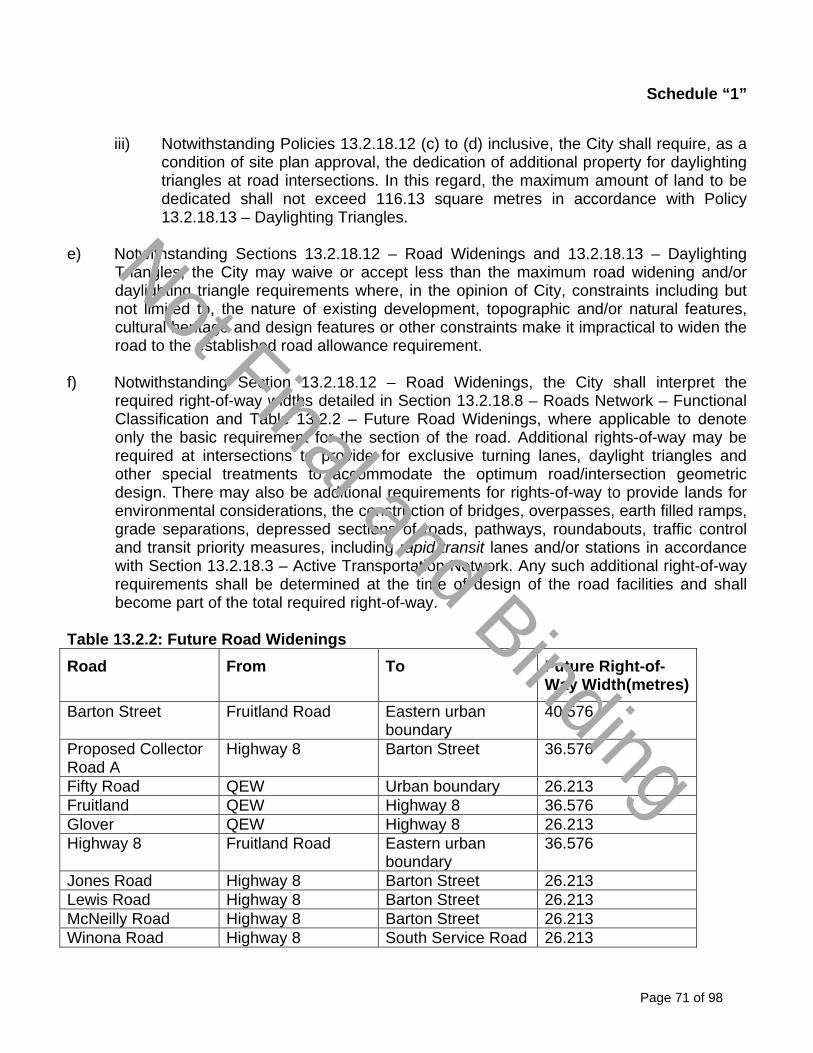
Schedule “1”
Page 71 of 98
iii) Notwithstanding Policies 13.2.18.12 (c) to (d) inclusive, the City shall require, as a
condition of site plan approval, the dedication of additional property for daylighting triangles at road intersections. In this regard, the maximum amount of land to be dedicated shall not exceed 116.13 square metres in accordance with Policy 13.2.18.13 – Daylighting Triangles.
e) Notwithstanding Sections 13.2.18.12 – Road Widenings and 13.2.18.13 – Daylighting
Triangles, the City may waive or accept less than the maximum road widening and/or daylighting triangle requirements where, in the opinion of City, constraints including but not limited to, the nature of existing development, topographic and/or natural features, cultural heritage and design features or other constraints make it impractical to widen the road to the established road allowance requirement.
f) Notwithstanding Section 13.2.18.12 – Road Widenings, the City shall interpret the
required right-of-way widths detailed in Section 13.2.18.8 – Roads Network – Functional Classification and Table 13.2.2 – Future Road Widenings, where applicable to denote only the basic requirement for the section of the road. Additional rights-of-way may be required at intersections to provide for exclusive turning lanes, daylight triangles and other special treatments to accommodate the optimum road/intersection geometric design. There may also be additional requirements for rights-of-way to provide lands for environmental considerations, the construction of bridges, overpasses, earth filled ramps, grade separations, depressed sections of roads, pathways, roundabouts, traffic control and transit priority measures, including rapid transit lanes and/or stations in accordance with Section 13.2.18.3 – Active Transportation Network. Any such additional right-of-way requirements shall be determined at the time of design of the road facilities and shall become part of the total required right-of-way.
Table 13.2.2: Future Road Widenings
Road From To Future Right-of-Way Width(metres)
Barton Street Fruitland Road Eastern urban boundary
40.576
Proposed Collector Road A
Highway 8 Barton Street 36.576
Fifty Road QEW Urban boundary 26.213 Fruitland QEW Highway 8 36.576 Glover QEW Highway 8 26.213 Highway 8 Fruitland Road Eastern urban
boundary 36.576
Jones Road Highway 8 Barton Street 26.213 Lewis Road Highway 8 Barton Street 26.213 McNeilly Road Highway 8 Barton Street 26.213 Winona Road Highway 8 South Service Road 26.213
Not Final and Binding

Schedule “1”
Page 72 of 98
Road with Offset Road Allowances Widenings
Road From To Survey Plan
Fruitland Road Jones Road 62R-457 Fruitland Road Eastern urban
boundary 4.0m widening offset to the south side
Jones Road Glover Road 62R-562 Glover Road Lot # 9 Plan 99047 A.B. Lot # 9 Lewis Road 62R-565 Lewis Road Winona Road 62R-564 / 62R-436
Barton Street
Winona Road Fifty Road 62R-563
13.2.18.13 Daylighting Triangles
a) The City shall require the conveyance of property for appropriate daylighting triangles and
corner rounding on existing roads at such times as the property is to be developed or redeveloped, as a condition of site plan approval, consent, or plan of subdivision approval, in accordance with City standards based on the intersecting roadways of the functional road classification detailed in Section 13.2.18.8 – Roads Network – Functional Classification. Daylighting triangles at intersections shall generally be as follows:
i) Local to local roads: 4.57 m triangle or radius;
ii) Collector to local or collector Roads: 9.14 m x 9.14 m triangle; and, iii) Arterial to collector or arterial (Urban): 12.19 m x 12.19 m triangle.
b) Notwithstanding the general daylight triangle dimensions in Policy 13.2.18.3 (a), within the
Fruitland-Winona Secondary Plan area:
i) Conveyance of lands exceeding the general daylight triangle dimensions in Policy 13.2.18.3 (a), may be required by the City to accommodate daylighting triangles for single or multi-lane roundabouts; and,
ii) Daylighting triangles at neighbourhood roundabout intersections shall generally be
established at 12.19 metre by 12.19 metre. This dimension may be reduced on a location by location basis as determined by the City once engineering designs have been approved and any surplus lands identified.
13.2.18.4 Access Management a) The efficiency, safety and traffic carrying capacity of parkways, major arterial and minor
arterial roads shall be protected by minimising the number and spacing of intersecting streets and access points.
Not Final and Binding
Schedule “1”
Page 73 of 98
b) To the extent feasible, the intersection of a new collector road with an arterial road shall
provide sufficient separation from the nearest major intersection to allow for the efficient operation of traffic control devices.
c) Local roads with cul-de-sacs shall not be permitted to connect to arterial roads unless
there are no reasonable alternatives.
d) Private access to arterial and collector roads shall be designed to minimize the number of
driveways and to consolidate driveways for adjacent sites where possible.
e) New development or redevelopment shall only be permitted on a property that has direct frontage on a publicly assumed road constructed to municipal standards.
f) The proposed North/South Collector Road ”A” located between Fruitland Road and Jones
Road shall be controlled with limited vehicular access points; g) The alignment of the local road network shall be detailed within the plans of subdivision in
accordance with the Block Servicing Strategy and policies of Section 13.2.19 – Block Servicing Strategy. The rights-of-way of all streets within and bordering the Secondary Plan area shall be protected and dedicated to the City in accordance Section 13.2.18.12 (a) through (f) – Road Widening;
h) Joint vehicular access to development along Barton Street shall be encouraged to not
interrupt the Barton Street Pedestrian Promenade; i) Access locations and access design shall conform to all City and Transportation
Association of Canada guidelines;
j) Roundabouts may be required by the City in addition to those identified on Schedule A2-3 – Fruitland-Winona Secondary Plan - Transportation Classification Plan;
k) Design of roundabouts shall consider the potential impacts on dwelling units such as:
i) Driveway locations for corner lots; and,
ii) The requirement of the dwelling unit to have local street driveway access.
13.2.18.15 Traffic Management a) Traffic calming shall be considered an effective means of reducing the negative impacts
of traffic on the quality of life for Hamilton residents in existing and planned neighbourhoods and other built-up areas.
b) Traffic calming devices shall only be installed where warranted in accordance with
current City traffic standards.
Not Final and Binding

Schedule “1”
Page 74 of 98
c) Traffic management plans for entire neighbourhoods (bounded by an arterial road network) shall be preferred over street-by-street solutions that may shift problems to adjacent roadways. Neighbourhood traffic management shall be explicitly addressed through secondary plans or Transportation Master Plans and, where appropriate, at the draft plan of subdivision or site plan stage for larger developments (i.e. consisting of multiple streets in a subdivision).
d) The City shall require transportation impact studies to assess the impact of proposed
developments on current travel patterns and/or future transportation requirements. These studies shall be submitted as part of applications for Official Plan amendments, subdivision approvals, major rezoning and major site plan approvals.
e) Roundabouts shall be the preferred method for intersection traffic control over all-way
stop and traffic signals. Design of roundabouts shall consider pedestrian and cycling safety and access.
f) Proactive safety measures for all road systems users, including persons with disabilities
or reduced mobility, shall be considered in both new development and redevelopment proposals.
g) Traffic calming devices, such as roundabouts, curb extensions at intersections, raised
crosswalks or raised intersections, shall be installed by the developer at the time of development of adjacent lands where warranted, and in accordance with City traffic policies.
h) Roundabouts within neighbourhoods at intersections identified on Schedule A2-3 – Fruitland-Winona Secondary Plan - Transportation Classification Plan may be required.
i) Roundabout design shall ensure driveways and bus stops are located within proximity of
the intersection. 13.2.18.16 Parking and Loading a) Parking and loading requirements regulated through the Zoning By-Law or site plan
approval shall ensure adequate parking for the site, while avoiding excess parking supply that can discourage transit use and active transportation choices.
b) Parking options and related incentives for transit and active transportation use shall be
improved through:
i) Installation of secure bike parking in strategic high activity public locations, including municipal parking facilities; and,
ii) Adoption of Zoning regulations to require secure bike parking in new commercial,
institutional, and multiple dwelling developments where appropriate.
Not Final and Binding

Schedule “1”
Page 75 of 98
c) To facilitate more efficient uses of off-street parking, the City shall encourage the use of shared parking and develop parking standards for mixed use development.
d) The negative impacts of parking on urban environments and pedestrian activity shall be
minimized through:
i) Placement of parking and loading areas at the rear of buildings where feasible; ii) Use of alternative paving materials such as but not limited to permeable pavement
systems; iii) Alternative surface water management in parking areas such as urban swales, and
ditches; iv) Other considerations including promotion of green technology and public art as a
component of parking structures; v) Landscaping treatments in accordance with Section 13.2.10.9 - Parking and the
Zoning By-Law; and, vi) Other applicable design guidelines and design policies of Volume 1, including
Section 13.2.10 – Urban Design Policies. d) New development on properties adjacent to major arterial and minor arterials and where
necessary, collector roads, shall include provisions for sufficient parking, loading, manoeuvring and off-street parking.
13.2.19 Block Servicing Strategy
The Fruitland-Winona Secondary Plan area is characterized by a relatively flat topography which requires specific grading and detailed servicing provisions to adequately service the future development area so development proceeds in a coordinated and comprehensive manner. A Block Servicing Strategy shall be required for the areas identified on Schedule A2-4 – Fruitland-Winona Secondary Plan – Block Servicing Strategy. The following policies shall apply to lands identified as the “Servicing Strategy Area” as identified on Schedule A2-4 – Fruitland-Winona Secondary Plan – Block Servicing Strategy Area Delineation: a) The City of Hamilton shall prepare a Terms of Reference for a Block Servicing Strategy in
consultation with the Conservation Authority. b) The City shall develop a Block Servicing Strategy for the Blocks identified on Schedule
A2-4 Fruitland-Winona Secondary Plan - Block Servicing Strategy Area Delineation; c) All development within the lands identified as the “Servicing Strategy Area” shall conform
Not Final and Binding

Schedule “1”
Page 76 of 98
to the Block Servicing Strategy.
d) A portion of the lands identified as part of Block 3 on Map B.7.8-4 – Block Servicing Strategy Area Delineation, and located north of Barton Street between McNeilly Road and east of Winona are outside the Secondary Plan area; however, these lands are subject to the policies of Section 13.2.19 – Block Servicing Strategy.
e) Notwithstanding Policy 13.2.19 (b) above, if a developer(s) wishes to proceed with development in advance of approval of the City initiated Block Servicing Strategy; the developer(s) may undertake a Block Servicing Strategy subject to the following:
i) The Block Servicing Strategy submission shall be to the satisfaction of the City, in
accordance with the Block Servicing Strategy Terms of Reference and shall include a minimum of one Block, as identified on Schedule A2-4 – Fruitland-Winona Secondary Plan - Block Servicing Strategy Area Delineation.
f) The Fruitland-Winona Sub-Watershed Studies shall form the basis of all Block Servicing
Strategies. g) A Block Servicing Strategy shall conform to the vision, objectives and policies of this Plan
and shall identify the land use designations, densities and natural heritage features, including Vegetation Protection Zones and Restoration Areas, in accordance with this Plan.
h) A Block Servicing Strategy shall have regard for existing development in accordance with
Policy 13.2.3.(d) of this Plan by reflecting the general scale and character of the established development pattern in the surrounding area by taking into consideration lot frontages and areas, building height, coverage, mass, setbacks, privacy and overview.
i) A Block Servicing Strategy shall guide phasing within each Block area within the
Fruitland-Winona Secondary Plan.
j) A Block Servicing Strategy shall include: i) The location and configuration of schools and parks;
ii) The detailed local road pattern and trail system; iii) The detailed alignment and recommendations regarding the phasing of
construction for the north-south Collector Road “A” as identified on Schedule A2-3 – Fruitland-Winona Secondary Plan – Transportation Classification Plan;
iv) The boundaries of land use designation and density and distribution of housing
types; vi) Meander Belt Width Assessments for all watercourses;
Not Final and Binding

Schedule “1”
Page 77 of 98
vii) A preliminary grading strategy, identifying and meeting existing grades along
adjacent roads and ensuring that development within a Block area will not compensate for drainage shortfalls by significantly raising the existing grade elevations;
viii) A preferred servicing plan; ix) Stormwater management strategy and functional design plan that ensures regional
stormwater conveyance to the Lake and drainage plans outlining the major and minor systems and detailed flow limits at critical points;
x) Plans for phasing of development including the size and location of future draft
plans of subdivision application to ensure the orderly development of the lands; xi) The identification and consideration of all areas regulated by the Conservation
Authority’s Development, Interference with Wetlands, and Alterations to Shorelines and Watercourses Regulation or its successor;
xii) A scoped Air Drainage Analysis Brief, which has been prepared by a qualified
engineer, climatologist, and/or agrologist to the satisfaction of the City and Ontario Ministry of Agriculture, Food and Rural Affairs or successor Ministry. The Air Drainage Analysis Brief shall include the following: 1. A review of the existing conditions, including air photos, topography, thermal
conditions, climate and air movement down the Niagara Escarpment and towards Lake Ontario, to evaluate the effects of the proposed development on the existing microclimate and airflow; and,
2. Where appropriate, proposed road layout and development patterns that maximize air drainage in a north/south alignment to minimize potential negative impacts on the tender fruit area to the south.
xiii) A Hydrological investigation that includes:
1. Groundwater levels and flow path; 2. Significant recharge and discharge zones;
3. The impacts of development on the functions mentioned in xiii) 1 and 2 above;
4. The foundation drain flow rate based on groundwater and severe wet
weather conditions;
Not Final and Binding

Schedule “1”
Page 78 of 98
5. A recommendation for an appropriate sump pump design; and,
6. A contingency plan to ensure that an appropriate mitigation strategy can be
implemented where:
a. An aquifer is breached during construction;
b. Groundwater is encountered during construction;
c. Continuous running of sump pump occurs; and,
d. Negative impacts occur on the water supply and sewage disposal system or any surface and groundwater related infrastructure.
k) Implementation of the Fruitland-Winona Secondary Plan Urban Design Guidelines;
l) Where a Block Servicing Strategy is prepared by the City, the Strategy shall include a process of consultation with the affected landowners.
m) Where a Block Servicing Strategy is prepared by a developer(s), the Strategy shall
demonstrate consultation and general landowner support for lands within the subject Block Servicing Strategy area, and be completed to the satisfaction of the City in consultation with the Conservation Authority.
n) A Block Servicing Strategy shall be used by the City to guide the review of planning
applications within the respective Block Servicing Strategy area;
o) In accordance with Policy 13.2.22.1 (a) of this Plan, the boundaries of the land use designations on Schedule A2-1 – Fruitland –Winona Secondary Plan – Land Use Plan, and the alignment of proposed collector roads identified on Schedule A2-3 – Fruitland-Winona Secondary Plan – Transportation Classification Plan, are intended to be flexible and may be modified within the Block Servicing Strategy to achieve a desirable urban pattern without amendment to this Plan, provided the proposed change does not result in a decrease in the residential density for the Block area or alter the intention and functionality of the collector road system.
p) The recommendations of a Block Servicing Strategy shall be incorporated into the City's
Staging of Development Report as appropriate. q) The following shall apply to new road crossings:
i) Where possible, road crossings shall avoid significant and/or sensitive natural
features; ii) Where it is not possible for road crossings to avoid significant and/or sensitive
natural features, road crossings may be located in previously disturbed
Not Final and Binding

Schedule “1”
Page 79 of 98
watercourse reaches or in locations where the disturbance or removal of riparian vegetation can be minimized;
iii) New roadway culverts and bridges shall have sufficient conveyance capacity to
pass the Regulatory flood event (larger of Hurricane Hazel and 100 year event) to avoid adverse backwater effects;
iv) Where new roadway culverts and bridges cannot meet the requirements set out in
Policy 13.2.19. (q) (iii) above, Regulatory flooding depths on roadways shall be based on the standards within the Ontario Ministry of Natural Resources Natural Hazards Technical Guides, latest version or its successor guideline; and,
v) If a minor realignment of the stream channel is necessary to achieve the desired
crossing configuration, the new channel should be established using natural channel design principles.
r) A Block Servicing Strategy, for the area identified as Block 1 on Schedule A2-4 – Block
Servicing Strategy Area Delineation, shall determine the floodplains for the following two locations:
i) Along Watercourse 5.0, immediately downstream of Fruitland Road (between
sections 2221 and 2150); and, ii) Along Watercourse 5.0, halfway between Highway No. 8 and Barton Street
(between sections 1693.967 and 1537.457). s) A Block Servicing Strategy, for the area identified as Block 2 on Schedule A2-4 – Block
Servicing Strategy Area Delineation, shall determine the floodplains along Watercourse 6.0, downstream of Highway No. 8 (between sections 2232.182 and 1785.033).
t) Landowners of holdings less than 8.0 hectares (20 acres) shall be encouraged to submit
joint draft plans of subdivisions with adjacent owners to ensure comprehensive planning and expedite their development proposals.
13.2.20 Lake Based Municipal Water and Wastewater Systems a) All new development and redevelopment within the urban area shall be connected to the
City’s water and wastewater system.
b) Where a private well(s) and/or private on-site septic system(s) is abandoned in favour of connection to the City’s water and wastewater system, the property owner shall properly plug the well and decommission the septic tank in accordance with pertinent legislation and guidelines so as to reduce or eliminate potential safety hazards.
Not Final and Binding

Schedule “1”
Page 80 of 98
c) The City shall be satisfied that adequate infrastructure services can be provided prior to any development or intensification proceeding and, where technically and economically possible, the City shall require such services to be located underground.
d) The City may require servicing or phasing agreements as conditions of development
approval to ensure that development proceeds in a manner that optimizes the utilization of sewer and water services and does not outpace the ability of the City to finance and construct new services.
13.2.21 Stormwater Management a) Stormwater management facilities have not been designated on Schedule A2-1 -
Fruitland-Winona Secondary Plan - Land Use Plan. The size, number and location of stormwater management facilities shall comply with City’s Criteria and Guidelines for Stormwater Infrastructure Design and Policies, the Fruitland-Winona Sub-watershed Studies and the Block Servicing Strategy required in Section 13.2.19 – Block Servicing Strategy of this Plan. Stormwater management facilities may be identified or relocated through the Block Servicing Strategy and shall comply with the policies of this Plan.
b) The following policies shall apply to the location and design of new stormwater
management facilities:
i) Stormwater management facilities shall be located and designed to maintain ecological function of the Natural Heritage feature;
ii) Stormwater management facilities shall be located adjacent to the Barton Street
Pedestrian Promenade and other Open Space Designations where possible; iii) Stormwater management facilities along the Barton Street Pedestrian Promenade
shall be designed to promote public safety, and, where possible, shall not be fenced; and,
iv) Stormwater management facilities shall be designed to provide visual attraction
and passive recreation where possible. 13.2.22 Implementation The following policies shall apply to the implementation of the Fruitland-Winona Secondary Plan: 13.2.22.1 General Policies a) The identification and proposed location of municipal infrastructure, parks, roads, water
and wastewater facilities or services, as identified on schedules or in text in this Plan:
i) may be changed without an amendment to this Plan provided the change is minor in nature and the intent of the Plan is maintained;
Not Final and Binding

Schedule “1”
Page 81 of 98
ii) shall not be interpreted as the City’s commitment to providing these municipal public facilities within a specific time frame; and,
iii) shall not be interpreted as necessarily being specifically or solely the responsibility
of the City to provide, finance or otherwise implement. b) Prior to the submission of a development application, excluding severances and minor
variances, for lands within the Fruitland-Winona Secondary Plan area, a Block Servicing Strategy shall be prepared, in accordance with the policies of Section 13.2.19 – Block Servicing Strategy of this Plan, and approved to the satisfaction of the City. No development application, that creates new lots through the subdivision of land or consent or any Zoning By-law Amendment application, shall be deemed complete unless it implements the Block Servicing Strategy or provides justification for changes to the Block Servicing Strategy to the satisfaction of the City.
c) All development applications shall demonstrate that they comply with the approved Block
Servicing Strategy. d) All development shall proceed in accordance with the approved Block Servicing Strategy. e) Where an amendment to this Plan is proposed, the City may also require an amendment
to the Block Servicing Strategy. 13.2.22.2 Phasing of Development a) Phasing of Development within the Fruitland-Winona Secondary Plan area shall be in
accordance with the City's Staging of Development Report as approved by Council.
b) Development within the Fruitland-Winona Secondary Plan area shall proceed in a coordinated and comprehensive manner.
13.2.22.3 Cost Sharing a) The City shall cost share in accordance with the City’s financial policies for development.
b) The City, where appropriate, may consider the use of front-ended agreements. 13.2.22.4 Parkland Dedication Policies a) In considering any development/redevelopment proposal, plan of subdivision or consent
to sever, Council shall determine whether to require the dedication of parkland or require cash-in-lieu of such dedication.
i) Council shall require a parkland dedication in an amount not exceeding 5% for
residential proposals, or alternatively, shall not exceed a rate of 1.0 hectare for
Not Final and Binding
Schedule “1”
Page 82 of 98
each 300 dwelling units proposed, (the rate to be applied will be that which yields the greater amount of either land or cash-in-lieu), or a combination thereof for developments or redevelopment that contain a mix of residential densities.
For the purposes of calculating parkland dedication on the basis of the number of
units, the following rates shall apply to any dedication of parkland or cash-in-lieu as a condition of residential development or redevelopment:
1. For land designated to permit residential development or redevelopment with
a density less than 20 units per hectare, dedication of land not to exceed an amount of 5% of the net land areas to be developed.
2. For land designated to permit residential development or redevelopment with
a density of 20 to 75 units per hectare, parkland shall be dedicated at a rate not to exceed 1 hectare for each 300 dwelling units proposed;
3. For land designated to permit residential development or redevelopment with
a density of 75 to 120 units per hectare, parkland shall be dedicated at a rate not to exceed 0.6 hectares for each 300 dwelling units proposed;
4. For land designated to permit residential development or redevelopment with
a density greater than 120 units per hectare, parkland shall be dedicated at a rate not to exceed 0.5 hectares for each 300 dwelling units proposed.
5. Notwithstanding Policy 13.2.22.4 (a) (ii), regardless of the density of
development, a maximum land dedication of 5% of the net land area shall apply to developments of single or semi-detached lots, duplexes, and a maximum of two apartment dwellings above commercial use.
6. In the case of lands to be developed for an individual single detached
dwelling in a rural area, the parkland dedication shall be based on an amount not to exceed 2.5% of a 0.4 hectare lot. This policy is not applicable to designated Rural Settlement Areas.
7. Notwithstanding Policy 13.2.22.4 (a) (i), Council may consider reducing the
residential parkland dedication rate for dwellings within specific geographic areas of the City and for certain types of charitable, non-profit or social/affordable housing, as provided for in the Parkland Dedication By-law.
ii) Council shall require a parkland dedication in an amount not exceeding 2% for
commercial proposals except as exempted in the Parkland Dedication By-law.
iii) Council shall require a parkland dedication in an amount not exceeding 5% for institutional proposals and all other land use proposals other than residential and commercial and schools, subject to any exemption as set out in the Parkland Dedication By-law.
Not Final and Binding

Schedule “1”
Page 83 of 98
iv) Council shall require a parkland dedication in the amount of 2% of the land area to
be developed or redeveloped for a school.
v) Council shall require that parkland dedication be based on a pro rata proportion for proposed mixed use development (for commercial and residential uses on one site or within one building), in accordance with the Parkland Dedication By-law.
vi) Council shall require a combination of dedication rates as defined in Policy
13.2.22.4 (a) applicable to specific use and/or density for any development including a subdivision containing lands proposed for a variety of land uses and/or at a variety of residential densities.
b) Notwithstanding Policy 13.2.22.4 (a) (iii), Council shall not require parkland dedication or
cash-in-lieu, as a condition of the approval of industrial development or redevelopment proposals.
c) Storm water management facilities, valley lands, hazard lands, woodlots, Environmentally Significant Areas, and major utility corridors and easements shall not be considered acceptable lands eligible to satisfy parkland dedication.
d) For the purpose of calculating the land area subject to the parkland dedication, storm
water management facilities, valley lands, hazard lands, woodlots, Core Areas, and major utility corridors and easements shall be excluded except where the lands listed above contain water services, wastewater services, private roads, public roads, or parking lots.
13.2.23 Area and Site Specific Policies 13.2.23.1 Site Specific Policy - Area A For lands municipally known as 685 - 687 Highway No. 8, and shown as Site Specific Policy – Area A on Schedule A2-1 - Fruitland-Winona Secondary Plan - Land Use Plan, the following policy shall apply:
a) In addition to the uses permitted in Section 13.2.5.1 (a) - Local Commercial Designation,
a motel shall be permitted. 13.2.23.2 Site Specific Policy- Area B
The following policies shall apply to the lands located at 703 Highway No. 8, and shown as Site Specific Policy – Area B on Schedule A2-1 - Fruitland-Winona Secondary Plan - Land Use Plan:
a) Notwithstanding Section 13.2.9 - Utility Designation, the following uses shall be permitted:
i) Any use considered as part of the essential operations of a utility, including but not
limited to major facilities, easements and rights-of-way for electric power, a works
Not Final and Binding

Schedule “1”
Page 84 of 98
yard, offices, customer services, training facilities, maintenance, and outdoor and vehicular storage; and,
ii) Medium Density Residential 2 designation in accordance with Policy 13.2.4.7 –
Medium Density Residential 2 Designation and subject to:
1. A Zoning By-Law amendment to permit the residential use; and,
2. A record of site condition is submitted prior to or at the time of application. 13.2.23.3 Area Specific Policy - Area C - Community Node For lands generally located within Concession 2, Part Lot 13, SLT SC, and designated as Community Park and Institutional and shown as Area Specific Policy - Area C on Schedule A2-1 – Fruitland-Winona Secondary Plan - Land Use Plan, the following policies shall apply:
a) Area Specific Policy - Area C shall be developed as a campus setting accommodating
two elementary schools and a community park and may include other community facilities/services;
b) The City shall work in collaboration with the Hamilton Wentworth District School Board
and the Hamilton Wentworth Catholic District School Board to determine a coordinated site design and layout, and other specific requirements for the subject lands;
c) Urban Braille shall be incorporated into the design of the community campus; d) The Community Park shall function as a combined Community Park and Neighbourhood
Park; e) The Community Park may have frontage on Barton Street and the proposed north/south Collector Road “A”; f) The elementary schools may be located on separate lots with independent access; g) The City shall investigate the potential to provide a seasonal produce market in
conjunction with the Community Park. h) Should any part of the Community Park or Institutional designated lands not be required
for such purposes, the lands may be developed for Residential uses without an amendment to this Plan subject to the following:
i) The City provides written confirmation that the lands are no longer required for
Community Park; ii) A Neighbourhood Park of a minimum of 2.0 hectares in size shall be maintained
and with frontage on Collector Road ‘B’; and,
Not Final and Binding

Schedule “1”
Page 85 of 98
iii) The remaining lands shall be developed for Medium Density Residential 2 uses in
accordance with Section 13.2.4.7 and all other relevant policies of this Plan. i) Should the lands bounded by Highway No. 8 to the south, Glover Road to the west,
McNeilly Road to the east and Barton Street to the north, be removed from the Greenbelt Plan and included within the Urban Boundary, relocation of the proposed Community Park to this block shall be considered, provided a Neighbourhood Park remains within the area identified as Site Specific Policy - Area C.
13.2.23.4 Area Specific Policy - Area D For the lands located at 775-791 Highway No. 8 and designated Local Commercial as shown as Area Specific Policy - Area D on Schedule A2-1 - Fruitland-Winona Secondary Plan - Land Use Plan; In addition to Section 13.2.5.1 – Local Commercial Designation of this Plan, the following policies shall apply:
a) Notwithstanding Policy 13.2.5.1 (e) (i), the gross floor area for a professional office may
exceed 500 square metres for the existing building; and, b) All new development shall conform to Section 13.2.5.1 - Local Commercial Designation of
this Plan. 13.2.23.5 Area Specific Policy - Area E
For the lands located south of the South Service Road and on the east side of Winona Road, as shown as Area Specific Policy – Area I on Schedule A2-1 – Fruitland—Winona Secondary Plan – Land Use Plan, the following policies shall apply:
a) In addition to Policy 13.2.5.2 (c) – District Commercial, the following uses shall be permitted:
i) Arts and cultural uses; ii) Entertainment uses; and,
iii) Free standing offices.
b) Notwithstanding Policy 13.2.5.2 (c) (i) and (iii), residential and live work units shall not be permitted.
13.2.23.6 Area Specific Policy - Area F For the lands generally located on the north and south side of Highway No. 8 within Winona and shown as Area Specific Policy – Area F on Schedule A2-1 - Fruitland-Winona Secondary Plan -
Not Final and Binding

Schedule “1”
Page 86 of 98
Land Use Plan, the following policies shall apply:
a) In addition to Section 3.2.5.1 - Local Commercial designation and Section 13.2.8 - Institutional designation, the following shall apply:
i) Where possible, on-street parking shall be provided within the right-of-way on
Highway No. 8; ii) Buildings shall be built up to the street line and locating parking, driveways or lanes
between the buildings and the street shall be discouraged; iii) Each building or store front shall face onto the street with the main entrance of
each building or store, as well as substantial fenestration, facing on to the street; iv) Building height shall be a minimum of two storeys; v) Sidewalks shall be required on both sides of the street;
vi) Transit shelters and stops shall be provided, where appropriate; vii) New buildings shall be designed to reflect a human scale of development,
contribute to public safety and security, and create a significantly enhanced pedestrian environment; and,
ix) Design of new buildings shall be encouraged to include awnings, canopies,
arcades, or front porches to provide weather protection.
b) Notwithstanding Policy 13.2.18.8 (b) (viii), on-street parking shall be permitted.
13.2.23.7 Area Specific Policy- Area G
For the lands bounded by Winona Road, South Service Road, CNR Railway and Fifty Road and as shown as Area Specific Policy - Area G, and designated District Commercial on Schedule A2-1 - Fruitland-Winona Secondary Plan - Land Use Plan, the following policies shall apply:
a) In addition to Policy 13.2.5.2 (c) – District Commercial, the following uses shall be
permitted:
i) Two department stores; ii) Arts and cultural uses; v) Entertainment uses; iv) Free standing offices; and,
Not Final and Binding

Schedule “1”
Page 87 of 98
v) An inter-regional multi modal transportation terminal. b) Notwithstanding 13.2.5.2 (c) (i) and 13.2.5.2 (c) (iii) - District Commercial, residential uses
shall not be permitted; c) Notwithstanding 13.2.5.2 (d) and 13.2.5.2 (g) – District Commercial, the maximum gross
leasable floor area of all commercial development for the site shall be 41,200 square metres excluding any building area associated with the inter-regional, multi modal transportation terminal, subject to the following:
i) The maximum gross floor area permitted for a single department store shall be
17,000 square metres, of which the maximum gross floor area for the sale and display of food shall be 4,180 square metres;
ii) The maximum total gross leasable floor area of all professional or business office
buildings shall be 10,000 square metres; and, iii) Individual stand-alone office buildings shall not exceed 2,000 square metres.
d) An inter-regional multi modal transportation terminal shall be developed in accordance
with Section 13.2.18.4 – Public Transit Network. Urban Design e) Prior to development of lands, the proponent shall complete urban design guidelines for
development of the site, to the satisfaction of the City, and in accordance with Section 13.2.10 - Urban Design Policies, Section 13.2.5.2 – District Commercial, and Policies 13.2.23.7 (f) – (h) below.
f) In addition to Section 13.2.10 - Urban Design Policies, the following urban design
principles shall apply to lands identified as Area Specific Policy – Area G: i) The mixture of uses and the location of the site along a major highway and at the
head of an arterial road, provides an opportunity for a transit supportive development;
ii) The urban form shall be compatible with the adjacent neighbourhoods and
employment land uses;
iii) The proposed development shall function as a community focal point. The unique
location of the site shall provide a gateway into the City which is of high quality of design. Gateways shall promote a sense of arrival and facilitate connectivity, orientation and ‘way finding’ to, and within, the site for both vehicles and pedestrians;
iv) A strong development image with an internal circulation system shall be applied.
Not Final and Binding

Schedule “1”
Page 88 of 98
This circulation system shall include an internal pedestrian-friendly ‘central street’ which is a central gathering and focal point for the development; and,
v) Area Specific Policy – Area G shall be developed with a comprehensive pedestrian
system for the entire site that links buildings to the central street, transit node and adjacent neighbourhoods with sidewalks on streets, pathways, trails, and/or pedestrian walkways.
g) In addition to Section 13.2.10 - Urban Design Policies, the following policies shall apply to
lands located along/fronting onto South Service Road and Winona Road shall:
i) Create a positive community image through the coordinated use of high quality paving materials, wide sidewalks, street furniture, pedestrian-scale lighting and signage, and enhanced landscaping; and,
ii) Drive-through stacking lanes shall be located toward the side or rear of buildings. Stacking lanes shall not face the public street.
h) In addition to Section 13.2.10 - Urban Design Policies, located along the ‘central street’
shall:
i) Incorporate buildings which address both sides of the street line in a prominent fashion to create a pleasant and attractive pedestrian experience and facilitate interaction between different activities;
ii) Encourage incorporation of design features such as varied roof lines, building
fenestration and canopies on all façades of buildings; iii) Encourage on-street parking to provide the ‘look and feel’ of a public street while
supporting pedestrian friendly urban design principles; and, iv) Buildings on the interior ‘central street’ shall be located to achieve the appearance
of wide boulevards of comprising sidewalks and landscaping areas yet create the spatial definition and a sense of enclosure that encourages a pedestrian-oriented street.
Energy and Environment i) Prior to development of lands shown as Area Specific Policy - Area G, the proponent shall
submit energy and environment design development guidelines for development of the site to the satisfaction of the City.
13.2.23.8 Area Specific Policy- Area H
For the lands located at:
Not Final and Binding

Schedule “1”
Page 89 of 98
i) Glover Road, Barton Street, Concession 1, dividing Lots 11 and 12 and Highway No. 8; ii) 970 Barton Street; iii) 1361 Barton Street; and, iv) 347 Fifty Road;
and as shown as Area Specific Policy - Area H on Schedule A2-1 - Fruitland-Winona Secondary Plan - Land Use Plan, the following policy shall apply:
a) Sections and policies of the Greenbelt Plan, including Section 5.2.1, permit the
implementation of the urban land use designations and policies of this Plan. 13.2.23.9 Area Specific Policy – Area I For the lands located at 339 and 347 Fifty Road and as shown as Area Specific Policy - Area I on Schedule A2-1 - Fruitland-Winona Secondary Plan - Land Use Plan, the following policy shall apply:
a) In addition to Policy 13.2.4.2 (c) - Low Density Residential, all forms of townhouses shall
be permitted in accordance with Official Plan Amendment No. 174. 13.2.23.10 Site Specific Policy - Area J
For the lands located at 269 Glover Road and as shown as Site Specific Policy - Area J on Schedule A2-1 - Fruitland-Winona Secondary Plan - Land Use Plan, the following policy shall apply:
a) In addition to Policy 13.2.23.8 - Area Specific Policy- Area H, Policy 13.2.4.2 – Low
Density Residential, and Policy 13.2.7 – Parks and Open Space, the following uses shall be permitted:
i) The existing private club and ancillary banquet hall.
Not Final and Binding

Schedule “1”
Page 90 of 98
13.2.24 New Definitions for Stoney Creek Official Plan to Apply only to the Fruitland-Winona Secondary Plan
The following new definitions shall apply to the Fruitland-Winona Secondary Plan area: Accessory (Urban): means, when used to describe a use of land, building or structure, a use which is commonly incidental, subordinate and exclusively devoted to the main use of a building and is situated within the same building or on the same lot. Active Transportation: non-motorized travel, including walking, cycling, inline skating and wheelchair movements. The active transportation network includes sidewalks, crosswalks, designated road lanes and off-road trails to accommodate active transportation (Metrolinx, 2008). Adaptive Reuse: means the adaptation of an existing building for another land use. Adjacent (Fruitland-Winona Secondary Plan area): In regard to cultural heritage and archaeology, those lands contiguous to, or located within 50 metres of, a protected heritage property. Adjacent Lands: means those lands contiguous to hazard lands, a specific natural heritage feature, or area where it is likely that development or site alteration would have a negative impact on the hazard, feature or area. The extent of the adjacent lands may be recommended by the Province or based on municipal approaches which achieve the same objectives. Ancillary: means subordinate use that supports a principal use or a primary function of a site or area. Archaeological Resources: Include artifacts, archaeological sites and marine archaeological sites. The identification and evaluation of such resources are based upon archaeological fieldwork undertaken in accordance with the Ontario Heritage Act (PPS, 2005). Area of Archaeological Potential: A defined geographical area with the potential to contain archaeological resources. Criteria for determining archaeological potential are established by the Province, this Plan and the City’s Archaeological Management Plan. Archaeological potential is confirmed through archaeological fieldwork undertaken in accordance with the Ontario Heritage Act (PPS, 2005, amended). Areas of Natural and Scientific Interest (ANSI): means areas of land and water containing natural landscapes or features that have been identified as having life science or earth science values related to protection, scientific study or education (PPS, 2005). Compact Urban Form: means a land-use pattern that encourages efficient use of land, walkable neighbourhoods, mixed land uses (residential, retail, workplace and institutional all within one neighbourhood), proximity to transit and reduced need for infrastructure. Compact urban form can include detached and semi-detached houses on small lots as well as
Not Final and Binding

Schedule “1”
Page 91 of 98
townhouses and walk-up apartments, multi-storey commercial developments, and apartments or offices above retail (Growth Plan, 2006). Conserved: in the context of cultural heritage resources, means the identification, protection, use and/or management of cultural heritage and archaeological resources in such a way that their heritage values, attributes and integrity are retained. This may be addressed through a conservation plan or heritage impact statement (PPS, 2005). Core Areas: includes key natural heritage features, key hydrologic features, and local natural areas. Cultural Heritage Conservation Plan Statement: A document comprising text and graphic material including plans, drawings and photographs that contains the results of historical research, field work, survey, analysis, and description(s) of cultural heritage resources together with a statement of cultural heritage value, interest, merit or significance accompanied by guidelines as required by the policies of this Plan. A cultural heritage conservation plan statement shall be considered a conservation plan as including in the PPS (2005) definition of conserved (above). Cultural Heritage Impact Assessment: A document comprising text and graphic material including plans, drawings and photographs that contains the results of historical research, field work, survey, analysis, and description(s) of cultural heritage resources together with a description of the process and procedures in deriving potential effects and mitigation measures as required by official plan policies ands any other applicable or pertinent guidelines. A cultural heritage impact assessment may include an archaeological assessment where appropriate. Cultural Heritage Landscape: A defined geographical area of heritage significance which has been modified by human activities and is valued by a community. It involves a grouping(s) of individual heritage features such as structures, spaces, archaeological sites and natural elements, which together form a significant type of heritage form, distinctive from that of its constituent elements or parts. Examples may include, but are not limited to, heritage conservation districts designated under the Ontario Heritage Act; and villages, parks, gardens, battlefields, mainstreets and neighbourhoods, cemeteries, trailways and industrial complexes of cultural heritage value (PPS, 2005). Cultural Heritage Resources: Structures, features, sites, and/or landscapes that, either individually or as part of a whole, are of historical, architectural, archaeological, and/or scenic value that may also represent intangible heritage, such as customs, ways-of-life, values, and activities. Development (Urban): means the creation of a new lot, a change in land use, or the construction of buildings and structures requiring approval under the Planning Act but does not include:
a) activities that create or maintain infrastructure used by a public body and authorized under an environment assessment process; or,
Not Final and Binding

Schedule “1”
Page 92 of 98
b) works subject to the Drainage Act. (PPS, 2005, amended)
Ecological Function: means the natural processes, products, or services that living and non-living environments provide or perform within or between species, ecosystems and landscapes, including hydrologic functions and biological, physical, chemical, and socio-economic interactions (PPS, 2005). Employment Area (formerly referred to as Industrial Areas): Areas designated in an official plan for clusters of business and economic activities including, but not limited to, manufacturing, warehousing, offices, and associated retail and ancillary facilities (PPS, 2005). Environmentally Significant Areas (ESAs): means locally significant areas that meet any one of the following criteria:
a) the area is a good representative of a biotic community characteristic of the natural landscapes of the City and not adequately represented in existing protected areas or the area is a good representative of pre-settlement biotic community;
b) there are biotic communities that are rare in the City, Province, or Canada;
c) the area is a large natural area (20 hectares or more in size); it may be sufficiently
large to provide habitat for species requiring large habitat areas;
d) there is habitat for species considered significant in the City, Province, or Canada;
e) the site fulfills a significant hydrological function (groundwater recharge or discharge, ground or surface water quality, or flood attenuation);
f) the site contains a significant earth science feature (distinctive and unusual
landform);
g) there is a high diversity of native species or biotic communities;
h) the area provides essential habitat for the continuation of species; for example, significant areas of species concentrations, areas essential for certain stage of the life cycle, source areas for species;
i) there are significant seasonal concentrations of wildlife;
j) the area acts as a link between natural areas or functions as a corridor for wildlife;
k) the area is in good natural condition, with few non-native species, particularly
invasive non-natives; or,
l) the area contains significant fish habitat.
Not Final and Binding

Schedule “1”
Page 93 of 98
Existing: when used in reference to a use, lot, building or structure, means any use, lot, building or structure legally established or created prior to the day of approval of this Official Plan. Fish Habitat: means the spawning grounds and nursery, rearing, food supply, and migration areas on which fish depend on directly or indirectly in order to carry out their life processes (PPS, 2005). Flood Plain: for river, stream and small inland lake systems, means the area, usually low lands adjoining a watercourse, which has been or may be subject to flooding hazards (PPS, 2005). Ground Water Feature: refers to water related features in the earth’s subsurface, including recharge/discharge areas, water tables, aquifers and unsaturated zones that can be defined by surface and subsurface hydrogeological investigations (PPS, 2005). Hedgerows: means a narrow, linear band or row of trees or shrubs with a minimum width of 10 metres and length of 200 metres or more. Hedgerows are linear natural or cultural features which may contribute to species dispersal. Infrastructure: means physical structures (facilities and corridors) that form the foundation for development. Infrastructure includes: sewage and water systems, sewage treatment systems, waste management systems, electric power generation and transmission, communications/telecommunications, transit and transportation corridors and facilities, oil and gas pipelines and associated facilities (PPS, 2005). Key Hydrologic Features (KHF): these features include:
a) Permanent and intermittent streams; b) Lakes (and their littoral zones); c) Seepage areas and springs; and, d) Wetlands. (Greenbelt Plan, 2005)
Key Natural Heritage Features (KNHF): include the following:
a) Significant habitat of endangered, threatened, and special concern species; b) Fish habitat; c) Wetlands; d) Life Science Areas of Natural and Scientific Interest (ANSIs); e) Significant valleylands; f) Significant woodlands; g) Significant wildlife habitat; h) Sand barrens, savannahs, and tallgrass prairies; and i) Alvars. (Greenbelt, Plan, 2005)
Linkages: means landscape areas that connect natural areas. Linkages are also important natural features, either in their own right or through restoration activities. They are avenues along
Not Final and Binding

Schedule “1”
Page 94 of 98
which plants and animals can propagate, genetic interchange can occur, populations can move in response to environmental changes and life cycle requirements, and species can be replenished from other natural areas. Conserving linkages also protects and enhances Core Areas. Local Natural Areas: means Environmentally Significant Areas (ESAs) as identified by the City of Hamilton, unevaluated wetlands, and Earth Science Areas of Natural and Scientific Interest (ANSI). Multiple Dwelling: means a building or part thereof containing three or more dwelling units but shall not include a street townhouse dwelling. Examples of such dwellings include block townhouse dwellings, stacked townhouse dwellings, and apartment dwellings. Natural Self-Sustaining Vegetation: means vegetation dominated by native plant species that can grow and persist without direct human management protection, or tending (Greenbelt Plan, 2005). Negative Impact: means
a) In regard to water, degradation to the quality or quantity of surface or ground water, key hydrologic features or vulnerable areas, and their related hydrologic functions, due to single, multiple or successive development or site alteration activities;
b) In regard to fish habitat, the harmful alteration, disruption, or destruction of fish
habitat, except where, in conjunction with the appropriate authorities, it has been authorized under the Fisheries Act, using the guiding principle of no net loss of productive capacity; and,
c) In regard to other natural heritage features and areas, degradation that threatens the
health and integrity of the natural features or ecological functions for which an area is identified due to single, multiple, or successive development or site alteration activities. (PPS, 2005)
Quality and Quantity of Water: is measured by indicators such as minimum base flow, depth to water table, aquifer pressure, oxygen levels, suspended soils, temperature bacteria, nutrients and hazardous contaminants, and hydrological regime (PPS, 2005). Rapid Transit: Transit service separated partially or completely from general vehicular traffic and therefore able to maintain higher levels of speed, reliability and vehicle productivity than can be achieved by transit vehicles operating in mixed traffic. Rapid transit can include light rail transit and/or bus rapid transit (adapted from Metrolinx, 2008). Restoration Area: means vacant or degraded lands adjacent to Core Areas where natural habitat has been altered, degraded, or destroyed. These areas provide opportunities to enhance and extend habitat of Core Areas. With proper habitat restoration, Restoration Areas will contribute to the function of the Natural Heritage System.
Not Final and Binding

Schedule “1”
Page 95 of 98
Sensitive: in regard to surface water feature and ground water feature, means areas that are particularly susceptible to impacts from activities or events including, but not limited to, water withdrawals, and additions of pollutants (PPS, 2005). Sensitive Land Use: means a building, amenity area, or outdoor space where routine or normal activities occurring at reasonably expected times would experience one or more adverse effect(s) from contaminant discharges generated by a nearby major facility. The sensitive land use may be a part of the natural or built environment. Depending on the particular facility involved, a sensitive land use and associated activities may include one or a combination of:
a) residences or facilities where people sleep (e.g. single and multi-unit dwellings, long term care facilities, hospitals, trailer parks, campgrounds, etc.). These uses are considered to be sensitive 24 hours a day;
b) a permanent structure for non-facility related use, particularly of an institutional
nature (e.g. schools, churches, community centres, day care centres);
c) certain outdoor recreational uses deemed by a municipality or other level of government to be sensitive (e.g. trailer park, picnic area, etc.);
d) certain agricultural operations (e.g. cattle raising, mink farming, cash crops and
orchards);
e) bird/wildlife habitats or sanctuaries. (MOE Guidelines, Procedure D-1-3, amended) Significant: In regard to cultural heritage and archaeology, means cultural heritage resources that are valued for the important contribution they make to our understanding of the history of a place, an event, or a people (PPS, 2005). Significant Wildlife Habitats: means areas where plants, animals and other organisms live and find adequate amounts of food, water, shelter and space needed to sustain their populations. Wildlife habitat is significant where it is ecologically important in terms of features, functions, representation, or amount and contributes to the quality and diversity of a Natural Heritage System. Significant wildlife habitat areas are defined as consisting of one or more of the following:
a) Critical habitat areas that provide for seasonal concentrations of animals;
b) Wildlife movement corridors;
c) Rare vegetation communities or specialized habitats for wildlife; and/or
d) Habitats for species of conservation concern including provincially and federally threatened, endangered, special concern species, and locally rare species.
Not Final and Binding

Schedule “1”
Page 96 of 98
e) MNR identifies criteria, as amended from time to time for the forgoing. (Greenbelt Plan, 2005)
Site Alteration: means activities, such as grading, excavation, and the placement of fill that would change the landform and natural vegetative characteristics of a site (PPS, 2005, amended). Small Scale: used to describe a permitted agriculture-related or secondary use, shall mean those uses that are characterized by a size and intensity of activity that is clearly secondary to and does not negatively impact the predominant use of the lands for agricultural uses, and which meet the maximum floor area, site coverage and other provisions of the Zoning By-law specific to that use. Transportation Demand Management: a program of incentives which influence whether, when, where and how people travel, and encourage them to make more efficient use of the transportation system (Metrolinx, 2008). Valley Lands: means a natural area that occurs in a valley or other landform depression that has water flowing through or standing for some period of the year (PPS, 2005). Vegetation Protection Zone (Outside of the Greenbelt Plan area): means a vegetated buffer area surrounding a Core Area which is of sufficient size to protect the features and functions from the impacts of the proposed change and associated activities that will occur before, during, and after construction. Where possible, the buffer should restore or enhance the features and/or functions of the Core Area. The width of the vegetation protection zone is to be determined when new development or site alteration is proposed within the adjacent lands to the Core Area. Watershed: means an area that is drained by a river and its tributaries. Wetlands (Fruitland-Winona Secondary Plan area): mean land such as swamp, marsh, bog, or fen (not including land that is being used for agricultural purposes and no longer exhibits wetland characteristics) that:
a) is seasonally or permanently covered with shallow water or has the water table close to or at the surface;
b) has hydric soils and vegetation dominated by water-tolerant plants; and
c) has been further identified according to evaluation procedures established by the
Ministry of Natural Resources, as amended from time to time.
d) This includes provincially and locally significant wetlands. (Greenbelt Plan, 2005) Woodlands (Fruitland-Winona Secondary Plan area): means treed areas that provide environmental and economic benefits to both the private landowners and the general public, such as erosion prevention, hydrological and nutrient cycling, provision of clean are and the long-term storage of carbon, provision of wildlife habitat, outdoor recreational opportunities, and
Not Final and Binding

Schedule “1”
Page 97 of 98
the sustainable harvest of a wide range of woodland products. Woodlands include treed areas, woodlots or forested areas (PPS, 2005). 5.0 Schedule Changes 5.1 Region of Hamilton-Wentworth 5.1.1 That Map 1 – Regional Development Pattern be amended by redesignating lands from
“Business Parks” to “Urban”, and from “Urban” to “Business Parks”, as shown on Schedule “A-1” attached to this Amendment.
5.1.2 That Map 6 – Transportation be amended by deleting the “Proposed Arterial Road”, as shown on Schedule “A-2” attached to this Amendment.
5.2 City of Stoney Creek 5.2.1 That Schedule “A” – General Land Use Plan be amended by deleting the subject lands
and the related legend entries, as shown on Schedule “B-2” attached to this Amendment.
5.2.2 That Schedule “A2” – Secondary Plan Winona Urban Community be deleted and
replaced by Schedule “A2-1” – Fruitland Winona Secondary Plan – Land Use Plan, as shown on Schedules “B-3” and “B-4” attached to this Amendment.
5.2.3 That Schedule “A2-2” – Fruitland Winona Secondary Plan – Natural Heritage System,
shown on Schedule “B-5” attached to this Amendment, be adopted into the Stoney Creek Official Plan.
5.2.4 That Schedule “A2-3” – Fruitland Winona Secondary Plan – Transportation Classification Plan, shown on Schedule “B-6” attached to this Amendment, be adopted into the Stoney Creek Official Plan.
5.2.5 That Schedule “A2-4” – Fruitland Winona Secondary Plan – Block Servicing Strategy
Area Delineation, shown on Schedule “B-7” attached to this Amendment, be adopted into the Stoney Creek Official Plan.
5.2.6 That Schedule “B” – Stoney Creek Open Spaces & Natural Environment System be
amended by deleting the subject lands and replacing them with a reference to Schedule “A2-2”, as shown on Schedule “B-8” attached to this Amendment.
5.2.7 That Schedule “C” – Staging of Development be amended by deleting the subject lands
and replacing them with a reference to Schedule “A2-4”, as shown on Schedule “B-9” attached to this Amendment.
Not Final and Binding

Schedule "1"
6.0 Implementation:
Implementing Zoning By-Law Amendments, site plan approvals, and plans of subdivision will giveeffect to this amendment.
This is Schedule "1" to By-law No. 13-175, passed on the 26th day of June, 2013.
TheCity of Hamilton
CateriniCity Clerk
Page 98 of 98
Not Final and Binding

Hamilton
Airport
Mountsberg
Reservoir
ValensReservoir
ChristieReservoir
Lake Niapenco
LA
KE
O N T A R I O
HAMI L TON
HARBOUR
ParadiseCootes
T. H. & B.
CANADIAN
NATIONAL
RAILWAY
RAILWAY
CANADIAN
PACIFIC
C. P
. R.
C. N. R.
SPA1
SPA 2
SPA4
SPA5
SPA 8
SPA 7
SPA 6
SPA 9
SPA 6
TOWN OF
TOWN OF
TOWNSHIP OF
CITY OF
TOWN OF
CITY OF
HAMILTON
GLANBROOK
ANCASTER
FLAMBOROUGH
DUNDAS
STONEY CREEK
CO
N.
14
E
.
MO
UN
TSB
ER
G
RD
.
CENTRE
RD.
CO
N.
11
E.
CO
N.
10
E.
CA
RLI
SLE
R
D.
PR
OG
RE
STO
N R
D.
CO
N.
8
E.
CO
N.
5
E.
CENTRE RD.
RD.
CENTRE RD.
PAR
KS
IDE
DR
IVE
PAR
KS
IDE
DR
.
EVANS
MILL
ST.MAIN ST.
HAMILTONST.
RD.
DU
ND
AS
ST.
ED
GE
W
OO
D
RD.
MO
FFITT RD
.
MILLG
ROVE
SIDE
RD.
BRO
CK R
D.
FREELTON RD.
LENN
ON
RD.
VALENS R
D.
FOREM
AN R
D.
CO
OPER
RD.
CON. 10 W
.
CON. 8 W
.
CO
OPER
RD.SH
EFFIELD
SEATON
SEATON
SHEFFIELD
RD.
RD.
RD.
RD
.
NORMAN
RD
.
PA
TR
ICK
RD
.
HU
NTER
RD.
LYND
EN R
D.
AN
SLE
Y R
D.
SAGER
RD.
FOXD
EN R
D.
WEIR
RD.
LYND
EN R
D.
ORKN
EY
RO
AD
VALENS
RD.
WESTO
VER R
D.
MID
DLETO
WN
RD.
MILLGROVE R
D.
ROCK
CH
AP
EL
RD. V A
LL
EY
RD.
GUELPH
RD.
YORK
RD
.
RD.
YO
RKS
YD
EN
HA
MRD
.
QUARRY RD.HARVEST R
D.
OFIELD
RD.
CR
A
R D
HO
LL OW
R D .
CR
O
.
OK S
FALLS VIE
W
RD
O
S L E RDR.
OLD
DU
ND
AS
AN
CA
STE
RO
LD
RD
.
TURN
BULL
RD.
MO
XLEY RD.
SODOM
RD.
SU
LP
HU
R
SP
R
IN
GS
RD
.
M IN
ER A
L
S P R I N G S
RD.
PADDY G
REEN'S RD.
MA R
TI N
'
S
RD.
FIELD
RD.
IN
DI
AN
T
RA I L
RD
LYND
EN R
D.
POWERLIN
E
RD.
LIME
KILN RD. M
cNIVE
NRD
.
SOU
THC
OTE
RD.
KITTY M
URRAY
LANE
SPRIN
GBRO
OK
AVE.
GOLF
LINKS
RD.
SCEN
IC D
R.
MOHAWK
RD.
HO
RN
IN
G
RD
.
UPPER
TRIN
ITY RD.
BOOK
RD.
SMITH
RD.
BUTTER
RD.
FIDD
LERS G
REEN
RD.
SHAVER
RD.
CARLUKE RD.
GLA
NC
AS
TE
R R
D.
GLA
NC
AS
TE
R R
D.
TWENTY
RD.
TALBOT LANE
SAFARI RD.
TR O
YRD.
DICKENSON RD.
FR
EN
CH
RD
.
ENGLISH CHURCH RD.
HO
ME
STE
AD
DR
.
SALEM
RD.
CHIPPEWA RD.
FE
RR
IS
RD
.
MIL
ES
R
D.
MIL
ES
R
D.
LEEMING RD.
WALKERS RD.
TY
NE
SID
E R
D.
GLO
VE
RS
R
D.
TR
INIT
Y C
HU
RC
H R
D.
KIRK RD. W.
CEMETERY RD.
GUYATT RD.
GOLF CLUB RD.
FLE
TC
HE
R'S
R
D.
HA
RR
ISO
N R
D.
HALL RD.
RD
.
KIRK RD. E.
BINBROOK RD.
RIDGE ST.
WO
OD
BU
RN
R
D.
WO
OD
BU
RN
RD
.
LA
IDM
AN
RD
.
RD
.
SIN
CLA
IRV
ILLE
RD
.
BARLOW RD.
BE
RR
Y R
D.
DA
RTN
ALL R
D.
PR
ITC
HA
RD
RD
.
UP
PE
R M
T.
ALB
ION
RD
.
PARAM
OUNT
DR
.G
ORD
ON
DRU
MM
ON
DAVE
. ISAAC BROCK DR.
SE
CO
ND
RD
. W
.
RD
. W
.
FIR
ST F
IRS
T
SE
CO
ND
TH
IRD FIF
TH
SIX
TH
SE
VE
NTH
EIG
HTH
NIN
TH
TE
NTH
RIDGE RD.
RID
GE
RD.
POWER LINE
RD.
TAP
LE
YTO
WN
RD
.
GREEN
MTN.
RD.
RD.
HIGHLAND
MUD
ST.
RD
. E
.
RD
. E
.
RD
. E
. RD
. E
.
RD
. E
.
RD
. E
.
RD
. E
.
RD
. E
.
RD
. E
.
RD
. E
.
ELE
VE
NTH
NEW MTN.
RD.
CE
NTE
NN
IAL
PK
WY.
LA
KE
AV
E.
RD
. GR
EE
N R
D.
MIL
LE
N R
D.
DE
WIT
TR
D.
FR
UIT
LA
ND
RD
.
JON
ES
RD
.
GLO
VE
RR
D.
McN
ELLY
RD
.
LE
WIS
RD
.
WIN
ON
AR
D.
FIF
TY
RD
.
ARVINAVE.
KING
ST.
UP
PE
R
UP
PE
R UP
PE
R
UP
PE
R
UP
PE
R
UP
PE
R
UP
PE
R
UP
PE
R
PA
RA
DIS
E
SCENIC
DR.
SAN ATORIUMRD.
RD
.R
D.
GA
RTH
WE
ST5th
ST.
JAM
ES
ST.
WE
LLIN
GTO
N
ST.
WE
NTW
OR
TH
ST.
SH
ER
MA
N
AV
E.
GA
GE
AV
E.
OTTA
WA
ST.
KE
NIL
WO
RTH
AV
E.
RYMAL
RD.
FENNELL
AVE.
DR.
BECKETT
LON
GW
OO
DR
D.
MAIN
ST.
PA
RA
DIS
ER
D.
DU
ND
UR
NS
T.
BA
Y
ST.
JAM
ES
ST.
JOH
N
ST.
WE
NTW
OR
TH
ST.
SA
NF
OR
D.A
V.B
IRC
HA
V.
GA
GE
AV.
OTTA
WA
ST.
KE
NIL
WO
RTH
PA
RK
DA
LE
AV.
BARTON ST.
NA
SH
RD
.
CANNONST.
MAIN
ST.
BURLINGTON
ST.
KING
ST.WILSON
LAWRENCE RD.
CONCESSION ST.
KING ST.
YORK
BLVD.
AV.
MA
LB
IO
NR
D.
HE
ND
ER
SH
OTT
RD
.
TIS
DA
LE
R
D.
NE
BO
R
D.
CON. 6 W
.
CON. 5 W
.
CON. 5 W
.
CON. 4 W
.
CON. 2 W
.
AV.
CUMBERLAND AV.
BEACH BLVD
CA
MP
BE
LLV
ILLE
RD
.
BLA
CK
HE
ATH
SHEFFIELD RD.
WHITE CHURCH RD.
MOHAWK
RD.
LIMERIDGE
RD.
STONE
CHURCH
RD.
ST.
T.
INDUSTRIAL DR.
DELAWARE
TR
IMB
LE
GLANBROOK-HALDIMAND TOWNLINE RD.
COOTES DR.
SA
NA
TO
RIU
M
RIC
E
AV.
HALDIBROOK RD.
WE
STB
RO
OK
R
D.
SAWMILL RD.
GORE RD.
PU
SLI
NC
H T
OW
NLI
NE
R
D.
ROCKTON RD.
MILBUROUGH LINE
ABERDEEN AV.
EASTPORT DR.
GARDEN
LANE
CR
EI
GH
TO
N RD
K I N G
S T .
DR
.O
LY
MP
I C
DENLOW
AV.
R E
MM
AIRPORT RD.
LINCOLN M. ALEXANDER PARKWAY
GR
AY
SR
D.
GR
AY
BARTON
ST.
QUEENSTON RD.
SH
ER
MA
N
AV.
VIC
TO
RIA
AV.
ST.
WE
LLIN
GTO
NS
T.
QU
EE
N
ST.
RYMAL
RD.
518
97
501
552
504
536
505
344
399
299
222
215
260
622
614
612
622
450
450
455
411
509
8
5
6
6
8
52
8
8
5
5
52
52
2
53
6
53
56
56
20
20
8
QEW
403
403
247
248
6
Special Policy Areas
Regional Centre Future Roadway
Mixed-use Centre
Parkway Belt West Policy Areas
SPA
OTHER
0 1 2 3 MI
0 1 2 3 4 KM
REGIONAL DEVELOPMENT
PATTERNURBAN AREAS
SCALE
0 1 2 3 MI
0 1 2 3 4 KM
Urban Area Boundary
Urban
Business Parks High Density Mixed-useCorridors
Municipal Boundary
Airport
HAMILTON - WENTWORTH
HAMILTON - WENTWORTH
TH
E S
US
TA
INA
BL
E R
EG
ION
TH
E S
US
TA
INA
BL
E R
EG
ION
July 2003
THE REGIONAL MUNICIPALITY OF HAMILTON-WENTWORTHRegional Environment Department
August 2012
Haldimand County
Wellin
gton C
ounty
Regional Municipality of Halton
Regio
nal M
unicip
ality o
f Nia
gara
Regional M
unicipality
of Waterloo
Brant County
MAP No. 1
REFER TO RURALHAMILTON OFFICIAL PLAN
LE
WIS
RD
Lands to be redesignated from “Business Park” to “Urban”
Date:June 2013
Revised By:KM/NB
File Reference No.ROPA -46(S)
Schedule A-1
Amendment No.46
To the Official Plan of the
former Region of Hamilton-Wentworth
Lands to be redesignated from “Urban” to “Business Park”
Not Final and Binding

0 1 2 3 MI
0 1 2 3 4 KM
MAP No. 6
TRANSPORTATIONLEGEND
SCALE
0 1 2 3 MI
0 1 2 3 4 KM
EXISTING
HAMILTON - WENTWORTH
HAMILTON - WENTWORTH
TH
E S
US
TA
INA
BL
E R
EG
ION
TH
E S
US
TA
INA
BL
E R
EG
ION
July 2003
THE REGIONAL MUNICIPALITY OF HAMILTON-WENTWORTHRegional Environment Department
Regional Municipality of Haldimand-Norfolk
Wellin
gton C
ounty
Regional Municipality of Halton
Regio
nal M
unicip
ality o
f Nia
gara
Regional M
unicipality
of Waterloo
Brant County
PROPOSED
INTER-REGIONAL HIGHWAY/CORRIDOR
RED HILL CREEK EXPRESSWAY
ARTERIAL
STUDY CORRIDOR
HamiltonAirport
Mountsberg
Reservoir
ValensReservoir
ChristieReservoir
Lake Niapenco
LA
KE
O N T A R I O
HAMI L TON
HARBOUR
ParadiseCootes
T. H. & B.
CANADIAN
NATIONAL
RAILWAY
RAILWAY
CANADIAN
PACIFIC
C. P
. R.
C. N. R.
Tyneside Blackheath
Sinclairville
Woodburn
Binbrook
Mount Hope
Southcote
Carluke
Orkney
Jerseyville
Alberton
Lynden
Greensville
Copetown
Troy
Sheffield
Elfrida
TapleytownTweedside
VinemountFruitland
Winona
Kirkwall
Valens
Westover
Strabane
Freelton
Millgrove
FlamboroughCentre
Waterdown
Carlisle
Rockton
Harper's Corner
Beverly Hills
TOWN OF
TOWN OF
TOWNSHIP OF
CITY OF
TOWN OF
CITY OF
HAMILTON
GLANBROOK
ANCASTER
FLAMBOROUGH
DUNDAS
STONEY CREEK
518
97
501
552
504
536
505
344
399
299
222
215
260
622
614
612
622
450
450
455
411
509
8
5
6
6
8
52
8
8
5
5
52
52
2
53
6
53
56
56
20
20
8
QEW
403
403
247
248
6
CON
. 1
4
E.
MO
UN
TSBE
RG
RD.
CENTRE
RD.
CON
. 1
1 E
.
CON
. 1
0 E
.
CARL
ISLE
RD
.
PRO
GRE
STO
N R
D.
CON
. 8
E.
CON
. 5
E.
CENTRE RD.
RD.
CENTRE RD.
PARK
SID
E D
RIVE
PARK
SID
E D
R.
EVANS
MILL
ST.MAIN ST.
HAMILTONST.
RD.
DU
ND
AS
ST.
ED
GE
WO
OD
RD.
MOFFITT RD.
MILLGROVE
SIDE
RD.
BROCK RD.
FREELTON RD.
LENNON RD.
VALENS RD.
FOREMAN RD.
COOPER RD.
CON. 10 W
.
CON. 8 W
.
COOPER RD.SHEFFIELD
SEATON
SEATONSHEFFIELD RD.
RD.
RD.
RD.
NORMAN
RD.
PATR
ICK
RD.
HUNTER RD.
LYNDEN RD.
ANSL
EY R
D.
SAGER RD.
FOXDEN RD.
WEIR RD.
LYNDEN RD.
ORKNEY
ROAD
VALENS
RD.
WESTOVER RD.
MIDDLETOW
N RD.
MILLGROVE RD.
ROCK
CHA
PEL
RD. V AL
LE
Y
RD.
GUELPH RD.
YORK
RD.
RD.
YORKS
YD
EN
HA
MRD.
QUARRY RD.HARVEST R
D.
OFIELD RD.
CR
A
R D
HO
LL O W
R D .
CR
O
.
OK S
FALLS VIEW
RD
O
S L E R DR.
OLD
DUNDAS
AN
CAST
ERO
LD
RD.
TURNBULL
RD.
MOXLEY RD.
SODOM
RD.
SU
LP
HUR
SP
R
I N GS
RD.
M IN
ER A L
S P R I N G S
RD.
PADDY GREEN'S RD.
MA R T I N
' S
RD.
FIELD
RD.
IN
DI
AN
T
R A I L
RD
LYNDEN RD.
POWERLINE
RD.
LIME
KILN RD. McNIVENRD.
SOUTHCOTE
RD.
KITTY MURRAY
LANESPRINGBROOK
AVE.
GOLF
LINKS RD.
SCENIC DR.
MOHAWK
RD.
HO
RN
IN
G
RD .
UPPER
TRINITY RD.
BOOK
RD.
SMITH
RD.
BUTTER
RD.
FIDDLERS GREEN RD.
SHAVER RD.
CARLUKE RD.
GLA
NCA
STER
RD
.
GLA
NCA
STER
RD
.
TWENTY
RD.
TALBOT LANE
SAFARI RD.
TR O
YRD.
DICKENSON RD.
FREN
CH R
D.
ENGLISH CHURCH RD.
HO
MES
TEA
D D
R.
SALEM
RD.
CHIPPEWA RD.
FERR
IS
RD.
MIL
ES R
D.
MIL
ES R
D.
LEEMING RD.
WALKERS RD.
TYN
ESID
E RD
.
GLO
VERS
R
D.
TRIN
ITY
CH
URC
H
RD.
KIRK RD. W.
CEMETERY RD.
GUYATT RD.
GOLF CLUB RD.
FLET
CHER
'S
RD.
HA
RRIS
ON
RD
.
HALL RD.
RD.
KIRK RD. E.
BINBROOK RD.
RIDGE ST.
WO
OD
BURN
RD
.W
OO
DBU
RNRD
.
LAID
MA
N R
D.
RD.
SIN
CLA
IRVI
LLE
RD.
BARLOW RD.
BERR
Y RD
.
DA
RTN
ALL
RD
.
PRIT
CHA
RDRD
.
UPP
ER M
T.
ALB
ION
RD
.
PARAMOUNT
DR.
GORDONDRUM
MOND
AVE. ISAAC BROCK DR.
SECO
ND
RD. W
.
RD. W
.
FIRS
T FIRS
T
SECO
ND
THIR
D FIFT
H
SIXT
H
SEVE
NTH
EIG
HTH
NIN
TH TEN
TH
RIDGE RD.
RID
GE
RD.POWER LINE
RD.
TAPL
EYTO
WN
RD.
GREEN
MTN.RD.
RD.HIGHLAND
MUD
ST.
RD. E
.
RD. E
.
RD. E
. RD. E
.
RD. E
.
RD. E
.
RD. E
.
RD. E
.
RD. E
.
RD. E
.
ELEV
ENTH
NEW MTN.
RD.
CEN
TEN
NIA
LPK
WY.
LAKE
AVE
.
RD. G
REEN
RD
.
MIL
LEN
RD
.
DEW
ITT
RD.
FRU
ITLA
ND
RD.
JON
ESRD
.
GLO
VER
RD.
McN
ELLY
RD.
LEW
ISRD
.
WIN
ON
ARD
.
FIFT
YRD
.
ARVINAVE.
KING
ST.
UPP
ER
UPP
ER UPP
ER
UPP
ER UPP
ER UPP
ER
UPP
ER
UPP
ER
PARA
DIS
E
SCENIC
DR.
SAN ATORIUMRD.
RD.
RD.
GA
RTH
WES
T5th
ST.
JAM
ES
ST.
WEL
LIN
GTO
N
ST.
WEN
TWO
RTH
ST.
SHER
MA
N
AVE
.
GA
GE
AVE
.
OTT
AW
A
ST.
KEN
ILW
ORT
HA
VE.
RYMALRD.
FENNELLAVE.
DR.
BECKETT
LON
GW
OO
DRD
.
MAIN
ST.
PARA
DIS
ERD
.
DU
ND
URN
ST.
BAY
ST.
JAM
ES
ST.
JOH
N
ST.
WEN
TWO
RTH
ST.
SAN
FORD
.AV.
BIRC
HA
V.
GA
GE
AV.
OTT
AW
AST
.
KEN
ILW
ORT
H
PARK
DA
LEA
V.
BARTON ST.
NA
SH
RD.
CANNON ST.
MAINST.
BURLINGTON
ST.
KING
ST.WILSON
LAWREN CE RD.
CONCESSION ST.
KING ST.
YORK
BLVD.
AV.
MA
LB
IO
NRD
.
HEN
DER
SHO
TT
RD.
TISD
ALE
RD
.
NEB
O
RD
.
CON. 6 W
.
CON. 5 W
.
CON. 5 W
.
CON. 4 W
.
CON. 2 W
.
AV.
CUMBERLAND AV.
BEACH BLVD
CAM
PBEL
LVIL
LE R
D.
BLA
CKH
EATH
SHEFFIELD RD.
WHITE CHURCH RD.
MOHAWK
RD.
LIMERIDGE
RD.
STONE
CHURCH
RD.
ST.
T.
INDUSTRIAL DR.
DELAWARE
TRIM
BLE
GLANBROOK-HALDIMAND TOWNLINE RD.
COOTES DR.
SAN
ATO
RIU
M
RICE
AV.
HALDIBROOK RD.
WES
TBRO
OK
RD
.
SAWMILL RD.
GORE RD.
PUSL
INCH
TO
WN
LIN
E R
D.
ROCKTON RD.
MILBUROUGH LINE
ABERDEEN AV.
EASTPORT DR.
GARDEN
LANE
CR
EI G
HT
ON R
D
K I N G
S T .
DR
.O
LY
MP
I C
DENLOW
AV.
R E
MM
AIRPORT RD.
LINCOLN M. ALEXANDER PARKWAY
GRA
YSRD
.
GRA
Y
BARTONST.
QUEENSTON RD.
SHER
MA
NA
V.
VICT
ORI
AA
V.
ST.
WEL
LIN
GTO
NST
.
QU
EEN
ST
.
RYMAL
RD.
Sinclairville
HamiltonAirport
Proposed Arterial Road to be deleted
Date:June 2013
Revised By:KM/NB
File Reference No.ROPA -46(S)
Schedule A-2
Amendment No.46
To the Official Plan of the
former Region of Hamilton-WentworthNot Final and Binding
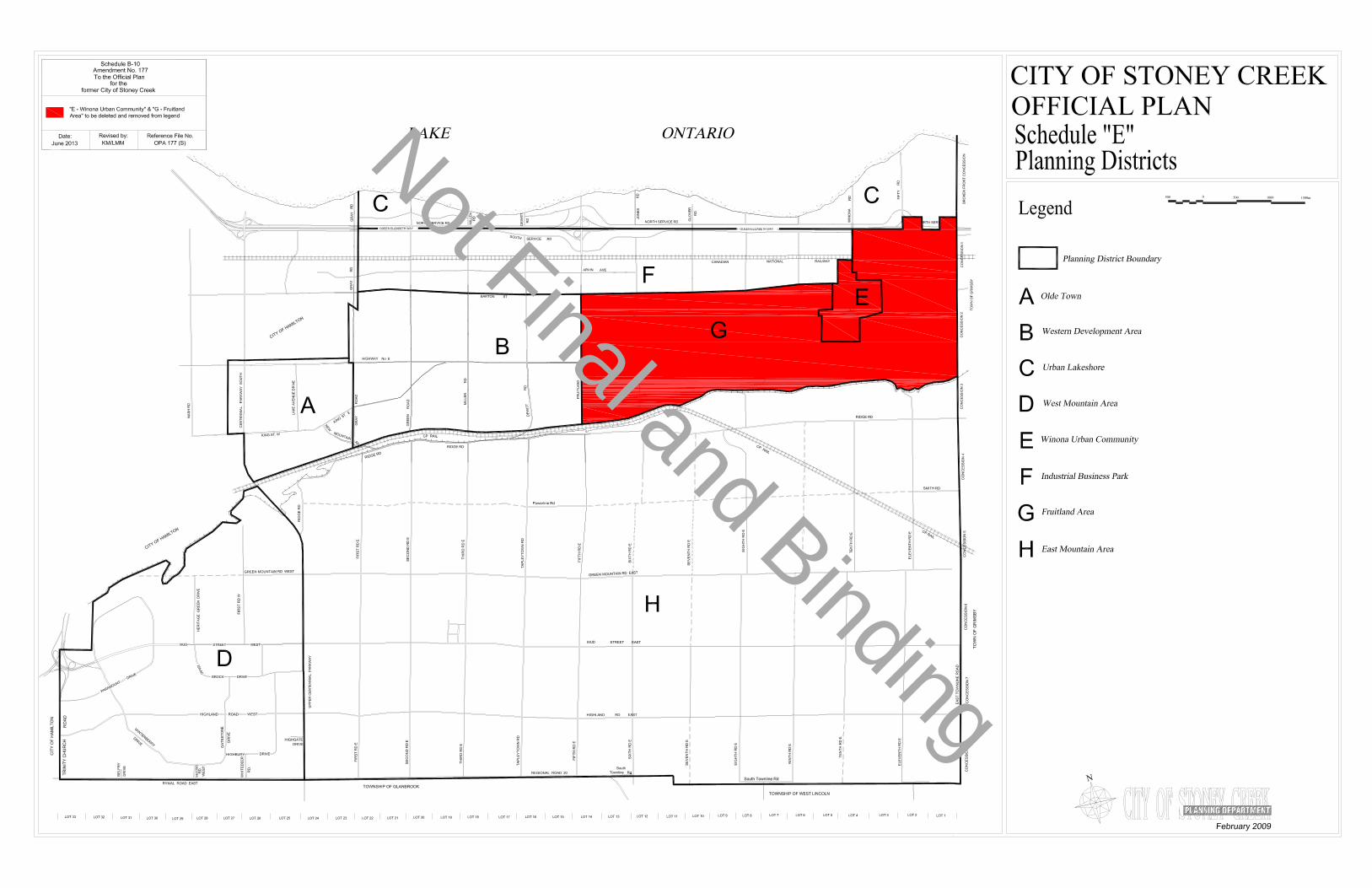
Not Final and Binding

Not Final and Binding

Not Final and Binding

Not To Scale
PLANNING & ECONOMIC DEVELOPMENT DEPARTMENT Teranet Land Information Services Inc. and its licensors. [2011]May Not be Reproduced without Permission. THIS IS NOT A PLANOF SURVEY
C
Date:June 7, 2013
City of Stoney CreekOfficial Plan
Fruitland-WinonaSecondary Plan
Schedule A2-1
Parks and Open Space Designations
Residential DesignationsLegend
Other Designations
Other Features
SWM
SWM
SWM
SWM
SWM
SWM
SWM
SWMES
ES
ES
ES
HIGHWAY NO. 8
JON
ES
RD
GLO
VE
R R
D
MC
NE
ILLY
RD
BARTON ST
CN RAILWAY
HIGHWAY NO. 8
GLENHOLME AVE
HELENA AVE
BE
L A
IR A
VE
SIL
VE
RLA
CE
CL
LEW
IS R
D
TU
SC
AN
I DR
WIN
ON
A R
D
WE
ST
AV
E
HIGHWAY NO. 8
PARK MANOR DR
BARTON ST
CO
LLE
CTO
R R
D G
SONOMA LN
ES
CA
RP
ME
NT
DR
QUEEN ELIZABETH WY
SERVICE RD
SOUTH SERVICE RD
FIF
TY
RD
SOUTH SERVICE RD
FR
UIT
LAN
D R
D
CO
LLEC
TOR
RD
G
CO
LLEC
TOR
RD
A O
PTIO
N 1
CO
LLEC
TOR
RD
A O
PTIO
N 2
CO
LLEC
TOR
RD
C
CO
LLEC
TOR
RD
A
CO
LLEC
TOR
RD
E
COLLECTOR RD D
CO
LLEC
TOR
RD
F
COLLECTOR RD B
Commercial and Mixed UseDesignations
Employment Area - BusinessPark
Institutional
ES Elementary School
Utility
SW M Storm Water Management
Neighbourhood Park
Community Park
General Open Space
Local Commercial
District Commercial
Arterial Commercial
Low Density Residential 1
Low Density Residential 2
Low Density Residential 3
Medium Density Residential 2
Storm Water Management
Area or Site Specific Policy
Secondary Plan Boundary
Lands in the Rural Area
Lake Ontario
Proposed Roads
Major Gateway
Minor Gateway
.
.Natural Open Space
Reference File No.:OPA-177(S)
Revised By:KM/LMM
Date:June 2013
Schedule B-4Amendment No. 177
to the Official Plan for the former City of Stoney Creek
"Schedule A2-1 - Fruitland-Winona Secondary Plan - Land Use Plan"to be adopted into the City of Stoney Creek Official Plan
Not Final and Binding

Not To Scale
PLANNING & ECONOMIC DEVELOPMENT DEPARTMENT Teranet Land Information Services Inc. and its licensors. [2011]May Not be Reproduced without Permission. THIS IS NOT A PLANOF SURVEY
C
Date: April 23, 2013
City of Stoney CreekOfficial Plan
Fruitland-WinonaSecondary Plan
Natural Heritage SystemSchedule A2-2
Legend
Other Features
HIGHWAY NO. 8
JON
ES
RD
GLO
VE
R R
D
MC
NE
ILLY
RD
BARTON ST
CN RAILWAY
HIGHWAY NO. 8
GLENHOLME AVE
HELENA AVE
BE
L A
IR A
VE
SIL
VE
RLA
CE
CL
LEW
IS R
D
TU
SC
AN
I DR
WIN
ON
A R
D
WE
ST
AV
E
HIGHWAY NO. 8
PARK MANOR DR
BARTON ST
CO
LLE
CTO
R R
D G
SONOMA LN
ES
CA
RP
ME
NT
DR
QUEEN ELIZABETH WY
SERVICE RD
SOUTH SERVICE RD
FIF
TY
RD
SOUTH SERVICE RD
FR
UIT
LAN
D R
D
Secondary Plan Boundary
Lands in the Rural Area
Lake Ontario
Core Areas
Linkages
Restoration Areas
Vegetation Protection Zone
Reference File No.:OPA-177(S)
Revised By:KM/LMM
Date:June 2013
Schedule B-5Amendment No.177
to the Urban Hamilton Official Plan
"Map B.7.4-2 - Fruitland-Winona Secondary Plan - Natural HeritageSystem" to be adopted into the Urban Hamilton Official Plan
Not Final and Binding

Not To Scale
PLANNING & ECONOMIC DEVELOPMENT DEPARTMENT Teranet Land Information Services Inc. and its licensors. [2011]May Not be Reproduced without Permission. THIS IS NOT A PLANOF SURVEY
C
Date: January 16, 2013
City of Stoney CreekOfficial Plan
Fruitland-WinonaSecondary Plan
Transportation Classification PlanSchedule A2-3
Legend
Other Features
HIGHWAY NO. 8
JON
ES
RD
GLO
VE
R R
D
MC
NE
ILLY
RD
BARTON ST
CN RAILWAY
HIGHWAY NO. 8
GLENHOLME AVE
HELENA AVE
BE
L A
IR A
VE
SIL
VE
RLA
CE
CL
LEW
IS R
D
TU
SC
AN
I DR
WIN
ON
A R
D
WE
ST
AV
E
HIGHWAY NO. 8
PARK MANOR DR
BARTON ST
CO
LLE
CTO
R R
D G
SONOMA LN
ES
CA
RP
ME
NT
DR
QUEEN ELIZABETH WY
SERVICE RD
SOUTH SERVICE RD
FIF
TY
RD
SOUTH SERVICE RD
FR
UIT
LAN
D R
D
CO
LLEC
TOR
RD
G
CO
LLEC
TOR
RD
A O
PTIO
N 1
CO
LLEC
TOR
RD
A O
PTIO
N 2
CO
LLEC
TOR
RD
C
CO
LLEC
TOR
RD
A
CO
LLEC
TOR
RD
E
COLLECTOR RD D
CO
LLEC
TOR
RD
F
COLLECTOR RD B
Secondary Plan Boundary
Lands in the Rural Area
Future Multi-ModalTransportation Hub
Potential Rapid Transit Route
Notes:1. All proposed collector roads will havebike lanes.
2. Potential for turning lanes, modernroundabout or traffic signal at Arterial/Collector Road intersection.
3. Future Multi-Modal Transportation Hubfor conceptual purposes only, exact locationto be determined.
Railways
Barton Street PedestrianPromenade
Proposed Bike Lane/PavedShoulder/Shared Lane
Proposed Extension ofOn-Street Bike Route
Existing On-Street Bike Route
Potential Intersection Control
Potential Roundabout Location
Collector
Multi-use Trail
Proposed Roads
Collector
Major Arterial
Lake Ontario
Minor Arterial
Reference File No.:OPA-177(S)
Revised By:KM/LMM
Date:June 2013
Schedule B-6Amendment No. 177
to the Official Plan for the former City of Stoney Creek
"Schedule A2-3 - Fruitland-Winona Secondary Plan - TransportationClassification Plan" to be adopted into the City of Stoney CreekOfficial Plan Not Final and Binding

Not To Scale
PLANNING & ECONOMIC DEVELOPMENT DEPARTMENT Teranet Land Information Services Inc. and its licensors. [2011]May Not be Reproduced without Permission. THIS IS NOT A PLANOF SURVEY
C
Date: February 6, 2013
City of Stoney CreekOfficial Plan
Fruitland-Winona Secondary Plan Block Servicing Strategy
Area DelineationSchedule A2-4
Legend
Other Features
HIGHWAY NO. 8
JON
ES
RD
GLO
VE
R R
D
MC
NE
ILLY
RD
BARTON ST
CN RAILWAY
HIGHWAY NO. 8
GLENHOLME AVE
HELENA AVE
BE
L A
IR A
VE
SIL
VE
RLA
CE
CL
LEW
IS R
D
TU
SC
AN
I DR
WIN
ON
A R
D
WE
ST
AV
E
HIGHWAY NO. 8
PARK MANOR DR
BARTON ST
CO
LLE
CTO
R R
D G
SONOMA LN
ES
CA
RP
ME
NT
DR
QUEEN ELIZABETH WY
SERVICE RD
SOUTH SERVICE RD
FIF
TY
RD
SOUTH SERVICE RD
FR
UIT
LAN
D R
D
Block 2
Block 3
Block 1
Secondary Plan Boundary
Lands in the Rural Area
Lake Ontario
Proposed Roads
Servicing Strategy Area
Reference File No.:OPA-177(S)
Revised By:KM/LMM
Date:June 2013
Schedule B-7Amendment No. 177
to the Official Plan for the former City of Stoney Creek
"Schedule A2-4 - Fruitland-Winona Secondary Plan - Block ServicingStrategy Area Delineation" to be adopted into the City of StoneyCreek Official Plan Not Final and Binding
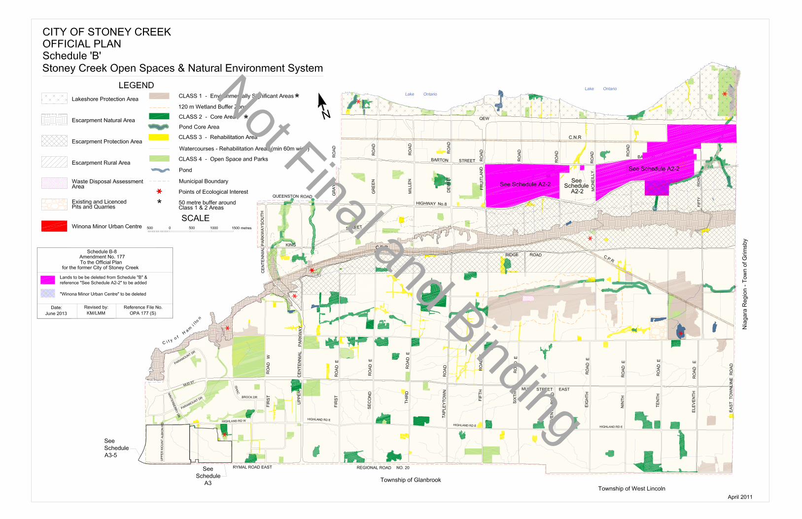
Not Final and Binding

Not Final and Binding