no. 7 subway extension—hudson yards ... - new york city · projects & proposals >...
TRANSCRIPT

Projects & Proposals > Manhattan > Hudson Yards
Hudson YardsOverview
• The Need • The Precedent • The Vision
The Need For centuries, New York has grown to meet the employment and housing needs of its citizens. The foresight of the city’s leaders – exemplified best in Manhattan's grid plan of 1811 and the annexation and consolidation of 1898 – has been matched by private entrepreneurship, especially in the railroads and in the subway systems that reached out from the City's point of origin in Lower Manhattan to the outer boroughs. Over time, in large part because of that confluence of transit lines, the office market settled in Manhattan.
That demand continues – the 2000 Census indicated that over 8 million people now live in New York City, the most in the City’s history. Companies continue to seek out New York City as a place to set up headquarters, the latest example is Bank of America. In the New York region, it is anticipated that there will be the need to accommodate over 440,000 new workers, requiring 111 million square feet of new space by 2025. If Midtown captures near its historical share, 45 million square feet of office space would be needed over the next 20 years. The problem is that there are few sites remaining in Midtown to accommodate new office buildings. Recent studies indicate that at most, there is perhaps room to accommodate only 20 million square feet in Midtown. In a place where dreams and ambitions are limitless, land is not. Manhattan in a few short years will be out of developable land for new office construction.
There is one last frontier available in Manhattan - Hudson Yards, the underutilized area bounded roughly by West 42nd Street and West 30th Street, Eighth Avenue to the Hudson River. It is in these 360 acres that the City can meet its public responsibility to continue to provide job and housing opportunities for all New Yorkers.
This need in Midtown is unrelated to - and not competitive with - the rebuilding of Lower Manhattan. Rebuilding Lower Manhattan and the World Trade Center is the City’s first priority and great progress is being made. The Trade Center is the last location in Lower Manhattan that can accommodate commercial buildings. With the completion of the Trade Center, Lower Manhattan will have no more capacity for new office development. The Trade Center is expected to be redeveloped over the course of the next decade, providing nearly 10 million square feet of commercial space. As the Trade Center is nearing completion, only then will Hudson Yards have the necessary subway access and public amenities to attract new development. We must look ahead, and plan ahead, so that New York will continue to provide office employment opportunities for its citizens in the future.
There is an unacceptable alternative: to abdicate and do nothing. Over the last several decades, regional office growth trend shifted from the City to New Jersey and Long Island where land is plentiful and cheaper. This shift in office locations has implications for the Region and New York City. Suburban office development has an environmental cost as workers shift from mass transit to private automobiles and patterns of regional sprawl expand. Not only does suburban office development have a negative impact on the region, but it negatively impacts New York City as well. Income taxes and real estate taxes generated by Manhattan office space is the major contributor to our city's operating budget. This revenue provides services to all New Yorkers in every borough. It is our responsibility to all New Yorkers - not only for direct jobs, but for those indirect revenues - to recapture our market share by making new sites available.
Office space is not our only need. Our convention center, the Jacob K. Javits, whose spin-off effects include jobs in retail, tourism, food and entertainment sectors, ranks only 18th in size in North America. The Javits is not only hindered by its size, but also by its array of spaces it can offer conventions. The Javits can't serve the 60 largest annual shows, and is fully booked for the limited space it does have. The convention center must expand to be competitive and must provide more meeting spaces, ball rooms, and plenary halls to attract new users.

Increasingly, people are moving into, and back to, Manhattan - to be closer to work, and to feed off Midtown's cultural and entertainment energy. The demand for new housing in New York City is great and is expected to grow. Hudson Yards provides not only for future commercial development in Manhattan, but also for approximately 12,600 new housing units.
Hudson Yards will provide opportunities for the desperately needed office space, convention center expansion, and residential growth that the City will need in the coming decades.
The Precedent New York's greatness over the centuries has been its ability to make major public investments that trigger private market response. The gridplan of 1811, laid out the future of development for the entire island of Manhattan at a time few people thought development would expand above Houston Street. Central Park was a visionary undertaking that is a treasure to the City and a much needed recreational space for thousands of New Yorkers. Hudson Yards is based on the ability of New York to make strategic public investments that provide invaluable returns long into the future.
Much of Hudson Yards, 33 acres to be exact, today is below grade railroad tracks that are proposed to be “covered over” to accommodate development and parks. The City is confident that this area can be transformed into one of the most desirable neighborhoods in the 21st Century because it accomplished this feat at the beginning of the 20th Century.
In 1903, the state legislature, responding to public outrage at the pollution and filth of the New York Central Railroad rail yards in mid-Manhattan, passed a law requiring the railroad to "cover its tracks". In response, the railroad built a deck over newly electrified tracks from Madison Avenue to Lexington Avenue, from East 42nd to East 56th streets. Down the middle of the deck a grand boulevard, Park Avenue, was built. It was crowned with a magnificent new train station, the Grand Central Terminal. Over the next three decades, new hotels, office buildings, and apartments sprang up along Park Avenue, forming the core of what would become the world's greatest central business district. One hundred years later, the trains still run under Park Avenue, and on the blocks over the tracks 160,000 people earn their living.
The vision for Hudson Yards is to transform today's underused Far West Side into a place where New Yorkers and tourists will want to live, work, play and visit. Just like Park Avenue 100 years ago, we must look forward to secure the City’s future.
Hudson Yards Vision
Rendering of Hudson Yards
The Hudson Yards is a comprehensive proposal to realize the development potential of Manhattan’s Far West Side. The Hudson Yards area extends from West 28th Street on the south, Seventh and Eighth avenues on the east, West 43rd Street on the north, and the Hudson River on the west. Hudson Yards is ideally located to allow for the expansion of the Midtown Central Business District and to help secure New York City’s economic future. The project includes a series of actions to transform Hudson Yards into a dynamic, transit-oriented urban center, permitting medium- to high-density development and a mix of uses, including commercial, residential, open space, cultural and entertainment.
The plan for the transformation of Hudson Yards is based on the “preferred direction” for the area, proposed by the Department of City Planning and the New York City Economic Development Corporation (NYCED) in 2003, and by the Far West Midtown Framework for Development completed by the Department of City Planning in 2001. The proposal identifies the following four key public sector actions that would be necessary to attract private development to the area:
Extending subway service Establishing a new open space network Zoning for appropriate densities and uses Creating a Convention Corridor
Extending Subway Service In conjunction with the Department’s rezoning proposal, the MTA is planning for the extension of the No. 7 Subway line. The No. 7 Subway line would be extended to the west from the existing terminus at West 41st Street and Seventh Avenue, with a station at West 41st Street and Tenth Avenue, and then south, to a new terminus at West 34th Street and Eleventh Avenue. The proposed extension would place nearly all points in Hudson Yards within less than a 10-minute walk to a subway station. No. 7 Subway

View the proposal
Creating Open Space Network The Hudson Yards plan includes a major new open space network (over 20 acres) that would travel through the heart of the new commercial district. Beginning at West 42nd Street the network would rise on a pedestrian bridge south to West 39th Street, where it would expand into a linear north-south park bordered by a new tree-lined boulevard (“Hudson Boulevard”) between Tenth and Eleventh avenues, terminating at a six-acre public square between West 30th and West 33rd streets. The new park and street system would be built on new platforms above the Amtrak rail road cut and the MTA’s Eastern Rail Yard, thereby regularizing the area’s topography and covering over the presence of unsightly transportation infrastructure. The park system would also link with the planned reuse of the High Line elevated rail line to the south in West Chelsea, and two new full block waterfront parks to the north and south of the New York Sports and Convention Center (NYSCC). Municipal parking facilities would be relocated from area waterfront piers to below-grade space beneath one of the new full block waterfront parks, allowing for expansion of the adjacent Hudson River Park.
Zoning for Appropriate Densities and Uses Rezoning the Hudson Yards area would reinforce existing neighborhoods while transforming underused areas into a thriving and desirable urban district. The proposed rezoning is based on a land use plan to allow significant commercial expansion over the next 30 to 40 years. The absence of sites in Midtown Manhattan for large floor-plate office buildings has led many companies to leave the City for larger sites elsewhere in the region. Rezoning would ensure that redevelopment of the area supports the larger goal of keeping New York competitive as a global city for the next several decades. While accommodating approximately 28 million square feet of commercial office growth, the plan also provides for approximately 12.6 million square feet of residential expansion.
Convention Corridor The need for a larger and more versatile Convention Center has long been apparent. Hudson Yards addresses this longstanding need with the creation of a Convention Corridor. Concurrent with the rezoning, two projects under State leadership will provide a first-class convention complex. The Jacob K. Javits Convention Center is proposed to be expanded north to West 41st Street with a hotel on West 42nd Street. The expansion will increase the size of its contiguous exhibition area from 760,00 square feet to 1,300,000 square feet. Additionally, the expansion will provide a convention center hotel, a ballroom of 86,000 square feet, and an increase in meeting rooms to 365,000 square feet.
Imagining the Future of Hudson Yards Hudson Yards is the future of New York City. Over the next decade the public sector will provide subway service, create parks, deck over unsightly railroad infrastructure and expand the convention facilities. These improvements are anticipated to be completed by 2012; private sector development is expected to occur over a longer period, transforming the area with highrise and midrise office and residential buildings.
View on the pedestrian bridge connecting 38th and 42nd Streets,
looking south
View of the High Line Market proposed along 30th Street, looking west

Superblocks along 33rd Street
Jacob K. Javits Convention Center, on 11th Avenue
Aerial view of the transportation
infrastructure network
Aerial view of surrounding neighborhoods
The MTA Railyards crossed by 11th Avenue
Projects & Proposals > Manhattan > Hudson Yards
Hudson YardsThe Area
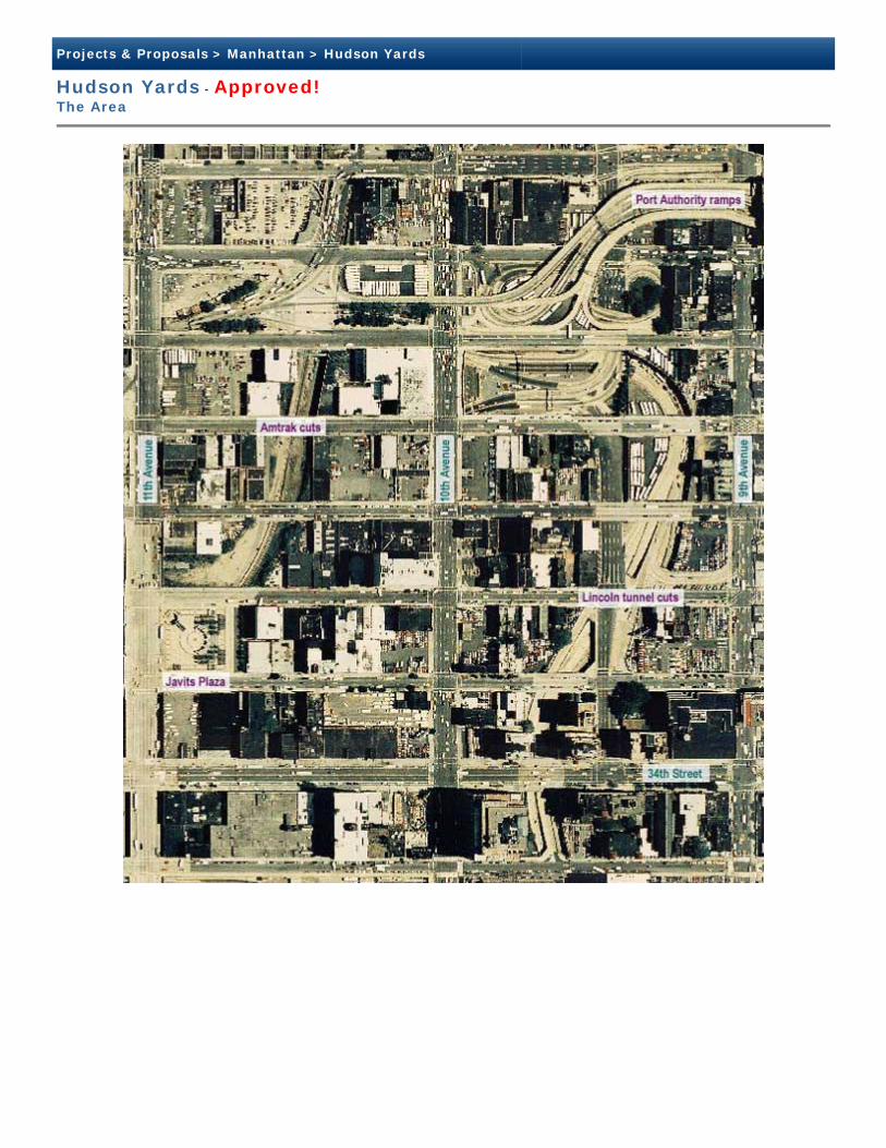
Hudson Yards is the area generally between West 30th Street on the south, Seventh and Eighth avenues on the east, West 43rd Street on the north, and Twelfth Avenue on the west. It is bordered by Clinton to the north, Chelsea to the south, Hudson River Park to the west, and the Garment Center and Midtown to the east. The area, currently, is isolated from the subway system, has few public amenities and little open space and is primarily characterized by large tracts of underutilized land. The land uses in the area are mainly transportation, commercial, industrial, parking lots, garages, and residential. Public facilities and open space comprise very few of the uses within the area.
Several significant buildings and transportation facilities are located in and around Hudson Yards. Major Transportation facilities include Pennsylvania Station, the proposed Moynihan Station to be constructed within the Farley Post Office building, and the Port Authority Bus Terminal. Major buildings in the area include the Jacob K. Javits Convention Center, Madison Square Garden, 450 West 33rd/Daily News building, and the commercial office buildings located at One and Two Pennsylvania Plaza.
The area is predominantly organized along Manhattan's grid of streets and avenues creating the typical 200 foot by 800 foot blocks. Although most of the blocks conform to the street grid, a series of superblocks extend from Seventh to Twelfth avenues along the south side of West 33rd Street. These superblocks are a consequence of the railroad network that links Pennsylvania Station with the Long Island Railroad storage and maintenance yards. The superblocks also extend from West 34th to West 39th streets between Eleventh and Twelfth avenues to accommodate the Jacob K. Javits Convention Center. In addition to the superblocks, the Lincoln
Tunnel and its access ramps disrupt the regular street grid. The Lincoln Tunnel is comprised of three separate tunnels, two of the entrances are between Ninth and Tenth avenues and one between Tenth and Eleventh avenues.
Transportation infrastructure is the dominant feature, establishing a gritty industrial character and bleak pedestrian environment in the area. The Lincoln Tunnel and its access ramps cover approximately 15 acres between Ninth and Eleventh avenues, the MTA Rail Yards cover 26 acres from West 30th to West 33rd streets between Tenth and Twelfth avenues (Eleventh Avenue bridges over the Yards dividing the Yards into two sites: the Eastern Yards and Western Yards), and the open Amtrak Empire Line railroad cut is visible from West 36th to West 39th streets between Tenth and Eleventh avenues. The infrastructure also bifurcates the area by disrupting the development pattern and establishing blank walls along the street edges.
Light industrial uses are scattered throughout the rezoning area, primarily concentrated in three areas, between Tenth and Eleventh avenues, across from the Javits Convention Center, in the Garment Center between Eighth and Ninth avenues north of West 35th Street, and between Seventh and Eighth avenues south of West 31st Street. The light industrial uses east of Eighth Avenue are concentrated in large loft buildings and include garment and printing uses. The area across from the Javits Convention Center is primarily auto related and vehicle storage uses.

Javits Convention Center plaza
Lincoln tunnel cuts at 9th Ave. and 35th St.
34th Street
Streetscape along 38th St. (10th & 11th Ave.)
Residential buildings along 9th Avenue
Lincoln tunnel access ramps at 39th Street
Amtrack cut at 39th Street
High-rise residential
across from the Javits Convention Center. Several small community parks have been created on Port Authority property through an agreement with the community. In addition, privately owned public space is located at One and Two Pennsylvania Plaza, and on the south side of West 42nd Street between Eleventh and Twelfth avenues.
The character of the proposed rezoning area differs significantly from one area to another. Along Ninth Avenue from West 35th Street to West 40th Street, the area is primarily residential buildings with five to six story walk-up apartment buildings with ground floor retail. Though there is a strong built context of residential buildings, there are several parking and underbuilt lots.
West of Ninth Avenue between West 35th and 40th streets, the area is primarily low scale, with one to three story commercial and industrial buildings, some walk-up apartment buildings, and larger loft buildings. The area is dominated by the presence of infrastructure, primarily the Lincoln Tunnel approaches between Ninth and Tenth avenues and the open Amtrak railroad cut between Tenth and Eleventh avenues. Much of the land that isn’t utilized for infrastructure uses are auto related uses or surface level bus and automobile parking. The lots west of Ninth Avenue are generally larger, the street walls are not continuous, and there are fewer ground floor retail uses.
West 34th Street from Eighth Avenue to Eleventh Avenue is a mixed-use corridor of commercial and residential uses. The level of development, including size and heights of buildings, is greatest near Eighth Avenue. Commercial and residential buildings include pre-war apartment buildings and converted loft buildings. West of Tenth Avenue, the level of development is lower scale and the uses more commercial and industrial.
West 31st to West 33rd streets from Eighth Avenue to Eleventh Avenue is primarily the open rail cuts that serve Pennsylvania Station. There are several large buildings that have been developed above these cuts, including the 450 West 33rd/Daily News building on Tenth Avenue, the Farley Post Office Building, and Madison Square Garden.
The area south of Pennsylvania Station is characterized by large loft structures of twelve to sixteen stories interspersed with low rise buildings and parking lots. Many of these buildings have been converted to commercial uses.
West 42nd Street to the west of Eighth Avenue is a mixture of high rise residential, theaters and entertainment uses, and low scale commercial uses. West 42nd Street has experienced a significant number of new, high-rise residential developments over the past several years. There are still several parking lots and low-scale buildings with entertainment, community facility, or industrial uses within this portion of West 42nd Street.
The Garment Center between Eighth and Ninth avenues is comprised of loft buildings of twelve to sixteen stories interspersed with low-rise buildings and parking lots. There is still garment related uses in these larger loft buildings, however, commercial uses are becoming more common. There are a few residential uses within the area.
Existing Zoning TThere have been few zoning changes in the area since the adoption of the 1961 Zoning Resolution, which mapped manufacturing districts in much of the area. The area - particularly west of Ninth Avenue - continues to remain zoned predominantly for low- and medium-density manufacturing. Several small areas have been rezoned to commercial districts, primarily along West 42nd Street, Ninth Avenue, and across from the Javits Convention Center on Eleventh Avenue.
The only permanent public open space is the hard-scape plaza
development along 42nd Street

Existing zoning map
zoned commercially. The major manufacturing designation is M1-5 with a floor area ratio (FAR) 5.0. Commercial designations vary, with C6-2 and C6-4 districts with FARs of 6.0 and 10.0 respectively being the most common.
The allowable FARs within the rezoning area are generally 5.0 and 6.0 FAR with scattered areas of higher density. Areas of higher density include the West 42nd Street corridor, the Special Jacob K. Javits Convention Center District along Eleventh Avenue, and the
superblock between Ninth and Tenth avenues and West 31st and West 33rd streets.
There are four special zoning districts that are wholly or partially within the area. The Special Jacob K. Javits Convention Center District was adopted in 1986 to promote development across from the Javits Convention Center between West 34th and West 39th streets. A portion of the Special Garment Center District is located between Eighth and Ninth avenues from West 35th to West 40th streets. The district includes preservation requirements for garment-related manufacturing uses in the midblocks. The other two special districts, the Special Clinton District and the Special Midtown District, are located at the periphery of the rezoning area.
Currently, the majority of the lot area within the rezoning area is zoned for manufacturing with the remaining area

Projects & Proposals > Manhattan > Hudson Yards
Hudson Yards - Approved!The Area
Projects & Proposals > Manhattan > Hudson Yards
Hudson Yards - Approved!The Area

Projects & Proposals > Manhattan > Hudson Yards
Hudson Yards - Approved!Original Proposal as Adopted
On November 23, 2004, the City Planning Commission approved the ten ULURP actions for Hudson Yards. On January 19, 2005, the City Council voted to adopt the ULURP applications for the Hudson Yards proposal with several modifications to the zoning map change (040499(A) ZMM) and the zoning text amendment (040500(A) ZRM). View the full ULURP Timeline.
ADOPTED ZONING MAP CHANGE (040499(A) ZMM) and ADOPTED ZONING TEXT AMENDMENT (N 040500(A) ZRM)
View the Adopted Zoning Text Amendment (2.1 mb) and the Adopted Zoning Map (400 kb).
View a graphical zoning presentation (2.5 mb).
Read the City Planning Commission Reports concerning Hudson Yards.
In general, the zoning map change would: rezone an area of West Midtown to C6-6, C6-4, C6-4M, C6-3, C6-3X, C2-8, R8A, C1-7A; establish the Special Hudson Yards District; modify the boundaries of the Special Garment Center District and the Special Midtown District; and eliminate the Special Jacob K. Javits Center Convention District. In general, the Zoning Text Amendment will: establish the Special Hudson Yards District; modify the text of the Special Garment Center District and the Special Clinton District; and eliminate the Special Jacob K. Javits Center Convention District.
The zoning map changes and text amendments will regulate densities and heights that would generally form a “bowl” within the rezoning area. Medium-density contextual districts (C1-7A and R8A) would be located along Ninth Avenue and the midblocks to the west, surrounded by higher density districts (C2-8 and C6-4) to the west along Tenth Avenue, to the south along West 34th Street, to the north along West 42nd Street, and to the east within the Special Garment Center District. The highest densities would be located along Eleventh Avenue and the West 33rd Street superblocks – areas that are closest to the proposed subway stations and farthest from the existing medium density residential area. In many areas, the use, density and bulk controls of the proposed zoning districts would be modified by the regulations of the Special Districts.
Predominantly Commercial Areas The zoning would facilitate high-density office development primarily along an L-shaped predominantly commercial corridor, running east-west between West 30th and West 33rd streets, above the eastern portion of the MTA’s Caemmerer Yard (Eastern Rail Yard) and right-of-way, and north-south between Tenth and Eleventh avenues West 41st Street, across from the Javits Convention Center. Additionally, predominantly commercial areas would also be located within existing commercial neighborhoods, adjacent to existing or planned public transportation. The allowable density within these areas would be comparable to Midtown to accommodate demand for projected office space.
New development in the predominantly commercial areas would be restricted primarily to commercial use, in order to ensure that new residential development would not reduce the supply of potential land assemblages for large floor-plate office buildings. However, to create a vibrant, 24-hour community, residential and community facility use would be allowed in combination with office development.
Predominantly Residential Areas Mixed-use residential and commercial districts would be located in areas with existing residential and commercial uses and in areas currently zoned manufacturing to encourage such mixed-use development. The zoning would strengthen these existing neighborhoods by directing compatible, predominantly residential development to these areas, and requiring building bulk envelopes that reinforce each area’s distinctive built character. These areas include Ninth Avenue, Tenth Avenue between West 34th and West 41st Streets; West 34th Street between Eighth and Tenth avenues; West 42nd Street within the Special Clinton District; and Eighth to Ninth avenues within the Special Garment Center District.
Hell’s Kitchen South The midblocks between Ninth and Tenth avenues, from West 35th to West 40th streets, known as Hell’s Kitchen South, contain a mixture of walk-up tenement and apartment buildings, vacant and parking lots, and access ramps to the Lincoln Tunnel. The proposed zoning would permit medium density residential development with ground floor retail with contextual envelopes. Additional zoning mechanisms would encourage the development of neighborhood open space on new platforms above the Lincoln Tunnel ramps, thereby covering below-grade transportation infrastructure and helping to knit back the neighborhood fabric.
Tenth Avenue Corridor

Tenth Avenue would serve as the transition between Hell’s Kitchen to the east and the new commercial district to the west. Density and bulk would be at appropriate levels to provide this transition, with slightly higher density and building height permitted along the west side of Tenth Avenue. Predominantly residential use would also be permitted along Tenth Avenue and would help to ensure a lively 24-hour community to the west.
West 34th Street and West 42nd Street (Special Clinton District Perimeter Area) The high density, mixed use character of West 34th Street and West 42nd Street would be reinforced by the proposed zoning, with higher densities permitted adjacent to existing and new public transportation.
Garment Center, western blocks In recognition of development opportunities within the Special Garment Center District between Eighth and Ninth avenues, the rezoning would allow new high density residential and commercial development on predominantly vacant sites, and limited residential and commercial conversions of existing buildings. The existing regulations that preserve garment-related uses would be retained for the area’s larger (70,000 square feet and above) buildings. Envelope controls for new development would ensure consistency with the Garment Center’s distinctive built form of high streetwall loft buildings. The northern-most block within the Special Garment Center District, located between West 39th and 40th streets and containing minimal garment-related uses, would be rezoned for high density commercial development, removed from the Special Garment Center District and incorporated into the Special Hudson Yards District.
View a graphical presentation (830 kb) of the actions listed below:
SITE SELECTION AND ACQUISITION FOR TOW POUND AND/OR SANITATION FACILITY(IES) (040501 PCM) Site selection and acquisition of Manhattan Block 675 (West 29th to West 30th streets and Eleventh to Twelfth avenues) would allow for construction of a new below-grade municipal facility to accommodate one or more of the following uses: a Police Department violation tow pound, a Department of Sanitation (DSNY) garage for District 2, and/or garage for DSNY District 5. This facility would allow for the relocation of these uses from within the Hudson River Park.
SITE SELECTION AND ACQUISITION FOR PUBLIC PARKING GARAGE (040502 PCM) Site selection and acquisition of property would allow for new below-grade public parking garage between West 34th and West 36th streets between Tenth and Eleventh avenues. The proposed public parking garage would accommodate potential parking demand generated by new commercial and residential development on sites where below-grade parking would be infeasible.
ACQUISITION OF PROPERTIES AND EASEMENTS (040503 PQM) (040504 PQM) (040505 PQM) These applications seek acquisition of easements and property for: a pedestrian bridge connecting the proposed park on West 42nd Street with the proposed park on West 39th Street; the construction of the extension of the No. 7 Subway line on behalf of the MTA; and the Eastern Rail Yard to facilitate commercial, residential, cultural, and open space uses on the site.
DISPOSITION OF CITY OWNED PROPERTY (040506 PPM) Disposition of city-owned property not fully used for public parking garage, parks, or streets; disposition of area beneath midblock park and boulevard for public parking garage; disposition of properties not fully used for the No. 7 Subway extension; disposition of Eastern Rail Yard; disposition of Block 685 Lot 38.
CITY MAP CHANGE (040507 MMM) (040508 MMM) These applications seek to establish a network of new parks in the area and Hudson Boulevard, a north – south street couplet between Tenth and Eleventh avenues. Much of the park and Hudson Boulevard would be above a lower limiting plane due to subsurface conditions under the park and boulevard. The linear park would extend from West 33rd to West 39th Street. A full-block park would also be mapped from West 29th to West 30th streets between Eleventh and Twelfth avenues. Hudson Boulevard “East” would run northbound from West 33rd Street to West 38th Street and Hudson Boulevard "West" southbound from West 38th Street to West 35th Street.

Projects & Proposals > Manhattan > Hudson Yards
Hudson Yards - Approved!ULURP Timeline
Project Component: Milestone Date:
Department of City Planning Certification: June 21, 2004
Community Board Review (60 days) CB 5 Land Use Committee July 1, 2004 CB 5 Public Hearing July 8, 2004 (Contact Board 212-465-0907 for more details)
CB 4 Land Use Committee July 13, 2004 CB 4 Public Hearing August 3, 2004 (Contact Board 212-736-4536 for more details)
Borough President and Borough Board Review (30 days) Borough President Public Hearing (Fashion Institute of Technology, HAFT Auditorium, Building C)
September 13, 2004, 6pm
Borough Board Public Hearing (1 Centre Street, 19th Floor)
September 15, 2004, 8:30am
City Planning Commission Review (60 days) Public Hearing
(Fashion Institute of Technology, HAFT Auditorium, Building C)
September 23, 2004, 9am
Adoption of applications November 22, 2004
City Council Review (50 days) December 13, 2004
City Council Adoption January 19, 2005

Projects & Proposals > Manhattan > Hudson Yards
Hudson Yards - Approved! Environmental Impact Statement (EIS)
The EIS:
The Metropolitan Transportation Authority (MTA) and the City of New York City Planning Commission (CPC), as co-lead agencies under the State Environmental Quality Review Act (SEQRA) and City Environmental Quality Review (CEQR), have prepared this Final Generic Environmental Impact Statement (FGEIS) for the proposed No. 7 Subway Extension and Hudson Yards Rezoning and Development Program. The FGEIS also covers two other major public actions in the Hudson Yards area – the expansion and modernization of the Jacob K. Javits Convention Center (Convention Center) and the development of a new multi-use sports, entertainment, and exhibition facility (Multi-Use Facility) adjacent to the Convention Center between West 30th and West 33rd streets.
The proposed public actions would promote the transit-oriented redevelopment of the Hudson Yards area.
The Proposed Action includes:
Adoption of zoning map and text amendments to the New York City Zoning Resolution and related land use actions to permit the development of Hudson Yards as a mixed-use community with new commercial and residential space, and a substantial amount of new open space, including approximately:
28 million square feet of office space;12.6 million square feet (12,600 units) of residential space;1.5 million square feet of hotel space; and,700,000 square feet of retail space.
Northward View of Hudson Yards in 2025, Michael McCann/DCP
The construction and operation of an extension of the No. 7 Subway line to serve Hudson Yards. The proposed route extends west across West 41st Street with a station at Tenth Avenue and West 41st Street. The alignment continues west and turns south on Eleventh Avenue with a station at Eleventh Avenue and West 34th Street;
Future No. 7 Subway Station, Datner Architects
Expansion, renovation, and modernization of the Jacob K. Javits Convention Center, including construction of approximately one million square feet of new exhibition space plus additional space for meeting rooms, banquet halls, and other facilities, and development of a new hotel with up to approximately 1,500 rooms;
View of Convention Center Expansion, HOK/Kohn Pederson Fox

A new multi-use sports, exhibition, and entertainment facility (Multi-Use Facility) with approximately 30,000 square feet of permanent meeting room space and the capability to convert into a number of different uses and configurations, including a stadium configuration with a seating capacity of approximately 75,000, an exposition configuration including 180,000 square feet of exhibition floor space, or a plenary hall configuration that provides a maximum seating capacity of approximately 40,000; and,
Multi-Use Facility, NY Jets/Kohn Pederson Fox
Accommodations for new, multi-agency facilities, including garages for the Department of Sanitation and New York City Police Department’s Tow Pound.
The co-lead agencies issued an Environmental Assessment Statement/Form (EAS/EAF) on February 10, 2003, a Positive Declaration for the Proposed Action on April 21, 2003, and a Draft Scoping Document on April 30, 2003. A public hearing on the Draft Scoping Document was held on June 5, 2003 to solicit public comments. Based on the public comments a Final Scoping Document was developed, including 18 alternatives to the proposed action. The Final Scoping Document was released on May 28, 2004. The Draft Generic Environmental Impact Statement (DGEIS) was released on June 21, 2004.
A Public Hearing on the DGEIS was held by the City Planning Commission and the Metropolitan Transportation Authority in conjunction with the ULURP process on September 23, 2004. Public comments on the DGEIS were received for a ten day period following the September 23rd public hearing. Please see the project schedule for a list of those dates.
The FGEIS is available at the Muhlenberg Branch Library (213 West 23rd Street) and can be downloaded below in PDF format. A CD with the complete FGEIS can be purchased for $2 in the Department of City Planning’s Map and Bookstore at 22 Reade Street.
The modified applications for the Zoning Map Change (C 040499(A) ZMM) and the Zoning Text Amendment (N 040500(A) ZRM) that were filed on August 30, 2004 by the Department of City Planning were analyzed in the FGEIS as Alternative S.
The FGEIS, prepared in accordance with SEQRA, CEQR, and the Final Scoping Document, analyzes the effects of the Proposed Action and Alternatives to the Proposed Action on land use, zoning, and public policy; socioeconomic conditions; community facilities and services; open space and recreational facilities; shadows; architectural historic resources; archaeological resources; urban design and visual resources; neighborhood character; natural resources; hazardous materials; Local Waterfront Revitalization Program; infrastructure; solid waste and sanitation services; energy; traffic and parking; transit and pedestrians; air quality; noise and vibration; construction; public health; unavoidable adverse impacts; growth; and commitments of resources.
No. 7 Subway Extension - Hudson Yards Rezoning and Development Program Final Generic Environmental Impact Statement
Executive Summary Text (0.5mb) Graphics (13.2mb) Chapter 1 – Purpose and Need Text (0.3mb) Graphics (0.7mb) Chapter 2 – Description of the Proposed Action Text (0.3mb) Graphics (4.2mb) Chapter 3 – Analytical Framework Text (0.2mb) Graphics (0.2mb) Chapter 4 – Land Use, Zoning, and Public Policy Text (0.4mb) Graphics (5.0mb) Chapter 5 – Socioeconomic Conditions Text (0.7mb) Graphics (1.4mb) Chapter 6 – Community Facilities and Services Text (0.2mb) Graphics (0.8mb) Chapter 7 – Open Space and Recreation Text (0.2mb) Graphics (0.6mb)
Chapter 8 – Shadows Text (0.3mb)
Graphics 1 (6.0mb)Graphics 2 (6.5mb)Graphics 3 (6.5mb)Graphics 4 (4.5mb)Graphics 5 (4.3mb)Graphics 6 (6.4mb)Graphics 7 (6.7mb)Graphics 8 (5.0mb)Graphics 9 (6.4mb)Graphics 10 (4.2mb)

Chapter 9 – Architectural Historic Resources Text (0.4mb) Graphics (6.0mb) Chapter 10 – Archaeological Resources Text (0.3mb) Graphics (0.7mb)
Chapter 11 – Urban Design and Visual Resources Text (0.5mb) Graphics 1 (7.6mb)Graphics 2 (5.0mb)
Chapter 12 – Neighborhood Character Text (0.4mb) Chapter 13 – Natural Resources Text (0.3mb) Graphics (1.4mb) Chapter 14 – Hazardous Materials Text (0.4mb) Chapter 15 – Waterfront Revitalization Text (0.1mb) Graphics (1.6mb) Chapter 16 – Infrastructure Text (0.1mb) Graphics (0.2mb) Chapter 17 – Solid Waste and Sanitation Services Text (0.3mb) Graphics (0.3mb) Chapter 18 – Energy Text (0.1mb)
Chapter 19 – Traffic and Parking Text (2.6mb) Graphics 1 (13.7mb)Graphics 2 (3.2mb)
Chapter 20 – Transit and Pedestrians Text (1.2mb) Graphics (2.9mb) Chapter 21 – Air Quality Text (0.4mb) Graphics (0.9mb) Chapter 22 – Noise and Vibration Text (0.3mb) Graphics (1.4mb) Chapter 23 – Construction Impacts Text (0.7mb) Graphics (1.7mb) Chapter 24 – Public Health Text (0.1mb) Chapter 25 – Unavoidable Adverse Impacts Text (0.1mb) Chapter 26 – Alternatives Text (0.9mb) Graphics (3.3mb) Chapter 27 – Growth-Inducing Aspects of the Proposed Action Text (0.1mb) Chapter 28 – Irreversible and Irretrievable
Commitments of ResourcesText (0.1mb)
Chapter 29 – Responses to Public Comments Text (0.5mb) Appendix A.1 – Zoning Text and Map Amendments;
City Map AmendmentsText (1.5mb)
Appendix A.2 – Reasonable Worst-Case Development Scenarios
Text (1.0mb)
Appendix A.3 – Conceptual Analysis for Neighborhood Parks Text (0.6mb) Appendix D – Socioeconomic Conditions Text (3.0mb) Appendix G – Community Facilities Text (0.3mb) Appendix I – Shadows Text (0.1mb) Appendix J – Architectural Historic Resources Text (3.1mb) Appendix K – Archaeological Resources Text (2.4mb) Graphics (45mb) Appendix N – Natural Resources Text (4.4mb) Appendix O – Hazardous Materials Text (2.5mb) Appendix P – Infrastructure Text (0.1mb) Appendix R – Energy Text (0.4mb) Appendix S.1 – Trip Generation Text (2.2mb) Appendix S.2 – Traffic Analysis Text (10.0mb) Appendix S.3 – Parking Analysis Text (0.3mb) Appendix S.4 – Transit Analysis Text (1.9mb) Appendix S.5 – Pedestrian Analysis Text (1.8mb) Appendix T – Air Quality Text (3.4mb) Appendix U – Noise and Vibration Text (3.2mb) Appendix V – Construction Text (1.2mb) Appendix W – Alternatives Studies Information Text (10.0mb) Appendix X – DSNY and NYPD Tow Pound
Alternative Site AnalysesText (0.2mb)
Appendix Y– References Text (0.1mb) Appendix Z – Glossary Text (0.1mb) Appendix AA – DGEIS Hearing Transcript Text (0.7mb)
Appendix BB – DGEIS Written CommentsText (16.8mb)Text (15.5mb)Text (32.4mb)
Note: The FGEIS analyses are complete and there are no missing appendices.

Projects & Proposals > Manhattan > Hudson Yards
Hudson YardsFollow-up Actions/Implementations
Update: January 30, 2009
Hudson Yards Follow-up Text Amendments
On February 11, 2008, the City Planning Commission referred a zoning text change application (N 080184 ZRM) submitted by the Department of City Planning relating to the Special Hudson Yards and Special Clinton Districts.
The original application (N 080184 ZRM) for the text change included 13 items encompassing use and bulk regulations, location of subway entrances, treatment of floor area related to transit easements and procedural and administrative processes for bonus and floor area transfer provisions for these special districts. In response to concerns raised during the public review relating to the theater bonus additional consideration was required with respect to the aspect of the proposal relating to the theater bonus in Subarea 2 of the 42nd Street Perimeter Area of the Special Clinton District (Section 96-25) and so, on June 20, 2008, the application was split into two parts (N 080184 ZRM and N 080184 (A) ZRM). This allowed the other 12 items to proceed (N 080184 (A) ZRM) while permitting further review and discussion of the theater bonus.
On July 2, 2008, the City Planning Commission approved application N 080184 ZRM (A) with modifications. The Commission modified the proposed text by changing Map 2 in Appendix A to ensure that the glazing and transparency requirements remain in effect for certain lots bordering the Mid-Block Park that will no longer have a retail requirement. Also, the Commission modified the proposed text to ensure that a building bordering the Park that is allowed to temporarily waive the glazing requirements would be required to comply with the glazing requirement six months after the demolition of the adjacent building in the Park.
The Commission also modified the text by adding language relating to transferable development rights so that the Commissioner of Buildings may issue a permit for a building that is not utilizing such rights while not excluding such building from subsequently filing for a permit that utilizes such rights.
Finally, to ensure that the recesses do not affect street walls at grade, the Commission modified the text so that recesses would not be allowed lower than the second story or 30 feet, whichever is higher. This modification would provide design flexibility to allow a variety of street wall designs.
Read the CPC Report (N 080184(A) ZRM)
On September 4, 2008, the City Council approved the proposed text amendments with the following modifications relating to the Special Hudson Yards District:
The Council modified the proposed text so that recesses would be allowed not any lower than 50 feet for buildings in Subdistrict D on 10th Avenue and 60 feet for buildings in Subdistrict C on 34th Street.
The Council also modified the proposed text relating to the District Improvement Bonus to mandate that applicants for as-of-right building permits for lots eligible for the bonus must inform the Chair of the City Planning Commission of their intent to file or not to file an application for the Bonus or, alternatively, to simply apply for the Bonus. The Chair would then inform the Commissioner of Buildings of such information. The modified text also requires that copies of the letters be sent to the local Community Board and the local City Councilmember.
View the adopted Zoning Text Amendment (N 080184 (A) ZRM)
Special Clinton District Text Amendments
After further review relating to the theater bonus in Subarea 2 of the 42nd Street Perimeter Area of the Special Clinton District (Section 96-25), the Department submitted a modified application (N 080184(B) ZRM) on October 20, 2008 which was referred to Community Board 4 and the Manhattan Borough President. The Commission held a public hearing on the application on November 19, 2008 and on December 17, 2008 approved the proposed text with modifications.

The proposed text, among other things, would:
Expand the types of performance spaces that may generate the theater bonus,
Limit the size of and prohibit adult uses in the performance spaces,
Create a role for the Commissioner of the Department of Cultural Affairs (DCA) to advise the Chair of the Commission as to the qualifications of the operator and the sufficiency of the performance space,
Clarify the Special Clinton District map to show where the theater bonus applies, and
Create an alternative method of obtaining the temporary certificates of occupancy for the bonused space (other than substantial completion of the theater space).
The Commission made the following modifications to the text:
To require a referral to Community Board 4, the local Council Member and the Borough President of any application for the Clinton District theater bonus, for a period of forty-five days,
To require, in the event of a change of operator of the performance space, that the plan and program and other aspects of the change be referred to Community Board 4 for information prior to the Commissioner of DCA advising the Chair as to the new proposed operator and any substantial renovation, if applicable,
That the preliminary design plans for a performance space provided to DCA for review include details regarding core, shell, structural, and mechanical systems only as necessary for DCA to determine that the performance space will operate efficiently; and
That the requirement that applicant and the prospective theater operator enter into a five-year lease does not apply in the event that applicant proposes to transfer ownership of the theater under the alternate method of obtaining the temporary certificates of occupancy (see last bullet in previous paragraph).
Read the CPC Report (N 080184(B) ZRM)
On January 28, 2009, the City Council approved the proposed text amendments without modifications and the changes are now in effect.
View the adopted Zoning Text Amendment (N 080184 (B) ZRM)
For more information on the Special Clinton District and related land-use actions, contact the Manhattan Office of the Department of City Planning at (212) 720-3480.
Update: February 11. 2008
Hudson Yards District/Clinton District Follow-Up Zoning Text Changes- Proposed
In order to address several issues raised during the last two years of the existence of the Special Hudson Yards District, the Department of City Planning has proposed follow-up zoning text amendments for the area rezoned under the Hudson Yards Rezoning of January, 2005.
The follow-up actions include zoning text changes to amend various sections of the Zoning Resolution related to use and bulk regulations, location of subway entrances, transit floor area and procedural and administrative processes for bonus provisions for the Special Hudson Yards District and the 42nd Street Perimeter Area of the Special Clinton District.
View a summary of the proposed actions.
View the proposed zoning text changes.
On February 11, 2008, the Department of City Planning referred the application (N 080184 ZRM) for the zoning text amendments to Manhattan Community Board 4 and the Borough President for a 60 day review period. The City Planning Commission will be holding a public hearing on the application after the expiration of the 60 day period. This web site will be updated to reflect the date of the hearing.
For additional information, contact the Department of City Planning's Manhattan Borough Office at 212 720 - 3480.
Overview
The adoption of the zoning proposal for Hudson Yards on January 19, 2005 marked the beginning of the transformation of Hudson Yards. The zoning reflects just one of the critical public sector actions necessary to create a vibrant 24 hour mixed-use business district. The other major public sector actions are:
Extending the Number 7 Subway Line,Developing a new open space network, andCreating a Convention Corridor
The actions are underway, but will take a number of years to be put in place. The Department of City Planning, Hudson Yards Development Corporation, Hudson Yards Infrastructure Corporation, the Metropolitan Transportation Authority (MTA), and other necessary City and State agencies will work together to implement the Hudson Yards plan. Information on the implementation can be found here and on the provided links to other agencies’ websites.
Acquisition Process
In June 2005, the City and State began the process of acquiring land necessary for the Number 7 Subway Line Extension and the creation of new parks, streets, and municipal facilities. Notices of an Eminent Domain Public Hearing were mailed to the affected constituents. The hearing was held on June 16, 2005 from 4 to 8pm at the Fashion Institute of Technology, Haft Auditorium (on the north side of West 27th Street, between Seventh and Eighth Avenues). The comment period of the Eminent Domain Procedure Law public hearing was held open until July 8, 2005.
On October 3 and 4, 2005, the City of New York and MTA published their respective determination and findings for the Hudson Yards Redevelopment Project in the New York Post and the City Record, in accordance with the Eminent Domain Procedure Law. Thereafter, the City anticipates that it will move to acquire title to the affected properties in the Spring of 2006.
Links
View the City of New York Determination and Findings and the MTA Determination and Finding.Read the Discussion of Property Acquisition and Relocation (0.9 mb). View the Hudson Yards Development Information (3.8 mb), a summary of the adopted zoning and development incentives.

Content Coming Soon...
Projects & Proposals > Manhattan > Hudson Yards
Hudson YardsFinancing
FinancingIn February 2004 the City of New York announced an outline for a plan of finance for the Hudson Yards infrastructure improvements including the No. 7 Subway extension and new parks and streets. The financing plan involves capturing the incremental revenues from new commercial and residential development in the area to cover debt service on bonds which will be issued by the Hudson Yards Infrastructure Corporation (HYIC), a special purpose local development corporation.
This plan offers the advantage of using well established mechanisms like the NYC Industrial Development Corporation, and is compatible with current commercial and residential incentive programs. While HYIC debt will have contingent support from the Transitional Finance Authority, the plan anticipates that these important improvements would be funded without recourse to the city's general revenues. The Hudson Yards redevelopment can be financed without impinging on the city's ability to fund other pressing obligations and over the long term will contribute billions of dollars to the city's economy in the form of increased tax payments.
City and state investments in the Convention Corridor- the expansion of the Jacob Javits Convention Center and the New York Sports and Convention Center- will be financed separately.
On July 12, 2004, the Office of Management and Budget presented an overview of the financing plan for Hudson Yards to the City Planning Commission. The presentation also briefly covered the financing components east of Eleventh Avenue.
View the presentation [0.5 mb]

Projects & Proposals > Manhattan > Hudson Yards
Hudson YardsPrior Planning Studies
• Master Plan (2003)• Economic Perspective• Framework (2001)
Master Plan In June 2002 the Department of City Planning, in partnership with the New York City Economic Development Corporation, engaged a multi-disciplinary Urban Design consultant team to create a master plan for the transformation of the Hudson Yards area. The design team, led by Cooper, Robertson & Partners, assisted the department in developing a comprehensive, integrated urban design plan for a vibrant new central business district and mixed-use community. The plan envisions a built environment that integrates design excellence with public open space and streetscape improvements. It is a plan that reclaims the streets for pedestrians, establishes a human scale and recaptures this long-neglected area as a vital part of Midtown and New York City.
This project provides the rarest of opportunities to build a vast and dynamic district at the heart of our city, a place where people will want to work, live, visit and invest. This district will reinforce the thriving neighborhoods to the north, east, and south, while creating a vibrant new place with generous open spaces, an inviting waterfront, new residential and office development, 24-hour activities, and innovative architecture worthy of New York City. Working together, we can turn this vision into reality, providing for the city's long-term health and vitality.
At a public forum held in November 2002, the department and the consultants presented the site analysis, providing an overview of the Hudson Yards area today including its assets and challenges, and a vision and roadmap for change.
On February 10, 2003, the department held a second public forum at which a Preferred Direction for the planning of the Hudson Yards area was presented. The presentation reviewed the assets and challenges of the Hudson Yards area and described the rationale for its future redevelopment.
The Preferred Direction proposes a series of public sector actions that would be the catalyst for this new district: expansion of mass transit, development of great public buildings, creation of a dynamic and place-defining open space network, and restructuring of the existing zoning districts to provide a vibrant mix of uses and great architecture. A synopsis of the Preferred Direction Plan is contained in the following PDF document:
Preferred Direction Plan - February 2003 (1.70 MB)
Urban Design Master Plan Consultant Team:
Cooper Robertson & Partners Architects/ Urban Designer
Arquitectonica Architects
Olin Partnership Landscape architects
Battle McCarthy Ltd Sustainable Design Consulting Engineer
Flack + Kurtz Sustainable Design
Philip Habib & Associates Traffic Consultant
Thornton Thomasetti Engineering Services

Projects & Proposals > Manhattan > Hudson Yards
Hudson YardsPrior Planning Studies
• Master Plan (2003)• Economic Perspective• Framework (2001)
Economic Perspective In June 2002 the City engaged a consultant team of Economics Research Associates (ERA) and Cushman & Wakefield (C&W) to prepare market forecasts, project the development potential of the area and timing of development, and to assess the potential for new development to support financing of the infrastructure necessary for the Hudson Yards. The study examined the major property categories- office, residential, hotel and retail- to determine the development potential of the Hudson Yards over a period of 20 years (2005-2025). ERA provided expertise in large-scale development finance and in the hotel and retail sectors, while C&W added unsurpassed knowledge of the New York office and residential markets. C&W's Analytics group provided economic growth forecasts based on data from Economy.com, the U.S Census, NYC Office of Management and Budget, and NYC Dept. of City Planning. The findings of ERA and C&W were closely integrated into the Hudson Yards Urban Design Master plan prepared concurrently by City Planning and the Cooper Robertson consultant team. A synopsis of the economic overview and demand forecast is contained in the following PDF:
C&W ERA Economic Overview and Demand Study Spring 2003 (560k)

Projects & Proposals > Manhattan > Hudson Yards
Hudson YardsPrior Planning Studies
• Master Plan (2003)• Economic Perspective• Framework (2001)
Far West Midtown A Framework for Development (December 2001) - Executive SummaryIn December 2001, the Department of City Planning released a framework for the redevelopment of the Far West Side. The redevelopment of Far West Midtown offers an extraordinary opportunity to meet the City's need for an expanded central business district. Together with the reconstruction of Lower Manhattan, the redevelopment of Far West Midtown would provide the expansion space the City's prime office users will need as the City's economy rebounds, spreading economic benefits throughout the City and region. With proper planning and investment, Far West Midtown would be a transit-oriented, pedestrian-friendly urban central business district, with office, hotel, entertainment, exhibition, and retail space that would be accessible to, and integrated with Midtown, while strengthening the City's tax base and providing new housing and public parks in an environmentally beneficial manner. Moreover, the value that would be created by the redevelopment of Far West Midtown, and the tax revenues it would generate, would permit the financing of the needed public investment without impinging on public funds needed elsewhere in the City.
This Framework establishes a plan for the revitalization, over the next two decades, of this critical but long-neglected area of Manhattan, through areawide infrastructure investments and zoning changes that reflect the growth potential of the area, and through innovative strategies for financing and implementation. An extension of the Number 7 Subway line to Far West Midtown, the first subway construction since the 1930's intended specifically to open new areas to development, is the key to ensuring that the area's infrastructure supports the projected new development.
Related Links:
Press Release - December 12, 2001
Reports in PDF Format:
Far West Midtown: A Framework for Development - Full Report (4.9 megabytes)
- or -
Part One (Executive Summary, Existing Conditions, Opportunities and Issues (2.2 megabytes)
Part Two (Development Framework, Implementation Strategy (2.8 megabytes)

Projects & Proposals
Related Notes
Items accompanied by this symbol require the free Adobe Acrobat Reader.