nnatural resources atural resources cconservation ... man carries a planting dibble and a box of...
TRANSCRIPT

1
WisconsinWisconsinConservationConservationHistoryHistory Soil Conservation ServiceSoil Conservation Service
Natural Resources Natural Resources Conservation ServiceConservation Service
A leader in conservation since 1935A leader in conservation since 1935

2

3
Dedication
NRCS - Th e cornerstone of conservation for 75 years
Wisconsin….The fi rst in the nation in conservationIn the early 1930s, Wisconsin became the home of the fi rst erosion control demonstration project in the country, the wildly successful Coon Creek Watershed in Vernon County. There, the science and art of soil conservation to protect our land, our water, our food and our nation, began.
This book is dedicated to the hundreds of men and women who have worked to keep Wisconsin as we found it, green, golden and fl owing with clean water. Through the three iterations of this agency, Soil Erosion Service, Soil Conservation Service and Natural Resources Conservation Service, our people have looked at problems from many perspectives – agricultural, environmental, cultural, economic – incorporating new technology and creating new solutions to the never-ending challenges that greet a fl ourishing society.
This 75th anniversary is a historic milestone for the nation – and for Wisconsin. We can be proud of our conservation heritage, as leaders and believers, we change and we grow to meet our new challenges.

4
LIST OF CONTRIBUTORS
Th e USDA is an equal opportunity provider and employer.
United States Department of AgricultureNatural Resources Conservation Service
Wisconsin 2010
Produced by Renae Anderson and Barbara Jansen
Contributors:Jack Densmore
Mel CoheeErnest Haugen
Stan DingleRoy Dingle
John RamsdenJim EnlowTom Th rall
Chris BordenEugene HausnerDouglas Helms
John CaineGary HaughnPat Murphy
Patricia Leavenworth
Photo Credits: Photos from NRCS historical collection, early publications, slide fi les and digital fi les. Photographers identifi ed on historic photographs, if known. Many of the photos from recent decades by Renae Anderson, Barbara Jansen and other NRCS employees.

5
TABLE OF CONTENTS
Introduction ......................................................................................... 7First in the Nation ..... Coon Creek Watershed ........................................ 8Th e 1930s ...... Getting Started ............................................................. 10Th e 1930s ...... In Th eir Words ............................................................. 12Civilian Conservation Corps ................................................................ 14Th e 1940s ...... Lines on the Land ........................................................ 16Th e 1950s ...... Th e Watershed Years ..................................................... 20Th e 1960s ...... Productive Farmlands ................................................... 24Th e 1970s ...... Consider the Earth ...................................................... 28Pine River Flood Protection ................................................................. 32Branching out ... RC&D ....................................................................... 34Soil is the Foundation .......................................................................... 36Th e 1980s ...... Th e No-till Revolution ................................................. 38Th e Farm Bills ...................................................................................... 40Th e 1990s ...... A broader mission - NRCS ............................................... 42Th e 2000s ...... Preserve, Restore, Reduce ............................................. 44Dates in Conservation History ............................................................. 48State Conservationists ........................................................................... 50Final Words . ....................................................................................... 51

6

7
IntroductionThis is the story of an agency born in 1935, during a time of hardship and desperation, when the very soil that put food on our tables was literally blowing in the wind.
Erosion was such a serious problem in the 1930’s that it aroused the nation to heed the message of a man named Hugh Hammond Bennett to save our soil.
Thanks to the vision of these early leaders, our prosperity as a nation has fl ourished. We began to realize then, and we must not ever forget, how the protection of our soil and water is the foundation of the health and wealth of our country.
Camp SCS, Higgins Estate, Trout Run Watershed, Melrose, Monroe County, Wisconsin. Severe gully erosion in Union silt loam underlain with fi ne sand. Previously cropland, pastureland during past fi ve years. Gully is about 40-feet deep. Wis-159 July 29, 1937

8
In the early 1930s, across the nation, gullies, fl oods,
droughts and dust storms were driving people off the
farm. Th rough the eff orts of Hugh Hammond Bennett,
the Congress of 1933 appropriated $5 million for a new
New Deal agency, the Soil Erosion Service (SES).
“Th e ready availability of good land and wildlife for so many generations gave rise to a careless and prodigal attitude toward our wealth of natural resources.”
Hugh Hammond Bennett
It took only 70 years, from the time of the fi rst infusion of white settlers, to the early 1930’s, for traditional farming methods to reduce the land around Coon Creek, and elsewhere, from pristine to the brink of agricultural uselessness. Hugh Hammond Bennett, as Chief of the Soil Erosion Service, launched a series of demonstration projects to show farmers that conservation could work to save soil, and their farms. Th e Coon Creek Watershed was a short-lived, wildly successful erosion control demonstration project, the fi rst in the nation, in western Vernon County, Wisconsin. It was 22 miles long, nine miles wide, 92,000 acres straddling three counties, with outlet directly to the Mississippi River.
Th e watershed was divided into four units with a Conservation Planner assigned to each. Herb Flueck, later the SCS State Conservationist for Minnesota; Marvin Schweers, who became State Conservationist for Wisconsin; John Bollinger, and Joe Schaenzer, were the four.
Ray H. Davis, director of the Upper Mississippi Soil Erosion Experimental Station in La Crosse and the four Planners sat down in late 1933 to fi gure out from scratch how this conservation project would work. Th ey devised this general land use plan*
First in the Nation
Open pasture with slopes >40% Woods with slope >25% Crop fi elds with slope >20% Ridge top fi elds with slope <10% All other fi elds with slope >3% All fl at fi elds *Second Annual Report, Coon Creek Demonstration Area, 1934-1935, SCS
Farmer shows soil conservation technicians the worst problem on his farm. He has planted 3,000 trees in this and a similar gully. Th e hillside has been seeded to permanent alfalfa. Th is farm is in the (proposed) Upper Pigeon Creek conservation district. Wis-49 Jackson County 1938
fence out cattle and plant trees fence out cattle; plant cover in gulliesseed to pasture or hayterrace and contour stripscontour stripsuse crop rotations

9
“Coon Valley is one of the thousand farm communities which, through the abuse of its originally rich soil, has not only fi lled the national dinner pail, but has created the Mississippi fl ood problem, the navigation problem, the overproduction problem, and the problem of its own future continuity.” Aldo Leopold, 1935
Coon Creek Watershed
Soil Conservation Service Nurseries were established throughout the country to grow and distribute plants for the stabilization of severely eroding lands. Since the mid-1930s, this need for conservation plants has grown, and is the realm of the present day NRCS Plant Materials Program. Th e Rose Lake Plant Materials Center for the Great Lakes Region was established in 1958.
Th is 2-acre nursery was located on the Adolph Lee farm, within the village limits of Coon Valley, Wisconsin. Civilian Conservation Corps (CCC) men are busy transplanting, weeding and watering.Source: Emergency Conservation Work Report July 25, 1934
Each man carries a planting dibble and a box of seedling trees. Reforestation of steep slopes is an integral part of the program at Coon Valley. SCS-1, 1935

10
Marv Schweers was one of the original four
conservation planners for the Coon Creek Watershed
hired in 1933. Th e original planners, as a matter
of necessity, were whole farm planners. Th ey looked
not only at cropland, but at feed rations, woodlots,
economics, wildlife areas, everything that could make
or break the success of a farm on the brink. Marv was
appointed Wisconsin State Conservationist in 1937
serving until his death at age 58 in October, 1962.
Ben Einer and Albert Chapiewsky were the fi rst farmers to sign
cooperative agreements with the project for application of erosion
control measures and correct land use practices on their farms. M. F.
Schweers was the Soil Erosion Service employee who “signed” them.
Getting Started
Marvin Schweers and wife Marie in Coon Valley, Vernon County, WI.
Sign at the entrance to the Coon Creek project. Such roadside signs as this have been used in projects in Wisconsin as part of the education and information work.Source: Annual Report, Soil Conservation Service, July 10, 1936

11
Elmer Manske Farm. One of the fi rst to sign up and the fi rst one to have terracing done. Farmer says he can notice a big diff erence in washing since fi elds were stripped and terraces built. Would not go back to the old system of farming.Wis-39-B June 28, 1934 Photo I.K. Landon1930s
Old Man Erosion and Mel Cohee
Mel Cohee, economist on the original Coon Creek Watershed staff , worked to make sure the new farm plans could succeed fi nancially, as so many farms in the watershed were already delinquent on taxes.
When rumors spread that farms would be taken over by the government if they slipped on their conservation plans, signups stopped. So, the SES staff hauled their generator and their glass slide projector to every one-room schoolhouse in the watershed to put on a play, “Old Man Erosion Gives Up,” which drew standing room-only crowds every night—22 performances with a total audience of 1,310. Th e play pits the destructive abilities of Old Man Erosion against the handsome young Mr. Conservation (Mel Cohee, the SES economist) in a battle for farms and topsoil. In the morning, there would be a line of farmers waiting to get conservation plans for their farms.
Advanced erosion with gullies 50-100 feet deep. Th e old road in the foreground has moved back for the sixth time. Th is gully started from Black River in 1900. It has made 80 acres of land worthless and has advanced three-quarters of a mile. Trees and grass are stabilizing the lower part of the gully. Wis-717 Melrose, WI July 1939
Mel Cohee , 2001

12
In Th eir Words...Remembering the Conservation PlanSpeech by Ernest Haugen, Coon Valley
Earth Day Celebration, May 2008
My father John Haugen signed on the agreement on March 19, 1934 in the evening. John Bollinger was the supervisor for the Soil Erosion Service. Th ey must have walked over the farm during the daytime. John Bollinger laid out the aerial photo and about ¼ of the western part was missing. So he made a map on a white paper. My father could choose the kind of grass seed that he wanted. So he picked out alfalfa and alsike clover and timothy seed also some sudan seed. For a total of 20 acres on one slope was to be terraced and another eight acres on another slope, and about 40 acres of timber to be fenced off , and another eight acres to fenced off .
About one week later I went along with my father and a neighbor, Sherman Larson and walked about 1½ miles to the Erickson house, to a meeting about soil erosion. I remember they talked about the cheapest way of going down to China.
When I came home from (being) with my neighbor boys, Grant and Ingman Nordrum, three terraces had already been made. Th ey started on the fourth one. Harold Johnson, a neighbor, was driving the Caterpillar No. 22 (new). Paul Lunde from Timber Coulee was on a brand new grader. William Johnson from St. Paul was the surveyor. He was a cousin to Sherman Larson. Later in the summer four terraces were made on the eight acres, very big ones. Henning Lee was the grader, about 2 1/2 miles were made.
Th e timber was fenced off by the CCC men (Civilian Conservation Corps). Nels Norstrom was the foreman. Th ey cut down trees and made fence posts. Th ey sharpened the posts and carried them along the fencerow. Th ree wires were used.
Farm record book was kept of the expenses and income, all machinery and livestock was written down. Egg production was kept up to date. Th e farm record book was signed by Mel Cohee, who was an economist. He also had
studied the soil erosion in the Bad Axe Watershed. But Hugh Hammond Bennett picked out Coon Creek Watershed because it was so close to the Experiment Station on Granddad’s Bluff near LaCrosse.
Th e Vernon County Soil Conservationist, Jim Radke brought Mel Cohee to our farm on November 18, 1998 to get acquainted. Mel Cohee was the last of the seven men who organized the Coon Creek Watershed. He told us that he and Hugh Hammond Bennett and (a) Forester from the State of New York, Ward Sheppard who had been good friends with President Franklin D. Roosevelt when Roosevelt was governor of the State Of New York. Th ey told him what should be done to control soil erosion in Wisconsin. So they wondered if they could get three million dollars for the project. President Roosevelt said better make it fi ve million dollar(s). So it became fi ve million dollars for fi ve years.
Sixty percent of the cropland was suppose to be in grass or hay. We have made more terraces since that time. We now have over 19,000 feet with terraces or over three miles, all are in very good shape. Th ere is four feet diameter culvert down in the town of Coon road. No water goes through the culvert now. Th e timber takes care of it. Th is is what I know. Ernest Haugen
Ernest and Joseph Haugen looking over the original conservation plan of the family farm that was originally signed in 1934.

13
by Jack Densmore, Forester for Coon Creek Watershed 1935-1937, Retired SCS 1972
1930s
Bill Steenberg sat perched on a barstool enjoying a morning beer in a tavern in Cashton. Bill, I had been told, was the fi rst farmer to use contour strip cropping in the Coon Creek Project and, perhaps, in Wisconsin. I had come to ask Bill how he happened to be a soil conservation pioneer.
In southwestern Wisconsin’s coulee country, this fi rst erosion control demonstration project included all of the 92,000 acres of the Coon Creek watershed. Initiated in 1933, it was one of several such projects started across the country under the leadership of Hugh Bennett, fi rst Chief of the Soil Conservation Service.
When I looked up Bill Steenberg in 1964, he was then 84 years old but he still remembered the night over thirty years ago when he made the decision for soil conservation.“I was milking cows one evening when Marv Schweers, one of the erosion boys, stopped in to see me. Marv said, “I suppose you feel like your neighbors, they want to wait a year before signing up with the soil erosion project.” I said, “No, I want to sign up now!”
“Before Marv left that evening we had worked out the new pattern for my fi elds. I was desperate, my wife had died, my fi ve children were hungry, I didn’t have enough feed for my 12 cows, and my fi elds suff ered from drought and erosion. I knew I had to give up or change.”
Even Bill wasn’t prepared for the reaction of his neighbors. He was ostracized. In their view he had given his farm to the Government. Even his brothers who farmed nearby refused to exchange work with him. Bill worried all summer about how he would handle the grain harvest that fall.
Fortunately, when the time came for threshing, his brothers relented and gave him a hand. In time, the Steenberg farm became a showplace for soil conservation.
Visitors from all over the country profi ted from Bill’s pioneering eff orts.
As Bill turned his attention to his morning beer, he said, “I am most proud of the way my sons are carrying on with the farm plans we started 30 years ago.”
I started working for the SCS in the summer of 1935 after graduating from the University of Minnesota. I was fi rst assigned as a forester for the La Valle CCC camp. Th en in November of that year, I received a letter from Marv Schweers, State Coordinator for the Service, promoting me to the Coon Creek Project but with no change in pay!
Since the project was started in 1933, I was in the ‘second wave’ of technicians assigned to the watershed. My responsibilities were in the area of forestry and wildlife management. I worked with a team including an agronomist, an economist, an engineer, a soil scientist and a farm planner. We were encouraged to learn from each other and, hopefully, become well-rounded soil conservationists.
Even though the demonstration project had been operational for several years when I arrived, we still heard many anti-erosion control comments. To some farmers soil erosion was just an inevitable aspect of farming; erosion was a natural phenomenon. However, farmers like Bill Steenberg were becoming less and less the exception. As a matter of fact, all of Bill’s neighbors eventually used contour strip cropping and other soil conservation measures.
Th e Coon Creek Erosion Control Project became a showplace and guide for soil conservation especially for the Driftless Area of Wisconsin, Iowa, and Minnesota.
Memories of the Coon Creek Project

14
Civilian Conservation Corps
“Th e work of the Civilian Conservation Corps is a story in itself ~ an epic in conservation accomplishment. Th e camps assigned to the Soil Conservation Service carried out a prodigious job in winning the confi dence of farmers in the eff ectiveness and practicability of soil conservation.”
Hugh Hammond Bennett
Th is terrace outlet structure is being constructed on the Arve Amundson farm. Th e channel has been excavated to required depth and the bottom leveled. Reinforced concrete spreaders are to be constructed in the cross trenches, using heavy wire for reinforcing. Th e chicken wire shown on the bank is to be embedded in the concrete and lapped over the sod and staked down to prevent the washing of sod.Source: Emergency Conservation Work SES-WIS-2, Coon Valley, WI May and June 1934
In early 1934, the CCCs arrived in Coon Valley, staking
their tents on 12 acres of fl at valley fl oor owned by Lewis
Brye and his cousin. By late fall, the barracks had been
constructed, housing 190 CCC boys who moved down from
the Long Lake CCC Camp to provide the strong backs
needed for the conservation work.
Camp located just outside the village of Coon Valley,Source: Emergency Conservation Work Report July 1934

15
Looking upstream at a wing dam under construction. Th e roll of wire is used to envelope the brush so that erosion along the water edge of the structure will not gradually disintegrate it. When rock is available in the stream bed, it is used to weigh down the brush. Otherwise quarry rock is used.Source: Emergency Conservation Work SES-WIS-2, Coon Valley, WI May and June 1934
Farm Conservation Camps in Wisconsin
SES-1/SCS-1 Camp Coon Valley, Vernon Co. 1934-37
SCS-2 Camp Gays Mills, Crawford Co. 1935-42
SCS-3 Camp Ellsworth, Pierce Co. 1935-42
SCS-4 Camp Argyle, Lafayette Co. 1935-39
SCS-5 Camp Durand, Pepin Co. 1935-36
SCS-6 Camp Viroqua, Vernon Co. 1935-42
SCS-7 Camp Holmen, LaCrosse Co. 1935-40
SCS-8 Camp Independence, Trempealeau Co. 1935-39
SCS-9 Camp LaValle, Sauk Co. 1935-37
SCS-10 Camp Platteville, Grant Co. 1935-41
SCS-11 Camp Mount Horeb, Dane Co. 1934-41
SCS-12 Camp Richland Center, Richland Co. 1935
SCS-13 Camp Irving, Jackson Co. 1935-40
SCS-14 Camp Dodge, Trempeauleau Co. 1935-37
SCS-15 Camp Nelson, Buff alo Co. 1935-37
SCS-16 Camp Bloomington, Grant Co. 1935-37
SCS-17 Camp West Salem, La Crosse Co. 1935-41
SCS-18 Camp Menomonie, Dunn Co. 1935-42
SCS-19 Camp Cochrane, Buff alo Co. 1935-41
SCS-20 Camp Ontario, Vernon Co. 1935-41
SCS-21 Camp Highland, Iowa Co. 1935-41
SCS-22 Camp Ettrick, Trempealeau Co. 1939-42
SCS-23 Camp Hixton, Jackson Co. 1940-42
Camp Independence, Trempealeau County, Wisconsin 1934 Photo: J. Densmore
16
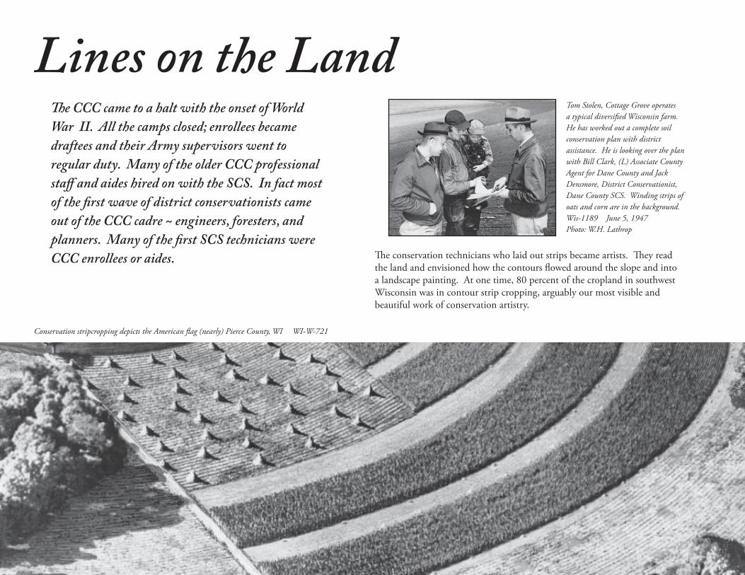
Th e CCC came to a halt with the onset of World
War II. All the camps closed; enrollees became
draftees and their Army supervisors went to
regular duty. Many of the older CCC professional
staff and aides hired on with the SCS. In fact most
of the fi rst wave of district conservationists came
out of the CCC cadre ~ engineers, foresters, and
planners. Many of the fi rst SCS technicians were
CCC enrollees or aides.
Lines on the LandTom Stolen, Cottage Grove operates a typical diversifi ed Wisconsin farm. He has worked out a complete soil conservation plan with district assistance. He is looking over the plan with Bill Clark, (L) Associate County Agent for Dane County and Jack Densmore, District Conservationist, Dane County SCS. Winding strips of oats and corn are in the background.Wis-1189 June 5, 1947 Photo: W.H. Lathrop
Th e conservation technicians who laid out strips became artists. Th ey read the land and envisioned how the contours fl owed around the slope and into a landscape painting. At one time, 80 percent of the cropland in southwest Wisconsin was in contour strip cropping, arguably our most visible and beautiful work of conservation artistry.
Conservation stripcropping depicts the American fl ag (nearly) Pierce County, WI WI-W-721

17
Eau Claire, WI ~ Mrs. M. Pierce operating a grain drill during a period when farm help was scarce because of the war eff ort. Wis-996 April 24, 1942
1940s
Legs Were Our Living Depending upon how diffi cult the land laid and also upon the width of strips, we could lay out 20 to 40 acres in half a day. Th e best I ever did in one day was on a big beautiful ridge up near Sylvan. It was a rare ridge where we could use strips 100 feet wide. And it was one all day job on the same ridge. Under these very rare conditions I came in with 125 acres of strips in one day. A forty laid out in 60-foot strips, which was the prevailing width on most farms, required six miles of walking just on the strip boundaries. Preliminaries took up another mile. Small fi elds added up to more walking accordingly than large fi elds. Anyone involved in laying out strips needed a good pair of legs.
from “Nothing But Conservation” by Roy Dingle
Th e W DitchSCS engineered thousands of acres of concrete or clay tile-drained fi elds and built miles of open ditches. Th e classic W ditch can still be seen ~ spoil spread out of the ditches and onto the fi eld created a W shape. Years later, thousands of acres of wetlands were restored by closing the W ditches.
Jeep tiling machine, Lafayette County, WI Wis-1230 July 23, 1948 Photo: John Baker
World War II brought huge demands for more cropland and better yields. In response, wetland drainage began in earnest to create more croppable acres. Farmers struggled in some fi elds so muddy they needed two tractors to pull wagons to pick up green corn shocks for silage. Th e tractors tore up the fi elds and compacted the soil. Farmers would dip into their cookie jar savings every year to see how many feet of drainage they could aff ord. Soil Conservation Service staff in the east and southeast part of the state earned the everlasting gratitude of those farmers for relieving them of the muck, mud and drudgery that came with wet fi elds.
Sheet erosion. M.M. Keliher D.C walks through inches of silt that washed down these slopes from several one-inch rain events forming these gullies. Wis 1184 Dunn County, WI May 1947

18
Cottage Grove, Dane County, WI Paul Helgesen planting corn in a contour strip. Upper slopes are oats and alfalfa. Th ere is a diversion terrace in the background.Wis-1250 May 1949 Photo: W.H. Lathrop
Dunn Co., WI Gully formed in one day destroying the highway ~ 30-feet deep, 100-feet wide and 150-feet long. March 1945
Dr and Mrs. Bennett and Regional Conservationist McClymonds inspecting Coon Valley conservation work. Frank Mlsna farm on Manske Ridge, Vernon County, WI Wis-1174 , October 1946 Photo M. Schweers
19
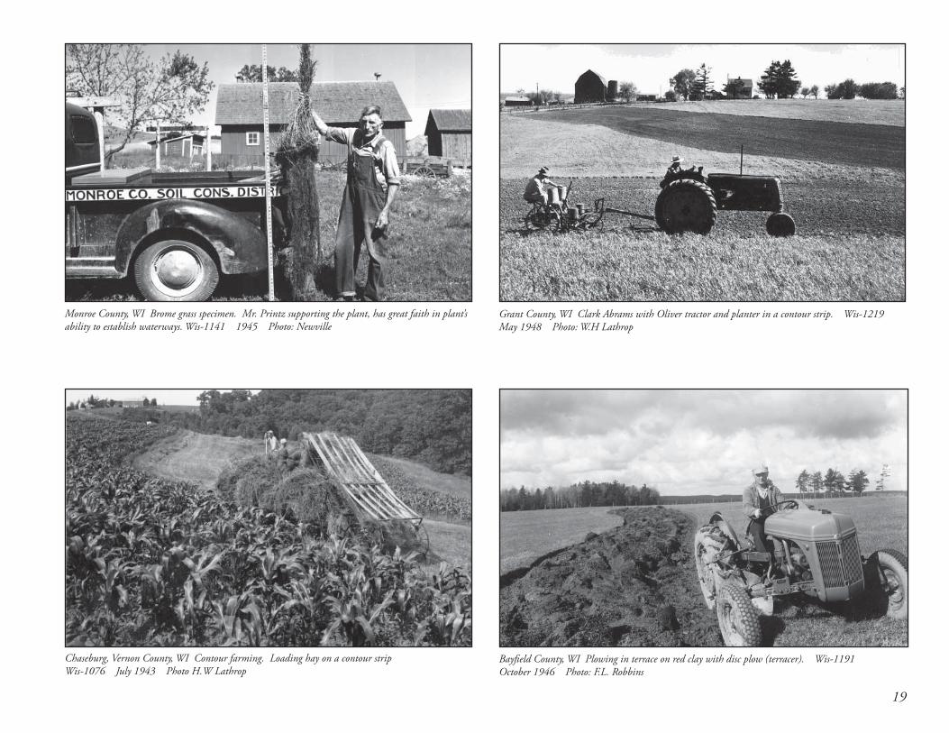
Monroe County, WI Brome grass specimen. Mr. Printz supporting the plant, has great faith in plant’s ability to establish waterways. Wis-1141 1945 Photo: Newville
Grant County, WI Clark Abrams with Oliver tractor and planter in a contour strip. Wis-1219 May 1948 Photo: W.H Lathrop
Bayfi eld County, WI Plowing in terrace on red clay with disc plow (terracer). Wis-1191 October 1946 Photo: F.L. Robbins
Chaseburg, Vernon County, WI Contour farming. Loading hay on a contour strip Wis-1076 July 1943 Photo H.W Lathrop

20
Th e Watershed Protection and Flood Prevention
Act (PL566), enacted in 1954 to help communities
protect, improve, and develop watersheds opened
the door to decades of large scale watershed
projects. Watershed planning and projects
dominated SCS activities for nearly three decades.
Th e Watershed Years 1950s
Initially, to be eligible for PL566, 75 percent of the farmland in the watershed had to be under a conservation farm plan, and the plan had to be implemented. SCS could then develop a Watershed Work Plan to help with the problem at hand ~ gullies, sediment, or fl ood damage reduction. But plans were only approved if the cost-benefi t analysis made it worthwhile – threats to bridges, roads, houses, cropland, particularly high value tobacco cropland, had to outweigh cost of the project. Many, many watersheds were assessed, but only around 20 were completed in Wisconsin.
Alma Creek Watershed, Buff alo County, WI Th e gully area in the picture is to be controlled by dam structures #4 and #5 in this watershed WI-14-8 1955
Alma-Mill Creek Watershed, Buff alo County, WI A detention structure controlling the upper reaches of this watershed. Th ese upland treatments were vital to the successs of the watershed program.WI-139-9 April 1959 Photo E.W. Cole
A washout on a town road near DePere in Brown County, WIWi-195-10 May 1960 Photo R. Forseth

21
Soil Conservationist Bernie Peterson and the Bob Klein family discuss the farm conservation plan they worked out together. By following this plan using the land within its capabilities, soil erosion will be checked and yields and profi ts should increase. WI-225-12
Board of Directors, Mill Creek Watershed Association holding a meeting at the Harris lumber company in Boaz, WI. L to R George Smart, Levi Walter, Dennis Young, Foster Patch, Roy Dingle, SCS Work Unit Conservationist, Gerald Fulton, Roy Nicholson, Henry Slaney, Frank Harris, and Paul Hendricks. WI-17-10 March 1955 Photo: E.W. Cole
Dairy herd in the foreground with contour strip cropping in the background. Blue Mounds, WI WI-27-7 July 1955 Photo: E.W. Cole
Coon Valley, Vernon Co., WI Group inspecting conservation practices on farm of the fi rst cooperators with the Coon Creek Project. Wi-28-2 July 1955 Photo E. Cole

22
Th e completed waterway and structure. Th e waterway has just been mowed and raked. Cattle have been fenced out of the area. Th e structure lowers the water safely to the level of the fl oor of the bridge at the bottom of the picture. Toe-wall and waterway combinations such as this will often cure a gully problem just above a roadside culvert or along a property line. WI-121-5 September 1958
John Bollinger (former SCS Farm Planner); H.H. Bennett (former Chief, SCS; Marv Schweers (former State Conservationist Wisconsin); an Herb Flueck (former State Conservationist, Minn.) standing beside roadside marker commemorating the establishment of the Nation’s First Watershed Project at Coon Valley, Wis. WI-28-9 July 1955 Photo E. Cole
Cedarburg, Washington County, WI Rudy and Agnes Krumbeigel with Work Unit Conservationist, Harold Ryan, SCS, observing the luxuriant growth of alfalfa-brome on their diversion terraces which were constructed last year. Wi-164-9 Sept. 1959 Photo: E.W Cole
Green Bay, Brown Co., WI Work unit offi ce at Green Bay. Mr. Stone, (r) Work Unit Conservationist, Soil Conservation Service greeting landowner. Wi-36-7 April 1956 Photo E. Cole

2323
L to R Avery Clark, Cooperator, Roy Dingle Work Unit Conservationist, Soil Conservation Service, Avery Marshall, veteran instructor looking at Clark’s farm plan, Richland County Soil Conservation District. Wis-1317 March 1955
Th e Conservation TechnicianTh e least recognized partner in the conservation team was the technician. Th e fi rst technicians were CCC aides or enrollees who, as the camps closed, became SCS employees. In later years they may have been farmers looking for other work or technical school grads. However, most SCS-applicable skills were learned through agency training and OJT.
My experience with technicians began in 1959, as an SCS Summer Engineering Technician in Eau Claire. Stanley Borm, of Dunn County, was the “on site technician”, who had been at the Nelson CCC Camp along with Area Conservationist Hal Smith.
Stanley was in his late 50’s when I met him, and a fun guy to be around. When we left the construction site near Pepin we would travel together, but in separate cars back towards Eau Claire. Fortunately, before we parted ways, there was a convenient Root Beer Stand where he would always buy us a cold drink after a hot day on the site.
Stanley was a jokester! Th e following summer, Bob Martin, who later became an Assistant State Conservationist, and I were helping Stanley on the Alma-Mill Creek Watershed, in prime rattlesnake country. Al Kjarsgaard, the area engineer, came down to oversee construction progress. While Al was out on the site, Stanley put a fake coiled rattlesnake on the car seat. When Al came back to the car and saw the snake, he calmly found a hand axe and slashed the snake . . . slicing right through the seat of the government car!
A favorite topic for lengthy discussion with Stanley was his dilemma about whether mortar held bricks together or apart?
Stanley retired at the required age of 70, even though he wasn’t ready to quit. Needing something to keep him busy, he and several retired friends joined the “Green Th umb” program. Together they built the “Caddie Woodlawn Home and Park” and the “Empire in Pine” museum along Hwy 25 in Dunn County.
Stanley Borm was truly an SCS technician to remember! Although anyone who has ever worked in the fi eld could name many more technicians who formed the backbone and spirit of the Soil Conservation Service.
By Stanley Dingle, Retired SCS Design Engineer
Looking over plans for terracing on the farm. River Falls, Pierce County, WI WI-34-2 September 1955 Photo E.W. Cole

24
Productive Farmlands
Contour stripcropping on Kewaunee Silt Loam, Waushara County WI Wis-1406 1961 Photo: E.W. Cole
Random tile drain system being installed in the Kewaunee-Manawa complex soils in micro-relief topography of the area along Lake Michigan. A grassed waterway is under construction through the middle of the farm. Picture is taken looking east. State Point Beach Forest and Lake Michigan in the background. Manitowoc County, WI Wis-1398 July 28, 1960 Photo E.W. Cole
Soil conservation and land improvement for agriculture
continued as the primary work of the agency for more than
40 years, from the 1940s through the 1980s, until evolving
toward a broader natural resource mission beginning in the
1990s.
Careful selection of production sites is the fi rst step in producing choice fruits and vegetables for the commercial market. Basic to the selection are soil and landscape characteristics to satisfy critical demands of the crops to be grown. Walter Raitanen (L), soil scientist for Libby and Frank Anderson State Soil Scientist of SCS, discuss merits of a proposed fi eld location as indicated in an SCS comprehensive soil survey. WI-L-372-11 1970

25
Bad Axe Watershed-One branch of Sidie Hollow which will impound water for fl ood control and recreation area. Conservation practices seen in the background will help prevent silting. Note how the valley fl oor has been destroyed from the numerous fl oods in the past years. Wi-317-4 1962
Watershed projects continue
1960s
Reinforced Concrete Drop Spillway construction, Bay City Watershed Placing steel and forms for concrete in Structure No. 2 Pierce County, WI 1962 Photo: B. Peterson
Th is water control structure and farm pond is on the 160-acre dairy farm of Alois Mashak. Th ere are contour strips to the left. Th e contour strips in the background are on the Cathrine Clemons, Farm Coon Creek Watershed, Monroe County, WI Wis 1418 August 1963 Photo: E.W. Cole
“If this streambank moves back another 10 feet as it did this spring,” said John Bergh, “it will be eight feet into my barnyard. It all but toppled my fences along the bank this year as the water swirled around this bend of the Little Suamico River.” WI-I-391-6
“A prosperous and enduring agriculture depends on an adequate supply of productive land, properly used and so protected from erosion that it will remain permanently productive.” Hugh Hammond Bennett
26
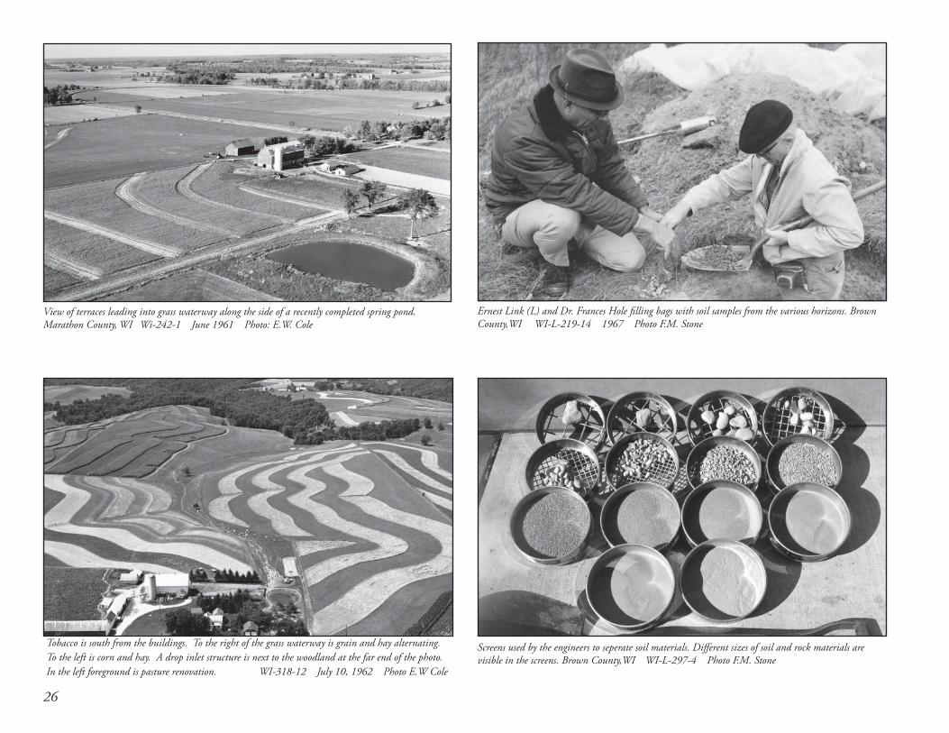
Tobacco is south from the buildings. To the right of the grass waterway is grain and hay alternating. To the left is corn and hay. A drop inlet structure is next to the woodland at the far end of the photo. In the left foreground is pasture renovation. WI-318-12 July 10, 1962 Photo E.W Cole
Ernest Link (L) and Dr. Frances Hole fi lling bags with soil samples from the various horizons. Brown County,WI WI-L-219-14 1967 Photo F.M. Stone
Screens used by the engineers to seperate soil materials. Diff erent sizes of soil and rock materials are visible in the screens. Brown County,WI WI-L-297-4 Photo F.M. Stone
View of terraces leading into grass waterway along the side of a recently completed spring pond.Marathon County, WI Wi-242-1 June 1961 Photo: E.W. Cole

27
George Alley, SCS Woodland Conservationist, checking a nine-year old stand of Black Spruce Rusk County, WI WI-L-315-9 May 1969 Photo: A.H. Martinson
Ditching and dike construction with a tile system for a pump drainage system on peat and muck soil Sheboygan County, WI WI-237-3 June 1961 Photo: E. W. Cole
Elbert and Margaret Twist review their conservation plan with Work Unit Conservatiionist Phil Baun (center) Lake Geneva, Walworth County, WI WI-278-11 October 1961
Field density apparatus used for testing in-place density of soils using the sand funnel method. Work being done by Civil Engineering Technician Harland Gunderson, watched by contractor’s workman. WI-197-8 1960

28
Earth Day
Th e environmental movement changed the way we approach the land. Wisconsin’s own Gaylord Nelson had the vision and the leadership to establish Earth Day, which made environmental protection a major national issue.
National Environmental Policy Act
Th e National Environmental Policy Act (NEPA), signed into law on the fi rst day of 1970, was short, simple, and comprehensive. It established a national policy to protect the environment, created a Council on Environmental Quality (CEQ), and required that a detailed written statements, now known as environmental impact statements, be prepared for major federal actions having a signifi cant eff ect on the environment.
Consider the EarthLand Improvement . . . . . . . . or Resource Protection?
Drainage and dam building began to slow with new concerns about protecting ecosystems and restoring the ecology.
Fence Row to Fence Row
In the ‘70s, USDA Secretary Earl Butz encouraged farmers to plant fence row to fence row to feed a hungry world, and “get big or get out” was his advice to farmers.
SCS continued on with land improvement ~ removing fence rows, draining wetlands for cropland, working toward better yields for agriculture. As the environmental movement grew, SCS began to move toward broader natural resource protection and less single-minded focus on land improvement for agriculture.
Red Clay Project
When President Kennedy fl ew into Duluth, he noted with concern the red clay plume fl owing into Lake Superior, or so the story goes. In the Red Clay Project, SCS experimented with ways to stabilize the red clay soils along the south shore of Lake Superior. Many types of conservation practices were tried out, and many techniques attempted to stabilize the red clay streambanks and shorelines. In the end it proved extremely diffi cult to accomplish, and also impossible to coordinate the wide range of partners across state lines. A fi nal report was issued in 1980.
State Conservationist W.W. Russell (L) and District Conservationist Harold Porter view new SCS sign Madison, WI May 1970

291970s
Water Bank – slowing wetland drainage
Th e Water Bank Program was the agency’s fi rst foray into preserving existing wetlands, instead of draining them. In addition, Water Bank sites restored the surrounding acres to wildlife habitat. Wisconsin had 1,000 10-year contracts, many of which were renewed for a second decade between 1972 and 1995.
Changing times
~ November 1977 ~
Congress passes the Soil and Water Resources
Conservation Act to conserve, protect and enhance
the nation’s natural resources for future uses.
Waterbank project with adjacent nesting cover.
Pearlie Reed, one of the fi rst black employees in Wisconsin, was hired in 1970 as a Soil Conservationist in Kenosha, worked in the Madison, and Sheboygan Falls Field offi ces, then moved on to administrative positions in the Madison State Offi ce, then as State Conservationist in Maryland and California. Pearlie became the agency’s 11th Chief and fi rst African American Chief in 1998. He is currently USDA Assistant Secretary for Administration.
Peg Whiteside, was the fi rst woman engineer for the Soil Conservation Service in Wisconsin.
Kathryn Gorichan, hired in 1974 became Wisconsin’s fi rst woman District Conservationist in Antigo, Langlade County.

30
Landowner Herman Grass(L) discusses conservation plan with District Conservationist Roman Statz. WI-W-112-9 Sauk County 1977
Dam construction continues in Vernon County. Bad Axe soil cement plant set up for dam. WI-W-6-11 1974
Maurice Kroll, SCS aide running a ditch survey with a level WI-L-314-14 May 1970
Th e conservation plan became the basis for all conservation work for the farm, the cooperators agreement and the record of resource concerns.

31
An alluvual fan from a gully in Rosholt soils caused by spring runoff Portage, WI. WI-L-467-7 April 1972
Waterways safely remove excess water from a series of diversions. Door County, WI 1974Photo: G. Link
Pollution Abatement. SCS Area Engineer Emerson Christensen and farmer Rudy Klug discussing pollution abatement type practice. Greenleaf, Brown County, WI November 1971 WI-L-489-16
Concrete slab for barnyard pollution abatement practice. Manure will be picked up from part of this slab and deposited in a stacker. Tongue and grooved 2 by 6 timbers will be nailed to the poles to provide for a manure stacking area. New Franken, Brown Co., WI WI WI-L-506-1 Nov.1972

32
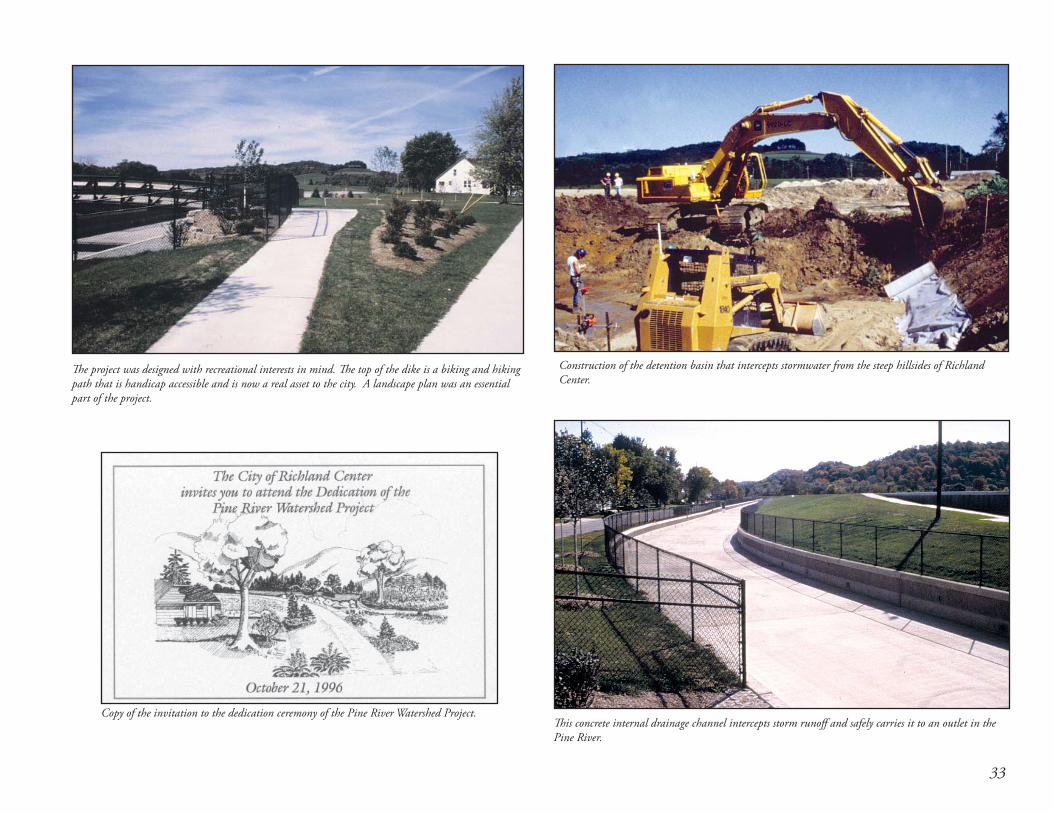
An Adventure in Flood ControlTh e City of Richland Center struggled with the fi nancial and social decision to proceed with the Pine River dike project. Th e City was divided. No fl ooding had taken place within the city for decades, so townspeople did not see the need. Many felt those who made their choice to live by the river should not be subsidized to move out of the fl ood-prone area. And some residents in the dike corridor feared they would not be treated fairly by the Government in relocating their homes. Residents on the land side of the dike within the potential fl ooding area were anxious for the project to proceed so their properties would be protected.
Pine River Flood ProtectionHard decisions were made and the project proceeded. A fl ood of about 50% of the dike design elevation did occur after one portion of the dike was completed. Th e residents saw clearly the value of the dike and support to complete the project never waivered again. Signifi cant fl oods have occurred since the project completion and the dike has performed well. Development in the area protected by the dike has added to the economic development of the community.
by John Ramsden, State Conservation Engineer
An article from the Richland Center Newspaper, the Richland Observer.September 1982
33
Th e project was designed with recreational interests in mind. Th e top of the dike is a biking and hiking path that is handicap accessible and is now a real asset to the city. A landscape plan was an essential part of the project.
Copy of the invitation to the dedication ceremony of the Pine River Watershed Project.
Construction of the detention basin that intercepts stormwater from the steep hillsides of Richland Center.
Th is concrete internal drainage channel intercepts storm runoff and safely carries it to an outlet in the Pine River.

34
What Shall We Call Th is Th ing?
RC&D was a concept initially conceived by Orville Freeman, John F. Kennedy’s Secretary of Agriculture. He was 100 percent in support of the soil conservation district concept ... but he felt problems did not stop at county or district lines. He felt resource issues had an economic impact and could have more of an economic impact if people would work together. After a discussion between Freeman and Donald Williams, the 2nd Chief of SCS, Williams recalls “Freeman turned to me and said “What shall we call this thing?” I said, “Well, we have been talking about resources and conservation and development from the standpoint of labor opportunities and economic opportunities. Really what you are talking about here is the economic side of the results of conservation.” He said, “Okay, let us call them RC&D projects.” Th at was how they were named and that was a start.”
Branching out
Th e immediate priority the Pri-Ru-Ta Council was replacement of old logging dams. Th e dams, constructed before the turn of the century, were in various stages of failure. Some dams had already experienced catastrophic failure, only to be replaced by poorly designed concrete dams. SCS sent in engineers to rebuild the structures. Th e RC&D Program funds provided up to a half a million dollars annually in technical and fi nancial assistance to Pri-Ru-Ta Council projects throughout the 1960’s into the late 1980’s. State Conservationist Richard Ackley, State Engineer Marvin Knabach, and Civil Engineer Duane Wallace were particularly helpful in those early years.
Th ose old wooden dams are all gone now, replaced with concrete and culverts or simply removed. Pri-Ru-Ta moved into forestry, nutrient management, ag product marketing, and livestock grazing, but the focus remains multi- county resource conservation and resources development projects with local sponsors, utilizing diverse funding sources to improve economic and environmental conditions in Wisconsin.
by Chris Borden, Pri-Ru-Ta RC&D Coordinator
Pri-Ru-Ta is the fi rst RC&D
Pri-Ru-Ta was one of the fi rst four RC&Ds authorized in February, 1964 by Donald Williams, Administrator of SCS. (Note – H.H Bennett was “Chief” of SCS, but the title was changed in a 1953 departmental re-organization; Norm Berg changed the title back to Chief during his tenure.) From Soil Conservation magazine, Vol. XXX
Th e fi rst Pri-Ru-Ta Council Board, 1962
~ September 1962 ~ Th e Resource Conservation and Development
Program is created to advance community development and environmental protection
in multi-county areas.

35
RC&Ds now serve all of WisconsinPri-Ru-Ta was the fi rst RC&D formed in Wisconsin and one of the fi rst four in the nation. All Wisconsin counties are now in RC&D:
• Pri-Ru-Ta ~ 1964
• Lumberjack ~ 1968
• Golden Sands ~ 1972
• River Country ~ 1977
• Glacierland ~ 1994
• Southwest Badger ~ 1996
• Town and Country ~ 2002
Resource Conservation and Development (RC&Ds) Councils launched many lake building and lake improvement projects in the cause of tourism and economic development. RC&D and SCS helped develop lakes and ski hills, with surveying and mapping. SCS used every tool in the toolbox to build up the economy and tourism of northern Wisconsin through RC&D. Pri-Ru-Ta
Medford WI
River CountryAltoona WI
Southwest BadgerLancaster, WI
Town and CountryJeff erson, WI
GlacierlandGreen Bay, WI
Golden SandsStevens Point, WI
LumberjackRhinelander, WI
Resource Conservation and Development (RC&D)
If one looks at a map of Northern Wisconsin, one sees many lakes, except in Rusk, Price, and Taylor counties. Th e Pri-Ru-Ta Council associated county wealth and development to lakes and tourism. Th ey wanted lakes. Th ey brought in engineers and soil surveyors to help with this endeavor. Yes, some old logging dams were looked at and replaced, most notably, Miller Dam in Taylor County was rebuilt to establish Chequamegon Waters Flowage. Many other lakes and fl owages were built as well, to help the local economy and quality of life. by Stan Dingle, 1st RC&D Engineer, Pri-Ru-Ta
36
From the beginning, SCS was in the business of making soil surveys, as was the USDA Bureau of Soils, the University of Wisconsin and the Wisconsin Geological and Natural History Survey. In 1952, Congress designated SCS as the single agency in charge of the National Cooperative Soil Survey.
From the 1960 through the 1980s, soil survey crews hopscotched around the state as counties came up with funding. By 1992, most Wisconsin counties had complete or nearly complete soil survey, except for 10 counties in northwestern Wisconsin. A Memorandum of Understanding signed in 1992 led to a massive multi-partnered undertaking, which astonished everyone, and against all odds, completed the soil survey in the fall of 2005 and the digital survey of the state by June 30, 2006.
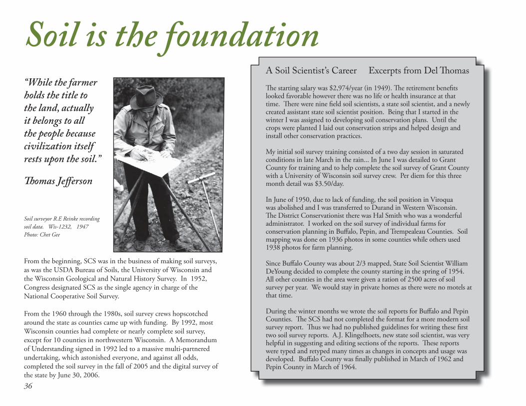
A Soil Scientist’s Career Excerpts from Del Th omas Th e starting salary was $2,974/year (in 1949). Th e retirement benefi ts looked favorable however there was no life or health insurance at that time. Th ere were nine fi eld soil scientists, a state soil scientist, and a newly created assistant state soil scientist position. Being that I started in the winter I was assigned to developing soil conservation plans. Until the crops were planted I laid out conservation strips and helped design and install other conservation practices.
My initial soil survey training consisted of a two day session in saturated conditions in late March in the rain... In June I was detailed to Grant County for training and to help complete the soil survey of Grant County with a University of Wisconsin soil survey crew. Per diem for this three month detail was $3.50/day.
In June of 1950, due to lack of funding, the soil position in Viroqua was abolished and I was transferred to Durand in Western Wisconsin. Th e District Conservationist there was Hal Smith who was a wonderful administrator. I worked on the soil survey of individual farms for conservation planning in Buff alo, Pepin, and Trempealeau Counties. Soil mapping was done on 1936 photos in some counties while others used 1938 photos for farm planning.
Since Buff alo County was about 2/3 mapped, State Soil Scientist William DeYoung decided to complete the county starting in the spring of 1954. All other counties in the area were given a ration of 2500 acres of soil survey per year. We would stay in private homes as there were no motels at that time.
During the winter months we wrote the soil reports for Buff alo and Pepin Counties. Th e SCS had not completed the format for a more modern soil survey report. Th us we had no published guidelines for writing these fi rst two soil survey reports. A.J. Klingelhoets, new state soil scientist, was very helpful in suggesting and editing sections of the reports. Th ese reports were typed and retyped many times as changes in concepts and usage was developed. Buff alo County was fi nally published in March of 1962 and Pepin County in March of 1964.
“While the farmer holds the title to the land, actually it belongs to all the people because civilization itself rests upon the soil.”
Th omas Jeff erson
Soil is the foundation
Soil surveyor R.E Reinke recording soil data. Wis-1232, 1947Photo: Chet Gee
37
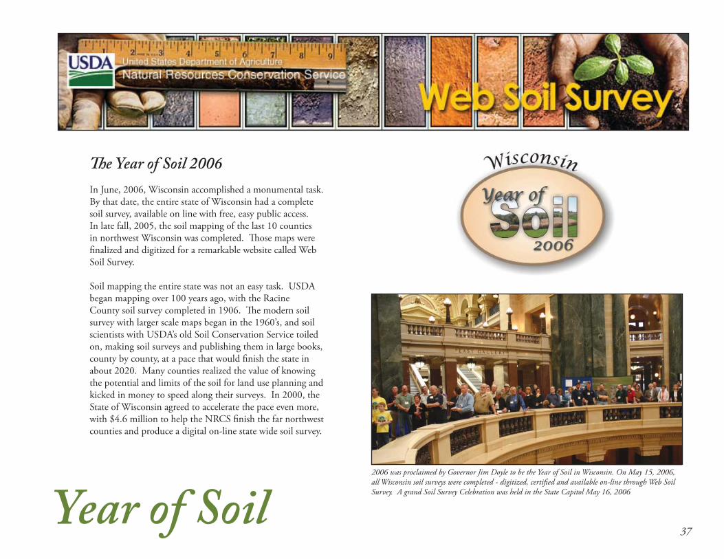
Th e Year of Soil 2006
In June, 2006, Wisconsin accomplished a monumental task. By that date, the entire state of Wisconsin had a complete soil survey, available on line with free, easy public access. In late fall, 2005, the soil mapping of the last 10 counties in northwest Wisconsin was completed. Th ose maps were fi nalized and digitized for a remarkable website called Web Soil Survey.
Soil mapping the entire state was not an easy task. USDA began mapping over 100 years ago, with the Racine County soil survey completed in 1906. Th e modern soil survey with larger scale maps began in the 1960’s, and soil scientists with USDA’s old Soil Conservation Service toiled on, making soil surveys and publishing them in large books, county by county, at a pace that would fi nish the state in about 2020. Many counties realized the value of knowing the potential and limits of the soil for land use planning and kicked in money to speed along their surveys. In 2000, the State of Wisconsin agreed to accelerate the pace even more, with $4.6 million to help the NRCS fi nish the far northwest counties and produce a digital on-line state wide soil survey.
Year of Soil2006 was proclaimed by Governor Jim Doyle to be the Year of Soil in Wisconsin. On May 15, 2006, all Wisconsin soil surveys were completed - digitized, certifi ed and available on-line through Web Soil Survey. A grand Soil Survey Celebration was held in the State Capitol May 16, 2006

38
By the 1970s, innovative farmers were testing out all kinds
of reduced tillage methods to save fuel, time and soil. SCS
began working with the farmer-innovators: those who
loved to experiment with hopes of saving time or money.
Th e No-till RevolutionTh e No-Till Revolution needed teamwork to proceed – SCS sold the concept to farmers as we wrote conservation plans, but we needed research from the University of Wisconsin on techniques, and better chemicals and equipment from the industry. Farmers’ big fear was getting laughed at for growing a weed patch where corn ought to be. We started with less drastic proposals, such as switching from moldboard plow to chisel plow or off set disk, which left a little residue on the surface; then to till-plant systems where a narrow area was tilled and planted at the same time; and then to no-till. It was a slow process to change farmers’ mindsets, but by the 80’s, conversion to conservation tillage was going full throttle.
Training was a huge process. At one farmer workshop in Eau Claire, we were prepared for and expected several hundred people, and were fl oored when 1500 showed up. Th is was in the very late 70’s when milk prices were down and dairies were converting to cash grain.
Sure sign of success: You knew they were
sold when you saw the moldboard plow
out in the yard as a lawn ornament!
by Jim Enlow, State Agronomist and State Resource Conservationist, 1976-1997

391980s
In the early 80s, SCS worked hard on wind erosion control in the Central Sands, promoting windbreaks and buff ers with limited success – a very tough sell.
Conservation tillage was economically cost eff ective.
Grassed waterways are an important conservation practice to convey runoff from terraces, diversions, or other water concentrations without causing erosion or fl ooding. Th ese waterways also protect and improve water quality.
Th e amount of residue left on the fi eld is measured by utilizing a residue rope.

40
Conservation Comes of Age
1985 Food Security Act was landmark legislation for conservation, establishing the concepts of Conservation Compliance, protection for fragile lands, and an option for land retirement. Several enduring conservation programs were created, including Sodbuster, Swampbuster, and the Conservation Reserve Program. Th is legislation completed the change in course of SCS to resource protection from land improvement. It also began the focus of SCS workload on programs and compliance.
Environmental Quality Incentives Program
EQIP became America’s primary cost-sharing program for farmland conservation replacing the old Agricultural Conservation Program. In 1995, in Wisconsin, erosion control and livestock practices for water quality were the primary resource concerns. Over 65 percent of the $16 million in EQIP funds were dedicated to livestock practices in 2009, a typical year.
Th e Farm Bills
Later farm bills built on the 1985 Farm Bill:
• 1990 Food, Agriculture, Conservation, and Trade (FACT) Act of 1990
• 1996 Federal Agriculture Improvement and Reform Act of 1996 extended the Conservation Reserve Program (CRP) and formed the Environmental Quality Incentives Program (EQIP).
• 2002 Farm Security and Rural Investment Act of 2002, added Conservation Security Program (CSP) to reward stewardship.
• Food, Conservation, and Energy Act of 2008
A stream crossing provides a path for livestock to travel to diff erent fi elds while improving water quality and reducing streambank erosion.

41New Programs
NM
P
FO
TG
NR
I CAMPS FOCS ACP LTA RUSLE
SWA
PA+H
CA
FO
CN
MP
EQIP WRP
A New Language
Computerization and offi ce automation ushered in a new language and major cultural change in SCS. Word processing, email and simple offi ce tools became common in the late 1980s. However, the huge potential of geographic-based data for conservation fi eld offi ces began to blossom in the 1990s. Two early custom database applications, CAMPS (Computer Assisted Management Planning System) and FOCS (Field Offi ce Computing System) began the march to automated conservation planning and contracting. Th e ability to digitize soil maps and link them to soil data revolutionized soil surveys. SCS became custodian of the soils layer, an essential layer used in Geographic Information Systems (GIS).
Th e adoption of new technologies including GIS and digital elevation modeling revolutionized both the production and delivery of soil survey information. Soil scientists now map directly on tablet computers instead of drawing on aerial photos with pencil and paper. Interactive websites allow anyone to access and utilize the extensive soils data and maps anywhere in the US.
Acronyms and Programs Galore
At the same time, new programs sprouted out of the Farm Bills, all dubbed with acronyms that created an agency shorthand, but may also have added confusion for many farmers.
In 1980, SCS was responsible for 10 program areas; by 2010, NRCS was responsible for 34 program areas. Th e 2002 Farm Bill began a dramatic increase in fi nancial assistance for conservation funding through NRCS.
Graph: courtesy of Douglas Helms, NRCS National Historian
1.000
2.000
3.000
4.000
5.000
6.000
7.000
8.000
9.000
1935 1940 1945 1950 1955 1960 1965 1970 1975 1980 1985 1990 1995 2000 2005 2010Total asistance, TA + FA, $Billions Technical Assistance, TA, $BillionsFinancial Assistance, FA, $Billions
$ B
illio
ns
USDA Funding 1936-2010*Conservation Technical Assistance (TA) and Financial Assistance (FA)
provided by USDA in year 2009 dollars
*Th e increase in funding in 1986 refl ects the Conservation Reserve Program through the USDA Farm Service Agency.

42
Conservation technology responded to consolidation in the
dairy and livestock industry and growth of animal feeding
operations. Manure management became a critical concern
in Wisconsin.
In the 70’s and 80’s gas shortages pushed farmers to cut fuel costs, and avoid daily manure hauling. Dairies began to expand, with more cows on fewer acres. In the 1990s, with consolidation and expansion in the dairy and livestock industry, and growth of confi ned animal feeding operations (CAFOs), NRCS responded to growing concerns about water quality and manure management. Th e Nutrient Management Practice Standard called for balancing fertilizer and nutrients with actual crop needs, not yield hopes.
State non-point source laws and stronger well codes pressed farmers and conservationists to adopt new and better technology to protect water quality. NRCS conservation practice standards for manure management were constantly being revised – trying to keep pace with the livestock industry’s needs. It also reprised the more holistic, 1930’s style planning, where-in the number of cattle, feed sources, and acres became key to the “new” Comprehensive Nutrient Management Plan (CNMP).
A broader mission . . . NRCS
Contour strips and manure spreading in Dane County, WI
Milking parlor and 300 cow dairy barn
M. G
odfre
y

431990s
1996 ~ A Geography of Hope was published, providing a new direction of stewardship and restoration of the land.
Excerpts from the Geography of Hope
Th e Nation in 1935 made a national commitment to the stewardship of private land in the Soil Conservation Act. Th at Act, passed in the depth of the Dust Bowl, recognized the long term welfare of all Americans rested in the hands of farmers and ranchers struggling to keep their land from eroding away.
Th e land, water, air, plants and animals still require someone to speak for its health, and that responsibility remains a challenge for the NRCS. Indeed, no other agency speaks for the health and fate of America’s private land.
A vision for the next century...We in NRCS have a vision…
... that farmers, ranchers, and all other private landowners understand that they have the care of the land in their hands.
... that our working land produces far more that grain and livestock it produces healthy soil, clean water, wildlife habitat, and pleasing landscapes to enrich the lives of rural and urban citizens alike.
... that local action and voluntary incentives based conservation is the most promising foundation for eff ective land stewardship.
... that the environment is a shared responsibility of urban and rural, public and private, federal state and local.
...Th at our nation will advance another step toward the state of harmony between land and people that we call conservation.
October, 1994, SCS is reborn as NRCS, and the raindrop logo restored.
Th e NRCS website evolved to become the primary mode of information communication for the agency.
www.wi.nrcs.usda.gov
Pat Leavenworth became the fi rst woman to serve as Wisconsin State Conservationist in 1994. Pat’s tenure was strongly shaped by the burgeoning role of the agency in implementing the new Farm Bill programs through frequent budget shortfalls. Building partnerships, customer service and outreach to under-served groups, particularly the Tribal Nations of Wisconsin, were her hallmarks as State Conservationist.
Earl Cosby became the fi rst African American State Conservationist for Wisconsin, serving from 1990 to 1994. He worked to implement a state reorganization and to launch Total Quality Management in Wisconsin before moving on as State Conservationist in Georgia.

44
Farm Bill programs and funding in the 2000s put more focus on land use and water quality with programs and practices to:• Preserve farmland• Restore wetlands and wildlife habitat• Reduce chemicals, nutrients and energy use
Preserve, Restore, Reduce
Th e Wetlands Reserve Program (WRP) accelerated toward large scale wetland restorations. Duff y’s Marsh, a 1,700 acre restoration in Marquette County, was drained decades ago for cropping, and is now restored waterfowl and wetland habitat.
Wetlands Reserve Program
Farm and Ranch Lands Protection Program
Turtle Valley Wildlife Area
Th is Wetlands Reserve Program project in Walworth County restored 1800 acres of high quality wetland complex. Restoration created habitat for waterfowl, sensitive grassland birds and threatened and endangered species.
Th e Farm and Ranch Lands Protection Program (FRPP) allows NRCS to help land trusts and other organizations to purchase agricultural easements on prime farmland, thus relieving the pressure on the farmer to develop the land, and securing the agricultural heritage that defi nes Wisconsin.
“Farmers have only temporary control over their land. It can be theirs for a lifetime and no longer. Th e public’s interest, however, goes on and on, endlessly, if nations are to endure. Hugh Hammond Bennett

452000s
Reduce – nutrients, pesticides
Wildlife Habitat Incentives Program
Environmental Quality Incentives Program
As a dairy and livestock state, nutrient management is the ongoing challenge to clean water. Th e NRCS Nutrient Management Standard 590 set the bar for the state goals and legislation for water quality.
Th e Wildlife Habitat Incentives Program (WHIP) retored thousands of acres of wildlife habitat for species in decline, including in-stream and streambank restorations, new for NRCS.
Conservation Technical Assistance
Conservation Technical Assistance (CTA) is what sets NRCS apart....on-site technical assistance. “We cannot depend on windshield surveys and offi ce planning to carry out a job of the complexity and magnitude of safeguarding our farmland and controlling fl oods.” Hugh Hammond Bennett, 1959.
Environmental Quality Incentives Program (EQIP) is the primary vehicle to help farmers with structural and management practices on agricultural land. Th e program has grown and adapted to become the big tent that agriculture needs to encompass the conventional and the non-conventiional- organic, specialty crops, grazing, energy, tribal agriculture.
Carrying out an eff ective nationwide soil conservation program is not a simple matter in a large country of diversifi ed characteristics and interests.” Hugh Hammond Bennett

46
Grazing Lands Conservation Initiative
Emergency Watershed Program
Torrential rains that fell in Vernon County in August 2007 are held back by the Duck Egg Dam, one of many constructed in the 1970’s.
Grazing Lands Conservation Initiative (GLCI) provided many Wisconsin farmers with the key to the good life, an economically viable and environmentally sound farm operation. Photo: Barbara Jansen
Conservation Stewardship Program
Th e Conservation Stewardship Program (CSP) off ered an entirely new approach... to reward good conservation farmers who care for the land.
Energy conservation and renewable energy production is again changing the face of agriculture, with NRCS program assistance.
Energy Conservation

47
Wisconsin Tribal Conservation Advisory Council
2001 - Th e Wisconsin Tribal Conservation Advisory Council (WTCAC) was organized in March 2001 to identify tribal conservation issues and to advise NRCS on more eff ective ways to deliver USDA programs to assist the eleven Indian Nations of Wisconsin. Th is Conservation Advisory Council, authorized in the 1995 Farm Bill, was the fi rst such council formed in the country.
Jean Buff alo-Reyes, the fi rst chairperson of the WTCAC.
NRCS’s work with Wisconsin tribes began mainly in the 1990s and blossomed in the next decade. Dozens of successful projects have been accomplished with over $1.6 million in funding for tribal conservation projects through the 2002 Farm Bill alone.
Projects range from simple well closures to protect groundwater, to broad campaigns to combat invasive species, to constructed practices to re-establish wild rice beds and sustain native food sources. Because of the uniqueness of tribal agriculture, NRCS worked to adapt existing conservation standards to these needs, such as Wild Rice Seeding, Pest Management for Aquatic Invasive Species, and Tree Drops for Fish Habitat.
Invasive trees and brush were cleared and oak savannah prairie restored to bring these sacred conical burial mounds back to their original setting through a WHIP project with the Ho-Chunk Nation.

48
Dates in Conservation HistoryAugust 25, 1933 ~ Th e Soil Erosion Service (predecessor to the Soil Conservation Service) was established as a temporary organization in the U.S. Department of the Interior.
September 19, 1933 ~ Actual operation of the Soil Erosion Service began under the direction of Hugh Hammond Bennett.
October 10, 1933 ~ Th e Coon Creek Watershed Demonstration Project, near Coon Valley, Wis., was the fi rst soil erosion control project established by the Soil Erosion Service. R. H. Davis was appointed Regional Director. Actual work started November 1933.
October 16, 1933 ~ Walter C. Lowdermilk entered on duty as Vice Director of the Soil Erosion Service. Lowdermilk authored the book, Conquest of the Land through 7,000 Years.
May 11, 1934 ~ First great duststorm.
June 30, 1934 ~ 2,200 persons employed in the Soil Erosion Service
March 6, 1935 ~ Second great duststorm.
March 25, 1935 ~ Th e Soil Erosion Service was transferred to USDA. Th is transfer included all funds, personnel, and property. Th irty-nine of the original 40 erosion control projects established under the Department of the Interior, were in operation.
April 27, 1935 Th is act directed the Secretary of Agriculture to establish an agency to be known as the Soil Conservation Service, a permanent agency of the USDA.
June 30, 1935 ~ 6,622 employees in SCS.
February 27, 1937 ~ Franklin Roosevelt urged passage of state legislation to create soil conservation districts. Th e Wisconsin Soil Conservation District Law, (Chapter 92) passed in 1937 led to the establishment of conservation districts along county lines.

49
June 30, 1937 ~ 13,245 employees in SCS.
1962 ~ Agriculture Act established the National Resource Conservation and Development Program (RC&D)
January 1, 1970 ~ Th e National Environmental Policy Act (NEPA) was signed into law to protect, maintain, and enhance the environment, and mandating these goals within federal agencies.
October 1972, Clean Water Act becomes the cornerstone for surface water quality protection for the nation.
1982 - Th e Wisconsin Soil Conservation District Law, (Chapter 92) was revised, abolishing conservation districts and creating Land Conservation Committees (LCCs), a unit of county government.
October 20, 1994 ~ SCS was renamed the Natural Resources Conservation Service to refl ect the broader mission of the agency. About 12,000 employees in NRCS.
2002 Farm Bill ~ Major changes for greater emphasis on conservation on working lands.
August 1954 ~ Th e Watershed Protection and Flood Prevention Act is enacted to help communities protect, improve, and develop watersheds.
Water Bank Act of 1970 ~ fi rst major eff ort to preserve wetlands in the important migratory waterfowl states.
Dec. 23, 1985 ~ Food Security Act was signed into law, the fi rst farmbill to include a conservation title. Established CRP, WRP, Conservation Compliance, Sodbuster, Swampbuster.Nov 15, 1952 ~ All soil survey activities of USDA placed under SCS.
April 14, 1996 ~ Farmbill established the Environmental Quality Incentives Program (EQIP) and the Wildlife Habitat Incentives Program (WHIP).
2006 ~ Th e entire digital soil survey of Wisconsin is completed.

5050505050500
State Conservationists Marvin F. Schweers 1937-1962
William W. Russell 1962-1971
Richard Akeley 1971-1975
Jerome C. Hytry 1976-1980
Cliff ton A. Maguire 1980-1989
Duane Johnson 1989-1990
Earl Cosby 1990-1994
Patricia S. Leavenworth 1994 - present

51
Final Words...
“Th e success of that demonstration project rang the bells around
the world and they were not the bells that tolled the doom of
progress, but rather those that tolled for better things for the
land that people live by.”
H.H. Bennett. July 1953
“Wisconsin Conservation History” is a wonderful account of
the SES/SCS/NRCS legacy in this state from our Coon Creek
Watershed beginnings to our present array of conservation
programs, watershed initiatives, RC&D endeavors and natural
resource inventories. Th is will be one of many testimonials to all
of Wisconsin’s great conservationists - those who dedicate their
lives for healthy natural resources, healthy people and healthy
communities. Our third workforce generation is now poised to
take over the reins in Wisconsin. I am confi dent that these young
professionals have ample diversity and skills needed to competently
carry the agency into the next hundred years. Th ere will be many
foreseen and unforeseen challenges and new problems to solve.
With them rides much hope for continued conservation successes
where the bells will toll for “better things for the land that people
live by.”
Yours in conservation,
Patricia S. LeavenworthState ConservationistJuly 2010

A Legacy of ConservationCelebrating 75 years of
Helping People Help the Land
2010
"Everything we do, all we share, even whatever we amount to as a great and enduring people, begins with and rests on the sustained productivity of our agricultural land."
Hugh Hammond Bennett