nhss draft report grey county 2016 07 20 jbb
TRANSCRIPT
Grey County Natural Heritage System Study “Green in Grey” DRAFT Prepared for: Grey County 595 9th Avenue East Owen Sound, ON N4K 3E3 Project No. 1575 ӏ July 2016
225 Labrador Drive, Unit 1, Waterloo, Ontario, N2K 4M8 Tel: (519) 725-2227 Web: www.nrsi.on.ca Email: [email protected]
Grey County Natural Heritage Systems Study
“Green in Grey”
DRAFT Project Team:
David Stephenson NRSI - Senior Biologist, Project Advisor Elaine Gosnell NRSI - Senior Biologist Katharina Richter NRSI - Terrestrial & Wetland Biologist, Project Manager Kaitlin Boddaert NRSI - GIS Analyst Lorelei Jones MSH – Principal, Planning
Report submitted on July 18, 2016
___________________________ Katharina Richter
Project Manager Terrestrial and Wetland Biologist
TABLE OF CONTENTS Executive Summary ............................................................................................ 1 1.0 Introduction ............................................................................................... 3 2.0 Context of Grey County ............................................................................ 5 3.0 Existing Protection and Policy Context .................................................. 7
3.1 Provincial Policy Statement ............................................................................... 7 3.2 Endangered Species Act .................................................................................... 9 3.3 Canadian Fisheries Act, 1985 .......................................................................... 10 3.4 Niagara Escarpment Plan ................................................................................. 10 3.5 Grey County Official Plan ................................................................................. 12 3.6 Municipalities .................................................................................................... 15 3.7 Conservation Authorities ................................................................................. 17
4.0 Natural Heritage Systems and Studies ................................................. 19 4.1 What is a Natural Heritage System? ................................................................ 19 4.2 Halton Region Natural Heritage System ......................................................... 21 4.3 Huron Natural Heritage Plan ............................................................................ 22 4.4 Middlesex Natural Heritage System Study...................................................... 24 4.5 Oxford Natural Heritage Study ......................................................................... 25 4.6 Collingwood Natural Heritage System Study ................................................. 26 4.7 Credit Valley Conservation Natural Heritage Systems Strategy ................... 26
5.0 Methods for Establishing the Grey County Natural Heritage System 28 5.1 Consultation ...................................................................................................... 28 5.2 Background Review ......................................................................................... 29
5.2.1 Species at Risk Screening and Significant Wildlife Habitat Screening ...... 30 5.3 Natural Feature Mapping .................................................................................. 31 5.4 Core Area and Linkage Analysis ..................................................................... 33
5.4.1 Core Areas ............................................................................................... 33 5.4.2 Linkages .................................................................................................. 36 5.4.3 Core Area and Linkage Summary ............................................................ 38
6.0 All Natural Heritage Features, Core Areas, and Linkages ................... 39 7.0 Delineation of Core Areas ...................................................................... 43
7.1 Significant Wetlands ........................................................................................ 43 7.2 Significant Woodlands ..................................................................................... 43 7.3 Significant Valleylands ..................................................................................... 44 7.4 Significant Wildlife Habitat ............................................................................... 45 7.5 Species at Risk ................................................................................................. 46
8.0 Policy Recommendations ...................................................................... 48 8.1 Goals and Objectives ....................................................................................... 49 8.2 Natural Environment Policies .......................................................................... 49 8.3 Mapping ............................................................................................................. 50 8.4 Core Areas ........................................................................................................ 51 8.5 Linkages ............................................................................................................ 52 8.6 Natural Heritage Features ................................................................................ 54 8.7 Implementation ................................................................................................. 55
9.0 Conclusion .............................................................................................. 57 10.0 References ........................................................................................... 58 List of Tables Table 1. Municipal Official Plan References ................................................................. 15 List of Figures Figure 1. Number of Deep Interior Polygons by Area Category .................................... 34 Figure 2. Identification of Deep Interior Habitat Areas .................................................. 35 Figure 3. Core Areas by Size ....................................................................................... 40 List of Maps Map 1. Boundaries and Jurisdictions Map 2. All Natural Heritage Features Map 3. Wooded Areas Map 4. Aquatic Features Map 5. Significant Natural Features Map 6. Core Areas and Linkages Map 7. Significant Natural Features, Core Areas, and Linkages Map 8. Natural Heritage System
List of Appendices Appendix I Technical Advisory Committee Information Appendix II County Species Lists Appendix III Species at Risk and Significant Wildlife Habitat Screenings Appendix IV Maps
Map A. Greenway Map B. Wildlife Corridor Analysis Map C. Natural Heritage System and Other Protected Areas Map D. Increased Protection Policy Areas Map E. Newly Protected Areas Map F. Aggregate Pits and Quarries Map G. Geology Features
Appendix V Technical Definitions and Criteria for Key Natural Heritage Features in the Natural Heritage System of the Protected Countryside Area, Technical Paper 1 – Appendix B (OMNR 2012) Appendix VI County Official Plan Section 2.8 Natural Environment Appendix VII Recommended Official Plan Policy Changes Appendix VIII Comment Summary Appendix IX Photo Appendix
Glossary of Acronyms ANSI Areas of Natural and Scientific Interest BSC Bird Studies Canada CA Conservation Authority COSEWIC Committee on the Status of Endangered Wildlife in Canada COSSARO Committee on the Status of Species at Risk in Ontario CUM Cultural meadow CUT Cultural thicket DFO Department of Fisheries and Oceans Canada EC Environment Canada EIS Environmental Impact Study ELC Ecological Land Classification ESA Endangered Species Act GCOP Grey County Official Plan GRCA Grand River Conservation Authority GSCA Grey Sauble Conservation Authority LIO Land Information Ontario MNRF Ministry of Natural Resources and Forestry MSH Macaulay Shiomi Howson Ltd. NCC Nature Conservancy of Canada NEC Niagara Escarpment Commission NEP Niagara Escarpment Plan NHIC Natural Heritage Information Centre NHSS Natural Heritage Systems Study NRSI Natural Resource Solutions Inc. NVCA Nottawasaga Valley Conservation Authority OBBA Ontario Breeding Bird Atlas OMMAH Ontario Ministry of Municipal Affairs and Housing OMNR Ontario Ministry of Natural Resources OP Official Plan OWES Ontario Wetland Evaluation System PPS Provincial Policy Statement PSA Priority Stewardship Area PSW Provincially Significant Wetland SAR Species at Risk SVCA Saugeen Valley Conservation Authority SWH Significant Wildlife Habitat SWHTG Significant Wildlife Habitat Technical Guide TAC Technical Advisory Committee UTRCA Upper Thames River Conservation Authority
Natural Resource Solutions Inc. Grey County Natural Heritage Systems Study DRAFT 1
Executive Summary The team of Natural Resource Solutions Inc. and Macaulay Shiomi Howson Ltd. was retained in November 2014 by Grey County to undertake a Natural Heritage Systems Study to delineate a Natural Heritage System within the County. The Provincial Policy Statement provides this direction. The Natural Heritage System Study for Grey County integrates ecological aspects with planning and policy in order to provide a balanced approach for the County. It builds on similar approaches in southern Ontario, but has been tailored to meet the unique needs of Grey due to its landscape, public interest, and planning needs, establishing a Natural Heritage System through a “made in Grey” approach. Grey County is located in the Great Lakes–St. Lawrence forest region of Ontario, within Ecoregion 6E. It borders Georgian Bay to the north, Bruce County to the west, Simcoe County to the east, Wellington and Dufferin Counties to the southwest and southeast respectively, with Huron County on the southwest corner. The watersheds of the Grand River, Grey Sauble, Nottawasaga Valley, and Saugeen Valley Conservation Authorities fall partially within the County. The Niagara Escarpment traverses the County in the north, fairly close to Georgian Bay. Grey County contains many natural heritage resources, with a forest cover of 39.1%, which is dispersed unevenly within the County. Grey County has a total natural heritage cover of 44.6%, with 39.2% being considered significant features. The NHSS is based on previously mapped and evaluated features and layers that were collected and compiled to form a preliminary mapping base and did not include ground-truthing or changes to the existing mapping layers. Significant features, on which the Natural Heritage System is based, were identified as the following:
Wetlands ≥2ha Provincially Significant Wetlands Significant Woodlands Significant Valleylands Life Science Areas of Natural and Scientific Interest Deer Yards and Deer Wintering Areas Aquatic features (watercourses and waterbodies)
Natural Resource Solutions Inc. Grey County Natural Heritage Systems Study DRAFT 2
All significant natural heritage features, including the core areas and linkages, make up the overall NHS, and support the natural processes to maintain biodiversity, natural functions, wildlife, and ecosystems. The NHS also contributes significantly to human health by providing environmental benefits such as carbon sequestration and climate control; recreational opportunities; as well as social, mental, and spiritual benefits. The Natural Heritage System in Grey County was based on the identification of very large, deep interior habitat areas, comprised of significant features. In total, the Grey County Natural Heritage System is comprised of 71 Core Areas and 82 Linkages, a combined total area of 61,635.0ha, making up 13.6% of the entire County. The Natural Heritage System, which includes the significant natural heritage features, Core Areas, and Linkages, makes up 202,857.2ha; 44.7% of Grey County. The Core Areas range in size from 132ha to 5,216ha. It is recommended that the Core Areas and Linkages will be protected through policy, where new development should be strictly limited. In addition, all other natural heritage features, both significant and not (44.6% of Grey County), will continue to receive protection in Grey County through existing policies in the Provincial Policy Statement, Grey County Official Plan, Niagara Escarpment Plan and Conservation Authority regulations. The Core Areas and Linkages may be enlarged over time, as gaps within Core Areas are naturalized and restored. Certain areas may be added through Species at Risk habitat management and the determination of Significant Wildlife Habitat adjacent to Core Areas and Linkages. In addition, there are many properties within the County of Grey that are in public ownership and receive environmental protection and stewardship. Many residents of Grey County have chosen Grey as their home because they admire and appreciate the natural heritage. Some have established environmental easements on their properties to protect the natural heritage features and wildlife in perpetuity.
Natural Resource Solutions Inc. Grey County Natural Heritage Systems Study DRAFT 3
1.0 Introduction The team of Natural Resource Solutions Inc. (NRSI) and Macaulay Shiomi Howson Ltd. (MSH) was retained in November 2014 by Grey County to undertake a Natural Heritage Systems Study to delineate a Natural Heritage System within the County. NRSI provided the technical background and natural heritage expertise, with MSH providing expertise on policy planning, the communications plan, and the public and stakeholders engagement strategy. Grey County’s Official Plan (2013) currently identifies natural features on an individual basis and includes Provincially Significant Wetlands (PSW), Areas of Natural and Scientific Interest (ANSI), Significant Woodlands, streams/watercourses/waterbodies, and other identified wetlands. Other natural heritage features may be identified and protected incidentally such as habitat of Endangered and Threatened species, Significant Valleylands, and Significant Wildlife Habitat (SWH). A Natural Heritage Systems Study (NHSS) was conducted to take a more holistic and systems-based approach to the natural heritage features in order to ensure that the quality and integrity of natural features are protected for the long-term. Conformity with the Provincial Policy Statement (PPS, OMMAH 2014) was a key trigger for this study. Section 2.1.3 of the PPS states that “Natural heritage systems shall be identified in Ecoregions 6E & 7E, recognizing that natural heritage systems will vary in size and form in settlement areas, rural areas, and prime agricultural areas.” Grey County is located in Ecoregion 6E. The wording of this section of the PPS provides for variability in the identification of Natural Heritage Systems across the Province and as a result, in Grey County the identification of the Natural Heritage System took into account the rich history of settlement, agriculture, resource use, tourism, and recreation. The PPS is supported by Ontario’s Biodiversity Strategy Target 12, which mandates that by 2015, “natural heritage systems plans and biodiversity conservation strategies are developed and implemented at the municipal and landscape levels” (Ontario Biodiversity Council 2011). Ontario’s Biodiversity Strategy (Ontario Biodiversity Council 2011) is the guiding framework for coordinating the conservation of Ontario’s biodiversity; its rich
Natural Resource Solutions Inc. Grey County Natural Heritage Systems Study DRAFT 4
variety of life and ecosystems. Ontario’s 15 biodiversity targets are supported by goals, objectives, and key action items outlined in the Strategy. The Natural Heritage System Study for Grey County integrates ecological aspects with planning and policy in order to provide a balanced approach for the County. The Grey County NHSS builds on similar approaches in southern Ontario, including those for Middlesex, Oxford, and Huron Counties; however it has been tailored to meet the unique needs of Grey due to its landscape, public interest, and planning needs. The study is heavily based on science, and included a review of background data and mapping; a flight over Grey County to take video footage of the landscape; a drive through much of the County to take photographs of certain features and linkages; a literature review; development of landscape criteria; a GIS modelling exercise to map the Natural Heritage System; and development of policy recommendations. Input and feedback from landowners and the public was sought throughout the study and focused on two sets of open houses. The study involved robust agency input from the County, local municipalities, Conservation Authorities, and the Ministry of Natural Resources and Forestry (MNRF) through a Technical Advisory Committee (TAC). All of these factors were incorporated to establish a Natural Heritage System and tailoring it to provide a “made in Grey” approach.
Natural Resource Solutions Inc. Grey County Natural Heritage Systems Study DRAFT 5
2.0 Context of Grey County Grey County is located in the Great Lakes–St. Lawrence forest region of Ontario, within Ecoregion 6E. It borders Georgian Bay to the north, Bruce County to the west, Simcoe County to the east, Wellington and Dufferin Counties to the southwest and southeast respectively, with Huron County kitty-corner in the southwest. The watersheds of 4 Conservation Authorities cover portions of Grey County, as shown on Map 1. Most of Grey County is covered by the Grey Sauble (GSCA) and Saugeen Valley (SVCA) Conservation Authorities, but smaller portions of the County to the east lie within the jurisdiction of the Nottawasaga Valley (NVCA) and Grand River (GRCA) Conservation Authorities. The Niagara Escarpment traverses the County in the north, fairly close to Georgian Bay. Grey County contains many natural heritage resources, with a forest cover of 39.1%. The southern portion of the County, roughly south of Grey Road 4, is dominated by agricultural fields with woodlands remaining mostly in the “back 40”, i.e. woodlots retained in the rear parts of properties. The central portion of the County contains many very large, wooded areas, as well as wetlands. The area within approximately 10km of the Georgian Bay shoreline, especially east of Owen Sound, is less wooded, dominated again by agricultural fields. Several cities and towns are located along the shoreline, as well as recreational areas including ski and golf resorts and associated development. Urban areas along the shoreline include Owen Sound, Meaford, Thornbury, and Craigleith. Some of the other larger towns in Grey County include Dundalk, Durham, Flesherton, Hanover, and Markdale. As part of this NHSS, previously mapped and evaluated features and layers were collected and compiled to form a preliminary mapping base. These natural features are shown on Map 2. This study did not entail ground-truthing or revising existing mapped natural feature layers. Some wetlands have been evaluated and mapped by the MNRF, while the Conservation Authorities have mapped and regulate all wetlands. Significant Woodlands have been mapped by the County of Grey (Map 3). Aquatic features have also been mapped by the Conservation Authorities (Map 4). Deer yards and deer wintering areas have been identified and mapped by the MNRF (Map 3). Known significant natural heritage features are shown on Map 5. Together the significant
Natural Resource Solutions Inc. Grey County Natural Heritage Systems Study DRAFT 6
natural features account for 39.2% of the County. Including non-significant features, the Grey County has a natural heritage cover of 44.6% (this includes all mapped wetlands, woodlands, waterbodies, Significant Valleylands, life science ANSIs, deer yards and wintering areas – see Map 2). As seen on Map 1, Grey County does not contain any First Nations Reserves, although it is traditional land of the Huron, Petun, Saugeen Ojibway Nation, Six Nations of the Grand River, Metis, and other nations (Grey County 2015).
Natural Resource Solutions Inc. Grey County Natural Heritage Systems Study DRAFT 7
3.0 Existing Protection and Policy Context Direction for the identification of a Natural Heritage System is given in the Provincial Policy Statement (PPS) Section 2.1.3, while the Natural Heritage Reference Manual (OMNR 2010) is the primary source of guidance on identifying significant natural features and providing a rationale for natural heritage systems. As Natural Heritage Systems have been identified in other Counties and municipalities based on the PPS and NHRM, the existing approaches taken were used as a basis for the Grey County NHSS. Case studies and examples from Ontario Nature’s Best Practices Guide to Natural Heritage Systems Planning (2014) were also considered. Locally relevant policies and guidelines were collected and reviewed including the Grey County Official Plan, Township Official Plans, and the Niagara Escarpment Plan (NEP) (updated 2015). A brief overview of each piece of legislation relevant to the NHSS is provided in sections below, including the PPS, Official Plans, Endangered Species Act, Fisheries Act, NEP, and the role of Conservation Authorities and their policies. 3.1 Provincial Policy Statement The PPS (OMMAH 2014) is issued under the authority of Section 3 of the Planning Act and came into effect on April 30, 2014, replacing the 2005 PPS. Section 3 requires that decisions affecting planning matters shall be consistent with policy statements under the Act. Section 4.4 of the PPS establishes that the PPS is to be read in its entirety and all relevant policies are to be applied to each situation. In this context, Section 2.1 of the PPS – Natural Heritage, establishes clear direction on the adoption of an ecosystem approach and the protection of resources that have been identified as ‘significant.’ These features are broadly defined within the PPS and rely on the MNRF and the municipality to identify and delineate specific natural features. The Natural Heritage Reference Manual (OMNR 2010) and the Significant Wildlife Habitat Technical Guide (OMNR 2000, OMNR 2012) were prepared by the MNRF to provide guidance on identifying natural features and in interpreting the Natural Heritage sections of the PPS.
Natural Resource Solutions Inc. Grey County Natural Heritage Systems Study DRAFT 8
The Provincial Policy Statement (2014) states that: 2.1.1 Natural features and areas shall be protected for the long term. 2.1.2 The diversity and connectivity of natural features in an area, and the long-term ecological function and biodiversity of natural heritage systems, should be maintained, restored or, where possible, improved, recognizing linkages between and among natural heritage features and areas, surface water features and ground water features. 2.1.3 Natural heritage systems shall be identified in Ecoregions 6E & 7E1, recognizing that natural heritage systems will vary in size and form in settlement areas, rural areas, and prime agricultural areas.
The MNRF provides guidance in identification of a natural heritage system in their Natural Heritage Reference Manual (OMNR 2010). Although the Natural Heritage Reference Manual was based on the 2005 PPS, its guidance may be applied to the 2014 PPS. Natural Heritage Systems are described more fully below in Section 4. The PPS protects Significant Wetlands, Significant Woodlands, Significant Valleylands, Significant Wildlife Habitat, Significant Areas of Natural and Scientific Interest (ANSIs), coastal wetlands; fish habitat; and habitat of Endangered or Threatened species as follows:
2.1.4 Development and site alteration shall not be permitted in: a) significant wetlands in Ecoregions 5E, 6E and 7E1 ; and b) significant coastal wetlands. 2.1.5 Development and site alteration shall not be permitted in: a) significant wetlands in the Canadian Shield north of Ecoregions 5E, 6E and 7E1 ; b) significant woodlands in Ecoregions 6E and 7E (excluding islands in Lake
Huron and the St. Marys River)1 ; c) significant valleylands in Ecoregions 6E and 7E (excluding islands in Lake Huron and the St. Marys River)1 ; d) significant wildlife habitat;
e) significant areas of natural and scientific interest; and f) coastal wetlands in Ecoregions 5E, 6E and 7E1 that are not subject to policy 2.1.4(b) unless it has been demonstrated that there will be no negative impacts on the natural features or their ecological functions.
2.1.6 Development and site alteration shall not be permitted in fish habitat except in accordance with provincial and federal requirements.
Natural Resource Solutions Inc. Grey County Natural Heritage Systems Study DRAFT 9
2.1.7 Development and site alteration shall not be permitted in habitat of endangered species and threatened species, except in accordance with provincial and federal requirements.
2.1.8 Development and site alteration shall not be permitted on adjacent lands to the natural heritage features and areas identified in policies 2.1.4, 2.1.5, and 2.1.6 unless the ecological function of the adjacent lands has been evaluated and it has been demonstrated that there will be no negative impacts on the natural features or on their ecological functions.
2.1.9 Nothing in policy 2.1 is intended to limit the ability of agricultural uses to continue. The Natural Heritage Reference Manual (OMNR 2010) provides technical guidance for implementing the natural heritage policies of the PPS and represents the province’s recommended technical criteria and guidance for identifying and protecting significant natural features as defined in the PPS. Significant Wildlife Habitats have the potential to occur within the County, and such habitats are protected from development under the PPS (OMMAH 2014). In addition, numerous Species at Risk are known to occur within the County and are protected under the Endangered Species Act (ESA) (2007). The Significant Wildlife Habitat Technical Guide (SWHTG) was prepared to assist planning authorities and other participants in the land use planning system (OMNR 2000). The SWHTG is a detailed technical manual that provides information on the identification, description, and prioritization of Significant Wildlife Habitat. The manual is intended for use in the municipal policy and development process under the Planning Act. An addendum to the SWHTG provides further detail on characterizing and identifying Significant Wildlife Habitat in Ecoregion 6E (OMNR 2015). 3.2 Endangered Species Act The provincial Endangered Species Act, 2007, protects Endangered and Threatened species, as identified by the Committee on the Status of Species at Risk in Ontario (COSSARO) and listed on the Species at Risk in Ontario List. The Act also protects the habitat of Endangered and Threatened species. Habitat for Endangered and Threatened species may be included in a Natural Heritage System, but because it is not
Natural Resource Solutions Inc. Grey County Natural Heritage Systems Study DRAFT 10
extensively mapped or even necessarily known, this cannot be done on a large scale. In addition, knowledge about the location of Species at Risk is generally restricted. In order to balance social and economic considerations with protection and recovery goals, the Endangered Species Act enables the Minister of Natural Resources and Forestry to issue permits or enter into agreements with proponents in order to authorize activities that would otherwise be prohibited, providing the legal requirements of the Act are met. As such, in certain circumstances, habitat for Species at Risk may be moved or recreated elsewhere. Habitat for Species at Risk in relation to the Natural Heritage System is discussed below. 3.3 Canadian Fisheries Act, 1985 The Canadian Fisheries Act, 1985, provides provisions for the protection of fish and fish habitat. In 2012, changes were made to the Fisheries Act to enhance the ability of Fisheries and Oceans Canada (DFO) to manage threats to the sustainability and productivity of Canada’s commercial, recreational and Aboriginal fisheries. The Fisheries Act protects fish and fish habitat. Fish habitat is defined in the Act as “spawning grounds and any other areas, including nursery, rearing, food supply and migration areas, on which fish depend directly or indirectly in order to carry out their life processes.” As such, watercourses and waterbodies are generally protected and may be part of a Natural Heritage System. 3.4 Niagara Escarpment Plan The Niagara Escarpment Plan was established in 1985, with recent approved modifications consolidated in 2015, and a proposed Niagara Escarpment Plan dated May 2016, as part of the coordinated review of the Growth Plan for the Greater Golden Horseshoe, the Greenbelt Plan, the Oak Ridges Moraine Conservation Plan, and the Niagara Escarpment Plan by the Government of Ontario. The Niagara Escarpment extends 725km, from Queenston on the Niagara River to the islands off of Tobermory on the Bruce Peninsula, and is recognized as a UNESCO Biosphere Reserve. In 2005, the Niagara Escarpment, which traverses Grey County, was included in the provincial Greenbelt. The Greenbelt Plan identifies where urbanization should not occur in order to protect agricultural areas, ecological features and functions. The policies of the Niagara
Natural Resource Solutions Inc. Grey County Natural Heritage Systems Study DRAFT 11
Escarpment Plan are the policies of the Greenbelt Plan for the Niagara Escarpment Plan Area (NEC 2015). The Niagara Escarpment is a prominent geologic formation in southern Ontario, containing many natural features including the source of many rivers and streams, while also providing many recreational opportunities and aggregate for extraction. Farming is also an important use on the Escarpment. The Niagara Escarpment is protected through the Niagara Escarpment Plan, which provides a framework of objectives and policies that aim to balance development, environmental protection, as well as recreation and tourism uses. The Niagara Escarpment Plan protects the Niagara Escarpment through a series of land use designations including Natural, Protection, Rural, Recreation, Urban, Minor Urban, and Mineral Resource Extraction. The greatest environmental protection is afforded to those areas within the Escarpment Natural and Protection Areas (NEC 2015). Escarpment Natural Areas are areas in a relatively natural state and associated stream valleys, wetlands and forests which are relatively undisturbed. These areas contain important plant and animal habitats and geological features, as well as cultural heritage features and are the most significant natural and scenic areas of the Escarpment. The Niagara Escarpment Plan policy aims to maintain these natural areas (NEC 2015). Escarpment Protection Areas are identified because of their visual prominence and environmental significance, but include lands that have been significantly modified by land use activities such as agriculture or residential development. Protection Areas include land needed to buffer prominent Escarpment Natural Areas and natural areas of regional significance. Niagara Escarpment Plan policy aims to maintain the remaining natural features and the open, rural landscape character of the Escarpment and vicinity (NEC 2015). The Niagara Escarpment Plan also identifies a Niagara Escarpment Parks and Open Space System for the establishment and coordination of a system of publicly owned lands on the Escarpment, as well as the Bruce Trail. There are 6 classes within the Niagara Escarpment Parks and Open Space System: Nature Reserve, Natural
Natural Resource Solutions Inc. Grey County Natural Heritage Systems Study DRAFT 12
Environment, Recreation, Historical, Escarpment Access, and Resource Management Area (NEC 2015). All development or intended uses on lands within the Niagara Escarpment Plan Area need to be in conformity with the Plan, at a minimum. The Grey County Official Plan conforms to the Niagara Escarpment Plan in Section 2.5. 3.5 Grey County Official Plan The Grey County Official Pan (GCOP) was adopted in 1997 and has been amended numerous times. The latest consolidation of the GCOP was June 25, 2013. The GCOP identifies a number of goals, in Section 1.5 including:
“Respect the natural, cultural, and heritage features of the County, including minimizing any adverse impacts on the natural environment, protecting significant environmental features, the water quality of the various watersheds...”.
“Ensure wise management of the physical resources of the County including the conservation of soil, aggregate and forests by providing a framework for sustainable development in the County.”
Environmental objectives are listed in Section 1.6.3 of the GCOP, identifying the desire for environmental protection and restoration, wise use of resources, and restricting development to suitable areas and include the following:
To identify lands with environmental constraints and/or the presence of sensitive features and establish policies to promote the protection, preservation, conservation, maintenance and enhancement of such areas.
To establish policies to ensure only appropriate and compatible development occurs on lands having inherent environmental hazards such as poor drainage, flood susceptibility, erosion, steep slopes, or any other condition which could be hazardous to development or where development would be hazardous to the environment.
To establish policies that will protect the areas of ground water recharge, cold water streams, lakes and other surface waters for their habitat, recreational, ecological and drinking water benefits.
Natural Resource Solutions Inc. Grey County Natural Heritage Systems Study DRAFT 13
To encourage the reforestation of vacant unused areas of land in co-operation with the Ministry of Natural Resources, Conservation Authorities, and volunteer organizations with particular regard for the reforestation of public lands, stream buffer strips, wind breaks, eroding slopes and non-viable agricultural areas.
To promote the wise management of fisheries and wildlife for the environmental, recreational and economical benefits of area residents and visitors.
To maintain and enhance the Niagara Escarpment natural land features as a substantially continuous natural environment while directing appropriate opportunities for development to the Escarpment Recreation Area, Urban Areas and Minor Urban Centre designations of the Niagara Escarpment Plan.
To consider the cumulative effects of new development on the natural environment and surrounding land uses.
Natural environment policies, in Section 2.8, recognize landscape features and processes, and the desire to conserve and maintain them. The policies also promote natural linkages between features in order to enhance ecological features, functions and processes and indicate that the ecological function and biodiversity of the natural heritage system should be maintained, restored or where possible improved. The policies address Hazard Lands, Provincially Significant Wetlands, other identified wetlands, watercourses, Significant Woodlands, and Special Policy Areas. The Hazard Lands have a designation on Schedule A and identify those lands having inherent environmental hazards. The permitted uses are forestry and uses connected with the conservation of water, soil, wildlife and other natural resources. Other uses including agriculture, passive public parks, public utilities and resource based recreational uses are permitted where site conditions are suitable. Provincially Significant Wetlands have also been given a land use designation on Schedule A and no development or site alteration is permitted within them and may only be permitted on adjacent lands if no negative impacts on the natural features or their ecological functions have been demonstrated through an Environmental Impact Study (EIS).
Natural Resource Solutions Inc. Grey County Natural Heritage Systems Study DRAFT 14
Significant Woodlands are shown in Appendix B and therefore currently do not have a distinct land use designation. Woodland is considered to be significant if it is either greater than or equal to 40 hectares in size outside of settlement areas, or greater than or equal to 4 hectares in size within settlement area boundaries. It may also be significant if it meets any two of the following three criteria outside of settlement areas:
(a) Proximity to other woodlands i.e. if a woodland was within 30 metres of another significant woodland, or
(b) Overlap with other natural heritage features i.e. if a woodland overlapped the boundaries of a Provincially Significant Wetland or an Area of Natural and Scientific Interest, or
(c) Interior habitat of greater than or equal to 8 hectares, with a 100 metre interior buffer on all sides.
No development or site alteration is permitted within or adjacent to significant woodlands unless an EIS demonstrates no negative impacts on the natural features or their ecological functions. Special Policy Areas are also shown as a development constraint in Appendix A. The Special Policy Area consists of shallow overburden with karst topography with the depth of soil being generally less than 1m over fractured bedrock (karst). The Natural Function policies address significant natural areas in the County for which there is no mapping or for which mapping is incomplete including Threatened and Endangered species habitat, fish habitat, valleylands, and Significant Wildlife Habitat. Implementation policies identify EIS requirements and indicate none of the natural heritage policies are intended to limit the ability of existing agricultural uses to continue. Policies define adjacent lands and identify the width based on the type of feature. For more details on these policies, see Appendix VI of this report which contains an excerpt of the Grey County Official Plan Section 2.8 Natural Environment. Maps contained in Appendix B also identify wetlands that are not provincially significant, provincially significant Earth and Life Science ANSIs, and watercourses. Policies note that there may be inaccuracies in the mapping.
Natural Resource Solutions Inc. Grey County Natural Heritage Systems Study DRAFT 15
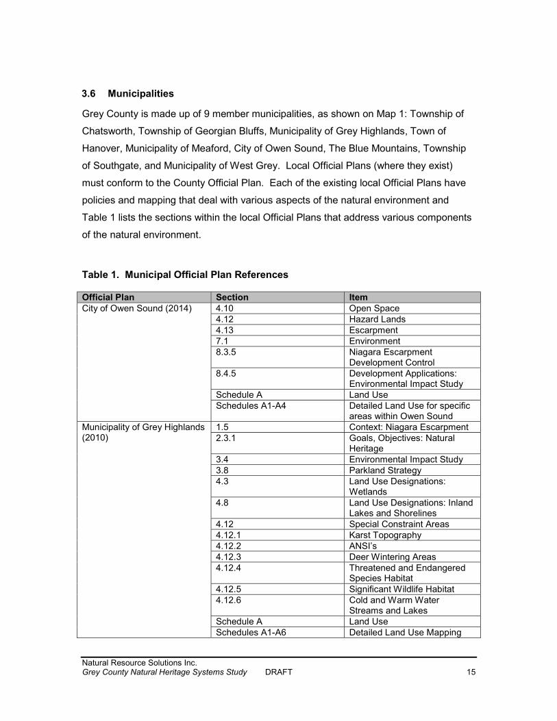
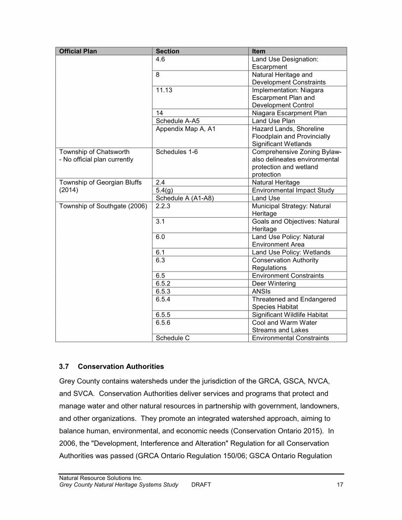
3.6 Municipalities Grey County is made up of 9 member municipalities, as shown on Map 1: Township of Chatsworth, Township of Georgian Bluffs, Municipality of Grey Highlands, Town of Hanover, Municipality of Meaford, City of Owen Sound, The Blue Mountains, Township of Southgate, and Municipality of West Grey. Local Official Plans (where they exist) must conform to the County Official Plan. Each of the existing local Official Plans have policies and mapping that deal with various aspects of the natural environment and Table 1 lists the sections within the local Official Plans that address various components of the natural environment. Table 1. Municipal Official Plan References Official Plan Section Item City of Owen Sound (2014) 4.10 Open Space
4.12 Hazard Lands 4.13 Escarpment 7.1 Environment 8.3.5 Niagara Escarpment
Development Control 8.4.5 Development Applications:
Environmental Impact Study Schedule A Land Use Schedules A1-A4 Detailed Land Use for specific
areas within Owen Sound Municipality of Grey Highlands (2010)
1.5 Context: Niagara Escarpment 2.3.1 Goals, Objectives: Natural
Heritage 3.4 Environmental Impact Study 3.8 Parkland Strategy 4.3 Land Use Designations:
Wetlands 4.8 Land Use Designations: Inland
Lakes and Shorelines 4.12 Special Constraint Areas 4.12.1 Karst Topography 4.12.2 ANSI’s 4.12.3 Deer Wintering Areas 4.12.4 Threatened and Endangered
Species Habitat 4.12.5 Significant Wildlife Habitat 4.12.6 Cold and Warm Water
Streams and Lakes Schedule A Land Use Schedules A1-A6 Detailed Land Use Mapping
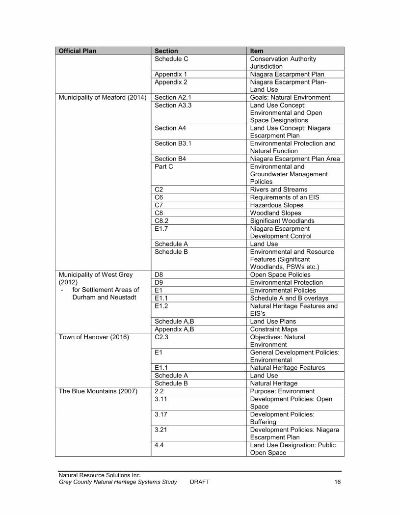
Natural Resource Solutions Inc. Grey County Natural Heritage Systems Study DRAFT 16
Official Plan Section Item Schedule C Conservation Authority
Jurisdiction Appendix 1 Niagara Escarpment Plan Appendix 2 Niagara Escarpment Plan-
Land Use Municipality of Meaford (2014) Section A2.1 Goals: Natural Environment
Section A3.3 Land Use Concept: Environmental and Open Space Designations
Section A4 Land Use Concept: Niagara Escarpment Plan
Section B3.1 Environmental Protection and Natural Function
Section B4 Niagara Escarpment Plan Area Part C Environmental and
Groundwater Management Policies
C2 Rivers and Streams C6 Requirements of an EIS C7 Hazardous Slopes C8 Woodland Slopes C8.2 Significant Woodlands E1.7 Niagara Escarpment
Development Control Schedule A Land Use Schedule B Environmental and Resource
Features (Significant Woodlands, PSWs etc.)
Municipality of West Grey (2012) - for Settlement Areas of
Durham and Neustadt
D8 Open Space Policies D9 Environmental Protection E1 Environmental Policies E1.1 Schedule A and B overlays E1.2 Natural Heritage Features and
EIS’s Schedule A,B Land Use Plans Appendix A,B Constraint Maps
Town of Hanover (2016) C2.3 Objectives: Natural Environment
E1 General Development Policies: Environmental
E1.1 Natural Heritage Features Schedule A Land Use Schedule B Natural Heritage
The Blue Mountains (2007) 2.2 Purpose: Environment 3.11 Development Policies: Open
Space 3.17 Development Policies:
Buffering 3.21 Development Policies: Niagara
Escarpment Plan 4.4 Land Use Designation: Public
Open Space
Natural Resource Solutions Inc. Grey County Natural Heritage Systems Study DRAFT 17
Official Plan Section Item 4.6 Land Use Designation:
Escarpment 8 Natural Heritage and
Development Constraints 11.13 Implementation: Niagara
Escarpment Plan and Development Control
14 Niagara Escarpment Plan Schedule A-A5 Land Use Plan Appendix Map A, A1 Hazard Lands, Shoreline
Floodplain and Provincially Significant Wetlands
Township of Chatsworth - No official plan currently
Schedules 1-6 Comprehensive Zoning Bylaw- also delineates environmental protection and wetland protection
Township of Georgian Bluffs (2014)
2.4 Natural Heritage 5.4(g) Environmental Impact Study Schedule A (A1-A8) Land Use
Township of Southgate (2006) 2.2.3 Municipal Strategy: Natural Heritage
3.1 Goals and Objectives: Natural Heritage
6.0 Land Use Policy: Natural Environment Area
6.1 Land Use Policy: Wetlands 6.3 Conservation Authority
Regulations 6.5 Environment Constraints 6.5.2 Deer Wintering 6.5.3 ANSIs 6.5.4 Threatened and Endangered
Species Habitat 6.5.5 Significant Wildlife Habitat 6.5.6 Cool and Warm Water
Streams and Lakes Schedule C Environmental Constraints
3.7 Conservation Authorities Grey County contains watersheds under the jurisdiction of the GRCA, GSCA, NVCA, and SVCA. Conservation Authorities deliver services and programs that protect and manage water and other natural resources in partnership with government, landowners, and other organizations. They promote an integrated watershed approach, aiming to balance human, environmental, and economic needs (Conservation Ontario 2015). In 2006, the "Development, Interference and Alteration" Regulation for all Conservation Authorities was passed (GRCA Ontario Regulation 150/06; GSCA Ontario Regulation
Natural Resource Solutions Inc. Grey County Natural Heritage Systems Study DRAFT 18
151/06; NVCA Ontario Regulation 172/06; SVCA Ontario Regulation 169/06). Through these regulations, Conservation Authorities regulate development and activities in and adjacent to river or stream valleys, Great Lakes and inland lakes shorelines, watercourses, hazardous lands, and wetlands. The policies ensure conformity of wording across all Conservation Authorities and complement municipal implementation of provincial policies under the Planning Act such as hazardous lands and wetlands. Development taking place on regulated lands may require permission from the Conservation Authority to confirm that the control of flooding, erosion, dynamic beaches, pollution, or the conservation of land are not affected. The regulations also regulate the straightening, changing, diverting or interfering in any way with the existing channel of a river, creek, stream, or watercourse; and regulate the changing or interfering in any way with a wetland (Conservation Ontario 2015). The Ontario Regulation for all Conservation Authorities within Grey County protect wetlands and watercourses. Watercourses are generally also protected as they provide fish habitat, which is protected by the Fisheries Act and the Provincial Policy Statement.
Natural Resource Solutions Inc. Grey County Natural Heritage Systems Study DRAFT 19
4.0 Natural Heritage Systems and Studies 4.1 What is a Natural Heritage System? A Natural Heritage System is defined in the Provincial Policy Statement, 2014 as:
a system made up of natural heritage features and areas, and linkages intended to provide connectivity (at the regional or site level) and support natural processes which are necessary to maintain biological and geological diversity, natural functions, viable populations of indigenous species, and ecosystems. These systems can include natural heritage features and areas, federal and provincial parks and conservation reserves, other natural heritage features, lands that have been restored or have the potential to be restored to a natural state, areas that support hydrologic functions, and working landscapes that enable ecological functions to continue. The Province has a recommended approach for identifying natural heritage systems, but municipal approaches that achieve or exceed the same objective may also be used.
According to the approach outlined in the Natural Heritage Reference Manual (OMNR 2010), the fundamental components of a Natural Heritage System consist of cores and linkages. Core areas are generally the building blocks of the Natural Heritage System and consist of relatively large natural areas which perform important ecological functions, such as Provincially Significant Wetlands and Significant Woodlands. Cores are identified based on a number of factors including size, integrity, shape, rare species and other significant designations, as well as other factors, and in many cases are comprised of clusters of several habitat types. Linkages are components of the Natural Heritage System that allow movement of wildlife and plant species. In addition, the natural heritage systems approach can encourage the consideration of future natural environment conditions including restoration areas and connectivity, thereby including areas that do not currently contain significant natural features or functions, but by association with the core have the potential to provide substantial ecological benefit. Natural Heritage Systems “support the natural processes and ecosystems that are necessary to maintain biological and geological diversity, natural functions and viable populations of native species. They provide essential ecosystem services such as carbon sequestration; resilience to climate change; temperature moderation; clean air; flood control; water storage, supply and purification; biodiversity conservation; and pollination. They also contribute to human health and well-being by providing
Natural Resource Solutions Inc. Grey County Natural Heritage Systems Study DRAFT 20
opportunities for active recreation as well as social, mental and spiritual benefits” (Crombie et al. 2015, p. 104) and are “essential for the health of both human and wildlife populations now and in the years and millenia [sic] to come” (Crombie et al. 2015, p. 98). Several large scale natural heritage system studies have been conducted in southern Ontario that include Grey County. The Great Lakes Conservation Blueprint (Henson and Brodribb 2005) is a natural heritage system analysis of the Great Lakes Region that identifies specific areas that will help conserve biodiversity. The Blueprint mapped protected areas, natural heritage lands, and priority stewardship lands by ecodistrict. It provides charts with detailed information about species and vegetation communities to be protected. Grey County is predominantly covered by the Mount Forest Ecodistrict 6E-5 of the Blueprint, with the Georgian Bay shoreline area covered by Meaford Ecodistrict 6E-4. Big Picture 2002 is another natural heritage system study prepared by the Nature Conservancy of Canada and the Natural Heritage Information Centre, elaborating on a system originally pioneered by Carolinian Canada (Carolinian Canada 2015). The study assembled and interpreted the best available digitally mapped data on biological diversity of southern Ontario to identify high-value core natural areas and highest probability linkages into a landscape-scale Natural Heritage System for southern Ontario (NCC and NHIC 2004). This Natural Heritage System is comprised of core areas with a minimum size of 200ha south of the Canadian Shield, with larger cores (500ha) on the Shield. Minimum corridor widths were identified as 200m plus any adjacent cover. This study was completed as a model for natural heritage planning at finer scales, such as by watersheds or municipalities, and to set priorities for restoration and securement (NCC and NHIC 2004). The City of London, as an example, has included Big Picture mapping in their Official Plan (2006) Schedules as a means to identify areas for naturalization and landowner stewardship initiatives (see Section 15.4.12. of the London OP). Ontario Nature and the Nature Conservancy of Canada (2008) created a greenway vision for the Grey and Bruce Counties, building on the Big Picture 2002 study (Henson 2015). The Greenway consists of core lands and waterways of conservation value, connected by corridors that allow wild species movement. The Greenway is based on
Natural Resource Solutions Inc. Grey County Natural Heritage Systems Study DRAFT 21
forested areas and identifies Priority Stewardship Areas (PSA) based on a forest system assessment, as well as PSA Connection Routes. The study also identified the major rivers within the counties (Ontario Nature and NCC 2008). As the Niagara Escarpment Plan (Niagara Escarpment Commission 2015) was created prior to natural heritage system development, it identifies a different approach to natural heritage protection than more recent studies and plans (Crombie et al. 2015). Nonetheless, it is part of a large-scale Natural Heritage System for Ontario, identified in the provincial Greenbelt, which establishes protective policies for the areas within it (OMMAH 2005). The Proposed Niagara Escarpment Plan (Niagara Escarpment Commission 2016) states that Natural Areas and Protection Areas of the Niagara Escarpment Plan resemble core areas of a Natural Heritage System, and Rural Areas of the Plan resemble linkages of a Natural Heritage System. Natural Heritage Systems have also been identified on a smaller scale. The following sections outline the Natural Heritage System approaches taken in other jurisdictions in southern Ontario, similar to Grey County or within its vicinity. These studies, as well as the large scale studies above, have been reviewed and considered in the development of the Natural Heritage System for Grey County. 4.2 Halton Region Natural Heritage System The Halton Regional Natural Heritage System was identified through the Sustainable Halton study (NSEI 2009). The Natural Heritage System contains some areas of active agriculture and it is noted that agricultural practices should not be restricted. The Sustainable Halton Natural Heritage System is comprised of the following:
Greenbelt Plan Area Niagara Escarpment Plan – Escarpment Natural Areas & Escarpment Protection
Areas Natural heritage features and functions within existing urban areas identified for
protection through earlier studies
Natural Resource Solutions Inc. Grey County Natural Heritage Systems Study DRAFT 22
Core Areas (based on individual natural heritage features such as woodlands, meadows or wetlands, and may include two or more natural heritage features that are in close proximity to one another)
o Woodlands 20ha o Wetlands: 10ha for marsh/thicket; 20ha for treed swamp o Open habitat: 15ha
Core Area Enhancements (one or more core areas that individually or collectively have been enhanced through the addition of supporting areas such as agricultural fields)
Centres for Biodiversity (areas comprised of multiple core areas and core area enhancements that collectively form large ecological areas at least 200ha in area)
Watercourses, surface water features and floodplains Linkages
o Regional linkages: 300-400m wide o Local linkages: 60-100m
Buffers (30m from woodlands and wetlands) 4.3 Huron Natural Heritage Plan The Huron Natural Heritage Plan Technical Document (County of Huron 2015) identified criteria to establish natural heritage feature significance within the County of Huron. The County has 20% natural cover. The study identified 98% of the natural cover within the County as being significant, with the remaining 2% also being important and identified as candidate significant patches. The candidate patches were also identified as important components of the Natural Heritage System. The natural heritage cover in Huron County is not equally distributed and is highly fragmented. The study recommends that connections between natural features should be enhanced where possible.
Natural Resource Solutions Inc. Grey County Natural Heritage Systems Study DRAFT 23
The following significance criteria were established for Huron County: Woodland Criteria
Patch contained a woodland that was 4ha or greater Patch contained at least one woodland with interior area (at least 0.5ha in size;
100m from edge) Patch contained a woodland vegetation community that was within 100m of
another woodland community equal to or greater than 4ha Wetland Criteria
Patches that contained either: o 4ha wooded wetland o 10ha wetland meadow or marsh o 2.5ha thicket swamp
Patch contained a wetland that was near to another wetland (<1000m) Thicket Criteria
Patches that contained a thicket community > 2.5ha Patch contained thicket interior area (at least 0.5ha or greater in size; 30m from
edge) Meadow Criteria
Patches that contained a meadow > 10ha Other Criteria
Patch within 100m from landform feature (gully, shore bluff, valleyland) Patch contained a Species at Risk Patch contained a Provincially or Locally Designated Area Patch was X-large size (>100ha) Patch located within 30m of a watercourse or waterbody Patch had high biodiversity (15 or more vegetation community polygons) Patch contained seeps
The Natural Heritage System of Huron County is comprised of coastal and hinterland landforms, natural heritage features, and watercourses.
Natural Resource Solutions Inc. Grey County Natural Heritage Systems Study DRAFT 24
4.4 Middlesex Natural Heritage System Study The Middlesex Natural Heritage Systems Study (UTRCA 2014) established 15 criteria to evaluate significant land resources within Middlesex County using scientific methods and GIS modeling. The criteria were used to identify significant natural heritage features and functions. Vegetation patches were mapped as part of the study, and those meeting at least one criterion were deemed significant and were identified as part of the Natural Heritage System for the County. Approximately 19.7% of Middlesex County contains significant natural cover. 78.5% of the patches were identified as significant, representing 98.8% of the total patch area. The following significance criteria were established for Middlesex County: Criterion 1 Vegetation Group within or touching a Significant Valley System Criterion 2 Vegetation Group within or touching a Life Science ANSI Criterion 3 Vegetation Group within 30m of an Open Watercourse Criterion 4 All Wetland Vegetation Groups ≥0.5ha Criterion 5 Woodland Vegetation Group ≥4ha Criterion 6 Woodland Vegetation Groups within 100m of a woodland Vegetation
Group ≥4ha Criterion 7 Thicket Vegetation Group ≥2ha Criterion 8 Meadow Vegetation Group ≥10ha Criterion 9 Meadow Vegetation Group within 100m of a large Woodland or large
Thicket Vegetation Group Criterion 10 Vegetation Patches containing a Vegetation Group that meets a Group Criteria
Criterion 11 Vegetation Patch contains a Diversity of Vegetation Ecosystems, Groups or Communities Criterion 12 Vegetation Patches within 100m of a Vegetation Patch that meets other Patch Criteria Criterion 13 Significant Wildlife Habitat

Natural Resource Solutions Inc. Grey County Natural Heritage Systems Study DRAFT 25
Criterion 14 Groundwater Dependent Wetlands Criterion 15 Watercourse Bluff and Deposition Areas Vegetation groups are generally woodlands, wetlands, thickets, and meadows. Vegetation patches are a mosaic of one or more abutting vegetation groups. The MNHSS recognizes the linkage function agricultural fields provide, but does not attempt to map all of these potential system linkages, which need to be identified when there is a conversion of land use. 4.5 Oxford Natural Heritage Study The Oxford Natural Heritage Study (County of Oxford 2006) mapped woodlands and natural areas based on air photo interpretation and GIS analysis. Oxford County has 14.3% natural cover, of which 12.5% is woodland. The study established 9 criteria to determine significant patches within Oxford County. Patches meeting at least one criterion were deemed significant and were identified as part of the Natural Heritage System for the County. In total, 79.5% of all patches were identified as significant. Watercourses within the County were categorized into 3 system types and mapped. The following significance criteria were established for Oxford County: Criterion 1 Patches that contain rare species Criterion 2 Patches that contain habitat designated in the Official Plans of Oxford County (such as Life Science ANSIs, Environmentally Significant
Areas, PSWs, Locally Significant Wetlands, or other designated areas) Criterion 3 Patches within 150m of designated, non-wetland habitats Criterion 4 Patches > 10ha in size Criterion 5 Patches with interior habitat (beyond 200m from edge) Criterion 6 Patches that occur within well-head capture zones or intrinsic groundwater susceptibility areas Criterion 7 Patches that contain an open watercourse or are within 50m of an open watercourse
Natural Resource Solutions Inc. Grey County Natural Heritage Systems Study DRAFT 26
Criterion 8 Patches with the largest amount of area on each landform and soil type in Oxford County and all patches that occur on valley lands Criterion 9 Patches that contain large amounts of each natural vegetation
community type 4.6 Collingwood Natural Heritage System Study The Town of Collingwood is located immediately east of Grey County, on the shores of Georgian Bay. The Town of Collingwood Natural Heritage System study was completed by the Nottawasaga Valley Conservation Authority in October 2011. The Natural Heritage System formed the basis for an update to the Environmental Protection policies of the Town’s Official Plan and Zoning By-law, which were developed by Town staff, Council, and the NVCA, in consultation with the public (Town of Collingwood 2014). Section 4.1 of the Collingwood Official Plan identifies areas of Environmental Protection. The natural heritage lands in Collingwood requiring protection due to their environmental importance are designated Environmental Protection Areas and are shown on Schedules A and B of the Official Plan. The Town of Collingwood identifies two categories of natural heritage features; those with a high level of significance as Category 1, and those with a lower level of significance as Category 2. Category 1 lands are areas where development is prohibited due to their sensitivity, significant functions, attributes, and linkages. They are lands considered to make the greatest contribution to the Natural Heritage System of the Town and include Provincially Significant Wetlands, major river valleys, fish habitat located within Significant Valleylands, and primary woodlands encompassing at least 4ha that are more than 75 years old. The Category 2 lands include Locally Significant Wetlands, younger woodlands encompassing at least 10ha, and fish habitat located outside Significant Valleylands. Limited forms of development may be permissible within Category 2 lands. 4.7 Credit Valley Conservation Natural Heritage Systems Strategy Credit Valley Conservation (CVC) very recently completed a Natural Heritage Systems Strategy (2015) for its watershed, identifying a Natural Heritage System. The Natural Heritage System integrates terrestrial and aquatic components based on GIS mapping
Natural Resource Solutions Inc. Grey County Natural Heritage Systems Study DRAFT 27
and Landscape Scale Analysis to assess and rank existing natural cover in terms of watershed importance. The Natural Heritage System comprises 39% of the CVC watershed, with 29% occupied by natural or naturalizing cover, and 10% occupied by other land uses such as agriculture, open space, or urban areas (CVC 2015). The Natural Heritage System provides a common watershed context for CVC to provide robust, science based natural resource management information to municipalities and key stakeholders, thereby providing efficiencies for planning at provincial, regional, and municipal scales, and lessening uncertainty to watershed stakeholders. The Natural Heritage System is intended to be provided to municipal planning authorities in an advisory capacity as a tool to review existing natural heritage system policies and strategies and to enhance the protection and restoration of natural heritage features and functions for the long term; it is not intended to limit the ability of municipalities to develop their own science-based natural heritage systems (CVC 2015). The Natural Heritage Systems Strategy identified high functioning natural heritage features, supporting features, contributing features, and Centres for Biodiversity, and it based the Natural Heritage System around these features. It is intended that the Natural Heritage System be viewed as a single system and implemented using a systems approach. As not all features and areas of the Natural Heritage System have the same level of ecological importance, different parts of the Natural Heritage System are subject to different policies during implementation by municipalities. Natural heritage features considered in the CVC Natural Heritage System are valleylands, wetlands, woodlands, aquatic habitat, Lake Ontario shoreline, Significant Wildlife Habitat, and habitat for Endangered and Threatened species. Buffers were also incorporated into the Natural Heritage System, as were Centres for Biodiversity, as identified by the study. A variable approach with regards to the Natural Heritage System was taken in the northern versus the southern portion of the watershed (CVC 2015).
Natural Resource Solutions Inc. Grey County Natural Heritage Systems Study DRAFT 28
5.0 Methods for Establishing the Grey County Natural Heritage System 5.1 Consultation The consultant team met with County staff on November 17, 2014 at a start-up meeting to discuss the project and schedule. For the larger audience, the Natural Heritage System Study was called the Natural Environment Study to avoid confusion with built heritage, but the two are in fact the same study. A webpage was created on the County’s website to inform the public and interested stakeholders about the project and to post study notices and information. A notice was also sent out by mail to area residents through as many tax notices as possible, informing residents of the study and indicating that two sets of public Open Houses would be held through the course of this project. A Technical Advisory Committee (TAC) was established at the beginning of the project. TAC members are listed in Appendix I. Three meetings were held with the TAC on February 25, June 22, and September 21, 2015. Information which was provided to the TAC in preparation for each meeting, as well as the presentations and comments, are included in Appendix I, as well as the Terms of Reference (TOR) developed for the TAC. Open Houses were held to inform the public about the study and its results. Two sessions were held, with each session being held once in a northern location and once in a southern location of the County to facilitate attendance. The Open Houses were advertised on the webpage, through newspaper and radio announcements, through social media, and directly to individuals who requested to be on a mailing list. Open Houses were held on the following dates and locations: Open House 1 March 30, 2015 – Owen Sound March 31, 2015 – Durham Open House 2 December 10, 2015 – Markdale and Owen Sound A summary of comments received during this study are included in Appendix VIII.
Natural Resource Solutions Inc. Grey County Natural Heritage Systems Study DRAFT 29
5.2 Background Review The first step in identifying a recommended Natural Heritage System for the County was the collection and review of existing natural heritage information and mapping across the County. All available natural feature data and mapping was collected from Grey County, GRCA, GSCA, NVCA, and SVCA. Legacy data from the MNRF, Natural Heritage Information Centre, MNRF wetland evaluations and ANSIs was collected. Mapping of designated natural features including Significant Woodlands, Provincially Significant Wetlands, other wetlands, ANSIs, watercourses and known locations of Significant Wildlife Habitat was collected. Wildlife species lists were compiled for the entire County using the wildlife atlases, including the Ontario Breeding Bird Atlas (BSC et al. 2006), Ontario Mammal Atlas (Dobbyn 1994), Ontario Reptile and Amphibian Atlas (Ontario Nature 2014), Ontario Butterfly Atlas (Jones et al. 2013), and Ontario Odonata Atlas (NHIC 2005). Data from wildlife atlases is provided based on 10x10km survey squares. All wildlife species reported from squares that overlap with Grey County were compiled. The Checklist of Vascular Plants for Bruce and Grey Counties Ontario (Owen Sound Field Naturalists 2010) was used to develop a list of plants for Grey County. Species lists were supplemented with data from the Natural Heritage Information Centre (MNRF 2015), a County list of Species at Risk provided by the MNRF (2015), and a review of aquatic Species at Risk distribution maps for the watercourses within the County of Grey (DFO 2015). The compiled species lists are appended (Appendix III) and were used to provide an understanding of the wildlife and plant communities known from Grey County, including significant species. The background review included some field reconnaissance at a high level. A flight over Grey County was undertake on May 6, 2015 to take video footage of the landscape. Ground-level photos were taken of select sites on a drive through the County on September 21, 2015. Some of these photos are included in Appendix IX.
Natural Resource Solutions Inc. Grey County Natural Heritage Systems Study DRAFT 30
5.2.1 Species at Risk Screening and Significant Wildlife Habitat Screening Wildlife lists were used to complete screening assessments of Species at Risk with potential to inhabit the County and to ensure they be included in the Natural Heritage System. SAR are those listed on the Species at Risk in Ontario List (MNRF 2015). These include species identified by COSSARO as provincially Endangered, Threatened, or Special Concern. Species listed as Endangered or Threatened are protected by the Endangered Species Act, 2007, which includes protection to their habitat. The SAR screening assessment is included in Appendix III. Species lists also provided a starting point for addressing Significant Wildlife Habitat in the County. The Significant Wildlife Habitat Technical Guide (SWHTG) outlines the types of habitats that the MNRF considers significant in Ontario for wildlife, and provides criteria to identify these habitats (OMNR 2000, OMNR 2012). The SWHTG groups Significant Wildlife Habitat into four broad categories: seasonal concentration areas, rare vegetation communities and specialized wildlife habitat, habitats of species of Conservation Concern, and animal movement corridors. A screening for the presence of Significant Wildlife Habitat was completed for the County and is included in Appendix III. A screening for Species of Conservation Concern is also included in the appendix. Species of Conservation Concern refer to:
species designated provincially as Special Concern, species that have been assigned a conservation status (S-Rank) of S1 to S3 or
SH by the Natural Heritage Information Centre, and species that are designated federally as Threatened or Endangered by the
Committee for the Status of Endangered Wildlife in Canada (COSEWIC), but not provincially by COSSARO. These species are protected by the federal Species at Risk Act, but not by the provincial Endangered Species Act.
Natural Resource Solutions Inc. Grey County Natural Heritage Systems Study DRAFT 31
5.3 Natural Feature Mapping Many significant natural features in the County have already been identified and mapped. Mapping layers for natural heritage features were requested and received from the County, GRCA, GSCA, NVCA, SVCA, and the MNRF Land Information Ontario (LIO) database, as follows: Natural Heritage Feature Mapping Layer(s) Provided by: Provincially Significant Wetlands MNRF Wetlands Conservation Authorities Significant Woodlands Grey County Woodlands LIO Significant Areas of Natural and Scientific Interest (Earth Science and Life Science)
MNRF
Watercourses, Waterbodies Conservation Authorities Deer Yard (Stratum 1) and Deer Wintering Area (Stratum 2)
MNRF
Please note not all of the above-listed layers are significant natural heritage features. For example, the Woodlands layer provided by LIO (and shown in Map 3), has been used as background data, but does not represent the identified Significant Woodlands, which have been identified by Grey County, and utilized as a separate layer. The above mapping layers were used to distill the key core and linkage area mapping. The existing significant natural heritage feature mapping was compiled onto one map as a starting point for the Natural Heritage System (Map 5). This mapping includes many of the significant natural heritage features as listed in the Provincial Policy Statement, but did not include Habitat of Endangered and Threatened Species, Significant Valleylands, or Significant Wildlife Habitat, as these have not been defined or mapped in Grey County. These features, however, are addressed in this study. Significant Valleylands were identified through the course of this study by the participating Conservation Authorities (Map 4) and have been mapped as 200m wide corridors for the purposes of and scope of this study. Detailed delineation of Significant
Natural Resource Solutions Inc. Grey County Natural Heritage Systems Study DRAFT 32
Valleylands should be done on a site specific basis as per the criteria outline in a section below. Major rivers, as identified in the Greenway study (Ontario Nature and NCC 2008), were also considered. Photos 2, 9, 10, and 11 (Appendix IX) show Significant Valleylands. Mapping of Species at Risk is sensitive data that is generally not provided in public reports. In addition, the province has not been comprehensively surveyed for Species at Risk or their habitats. The same is true for Significant Wildlife Habitat. Based on our analysis through the Species at Risk and Significant Wildlife Habitat screenings, much of the habitat for Species at Risk, as well as Significant Wildlife Habitat will already be included in the mapping of significant natural features identified above. For example, many Species at Risk require woodland and/or wetland habitats for their survival and reproduction. These habitats are well documented in the County and are protected through existing policies. Further identification and mapping of Species at Risk habitat and Significant Wildlife Habitat is to be done at more detailed studies such as Environmental Impact Studies completed on a site specific scale. Incorporation of these areas into the Natural Heritage System is detailed below. All wetlands, regardless of size, are protected by Conservation Authority regulations (see Section 3.7). For the purposes of this study, wetlands less than 2ha in area were not mapped or included. Wetlands smaller than 2ha in area are referred to in the Ontario Regulations, as well as the Ontario Wetland Evaluation System (OWES) (OMNR 2013), as requiring different consideration. The significant features are shown on Map 5. Together, the significant natural features within the County total almost 180,000ha, or 39.2% of the County. Significant natural features in Grey County for the purposes of delineating the Natural Heritage System were identified as the following:
Wetlands ≥2ha (CA layers) Provincially Significant Wetlands (PSW) (MNRF layer) Significant Woodlands (County layer) Significant Valleylands (identified through NHSS – mapped as 200m wide corridor) Life Science ANSI (MNRF layer) Deer Yard (Stratum 1) and Deer Wintering Area (Stratum 2) (MNRF layer) Aquatic features (watercourses and waterbodies) (CA layers)
Natural Resource Solutions Inc. Grey County Natural Heritage Systems Study DRAFT 33
The woodland areas as mapped by the County and LIO are shown on Map 3. As noted above, these areas were used a background layers to distill natural core areas and linkages. The most accurate and recent mapping layers available were used for this study. The GIS layers were taken “as is”. Based on the size of the County and the scope of this project, the mapping layers could not be reviewed or revised for accuracy. It should be noted that many layers were created through desk-top review of aerial photographs by the source agency and have not been staked or verified in the field. The Grey County Official Plan states the following regarding Significant Woodlands:
The identification was primarily a desk-top based Geographic Information Systems (GIS) exercise and the County acknowledges that inaccuracies or omissions in the mapping may be present. As a result site visits by qualified individuals may be required at the application stage to scope any potential studies. (Section 2.8.1)
Criteria for in-the-field natural feature boundary delineation and verification are provided in Section 7 of this report. 5.4 Core Area and Linkage Analysis 5.4.1 Core Areas Once the significant natural features were identified and the mapping layers compiled, the mapping was assessed for habitat clusters that could be identified as “Core Areas”. Core Areas were identified in this study based on very large interior habitat conditions. Typically interior habitat is defined as the area 100m from the edge, especially in woodlands (OMNR 2010), and the area even further from the edge, such as 200m or more, is referred to as “deep interior habitat” (OMNR 2010, OMNR 2012, UTRCA 2009). Many forms of wildlife are often cited as requiring habitat 100m from the edge (often from development), as this distance provides relative seclusion from outside influences (OMNR 2010, EC 2013). Whereas many municipalities in southern Ontario have low natural cover and lack Core Areas with any interior habitat even 100m from the edge, Grey County has a high proportion of natural cover (44.6%) and thousands of areas that provide some interior
Natural Resource Solutions Inc. Grey County Natural Heritage Systems Study DRAFT 34
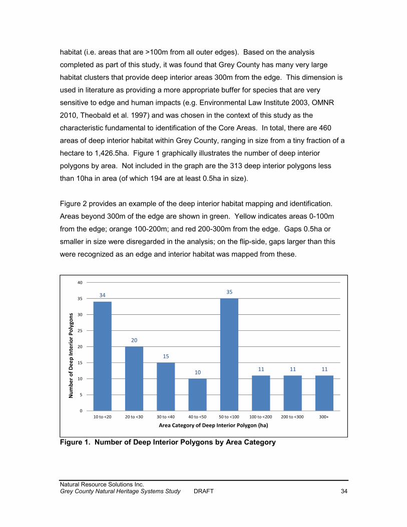
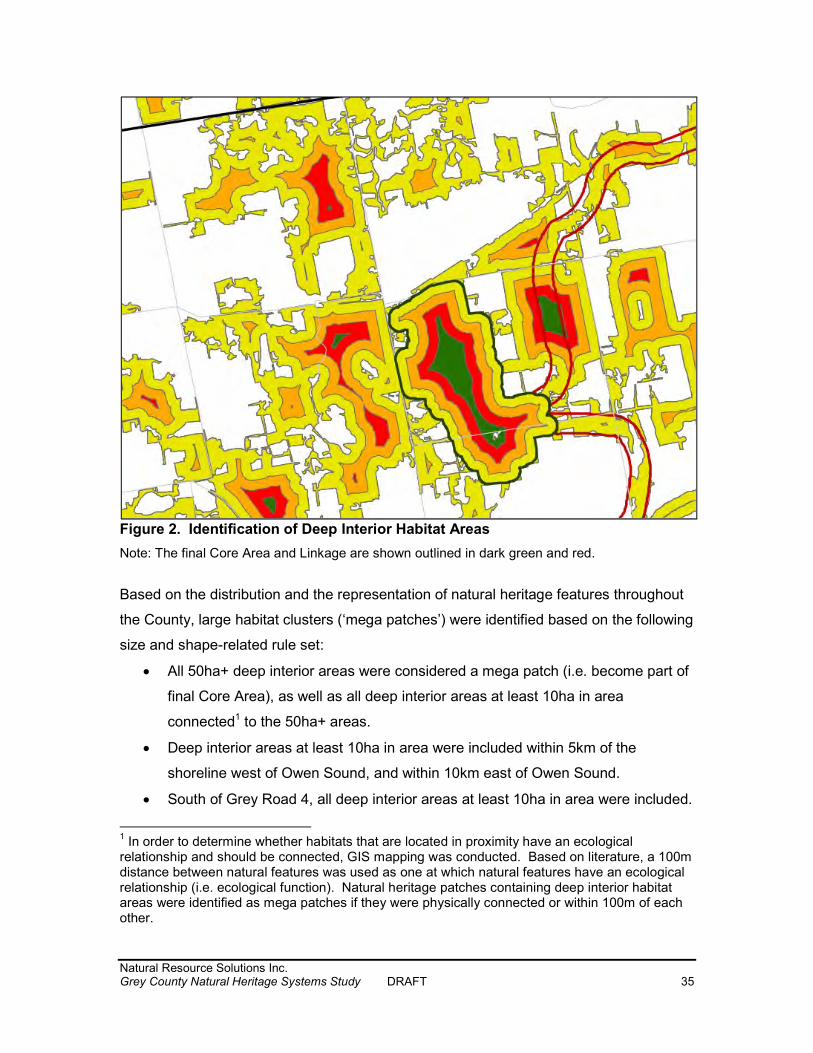
habitat (i.e. areas that are >100m from all outer edges). Based on the analysis completed as part of this study, it was found that Grey County has many very large habitat clusters that provide deep interior areas 300m from the edge. This dimension is used in literature as providing a more appropriate buffer for species that are very sensitive to edge and human impacts (e.g. Environmental Law Institute 2003, OMNR 2010, Theobald et al. 1997) and was chosen in the context of this study as the characteristic fundamental to identification of the Core Areas. In total, there are 460 areas of deep interior habitat within Grey County, ranging in size from a tiny fraction of a hectare to 1,426.5ha. Figure 1 graphically illustrates the number of deep interior polygons by area. Not included in the graph are the 313 deep interior polygons less than 10ha in area (of which 194 are at least 0.5ha in size). Figure 2 provides an example of the deep interior habitat mapping and identification. Areas beyond 300m of the edge are shown in green. Yellow indicates areas 0-100m from the edge; orange 100-200m; and red 200-300m from the edge. Gaps 0.5ha or smaller in size were disregarded in the analysis; on the flip-side, gaps larger than this were recognized as an edge and interior habitat was mapped from these.
Figure 1. Number of Deep Interior Polygons by Area Category
34
2015
10
35
11 11 11
0
5
10
15
20
25
30
35
40
10 to <20 20 to <30 30 to <40 40 to <50 50 to <100 100 to <200 200 to <300 300+
Number
of Dee
p Interi
or Poly
gons
Area Category of Deep Interior Polygon (ha)
Natural Resource Solutions Inc. Grey County Natural Heritage Systems Study DRAFT 35
Figure 2. Identification of Deep Interior Habitat Areas Note: The final Core Area and Linkage are shown outlined in dark green and red. Based on the distribution and the representation of natural heritage features throughout the County, large habitat clusters (‘mega patches’) were identified based on the following size and shape-related rule set:
All 50ha+ deep interior areas were considered a mega patch (i.e. become part of final Core Area), as well as all deep interior areas at least 10ha in area connected1 to the 50ha+ areas.
Deep interior areas at least 10ha in area were included within 5km of the shoreline west of Owen Sound, and within 10km east of Owen Sound.
South of Grey Road 4, all deep interior areas at least 10ha in area were included. 1 In order to determine whether habitats that are located in proximity have an ecological relationship and should be connected, GIS mapping was conducted. Based on literature, a 100m distance between natural features was used as one at which natural features have an ecological relationship (i.e. ecological function). Natural heritage patches containing deep interior habitat areas were identified as mega patches if they were physically connected or within 100m of each other.
Natural Resource Solutions Inc. Grey County Natural Heritage Systems Study DRAFT 36
These reflect that in the portions of the County along the shoreline, and south of Grey Road 4, the percent cover and size distribution of the habitat patches is substantially lower than in the central portions of the County. As such, north of Grey Road 4 but south of the shoreline areas, natural heritage patches with deep interior areas less than 50ha were excluded if they were not connected to another patch with significant deep interior area. Primary, Secondary and Tertiary Settlement areas were excluded as well, as were areas with an approved secondary plan, which already addresses natural environmental features on those lands.2
Core Areas were delineated based on the identification of mega patches, as the patch boundary, i.e. the outermost limit of the compilation of significant natural features. Narrow fingers, such as hedgerows, were not included in the Core Area delineation (see Figure 2). Based on this, it is important to note that the actual area of the Core is much larger than the areas of the deep interior discussed above. For example, a hypothetical circular Core Area supporting a 10ha deep interior would be approximately 72ha in total area. Examples of Core Areas are shown in Photos 3 and 4 in Appendix IX. 5.4.2 Linkages Following the identification of Core Areas, a series of linkages were identified to provide connectivity between Cores and establish a system of natural heritage. Linkages are designed to provide movement corridors for both plants and animals between Core Areas, and provide and protect biodiversity and the long-term viability of ecological systems (OMNR 2010). They support natural processes which are necessary to maintain biological and geological diversity, natural functions, viable populations of indigenous species, and ecosystems. The Linkages were identified based on several factors including using the areas of greatest natural cover (terrestrial and/or aquatic, as well as areas of deep interior habitat), while focusing on the shortest distance between Core Areas. The video 2 The Castle Glen development, southeast of Ravenna, is the only development that applied. A Core Area otherwise included because its 10 to <30ha deep interior area is located within 10km of the Georgian Bay shoreline, as well as being 100m from a deep interior habitat area at least 50ha in size. Once the approved development proceeds, the Core Area criteria are no longer met.
Natural Resource Solutions Inc. Grey County Natural Heritage Systems Study DRAFT 37
footage and drive through the County were considered in the delineation of Linkages. The number of Linkages at the County scale was minimized, while still providing connectivity between Core Areas. A corridor width of 200m was used to identify Linkages. This width was identified in Grey County based on the fact that interior habitat is generally identified as habitat 100m from the edge (OMNR 2010, EC 2013). A 200m wide linkage will, in theory, provide some interior habitat. The 200m wide linkage also provides consistency with the 200m wide Significant Valleyland corridor. A 200m wide linkage (i.e. corridor) width is supported by the Big Picture natural heritage system for Ontario (Carolinian Canada 2000 and 2015, NCC and NHIC 2015). As Linkages are generally identified in areas with existing natural cover, they will provide appropriate habitat for wildlife movement and dispersal of flora. Linkages identified as Connection Routes and mapped in Ontario Nature’s Greenway System (2008) were considered and reviewed, as was MNRF’s landscape connectivity analysis (Bowman and Cordes 2015, Koen et al. 2014). Linkages are located outside of settlement areas, with the exception of Linkages in Owen Sound and Springmount. In both of these areas, natural cover between Core Areas is limited. Rather than identify a linkage between Core Areas through existing agricultural areas with no natural heritage features, the Linkages were delineated along existing natural features within the settlement boundary. The Owen Sound Linkage is comprised of Significant Woodland and a watercourse (see Photo 1 in Appendix IX). The Springmount Linkage is comprised of Significant Valleyland, Significant Woodland, wetland, and a watercourse (see Photo 2 in Appendix IX). In these two cases, the Linkage may be narrower than elsewhere in the County. See the policy discussion below. Linkages are not necessarily located in pristine natural environment, but partially occur through agricultural fields (see Photo 8). Proposed polices do not prohibit agricultural uses and operations in these areas; they may provide appropriate habitat for species and/or offer opportunities for stewardship. Other photos of Linkages are included in Appendix IX: Photos 5, 9, and 10.
Natural Resource Solutions Inc. Grey County Natural Heritage Systems Study DRAFT 38
5.4.3 Core Area and Linkage Summary A random sub-sample of Core Areas was reviewed using air photos and the aerial video footage to assess the mapping approach. Core Area boundaries should be refined at a site specific scale, as necessary, and as outlined in Section 7. The identified Core Areas and Linkages are shown on Map 6, with the Niagara Escarpment Plan Area shown for comparison purposes. The PPS (OMMAH 2014) designates an adjacent lands zone on natural features for the purpose of protecting them from potential impacts. A 120m adjacent lands zone, as per the PPS, is shown around each Core Area to identify the area where impacts to natural features may arise when development occurs and requires consideration through an EIS.
Map 7 overlays the Core Areas and Linkages over the significant natural features. This map can be utilized in land use planning, reviewing development applications, and as a basis for targeting restoration and stewardship programs. This map can be used to provide the details of significant natural features comprising each Core Area, details of the route and make-up of Linkages, as well as understanding features that are outside of the Core Areas and Linkages.
Natural Resource Solutions Inc. Grey County Natural Heritage Systems Study DRAFT 39
6.0 All Natural Heritage Features, Core Areas, and Linkages The Natural Heritage System identified for Grey County is consistent with the approach prescribed by the PPS (2014), as defining a network of Cores and Linkages. The Core Areas and Linkages were identified based on the unique landscape and the context of Grey County, incorporating public input, County planning staff needs, and TAC comments and guidance. Current policies provide varying degrees of protection to Grey County’s natural heritage features (Grey County 2013), as described in Section 3, while policy guidance for the new Natural Heritage System is provided in Section 8. The Natural Heritage System includes a subset of the County’s natural heritage features that together form the Core Areas and Linkages of the Natural Heritage System and receive the highest level of protection compared to many of the other remaining non-NHS natural features. The Grey County Natural Heritage System includes 71 Core Areas and 82 Linkages. The Core Areas range in size from 132ha to 5,216ha with a total area of 55,104.3ha (12.1% of the entire County; 30.6% of the mapped significant natural features). Figure 3 shows the number of Core Areas by size category. The identification of the Natural Heritage System is based on a review of the natural heritage features in the County, as well as the current protection and conservation afforded these areas by existing policies and regulations (e.g. PPS, CA regulations, County OP). Based on the relatively high percent natural cover in the County and the landscape context across the County, appropriate size thresholds for Core Areas were determined, which differ from north to south, and in rural versus settlement areas across the County. Together these resulted in the identification of a Natural Heritage System that differs from other municipalities with lower natural cover and that contain fewer natural heritage features. A key finding was that the County sustains a number of very large clusters of natural habitats, 17 of which are greater than 1,000ha in area. Such large natural habitats are notably absent in other Natural Heritage Systems in southern Ontario. As such, the focus of this NHSS was on the identification of mega-patches that would be an additional layer to the other natural features currently being protected. The identification of the Core Areas is based on the compilation of natural features which provide deep interior
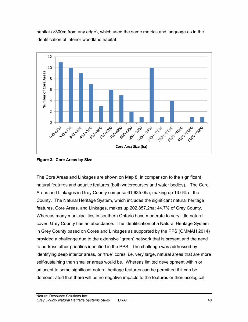
Natural Resource Solutions Inc. Grey County Natural Heritage Systems Study DRAFT 40
habitat (>300m from any edge), which used the same metrics and language as in the identification of interior woodland habitat.
Figure 3. Core Areas by Size The Core Areas and Linkages are shown on Map 8, in comparison to the significant natural features and aquatic features (both watercourses and water bodies). The Core Areas and Linkages in Grey County comprise 61,635.0ha, making up 13.6% of the County. The Natural Heritage System, which includes the significant natural heritage features, Core Areas, and Linkages, makes up 202,857.2ha; 44.7% of Grey County. Whereas many municipalities in southern Ontario have moderate to very little natural cover, Grey County has an abundance. The identification of a Natural Heritage System in Grey County based on Cores and Linkages as supported by the PPS (OMMAH 2014) provided a challenge due to the extensive “green” network that is present and the need to address other priorities identified in the PPS. The challenge was addressed by identifying deep interior areas, or “true” cores, i.e. very large, natural areas that are more self-sustaining than smaller areas would be. Whereas limited development within or adjacent to some significant natural heritage features can be permitted if it can be demonstrated that there will be no negative impacts to the features or their ecological
02468
1012
Number
of Cor
e Area
s
Core Area Size (ha)
Natural Resource Solutions Inc. Grey County Natural Heritage Systems Study DRAFT 41
functions (PPS, Section 2.1.5), it is recommended that the Core Areas and Linkages be protected through more restrictive policy. Recommended policy is provided below in Section 8 and Appendix VII. The Core Areas identified through this NHSS are very large areas that provide a variety of habitats and ecological functions, including deep interior habitat. The identification of the Cores and Linkages should in no way detract from the protection already afforded to other natural heritage features within the County that are not included within the Cores and Linkages, or lessen their significance. Protection policies on other natural heritage features (such as Significant Woodlands, wetlands, PSWs, etc) will continue to be in effect. As well, many other areas, including agricultural fields, provide a linkage function for plant and wildlife movement, not solely those identified through this study as Linkages. Significant Valleylands, identified through the NHSS are a prime example of wide corridors that can provide linkage functions. Grey County will continue to have a high percentage of natural heritage through its existing protection policies. The identification of the Cores and Linkages allows for further protection of areas that are extremely large and significant on a County wide basis. Some Core Areas contain “holes” (i.e. gaps), which are entirely surrounded by Core. These areas are preferred sites for restoration and inclusion into the Core Area if current, non-natural uses discontinue. Photo 6 in Appendix IX provides an example of such an area. Several large scale Natural Heritage System studies that overlap with Grey County were considered in the establishment of the Grey Natural Heritage System. Several maps are appended showing how these other studies compare with the Grey County Natural Heritage System. The Core Areas and Linkages are compared to Ontario Nature’s Greenway in Appendix IV, Map A, and to the MNRF’s wildlife landscape connectivity analysis in Map B.
Natural Resource Solutions Inc. Grey County Natural Heritage Systems Study DRAFT 42
Additional maps are attached in Appendix IV to show the following: Map C Natural Heritage System and Other Protected Areas
Comparison between the NHS and lands already protected by a variety of agencies or in public ownership (Bruce Trail Conservancy properties and easements, Escarpment Biosphere Conservancy properties and easements, Conservation Authority properties, County Forest, Crown Land, Federal Land). NHS not covered by one of the additional layers are private lands. It should be noted that Escarpment Biosphere Conservancy easements are private property and there is no public access.
Map D Increased Protection Policy Areas Areas with increased protection shown (i.e. Core Areas and Linkages
that do not coincide with a PSW or other protected property as per Map C). Map E Newly Protected Areas Core Areas and Linkages that do not coincide with a significant natural
heritage feature, as per Map 5.
Map F Aggregate Pits and Quarries Approved aggregate sites in relation to the Natural Heritage System. Map G Geology Features Areas of karst and Earth Science ANSIs in relation to the Core Areas
and Linkages. For comparison purposes, as these features were not considered in the identification of the Core Areas or Linkages.
Natural Resource Solutions Inc. Grey County Natural Heritage Systems Study DRAFT 43
7.0 Delineation of Core Areas As stated above, the mapping layers compiled through the NHSS were not ground-truthed or refined and the boundaries provided in this study are at a County-scale and must be interpreted as such. The following subsections outline the methods and criteria used to identify natural heritage feature boundaries on a site specific basis when more detailed studies are undertaken, such as through a subwatershed study, secondary plan, or when a development application is made. Mapping refinement is to be carried out by qualified individuals on a site specific basis following provincial and local standards and methods as discussed in this section, which may be updated from time to time by the responsible authority (e.g. MNRF). The delineation of the natural heritage feature boundaries is the process to determine the Core Area boundary. Where minor revisions are necessary because the boundaries overlap existing residences, farm buildings etc., local municipalities, in consultation with the County and applicable Conservation Authority, may refine the boundaries to reflect existing circumstances without the requirements for an EIS. 7.1 Significant Wetlands Significant Wetlands are identified by the MNRF through the Ontario Wetland Evaluation System (OWES) process (OMNR 2013). Wetland boundaries and evaluations may only be identified and completed by people who have been certified by the MNRF and have taken the wetland evaluation course offered by the agency. If a wetland is unevaluated, it must be evaluated through OWES to determine whether or not it is Provincially Significant. 7.2 Significant Woodlands Woodlands are to be delineated according to the guidelines included in Appendix B of the Technical Definitions and Criteria for Key Natural Heritage Features in the Natural Heritage System of the Protected Countryside Area, Technical Paper 1 (OMNR 2012). These guidelines are attached in Appendix V.
Natural Resource Solutions Inc. Grey County Natural Heritage Systems Study DRAFT 44
Criteria for the identification of Significant Woodlands was developed in conjunction with the Ministry of Natural Resources and Forestry (MNRF) and is provided in the Grey County Official Plan Section 2.8.4:
In order to be considered significant a woodland must be either greater than or equal to forty (40) hectares in size outside of settlement areas, or greater than or equal to four (4) hectares in size within settlement area boundaries. If a woodland fails to meet those criteria, a woodland can also be significant if it meets any two of the following three criteria:
(a) Proximity to other woodlands i.e. if a woodland was within 30 metres of another significant woodland, or (b) Overlap with other natural heritage features i.e. if a woodland overlapped the boundaries of a Provincially Significant Wetland or an Area of Natural and Scientific Interest, or (c) Interior habitat of greater than or equal to eight (8) hectares, with a 100 metre interior buffer on all sides.
7.3 Significant Valleylands Significant Valleylands have been identified through the course of this NHSS in consultation with the participating Conservation Authorities (Map 4). Based on the scope of the study, Significant Valleylands were mapped as 200m wide corridors (100m from the watercourse centerline). The boundaries of Significant Valleylands should be delineated in the field on a site specific basis using the following criteria:
The valley must be ≥100 m wide and ≥2 km long. The valley banks must be ≥3 m in height (extrapolated from 5m contours at
1:10,000 or better information where available). Where valley slope is 3:1 on one side with no slope on the opposite side of the
watercourse, the opposite valley limit is delineated using either 100m from centreline of the watercourse or the limit of the floodplain to create a continuous valley feature.
Where 3:1 valley slopes occur on both sides of the river, but they are not continuous, the floodplain limit (or contour information and professional judgment) is used to delineate a continuous valley feature.
This approach is consistent with Significant Valleyland delineation in Huron and Middlesex Counties (Huron 2015, UTRCA 2014),
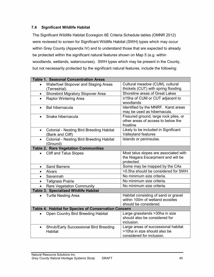
Natural Resource Solutions Inc. Grey County Natural Heritage Systems Study DRAFT 45
7.4 Significant Wildlife Habitat The Significant Wildlife Habitat Ecoregion 6E Criteria Schedule tables (OMNR 2012) were reviewed to screen for Significant Wildlife Habitat (SWH) types which may occur within Grey County (Appendix IV) and to understand those that are expected to already be protected within the significant natural features shown on Map 5 (e.g. within woodlands, wetlands, watercourses). SWH types which may be present in the County, but not necessarily protected by the significant natural features, include the following: Table 1. Seasonal Concentration Areas
Waterfowl Stopover and Staging Areas (Terrestrial)
Cultural meadow (CUM), cultural thickets (CUT) with spring flooding Shorebird Migratory Stopover Area Shoreline areas of Great Lakes Raptor Wintering Area ≥15ha of CUM or CUT adjacent to woodlands Bat hibernacula Identified by the MNRF. Karst areas may be used as hibernacula. Snake hibernacula Fissured ground, large rock piles, or other areas of access to below the
frostline Colonial - Nesting Bird Breeding Habitat (Bank and Cliff)
Likely to be included in Significant Valleyland features
Colonial - Nesting Bird Breeding Habitat (Ground)
Islands or peninsulas. Table 2. Rare Vegetation Communities
Cliff and Talus Slopes Most talus slopes are associated with the Niagara Escarpment and will be protected. Sand Barrens Some may be mapped by the CAs
Alvars >0.5ha should be considered for SWH Savannah No minimum size criteria. Tallgrass Prairie No minimum size criteria. Rare Vegetation Community No minimum size criteria.
Table 3. Specialized Wildlife Habitat Turtle Nesting Area Habitat consisting of sand or gravel within 100m of wetland ecosites
should be considered. Table 4. Habitat for Species of Conservation Concern
Open Country Bird Breeding Habitat Large grasslands >30ha in size should also be considered for inclusion. Shrub/Early Successional Bird Breeding
Habitat Large areas of successional habitat >10ha in size should also be considered for inclusion.
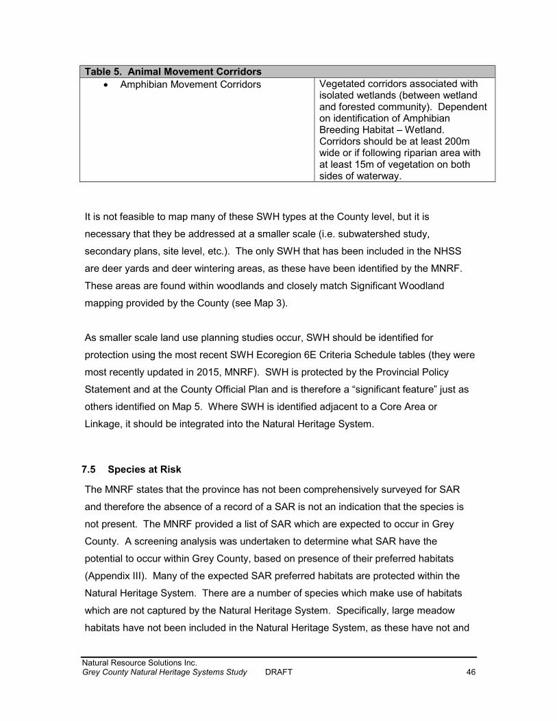
Natural Resource Solutions Inc. Grey County Natural Heritage Systems Study DRAFT 46
Table 5. Animal Movement Corridors Amphibian Movement Corridors Vegetated corridors associated with isolated wetlands (between wetland
and forested community). Dependent on identification of Amphibian Breeding Habitat – Wetland. Corridors should be at least 200m wide or if following riparian area with at least 15m of vegetation on both sides of waterway.
It is not feasible to map many of these SWH types at the County level, but it is necessary that they be addressed at a smaller scale (i.e. subwatershed study, secondary plans, site level, etc.). The only SWH that has been included in the NHSS are deer yards and deer wintering areas, as these have been identified by the MNRF. These areas are found within woodlands and closely match Significant Woodland mapping provided by the County (see Map 3). As smaller scale land use planning studies occur, SWH should be identified for protection using the most recent SWH Ecoregion 6E Criteria Schedule tables (they were most recently updated in 2015, MNRF). SWH is protected by the Provincial Policy Statement and at the County Official Plan and is therefore a “significant feature” just as others identified on Map 5. Where SWH is identified adjacent to a Core Area or Linkage, it should be integrated into the Natural Heritage System.
7.5 Species at Risk The MNRF states that the province has not been comprehensively surveyed for SAR and therefore the absence of a record of a SAR is not an indication that the species is not present. The MNRF provided a list of SAR which are expected to occur in Grey County. A screening analysis was undertaken to determine what SAR have the potential to occur within Grey County, based on presence of their preferred habitats (Appendix III). Many of the expected SAR preferred habitats are protected within the Natural Heritage System. There are a number of species which make use of habitats which are not captured by the Natural Heritage System. Specifically, large meadow habitats have not been included in the Natural Heritage System, as these have not and
Natural Resource Solutions Inc. Grey County Natural Heritage Systems Study DRAFT 47
cannot be mapped at a County scale due to the changing nature of these habitats as lands are rotated through agricultural crops. Meadow areas such as grasslands and hayfields are used by some open country bird species that are SAR, notably Bobolink (Dolichonyx oryzivorus) and Eastern Meadowlark (Sturnella magna). These species require grasslands 10 or more hectares in area (McCracken et al. 2013). Although the amount of meadow habitat within Grey County is unknown and the size of fields is also unknown, the County contains large amounts of meadow habitat, as well as very large fields, many in excess of 100ha. The Ontario Breeding Bird Atlas shows a high abundance of Bobolink and Eastern Meadowlark in the Grey and southern Bruce County area (BSC et al. 2006). This area is identified as one of few “cores” for the Bobolink and Eastern Meadowlark populations in Ontario due to its large areas of low-intensity agriculture such as pasture and hay crops. As smaller scale land use planning studies occur such as subwatershed studies, secondary plans and site level studies, SAR must be considered and surveyed for where it is warranted and in consultation with the MNRF. Where SAR habitat is identified adjacent to a Core Area or Linkage, it should be integrated into the Core Area or Linkage. Where permitting through the Endangered Species Act allows the creation of SAR habitat through biodiversity offsetting measures, it is recommended that this habitat be created adjacent to a Core Area or Linkage and to integrate the SAR habitat with the Core Area or Linkage wherever possible.
Natural Resource Solutions Inc. Grey County Natural Heritage Systems Study DRAFT 48
8.0 Policy Recommendations In developing a policy basis for establishing and maintaining the Natural Heritage System it must be recognized that the Natural Heritage System includes all significant natural heritage features and associated buffers within the County., The features within the Natural Heritage System have varying levels of conservation consideration though Provincial, County and/or Conservation Authority policies and regulations. Introduced as a part of this study are Core Areas and Linkages. The approach that is being recommended is intended to balance the need for the creation and protection of the Core Areas and Linkages with the protection of on-going agricultural, recreational, tourism, and resource uses within Grey County. This approach is consistent with the PPS, which provides protection for prime agricultural areas and mineral aggregate resources and which also promotes recreational, tourism and other economic opportunities in rural areas. It is recognized that the agroindustry and aggregates support rural and urban lifestyles and economies in Ontario. Crombie et al. (2015) recommend developing a long-term strategy for ensuring the wise use, conservation, availability, and management of mineral aggregate resources, including progressive rehabilitation and applying stringent controls to protect water resources and natural heritage, among others. The Core Areas have been identified as areas that have significant interior habitat and Linkages were identified based on the shortest distance between Core Areas with the area of greatest natural cover. Linkages are identified as 200m wide corridors that provide a diversity of habitats. Given the size of the areas under consideration, a broad range of issues and pressures need to be considered. The recommended policies seek to provide protection for the Core Areas and Linkages, while permitting existing land uses to continue and to recognize that crossings of these areas either currently exist or may be required in the future. The following modifications are recommended to the existing GCOP policies in order to implement a Natural Heritage System within the County. Excerpts from the GCOP
Natural Resource Solutions Inc. Grey County Natural Heritage Systems Study DRAFT 49
Section 2.8 are included in Appendix VI. Recommendations with regards to new Official Plan policy wording is included in Appendix VII, where the proposed changes to the existing policies are tracked. 8.1 Goals and Objectives The existing goals in the GCOP identify the importance of protecting significant environmental features and minimizing adverse impact on the natural environment. In order to provide a strong policy basis for the creation of a Natural Heritage System, it is recommended that goals be modified to recognize the importance of an interconnected Natural Heritage System that supports diversity and strengthens resiliency. This approach should also be reflected in the Objectives section of the GCOP. It is recommended that the Environmental Objectives be modified by adding a new objective to recognize that the County will support the connectivity and biodiversity of natural heritage features through the creation of a Natural Heritage System. The Core Areas and Linkages are intended to ensure a healthy and resilient ecosystem that includes Core Areas with deep interior habitat and Linkages that allows species to move and adapt through functional linkages thereby protecting biodiversity for the long term. It is also recommended that the existing objectives be amended to include restoration of the sensitive environmental features in addition to protection, preservation, conservation, maintenance, and enhancement. 8.2 Natural Environment Policies In order to clearly identify the purpose and function of the Natural Heritage System, policies within Section 2.8 of the GCOP addressing the Natural Environment should be modified. Policies should state that the County has undertaken a Natural Heritage System Study and that a Natural Heritage System is a system made up of natural heritage features and areas, and linkages intended to provide connectivity and support natural processes which are necessary to maintain biological and geological diversity, natural functions, viable populations of indigenous species, and ecosystems. These systems can include natural heritage features and areas, provincial parks and conservation reserves, other natural heritage features, lands that have been restored or
Natural Resource Solutions Inc. Grey County Natural Heritage Systems Study DRAFT 50
have the potential to be restored to a natural state, areas that support hydrologic functions, and working landscapes that enable ecological functions to continue. A Natural Heritage System has a greater ability to sustain itself compared with an approach which only protects individual features as it facilitates biodiversity and resiliency. As the Natural Heritage System provides a range of habitats, it may include areas which are not significant natural features, but which are critical to maintaining connectivity. A policy should also be added that recognizes that in Grey County there are natural heritage features which are located outside of the Natural Heritage System and that there are many natural heritage features shown on Appendix B of the GCOP that are required to be conserved by the Provincial Policy Statement, as well as County and Conservation Authority policies and regulations. Policies should also identify that the Core Areas and Linkages are to be provided additional protection and support for restoration. Policies should be included to indicate that the Natural Heritage System is focused on the rural areas, although the identification of natural heritage features on Map 5 does include natural heritage features within the settlement areas. Protection of the Natural Heritage System within settlement areas will be identified through the local Official Plans. Local municipalities will be encouraged to provide for the extension of Core Areas and Linkages into the settlement areas where significant natural heritage features (particularly Significant Valleylands) are contiguous with the County Natural Heritage System. 8.3 Mapping The Core Areas and Linkages (Map 6) should be designated on a new Schedule in the County Official Plan. Map 6 is to act as an overlay to Schedule A - Land Use Designations and significant changes to the boundaries of the Core Areas and Linkages will require an amendment to the GCOP. Appendix B of the Official Plan - Constraint Mapping should be amended to identify all known significant natural heritage features that have been mapped as shown on Map 5.
Natural Resource Solutions Inc. Grey County Natural Heritage Systems Study DRAFT 51
8.4 Core Areas In order to clarify what a Core Area is, a definition should be provided that states that they are large, sustainable habitat clusters that are the building blocks of Natural Heritage Systems and which are capable of providing and sustaining ecological functions. They may be comprised of a mix of habitat types. GCOP policy should require Core Areas to be identified in the local Official Plans with the qualification that the boundaries of Core Areas may be refined in the local Official Plan based on criteria for identifying the Core Area boundaries at a site specific level. It should be noted that the area of Core can be expanded at the local level should not be significantly reduced except where the boundaries overlap existing residences, farm buildings etc. In such cases, local municipalities, in consultation with the County and applicable Conservation Authority, may refine the boundaries to reflect existing circumstances without the requirements for an EIS. Gaps within the Core Area are preferred sites for restoration and inclusion into the Core Area if current, non-natural uses discontinue. The Core Area policies should identify that development and site alteration are prohibited in Core Areas except for
Agricultural uses conservation and flood control projects, forest, fish and wildlife management, essential infrastructure, passive recreation, sustainable forestry, existing uses, buildings and structures, existing or expanded mineral aggregate extraction, development on existing lots of record subject to a suitable building envelope
being identified through a scoped EIS and/or in consultation with the applicable Conservation Authority, and
accessory uses, buildings and structures.
Natural Resource Solutions Inc. Grey County Natural Heritage Systems Study DRAFT 52
Essential infrastructure should be defined in the GCOP to include sewage, water and stormwater management systems, electricity transmission and distribution systems, communications/telecommunications, transportation corridors, trails, oil and gas pipelines and associated facilities. Where possible, even such infrastructure should avoid the Natural Heritage System, especially Core Areas. Where not avoidable, crossing of Core Areas should be minimized, consider the shortest route across the Core, and include context sensitive design, such as a narrow footprint, eco-passages, and other best management practices. Minor expansion of legally existing uses, buildings, or structures may be permitted outside of Provincially Significant Wetlands, if an EIS can demonstrate no significant incremental or cumulative impacts on the natural features, or ecological functions of the Core Area. Policies in Section 2.8 of the GCOP currently state that with respect to natural heritage features and areas, nothing in the policies is intended to limit the ability of existing agricultural uses to continue. The intent of the Core Area is to protect the very large natural areas in the County while recognizing continued private use and encouraging landowners to continue to protect and manage these lands in an environmentally sustainable manner. Core Areas should have a 120m adjacent land zone with policies that reflect the definition of adjacent lands within Provincial Policy Statement. Development proposed within the 120m adjacent land zone will be required to undertake an EIS which will recognize the need to assess the natural features that fall inside the adjacent lands and/or extend beyond the adjacent lands, and in some cases, these adjacent land zones would include existing land uses and may cutoff portions of existing natural features. 8.5 Linkages Policies should be created to address Linkages and to provide a definition stating that they are components of Natural Heritage Systems and are intended to provide movement corridors for both plants and animals between Core Areas in order to protect biodiversity and the long-term viability of ecological systems. Linkages are ecologically functional, with a width of at least 200m in Grey County. Linkages are delineated within the Natural Heritage System as the closest distance between Core Areas with the
Natural Resource Solutions Inc. Grey County Natural Heritage Systems Study DRAFT 53
greatest amount of natural cover, both terrestrial and aquatic and may include agricultural fields. Policies should state that the boundaries of Linkages can be refined in the local Official Plan, but must meet the definition and criteria. The Linkage policies should identify that development and site alteration are prohibited in Linkages except for:
conservation and flood control projects, forest, fish and wildlife management, essential infrastructure, passive recreation, sustainable forestry, agricultural uses including new buildings and structures, existing uses, buildings and structures, new, existing or expanded mineral aggregate extraction, development on existing lots of record subject to a suitable building envelope
being identified through a scoped EIS and/or in consultation with the applicable Conservation Authority,, and
accessory uses, buildings and structures. Essential infrastructure should be defined in the GCOP as noted above for Core Areas. Where possible, even such infrastructure should avoid Linkages. Where not avoidable, crossing of Linkages should be minimized, consider the shortest route across the Linkage, and include context sensitive design, such as a narrow footprint, eco-passages, and other best management practices. Expansion of legally existing uses, buildings, or structures may be permitted outside of Provincially Significant Wetlands, if an EIS can demonstrate no significant incremental or cumulative impacts on the natural features, or ecological functions of the Linkage Policies in Section 2.8 of the GOP currently state that with respect to natural heritage features and areas nothing in the policies is intended to limit the ability of existing agricultural uses to continue.
Natural Resource Solutions Inc. Grey County Natural Heritage Systems Study DRAFT 54
The intent of Linkages is to provide for connectivity within the Natural Heritage System while recognizing continued private use and encouraging landowners to continue to protect and manage these lands. Development proposed within the Linkage will be required to undertake an EIS in accordance with the requirements established in Section 2.8.7 of the GCOP. 8.6 Natural Heritage Features Existing Hazard Land and Provincially Significant Wetland designations should remain on Schedule A - Land Use, recognizing that some Provincially Significant Wetlands may also be a component of the Core Areas or Linkages of the Natural Heritage System. It is recommended that the existing Natural Function policies be renamed to Natural Heritage Features. The Natural Function policy (1) should be modified to indicate there is insufficient information available, and the scale of the study is too broad, to definitively establish the boundaries of the natural heritage features as shown on Appendix B. Therefore, the policies of the Plan require that where development is proposed within (except for Provincially Significant Wetlands) or adjacent to a natural heritage feature, the ultimate boundary will be determined through more detailed studies based on a range of criteria including the provision of appropriate buffers. For a site specific application, the boundary will be determined through submission of an EIS where the site is located within 120m of any part of a natural heritage feature. Policy should also be added that indicates local municipalities may carry out more detailed municipal wide or area specific natural heritage studies and refine the boundaries of the natural heritage features. Local mapping of the Natural Heritage System may be more restrictive, but should not be less restrictive except where the boundaries overlap existing residences, farm buildings etc. In such cases, local municipalities, in consultation with the County and the applicable Conservation Authority, may refine the boundaries to reflect existing circumstances without the requirements for an EIS.
Natural Resource Solutions Inc. Grey County Natural Heritage Systems Study DRAFT 55
It is recommended that buffer widths generally be established as 30m from all natural heritage features that are within the Natural Heritage System, unless an EIS identifies a different buffer as appropriate. 8.7 Implementation In order to effectively implement the Natural Heritage System and ensure its long term protection, it is recommended that the lands within the Core Areas be placed in a Natural Heritage System Core Area zone with a Holding provision by the local municipality. The zone would only allow for the permitted uses listed above including existing uses and would permit a single detached dwelling on an existing lot of record. The zoning would identify that the Holding provision could be lifted when an EIS had been undertaken to the satisfaction of the municipality in consultation with the relevant Conservation Authority. If conditional zoning becomes available, it is recommended that conditional zoning be utilized instead of a Holding provision. The challenge with using a Holding provision is that once the Hold is lifted, it does not require a further EIS to be undertaken prior to subsequent new development occurring on that site. Conditional zoning could require an EIS to be carried out prior to any development being allowed to proceed. It is also recommended that a policy be added that permits lot severances to facilitate conveyances to public bodies or non-profits entities for natural heritage conservation, provided it does not create a separate lot for a residential dwelling in the Special Agriculture designation. County staff will work with municipalities on an appropriate approach for implementation of the Natural Heritage System at a zoning level. Scoping of an EIS is recommended to be undertaken as early in the process as possible at a pre-submission consultation meeting with the proponent, County, municipality, and applicable Conservation Authority. The scope of the EIS depends on the proposed development or site alteration and the site conditions. A Terms of Reference is to be written to clearly identify the work to be included in the EIS. At a minimum, the EIS should include anuran (frog and toad) surveys if suitable breeding habitat exists,
Natural Resource Solutions Inc. Grey County Natural Heritage Systems Study DRAFT 56
breeding bird surveys, multiple season vegetation inventories and Ecological Land Classification. Other natural heritage studies that may be required include surveys for turtles, snakes, salamanders, insects (butterflies, dragonflies, damselflies, bees), and/or mammals (including bats). Hydrological and hydrogeological resources and issues must be identified, which includes surface water features, recharge and discharge zones, groundwater quality and quantity, groundwater elevation and flow direction, and connections between groundwater and surface water.
Natural Resource Solutions Inc. Grey County Natural Heritage Systems Study DRAFT 57
9.0 Conclusion A Natural Heritage System was identified for Grey County by NRSI and MSH, through a consultative process including the County, a Technical Advisory Committee, and the public, as well as a review of relevant guidance documents and other Natural Heritage System studies. The Grey County Natural Heritage System is comprised of 71 Core Areas and 82 Linkages, a combined total area of 61,635ha, making up 13.6% of the entire County. In addition, the County contains a large amount of natural heritage features not included within the Natural Heritage System, which are also protected through existing policies and regulations, for a total of 44.6% of the County. The Natural Heritage System, which includes the significant natural heritage features, Core Areas, and Linkages, makes up 202,857.2ha; 44.7% of Grey County. The Natural Heritage System and recommended policies aim to provide a balanced approach between environmental protection, agricultural, recreational, tourism, and resource uses within Grey County. As the County moves forward with this Natural Heritage System Study, it is recommended the Natural Heritage System be adopted in the Official Plan and shown on Schedule A. Various amendments are recommended to the goals and objectives listed in the Official Plan, revisions to the Natural Environment policies in Section 2.8, and an inclusion of all mapped natural heritage features within Map B – Constraint Mapping of the Official Plan.
Natural Resource Solutions Inc. Grey County Natural Heritage Systems Study DRAFT 58
10.0 References Bird Studies Canada, Environment Canada's Canadian Wildlife Service, Ontario Nature,
Ontario Field Ornithologists and Ontario Ministry of Natural Resources. 2006. Ontario Breeding Bird Atlas Database, 31 January 2008. http://www.birdsontario.org/atlas/aboutdata.jsp?lang=en Bowman, J. and C. Cordes. 2015. Landscape Connectivity in the Great Lakes Basin. Jeff Bowman and Chad Cordes, Wildlife Research and Monitoring Section, Ontario Ministry of Natural Resources and Forestry. June 2015.
Carolinian Canada. 2000. Guidelines for determining setbacks and buffers. In Draft Guide for Determination of Setbacks and Buffers. Pp. 27-33 Carolinian Canada. 2015. Website: Big Picture Methodology.
https://caroliniancanada.ca/legacy/ConservationPrograms_BigPictureMethodology.htm (Accessed December 9, 2015). City of London. 2006. Official Plan. Collingwood (Town of). 2014. Official Plan. Office Consolidation, December 2014. Conservation Ontario. 2015. Website. http://www.conservation-ontario.on.ca/ Accessed October 7, 2015. Credit Valley Conservation (CVC). 2015. Credit Valley Conservation Natural Heritage System Strategy. Phase 3: Credit River Watershed Natural Heritage System.
Final technical report, September 2015. 200p. Dobbyn, J.S. 1994. Atlas of the Mammals of Ontario. Don Mills, Federation of Ontario Naturalists.
Environmental Law Institute. 2003. Conservation Thresholds for Land Use Planners. Washington, D.C. Pp. 55. Environment Canada. 2013. How Much Habitat is Enough? Third Edition. Environment Canada, Toronto, Ontario. Fisheries and Oceans Canada (DFO). 2015. Species at Risk Distribution Maps. (http://www.conservation-ontario.on.ca/what-we-do/watershed-
stewardship/aquatic-species-at-risk). Accessed August 20, 2015. Grey County. 2013. Official Plan. Office consolidation June 25, 2013. Grey County. 2015. Website. www.grey.ca
Natural Resource Solutions Inc. Grey County Natural Heritage Systems Study DRAFT 59
Henson, B.L. and K.E. Brodribb. 2005. Great Lakes Conservation Blueprint for Terrestrial Biodiversity. Volume 2 Ecodistrict Summaries. Nature Conservancy of Canada and Ontario Ministry of Natural Resources.
Henson, B. 2015. Personal communication (email) between Bonnie Henson, Natural Heritage Project Ecologist, Ontario Natural Heritage Information Centre, Ministry of Natural Resources and Forestry with Katharina Walton, NRSI. December 9, 2015. Re: Big Picture 2002.
Huron County. 2015. Huron Natural Heritage Plan Technical Document. 115 pp. Koen, E.L., J. Bowman, C. Sadowski, and A.A. Walpole. 2014. Landscape connectivity for wildlife: development and validation of multispecies linkage maps. Methods in
Ecology and Evolution. McCracken, J. D., R. A. Reid, R. B. Renfrew, B. Frei, J. V. Jalava, A. Cowie and A. R. Couturier. 2013. Draft recovery strategy for the bobolink (Dolichonyx oryzivorus) and the eastern meadowlark (Sturnella magna) in Ontario. Ontario Recovery Strategy Series. Prepared for the Ontario Ministry of Natural Resources, Peterborough, Ontario. viii +86 pp.
Nature Conservancy of Canada (NCC) and Natural Heritage Information Centre (NHIC). 2004. Power Point presentation, April 23, 2004. Niagara Escarpment Commission. 2015. The Niagara Escarpment Plan. Office Consolidation October 1, 2015. Niagara Escarpment Commission. 2016. Proposed Niagara Escarpment Plan (2016).
May 2016. Noss, R.F., and A.Y. Cooperrider. 1994. Saving Nature’s Legacy: Protecting and Restoring Biodiversity. Island Press, Washington, D.C. Pp. 416 Ontario Ministry of Municipal Affairs and Housing (OMMAH). 2005. Greenbelt Plan.
http://www.mah.gov.on.ca/Page189.aspx#greenbelt Ontario Ministry of Municipal Affairs and Housing (OMMAH). 2014. Provincial Policy Statement. Queen’s Printer for Ontario, 2014. Ontario Ministry of Natural Resources (OMNR). 2012. Greenbelt Plan 2005 – Technical Definitions and Criteria for Key Natural Heritage Features in the Natural Heritage
System of the Protected Countryside Area. Technical Paper 1. December 7, 2012. Ontario Ministry of Natural Resources (OMNR). 2012. Significant Wildlife Habitat Criteria Schedules for Ecoregion 6E (Draft). February 2012. Ontario Ministry of Natural Resources (OMNR). 2013. Ontario Wetland Evaluation System: Southern Manual. 3rd Edition, Version 3.2.

Natural Resource Solutions Inc. Grey County Natural Heritage Systems Study DRAFT 60
Ontario Ministry of Natural Resources and Forestry (MNRF). 2015. Natural Heritage Information Centre: Biodiversity Explorer. https://www.biodiversityexplorer.mnr.gov.on.ca/nhicWEB/mainSubmit.do (Accessed January 21, 2015).
Ontario Ministry of Natural Resources and Forestry (MNRF). 2015. Significant Wildlife Habitat Criteria Schedules for Ecoregion 6E. January 2015. Ontario Nature and Nature Conservancy of Canada (NCC). 2008. Greenway Mapping Methodology. February 1, 2008. [And Figure 1A. Grey-Bruce Greenway Vision] Ontario Nature. 2014. Reptiles and Amphibians of Ontario Range Maps. http://www.ontarionature.org/protect/species/reptiles_and_amphibians/index.php
(Accessed January 14, 2015). Owen Sound Field Naturalists. 2010. A Checklist of Vascular Plants for Bruce and Grey Counties Ontario. 4th Edition April 2010, Bruce-Grey Plant Committee. D. Crombie, K. Currie, R. Horst, J. MacKenzie, L. Moore, D. Zimmerman. 2015. Planning for Health, Prosperity and Growth in the Greater Golden Horseshoe:
2015-2041. Queen’s Printer for Ontario. December 2015. http://www.mah.gov.on.ca/Asset11110.aspx?method=1 Theobald, David M., James R. Miller, and N. Thompson Hobbs. 1997. Estimating the cumulative effects of development on wildlife habitat. Landscape and Urban
Planning 39:25-36. Upper Thames River Conservation Authority (UTRCA). 2014. Middlesex Natural Heritage Systems Study - A study to identify Natural Heritage Systems in Middlesex County. October 6, 2014.

Natural Resource Solutions Inc. Grey County Natural Heritage Systems Study
MAPS

Natural Resource Solutions Inc. Grey County Natural Heritage Systems Study
APPENDIX I Technical Advisory Committee Information

TAC 1
225 Labrador Drive, Unit 1, Waterloo, Ontario, N2K 4M8 Tel: (519) 725-2227 Web: www.nrsi.on.ca Email: [email protected]
Grey County Natural Heritage Systems Study “Green in Grey”
Terms of Reference for the Technical Advisory Committee
Purpose of the Project The County of Grey has retained the team of Natural Resource Solutions Inc. (NRSI) and Macaulay Shiomi Howson Ltd. (MSH) to complete a Natural Heritage Systems Study (NHSS) for the County. The Grey County Official Plan (‘the Plan’) presently identifies several individual natural heritage features including Provincially Significant Wetlands (PSW’s), Areas of Natural and Scientific Interest (ANSI’s), Significant Woodlands, streams/watercourses/water bodies, and Other Identified Wetlands. In addition, incidental natural heritage features (e.g. valleylands or wildlife habitat) may also be identified through the County’s Hazard Land mapping, and the protected / natural areas mapped within the Niagara Escarpment Plan (NEP). While the County is satisfied that the current feature mapping is protecting significant portions of what needs to be protected, this approach has limitations in its ability to address the cumulative impact of change on natural heritage features and linkages between features. In addition, the new requirements of the Provincial Policy Statement (PPS) 2014, section 2.1.3, require “Natural Heritage Systems” to be identified. In order to meet the requirements of the PPS and to better understand the linkages and connections between existing natural heritage features, there is a need to move towards a system based approach in identifying natural heritage. To that end, the County is preparing a NHSS. A key component of the NHSS will be consulting with the County’s nine member municipalities, four conservation authorities, and other stakeholders. The County will establish a Technical Advisory Committee (TAC) made up of County, Municipal, Conservation Authority and others to help guide and inform the process. Expectations of TAC The role of the TAC is to provide recommendations, advice and information to the study team on the development of the Natural Heritage System for Grey County. This will include review of existing designated features, mapping, proposed criteria, methods, as well as the draft and final NHSS report. TAC members should have experience and expertise in biology, ecology, geology and/or Natural Heritage Systems. Emphasis in this study will be placed on identifying the less well defined components of the Natural Heritage System, including such features as significant habitat of endangered and threatened species, significant valleylands, and significant wildlife habitat, as well as determining linkages and restoration areas. The topics of discussion at each of the upcoming meetings are anticipated as follows:
TAC Meeting #1 (end of February 2015) – preliminary natural feature mapping and draft criteria for NHS components (linkages, significant habitat of endangered and threatened species, significant valleylands, and significant wildlife habitat)

NRSI_1575_Grey County NHSS_ToR for TAC_2015_01_23_MEG 2
TAC meeting #2 (end of July 2015) – updated natural feature mapping, application of draft criteria, technical questions with respect to criteria, draft NHS TAC Meeting #3 (early October 2015) – final draft NHS and report, any further revisions
Prior to each meeting, the project team will provide materials for review, to be discussed at the TAC meeting. If you are unable to attend the meeting, input can be provided by email to NRSI. NRSI will chair the meetings and meeting minutes will be taken by Monica Scribner from the County. A total of 3 half (1/2) day meetings with TAC are planned throughout the project cycle as shown above. Meetings will be held at the County office in Owen Sound. Details of time and location will be determined during the process. The project is to be completed and presented to County Council by December 2015. The project contact at the County of Grey is Sarah Morrison, 519-372-0219 ext. 1241, [email protected]. Questions or comments of a technical nature can be directed to NRSI (519) 725-2227, David Stephenson [email protected] and Katharina Walton [email protected].
Head Office: 225 Labrador Drive, Waterloo, Ontario, N2K 4M8 Tel: (519) 725-2227 Fax: (519) 725-2575 Web: www.nrsi.on.ca Email: [email protected]
February 19, 2015 Project 1575 Dear TAC Member; Re: Grey County Natural Heritage System Study
Technical Advisory Committee Meeting #1 Natural Resource Solutions Inc. (NRSI) has been retained by Grey County to identify and delineate a Natural Heritage System (NHS) within the County. A project specific website has been created on the County’s site to advertise the project as “Green in Grey”:
http://www.grey.ca/services/planning-development/natural-environment-study/ Public input is being solicited through a number of methods. A mail notice is being sent out to area residents through as many tax notices as possible indicating that two public workshops will be held through the course of this project (end of March and mid October). Three Technical Advisory Committee (TAC) meetings are also part of the project, and a Terms of Reference for the TAC was emailed out to each of you by the County’s project manager, Sarah Morrison on January 28, 2015. The first TAC meeting is scheduled for February 25th, with a second and third meeting anticipated for July and September 2015. Since project initiation in November 2014, NRSI has completed the following:
Compiled species lists from the various wildlife atlases (birds, butterflies, reptiles, amphibians, mammals, odonates, plants)
Reviewed other Natural Heritage System Studies (Oxford, Huron, Middlesex, Collingwood)
Reviewed Official Plan policies re. natural heritage and wetlands Reviewed Significant Wildlife Habitat criteria for the County Begun to develop preliminary criteria for the NHS in Grey County; and Created base maps from data received from the County, four member
Conservation Authorities, and the Ministry of Natural Resources and Forestry (MNRF) Land Information Ontario (LIO) database.
A general overview of the County with member municipalities, Conservation Authorities, First Nations Reserves, and major river systems is shown on Map 1. Many natural features have already been identified in the County. These include:
Provincially Significant Wetlands (PSWs) Other wetlands (not provincially significant) Significant Woodlands Areas of Natural and Scientific Interest (ANSIs) Fish habitat
Natural Resource Solutions Inc. 2
These features have been identified on Map 2, and comprise the starting point for the NHS. The purpose of this study is to identify and recommend a NHS for Grey County that also ensures that other natural heritage features including Significant Valleylands, Significant Wildlife Habitat (SWH), and habitat of Endangered and Threatened species are considered, in a system of cores and linkages. Currently, these features have not been defined and mapped in the County. At this first TAC meeting we will discuss some preliminary methods of identifying and protecting these features for which data sets are incomplete and may be difficult to map. Below are some preliminary thoughts for your review. Significant Valleylands Significant valleylands were included in the NHS for Huron and Middlesex Counties. These features were identified and mapped using the following criteria:
The valley must be ≥100 m wide and ≥2 km long. The valley banks must be ≥3 m in height (extrapolated from 5m contours at
1:10,000 or better information where available). Where valley slope is 3:1 on one side with no slope on the opposite side of the
watercourse, the opposite valley limit is delineated using either 100m from centreline of the watercourse or the limit of the floodplain to create a continuous valley feature.
Where 3:1 valley slopes occur on both sides of the river, but they are not continuous, the floodplain limit (or contour information and professional judgment) is used to delineate a continuous valley feature.
An alternate approach, defined in the Region of Waterloo’s Official Plan (Section 7.C.7), is the following:
Environmentally Significant Valley Features are natural features within a significant valley that consist of:
(a) at least one of the following: i) river channel; or ii) Environmentally Significant Discharge Areas or Environmentally
Significant Recharge Areas; or
(b) both of the following ecological features: i) habitat of regionally significant species of flora or fauna; ii) natural area, such as a woodland of one to four hectares in extent,
floodplain meadow or wetland, which consists primarily of native species; or;
(c) any one of Policy 7.C.7(b) above plus any one of the following Earth Science
features: i) river terrace; ii) esker; iii) cliff or steep slopes; iv) oxbow; v) confluence with significant watercourse draining a watershed greater
than five square kilometres;
7
feature? (This goes beyond the PPS). Note that input from the Open Houses was in favour of a NHS and protecting as much of the Grey County natural environment as possible.
Do you agree with the suggested policy addressing proposed development within the NHS (i.e. within the outer 120m of the NHS)?
Notes:
- NHS needs to maintain functionality and connectivity. Look for cores and linkages, as PPS already protects features.
- Need stratified approach with regards to NHS and policy. Restrictive policy would require a scoped NHS. 7 Natural Heritage
System The entire NHS, comprised of Significant Features (Map 4), NHS Connection Routes (Map 5), and 120m adjacent lands (Map 6).
Should watercourses and waterbodies be included in the green mapping? Should the 120m adjacent lands zone be added to these?
Notes: - NHS and ON Nature
Greenway For comparison purposes only. ON Nature Greenway based on large
forested areas only. Notes: -
8 Natural Heritage System and Other Protected Areas
The NHS, along with other protected areas for comparison purposes: lands owned by Conservation Authorities, provincial parks (Craigleith PP), Niagara Escarpment area, properties owned/managed by the Escarpment Biosphere Conservancy.
Are there other protected areas and properties that should be shown?
Notes: Add County Forests, MNRF lands, lands owned by Bruce Trail Conservancy 9 Aggregate Pits &
Quarries The NHS and licensed aggregate pit locations. NHS has not been deleted from these sites.
Should the licensed aggregate pits be removed from the NHS or, should they be left in, with policy to address these uses? Some properties are not active currently and may never be or may not become active for a long time. As aggregate pits close and sites are rehabilitated, they can be considered for inclusion into the NHS in the future.
Notes: Map 9 - Add ‘quarries’ to the title of this map. The maps the County uses in the Official Plan show licensed pits and quarries, but may not be reflective of the most recent license data in this regard as there appear to be a few approved extractive operations missing. It is recommended that the most recent data be accessed from Land Information Ontario (LIO) to ensure the data is correct in this regard.
8
As for rehabilitation, we have existing land use designations underlying the extractive designation on these locations. The County Official Plan does however contain policies which speak to rehabilitation considering linkages to natural heritage features or bolstering the feature itself as part of the progressive rehabilitation plans.
Biodiversity Offsetting It is recommended that the identified NHS be used to guide the location of any biodiversity offsetting measures that may occur when natural features are removed through approved development. For example, policy should outline that any grasslands or thickets that have to be retained or created to address overall benefit permits from the MNRF or through biodiversity offsetting measures prescribed by municipal governments be located adjacent to or contiguous with the NHS. Do you agree with this approach? Should areas of recommended NHS Enhancement be mapped? (These would be smaller areas that are encircled by NHS).
Notes: Big green map does not show watercourses which would add even more green to the map. Are there any existing municipal policy approaches towards bio-diversity offsetting? It was noted that the City of Guelph may have some policies with respect to this subject matter. It was further noted that the NEC is not in favour of compensation for the destruction of features in this regard. The current Endangered Species Act and implementing Regulations does offer some situations where offsetting may be possible but avoidance or mitigation need to be examined first. It’s also important to note that it’s not simply ‘compensation’, but rather it’s ‘overall benefit’. The group discussed the pros and cons of compensation.
Rename title of study: Natural Environment Study is ambiguous. We are getting comments on things such as noise pollution, light pollution, human health impacts, etc. Should the study be renamed to Natural Heritage Systems Study?
Notes: We have received lots of comments about natural environment issues but not natural heritage features. At the next open house we will be clarifying that for people and on the website also. At this stage we will keep name the same so it doesn’t confuse people, but try to further educate people on the scope and purpose of this study. Other General Items Discussed:
- Map 8 should also show County Forest properties alongside the publicly owned lands. It was noted however that sustainable forest management practices are utilized within these forests. County staff can share a GIS layer showing County forest boundaries.
- Map 8 may also want to show the Bruce Trail lands and any Provincial lands (e.g. lands owner by the Ministry of Natural Resources and Forestry). Most of these GIS layers should be available from the Province.

9
- Future policy options regarding conservation severances/easements would also be useful. The County has been experiencing a higher demand for such applications in recent years.
Next Steps - Revise mapping - Writing NHSS report - Developing policy recommendations - TAC meeting #3 – end of September - Open House – mid October - Public, Municipal and Stakeholder comment period - Finalize report - Presentation to Planning and Community Development Committee – November - Presentation to Council – December
*The above dates and timeframes are subject to change depending on feedback and comments received.
Meeting adjourned at 11:30 a.m.
1078 Bruce Road 12, P.O. Box 150, Formosa ON Canada N0G 1W0 Tel 519-367-3040, Fax 519-367-3041, [email protected], www.svca.on.ca
Watershed Member Municipalities
Municipality of Arran-Elderslie, Municipality of Brockton, Township of Chatsworth, Municipality of Grey Highlands, Town of Hanover, Township of Howick, Municipality of Morris-Turnberry, Municipality of South Bruce, Township of Huron-Kinloss, Municipality of Kincardine, Town of Minto, Township of Wellington North,
Town of Saugeen Shores, Township of Southgate, Municipality of West Grey
SENT ELECTRONICALLY ONLY ([email protected]) July 2, 2015 Natural Resource Solutions Inc. 225 Labrador Drive, Unit 1 Waterloo, ON N2K 4M8 ATTENTION: David E. Stephenson, Senior Biologist & Certified Arborist Dear Mr. Stephenson, RE: Grey County Natural Heritage System Study Technical Advisory Committee (TAC) Meeting #2 In response to your letter dated June 10, 2015, and as a follow up to the TAC Meeting held on June 22, 2015, the following SVCA comments are offered. Discussion Items
1) The watercourse upstream (northeast) of McCullough Lake should be identified as Hamilton Creek. Hamilton Creek should be included with the major rivers, and therefore included as a Significant Valleyland. The watercourse downstream of McCullough Lake has been identified correctly as the North Saugeen River. All other major rivers have been identified and mapped correctly.
2) a) It is the understanding of the SVCA that mapping which includes the Earth Science ANSI’s is being prepared by NRSI. With the addition of the Earth Science ANSI’s, the SVCA agrees with the list of significant features that will form the basis of the NHS.
b) The SVCA doesn’t object to the approach outlined for mapping Significant Valleylands. c) The SVCA agrees with the approach that Significant Wildlife Habitat and Habitat of Endangered and Threatened Species will not be mapped as part of the NHS at this time, but be addressed through policy.
2) The SVCA agrees that Biodiversity Offsetting should be located adjacent to or contiguous with the NHS.
3) The SVCA does not disagree with the approach outlined for mapping the Connection Route. In the opinion of the SVCA, the corridors should become part of the NHS.
Grey County Natural Heritage System Study Technical Advisory Committee (TAC) Meeting #2 July 2, 2015 Page 2 of 2
4)
The SVCA does not agree with incorporating the 120m Adjacent Lands within the NHS. In our opinion the Adjacent Lands should either be shown as a different overlay on the mapping, or not included on the mapping and addressed through policy only.
The SVCA does not object to no development or site alteration being permitted in any NHS feature; however, as you have stated, this goes beyond the PPS.
The SVCA would be agreeable to policies that would allow an EIS to be completed in consideration of development within the NHS or the lands adjacent to the features.
5) Other than the additional areas discussed at the meeting (County Forests, etc.) the SVCA is not aware of other protected areas and/or properties that should be shown.
6) The SVCA would like to see the licensed aggregate pits included in the NHS with policies. We trust these comments are helpful. Should questions arise, please do not hesitate to contact this office. Sincerely, Candace Hamm Candace Hamm Environmental Planning Coordinator Saugeen Conservation CH\ cc: Sarah Morrison, Grey County (via e-mail)

TAC 3
Head Office: 225 Labrador Drive, Waterloo, Ontario, N2K 4M8 Tel: (519) 725-2227 Fax: (519) 725-2575 Web: www.nrsi.on.ca Email: [email protected]
September 16, 2015 Project 1575 Dear TAC Member; Re: Grey County Natural Heritage System Study
Technical Advisory Committee (TAC) Meeting #3 We are approaching TAC meeting 3 out of 3, scheduled for Monday, September 21, 2015 at 9 a.m., to be held at the Grey County Administration Building within the Council Chambers. The second TAC meeting was held June 22, 2015. At that meeting, several maps were presented, which included a map showing a potential Natural Heritage System (NHS) comprised of all features within Grey County that have some level of conservation or protection based on current policies, regulations, etc. (That map also showed a 120m buffer, which also represented lands that had some level of conservation). Based on the input received from the TAC meeting #2, and a request made by County staff, NRSI undertook a GIS modelling exercise to identify core areas. A fulsome description of this process will be provided at the upcoming TAC. However, in summary, an analysis of the mapping that had already been completed to include significant features (Map 1) within the County was undertaken to identify natural areas by size. Using this approach, large, connected areas would be identified as potential cores. This map is attached as Map 7. A size distribution analysis was completed to determine the spatial distribution of potential cores, as well as representation of the various core sizes (for example, how many areas of 100ha, 500ha, 1000ha, etc). Associated with the cores would be a series of linkages. This revised mapping of cores and potential linkages was provided to the County for review and was discussed on another conference call held September 8, 2015. The results of this analysis showed that many areas included a range of patch sizes, including some very narrow hedgerows. In order to determine whether the results were a product of digitizing versus ecologically based areas, this additional analysis focused on determining if there are clusters of habitats that could form the basis for potential cores. As such, a further GIS modelling exercise has been undertaken which is briefly described in this letter and will be discussed in more detail at the TAC meeting September 21.
Natural Resource Solutions Inc. 2
The following methods were followed: 1. The Significant Features map was used as a base map. The Boyne River was
added to this map as a Significant Valleyland, as requested by the GSCA. The base layers are comprised of:
Provincially Significant Wetlands Wetlands ≥2ha Significant Woodlands Significant Valleylands Life Science ANSIs Deer Yard (Stratum 1) and Deer Wintering Areas (Stratum 2)
The significant features are shown on Map 1. Although the Earth Science ANSIs are shown on this map, they were not included in this analysis as they include lands that are not currently woodland, wetland, etc. They have been shown on Map 1 for comparison purposes and because they are significant features that are protected by the province.
2. Internal zones were delineated within each natural area polygon mapped in Step 1, based on typical metrics used in the literature to identify possible ‘interior’ habitats (100m, 200m, and 300m from the edge). The areas that were beyond100m, 200m, 300m, and greater than 300m from the natural feature edge were mapped. Map 2 shows this working, “bullseye” map. The dark green areas identify the deep interior areas, more than 300m from the feature edge. Small gaps, <0.5ha, were omitted. This approach allowed us to set-aside the narrow fingers of polygons and identify larger habitat clusters, as well as identify the building blocks of true “cores”, i.e. large natural areas that provide interior habitat conditions.
3. A size distribution bar chart was developed to order these deep interior polygons by size. In total, there are 460 areas of deep interior habitat, ranging in size from a tiny fraction to 1,426.5ha. Based on this mapping, it was evident that many patches had habitats that were >100m and >200m from the edge, and several contained habitats that were >300m from the edge (typically referred to as ‘deep interior’). Based on this, the subsequent analysis focused on areas that contain deep interior habitat (i.e. habitat more than 300m from the edge) that may form the basis of potential cores. 313 deep interior polygons are less than 10ha in area (of which 194 are at least 0.5ha in area). The chart below shows the size distribution of deep interior polygons by area between 10ha and more than 300ha.
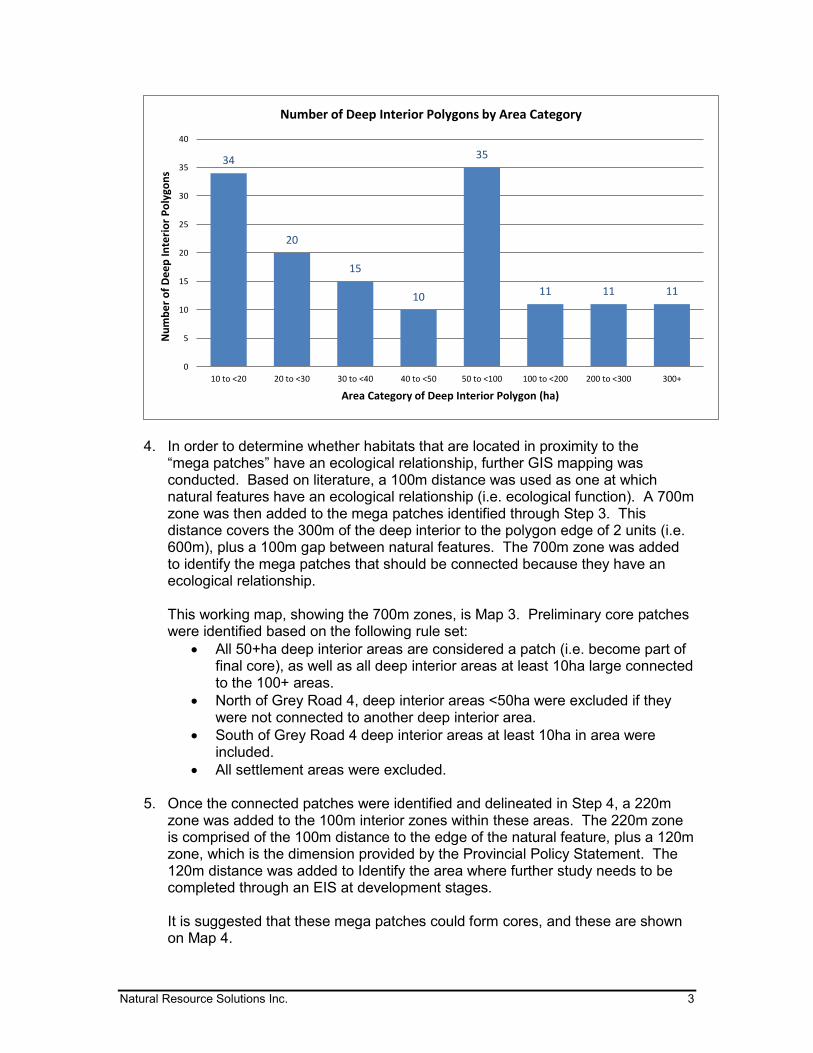
Natural Resource Solutions Inc. 3
4. In order to determine whether habitats that are located in proximity to the
“mega patches” have an ecological relationship, further GIS mapping was conducted. Based on literature, a 100m distance was used as one at which natural features have an ecological relationship (i.e. ecological function). A 700m zone was then added to the mega patches identified through Step 3. This distance covers the 300m of the deep interior to the polygon edge of 2 units (i.e. 600m), plus a 100m gap between natural features. The 700m zone was added to identify the mega patches that should be connected because they have an ecological relationship.
This working map, showing the 700m zones, is Map 3. Preliminary core patches were identified based on the following rule set:
All 50+ha deep interior areas are considered a patch (i.e. become part of final core), as well as all deep interior areas at least 10ha large connected to the 100+ areas.
North of Grey Road 4, deep interior areas <50ha were excluded if they were not connected to another deep interior area.
South of Grey Road 4 deep interior areas at least 10ha in area were included.
All settlement areas were excluded.
5. Once the connected patches were identified and delineated in Step 4, a 220m zone was added to the 100m interior zones within these areas. The 220m zone is comprised of the 100m distance to the edge of the natural feature, plus a 120m zone, which is the dimension provided by the Provincial Policy Statement. The 120m distance was added to Identify the area where further study needs to be completed through an EIS at development stages. It is suggested that these mega patches could form cores, and these are shown on Map 4.
34
20
15
10
35
11 11 11
0
5
10
15
20
25
30
35
40
10 to <20 20 to <30 30 to <40 40 to <50 50 to <100 100 to <200 200 to <300 300+
Nu
mb
er
of
De
ep
Inte
rio
r P
oly
gon
s
Area Category of Deep Interior Polygon (ha)
Number of Deep Interior Polygons by Area Category
Natural Resource Solutions Inc. 4
6. Linkages were added between these potential core areas to provide connectivity between cores and a system of natural heritage. These linkages were based on several factors including:
Shortest distance between core areas Area of greatest natural cover (terrestrial and/or aquatic; areas of deep
interior habitat considered) ON Nature’s Greenway Connection Routes (i.e. linkages) were
considered Linkages are recommended to be a minimum of 200m wide. The cores and linkages are shown on Map 5, which include the Significant Valleylands.
In order to assess possible approaches to developing policies, Map 5 is overlain with boundaries of the Niagara Escarpment, as well as Earth Science ANSIs. It is suggested that these cores receive greater protection through policy than areas outside these cores. MSH is currently developing several policy approaches that will be sent out shortly and discussed at the TAC meeting. We look forward to meeting with you at the TAC meeting on September 21, 2105. An agenda for the meeting will be sent out ahead of the meeting by email. If you have additional items that you think should be discussed, please email myself and Katharina Walton ([email protected] and [email protected]). Sincerely, Natural Resource Solutions Inc. David Stephenson Senior Biologist

600 Annette Street Toronto, ON M6S 2C4
T 416.487.4101 F 416.487.5489
471 Timothy Street Newmarket, ON L3Y 1P9
T 905.868.8230 F 905.868.8501
land use planning consultants www.mshplan.ca
September 16, 2015 To Members of the Technical Advisory Committee Re: Grey County Natural Heritage System Study TAC Meeting 3 – Policy Options One of the purposes of the third TAC meeting is to discuss the policy options for moving forward with the implementation of a Natural Heritage System for Grey County. The following information is provided for discussion purposes at the meeting. This letter must be read in conjunction with Maps A, B and C which are available on the NRSI portal at: https://portal.nrsi.on.ca/public.php?service=files&t=3e5a2f76b583f0cc278b3de21c1fac5f Password: GreyPolicyMapsABC (case sensitive) PPS Context The Provincial Policy Statement (2014) states that: “2.1.1 Natural features and areas shall be protected for the long term. 2.1.2 The diversity and connectivity of natural features in an area, and the long-term ecological function and biodiversity of natural heritage systems, should be maintained, restored or, where possible, improved, recognizing linkages between and among natural heritage features and areas, surface water features and ground water features. 2.1.3 Natural heritage systems shall be identified in Ecoregions 6E & 7E1, recognizing that natural heritage systems will vary in size and form in settlement areas, rural areas, and prime agricultural areas.” A natural heritage system is defined in the Provincial Policy Statement, 2014 as: “a system made up of natural heritage features and areas, and linkages intended to provide connectivity (at the regional or site level) and support natural processes which are necessary to maintain biological and geological diversity, natural functions, viable populations of indigenous species, and ecosystems. These systems can include natural heritage features and areas, federal and provincial parks and conservation reserves, other natural heritage features, lands that have been restored or have the potential to be restored to a natural state, areas that support hydrologic functions, and working landscapes that enable ecological functions to continue. The Province has a recommended approach for identifying natural heritage systems, but municipal approaches that achieve or exceed the same objective may also be used.” The Ministry of Natural Resources and Forestry (MNRF) provides guidance in identification of a natural heritage system in their Natural Heritage Reference Manual. Using this approach, the fundamental components of a natural heritage system consist of cores and linkages. Core areas are
land use planning consultants
2 Grey County NHSS
generally the building blocks of the natural heritage system and consist of relatively large natural areas which perform important ecological functions, such as provincially significant wetlands and significant woodlands. Cores are identified based on a number of factors including size, integrity, shape, rare species and other significant designations as well as other factors, and in many cases are comprised of clusters of several habitat types. Linkages are components of the natural heritage system that allow movement of wildlife and plant species. In addition, the natural heritage systems approach can encourage the consideration of future natural environment conditions including restoration areas and connectivity, thereby including areas that do not currently contain significant natural features or functions, but by association with the core have the potential to provide substantial ecological benefit. Highlights of the Current County Policy Approach
1. Goals indicate “Respect the natural, cultural and heritage features of the County, including
minimizing adverse impacts on the natural environment, protecting significant environmental features, the water quality of various watershed …”
2. Environmental Objectives are provided. 3. Natural Environment policies recognize landscape features and processes. 4. Schedule A Land Use designates hazards lands and provincially significant wetlands. 5. Appendix B maps significant woodlands, other identified wetlands, and provincially
significant Earth and Life Science ANSIs in. Policies note that there may be inaccuracies in the mapping. Policies indicate that significant woodlands must be 40 ha in size or larger outside of settlement areas or 4 ha within settlement area boundaries or for overlap with other woodlands, natural heritage features or interior habitat greater than 8 ha
6. Appendix A maps special policy areas (Karst). 7. Policies note the attempt to maintain natural linkages between features. 8. Policies define adjacent lands and identify the width based on the type of feature 9. Policies note that nothing is intended to limit the ability of existing agricultural uses to
continue 10. Policies address Hazard lands. 11. Policies address provincially significant wetlands, 12. Policies address significant woodlands 13. Policies address special policy areas. 14. Policies address Natural Function which are significant natural areas in the County for which
there is no mapping or mapping is incomplete including threatened and endangered species habitat, valleylands and wildlife habitat.
15. Implementation policies identify Environmental Impact Study requirements and indicates none of the natural heritage policies are intended to limit the ability of existing agricultural uses to continue
Natural Heritage System Policy Options Option 1 Option 1 as shown on Map A identifies all of the known (mapped) significant natural heritage features in the County. As is obvious from reviewing the map, using these features with the
land use planning consultants
3 Grey County NHSS
associated buffers as the basis for creating the Natural Heritage System (NHS) means that an extensive portion of the County would be located within the NHS. Although this map indicates all of the natural features in the County that currently have some level of conservation though provincial, county and/or conservation authority polices and regulations, considering further protection of these areas does not appear to be consistent with the County’s desire to balance natural heritage protection with the on-going agricultural, recreational/tourism and resource uses within the County, does not focus on conservation of cores and linkages as per the PPS, could exceed the requirements under the PPS for natural heritage protection and may in fact, conflict with the PPS which also seeks to protect prime agricultural areas and mineral aggregate resources. Notwithstanding, it is important to note that regardless of further identification of NHS and development of policies, these areas will receive some level of conservation consideration. Option 2 Option 2 as shown on Map B identifies potential Core Areas based on analysis of the natural feature mapping assembled during this study. This option assesses the area of natural areas within the County in an attempt to determine the existence of possible large core areas. Option 2 is based on digitized natural features and a GIS rule-set used to identify Core Areas by examining the distribution of core areas of various sizes. This approach is very much affected by the approach to digitizing the features which may not reflect actual ecological viability. It also leaves large areas of the County within the Core of the NHS. This approach does not differentiate between large sustainable habitats and narrow habitats as delineation is based on GIS rule-sets not ecological principles. Again, in order to address the desire to balance protection of the NHS with the existing on-going uses in the County it becomes difficult to provide a policy framework that achieves that goal without broadening the permitted uses within the Core to an extent that makes the Core less relevant. This approach also makes it impossible to differentiate between narrow, unsustainable habitats and large ecologically sustainable and diverse habitat clusters. Option 3 Map 3 as shown on Map C identifies Core Areas for the NHS that are based on large natural areas that provide interior habitat conditions. The approach focused on identifying large clusters of habitats and addressed the presence of narrow and fragmented natural areas. The Core Areas are substantially reduced from Map A, but take into account the current natural vegetative cover of the County and thereby focus on natural habitat clusters that are far greater in area than in any other municipality in southern Ontario. The Cores are therefore more appropriate for creating “no-touch” areas that truly protect the natural heritage features given the relatively high natural cover of the County. The Linkages were assessed based on the location of the Cores. The high natural cover of the County, in conjunction with conservation policies and regulations currently in place, provides for a diversity of connections. However, it is essential that connections between the Cores be identified and policies be developed that address them. At the same time, it is important to recognize that given the size of the proposed Cores and Linkages, crossings of these areas either currently exist or may be required in the future. Also given the size of the areas under consideration, the potential broad range of issues and pressures must also be considered.

land use planning consultants
4 Grey County NHSS
Draft Policy Approach for the Recommended Option Based on the three options that were reviewed, it is recommended that Option 3 be utilized. The following Official Plan amendment approach is suggested in order to implement Option 3. Goals and Objectives
• Modify Goal 3 to reflect that a natural heritage system approach is being used to provide connections between environmental features
• Modify Environmental objectives by adding the word “restoration” after “maintenance” to the first objective
• Modify Environmental objectives by adding an objective to maintain the functionality and connectivity of the natural heritage system of the County
Natural Environment Policies
• Add policies to identify that the natural heritage system is comprised of a connected and integrated system of natural core areas and linkages which provide connectivity and support natural processes which are necessary to maintain biological and geological diversity, natural functions, viable populations of indigenous species, and ecosystems. A natural heritage system has a greater ability to sustain itself compared with an approach which only protects individual features as it facilitates biodiversity and resiliency. As the natural heritage system provides a range of habitats, it may include areas which are not significant natural features but which are critical to maintaining connectivity. Policies should also recognize that there are many areas that will be conserved by existing provincial, County and Conservation Authority policies/regulations, but that the County Cores/Linkages are to be provided extra consideration/protection/restoration.
• Provide policies indicating that NHS is focused on the rural areas. Core Areas
• Core Areas are to be designated on Schedule A Land Use • Provide a definition of Cores Areas which identifies that they are large, sustainable habitat
clusters; the building blocks of natural heritage systems. Core areas are capable of providing and sustaining ecological functions and may be comprised of a mix of ecosystem types.
• Provide policy that requires Core areas to be identified / designated in the local Official Plan. The boundaries of Core areas may be refined in the local Official Plan based on criteria for identifying the core area boundaries at a site specific level and the area of Core can be expanded but cannot be reduced. Gaps within the Core would be preferred sites for restoration and inclusion into the Core if current, non-natural uses discontinue.
• Provide policy that development and site alteration are prohibited in Core areas except for: o conservation and flood control projects, o forest, fish and wildlife management, o essential infrastructure, o passive recreation, o legally existing uses, buildings and structures, and o accessory uses, buildings and structures.
land use planning consultants
5 Grey County NHSS
• Minor expansion of legally existing uses, buildings, or structures may be permitted outside of provincially significant wetlands, if an EIS can demonstrate no significant incremental or cumulative impacts on the land forms, features, or ecological function of the Core area.
• The intent of the Core is to protect the very large natural areas in the County while recognizing continued private use and encouraging landowners to continue to protect and manage these lands.
• Cores should have a 120 m adjacent land zone with policies that reflect the PPS definition of adjacent lands. Development proposed within the 120 adjacent land zone will be required to undertake an EIS which will recognize the need to assess the natural features that fall inside the adjacent lands and/or extend beyond the adjacent lands and in some cases, these adjacent land zones would include existing land uses and may cutoff portions of existing natural features.
Linkages • Linkages are to be shown on Schedule A. • The establishment of Linkages are based on several factors including:
o Shortest distance between core areas o Area of greatest natural cover (terrestrial and/or aquatic; areas of deep interior
habitat considered) • Provide a definition of Linkages that they are components of natural heritage systems and
are designed to provide movement corridors for both plants and animals between core areas to provide and protect biodiversity and the long-term viability of ecological systems. Linkages are ecologically functional, with a width of at least 200 m in Grey County. Linkages are delineated within the NHS as the closest distance between cores, while providing the most habitat (i.e. natural heritage features).
• The boundaries of Linkages can be refined in the local Official Plan but must meet the definition/ criteria.
• Provide policy that development and site alteration are prohibited in Linkages except for: o conservation and flood control projects, o forest, fish and wildlife management, o essential infrastructure, o passive recreation, o sustainable forestry???, o agricultural uses including new buildings and structures???, o mineral aggregate operations or wayside pits and quarries???, o legally existing uses, buildings and structures, and o accessory uses, buildings and structures.
• Expansion of legally existing uses, buildings, or structures may be permitted outside of provincially significant wetlands, if an EIS can demonstrate no significant incremental or cumulative impacts on the land forms, features, or ecological function of the Linkage area.
• Development proposed within the Linkage will be required to undertake an EIS. • The intent of Linkages is to provide for connectivity within the NHS while recognizing
continued private use and encouraging landowners to continue to protect and manage these lands.
• Crossing of Linkages (e.g. for roads, utilities, buildings) should be minimized and context sensitive design as well as eco-passages need to be considered.

land use planning consultants
6 Grey County NHSS
• Where Core areas are within 240 m of each other, they will be considered to be one Core and a connection of at least 300 m wide should be provided.
Natural Heritage Features
• Existing Hazard Land designations to remain on Schedule A Land Use • Provincially Significant Wetland designations not included in the Core Area to remain on
Schedule A Land Use • A Map similar to Map A showing all natural heritage features to be provided in the
appendices. • Modify the existing Natural Function policies to be called Natural Heritage Features. • Modify Natural Function policy (1) to indicate there is insufficient information available and
the scale of the study too broad, to definitively establish the boundaries of the natural heritage features. Therefore, the policies of the Plan require that where development is proposed within (except for wetlands) or adjacent to a natural heritage feature, the ultimate boundary will be determined through more detailed studies based on a range of criteria including the provision of appropriate buffers. For a site specific application, the boundary will be determined through submission of an Environmental Impact Study (EIS) where the site is located within 120 metres of any part of the natural heritage feature.
• Provide policy that indicates the local municipality may also carry out a more detailed municipal wide or area specific natural heritage study and refine the boundaries of the natural heritage features. Local mapping may be more restrictive but not less so.
• Buffer widths are recommended as 30 m from all natural heritage features that are within the NHS unless an EIS identifies a larger buffer is required.
Areas for additional discussion • Should new single detached dwelling be permitted on an existing lot of record in the Core
Area if the zoning would have permitted the dwelling on the date the OPA was adopted subject to an EIS to determine the most appropriate location for the dwelling?
We look forward to hearing your input at the meeting. Thank you Yours truly, Macaulay Shiomi Howson Ltd
Lorelei Jones, MCIP, RPP Principal
Minutes
Grey County Natural Heritage Systems Study
Technical Advisory Committee Meeting #3
Monday, September 21, 2015 – 9:00 a.m.
Grey County Council Chambers
Present: David Stephenson and Katharina Walton, NRSI; Lorelei Jones, MSH; Suzanne Robinson, MNRF; Judy Rhodes-Munk, NEC; Dave Featherstone, NVCA; Erik Downing SVCA; Andy Sorensen, GSCA; Liz Buckton, Municipality of Meaford; Margaret Potter and John Howard, City of Owen Sound.
County Staff Present: Randy Scherzer, Scott Taylor, Sarah Morrison and Monica Scribner (recording secretary)
Presentation by Katharina Walton, Natural Resource Solutions Inc.
(NRSI)
Ms. Walton provided an overview of prior steps taken and then reviewed a number of maps completed as part of the process to date.
The “all green map” shows all significant natural heritage features; however that map has been refined from the last discussions to focus on priority areas for the natural heritage system.
As part of the mapping exercise NRSI merged all natural heritage features and reviewed the resulting polygons based on size and connectivity to other features. They then refined the polygons using air photos, the flight video and MNRF mapping.
Next, interior core habitat was examined using an interior core analysis mapping exercise. The methodology involved using a 300 metre internal buffer, and the resulting areas were considered core habitat. If there was a hole that was less than half a hectare, then it was included in the core. ‘Fingers’ or hedgerows were also generally excluded from the functional boundary of the core. The Core Area boundary is the line 300 metres out from the 300 metre internal buffer line, i.e. the woodland edge without the ‘fingures’.
North of Grey Road 4, all interior core habitats of at least 50 hectares were included as core habitat. Deep interior core that was 10 hectares or greater could also be included if it was connected to a 50 hectare core. South of Grey Road 4 all deep interior cores of 10 hectares or greater were included as core habitat. Any patch at least 10 hectares within 5 kilometers of the shore was also included as core habitat. Note: although Core Areas were identified based on the size of
2
their deep interior habitat, Core Areas are mapped generally as the entire feature. Settlement areas were excluded from this core mapping exercise. A graph was created that shows the number of the deep interior polygons by
area. Keep in mind they look small on the map but they are actually large areas; most are 50+ hectares in size.
To map the linkages they looked at connection routes, all existing significant features, and significant valleylands. For the linkages the shortest route was examined, but the linkages are generally based on areas of greatest natural coverage.
Comments
It may be useful for review to show a map of which new areas or features are being added through the natural heritage systems study process.
What constitutes a ‘connection’ for the purposes of this study? Some of the current boundaries do appear to go into settlement areas (e.g. Owen
Sound and Springmount). Individual feature mapping is still protected in settlement areas even if cores and linkages do not extend into these areas.
The system and linkages should be mapped based on science and preferred options. In some cases best efforts clauses may be necessary to strive towards the linkages, and where it is not feasible, perhaps alternative linkages could be considered.
Should there be alternatives to mapped linkages provided in local official plans? The hope is to have scientifically defensible corridors shown on the mapping, and
not areas where the linkages cannot be scientifically defended.
Presentation by Lorelei Jones, Macaulay Shiomi Howson Ltd.
(MSH)
One of the purposes of the third TAC meeting is to discuss the policy options for moving forward with the implementation of a Natural Heritage System for Grey County. The following information is provided for discussion purposes at the meeting. This letter must be read in conjunction with Maps.
PPS Context
The Provincial Policy Statement (2014) states that: “2.1.1 Natural features and areas shall be protected for the long term. 2.1.2 The diversity and connectivity of natural features in an area, and the long-term ecological function and biodiversity of natural heritage systems, should be maintained, restored or, where possible, improved, recognizing linkages between and among natural heritage features and areas, surface water features and ground water features. 2.1.3 Natural heritage systems shall be identified in Eco regions 6E & 7E1, recognizing that natural heritage systems will vary in size and form in settlement areas, rural areas, and prime agricultural areas.”
A natural heritage system is defined in the Provincial Policy Statement, 2014 as:
3
“A system made up of natural heritage features and areas, and linkages intended to provide connectivity (at the regional or site level) and support natural processes which are necessary to maintain biological and geological diversity, natural functions, viable populations of indigenous species, and ecosystems. These systems can include natural heritage features and areas, federal and provincial parks and conservation reserves, other natural heritage features, lands that have been restored or have the potential to be restored to a natural state, areas that support hydrologic functions, and working landscapes that enable ecological functions to continue. The Province has a recommended approach for identifying natural heritage systems, but municipal approaches that achieve or exceed the same objective may also be used.”
The Ministry of Natural Resources and Forestry (MNRF) provides guidance in identification of a natural heritage system in their Natural Heritage Reference Manual. Using this approach, the fundamental components of a natural heritage system consist of cores and linkages. Core areas are generally the building blocks of the natural heritage system and consist of relatively large natural areas which perform important ecological functions, such as provincially significant wetlands and significant woodlands. Cores are identified based on a number of factors including size, integrity, shape, rare species and other significant designations as well as other factors, and in many cases are comprised of clusters of several habitat types. Linkages are components of the natural heritage system that allow movement of wildlife and plant species. In addition, the natural heritage systems approach can encourage the consideration of future natural environment conditions including restoration areas and connectivity, thereby including areas that do not currently contain significant natural features or functions, but by association with the core have the potential to provide substantial ecological benefit.
Highlights of the Current County Policy Approach
1. Goals indicate “Respect the natural, cultural and heritage features of the County, including minimizing adverse impacts on the natural environment, protecting significant environmental features, the water quality of various watersheds”
2. Environmental Objectives are provided. 3. Natural Environment policies recognize landscape features and processes. 4. Schedule A Land Use designates hazards lands and provincially significant
wetlands. 5. Appendix B maps significant woodlands, other identified wetlands, and
provincially significant Earth and Life Science ANSIs in. Policies note that there may be inaccuracies in the mapping. Policies indicate that significant woodlands must be 40 ha in size or larger outside of settlement areas or 4 ha within settlement area boundaries or for overlap with other woodlands, natural heritage features or interior habitat greater than 8 ha
6. Appendix A maps special policy areas (Karst). 7. Policies note the attempt to maintain natural linkages between features. 8. Policies define adjacent lands and identify the width based on the type of
feature 9. Policies note that nothing is intended to limit the ability of existing agricultural
uses to continue
4
10. Policies address Hazard lands. 11. Policies address provincially significant wetlands, 12. Policies address significant woodlands 13. Policies address special policy areas. 14. Policies address Natural Function which are significant natural areas in the
County for which there is no mapping or mapping is incomplete including threatened and endangered species habitat, valleylands and wildlife habitat.
15. Implementation policies identify Environmental Impact Study requirements and indicate none of the natural heritage policies are intended to limit the ability of existing agricultural uses to continue
Natural Heritage System Policy Options
Option 1
Option 1 as shown on Map A identifies all of the known (mapped) significant natural heritage features in the County. As is obvious from reviewing the map, using these features with the associated buffers as the basis for creating the Natural Heritage System (NHS) means that an extensive portion of the County would be located within the NHS. Although this map indicates all of the natural features in the County that currently have some level of conservation though provincial, county and/or conservation authority policies and regulations, considering further protection of these areas does not appear to be consistent with the County’s desire to balance natural heritage protection with the on-going agricultural, recreational/tourism and resource uses within the County, does not focus on conservation of cores and linkages as per the PPS, could exceed the requirements under the PPS for natural heritage protection and may in fact, conflict with the PPS which also seeks to protect prime agricultural areas and mineral aggregate resources. Notwithstanding, it is important to note that regardless of further identification of NHS and development of policies, these areas will receive some level of conservation consideration.
Option 2
Option 2 as shown on Map B identifies potential Core Areas based on analysis of the natural feature mapping assembled during this study. This option assesses the area of natural areas within the County in an attempt to determine the existence of possible large core areas. Option 2 is based on digitized natural features and a GIS rule-set used to identify Core Areas by examining the distribution of core areas of various sizes. This approach is very much affected by the approach to digitizing the features which may not reflect actual ecological viability. It also leaves large areas of the County within the Core of the NHS. This approach does not differentiate between large sustainable habitats and narrow habitats as delineation is based on GIS rule-sets not ecological principles. Again, in order to address the desire to balance protection of the NHS with the existing on-going uses in the County it becomes difficult to provide a policy framework that achieves that goal without broadening the permitted uses within the Core to an extent that makes the Core less relevant. This approach also makes it impossible to differentiate between narrow, unsustainable habitats and large ecologically sustainable and diverse habitat clusters.
5
Option 3
Map 3 as shown on Map C identifies Core Areas for the NHS that are based on large natural areas that provide interior habitat conditions. The approach focused on identifying large clusters of habitats and addressed the presence of narrow and fragmented natural areas. The Core Areas are substantially reduced from Map A, but take into account the current natural vegetative cover of the County and thereby focus on natural habitat clusters that are far greater in area than in any other municipality in southern Ontario. The Cores are therefore more appropriate for creating “no-touch” areas that truly protect the natural heritage features given the relatively high natural cover of the County. The Linkages were assessed based on the location of the Cores. The high natural cover of the County, in conjunction with conservation policies and regulations currently in place, provides for a diversity of connections. However, it is essential that connections between the Cores be identified and policies be developed that address them. At the same time, it is important to recognize that given the size of the proposed Cores and Linkages, crossings of these areas either currently exist or may be required in the future. Also given the size of the areas under consideration, the potential broad range of issues and pressures must also be considered.
Draft Policy Approach for the Recommended Option
Based on the three options that were reviewed, it is recommended that Option 3 be utilized. The following Official Plan amendment approach is suggested in order to implement Option 3.
Goals and Objectives
• Modify Goal 3 to reflect that a natural heritage system approach is being used to provide connections between environmental features
• Modify Environmental objectives by adding the word “restoration” after “maintenance” to the first objective
• Modify Environmental objectives by adding an objective to maintain the functionality and connectivity of the natural heritage system of the County
Natural Environment Policies
Add policies to identify that the natural heritage system is comprised of a connected and integrated system of natural core areas and linkages which provide connectivity and support natural processes which are necessary to maintain biological and geological diversity, natural functions, viable populations of indigenous species, and ecosystems. A natural heritage system has a greater ability to sustain itself compared with an approach which only protects individual features as it facilitates biodiversity and resiliency. As the natural heritage system provides a range of habitats, it may include areas which are not significant natural features but which are critical to maintaining connectivity. Policies should also recognize that there are many areas that will be conserved by existing provincial, County and Conservation Authority policies/regulations, but that the
6
County Cores/Linkages are to be provided extra consideration/protection/restoration.
Provide policies indicating that NHS is focused on the rural areas.
Core Areas
Core Areas are to be designated on Schedule A Land Use
Provide a definition of Cores Areas which identifies that they are large, sustainable habitat clusters; the building blocks of natural heritage systems. Core areas are capable of providing and sustaining ecological functions and may be comprised of a mix of ecosystem types.
Provide policy that requires Core areas to be identified / designated in the local Official Plan. The boundaries of Core areas may be refined in the local Official Plan based on criteria for identifying the core area boundaries at a site specific level and the area of Core can be expanded but cannot be reduced. Gaps within the Core would be preferred sites for restoration and inclusion into the Core if current, non-natural uses discontinue.
Provide policy that development and site alteration are prohibited in Core areas except for: conservation and flood control projects, forest, fish and wildlife management, essential infrastructure, passive recreation, legally existing uses, buildings and structures, and accessory uses, buildings and structures.
Minor expansion of legally existing uses, buildings, or structures may be permitted outside of provincially significant wetlands, if an EIS can demonstrate no significant incremental or cumulative impacts on the land forms, features, or ecological function of the Core area.
The intent of the Core is to protect the very large natural areas in the County while recognizing continued private use and encouraging landowners to continue to protect and manage these lands.
Cores should have a 120 m adjacent land zone with policies that reflect the PPS definition of adjacent lands. Development proposed within the 120 adjacent land zone will be required to undertake an EIS which will recognize the need to assess the natural features that fall inside the adjacent lands and/or extend beyond the adjacent lands and in some cases, these adjacent land zones would include existing land uses and may cutoff portions of existing natural features.
Linkages
Linkages are to be shown on Schedule A.
The establishment of Linkages are based on several factors including: o Shortest distance between core areas o Area of greatest natural cover (terrestrial and/or aquatic; areas of
deep interior habitat considered)
7
Provide a definition of Linkages that they are components of natural heritage systems and are designed to provide movement corridors for both plants and animals between core areas to provide and protect biodiversity and the long-term viability of ecological systems. Linkages are ecologically functional, with a width of at least 200 m in Grey County. Linkages are delineated within the NHS as the closest distance between cores, while providing the most habitats (i.e. natural heritage features).
The boundaries of Linkages can be refined in the local Official Plan but must meet the definition/ criteria.
Provide policy that development and site alteration are prohibited in Linkages except for:
o conservation and flood control projects o forest, fish and wildlife management o essential infrastructure o passive recreation o sustainable forestry? o agricultural uses including new buildings and structures? o mineral aggregate operations or wayside pits and quarries? o legally existing uses, buildings and structures, and o accessory uses, buildings and structures.
• Expansion of legally existing uses, buildings, or structures may be permitted outside of provincially significant wetlands, if an EIS can demonstrate no significant incremental or cumulative impacts on the land forms, features, or ecological function of the Linkage area.
• Development proposed within the Linkage will be required to undertake an EIS.
• The intent of Linkages is to provide for connectivity within the NHS while recognizing continued private use and encouraging landowners to continue to protect and manage these lands.
• Crossing of Linkages (e.g. for roads, utilities, buildings) should be minimized and context sensitive design as well as eco-passages need to be considered.
• Where Core areas are within 240 m of each other, they will be considered to be one Core and a connection of at least 300 m wide should be provided.
Natural Heritage Features
Existing Hazard Land designations to remain on Schedule A Land Use
Provincially Significant Wetland designations not included in the Core Area to remain on Schedule A Land Use
A Map similar to Map A showing all natural heritage features to be provided in the appendices.
Modify the existing Natural Function policies to be called Natural Heritage Features.
Modify Natural Function policy (1) to indicate there is insufficient information available and the scale of the study too broad, to definitively establish the boundaries of the natural heritage features. Therefore, the policies of the Plan require that where development is proposed within (except for wetlands) or adjacent to a natural heritage feature, the ultimate boundary will be determined through more detailed studies based on a range of criteria
8
including the provision of appropriate buffers. For a site specific application, the boundary will be determined through submission of an Environmental Impact Study (EIS) where the site is located within 120 metres of any part of the natural heritage feature.
Provide policy that indicates the local municipality may also carry out a more detailed municipal wide or area specific natural heritage study and refine the boundaries of the natural heritage features. Local mapping may be more restrictive but not less so.
Buffer widths are recommended as 30 m from all natural heritage features that are within the NHS unless an EIS identifies a larger buffer is required.
Areas for additional discussion
Should new single detached dwelling be permitted on an existing lot of record in the Core Area if the zoning would have permitted the dwelling on the date the OPA was adopted subject to an EIS to determine the most appropriate location for the dwelling?”
Comments on the Policy Options
If we have core areas and linkages in our Official Plan how does this get implemented at the local level? Would these areas be included in local zoning by-laws? Currently a number of the County’s mapped natural heritage features are Official Plan level constraints and are not zoned. We need to be careful not to get to a point where any minor work on a property would require an EIS.
There needs to be some clear exemptions on what development is permitted in core areas and linkages, whether it be alterations to an existing use/structure, or new development on a vacant lot of record. Within these exemptions we also need to define when an EIS is required and when it may be able to be waived.
There is merit in showing the cores and linkages on schedule A so you get the whole picture, but could identify it as an overlay so you can permit/not permit for implementation and updating zoning by-laws purposes.
A scoped-EIS procedure should also be created for more streamlined approvals for more minor applications.
If we are going to have more restrictive policies within cores, could there be some less restrictive provisions outside of the core areas? Such an approach may help strike a balanced approach, while highlighting the importance of the cores.
Currently people get frustrated that they have to do an EIS for minor works (e.g. for building a house in the adjacent lands to woodlands).
It is important to protect the ANSI. It appears some ANSI boundaries are included within the cores, while other parts of the ANSI are not. If you cut off the boundaries, would that affect the ANSI, and take away from why it was mapped in the first place?
Although an individual feature boundary may be ‘cut’ for the purposes of determining the core, the entire individual feature will still have protection as
9
an individual feature, and the portion within the core will simply have that added protection.
If we do not have a lot of scientific data on the cores themselves, it may make determining the parameters of an EIS difficult. Scoping the EIS could also become difficult in this regard. The cores which overlap public lands may already be studied and have a good level of background information about them.
Looking at the individual appendix maps will still show the boundaries for each natural heritage feature which will aide in the background for EIS’s in this regard.
Huron County stopped at the “all green map” and went with the features that are mapped. This may not be an appropriate approach for Grey.
We need to make sure the policy language is clean and easy to interpret. Is there anything new being protected and how much more is being
protected? Can a map be created to show what is new versus what currently exists?
Will the Municipalities be required to include the NHS mapping in their zoning by-law?
Could a map be created for information purpose that removes lands that are in public ownership, to determine what would be left? There is a large land base in public ownership that will not be developed.
A similar map could be created for those lands Identified which are proposed to have a higher level of protection.
Could look at it as a two-tiered approach wherein the lands shown on the land use schedules could be no development, whereas lands shown on appendices would be a ‘maybe’ subject to further screening or an EIS.
Should the cores include all Provincially Significant Wetlands (PSWs) instead of ‘cutting’ some, or is this covered off by having PSWs already shown on schedule A?
Sometimes ground-truthing, or on-site inspection is key for determining the studies or level of study needed. It may even be possible to use a drone to investigate an area looking at a species in hard to reach areas.
Concern that we have to be careful when putting things in a policy. It may undercut all our linkages and handcuff us to the policy. The example of two species close to area but who do not need the linkage was brought up.
Oak Ridges Moraine linkages are 600m wide. We are not suggesting that large of a linkage because the Core Areas will be self-sustaining; linkages will provide for wildlife movement between Core Areas.
Perhaps the policies for the linkages could be about education, promoting restoration, and strengthening of the linkages; rather than taking a ‘big-stick’ type approach.
NRSI has provided so much information it should be available to all of the people involved for review i.e. such Municipal staff can go out and see if an EIS is needed.
Where the cores do not follow a feature boundary, this may cause confusion. Is it possible to round out the core to follow the features?
10
The way the “all green map” is presented is important. It would be best to use positive messaging like “look at all the green; we have so much great land” etc.
The little bits outside of the significant woodlands are causing us the most issues e.g. hedgerows and thin slivers of woodlands. Can we remove these areas from the layers as part of this process or refine later?
Next Steps
With respect to individual landowner requests for site visits, the overall feeling from the group is that this may be beyond the scope of this study. Agencies such as the Conservation Authorities and the Ministry of Natural Resources and Forestry could also help answer questions on this one, once the study is more substantially completed or through the implementation.
NRSI and MSH staff will take the input from today and address the issues. All TAC members to send Katharina comments as quickly as possible (preferably
by end of October) by email or phone. Please let her know if you agree with the approach, policy direction comments and overall core linkages comments.
Information will be shared with Municipalities and Councils to allow them a chance to comment before and after the next open houses. Including the period before and after the open houses a two month comment period would be appropriate.
All maps and the presentation will be put on the Portal by Katharina. NHSS policy recommendations will also be shared. Open Houses and receive public input. Finalize report Presentation to Planning and Community Development Committee Presentation to County Council Future Official Plan Amendment to the County Plan to implement the results.
Meeting adjourned

From: Liz Buckton [mailto:[email protected]]
Sent: Thursday, September 24, 2015 1:20 PM To: Taylor,Scott
Cc: Morrison, Sarah; Rob Armstrong Subject: Natural Heritage Study - Comments (Staff)
Hi Scott,
I’m on a roll today!
I wanted to get you the brief staff comments that you had requested regarding the Natural Heritage System Study approach and policy directions (preliminary).
I have prepared seven comments below (and have discussed with Rob).
1) I support approach / option # 3 based upon the identification of areas of significant interior habitat.
2) I agree with an increased emphasis on ‘restoration’ of core and linkages – what a wonderful opportunity for public education around stewardship of the NHS.
3) Given the rural context of the linkage lands – I would suggest that land use permissions in these areas could remain fairly broad.
4) I would suggest that linkages, wherever possible, should follow features which exist on the landscape. I think this is most intuitive for the public and will result in better changes of public and political buy-in.
5) I would appreciate some implementation suggestions regarding how the EIS-based development/alteration in linkage areas and within 120m adjacent lands around the no-touch cores would be carried forward into the Zoning By-law. The significant woodlands mapping, for example, is only really applied at time of a Planning Act application or where review is otherwise triggered through the GSCA regulations. But with these areas, I understand we’d be prohibiting development and site alteration…which then must involve our ZBL.
i. Would this be done using holding symbol…if so, what are the criteria for removal?. Full removal? Or just on part of a parcel to facilitate a specific alteration?
ii. Also, if no other constraints apply to the lands, are there certain activities that could be given blanket exemption (e.g. a deck for an existing dwelling etc…) to prevent the need to screen/scope an EIS?
6) There was mention in the letter that ‘eco-passages’ may be indicated in some locations where the linkages/core are transected by transportation or utility corridors. I believe that key locations should be identified, as we would need supportive policies within the OP for any road widenings/dedications to be taken to allow for such works.

7) I believe you will find strong political support for maintaining dwelling permissions on lots of record, in core areas, linkages or otherwise. If such development is to be conditional upon an EIS, how would this be implemented within the Zoning? Would we created an NHS-Core Zone which allows for a dwelling on a lot of record? What would trigger the EIS? Or would a ZBLA be required? Just not sure how it is intended that this will flow through the ZBL.
Thanks for the opportunity to be involved in this process!
Liz
Liz Buckton, BSc. (Hons), MCIP, RPP
Senior Planner Municipality of Meaford
21 Trowbridge Street West, Meaford
519 538-1060 ext. 1120 | [email protected] Twitter | Facebook | meaford.ca

Subject: RE: Grey County NHSS - TAC#3
From: Erik Downing <[email protected]>
Date: 01/10/2015 4:29 PM
To: Katharina Walton <[email protected]>, "[email protected]" <[email protected]>, David
Stephenson <[email protected]>
CC: "Morrison, Sarah" <[email protected]>, Sco6 Taylor <[email protected]>, Candace
Hamm <[email protected]>, "Scherzer, Randy" <[email protected]>, Judy Rhodes-Munk
<[email protected]>, Dave Featherstone <[email protected]>,
"[email protected]" <[email protected]>
Gree>ngs,
The SVCA con>nues to be interested in the Grey County Natural Heritage System delinea>on process. Please con>nue
to keep the SVCA aware of developments and ac>vity with regards to this project.
The SVCA’s comments general to TAC Mee>ng #3 is that:
- While Grey County is blessed with many Natural Heritage Features that may be too far reaching to include in
restric>ve Natural Heritage System the SVCA is in favor for some inclusion of all features in the NHS. Crea>ng a 2 >er,
NHS feature/or not but s>ll protected by PPS for things as pronounced as PSWs, ANSIs, woodlands may undermine
those exis>ng policies and therefore the SVCA’s recommenda>on is for a full coverage NHS of all known features, with
specific restric>on areas with extremely valuable areas of system (the high level ‘Core’ makes sense here prior to
reviewing report). By the defini>on of the NHS in the PPS to not include features in system, opens a door to them not
being ‘natural heritage features’ as defined by the PPS. Maybe in the text of the NHS it could say all features mapped,
or not, are a part of NHS, and NHS policies will only apply to “Core” indicated on a Schedule.
- The scien>fic base for the NHS will con>nue to be of interest as that will allow defensibility and understanding on
why and where new restric>ons are proposed (and guide review agencies). In the push to reduce the ‘green’ area we
need to be certain and clear why some areas were cut, and why other areas remained with a scien>fic base. The
SVCA’s understanding of the report is that it would come back with the important areas, for be6er or for worse, and
then the policy draIers would manipulate the data to get a policy. It seems like the data is shiIing with the policy
ideas currently.
- a map showing exis>ng restric>ons on the landscape vs. proposed would be useful.
The SVCA’s preference on the features mapped op>ons is premature given above recommenda>ons.
The SVCA’s policy recommenda>on then from the eventual map are that the text outlines that all features known are
part of the system, addi>onal features like significant valleys might be able to slip into OP update as they are needed,
a but only the indicated core areas get addi>onal NHS control. Restric>ons to proposed development in a planning
context makes sense in and adjacent to the core areas and linkages. The SVCA would need to review the Natural
Heritage System direc>on of the PPS to determine if Zoning Restric>ons to exis>ng lots is prudent. Much issue will
arise from this I’d an>cipate if pursued, not to say it is not prudent given dis>lling of many important areas down to
high level core areas that which Southern Ontario has lost for most part.
The SVCA noted some response to the TAC #3 mee>ng was requested by October 2, 2015. The SVCA may be able to
provide addi>onal comments if requested as the above represents a cursory review of higher level considera>ons
represented in the mee>ng, and to some degree in the September 16, 2015 document. More specific policy
discussion to the proposed policies may be available if requested.
Regards,
RE:GreyCountyNHSS-TAC#3
1of2 08/02/20161:12PM
Subject: Re: Grey County NHSS - TAC#3
From: Dave Featherstone <[email protected]>
Date: 07/10/2015 11:53 AM
To: Erik Downing <[email protected]>, Katharina Walton <[email protected]>,
"[email protected]" <[email protected]>, "David Stephenson" <[email protected]>
CC: "Morrison, Sarah" <[email protected]>, Sco6 Taylor <[email protected]>, Candace
Hamm <[email protected]>, "Scherzer, Randy" <[email protected]>, Judy Rhodes-Munk
<[email protected]>, "[email protected]" <[email protected]>,
Chris Hibberd <[email protected]>, Glenn Switzer <[email protected]>
Good morning. My apologies for the delay in providing comments. Similar to Erik's recent comments, NVCA
staff have had insufficient ?me to fully review the NHS work to date or to vet that review through senior
staff. The following comments are preliminary and subject to change based on more fulsome review at our
office.
NRSI has undertaken significant work and analysis in support of NHS development in Grey County. It is one
of the first NHS studies (if not the first) within a rela?vely rich natural heritage landscape in southern
Ontario. The general approach in Op?on/Policy 3 (cores/corridors with "Tier 1" i.e. PSW-type protec?on)
appears to be a prac?cal, science-based approach which appears to go beyond PPS/NHRM - an
approach which we tenta?vely support. We note that the extensive core areas in Grey County are most
likely a significant "source" area for other parts of southern Ontario i.e. high levels of forest interior habitat
allow for significant reproduc?on of forest interior bird species which likely disperse to "less rich" areas of
southern Ontario. At this ?me, we suggest that this approach will not reduce protec?on of Tier 1 features
(i.e. PSW, coastal wetlands) or Tier 2 features (i.e. ANSI, significant woodlands) outside of the NHS since
associated PPS/County policies would s?ll apply to those features.
We agree with corridor/linkage widths but note it will be essen?al to provide strong ra?onale for
corridors/linkages i.e. provincial documents/scien?fic literature/other southern Ontario approaches in the
associated technical report.
With regard to "lots of record", NVCA has historically recognized "principle of development" on these
proper?es provided appropriate zoning is in place and provided other hazards i.e. floodplain are not
present. Based on this historical prac?ce, our preliminary thought is that we would con?nue to support
"principle of development" on these lots within the NHS. Staff note that the NHS consists of large core areas
and rela?vely wide linkages/corridors and that development of one residen?al lot is unlikely to impact
the NHS subject to EIS which would be focused on iden?fying a "minimal impact" building envelope on the
property.
The issue of building linkages through se6lement areas was discussed at our TAC#3 mee?ng. We
recommend that linkages follow exis?ng habitat features wherever possible and that the County system can
be used as a guide for municipal NHS development within se6lement areas. Only where there is a high
probability that linkages will be severed/too narrow to meet NHS objec?ves should linkages be created
around the se6lement area.
NVCA-specific NHS Comments
Re:GreyCountyNHSS-TAC#3
1of2 08/02/20161:14PM
Staff note that forest cover mapping along the outside periphery of Grey County (immediately south and
east of the County) is incomplete (see "north" and "south" a6achments). This may impact analysis of
NHS linkages east to Simcoe County and south to Dufferin County. Simcoe County Greenlands (either
approved or proposed - currently under appeal) should be reviewed to ensure connec?vity to this system is
appropriately considered. We also have “eye-balled” corridors/linkages on a subwatershed level for the Blue
Mountain subwatersheds and Mad River subwatersheds (see a6ached NVCA health checks - .pdf).
Significant valleylands are not iden?fied within the NVCA por?on of Grey County. Staff have iden?fied four
candidate valleylands for considera?on (see "north" and "south" a6achments):
Mad River - catchment size consistent with other significant valleylands which extend to headwaters
i.e. Beaver River just to the north; strongly recommend that this system be iden?fied as significant
valleyland
Noisy River - major tributary of Mad; however, appears to run just south of Grey County
Silver Creek and Pre6y River - largest systems directly entering Georgian Bay within our watershed
with significant headwater areas in Grey County - may be smaller than other significant
valleyland systems
Staff recommend that the "Mad River" connec?on be shiKed south from the proposed loca?on to run along
the Mad River (see MadR_Link a6achment). This is a more natural connec?on and likely more defensible
since it is associated with other land use constraints i.e. floodplain. Also, this connec?on shiK provides
significant opportuni?es for future enhancements that will have mul?ple benefits i.e. riparian/fish
habitat/water quality benefits as well as NHS connec?on. There is a "stepping stone" forest along this
connec?on that is not mapped in the Grey NHS mapping.
We trust these comments are of assistance. NVCA staff look forward to further work with Grey County, NRSI
and the rest of the technical team on this important project.
Best regards,
David Featherstone, B.Sc.
Manager, Watershed Monitoring Program
Nottawasaga Valley Conservation Authority
8195 8th
Line, Utopia, ON
L0M 1T0
(705) 424-1479 Ext. 242
Attachments:
2013 Blue Mountains SWHC.pdf 1.3 MB
2013 Mad River SWHC.pdf 1.4 MB
MadR_Link.jpg 1.8 MB
NVCA_North.jpg 2.3 MB
NVCA_South.jpg 2.2 MB
Re:GreyCountyNHSS-TAC#3
2of2 08/02/20161:14PM

Natural Resource Solutions Inc. Grey County Natural Heritage Systems Study
APPENDIX II County Species Lists
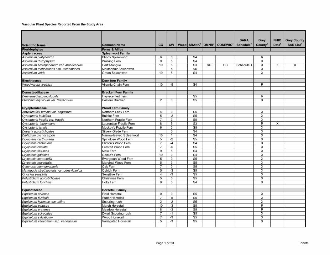
Vascular Plant Species Reported From the Study Area
Scientific Name Common Name CC CW Weed SRANK1 OMNR2 COSEWIC3SARA
Schedule4Grey
County5NHIC Data6
Grey County SAR List7
Pteridophytes Ferns & AlliesAspleniaceae Spleenwort FamilyAsplenium platyneuron Ebony Spleenwort 6 3 S4 RAsplenium rhizophyllum Walking Fern 9 5 S4 XAsplenium scolopendrium var. americanum Hart's-tongue 10 5 S3 SC SC Schedule 1 X X XAsplenium trichomanes ssp. trichomanes Maidenhair Spleenwort 5 SU XAsplenium viride Green Spleenwort 10 5 S4 X
Blechnaceae Deer-fern FamilyWoodwardia virginica Virginia Chain Fern 10 -5 S4 R
Dennstaedtiaceae Bracken Fern FamilyDennstaedtia punctilobula Hay-scented Fern S5 RPteridium aquilinum var. latiusculum Eastern Bracken 2 3 S5 X
Dryopteridaceae Wood Fern FamilyAthyrium filix-femina var. angustum Northern Lady Fern 4 0 S5 XCystopteris bulbifera Bulblet Fern 5 -2 S5 XCystopteris fragilis var. fragilis Northern Fragile Fern 7 3 S5 XCystopteris laurentiana Laurentian Fragile Fern 8 5 S3 R XCystopteris tenuis Mackay's Fragile Fern 6 5 S5 XDeparia acrostichoides Silvery Glade Fern 0 S4 XDiplazium pycnocarpon Narrow-leaved Spleenwort 10 1 S4 XDryopteris carthusiana Spinulose Wood Fern 5 -2 S5 XDryopteris clintoniana Clinton's Wood Fern 7 -4 S4 XDryopteris cristata Crested Wood Fern 7 -5 S5 XDryopteris filix-mas Male Fern 9 5 S4 XDryopteris goldiana Goldie's Fern 10 0 S4 XDryopteris intermedia Evergreen Wood Fern 5 0 S5 XDryopteris marginalis Marginal Wood Fern 5 3 S5 XGymnocarpium dryopteris Oak Fern 7 0 S5 XMatteuccia struthiopteris var. pensylvanica Ostrich Fern 5 -3 S5 XOnoclea sensibilis Sensitive Fern 4 -3 S5 XPolystichum acrostichoides Christmas Fern 5 5 S5 XPolystichum lonchitis Holly Fern 9 5 S4 X
Equisetaceae Horsetail FamilyEquisetum arvense Field Horsetail 0 0 S5 XEquisetum fluviatile Water Horsetail 7 -5 S5 XEquisetum hyemale ssp. affine Scouring-rush 2 -2 S5 XEquisetum palustre Marsh Horsetail 10 -3 S5 REquisetum pratense Meadow Horsetail 8 -3 S5 REquisetum scirpoides Dwarf Scouring-rush 7 -1 S5 XEquisetum sylvaticum Wood Horsetail 7 -3 S5 XEquisetum variegatum ssp. variegatum Variegated Horsetail 5 -3 S5 X
Page 1 of 23 Plants
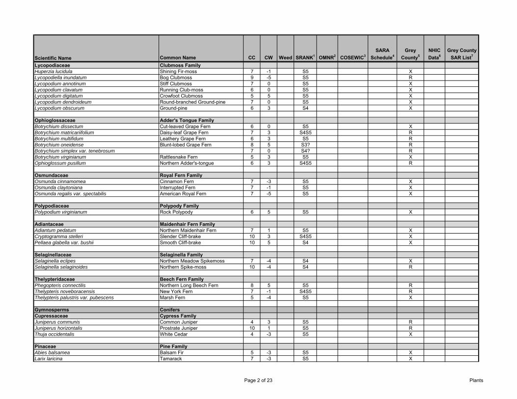
Scientific Name Common Name CC CW Weed SRANK1 OMNR2 COSEWIC3SARA
Schedule4Grey
County5NHIC Data6
Grey County SAR List7
Lycopodiaceae Clubmoss FamilyHuperzia lucidula Shining Fir-moss 7 -1 S5 XLycopodiella inundatum Bog Clubmoss 9 -5 S5 RLycopodium annotinum Stiff Clubmoss 7 0 S5 XLycopodium clavatum Running Club-moss 6 0 S5 XLycopodium digitatum Crowfoot Clubmoss 5 5 S5 XLycopodium dendroideum Round-branched Ground-pine 7 0 S5 XLycopodium obscurum Ground-pine 6 3 S4 X
Ophioglossaceae Adder's Tongue FamilyBotrychium dissectum Cut-leaved Grape Fern 6 0 S5 XBotrychium matricariifolium Daisy-leaf Grape Fern 7 3 S4S5 RBotrychium multifidum Leathery Grape Fern 6 3 S5 RBotrychium oneidense Blunt-lobed Grape Fern 8 5 S3? RBotrychium simplex var. tenebrosum 7 0 S4? RBotrychium virginianum Rattlesnake Fern 5 3 S5 XOphioglossum pusillum Northern Adder's-tongue 6 3 S4S5 R
Osmundaceae Royal Fern FamilyOsmunda cinnamomea Cinnamon Fern 7 -3 S5 XOsmunda claytoniana Interrupted Fern 7 -1 S5 XOsmunda regalis var. spectabilis American Royal Fern 7 -5 S5 X
Polypodiaceae Polypody FamilyPolypodium virginianum Rock Polypody 6 5 S5 X
Adiantaceae Maidenhair Fern FamilyAdiantum pedatum Northern Maidenhair Fern 7 1 S5 XCryptogramma stelleri Slender Cliff-brake 10 3 S4S5 XPellaea glabella var. bushii Smooth Cliff-brake 10 5 S4 X
Selaginellaceae Selaginella FamilySelaginella eclipes Northern Meadow Spikemoss 7 -4 S4 XSelaginella selaginoides Northern Spike-moss 10 -4 S4 R
Thelypteridaceae Beech Fern FamilyPhegopteris connectilis Northern Long Beech Fern 8 5 S5 RThelypteris noveboracensis New York Fern 7 -1 S4S5 RThelypteris palustris var. pubescens Marsh Fern 5 -4 S5 X
Gymnosperms ConifersCupressaceae Cypress FamilyJuniperus communis Common Juniper 4 3 S5 RJuniperus horizontalis Prostrate Juniper 10 1 S5 RThuja occidentalis White Cedar 4 -3 S5 X
Pinaceae Pine FamilyAbies balsamea Balsam Fir 5 -3 S5 XLarix laricina Tamarack 7 -3 S5 X
Page 2 of 23 Plants
Scientific Name Common Name CC CW Weed SRANK1 OMNR2 COSEWIC3SARA
Schedule4Grey
County5NHIC Data6
Grey County SAR List7
Picea glauca White Spruce 6 3 S5 XPicea mariana Black Spruce 8 -3 S5 XPinus strobus Eastern White Pine 4 3 S5 XTsuga canadensis Eastern Hemlock 7 3 S5 X
Taxaceae Yew FamilyTaxus canadensis American Yew 7 3 S5 XDicotyledons DicotsAceraceae Maple FamilyAcer negundo Manitoba Maple 0 -2 S5 XAcer pensylvanicum Striped Maple 7 2 S5 RAcer rubrum Red Maple 4 0 S5 XAcer saccharinum Silver Maple 5 -3 S5 XAcer saccharum ssp. saccharum Sugar Maple 4 3 S5 XAcer spicatum Mountain Maple 6 3 S5 X
Anacardiaceae Sumac or Cashew FamilyRhus aromatica Fragrant Sumac 8 5 S5 RRhus hirta Staghorn Sumac 1 5 S5 XToxicodendron radicans ssp. negundo Poison-ivy 5 -1 S5 XToxicodendron vernix Poison Sumac 8 -5 S4 R
Apiaceae Carrot or Parsley FamilyAngelica atropurpurea Dark-purple Alexanders 6 -5 S5 RCicuta bulbifera Bulb-bearing Water-hemlock 5 -5 S5 XCicuta maculata Spotted Water-hemlock 6 -5 S5 XCryptotaenia canadensis Honewort 5 0 S5 XHeracleum lanatum Cow-parsnip 3 -3 S5 RHydrocotyle americana American Marsh-pennywort 7 -5 S5 XOsmorhiza bererii Sweet-cicely 9 5 S4 ROsmorhiza claytonii Woolly Sweet-cicely 5 4 S5 XOsmorhiza longistylis Anise-root 6 4 S5 RSanicula marilandica Black Snakeroot 5 3 S5 XSanicula odorata Clustered Snakeroot 6 -1 S5 RSium suave Hemlock Water-parsnip 4 -5 S5 X
Apocynaceae Dogbane FamilyApocynum androsaemifolium ssp. androsaemifolium Spreading Dogbane 3 5 S5 X
Aquifoliaceae Holly FamilyIlex verticillata Winterberry 5 -4 S5 XNemopanthus mucronatus Mountain-holly 8 -5 S5 X
Page 3 of 23 Plants
Scientific Name Common Name CC CW Weed SRANK1 OMNR2 COSEWIC3SARA
Schedule4Grey
County5NHIC Data6
Grey County SAR List7
Araliaceae Ginseng FamilyAralia hispida Bristly Sarsaparilla 8 5 S5 RAralia nudicaulis Wild Sarsaparilla 4 3 S5 XAralia racemosa ssp. racemosa Spikenard 7 5 S5 XPanax quinquefolius Ginseng 9 5 S3 END E Schedule 1 X X
Aristolochiaceae Duchman's-pipe FamilyAsarum canadense Wild Ginger 6 5 S5 X
Asclepiadaceae Milkweed FamilyAsclepias incarnata ssp. incarnata Swamp Milkweed 6 -5 S5 XAsclepias syriaca Common Milkweed 0 5 S5 XAsclepias verticillata Whorled Milkweed 6 5 S4 R
Asteraceae Composite or Aster FamilyAchillea millefolium ssp. lanulosa Woolly Yarrow 0 3 S5 XAdenocaulon bicolor Trail-plant 9 3 S1 R XAmbrosia artemisiifolia Common Ragweed 0 3 S5 XAmbrosia trifida Giant Ragweed 0 -1 S5 RAnaphalis margaritacea Pearly Everlasting 3 5 S5 XAntennaria neglecta Field Pussytoes 3 5 S5 XAntennaria parlinii ssp. parlinii Parlin's Pussytoes SU XArnoglossum plantagineum Tuberous Indian-plantain 10 0 S3 SC SC Schedule 1 X XBidens cernua Stick-tight 2 -5 S5 XBidens frondosa Devil's Beggar-ticks 3 -3 S5 XBidens tripartita European Beggar-ticks 4 -3 S5 XBidens vulgata Tall Beggar-ticks 5 -3 S5 XCirsium muticum Swamp Thistle 8 -5 S5 XConyza canadensis Horseweed 0 1 S5 XErigeron philadelphicus ssp. philadelphicus Philadelphia Fleabane 1 -3 S5 XErigeron strigosus Daisy Fleabane 0 1 S5 XEupatorium perfoliatum Perfoliate Thoroughwort 2 -4 S5 XEupatorium rugosum White Snakeroot 5 3 S5 XEupatorium maculatum ssp. maculatum Spotted Joe-pye-weed 3 -5 S5 XEurybia macrophylla Large-leaved Aster 5 5 S5 XEuthamia graminifolia Flat-topped Bushy Goldenrod 2 -2 S5 XLactuca biennis Biennial Lettuce 6 0 S5 XLactuca canadensis Tall Lettuce 3 2 S5 XPackera aureus Golden Groundsel 7 -3 S5 XPackera paupercula Balsam Groundsel 7 -1 S5 RPetasites frigidus Palmate-leaf Sweet-coltsfoot 8 -3 S5 RPolymnia canadensis Small-flowered Leaf-cup 8 5 S4 RPrenanthes alba White Rattlesnake-root 6 3 S5 XPrenanthes altissima Tall White Rattlesnake-root 5 3 S5 XPrenanthes racemosa ssp. racemosa Glaucous White Rattlesnake-root 10 SU RPseudognaphalium macounii Viscid Cudweed 4 5 S5 XPseudognaphalium obtusifolium Fragrant Cudweed 4 5 S5 XRudbeckia hirta Black-eyed Susan 0 3 S5 XRudbeckia laciniata Tall Coneflower 7 -4 S5 R
Page 4 of 23 Plants
Scientific Name Common Name CC CW Weed SRANK1 OMNR2 COSEWIC3SARA
Schedule4Grey
County5NHIC Data6
Grey County SAR List7
Solidago altissima var. altissima Tall Goldenrod 1 3 S5 XSolidago arguta var. arguta Sharp-leaved Goldenrod 8 3 S3 RHSolidago caesia Blue-stem Goldenrod 5 3 S5 RSolidago canadensis Canada Goldenrod 1 3 S5 XSolidago flexicaulis Zig-zag Goldenrod 6 3 S5 XSolidago gigantea Giant Goldenrod 4 -3 S5 XSolidago hispida var. hispida Hairy Goldenrod 7 5 S5 XSolidago juncea Early Goldenrod 3 5 S5 RSolidago nemoralis ssp. nemoralis Gray Goldenrod 2 5 S5 XSolidago ohioensis Ohio Goldenrod 10 -5 S4 RSolidago rugosa ssp. rugosa Rough Goldenrod 4 -1 S5 XSolidago uliginosa Marsh Goldenrod 9 -5 S5 XSymphyotrichum boreale Rush Aster 10 -5 S5 XSymphyotrichum ciliatum Rayless Annual Aster 0 -1 S4 RSymphyotrichum ciliolatum Ciliolate Aster 6 4 S5 XSymphyotrichum cordifolium Heart-leaved Aster 5 5 S5 XSymphyotrichum ericoides var. ericoides White Heath Aster S5 XSymphyotrichum laeve var. laeve Smooth Blue Aster 7 5 S5 RSymphyotrichum lanceolatum var. lanceolatum Tall White Aster 3 -3 S5 XSymphyotrichum lateriflorum var. lateriflorum Calico Aster 3 -2 S5 XSymphyotrichum novae-angliae New England Aster 2 -3 S5 XSymphyotrichum ontarione Ontario Aster 6 0 S4 RSymphyotrichum pilosum var. pilosum Hairy Aster 4 2 S5 RSymphyotrichum puniceum var. puniceum Purple-stemmed Aster S5 XSymphyotrichum urophyllum Arrow-leaved Aster 6 5 S4 X
Balsaminaceae Touch-me-not FamilyImpatiens capensis Spotted Touch-me-not 4 -3 S5 XImpatiens pallida Pale Touch-me-not 7 -3 S5 X
Berberidaceae Barberry FamilyCaulophyllum thalictroides Blue Cohosh 6 5 S5 XPodophyllum peltatum May-apple 5 3 S5 R
Betulaceae Birch FamilyAlnus incana spp. rugosa Speckled Alder 6 -5 S5 XBetula alleghaniensis Yellow Birch 6 0 S5 XBetula papyrifera White Birch 2 S5 XBetula pumila Swamp Birch 9 -5 S5 XCarpinus caroliniana ssp. virginiana Blue Beech 6 0 S5 XCorylus cornuta ssp. cornuta Beaked Hazel 5 5 S5 XOstrya virginiana Hop Hornbeam 4 4 S5 X
Page 5 of 23 Plants
Scientific Name Common Name CC CW Weed SRANK1 OMNR2 COSEWIC3SARA
Schedule4Grey
County5NHIC Data6
Grey County SAR List7
Boraginaceae Borage FamilyHackelia deflexa Spurred Stickweed 5 5 S5 XHackelia virginiana Virginia Stickweed 5 1 S5 XMyosotis laxa Smaller Forget-me-not 6 -5 S5 X
Brassicaceae Mustard FamilyArabis divaricarpa var. divaricarpa Divaricate Rock-cress 7 S5 RArabis glabra Tower-mustard 4 5 S5 XArabis hirsuta ssp. pycnocarpa Hairy Rock-cress 8 3 S5 RCardamine concatenata Cut-leaved Toothwort 6 3 S5 XCardamine diphylla Two-leaved Toothwort 7 5 S5 XCardamine pensylvanica Pensylvania Bitter-cress 6 -4 S5 XCardamine X maxima Large Toothwort S3 RLepidium densiflorum Common Pepper-grass 0 -2 SE5 XRorippa aquatica Lake Water-cress 9 -5 S3? RRorippa palustris ssp. fernaldiana Marsh Yellow-cress 3 -5 S5 X
Cabombaceae Water-shield FamilyBrasenia schreberi Water-shield 7 -5 S5 R
Campanulaceae Bellflower FamilyCampanula aparinoides Marsh Bellflower 7 -5 S5 XLobelia cardinalis Cardinal-flower 7 -5 S5 XLobelia inflata Indian Tobacco 3 4 S5 XLobelia kalmii Kalm's Lobelia 9 -5 S5 XLobelia siphilitica Great Lobelia 6 -4 S5 X
Caprifoliaceae Honeysuckle FamilyDiervilla lonicera Bush Honeysuckle 5 5 S5 XLinnaea borealis ssp. longiflora Twinflower 7 0 S5 XLonicera canadensis American Fly Honeysuckle 6 3 S5 XLonicera dioica Glaucous Honeysuckle 5 3 S5 XLonicera hirsuta Hairy Honeysuckle 7 0 S5 XLonicera oblongifolia Swamp Fly Honeysuckle 8 -5 S5 XLonicera villosa Mountain Fly Honeysuckle 10 -3 S5 XSambucus canadensis Common Elderberry 5 -2 S5 XSambucus racemosa ssp. pubens Red-berried Elderberry 5 2 S5 XSymphoricarpos albus Snowberry 7 4 S5 RTriosteum aurantiacum Wild Coffee 7 5 S5 XViburnum acerifolium Maple-leaved Viburnum 6 5 S5 RViburnum cassinoides Northern Wild Raisin 7 -3 S5 XViburnum lantanoides Hobblebush 8 0 S5 RViburnum lentago Nannyberry 4 -1 S5 XViburnum rafinesquianum Downy Arrow-wood 7 5 S5 RViburnum trilobum High Bush Cranberry 5 -3 S5 X
Page 6 of 23 Plants
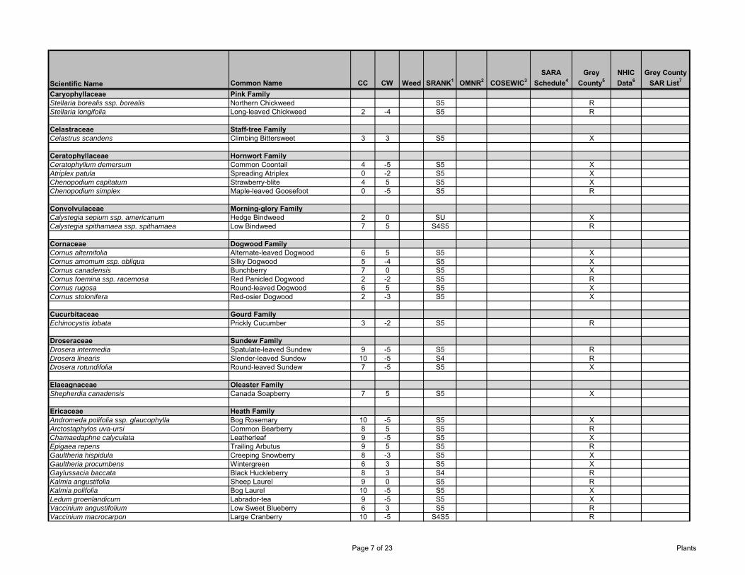
Scientific Name Common Name CC CW Weed SRANK1 OMNR2 COSEWIC3SARA
Schedule4Grey
County5NHIC Data6
Grey County SAR List7
Caryophyllaceae Pink FamilyStellaria borealis ssp. borealis Northern Chickweed S5 RStellaria longifolia Long-leaved Chickweed 2 -4 S5 R
Celastraceae Staff-tree FamilyCelastrus scandens Climbing Bittersweet 3 3 S5 X
Ceratophyllaceae Hornwort FamilyCeratophyllum demersum Common Coontail 4 -5 S5 XAtriplex patula Spreading Atriplex 0 -2 S5 XChenopodium capitatum Strawberry-blite 4 5 S5 XChenopodium simplex Maple-leaved Goosefoot 0 -5 S5 R
Convolvulaceae Morning-glory FamilyCalystegia sepium ssp. americanum Hedge Bindweed 2 0 SU XCalystegia spithamaea ssp. spithamaea Low Bindweed 7 5 S4S5 R
Cornaceae Dogwood FamilyCornus alternifolia Alternate-leaved Dogwood 6 5 S5 XCornus amomum ssp. obliqua Silky Dogwood 5 -4 S5 XCornus canadensis Bunchberry 7 0 S5 XCornus foemina ssp. racemosa Red Panicled Dogwood 2 -2 S5 RCornus rugosa Round-leaved Dogwood 6 5 S5 XCornus stolonifera Red-osier Dogwood 2 -3 S5 X
Cucurbitaceae Gourd FamilyEchinocystis lobata Prickly Cucumber 3 -2 S5 R
Droseraceae Sundew FamilyDrosera intermedia Spatulate-leaved Sundew 9 -5 S5 RDrosera linearis Slender-leaved Sundew 10 -5 S4 RDrosera rotundifolia Round-leaved Sundew 7 -5 S5 X
Elaeagnaceae Oleaster FamilyShepherdia canadensis Canada Soapberry 7 5 S5 X
Ericaceae Heath FamilyAndromeda polifolia ssp. glaucophylla Bog Rosemary 10 -5 S5 XArctostaphylos uva-ursi Common Bearberry 8 5 S5 RChamaedaphne calyculata Leatherleaf 9 -5 S5 XEpigaea repens Trailing Arbutus 9 5 S5 RGaultheria hispidula Creeping Snowberry 8 -3 S5 XGaultheria procumbens Wintergreen 6 3 S5 XGaylussacia baccata Black Huckleberry 8 3 S4 RKalmia angustifolia Sheep Laurel 9 0 S5 RKalmia polifolia Bog Laurel 10 -5 S5 XLedum groenlandicum Labrador-tea 9 -5 S5 XVaccinium angustifolium Low Sweet Blueberry 6 3 S5 RVaccinium macrocarpon Large Cranberry 10 -5 S4S5 R
Page 7 of 23 Plants
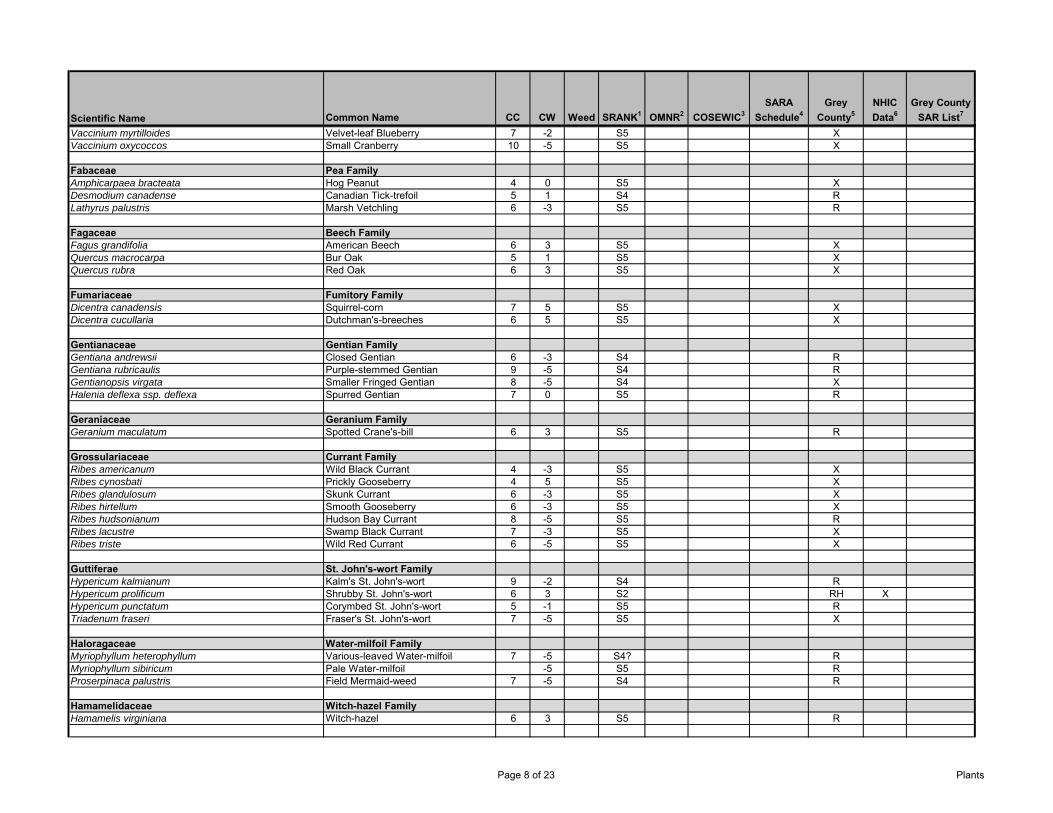
Scientific Name Common Name CC CW Weed SRANK1 OMNR2 COSEWIC3SARA
Schedule4Grey
County5NHIC Data6
Grey County SAR List7
Vaccinium myrtilloides Velvet-leaf Blueberry 7 -2 S5 XVaccinium oxycoccos Small Cranberry 10 -5 S5 X
Fabaceae Pea FamilyAmphicarpaea bracteata Hog Peanut 4 0 S5 XDesmodium canadense Canadian Tick-trefoil 5 1 S4 RLathyrus palustris Marsh Vetchling 6 -3 S5 R
Fagaceae Beech FamilyFagus grandifolia American Beech 6 3 S5 XQuercus macrocarpa Bur Oak 5 1 S5 XQuercus rubra Red Oak 6 3 S5 X
Fumariaceae Fumitory FamilyDicentra canadensis Squirrel-corn 7 5 S5 XDicentra cucullaria Dutchman's-breeches 6 5 S5 X
Gentianaceae Gentian FamilyGentiana andrewsii Closed Gentian 6 -3 S4 RGentiana rubricaulis Purple-stemmed Gentian 9 -5 S4 RGentianopsis virgata Smaller Fringed Gentian 8 -5 S4 XHalenia deflexa ssp. deflexa Spurred Gentian 7 0 S5 R
Geraniaceae Geranium FamilyGeranium maculatum Spotted Crane's-bill 6 3 S5 R
Grossulariaceae Currant FamilyRibes americanum Wild Black Currant 4 -3 S5 XRibes cynosbati Prickly Gooseberry 4 5 S5 XRibes glandulosum Skunk Currant 6 -3 S5 XRibes hirtellum Smooth Gooseberry 6 -3 S5 XRibes hudsonianum Hudson Bay Currant 8 -5 S5 RRibes lacustre Swamp Black Currant 7 -3 S5 XRibes triste Wild Red Currant 6 -5 S5 X
Guttiferae St. John's-wort FamilyHypericum kalmianum Kalm's St. John's-wort 9 -2 S4 RHypericum prolificum Shrubby St. John's-wort 6 3 S2 RH XHypericum punctatum Corymbed St. John's-wort 5 -1 S5 RTriadenum fraseri Fraser's St. John's-wort 7 -5 S5 X
Haloragaceae Water-milfoil FamilyMyriophyllum heterophyllum Various-leaved Water-milfoil 7 -5 S4? RMyriophyllum sibiricum Pale Water-milfoil -5 S5 RProserpinaca palustris Field Mermaid-weed 7 -5 S4 R
Hamamelidaceae Witch-hazel FamilyHamamelis virginiana Witch-hazel 6 3 S5 R
Page 8 of 23 Plants
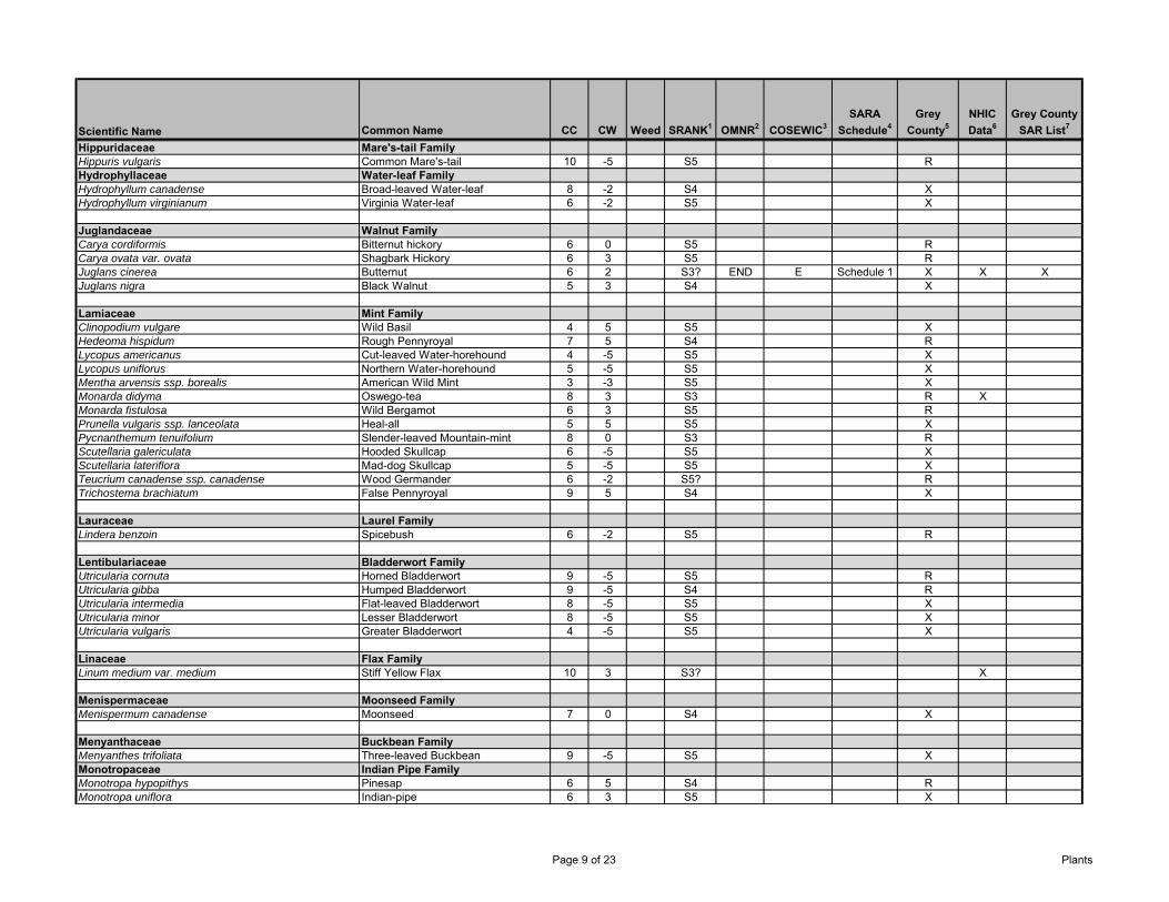
Scientific Name Common Name CC CW Weed SRANK1 OMNR2 COSEWIC3SARA
Schedule4Grey
County5NHIC Data6
Grey County SAR List7
Hippuridaceae Mare's-tail FamilyHippuris vulgaris Common Mare's-tail 10 -5 S5 RHydrophyllaceae Water-leaf FamilyHydrophyllum canadense Broad-leaved Water-leaf 8 -2 S4 XHydrophyllum virginianum Virginia Water-leaf 6 -2 S5 X
Juglandaceae Walnut FamilyCarya cordiformis Bitternut hickory 6 0 S5 RCarya ovata var. ovata Shagbark Hickory 6 3 S5 RJuglans cinerea Butternut 6 2 S3? END E Schedule 1 X X XJuglans nigra Black Walnut 5 3 S4 X
Lamiaceae Mint FamilyClinopodium vulgare Wild Basil 4 5 S5 XHedeoma hispidum Rough Pennyroyal 7 5 S4 RLycopus americanus Cut-leaved Water-horehound 4 -5 S5 XLycopus uniflorus Northern Water-horehound 5 -5 S5 XMentha arvensis ssp. borealis American Wild Mint 3 -3 S5 XMonarda didyma Oswego-tea 8 3 S3 R XMonarda fistulosa Wild Bergamot 6 3 S5 RPrunella vulgaris ssp. lanceolata Heal-all 5 5 S5 XPycnanthemum tenuifolium Slender-leaved Mountain-mint 8 0 S3 RScutellaria galericulata Hooded Skullcap 6 -5 S5 XScutellaria lateriflora Mad-dog Skullcap 5 -5 S5 XTeucrium canadense ssp. canadense Wood Germander 6 -2 S5? RTrichostema brachiatum False Pennyroyal 9 5 S4 X
Lauraceae Laurel FamilyLindera benzoin Spicebush 6 -2 S5 R
Lentibulariaceae Bladderwort FamilyUtricularia cornuta Horned Bladderwort 9 -5 S5 RUtricularia gibba Humped Bladderwort 9 -5 S4 RUtricularia intermedia Flat-leaved Bladderwort 8 -5 S5 XUtricularia minor Lesser Bladderwort 8 -5 S5 XUtricularia vulgaris Greater Bladderwort 4 -5 S5 X
Linaceae Flax FamilyLinum medium var. medium Stiff Yellow Flax 10 3 S3? X
Menispermaceae Moonseed FamilyMenispermum canadense Moonseed 7 0 S4 X
Menyanthaceae Buckbean FamilyMenyanthes trifoliata Three-leaved Buckbean 9 -5 S5 XMonotropaceae Indian Pipe FamilyMonotropa hypopithys Pinesap 6 5 S4 RMonotropa uniflora Indian-pipe 6 3 S5 X
Page 9 of 23 Plants
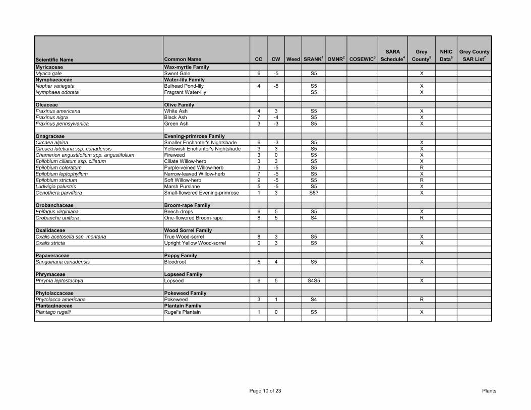
Scientific Name Common Name CC CW Weed SRANK1 OMNR2 COSEWIC3SARA
Schedule4Grey
County5NHIC Data6
Grey County SAR List7
Myricaceae Wax-myrtle FamilyMyrica gale Sweet Gale 6 -5 S5 XNymphaeaceae Water-lily FamilyNuphar variegata Bulhead Pond-lily 4 -5 S5 XNymphaea odorata Fragrant Water-lily S5 X
Oleaceae Olive FamilyFraxinus americana White Ash 4 3 S5 XFraxinus nigra Black Ash 7 -4 S5 XFraxinus pennsylvanica Green Ash 3 -3 S5 X
Onagraceae Evening-primrose FamilyCircaea alpina Smaller Enchanter's Nightshade 6 -3 S5 XCircaea lutetiana ssp. canadensis Yellowish Enchanter's Nightshade 3 3 S5 XChamerion angustifolium spp. angustifolium Fireweed 3 0 S5 XEpilobium ciliatum ssp. ciliatum Ciliate Willow-herb 3 3 S5 XEpilobium coloratum Purple-veined Willow-herb 3 -5 S5 REpilobium leptophyllum Narrow-leaved Willow-herb 7 -5 S5 XEpilobium strictum Soft Willow-herb 9 -5 S5 RLudwigia palustris Marsh Purslane 5 -5 S5 XOenothera parviflora Small-flowered Evening-primrose 1 3 S5? X
Orobanchaceae Broom-rape FamilyEpifagus virginiana Beech-drops 6 5 S5 XOrobanche uniflora One-flowered Broom-rape 8 5 S4 R
Oxalidaceae Wood Sorrel FamilyOxalis acetosella ssp. montana True Wood-sorrel 8 3 S5 XOxalis stricta Upright Yellow Wood-sorrel 0 3 S5 X
Papaveraceae Poppy FamilySanguinaria canadensis Bloodroot 5 4 S5 X
Phrymaceae Lopseed FamilyPhryma leptostachya Lopseed 6 5 S4S5 X
Phytolaccaceae Pokeweed FamilyPhytolacca americana Pokeweed 3 1 S4 RPlantaginaceae Plantain FamilyPlantago rugelii Rugel's Plantain 1 0 S5 X
Page 10 of 23 Plants
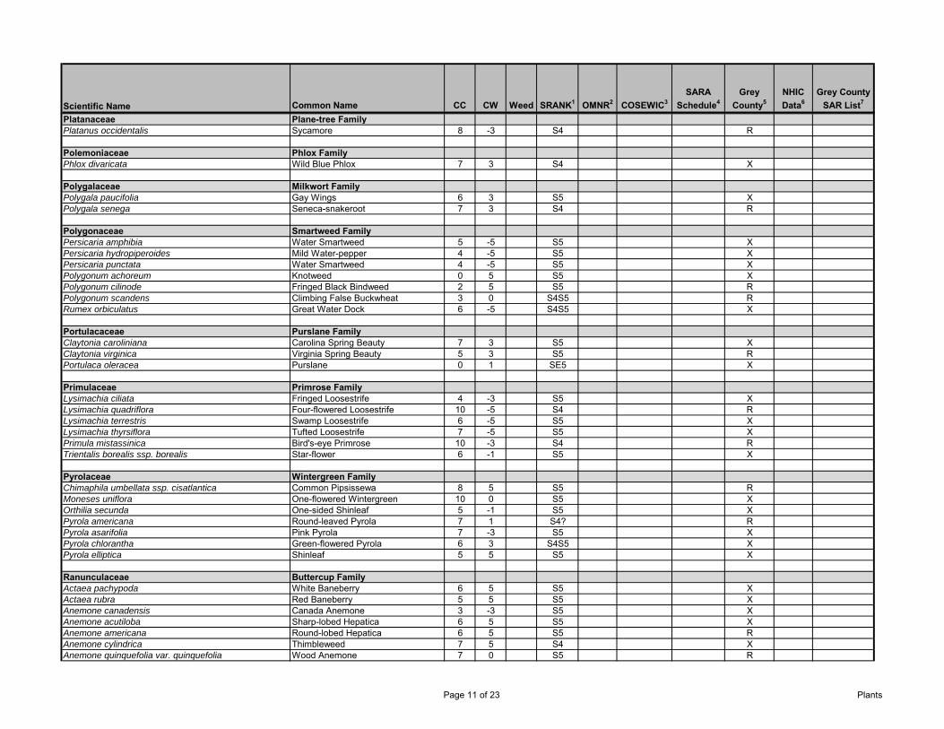
Scientific Name Common Name CC CW Weed SRANK1 OMNR2 COSEWIC3SARA
Schedule4Grey
County5NHIC Data6
Grey County SAR List7
Platanaceae Plane-tree FamilyPlatanus occidentalis Sycamore 8 -3 S4 R
Polemoniaceae Phlox FamilyPhlox divaricata Wild Blue Phlox 7 3 S4 X
Polygalaceae Milkwort FamilyPolygala paucifolia Gay Wings 6 3 S5 XPolygala senega Seneca-snakeroot 7 3 S4 R
Polygonaceae Smartweed FamilyPersicaria amphibia Water Smartweed 5 -5 S5 XPersicaria hydropiperoides Mild Water-pepper 4 -5 S5 XPersicaria punctata Water Smartweed 4 -5 S5 XPolygonum achoreum Knotweed 0 5 S5 XPolygonum cilinode Fringed Black Bindweed 2 5 S5 RPolygonum scandens Climbing False Buckwheat 3 0 S4S5 RRumex orbiculatus Great Water Dock 6 -5 S4S5 X
Portulacaceae Purslane FamilyClaytonia caroliniana Carolina Spring Beauty 7 3 S5 XClaytonia virginica Virginia Spring Beauty 5 3 S5 RPortulaca oleracea Purslane 0 1 SE5 X
Primulaceae Primrose FamilyLysimachia ciliata Fringed Loosestrife 4 -3 S5 XLysimachia quadriflora Four-flowered Loosestrife 10 -5 S4 RLysimachia terrestris Swamp Loosestrife 6 -5 S5 XLysimachia thyrsiflora Tufted Loosestrife 7 -5 S5 XPrimula mistassinica Bird's-eye Primrose 10 -3 S4 RTrientalis borealis ssp. borealis Star-flower 6 -1 S5 X
Pyrolaceae Wintergreen FamilyChimaphila umbellata ssp. cisatlantica Common Pipsissewa 8 5 S5 RMoneses uniflora One-flowered Wintergreen 10 0 S5 XOrthilia secunda One-sided Shinleaf 5 -1 S5 XPyrola americana Round-leaved Pyrola 7 1 S4? RPyrola asarifolia Pink Pyrola 7 -3 S5 XPyrola chlorantha Green-flowered Pyrola 6 3 S4S5 XPyrola elliptica Shinleaf 5 5 S5 X
Ranunculaceae Buttercup FamilyActaea pachypoda White Baneberry 6 5 S5 XActaea rubra Red Baneberry 5 5 S5 XAnemone canadensis Canada Anemone 3 -3 S5 XAnemone acutiloba Sharp-lobed Hepatica 6 5 S5 XAnemone americana Round-lobed Hepatica 6 5 S5 RAnemone cylindrica Thimbleweed 7 5 S4 XAnemone quinquefolia var. quinquefolia Wood Anemone 7 0 S5 R
Page 11 of 23 Plants

Scientific Name Common Name CC CW Weed SRANK1 OMNR2 COSEWIC3SARA
Schedule4Grey
County5NHIC Data6
Grey County SAR List7
Anemone virginiana var. virginiana Thimbleweed 4 5 S5 XAquilegia canadensis Wild Columbine 5 1 S5 XCaltha palustris Marsh-marigold 5 -5 S5 XClematis occidentalis var. occidentalis Purple Clematis 8 5 S4S5 RClematis virginiana Virgin's-bower 3 0 S5 XCoptis trifolia Gold-thread -3 S5 XHydrastis canadensis Golden Seal 10 5 S2 THR T Schedule 1 RRanunculus abortivus Kidney-leaf Buttercup 2 -2 S5 XRanunculus flabellaris Yellow Water-crowfoot 7 -5 S4? RRanunculus hispidus var. caricetorum Swamp Buttercup 5 -5 S5 XRanunculus pensylvanicus Bristly Buttercup 3 -5 S5 RRanunculus recurvatus var. recurvatus Hooked Buttercup 4 -3 S5 XRanunculus sceleratus var. sceleratus Cursed Buttercup 2 -5 S5 XThalictrum dioicum Early Meadow-rue 5 2 S5 XThalictrum pubescens Tall Meadow-rue 5 -2 S5 X
Rhamnaceae Buckthorn FamilyRhamnus alnifolia Alder-leaved Buckthorn 7 -5 S5 X
Rosaceae Rose FamilyAgrimonia gryposepala Tall Hairy Agrimony 2 2 S5 XAmelanchier laevis Smooth Juneberry 5 5 S5 XAmelanchier spicata Low Juneberry 7 3 S5? XAronia melanocarpa Black chokeberry 7 -3 S5 XComarum palustre Marsh Cinquefoil 7 -5 S5 XCrataegus apiomorpha Pear-shaped Hawthorn 4 5 S1S2 XCrataegus chrysocarpa Round-leaved Hawthorn 4 5 S5 XCrataegus corusca Gleaming Hawthorn 4 5 SNA XCrataegus douglasii Douglas' Hawthorn 7 0 S4? RCrataegus macracantha Large-thorned Hawthorn 4 5 S5 XCrataegus macrosperma Variable Thorn 4 5 S5 XCrataegus pedicellata Scarlet Hawthorn 4 5 S4 RCrataegus pringlei Pringle's Hawthorn 4 5 S5 XCrataegus punctata Large-fruited Thorn 4 5 S5 XCrataegus scabrida Rough Hawthorn 4 5 S3? XCrataegus submollis Emerson's Thorn 4 5 S4S5 XCrataegus suborbiculata Caughuawaga Thorn 4 5 S2 XCrataegus succulenta var. macracantha Long-spined Thorn 4 5 S4S5 XDalibarda repens Dewdrop, Robin Runaway 8 4 S4S5 XDasiphora fruticosa ssp. floribunda Shrubby Cinquefoil 9 -3 S5 XFragaria vesca ssp. americana Woodland Strawberry 4 4 S5 XFragaria virginiana ssp. virginiana Scarlet Strawberry 2 1 SU XGeum aleppicum Yellow Avens 2 -1 S5 XGeum canadense White Avens 3 0 S5 XGeum rivale Purple Avens 7 -5 S5 XPhysocarpus opulifolius Ninebark 5 -2 S5 XArgentia anserina ssp. anserina Silverweed 5 -4 S5 XPotentilla simplex Old-field (Common) Cinquefoil 3 4 S5 RPrunus nigra Canada Plum 4 4 S4 X
Page 12 of 23 Plants
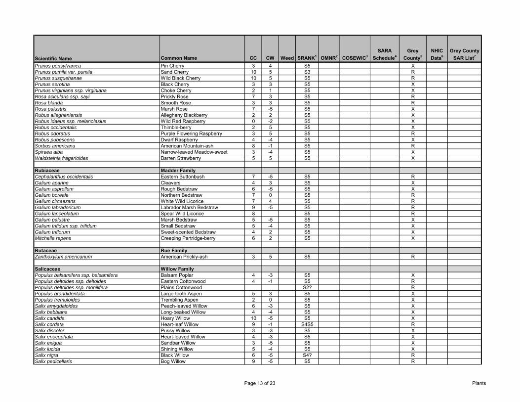
Scientific Name Common Name CC CW Weed SRANK1 OMNR2 COSEWIC3SARA
Schedule4Grey
County5NHIC Data6
Grey County SAR List7
Prunus pensylvanica Pin Cherry 3 4 S5 XPrunus pumila var. pumila Sand Cherry 10 5 S3 RPrunus susquehanae Wild Black Cherry 10 5 S5 RPrunus serotina Black Cherry 3 3 S5 XPrunus virginiana ssp. virginiana Choke Cherry 2 1 S5 XRosa acicularis ssp. sayi Prickly Rose 7 3 S5 RRosa blanda Smooth Rose 3 3 S5 RRosa palustris Marsh Rose 7 -5 S5 XRubus allegheniensis Alleghany Blackberry 2 2 S5 XRubus idaeus ssp. melanolasius Wild Red Raspberry 0 -2 S5 XRubus occidentalis Thimble-berry 2 5 S5 XRubus odoratus Purple Flowering Raspberry 3 5 S5 RRubus pubescens Dwarf Raspberry 4 -4 S5 XSorbus americana American Mountain-ash 8 -1 S5 RSpiraea alba Narrow-leaved Meadow-sweet 3 -4 S5 XWaldsteinia fragarioides Barren Strawberry 5 5 S5 X
Rubiaceae Madder FamilyCephalanthus occidentalis Eastern Buttonbush 7 -5 S5 RGalium aparine Cleavers 4 3 S5 XGalium asprellum Rough Bedstraw 6 -5 S5 XGalium boreale Northern Bedstraw 7 0 S5 RGalium circaezans White Wild Licorice 7 4 S5 RGalium labradoricum Labrador Marsh Bedstraw 9 -5 S5 RGalium lanceolatum Spear Wild Licorice 8 S5 RGalium palustre Marsh Bedstraw 5 -5 S5 XGalium trifidum ssp. trifidum Small Bedstraw 5 -4 S5 XGalium triflorum Sweet-scented Bedstraw 4 2 S5 XMitchella repens Creeping Partridge-berry 6 2 S5 X
Rutaceae Rue FamilyZanthoxylum americanum American Prickly-ash 3 5 S5 R
Salicaceae Willow FamilyPopulus balsamifera ssp. balsamifera Balsam Poplar 4 -3 S5 XPopulus deltoides ssp. deltoides Eastern Cottonwood 4 -1 S5 RPopulus deltoides ssp. monilifera Plains Cottonwood S2? RPopulus grandidentata Large-tooth Aspen 5 3 S5 XPopulus tremuloides Trembling Aspen 2 0 S5 XSalix amygdaloides Peach-leaved Willow 6 -3 S5 XSalix bebbiana Long-beaked Willow 4 -4 S5 XSalix candida Hoary Willow 10 -5 S5 XSalix cordata Heart-leaf Willow 9 -1 S4S5 RSalix discolor Pussy Willow 3 -3 S5 XSalix eriocephala Heart-leaved Willow 4 -3 S5 XSalix exigua Sandbar Willow 3 -5 S5 XSalix lucida Shining Willow 5 -4 S5 XSalix nigra Black Willow 6 -5 S4? RSalix pedicellaris Bog Willow 9 -5 S5 R
Page 13 of 23 Plants
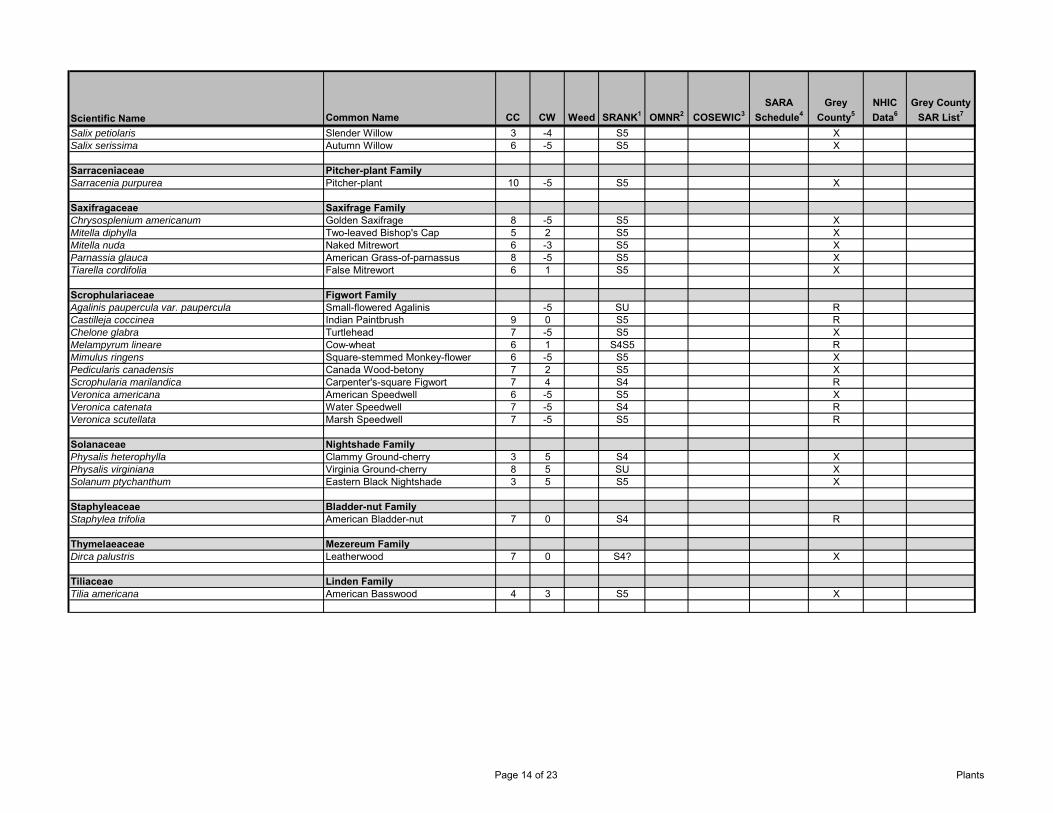
Scientific Name Common Name CC CW Weed SRANK1 OMNR2 COSEWIC3SARA
Schedule4Grey
County5NHIC Data6
Grey County SAR List7
Salix petiolaris Slender Willow 3 -4 S5 XSalix serissima Autumn Willow 6 -5 S5 X
Sarraceniaceae Pitcher-plant FamilySarracenia purpurea Pitcher-plant 10 -5 S5 X
Saxifragaceae Saxifrage FamilyChrysosplenium americanum Golden Saxifrage 8 -5 S5 XMitella diphylla Two-leaved Bishop's Cap 5 2 S5 XMitella nuda Naked Mitrewort 6 -3 S5 XParnassia glauca American Grass-of-parnassus 8 -5 S5 XTiarella cordifolia False Mitrewort 6 1 S5 X
Scrophulariaceae Figwort FamilyAgalinis paupercula var. paupercula Small-flowered Agalinis -5 SU RCastilleja coccinea Indian Paintbrush 9 0 S5 RChelone glabra Turtlehead 7 -5 S5 XMelampyrum lineare Cow-wheat 6 1 S4S5 RMimulus ringens Square-stemmed Monkey-flower 6 -5 S5 XPedicularis canadensis Canada Wood-betony 7 2 S5 XScrophularia marilandica Carpenter's-square Figwort 7 4 S4 RVeronica americana American Speedwell 6 -5 S5 XVeronica catenata Water Speedwell 7 -5 S4 RVeronica scutellata Marsh Speedwell 7 -5 S5 R
Solanaceae Nightshade FamilyPhysalis heterophylla Clammy Ground-cherry 3 5 S4 XPhysalis virginiana Virginia Ground-cherry 8 5 SU XSolanum ptychanthum Eastern Black Nightshade 3 5 S5 X
Staphyleaceae Bladder-nut FamilyStaphylea trifolia American Bladder-nut 7 0 S4 R
Thymelaeaceae Mezereum FamilyDirca palustris Leatherwood 7 0 S4? X
Tiliaceae Linden FamilyTilia americana American Basswood 4 3 S5 X
Page 14 of 23 Plants
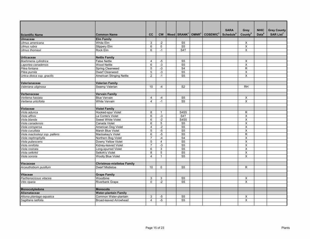
Scientific Name Common Name CC CW Weed SRANK1 OMNR2 COSEWIC3SARA
Schedule4Grey
County5NHIC Data6
Grey County SAR List7
Ulmaceae Elm FamilyUlmus americana White Elm 3 -2 S5 XUlmus rubra Slippery Elm 6 0 S5 XUlmus thomasii Rock Elm 6 -1 S4? X
Urticaceae Nettle FamilyBoehmeria cylindrica False Nettle 4 -5 S5 XLaportea canadensis Wood Nettle 6 -3 S5 XPilea fontana Spring Clearweed 5 -3 S4 RPilea pumila Dwarf Clearweed 5 -3 S5 XUrtica dioica ssp. gracilis American Stinging Nettle 2 -1 S5 X
Valerianaceae Valerian FamilyValeriana uliginosa Swamp Valerian 10 -4 S2 RH
Verbenaceae Vervain FamilyVerbena hastata Blue Vervain 4 -4 S5 XVerbena urticifolia White Vervain 4 -1 S5 X
Violaceae Violet FamilyViola adunca Hooked-spur Violet 8 1 S4S5 RViola affinis Le Conte's Violet 6 -3 S4? XViola blanda Sweet White Violet 6 -2 S4S5 XViola canadensis Canada Violet 6 5 S5 XViola conspersa American Dog Violet 4 -2 S5 XViola cucullata Marsh Blue Violet 5 -5 S5 XViola macloskeyi ssp. pallens Macloskey's Violet 6 -5 S5 RViola nephrophylla Northern Bog Violet 7 -4 S4 XViola pubescens Downy Yellow Violet 5 4 S5 XViola renifolia Kidney-leaved Violet 7 -3 S5 XViola rostrata Long-spurred Violet 6 3 S5 XViola selkirkii Selkirk's Violet 8 5 S5 XViola sororia Woolly Blue Violet 4 1 S5 X
Viscaceae Christmas-mistletoe FamilyArceuthobium pusillum Dwarf Mistletoe 10 0 S5 R
Vitaceae Grape FamilyParthenocissus vitacea Woodbine 3 3 S5 XVitis riparia Riverbank Grape 0 -2 S5 X
Monocotyledons MonocotsAlismataceae Water-plantain FamilyAlisma plantago-aquatica Common Water-plantain 3 -5 S5 XSagittaria latifolia Broad-leaved Arrowhead 4 -5 S5 X
Page 15 of 23 Plants
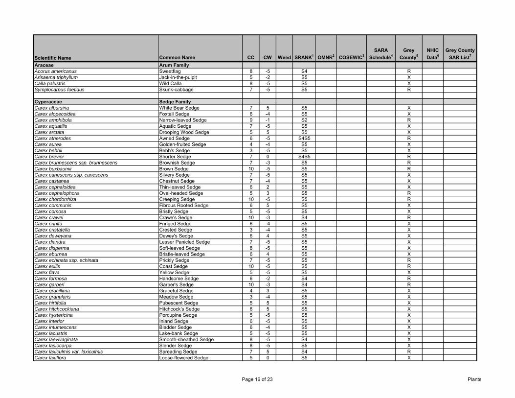
Scientific Name Common Name CC CW Weed SRANK1 OMNR2 COSEWIC3SARA
Schedule4Grey
County5NHIC Data6
Grey County SAR List7
Araceae Arum FamilyAcorus americanus Sweetflag 8 -5 S4 RArisaema triphyllum Jack-in-the-pulpit 5 -2 S5 XCalla palustris Wild Calla 8 -5 S5 XSymplocarpus foetidus Skunk-cabbage 7 -5 S5 R
Cyperaceae Sedge FamilyCarex albursina White Bear Sedge 7 5 S5 XCarex alopecoidea Foxtail Sedge 6 -4 S5 XCarex amphibola Narrow-leaved Sedge 9 -1 S2 RCarex aquatilis Aquatic Sedge 7 -5 S5 XCarex arctata Drooping Wood Sedge 5 5 S5 XCarex atherodes Awned Sedge 6 -5 S4S5 RCarex aurea Golden-fruited Sedge 4 -4 S5 XCarex bebbii Bebb's Sedge 3 -5 S5 XCarex brevior Shorter Sedge 7 0 S4S5 RCarex brunnescens ssp. brunnescens Brownish Sedge 7 -3 S5 RCarex buxbaumii Brown Sedge 10 -5 S5 RCarex canescens ssp. canescens Silvery Sedge 7 -5 S5 XCarex castanea Chestnut Sedge 7 -4 S5 XCarex cephaloidea Thin-leaved Sedge 6 2 S5 XCarex cephalophora Oval-headed Sedge 5 3 S5 RCarex chordorrhiza Creeping Sedge 10 -5 S5 RCarex communis Fibrous Rooted Sedge 6 5 S5 XCarex comosa Bristly Sedge 5 -5 S5 XCarex crawei Crawe's Sedge 10 -3 S4 RCarex crinita Fringed Sedge 6 -4 S5 XCarex cristatella Crested Sedge 3 -4 S5 XCarex deweyana Dewey's Sedge 6 4 S5 XCarex diandra Lesser Panicled Sedge 7 -5 S5 XCarex disperma Soft-leaved Sedge 8 -5 S5 XCarex eburnea Bristle-leaved Sedge 6 4 S5 XCarex echinata ssp. echinata Prickly Sedge 7 -5 S5 RCarex exilis Coast Sedge 10 -5 S5 RCarex flava Yellow Sedge 5 -5 S5 XCarex formosa Handsome Sedge 6 -2 S4 RCarex garberi Garber's Sedge 10 -3 S4 RCarex gracillima Graceful Sedge 4 3 S5 XCarex granularis Meadow Sedge 3 -4 S5 XCarex hirtifolia Pubescent Sedge 5 5 S5 XCarex hitchcockiana Hitchcock's Sedge 6 5 S5 XCarex hystericina Porcupine Sedge 5 -5 S5 XCarex interior Inland Sedge 6 -5 S5 XCarex intumescens Bladder Sedge 6 -4 S5 XCarex lacustris Lake-bank Sedge 5 -5 S5 XCarex laevivaginata Smooth-sheathed Sedge 8 -5 S4 XCarex lasiocarpa Slender Sedge 8 -5 S5 XCarex laxiculmis var. laxiculmis Spreading Sedge 7 5 S4 RCarex laxiflora Loose-flowered Sedge 5 0 S5 X
Page 16 of 23 Plants

Scientific Name Common Name CC CW Weed SRANK1 OMNR2 COSEWIC3SARA
Schedule4Grey
County5NHIC Data6
Grey County SAR List7
Carex leptalea ssp. leptalea Bristle-stalked Sedge 8 -5 S5 XCarex leptonervia Finely-nerved Sedge 5 0 S5 XCarex limosa Mud Sedge 10 -5 S5 XCarex livida Livid Sedge 10 -5 S5 RCarex lupulina Hop Sedge 6 -5 S5 XCarex lurida Sallow Sedge 6 -5 S5 RCarex magellanica ssp. irrigua Stunted Sedge 10 -5 S5 RCarex normalis Larger Straw Sedge 6 -3 S4 RCarex oligosperma Few-seeded Sedge 10 -5 S4 RCarex pallescens Pale Sedge 5 3 S5 RCarex pauciflora Few-flowered Sedge 10 -5 S5 RCarex peckii Peck's Sedge 6 5 S5 XCarex pedunculata Long-stalked Sedge 5 5 S5 XCarex pellita Woolly Sedge 4 -5 S5 XCarex pensylvanica Pennsylvania Sedge 5 5 S5 RCarex plantaginea Plantain-leaved Sedge 7 5 S5 XCarex prairea Prairie Sedge 7 -4 S5 RCarex prasina Drooping Sedge 10 -5 S4 RCarex projecta Necklace Sedge 5 -4 S5 XCarex pseudocyperus Cypress-like Sedge 6 -5 S5 XCarex radiata Radiate Sedge 4 5 S5 XCarex retrorsa Retrorse Sedge 5 -5 S5 XCarex rosea Stellate Sedge 5 5 S5 XCarex sartwellii Sartwell's Sedge 8 -4 S4 RCarex scabrata Rough Sedge 8 -5 S5 XCarex schweinitzii Schweinitz's Sedge 9 -5 S3 X XCarex sparganioides Burreed Sedge 5 0 S5 XCarex sprengelii Long-beaked Sedge 6 0 S5 RCarex sterilis Sterile Sedge 10 -5 S4 RCarex stipata Awl-fruited Sedge 3 -5 S5 XCarex stricta Tussock Sedge 4 -5 S5 XCarex tenera Straw Sedge 4 -1 S5 XCarex tenuiflora Sparse-flowered Sedge 10 -5 S5 RCarex tribuloides Blunt Broom Sedge 5 -4 S4S5 RCarex trisperma var. trisperma Three-seeded Sedge S5 XCarex tuckermanii Tuckerman's Sedge 7 -5 S4 XCarex utriculata Beaked Sedge 7 -5 S5 XCarex vesicaria Inflated Sedge 7 -5 S5 RCarex viridula ssp. viridula Greenish Sedge 5 -5 S5 RCarex vulpinoidea Fox Sedge 3 -5 S5 XCarex woodii Wood's Sedge 6 0 S4 RCladium mariscoides Water Bog-rush 9 -5 S5 XCyperus bipartitus Umbrella Sedge 4 -4 S5 RDulichium arundinaceum Reed-like Three-way Sedge 7 -5 S5 XEleocharis acicularis Needle Spike-rush 5 -5 S5 REleocharis compressa Flat-stemmed Spike-rush 8 -3 S4 REleocharis elliptica Elliptic Spike-rush 7 -3 S5 REleocharis erythropoda Red-footed Spike-rush 4 -5 S5 XEleocharis intermedia Matted Spike-rush 7 -3 S4 X
Page 17 of 23 Plants
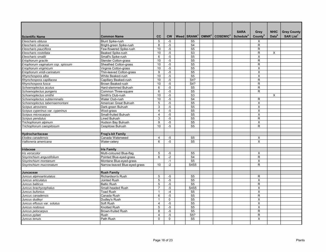
Scientific Name Common Name CC CW Weed SRANK1 OMNR2 COSEWIC3SARA
Schedule4Grey
County5NHIC Data6
Grey County SAR List7
Eleocharis obtusa Blunt Spike-rush 5 -5 S5 XEleocharis olivacea Bright-green Spike-rush 8 -5 S4 REleocharis pauciflora Few-flowered Spike-rush 10 -5 S5 REleocharis rostellata Beaked Spike-rush 10 -5 S3 R XEleocharis smallii Small's Spike-rush 6 -5 S5 XEriophorum gracile Slender Cotton-grass 10 -5 S5 REriophorum vaginatum ssp. spissum Sheathed Cotton-grass 10 -5 S5 REriophorum virginicum Virginia Cotton-grass 10 -5 S5 XEriophorum viridi-carinatum Thin-leaved Cotton-grass 9 -5 S5 XRhynchospora alba White Beaked-rush 10 -5 S5 XRhynchospora capillacea Capillary Beaked-rush 10 -5 S4? RRhynchospora fusca Brown Beaked-rush 10 -5 S4? RSchoenoplectus acutus Hard-stemmed Bulrush 6 -5 S5 RSchoenoplectus pungens Common Three-square 6 -5 S5 RSchoenoplectus smithii Smith's Club-rush 10 -5 S3 XSchoenoplectus subterminalis Water Club-rush 10 -5 S4 RSchoenoplectus tabernaemontani American Great Bulrush 5 -5 S5 XScirpus atrovirens Dark-green Bulrush 3 -5 S5 XScirpus cyperinus var. cyperinus Wool-grass 4 -5 S5 XScirpus microcarpus Small-fruited Bulrush 4 -5 S5 XScirpus pendulus Lined Bulrush 3 -5 S5 RTrichophorum alpinum Hudson Bay Bulrush 9 -5 S5 XTrichophorum caespitosum Cespitose Bulrush 10 -5 S5 R
Hydrocharitaceae Frog's-bit FamilyElodea canadensis Canada Waterweed 4 -5 S5 XVallisneria americana Water-celery 6 -5 S5 X
Iridaceae Iris FamilyIris versicolor Multi-coloured Blue-flag 5 -5 S5 XSisyrinchium angustifolium Pointed Blue-eyed-grass 6 -2 S4 RSisyrinchium montanum Montane Blue-eyed-grass -1 S5 XSisyrinchium mucronatum Narrow-leaved Blue-eyed-grass 10 -2 S4S5 R
Juncaceae Rush FamilyJuncus alpinoarticulatus Richardson's Rush 5 -5 S5 RJuncus articulatus Jointed Rush 5 -5 S5 XJuncus balticus Baltic Rush 5 -5 S5 RJuncus brachycephalus Small-headed Rush 7 -5 S4S5 XJuncus bufonius Toad Rush 1 -4 S5 XJuncus canadensis Canada Rush 6 -5 S5 RJuncus dudleyi Dudley's Rush 1 0 S5 XJuncus effusus var. solutus Soft Rush 4 -5 S5 XJuncus nodosus Knotted Rush 5 -5 S5 XJuncus pelocarpus Brown-fruited Rush 8 -5 S5 RJuncus pylaei Rush 4 -5 S5? RJuncus tenuis Path Rush 0 0 S5 X
Page 18 of 23 Plants
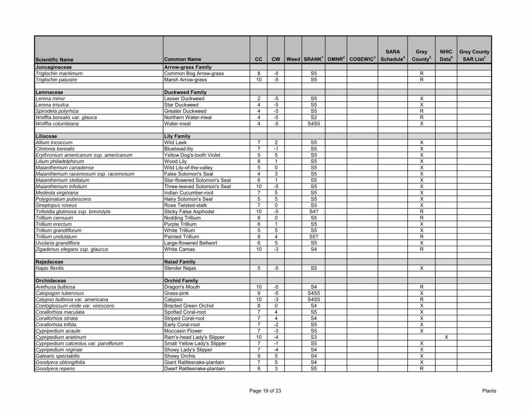
Scientific Name Common Name CC CW Weed SRANK1 OMNR2 COSEWIC3SARA
Schedule4Grey
County5NHIC Data6
Grey County SAR List7
Juncaginaceae Arrow-grass FamilyTriglochin maritimum Common Bog Arrow-grass 8 -5 S5 RTriglochin palustre Marsh Arrow-grass 10 -5 S5 R
Lemnaceae Duckweed FamilyLemna minor Lesser Duckweed 2 -5 S5 XLemna trisulca Star Duckweed 4 -5 S5 XSpirodela polyrhiza Greater Duckweed 4 -5 S5 RWolffia borealis var. glauca Northern Water-meal 4 -5 S2 RWolffia columbiana Water-meal 4 -5 S4S5 X
Liliaceae Lily FamilyAllium tricoccum Wild Leek 7 2 S5 XClintonia borealis Bluebead-lily 7 -1 S5 XErythronium americanum ssp. americanum Yellow Dog's-tooth Violet 5 5 S5 XLilium philadelphicum Wood Lily 8 1 S5 XMaianthemum canadense Wild Lily-of-the-valley 5 0 S5 XMaianthemum racemosum ssp. racemosum False Solomon's Seal 4 3 S5 XMaianthemum stellatum Star-flowered Solomon's Seal 6 1 S5 XMaianthemum trifolium Three-leaved Solomon's Seal 10 -5 S5 XMedeola virginiana Indian Cucumber-root 7 5 S5 XPolygonatum pubescens Hairy Solomon's Seal 5 5 S5 XStreptopus roseus Rose Twisted-stalk 7 0 S5 XTofieldia glutinosa ssp. brevistyla Sticky False Asphodel 10 -5 S4? RTrillium cernuum Nodding Trillium 8 0 S5 RTrillium erectum Purple Trillium 6 1 S5 XTrillium grandiflorum White Trillium 5 5 S5 XTrillium undulatum Painted Trillium 8 4 S5? RUvularia grandiflora Large-flowered Bellwort 6 5 S5 XZigadenus elegans ssp. glaucus White Camas 10 -3 S4 R
Najadaceae Naiad FamilyNajas flexilis Slender Najas 5 -5 S5 X
Orchidaceae Orchid FamilyArethusa bulbosa Dragon's Mouth 10 -5 S4 RCalopogon tuberosus Grass-pink 9 -5 S4S5 XCalypso bulbosa var. americana Calypso 10 -3 S4S5 RCoeloglossum viride var. virescens Bracted Green Orchid 8 0 S4 XCorallorhiza maculata Spotted Coral-root 7 4 S5 XCorallorhiza striata Striped Coral-root 7 4 S4 XCorallorhiza trifida Early Coral-root 7 -2 S5 XCypripedium acaule Moccasin Flower 7 -3 S5 XCypripedium arietinum Ram's-head Lady's Slipper 10 -4 S3 XCypripedium calceolus var. parviflorum Small Yellow Lady's Slipper 7 -1 S5 XCypripedium reginae Showy Lady's Slipper 7 -4 S4 XGalearis spectabilis Showy Orchis 9 5 S4 XGoodyera oblongifolia Giant Rattlesnake-plantain 7 5 S4 XGoodyera repens Dwarf Rattlesnake-plantain 8 3 S5 R
Page 19 of 23 Plants
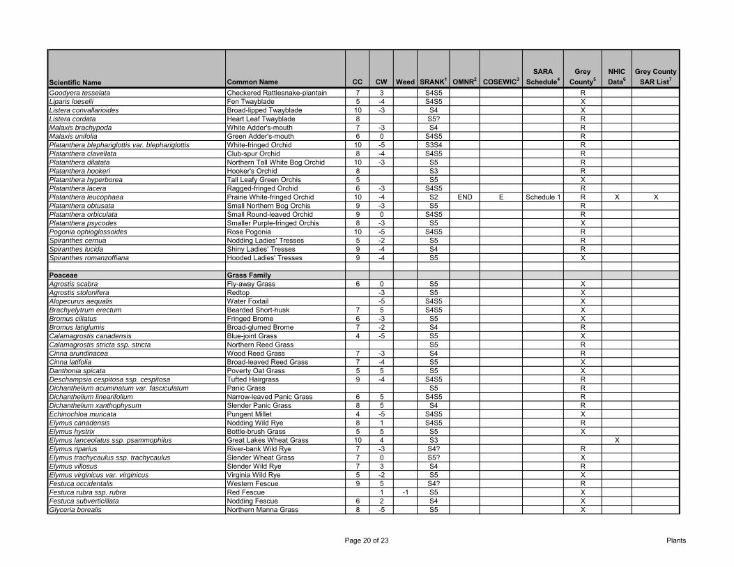
Scientific Name Common Name CC CW Weed SRANK1 OMNR2 COSEWIC3SARA
Schedule4Grey
County5NHIC Data6
Grey County SAR List7
Goodyera tesselata Checkered Rattlesnake-plantain 7 3 S4S5 RLiparis loeselii Fen Twayblade 5 -4 S4S5 XListera convallarioides Broad-lipped Twayblade 10 -3 S4 XListera cordata Heart Leaf Twayblade 8 S5? RMalaxis brachypoda White Adder's-mouth 7 -3 S4 RMalaxis unifolia Green Adder's-mouth 6 0 S4S5 RPlatanthera blephariglottis var. blephariglottis White-fringed Orchid 10 -5 S3S4 RPlatanthera clavellata Club-spur Orchid 8 -4 S4S5 RPlatanthera dilatata Northern Tall White Bog Orchid 10 -3 S5 RPlatanthera hookeri Hooker's Orchid 8 S3 RPlatanthera hyperborea Tall Leafy Green Orchis 5 S5 XPlatanthera lacera Ragged-fringed Orchid 6 -3 S4S5 RPlatanthera leucophaea Prairie White-fringed Orchid 10 -4 S2 END E Schedule 1 R X XPlatanthera obtusata Small Northern Bog Orchis 9 -3 S5 RPlatanthera orbiculata Small Round-leaved Orchid 9 0 S4S5 RPlatanthera psycodes Smaller Purple-fringed Orchis 8 -3 S5 XPogonia ophioglossoides Rose Pogonia 10 -5 S4S5 RSpiranthes cernua Nodding Ladies' Tresses 5 -2 S5 RSpiranthes lucida Shiny Ladies' Tresses 9 -4 S4 RSpiranthes romanzoffiana Hooded Ladies' Tresses 9 -4 S5 X
Poaceae Grass FamilyAgrostis scabra Fly-away Grass 6 0 S5 XAgrostis stolonifera Redtop -3 S5 XAlopecurus aequalis Water Foxtail -5 S4S5 XBrachyelytrum erectum Bearded Short-husk 7 5 S4S5 XBromus ciliatus Fringed Brome 6 -3 S5 XBromus latiglumis Broad-glumed Brome 7 -2 S4 RCalamagrostis canadensis Blue-joint Grass 4 -5 S5 XCalamagrostis stricta ssp. stricta Northern Reed Grass S5 RCinna arundinacea Wood Reed Grass 7 -3 S4 RCinna latifolia Broad-leaved Reed Grass 7 -4 S5 XDanthonia spicata Poverty Oat Grass 5 5 S5 XDeschampsia cespitosa ssp. cespitosa Tufted Hairgrass 9 -4 S4S5 RDichanthelium acuminatum var. fasciculatum Panic Grass S5 RDichanthelium linearifolium Narrow-leaved Panic Grass 6 5 S4S5 RDichanthelium xanthophysum Slender Panic Grass 8 5 S4 REchinochloa muricata Pungent Millet 4 -5 S4S5 XElymus canadensis Nodding Wild Rye 8 1 S4S5 RElymus hystrix Bottle-brush Grass 5 5 S5 XElymus lanceolatus ssp. psammophilus Great Lakes Wheat Grass 10 4 S3 XElymus riparius River-bank Wild Rye 7 -3 S4? RElymus trachycaulus ssp. trachycaulus Slender Wheat Grass 7 0 S5? XElymus villosus Slender Wild Rye 7 3 S4 RElymus virginicus var. virginicus Virginia Wild Rye 5 -2 S5 XFestuca occidentalis Western Fescue 9 5 S4? RFestuca rubra ssp. rubra Red Fescue 1 -1 S5 XFestuca subverticillata Nodding Fescue 6 2 S4 XGlyceria borealis Northern Manna Grass 8 -5 S5 X
Page 20 of 23 Plants
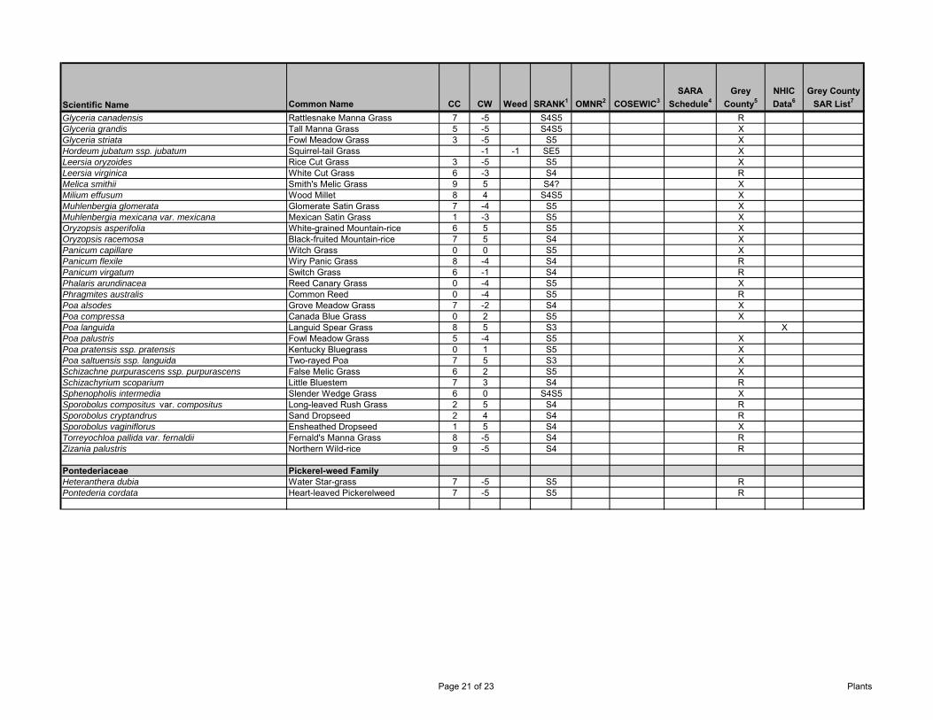
Scientific Name Common Name CC CW Weed SRANK1 OMNR2 COSEWIC3SARA
Schedule4Grey
County5NHIC Data6
Grey County SAR List7
Glyceria canadensis Rattlesnake Manna Grass 7 -5 S4S5 RGlyceria grandis Tall Manna Grass 5 -5 S4S5 XGlyceria striata Fowl Meadow Grass 3 -5 S5 XHordeum jubatum ssp. jubatum Squirrel-tail Grass -1 -1 SE5 XLeersia oryzoides Rice Cut Grass 3 -5 S5 XLeersia virginica White Cut Grass 6 -3 S4 RMelica smithii Smith's Melic Grass 9 5 S4? XMilium effusum Wood Millet 8 4 S4S5 XMuhlenbergia glomerata Glomerate Satin Grass 7 -4 S5 XMuhlenbergia mexicana var. mexicana Mexican Satin Grass 1 -3 S5 XOryzopsis asperifolia White-grained Mountain-rice 6 5 S5 XOryzopsis racemosa Black-fruited Mountain-rice 7 5 S4 XPanicum capillare Witch Grass 0 0 S5 XPanicum flexile Wiry Panic Grass 8 -4 S4 RPanicum virgatum Switch Grass 6 -1 S4 RPhalaris arundinacea Reed Canary Grass 0 -4 S5 XPhragmites australis Common Reed 0 -4 S5 RPoa alsodes Grove Meadow Grass 7 -2 S4 XPoa compressa Canada Blue Grass 0 2 S5 XPoa languida Languid Spear Grass 8 5 S3 XPoa palustris Fowl Meadow Grass 5 -4 S5 XPoa pratensis ssp. pratensis Kentucky Bluegrass 0 1 S5 XPoa saltuensis ssp. languida Two-rayed Poa 7 5 S3 XSchizachne purpurascens ssp. purpurascens False Melic Grass 6 2 S5 XSchizachyrium scoparium Little Bluestem 7 3 S4 RSphenopholis intermedia Slender Wedge Grass 6 0 S4S5 XSporobolus compositus var. compositus Long-leaved Rush Grass 2 5 S4 RSporobolus cryptandrus Sand Dropseed 2 4 S4 RSporobolus vaginiflorus Ensheathed Dropseed 1 5 S4 XTorreyochloa pallida var. fernaldii Fernald's Manna Grass 8 -5 S4 RZizania palustris Northern Wild-rice 9 -5 S4 R
Pontederiaceae Pickerel-weed FamilyHeteranthera dubia Water Star-grass 7 -5 S5 RPontederia cordata Heart-leaved Pickerelweed 7 -5 S5 R
Page 21 of 23 Plants
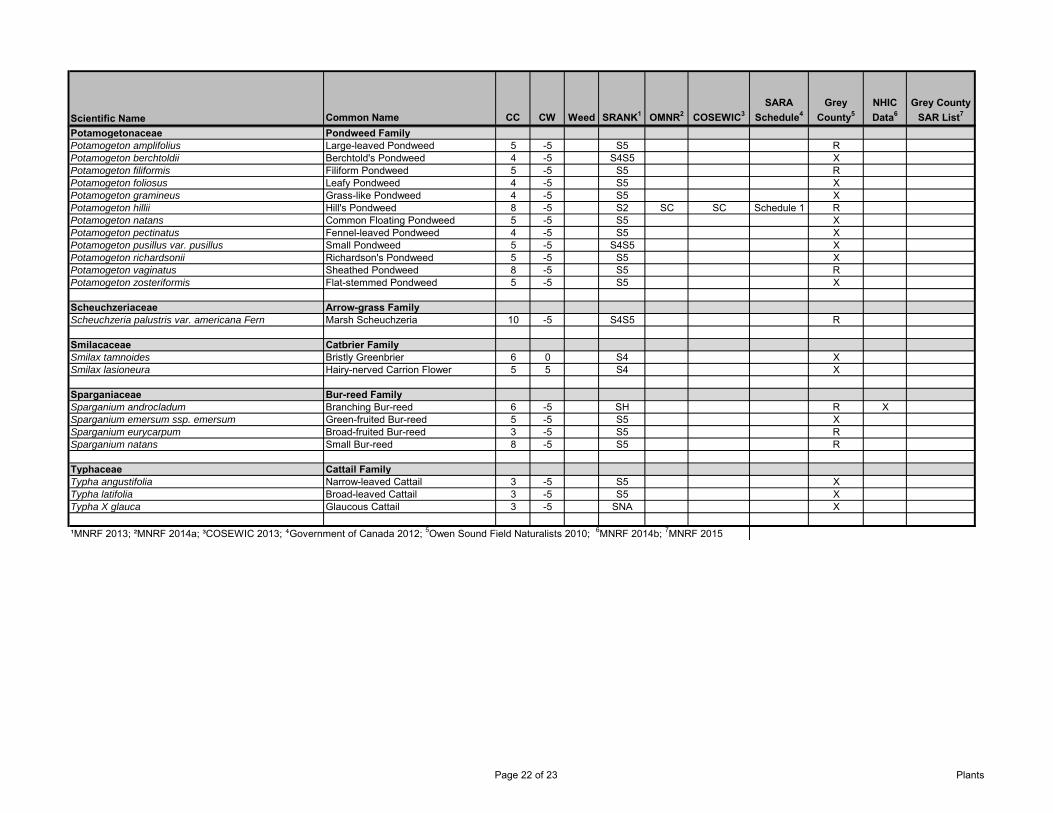
Scientific Name Common Name CC CW Weed SRANK1 OMNR2 COSEWIC3SARA
Schedule4Grey
County5NHIC Data6
Grey County SAR List7
Potamogetonaceae Pondweed FamilyPotamogeton amplifolius Large-leaved Pondweed 5 -5 S5 RPotamogeton berchtoldii Berchtold's Pondweed 4 -5 S4S5 XPotamogeton filiformis Filiform Pondweed 5 -5 S5 RPotamogeton foliosus Leafy Pondweed 4 -5 S5 XPotamogeton gramineus Grass-like Pondweed 4 -5 S5 XPotamogeton hillii Hill's Pondweed 8 -5 S2 SC SC Schedule 1 RPotamogeton natans Common Floating Pondweed 5 -5 S5 XPotamogeton pectinatus Fennel-leaved Pondweed 4 -5 S5 XPotamogeton pusillus var. pusillus Small Pondweed 5 -5 S4S5 XPotamogeton richardsonii Richardson's Pondweed 5 -5 S5 XPotamogeton vaginatus Sheathed Pondweed 8 -5 S5 RPotamogeton zosteriformis Flat-stemmed Pondweed 5 -5 S5 X
Scheuchzeriaceae Arrow-grass FamilyScheuchzeria palustris var. americana Fern Marsh Scheuchzeria 10 -5 S4S5 R
Smilacaceae Catbrier FamilySmilax tamnoides Bristly Greenbrier 6 0 S4 XSmilax lasioneura Hairy-nerved Carrion Flower 5 5 S4 X
Sparganiaceae Bur-reed FamilySparganium androcladum Branching Bur-reed 6 -5 SH R XSparganium emersum ssp. emersum Green-fruited Bur-reed 5 -5 S5 XSparganium eurycarpum Broad-fruited Bur-reed 3 -5 S5 RSparganium natans Small Bur-reed 8 -5 S5 R
Typhaceae Cattail FamilyTypha angustifolia Narrow-leaved Cattail 3 -5 S5 XTypha latifolia Broad-leaved Cattail 3 -5 S5 XTypha X glauca Glaucous Cattail 3 -5 SNA X
¹MNRF 2013; ²MNRF 2014a; ³COSEWIC 2013; ⁴Government of Canada 2012; 5Owen Sound Field Naturalists 2010; 6MNRF 2014b; 7MNRF 2015
Page 22 of 23 Plants
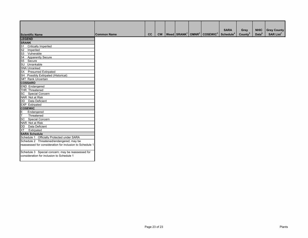
Scientific Name Common Name CC CW Weed SRANK1 OMNR2 COSEWIC3SARA
Schedule4Grey
County5NHIC Data6
Grey County SAR List7
LEGENDSRANKS1 Critically ImperiledS2 ImperiledS3 VulnerableS4 Apparently SecureS5 Secure SU UnrankableSNA UnrankedSX Presumed ExtirpatedSH Possibly Extirpated (Historical)S#? Rank UncertainCOSSAROEND EndangeredTHR ThreatenedSC Special ConcernNAR Not at RiskDD Data DeficientEXP ExtirpatedCOSEWICE EndangeredT ThreatenedSC Special ConcernNAR Not at RiskDD Data DeficientXT ExtirpatedSARA ScheduleSchedule 1 Officially Protected under SARASchedule 2 Threatened/endangered; may be reassessed for consideration for inclusion to Schedule 1
Schedule 3 Special concern; may be reassessed for consideration for inclusion to Schedule 1
Page 23 of 23 Plants
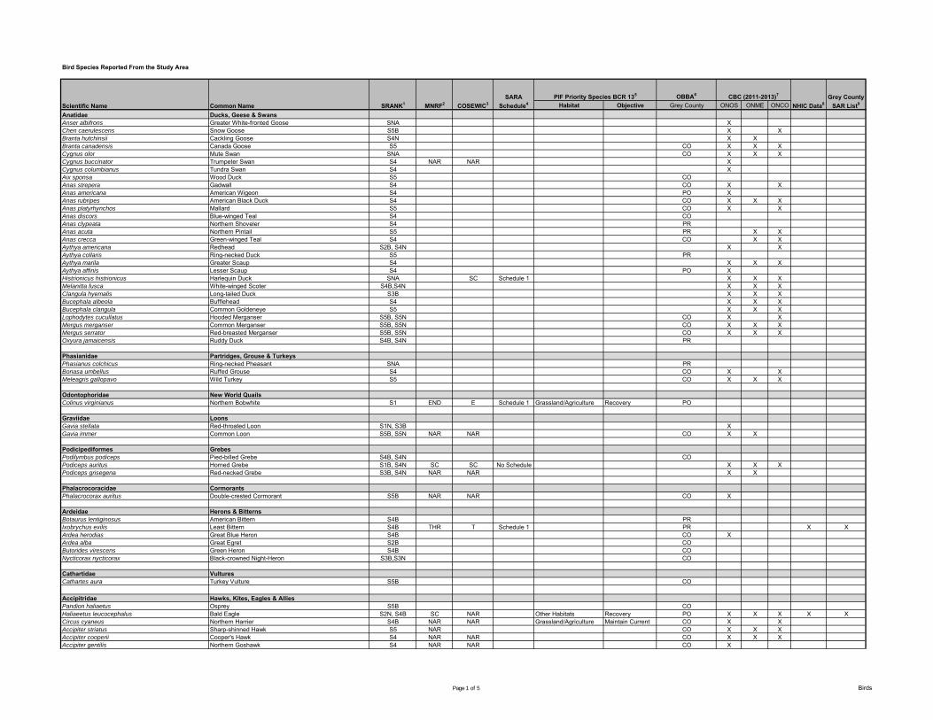
Bird Species Reported From the Study Area
OBBA6
Habitat Objective Grey County ONOS ONME ONCOAnatidae Ducks, Geese & SwansAnser albifrons Greater White-fronted Goose SNA XChen caerulescens Snow Goose S5B X XBranta hutchinsii Cackling Goose S4N X XBranta canadensis Canada Goose S5 CO X X XCygnus olor Mute Swan SNA CO X X XCygnus buccinator Trumpeter Swan S4 NAR NAR XCygnus columbianus Tundra Swan S4 XAix sponsa Wood Duck S5 COAnas strepera Gadwall S4 CO X XAnas americana American Wigeon S4 PO XAnas rubripes American Black Duck S4 CO X X XAnas platyrhynchos Mallard S5 CO X XAnas discors Blue-winged Teal S4 COAnas clypeata Northern Shoveler S4 PRAnas acuta Northern Pintail S5 PR X XAnas crecca Green-winged Teal S4 CO X XAythya americana Redhead S2B, S4N X XAythya collaris Ring-necked Duck S5 PRAythya marila Greater Scaup S4 X X XAythya affinis Lesser Scaup S4 PO XHistrionicus histrionicus Harlequin Duck SNA SC Schedule 1 X X XMelanitta fusca White-winged Scoter S4B,S4N X X XClangula hyemalis Long-tailed Duck S3B X X XBucephala albeola Bufflehead S4 X X XBucephala clangula Common Goldeneye S5 X X XLophodytes cucullatus Hooded Merganser S5B, S5N CO X XMergus merganser Common Merganser S5B, S5N CO X X XMergus serrator Red-breasted Merganser S5B, S5N CO X X XOxyura jamaicensis Ruddy Duck S4B, S4N PR
Phasianidae Partridges, Grouse & TurkeysPhasianus colchicus Ring-necked Pheasant SNA PRBonasa umbellus Ruffed Grouse S4 CO X XMeleagris gallopavo Wild Turkey S5 CO X X X
Odontophoridae New World QuailsColinus virginianus Northern Bobwhite S1 END E Schedule 1 Grassland/Agriculture Recovery PO
Graviidae LoonsGavia stellata Red-throated Loon S1N, S3B XGavia immer Common Loon S5B, S5N NAR NAR CO X X
Podicipediformes GrebesPodilymbus podiceps Pied-billed Grebe S4B, S4N COPodiceps auritus Horned Grebe S1B, S4N SC SC No Schedule X X XPodiceps grisegena Red-necked Grebe S3B, S4N NAR NAR X X
Phalacrocoracidae CormorantsPhalacrocorax auritus Double-crested Cormorant S5B NAR NAR CO X
Ardeidae Herons & BitternsBotaurus lentiginosus American Bittern S4B PRIxobrychus exilis Least Bittern S4B THR T Schedule 1 PR X XArdea herodias Great Blue Heron S4B CO XArdea alba Great Egret S2B COButorides virescens Green Heron S4B CONycticorax nycticorax Black-crowned Night-Heron S3B,S3N CO
Cathartidae VulturesCathartes aura Turkey Vulture S5B CO
Accipitridae Hawks, Kites, Eagles & AlliesPandion haliaetus Osprey S5B COHaliaeetus leucocephalus Bald Eagle S2N, S4B SC NAR Other Habitats Recovery PO X X X X XCircus cyaneus Northern Harrier S4B NAR NAR Grassland/Agriculture Maintain Current CO X XAccipiter striatus Sharp-shinned Hawk S5 NAR CO X X XAccipiter cooperii Cooper's Hawk S4 NAR NAR CO X X XAccipiter gentilis Northern Goshawk S4 NAR NAR CO X
Scientific Name Common Name SRANK1 MNRF2 COSEWIC3SARA
Schedule4PIF Priority Species BCR 135 CBC (2011-2013)7
NHIC Data8Grey County
SAR List9
Page 1 of 5 Birds
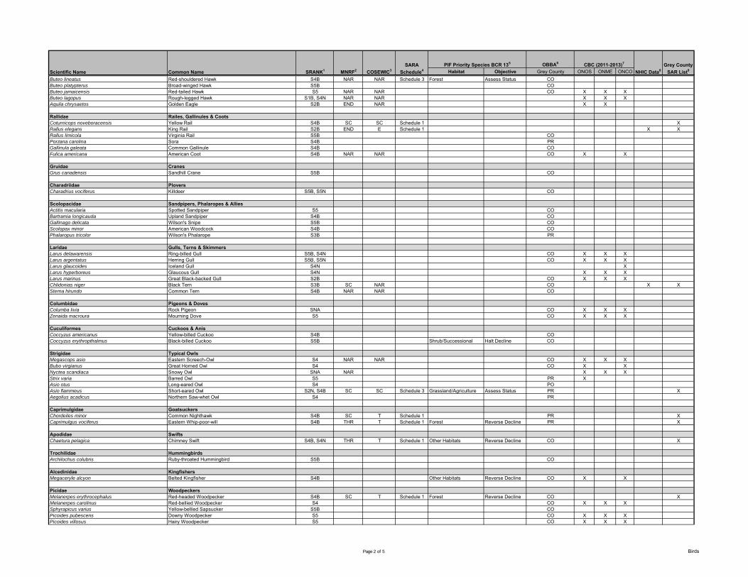
OBBA6
Habitat Objective Grey County ONOS ONME ONCOScientific Name Common Name SRANK1 MNRF2 COSEWIC3SARA
Schedule4PIF Priority Species BCR 135 CBC (2011-2013)7
NHIC Data8Grey County
SAR List9
Buteo lineatus Red-shouldered Hawk S4B NAR NAR Schedule 3 Forest Assess Status COButeo platypterus Broad-winged Hawk S5B COButeo jamaicensis Red-tailed Hawk S5 NAR NAR CO X X XButeo lagopus Rough-legged Hawk S1B, S4N NAR NAR X X XAquila chrysaetos Golden Eagle S2B END NAR X X
Rallidae Railes, Gallinules & CootsCoturnicops noveboracensis Yellow Rail S4B SC SC Schedule 1 XRallus elegans King Rail S2B END E Schedule 1 X XRallus limicola Virginia Rail S5B COPorzana carolina Sora S4B PRGallinula galeata Common Gallinule S4B COFulica americana American Coot S4B NAR NAR CO X X
Gruidae CranesGrus canadensis Sandhill Crane S5B CO
Charadriidae PloversCharadrius vociferus Killdeer S5B, S5N CO
Scolopacidae Sandpipers, Phalaropes & AlliesActitis macularia Spotted Sandpiper S5 COBartramia longicauda Upland Sandpiper S4B COGallinago delicata Wilson's Snipe S5B COScolopax minor American Woodcock S4B COPhalaropus tricolor Wilson's Phalarope S3B PR
Laridae Gulls, Terns & SkimmersLarus delawarensis Ring-billed Gull S5B, S4N CO X X XLarus argentatus Herring Gull S5B, S5N CO X X XLarus glaucoides Iceland Gull S4N XLarus hyperboreus Glaucous Gull S4N X X XLarus marinus Great Black-backed Gull S2B CO X X XChlidonias niger Black Tern S3B SC NAR CO X XSterna hirundo Common Tern S4B NAR NAR CO
Columbidae Pigeons & DovesColumba livia Rock Pigeon SNA CO X X XZenaida macroura Mourning Dove S5 CO X X X
Cuculiformes Cuckoos & AnisCoccyzus americanus Yellow-billed Cuckoo S4B COCoccyzus erythropthalmus Black-billed Cuckoo S5B Shrub/Successional Halt Decline CO
Strigidae Typical OwlsMegascops asio Eastern Screech-Owl S4 NAR NAR CO X X XBubo virgianus Great Horned Owl S4 CO X XNyctea scandiaca Snowy Owl SNA NAR X X XStrix varia Barred Owl S5 PR XAsio otus Long-eared Owl S4 POAsio flammeus Short-eared Owl S2N, S4B SC SC Schedule 3 Grassland/Agriculture Assess Status PR XAegolius acadicus Northern Saw-whet Owl S4 PR
Caprimulgidae GoatsuckersChordeiles minor Common Nighthawk S4B SC T Schedule 1 PR XCaprimulgus vociferus Eastern Whip-poor-will S4B THR T Schedule 1 Forest Reverse Decline PR X
Apodidae SwiftsChaetura pelagica Chimney Swift S4B, S4N THR T Schedule 1 Other Habitats Reverse Decline CO X
Trochilidae HummingbirdsArchilochus colubris Ruby-throated Hummingbird S5B CO
Alcedinidae KingfishersMegaceryle alcyon Belted Kingfisher S4B Other Habitats Reverse Decline CO X X
Picidae WoodpeckersMelanerpes erythrocephalus Red-headed Woodpecker S4B SC T Schedule 1 Forest Reverse Decline CO XMelanerpes carolinus Red-bellied Woodpecker S4 CO X X XSphyrapicus varius Yellow-bellied Sapsucker S5B COPicoides pubescens Downy Woodpecker S5 CO X X XPicoides villosus Hairy Woodpecker S5 CO X X X
Page 2 of 5 Birds
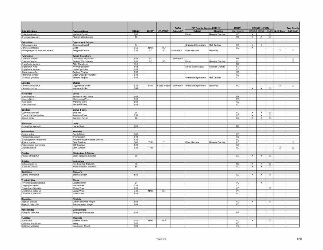
OBBA6
Habitat Objective Grey County ONOS ONME ONCOScientific Name Common Name SRANK1 MNRF2 COSEWIC3SARA
Schedule4PIF Priority Species BCR 135 CBC (2011-2013)7
NHIC Data8Grey County
SAR List9
Colaptes auratus Northern Flicker S4B Forest Reverse Decline CO X XDryocopus pileatus Pileated Woodpecker S5 CO X X X
Falconidae Caracaras & FalconsFalco sparverius American Kestrel S4 Grassland/Agriculture Halt Decline CO X XFalco columbarius Merlin S5B NAR NAR CO XFalco peregrinus anatum/tundrius Peregrine Falcon S3B SC SC Schedule 1 Other Habitats Recovery X X
Tyrannidae Tyrant FlycathersContopus cooperi Olive-sided Flycatcher S4B SC T Schedule 1 PR XContopus virens Eastern Wood-Pewee S4B SC SC Forest Reverse Decline CO XEmpidonax alnorum Alder Flycatcher S5B COEmpidonax traillii Willow Flycatcher S5B Shrub/Successional Maintain Current COEmpidonax minimus Least Flycatcher S4B COSayornis phoebe Eastern Phoebe S5B COMyiarchus crinitus Great Crested Flycatcher S4B COTyrannus tyrannus Eastern Kingbird S4B Grassland/Agriculture Halt Decline CO
Laniidae ShrikesLanius ludovicianus Loggerhead Shrike S2B END E (ssp. migrans )Schedule 1 Grassland/Agriculture Recovery PO X XLanius excubitor Northern Shrike SNA X X X
Vireonidae VireosVireo flavifrons Yellow-throated Vireo S4B PRVireo solitarius Blue-headed Vireo S5B PRVireo gilvis Warbling Vireo S5B COVireo olivaceus Red-eyed Vireo S5B CO
Corvidae Crows & JaysCyanocitta cristata Blue Jay S5 CO X X XCorvus brachyrhynchos American Crow S5B CO X X XCorvus corax Common Raven S5 CO X X X
Alaudidae LarksEremophila alpestris Horned Lark S5B CO
Hirundinidae SwallowsProgne subis Purple Martin S4B COTachycineta bicolor Tree Swallow S4B COStelgidopteryx serripennis Northern Rough-winged Swallow S4B CORiparia riparia Bank Swallow S4B THR T Other Habitats Reverse Decline CO XPetrochelidon pyrrhonota Cliff Swallow S4B COHirundo rustica Barn Swallow S4B THR T CO X X
Paridae Chickadees & TitmicePoecile atricapillus Black-capped Chickadee S5 CO X X X
Sittidae NuthatchesSitta canadensis Red-breasted Nuthatch S5 CO X X XSitta carolinensis White-breasted Nuthatch S5 CO X X X
Certhiidae CreepersCerthia americana Brown Creeper S5B CO X X X
Troglodytidae WrensThryothorus ludovicianus Carolina Wren S4 PO XTroglodytes aedon House Wren S5B COTroglodytes hiemalis Winter Wren S5B CO XCistothorus platensis Sedge Wren S4B NAR NAR PRCistothorus palustris Marsh Wren S4B CO
Regulidae KingletsRegulus satrapa Golden-crowned Kinglet S5B CO X XRegulus calendula Ruby-crowned Kinglet S4B PO
Polioptilidae GnatcatchersPolioptila caerulea Blue-gray Gnatcatcher S4B PR
Turdidae ThrushesSialia sialis Eastern Bluebird S5B NAR NAR CO X XCatharus fuscescens Veery S4B COCatharus ustulatus Swainson's Thrush S4B PO
Page 3 of 5 Birds
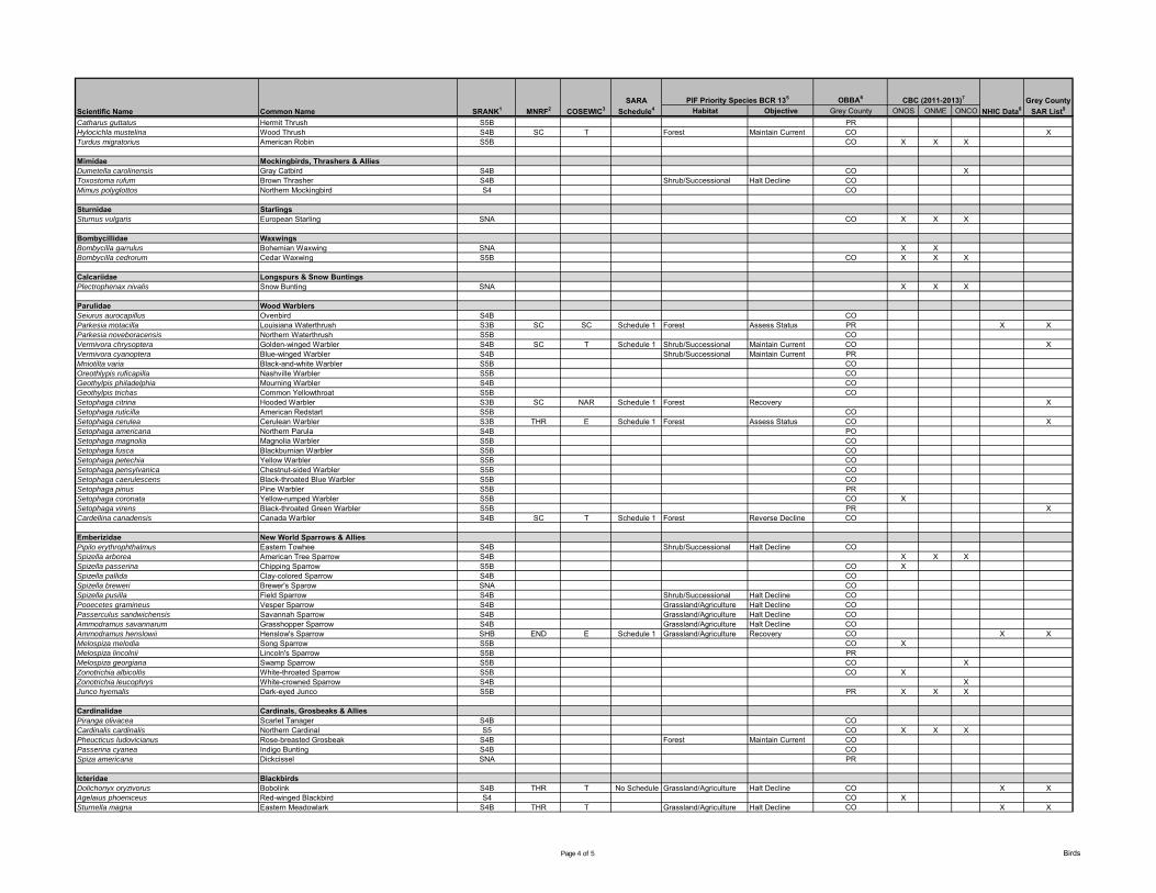
OBBA6
Habitat Objective Grey County ONOS ONME ONCOScientific Name Common Name SRANK1 MNRF2 COSEWIC3SARA
Schedule4PIF Priority Species BCR 135 CBC (2011-2013)7
NHIC Data8Grey County
SAR List9
Catharus guttatus Hermit Thrush S5B PRHylocichla mustelina Wood Thrush S4B SC T Forest Maintain Current CO XTurdus migratorius American Robin S5B CO X X X
Mimidae Mockingbirds, Thrashers & AlliesDumetella carolinensis Gray Catbird S4B CO XToxostoma rufum Brown Thrasher S4B Shrub/Successional Halt Decline COMimus polyglottos Northern Mockingbird S4 CO
Sturnidae StarlingsSturnus vulgaris European Starling SNA CO X X X
Bombycillidae WaxwingsBombycilla garrulus Bohemian Waxwing SNA X XBombycilla cedrorum Cedar Waxwing S5B CO X X X
Calcariidae Longspurs & Snow BuntingsPlectrophenax nivalis Snow Bunting SNA X X X
Parulidae Wood WarblersSeiurus aurocapillus Ovenbird S4B COParkesia motacilla Louisiana Waterthrush S3B SC SC Schedule 1 Forest Assess Status PR X XParkesia noveboracensis Northern Waterthrush S5B COVermivora chrysoptera Golden-winged Warbler S4B SC T Schedule 1 Shrub/Successional Maintain Current CO XVermivora cyanoptera Blue-winged Warbler S4B Shrub/Successional Maintain Current PRMniotilta varia Black-and-white Warbler S5B COOreothlypis ruficapilla Nashville Warbler S5B COGeothylpis philadelphia Mourning Warbler S4B COGeothylpis trichas Common Yellowthroat S5B COSetophaga citrina Hooded Warbler S3B SC NAR Schedule 1 Forest Recovery XSetophaga ruticilla American Redstart S5B COSetophaga cerulea Cerulean Warbler S3B THR E Schedule 1 Forest Assess Status CO XSetophaga americana Northern Parula S4B POSetophaga magnolia Magnolia Warbler S5B COSetophaga fusca Blackburnian Warbler S5B COSetophaga petechia Yellow Warbler S5B COSetophaga pensylvanica Chestnut-sided Warbler S5B COSetophaga caerulescens Black-throated Blue Warbler S5B COSetophaga pinus Pine Warbler S5B PRSetophaga coronata Yellow-rumped Warbler S5B CO XSetophaga virens Black-throated Green Warbler S5B PR XCardellina canadensis Canada Warbler S4B SC T Schedule 1 Forest Reverse Decline CO
Emberizidae New World Sparrows & AlliesPipilo erythrophthalmus Eastern Towhee S4B Shrub/Successional Halt Decline COSpizella arborea American Tree Sparrow S4B X X XSpizella passerina Chipping Sparrow S5B CO XSpizella pallida Clay-colored Sparrow S4B COSpizella breweri Brewer's Sparow SNA COSpizella pusilla Field Sparrow S4B Shrub/Successional Halt Decline COPooecetes gramineus Vesper Sparrow S4B Grassland/Agriculture Halt Decline COPasserculus sandwichensis Savannah Sparrow S4B Grassland/Agriculture Halt Decline COAmmodramus savannarum Grasshopper Sparrow S4B Grassland/Agriculture Halt Decline COAmmodramus henslowii Henslow's Sparrow SHB END E Schedule 1 Grassland/Agriculture Recovery CO X XMelospiza melodia Song Sparrow S5B CO XMelospiza lincolnii Lincoln's Sparrow S5B PRMelospiza georgiana Swamp Sparrow S5B CO XZonotrichia albicollis White-throated Sparrow S5B CO XZonotrichia leucophrys White-crowned Sparrow S4B XJunco hyemalis Dark-eyed Junco S5B PR X X X
Cardinalidae Cardinals, Grosbeaks & AlliesPiranga olivacea Scarlet Tanager S4B COCardinalis cardinalis Northern Cardinal S5 CO X X XPheucticus ludovicianus Rose-breasted Grosbeak S4B Forest Maintain Current COPasserina cyanea Indigo Bunting S4B COSpiza americana Dickcissel SNA PR
Icteridae BlackbirdsDolichonyx oryzivorus Bobolink S4B THR T No Schedule Grassland/Agriculture Halt Decline CO X XAgelaius phoeniceus Red-winged Blackbird S4 CO XSturnella magna Eastern Meadowlark S4B THR T Grassland/Agriculture Halt Decline CO X X
Page 4 of 5 Birds
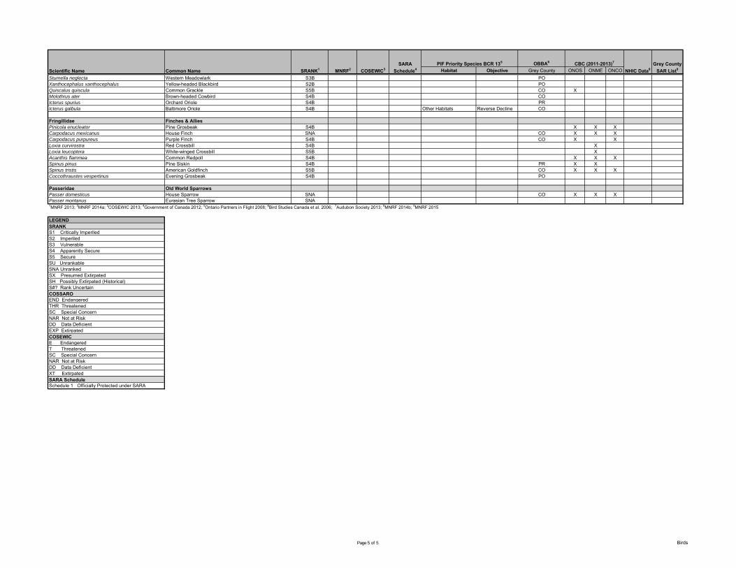
OBBA6
Habitat Objective Grey County ONOS ONME ONCOScientific Name Common Name SRANK1 MNRF2 COSEWIC3SARA
Schedule4PIF Priority Species BCR 135 CBC (2011-2013)7
NHIC Data8Grey County
SAR List9
Sturnella neglecta Western Meadowlark S3B POXanthocephalus xanthocephalus Yellow-headed Blackbird S2B POQuiscalus quiscula Common Grackle S5B CO XMolothrus ater Brown-headed Cowbird S4B COIcterus spurius Orchard Oriole S4B PRIcterus galbula Baltimore Oriole S4B Other Habitats Reverse Decline CO
Fringillidae Finches & AlliesPinicola enucleator Pine Grosbeak S4B X X XCarpodacus mexicanus House Finch SNA CO X X XCarpodacus purpureus Purple Finch S4B CO X XLoxia curvirostra Red Crossbill S4B XLoxia leucoptera White-winged Crossbill S5B XAcanthis flammea Common Redpoll S4B X X XSpinus pinus Pine Siskin S4B PR X XSpinus tristis American Goldfinch S5B CO X X XCoccothraustes vespertinus Evening Grosbeak S4B PO
Passeridae Old World SparrowsPasser domesticus House Sparrow SNA CO X X XPasser montanus Eurasian Tree Sparrow SNA1MNRF 2013; 2MNRF 2014a; 3COSEWIC 2013; 4Government of Canada 2012; 5Ontario Partners in Flight 2008; 6Bird Studies Canada et al. 2006; 7Audubon Society 2013; 8MNRF 2014b; 9MNRF 2015
LEGENDSRANKS1 Critically ImperiledS2 ImperiledS3 VulnerableS4 Apparently SecureS5 Secure SU UnrankableSNA UnrankedSX Presumed ExtirpatedSH Possibly Extirpated (Historical)S#? Rank UncertainCOSSAROEND EndangeredTHR ThreatenedSC Special ConcernNAR Not at RiskDD Data DeficientEXP ExtirpatedCOSEWICE EndangeredT ThreatenedSC Special ConcernNAR Not at RiskDD Data DeficientXT ExtirpatedSARA ScheduleSchedule 1 Officially Protected under SARA
Page 5 of 5 Birds
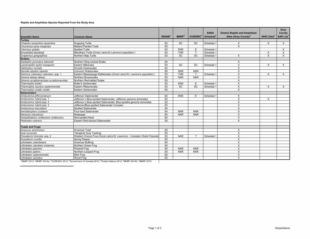
Reptile and Amphibian Species Reported From the Study Area
Scientific Name Common Name SRANK1 MNRF2 COSEWIC3SARA
Schedule4Ontario Reptile and Amphibian
Atlas (Grey County)5 NHIC Data6
Grey County
SAR List7
TurtlesChelydra serpentina serpentina Snapping Turtle S3 SC SC Schedule 1 X X XChrysemys picta marginata Midland Painted Turtle S5 XClemmys guttata Spotted Turtle S3 END E Schedule 1 XEmydoidea blandingii Blanding's Turtle (Great Lakes/St Lawrence population ) S3 THR T Schedule 1 X XGraptemys geographica Northern Map Turtle S3 SC SC Schedule 1 X X XSnakesDiadophis punctatus edwardsi Northern Ring-necked Snake S4 XLampropeltis taylori triangulum Eastern Milksnake S3 SC SC Schedule 1 X X XOpheodrys vernalis Smooth Greensnake S4 XNerodia sipedon sipedon Common Watersnake S5 NAR NAR XSistrurus catenatus catenatus pop. 1 Eastern Massasauga Rattlesnake (Great Lakes/St. Lawrence population ) S3 THR T Schedule 1 X X XStoreria dekayi dekayi Northern Brownsnake S5 NAR NAR XStoreria occipitomaculata occipitomaculata Northern Red-bellied Snake S5 XThamnophis butleri Butler's Gartersnake S2 END E Schedule 1 XThamnophis sauritus septentrionalis Eastern Ribbonsnake S3 SC SC Schedule 1 X X XThamnophis sirtalis sirtalis Eastern Gartersnake S5 XSalamandersAmbystoma jeffersonianum Jefferson Salamander S2 END E Schedule 1 XAmbystoma hybrid pop. 1 Jefferson x Blue-spotted Salamander; Jefferson genome dominates S2 X XAmbystoma hybrid pop. 2 Jefferson x Blue-spotted Salamander; Blue-spotted genome dominates S2 XAmbystoma hybrid pop. 3 Jefferson/Blue-spotted Salamander Complex S2 XAmbystoma maculatum Spotted Salamander S4 XHemidactylium scutatum Four-toed Salamander S4 NAR NAR XNecturus maculosus Mudpuppy S4 NAR NAR XNotophthalmus viridescens viridescens Red-spotted Newt S5 XPlethodon cinereus Eastern Red-backed Salamander S5 X
Toads and FrogsAnaxyrus americanus American Toad S5 XHyla versicolor Tetraploid Gray Treefrog S5 XPseudacris triseriata pop. 2 Western Chorus Frog (Great Lakes/St. Lawrence - Canadian Shield Population) S3 NAR T Schedule 1 XPseudacris crucifer Spring Peeper S5 XLithobates catesbeiana American Bullfrog S4 XLithobates clamitans melanota Northern Green Frog S5 XLithobates palustris Pickerel Frog S4 NAR NAR XLithobates pipiens Northern Leopard Frog S5 NAR NAR XLithobates septentrionalis Mink Frog S5 XLithobates sylvatica Wood Frog S5 X1MNRF 2013; 2MNRF 2014a; 3COSEWIC 2013; 4Government of Canada 2012; 5Ontario Nature 2013; 6MNRF 2014b; 7MNRF 2015
Page 1 of 2 Herpetofauna
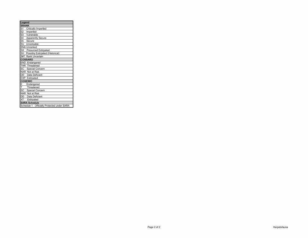
LegendSRANKS1 Critically ImperiledS2 ImperiledS3 VulnerableS4 Apparently SecureS5 Secure SU UnrankableSNA UnrankedSX Presumed ExtirpatedSH Possibly Extirpated (Historical)S#? Rank UncertainCOSSAROEND EndangeredTHR ThreatenedSC Special ConcernNAR Not at RiskDD Data DeficientEXP ExtirpatedCOSEWICE EndangeredT ThreatenedSC Special ConcernNAR Not at RiskDD Data DeficientXT ExtirpatedSARA ScheduleSchedule 1 Officially Protected under SARA
Page 2 of 2 Herpetofauna

Mammal Species Reported From the Study Area
Scientific Name Common Name SRANK1 MNRF2 COSEWIC3SARA
Schedule4Ontario Mammal Atlas (Grey
County)5NHIC6 Grey County
SAR List7
Didelphimorphia OpossumsDidelphis virginiana Virginia Opossum S4 X
Insectivora Shrews and MolesBlarina brevicauda Northern Short-tailed Shrew S5 XCondylura cristata Star-nosed Mole S5 XSorex cinereus Masked Shrew S5 X
Chiroptera BatsEptesicus fuscus Big Brown Bat S5 XLasionycteris noctivagans Silver-haired Bat S4 XLasiurus borealis Red Bat S4 XLasiurus cinereus Hoary Bat S4 XMyotis leibii Eastern Small-footed Bat S2S3 END X XMyotis lucifugus Little Brown Myotis S4 END E X XMyotis septentrionalis Northern Myotis S3 END E X X
Lagomorpha Rabbits and HaresLepus americanus Snowshoe Hare S5 XLepus europaeus European Hare SNA XSylvilagus floridanus Eastern Cottontail S5 X
Rodentia RodentsCastor canadensis Beaver S5 XErethizon dorsatum Porcupine S5 XGlaucomys sabrinus Northern Flying Squirrel S5 XMarmota monax Woodchuck S5 XMicrotus pennsylvanicus Meadow Vole S5 XOndatra zibethicus Muskrat S5 XPeromyscus leucopus White-footed Mouse S5 XPeromyscus maniculatus Deer Mouse S5 XRattus norvegicus Norway Rat SNA XSciurus carolinensis Eastern Gray Squirrel S5 XTamiasciurus hudsonicus Red Squirrel S5 XTamias striatus Eastern Chipmunk S5 XZapus hudsonius Meadow Jumping Mouse S5 X
Page 1 of 2 Mammals
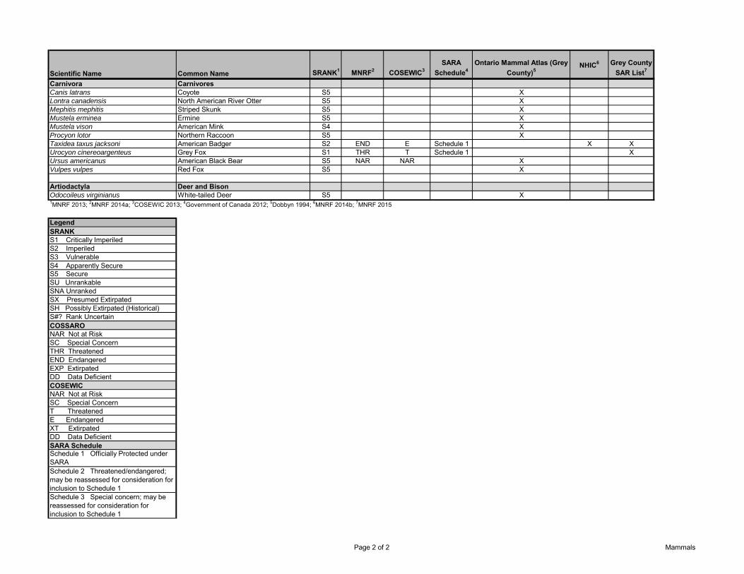
Scientific Name Common Name SRANK1 MNRF2 COSEWIC3SARA
Schedule4Ontario Mammal Atlas (Grey
County)5NHIC6 Grey County
SAR List7
Carnivora CarnivoresCanis latrans Coyote S5 XLontra canadensis North American River Otter S5 XMephitis mephitis Striped Skunk S5 XMustela erminea Ermine S5 XMustela vison American Mink S4 XProcyon lotor Northern Raccoon S5 XTaxidea taxus jacksoni American Badger S2 END E Schedule 1 X XUrocyon cinereoargenteus Grey Fox S1 THR T Schedule 1 XUrsus americanus American Black Bear S5 NAR NAR XVulpes vulpes Red Fox S5 X
Artiodactyla Deer and BisonOdocoileus virginianus White-tailed Deer S5 X1MNRF 2013; 2MNRF 2014a; 3COSEWIC 2013; 4Government of Canada 2012; 5Dobbyn 1994; 6MNRF 2014b; 7MNRF 2015
LegendSRANKS1 Critically ImperiledS2 ImperiledS3 VulnerableS4 Apparently SecureS5 Secure SU UnrankableSNA UnrankedSX Presumed ExtirpatedSH Possibly Extirpated (Historical)S#? Rank UncertainCOSSARONAR Not at RiskSC Special ConcernTHR ThreatenedEND EndangeredEXP ExtirpatedDD Data DeficientCOSEWICNAR Not at RiskSC Special ConcernT ThreatenedE EndangeredXT ExtirpatedDD Data DeficientSARA ScheduleSchedule 1 Officially Protected under SARASchedule 2 Threatened/endangered; may be reassessed for consideration for inclusion to Schedule 1Schedule 3 Special concern; may be reassessed for consideration for inclusion to Schedule 1
Page 2 of 2 Mammals
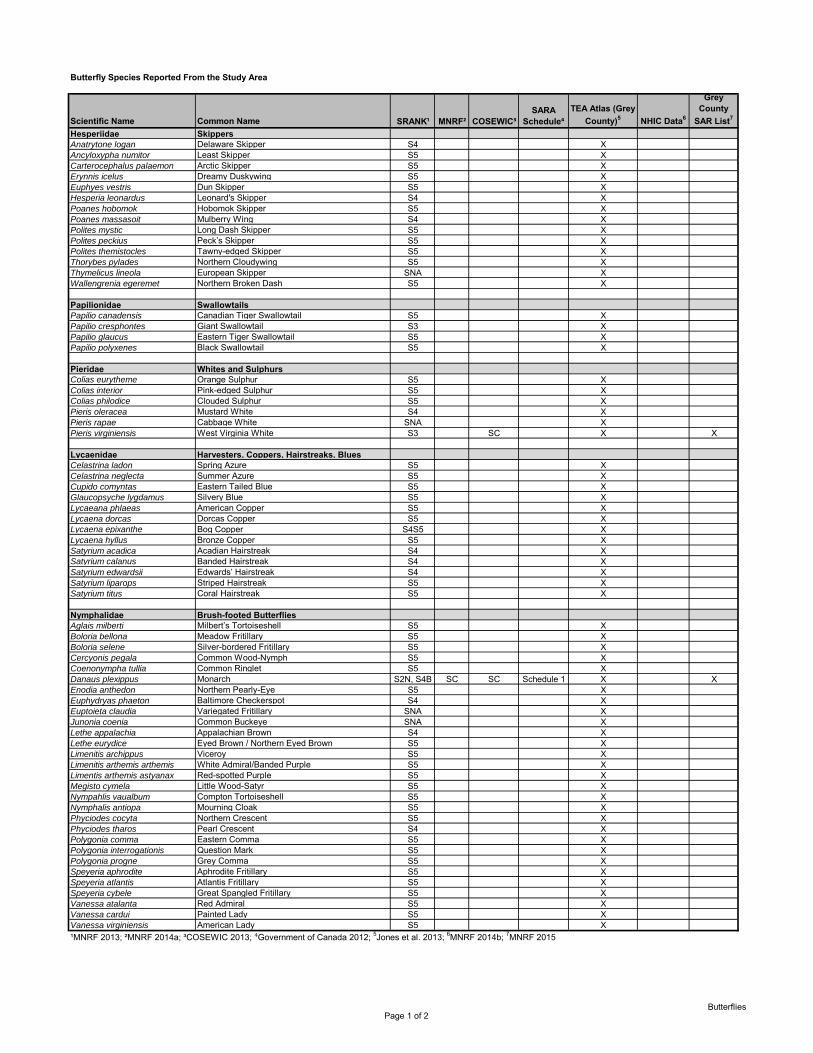
Scientific Name Common Name SRANK¹ MNRF² COSEWIC³
SARA Schedule⁴
TEA Atlas (Grey County)5 NHIC Data6
Grey County
SAR List7
Hesperiidae SkippersAnatrytone logan Delaware Skipper S4 XAncyloxypha numitor Least Skipper S5 XCarterocephalus palaemon Arctic Skipper S5 XErynnis icelus Dreamy Duskywing S5 XEuphyes vestris Dun Skipper S5 XHesperia leonardus Leonard's Skipper S4 XPoanes hobomok Hobomok Skipper S5 XPoanes massasoit Mulberry Wing S4 XPolites mystic Long Dash Skipper S5 XPolites peckius Peck’s Skipper S5 XPolites themistocles Tawny-edged Skipper S5 XThorybes pylades Northern Cloudywing S5 XThymelicus lineola European Skipper SNA XWallengrenia egeremet Northern Broken Dash S5 X
Papilionidae SwallowtailsPapilio canadensis Canadian Tiger Swallowtail S5 XPapilio cresphontes Giant Swallowtail S3 XPapilio glaucus Eastern Tiger Swallowtail S5 XPapilio polyxenes Black Swallowtail S5 X
Pieridae Whites and SulphursColias eurytheme Orange Sulphur S5 XColias interior Pink-edged Sulphur S5 XColias philodice Clouded Sulphur S5 XPieris oleracea Mustard White S4 XPieris rapae Cabbage White SNA XPieris virginiensis West Virginia White S3 SC X X
Lycaenidae Harvesters, Coppers, Hairstreaks, BluesCelastrina ladon Spring Azure S5 XCelastrina neglecta Summer Azure S5 XCupido comyntas Eastern Tailed Blue S5 XGlaucopsyche lygdamus Silvery Blue S5 XLycaeana phlaeas American Copper S5 XLycaena dorcas Dorcas Copper S5 XLycaena epixanthe Bog Copper S4S5 XLycaena hyllus Bronze Copper S5 XSatyrium acadica Acadian Hairstreak S4 XSatyrium calanus Banded Hairstreak S4 XSatyrium edwardsii Edwards’ Hairstreak S4 XSatyrium liparops Striped Hairstreak S5 XSatyrium titus Coral Hairstreak S5 X
Nymphalidae Brush-footed ButterfliesAglais milberti Milbert’s Tortoiseshell S5 XBoloria bellona Meadow Fritillary S5 XBoloria selene Silver-bordered Fritillary S5 XCercyonis pegala Common Wood-Nymph S5 XCoenonympha tullia Common Ringlet S5 XDanaus plexippus Monarch S2N, S4B SC SC Schedule 1 X XEnodia anthedon Northern Pearly-Eye S5 XEuphydryas phaeton Baltimore Checkerspot S4 XEuptoieta claudia Variegated Fritillary SNA XJunonia coenia Common Buckeye SNA XLethe appalachia Appalachian Brown S4 XLethe eurydice Eyed Brown / Northern Eyed Brown S5 XLimenitis archippus Viceroy S5 XLimenitis arthemis arthemis White Admiral/Banded Purple S5 XLimentis arthemis astyanax Red-spotted Purple S5 XMegisto cymela Little Wood-Satyr S5 XNympahlis vaualbum Compton Tortoiseshell S5 XNymphalis antiopa Mourning Cloak S5 XPhyciodes cocyta Northern Crescent S5 XPhyciodes tharos Pearl Crescent S4 XPolygonia comma Eastern Comma S5 XPolygonia interrogationis Question Mark S5 XPolygonia progne Grey Comma S5 XSpeyeria aphrodite Aphrodite Fritillary S5 XSpeyeria atlantis Atlantis Fritillary S5 XSpeyeria cybele Great Spangled Fritillary S5 XVanessa atalanta Red Admiral S5 XVanessa cardui Painted Lady S5 XVanessa virginiensis American Lady S5 X¹MNRF 2013; ²MNRF 2014a; ³COSEWIC 2013; ⁴Government of Canada 2012; 5Jones et al. 2013; 6MNRF 2014b; 7MNRF 2015
Butterfly Species Reported From the Study Area
Page 1 of 2Butterflies
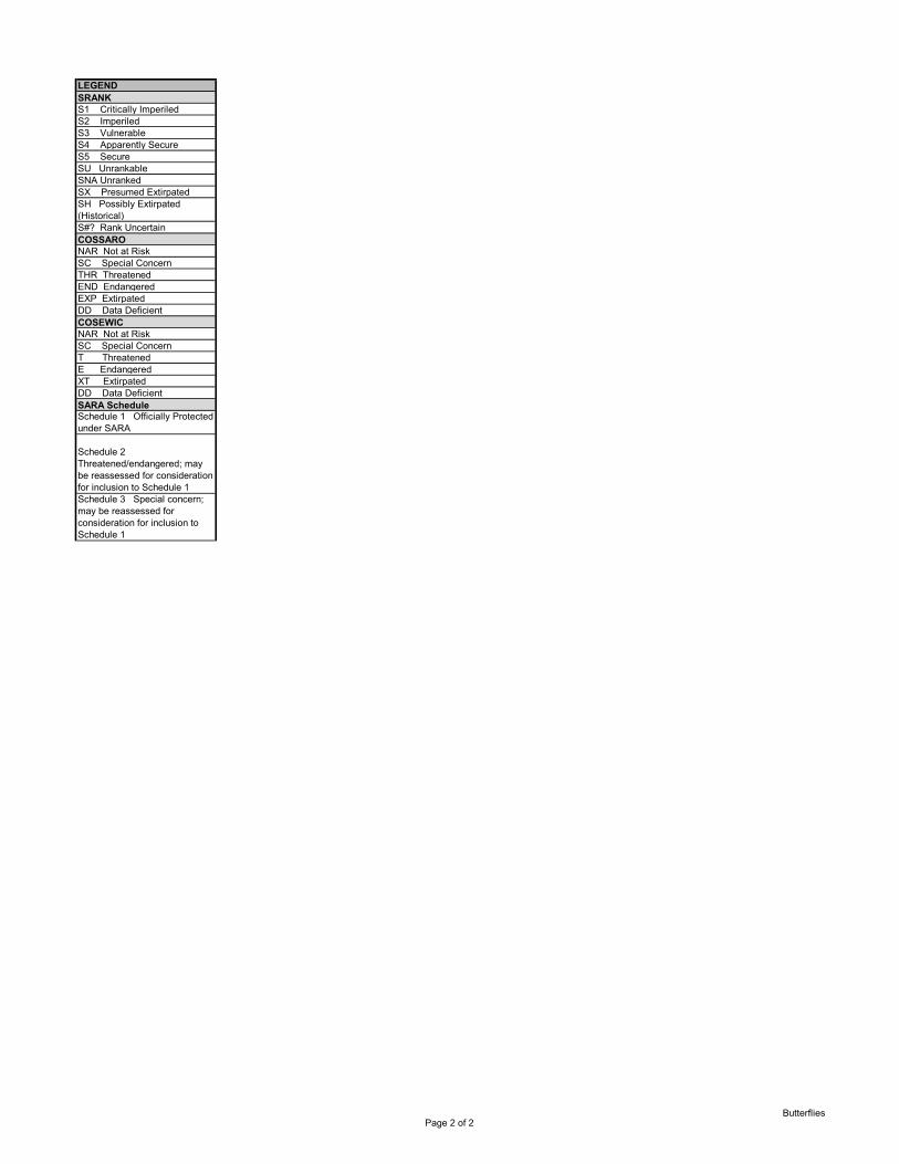
LEGENDSRANKS1 Critically ImperiledS2 ImperiledS3 VulnerableS4 Apparently SecureS5 Secure SU UnrankableSNA UnrankedSX Presumed ExtirpatedSH Possibly Extirpated (Historical)S#? Rank UncertainCOSSARONAR Not at RiskSC Special ConcernTHR ThreatenedEND EndangeredEXP ExtirpatedDD Data DeficientCOSEWICNAR Not at RiskSC Special ConcernT ThreatenedE EndangeredXT ExtirpatedDD Data DeficientSARA ScheduleSchedule 1 Officially Protected under SARA
Schedule 2 Threatened/endangered; may be reassessed for consideration for inclusion to Schedule 1Schedule 3 Special concern; may be reassessed for consideration for inclusion to Schedule 1
Page 2 of 2Butterflies
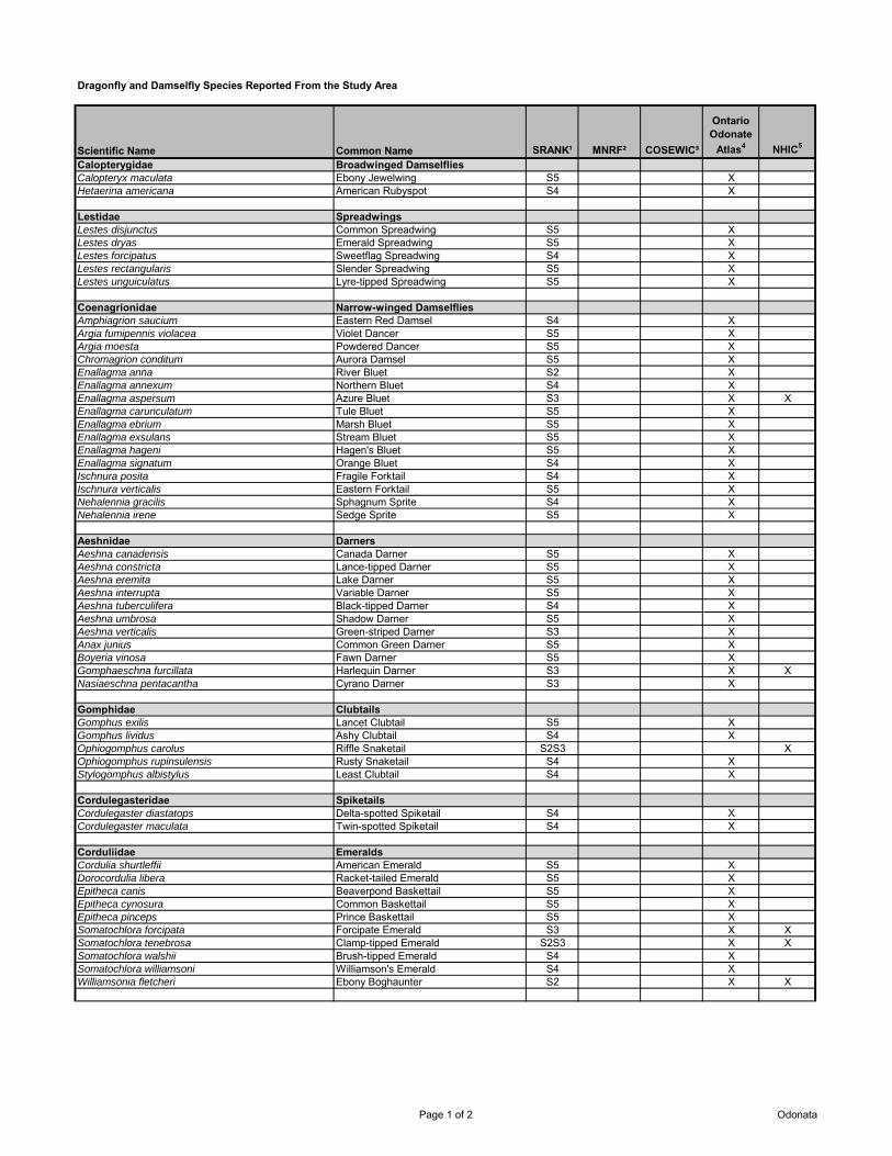
Dragonfly and Damselfly Species Reported From the Study Area
Scientific Name Common Name SRANK¹ MNRF² COSEWIC³
Ontario Odonate
Atlas4 NHIC5
Calopterygidae Broadwinged DamselfliesCalopteryx maculata Ebony Jewelwing S5 XHetaerina americana American Rubyspot S4 X
Lestidae SpreadwingsLestes disjunctus Common Spreadwing S5 XLestes dryas Emerald Spreadwing S5 XLestes forcipatus Sweetflag Spreadwing S4 XLestes rectangularis Slender Spreadwing S5 XLestes unguiculatus Lyre-tipped Spreadwing S5 X
Coenagrionidae Narrow-winged DamselfliesAmphiagrion saucium Eastern Red Damsel S4 XArgia fumipennis violacea Violet Dancer S5 XArgia moesta Powdered Dancer S5 XChromagrion conditum Aurora Damsel S5 XEnallagma anna River Bluet S2 XEnallagma annexum Northern Bluet S4 XEnallagma aspersum Azure Bluet S3 X XEnallagma carunculatum Tule Bluet S5 XEnallagma ebrium Marsh Bluet S5 XEnallagma exsulans Stream Bluet S5 XEnallagma hageni Hagen's Bluet S5 XEnallagma signatum Orange Bluet S4 XIschnura posita Fragile Forktail S4 XIschnura verticalis Eastern Forktail S5 XNehalennia gracilis Sphagnum Sprite S4 XNehalennia irene Sedge Sprite S5 X
Aeshnidae DarnersAeshna canadensis Canada Darner S5 XAeshna constricta Lance-tipped Darner S5 XAeshna eremita Lake Darner S5 XAeshna interrupta Variable Darner S5 XAeshna tuberculifera Black-tipped Darner S4 XAeshna umbrosa Shadow Darner S5 XAeshna verticalis Green-striped Darner S3 XAnax junius Common Green Darner S5 XBoyeria vinosa Fawn Darner S5 XGomphaeschna furcillata Harlequin Darner S3 X XNasiaeschna pentacantha Cyrano Darner S3 X
Gomphidae ClubtailsGomphus exilis Lancet Clubtail S5 XGomphus lividus Ashy Clubtail S4 XOphiogomphus carolus Riffle Snaketail S2S3 XOphiogomphus rupinsulensis Rusty Snaketail S4 XStylogomphus albistylus Least Clubtail S4 X
Cordulegasteridae SpiketailsCordulegaster diastatops Delta-spotted Spiketail S4 XCordulegaster maculata Twin-spotted Spiketail S4 X
Corduliidae EmeraldsCordulia shurtleffii American Emerald S5 XDorocordulia libera Racket-tailed Emerald S5 XEpitheca canis Beaverpond Baskettail S5 XEpitheca cynosura Common Baskettail S5 XEpitheca pinceps Prince Baskettail S5 XSomatochlora forcipata Forcipate Emerald S3 X XSomatochlora tenebrosa Clamp-tipped Emerald S2S3 X XSomatochlora walshii Brush-tipped Emerald S4 XSomatochlora williamsoni Williamson's Emerald S4 XWilliamsonia fletcheri Ebony Boghaunter S2 X X
Page 1 of 2 Odonata

Scientific Name Common Name SRANK¹ MNRF² COSEWIC³
Ontario Odonate
Atlas4 NHIC5
Libellulidae SkimmersCelithemis eponina Halloween Pennant S4 XErythemis simplicicollis Eastern Pondhawk S5 XLadona julia Chalk-fronted Corporal S5 XLeucorrhinia frigida Frosted Whiteface S5 XLeucorrhinia hudsonica Hudsonian Whiteface S5 XLeucorrhinia intacta Dot-tailed Whiteface S5 XLeucorrhinia proxima Red-waisted (Belted) Whiteface S5 XLibellula luctuosa Widow Skimmer S5 XLibellula pulchella Twelve-spotted Skimmer S5 XLibellula quadrimaculata Four-spotted Skimmer S5 XMacromia illinoiensis Illinois (Swift) River Cruiser S4 XNannothemis bella Elfin Skimmer S4 XPantala flavescens Wandering Glider S4 XPlathemis lydia Common Whitetail S5 XSympetrum corruptum Variegated Meadowhawk S3 XSympetrum costiferum Saffron-bordered Meadowhawk S4 XSympetrum internum Cherry-faced Meadowhawk S5 XSympetrum obtrusum White-faced Meadowhawk S5 XSympetrum semicinctum Band-winged Meadowhawk S4 XSympetrum vicinum Yellow-legged (Banded) Meadowhawk S5 X¹MNRF 2013; ²MNRF 2014a; ³COSEWIC 2013; ⁴Government of Canada 2012; ⁵MNRF 2014b
LEGENDSRANKS1 Critically ImperiledS2 ImperiledS3 VulnerableS4 Apparently SecureS5 Secure SU UnrankableSNA UnrankedSX Presumed ExtirpatedSH Possibly Extirpated (Historical)S#? Rank UncertainCOSSARONAR Not at RiskSC Special ConcernTHR ThreatenedEND EndangeredEXP ExtirpatedDD Data DeficientCOSEWICNAR Not at RiskSC Special ConcernT ThreatenedE EndangeredXT ExtirpatedDD Data DeficientSARA ScheduleSchedule 1 Officially Protected under SARASchedule 2 Threatened/endangered; may be reassessed for consideration for inclusion to Schedule 1Schedule 3 Special concern; may be reassessed for consideration for inclusion to Schedule 1
Page 2 of 2 Odonata
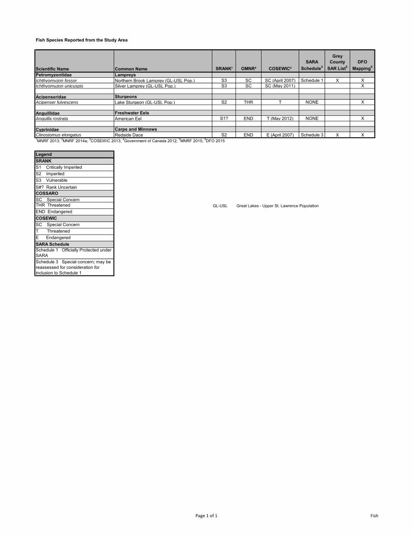
Fish Species Reported from the Study Area
Scientific Name Common Name SRANK¹ OMNR² COSEWIC³
SARA Schedule4
Grey County
SAR List5DFO
Mapping6
Petromyzontidae LampreysIchthyomyzon fossor Northern Brook Lamprey (GL-USL Pop.) S3 SC SC (April 2007) Schedule 1 X XIchthyomyzon unicuspis Silver Lamprey (GL-USL Pop.) S3 SC SC (May 2011) X
Acipenseridae SturgeonsAcipenser fulvescens Lake Sturgeon (GL-USL Pop.) S2 THR T NONE X
Anguillidae Freshwater EelsAnguilla rostrata American Eel S1? END T (May 2012) NONE X
Cyprinidae Carps and MinnowsClinostomus elongatus Redside Dace S2 END E (April 2007) Schedule 3 X X1MNRF 2013; 2MNRF 2014a; 3COSEWIC 2013; 4Government of Canada 2012; 5MNRF 2015; 6DFO 2015
LegendSRANKS1 Critically ImperiledS2 ImperiledS3 VulnerableS#? Rank UncertainCOSSAROSC Special ConcernTHR Threatened GL-USL Great Lakes - Upper St. Lawrence PopulationEND EndangeredCOSEWICSC Special ConcernT ThreatenedE EndangeredSARA ScheduleSchedule 1 Officially Protected under SARASchedule 3 Special concern; may be reassessed for consideration for inclusion to Schedule 1
Page 1 of 1 Fish

Freshwater Mussel Species Reported from the Study Area
Scientific Name Common Name SRANK¹ OMNR² COSEWIC³
SARA SCHEDULE4 NHIC Data5
NRSI Observed
DFO Mapping6
LampsilinaeVillosa iris Rainbow S2S3 THR E Schedule 1 X1OMNR 2013a; 2OMNR 2013b; 3COSEWIC 2012; 4Government of Canada 2012; 5OMNR 2013c; 6DFO 2015 Total 0 0 1
LegendSRANKS2 ImperiledS3 VulnerableCOSSAROTHR ThreatenedCOSEWICE EndangeredSARA Schedule
Schedule 1 Officially Protected under SARA

Natural Resource Solutions Inc. Grey County Natural Heritage Systems Study
APPENDIX III Species at Risk and Significant Wildlife Habitat Screenings
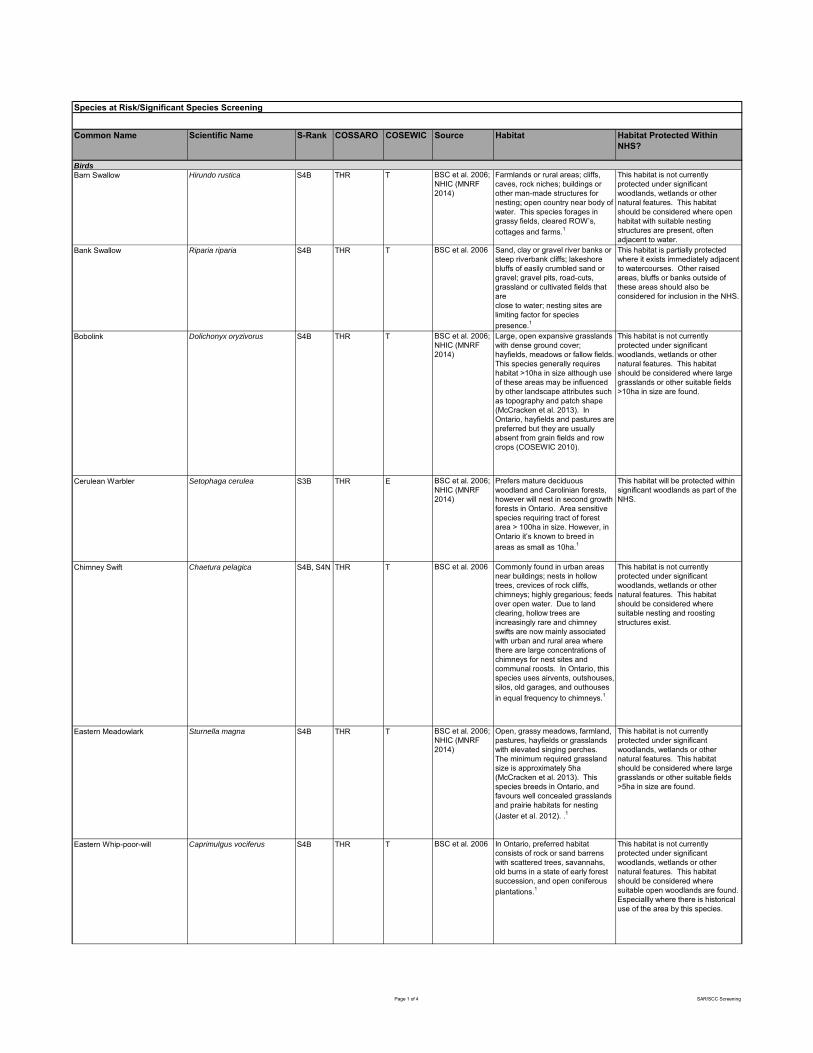
Common Name Scientific Name S-Rank COSSARO COSEWIC Source Habitat Habitat Protected Within NHS?
Barn Swallow Hirundo rustica S4B THR T BSC et al. 2006; NHIC (MNRF 2014)
Farmlands or rural areas; cliffs, caves, rock niches; buildings or other man-made structures for nesting; open country near body of water. This species forages in grassy fields, cleared ROW’s, cottages and farms.1
This habitat is not currently protected under significant woodlands, wetlands or other natural features. This habitat should be considered where open habitat with suitable nesting structures are present, often adjacent to water.
Bank Swallow Riparia riparia S4B THR T BSC et al. 2006 Sand, clay or gravel river banks or steep riverbank cliffs; lakeshore bluffs of easily crumbled sand or gravel; gravel pits, road-cuts, grassland or cultivated fields that areclose to water; nesting sites are limiting factor for species presence.1
This habitat is partially protected where it exists immediately adjacent to watercourses. Other raised areas, bluffs or banks outside of these areas should also be considered for inclusion in the NHS.
Bobolink Dolichonyx oryzivorus S4B THR T BSC et al. 2006; NHIC (MNRF 2014)
Large, open expansive grasslands with dense ground cover; hayfields, meadows or fallow fields. This species generally requires habitat >10ha in size although use of these areas may be influenced by other landscape attributes such as topography and patch shape (McCracken et al. 2013). In Ontario, hayfields and pastures are preferred but they are usually absent from grain fields and row crops (COSEWIC 2010).
This habitat is not currently protected under significant woodlands, wetlands or other natural features. This habitat should be considered where large grasslands or other suitable fields >10ha in size are found.
Cerulean Warbler Setophaga cerulea S3B THR E BSC et al. 2006; NHIC (MNRF 2014)
Prefers mature deciduous woodland and Carolinian forests, however will nest in second growth forests in Ontario. Area sensitive species requiring tract of forest area > 100ha in size. However, in Ontario it’s known to breed in areas as small as 10ha.1
This habitat will be protected within significant woodlands as part of the NHS.
Chimney Swift Chaetura pelagica S4B, S4N THR T BSC et al. 2006 Commonly found in urban areas near buildings; nests in hollow trees, crevices of rock cliffs, chimneys; highly gregarious; feeds over open water. Due to land clearing, hollow trees are increasingly rare and chimney swifts are now mainly associated with urban and rural area where there are large concentrations of chimneys for nest sites and communal roosts. In Ontario, this species uses airvents, outshouses, silos, old garages, and outhouses in equal frequency to chimneys.1
This habitat is not currently protected under significant woodlands, wetlands or other natural features. This habitat should be considered where suitable nesting and roosting structures exist.
Eastern Meadowlark Sturnella magna S4B THR T BSC et al. 2006; NHIC (MNRF 2014)
Open, grassy meadows, farmland, pastures, hayfields or grasslands with elevated singing perches. The minimum required grassland size is approximately 5ha (McCracken et al. 2013). This species breeds in Ontario, and favours well concealed grasslands and prairie habitats for nesting (Jaster et al. 2012). .1
This habitat is not currently protected under significant woodlands, wetlands or other natural features. This habitat should be considered where large grasslands or other suitable fields >5ha in size are found.
Eastern Whip-poor-will Caprimulgus vociferus S4B THR T BSC et al. 2006 In Ontario, preferred habitat consists of rock or sand barrens with scattered trees, savannahs, old burns in a state of early forest succession, and open coniferous plantations.1
This habitat is not currently protected under significant woodlands, wetlands or other natural features. This habitat should be considered where suitable open woodlands are found. Especiallly where there is historical use of the area by this species.
Species at Risk/Significant Species Screening
Birds
Page 1 of 4 SAR/SCC Screening
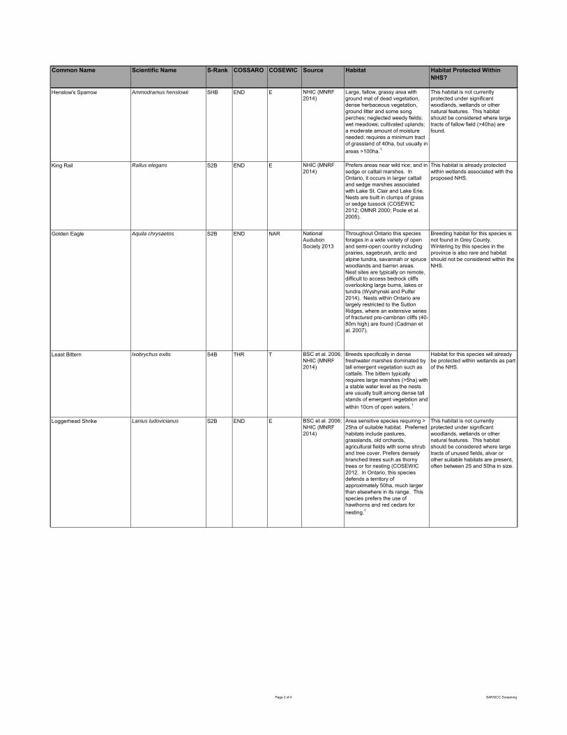
Common Name Scientific Name S-Rank COSSARO COSEWIC Source Habitat Habitat Protected Within NHS?
BirdsHenslow's Sparrow Ammodramus henslowii SHB END E NHIC (MNRF 2014)
Large, fallow, grassy area with ground mat of dead vegetation, dense herbaceous vegetation, ground litter and some song perches; neglected weedy fields; wet meadows; cultivated uplands; a moderate amount of moisture needed; requires a minimum tract of grassland of 40ha, but usually in areas >100ha.1
This habitat is not currently protected under significant woodlands, wetlands or other natural features. This habitat should be considered where large tracts of fallow field (>40ha) are found.
King Rail Rallus elegans S2B END E NHIC (MNRF 2014)
Prefers areas near wild rice; and in sedge or cattail marshes. In Ontario, it occurs in larger cattail and sedge marshes associated with Lake St. Clair and Lake Erie. Nests are built in clumps of grass or sedge tussock (COSEWIC 2012; OMNR 2000; Poole et al. 2005).
This habitat is already protected within wetlands associated with the proposed NHS.
Golden Eagle Aquila chrysaetos S2B END NAR National Audubon Society 2013
Throughout Ontario this species forages in a wide variety of open and semi-open country including prairies, sagebrush, arctic and alpine tundra, savannah or spruce woodlands and barren areas. Nest sites are typically on remote, difficult to access bedrock cliffs overlooking large burns, lakes or tundra (Wyshynski and Pulfer 2014). Nests within Ontario are largely restricted to the Sutton Ridges, where an extensive series of fractured pre-cambrian cliffs (40-80m high) are found (Cadman et al. 2007).
Breeding habitat for this species is not found in Grey County. Wintering by this species in the province is also rare and habitat should not be considered within the NHS.
Least Bittern Ixobrychus exilis S4B THR T BSC et al. 2006; NHIC (MNRF 2014)
Breeds specifically in dense freshwater marshes dominated by tall emergent vegetation such as cattails. The bittern typically requires large marshes (>5ha) with a stable water level as the nests are usually built among dense tall stands of emergent vegetation and within 10cm of open waters.1
Habitat for this species will already be protected within wetlands as part of the NHS.
Loggerhead Shrike Lanius ludovicianus S2B END E BSC et al. 2006; NHIC (MNRF 2014)
Area sensitive species requiring > 25ha of suitable habitat. Preferred habitats include pastures, grasslands, old orchards, agricultural fields with some shrub and tree cover. Prefers densely branched trees such as thorny trees or for nesting (COSEWIC 2012. In Ontario, this species defends a territory of approximately 50ha, much larger than elsewhere in its range. This species prefers the use of hawthorns and red cedars for nesting.1
This habitat is not currently protected under significant woodlands, wetlands or other natural features. This habitat should be considered where large tracts of unused fields, alvar or other suitable habitats are present, often between 25 and 50ha in size.
Page 2 of 4 SAR/SCC Screening

Common Name Scientific Name S-Rank COSSARO COSEWIC Source Habitat Habitat Protected Within NHS?
BirdsNorthern Bobwhite Colinus virginianus S1 END E BSC et al. 2006 Requires interspersed habitat of grassland, croplands, and brush within close proximity to each other. In Ontario, this species uses farmland and crops over grasslands.1
This habitat is not currently protected under significant woodlands, wetlands or other natural features. This habitat should be considered where agricultural lands are interspersed with grassland and brush.
Prothonotary Warbler Protonotaria citrea S1B END E BSC et al. 2006 This species typically occurs in mature and semi-mature deciduous swamp forest and riparian floodplains typically dominated by silver maple (Acer saccharinum), ash (Fraxinus spp.), yellow birch (betula alleghaniensis) and willows (Salix spp.).1
Habitat for this species will already be protected within wetlands and riparian areas as part of the NHS.
American Badger Taxidea taxus jacksoni S2 END E NHIC (MNRF 2014)
Open grasslands and oak savannahs; dens in newhole or enlarged existing hole; sometimes makes foodcaches.1
This habitat is not currently protected under significant woodlands, wetlands or other natural features. This habitat should be considered where grasslands and oak savannahs are present, often near agricultural lands.
Eastern Small-footed Bat Myotis leibii S2S3 END Dobbyn 1994 Roosts in caves, mine shafts, crevices or buildings thatare in or near woodland; hibernates in cold dry cavesor mines; maternity colonies in caves or buildings;hunts in forests.1
To a large degree, habitat for this species will be protected within significant woodlands. Some consideration for additional habitat provided in non-significant woodlands should be provided. MNRF should be consulted for locations of wintering sites, if any are found in Grey County.
Grey Fox Urocyon cinereoargenteus S1 THR T MNRF 2015 Deciduous forests, especially swampy areas.1
This habitat is partially protected within significant woodlands. Other smaller woodlands and swampy areas should be considered.
Little Brown Myotis Myotis lucifuga S4 END E Dobbyn 1994 Uses caves, quarries, tunnels, hollow trees or buildings for roosting; winters in humid caves; maternity sites in dark warm areas such as attics andbarns; feeds primarily in wetlands, forest edges.1
To a large degree, habitat for this species will be protected within significant woodlands. Some consideration for additional habitat provided in non-significant woodlands should be provided. MNRF should be consulted for locations of wintering sites, if any are found in Grey County.
Northern Myotis Myotis septentrionalis S3 END E Dobbyn 1994 Roost under loose bark and in the cavities of trees, hibernate in caves or abandoned mines.1
To a large degree, habitat for this species will be protected within significant woodlands. Some consideration for additional habitat provided in non-significant woodlands should be provided. MNRF should be consulted for locations of wintering sites, if any are found in Grey County.
Blanding's Turtle Emydoidea blandingii S3 THR T NHIC (MNRF 2014)
Shallow water marshes, bogs, ponds or swamps, or coves in larger lakes with soft muddy bottoms and aquatic vegetation; basks on logs, stumps, or banks; surrounding natural habitat is important in summer as they frequently move from aquatic habitat to terrestrial habitats; hibernates in bogs; not readily observed.1
Habitat for this species will be protected largely within wetlands as part of the NHS. However, category 2-3 habitat can extend to within 2km from wetlands.
Mammals
Herpetofauna
Page 3 of 4 SAR/SCC Screening
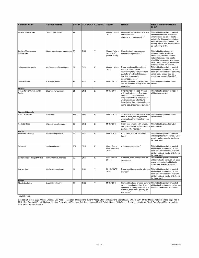
Common Name Scientific Name S-Rank COSSARO COSEWIC Source Habitat Habitat Protected Within NHS?
BirdsButler's Gartersnake Thamnophis butleri S2 Ontario Nature 2013
Wet meadows, pastures, margins of marshes andstreams, and open country.1
This habitat is partially protected within wetlands and adjacent to watercourses but other habitat suitable for this species including wet meadows, pastures and open country should also be considered as part of the NHS.
Eastern Massasauga Rattlesnake
Sistrurus catenatus catenatus pop. 1S3 THR T Ontario Nature 2013; NHIC (MNRF 2014)
Open bedrock outcroppings, conifer swamps/swales.1
This habitat is not currently protected under significant woodlands, wetlands or other natural features. This habitat should be considered where open bedrock outcroppings and conifer swamps/swales are present.
Jefferson Salamander Ambystoma jeffersonianum S2 END E Ontario Nature 2013
Damp shady deciduous forest, swamps, moist pasture, lakeshores; temporary woodland pools for breeding; hides under leaf litter, stones or in decomposing logs.1
This habitat is partially protected within significant woodlands, but other smaller woodlands containing vernal pools should also be considered as part of the NHS.
Spotted Turtle Clemmys guttata S3 END E MNRF 2015 Ponds, marshes, bogs and fens with an abundant supply of aquatic vegetation.1
This habitat is protected within wetlands.
Insects
Hungerford's Crawling Water Beetle
Brychius hungerfordi S1 END E MNRF 2015 Small to medium sized streams with moderate to fast flow, good aeration, cool temperatures, inorganic substrate and alkaline water conditions, often found immediately downstream of human dams, beaver dams and culverts.1
This habitat is already protected within watercourses.
Fish and Mussels
Rainbow Mussel Villosa iris S2S3 THR E MNRF 2015 Small to medium sized rivers most often in clean, well-oxygenated waters at depths of less than one metre.1
This habitat is protected within watercourses.
Redside Dace Clinostomus elongatus S2 END E MNRF 2015 Clear, cool streams with a rubble and gravel bottom and a mixture of pool and riffle habitats.1
This habitat is protected within watercourses.
American Ginseng Panax quinquefolius S2 END E MNRF 2015 Rich, moist, mature deciduous forest.1
This habitat is partially protected within significant woodlands. Other smaller mature woodlands should be considered.
Butternut Juglans cinerea S3? END E Owen Sound Field Naturalist 2010
Rich-moist woodlands.1 This habitat is partially protected within significant woodlands, but other smaller woodlands may also contain suitable habitat and should be considered.
Eastern Prairie-fringed Orchid Platanthera leucophaea S2 END E NHIC (MNRF 2014)
Wetlands, fens, swamps and tall grass prarie.1
This habitat is partially protected within wetlands, however, tall grass prairie remnants should also be considered where they occur.
Golden Seal Hydrastis canadensis S2 THR T NHIC (MNRF 2014)
Damp, deciduous woods, often on clay soil.1
This habitat is partially protected within significant woodlands, but other smaller woodlands may also contain suitable habitat and should be considered.
Flooded Jellyskin Leptogium rivulare S3 THR T MNRF 2015 Grows at the base of trees growing around vernal ponds that fill with meltwater in spring, then dry up in summer, often found growing on Black Ash.1
This habitat is partially protected within significant woodlands but may also occur in smaller woodlands.
Sources: BSC et al. 2006 (Ontario Breeding Bird Atlas); Jones et al. 2013 (Ontario Butterfly Atlas); MNRF 2005 (Ontario Odonate Atlas); MNRF 2014 (MNRF Make-a-natural heritage map); MNRF 2015 (Grey County SAR List); National Audubon Society 2013 (Christmas Bird Count Historical Data); Ontario Nature 2013 (Ontario Reptile and Amphibian Atlas); Owen Sound Field Naturalists 2010 (Grey County Plant List)
Lichen
1OMNR 2000
Plants
Page 4 of 4 SAR/SCC Screening
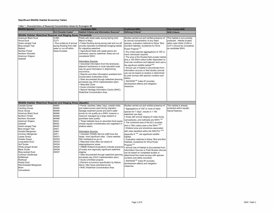
Significant Wildlife Habitat Screening Tables
Table 1. Characteristics of Seasonal Concentration Areas for Ecoregion 6E.Wildlife Species1 Confirmed SWH Grey County NHS
ELC Ecosite Codes1 Habitat Criteria and Information Sources1 Defining Criteria1 NHS Criteria
American Black DuckWood DuckGreen-winged TealBlue-winged TealMallardNorthen PintailNorthern ShovelerAmerican WigeonGadwall
CUM1CUT1- Plus evidence of annual spring flooding from melt water or run-off within these Ecosites.
Fields with sheet water during Spring (mid March to May).• Fields flooding during spring melt and run-off provide important invertebrate foraging habitat for migrating waterfowl.• Agricultural fields with waste grains are commonly used by waterfowl, these are not considered SWH.
Information Sources• Anecdotal information from the landowner, adjacent landowners or local naturalist clubs may be good information in determining occurrence.• Reports and other information available from Conservation Authorities (CAs) • Sites documented through waterfowl planning processes (eg. EHJV implementation plan)• Naturalist Clubs• Ducks Unlimited Canada• Natural Heritage Information Centre (NHIC) Waterfowl Concentration Area
Studies carried out and verified presence of an annual concentration of any listed species, evaluation methods to follow “Bird and Bird Habitats: Guidelines for Wind Power Projects”ccxi
• Any mixed species aggregations of 100Í or more individuals required.• The area of the flooded field ecosite habitat plus a 100-300m radius buffer dependant on local site conditions and adjacent land use is the significant wildlife habitatcxlviii.• Annual use of habitat is documented from information sources or field studies (annual use can be based on studies or determined by past surveys with species numbers and dates). • SWHDSScxlix Index #7 provides development effects and mitigation measures.
This habitat is not currently protected. Habitat located within open fields (CUM or CUT1) should be considered as candidate SWH.
Canada GooseCackling GooseSnow GooseAmerican Black DuckNorthern PintailNorthern ShovelerAmerican WigeonGadwallGreen-winged TealBlue-winged TealHooded MerganserCommon MerganserLesser ScaupGreater ScaupLong-tailed DuckSurf ScoterWhite-winged ScoterBlack ScoterRing-necked DuckCommon GoldeneyeBuffleheadRedheadRuddy DuckRed-breasted MerganserBrantCanvasback
MAM1MAM2MAM3MAM4MAM5MAM6MAS1MAS2MAS3SAS1SAM1SAF1SWD1SWD2SWD3SWD4SWD5SWD6SWD7
• Ponds, marshes, lakes, bays, coastal inlets, and watercourses used during migration. Sewage treatment ponds and storm water ponds do not qualify as a SWH, however a reservoir managed as a large wetland or pond/lake does qualify.• These habitats have an abundant food supply (mostly aquatic invertebrates and vegetation in shallow water).
Information Sources• Canadian Wildlife Service staff know the larger, most significant sites. Check website: http://wildspace.ec.gc.ca • Naturalist clubs often are aware of staging/stopover areas.• OMNR Wetland Evaluations indicate presence of locally and regionally significant waterfowl staging.• Sites documented through waterfowl planning processes (eg. EHJV implementation plan)• Ducks Unlimited projects• Element occurrence specification by Nature Serve: http://www.natureserve.org • NHIC Waterfowl Concentration Area
Studies carried out and verified presence of:• Aggregations of 100Í or more of listed species for 7 daysÍ, results in > 700 waterfowl use days. • Areas with annual staging of ruddy ducks, canvasbacks, and redheads are SWH cxlix
• The combined area of the ELC ecosites and a 100m radius area is the SWH cxlviii
• Wetland area and shorelines associated with sites identified within the SWHTG cxlviii
Appendix K cxlix are significant wildlife habitat. • Evaluation methods to follow “Bird and Bird Habitats: Guidelines for Wind Power Projects”ccxi
• Annual Use of Habitat is Documented from Information Sources or Field Studies (Annual can be based on completed studies or determined from past surveys with species numbers and dates recorded).• SWHDSScxlix Index #7 provides development effects and mitigation measures.
This habitat is already protected within aquatic natural features.
Candidate SWH
Wildlife Habitat: Waterfowl Stopover and Staging Areas (Terrestrial)
Wildlife Habitat: Waterfowl Stopover and Staging Areas (Aquatic)
Page 1 of 8 SWH Table 1
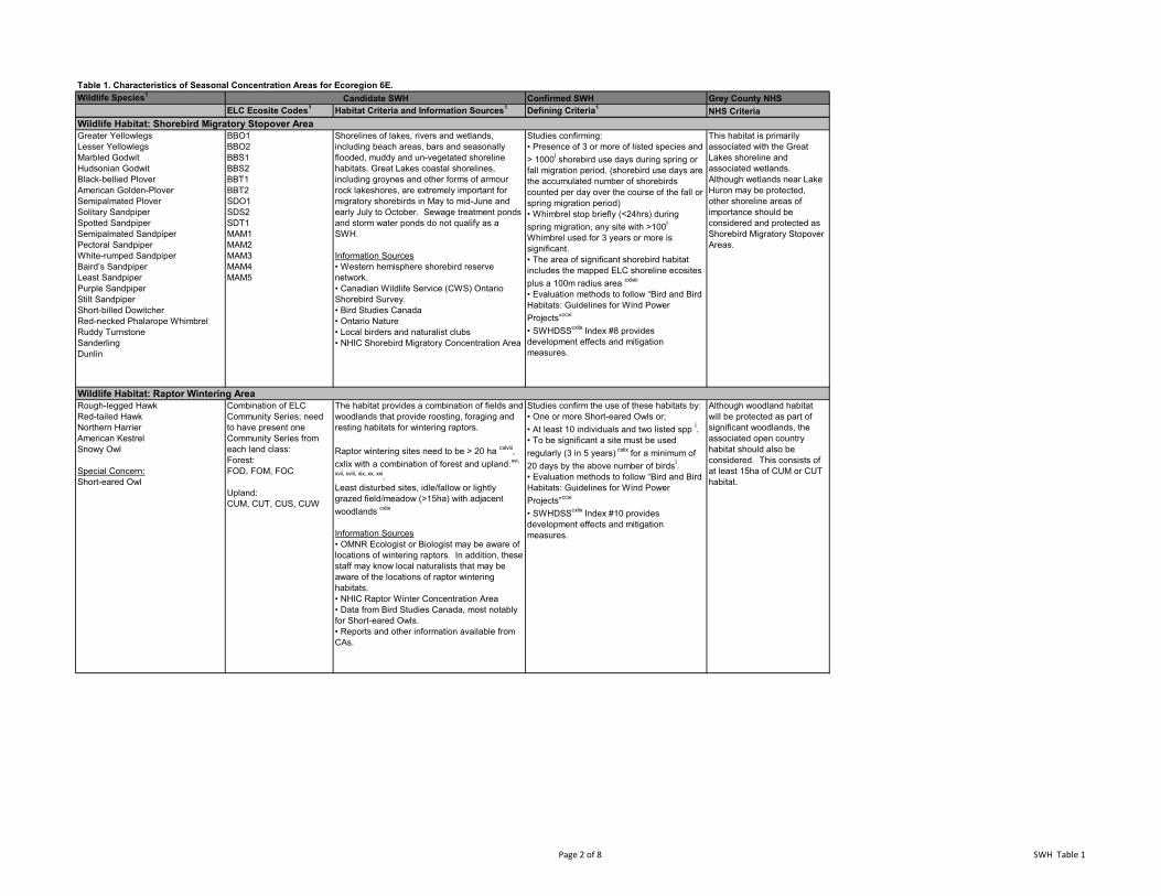
Table 1. Characteristics of Seasonal Concentration Areas for Ecoregion 6E.Wildlife Species1 Confirmed SWH Grey County NHS
ELC Ecosite Codes1 Habitat Criteria and Information Sources1 Defining Criteria1 NHS CriteriaCandidate SWH
Greater YellowlegsLesser YellowlegsMarbled GodwitHudsonian GodwitBlack-bellied PloverAmerican Golden-PloverSemipalmated PloverSolitary SandpiperSpotted SandpiperSemipalmated SandpiperPectoral SandpiperWhite-rumped SandpiperBaird’s SandpiperLeast SandpiperPurple SandpiperStilt Sandpiper Short-billed DowitcherRed-necked Phalarope WhimbrelRuddy TurnstoneSanderlingDunlin
BBO1BBO2BBS1BBS2BBT1BBT2SDO1SDS2SDT1MAM1MAM2MAM3MAM4MAM5
Shorelines of lakes, rivers and wetlands, including beach areas, bars and seasonally flooded, muddy and un-vegetated shoreline habitats. Great Lakes coastal shorelines, including groynes and other forms of armour rock lakeshores, are extremely important for migratory shorebirds in May to mid-June and early July to October. Sewage treatment ponds and storm water ponds do not qualify as a SWH. Information Sources• Western hemisphere shorebird reserve network.• Canadian Wildlife Service (CWS) Ontario Shorebird Survey.• Bird Studies Canada• Ontario Nature• Local birders and naturalist clubs• NHIC Shorebird Migratory Concentration Area
Studies confirming:• Presence of 3 or more of listed species and > 1000Í shorebird use days during spring or fall migration period. (shorebird use days are the accumulated number of shorebirds counted per day over the course of the fall or spring migration period)• Whimbrel stop briefly (<24hrs) during spring migration, any site with >100Í
Whimbrel used for 3 years or more is significant.• The area of significant shorebird habitat includes the mapped ELC shoreline ecosites plus a 100m radius area cxlviii
• Evaluation methods to follow “Bird and Bird Habitats: Guidelines for Wind Power Projects”ccxi
• SWHDSScxlix Index #8 provides development effects and mitigation measures.
This habitat is primarily associated with the Great Lakes shoreline and associated wetlands. Although wetlands near Lake Huron may be protected, other shoreline areas of importance should be considered and protected as Shorebird Migratory Stopover Areas.
Rough-legged HawkRed-tailed HawkNorthern HarrierAmerican KestrelSnowy Owl
Special Concern:Short-eared Owl
Combination of ELC Community Series; need to have present one Community Series from each land class: Forest: FOD, FOM, FOC
Upland:CUM, CUT, CUS, CUW
The habitat provides a combination of fields and woodlands that provide roosting, foraging and resting habitats for wintering raptors. Raptor wintering sites need to be > 20 ha cxlviii, cxlix with a combination of forest and upland.xvi,
xvii, xviii, xix, xx, xxi.Least disturbed sites, idle/fallow or lightly grazed field/meadow (>15ha) with adjacent woodlands cxlix
Information Sources• OMNR Ecologist or Biologist may be aware of locations of wintering raptors. In addition, these staff may know local naturalists that may be aware of the locations of raptor wintering habitats. • NHIC Raptor Winter Concentration Area• Data from Bird Studies Canada, most notably for Short-eared Owls.• Reports and other information available from CAs.
Studies confirm the use of these habitats by:• One or more Short-eared Owls or;• At least 10 individuals and two listed spp Í.• To be significant a site must be used regularly (3 in 5 years) cxlix for a minimum of 20 days by the above number of birdsÍ.• Evaluation methods to follow “Bird and Bird Habitats: Guidelines for Wind Power Projects”ccxi
• SWHDSScxlix Index #10 provides development effects and mitigation measures.
Although woodland habitat will be protected as part of significant woodlands, the associated open country habitat should also be considered. This consists of at least 15ha of CUM or CUT habitat.
Wildlife Habitat: Shorebird Migratory Stopover Area
Wildlife Habitat: Raptor Wintering Area
Page 2 of 8 SWH Table 1
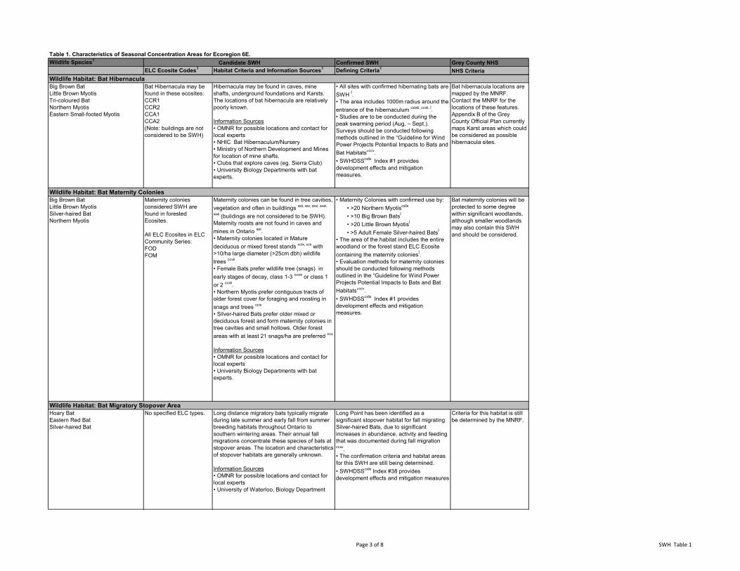
Table 1. Characteristics of Seasonal Concentration Areas for Ecoregion 6E.Wildlife Species1 Confirmed SWH Grey County NHS
ELC Ecosite Codes1 Habitat Criteria and Information Sources1 Defining Criteria1 NHS CriteriaCandidate SWH
Big Brown BatLittle Brown MyotisTri-coloured BatNorthern MyotisEastern Small-footed Myotis
Bat Hibernacula may be found in these ecosites:CCR1CCR2CCA1CCA2(Note: buildings are not considered to be SWH)
Hibernacula may be found in caves, mine shafts, underground foundations and Karsts. The locations of bat hibernacula are relatively poorly known.
Information Sources• OMNR for possible locations and contact for local experts• NHIC Bat Hibernaculum/Nursery• Ministry of Northern Development and Mines for location of mine shafts.• Clubs that explore caves (eg. Sierra Club)• University Biology Departments with bat experts.
• All sites with confirmed hibernating bats are SWH Í.• The area includes 1000m radius around the entrance of the hibernaculum cxlviii, ccvii, Í.• Studies are to be conducted during the peak swarming period (Aug. – Sept.). Surveys should be conducted following methods outlined in the “Guideline for Wind Power Projects Potential Impacts to Bats and Bat Habitats”ccv.• SWHDSScxlix Index #1 provides development effects and mitigation measures.
Bat hibernacula locations are mapped by the MNRF. Contact the MNRF for the locations of these features. Appendix B of the Grey County Official Plan currently maps Karst areas which could be considered as possible hibernacula sites.
Big Brown BatLittle Brown MyotisSilver-haired BatNorthern Myotis
Maternity colonies considered SWH are found in forested Ecosites.
All ELC Ecosites in ELC Community Series:FODFOM
Maternity colonies can be found in tree cavities, vegetation and often in buildlings xxii, xxv, xxvi, xxvii,
xxxi (buildings are not considered to be SWH). Maternity roosts are not found in caves and mines in Ontario xxii. • Maternity colonies located in Mature deciduous or mixed forest stands ccix, ccx with >10/ha large diameter (>25cm dbh) wildlife trees ccvii
• Female Bats prefer wildlife tree (snags) in early stages of decay, class 1-3 ccxiv or class 1 or 2 ccxii.• Northern Myotis prefer contiguous tracts of older forest cover for foraging and roosting in snags and trees ccix
• Silver-haired Bats prefer older mixed or deciduous forest and form maternity colonies in tree cavities and small hollows. Older forest areas with at least 21 snags/ha are preferred ccx
Information Sources• OMNR for possible locations and contact for local experts• University Biology Departments with bat experts.
• Maternity Colonies with confirmed use by: • >20 Northern Myotiscxlix
• >10 Big Brown BatsÍ
• >20 Little Brown MyotisÍ
• >5 Adult Female Silver-haired BatsÍ
• The area of the habitat includes the entire woodland or the forest stand ELC Ecosite containing the maternity coloniesÍ.• Evaluation methods for maternity colonies should be conducted following methods outlined in the “Guideline for Wind Power Projects Potential Impacts to Bats and Bat Habitats”ccv.• SWHDSScxlix Index #1 provides development effects and mitigation measures.
Bat maternity colonies will be protected to some degree within significant woodlands, although smaller woodlands may also contain this SWH and should be considered.
Hoary BatEastern Red BatSilver-haired Bat
No specified ELC types. Long distance migratory bats typically migrate during late summer and early fall from summer breeding habitats throughout Ontario to southern wintering areas. Their annual fall migrations concentrate these species of bats at stopover areas. The location and characteristics of stopover habitats are generally unknown. Information Sources• OMNR for possible locations and contact for local experts• University of Waterloo, Biology Department
Long Point has been identified as a significant stopover habitat for fall migrating Silver-haired Bats, due to significant increases in abundance, activity and feeding that was documented during fall migration ccxv.• The confirmation criteria and habitat areas for this SWH are still being determined.• SWHDSScxlix Index #38 provides development effects and mitigation measures
Criteria for this habitat is still be determined by the MNRF.
Wildlife Habitat: Bat Maternity Colonies
Wildlife Habitat: Bat Migratory Stopover Area
Wildlife Habitat: Bat Hibernacula
Page 3 of 8 SWH Table 1
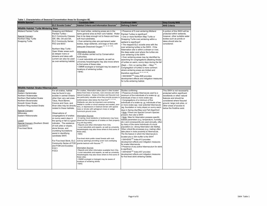
Table 1. Characteristics of Seasonal Concentration Areas for Ecoregion 6E.Wildlife Species1 Confirmed SWH Grey County NHS
ELC Ecosite Codes1 Habitat Criteria and Information Sources1 Defining Criteria1 NHS CriteriaCandidate SWH
Midland Painted Turtle
Special Concern:Northern Map TurtleSnapping Turtle
Snapping and Midland Painted Turtles - ELC Community Classes: SW, MA, OA and SA; ELC Community Series: FEO and BOO
Northern Map Turtle - Open Water areas such as deeper rivers or streams and lakes with current can also be used as over-wintering habitat.
For most turtles, wintering areas are in the same general area as their core habitat. Water has to be deep enough not to freeze and have soft mud substrates. • Over-wintering sites are permanent water bodies, large wetlands, and bogs or fens with adequate Dissolved Oxygen cix, cx, cxi, cxviii.
Information Sources• EIS studies carried out by Conservation Authorities.• Local naturalists and experts, as well as university herpetologists may also know where to find some of these sites.• OMNR ecologist or biologist may be aware of locations of wintering turtles• NHIC
• Presence of 5 over-wintering Midland Painted Turtles is significantÍ.• One or more Northern Map Turtle or Snapping Turtle over-wintering within a wetland is significantÍ.• The mapped ELC ecosite area with the over wintering turtles is the SWH. If the hibernation site is within a stream or river, the deep-water pool where the turtles are over wintering is the SWH.• Over wintering areas may be identified by searching for congregations (Basking Areas) of turtles on warm, sunny days during the fall (Sept. – Oct.) or spring (Mar. – May) cvii. Congregation of turtles is more common where wintering areas are limited and therefore significant cix, cx, cxi, cxii.• SWHDSScxlix Index #28 provides development effects and mitigation measures for turtle wintering habitat.
A portion of this SWH will be protected within wetlands, however, other suitable water bodies such as ponds or lakes should also be considered.
Snakes:Eastern GartersnakeNorthern WatersnakeNorthern Red-bellied SnakeNorthern BrownsnakeSmooth Green SnakeNorthern Ring-necked Snake Special Concern:MilksnakeEastern Ribbonsnake
Lizard:Special Concern (Southern Shield population):Five-lined Skink
For all snakes, habitat may be found in any ecosite in central Ontario other than very wet ones. Talus, Rock Barren, Crevice and Cave, and Alvar sites may be directly related to these habitats.
Observations of congregations of snakes on sunny warm days in the spring or fall is a good indicator. The existence of rock piles or slopes, stone fences, and crumbling foundations assist in identifying candidate SWH.
For Five-lined Skink, ELC Community Series of FOD and FOM and Ecosites:FOC1FOC3
For snakes, hibernation takes place in sites located below frost lines in burrows, rock crevices and other natural locations. Areas of broken and fissured rock are particularly valuable since they provide access to subterranean sites below the frost linexliv, l, li, lii, cxii. Wetlands can also be important over-wintering habitat in conifer or shrub swamps and swales, poor fens, or depressions in bedrock terrain with sparse trees or shrubs with sphagnum moss or sedge hummock ground cover.
Information Sources• In spring, local residents or landowners may have observed the emergence of snakes on their property (e.g.old dug wells).• Reports and other information from CAs.• Local naturalists and experts, as well as university herpetologists may also know where to find some of these sites.• NHIC
Five-lined skink prefer mixed forests with rock outcrop openings providing cover rock overlaying granite bedrock with fissures cciii.
Information Sources• Reports and other information available from CAs.• Local naturalists and experts, as well as university herpetologists may also know where to find some of these sites.• OMNR ecologist or biologist may be aware of locations of wintering skinks• NHIC
Studies confirming:• Presence of snake hibernacula used by a minimum of five individuals of a snake sp. or; individuals of two or more snake spp.• Congregations of a minimum of five individuals of a snake sp. or; individuals of two or more snake spp. near potential hibernacula (eg. foundation or rocky slope) on sunny warm days in Spring (Apr/May) and Fall (Sept/Oct)Í. • Note: If there are Special Concern Species present, then site is SWH• Note: Sites for hibernation possess specific habitat parameters (e.g. temperature, humidity, etc.) and consequently are used annually, often by many of the same individuals of a local population [i.e. strong hibernation site fidelity]. Other critical life processes (e.g. mating) often take place in close proximity to hibernacula. The the feature in which the hibernacula is located plus a 30m buffer is the SWHÍ
• SWHDSScxlix Index #13 provides development effects and mitigation measures for snake hibernacula.• Presence of any active hibernaculum for skink is significant.• SWHDSScxlix Index #37 provides development effects and mitigation measures for five-lined skink wintering habitat.
This SWH is not necessarily protected within significant woodlands or other natural features and should be considered where fissured ground, large rock piles, or other areas of access to below the frostline exist.
Wildlife Habitat: Turtle Wintering Area
Wildlife Habitat: Snake Hibernaculum
Page 4 of 8 SWH Table 1
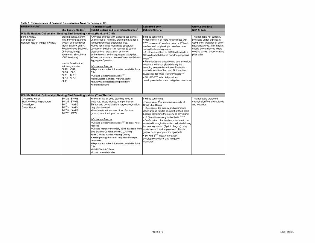
Table 1. Characteristics of Seasonal Concentration Areas for Ecoregion 6E.Wildlife Species1 Confirmed SWH Grey County NHS
ELC Ecosite Codes1 Habitat Criteria and Information Sources1 Defining Criteria1 NHS CriteriaCandidate SWH
Bank SwallowCliff SwallowNorthern Rough-winged Swallow
Eroding banks, sandy hills, borrow pits, steep slopes, and sand piles (Bank Swallow and N. Rough-winged Swallow).Cliff faces, bridge abutments, silos, barns (Cliff Swallows).
Habitat found in the following ecosites:CUM1 CUT1CUS1 BLO1BLS1 BLT1CLO1 CLS1CLT1
• Any site or areas with exposed soil banks, undisturbed or naturally eroding that is not a licensed/permitted aggregate area.• Does not include man-made structures (bridges or buildings) or recently (2 years) disturbed soil areas, such as berms, embankments, soil or aggregate stockpiles.• Does not include a licensed/permitted Mineral Aggregate Operation.
Information Sources• Reports and other information available from CAs • Ontario Breeding Bird Atlas ccv
• Bird Studies Canada; NatureCounts
http://www.birdscanada.org/birdmon/• Naturalist clubs
Studies confirming: • Presence of 1 or more nesting sites with 8cxlvix or more cliff swallow pairs or 50Í bank swallow and rough-winged swallow pairs during the breeding season.• A colony identified as SWH will include a 50m radius habitat area from the peripheral nestsccvii
• Field surveys to observe and count swallow nests are to be completed during the breeding season (May-June). Evaluation methods to follow “Bird and Bird Habitats: Guidelines for Wind Power Projects”ccxi
• SWHDSScxlix Index #4 provides development effects and mitigation measures
This habitat is not currently protected under significant woodlands, wetlands or other natural features. This habitat should be considered where eroding banks, slopes or sand piles exist.
Great Blue Heron Black-crowned Night-heron Great Egret Green Heron
SWM2 SWM3SWM5 SWM6SWD1 SWD2SWD3 SWD4SWD5 SWD6SWD7 FET1
• Nests in live or dead standing trees in wetlands, lakes, islands, and peninsulas. Shrubs and occasionally emergent vegetation may also be used.• Most nests in trees are 11 to 15m from ground, near the top of the tree.
Information Sources• Ontario Breeding Bird Atlas ccv, colonial nest records.• Ontario Heronry Inventory 1991 available from Bird Studies Canada or NHIC (OMNR).• NHIC Mixed Wader Nesting Colony• Aerial photographs can help identify large heronries• Reports and other information available from CAs• MNR District Offices• Local naturalist clubs
Studies confirming:• Presence of 5Í or more active nests of Great Blue Heron.• The edge of the colony and a minimum 300m area of habitat or extent of the Forest Ecosite containing the colony or any island <15.0ha with a colony is the SWH cc, ccvii
• Confirmation of active heronries are to be achieved through site visits conducted during the nesting season (April to August) or by evidence such as the presence of fresh guano, dead young and/or eggshells• SWHDSScxlix Index #5 provides development effects and mitigation measures.
This habitat is protected through significant woodlands and wetlands.
Wildlife Habitat: Collonially - Nesting Bird Breeding Habitat (Bank and Cliff)
Wildlife Habitat: Collonially - Nesting Bird Breeding Habitat (Tree/Shrubs)
Page 5 of 8 SWH Table 1
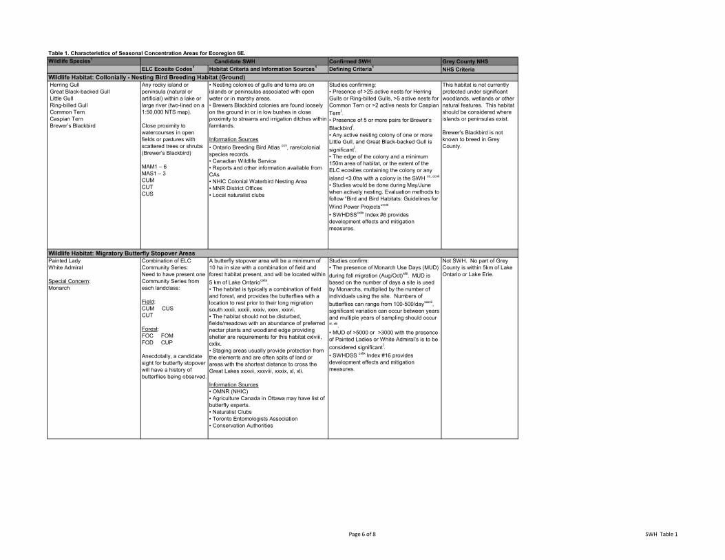
Table 1. Characteristics of Seasonal Concentration Areas for Ecoregion 6E.Wildlife Species1 Confirmed SWH Grey County NHS
ELC Ecosite Codes1 Habitat Criteria and Information Sources1 Defining Criteria1 NHS CriteriaCandidate SWH
Herring Gull Great Black-backed Gull Little Gull Ring-billed Gull Common Tern Caspian Tern Brewer’s Blackbird
Any rocky island or peninsula (natural or artificial) within a lake or large river (two-lined on a 1:50,000 NTS map).
Close proximity to watercourses in open fields or pastures with scattered trees or shrubs (Brewer’s Blackbird)
MAM1 – 6MAS1 – 3CUMCUTCUS
• Nesting colonies of gulls and terns are on islands or peninsulas associated with open water or in marshy areas.• Brewers Blackbird colonies are found loosely on the ground in or in low bushes in close proximity to streams and irrigation ditches within farmlands.
Information Sources• Ontario Breeding Bird Atlas ccv, rare/colonial species records.• Canadian Wildlife Service• Reports and other information available from CAs• NHIC Colonial Waterbird Nesting Area • MNR District Offices• Local naturalist clubs
Studies confirming:• Presence of >25 active nests for Herring Gulls or Ring-billed Gulls, >5 active nests for Common Tern or >2 active nests for Caspian TernÍ.• Presence of 5 or more pairs for Brewer’s BlackbirdÍ.• Any active nesting colony of one or more Little Gull, and Great Black-backed Gull is significantÍ.• The edge of the colony and a minimum 150m area of habitat, or the extent of the ELC ecosites containing the colony or any island <3.0ha with a colony is the SWH cc, ccvii
• Studies would be done during May/June when actively nesting. Evaluation methods to follow “Bird and Bird Habitats: Guidelines for Wind Power Projects”ccxi
• SWHDSScxlix Index #6 provides development effects and mitigation measures.
This habitat is not currently protected under significant woodlands, wetlands or other natural features. This habitat should be considered where islands or peninsulas exist.
Brewer's Blackbird is not known to breed in Grey County.
Painted LadyWhite Admiral
Special Concern:Monarch
Combination of ELC Community Series:Need to have present one Community Series from each landclass:
Field:CUM CUSCUT
Forest:FOC FOMFOD CUP
Anecdotally, a candidate sight for butterfly stopover will have a history of butterflies being observed.
A butterfly stopover area will be a minimum of 10 ha in size with a combination of field and forest habitat present, and will be located within 5 km of Lake Ontariocxlix. • The habitat is typically a combination of field and forest, and provides the butterflies with a location to rest prior to their long migration south xxxii, xxxiii, xxxiv, xxxv, xxxvi. • The habitat should not be disturbed, fields/meadows with an abundance of preferred nectar plants and woodland edge providing shelter are requirements for this habitat cxlviii, cxlix.• Staging areas usually provide protection from the elements and are often spits of land or areas with the shortest distance to cross the Great Lakes xxxvii, xxxviii, xxxix, xl, xli.
Information Sources• OMNR (NHIC)• Agriculture Canada in Ottawa may have list of butterfly experts.• Naturalist Clubs• Toronto Entomologists Association• Conservation Authorities
Studies confirm:• The presence of Monarch Use Days (MUD) during fall migration (Aug/Oct)xliii. MUD is based on the number of days a site is used by Monarchs, multiplied by the number of individuals using the site. Numbers of butterflies can range from 100-500/dayxxxvii, significant variation can occur between years and multiple years of sampling should occur xl, xlii.• MUD of >5000 or >3000 with the presence of Painted Ladies or White Admiral’s is to be considered significantÍ.• SWHDSS cxlix Index #16 provides development effects and mitigation measures.
Not SWH. No part of Grey County is within 5km of Lake Ontario or Lake Erie.
Wildlife Habitat: Collonially - Nesting Bird Breeding Habitat (Ground)
Wildlife Habitat: Migratory Butterfly Stopover Areas
Page 6 of 8 SWH Table 1
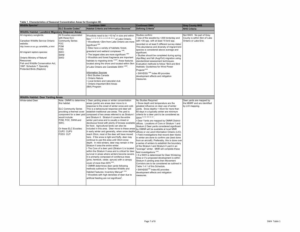
Table 1. Characteristics of Seasonal Concentration Areas for Ecoregion 6E.Wildlife Species1 Confirmed SWH Grey County NHS
ELC Ecosite Codes1 Habitat Criteria and Information Sources1 Defining Criteria1 NHS CriteriaCandidate SWH
All migratory songbirds.
Canadian Wildlife Service Ontario website:http://www.on.ec.gc.ca/wildlife_e.html
All migrant raptors species:
Ontario Ministry of Natural Resources: Fish and Wildlife Conservation Act, 1997. Schedule 7: Specially Protected Birds (Raptors)
All Ecosites associated with these ELC Community Series:FOC FOM FOD SWC SWM SWD
Woodlots need to be >10 haÍ in size and within 5km iv, v, vi, vii, viii, ix, x, xi, xii, xiii, xiv, xv of Lake Ontario.• Woodlands <2km from Lake Ontario are more significant cxlix
• Sites have a variety of habitats; forest, grassland and wetland complexes cxlix.• The largest sites are more significant cxlix
• Woodlots and forest fragments are important habitats to migrating birds ccxviii, these features located along the shore and located within 5km of Lake Ontario are Candidate SWH cxlviii. Information Sources• Bird Studies Canada• Ontario Nature• Local birders and naturalist club• Ontario Important Bird Areas(IBA) Program
Studies confirm:• Use of the woodlot by >200 birds/day and with >35 spp. with at least 10 bird spp. recorded on at least 5 different survey datesÍ. This abundance and diversity of migrant bird species is considered above average and significant. • Studies should be completed during spring (Apr/May) and fall (Aug/Oct) migration using standardized assessment techniques. Evaluation methods to follow “Bird and Bird Habitats: Guidelines for Wind Power Projects”ccxi
• SWHDSS cxlix Index #9 provides development effects and mitigation measures.
Not SWH. No part of Grey County is within 5km of Lake Ontario or Lake Erie.
White-tailed Deer Note: OMNR to determine this habitat.
ELC Community Series providing a thermal cover component for a deer yard would include:FOM, FOC, SWM and SWC.
Or these ELC Ecosites:CUP2 CUP3FOD3 CUT
• Deer yarding areas or winter concentration areas (yards) are areas deer move to in response to the onset of winter snow and cold. This is a behavioural response and deer will establish traditional use areas. The yard is composed of two areas referred to as Stratum I and Stratum II. Stratum II covers the entire winter yard area and is usually a mixed or deciduous forest with plenty of browse available for food. Agricultural lands can also be included in this area. Deer move to these areas in early winter and generally, when snow depths reach 20cm, most of the deer will have moved here. If the snow is light and fluffy, deer may continue to use this area until 30cm snow depth. In mild winters, deer may remain in the Stratum II area the entire winter.• The Core of a deer yard (Stratum I) is located within the Stratum II area and is critical for deer survival in areas where winters become severe. It is primarily composed of coniferous trees (pine, hemlock, cedar, spruce) with a canopy cover of more than 60%cxciv. • OMNR determines deer yards following methods outlined in “Selected Wildlife and Habitat Features: Inventory Manual" cxcv
• Woodlots with high densities of deer due to artificial feeding are not significantÍ.
No Studies Required:• Snow depth and temperature are the greatest influence on deer use of winter yards. Snow depths > 40cm for more than 60 days in a typically winter are minimum criteria for a deer yard to be considered as SWH lvi, lvii, lviii, lix, lx, Í.• Deer Yards are mapped by OMNR District offices. Locations of Core or Stratum 1 and Stratum 2 Deer yards considered significant by OMNR will be available at local MNR offices or via Land Information Ontario (LIO).• Field investigations that record deer tracks in winter are done to confirm use (best done from an aircraft). Preferably, this is done over a series of winters to establish the boundary of the Stratum I and Stratum II yard in an "average" winter. MNR will complete these field investigations cxcv.• If a SWH is determined for Deer Wintering Area or if a proposed development is within Stratum II yarding area then Movement Corridors are to be considered as outlined in Table 1.4.1 of this Schedule.• SWHDSScxlix Index #2 provides development effects and mitigation measures.
Deer yards are mapped by the MNRF and are identified by LIO mapping.
Wildlife Habitat: Landbird Migratory Stopover Areas
Wildlife Habitat: Deer Yarding Areas
Page 7 of 8 SWH Table 1
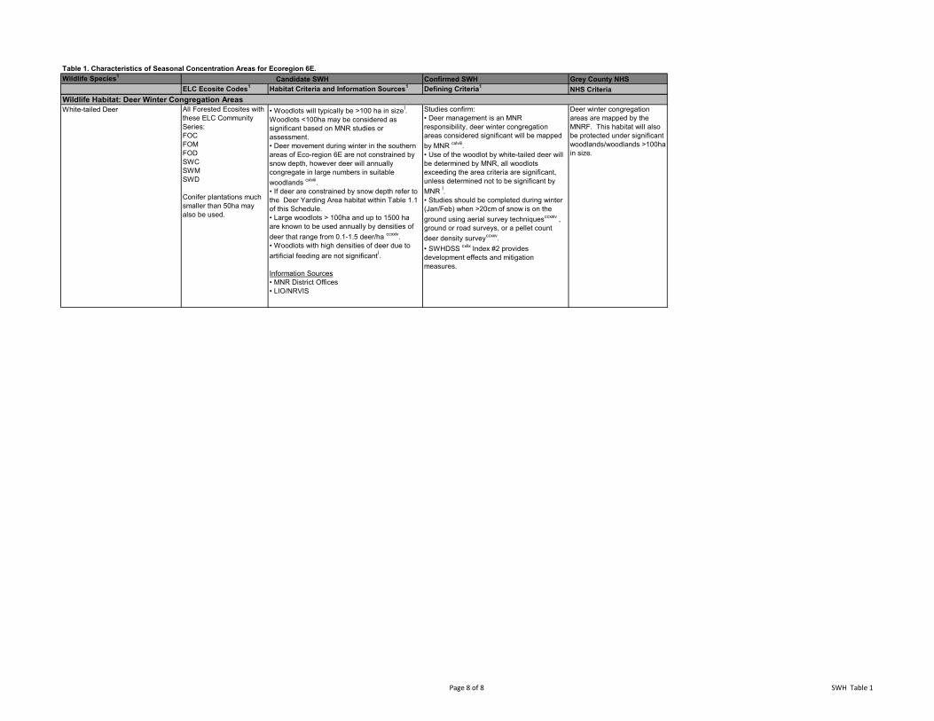
Table 1. Characteristics of Seasonal Concentration Areas for Ecoregion 6E.Wildlife Species1 Confirmed SWH Grey County NHS
ELC Ecosite Codes1 Habitat Criteria and Information Sources1 Defining Criteria1 NHS CriteriaCandidate SWH
White-tailed Deer All Forested Ecosites with these ELC Community Series:FOC FOM FOD SWC SWM SWD
Conifer plantations much smaller than 50ha may also be used.
• Woodlots will typically be >100 ha in sizeÍ. Woodlots <100ha may be considered as significant based on MNR studies or assessment.• Deer movement during winter in the southern areas of Eco-region 6E are not constrained by snow depth, however deer will annually congregate in large numbers in suitable woodlands cxlviii. • If deer are constrained by snow depth refer to the Deer Yarding Area habitat within Table 1.1 of this Schedule.• Large woodlots > 100ha and up to 1500 ha are known to be used annually by densities of deer that range from 0.1-1.5 deer/ha ccxxiv.• Woodlots with high densities of deer due to artificial feeding are not significantÍ.
Information Sources• MNR District Offices• LIO/NRVIS
Studies confirm:• Deer management is an MNR responsibility, deer winter congregation areas considered significant will be mapped by MNR cxlviii.• Use of the woodlot by white-tailed deer will be determined by MNR, all woodlots exceeding the area criteria are significant, unless determined not to be significant by MNR Í. • Studies should be completed during winter (Jan/Feb) when >20cm of snow is on the ground using aerial survey techniquesccxxiv , ground or road surveys, or a pellet count deer density surveyccxxv. • SWHDSS cxlix Index #2 provides development effects and mitigation measures.
Deer winter congregation areas are mapped by the MNRF. This habitat will also be protected under significant woodlands/woodlands >100ha in size.
Wildlife Habitat: Deer Winter Congregation Areas
Page 8 of 8 SWH Table 1
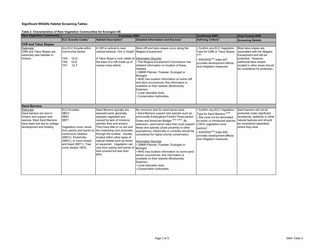
Significant Wildlife Habitat Screening Tables
Table 2. Characteristics of Rare Vegetation Communities for Ecoregion 6E.Rare Vegetation Community1 Confirmed SWH Grey County NHS
ELC Ecosite Codes1 Habitat Description1 Detailed Information and Sources1 Defining Criteria1 Screening Details
Rationale:Cliffs and Talus Slopes are extremely rare habitats in Ontario.
Any ELC Ecosite within Community Series:
TAO CLOTAS CLSTAT CLT
A Cliff is vertical to near vertical bedrock >3m in height.
A Talus Slope is rock rubble at the base of a cliff made up of coarse rocky debris.
Most cliff and talus slopes occur along the Niagara Escarpment.
Information Sources• The Niagara Escarpment Commission has detailed information on location of these habitats.• OMNR Planner, Forester, Ecologist or Biologist • NHIC has location information on some cliff and talus occurrences, this information is available on their website (Biodiversity Explorer).• Local naturalist clubs • Conservation Authorities
• Confirm any ELC Vegetation Type for Cliffs or Talus Slopes lxxviii
• SWHDSScxlix Index #21 provides development effects and mitigation measures.
Most talus slopes are associated with the Niagara Escarpment and will be protected. However, additional talus slopes located in other areas should be considered for protection.
Rationale:Sand barrens are rare in Ontario and support rare species. Most Sand Barrens have been lost due to cottage development and forestry.
ELC Ecosites:SBO1SBS1SBT1
Vegetation cover varies from patchy and barren to continuous meadow (SBO1), thicket-like (SBS1), or more closed and treed (SBT1). Tree cover always <60%.
Sand Barrens typically are exposed sand, generally sparsely vegetated and caused by lack of moisture, periodic fires and erosion. They have little or no soil and the underlying rock protrudes through the surface. Usually located within other types of natural habitat such as forest or savannah. Vegetation can vary from patchy and barren to tree covered but less than 60%.
No minimum size for sand barren area.• Sand Barrens support rare species such as provincially Endangered Forked Three-awned Grass and American Badger lxxxv, lxxxvi. By extension, sand barren sites that could support these rare species (close proximity to other populations), historically or currently should be considered for higher priority conservation.
Information Sources• OMNR Planner, Forester, Ecologist or Biologist • NHIC has location information on some sand barren occurrences, this information is available on their website (Biodiversity Explorer).• Local naturalist clubs • Conservation Authorities
• Confirm any ELC Vegetation Type for Sand Barrens lxxviii
• Site must not be dominated by exotic or introduced species (<50% vegetative cover exotics)Í.• SWHDSScxlix Index #20 provides development effects and mitigation measures.
Sand barrens will not be protected under significant woodlands, wetlands or other natural features and should be considered separately where they exist.
Candidate SWH
Cliff and Talus Slopes
Sand Barrens
Page 1 of 3 SWH Table 2
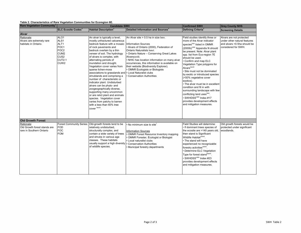
Table 2. Characteristics of Rare Vegetation Communities for Ecoregion 6E.Rare Vegetation Community1 Confirmed SWH Grey County NHS
ELC Ecosite Codes1 Habitat Description1 Detailed Information and Sources1 Defining Criteria1 Screening DetailsCandidate SWH
Rationale:Alvars are extremely rare habitats in Ontario.
ALO1ALS1ALT1FOC1FOC2CUM2CUS2CUT2-1CUW2
An alvar is typically a level, mostly unfractured calcareous bedrock feature with a mosaic of rock pavements and bedrock overlain by a thin veneer of soil. The hydrology of alvars is complex, with alternating periods of inundation and drought. Vegetation cover varies from sparse lichen-moss associations to grasslands and shrublands and comprising a number of characteristic or indicator plant. Undisturbed alvars can be phyto- and zoogeographically diverse, supporting many uncommon or are relict plant and animals species. Vegetation cover varies from patchy to barren with a less than 60% tree cover lxxviii.
An Alvar site > 0.5 ha in size lxxv.
Information Sources• Alvars of Ontario (2000), Federation of Ontario Naturalists lxxvi.• Ontario Nature – Conserving Great Lakes Alvarsccviii. • NHIC has location information on many alvar occurrences, this information is available on their website (Biodiversity Explorer).• OMNR Ecologists or Biologists• Local Naturalist clubs• Conservation Authorities
Field studies identify three or more of the Alvar indicator specieslxxv listed in OMNR (2000b)cxlix Appendix N should be present. Note: Alvar plant spp. list from Eco-region 7E should be used.• Confirm and map ELC Vegetation Type polygons for Alvarslxxviii
• Site must not be dominated by exotic or introduced species (<50% vegetative cover exotics). • The alvar must be in excellent condition and fit in with surrounding landscape with few conflicting land useslxxv.• SWHDSScxlix Index #17 provides development effects and mitigation measures.
Alvars are not protected under other natural features and alvars >0.5ha should be considered for SWH.
Rationale:Old Growth forest stands are rare in Southern Ontario
Forest Community Series:FODFOCFOM
Old-growth forests tend to be relatively undisturbed, structurally complex, and contain a wide variety of trees and shrubs in various age classes. These habitats usually support a high diversity of wildlife species.
• No minimum size to siteÍ
Information Sources• OMNR Forest Resource Inventory mapping• OMNR Forester, Ecologist or Biologist• Local naturalist clubs• Conservation Authorities• Municipal forestry departments
Field Studies will determine:• If dominant trees species of the ecosite are >140 years old, then stand is Significant Wildlife Habitatcxlviii. • The stand will have experienced no recognizable forestry activitiescxlviii.• Determine ELC Vegetation Type for forest standlxxviii.• SWHDSScxlix Index #23 provides development effects and mitigation measures.
Old growth forests would be protected under significant woodlands.
Alvar
Old Growth Forest
Page 2 of 3 SWH Table 2
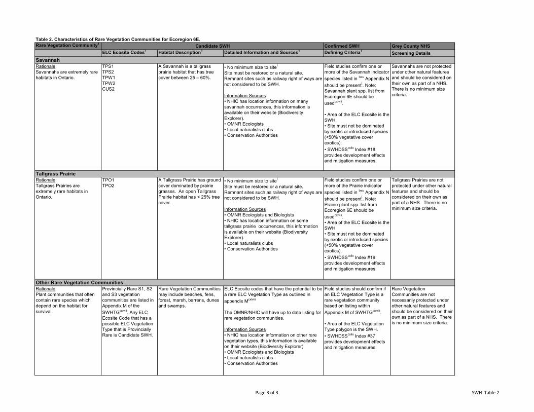
Table 2. Characteristics of Rare Vegetation Communities for Ecoregion 6E.Rare Vegetation Community1 Confirmed SWH Grey County NHS
ELC Ecosite Codes1 Habitat Description1 Detailed Information and Sources1 Defining Criteria1 Screening DetailsCandidate SWH
Rationale:Savannahs are extremely rare habitats in Ontario.
TPS1TPS2TPW1TPW2CUS2
A Savannah is a tallgrass prairie habitat that has tree cover between 25 – 60%.
• No minimum size to siteÍ
Site must be restored or a natural site. Remnant sites such as railway right of ways are not considered to be SWH.
Information Sources• NHIC has location information on many savannah occurrences, this information is available on their website (Biodiversity Explorer).• OMNR Ecologists• Local naturalists clubs• Conservation Authorities
Field studies confirm one or more of the Savannah indicator species listed in lxxv Appendix N should be presentÍ. Note: Savannah plant spp. list from Ecoregion 6E should be usedcxlviii.
• Area of the ELC Ecosite is the SWH.• Site must not be dominated by exotic or introduced species (<50% vegetative cover exotics).• SWHDSScxlix Index #18 provides development effects and mitigation measures.
Savannahs are not protected under other natural features and should be considered on their own as part of a NHS. There is no minimum size criteria.
Rationale:Tallgrass Prairies are extremely rare habitats in Ontario.
TPO1TPO2
A Tallgrass Prairie has ground cover dominated by prairie grasses. An open Tallgrass Prairie habitat has < 25% tree cover.
• No minimum size to siteÍ
Site must be restored or a natural site. Remnant sites such as railway right of ways are not considered to be SWH.
Information Sources• OMNR Ecologists and Biologists• NHIC has location information on some tallgrass prairie occurrences, this information is available on their website (Biodiversity Explorer).• Local naturalists clubs• Conservation Authorities
Field studies confirm one or more of the Prairie indicator species listed in lxxv Appendix N should be presentÍ. Note: Prairie plant spp. list from Ecoregion 6E should be usedcxlviii.• Area of the ELC Ecosite is the SWH• Site must not be dominated by exotic or introduced species (<50% vegetative cover exotics).• SWHDSScxlix Index #19 provides development effects and mitigation measures.
Tallgrass Prairies are not protected under other natural features and should be considered on their own as part of a NHS. There is no minimum size criteria.
Rationale:Plant communities that often contain rare species which depend on the habitat for survival.
Provincially Rare S1, S2 and S3 vegetation communities are listed in Appendix M of the SWHTGcxlviii. Any ELC Ecosite Code that has a possible ELC Vegetation Type that is Provincially Rare is Candidate SWH.
Rare Vegetation Communities may include beaches, fens, forest, marsh, barrens, dunes and swamps.
ELC Ecosite codes that have the potential to be a rare ELC Vegetation Type as outlined in appendix Mcxlviii
The OMNR/NHIC will have up to date listing for rare vegetation communities.
Information Sources• NHIC has location information on other rare vegetation types, this information is available on their website (Biodiversity Explorer) • OMNR Ecologists and Biologists• Local naturalists clubs• Conservation Authorities
Field studies should confirm if an ELC Vegetation Type is a rare vegetation community based on listing within Appendix M of SWHTGcxlviii.
• Area of the ELC Vegetation Type polygon is the SWH.• SWHDSScxlix Index #37 provides development effects and mitigation measures.
Rare Vegetation Communities are not necessarily protected under other natural features and should be considered on their own as part of a NHS. There is no minimum size criteria.
Savannah
Tallgrass Prairie
Other Rare Vegetation Communities
Page 3 of 3 SWH Table 2
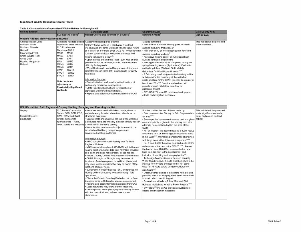
Significant Wildlife Habitat Screening Tables
Table 3. Characteristics of Specialized Wildlife Habitat for Ecoregion 6E.Wildlife Species1 Confirmed SWH Grey County NHS
ELC Ecosite Codes1 Habitat Criteria and Information Sources1 Defining Criteria1 NHS Criteria
American Black DuckNorthern PintailNorthern ShovelerGadwallBlue-winged TealGreen-winged TealWood DuckHooded MerganserMallard
All upland habitats located adjacent to these wetland ELC Ecosites are Candidate SWH:MAS1 MAS2MAS3 SAS1SAM1 SAF1MAM1 MAM2MAM3 MAM4MAM5 MAM6SWT1 SWT2SWD1 SWD2SWD3 SWD4
Note: includes adjacency to Provincially Significant Wetlands
A waterfowl nesting area extends 120mcxlix from a wetland (> 0.5 ha) or a wetland (>0.5ha) and any small wetlands (0.5ha) within 120m or a cluster of 3 or more small (<0.5 ha) wetlands within 120m of each individual wetland where waterfowl nesting is known to occurcxlix.• Upland areas should be at least 120m wide so that predators such as racoons, skunks, and foxes have difficulty finding nests.• Wood Ducks and Hooded Mergansers utilize large diameter trees (>40cm dbh) in woodlands for cavity nest sites.
Information Sources• Ducks Unlimited staff may know the locations of particularly productive nesting sites.• OMNR Wetland Evaluations for indication of significant waterfowl nesting habitat.• Reports and other information available from CAs
Studies confirmed:• Presence of 3 or more nesting pairs for listed species excluding MallardsÍ, or• Presence of 10 or more nesting pairs for listed species including MallardsÍ.• Any active nesting site of an American Black Duck is considered significant.• Nesting studies should be completed during the spring breeding season (April - June). Evaluation methods to follow “Bird and Bird Habitats: Guidelines for Wind Power Projects”ccxi
• A field study confirming waterfowl nesting habitat will determine the boundary of the waterfowl nesting habitat for the SWH, this may be greater or less than 120mcxlviii from the wetland and will provide enough habitat for waterfowl to successfully nest.• SWHDSScxlix Index #25 provides development effects and mitigation measures.
This habitat will be protected under wetlands.
Osprey
Special Concern:Bald Eagle
ELC Forest Community Series: FOD, FOM, FOC, SWD, SWM and SWC directly adjacent to riparian areas – rivers, lakes, ponds and wetlands
• Nests are associated with lakes, ponds, rivers or wetlands along forested shorelines, islands, or on structures over water.• Osprey nests are usually at the top a tree whereas Bald Eagle nests are typically in super canopy trees in a notch within the tree’s canopy.• Nests located on man-made objects are not to be included as SWH (e.g. telephone poles and constructed nesting platforms).
Information Sources• NHIC compiles all known nesting sites for Bald Eagles in Ontario.• MNR values information (LIO/NRVIS) will list known nesting locations. Note: data from NRVIS is provided as a point and does not represent all the habitat.• Nature Counts, Ontario Nest Records Scheme data.• OMNR Ecologist or Biologist may be aware of locations of nesting raptors. In addition, these staff may know local naturalists that may be aware of the locations of raptor nests.• Sustainable Forestry Licence (SFL) companies will identify additional nesting locations through field operations.• Check the Ontario Breeding Bird Atlas ccv or Rare Breeding Birds in Ontario for species documented• Reports and other information available from CAs.• Local naturalists may know of other locations.• Use maps and aerial photographs to identify forests with few roads that tend to have less human disturbance.
Studies confirm the use of these nests by:• One or more active Osprey or Bald Eagle nests in an areacxlviii. • Some species have more than one nest in a given area and priority is given to the primary nest with alternate nests included within the area of the SWH. • For an Osprey, the active nest and a 300m radius around the nest or the contiguous woodland stand is the SWHccvii, maintaining undisturbed shorelines with large trees within this area is importantcxlviii.• For a Bald Eagle the active nest and a 400-800m radius around the nest is the SWHcvi, ccvii. Area of the habitat from 400-800m is dependant on site lines from the nest to the development and inclusion of perching and foraging habitatcvi.• To be significant a site must be used annually. When found inactive, the site must be known to be inactive for >3 years or suspected of not being used for >5 years before being considered not significantccvii.• Observational studies to determine nest site use, perching sites and foraging areas need to be done from mid March to mid August. • Evaluation methods to follow “Bird and Bird Habitats: Guidelines for Wind Power Projects”ccxi
• SWHDSScxlix Index #26 provides development effects and mitigation measures
This habitat will be protected under significant wetlands, water bodies and wetland habitat.
Candidate SWH
Wildlife Habitat: Waterfowl Nesting Area
Wildlife Habitat: Bald Eagle and Osprey Nesting, Foraging and Perching Habitat
Page 1 of 4 SWH Table 3
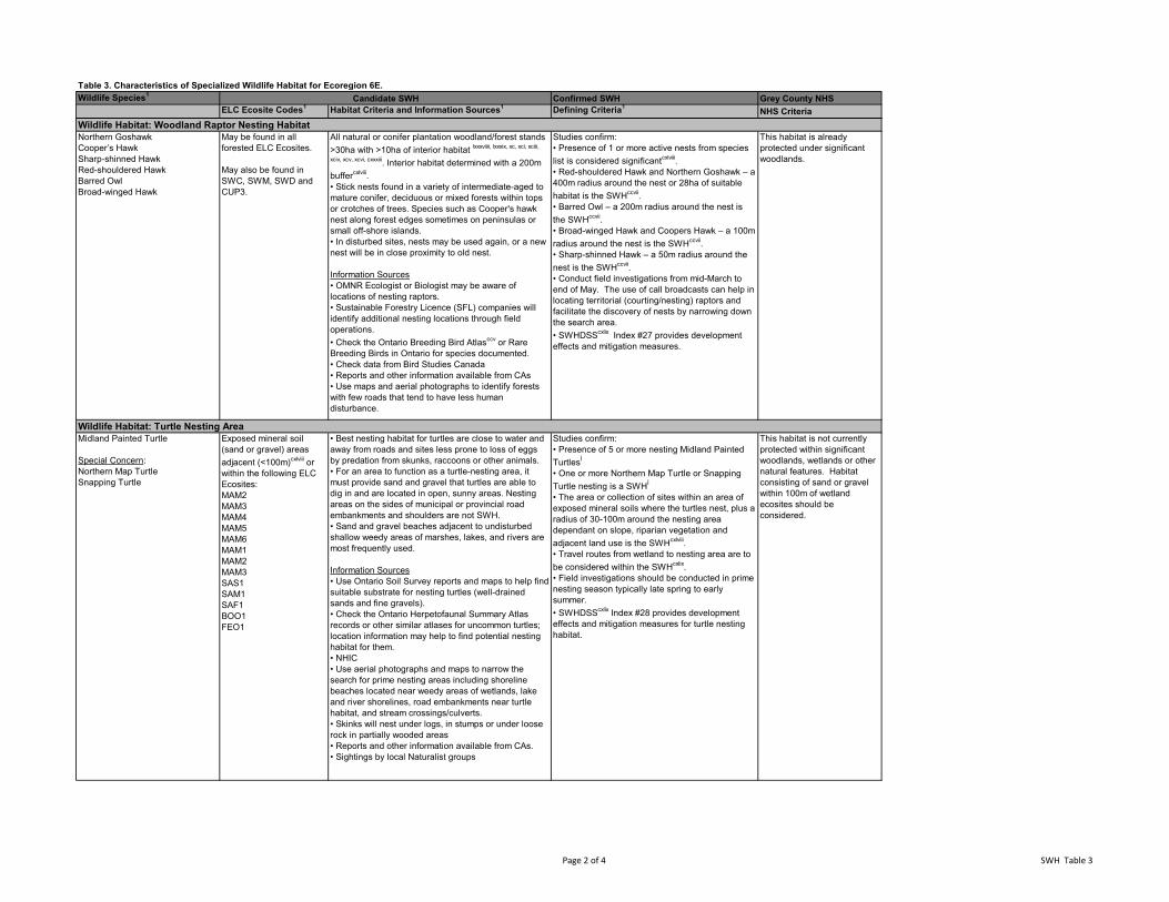
Table 3. Characteristics of Specialized Wildlife Habitat for Ecoregion 6E.Wildlife Species1 Confirmed SWH Grey County NHS
ELC Ecosite Codes1 Habitat Criteria and Information Sources1 Defining Criteria1 NHS CriteriaCandidate SWH
Northern GoshawkCooper’s HawkSharp-shinned HawkRed-shouldered HawkBarred OwlBroad-winged Hawk
May be found in all forested ELC Ecosites.
May also be found in SWC, SWM, SWD and CUP3.
All natural or conifer plantation woodland/forest stands >30ha with >10ha of interior habitat lxxxviiii, lxxxix, xc, xci, xciii,
xciv, xcv, xcvi, cxxxiii. Interior habitat determined with a 200m buffercxlviii.• Stick nests found in a variety of intermediate-aged to mature conifer, deciduous or mixed forests within tops or crotches of trees. Species such as Cooper's hawk nest along forest edges sometimes on peninsulas or small off-shore islands.• In disturbed sites, nests may be used again, or a new nest will be in close proximity to old nest.
Information Sources• OMNR Ecologist or Biologist may be aware of locations of nesting raptors. • Sustainable Forestry Licence (SFL) companies will identify additional nesting locations through field operations.• Check the Ontario Breeding Bird Atlasccv or Rare Breeding Birds in Ontario for species documented.• Check data from Bird Studies Canada• Reports and other information available from CAs• Use maps and aerial photographs to identify forests with few roads that tend to have less human disturbance.
Studies confirm:• Presence of 1 or more active nests from species list is considered significantcxlviii.• Red-shouldered Hawk and Northern Goshawk – a 400m radius around the nest or 28ha of suitable habitat is the SWHccvii.• Barred Owl – a 200m radius around the nest is the SWHccvii.• Broad-winged Hawk and Coopers Hawk – a 100m radius around the nest is the SWHccvii.• Sharp-shinned Hawk – a 50m radius around the nest is the SWHccvii.• Conduct field investigations from mid-March to end of May. The use of call broadcasts can help in locating territorial (courting/nesting) raptors and facilitate the discovery of nests by narrowing down the search area. • SWHDSScxlix Index #27 provides development effects and mitigation measures.
This habitat is already protected under significant woodlands.
Midland Painted Turtle
Special Concern:Northern Map TurtleSnapping Turtle
Exposed mineral soil (sand or gravel) areas adjacent (<100m)cxlviii or within the following ELC Ecosites:MAM2MAM3MAM4MAM5MAM6MAM1MAM2MAM3SAS1SAM1SAF1BOO1FEO1
• Best nesting habitat for turtles are close to water and away from roads and sites less prone to loss of eggs by predation from skunks, raccoons or other animals.• For an area to function as a turtle-nesting area, it must provide sand and gravel that turtles are able to dig in and are located in open, sunny areas. Nesting areas on the sides of municipal or provincial road embankments and shoulders are not SWH.• Sand and gravel beaches adjacent to undisturbed shallow weedy areas of marshes, lakes, and rivers are most frequently used.
Information Sources• Use Ontario Soil Survey reports and maps to help find suitable substrate for nesting turtles (well-drained sands and fine gravels).• Check the Ontario Herpetofaunal Summary Atlas records or other similar atlases for uncommon turtles; location information may help to find potential nesting habitat for them.• NHIC• Use aerial photographs and maps to narrow the search for prime nesting areas including shoreline beaches located near weedy areas of wetlands, lake and river shorelines, road embankments near turtle habitat, and stream crossings/culverts.• Skinks will nest under logs, in stumps or under loose rock in partially wooded areas• Reports and other information available from CAs.• Sightings by local Naturalist groups
Studies confirm:• Presence of 5 or more nesting Midland Painted TurtlesÍ
• One or more Northern Map Turtle or Snapping Turtle nesting is a SWHÍ
• The area or collection of sites within an area of exposed mineral soils where the turtles nest, plus a radius of 30-100m around the nesting area dependant on slope, riparian vegetation and adjacent land use is the SWHcxlviii.• Travel routes from wetland to nesting area are to be considered within the SWHcxlix.• Field investigations should be conducted in prime nesting season typically late spring to early summer.• SWHDSScxlix Index #28 provides development effects and mitigation measures for turtle nesting habitat.
This habitat is not currently protected within significant woodlands, wetlands or other natural features. Habitat consisting of sand or gravel within 100m of wetland ecosites should be considered.
Wildlife Habitat: Woodland Raptor Nesting Habitat
Wildlife Habitat: Turtle Nesting Area
Page 2 of 4 SWH Table 3
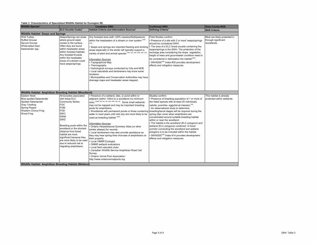
Table 3. Characteristics of Specialized Wildlife Habitat for Ecoregion 6E.Wildlife Species1 Confirmed SWH Grey County NHS
ELC Ecosite Codes1 Habitat Criteria and Information Sources1 Defining Criteria1 NHS CriteriaCandidate SWH
Wild TurkeyRuffed GrouseSpruce GrouseWhite-tailed DeerSalamander spp.
Seeps/Springs are areas where ground water comes to the surface. Often they are found within headwater areas within forested habitats. Any forested Ecosite within the headwater areas of a stream could have seeps/springs.
Any forested area (with <25% meadow/field/pasture) within the headwaters of a stream or river system cxvii,
cxlix.• Seeps and springs are important feeding and drinking areas especially in the winter will typically support a variety of plant and animal species cxix, cxx, cxxi, cxxii, cxiii, cxiv.
Information Sources• Topographical Map• Thermography• Hydrological surveys conducted by CAs and MOE• Local naturalists and landowners may know some locations• Municipalities and Conservation Authorities may have drainage maps and headwater areas mapped.
Field Studies confirm:• Presence of a site with 2 or moreÍ seeps/springs should be considered SWH.• The area of a ELC forest ecosite containing the seeps/springs is the SWH. The protection of the recharge area considering the slope, vegetation, height of trees and groundwater condition need to be considered in delineation the habitatcxlviii.• SWHDSScxlix Index #30 provides development effects and mitigation measures
Most are likely protected in through significant woodlands.
Eastern NewtBlue-spotted SalamanderSpotted SalamanderGray TreefrogSpring PeeperWestern Chorus FrogWood Frog
All Ecosites associated with these ELC Community Series:FOC FOMFOD SWC SWMSWD
Breeding pools within the woodland or the shortest distance from forest habitat are more significant because they are more likely to be used due to reduced risk to migrating amphibians.
• Presence of a wetland, lake, or pond within or adjacent (within 120m) to a woodland (no minimum size) clxxxii, lxiii, lxv, lxvi, lxvii, lxviii, lxix, lxx. Some small wetlands may not be mapped and may be important breeding pools for amphibians.• Woodlands with permanent ponds or those containing water in most years until mid-July are more likely to be used as breeding habitat cxlviii.
Information Sources• Ontario Herpetofaunal Summary Atlas (or other similar atlases) for records• Local landowners may also provide assistance as they may hear spring-time choruses of amphibians on their property.• Local OMNR Ecologist• OMNR wetland evaluations• Local field naturalist clubs• Canadian Wildlife Service Amphibian Road Call Survey• Ontario Vernal Pool Association: http://www.ontariovernalpools.org
Studies confirm:• Presence of breeding population of 1 or more of the listed species with at least 20 individuals (adults, juveniles, eggs/larval masses) lxxi.• An observational study to determine breeding/larval stages will be required during the spring (Apr-June) when amphibians are concentrated around suitable breeding habitat within or near the woodland.• The habitat is the woodland (ELC polygons) and wetland (ELC polygons) combined. A travel corridor connecting the woodland and wetland polygons is to be included within the habitat.• SWHDSScxlix Index #14 provides development effects and mitigation measures.
This habitat is already protected within wetlands.
Wildlife Habitat: Amphibian Breeding Habitat (Woodland)
Wildlife Habitat: Amphibian Breeding Habitat (Wetland)
Wildlife Habitat: Seeps and Springs
Page 3 of 4 SWH Table 3
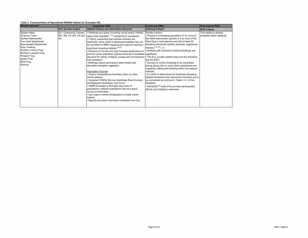
Table 3. Characteristics of Specialized Wildlife Habitat for Ecoregion 6E.Wildlife Species1 Confirmed SWH Grey County NHS
ELC Ecosite Codes1 Habitat Criteria and Information Sources1 Defining Criteria1 NHS CriteriaCandidate SWH
Eastern NewtAmerican ToadSpotted SalamanderFour-toed SalamanderBlue-spotted SalamanderGray TreefrogWestern Chorus FrogNorthern Leopard FrogPickerel FrogGreen FrogMink FrogBullfrog
ELC Community Classes SW, MA, FE, BO, OA and SA.
• Wetlands and pools (including vernal pools) >500m2 (about 25m diameter) ccvii isolated from woodlands (>120m), supporting high species diversity are significant; some small or ephemeral habitats may not be identified on MNR mapping and could be important amphibian breeding habitats clxxxiv.• Presence of shrubs and logs increase significance of pond for some amphibian species because of available structure for calling, foraging, escape and concealment from predators.• Bullfrogs require permanent water bodies with abundant emergent vegetation.
Information Sources• Ontario Herpetofaunal Summary Atlas (or other similar atlases) • Canadian Wildlife Service Amphibian Road Surveys and Backyard Amphibian Call Count.• OMNR Ecologist or Biologist may know of populations, wetland evaluations may be a good source of information.• Use maps or aerial photography to locate marsh habitat.• Reports and other information available from CAs.
Studies confirm:• Presence of breeding population of 1or more of the listed salamander species or 3 or more of the listed frog or toad species and with at least 20 breeding individuals (adults, juveniles, eggs/larval masses) lxxi, lxxiii, or• Wetland with confirmed breeding Bullfrogs are significantÍ.• The ELC ecosite wetland area and the shoreline are the SWH.• Surveys to confirm breeding to be completed during spring (Apr to June) when amphibians are migrating, calling and breeding within the wetland habitats.• If a SWH is determined for Amphibian Breeding Habitat (Wetlands) then Movement Corridors are to be considered as outlined in Table 1.4.1 of this Schedule.• SWHDSScxlix Index #15 provides development effects and mitigation measures.
This habitat is already protected within wetlands.
Page 4 of 4 SWH Table 3
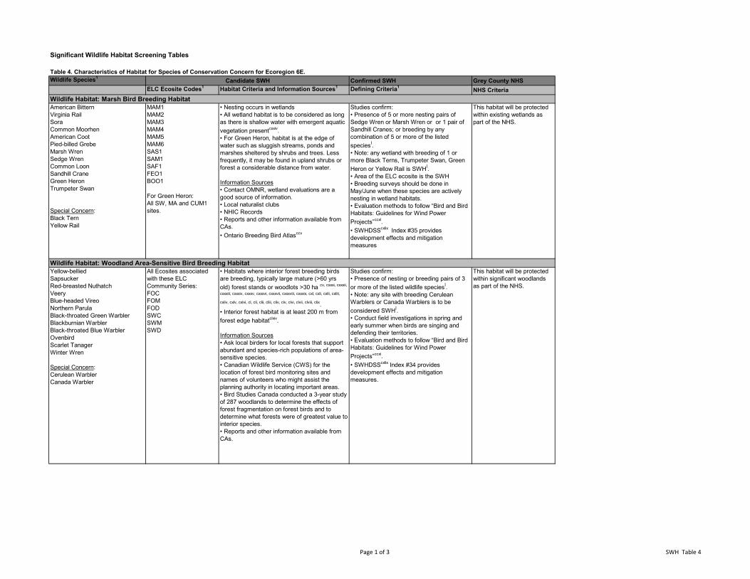
Significant Wildlife Habitat Screening Tables
Table 4. Characteristics of Habitat for Species of Conservation Concern for Ecoregion 6E.Wildlife Species1 Confirmed SWH Grey County NHS
ELC Ecosite Codes1 Habitat Criteria and Information Sources1 Defining Criteria1 NHS Criteria
American BitternVirginia RailSora Common MoorhenAmerican CootPied-billed GrebeMarsh WrenSedge WrenCommon Loon Sandhill CraneGreen HeronTrumpeter Swan
Special Concern:Black TernYellow Rail
MAM1MAM2MAM3MAM4MAM5MAM6SAS1SAM1SAF1FEO1BOO1
For Green Heron:All SW, MA and CUM1 sites.
• Nesting occurs in wetlands• All wetland habitat is to be considered as long as there is shallow water with emergent aquatic vegetation presentcxxiv.• For Green Heron, habitat is at the edge of water such as sluggish streams, ponds and marshes sheltered by shrubs and trees. Less frequently, it may be found in upland shrubs or forest a considerable distance from water.
Information Sources• Contact OMNR, wetland evaluations are a good source of information.• Local naturalist clubs• NHIC Records• Reports and other information available from CAs.• Ontario Breeding Bird Atlasccv
Studies confirm:• Presence of 5 or more nesting pairs of Sedge Wren or Marsh Wren or or 1 pair of Sandhill Cranes; or breeding by any combination of 5 or more of the listed speciesÍ.• Note: any wetland with breeding of 1 or more Black Terns, Trumpeter Swan, Green Heron or Yellow Rail is SWHÍ.• Area of the ELC ecosite is the SWH• Breeding surveys should be done in May/June when these species are actively nesting in wetland habitats.• Evaluation methods to follow “Bird and Bird Habitats: Guidelines for Wind Power Projects”ccxi.• SWHDSScxlix Index #35 provides development effects and mitigation measures
This habitat will be protected within existing wetlands as part of the NHS.
Yellow-belliedSapsuckerRed-breasted NuthatchVeery Blue-headed VireoNorthern ParulaBlack-throated Green WarblerBlackburnian WarblerBlack-throated Blue WarblerOvenbirdScarlet TanagerWinter Wren
Special Concern:Cerulean Warbler Canada Warbler
All Ecosites associated with these ELC Community Series:FOC FOMFOD SWC SWMSWD
• Habitats where interior forest breeding birds are breeding, typically large mature (>60 yrs old) forest stands or woodlots >30 ha cv, cxxxi, cxxxii,
cxxxiii, cxxxiv, cxxxv, cxxxvi, cxxxvii, cxxxviii, cxxxix, cxl, cxli, cxlii, cxliii,
cxliv, cxlv, cxlvi, cl, cli, clii, cliii, cliv, clv, clvi, clvii, clviii, clix. • Interior forest habitat is at least 200 m from forest edge habitatclxiv.
Information Sources• Ask local birders for local forests that support abundant and species-rich populations of area-sensitive species.• Canadian Wildlife Service (CWS) for the location of forest bird monitoring sites and names of volunteers who might assist the planning authority in locating important areas.• Bird Studies Canada conducted a 3-year study of 287 woodlands to determine the effects of forest fragmentation on forest birds and to determine what forests were of greatest value to interior species.• Reports and other information available from CAs.
Studies confirm: • Presence of nesting or breeding pairs of 3 or more of the listed wildlife speciesÍ.• Note: any site with breeding Cerulean Warblers or Canada Warblers is to be considered SWHÍ.• Conduct field investigations in spring and early summer when birds are singing and defending their territories.• Evaluation methods to follow “Bird and Bird Habitats: Guidelines for Wind Power Projects”ccxi.• SWHDSScxlix Index #34 provides development effects and mitigation measures.
This habitat will be protected within significant woodlands as part of the NHS.
Candidate SWH
Wildlife Habitat: Marsh Bird Breeding Habitat
Wildlife Habitat: Woodland Area-Sensitive Bird Breeding Habitat
Page 1 of 3 SWH Table 4
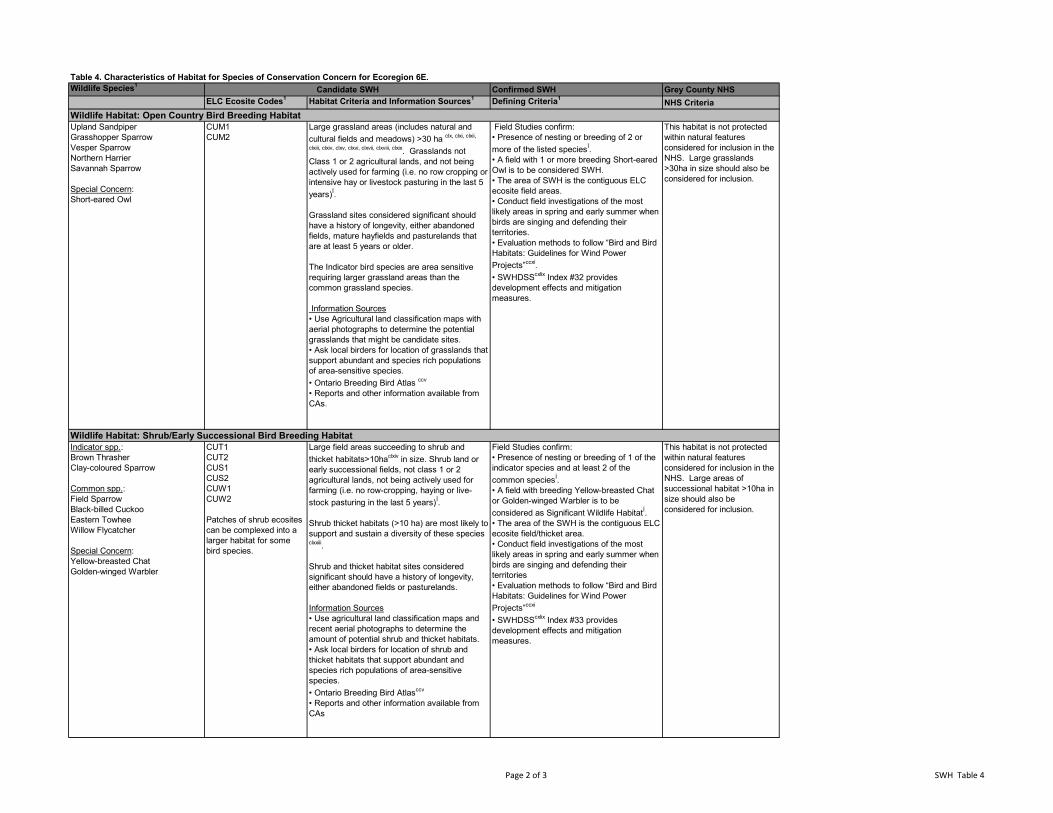
Table 4. Characteristics of Habitat for Species of Conservation Concern for Ecoregion 6E.Wildlife Species1 Confirmed SWH Grey County NHS
ELC Ecosite Codes1 Habitat Criteria and Information Sources1 Defining Criteria1 NHS CriteriaCandidate SWH
Upland SandpiperGrasshopper SparrowVesper SparrowNorthern HarrierSavannah Sparrow
Special Concern:Short-eared Owl
CUM1CUM2
Large grassland areas (includes natural and cultural fields and meadows) >30 ha clx, clxi, clxii,
clxiii, clxiv, clxv, clxvi, clxvii, clxviii, clxix. Grasslands not Class 1 or 2 agricultural lands, and not being actively used for farming (i.e. no row cropping or intensive hay or livestock pasturing in the last 5 years)Í.
Grassland sites considered significant should have a history of longevity, either abandoned fields, mature hayfields and pasturelands that are at least 5 years or older.
The Indicator bird species are area sensitive requiring larger grassland areas than the common grassland species.
Information Sources• Use Agricultural land classification maps with aerial photographs to determine the potential grasslands that might be candidate sites.• Ask local birders for location of grasslands that support abundant and species rich populations of area-sensitive species. • Ontario Breeding Bird Atlas ccv
• Reports and other information available from CAs.
Field Studies confirm:• Presence of nesting or breeding of 2 or more of the listed speciesÍ.• A field with 1 or more breeding Short-eared Owl is to be considered SWH.• The area of SWH is the contiguous ELC ecosite field areas.• Conduct field investigations of the most likely areas in spring and early summer when birds are singing and defending their territories.• Evaluation methods to follow “Bird and Bird Habitats: Guidelines for Wind Power Projects”ccxi.• SWHDSScxlix Index #32 provides development effects and mitigation measures.
This habitat is not protected within natural features considered for inclusion in the NHS. Large grasslands >30ha in size should also be considered for inclusion.
Indicator spp.:Brown ThrasherClay-coloured Sparrow
Common spp.:Field SparrowBlack-billed CuckooEastern TowheeWillow Flycatcher
Special Concern: Yellow-breasted ChatGolden-winged Warbler
CUT1CUT2CUS1CUS2CUW1CUW2
Patches of shrub ecosites can be complexed into a larger habitat for some bird species.
Large field areas succeeding to shrub and thicket habitats>10haclxiv in size. Shrub land or early successional fields, not class 1 or 2 agricultural lands, not being actively used for farming (i.e. no row-cropping, haying or live-stock pasturing in the last 5 years)Í.
Shrub thicket habitats (>10 ha) are most likely to support and sustain a diversity of these species clxxiii.
Shrub and thicket habitat sites considered significant should have a history of longevity, either abandoned fields or pasturelands.
Information Sources• Use agricultural land classification maps and recent aerial photographs to determine the amount of potential shrub and thicket habitats.• Ask local birders for location of shrub and thicket habitats that support abundant and species rich populations of area-sensitive species.• Ontario Breeding Bird Atlasccv
• Reports and other information available from CAs
Field Studies confirm:• Presence of nesting or breeding of 1 of the indicator species and at least 2 of the common speciesÍ.• A field with breeding Yellow-breasted Chat or Golden-winged Warbler is to be considered as Significant Wildlife HabitatÍ.• The area of the SWH is the contiguous ELC ecosite field/thicket area.• Conduct field investigations of the most likely areas in spring and early summer when birds are singing and defending their territories• Evaluation methods to follow “Bird and Bird Habitats: Guidelines for Wind Power Projects”ccxi
• SWHDSScxlix Index #33 provides development effects and mitigation measures.
This habitat is not protected within natural features considered for inclusion in the NHS. Large areas of successional habitat >10ha in size should also be considered for inclusion.
Wildlife Habitat: Open Country Bird Breeding Habitat
Wildlife Habitat: Shrub/Early Successional Bird Breeding Habitat
Page 2 of 3 SWH Table 4
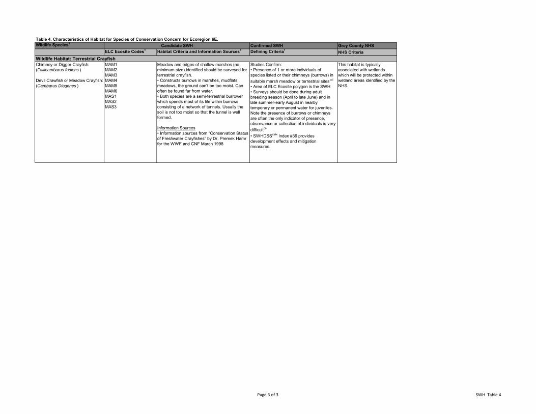
Table 4. Characteristics of Habitat for Species of Conservation Concern for Ecoregion 6E.Wildlife Species1 Confirmed SWH Grey County NHS
ELC Ecosite Codes1 Habitat Criteria and Information Sources1 Defining Criteria1 NHS CriteriaCandidate SWH
Chimney or Digger Crayfish: (Fallicambarus fodiens )
Devil Crawfish or Meadow Crayfish: (Cambarus Diogenes )
MAM1MAM2MAM3MAM4MAM5MAM6MAS1MAS2MAS3
Meadow and edges of shallow marshes (no minimum size) identified should be surveyed for terrestrial crayfish.• Constructs burrows in marshes, mudflats, meadows, the ground can’t be too moist. Can often be found far from water.• Both species are a semi-terrestrial burrower which spends most of its life within burrows consisting of a network of tunnels. Usually the soil is not too moist so that the tunnel is well formed.
Information Sources• Information sources from “Conservation Status of Freshwater Crayfishes” by Dr. Premek Hamr for the WWF and CNF March 1998
Studies Confirm:• Presence of 1 or more individuals of species listed or their chimneys (burrows) in suitable marsh meadow or terrestrial sitescci
• Area of ELC Ecosite polygon is the SWH• Surveys should be done during adult breeding season (April to late June) and in late summer-early August in nearby temporary or permanent water for juveniles. Note the presence of burrows or chimneys are often the only indicator of presence, observance or collection of individuals is very difficultcci
• SWHDSScxlix Index #36 provides development effects and mitigation measures.
This habitat is typically associated with wetlands which will be protected within wetland areas identified by the NHS.
Wildlife Habitat: Terrestrial Crayfish
Page 3 of 3 SWH Table 4
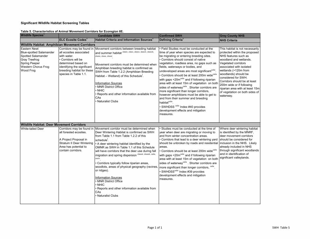
Significant Wildlife Habitat Screening Tables
Table 5. Characteristics of Animal Movement Corridors for Ecoregion 6E.Wildlife Species1 Confirmed SWH Grey County NHS
ELC Ecosite Codes1 Habitat Criteria and Information Sources1 Defining Criteria1 NHS Criteria
Eastern NewtBlue-spotted SalamanderSpotted SalamanderGray TreefrogSpring PeeperWestern Chorus FrogWood Frog
Corridors may be found in all ecosites associated with water.• Corridors will be determined based on identifying the significant breeding habitat for these species in Table 1.1.
Movement corridors between breeding habitat and summer habitat clxxiv, clxxv, clxxvi, clxxvii, clxxviii,
clxxix, clxxx, clxxxi.
Movement corridors must be determined when Amphibian breeding habitat is confirmed as SWH from Table 1.2.2 (Amphibian Breeding Habitat – Wetland) of this ScheduleÍ.
Information Sources• MNR District Office• NHIC• Reports and other information available from CAs• Naturalist Clubs
• Field Studies must be conducted at the time of year when species are expected to be migrating or entering breeding sites.• Corridors should consist of native vegetation, roadless area, no gaps such as fields, waterways or bodies, and undeveloped areas are most significantcxlix.• Corridors should be at least 200m widecxlix
with gaps <20mcxlix and if following riparian area with at least 15m of vegetation on both sides of waterwaycxlix . Shorter corridors are more significant than longer corridors, however amphibians must be able to get to and from their summer and breeding habitatcxlix.• SWHDSS cxlix Index #40 provides development effects and mitigation measures.
This habitat is not necessarily protected within the proposed NHS features such as woodland and wetlands. Vegetated corridors associated with isolated wetlands (>120m from woodlands) should be considered for SWH. Corridors should be at least 200m wide or if following riparian area with at least 15m of vegetation on both sides of waterway.
White-tailed Deer Corridors may be found in all forested ecosites.
A Project Proposal in Stratum II Deer Wintering Area has potential to contain corridors.
Movement corridor must be determined when Deer Wintering Habitat is confirmed as SWH from Table 1.1 from Table 1.2.2 of this scheduleÍ. • A deer wintering habitat identified by the OMNR as SWH in Table 1.1 of this Schedule will have corridors that the deer use during fall migration and spring dispersion clxxxii, clxxxiii, cxlix,
cxciv. • Corridors typically follow riparian areas, woodlots, areas of physical geography (ravines, or ridges).
Information Sources• MNR District Office• NHIC• Reports and other information available from CAs• Naturalist Clubs
• Studies must be conducted at the time of year when deer are migrating or moving to and from winter concentration areas.• Corridors that lead to a deer wintering yard should be unbroken by roads and residential areas. • Corridors should be at least 200m widecxlix
with gaps <20mcxlix and if following riparian area with at least 15m of vegetation on both sides of waterwaycxlix . Shorter corridors are more significant than longer corridors, cxlix.• SWHDSScxlix Index #39 provides development effects and mitigation measures.
Where deer wintering habitat is identified by the MNRF, deer movement corridors should be considered for inclusion in the NHS. Likely already included in NHS through significant woodlands and in identification of significant valleylands.
Candidate SWH
Wildlife Habitat: Amphibian Movement Corridors
Wildlife Habitat: Deer Movement Corridors
Page 1 of 1 SWH Table 5

Natural Resource Solutions Inc. Grey County Natural Heritage Systems Study
APPENDIX IV Maps
Map A. Greenway Map B. Wildlife Corridor Analysis Map C. Natural Heritage System and Other Protected Areas Map D. Restrictive Policy Areas Map E. Newly Protected Areas (Restrictive Policy) Map F. Aggregate Pits and Quarries Map G. Geology Features

Natural Resource Solutions Inc. Grey County Natural Heritage Systems Study
APPENDIX V Technical Definitions and Criteria for Key Natural Heritage Features in the
Natural Heritage System of the Protected Countryside Area, Technical Paper 1 – Appendix B
(Source: OMNR 2012)
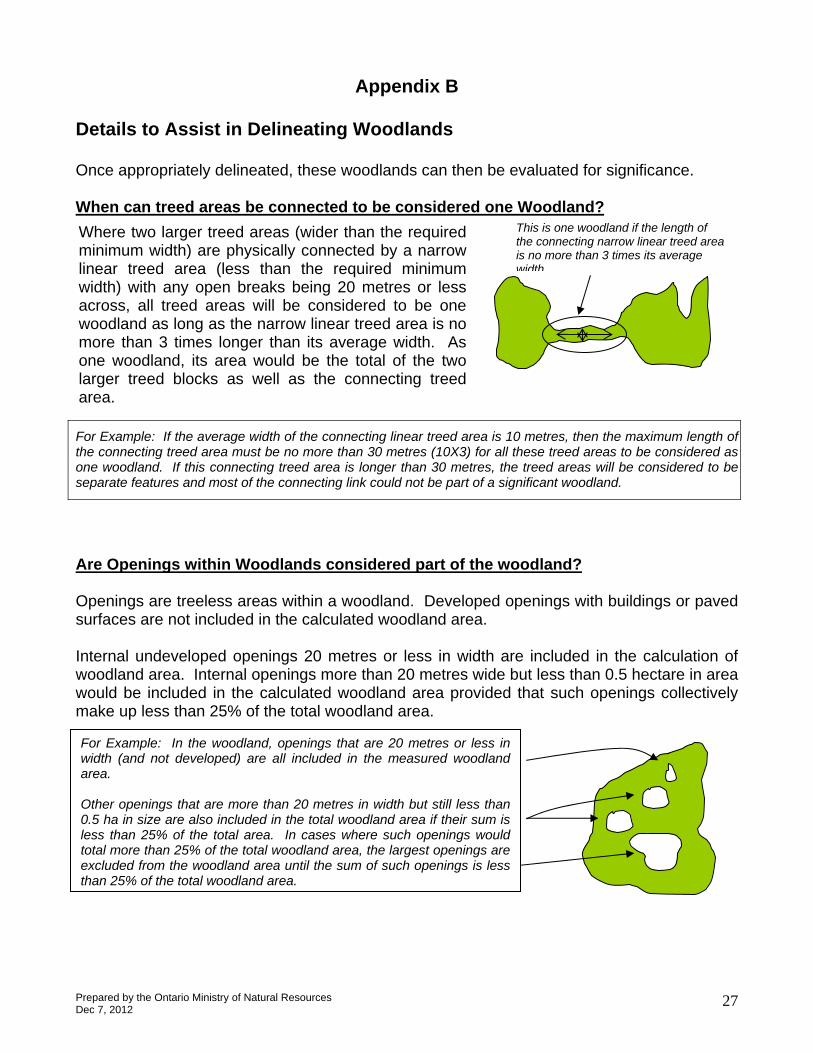
Appendix B
Details to Assist in Delineating Woodlands
Once appropriately delineated, these woodlands can then be evaluated for significance.
When can treed areas be connected to be considered one Woodland? This is one woodland if the length of Where two larger treed areas (wider than the required the connecting narrow linear treed area
minimum width) are physically connected by a narrow is no more than 3 times its average linear treed area (less than the required minimum width) with any open breaks being 20 metres or less across, all treed areas will be considered to be one woodland as long as the narrow linear treed area is no more than 3 times longer than its average width. As one woodland, its area would be the total of the two larger treed blocks as well as the connecting treed area.
width
For Example: If the average width of the connecting linear treed area is 10 metres, then the maximum length of the connecting treed area must be no more than 30 metres (10X3) for all these treed areas to be considered as one woodland. If this connecting treed area is longer than 30 metres, the treed areas will be considered to be separate features and most of the connecting link could not be part of a significant woodland.
Are Openings within Woodlands considered part of the woodland?
Openings are treeless areas within a woodland. Developed openings with buildings or paved surfaces are not included in the calculated woodland area.
Internal undeveloped openings 20 metres or less in width are included in the calculation of woodland area. Internal openings more than 20 metres wide but less than 0.5 hectare in area would be included in the calculated woodland area provided that such openings collectively make up less than 25% of the total woodland area.
For Example: In the woodland, openings that are 20 metres or less in width (and not developed) are all included in the measured woodland area.
Other openings that are more than 20 metres in width but still less than 0.5 ha in size are also included in the total woodland area if their sum is less than 25% of the total area. In cases where such openings would total more than 25% of the total woodland area, the largest openings are excluded from the woodland area until the sum of such openings is less than 25% of the total woodland area.
Prepared by the Ontario Ministry of Natural Resources Dec 7, 2012
27
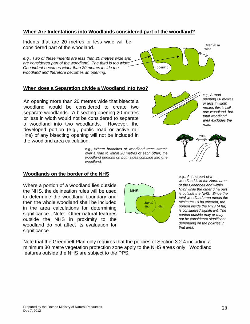
When Are Indentations into Woodlands considered part of the woodland?
opening
wide
Indents that are 20 metres or less wide will be considered part of the woodland.
e.g., Two of these indents are less than 20 metres wide and are considered part of the woodland. The third is too wide. One indent becomes wider than 20 metres inside the woodland and therefore becomes an opening.
When does a Separation divide a Woodland into two?
Over 20 m
e.g., A road opening 20 metres An opening more than 20 metres wide that bisects a or less in width
woodland would be considered to create two means this is still one woodland, but separate woodlands. A bisecting opening 20 metres total woodland or less in width would not be considered to separate area excludes the
a woodland into two woodlands. However, the road.
developed portion (e.g., public road or active rail line) of any bisecting opening will not be included in the woodland area calculation.
e.g., Where branches of woodland trees stretch over a road to within 20 metres of each other, the woodland portions on both sides combine into one woodland.
Woodlands on the border of the NHS
20m
e.g., A 4 ha part of a woodland is in the North area
Signif. 4ha 6ha
NHS
of the Greenbelt and within NHS while the other 6 ha part
Where a portion of a woodland lies outside the NHS, the delineation rules will be used
is outside the NHS. Since the to determine the woodland boundary and total woodland area meets the
minimum 10 ha criterion, the portion inside the NHS (4 ha)
then the whole woodland shall be included in the area calculations for determining
is considered significant. The significance. Note: Other natural features portion outside may or may
not be considered significant depending on the policies in
outside the NHS in proximity to the woodland do not affect its evaluation for
that area.significance.
Note that the Greenbelt Plan only requires that the policies of Section 3.2.4 including a minimum 30 metre vegetation protection zone apply to the NHS areas only. Woodland features outside the NHS are subject to the PPS.
Prepared by the Ontario Ministry of Natural Resources Dec 7, 2012
28

Natural Resource Solutions Inc. Grey County Natural Heritage Systems Study
APPENDIX VI County Official Plan Section 2.8 Natural Environment
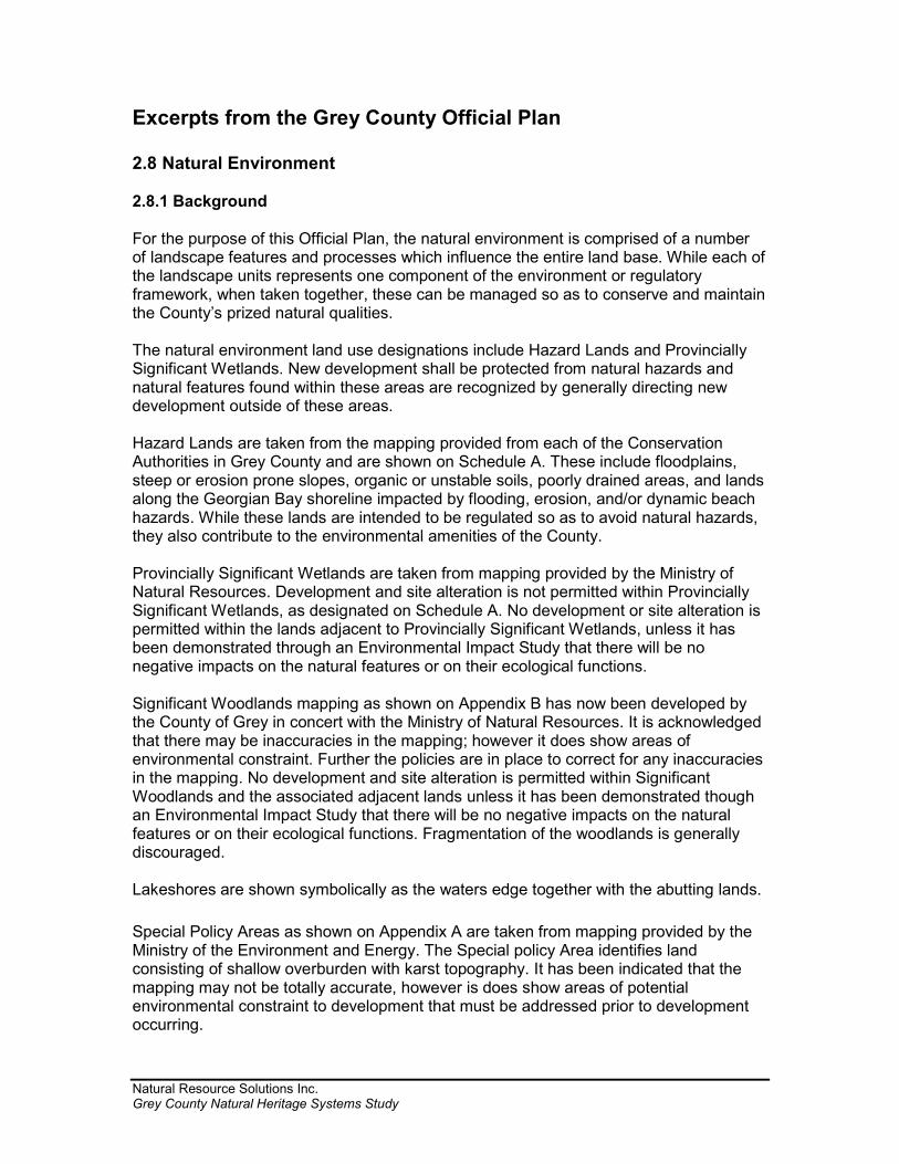
Natural Resource Solutions Inc. Grey County Natural Heritage Systems Study
Excerpts from the Grey County Official Plan 2.8 Natural Environment 2.8.1 Background For the purpose of this Official Plan, the natural environment is comprised of a number of landscape features and processes which influence the entire land base. While each of the landscape units represents one component of the environment or regulatory framework, when taken together, these can be managed so as to conserve and maintain the County’s prized natural qualities. The natural environment land use designations include Hazard Lands and Provincially Significant Wetlands. New development shall be protected from natural hazards and natural features found within these areas are recognized by generally directing new development outside of these areas. Hazard Lands are taken from the mapping provided from each of the Conservation Authorities in Grey County and are shown on Schedule A. These include floodplains, steep or erosion prone slopes, organic or unstable soils, poorly drained areas, and lands along the Georgian Bay shoreline impacted by flooding, erosion, and/or dynamic beach hazards. While these lands are intended to be regulated so as to avoid natural hazards, they also contribute to the environmental amenities of the County. Provincially Significant Wetlands are taken from mapping provided by the Ministry of Natural Resources. Development and site alteration is not permitted within Provincially Significant Wetlands, as designated on Schedule A. No development or site alteration is permitted within the lands adjacent to Provincially Significant Wetlands, unless it has been demonstrated through an Environmental Impact Study that there will be no negative impacts on the natural features or on their ecological functions. Significant Woodlands mapping as shown on Appendix B has now been developed by the County of Grey in concert with the Ministry of Natural Resources. It is acknowledged that there may be inaccuracies in the mapping; however it does show areas of environmental constraint. Further the policies are in place to correct for any inaccuracies in the mapping. No development and site alteration is permitted within Significant Woodlands and the associated adjacent lands unless it has been demonstrated though an Environmental Impact Study that there will be no negative impacts on the natural features or on their ecological functions. Fragmentation of the woodlands is generally discouraged. Lakeshores are shown symbolically as the waters edge together with the abutting lands. Special Policy Areas as shown on Appendix A are taken from mapping provided by the Ministry of the Environment and Energy. The Special policy Area identifies land consisting of shallow overburden with karst topography. It has been indicated that the mapping may not be totally accurate, however is does show areas of potential environmental constraint to development that must be addressed prior to development occurring.

Natural Resource Solutions Inc. Grey County Natural Heritage Systems Study
While each of these designations and constraints was produced with information provided by different Ministries and agencies, the County Plan uses data collectively to provide an integrated approach to the environment. Geographic as well as jurisdictional fragmentation increases the potential for native species to abandon specific areas and reduces the potential for re-colonization. This Plan attempts to maintain natural linkages so as to enhance ecological features, functions and processes. The diversity and connectivity of natural features in an area, and the long term ecological function and biodiversity of natural heritage systems, should be maintained, restored or where possible, improved, recognizing linkages between and among natural heritage features and areas, surface water features and groundwater features. The cumulative effects of new development on the natural environment as defined in section 2.8 of this plan, and surrounding land uses shall also be addressed. There is no County-wide mapping of fish habitat, valleylands, wildlife habitat and aquifer recharge areas on which to base land use designations. Until such mapping becomes available, the Hazard Lands and Provincially Significant Wetlands designations and the natural features shown on Appendices A and B shall be interpreted as generally representative of many, but not necessarily all, of these features. The Endangered Species Act, 2007, which came into effect on June 23, 2007 provides protection for significant endangered, threatened and extirpated species and habitat. The Act applies to all projects including infrastructure, development, maintenance, and Planning Act Applications. Limited mapping from the Ministry of Natural Resources showing areas of significant endangered or threatened species is available. This broad mapping is not indicative of the specific habitat area, but rather serves as an area of constraint flagging further study. The County may use this mapping when assessing development applications, with advice from the Ministry of Natural Resources. For the purposes of Section 2.8 of this Plan, ‘adjacent lands’ means those lands, contiguous to a specific natural heritage feature or area, where it is likely that development or site alteration would have a negative impact on the feature or area. The adjacent lands widths listed below are approximate values to be used in this Plan unless different values are established by amendment to this Plan or in a local official plan supported by a technical study prepared by a qualified professional knowledgeable on natural resources: Feature or Area Adjacent Land Width Significant Habitat of Threatened or Endangered Species 50 metres Significant Wetlands 120 metres Other Identified Wetlands 30 metres Fish Habitat 50 metres Significant Woodlands 50 metres Significant Valleylands 50 metres Significant Wildlife Habitat 50 metres Area of natural and Scientific Interest 50 metres The County and appropriate Ministries and Conservation Authorities will have regard to these matters when Environmental Impact Studies reveal matters in each of these areas which require consideration. Where there are Provincial or Federal environmental approvals required, the County will comment on the appropriateness of these applications from a County perspective.
Natural Resource Solutions Inc. Grey County Natural Heritage Systems Study
In 2006 Conservation Authorities implemented updated Regulations under the Conservation Authorities Act, replacing the former Fill, Construction and Alteration to Waterways Regulation with the new Development, Interference with Wetlands and Alterations to Shorelines and Watercourses Regulation. The Regulated Areas include flood plains, valleylands, watercourses, meander belts, all wetlands, and the lands along the Georgian Bay shoreline. The Authorities use Regulation Limit mapping to delineate the actual areas subject to the Regulation, but in general the Hazard Lands designation and the Provincially Significant Wetlands designation (plus 120 metre adjacent lands) shown in the Official Plan are within the Regulated Areas. Approval from the Conservation Authority is required before any person may begin “development” (as defined in the Conservation Authorities Act) or alter any wetland or watercourse. The applicable Conservation Authority should be consulted for any proposal subject to the Regulation. Nothing in Section 2.8 that relates specifically to natural heritage features and areas is intended to limit the ability of existing agricultural uses to continue. 2.8.2 Hazard Lands Designation
(1) The Hazard Lands designation as shown on Schedule A identifies those lands having inherent environmental hazards such as flood susceptibility, erosion susceptibility, and dynamic beach hazards, and hazardous sites that exhibit instability, or poor drainage, or any other physical condition which is severe enough to pose a risk for the occupant, property damage or social disruption if developed.
(2) Permitted uses in the Hazard Lands designation are forestry and uses connected with the conservation of water, soil, wildlife and other natural resources. Other uses also permitted are agriculture, passive public parks, public utilities and resource based recreational uses. The aforementioned uses will only be permitted where site conditions are suitable and where the relevant hazard impacts have been reviewed.
(3) In the Hazard Lands designation buildings and structures are generally not permitted. Minor extensions or enlargements of existing buildings and structures may be permitted subject to the policies of Section 2.8. Non-habitable buildings connected with public parks, such as picnic shelters, may be permitted.
(4) Development and site alteration shall not be permitted within the floodway portion of the floodplain or defined portion of the dynamic beach. The floodway is the entire flood plain, unless the Two-Zone Concept is in use.
(5) Implementation of the Two-Zone Concept or Floodplain Special Policy Area shall be by official plan amendment and subject to the following: (a) The Two-Zone Concept shall continue to be used for the Saugeen River floodplain on Lot 56 to 59 inclusive, Concession 2 E.G.R., (Glenelg Township) Municipality of West Grey, with the floodway being the 100 Year flood plain and the flood fringe being the outer portions of the Regional Storm flood plain. Appropriate
Natural Resource Solutions Inc. Grey County Natural Heritage Systems Study
development may be permitted in the flood fringe provided suitable flood damage reduction measures are undertaken to protect against Regional Storm flooding. Development and site alteration within the floodway, flood fringe or Regulated Area requires the approval of the Conservation Authority, in addition to any other applicable approvals. (6) Placing, removing or re-grading fill material of any kind, whether originating on the site or elsewhere, is not permitted without written approval of the appropriate Conservation Authority in Hazard Lands.
(7) Certain public or private works which, by their nature, must locate within Hazard Lands shall be permitted to do so. These works include flood and erosion control, drainage, water works, those directly required for the management or maintenance of the natural environment, and other necessary works of approved design.
(8) Replacement of existing buildings or structures may be permitted if the hazard risk does not increase from the original condition, and the feasibility of re-locating the buildings or structures outside of the hazard areas has been assessed.
(9) In the Hazard Lands designation new development and site alterations will only be considered if all of the following can be satisfied: (i) The hazards can be safely addressed and new hazards are not created or existing ones aggravated;
(ii) No adverse environmental impacts will result, The County, in consultation with the Conservation Authority, may require an Environmental Impact Study to be prepared at the proponent’s expense, in accordance with this Plan; (iii) Vehicles and people have a way of safely entering and exiting at all times; (iv) The development does not include; (a) institutional uses including hospitals, nursing homes, pre-school, school nurseries, day care and schools, where there is a threat to the safe evacuation of the sick, the elderly, persons with
disabilities or the young during an emergency as a result of flooding, failure of flood proofing measures or protection works, or erosion; or (b) emergency services such as that provided by fire, police and ambulance stations and electrical substations, which would be impaired during an emergency as a result of flooding, the failure of flood proofing measures and/or protection works, and/or erosion; or (c) involve hazardous substances, and their disposal, manufacture, treatment or storage of, and;
Natural Resource Solutions Inc. Grey County Natural Heritage Systems Study
(iv) The advice, or approval where required, of the appropriate Conservation Authority shall be obtained. The County and the Conservation Authority will consider the mitigation of effects on vegetation, wildlife and fishery resources and the natural features of the site. (v) There is no feasible location for the development outside of the Hazard Lands designation.
(10) Where new development is proposed on a site, part of which is Hazard Lands, then such lands shall not be necessarily be acceptable as part of the five per cent dedication for parkland. All lands dedicated to the municipality shall be conveyed in a condition satisfactory to Council. 2.8.3 Provincially Significant Wetlands Designation
(1) No development or site alteration is permitted within the Provincially Significant Wetlands designation. Except where such activity is associated with forestry and uses connected with the conservation of water, soil, wildlife and other natural
resources but not including buildings and will not negatively impact of the integrity of the wetland. (2) No development and site alteration may occur within the adjacent lands of the Provincially Significant Wetlands designation unless it has been demonstrated
through an Environmental Impact Study, as per section 2.8.7 of this Plan, that there will be no negative impacts on the natural features or their ecological functions. Development and site alteration within the adjacent lands of the Provincially Significant Wetlands designation will require a permit from the appropriate conservation authority as per the conservation authority’s generic regulations.
(3) Changes to the Provincially Significant Wetlands designation or the adjacent lands requires the approval of the Ministry of Natural Resources or its delegated authority. 2.8.4 Significant Woodlands
Significant Woodlands are a development constraint shown on Appendix B attached hereto and forming part of the Plan. The criteria for the identification of Significant Woodlands were developed by the County of Grey with assistance from the Ministry of Natural Resources. The identification was primarily a desk-top based Geographic Information Systems (GIS) exercise and the County acknowledges that inaccuracies or omissions in the mapping may be present. As a result site visits by qualified individuals may be required at the application stage to scope any potential studies. In order to be considered significant a woodland must be either greater than or equal to forty (40) hectares in size outside of settlement areas, or greater than or equal to four (4) hectares in size within settlement area boundaries. If a woodland fails to meet those
Natural Resource Solutions Inc. Grey County Natural Heritage Systems Study
criteria, a woodland can also be significant if it meets any two of the following three criteria: (a) Proximity to other woodlands i.e. if a woodland was within 30 metres of another significant woodland, or
(b) Overlap with other natural heritage features i.e. if a woodland overlapped the boundaries of a Provincially Significant Wetland or an Area of Natural and Scientific Interest, or
(c) Interior habitat of greater than or equal to eight (8) hectares, with a 100 metre interior buffer on all sides. (1) No development or site alteration may occur within Significant Woodlands or their adjacent lands unless it has been demonstrated through an Environmental
Impact Study, as per section 2.8.7 of this Plan, that there will be no negative impacts on the natural features or their ecological functions. The adjacent lands are defined in section 6.19 of this Plan. Notwithstanding the above, projects undertaken by a Municipality or Conservation Authority may be exempt from the Environmental Impact Study requirements, provided said project is a public work or conservation project. (2) Notwithstanding paragraph (1), where it can be proven that a woodland identified as significant has ceased to exist, or ceased to exhibit characteristics of significance, prior to November 1, 2006, an Environmental Impact Study will not be required. Site photographs or a site visit by a qualified individual may be necessary to determine that a woodland no longer exists. (3) Notwithstanding paragraph (1), tree cutting and forestry will be permitted in accordance with the County Forest Management By-law.
(4) Notwithstanding paragraph (1) and (3), fragmentation of significant woodlands is generally discouraged. 2.8.5 Special Policy Area
The Special Policy Area is a development constraint that is shown on Appendix A attached hereto and forming part of the Plan. The Special Policy Area consists of shallow overburden with karst topography. The depth of soil is generally less than one metre over fractured bedrock (karst). In areas identified as Special Policy Area on Appendix A it will be necessary for the proponent of any planning application to address the need of providing an Environmental Impact Study. The objective of the Environmental Impact Study shall be twofold; to determine if in fact that the Special Policy Area (shallow overburden with karst topography) does exist. This may be accomplished simply by on-site test holes. The proponent shall dig two test holes in the location of a proposed dwelling or business (e.g. in the northwest and southeast corners), one test hole in the location of the proposed sewage system and one test hole in the proposed location of each accessory
Natural Resource Solutions Inc. Grey County Natural Heritage Systems Study
structure. The test holes shall be inspected by a qualified municipal official or qualified third party consultant capable of determining karst topography. A brief report of the findings shall then be prepared and submitted to the County of Grey and the local Municipality. If the Special Policy Area does exist, a study by a qualified individual shall be prepared to assess the impacts and mitigation measures on the surface and groundwater supply of the planning application. This study will also address the potential hazard associated with unstable bedrock conditions as a result of karst features. The study shall be to the satisfaction of the County of Grey, the local municipality and the appropriate authority designated under the Ontario Building Code for sewage systems. Notwithstanding the requirements of Section 2.8.5, in areas where full municipal water and sewer services are already installed, the special policy area requirements shall not apply for new fully serviced development. 2.8.6 Natural Function The Natural Function policies address specific significant natural areas within the County for which mapping is generally not available or is incomplete at present, including threatened and endangered species habitat, fish habitat, valleylands, and wildlife habitat. Provincially significant Areas of Natural and Scientific Interest are shown on Appendix B. In general development and site alteration that is incompatible with significant natural features and areas will not be permitted. (1) In the absence of more specific mapping showing significant natural areas and
functions, the Hazard Lands, and the Provincially Significant Wetlands designations shall be used, in conjunction with Appendices A and B. Development and site alteration shall not be permitted within valleylands, wildlife habitat, and their adjacent lands, unless it has been demonstrated through an acceptable Environmental Impact Study is completed in accordance with Section 2.8.6(4) of this Plan that there will be no negative impacts on the natural features or their ecological functions. Development and site alteration shall not be permitted in fish habitat except in accordance with provincial and federal requirements.
(2) No development or site alteration shall be permitted within areas of significant threatened and endangered species as identified by the Ministry of Natural Resources. No development or site alteration may occur within the adjacent lands to areas of significant threatened and endangered species unless it has been demonstrated through an Environmental Impact Study that there will be no negative impacts on the natural features or their ecological functions. The adjacent lands are defined in section 6.19 of this Plan. (3) No development or site alteration may occur within Areas of Natural and Scientific Interest or their adjacent lands unless it has been demonstrated through an Environmental Impact Study that there will be no negative impacts on the natural features or their ecological functions. The adjacent lands are defined in section 6.19 of this Plan
(4) Where it is allowed by this Plan, development and site alteration may be permitted provided it is demonstrated by an acceptable Environmental Impact Study, prepared by a qualified individual, that there will be no negative impacts
Natural Resource Solutions Inc. Grey County Natural Heritage Systems Study
on the natural features or on the ecological function for which the area is identified. (5) No development shall be permitted within 30 metres of the banks of a stream, river, lake, or Georgian Bay. Where an Environmental Impact Study prepared in accordance with Section 2.8.6(4) of this Plan concludes setbacks may be reduced and/or where it has been determined by the appropriate Conservation Authority these setbacks may be reduced. Landowners are encouraged to forest the areas within 30 metres of any stream to maintain and improve fish habitat, ecological function of the stream and to increase natural connections. (6) No development or site alterations are permitted within other identified wetlands, shown on Appendix B, unless it has been demonstrated that there will be no negative impacts on the natural features or on their ecological functions. (7) No development or site alterations are permitted within the 30 metre adjacent lands to other identified wetlands unless it has been demonstrated that there will be no negative impacts on the natural features or on their ecological functions.
(8) The County may undertake a Natural Heritage Study, with the assistance from local municipalities and/or interested partners. A primary objective of the undertaking will be to identify and map significant natural heritage features and functions where such information is lacking, and to augment existing information.
(9) When the more detailed identification of areas of significant threatened and endangered species, fish habitat, valleylands and wildlife habitat has been completed by the County or appropriate authority, they will be recognized in this Plan, by amendment to this Plan.
(10)The County, through its development review and approval authority, may require the preparation of subwatershed plans for major specific development proposals, or expansion to a recreation area or settlement area, the cost of which may be the proponent’s responsibility. Before a decision is made to do so, the County will consult with the local municipality(ies) and the appropriate Conservation Authority. 2.8.7 Implementation
The Natural Environment policies of this Plan shall be implemented by the following methods:
(1) Where an Environmental Impact Study is required in accordance with the policies of this Plan, it will be prepared, at the proponents expense, by a qualified professional and will consist of: (a) A statement of the purpose and rationale for the development (b) Maps and site plans showing the location of the lands affected by the development proposal in relation (where applicable) to the Hazard Lands,
Provincially Significant Wetlands, Other identified Wetlands, Significant Woodlands, Areas of Natural and Scientific Interest, generalized locations (element occurrences) of endangered and threatened species and the
Natural Resource Solutions Inc. Grey County Natural Heritage Systems Study
Georgian Bay Shoreline as well as existing land uses, trees, surface water and landscape context, ownership patterns, existing and proposed land use designations and alternative development concepts; and
(c) Analysis of the impacts of the proposal on the natural features and ecological functions of the site and development influence area and proposed measures to mitigate these impacts if appropriate/feasible. (d) All other requirements of an Environmental Impact Study as defined in Section 6.19 of this Plan.
(2) The County will provide a site scoped Environmental Impact Study format to be used where buildings and structures are to be replaced or expanded, accessory buildings, structures and site modification are proposed and where a single dwelling on a vacant lot is proposed. A full scale Environmental Impact Study will be required for all other applications, except for the creation of a single lot where a site scoped Environmental Impact Study will be sufficient. Site scoped and full scale Environmental Impact Studies shall be prepared by a qualified professional. The local municipality, based on the provisions of a local Official Plan and/or Secondary Plan, may develop an Environmental Impact Study format to address Environmental Constraint issues of a local nature provided all matters contained in the County format are incorporated. The County may allow for the waiving of the requirement for the preparation of an Environmental Impact Study when one or more of the following applies: (a) A development is subject to a duplicate or similar environmental assessment process; (b) A development is minor in nature; or (c) The site conditions for a development are such that the preparation of an Environmental Impact Study would serve no useful purpose for the protection
of significant environmental features. The county may seek outside independent advice as to whether: the proposed development is minor in nature; an Environmental Impact Study would serve any useful purpose; and/or the adequacy of a duplicate environmental assessment process.
(3) The Zoning By-laws adopted by the appropriate municipal Councils will contain appropriate standards for buffer planting, setbacks, permitted uses etc. Municipalities shall utilize holding provisions, or a similar technique which achieves the same effect, for lands adjacent to Natural Heritage Features, which would require an Environmental Impact Study (EIS) prior to development or site alteration.
Natural Resource Solutions Inc. Grey County Natural Heritage Systems Study
(4) Where appropriate, site plan control and development agreements will be utilized through the use of Section 41 of the Planning Act, R.S.O. 1990, as amended, to fulfill the requirements of the local municipality relative to the Natural Environment provisions of the County Official Plan.
(5) The assistance and advice of the various authorities will be obtained where appropriate in the applications of the Natural Environment policies. (6) Nothing in Section 2.8 that relates specifically to natural heritage features and
areas is intended to limit the ability of existing agricultural uses to continue. (7) The policies of the Niagara Escarpment Plan apply in addition to the policies of the Official Plan where identified Natural Environment features are located within the boundaries of the Niagara Escarpment Plan.

Natural Resource Solutions Inc. Grey County Natural Heritage Systems Study
APPENDIX VII Recommended Official Plan Policy Changes
Recommended Changes to the Grey County Official Plan 1.5 Goals 3. Respect the natural, cultural, and heritage features of the County, including minimizing any
adverse impacts on the natural environment, recognizing that an interconnected Natural Heritage System supports diversity and strengthens resiliency, protecting significant environmental features, the water quality of the various watersheds and protecting archaeological sites and conserving cultural heritage resources and landscapes.
1.6 Objectives 1.6.3 Environmental
To support the connectivity and biodiversity of natural heritage features and functions through the creation of a Natural Heritage System. The Natural Heritage System is intended to ensure a healthy and resilient ecosystem that includes Core Areas with deep interior habitat and Linkages which allow species to move and adapt, thereby protecting biodiversity for the long term.
To identify lands with environmental constraints and/or the presence of sensitive features and establish policies to promote the protection, preservation, conservation, maintenance, and restoration and enhancement of such areas.
2.8 Natural Environment 2.8.1 Background For the purpose of this Official Plan, the natural environment is comprised of a number of landscape natural features and processes which influence the entire land base. While each of the natural featureslandscape units represents one component of the environment or regulatory framework, when taken together, these can be managed so as to conserve and maintain the County’s prized natural qualities. The County has undertaken a Natural Heritage System Study to satisfy the requirements of the Provincial Policy Statement and to further ensure that the County’s natural environment is considered in a more holistic fashion. A Natural Heritage System is a system made up of natural heritage features and areas, and linkages intended to provide connectivity and support natural processes which are necessary to maintain biological and geological diversity, natural functions, viable populations of indigenous species, and ecosystems. These systems can include natural heritage features and areas, provincial parks and conservation reserves, other natural heritage features, lands that have been restored or have the potential to be restored to a natural state, areas that support hydrologic functions, and working landscapes that enable ecological functions to continue. A Natural Heritage System has a greater ability to sustain itself compared with an approach which only protects individual features as it facilitates biodiversity and resiliency for the long term. As the Natural Heritage System provides a range of habitats, it may include areas which are not significant natural features, but which are critical to maintaining connectivity. In addition, there are
natural heritage features which are located outside of the Cores Areas and Linkages of the Natural Heritage System. There are many natural heritage features shown on Appendix B that are required to be conserved by the Provincial Policy Statement, as well as County and Conservation Authority policies and regulations. The Natural Heritage System is focused on the rural areas, although the identification of natural heritage features on Schedule X does include natural heritage features within the settlement areas. Protection of the Natural Heritage System within settlement areas will be identified through the local Official Plans. Local municipalities should provide for the extension of Core Areas and Linkages into the settlement areas where significant natural heritage features (particularly Significant Valleylands) are contiguous with the County Natural Heritage System. The Core Areas and Linkages have been provided additional protection and support for restoration. Specific Policies dealing with Core Areas and Linkages are found in section 2.8.7 and 2.8.8 respectively. Development and site alteration is generally not permitted within Core Areas and Linkages, as designated on Schedule X, other than certain exceptions. No development or site alteration is permitted within the lands adjacent to Core Areas and Linkages, unless it has been demonstrated through an Environmental Impact Study that there will be no negative impacts on the natural features or on their ecological functions contained within the Core Areas and Linkages. The natural environment land use designations include Hazard Lands and Provincially Significant Wetlands. New development shall be protected from natural hazards and natural features found within these areas are recognized by generally directing new development outside of these areas. Hazard Lands are taken from the mapping provided from each of the Conservation Authorities in Grey County and are shown on Schedule A. These include floodplains, steep or erosion prone slopes, organic or unstable soils, poorly drained areas, and lands along the Georgian Bay shoreline impacted by flooding, erosion, and/or dynamic beach hazards. While these lands are intended to be regulated so as to avoid natural hazards, they also contribute to the environmental amenities of the County. Provincially Significant Wetlands are taken from mapping provided by the Ministry of Natural Resources and Forestry. Development and site alteration is not permitted within Provincially Significant Wetlands, as designated on Schedule A. No development or site alteration is permitted within the lands adjacent to Provincially Significant Wetlands, unless it has been demonstrated through an Environmental Impact Study that there will be no negative impacts on the natural features or on their ecological functions. Significant Woodlands mapping as shown on Appendix B has now been developed by the County of Grey in concert with the Ministry of Natural Resources and Forestry. It is acknowledged that there may be inaccuracies in the mapping; however it does show areas of environmental constraint. Further the policies are in place to correct for any inaccuracies in the mapping. No development and site alteration is permitted within Significant Woodlands and the associated adjacent lands unless it has been demonstrated though an Environmental Impact Study that there will be no negative impacts on the natural features or on their ecological functions. Fragmentation of the woodlands is generally discouraged. Lakeshores are shown symbolically as the waters edge together with the abutting lands.
Special Policy Areas as shown on Appendix A are taken from mapping provided by the Ministry of the Environment and EnergyClimate Change. The Special policy Area identifies land consisting of shallow overburden with karst topography. It has been indicated that the mapping may not be totally accurate, however is does show areas of potential environmental constraint to development that must be addressed prior to development occurring. While each of these designations and constraints was produced with information provided by different Ministries and agencies, the County Plan uses data collectively to provide an integrated approach to the environment. Geographic as well as jurisdictional fragmentation increases the potential for native species to abandon specific areas and reduces the potential for re-colonization. This Plan identifies a Natural Heritage System attempts to maintain natural areas and linkages so as to enhance ecological features, functions and processes. The diversity and connectivity of natural features in an area, and the long term ecological function and biodiversity of the nNatural Hheritage Ssystems, should be maintained, restored or where possible, improved, recognizing linkages between and among natural heritage features and areas, surface water features and groundwater features. The cumulative effects of new development on the natural environment as defined in section 2.8 of this plan, and surrounding land uses shall also be addressed. There is no County-wide mapping of fish habitat, valleylands, wildlife habitat and aquifer recharge areas on which to base land use designations. Until such mapping becomes available, the Hazard Lands and Provincially Significant Wetlands designations and the natural features shown on Appendices A and B shall be interpreted as generally representative of many, but not necessarily all, of these features. The Endangered Species Act, 2007, which came into effect on June 23, 2007 provides protection for significant endangered, threatened and extirpated species and habitat. The Act applies to all projects including infrastructure, development, maintenance, and Planning Act Applications. Limited mapping from the Ministry of Natural Resources and Forestry showing areas of significant endangered or threatened species is available. This broad mapping is not indicative of the specific habitat area, but rather serves as an area of constraint flagging further study. The County may use this mapping when assessing development applications, with advice from the Ministry of Natural Resources and Forestry. For the purposes of Section 2.8 of this Plan, ‘adjacent lands’ means those lands, contiguous to a specific natural heritage feature or area, where it is likely that development or site alteration would have a negative impact on the feature or area. The Most of the adjacent lands widths listed below are recommended by the province under the Natural Heritage Reference Manual 2010 approximate values and are to be used in this Plan unless different values are established by amendment to this Plan or in a local official plan supported by a technical study prepared by a qualified professional knowledgeable on natural resources: Feature or Area Adjacent Land Width Significant Habitat of Threatened or Endangered Species 50 120 metres Significant Wetlands 120 metres Other Identified Wetlands 30 metres Fish Habitat 50 120 metres Significant Woodlands 50 120 metres Significant Valleylands 50 120 metres Significant Wildlife Habitat 50 120 metres Area of natural and Scientific Interest (life science) 50 120 metres Area of natural and Scientific Interest (earth science) 50 metres
Core Areas and Linkages 120 metres The County and appropriate Ministries and Conservation Authorities will have regard to these matters when Environmental Impact Studies reveal matters in each of these areas which require consideration. Where there are Provincial or Federal environmental approvals required, the County will comment on the appropriateness of these applications from a County perspective. In 2006 Conservation Authorities implemented updated Regulations under the Conservation Authorities Act, replacing the former Fill, Construction and Alteration to Waterways Regulation with the new Development, Interference with Wetlands and Alterations to Shorelines and Watercourses Regulation. The Regulated Areas include flood plains, valleylands, watercourses, meander belts, all wetlands, and the lands along the Georgian Bay shoreline. The Authorities use Regulation Limit mapping to delineate the actual areas subject to the Regulation, but in general the Hazard Lands designation and the Provincially Significant Wetlands designation (plus 120 metre adjacent lands) shown in the Official Plan are within the Regulated Areas. Approval from the Conservation Authority is required before any person may begin “development” (as defined in the Conservation Authorities Act) or alter any wetland or watercourse. The applicable Conservation Authority should be consulted for any proposal subject to the Regulation. Nothing in Section 2.8 that relates specifically to natural heritage features and areas is intended to limit the ability of existing agricultural uses to continue. 2.8.2 Hazard Lands Designation
(1) The Hazard Lands designation as shown on Schedule A identifies those lands having inherent environmental hazards such as flood susceptibility, erosion susceptibility, and dynamic beach hazards, and hazardous sites that exhibit instability, or poor drainage, or any other physical condition which is severe enough to pose a risk for the occupant, property damage or social disruption if developed.
(2) Permitted uses in the Hazard Lands designation are forestry and uses connected with the
conservation of water, soil, wildlife and other natural resources. Other uses also permitted are agriculture, passive public parks, public utilities and resource based recreational uses. The aforementioned uses will only be permitted where site conditions are suitable and where the relevant hazard impacts have been reviewed.
(3) In the Hazard Lands designation buildings and structures are generally not permitted. Minor
extensions or enlargements of existing buildings and structures may be permitted subject to the policies of Section 2.8. Non-habitable buildings connected with public parks, such as picnic shelters, may be permitted.
(4) Development and site alteration shall not be permitted within the floodway portion of the
floodplain or defined portion of the dynamic beach. The floodway is the entire flood plain, unless the Two-Zone Concept is in use.
(5) Implementation of the Two-Zone Concept or Floodplain Special Policy Area shall be by
official plan amendment and subject to the following: (a) The Two-Zone Concept shall continue to be used for the Saugeen River floodplain on
Lot 56 to 59 inclusive, Concession 2 E.G.R., (Glenelg Township) Municipality of West
Grey, with the floodway being the 100 Year flood plain and the flood fringe being the outer portions of the Regional Storm flood plain. Appropriate development may be permitted in the flood fringe provided suitable flood damage reduction measures are undertaken to protect against Regional Storm flooding. Development and site alteration within the floodway, flood fringe or Regulated Area requires the approval of the Conservation Authority, in addition to any other applicable approvals.
(6) Placing, removing or re-grading fill material of any kind, whether originating on the site or
elsewhere, is not permitted without written approval of the appropriate Conservation Authority in Hazard Lands.
(7) Certain public or private works which, by their nature, must locate within Hazard Lands shall
be permitted to do so. These works include flood and erosion control, drainage, water works, those directly required for the management or maintenance of the natural environment, and other necessary works of approved design.
(8) Replacement of existing buildings or structures may be permitted if the hazard risk does not
increase from the original condition, and the feasibility of re-locating the buildings or structures outside of the hazard areas has been assessed.
(9) In the Hazard Lands designation new development and site alterations will only be
considered if all of the following can be satisfied: (i) The hazards can be safely addressed and new hazards are not created or existing
ones aggravated; (ii) No adverse environmental impacts will result. The County, in consultation with the
Conservation Authority, may require an Environmental Impact Study to be prepared at the proponent’s expense, in accordance with this Plan;
(iii) Vehicles and people have a way of safely entering and exiting at all times; (iv) The development does not include;
(a) institutional uses including hospitals, nursing homes, pre-school, school nurseries, day care and schools, where there is a threat to the safe evacuation of the sick, the elderly, persons with disabilities or the young during an emergency as a result of flooding, failure of flood proofing measures or protection works, or erosion; or
(b) emergency services such as that provided by fire, police and ambulance stations and electrical substations, which would be impaired during an emergency as a result of flooding, the failure of flood proofing measures and/or protection works, and/or erosion; or
(c) involve hazardous substances, and their disposal, manufacture, treatment or storage of, and:;
(v) The advice, or approval where required, of the appropriate Conservation Authority shall be obtained. The County and the Conservation Authority will consider the mitigation of effects on vegetation, wildlife and fishery resources and the natural features of the site.
(vi) There is no feasible location for the development outside of the Hazard Lands designation.
(10) Where new development is proposed on a site, part of which is Hazard Lands, then such lands shall not be necessarily be acceptable as part of the five per cent dedication for parkland. All lands dedicated to the municipality shall be conveyed in a condition satisfactory to Council.
2.8.3 Provincially Significant Wetlands Designation
(1) No development or site alteration is permitted within the Provincially Significant Wetlands designation. Except where such activity is associated with forestry and uses connected with the conservation of water, soil, wildlife and other natural resources but not including buildings and will not negatively impact of the integrity of the wetland.
(2) No development and site alteration may occur within the adjacent lands of the Provincially Significant Wetlands designation unless it has been demonstrated through an Environmental Impact Study, as per section 2.8.7 of this Plan, that there will be no negative impacts on the natural features or their ecological functions.
Development and site alteration within the adjacent lands of the Provincially Significant Wetlands designation will require a permit from the appropriate conservation authority as per the conservation authority’s generic regulations.
(3) Changes to the Provincially Significant Wetlands designation or the adjacent lands requires the approval of the Ministry of Natural Resources and Forestry or its delegated authority.
2.8.4 Significant Woodlands Significant Woodlands are a development constraint shown on Appendix B attached hereto and forming part of the Plan. The criteria for the identification of Significant Woodlands were developed by the County of Grey with assistance from the Ministry of Natural Resources and Forestry. The identification was primarily a desk-top based Geographic Information Systems (GIS) exercise and the County acknowledges that inaccuracies or omissions in the mapping may be present. As a result site visits by qualified individuals may be required at the application stage to scope any potential studies. In order to be considered significant, a woodland must be either greater than or equal to forty (40) hectares in size outside of settlement areas, or greater than or equal to four (4) hectares in size within settlement area boundaries. If a woodland fails to meet those criteria, a woodland can also be significant if it meets any two of the following three criteria:
(a) Proximity to other woodlands i.e. if a woodland was within 30 metres of another significant woodland, or
(b) Overlap with other natural heritage features i.e. if a woodland overlapped the boundaries of a Provincially Significant Wetland or an Area of Natural and Scientific Interest, or
(c) Interior habitat of greater than or equal to eight (8) hectares, with a 100 metre interior buffer on all sides.
(1) No development or site alteration may occur within Significant Woodlands or their adjacent lands unless it has been demonstrated through an Environmental Impact Study, as per section 2.8.7 of this Plan, that there will be no negative impacts on the natural features or their ecological functions. The adjacent lands are defined in section 6.19 of this Plan. Notwithstanding the above, projects undertaken by a Municipality or Conservation

Authority may be exempt from the Environmental Impact Study requirements, provided said project is a public work or conservation project.
(2) Notwithstanding paragraph (1), where it can be proven that a woodland identified as significant has ceased to exist, or ceased to exhibit characteristics of significance, prior to November 1, 2006, an Environmental Impact Study will not be required. Site photographs or a site visit by a qualified individual may be necessary to determine that a woodland no longer exists.
(3) Notwithstanding paragraph (1), tree cutting and forestry will be permitted in accordance with the County Forest Management By-law.
(4) Notwithstanding paragraph (1) and (3), fragmentation of significant woodlands is generally discouraged.
2.8.5 Special Policy Area The Special Policy Area is a development constraint that is shown on Appendix A attached hereto and forming part of the Plan. The Special Policy Area consists of shallow overburden with karst topography. The depth of soil is generally less than one metre over fractured bedrock (karst). In areas identified as Special Policy Area on Appendix A it will be necessary for the proponent of any planning application to address the need of providing an Environmental Impact Study. The objective of the Environmental Impact Study shall be twofold; to determine if in fact that the Special Policy Area (shallow overburden with karst topography) does exist. This may be accomplished simply by on-site test holes. The proponent shall dig two test holes in the location of a proposed dwelling or business (e.g. in the northwest and southeast corners), one test hole in the location of the proposed sewage system and one test hole in the proposed location of each accessory structure. The test holes shall be inspected by a qualified municipal official or qualified third party consultant capable of determining karst topography. A brief report of the findings shall then be prepared and submitted to the County of Grey and the local Municipality. If the Special Policy Area does exist, a study by a qualified individual shall be prepared to assess the impacts and mitigation measures on the surface and groundwater supply of the planning application. This study will also address the potential hazard associated with unstable bedrock conditions as a result of karst features. The study shall be to the satisfaction of the County of Grey, the local municipality and the appropriate authority designated under the Ontario Building Code for sewage systems. Notwithstanding the requirements of Section 2.8.5, in areas where full municipal water and sewer services are already installed, the special policy area requirements shall not apply for new fully serviced development. 2.8.6 Natural Heritage FeaturesFunction The Natural Heritage FeatureFunction policies address specific significant natural areas features within the County for which mapping is generally not available or is incomplete at present, including threatened and endangered species habitat, fish habitat, valleylands, and wildlife habitat. Provincially significant Areas of Natural and Scientific Interest are shown on Appendix B. Although a Natural Heritage System Study has been undertaken, there is insufficient information available, and the scale of the study is too broad, to definitively establish the boundaries of the natural heritage features as shown on Appendix B. In general development and site alteration that is incompatible with significant natural heritage features and areas will not be permitted.
(1) In the absence of more specific mapping showing significant natural heritage areas and
functions, the Hazard Lands, and the Provincially Significant Wetlands designations shall be used, in conjunction with Appendices A and B. Development and site alteration shall not be permitted within valleylands, wildlife habitat, and their adjacent lands, unless it has been demonstrated through an acceptable Environmental Impact Study is completed in accordance with Section 2.8.6(4) of this Plan that there will be no negative impacts on the natural heritage features or their ecological functions. Development and site alteration shall not be permitted in fish habitat except in accordance with provincial and federal requirements.
(2) No development or site alteration shall be permitted within areas of significant threatened and endangered species as identified by the Ministry of Natural Resources and Forestry. No development or site alteration may occur within the adjacent lands to areas of significant threatened and endangered species unless it has been demonstrated through an Environmental Impact Study that there will be no negative impacts on the natural heritage features or their ecological functions. The adjacent lands are defined in section 6.19 of this Plan.
(3) No development or site alteration may occur within Areas of Natural and Scientific Interest or their adjacent lands unless it has been demonstrated through an Environmental Impact Study that there will be no negative impacts on the natural heritage features or their ecological functions. The adjacent lands are defined in section 6.19 of this Plan
(4) Where it is allowed by this Plan, development and site alteration may be permitted provided
it is demonstrated by an acceptable Environmental Impact Study, prepared by a qualified individual, that there will be no negative impacts on the natural heritage features or on the ecological function for which the area is identified.
(5) No development shall be permitted within 30 metres of the banks of a stream, river, lake, or Georgian Bay. Where an Environmental Impact Study prepared in accordance with Section 2.8.6(4) of this Plan concludes setbacks may be reduced and/or where it has been determined by the appropriate Conservation Authority these setbacks may be reduced. Landowners are encouraged to forest the areas within 30 metres of any stream to maintain and improve fish habitat, ecological function of the stream and to increase natural connections.
(6) No development or site alterations are permitted within other identified wetlands, shown on Appendix B, unless it has been demonstrated that there will be no negative impacts on the natural heritage features or on their ecological functions.
(7) No development or site alterations are permitted within the 30 metre adjacent lands to
other identified wetlands unless it has been demonstrated that there will be no negative impacts on the natural heritage features or on their ecological functions.
(8) The County may has undertaken a Natural Heritage System Study, with the assistance from
local municipalities and/or interested partners. A primary objective of the undertaking will wasbe to identify and map significant natural heritage features and functions where such information is was lacking, and to augment existing information. Local municipalities may
also carry out more detailed municipal wide or area specific natural heritage studies and refine the boundaries of the natural heritage features. Local mapping of the Natural Heritage System may be more restrictive, but should not be less restrictive except where the boundaries overlap existing buildings and structures. In such cases, local municipalities, in consultation with the County and the applicable Conservation Authority, may refine the boundaries to reflect existing circumstances without the requirements for an Environmental Impact Study.
(9) When the more detailed identification of areas of significant threatened and endangered
species, fish habitat, valleylands and wildlife habitat has been completed by the County or appropriate authority, they will be recognized in this Plan, by amendment to this Plan.
(10) The County, through its development review and approval authority, may require the
preparation of subwatershed plans for major specific development proposals, or expansion to a recreation area or settlement area, the cost of which may be the proponent’s responsibility. Before a decision is made to do so, the County will consult with the local municipality(ies) and the appropriate Conservation Authority.
2.8.7 Core Areas Core Areas are large, sustainable habitat clusters that are the building blocks of the Natural Heritage System and which are capable of providing and sustaining ecological functions for the long term. They may be comprised of a mix of habitat types. Core Areas shall be identified in the local Official Plans and the boundaries may be refined in local Official Plans based on criteria for identifying the Core Area boundaries at a site specific level. Core Aareas may be expanded in the local Official Plan but should not be significantly reduced except where the boundaries overlap existing buildings and structures. In such cases, local municipalities, in consultation with the County and applicable Conservation Authority, may refine the boundaries to reflect existing circumstances without the requirements for an Environmental Impact Study. Gaps within the Core Area are preferred sites for restoration and inclusion into the Core Area if current, non-natural uses discontinue. Development and site alteration are prohibited in Core Areas except for:
agricultural uses
conservation and flood control projects,
forest, fish and wildlife management,
essential infrastructure,
passive recreation,
sustainable forestry,
existing uses, buildings and structures,
existing or expanded mineral extraction operations,
development on existing lots of record subject to a suitable building envelope being identified through a scoped Environmental Impact Study and/or in consultation with the applicable Conservation Authority, and
accessory uses, buildings and structures.
Essential infrastructure includes sewage, water and stormwater management systems, electricity transmission and distribution systems, communications/ telecommunications, transportation corridors, trails, oil and gas pipelines and associated facilities. Where possible, infrastructure should avoid the Core Areas. Where it is not possible for essential infrastructure to avoid the Core Areas, the following principles should be applied:
crossing of Core Areas should be minimized,
the shortest route across the Core Area should be utilized, where possible, and
context sensitive design, such as a narrow footprint, eco-passages, and other best management practices should be employed.
Minor expansion of existing uses, buildings, or structures may be permitted outside of Provincially Significant Wetlands, if an Environmental Impact Study can demonstrate no significant incremental or cumulative impacts on the natural features, or ecological functions of the Core Area. The intent of the Core Area is to protect the very large natural areas with deep interior habitat while recognizing continued private use. and lLandowners will be encouraged to continue to protect and manage these lands in an environmentally sustainable manner. Land within 120 metres of the Core Area will be treated as adjacent lands and development proposed within the 120 metres adjacent land zone shall be required to undertake an Environmental Impact Study in accordance with the requirements established in section 2.8.9. The Environmental Impact Study will assess the natural features that fall inside the adjacent lands and/or extend beyond the adjacent lands. In some cases, these adjacent land zones may include existing land uses and may cutoff portions of existing natural features. 2.8.8 Linkages Linkages are components of Natural Heritage Systems intended to provide movement corridors for both plants and animals between Core Areas in order to protect biodiversity and the long-term viability of ecological systems. Linkages are ecologically functional, with a width of at least 200 metres. Linkages are delineated within the Natural Heritage System as the closest distance between Core Areas with the greatest amount of natural cover, both terrestrial and aquatic, and may include agricultural fields. The boundaries of Linkages may be refined in the local Official Plan, subject to satisfying the criteria. Development and site alteration are prohibited in Linkages except for:
conservation and flood control projects,
forest, fish and wildlife management,
essential infrastructure,
passive recreation,
sustainable forestry,
agricultural uses including new buildings and structures,
existing uses, buildings and structures,
new, existing or expanded mineral aggregate extraction operations,
development on existing lots of record subject to a suitable building envelope being identified through a scoped Environmental Impact Study and/or in consultation with the applicable Conservation Authority, and
accessory uses, buildings and structures.
Essential infrastructure includes sewage, water and stormwater management systems, electricity transmission and distribution systems, communications/ telecommunications, transportation corridors, trails, oil and gas pipelines and associated facilities. Where possible, infrastructure should avoid Linkages. Where it is not possible for essential infrastructure to avoid Linages the following principles should be applied:
crossing of Linkage should be minimized,
the shortest route across the Linkage should be utilized, where possible, and
context sensitive design, such as a narrow footprint, eco-passages, and other best management practices should be employed.
Expansion of existing uses, buildings, or structures may be permitted outside of Provincially Significant Wetlands, if an Environmental Impact Study demonstrates no significant incremental or cumulative impacts on the natural features, or ecological functions of the Linkage. In assessing development in proximity to a Linkage, the resulting EIS should make recommendations for protection, enhancement, and/or restoration of the Linkage. The purpose of Linkages is to provide for connectivity within the Natural Heritage System while recognizing continued private use and encouraging landowners to continue to protect and manage these lands. Development proposed within the Linkage will be required to undertake an Environmental Impact Study in accordance with the requirements established in Section 2.8.9. 2.8.9 Implementation The Natural Environment policies of this Plan shall be implemented by the following methods:
(1) Where an Environmental Impact Study is required in accordance with the policies of this Plan, it will be prepared, at the proponents expense, by a qualified professional and will consist of:
(a) A statement of the purpose and rationale for the development. (b) Maps and site plans showing the location of the lands affected by the development
proposal in relation (where applicable) to the Hazard Lands, Provincially Significant Wetlands, Other Iidentified Wetlands, Significant Woodlands, Areas of Natural and Scientific Interest, generalized locations (element occurrences) of endangered and threatened species, Core Areas and Linkages, and the Georgian Bay Shoreline, as well as existing land uses, trees, surface water and landscape context, ownership patterns, existing and proposed land use designations and alternative development concepts.; and
(c) Analysis of the impacts of the proposal on the natural features and ecological functions of the site and development influence area and proposed measures to mitigate these impacts if appropriate/feasible.
(d) All other requirements of an Environmental Impact Study as defined in Section 6.19 of this Plan.
(2) The County will provide a site scoped Environmental Impact Study format to be used where
buildings and structures are to be replaced or expanded, accessory buildings, structures and site modification are proposed and where a single dwelling on a vacant lot is proposed. A full scale Environmental Impact Study will be required for all other applications, except for
the creation of a single lot where a site scoped Environmental Impact Study will be sufficient. Site scoped and full scale Environmental Impact Studies shall be prepared by a qualified professional.
The local municipality, based on the provisions of a local Official Plan and/or Secondary Plan, may develop an Environmental Impact Study format to address Environmental Constraint issues of a local nature provided all matters contained in the County format are incorporated.
The County may allow for the waiving of the requirement for the preparation of an
Environmental Impact Study when one or more of the following applies: (a) A development is subject to a duplicate or similar environmental assessment
process; (b) A development is minor in nature; or (c) The site conditions for a development are such that the preparation of an
Environmental Impact Study would serve no useful purpose for the protection of significant environmental features. The county may seek outside independent advice as to whether: the proposed development is minor in nature; an Environmental Impact Study would serve any useful purpose; and/or the adequacy of a duplicate environmental assessment process.
Lands within Core Areas should be placed in a natural heritage system core area zone with a
Holding provision by the local municipality. The permitted uses shall correspond with the uses listed in Section 2.8.7. The Holding provision will be lifted when an Environmental Impact Study has been undertaken to the satisfaction of the municipality in consultation with the relevant Conservation Authority. County staff will work with local municipalities on a final implementation at a zoning level.
(3) The Zoning By-laws adopted by the appropriate municipal Councils will contain appropriate standards for buffer planting, setbacks, permitted uses etc. Municipalities shall utilize holding provisions, or a similar technique which achieves the same effect, for lands adjacent to Natural Heritage Features, which would require an Environmental Impact Study (EIS) prior to development or site alteration.
(4) Where appropriate, site plan control and development agreements will be utilized through the use of Section 41 of the Planning Act, R.S.O. 1990, as amended, to fulfill the requirements of the local municipality relative to the Natural Environment provisions of the County Official Plan.
(5) Lot creation by way of severance may be permitted to facilitate conveyances to public
bodies or non-profits entities for natural heritage conservation, provided it does not create a separate lot for a residential dwelling in the Special Agriculture designation.
(4)(6) The assistance and advice of the various authorities will be obtained where appropriate in the applications of the Natural Environment policies.
(5)(7) Nothing in Section 2.8 that relates specifically to natural heritage features and areas is
intended to limit the ability of existing agricultural uses to continue.
(6)(8) The policies of the Niagara Escarpment Plan apply in addition to the policies of the
Official Plan where identified Natural Environment features are located within the boundaries of the Niagara Escarpment Plan.
6.19 Definitions
ENVIRONMENTAL IMPACT STUDY (EIS) is a study to identify and assess the potential impacts of specific development proposals on known or potentially sensitive areas in the Natural Environment as defined in Section 2.8 of this Plan designations/constraints and the Special Policy Area. The purpose of the EIS is to assess whether or not the development as proposed can integrate into the natural environment and if not, whether or how it can be modified or, where necessary, mitigated to better fit into the natural environment as defined in Section 2.8 of this Plan. Site EIS’s can take the form of full or scoped studies. The County, together with the appropriate Ministries and Conservation Authorities, will assist proponents in identifying the key technical issues to be addressed and the appropriate level of effort required in the preparation of a site EIS. The exact EIS requirements will vary depending on the specific development scenario being proposed. Where small developments (i.e. individual lot severances) barely encroach on sensitive lands, a scoped EIS would likely be the appropriate vehicle for addressing impacts. Larger, more complex proposals (i.e. plans of subdivision) are more likely to require a full site EIS. Components of the EIS shall include:
a description of the natural environment as defined in Section 2.8 of this Plan, including both physical form and ecological function;
summary of the development proposal;
prediction of the potential direct, indirect and cumulative effects of development compared with overall environmental goals;
identification and evaluation of options to avoid impacts;
identification and evaluation of options for mitigation or rehabilitation, including setbacks and ecological buffers;
recommendations on the connectivity or linkage of the natural heritage feature or features being assessed to other natural heritage features or systems;
recommendations on the restoration or improvement of natural heritage features;
demonstration that there will be no negative impacts on the natural features or their ecological functions;
an implementation plan, and;
evaluation of the need for a monitoring plan.

Natural Resource Solutions Inc. Grey County Natural Heritage Systems Study
APPENDIX VIII
Comment Summary
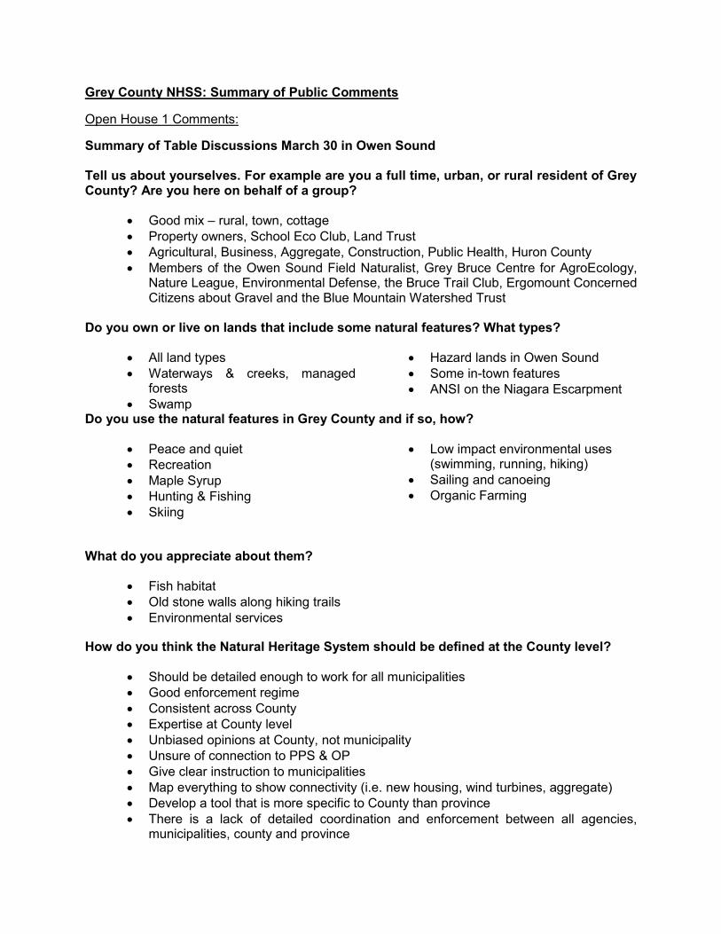
Grey County NHSS: Summary of Public Comments
Open House 1 Comments:
Summary of Table Discussions March 30 in Owen Sound Tell us about yourselves. For example are you a full time, urban, or rural resident of Grey County? Are you here on behalf of a group?
Good mix – rural, town, cottage Property owners, School Eco Club, Land Trust Agricultural, Business, Aggregate, Construction, Public Health, Huron County Members of the Owen Sound Field Naturalist, Grey Bruce Centre for AgroEcology,
Nature League, Environmental Defense, the Bruce Trail Club, Ergomount Concerned Citizens about Gravel and the Blue Mountain Watershed Trust
Do you own or live on lands that include some natural features? What types?
All land types Waterways & creeks, managed
forests Swamp
Hazard lands in Owen Sound Some in-town features ANSI on the Niagara Escarpment
Do you use the natural features in Grey County and if so, how?
Peace and quiet Recreation Maple Syrup Hunting & Fishing Skiing
Low impact environmental uses (swimming, running, hiking)
Sailing and canoeing Organic Farming
What do you appreciate about them?
Fish habitat Old stone walls along hiking trails Environmental services
How do you think the Natural Heritage System should be defined at the County level?
Should be detailed enough to work for all municipalities Good enforcement regime Consistent across County Expertise at County level Unbiased opinions at County, not municipality Unsure of connection to PPS & OP Give clear instruction to municipalities Map everything to show connectivity (i.e. new housing, wind turbines, aggregate) Develop a tool that is more specific to County than province There is a lack of detailed coordination and enforcement between all agencies,
municipalities, county and province
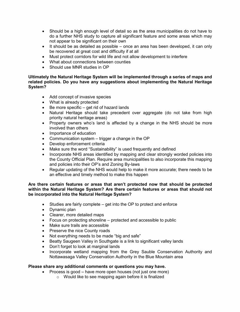
Should be a high enough level of detail so as the area municipalities do not have to do a further NHS study to capture all significant feature and some areas which may not appear to be significant on their own
It should be as detailed as possible – once an area has been developed, it can only be recovered at great cost and difficulty if at all
Must protect corridors for wild life and not allow development to interfere What about connections between counties Should use MNR studies in OP
Ultimately the Natural Heritage System will be implemented through a series of maps and related policies. Do you have any suggestions about implementing the Natural Heritage System?
Add concept of invasive species What is already protected Be more specific – get rid of hazard lands Natural Heritage should take precedent over aggregate (do not take from high
priority natural heritage areas) Property owners who’s land is affected by a change in the NHS should be more
involved than others Importance of education Communication system – trigger a change in the OP Develop enforcement criteria Make sure the word “Sustainability” is used frequently and defined Incorporate NHS areas identified by mapping and clear strongly worded policies into
the County Official Plan. Require area municipalities to also incorporate this mapping and policies into their OP’s and Zoning By-laws
Regular updating of the NHS would help to make it more accurate; there needs to be an effective and timely method to make this happen
Are there certain features or areas that aren’t protected now that should be protected within the Natural Heritage System? Are there certain features or areas that should not be incorporated into the Natural Heritage System?
Studies are fairly complete – get into the OP to protect and enforce Dynamic plan Clearer, more detailed maps Focus on protecting shoreline – protected and accessible to public Make sure trails are accessible Preserve the nice County roads Not everything needs to be made “big and safe” Beatty Saugeen Valley in Southgate is a link to significant valley lands Don’t forget to look at marginal lands Incorporate wetland mapping from the Grey Sauble Conservation Authority and
Nottawasaga Valley Conservation Authority in the Blue Mountain area
Please share any additional comments or questions you may have. Process is good – have more open houses (not just one more)
o Would like to see mapping again before it is finalized
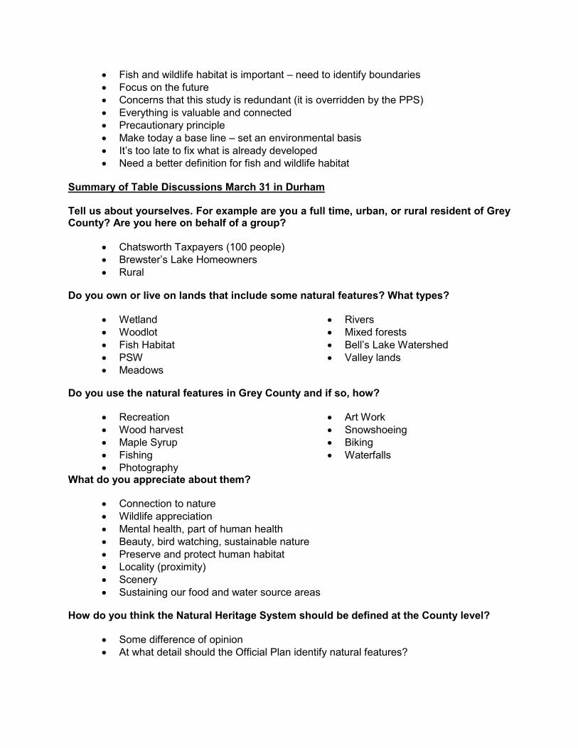
Fish and wildlife habitat is important – need to identify boundaries Focus on the future Concerns that this study is redundant (it is overridden by the PPS) Everything is valuable and connected Precautionary principle Make today a base line – set an environmental basis It’s too late to fix what is already developed Need a better definition for fish and wildlife habitat
Summary of Table Discussions March 31 in Durham Tell us about yourselves. For example are you a full time, urban, or rural resident of Grey County? Are you here on behalf of a group?
Chatsworth Taxpayers (100 people) Brewster’s Lake Homeowners Rural
Do you own or live on lands that include some natural features? What types?
Wetland Woodlot Fish Habitat PSW Meadows
Rivers Mixed forests Bell’s Lake Watershed Valley lands
Do you use the natural features in Grey County and if so, how?
Recreation Wood harvest Maple Syrup Fishing Photography
Art Work Snowshoeing Biking Waterfalls
What do you appreciate about them?
Connection to nature Wildlife appreciation Mental health, part of human health Beauty, bird watching, sustainable nature Preserve and protect human habitat Locality (proximity) Scenery Sustaining our food and water source areas
How do you think the Natural Heritage System should be defined at the County level?
Some difference of opinion At what detail should the Official Plan identify natural features?
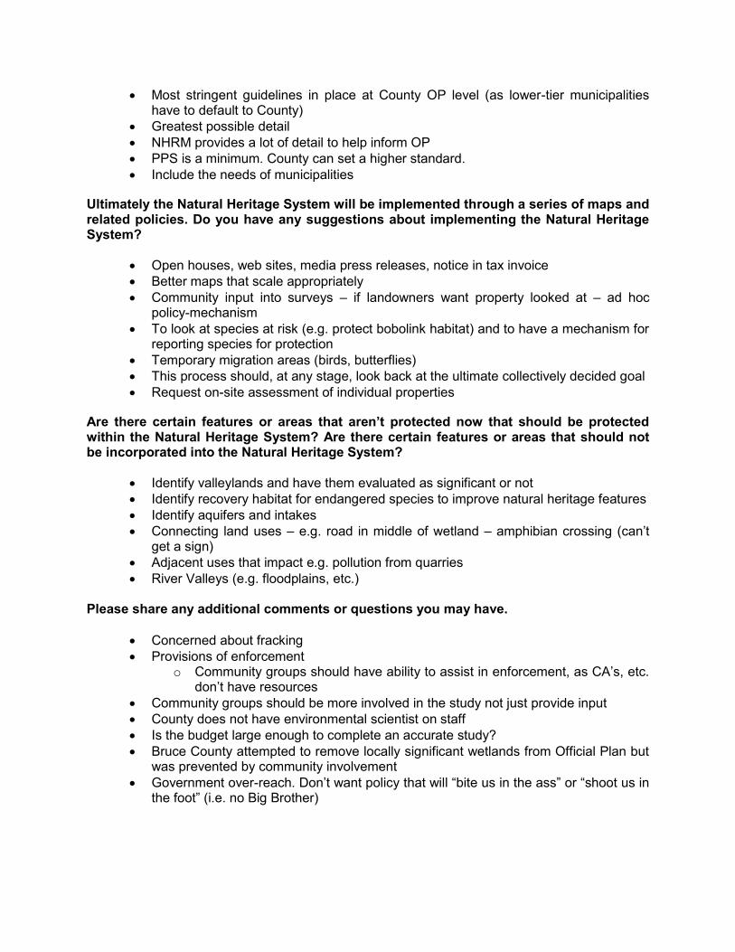
Most stringent guidelines in place at County OP level (as lower-tier municipalities have to default to County)
Greatest possible detail NHRM provides a lot of detail to help inform OP PPS is a minimum. County can set a higher standard. Include the needs of municipalities
Ultimately the Natural Heritage System will be implemented through a series of maps and related policies. Do you have any suggestions about implementing the Natural Heritage System?
Open houses, web sites, media press releases, notice in tax invoice Better maps that scale appropriately Community input into surveys – if landowners want property looked at – ad hoc
policy-mechanism To look at species at risk (e.g. protect bobolink habitat) and to have a mechanism for
reporting species for protection Temporary migration areas (birds, butterflies) This process should, at any stage, look back at the ultimate collectively decided goal Request on-site assessment of individual properties
Are there certain features or areas that aren’t protected now that should be protected within the Natural Heritage System? Are there certain features or areas that should not be incorporated into the Natural Heritage System?
Identify valleylands and have them evaluated as significant or not Identify recovery habitat for endangered species to improve natural heritage features Identify aquifers and intakes Connecting land uses – e.g. road in middle of wetland – amphibian crossing (can’t
get a sign) Adjacent uses that impact e.g. pollution from quarries River Valleys (e.g. floodplains, etc.)
Please share any additional comments or questions you may have.
Concerned about fracking Provisions of enforcement
o Community groups should have ability to assist in enforcement, as CA’s, etc. don’t have resources
Community groups should be more involved in the study not just provide input County does not have environmental scientist on staff Is the budget large enough to complete an accurate study? Bruce County attempted to remove locally significant wetlands from Official Plan but
was prevented by community involvement Government over-reach. Don’t want policy that will “bite us in the ass” or “shoot us in
the foot” (i.e. no Big Brother)
Additional Comments
It’s important for the County to capture all significant features and some that may not be significant on their own (e.g. important linkages/connections). To do otherwise and leave things up to seven municipalities will result in a mish-mash of approaches, problems at municipal boundaries where features/linkages do no connect, differing opinions on what is significant and the lack of a comprehensive systems approach to ensure ecological integrity across the county.
A potential problem that needs to be addressed is how the Grey County plan will fit in and/or connect with adjacent Counties (e.g. Bruce and Simcoe). The landscape is continuous without regard for artificial political boundaries.
It is important to set a planning time horizon on this exercise. We should be concerned about what the Grey County landscape look like in the future.
Detailed maps and policies are required with strict adherence to them. Without careful review of development proposals and follow-up inspections/enforcement, this will have been a meaningless exercise.
The Source Water Protection results should be incorporated in the NHS. Suggest that a representative should be included on the TAC.
Mechanisms should be included in the NHS for the gathering and inclusion of new information (i.e. new endangered species and bat hibernacula locations).
The NHS data maps have to be continuously updated to remain relevant. One result of the NHS effort should be the identification of data gaps and needs.
There are historical records of Henslow Sparrow in the Dundalk area. Suspect there will be areas of lesser significance identified that play an important
linkage role. This should lead to another NHS product that will identify rehabilitation areas for stewardship interests to focus their efforts.
Does the province have measures in place that will prevent “navigation” of ESA becoming extinction of ESA?
The Grey/Bruce Public Health Unit should have permanent membership on the Planning Committee of Grey County.
What can NRSI possibly tell Grey County that they don’t already know? Define “Natural Heritage System” and “Grasslands” All wetlands, regardless of designation, should be protected by specific, clear and
authoritative policies in the GCOP. Policies in support of the NHS should be as stringent as possible. A decision on a
property-by-property basis could always be less stringent, but if a policy doesn’t exist, a local/municipal decision cannot be more stringent than the policy that exists.
Education to property owners is crucial – if people don’t know policies exist then they aren’t very useful. Also, make known what are the benefits/consequences to following/not following a policy.
As best as possible, utilize existing data and do not duplicated existing information. Grey County doses a good job with current protection of natural environment
features. However, fine-tuning of natural feature boundaries is required. Is the budget large enough to provide enough detail? Suggest implementing the NHS through zoning by-laws, consent approvals and
building permits. Mapping should be of a much better scale so one can interpret them. There should be increased community control over development permits for gravel
and wind uses.
Water levels and water purity are going to be one of the most important things in our future.
Dangerous practises near waterways (however grandfathered they are) should be addressed (i.e. landfills and old gravel pits).
Could there be a rule-based rather than mapping based definition of the smaller scale heritage sites?
Bird migration is being impacted by industrialization. Migration routes need to have stronger rules.
Need to establish protocols for NHS provincial standards, which should be applied and firmly adhered to.
MOE & MNR have not represented rural communities very well. We do not need new policies; we need to act on those in place.
Is this plan going to increase protection for the natural environment or is it just wiggling things around to allow more development?
On one side there are the significant natural features already identified – wetlands, woodlots, etc. On the other side there are urban areas and intensive agricultural areas. It is the area between these two that need attention; therefore, we need to focus on this middle landscape.
Owen Sound Field Naturalists have a large pool of expertise on the natural heritage aspect of Grey & Bruce. Have you thought about how to access that knowledge?
Grey County is an environmental paradise with abundant fresh, clean water, forestation and clear air.
What if the PPS is wrong? How can we expect that environmental assessments from firms paid for by the
developer are non-biased? What increase in environmental protection will be instituted through this process? Human health should be the stated reason for protecting the natural environment
and the consequences of protecting it. It has been our experience that the definition of significant woodlands inside the City
of Owen Sound has caused delays for developers as they are asked to undertake a study. The time and uncertainty associated with this delay is significant. Delays which generate uncertainty regarding the development can cause investors to look elsewhere and not move forward. Inside the urban boundary of the City, only a certain amount of land is zoned for commercial development. This should be exempt from the significant woodlands requirements; otherwise, we add a level of delay that is not ‘investor friendly’. Grey County should re-visit its original intent of this policy and determine ways to meet the intent in a broad way, and consider how this policy can be adjusted to meet the intent of the new Owen Sound economic development strategy – business friendly and certainty with decisions. It’s the delay and uncertainty associated with the study that causes the problems.
In your description of this project you mention the "continued need for development in Grey County. Farmland is stripped to make room for houses and aggregate uses are threatening our water sources. I believe that when it comes to development, we need to think smaller.
Our experience with the Green Energy Act and the REA is that industry, especially Wind Energy companies, are granted exemptions from the Endangered Species Act as well as any other legislation supposedly designed to offer protections to our environment. I am concerned that residents and even Municipal governments will see themselves severely restricted in what they can do on their own land while industries with deep pockets to pay for studies and advice on how to "navigate" the
ESA (etc.) will be able to do as they please. I would prefer to avoid a situation wherein residents enjoyment of property is severely restricted, unable to put up a garage, cut down a tree, go for a walk or whatever, while next door an industrial project is strip mining, clearing roads through forests, killing bats and birds or pouring mega tonnes of concrete into the land simply because they have more money.
How can the new NHS areas be protected from development similar to the protection under PPS s. 2.1? Will the County actively pursue this level of protection or will it be left to non-profit groups to propose changes to the regulations?
Open House 2 Comments:
Comments from Open House Dec. 10, 2016 in Markdale Don’t forget about the people in Grey County. We don’t want to be a “graveyard” for
Toronto. I want to be able to manage my property the way I want. I object seriously to another level of rules being imposed on me as a landowner. It seems that more protection is given to the cougars the Ministry is releasing than to people. I have to provide protection for the cougars and can’t build a house for refugees on the corner of my property.
Suggest using lot lines to delineate Linkages so they do not cut through properties. Currently it is unclear where the boundaries of Linkages are.
General consensus at the meeting was support of restoration areas within ‘gaps’ of Core Areas.
“Restoration”, as in restoration areas, has a negative connotation (brings to mind contaminated soil). Consider using “Conversion areas” instead.
General consensus at the meeting was support to include the NHS in a Schedule of the Official Plan.
If a property is located in the middle of a Linkage, the County should buy the property. I oppose any new structure in a Linkage. General consensus at the meeting was support of the 200m width of linkages. Someone
added that the width of Linkages should consider the requirements of wildlife, therefore may have to be wider in some circumstances.
Suggest drawing the Linkages diagrammatically. Conservation easements should also be mapped on Map 9. Policy needs to be fair to all and not favour big business. I would have liked to see some text on how comments provided after the first Open
House were considered and incorporated into the study. “Essential infrastructure” should be defined. It should be ensured that infrastructure that
is to cross the NHS is truly essential. There needs to be a mechanism to deal with faulty mapping. E.g. revising a Core Area
boundary if it is based on a faulty mapping layer. Aggregate quarries are a big issue in Grey County. The County’s Official Plan shows
aggregate resource areas, which should be incorporated into your study. The conflict between aggregate sites and natural heritage protection should be acknowledged in the study.
Comments from Open House Dec. 10, 2016 in Owen Sound
I am very encouraged that the significant valleylands have been identified in the County. I have been fighting for years to get the Beatty Saugeen River designated as a significant valleyland near Holstein.
General consensus at the meeting was support of the 200m width of linkages as a minimum. Some species require wider movement corridors.
Restoration areas should be considered. Likely areas include abandoned railways and some agricultural fields. Agricultural fields are being abandoned quite regularly in the County.
General consensus at the meeting was support to include the NHS in a Schedule of the Official Plan, but an amendment should not always be required. Don’t make landowners have to go through Official Plan amendment to correct a mapping error.
Clearly define “essential infrastructure”. Clearly define “legally existing uses”. Identify what types of existing uses can be expanded in Linkages and Core Areas.
Some businesses, such as greenhouses, can be very intensive. Would the building of additional, very large greenhouses be allowed in the NHS?
The Aggregate Resources Act works in parallel to the Planning Act. Keep this in mind. Hedgerows should be protected in the County. Large corporate farms take hedgerows
out, which is leading to erosion of land. Need balanced approach as per Provincial Policy Statement. The Grey County Official Plan should include policies on Environmental Impact Studies
including when they are required and how they should be scoped. An EIS can’t be required unless a planning application is submitted and so Municipalities
will need to use a Holding provision on the zoning which would only be lifted when an EIS was prepared and would therefore have to be done before a building permit was issued. Guidance should be provided on when an EIS could be scoped to provide some clarity. The Holding symbol is probably the least offensive approach.
Other Comments:
Ontario Ministry of Natural Resources and Forestry Goals and Objectives Recommend a report be prepared to describe the goals and objectives of the project: clarify if strategies will result in obtaining other goals and objectives beyond their intent. How were other provincial interests in the PPS considered; were access to mineral aggregate and rehabilitation of existing mineral aggregate operations an objective? Criteria and Refinement Technical documentation on natural features in Option 1 and Option 2 would be helpful to understand the criteria and refinement undertaken of the natural areas. Example: why linkages 200m wide appropriate for meeting the identified goals and objectives? Draft Policy Approach Support for Schedule C - Natural Heritage Systems as an overlay to Schedule A - Land Use Designations, as well as a policy approach that would provide consideration, protection and restoration to Core Areas and Linkages within the NHS.
When a provincially significant natural heritage feature is located within a Core Area, the entirety of the feature should be included to eliminate confusion on applicable policies. With the possibility of reduction in area of the Core Areas through the proposed refinement approach, as well as the policy that NHS areas cannot be reduced, would it be expected that other areas of NHS be expanded? In regards to MSH November letter that advises that gaps within the Core will be preferred sites for restoration if current, non-natural uses discontinue; agree with this objective but more information needed for effective implementation through policy. Concern that proposed policies of the NHS that prevent development and site alterations do not take into consideration the mineral aggregate resource policies of the PPS which require as much of the mineral aggregate resources as is realistically possible be made available as close to markets as possible. Suggest the Aggregate Resource Inventory mapping found at http://www.geologyontario.mndmf.gov.on.ca/mndmfiles/pub/data/imaging/arip180/arip180.pdf be compared to the mapped areas of NHS. Further assessment of areas of impact may necessitate revisions to the NHS boundaries. Strongly recommend that new aggregate extraction operations be permitted within the NHS subject to a license issued under the Aggregate Resources Act (ARA). Support the 120m adjacent land zone and the requirement for an EIS where development is proposed within the zone, however the EIS should assess the impact of the proposed development on the Core Area in addition to impacts on the natural features within the adjacent land zone. Rationale as to why 200m is an effective width for ecologically functional linkages should be provided in the documentation. Since this is the minimum standard, consider making linkages wider where warranted. Implementation Unclear in MSH's letter if the NHS Core Zone Holding zoning would apply only to existing lot of record and more information on implementation would be helpful. Travis and Associates Concern about Map 5 showing the majority of the subject lands as "Wetlands" and "Significant Woodland". The subject lands have established principles of development by virtue of Local Official Plan through LOPA 27 and are zoned for development. It is suggested that the mapping as it affects their client's lands is incorrect and inconsistent with approved land uses. The constraints and their boundaries on Map 5 should be modified to account for the peer reviewed work and approved development plans. Similarly on Map 6, "Significant Natural Features" on client's lands also be modified to account for approved development land uses. Saugeen Conservation Concern in recognising the entirety of Grey County's many Natural Heritage features within the proposed system in the recommended policy option. To recognise all these features may be too far reaching to include in NHS policies. Features as pronounced as Provincially Significant
Wetlands, Areas of Natural and Scientific Interest, and woodlands will either be within the NHS policy area or not and this may undermine those existing policies the SVCA cautions. Cutting off a wetland or woodland from the system would inevitably call into question that portion of the woodland’s value and need to protect if NHS was interested in feature’s value and did not include it. By the definition of the NHS in the Provincial Policy Statement (PPS) to not include features in system, opens a door to them not being ‘natural heritage features’ as defined by the PPS at all. Recommendation is for full coverage of all known features be mapped. The addition of specific policy areas for extremely valuable areas of system then can be added to policy and be mapped within the larger system. Maybe in the text of the NHS it could indicate all features mapped, or not, are a part of NHS and NHS policies will only apply to “Core” indicated on a Schedule. There needs to be scientific reasoning why some 'restricted areas' have been cut and others have not, the science of the Natural Heritage System needs to be sound and not bent to meet policy. The SVCA’s policy recommendation is that all features known are part of the system. From this base map the indicated core areas get additional NHS control. Restrictions to proposed development in a planning context makes sense in and adjacent to the core areas and linkages in accordance with the PPS. Existing controls remain on the non NHS features but should be clarified. SVCA staff would need to review the NHS direction of the PPS to determine if blanket NHS zoning to existing lots and uses is prudent when a planning application is not required as this is not the case with existing natural heritage features presently. Saugeen Nature Would like to see consideration for increasing the extent of the natural area designated for maximum protection to a proportion greater than 13.6%. Size and Location of Core Areas More of the Grey County landscape should be set aside for greater protection as part of the Core Areas and Linkages in the Natural Heritage System. There is a healthy proportion of Core Areas in Georgian Bluffs, but very little area has been designated as Cores in the southern municipalities of West Grey and Southgate. All known Grey County ANSIs should be included as part of the fully protected natural heritage system. Gaps in Core Areas should be identified as restoration areas. This can be a long-term policy/action item, including working with the real estate sector and conservation sector to sell property in these areas to conservation minded individuals and groups. Width and Location of Linkages Some important ones have been missed: -the Saugeen River valley running to the northeast of Durham east to Highway 10 and west from Durham to Hanover -parts of the Rocky Saugeen , South Saugeen and Beatty Saugeen -North Saugeen from Mooresburg to Chesley -lower stretches of the Bighead River
Official Plan Place the Natural Heritage System maps in a Schedule in the Official Plan. This schedule could be sent to all potential developers of land in Grey County, so that they know where the areas are located that are fully protected, and can avoid buying land that is protected by the Natural Heritage System policies. Recommended Policy The following should be deleted and not permitted: -‘essential infrastructure’ such as roads – these can be directed around Core Areas and significant natural habitat. Green Infrastructure such as Core Areas and Linkages are far more essential to our health and well-being than roads and gas pipelines. -expansion of existing buildings and structures in the designated areas further development on existing lots of record in the Cores and Linkages accessory uses, buildings and structures -increased agricultural uses, including new buildings and structures -there is lots of land in Grey County available for development, on existing poor farmland. There is no need to cut into significant woodlands, fill wetlands, or take out other natural areas to build. Aggregate Issues Grey County should make final decisions on the aggregate/NHS overlap. They should expand the NHS in areas where aggregate resources are not marked on the map so that the County can maintain a good area of natural cover where there is no conflict with aggregate resources. Blue Mountain Watershed Trust Foundation Scale/extent of the NHS: Content with width and location of the Linkages as long as the width is appropriately sized and located for the type of wildlife movement they are supposed to serve. The Map shows a uniform width for the corridors more for symbolic map legend purposes. They should be connecting up to the appropriate Core Natural areas on the map to serve the particular species that require natural movement opportunities. Implementation of the Natural Heritage System: Maps should be created through a Schedule in the Official Plan which requires an Official Plan amendment for changes and carries more legal weight. Policy for the Natural Heritage System: Concerned about the exception for “essential infrastructure” in the Core Areas and Linkages. Township of Southgate Southgate council is concerned that residents involved may not have been adequately informed of the study nor provided with adequate opportunity for commenting. Egremont/Proton Federation Of Agriculture Would like the following questions answered:
1. Please describe to us how this Easement/Corridor works and what it means to the Landowner?
2. What eligible bodies have control over this Easement/Corridor? 3. Are eligible bodies able to transfer Easement/Corridor to other eligible bodies?
4. Considering, an Easement/Corridor could very well be considered a lien against the title of the property, what compensation will be offered to a landowner that will have an Easement/Corridor on the property?
5. Can an Easement/Corridor be changed into a walking trail without the property owners’ permission?
6. Will an Easement/Corridor hinder future conventional agricultural practices and development?
7. Is there evidence i.e. animal counts, to show the necessity for a migratory Easement/Corridor for wildlife?
Additional comments by independent parties:
Similar concerns as the Saugeen Field Naturalists, particularly areas not included as Core Areas. For example Wilder Lake where one of the Core Areas is Camp Oliver Tract, located east if Camp Oliver Road. Why was this tract chosen but not an area of similar size on the other side of Camp Oliver Road that has more significant wetlands, cold water streams and Black Lake, a classic kettle lake. Further to the south is Wilder Lake a classic marl lake. To the south, east and southeast of this is the ANSI area, the Saugeen Kame Terraces. These terraces are some the largest and best preserved in Ontario. A similar series of smaller terraces run from the west side of Wilder Lake northeast past the east side of Black Lake and across Camp Oliver Road. As a whole, the areas contain a number Quaternary landform features.
Concern about the connectivity of the wildlife corridors, feels the map is fragmented and
is not giving proper consideration to the natural habitat of wildlife and tree species.
It is crucial that more of the Grey County landscape be designated as part of the Core Areas and Linkages for protection. Gaps in core areas should be identified as restoration areas.
Many linkages appear to be missing, for example the Saugeen River valley running to
the northeast of Durham.
Properties which have "Conservation Easements" in place with the Federal Government should be included in the mapping. Those easements are “in perpetuity", each is unique in the detail, but for the most part impose very limited or no development. The Escarpment Biosphere Conservancy owns/monitors several other similar properties in Grey County, all of which should be acknowledged and incorporated into the study.
Concerned about the proposed requirements for the Environmental Impact Studies if
existing lots in the proposed core areas are developed. The cost of these studies are to be borne by the landowner and this amounts to expropriation without compensation because owners' rights to a free development of their properties are reduced.
Private property can be entered into a Conservation Agreement with the Escarpment
Biosphere Conservancy. It is registered on title and restricts the use of the land to very controlled forest management, except where a small portion of the land may be designated residential for the purposed of someone living there to tend to the land. This is approved by Environment Canada and done in accordance with the Conservation

Land Act of Ontario so if a residence is built it should not require additional permits or an Environmental Impact Study.
There are other private nature reserves besides the Escarpment Biosphere
Conservancy and the Conservation Authorities that are referred to in Map 9. These private initiatives may satisfy the provincial policy and county administration may not be necessary. Private initiatives should be supported, not penalized.

Natural Resource Solutions Inc. Grey County Natural Heritage Systems Study
APPENDIX IX Photo Appendix
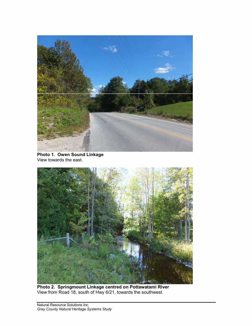
Natural Resource Solutions Inc. Grey County Natural Heritage Systems Study
Photo 1. Owen Sound Linkage View towards the east.
Photo 2. Springmount Linkage centred on Pottawatami River View from Road 18, south of Hwy 6/21, towards the southwest.
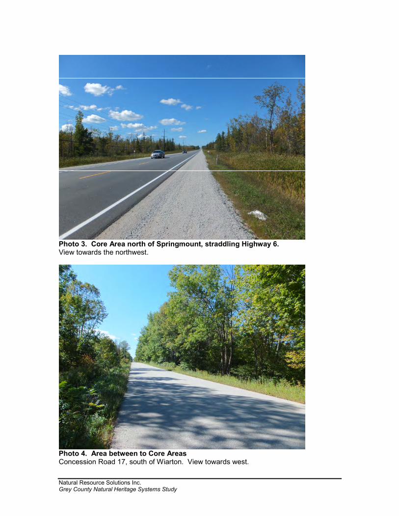
Natural Resource Solutions Inc. Grey County Natural Heritage Systems Study
Photo 3. Core Area north of Springmount, straddling Highway 6. View towards the northwest.
Photo 4. Area between to Core Areas Concession Road 17, south of Wiarton. View towards west.
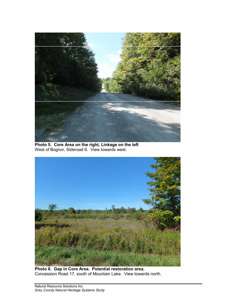
Natural Resource Solutions Inc. Grey County Natural Heritage Systems Study
Photo 5. Core Area on the right, Linkage on the left West of Bognor, Sideroad 6. View towards west.
Photo 6. Gap in Core Area. Potential restoration area. Concession Road 17, south of Mountain Lake. View towards north.
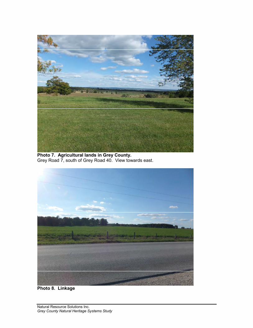
Natural Resource Solutions Inc. Grey County Natural Heritage Systems Study
Photo 7. Agricultural lands in Grey County. Grey Road 7, south of Grey Road 40. View towards east.
Photo 8. Linkage
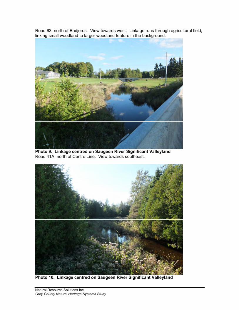
Natural Resource Solutions Inc. Grey County Natural Heritage Systems Study
Road 63, north of Badjeros. View towards west. Linkage runs through agricultural field, linking small woodland to larger woodland feature in the background.
Photo 9. Linkage centred on Saugeen River Significant Valleyland Road 41A, north of Centre Line. View towards southeast.
Photo 10. Linkage centred on Saugeen River Significant Valleyland
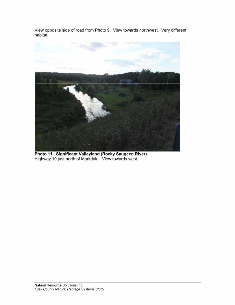
Natural Resource Solutions Inc. Grey County Natural Heritage Systems Study
View opposite side of road from Photo 9. View towards northwest. Very different habitat.
Photo 11. Significant Valleyland (Rocky Saugeen River) Highway 10 just north of Markdale. View towards west.