new gabon survey demonstrates how better design delivers
TRANSCRIPT

6 | seismic profile
The quality of the seismic data you record depends on the quality of the energy generated by the source, how it interacts with the subsurface
and the ability to record all the effects of those interactions. To obtain the required response from the reservoir it is necessary to start with the right sound, at the right level, from the right angle. This requires the use of the
right survey design, with the right equipment and the right acquisition methods, as well as preserving all the recorded information through
advanced broadband processing and imaging.
By integrating all the available geological knowledge with existing gravity and velocity information it is possible to
design the optimum acquisition parameters for a survey. This integrated approach was used to design, acquire and process the new 25,000-km2 broadband multi-client 3D
survey offshore Gabon, that covers the fi ve blocks on offer in Gabon’s new deepwater license round (see fi gure 1).
by Jo Firth, CGG
New Gabon survey demonstrates how
better design delivers better data
seismic Profile Gabon

2015 issue fourteen | 7
Figure 1. Map showing the available license blocks and area of the new broadband 25000-km2 multi-client survey.
Gabon’s deep offshore South Basin is one of the last underexplored areas of the West Africa Atlantic Margin. Interest in this area and other deepwater pre-salt plays offshore southwest Africa has been renewed following the success of exploration in the South Atlantic conjugate margin in Brazil, as well as major discoveries offshore Angola. Recent discoveries have also been made in the vicinity of the new survey, such as ENI’s large pre-salt discoveries, Nene and Minsala, offshore Congo, just 80 km to the east, Harvest’s Ruche and Tortue discoveries a few kilometers northeast, Total’s Diaman gas and condensate discovery in the Diaba block and Shell’s Leopard gas discovery in block BCD-10 to the north-west. All of these recent pre-salt discoveries surround the new CGG multi-client seismic survey area. Six wells have so far been drilled within the main full-fold survey area but only one of them penetrated the salt to test pre-salt reservoirs. An additional four wells that all drilled through the salt layer and are located in the vicinity of the survey area were tied to the seismic data by extending some of the sail lines.
CGG Robertson has recently undertaken a regional geological study extending from the Niger Delta to the Congo, which collated all the available data into a suite of paleo-geographic reconstructions that have provided a new view of basin development in the South Gabon area. The gravity and magnetic data enabled us to estimate the depth of the sedimentary basin and the required output depth of the data. The geological study aided prediction of the stratigraphic column and impedance contrasts to be expected in the overburden, as well as the main strike direction, so that the optimal sail line direction for illumination could be identified. It also helped in understanding the complexity of the overburden (due to salt deformation) and in identification of areas where illumination and imaging would be challenging.
Combined with our previous experience in the area, this insight gave us a clear perspective on the planning of the seismic survey. We performed wave equation modelling, using existing velocity and density models, to determine the optimal streamer lengths and bin sizes for the survey. To achieve the low frequencies necessary for penetrating to the pre-salt target, as well as the high frequencies required for detailed imaging of the post-salt, broadband data were acquired using the BroadSeis™ solution. The variability of the streamer depth and shape of the cable were tuned for the water depth and targets so that the notch diversity and output spectra were optimized for the survey. By combining the results of the detailed modelling and analysis with our geological knowledge and information from
seismic Profile Gabon

8 | seismic profile
our clients, it was possible to ascertain the right parameters in order to acquire the correct data for imaging the target. Combining advanced subsurface imaging technologies customized for the local geology with reservoir-oriented QC and optimal acquisition ensures delivery of the highest-quality seismic images.
The seismic survey was acquired by two vessels, the Geo Caribbean and the Oceanic Endeavour, each towing 10 x 10 km streamers, at 120 m separation and acquiring data simultaneously, in order to complete the acquisition last summer. BroadSeis capitalizes on the exceptional low-noise characteristics of Sercel Sentinel® solid foam-filled streamers (Dowle 2006). The proprietary curved streamer shape allows the majority of the streamer to be towed deep, up to 50 m. This deep tow enables the recording of the ultra-low frequencies required for pre-salt imaging and also avoids much of the sea-state noise, to extend the weather window for greater operational efficiency and faster turnaround times. The ultra-low frequencies achieved using the BroadSeis solution provide better penetration through complex overburdens, improved signal-to-noise ratios for deeper targets and more quantitative seismic inversion.
The two vessels were employed simultaneously on the survey using SynAcq, our synchronized acquisition technique, in which both vessels make use of advanced navigation tools for the planning and management of seismic interference (SI or noise contamination from the nearby vessel shots) to work semi-independently whilst avoiding any interference which cannot readily be attenuated in processing. The success of this strategy in the North Sea has led to it being applied in other areas to acquire as much data as possible, as fast as possible, without compromising quality. In the deep waters of the Gabon survey area, SI is much less of a problem than in the shallow waters of the
North Sea, but the same strategy is being employed to ensure high-quality data uncompromised by any SI that is challenging to remove.
When sorted away from shot order SI tends to be incoherent, random and intermittent, as long as the SI does not arrive at the same time from shot to shot, and can be attenuated with multi-dimensional impulsive denoise tools. This can be ensured through planning and preventative actions, such as the adjustment of vessel speeds when they are passing near each other. Management of potential SI is supported by a proprietary dedicated tool in the Sercel SeaPro Nav navigation system. Onboard processing tests ensure that any SI contamination can be removed without damaging the primary data (Elboth, 2015). This combination of planned acquisition and processing enables the vessels to work, if necessary, as close as 20 km apart and the data to be acquired in half the time without degrading quality.
All seismic imaging begins with the release of acoustic energy into the water, continues with the propagation of this energy through and reflecting from the subsurface to be recorded as seismic data. The image of the subsurface and the attributes of the reservoir have to be deconvolved from any imprint of the acquisition system. Measuring the actual energy emitted by the source allows accurate removal of the source signature from the data to deliver data that is free from the imprint of the source array. CGG’s Full Source Characterization (FSC) techniques were used during acquisition of the Gabon survey. These carefully measure and monitor the source signature in real time to ensure stability, especially at low frequencies. Using FSC provides more accurate signatures from the field, which deliver more accurate 3D designature in processing than can be obtained by using modeled signatures. Ultimately this delivers clearer images of the subsurface, without the seismic source imprint.
Figure 2. Comparison of designature using a Nucleus modeled far-field signature and a far-field signature derived from near-field hydrophones.
During acquisition the marine source is moving continuously. From a distance it may appear to be a single point, quiet and static, but from close up and shallow, each element of the 250-m2 source array can be distinguished and is moving relative to the others. Removing the illumination imprint of this structure in shallow water (only a small proportion of this survey) requires an accurate estimate of the seismic signature of each element at its true location.
FSC technology enables the source signature to be estimated for each element in any direction (azimuth) at any distance (offset) for each shot. The sound propagation of each individual source element is recorded at the near-field hydrophone while a newly-developed proprietary onboard system, with dedicated real-time software, performs joint
8 | seismic profile
seismic Profile Gabon

2016 issue fourteen | 9
inversion to generate accurate far-field signatures (Ziolkowski, 1982; Poole, 2013; Ni, 2014). The contribution of each element at any location and any depth can be identified. The complexity of the generated wavefield, including the activated bubbles, their interactions, and their reflection from the sea surface, is revealed.
Figure 3. Real-time far-field reconstruction from near-field hydrophone recordings enables monitoring of shot-to-shot source signature stability.
This approach has been proven to deliver a better estimate of the bubble and the low-frequency signal compared to conventional pressure field modelling (see figure 2), and is an essential element of broadband acquisition. It enables accurate designature throughout the bandwidth, encompassing de-bubbling and zero-phasing in the same step and makes the removal of the imprint of the marine source system from the images and attributes of the subsurface possible, regardless of depth. 3D source deghosting and designature, critical for shallow targets, can be performed accurately to complement our 3D receiver deghosting (Wu et al, 2014). This uses a progressive sparse Tau-Px-Py inversion to ensure ghosts are correctly handled in areas of complex geology and so delivers the sharpest possible broadband wavelets with stable and accurate low frequencies. The FSC system is also used to monitor the derived far-field signature for every shot in the field as an aid to acquisition quality control and to ensure a stable signature (figure 3).
The seismic data that has been acquired over the Gabon South Basin using this system has been favorably received by our clients. Even a very early-stage seismic section, with minimal testing of parameters, and velocities from old sparse 2D data, was declared by an interpreter from a major international oil company to be “way beyond expectations” and showed more detail below the salt than had been anticipated or ever seen before.
The intermediate TomoML, multi-layer tomography, velocity model (Figure 4) was constrained by the initial seismic interpretation and a depth-to-basement map derived from gravity data acquired simultaneously with the seismic. For the final RTM (Pre-stack Reverse Time Depth Migration) seismic dataset, Full Waveform Inversion, capitalizing on the ultra-low frequencies delivered by BroadSeis, will be used to generate the velocity model for the shallow sedimentary package. This dataset is expected to be completed by the middle of 2016, but a fast-track Pre-stack Time Migration
2015 issue fourteen | 9
seismic Profile Gabon
Figure 4. Intermediate PSDM velocity model.
10 | seismic profile
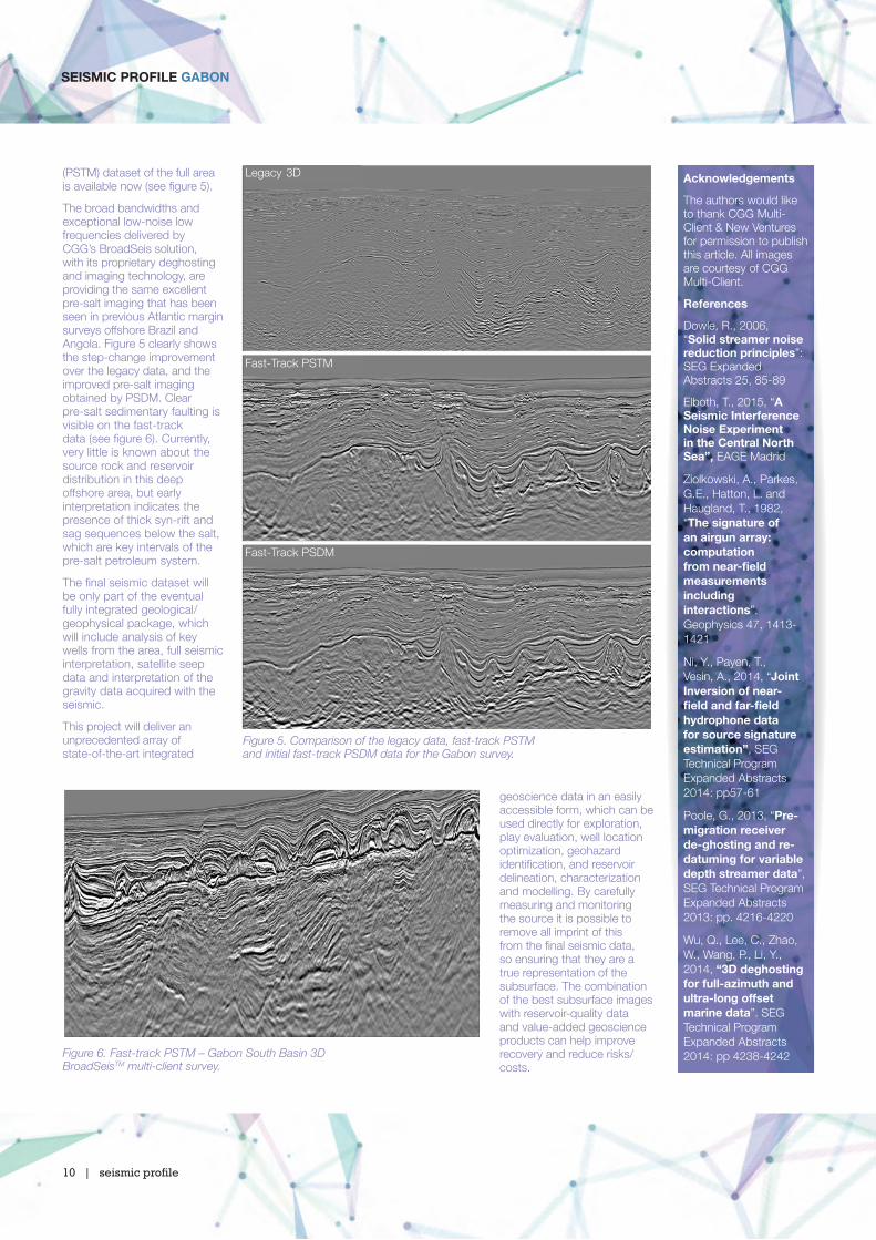
(PSTM) dataset of the full area is available now (see fi gure 5).
The broad bandwidths and exceptional low-noise low frequencies delivered by CGG’s BroadSeis solution, with its proprietary deghosting and imaging technology, are providing the same excellent pre-salt imaging that has been seen in previous Atlantic margin surveys offshore Brazil and Angola. Figure 5 clearly shows the step-change improvement over the legacy data, and the improved pre-salt imaging obtained by PSDM. Clear pre-salt sedimentary faulting is visible on the fast-track data (see fi gure 6). Currently, very little is known about the source rock and reservoir distribution in this deep offshore area, but early interpretation indicates the presence of thick syn-rift and sag sequences below the salt, which are key intervals of the pre-salt petroleum system.
The fi nal seismic dataset will be only part of the eventual fully integrated geological/geophysical package, which will include analysis of key wells from the area, full seismic interpretation, satellite seep data and interpretation of the gravity data acquired with the seismic.
This project will deliver an unprecedented array of state-of-the-art integrated
Figure 5. Comparison of the legacy data, fast-track PSTM and initial fast-track PSDM data for the Gabon survey.
Figure 6. Fast-track PSTM – Gabon South Basin 3DBroadSeisTM multi-client survey.
geoscience data in an easily accessible form, which can be used directly for exploration, play evaluation, well location optimization, geohazard identifi cation, and reservoir delineation, characterization and modelling. By carefully measuring and monitoring the source it is possible to remove all imprint of this from the fi nal seismic data, so ensuring that they are a true representation of the subsurface. The combination of the best subsurface images with reservoir-quality data and value-added geoscience products can help improve recovery and reduce risks/costs.
acknowledgements
The authors would like to thank CGG Multi-Client & New Ventures for permission to publish this article. All images are courtesy of CGG Multi-Client.
references
Dowle, R., 2006, “solid streamer noise reduction principles”: SEG Expanded Abstracts 25, 85-89
Elboth, T., 2015, “a seismic interference noise experiment in the central north sea”, EAGE Madrid
Ziolkowski, A., Parkes, G.E., Hatton, L. and Haugland, T., 1982, “The signature of an airgun array: computation from near-fi eld measurements including interactions”. Geophysics 47, 1413-1421
Ni, Y., Payen, T., Vesin, A., 2014, “Joint inversion of near-fi eld and far-fi eld hydrophone data for source signature estimation”, SEG Technical Program Expanded Abstracts 2014: pp57-61
Poole, G., 2013, “Pre-migration receiver de-ghosting and re-datuming for variable depth streamer data”, SEG Technical Program Expanded Abstracts 2013: pp. 4216-4220
Wu, Q., Lee, C., Zhao, W., Wang, P., Li, Y., 2014, “3D deghosting for full-azimuth and ultra-long offset marine data”. SEG Technical Program Expanded Abstracts 2014: pp 4238-4242
10 | seismic profile
seismic Profile Gabon
Legacy 3D
Fast-Track PSTM
Fast-Track PSDM