new findings in haÃappan town planning and metrology
TRANSCRIPT
| 299NEW FINDINGS IN HAãAPPAN TOWN PLANNING AND METROLOGY
9
New Findings inHaÃappan Town Planning and Metrology
Michel Danino
IT is a privilege to contribute to a Festschrift to Dr S.R. Rao, who left his mark on Indianarchaeology after Independence. His excavations at Lothal in the 1950s represented aturning point in our understanding of the HaÃappan civilization beyond the IndusValley, and in several ways my paper is intimately connected to them. Its startingpoint, however, is DholÀvÁra.
DholÀvÁra’s Plan and Proportions
DholÀvÁra (23°53"10" N, 70°13' E) is probably the most spectacular HaÃappan site to beseen after Moheôjo-dÀÃo, and, at 48 ha, the second largest in India (after RÀkhÁgaÃhÁ inHaryana). Discovered by the late Jagat Pati Joshi in the 1960s on the Khadir island ofthe Rann of Kachchh, it was excavated in the 1990s under the direction of R.S. Bisht ofthe Archaeological Survey of India (ASI). The HaÃappans’ motivations in setting upthis large city in such a harsh and forbidding environment must have been intimatelyrelated to access to raw materials, craft production and trade. There is evidence thatthe Rann of Kachchh was navigable in HaÃappan times, which would have givenDholÀvÁra access to the sea.1 As a regional capital, DholÀvÁra must have exerted ameasure of control over the hundreds of smaller HaÃappan sites dotting Kachchh,Saurashtra and mainland Gujarat. It flourished during the Mature HaÃappan phase,i.e. between 2600 and 1900 BCE.
Even if the climate was probably slightly more congenial than it is today, theestablishment of such a city in this location is a feat of planning, engineering, labourcontrol and execution, especially in the field of water harvesting and management:DholÀvÁra’s colossal water structures, covering some 17 ha and often interconnected
1 Danino 2010a: 165 (and references cited).
Read by the A
uthor

300 | MICHEL DANINO
through underground drains, were the sine qua non of the city’s survival through theyear.
Like most HaÃappan sites, DholÀvÁra followed a strict plan, but one of its kindwith multiple enclosures. While HaÃappan town planning is often based on anacropolis/lower town duality (as at Moheôjo-dÀÃo and KÀlibaôgan), DholÀvÁra’s plan(fig. 9.1) is triple: an acropolis or upper town consisting of a massive “castle” locatedon the city’s high point and an adjacent “bailey”; a middle town, separated from theacropolis by a huge ceremonial ground; and a lower town, part of which was occupiedby a series of reservoirs (terms such as “castle” and “bailey” are those of the excavator).
fig. 9.1: Plan of DholÀvÁra (adapted from Bisht 1999)
| 301NEW FINDINGS IN HAãAPPAN TOWN PLANNING AND METROLOGY
A mere look at the plan suggests a complex conceptual background. Can we makesome sense of the concepts and rules DholÀvÁra’s urban architects followed? To do so,we need to study the dimensions of the various fortifications, which were preciselymeasured by the ASI team. Table 9.1 summarizes them,2 with a maximum margin oferror of 0.5 %.3 Importantly, the three longest dimensions have since been confirmedby Global Positioning System (GPS) readings.4
It became immediately clear to the excavator that these dimensions obeyed preciseratios or proportions. Bisht highlighted some of them as follows (I have added inparentheses the margins of error calculated on the basis of Table 9.1 and rounded offto the first decimal):
1. The city’s length (east–west axis) and width (north–south) are in a ratio of 5 : 4 or1.25 (0.0 %, a perfect match).
2. The “castle” also reflects the city’s ratio of 5 : 4 (0.9 % inner, 2.4 % outer).
3. The “bailey” is square (ratio 1 : 1).
4. The middle town’s length and breadth are in a ratio of 7 : 6 (0.5 %).
5. The ceremonial ground’s proportions are 6 : 1 (0.7 %).
All but one ratios are verified within 1 %, an excellent agreement considering theirregularities of the terrain. In two papers,5 I worked out a few other important ratiosat work in DholÀvÁra, some of which would have been chosen by the town planners in
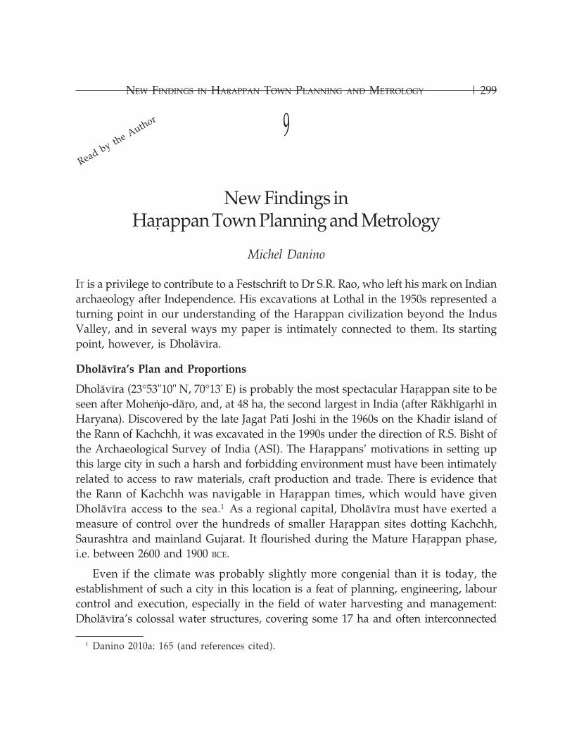
Table 9.1: DholÀvÁra’s Dimensions
Dimension Measurement (in metres)
Length Width
Entire city 771.1 616.85
Middle town 340.5 290.45
Ceremonial ground 283 47.5
“Castle” (inner) 114 92
“Castle” (outer) 151 118
“Bailey” 120 120
2 Bisht 1997, 1999, 2000.3 Bisht 2000: 18.4 Danino 2010b.5 Danino 2005, 2010c.
302 | MICHEL DANINO
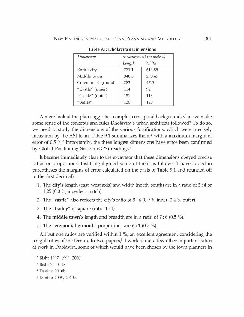
Table 9.2. DholÀvÁra’s Ratios and Margins of Errors
Dimensions Ratio Margin of Error (%)
Entire city* 5 : 4 0.0
“Castle”, inner* 5 : 4 0.9
“Castle”, outer* 5 : 4 2.4
“Bailey”* 1 : 1 0.0
Middle town* 7 : 6 0.5
Ceremonial ground* 6 : 1 0.7
Castle’s outer to inner lengths** 4 : 3 0.7
Middle town’s length to castle’s internal length** 3 : 1 0.4
Middle town’s length to castle’s outer length** 9 : 4 0.2
City’s length to middle town’s length** 9 : 4 0.6
Middle town’s length to ceremonial ground’s length** 6 : 5 0.3
* Proposed by R.S. Bisht, ** Proposed by Michel Danino.
6 Danino 2010c.
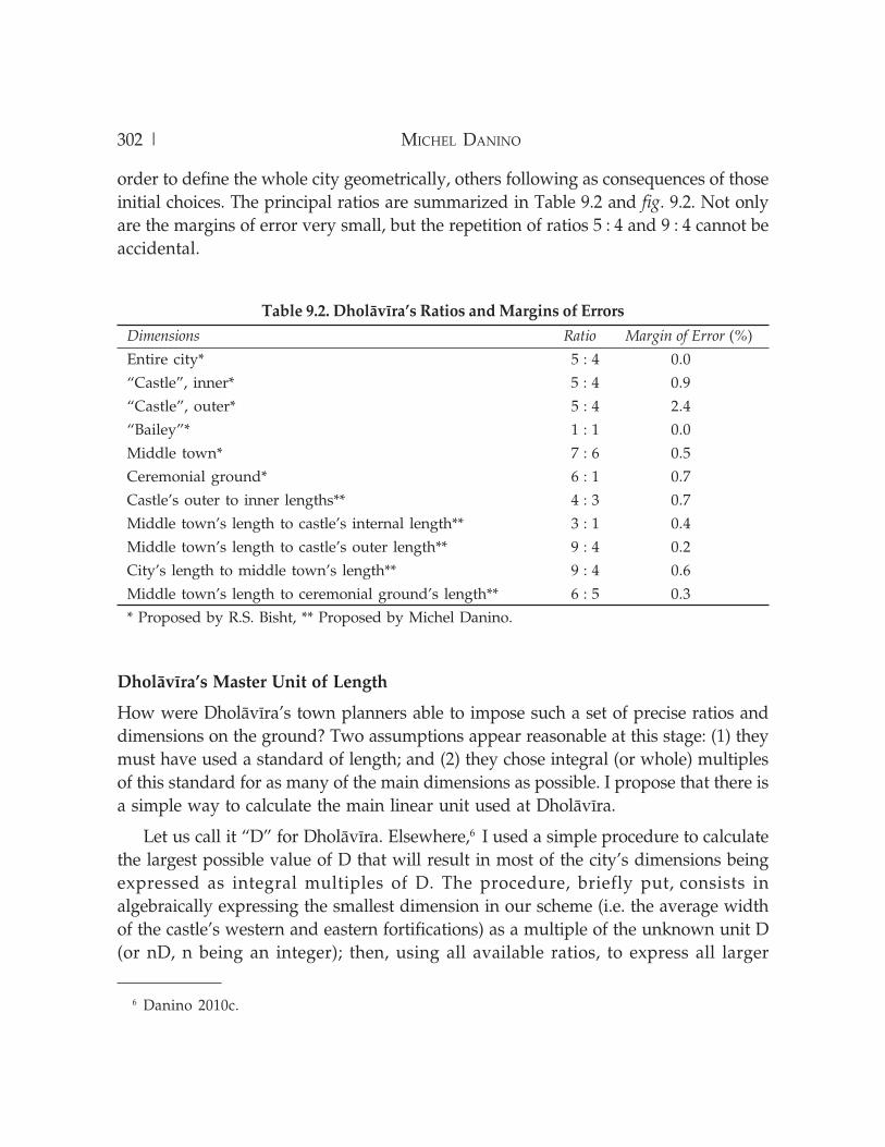
order to define the whole city geometrically, others following as consequences of thoseinitial choices. The principal ratios are summarized in Table 9.2 and fig. 9.2. Not onlyare the margins of error very small, but the repetition of ratios 5 : 4 and 9 : 4 cannot beaccidental.
DholÀvÁra’s Master Unit of Length
How were DholÀvÁra’s town planners able to impose such a set of precise ratios anddimensions on the ground? Two assumptions appear reasonable at this stage: (1) theymust have used a standard of length; and (2) they chose integral (or whole) multiplesof this standard for as many of the main dimensions as possible. I propose that there isa simple way to calculate the main linear unit used at DholÀvÁra.
Let us call it “D” for DholÀvÁra. Elsewhere,6 I used a simple procedure to calculatethe largest possible value of D that will result in most of the city’s dimensions beingexpressed as integral multiples of D. The procedure, briefly put, consists inalgebraically expressing the smallest dimension in our scheme (i.e. the average widthof the castle’s western and eastern fortifications) as a multiple of the unknown unit D(or nD, n being an integer); then, using all available ratios, to express all larger
| 303NEW FINDINGS IN HAãAPPAN TOWN PLANNING AND METROLOGY
dimensions in terms of nD. We find, of course, that a few dimensions are not integralbut fractional expressions of nD. To make those fractions disappear, we choose “n” asthe least common multiple of their denominators. It turns out that with n = 10, allfractional results disappear, except one. Going back to our initial formula, the widthof the castle’s western and eastern fortifications, which we expressed as nD, is now10 D. Bringing into play the proportions listed above, we can express all but onedimensions as multiples of D. Fig. 9.3 summarizes the findings. (The exception is themiddle town’s width, but this is normal: if the middle town’s length is, as producedby these calculations, 180 D, with a ratio of 7 : 6 between them, the width cannot be anintegral multiple of D; it will be about 154.3 D. In reality, at 290.45 m, it is almost153 D.)
We now only need to determine the value of D, which is simply derived from thecity’s length: if 771.1 m = 405 D, then D = 1.904 m or 190.4 cm, which we may round offto 1.9 m.
fig. 9.2: Main ratios at work in DholÀvÁra’s plan

304 | MICHEL DANINO
Dimension Length Theoretical Actual Margin of(in Terms Measurement Measurement Error (%)of Unit D) (Metres) (Metres)
Lower town’s length 405 771.1 771.1 0.0
Lower town’s width 324 616.9 616.85 0.0
Middle town’s length 180 342.7 340.5 + 0.6
Middle town’s width 154.3 293.8 290.45 + 1.1
Ceremonial ground’s length 150 285.6 283 + 0.9
Ceremonial ground’s width 25 47.6 47.5 + 0.2
Inner castle’s length 60 114.2 114 + 0.2
Inner castle’s width 48 91.4 92 – 0.7
Outer castle’s length 80 152.3 151 + 0.9
Outer castle’s width 64 121.9 118 + 3.2
Bailey’s length and width 63 120.0 120 0.0
Table 9.3: Comparison Between Theoretical and Actual Dimensions
Starting from this value and calculating the theoretical dimensions backward usingfig. 9.3, we can compare them with the actual dimensions. Table 9.3 lists the results, as
fig. 9.3: DholÀvÁra’s main dimensions expressed in terms of dhanus,DholÀvÁra’s master unit of length
| 305NEW FINDINGS IN HAãAPPAN TOWN PLANNING AND METROLOGY
well as the margins of error between theoretical and actual dimensions. The latter areremarkably modest, 0.6 % on average (the highest being, again, in the outer dimensionsof the “castle”). These almost perfect matches appear to rule out the play of chance.
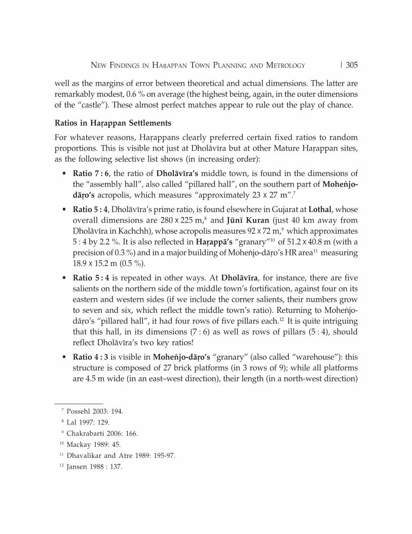
Ratios in HaÃappan Settlements
For whatever reasons, HaÃappans clearly preferred certain fixed ratios to randomproportions. This is visible not just at DholÀvÁra but at other Mature HaÃappan sites,as the following selective list shows (in increasing order):
• Ratio 7 : 6, the ratio of DholÀvÁra’s middle town, is found in the dimensions ofthe “assembly hall”, also called “pillared hall”, on the southern part of Moheôjo-
dÀÃo’s acropolis, which measures “approximately 23 x 27 m”.7
• Ratio 5 : 4, DholÀvÁra’s prime ratio, is found elsewhere in Gujarat at Lothal, whoseoverall dimensions are 280 x 225 m,8 and JÂnÁ Kuran (just 40 km away fromDholÀvÁra in Kachchh), whose acropolis measures 92 x 72 m,9 which approximates5 : 4 by 2.2 %. It is also reflected in HaÃappÀ’s “granary”10 of 51.2 x 40.8 m (with aprecision of 0.3 %) and in a major building of Moheôjo-dÀÃo’s HR area11 measuring18.9 x 15.2 m (0.5 %).
• Ratio 5 : 4 is repeated in other ways. At DholÀvÁra, for instance, there are fivesalients on the northern side of the middle town’s fortification, against four on itseastern and western sides (if we include the corner salients, their numbers growto seven and six, which reflect the middle town’s ratio). Returning to Moheôjo-dÀÃo’s “pillared hall”, it had four rows of five pillars each.12 It is quite intriguingthat this hall, in its dimensions (7 : 6) as well as rows of pillars (5 : 4), shouldreflect DholÀvÁra’s two key ratios!
• Ratio 4 : 3 is visible in Moheôjo-dÀÃo’s “granary” (also called “warehouse”): thisstructure is composed of 27 brick platforms (in 3 rows of 9); while all platformsare 4.5 m wide (in an east–west direction), their length (in a north-west direction)
7 Possehl 2003: 194.8 Lal 1997: 129.9 Chakrabarti 2006: 166.
10 Mackay 1989: 45.11 Dhavalikar and Atre 1989: 195-97.12 Jansen 1988 : 137.

306 | MICHEL DANINO
13 Jansen 1979: 420.14 Lal 1998: 119.15 Ibid., 96.16 Ibid., 43.17 Danino 2010b.18 Jansen 1979: 420.19 Jansen 1988: 134.
is 8 m for the first row, 4.5 m for the central row, and 6 m for the third row.13 It issingular that both pairs (8, 6) and (6, 4.5) precisely reflect the ratio 4 : 3.
• Ratio 3 : 2 is the overall ratio of KÀlibaôgan’s lower town (approximate dimensions360 x 240 m),14 as well as of a sacrificial pit (1.50 x 1 m).15 It is also the ratio of threereservoirs at DholÀvÁra: one in the “castle” measuring 4.35 x 2.95 m,16 and twolarger ones to the south of the castle.17 We find it again (within 1 %) at Moheôjo-dÀÃo in the overall platform of the “granary”, which measures 50 x 33 m.18
• Ratio 2 : 1 is that of DholÀvÁra’s acropolis (“castle” and “bailey” together); it isalso found at Moheôjo-dÀÃo19 (whose acropolis rests on a huge brick platform
fig. 9.4: A view of DholÀvÁra’s eastern reservoir (author’s photo).

| 307NEW FINDINGS IN HAãAPPAN TOWN PLANNING AND METROLOGY
measuring 400 x 200 m), KÀlibaôgan20 (acropolis of 120 x 240 m) and SurkoÇaçÀ21
(overall dimensions 130 x 65 m).
• Ratio 9 : 4, apart from its double presence at DholÀvÁra, is found at Moheôjo-
dÀÃo’s long building located just north of the Great Bath, called “block 6” andmeasuring approximately 56.4 x 25 m,22 thus within 0.3 %.
• Ratio 7 : 3 is found at HaÃappÀ’s mound AB in “14 symmetrically arranged smallhouses”,23 each measuring 17.06 x 7.31 m (nil margin).
• Ratio 5 : 2 is that of DholÀvÁra’s colossal eastern reservoir24 (73.5 x 29.3 m, thuswith a margin of 0.3 %), fig. 9.4. It is also reflected, with the same high precision,in twelve rooms of HaÃappÀ’s “granary”, each measuring 15.2 x 6.1 m.25
20 Lal 1997: 122.21 Ibid., 135.22 Mackay 1998: 17.23 Chakrabarti 2006: 156.24 Danino 2010b.25 Kenoyer 1998: 64.
fig. 9.5: A view of DholÀvÁra’s SR3 southern reservoir (author’s photo).

308 | MICHEL DANINO
26 Kenoyer 1998: 64.27 Mackay 1938: 10.28 Ibid.29 Rao 1979: 1: 123.
• Ratio 11 : 4 is that of the secondary rock-cut reservoir “SR3”26 found to the southof the DholÀvÁra’s “castle”, 15.5 x 5.65 m, with a high degree of precision (0.2 %),fig. 9.5.
• Ratio 3 : 1 is found at Moheôjo-dÀÃo’s “college” whose average dimensions are70.3 x 23.9 m.27
• Ratio 7 : 2 is that of DholÀvÁra’s primary rock-cut reservoir “SR3”28 mentionedabove (33.4 x 9.45 m, thus with a margin of 1 %), fig. 9.5.
• Ratio 6 : 1 is reflected not just in DholÀvÁra’s ceremonial ground but in Lothal’sdockyard29 (average dimensions 216.6 x 36.6 m).
The above examples are summarized (with a few more) in fig. 9.6. In probabilisticterms, while lower ratios (such as 7 : 6) could be rejected as a rough approximation of1 and therefore of little significance, the higher we rise in the scale and the less tenablesuch an explanation will be: the intentional use of specific proportions is indisputable,although it has not attracted sufficient attention so far. HaÃappan architects and buildersdid not believe in haphazard constructions, but followed precise canons of aestheticsbased on specific proportions.
We can also see that DholÀvÁra’s ratios are not exclusive to this site but are part ofa broader HaÃappan tradition of town planning and architecture, whose conceptualfoundations remain poorly understood.
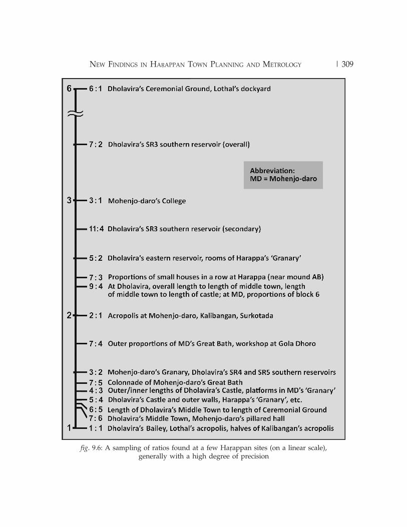
Dimensions in HaÃappan Settlements
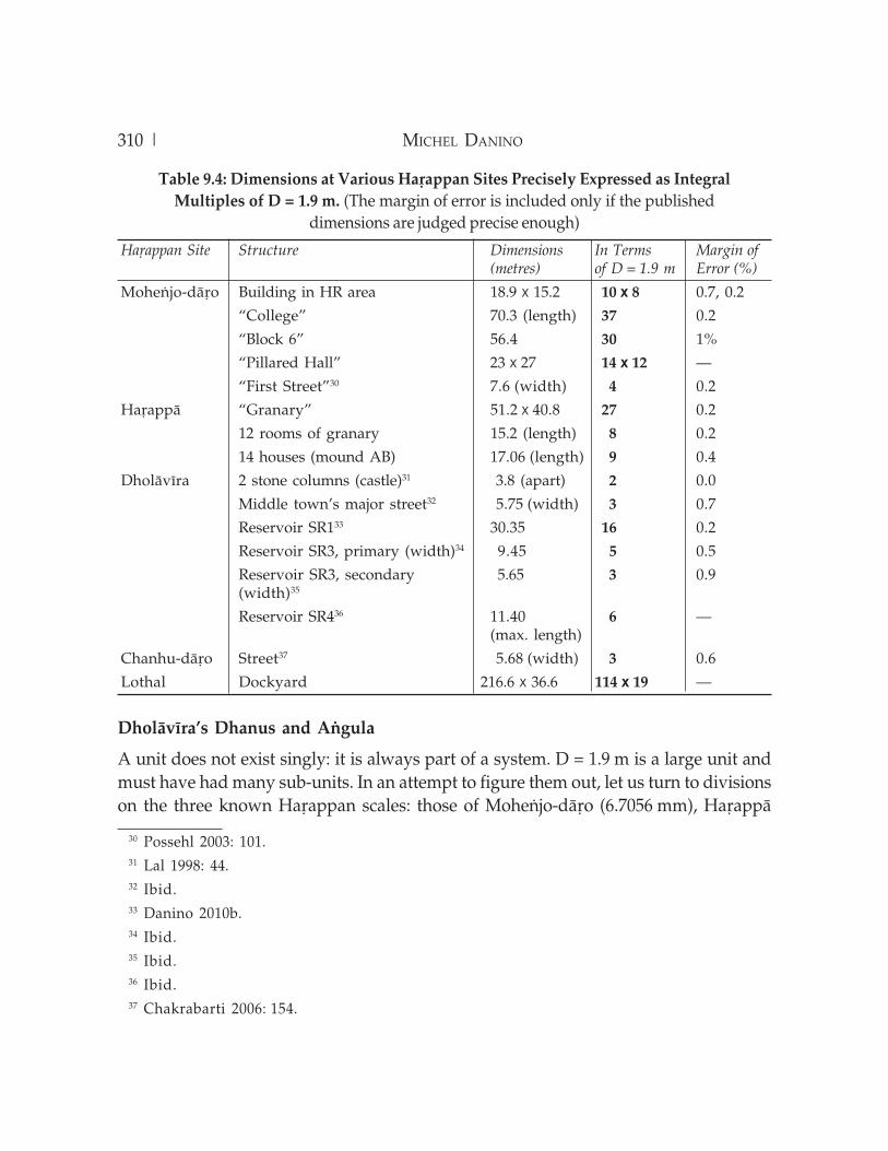
Ratios apart, we come across many dimensions of structures in HaÃappan settlementsthat can be expressed as integral multiples of our proposed DholÀvÁra unit D = 1.9 m.A few examples are given in Table 9.4, while fig. 9.7 illustrates the case of Moheôjo-dÀÃo’s acropolis.
While every single dimension cannot be expected to be a whole multiple of D, it isstriking enough that so many should turn out to be. This makes a strong case forDholÀvÁra’s unit to have been one of the standards in the HaÃappan world, at least asfar as town planning and architecture are concerned.
| 309NEW FINDINGS IN HAãAPPAN TOWN PLANNING AND METROLOGY
fig. 9.6: A sampling of ratios found at a few HaÃappan sites (on a linear scale),generally with a high degree of precision
310 | MICHEL DANINO
DholÀvÁra’s Dhanus and Aôgula
A unit does not exist singly: it is always part of a system. D = 1.9 m is a large unit andmust have had many sub-units. In an attempt to figure them out, let us turn to divisionson the three known HaÃappan scales: those of Moheôjo-dÀÃo (6.7056 mm), HaÃappÀ
30 Possehl 2003: 101.31 Lal 1998: 44.32 Ibid.33 Danino 2010b.34 Ibid.35 Ibid.36 Ibid.37 Chakrabarti 2006: 154.
Table 9.4: Dimensions at Various HaÃappan Sites Precisely Expressed as Integral
Multiples of D = 1.9 m. (The margin of error is included only if the published
dimensions are judged precise enough)
HaÃappan Site Structure Dimensions In Terms Margin of(metres) of D = 1.9 m Error (%)
Moheôjo-dÀÃo Building in HR area 18.9 x 15.2 10 x 8 0.7, 0.2
“College” 70.3 (length) 37 0.2
“Block 6” 56.4 30 1%
“Pillared Hall” 23 x 27 14 x 12 —
“First Street”30 7.6 (width) 4 0.2
HaÃappÀ “Granary” 51.2 x 40.8 27 0.2
12 rooms of granary 15.2 (length) 8 0.2
14 houses (mound AB) 17.06 (length) 9 0.4
DholÀvÁra 2 stone columns (castle)31 3.8 (apart) 2 0.0
Middle town’s major street32 5.75 (width) 3 0.7
Reservoir SR133 30.35 16 0.2
Reservoir SR3, primary (width)34 9.45 5 0.5
Reservoir SR3, secondary 5.65 3 0.9(width)35
Reservoir SR436 11.40 6 —(max. length)
Chanhu-dÀÃo Street37 5.68 (width) 3 0.6
Lothal Dockyard 216.6 x 36.6 114 x 19 —
| 311NEW FINDINGS IN HAãAPPAN TOWN PLANNING AND METROLOGY
(9.34 mm),38 and Lothal (1.77 mm). The last is evidenced on an ivory scale found atLothal, which has 27 graduations covering 46 mm. (Both S.R. Rao39 and V.B. Mainkarerred in dividing 46 mm by 27, when the length must of course be divided by the 26divisions formed by the 27 graduations.)
38 Mainkar 1984: 146.39 Rao 1979: 2, 626.
fig. 9.7: Moheôjo-dÀÃo’s acropolis: a few ratios and dimensionsexpressed in terms of DholÀvÁra’s unit D = 1.9 m
312 | MICHEL DANINO
Dividing D by the first two units yields no clear result. Dividing it by the Lothalunit (1904 by 1.77), we get 1075.7, or, with an approximation of 0.4 %, 1080. This lastnumber can be written 108 X 10. In other words, D can be expressed as 108 times1.77 cm.
Let us pursue this line of inquiry: what is so special about 1.77 cm? First, let usremember that the values of the traditional digit in the ancient world, be it in Egypt,Mesopotamia, China, Greece, Japan or the Roman Empire, fluctuated between 1.6 and1.9 cm.40 Ten times the Lothal unit falls in that range. Then, ArthaœÀstra defines a digit(aôgula in Sanskrit) as eight widths of barley grain (2.20.6) or “the maximum width ofthe middle part of the middle finger of a middling man” (2.20.7).41 Some eight centurieslater, VarÀhamihira’s B¦hat SaÚhitÀ (LVIII.2) repeats the first definition; that is the“standard” aôgula of classical India (there are indeed variations in later or regionaltraditions of iconometry, but they need not detain us here). Most scholars from J.F.Fleet down took the aôgula to be “roughly equating . . . 3/
4
th of an inch”,42 that is,1.9 cm. K.S. Shukla,43 Ajay Mitra Shastri44 or A.K. Bag,45 to quote just a few, endorsedthis approximate value. In contrast, the metrologist V.B. Mainkar46 traced the“development of length and area measures in India” and narrowed the value of theaôgula to 17.78 mm. He was probably the first to suggest that ten times the Lothal unit,i.e. 1.77 cm, was almost identical to the traditional aôgula.
Moreover, a crude terracotta scale from KÀlibaôgan was submitted to carefulscrutiny by the late R. Balasubramaniam, who established that it is based on a unit of1.75 cm.47 This is almost the same as the Lothal unit of 1.77 cm.
Let us average the two and call 1.76 cm “A” for aôgula; we then have the followingrelation: D = 108 A. This is an arresting result, since the concept of “108 aôgulas” iswell attested in classical India. For instance, one of the systems of units described inKauÇilya’s ArthaœÀstra (2.20.19) fits very well in the Dholavirian scheme: “108 aôgulas
40 Rottländer 1983: 205.41 Kangle 1986: 138.42 Chattopadhyaya 1986: 231.43 Shukla 1976: 19.44 Shastri 1996: 327.45 Bag 1997: 667.46 Mainkar 1984: 147.47 Balasubramaniam and Joshi 2008: 588-89.

| 313NEW FINDINGS IN HAãAPPAN TOWN PLANNING AND METROLOGY
make a dhanus (meaning a bow), a measure [used] for roads and city walls”.48 “Citywalls” are precisely the context in which our unit D was used at DholÀvÁra andelsewhere. We can now propose that “D” also stands for dhanus.
The HaÃappan brick provides us with a degree of confirmation of the Lothal aôgula.In the Mature phase (and occasionally in the Early phase), most bricks follow ratios of1 : 2 : 4 in terms of height–width–length; among several different sizes in this ratio,one dominates by far: 7 x 14 x 28 cm, measured and averaged over numerous samples(as mentioned by Kenoyer49 and by Rottländer quoting Jansen50 ); the first dimension,7 cm, is almost exactly 4 Lothal aôgulas (the difference being just 0.5 mm or 0.7 %). Sothe humble brick’s dimensions can be elegantly expressed as 4 x 8 x 16 A.
Between the aôgula and the dhanus, there must have been several important sub-units, and elsewhere51 I attempted to work out a few of them; preliminary findingsare that units of 4, 8, 10, 15, 16, 27 and 36 aôgulas were probably in use in HaÃappantimes. However, this requires confirmation through more systematic studies.
Continuity of the DholÀvÁra Scheme of Ratios and Units
The scheme of ratio and units found at DholÀvÁra finds further echoes in historicaltimes. ArthaœÀstra apart, “many [early texts] concentrate on the description of an imageof 108 aôgulas in length”.52 The origin of the concept behind the sacred number 108 isprobably multiple. It could be simply based on the human body: 108 aôgulas (1.9 m) isthe height of a tall man, as specifically mentioned by VarÀhamihira in his B¦hat SaÚhitÀ
(68.105).53 From a different perspective, simple but compelling astronomicalconsiderations behind 108 have been demonstrated by Subhash Kak.54
DholÀvÁra’s ratios must have been perceived as specially auspicious, otherwiseevery enclosure might as well have been square. Some of those ratios are still in use invarious traditions of VÀstu-Œilpa. In the sixth century CE, for instance, VarÀhamihirawrote in his B¦hat SaÚhitÀ (53.4-5):
48 Kangle 1986: 139.49 Kenoyer 1998: 57.50 Rottländer 1983: 202.51 Danino 2008: 66-79.52 Nardi 2006: 260.53 Bhat 1981: 642.54 Kak 2000: 101-02, 124.

314 | MICHEL DANINO
The length of a king’s palace is greater than the breadth by a quarter. . . . The length of
the house of a commander-in-chief exceeds the width by a sixth.55
These two ratios, 1 + 1/4 and 1 + 1/6, are identical to 5 : 4 and 7 : 6 — very preciselyDholÀvÁra’s most prominent ratios (see fig. 9.2). Such a perfect double match appearsto be beyond the realm of coincidence.
A recent work by Mohan Pant and Shuji Funo56 compared the grid dimensions ofbuilding clusters and quarter blocks of three cities: Moheôjo-dÀÃo, Sirkap (Taxila, earlyhistorical, fig. 9.8), and Thimi (in Kathmandu Valley, a contemporary town of historicalorigins). Carefully superimposing grids on published plans of all three cities (theirown in the case of Thimi), the authors found that block dimensions measure 9.6 m,19.2 m (= 9.6 m x 2), or multiples of such dimensions. This, they argue, evokes theArthaœÀstra’s unit called rajju, equal to 10 daõças. As regards the daõça, which has fourpossible traditional values, the authors chose that of 108 aôgulas as prescribed in
55 Bhat 1981: 451-5256 Pant and Funo 2005: 51-59.
fig. 9.8: Plan of Sirkap, one of Taxila’s mounds. The blocks of houses are separated byregularly spaced streets, 38.4 m apart (= 1.92 x 20)

| 315NEW FINDINGS IN HAãAPPAN TOWN PLANNING AND METROLOGY
ArthaœÀstra (2.20.18-19); it is the same passage which I quoted earlier to define thedhanus, and the daõça is mentioned in it as another name of the dhanus: for our purposes,the two terms are identical.
Pant’s and Funo’s unit of 1.92 m differs from mine of 1.9 m by just 1 %; in bothcases, the unit was equated 108 aôgulas. Their work thus lends support to my suggestionthat such concepts survived the collapse of HaÃappan urbanism and re-emerged inKauÇilya’s canons of urbanism. Is this so surprising, when we already know that theHaÃappans’ weight system, metallurgical, agricultural and craft techniques did liveon, apart from numerous religious symbols and practices?57
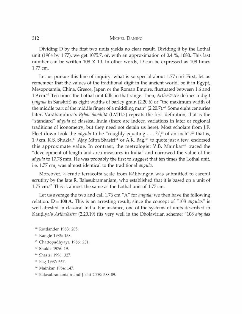
We get further confirmation of such continuity from a case study of the Delhi IronPillar (Qutub Minar complex) by R. Balasubramaniam,58 who applied to it theHaÃappan dhanus and aôgula I had proposed and found they expressed the pillar’sdimensions with unexpected harmony (fig. 9.9): its total length of 7.67 m, for instance,is precisely 4 D; its diameter, 36 aôgulas at the bottom, shrinks to 24 aôgulas at groundlevel, finally to taper off at 12 aôgulas at the very top. If this were not enough, the ratiobetween the pillar’s entire length (7.67 m) and the portion above the ground (6.12 m)is 5 : 4, verified to 0.2 % — again, DholÀvÁra’s master ratio. This bears out once againthat HaÃappan ratios and linear units survived the collapse of the Indus cities andpassed to those of the Ganges Valley. Balasubramaniam applied the same units withexcellent results to engineered caves of the Mauryan period59 and to the Taj Mahalcomplex,60 opening a new line of inquiry in classical Indian metrology.
HaÃappan and Classical Concepts
On a cultural level, the presence of carefully proportioned fortifications as at DholÀvÁramight be as much a specific cultural trait as pyramids are to Egypt or ziggurats toMesopotamia. Here, instead of erecting colossal buildings, enormous energy was spenton defining spaces: the space of the rulers and administrators (the acropolis) and thespaces for other classes of citizens. Demarcating was a vital need not for defence, butfor self-definition: fortifications probably stood for authority and segregation, as PiotrA. Eltsov has recently argued too.61
57 Danino 2003: 21-32.58 Balasubramaniam 2008: 766-70.59 Balasubramaniam 2009b.60 Balasubramaniam 2009a.61 Eltsov 2008.
316 | MICHEL DANINO
But there may also be deeper motives at work: ratios and units apart, we can discerna few important principles underlying DholÀvÁra’s fascinating harmony, in an almostPythagorean sense of the term. More work and data are needed to bring out thoseprinciples securely, but I proposed elsewhere62 that the Vedic principle of addition of a
unit is at work here: 5 : 4 should be read as “one unit plus one fourth”, and the keyratio of 9 : 4, for instance, is nothing but 5 : 4 plus one unit. This addition to the unit ofa fraction of itself can also be seen as a process of expansion, of auspicious increase
62 Danino 2008.
fig. 9.9: A sketch of the Delhi Iron Pillar with the main dimensions expressed in termsof D = DholÀvÁra’s dhanus (1.9 m) and A = DholÀvÁra’s aôgula (1.76 cm)
| 317NEW FINDINGS IN HAãAPPAN TOWN PLANNING AND METROLOGY
symbolizing or inviting prosperity. Thus MÀnasÀra, a treatise of Hindu architecture,applies this process when it specifies (35.18-20) that
the length of the mansion [to be built] should be ascertained by commencing with its
breadth, or increasing it by one-fourth, one-half, three-fourth, or making it twice, or
greater than twice by one-fourth, one-half or three-fourths, or making it three times.63
The outcome is a series of ratios: 5 : 4, 3 : 2, 7 : 4, 2 : 1, 9 : 4, 5 : 2, 11 : 4, 3 : 1. Since wefound all these ratios at DholÀvÁra or other HaÃappan settlements, it is tempting toassume that the concept behind such auspicious ratios was the same in HaÃappantimes.
Also found at DholÀvÁra is another Vedic principle, that of recursion or repetition ofa motif.64 Thus the “castle” and the overall city share the same ratio (5 : 4), and 9 : 4defines the expansion from the length of the “castle” to that of the middle town, andagain to that of the lower town.
The thread connecting those principles was anticipated by astrophysicist J. McKimMalville, who saw in DholÀvÁra’s features “the apparent intent . . . to interweave, bymeans of geometry, the microcosm and the macrocosm”.65 To the ancient mind, theconcept of sacred space was inseparable from the practice of town planning andarchitecture. Dilip Chakrabarti echoes this in his recent observation:
The ideals of ancient Indian town planning seem to run deep through the concepts
embedded in the HaÃappan cities like Moheôjo-dÀÃo and DholÀvÁra.66
References
Acharya, P.K. (1934), 1994, Architecture of Manasara, vol. 4 in Manasara Series, repr., New Delhi:
Munshiram Manoharlal.
Bag, A.K., 1997, History of Technology in India, vol. 1, New Delhi: Indian National Science Academy.
Balasubramaniam, R., 2008, “On the Mathematical Significance of the Dimensions of the Delhi
Iron Pillar”, Current Science, 95(6): 766-70.
———, 2009a, “New Insights on the Modular Planning of the Taj Mahal”, Current Science 97(1):
42-49.
63 Acharya 1994: 374.64 Kak 2009.65 Malville 2000: 3.66 Chakrabarti 2006: 166.
318 | MICHEL DANINO
———, 2009b, “New Insights on Metrology During the Mauryan Period”, Current Science, 97(5):
680-82.
Balasubramaniam, R. and J.P. Joshi, 2008, “Analysis of Terracotta Scale of HaÃappan Civilization
from KÀlibaôgan”, Current Science, 95(5): 588-89.
Bhat, M.R., 1981, VarÀhamihira’s B¦hat SaÚhitÀ, vol. 1, New Delhi: Motilal Banarsidass.
Bisht, R.S., 1997, “DholÀvÁra Excavations: 1990–94”, in Facets of Indian Civilization: Essays in Honourof Prof. B.B. Lal, ed. J.P. Joshi, vol. 1, pp. 107-20, New Delhi: Aryan Books International.
———, 1999, “DholÀvÁra and Banawali: Two Different Paradigms of the HaÃappan Urbis Forma”,
Puratattva, 29: 14-37.
———, 2000, “Urban Planning at DholÀvÁra: A HaÃappan City”, in Ancient Cities, Sacred Skies:Cosmic Geometries and City Planning in Ancient Indi, ed. J.M. Malville and L.M. Gujral, pp. 11-
23, New Delhi: Indira Gandhi National Centre for the Arts and Aryan Books International.
Chakrabarti, D.K., 2006, The Oxford Companion to Indian Archaeology: The Archaeological Foundationsof Ancient India, New Delhi: Oxford University Press.
Chattopadhyaya, D., 1986, History of Science and Technology in Ancient India: The Beginnings, Calcutta:
Firma KLM.
Danino, M., 2003, “The HaÃappan Heritage and the Aryan Problem”, Man and Environment,23(1): 21-32.
———, 2005, “DholÀvÁra’s Geometry: A Preliminary Study”, Puratattva, 35: 76-84.
———, 2008, New Insights into HaÃappan Town-Planning, Proportions and Units,
with Special Reference to DholÀvÁra”, Man and Environment, 33(1): 66-79.
———, 2010a, The Lost River: On the Trail of the Sarasvati, New Delhi: Penguin Books.
———, 2010b, “Further Research into HaÃappan Metrology at DholÀvÁra”, Man and Environment35(2): 35-44.
———, 2010c, “Unravelling DholÀvÁra’s Geometry”, in Rama Vijayam: Recent Researches inArchaeology, History and Culture (Festschrift to Prof. K.V. Raman), ed. P.C. Reddy, pp. 179-93,
Delhi: Agam Kala Prakashan.
Dhavalikar, M.K. and S. Atre, 1989, “The Fire Cult and Virgin Sacrifice: Some HaÃappan Rituals”,
in Old Problems and New Perspectives in the Archaeology of South Asia, ed. J.M. Kenoyer, pp. 193-
205, Madison, Wisconsin: University of Wisconsin.
Eltsov, P.A., 2008, From HaÃappÀ to Hastinapura: A Study of the Earliest South Asian City and Civilization,Boston and Leiden: Brill Academic Publishers.
Jansen, M., 1979, “Architectural Problems of the HaÃappÀ Culture”, in South Asian Archaeology1977, ed. M. Taddei, vol. 1, p. 420, Naples: Istituto Universitario Orientale, Seminario di
Studi Asiatici.
———, 1988, “Moheôjo-dÀÃo: Architecture et urbanisme”, in Les cités oubliées de l’Indus: Archéologiedu Pakistan, ed. J.-F. Jarrige, p. 133-42, Paris: Association fran‡aise d’action artistique &
Musée national des Arts asiatiques Guimet.
Kak, S., 2000, The Astronomical Code of the Rgveda, 2nd edn., New Delhi: Munshiram Manoharlal.

| 319NEW FINDINGS IN HAãAPPAN TOWN PLANNING AND METROLOGY
———, 2009, Archaeoastronomy in India, retrieved from http://arxiv.org/pdf/1002.4513v1 on
23.12.2010.
Kangle, R.P., 1986, The KauÇilya ArthaœÀstra, II, New Delhi: Motilal Banarsidass.
Kenoyer, J.M., 1998, Ancient Cities of the Indus Valley Civilization, Karachi and Islamabad: Oxford
University Press and American Institute of Pakistan Studies.
Lal, B.B., 1997, The Earliest Civilization of South Asia, New Delhi: Aryan Books International.
———, 1998, India 1947–1997: New Light on the Indus Civilization, New Delhi: Aryan Books
International.
Mackay, E., (1948) 1989, Early Indus Civilization: Ancient Cities of the Indus Plains, repr., Patna:
Eastern Book House.
Mackay, E.J.H., 1938, Further Excavations at Mohenjo-daro, vol. 1, Delhi: Government of India,
repr., 1998, New Delhi: Munshiram Manoharlal.
Mainkar, V.B., 1984, “Metrology in the Indus Civilization”, in Frontiers of the Indus Civilization,
ed. B.B. Lal and S.P. Gupta, pp. 141-51, New Delhi, Books & Books.
Malville, J.M. and L.M. Gujral, eds., 2000, Ancient Cities, Sacred Skies: Cosmic Geometries and CityPlanning in Ancient India, New Delhi: Indira Gandhi National Centre for the Arts and Aryan
Books International.
Nardi, I., 2006, “On Measuring Images: A Critical Analysis of the Theory of Talamana”, in
Sahrdaya: Studies in Indian and South East Asian Art in Honour of Dr. R. Nagaswamy, ed. B.
Baumer, R.N. Misra, C. Prapandvidya and D. Handa, Chennai: Tamil Arts Academy.
Pant, M. and S. Funo, 2005, “The Grid and Modular Measures in the Town Planning of
Mohenjodaro and Kathmandu Valley: A Study on Modular Measures in Block and Plot
Divisions in the Planning of Mohenjodaro and Sirkap (Pakistan), and Thimi (Kathmandu
Valley)”, in Journal of Asian Architecture and Building Engineering, 4(1), retrieved from
www.jstage.jst.go.jp/article/jaabe/4/1/51/_pdf on 09.09.2007.
Possehl, G.L., 2003, The Indus Civilization: A Contemporary Perspective, New Delhi: Vistaar
Publications.
Rao, S.R., 1979, Lothal, a HaÃappan Port Town (1955-62), vols. 1-2, New Delhi: Archaeological
Survey of India.
Rottländer, R.C.A., 1983, “The HaÃappan Linear Measurement Unit”, Reports on Field Work CarriedOut at Mohenjo-daro: Interim Reports, vol. 1, ed. M. Jansen and G. Urban, Aachen: German
Research Project Mohenjo-Daro RWTH Aachen.
Shastri, A.M., 1996, Ancient Indian Heritage: VarÀhamihira’s India, vols. 1-2, New Delhi: Aryan
Books International.
Shukla, K.S., 1976, °ryabhaÇÁya of °ryabhaÇa, New Delhi: Indian National Science Academy.