new avenues of research in oceans and maritime history · new avenues of research in oceans and...
TRANSCRIPT
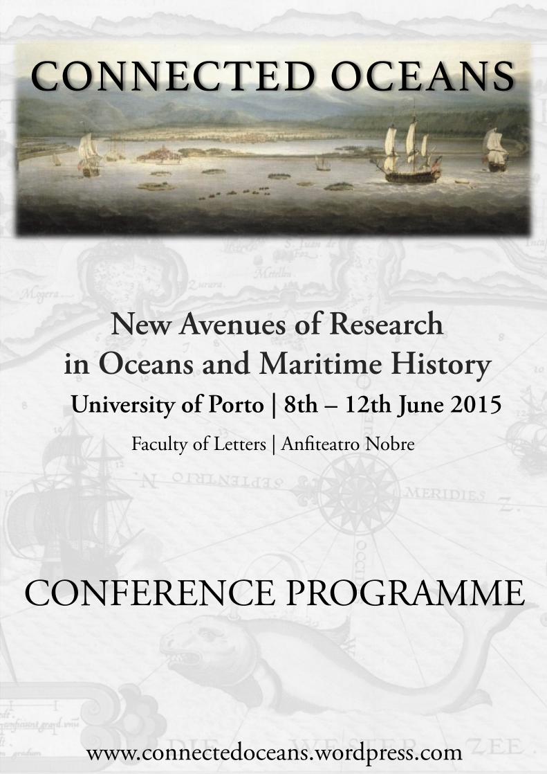
CONNECTED OCEANS !
CONFERENCE PROGRAMME
New Avenues of Research in Oceans and Maritime History University of Porto | 8th – 12th June 2015
Faculty of Letters | Anfiteatro Nobre
www.connectedoceans.wordpress.com

TABLE OF CONTENTS
WELCOME 1
CONFERENCE PROGRAMME 2
ABSTRACTS 6
CONFERENCE DINNER 26
LIST OF PARTICIPANS 27
PORTO GUIDE 29
FORTHCOMING EVENTS 38

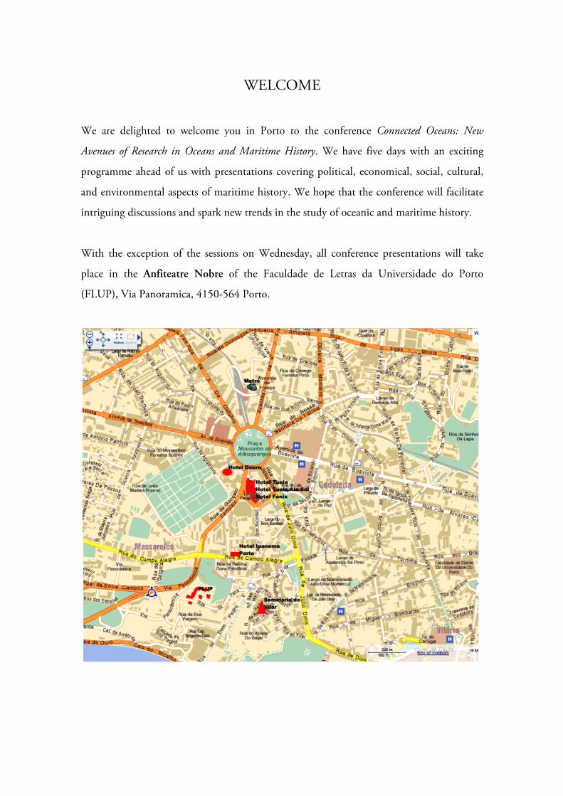
WELCOME
We are delighted to welcome you in Porto to the conference Connected Oceans: New
Avenues of Research in Oceans and Maritime History. We have five days with an exciting
programme ahead of us with presentations covering political, economical, social, cultural,
and environmental aspects of maritime history. We hope that the conference will facilitate
intriguing discussions and spark new trends in the study of oceanic and maritime history.
With the exception of the sessions on Wednesday, all conference presentations will take
place in the Anfiteatre Nobre of the Faculdade de Letras da Universidade do Porto
(FLUP), Via Panoramica, 4150-564 Porto.

Connected Oceans 8-12 June, University of Porto
2
CONFERENCE PROGRAMME
Monday, 8th June 2015 – Indian Ocean
08.30 - 09.30 Registration
09.00 - 09.30 Official Opening
09.30 - 10.30 Opening Lecture – Michael Pearson (University of New South Wales) Oceans Connect: Notes on Connections and Comparisons
10.30 - 11.00 Coffee Break
11.00 - 11.45 Rila Mukherjee (University of Hyderabad, India) The Bay of Bengal in the Indian Ocean World
11.45 - 12.30 Radhika Seshan, (University of Pune, India) Intersections: People, Ports and Trade in the 17th Century Madras and Surat
12.30 - 14.30 Lunch
14.30 - 15.00 Jesús Bohorquez (European University Institute, Florence) Linking the Indian and Atlantic Oceans: Revisiting Indo-Portuguese Trade in Global Perspective (1780-1811)
15.00 - 15.30 Felix Schürmann (University of Kassel, Germany) American Whalers in the Struggle for the Control of Anjouan, c. 1835-1890
15.30 - 16.00 Coffee Break
16.00 - 16.30 Diane Kirkby (La Trobe University, Melbourne) ‘We Seafarers…who share the seas’: Maritime Unions Connecting Work and Politics
16.30 - 17.00 Cristina Brito (CHAM-NOVA, University of Lisbon) The Future of the Oceans Past Research: Bringing the Sea to the Ocean History
18:15 Conference Reception: Porto de Honra at the Casa do Infante, Porto
Tuesday, 9th June 2015 – Atlantic Ocean 09.00 - 09.45 Roquinaldo Ferreira (Brown University, Rhode Island)
Managing Empire: The Foundation of the Ajudá Fort and the Politics of Slavery in the South Atlantic
09.45 - 10.30 Filipa Ribeiro da Silva (University of Macao, China) The Slave Trade and the Development of the Atlantic-African Port System, 1400-1800s
Connected Oceans 8-12 June, University of Porto
3
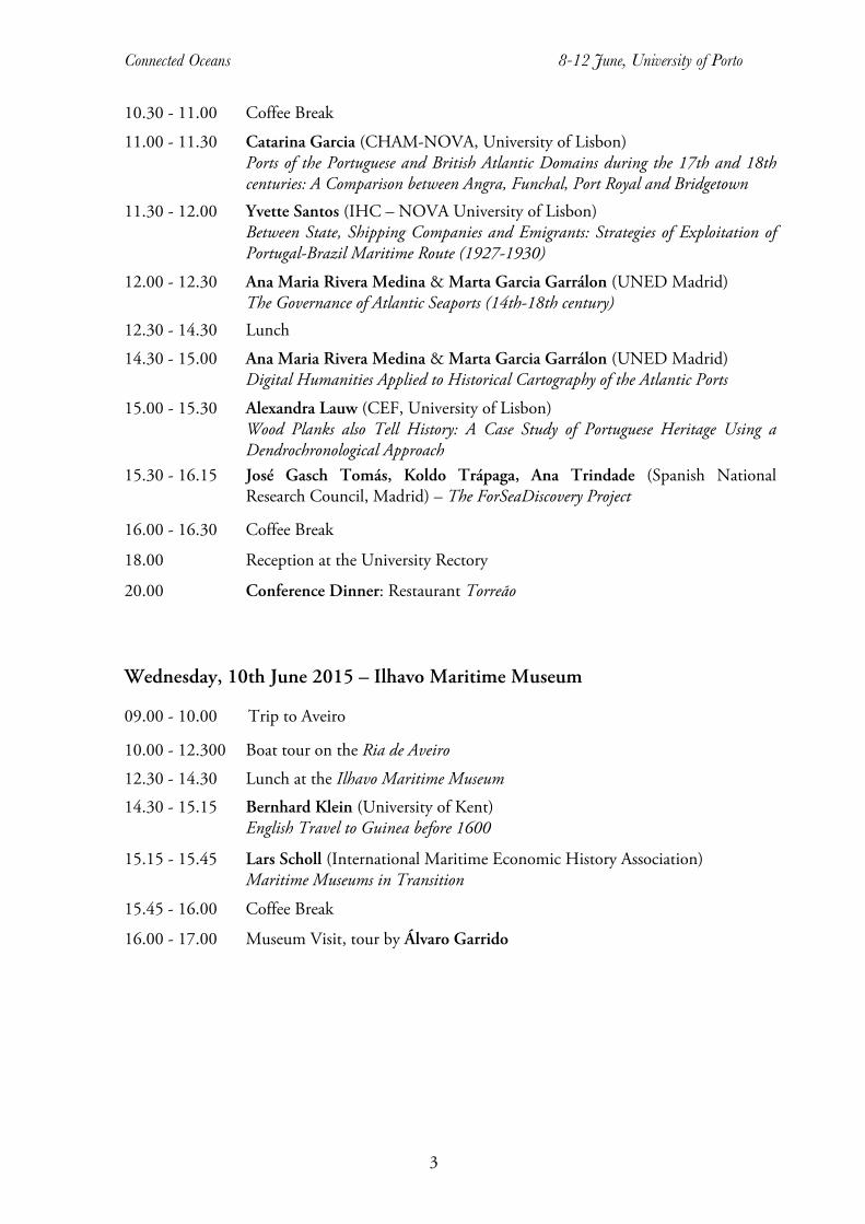
10.30 - 11.00 Coffee Break 11.00 - 11.30 Catarina Garcia (CHAM-NOVA, University of Lisbon)
Ports of the Portuguese and British Atlantic Domains during the 17th and 18th centuries: A Comparison between Angra, Funchal, Port Royal and Bridgetown
11.30 - 12.00 Yvette Santos (IHC – NOVA University of Lisbon) Between State, Shipping Companies and Emigrants: Strategies of Exploitation of Portugal-Brazil Maritime Route (1927-1930)
12.00 - 12.30 Ana Maria Rivera Medina & Marta Garcia Garrálon (UNED Madrid) The Governance of Atlantic Seaports (14th-18th century)
12.30 - 14.30 Lunch 14.30 - 15.00 Ana Maria Rivera Medina & Marta Garcia Garrálon (UNED Madrid)
Digital Humanities Applied to Historical Cartography of the Atlantic Ports 15.00 - 15.30 Alexandra Lauw (CEF, University of Lisbon)
Wood Planks also Tell History: A Case Study of Portuguese Heritage Using a Dendrochronological Approach
15.30 - 16.15 José Gasch Tomás, Koldo Trápaga, Ana Trindade (Spanish National Research Council, Madrid) – The ForSeaDiscovery Project
16.00 - 16.30 Coffee Break
18.00 Reception at the University Rectory
20.00 Conference Dinner: Restaurant Torreão
Wednesday, 10th June 2015 – Ilhavo Maritime Museum
09.00 - 10.00 Trip to Aveiro
10.00 - 12.300 Boat tour on the Ria de Aveiro 12.30 - 14.30 Lunch at the Ilhavo Maritime Museum 14.30 - 15.15 Bernhard Klein (University of Kent)
English Travel to Guinea before 1600
15.15 - 15.45 Lars Scholl (International Maritime Economic History Association) Maritime Museums in Transition
15.45 - 16.00 Coffee Break
16.00 - 17.00 Museum Visit, tour by Álvaro Garrido

Connected Oceans 8-12 June, University of Porto
4
Thursday, 11th June 2015 – Pacific Ocean
09.00 - 09.45 Malcolm Tull (Murdoch University, Australia) Adaption Options for Coastal Communities: An Australian Case Study
09.45 - 10.30 Xabier Lamikiz (University of Basque Country, Spain) Connecting the Indian and Pacific Oceans: Armenian Merchants and Cross-Cultural Trade in Manila, c. 1660-1800
10.30 - 11.00 Coffee Break
11.00 - 11.30 Eberhard Crailsheim (FernUniversität in Hagen, Germany) Seville and Manila: Illegal Trade and Corruption in the Spanish Empire (17th and 18th Centuries)
11.30 - 12.00 Amândio Barros (CITCEM, IP Porto, Portugal) Maritime and Commercial Dynamics between Portuguese, Spanish, Chinese and Japanese embracing Cape and Manila Galleon Routes
12.00 - 12.30 Jo Stanley (Maritime Historical Studies Centre, University of Hull & Centre for Mobilities Research, Lancaster University) Hilarious Seasickness: What Comic Postcards Reveal
12.30 - 14.30 Lunch
14.30 - 15.00 Makereta R. Mua (Fiji National University) Diasporic Connections Amongst Rotumans and Torrest Strait Islanders
15.00 - 15.30 Alexander Kraus (Westfälische Wilhelms-Universität Münster, Germany) The Sound of the Seas: An Acoustic History of the Oceans in the 19th Century
15.30 - 16.00 Jorge Pacheco (CBMA, University of Minho) & Amélia Polónia (CITCEM, University of Porto) Circulating Natures in the First Global Age. Environmental impacts of the Historical Uses of the Sea
16.00 - 16.15 Coffee Break
16.15 - 17.00 Paul D'Arcy (Australian National University) The Blue Hemisphere: Pacific Reflections on Ocean Histories that are more Aquatic than Coastal
Friday, 12th June 2015
09.00 - 09.45 Maria Fusaro (Exeter University) The Global Relevance of the European ‘Ocean’: an Historiographical Reassessment of the Early Modern Mediterranean
09.45 - 10.30 Ruthy Gertwagen (University of Haifa, Israel) Life on Board of Sailing Ships - Travellers’ Perspectives (12th -16th centuries)
10.30 - 11.00 Coffee Break
Connected Oceans 8-12 June, University of Porto
5
11.00 - 11.45 René Taudal Poulsen (Copenhagen Business School) Will shipping transition from motor to sail? Why maritime history can contribute to key discussions in present day shipping
11.45 - 12.30 Leos Muller (Stockholm University, Sweden) Neutral Shipping, Natural law and International Relations in the 18th Century. A Nordic Perspective
12.30 - 14.30 Lunch
14.30 - 15.30 Keynote-Address: Richard Unger (University of British Columbia) Seeing the Seas: Graphic Representations of the World's Waters in the Middle Ages and the Renaissance
15.30 - 16.00 Closing Remarks

Connected Oceans 8-12 June, University of Porto
6
ABSTRACTS
MICHAEL PEARSON | University of New South Wales Oceans Connect: Notes on Connections and Comparisons
The presentation will fall into two parts. The first part will sketch ways in which oceans connect, flow into each other. Just as we reject the myth of continents, so also with the oceans. One could of course instance many other examples to break down the tyranny of names, but this paper will sketch some parts of the historiography of the Atlantic, Mediterranean and Pacific bodies of water to see what they can contribute to work on the Indian Ocean. In each case both positive and negative aspects will be pointed out.
RILA MUKHERJEE | University of Hyderabad, India The Bay of Bengal in the Indian Ocean World
The presentation will focus on flows in the Bay of Bengal to investigate the level of its integration into the Indian Ocean world through a history of commodities (kauris, slaves) and technology-dispersion (boat-building) in order to facilitate a trans-disciplinary research agenda. The circulation of humans, ideas and plants in the Indian Ocean world will be focal to the presentation.
RADHIKA SESHAN | University of Pune, India Intersections: People, Ports and Trade in the 17th Century Madras and Surat
As is well known, with the expansion of Mughal power into the peninsular region of India, the port of Surat on the west coast of India acquired tremendous importance. The final conquests of the Sultanates of Gujarat and Ahmednagar by the Mughals meant not only that Surat’s hinterland expanded to include the entire Mughal Empire, but also that the Mughals incorporated the earlier networks into their system. Thus, when the northern European companies came to India, the logical point of entry was Surat, as it gave them access to the country and to the range of activities associated with trade. Madras was very different because there was no clear-cut hinterland nor were there pre-existing networks of trade from this place. The English therefore had to build up their own networks and try and get access to the same hinterland that merchants elsewhere along the coast were entering. Again unlike the Mughal Empire, this hinterland was initially controlled by many political players and even if later there were primarily two sultanates, there did not exist the levels of unity and security visible in the north. Despite these differences one can identify some similarities through the ways in which the English attempted to enter into the local markets. Three levels of networks can be identified – those which they established with the brokers within the towns (like Bhimji Parekh in Surat and Sesadri Chetti in Madras); the larger merchants who operated

Connected Oceans 8-12 June, University of Porto
7
particularly in Gujarat like Virji Vora in Surat or Makhdum Nina in Porto Novo on the east coast; and the administrators in or over these two ports. It is these intersections of merchants, companies and politics – people, places, ports and trade – that the paper proposes to examine.
JESUS BOHORQUEZ | European University Institute, Florence Linking the Indian and Atlantic Oceans: Revisiting Indo-Portuguese trade in global perspective (1780-1811)
Despite the interest that Indo-Portuguese trading connections have recently acquired, much is still unknown about the private trade and the traders that connected the Indian and Atlantic Oceans. This paper focuses on the steady growth of intercontinental commerce that took place during the last quarter of the 18th-century. However, different to most of the ongoing research, it focuses on the movement of capital flows, instead of merely concentrating on either merchant networks or textile trades. By putting the Portuguese empire into a global perspective, attention is given to the multidirectional ways in which capital flowed from and to Asia as well as to the vast set of national and foreign agents that were involved in it. The paper claims that it is necessary to reconstruct the connections that existed between the Atlantic and Indian Oceans (Brazilian trades and African slave trades) in order to better understand capital flows as well as mercantile networks. Contrary to most Portuguese historians who tend to concentrate on the colonial entrepôts like Goa, I further focus on the foreign territories, principally but not exclusively, the Coast of Coromandel, the Bay of Bengal, and its chief city Calcutta.
FELIX SCHÜRMANN | Universität Kassel, Germany American Whalers in the Struggles for the Control of Anjouan, c. 1835–1890
Whaling vessels from the United States gradually opened up the western Indian Ocean as a hunting ground for sperm and humpback whales from about 1820 on. In this maritime area, the migratory behaviour of whales as well as the seasonal reversal of the monsoon winds pre-structured the ships’ movements and limited the range of places and time periods they could use for provisioning themselves at the coast. The island of Anjouan, or Nzwani, located at the northern end of the Mozambique Channel as part of the Comoros archipelago, emerged as one of their major ports of call in the mid-1830s. With varying intensity, whalers frequented Anjouan’s main harbour Mutsamudu until the end of American whaling in this area during the 1880s, mainly in order to obtain provisions and water. In some years, whalers made up the largest proportion of shipping traffic in Mutsamudu – particularly during the 1840s and 1850s, when about 25 whaling vessels entered this harbour each year. American whaling in the western Indian Ocean coincided with a period of intense imperial tensions mainly between Britain and France about the balance of colonial and naval power in this maritime region. Anjouan constituted a focal point of these conflicts:
Connected Oceans 8-12 June, University of Porto
8
France sought to colonise the Comoros in order to compensate for the loss of Mauritius and the Seychelles during the Napoleonic Wars, whereas Britain exerted heavy influence on Anjouan in order to limit French influence. The alternating sultans of Anjouan, on their part, ruled under the threat of constant internal power rivalries and recurring uprisings in the interior of the island. Within this situation of severe tensions, the whalers’ trade for provisions evolved into an economic and political factor of considerable importance. My presentation will portray the impacts of whalers’ activities on Anjouan and outline them as an example for unintended but consequential side-effects of American whaling. The exploitation of ecological resources – virtually conditioned by the movements of the hunted whales and thus subject to animal agency – indirectly became a factor in the struggles for the control of Anjouan. The weight of this factor became clearly visible in 1850, when sultan Salim imprisoned a captain as a symbolic punishment for a number of frauds committed by various whalers. In response, the US Navy sent a sloop-of-war to Anjouan, which by bombing the citadel of Mutsamudu carried out the first military action by the United States in the Indian Ocean in history. Arguing in this manner, the presentation will exemplify a major line of reasoning in my PhD thesis, according to which the political, economic, social, and cultural side-effects of American-style pelagic whaling formed an important undercurrent in the history of global entanglements. Particularly with regard to Africa, this undercurrent today is overshadowed by the grand narratives of European expansion, slave trade, and colonialism. However, since whalers created very distinct forms of relationships and spatial connections, it is worthwhile to study this group of actors from a global history perspective.
DIANE KIRKBY | La Trobe University, Melbourne, Australia ‘We Seafarers…who share the seas’: Maritime Unions Connecting Work and Politics
As the oceans linked the modern world of trade, tourism and migration, seafarers believed the sea united their world. Historian Marcus Rediker noted the nature of ‘the seamen’s international life and labor.’ He argued that seafaring required an international history because seafarers link the pasts of Britain and America to all other parts of the world. In 1972 Australia’s seafarers celebrated the centenary history of their union (the SUA) as the oldest continuing maritime union in the world. They believed the survival of their organisation was because their values - of unity and collectivism - were embedded in their occupation, and its international nature: that internationalism was ‘the language of seafarers.’ It was their work, and also their politics. ‘We seafarers…who share the seas’ is their expression of that collective identity and mutual responsibility. The SUA leadership urged the membership ‘Always ... be aware of and alert to what is happening throughout the world’, that what happened to workers in other lands would inevitably have an effect on Australians. Officials sponsored visits to and from overseas unionists, sent delegations of youthful seafarers to international meetings, and engaged themselves in supporting political causes in other countries. This paper looks at that collective identity and asks what did
Connected Oceans 8-12 June, University of Porto
9
internationalism mean in practice? It explores the nature of the workers’ life at sea and the realities that fostered this belief in internationalism and collective responsibility. The paper takes as a case study the campaign against apartheid in South Africa. This was conducted alongside many other trade unions both in Australia and overseas. The International Labour Organization of the United Nations had a Committee on Apartheid which passed a Declaration Against Apartheid in 1981, urging trade unions as well as governments to exert pressure on companies and mobilise workers. The SUA had a deep and sustained commitment to the cause and showed leadership on enforcing the oil embargo through the Maritime Unions Against Apartheid formed in London in 1985. For many members of the SUA their struggle against apartheid arose from their own first-hand knowledge and experience of the racism it institutionalised. To seafarers this was not an abstract problem divorced from the mundane reality of work at sea. Apartheid was often taken as a direct attack on themselves, their seafaring mates, the close, almost familial bonds they formed. ‘Coloured’ seafarers could not come confidently ashore in South African ports. South African crew members could not return hospitality they had received from Australian seafarers by inviting them home or to a pub for a drink. Visiting seafarers were warned in pamphlets distributed by the South African Seamen’s Welfare Committee how to behave in port: that under the apartheid system sexual intercourse between racially different people was a criminal offence punishable by a gaol term and just to be in the company of ‘Indian, Coloured or Native Women’ was taken as an intention to commit such an offence and parts of town were to be avoided. The issue of apartheid and the success of the maritime unions’ oil embargo in the campaign against it illustrates the international life and labour of the seafarer across connecting oceans.
CRISTINA BRITO | CHAM - Portuguese Centre for Global History The Future of the Oceans Past Research: Bringing the Sea to the Ocean History
The ocean, people’s interactions with it, and its living creatures have undergone a long history of change that is not very visible. Over the past hundreds and thousands of years, the ocean and life within it have naturally evolved and changed. People throughout history have harvested marine resources for food, fuel, clothing, medicine and ornaments, transformed coastal habitats, influenced water quality, and transplanted marine species. Over time, such changes have altered the abundance of many marine populations and the structure and functioning of marine resources. This change in marine ecosystems induced shifts in human activities and practices in coastal regions. So, it becomes necessary to evaluate critically the relationship between humans and the ocean, and to assess the local, regional and global dimensions of human impacts on coastal and open seas. It is the moment to establish historical reference points and long-term trajectories of change, both in human shore-based communities and in the marine resources upon which they depend. To better inform the future, it is essential to understand the drivers and consequences of past changes. But we cannot forget what is happening below the surface of the sea. Historians have written extensively about human cultures on top of the ocean, but rarely

Connected Oceans 8-12 June, University of Porto
10
have they considered other species as significant actors in the creation of oceanic and coastal histories. Thinking about life beneath the waves transforms our view of events on the surface. It uncovers new historical actors, reshapes traditional geographies, and complicates older stories of the ocean as a projection of imperial and commercial powers. Former efforts in this direction include the international consortium with historians and biologists working together in the ‘History of Marine Animal Populations.’ Currently, a new European project – Oceans Past Platform – addresses several of these aspects by referring to the history of fisheries and aquaculture, the gendered seas, and the changing values and perceptions towards the marine environment. As said before, human impacts on the oceans, but also natural biological and geological changes in ecosystems, have historically shaped the marine environment. Consequently, coastal communities changed their values and perceptions of the sea, as well as their way of living and of using natural resources. However, for several regions of the world this history of interactions and changes remains to be written and discussed. Future research on the oceans’ past will focus on bringing the sea itself to the oceanic histories and on documenting the changing relationship between human societies and marine life in order to develop a comparative, transdisciplinary, and transchronological understanding of the human–ocean systems. ROQUINALDO FERREIRA | Brown University, Rhode Island Managing Empire: The Foundation of the Ajudá Fort and the Politics of Slavery in the South Atlantic
The paper deals with the construction of the Portuguese fort of Ajudá in 1722. It will examine the social and cultural foundations of the slave trade between the Bight of Benin and Brazil in the first half of the eighteenth century, focusing on imperial politics by the kingdom of Whydah and Dahomey towards Brazil, as well as the intense competition pitting Portuguese against other European merchants. This paper is based on the first chapter of a book that draws on sources collected in Brazilian, British, French, Dutch, Danish, and Portuguese archives. The paper sees the Whydah and Dahomey kingdoms as imperial powers able to project power across the Atlantic to Brazil, articulating transatlantic policies that had critical impact on the social, commercial, and politics fabrics of these African kingdoms. It conceives the south Atlantic as an integrated zone where African polities where active participants in commercial diplomacy across the Atlantic. This paper frames the city of Salvador not only as a commercial hub but also as key centre for the formulation of policies pertaining to the management of the broader Portuguese empire.
FILIPA RIBEIRO DA SILVA | University of Macao, China The Slave Trade and the Development of the Atlantic-African Port System, 1400-1800s
Most of the scholarship on the transatlantic slave trade has focused on the volume, the conditions and the profits of this hideous commerce and its demographic, economic and social impact on the coastal areas of Atlantic Africa. Much has been therefore published
Connected Oceans 8-12 June, University of Porto
11
about the history of specific ports and coastal regions, while little is still known about the contribution of the slave trade to the overall formation and shaping of the Atlantic Africa port system and its small regional seaport systems, the links between various ports, their struggle for economic success, and the factors pushing forward changes in their position within geo-economics and geo-politics of the system. This study will partially address this matter by examining how the slave trade in addition to other local, regional and international economic and political dynamics have contributed to the rise and fall of seaports in Atlantic Africa and helped shaping its port system. To do so, the author will use the ‘Trans-Atlantic Slave Trade Database’ and other datasets available as points of departure and the specific literature on various slave ports of Atlantic Africa.
ANA CATARINA ABRANTES GARCIA | Portuguese Centre for Global History Ports of the Portuguese and British Atlantic domains during the 17th and 18th centuries: A comparison between Angra, Funchal, Port Royal and Bridgetown.
Based on a comparative study between the port systems of the Portuguese and British Empires in the Atlantic, during the 17th – 18th centuries, this paper will be the result of a study on four insular ports under these two imperial domains, such as: Angra in the Azores, Madeira Funchal, and Bridgetown in Barbados and Port Royal in Jamaica. Based on the two imperial models, the objective for this paper is to compare the main factors that led to the choice of these sites as key places to the Atlantic overseas goals of each imperial model, how they had developed to satisfy the trade needs, and their most relevant problems. In this sense, it will be important to analyse if the occupation of this non-transformed colonies had a positive answer from what was “expected” from each Imperial enterprise, taking into account the geographical, economic, and social factors of each port city. The methodological approach to the study of these Atlantic insular ports will focus on crossing data from landscape archaeology, nautical and underwater archaeology, together with historical documentation and old maps. For example, in the case of Angra in the Azores, we can see the main port of the island located in a very sheltered bay, facing south, characterized by mixed bottoms ideal for a good anchorage, with a good access to land and protected from almost all quadrants. However, the sudden arrival of fierce storms from the South turned site a trap for the anchored vessels. In spite of this, since the end of the 15th century the port was considered as the best seaport in the Azores due to his "specialization" as a port of call and for the protection given to the Portuguese ships crossing the Atlantic. After the mid-17th century calls in Angra were avoided because of its potential hazards. Port Royal, in Jamaica, is another insular port apparently also naturally well protected with deep sea to the approach of ships to land. At land, the city developed quickly, from an initial military establishment to a well-populated settlement and, as John Taylor wrote in 1688, a ‘formidable City well built, strongly fortified and populated.’ But the port city, initially ideal for the British intentions as a base for plundering and to export sugar, also revealed to be a trap like Angra, due to the high instability of his soils, in

Connected Oceans 8-12 June, University of Porto
12
tectonic terms, ending almost totally destroyed after a strong earthquake in 1692, followed by a tsunami. In summary, for this communication we propose to analyse the geographical and geomorphological factors that motivated these two European powers to use these four sites as important ports to the Atlantic overseas expansion goals of Portuguese and British. We will do so by crossing data with archaeology and historical information in order to understand if each context resulted from equivalent or different frameworks.
YVETTE SANTOS | Universidade Nova de Lisboa, Portugal Between State, Shipping Companies and Emigrants: Strategies of exploitation of Portugal-Brazil maritime route (1927-1930)
In 1927, with the fragmentation of the shipping company Transportes Marítimos do Estado, two national shipping companies were competing to obtain the monopoly to explore the maritime line linking Portugal to Brazil. For Companhia Colonial de Navegação (CCN) and for Companhia Nacional de Navegação (CNN) the purpose was to benefit from the business of maritime transport of Portuguese emigrants, which was still financially significant even if immigration policies (in the USA or in Brazil) were showing lesser entrances of immigrants since the end of the First World War. In the face of the fierce competition between both national companies, which since their creation developed different corporate strategies to ensure profitability, CNN was finally chosen to have the responsibility of exploring the maritime route between Portugal and Brazil. Nevertheless, two years after officially opening the travels to Brazil (in 1929-30), CNN was forced to terminate its activities due to the socioeconomic impacts of the international crisis and the closing of entrances for Portuguese emigrants in Brazil. The two ships employed in this maritime line returned to be used exclusively in the exploitation of Africa lines. At the same time, legal norms were established by the Colonial Act (1930) to regulate the exploitation of Africa’s maritime lines by national ship companies, define the state subsidiary for each company, and guarantee a state protection from the international maritime competition. It is necessary to wait for the Second World War - the refugees transport and the resume of Portuguese emigration at the end of the war (1944) - in order to question, once again, the political and ideological importance of maintaining maritime connection between Portugal and Brazil. From the results of preliminary research about the Portuguese maritime lobby and the transport of Portuguese emigrants, this communication pretends to understand the process of negotiation between national companies and Portuguese government in order to have the responsibility of exploring the Portugal-Brazil maritime line. Then, I will try to identify the corporate strategy of each company in order to understand the reasons behind proposing the opening of a maritime line with Brazil and the justification of leaving it after two years of activities. This will also shed some light on the state's position in a key moment, when Portuguese government assumes the function as the regulator and the subsidizer of national maritime transport.
Connected Oceans 8-12 June, University of Porto
13
ALEXANDRA LAUW | Universidade de Lisbon, Portugal Wood Planks also Tell History: A Case Study of Portuguese Heritage Using a Dendrochronological Approach
The Flemish region shelters historic towns that were centres of culture and commerce with a rich and fascinating world of art collections. In the fifteenth and sixteenth centuries, there were important artistic workshops in various cities, producing works of art on request, but also for export; in other words, there was a serial production intended for the international market. It was mainly in the second third of the sixteenth century that the number of exported works of art achieved its peak, with the Iberian Peninsula as the main destination. In Portugal, there are several examples of original Flemish paintings in public and private collections. There is also an extensive range of Portuguese paintings of Flemish influence that were painted on imported timber. In fact, in the fifteenth and sixteenth centuries, there was forest decline and wood scarcity in Portugal, triggered by the Portuguese maritime expansion that lead to a strong development of shipbuilding and maritime trade in addition to manufacturing activities and demographic expansion. Trade between Portugal and the Hanseatic League began in the late fourteenth century - the development of the fishing industry in northern Europe lead to the need of salt that was transported from Portugal who received in return cereals and timber. In the Madeira Island there are also works of art of the most important Flemish masters of the first half of the sixteenth century. The Flemish art collection that exists there is unique and reflects the international level of one of the periods of greatest economic development of Madeira, which coincides with the peak of the sugar trade with northern Europe. Flemish paintings came to Funchal in considerable quantity and quality from Bruges and Antwerp. Most of them were orders for church decoration (ostentatious triptychs or mixed altarpieces) and, less often, for private chapels of the affluent residential owners.
MARTA GARCÍA GARRALÓN & ANA MARÍA RIVERA MEDINA | UNED Madrid The Governance of the Atlantic Ports (14th-18th Century)
The international and multidisciplinary research group to enquire about the Atlantic portuary history The Governance of the Atlantic Ports (XIVth-XVIIIth Centuries) was born in 2012 with the goal to enquire about the historical dynamics in the Atlantic portuary areas, promoting the analysis of the making, consolidation, transference and articulation of the different portuary patterns. Economical, social, demographic urban, cultural, or religious dynamics related to ports are studied in this research group. Moreover, the use of methods that allow a transversal analysis when it comes to examining portuary systems and webs, metropolitan and colonial models or the effect of historical process, such as independence courses are specially fostered.
Connected Oceans 8-12 June, University of Porto
14
The research group has currently more than 70 European, African and American researchers with specialists in many different areas (historians, archaeologists, economists, engineers) whose scientific input enriches the study of the Atlantic portuary systems. An internal web page has been created to allow work between its members, as well as a free-access web page that broadcast the group’s activities. The organization of the scientific meetings (Porto, Madrid, Lisbon and, for 2015 Ferrol), the publication of scientific material related to the activities of the group and the broadcast of its activities in radio and television have been the main objectives of the groups’ program.
MARTA GARCÍA GARRALÓN & ANA MARÍA RIVERA MEDINA | UNED Madrid Digital Humanities applied to the Historical Cartographical of the Atlantic Ports
During the last years, digitalization studies have spread and valuable bibliographic and archival documentation has been made available to the public. As a result, a great volume of work and consultation material related to the humanistic scope has reached the public and many researchers. This process has not always been supported by appropriate coordination between the different promoting entities. However, web sites addressed to the standardization and the free access of the public that contain a very significant part of this material have been progressively created. This whole volume of information and original materials is modifying, and will certainly continue affecting in a greater manner in the new future, the empirical basis of historians' practice, not only when researching but also when it comes to teaching. The first digitalized documentation made possible bibliographic and documentary consultations. Nowadays we can propose educational and research projects based exclusively in the available documentation of the web. This is precisely where the digital project of E-port: Cartografía Atlántica, siglos XIV-XVIII is born, resulting from the goal of the historical analysis of the representations that are still preserved about the evolution of the Atlantic coast, and, in a particular manner, of its infrastructures and ports, along a wide chronological context. Two are the main axis that structure this project:
a) The study of the evolution of the Atlantic coast representations, exploring the material, real and symbolic character of the representations, as well as its functionality and its objective or subjective materialization.
b) The study of the evolution of the organization and equipment of portuary areas. Historical cartography as a documentary source for research raises the necessity to turn to technological means linked to digital humanities. This will enable an analysis of the physical and geographical scope or the historical, social, cultural and technical context, in which the coastal and Atlantic ports representations from the 14th to the 18th century have been developed. The final result has materialized into a creation of a pilot project about a digital platform implemented on the free software Omeka that has allowed the creation of a
Connected Oceans 8-12 June, University of Porto
15
database with more than 800 port-related and coastal Atlantic lines. This material is available to researchers and the interested public.
ANA RITA TRINDADE, JOSÉ GASCH-TOMÁS, KOLDO TRAPAGA | Spanish National Research Council, Madrid The ForSEAdiscovery Project – Forest Resources for Iberian Empires: Ecology and Globalization in the Age of Discovery
In the Early Modern Age (16th-17th centuries) the construction of ocean-going ships was paramount to the development of cultural encounters in what became the Age of Discovery and European expansion. In the case of the Iberian Empires, the establishment of new trade routes brought up the need for armed merchantmen, galleons and smaller vessels, placing unprecedented demands on Iberian forests for the supply of construction timber. Forestry and sea power became inextricably linked, creating new geopolitical tensions, alliances and forest regulations. Key questions in this context are: could Iberian forest resources sustain the increasing demand of sound timber, or was the wood imported from elsewhere? If so, how were the trade networks organized? And did the lack of raw material force the technological changes occurred in shipbuilding in the 16th century, or were they a result of exchange between Mediterranean and Atlantic shipbuilding traditions? The ForSEA discovery project will address these questions through a multidisciplinary and innovative training research program to improve the understanding of our historical past, our cultural heritage, and our knowledge of the use of resources for shipbuilding. The prerequisite for such approach is combining knowledge derived from Humanities and Life Sciences. In this joint presentation the rationales and objectives of the ForSEAdiscovery project will be outlined, followed by three brief presentations of associated projects: Koldo Trapaga's Timber supply in Portugal shipyards during the union of Spanish and Portuguese Monarchy (1580-1640): a multidisciplinary approach, José GaschTomás' Shipbuilding and Deforestation in the First Global Age: The Case of the North of the Iberian Peninsula (17th and 18th centuries), and Anna Rita Trindade's From forests to oceans: timber supply management for Andalusian shipbuilding in the beginning of the Bourbon dynasty (1700-1759).
LARS SCHOLL | International Maritime Economic History Association Maritime Museums in Transition
During the last two or three decades maritime museums around the world have been undergoing a remarkable transition. In many cases founded by enthusiasts with a strong antiquarian approach the collections were looked after by curators with little interest in academic research, if at all. It was their duty to study the individual objects and prepare them for being put on display. In many cases there wasn’t even money for professional designers. This has changed dramatically in recent years. Academically trained staff is in charge of the exhibits. Historians, designers, and educational experts work together. New
Connected Oceans 8-12 June, University of Porto
16
methods of presentation are tested. The daily work has become very professionalized. But the most important step in the new direction was the liaison of maritime museums with various departments of universities close by. Research projects were inaugurated, PhD-programs initiated and teaching of students by members of the museums became regular features. International associations like the Commission for Maritime History or Commission for Maritime Museums were very helpful in the development of new attitudes to the functions of modern museums.
BERNHARD KLEIN | University of Kent English Travel to Guinea before 1600
The trading voyages to Guinea of the 1550s and 60s were among the first regularly undertaken by English seafarers to locations outside Europe. Accounts of ten separate Guinea voyages were included in the first edition of Hakluyt’s Principal Navigations (1589), but few of these have been the subject of recent critical attention. As a result, some of the key players in the early African voyages – such as John Lok, who brought five sub-Saharan Africans to London in 1555; William Towerson, who sailed to Guinea three times in the 1550s; or Robert Baker, who wrote a travel poem about two Guinea voyages in the 1560s – remain virtually unknown figures. This paper will sketch out the general context of English travel to Guinea, focus on the English merchants’ relations with local African traders and European competitors, and argue that contact with west Africa shaped English overseas “travel knowledge” in a more profound sense than has been appreciated.
MALCOLM TULL | Murdoch University, Australia Adaptation Options for Coastal Communities: An Australian Case Study
Since the late 20th Century Australia’s coastal communities, many of which have a history of dependence on commercial fishing, have been forced by environmental pressures, including climate change, to re-orientate to other activities such as marine tourism, aquaculture and non-marine industries. The ability of communities to adapt to climate change and other stressors depends on their natural, social, financial, human, and physical assets or what can be collectively referred to as ‘capitals’. One aim of this paper is to present a methodology that brings together all of these ‘capitals’ and enables coastal towns to be scored on their vulnerability to climate change. The research draws on a variety of sources including vulnerability reports of fished species, census reports, and scientific papers. An associated website makes this information readily accessible to communities wanting to plan for their futures. The paper also reports on an attempt to apply this approach in an historical context with a case study of the coastal community of Geraldton in Western Australia. It will be argued that the growing diversity and performance of Geraldton’s economy, driven mainly by mining activity, and the quality of regional institutional and social capital, have combined to create adaptive capacity and resilience to change.
Connected Oceans 8-12 June, University of Porto
17
XABIER LAMIKIZ | University of Basque Country, Spain Connecting the Indian and Pacific Oceans: Armenian Merchants and Cross-Cultural Trade in Manila, c. 1660-1800
This paper will examine the presence of Armenian merchants from New Julfa in Manila, and will aim to bring together Spanish primary sources and the rich historiography on the Julfan trade diaspora. Attracted by the silver arriving from Acapulco, Armenians played an important commercial role in the Philippines. I will address their complicated relationship with the Spanish authorities, their participation in both inter-Asiatic and trans-Pacific exchanges, and their life experiences as told in their own words before the court of the Spanish Inquisition in Manila.
EBERHARD CRAILSHEIM | FernUniversität in Hagen, Germany Seville and Manila Illegal Trade and Corruption in the Spanish Empire (17th and 18th Centuries)
Political corruption takes place when an office-holder acts in an official capacity against the law for personal gain. In the early modern times, such political corruption was often detected by the analysts of the Spanish economy (arbistristas) and indicated as one of the main reasons for Spain’s decline. The economic life-line of the Spanish Empire was the bullion flow from the rich mines of Peru and Mexico to Seville. The second great place of arrival of the American silver was Manila, the capital of the distant colony of the Philippines. Both cities were bottle necks of the Spanish economic system and essential hubs in the commercial networks, connecting America with Europe and Asia respectively. This paper reflects on these two neuralgic port cities as links between the continents and inquires the nature of the illegal trafficking and the corruption that took place there. On a general level, the paper starts from the definition of corruption as a pejorative term of demarcation for morally doubtful behaviour, which requires a contemporary discourse and some sort of scandal to be made public. Which laws were issued to fight against the phenomenon, which notes were written to denunciate it? What do these texts tell us about the practices of contraband, bribery, and embezzlement? What do they tell us about the perception of corruption in the contemporary society? Based on these general theoretical reflections, the paper takes Seville and Manila as examples and displays some mechanisms of smuggling and malversation that took place in the 17th and 18th centuries. Besides the transatlantic bullion trade, it focuses on the Manila-Acapulco galleon, the intra-Philippine trade, the trade between China and Manila, and the trade between Seville and Northwestern Europe. Thereby, it asks about the actors involved in corruption, their reasons, and the consequences of the illegal practices of that time. Also the concrete official measures against them will be addressed as well as their chances of success. Finally, the paper will outline the similarities and differences between the two port cities.
Connected Oceans 8-12 June, University of Porto
18
AMÂNDIO BARROS | CITCEM, IP Porto, Portugal Maritime and Commercial Dynamics between Portuguese, Spanish, Chinese and Japanese embracing Cape and Manila Galleon Routes
Contrary to what has been written for a long time, the dynamics that led to the formation of the first global age had their origin in ports and agents strategies, which often acted on the fringes of the schemes and policies of the central states. The imperial policies, first tested by the Iberian kingdoms, contained many restrictive elements to the action of free agents (merchants, seamen, artisans) and ports that were not part of the monopoly circuits. However, today we begin to realize that the role of ports and their agents was essential both for the 'state' politics and logistics, as for the building an extraordinarily complex web of relationships through which passed new mechanisms that have shaped the early modern world. Their strategies have gone through the use of the means provided by the monopoly routes - such as Cape Route or Route of the Indies of Castile - to move overseas, shifting merchandise and, thereafter, circulated to ports and emporiums of the Indian and Pacific Oceans where they established self-organized merchant communities that became involved in the trade dynamics of the region. Most of these approaches are generally ignored. Through seaports historical data and merchant communities’ petitions to the Crown it is possible to collect valuable information about the strategies adopted by the European merchants in the Indian and Pacific oceans. In this paper, I will try to follow the role of one of these communities: Macao, in relation to Manila and Nagasaki, the involvement of its merchants in the maritime circuits of the South China Seas, their connections and extensions and the way they embrace Cape Route and Manila/Acapulco Galleon Route. Most data relates to problems created by political ambitions of states and expansionist projects of institutions such as the Jesuits, seen as highly damaging to the interests of the Macanese and Philippine communities, but they also express their views about the region, its trade and politics, navigation and port's daily life. Finally, the data is relevant to assess the role of commercial networks in the circulation and dissemination of cultural, aesthetic and economic canons which produced important changes in the Early Modern World.
JO STANLEY | University of Hull, UK Hilarious Seasickness: What Comic Postcards Reveal
Users of any sea face an ‘elephant in the room’, a central subject about which there are puzzling silences: motion sickness. Mal de mer is a special and sometimes fatal malady that was the concomitant of many voyages before Hyoscine Hydrobromide-based remedies emerged. In Europe and the US in the first decades of the twentieth century comic postcards representing ‘the inevitable’ seasickness were published in markedly large numbers. This
Connected Oceans 8-12 June, University of Porto
19
paper uses a range of British and US postcards collected from E-bay over the last two years to explore the discourses and identify the different ways the seafarer (as non-sick stooge) and the passenger (the sick protagonist) were represented. It pays especial attention to the way women passengers were shown as blithely unaffected or totally prostrated, and women seafarers were totally absent from such images. This is significant in the light of a recent study that showed 1.7 women were so afflicted, for every one man. (Stevens and Parsons, 2002). Why make a jokey communication about a subject some might see as distasteful or too serious to be a laughing matter? Why publish cards solely about sickness on this transport mode, not air, bus or rail travel? This highly illustrated paper argues that from this evidence the following can be concluded:
• That card manufacturers saw it as lucrative and socially acceptable topic • That the pictured presence of others (the healthy, other victims, and the crew)
attests to seasickness being perceived to be a common situation publicly endured, not a private and unusual misery. It suggests that being witnessed or accompanied in this agony was somehow as central to the distress as actually being nauseous.
• That these cards were a remarkable anti-advertisement for shipping companies, whose brochures omitted any mention of discomfort.
• These postcards were an unofficial acknowledgement of mobility’s costs, and the humour was a strategy for minimising the seriousness of that cost.
MAKERETA MUA | Fiji National University Diasporic Connections Amongst Rotumans and Torres Strait Islanders
Rotuman workers in the Torres Strait Island Pearling industry originated from Rotuma, a small fertile volcanic island situated four hundred and sixty-five kilometers to the north of the Fiji group. Rotuma is approximately 43 square kilometers in area with fringing reefs and islets rich in fish and other edible sea creatures and plants. The island is not on the main sea routes and, as a result, sea services are relatively poor. Rotuma was ceded to Great Britain in 1881 whereupon it was made part of the Colony of Fiji. It remained part of Fiji politically following Fiji’s independence in 1970. The Rotuman diaspora was born out of [mainly] voluntary movement of Rotuman workers who left Rotuma from the 1790s on whaling ships. In the 1830s more Rotumans left on sandalwood voyages and several years later, about seven hundred men, nearly a third of the population left Rotuma to work in the Torres Strait pearling industry (Gardiner, 1898; Plate, 2005:93). The Torres Strait Islands is situated between the tip of Australia’s Cape York and the Western Province of Papua New Guinea and in the 1870s the islands were overtaken by the pearling industries, bringing people from all over the Pacific. The recruitment of Pacific Islander seamen ceased with Federation and the introduction of the White Australia policy at the turn of the 19th century and, while some Rotuman men who had married local Torres Strait women were permitted to stay, all had died by the 1930s (Mua and Beckett, 2014).
Connected Oceans 8-12 June, University of Porto
20
In May 2004 I travelled to the Torres Strait Islands to interview several Part-Rotuman-Torres Strait Islanders (PRTS Islanders) to find out whether they, the descendants, have any sense of Rotuman identity and whether that shaped their social lives in any way. Whilst in the Torres Strait, I received many requests by PRTS Islanders to assist in re-connecting them to their Rotuman relatives back in Fiji. This paper will briefly discuss how the early Rotuman workers were perceived by the local Torres Strait Islanders during their early years of work in the Torres Strait, and how it shaped their identity and status. One of the key questions in this paper would be: How did the PRTS Islanders conceptualise their Rotuman ancestry and did this have any impact on their status as Torres Strait Islanders? The paper will focus on three genealogical links (case studies) that highlight the importance and implications of this connectedness to Rotuma. One of the case studies report about Jack Ansey [Anise], a Rotuman worker who was left behind on Murray Islands in the eastern Torres Strait after the expulsion of Rotumans and other Pacific Islanders from Murray Islands in August 1885. Anise’s family links extended even further from Rotuma to Wallis and Futuna and Papua New Guinea. The second case study was on George Morseu, whose tragic death highlights the questionable practices and misfortunes associated with pearl shelling. The third case study was unusual in that it involved a Rotuman man in Sydney who wanted me to trace his two great-grand uncles, Garagsau and Konau [Isey brothers] both of whom were pearl divers in the Torres Strait and who were believed to have drowned at sea while diving for pearls. My research found that neither of these men had drowned.
ALEXANDER KRAUS | Westfälische Wilhelms-Universität Münster, Germany The Sound of the Seas. An Acoustic History of the Oceans in the 19th century
Our perception of the seas is largely visual. But if you listen to what most of the discoverers, sailors, captains and sea travellers of the 19th century say about their experiences on and the sound of the seas, by analysing their journals, log books and published travel reports, two things become apparent: Firstly, the perception of the seas alters constantly during the century. The ocean, at the beginning of the century still a dangerous, demonic opponent, becomes more and more literally tamed. And, secondly, this process manifests itself not visually, but can only be detected acoustically. Focusing on the acoustic perception of the Arctic Ocean when reading the reports of European and US-American scientists of the 19th century travelling the Arctic, the ghostly, gruesome wild of this harsh and extreme environment is ubiquitous. The frozen Polar Sea appears almost peculiarly alive. It felt as if being surrounded by »demons«, as Julius Payer puts it, one of the two commanders of the Austro-Hungarian North Pole-Expedition of 1872–74. Every time the icebound ships experienced ice pressures, it felt like »torture« to the crews. Some of the reports such as that of the US-American polar explorer George De Long, whose ship Jeannette was getting icebound in the Chukchi Sea in 1879, reads like veritable horror stories. The constant interplay between a deafening creaking,
Connected Oceans 8-12 June, University of Porto
21
grinding and groaning, and moments of deadly silence was crucial as well as exhausting to De Long and his crew: »The pressure was tremendous, and the noise was not calculated to calm one’s mind. I know of no sound on shore that can be compared to it.« For Carl Weyprecht instead, the sound of the Polar Sea has a completely different role to play in his Metamorphosen des Polareises, published in 1879. For him, the sound of the sea ice indicates the liveliness of the frozen Sea. It is not excluded from life’s natural cycle anymore. The much acclaimed arctic silence is detected by Weyprecht as a merely temporary phenomenon that sooner or later would be replaced by an Artic crackling and crunching, a special sort of »music« in his ears. While Weyprecht tries to find a scientific explanation for the sounds of the Polar Sea, Fridtjof Nansen is setting an end to the daunting horror of it right at the beginning of the 20th century. His expeditionary ship Fram was constructed as if it would become icebound – which was the goal of the expedition: to reach the North Pole by drifting within the ice –, it would be lifted to avoid any pressure of the ice. So in his travel log one can read again and again how the crew was sitting below deck in a cosy atmosphere, chatting and laughing while the frozen sea outside was »cracking and roaring«. Within such a ship the acoustic dimension of the natural forces lost their original significance. The sound of the sea was still symbolising the seas’s power and destructive force, but doesn’t evoke any anxieties anymore. What is shown here in short for the Arctic Sea can be adopted – so my suggestion – to the other oceans and special parts of them, for example the Roaring Forties, Furious Fifties, Screaming Sixties, the Pacific, Atlantic or the Mediterranean Sea. Travel logs and diaries, but also poetry and novels offer an ample supply of sound impressions of the seas. Apart from that a couple of composers of the 19th century like Claude Debussy, Ralph Vaughan Williams, Edward Elgar or Frank Bridge had tried to translate their impressions of the seas into music. Explanatory commentaries of them as well as concert reviews can be opened up as sources to the acoustic perception of the oceans. In my presentation, I would like to outline one or two chapters of this unwritten acoustic history of the seas.
AMÉLIA POLONIA | CITCEM - University of Porto & JORGE PACHECO | CBMA, University of Minho Circulating Natures in the First Global Age. Environmental Impacts of the Historical Uses of the Seas
The presentation will submit to the discussion how historical uses of the seas during the Early Modern Age (15th-18th centuries) contributed to environmental changes, both on land and at sea, while connecting different continents and oceans at a global level; and which was the impact of an on-going globalization process, based on maritime dynamics, on the environment and environmental dynamics. Assuming that the sea in its economic, cultural and environmental dimensions, contributed actively to world history, and is, in itself, a major factor of globalization, the project proposal intends to highlight the topic of the sea as an agent for broad global

Connected Oceans 8-12 June, University of Porto
22
exchange, focusing on interdependencies which fostered connections between the local and the global. Through an analysis centered on the dynamics of the European overseas expansion, some environmental impacts resulting from the historical uses of the sea will be analysed. Finally, away from the assumptions of the “green imperialism”, the project conversely discusses the potential application of cooperation and self-organization theories and mathematical modelling to the study of the environmental impacts of colonial dynamics in the First Global Age (1500-1800).
PAUL D'ARCY | Australian National University The Blue Hemisphere: Pacific Reflections on Ocean Histories that are more Aquatic than Coastal
The vast majority of maritime historians focus on bodies of water defined by their continental margins, even though their particular interest might be thematic rather than regional connections and coherence. Four such ocean spaces attract the attention of most maritime historians: the Atlantic Ocean, the Mediterranean Sea, the Indian Ocean and the Pacific Ocean. The Pacific Ocean is the largest by far and the only one of these four not to have a substantial body of scholarship that conceptualizes it as a coherent, inter-linked space. This lack of coherence is largely the result of the sheer size of the Pacific. It covers an area greater than all of the land in the world combined. The Pacific is also larger than the Atlantic, Indian, and Mediterranean combined. The Pacific’s ‘sea of islands’ and the history of its coastal inhabitants are particularly relevant to historians seeking to conceptualize their field more in terms of histories of the sea than histories across the sea. Pacific Island nation leaders are increasingly emphasizing that their island nations should be re-conceptualized not as small island nations but rather big ocean nations. Calls have mounted recently to balance essentially continental, Euro-centric outlooks emphasizing the flow of goods and people across the sea as measures of cultural and regional coherence with more oceanic ones where the sea is not merely a time passage for people between terrestrial stages of historical actions but also one rich spaces of historical enactment, and cultural meaning and memory. As Karen Wigen noted in her introduction to a recent forum on oceans in history, “No longer outside time, the sea is being given a history, even as the history of the world is being retold from the perspective of the sea.” Pacific Studies has much to offer those seeking to make the sea more prominent in history. Pacific Island maritime history is intimately linked to indigenous history, and has been enhanced by the survival of indigenous seafaring traditions and maritime cultural outlooks and priorities through the era of European and Japanese colonial rule. While Atlantic scholars are blessed with an abundance of written sources, Pacific scholars by necessity must employ more multidisciplinary approaches to take account of dealing with cultures whose history was recorded orally and who live in seas less travelled by those who recorded their observations in written form. Pacific Island seas have however been

Connected Oceans 8-12 June, University of Porto
23
intensively studied by anthropologists in particular since World War Two and are today still more closely linked to local environments for their subsistence and well-being than many in the Atlantic World who have grown less dependent on local seas because of their central place in the global economy their overseas’ expansion helped create. These features combine to produce populated seas that are used intensively, culturally mapped in intimate detail and imbued with history. MARIA FUSARO | Exeter University The Global Relevance of the European ‘Ocean’: an Historiographical Reassessment of the Early Modern Mediterranean
Focusing especially on two ERC projects - Sailing into Modernity: Comparative Perspectives on the Sixteenth and Seventeenth Century European Economic Transition’ (ERC Starting Grant 284340 – PI Maria Fusaro), and La reconfiguration de l’espace méditerranéen: échanges interculturels et pragmatique du droit en Méditerranée, XVe-début XIXe siècle (ERC Advanced Grant – PI Wolfgang Kaiser) – this paper will reassess the continuing importance of the Mediterranean within early modern global history and recent historiography. It will do so by discussing these projects within the frame of recent historiographical developments across different sub-disciplines and national historiographies.
RUTHY GERTWAGEN | University of Haifa, Israel Life on Board of Sailing Ships - Travellers’ Perspectives (12th -16th centuries)
This paper discusses everyday life as experienced by travellers on board of sailing ships during storms, calms and at all seasons. The life on board is a micro-cosmos, the relationships between the travellers of the three religions, between the passengers and crews and between the members of the crews are dealt with. By doing so the ships, sea routes and the cultural mentality born of these experiences are also discussed.
RENÉ TAUDAL POULSEN | Copenhagen Business School, Denmark Will shipping transition from motor to sail? Why maritime history can contribute to key discussions in present day shipping
For decades the global shipping industry has enjoyed a ‘green’ reputation in the general public. Compared to rail, truck and aviation, ships have relatively low CO2-emissions per transport work. However the ‘green’ reputation of the industry is now being fundamentally challenged by powerful stakeholders, including national and international policy makers, major shippers, large ports and various NGOs: Shipping’s absolute CO2-emission levels are very likely to rise significantly in the coming decades, and it is now clear that ship operations are causing multiple environmental and human health problems. Within the last five years, strong stakeholders have started to pose new demands on the shipping industry for a significantly reduced environmental footprint. These pressures
Connected Oceans 8-12 June, University of Porto
24
are starting to force shipping companies to reconsider current business practices and dominating ship technologies. The industry’s consumption of marine heavy fuel oil, upon which it has relied since the inter-war period, is drawn into question and the issue of alternative, cleaner fuels has reached the top of the industry’s technology and regulatory agenda. It remains unclear, however, how the shipping industry can reduce the environmental footprint in the long run. This paper will argue that maritime history has an important contribution to make for the current environmental discussion in shipping. Fuel switches or energy transitions have taken place in shipping before: The transitions from sail to steam and steam to motor are well researched topics within maritime history, and may hold important lessons for current discussions. Traditionally maritime history has shied away from engaging in shipping industry discussions beyond its own disciplinary boundary. However, this paper will argue how and why maritime history has a potentially relevant and important contribution to make here.
LEOS MULLER | Stockholm University, Sweden Neutral Shipping, Natural law and International Relations in the 18th Century. A Nordic Perspective
Eighteenth-century maritime trade is characterised by two contradictory characteristics: on the one hand, a big expansion of shipping and trade in European waters and on global scale, and on the other hand, an unprecedented maritime warfare, due to the Anglo-French wars between 1689 and 1815. Shipping and trade under neutral flags significantly reduced the impact of the warfare on functioning of markets and commercial channels, and the Nordic countries, Sweden and Denmark, did play a crucial role in this story. The paper focuses on the legal, economic, and diplomatic aspects of the Nordic neutral shipping. The point of departure of Nordic neutral shipping is the actual acceptance of neutrality as a viable standpoint of international relations from the mid-seventeenth century. This standpoint was based on natural law and law of nations, expressed by legal and political thinkers such as Grotius, Pufendorf, Bynkershoek and others, and implemented, at least partially, in bilateral commercial treaties and peace settlements, e. g. Utrecht in 1713, and it had significant impact on trade in international waters. The practice of Nordic neutral shipping, still, was connected with substantial risks. On the one hand neutral shipping and trade boomed with wartime high freights and commodity prices. On the other hand, belligerents, Britain in particular, seized neutrals, questioning their true neutrality or questioning neutrality as a principle. Cases of seized ships and cargoes filled the diplomatic correspondence between Britain and Nordic countries connecting in this way the private economic interest with foreign policy on high level. Nevertheless, when we compare the cases of seized ships and the actual costs of neutrals with the increasing numbers of Nordic vessels sailing to the Mediterranean, the West Indies and the Indian Ocean the economic benefits appear to outweigh risks.
Connected Oceans 8-12 June, University of Porto
25
Yet, neutral policy had its limits. In the course of the French Revolutionary Wars the features of Anglo-French conflict changed and from 1800, after some 150 years, neutrality was no longer a viable way for Sweden and Denmark.
RICHARD UNGER | University of British Columbia Seeing the Seas: Graphic Representations of the World's Waters in the Middle Ages and the Renaissance
In the early Middle Ages depictions of the oceans were incidental to or just non-existent on maps of the world. Skills of Roman mapmaking were lost or just given up. Concentration was on landmasses, in part inspired by religious interests which saw in maps potential for contributing to theology. That remained true in the high Middle Ages on the massive mappaemundi, designed largely to teach Christian history. At the same time as cartographers produced those big and complex encyclopedic works, sailors had probably begun to generate small sketches of short stretches of coast. By the late twelfth centuries those small maps, based on courses and distances sailed, were put together to make useable charts. Books of sailing directions appeared a bit later, the data compiled using the compass which took a place on board ships in Mediterranean. The earliest surviving portolan chart of the Mediterranean, summarizing the information in such books, is from the late thirteenth century. Simpler and less ambitious charts like it were probably in use well before that date. The rediscovery of classical mapmaking methods in the fifteenth century, the emergence of ways to make globes and new data from voyages of discovery changed world maps. Covering almost the entire surface of the planet, they were complete with the latest information and decoration to declare the success of seafaring. The manuscript maps coming out of cartographers’ workshops were soon followed by printed ones. Standardized and produced in larger numbers they could reach a wider public. The evolution of the graphic representation of the seas gave sailors new tools for navigation but also gave all those who saw the maps a different way of looking at the world. The proliferation of maps in the Renaissance, some historians argue, had an impact on military actions and political decisions. World maps, with the majority of the surface being oceans and seas, gained ever wider currency in the Renaissance. They too probably had an impact on thinking about the globe, though in ways that are difficult to assess and even harder to measure. Some of the effects would appear to be obvious but to find expressions of changing views is difficult. While individuals might be impressed with mapping the seas and with the advances in geography, evidence that their own thinking about strategies and policies and economic initiatives might have been affected by maps is hard to find. One source of direct and very helpful evidence comes from the world maps themselves as they evolved and changed through the sixteenth century.
Connected Oceans 8-12 June, University of Porto
26
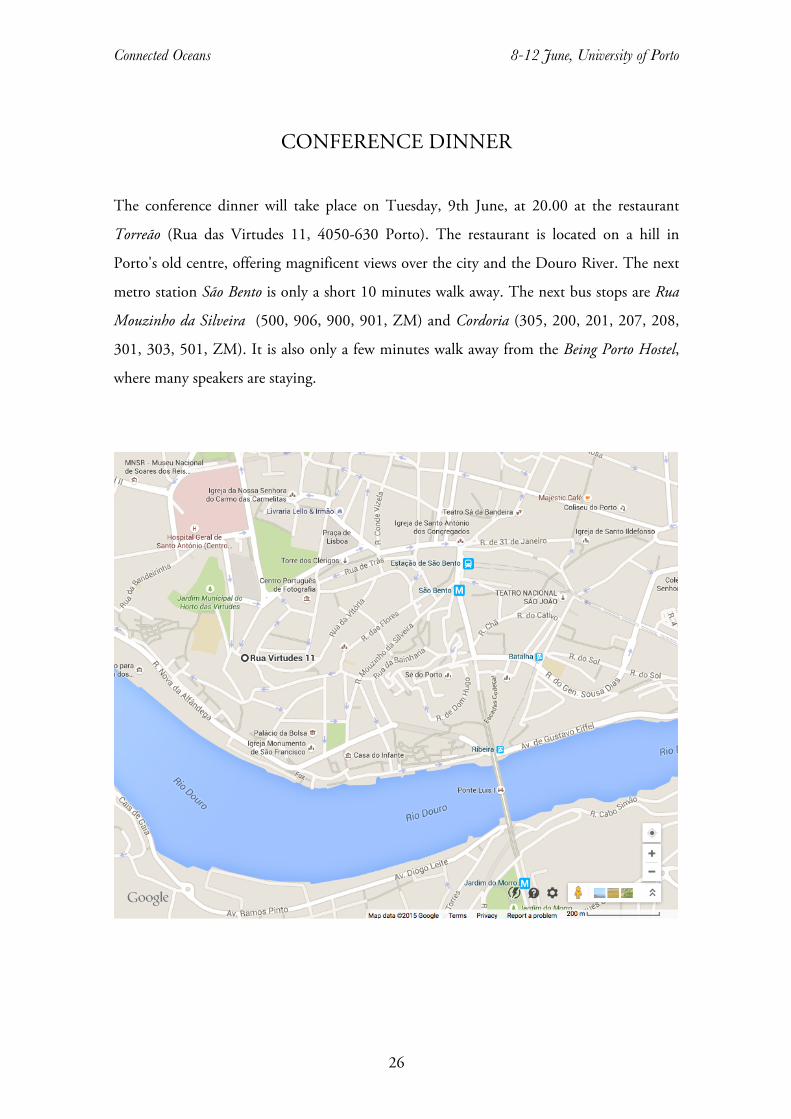
CONFERENCE DINNER
The conference dinner will take place on Tuesday, 9th June, at 20.00 at the restaurant
Torreão (Rua das Virtudes 11, 4050-630 Porto). The restaurant is located on a hill in
Porto's old centre, offering magnificent views over the city and the Douro River. The next
metro station São Bento is only a short 10 minutes walk away. The next bus stops are Rua
Mouzinho da Silveira (500, 906, 900, 901, ZM) and Cordoria (305, 200, 201, 207, 208,
301, 303, 501, ZM). It is also only a few minutes walk away from the Being Porto Hostel,
where many speakers are staying.
Connected Oceans 8-12 June, University of Porto
27
LIST OF PARTICIPANTS
Alexander Kraus Westfälische Wilhelms-Universität
Münster, Germany
Alexandra Maria Rodrigues
Ferreira Lauw
Universidade de Lisbon, Portugal [email protected]
Álvarro Garido Universidate de Coimbra, Portugal [email protected] Amândio Barros CITCEM - School of Education of Porto
Polytechnic
Amélia Polónia CITCEM - University of Porto [email protected]
Ana Catarina Abrantes Garcia Portuguese Centre for Global History [email protected]
Ana Maria Rivera Medina UNED-Madrid [email protected]
Ana Rita Trindade Centro de Ciencias Humanas y Sociales,
CSIC, Madrid, Spain
Ana Sofia Ribeiro CITCEM - University of Porto [email protected]
Bernhard Klein University of Kent [email protected]
Cristina Brito CHAM - Portuguese Centre for Global
History
Daniel Lange Freie Universität Berlin, Germany &
University of Kent, UK
Diane Kirkby La Trobe University, Melbourne, Australia [email protected]
Eberhard Crailsheim FernUniversität in Hagen, Germany eberhard.crailsheim@fernuni-
hagen.de
Felix Schürmann University of Kassel, Germany [email protected]
Filipa Ribeiro da Silva University of Macao [email protected]
Jesus Bohorquez European University Institute, Florence.
Italy
Jo Stanley University of Hull, UK [email protected]
Jorge M. Pacheco CBMA – University of Minho [email protected]
José Luis Gasch Tomás Centro de Ciencias Humanas y Sociales,
CSIC, Madrid, Spain
Connected Oceans 8-12 June, University of Porto
28
Koldo Trapaga Monchet Universidade Nova de Lisboa , Portugal [email protected]
Lars Scholl International Maritime Economic History
Association
Leos Muller Stockholm University [email protected]
Makereta Mua Fiji National University [email protected]
Malcolm Tull Murdoch University [email protected]
Maria Fusaro Exeter University [email protected]
Marta García Garralón UNED - Madrid [email protected]
Michael Pearson University of New South Wales [email protected]
Paul D'Arcy Australian National University [email protected]
Radhika Seshan University of Pune [email protected]
René Taudal Poulsen Copenhagen Business School [email protected]
Richard Unger University of British Columbia [email protected]
Rila Mukherjee University of Hyderabad [email protected]
Roquinaldo Ferreira Brown University [email protected]
Ruthy Gertwagen University of Haifa [email protected]
Xabier Lamikiz University of Basque Country [email protected]
Yvette Santos Universidade Nova de Lisboa, Portugal [email protected]

Connected Oceans 8-12 June, University of Porto
29
GUIDE – HISTORIC CENTRE OF PORTO
World Heritage Walking Tour © Universidade Digital – Gestão de Informação (2013)
Porto Património Mundial (Livro II) The city of Porto lies on uneven ground, on two hills, both overlooking the rio Douro (Douro River). In 1996, the historic centre was classified by UNESCO as World Cultural Heritage. This classification covered the old town, with many medieval and modern buildings, century-old streets, interspersed with archaeological remains from the 4th to the 3rd centuries B.C.
Connected Oceans 8-12 June, University of Porto
30
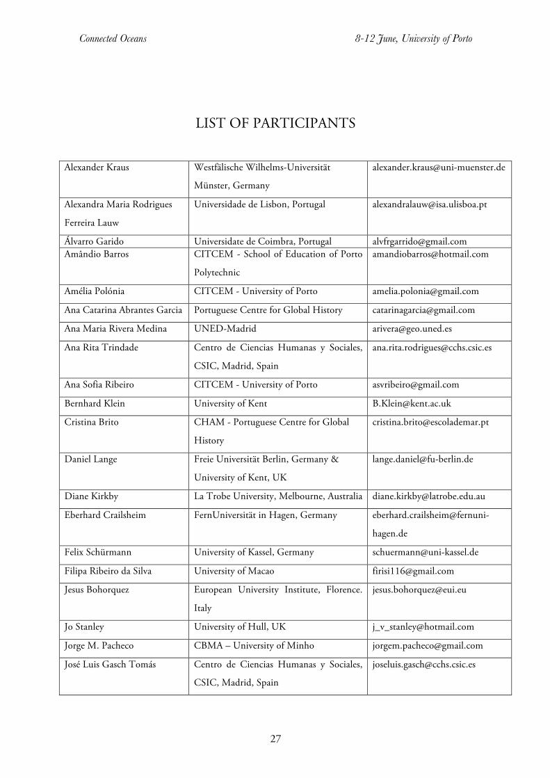
1. Edifício da Reitoria / Rectorate Building (Praça de Gomes Teixeira) The Rectorate building in Praça de Gomes Teixeira (Gomes Teixeira Square) lies in the heart of the historic centre, an urban area with a strong medieval imprint. It is surrounded by remarkable buildings such as the Clérigos monument (national monument), the building of the former Cadeia e Tribunal da Relação do Porto (Tribunal Jail and Court of Appeal of Porto), building of public interest, converted into the Centro Português de Fotografia (Portuguese Centre for Photography) in 1997, the former Hospital da Misericórdia (Misericórdia Hospital), today Hospital de Santo António (Santo António Hospital, national monument), the church of the former Convento dos Carmelitas Descalços (Convent of the Discalced Carmelites) and the Igreja da Venerável Ordem Terceira do Carmo (Church of the Honourable Order of Terceira do Carmo). Built and remodelled over more than one century, the building housed the Royal Academy of Maritime and Trade Affairs (1803-1837) and the Polytechnic Academy of Porto, its successor (1837-1911). The space belonged to the Colégio dos Meninos Órfãos (College of Orphaned Children), which remained there until mid-19th century. The College building resembled a convent, with four wings around a cloister and a church - Igreja de Nossa Senhora da Graça (Church of Nossa Senhora da Graça) - on the northern side. In 1911, with the establishment of the University of Porto, this building housed the Rectorate, the Faculty of Sciences, with its museums and laboratories, and an Engineering School, linked to that Faculty. On 20 April 1974, a devastating fire destroyed part of the construction. This monument is currently home of the Rectorate of the U.Porto and of two museums: the Museum of Natural History and the Science Museum, both established in 1996. 2. Fonte dos Leões / Fountain of Lions (Praça de Gomes Teixeira)
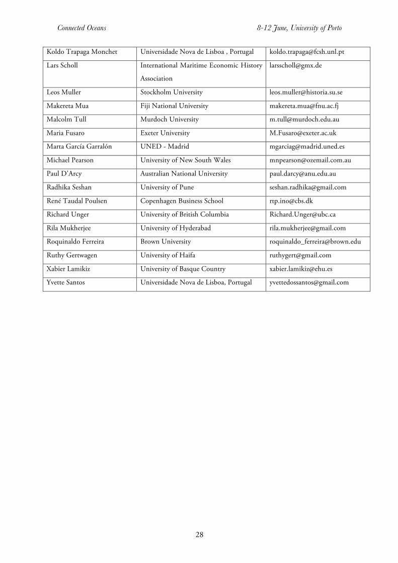
The Fonte dos Leões (Fountain of Lions) is a monumental fountain, 8 metres wide and 6 metres tall, integrated in the water supply system of Porto during the 1880s. It was awarded to the French company “Compagnie Générale des Eaux pour l'Etranger”, also responsible for the construction of this public equipment. Approved in 1885, it came into operation from the next year on. The fountain, besides decorating
the Praça dos Voluntários da Rainha (Voluntários da Rainha Square), provided the required ventilation and oxygenation of the water, and provided relief to pipes under pressure.
Connected Oceans 8-12 June, University of Porto
31
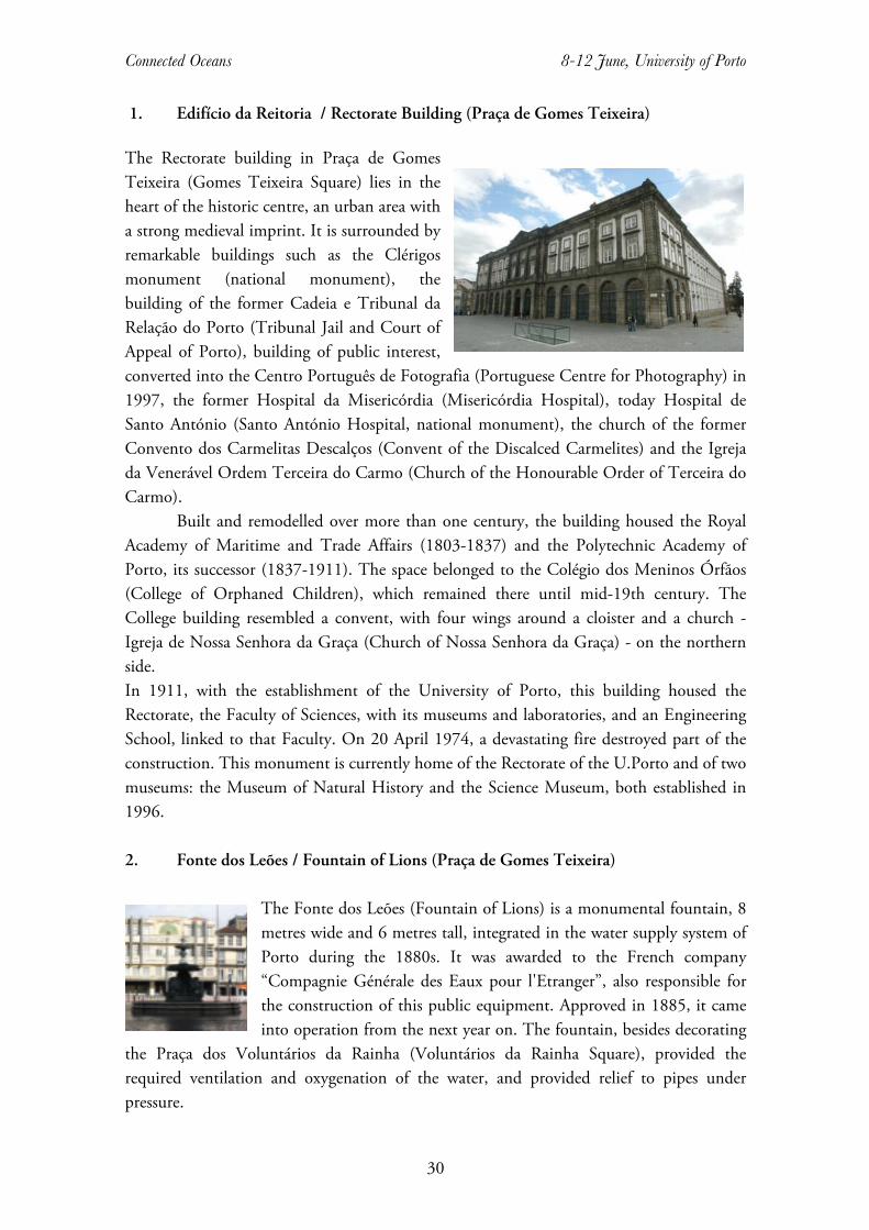
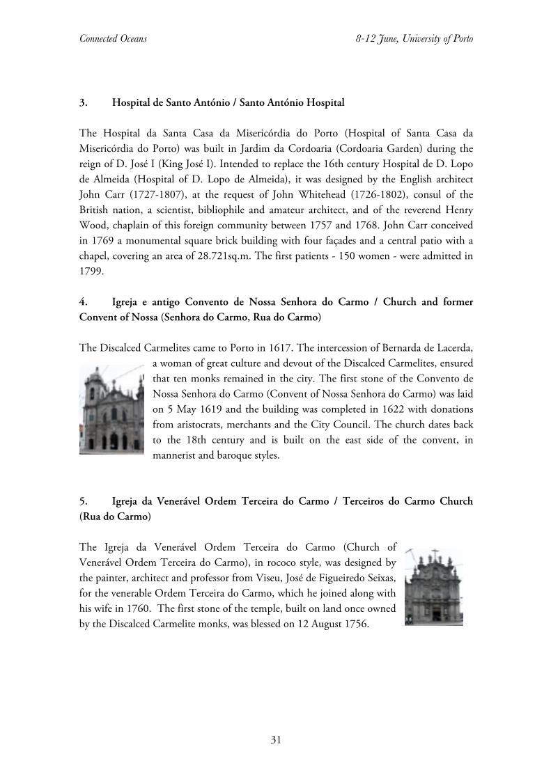
3. Hospital de Santo António / Santo António Hospital The Hospital da Santa Casa da Misericórdia do Porto (Hospital of Santa Casa da Misericórdia do Porto) was built in Jardim da Cordoaria (Cordoaria Garden) during the reign of D. José I (King José I). Intended to replace the 16th century Hospital de D. Lopo de Almeida (Hospital of D. Lopo de Almeida), it was designed by the English architect John Carr (1727-1807), at the request of John Whitehead (1726-1802), consul of the British nation, a scientist, bibliophile and amateur architect, and of the reverend Henry Wood, chaplain of this foreign community between 1757 and 1768. John Carr conceived in 1769 a monumental square brick building with four façades and a central patio with a chapel, covering an area of 28.721sq.m. The first patients - 150 women - were admitted in 1799. 4. Igreja e antigo Convento de Nossa Senhora do Carmo / Church and former Convent of Nossa (Senhora do Carmo, Rua do Carmo) The Discalced Carmelites came to Porto in 1617. The intercession of Bernarda de Lacerda,
a woman of great culture and devout of the Discalced Carmelites, ensured that ten monks remained in the city. The first stone of the Convento de Nossa Senhora do Carmo (Convent of Nossa Senhora do Carmo) was laid on 5 May 1619 and the building was completed in 1622 with donations from aristocrats, merchants and the City Council. The church dates back to the 18th century and is built on the east side of the convent, in mannerist and baroque styles.
5. Igreja da Venerável Ordem Terceira do Carmo / Terceiros do Carmo Church (Rua do Carmo) The Igreja da Venerável Ordem Terceira do Carmo (Church of Venerável Ordem Terceira do Carmo), in rococo style, was designed by the painter, architect and professor from Viseu, José de Figueiredo Seixas, for the venerable Ordem Terceira do Carmo, which he joined along with his wife in 1760. The first stone of the temple, built on land once owned by the Discalced Carmelite monks, was blessed on 12 August 1756.
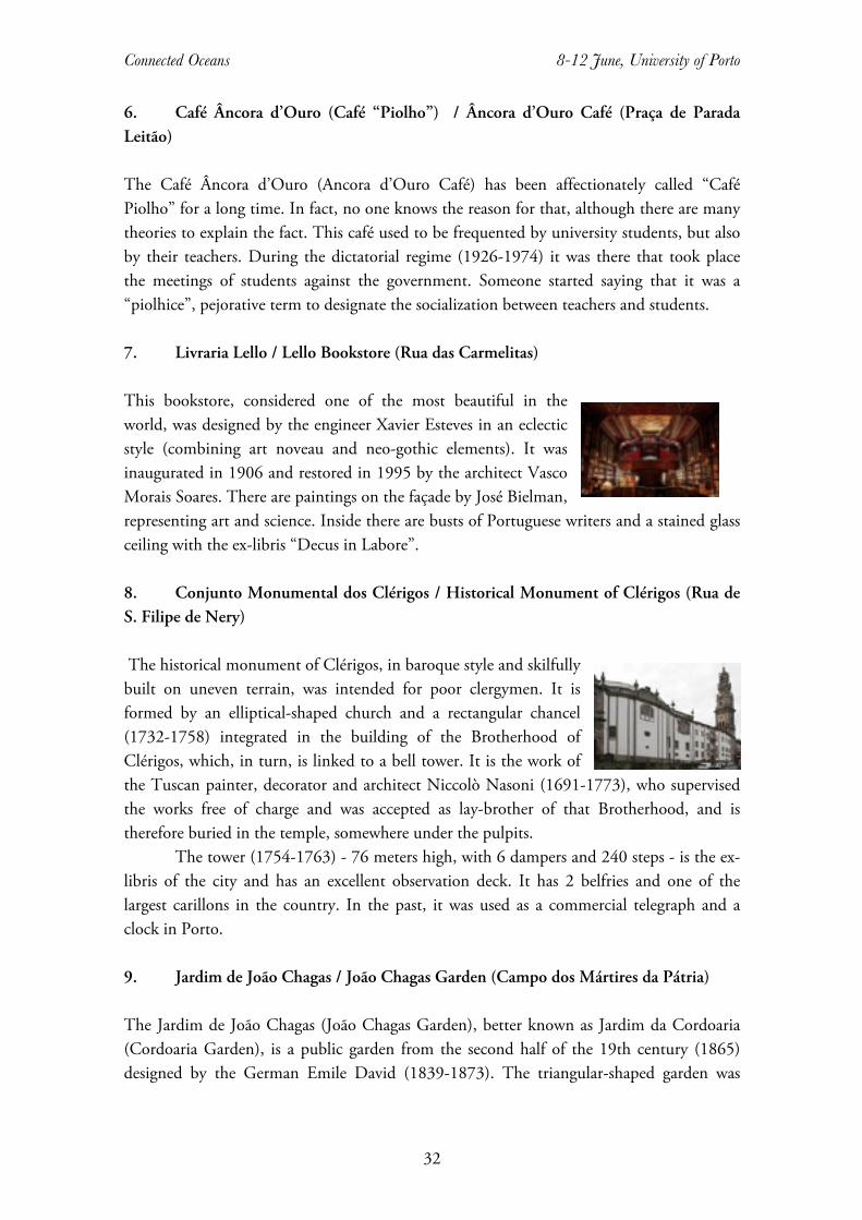
Connected Oceans 8-12 June, University of Porto
32
6. Café Âncora d’Ouro (Café “Piolho”) / Âncora d’Ouro Café (Praça de Parada Leitão) The Café Âncora d’Ouro (Ancora d’Ouro Café) has been affectionately called “Café Piolho” for a long time. In fact, no one knows the reason for that, although there are many theories to explain the fact. This café used to be frequented by university students, but also by their teachers. During the dictatorial regime (1926-1974) it was there that took place the meetings of students against the government. Someone started saying that it was a “piolhice”, pejorative term to designate the socialization between teachers and students. 7. Livraria Lello / Lello Bookstore (Rua das Carmelitas) This bookstore, considered one of the most beautiful in the world, was designed by the engineer Xavier Esteves in an eclectic style (combining art noveau and neo-gothic elements). It was inaugurated in 1906 and restored in 1995 by the architect Vasco Morais Soares. There are paintings on the façade by José Bielman, representing art and science. Inside there are busts of Portuguese writers and a stained glass ceiling with the ex-libris “Decus in Labore”. 8. Conjunto Monumental dos Clérigos / Historical Monument of Clérigos (Rua de S. Filipe de Nery) The historical monument of Clérigos, in baroque style and skilfully built on uneven terrain, was intended for poor clergymen. It is formed by an elliptical-shaped church and a rectangular chancel (1732-1758) integrated in the building of the Brotherhood of Clérigos, which, in turn, is linked to a bell tower. It is the work of the Tuscan painter, decorator and architect Niccolò Nasoni (1691-1773), who supervised the works free of charge and was accepted as lay-brother of that Brotherhood, and is therefore buried in the temple, somewhere under the pulpits. The tower (1754-1763) - 76 meters high, with 6 dampers and 240 steps - is the ex-libris of the city and has an excellent observation deck. It has 2 belfries and one of the largest carillons in the country. In the past, it was used as a commercial telegraph and a clock in Porto. 9. Jardim de João Chagas / João Chagas Garden (Campo dos Mártires da Pátria) The Jardim de João Chagas (João Chagas Garden), better known as Jardim da Cordoaria (Cordoaria Garden), is a public garden from the second half of the 19th century (1865) designed by the German Emile David (1839-1873). The triangular-shaped garden was

Connected Oceans 8-12 June, University of Porto
33
totally renovated under the urban programme "Porto 2001 - European Capital of Culture" and is decorated by sculptures from different periods and styles. 10. Centro Português de Fotografia ( antiga Cadeia e Tribunal da Relação do Porto) / Portuguese Center of Photography (Largo Amor de Perdição) The Cadeia e Tribunal da Relação do Porto (Jail and Court of Appeal of Porto) were
established when the Philip dynasty ruled in Portugal. The initiative of the construction belongs to João de Almada e Melo and took place between 1765 and 1796. This austere and irregular polygonal monument has two noble façades, one facing east, towards Rua de S. Bento da Vitória, which has a fountain and a grander frontage facing
the old Alameda do Olival, now Campo dos Mártires da Pátria (Mártires da Pátria Square). The three-storey building now hosts the Portuguese Center of Photography. 11. Judiaria Nova do Olival / Jewry Nova do Olival (Rua de S. Bento da Vitória / Rua de S. Miguel) In 1386, D. João I (King João I) order the Jews scattered in Porto to move to an enclosed space, justifying the measure with security reasons. The jewish ghetto occupied an area of 30 strips of land for which the jews paid an annual fee of 200 maravedis. It was fenced off and had two doors. Later, the Jews moved to other areas of the city, considered now the first modern urban development in Porto. The population developed around a main axis (north-south), with perpendicular roads stemming from it. It was a town within a town. The edict of expulsion by D. Manuel I (King Manuel I), on December 1496, brought the end of the Jewish quarters and many Jews abandoned the kingdom, while others converted to Christianity. Recently, during some construction works at a house in Rua de S. Miguel, an “ehal” (ark) was found containing the Torah. This object was identified by archaeologists and historians of the Faculty of Arts of the University of Porto as one of the four existing ones in Portugal dating from the late 16th or early 17th centuries. 11.1 Mosteiro de S. Bento da Vitória / S. Bento da Vitória Monastery (Rua de S. Bento da Vitória) The first male Benedictine monastery of Porto and at the same time the last of the old Portuguese congregation was built after the royal authorization granted in 1598, near the gothic wall and the Jewish quarters. The project was designed by Diogo Marques Lucas. The construction and decoration phases lasted from 1604 to early 18th century. The result was a grand mannerist and baroque construction, known for its religious and artistic relevance, but also for the cultural activities held there: singing and music. The monastery served as a hospital during the French Invasions and during the Siege of Porto, when the monks abandoned it permanently. Between 1984-1990, a small community of Benedictine
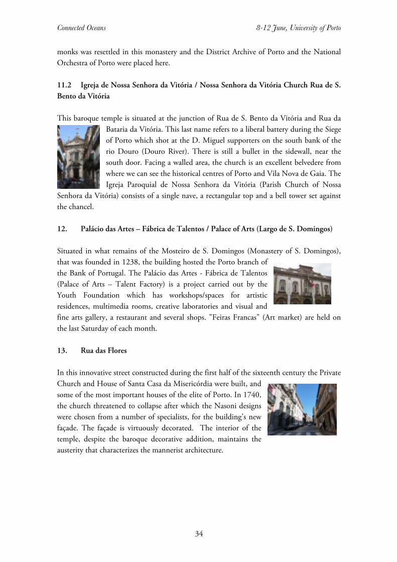
Connected Oceans 8-12 June, University of Porto
34
monks was resettled in this monastery and the District Archive of Porto and the National Orchestra of Porto were placed here. 11.2 Igreja de Nossa Senhora da Vitória / Nossa Senhora da Vitória Church Rua de S. Bento da Vitória This baroque temple is situated at the junction of Rua de S. Bento da Vitória and Rua da
Bataria da Vitória. This last name refers to a liberal battery during the Siege of Porto which shot at the D. Miguel supporters on the south bank of the rio Douro (Douro River). There is still a bullet in the sidewall, near the south door. Facing a walled area, the church is an excellent belvedere from where we can see the historical centres of Porto and Vila Nova de Gaia. The Igreja Paroquial de Nossa Senhora da Vitória (Parish Church of Nossa
Senhora da Vitória) consists of a single nave, a rectangular top and a bell tower set against the chancel. 12. Palácio das Artes – Fábrica de Talentos / Palace of Arts (Largo de S. Domingos) Situated in what remains of the Mosteiro de S. Domingos (Monastery of S. Domingos), that was founded in 1238, the building hosted the Porto branch of the Bank of Portugal. The Palácio das Artes - Fábrica de Talentos (Palace of Arts – Talent Factory) is a project carried out by the Youth Foundation which has workshops/spaces for artistic residences, multimedia rooms, creative laboratories and visual and fine arts gallery, a restaurant and several shops. "Feiras Francas" (Art market) are held on the last Saturday of each month. 13. Rua das Flores In this innovative street constructed during the first half of the sixteenth century the Private Church and House of Santa Casa da Misericórdia were built, and some of the most important houses of the elite of Porto. In 1740, the church threatened to collapse after which the Nasoni designs were chosen from a number of specialists, for the building’s new façade. The façade is virtuously decorated. The interior of the temple, despite the baroque decorative addition, maintains the austerity that characterizes the mannerist architecture.

Connected Oceans 8-12 June, University of Porto
35
14. Estação de S. Bento / S. Bento Railway Station (Praça de Almeida Garrett)
The building was constructed at the beginning of the twentieth century, replacing a benedictine monastery founded in the 16th century - Convento de S. Bento de Avé Maria (Convent of S. Bento de Avé Maria). The vestibule of the station is adorned with 20,000 azulejos (tiles) that were illustrated by the painter Jorge Colaço
(1864- 1942). It is one of the most notable artistic achievements in “azulejos” of the 20th century. The panels depict various moments of the railway and transport history as well as celebrated events from the history of Portugal. 15. Igreja dos Congregados / Congregados Church (Praça de Almeida Garrett) In the Porto architectonic panorama of the late 17th/early 18th century, the House and the Church of Congregação do Oratório occupy an important position. Connected to a mannerist tradition that would remain in the city’s architecture until the early 18th century, the church’s façade presents some decorative schemes of proto-baroque style. 16. Catedral / Cathedral (Terreiro da Sé) This construction, dating from the 12th/13th century, has been enlarged and renewed over the years up to its final setting, in the 20th century, resulting in an idealized reconstitution of the medieval cathedral. Special mention goes to the cloister, from the 14th century, to the capela do Santíssimo Sacramento (Chapel of Santíssimo Sacramento) and its silver altar, from 18th (mannerist), to the 18th century baroque frescos in the main chapel, the galilee and the sacristy, by Nicolau Nasoni and to the sculpture, by Teixeira Lopes (father). 17. Casa da Câmara / Town-hall (Terreiro da Sé) The tower of the townhall, built in the 14th and 15th centuries, was one of the most important buildings in the upper side of the city. The town meetings were held here until the mid-fifteen hundreds. Then, the building began to decay due to having been built on top of the wooden foundations of the old medieval wall. The present building was restored by the architect Fernando Távora. 18. Paço Episcopal / Bishop’s Palace (Terreiro da Sé) After its construction in the 13th century, the Bishop D. Rafael de Mendonça remodelled it sometime after 1770. This palace, the largest in the city, has been ascribed to the architect Nicolau Nasoni.

Connected Oceans 8-12 June, University of Porto
36
19. Igreja de S. Lourenço / S. Lourenço Church (Largo do Colégio) The architectonic whole that comprises the Igreja de S. Lourenço (Church of S. Lourenço) was conceived as a College of the Society of Jesus in the city of Porto. The foundation stone was laid on 20 August 1573 and the Jesuits settled there until their expulsion in 1759. Until 1832, the Discalced Hermits of St. Augustine used the construction as a monastic space. Soon afterwards, it was acquired by the Porto's Diocese for the establishment of the Diocesan Seminary. This usufructuary keeps a museum of Sacred Art and Archaeology on premises that used to belong to the Jesuit College. 20. Feitoria Inglesa / British Factory House (Rua do Infante D. Henrique)
Built between 1785 and 1790, following a plan by the Consul John Whitehead, it was meant to be used as a meeting place for the English businessmen living in Porto. On the main façade, facing Rua do Infante D. Henrique, the ground floor is made up of seven arches that give access to the colonnaded gallery. In contrast with
this, the main floor is formed of high openings with verandas and pediments. A balustrade attic tops the building. 21. Praça da Ribeira / Ribeira Square A square of medieval origin formerly separated from the river by part of the gothic wall, transformed in the 18th century by João de Almada e Melo and John Whitehead, decorated by two fountains with statues representing St. John by the sculpture João Cutileiro and a Cube by the artist José Rodrigues. Between the square and the bridge an interesting arcade was developed. 22. Ponte Luís I / Luís I Bridge In the 19th century, the government determined the opening of the competition for the construction of a metal bridge over the rio Douro (Douro River) for the replacement of the suspended bridge. The winning proposal was the project of the engineer Teófilo Seyrig, from the Belgian company Societé de Willebroeck. Teófilo Seyrig had already been the author of the plan and head of the team in the project of the Ponte D. Maria Pia (Queen Maria Pia Bridge) as Eiffel’s associate. The construction works began in 1881 and the inauguration occurred on 31 October 1886. The arch comprises 172m of cord and is 44.6m tall.
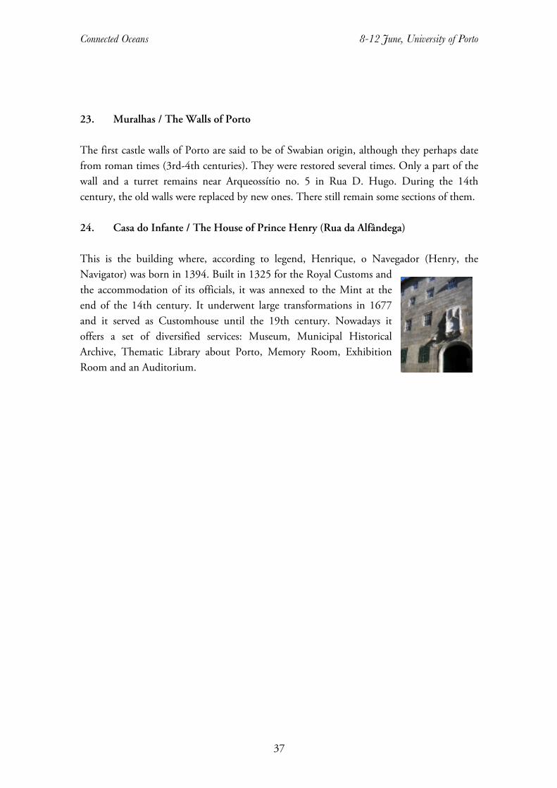
Connected Oceans 8-12 June, University of Porto
37
23. Muralhas / The Walls of Porto The first castle walls of Porto are said to be of Swabian origin, although they perhaps date from roman times (3rd-4th centuries). They were restored several times. Only a part of the wall and a turret remains near Arqueossítio no. 5 in Rua D. Hugo. During the 14th century, the old walls were replaced by new ones. There still remain some sections of them. 24. Casa do Infante / The House of Prince Henry (Rua da Alfândega) This is the building where, according to legend, Henrique, o Navegador (Henry, the Navigator) was born in 1394. Built in 1325 for the Royal Customs and the accommodation of its officials, it was annexed to the Mint at the end of the 14th century. It underwent large transformations in 1677 and it served as Customhouse until the 19th century. Nowadays it offers a set of diversified services: Museum, Municipal Historical Archive, Thematic Library about Porto, Memory Room, Exhibition Room and an Auditorium.
Connected Oceans 8-12 June, University of Porto
38
FORTHCOMING EVENTS
7th IMEHA International Congress of Maritime History “Old Worlds, New Worlds? Emerging Themes in Maritime History”
27 June – 1 July 2016 Murdoch University, Perth, Western Australia
The Organising Committee for the 7th IMEHA International Congress of Maritime History (ICMH7) invite proposals for panels and papers to be presented at its 2016 Congress. The Congress will be hosted by Murdoch University, the Western Australian Maritime Museum, the Australian Association for Maritime History and the International Commission for Maritime History and held at Murdoch University, Perth Australia. The theme for the conference is “Old Worlds, New Worlds? Emerging themes in maritime history”. ICMH7 has adopted a broad concept of maritime history, considering all interdisciplinary fields, covering all historical periods and various aspects of humankind’s relationship with the sea from ancient times to the present. Australia is an island nation. According to Frank Broeze, “Australian history and Australian society have been shaped by the dynamic interaction of land, cities and the sea.” So Perth, located on the edge of the Indian Ocean, is a superb location for a conference on maritime history. Papers will be welcome on a wide range of research areas reflecting people and their activities and interest in, on, around and under the waters of the world.
Deadline: 31 October 2015
Participants are invited to submit a short proposal in English (maximum 350 words) indicating the scope of their intended panel or paper, together with a short biographical note. Please email your abstract to [email protected] Papers from the Congress will be considered for publication by the International Maritime Economic History Association in the International Journal of Maritime History or in the accompanying series Research in Maritime History.
For further details see www.icmh7.com.au

We would like to thank our generous sponsors:
ORGANISED BY
AMÉLIA POLÓNIA, U. PORTO / CITCEM
ÁLVARO GARRIDO, U. COIMBRA / CEIS20
AMÂNDIO BARROS, IPP – ESE / CITCEM
ANA SOFIA RIBEIRO, CIDHEUS / CITCEM
DANIEL LANGE, FU BERLIN / U. KENT
WITH THE HELP OF: FABIANO BRACHT, GISELE CONCEIÇÃO, MONIQUE PALMA, SUSANA
BARROS AND MARLENE CRUZ