nevada archaeologist volume 9 1991nvarch.org/amcs/wp-content/uploads/2017/09/1991-volume-9...nevada...
TRANSCRIPT
1::i::iN 1041-4479
NEVADA ARCHAEOLOGIST
VOLUME 9 1991
A SPECIAL PRINTING IN CONJUNCTION WITH
ADVENTURES IN THE PAST,
A GREAT BASIN TRIBUTE
NEVADA ARCHAEOLOGICAL ASSOCIATION
NEVADA ARCHAEOLOGICAL ASSOCIATION
ThE dESiGN foR m. NAA Ioqo WAS ildAplId by Robmr EIsrON roo.. A GAAfidd FIAT P£TROGlypk
ThE NEVAdA ARcl...okx;icAI AssociAriON is AN iNcoRpoI.md, NON
poofir OR<;ANiwiON REGismlEd iN rhE SrArE 01 NEv.w., ANd HAs NO pAid 'MJ>I<¥'''' M,MbE..J.ip is opEN ro ANY pER<ON 'iiGr<iNG rilE NAA coo. 01 Emics '"'" is iNTIREsrrd .. ARCI.uol<x;y ANd ir; AlliEd sciENCB, ANd iN m, COI'NJlVATiON 01 ARCiwolo<;ic.t RE'iOUlCf'i. RR,Usr; foR MFMbE..J.ip ANd d .... shoold bE """ ro rhE TRfA'iURfR '""'" AddRf'" is showN bElow. MAkE AD c1ifds ANd ""''l' ORdERS pAyAhl£ ro m. NEV.d. AIlcIwoolo<;ic.tA'iSOCiArioN. M,,",,,..J.ip CARds wiU bE is'iUEd ON mE pAyMENT 01 dues ANd mE REaipT 01 A siGN,d CodE 01 Emics. AcrivF MEMbERS REaM A sthsaIipriON TO rhE NEV.d. ARdwoloqisT ANd m. NAA NEWS!mER. SthicRipriON is by ME"bE..J.ip ONly; """""R, r.dividuAl OR Iw::k is5UEs MAy bE pt>IICi<ASFd "pARAlIly.
TR£ASURER
Ediroo
HtIEN Mom'NSON ~9 m EI CAM"" Ro.o<l lAs VEGA', NEv.d. 8910 ~
RAMONA RENO P.O. Box 10~ SiMI< Chy, NEVAdA 89428
DiANE JENNiNGs 2 n ~ PtnN.w [)oM
RENO, NEVAdA 89 ~m
DR. G..oy HAYNES DEpARTM'NT 01 ANThROpOloqy UNMRShy 01 NEVAdA, RENO RENO, NEVAdA 89~~7
DuES
876-6944
847-0H4
747-4808
784.-6704
SrudENT ................................................. $ ~.OO
AcrM ...................................................... 10.00 AcrivF FAMily ............................................. 12.00 SuppoRTiNG .•••••••.•••••.•.....••••••.•••••...•..•..••.•• 2 ~.OO SpoNsoR •....•..••.•••••••••••.••..•..•••..•.••••••....•.• ~O.OO PATRON .................................................. 100.00
All ",,",,,..J.ip CAII<jORiES RECfM A sOOsrnipTiON ro rhE NEVAliA ARc!..,okx;isr, rhE jouRNAl of "" AssociATioN.
80AAd of DiR£OOflS
ThE BoARd 01 DiREcrORS 01 mE NEVAdA AAclwolo<;icAl AssociAliON is ,IrCTEd ANNuAlly by m, ", .. bE..J.ip. BoARd MEMbERS "RIlE ONE
\'fAR IfRMS. ThE Bo.Ad 01 DiRECTORS EIECrs "" Aw,,:iAlioN's oIfiaRS roo.. ""'" ",MbE", ,I£wd 10 mE BoAAd. ThE BoAAd of DiRECrORS Also AppOiNTS mE Ediroo of "" NEVAdA ARcOOoIoqisr foR A TERM NOt TO EXCEEd mE Yf~ ThE BoARd of DiRECTORS
Mffl"'i THREE: liMfS ... YEAR, 0NCf ~ M SOI..I1k:RN pARJ of rlif STAIF ir.. NovEMbER, 0NCf iN m, NORmERN pART 01 "" SrAII .. MARCh ANd ONU .. OcrobER iowEdiAlIly pRioR TO "" ANNUAl MmiN<;.
MEMbER PAT IlARkER NEVAd.. ARcOOoIo<;icAl AssociAriON
MEMbER DAUINA !'fARis LKoIN ColMy o,ApIH!, N.AA
MEMbER Bob EIsrON NE"Ad.. Andwolo<;icAl AssociAriON
MEMbER DiANE JE .... i"", o,....cliill eo....ry o,ApIFR, N.AA
MEMbER DAvid JohNsON NEvAd.. ARcOOoIoqicAl AssociAriON
MEMbER DAN K.o.ffm o,....cliill ColMy o,AplfR, N.A.A.
MEMbER HElEN MORTENSON
ARcOOo-NEVAdA SociffY
MEMbER SusAN MlIllpIry And..""NEVMA SociEry
fuTuRE !w.<s
MANUSCllip" srn..irfEd foR publiCATioN iN "" NEvAdA ARc!..fO/oq5T shoold follow mE sryIE GUid, 01 "" JANUARY 1979 isSUE 01 AorERiCAN ANri9viry. MANUSCRip" should bE rypEd ANd doulli SpAUd ~, iNcludiNG NOlES ANd biblioq<Aphy, ANd iUusmAriONs shoold bE CAME .... REAdy wim A CApTioN rypEd ON A "pARAlI shEET 01 pApER, Also dotlrk"I"'CEd. su"" issiONs roo.. A\OCArioNAl AS UlEU AS pROfBsiON.ts _ ENCO<JRAGHI.
MAN=Rip" should bE srn..rn ro NEVAliA ARclwolo<;i>f, do DAvid S. JoIr.soo, Posr OfflU Box 704, CARSON Chy, NEVAdA 89702"()704.

Nevada Archaeologist Volume 9 1991
EDITOR'S CORNER
This issue of the Nevada Archaeologist was printed by the U. S. Bureau of Land Management, Nevada State Office in Reno, Nevada. Our thanks to Dr. Pat Barker for arranging this.
This issue provides another varied set of offerings that we hope prove of interest to the members of the Nevada Archaeological Association. Four articles deal with prehistoric sites, material culture, and paleoenvironments; two other articles discuss historic-period sites in Nevada.
The final paper in this issue is a valuable bibliography of all articles published over the years in the Nevada Archaeologist. We have Mona Reno to thank for this compendium, which is arranged alphabetically by author.
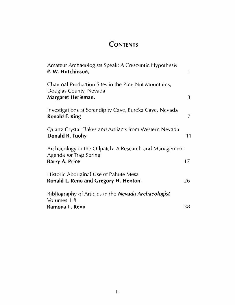
CONTENTS
Amateur Archaeologists Speak: A Crescentic Hypothesis P. W. Hutchinson. 1
Charcoal Production Sites in the Pine Nut Mountains, Douglas County, Nevada Margaret Herleman. 3
Investigations at Serendipity Cave, Eureka Cave, Nevada Ronald F. King 7
Quartz Crystal Flakes and Artifacts from Western Nevada Donald R. Tuohy 11
Archaeology in the Oilpatch: A Research and Management Agenda for Trap Spring Barry A. Price 1 7
Historic Aboriginal Use of Pahute Mesa Ronald L. Reno and Gregory H. Henton. 26
Bibliography of Articles in the Nevada Archaeologist Volumes 1-8 Ramona L. Reno
II
38
AMATEURARcHAEOLOGISfS SPEAK: A CRESCENTIC HYPOTHESIS
P. W. Hutchinson Reno, Nevada Nevada Archaeologist Volume 9 1991
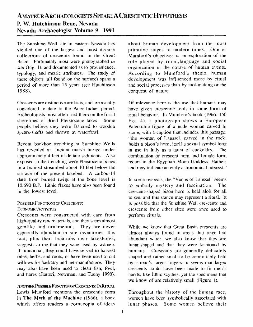
The Sunshine Well site in eastern Nevada has yielded one of the largest and most diverse collections of crescents found in the Great Basin. Fortunately most were photographed in situ (Fig. I), and documented as to provenience, typology, and metric attributes. The study of these objects (all found on the surface) spans a period of more than 15 years (see Hutchinson 1988).
Crescents are distinctive artifacts, and are usually considered to date to the Paleo-Indian period. Archeologists most often find them on the fossil shorelines of dried Pleistocene lakes. Some people believe they were fastened to wooden spears-shafts and thrown at waterfowl.
Recent backhoe trenching at Sunshine Wells has revealed an ancient marsh buried under approximately 4 feet of deltaic sediments. Also exposed in the trenching were Pleistocene bones in a braided streambed about 10 feet below the surface of the present lakebed. A carbon-14 date from burned twi gs at the bone level is 10,690 B.P. Lithic flakes have also been found in the lowest level.
POSSlBLEFuNCTIONS OF CRESCENTS:
ECONOMIC AcnvmES
Crescents were constructed with care from high-quality raw materials, and they seem almost gemlike and ornamental. They are never especially abundant in site inventories; this fact, plus their locations near lakeshores, suggests to me that they were used by women. If functional, they could have served to harvest tules, herbs, and roots, or have been used to cut willows for basketry and net-manufacture. They may also have been used to clean fish, fowl, and hares (Hattori, Newman, and Tuohy 1990).
ANoTIIEl!. Possmu: FuNCIlON OFCIlli."iCENTS: L" RnuAL Lewis Mumford mentions the crescentic form in The Myth of the Machine (1966), a book which offers readers a cornucopia of ideas
about human development from the most primitive stages to modern times. One of Mumford's objectives is an exploration of the role played by ritual,language and social organization in the course of human events. According to Mumford's thesis, human development was influenced more by ritual and social processes than by tool-making or the conquest of nature.
Of relevance here is the use that humans may have given crescentic tools in some form of ritual behavior. In Mumford's book (1966: 150 Fig. 4), a photograph shows a European Paleolithic figure of a nude woman carved in stone, with a caption that includes this passage: "the woman of Laussel, carved in the rock, holds a bison's horn, itself a sexual symbol long in use in Italy as a taunt of cuckoldry. The combination of crescent horn and female form recurs in the Egyptian Moon Goddess, Hather; and may indicate an early astronomical interest."
In some respects, the "Venus of Laussel" seems to embody mystery and fascination. The crescent -shaped bison horn is held aloft for all to see, and this stance may represent a ritual. It is possible that the Sunshine Well crescents and crescents from other sites were once used to perform rituals.
While we know that Great Basin crescents are almost always found in areas that once had abundant water, we also know that they are lunar-shaped and that they were fashioned by humans. Crescents are generally delicately shaped and rather small to be comfortably held by a man's larger fingers; it seems that larger crescents could have been made to fit men's hands, like lithic scythes, yet the specimens that we know of are relatively small (Figure I).
Throughout the history of the human race, women have been symbolically associated with lunar phases. Some women believe their
menstrual cycles are controlled by phases ofthe moon. I propose that crescents were possiblyused by women at Great Basin lakeshores toperform some sort of ritual.
More scientific evidence is required todemonstrate the manner in which crescentswere used, and their true age, but these thoughtsmay be of some interest in our search forinsights about the prehistoric life of Great Basinpeoples.
Hattori, E. M., M. Newman, and D. Tuohy. 1990. Bloodresidue analysis of flaked stone crescents from the northernGreat Basin. Paper presented at the 22nd Great BasinAnthropological Conference, Reno.
Hutchinson, P. W. 1988. The prehistoric dwellers atLake Hubbs. In Early human occupation in far westernNorth America: the Clo vis-Archaic interface (J.A. WiUig,C. M. Aikens, and J.L. Pagan, eds.), pp. 303-318. NevadaState Museum Anthropological Papers Number 21.
Mumford, Lewis. 1966. The Myth of the Machine:Techniques and Human Development. Harcourt, Braceand World, N.Y.
Fig. 1: Crescent found at Sunshine Well, site SW-1.
2
CHARCOAL PRODUCTION SITES IN THE PINE NUT MOUNTAINS, DOUGLAS COUNTY, NEVADA
Margaret Herleman , Carson City, Nevada Nevada Archaeologist Volume 9 1991
INTRODUCTION
In this paper I describe several charcoal production sites in western Nevada, located on the
The ground is steep, cut with many canyons, and has few level surfaces. There are many large circular meilerplatforms (see below) to be seen from the ridges in the area. Unfortunately many sites have been destroyed, because the BLM has allowed wood-cutting and the use of 4-wheel drive vehicles has been devastating on the slopes.
BACKGROUND: CHARCOAL PRODUCTION
Terms used to describe the type of charcoalproduCing facilities that I discuss here vary from "pit" to "rick" to "meiler." These types of facilities have been documented since 5200 B.P. when the ancient Egyptians used charcoal to reduce copper ores. The method is still used in many regions of the world, including the Mediterranean, India, China, and parts of Japan.
Making charcoal from wood is essentially the process of partially burning wood with limited oxygen. Enough air is admitted to burn the gasses, but not enough to burn the carbon residue, which is charcoal. In constructing a meiler of the type that appears in the Pine Nut Mountains, a central chimney is made, either by driving three or four poles into the ground and keeping them separated, or by building a triangular or square crib of wood in the center. Four-foot lengths of wood, in this case pinon, are stacked around the central chimney and leaned slightly towards the center. Thechimney is packed with dry grass, twigs, or other combustibles used to start the fire. The entire mound, except for the central opening at top, is covered with three to five inches of grass and pine needles. This fine organic material is
3
topped with two to five inches of wet clay soil. Care must be taken to make the soil layer as airtight as possible. Small openings are left around the bottom of the mound to furnish draft for the meiler (see Zeier 1987 for more details and bibliography).
Management of the burning process requires considerable skill. The meiler is lit through the central chimney, and after the fire is well started the draft is reduced by closing the top and bottom openings. Burningconditions are judged by the color of the smoke, and wet clay is kept on hand to repair cracks which may appear in the covering. The meiler must be watched day and night. Aone-hundred-cord meilerprobably required three weeks to a month to burn. Too rapid burning results in a pi Ie of ashes, whereas too little air allows a buildup of gasses, leading to an explOSion of the entire meiler and a total loss, plus the added danger of starting a fire that could destroy surrounding trees, other meilers, and the wood-burners' camp. The Chinese used an ancient method to control access of air from the bottom holes: flattened cans were rolled into a funnel shape, and the small ends stuck into the meiler's bottom airflow holes. These objects have been found in Chinese camps in the area, with the small ends showing burning. In the literature these objects are called "tuyeres."
When it is judged that the wood has been completely burned, all openings in the meiler are closed. The cooling process requires a week or ten days for a medium-sized meiler, which would be perhaps 20 to 25 feet in diameter, holding approximately 35 cords of wood and expected to burn five to seven days. It was thus more efficient to burn three or more meilers atthe same time, since they all required constanttending. On this basis, one ortwo men can be on continual watch, tending several meilers at the same time.
Opening the cooled meiler is a dangerous operation, best carried out in calm winds. Unless the mass is completely cold, the meiler is always in jeopardy of igniting the charcoal during the opening process. A meiler produces from 2,800 to 3,000 bushels of charcoal out of 100 cords of wood. Therefore rough Iy 10 to 100 acres of woodland has to be cut for each large meiler. A yield of 300 bushels of charcoal may have been a reasonable average for the period under discussion here. See Zeier (1987) for an illustrated review of the process, supplementary information, and references.
THE SITES
The primary site described here, BLM # CR NV-03-3140, was first brought to my attention by Brian Hatoff and Tom Abbot of the Carson City BLM office. My partner Tom Condon had noted the size and frequency of the circles and asked me for identification. Before his death, Tom had located more than 2,400 circles in the Pine Nut Mountains around Carson City, Minden, and Gardnerville. We selected this site as a type site, since it was near an old wagon road, had many meilers nearby, and appeared to have been used for some time. It was, however, heavily vandal ized, possibly by bottle hunters.
The site is at 6,400 feet above sea level (asl), surrounded by pinon and juniper secondary growth, at least that which has not been "wooded." Old stumps in the area show axecutmarks. Many stumps are three orfour times the size of living trees. Around two large meilers, each over 20 feet in diameter, were several rock structures. One may have been a small oven or forge, others perhaps windbreaks around a sleeping/cooking area. There were also three rock walls built into a hill, apparently for a meiler. On the ground were many glass sherds and small fresh pits, probably dug by bottle-hunters. Many identifiable cans and
4
pieces of hand-forged iron and cut lumber were seen. Identified were horseshoes, hames, bellows, wagon parts, cut nails, skids, stoves, axe heads, barrel parts, glass and pottery. A pit had been dug into a side hill and lined with stone, which may have been a spring improvement.
Fifteen meilers were found up the canyon, leading us to hypothesize that this may have been a semi-permanent sleeping and staging area. The cans had soldered seams and matchstick bottoms, bearing out the ti me frame postulated to be in the early to middle 1860s. A coffee pot minus a spout was found, as well as many larger containers appearing to have been modified as cooking containers and sieves. We could not decipher many of the embossed titles on the cans, due to crushing and rusting. Considerable earth movement had disturbed much of the "camp" area.
The glass sherds were widely scattered, and included much purple glass. Most of the identifiable containers were of the expected whiskey, bitters, medicine, and condiment groups, many with pontil marks and all with applied lips. Those which could be dated fell into the same time frame as the cans.
The ceramic fragments indicated to us that this was not a Chinese assemblage, since they were all of American or British make. Several came from octagonal vessels, including even a portion of a covered dish, an unexpectedlyfancy article to find in such a rough camp.
About 1/3 mile up the canyon was a site we called the "blow-out," containing the remains of a mei ler some 40 feet in diameter surrounded by chunks of slag that bore the imprint of logs. Alsofound were large, partially burned portions of cut wood, about 8 inches square, and a heavy concentration of charcoal, some 8 to 12
inches thick. We deduced that this meiler had burned out of control, perhaps exploding from improperly controlled gas build-up, ejecting billets through the cover. The slag, part of it glazed, appeared to be the result of the clay covering being baked by the heat of the interior fire.
A short distance up the road, at an elevation of about 6500 feet asl, a larger collection of structures and more burned-out meilers were found in a nearby drainage. These structures appear to have been larger and more substantial than the lower structures, and whole walls had fallen in. A fire probably had burned in this area, perhaps when the meilers in the draw went out of control. The site contains a massive amount of wooden and metal wagon parts, covering more than an acre. A large forge was here, and the largest collection of burned glass was seen in this area. All glass (other than modern bottles discarded in the sagebrush) had been burned. Since this is only a short distance below a saddleback that has an old wagon road, it may be inferred that it was a stop for haulers going to other parts of the Pine Nut Mountains south of Sunrise Pass, and probably boasted a bar/saloon. The presence of a bar and haulage stopover would account for the large quantity of burned whiskey-bottle glass and the wagon parts, which appear to have come from several different types and sizes of wagons. Some of the buildings had been made of roughcut lumber, and burned. Lumber was quite expensive in the mid-1860s, the period when we think the site was occupied (based on the bottles in the sites), and its presence supports our view that the site was a settled camp.
Section 35 contains a much larger, more permanent site, with as many as 20 structures in it. The site is located in a fairly large, flat area, with hills and ravines all around it. Many structures showed damage from burning, and
5
were surrounded by mei lers that are smaller than those described above. The largest mei lers are found near the steeper hills, where the trees could have been skidded with less labor.
At least one structure had Chinese artifacts, although most did not. A scenario may be proposed that Chinese people moved into the area after it was abandoned by the original settlers. It may also be proposed that the cabin with the Chinese artifacts was used at the same time as the others were; this cabin is rather isolated from the others, and more thoroughly burned than the other structures. If a later habitation, perhaps the Chinese were gleaning some of the cut-over hills and making smaller amounts of charcoal.
A major inquiry was made concerning the use of all this charcoal, because the Comstock ores did not require smelting. Ray Whalmsley of Dayton told me about his great-grandfather's activities in the Como area. He ran crews of 25 to 30 Chinese wood-cutters and burners from about 1859 to 1901, and he also maintained a base camp in the Burbank Springs area and China Camp, near the area reported here. He contracted with the mills and mines in Virginia City to furnish charcoal for blacksmith shops and the several foundries, which meant many hundreds of bushels of charcoal.
One of the outstanding research questions in this study, undertaken in 1982 and 1983 for a class in Industrial Archeology at the University of Nevada, Reno, was to understand the reason for all this charcoal production in an area which did not have recalcitrant ores requiring smelting, such as were present in the eastern part of the state. No extant permanent kilns can befound in the Pine Nut Mountains, aside from the small ones used for lime extraction. I submit that the size of the meilers rules out a Native American origin for the burning of pine nuts, or
for cooking, or even for ceremonial functions. Herders of sheep and cattle wou Id have had no use for such large circles, most being 20-40 feet in diameter. Each site showed that a consistent effort had been made to level the bases, sometimes by building up with stones and by infilling with dirt. All sites are surrounded by quite large tree stumps, which were cut with axes, and all circles showed signs of charcoal remains. No excavations were attempted, and I therefore cannot answer whether any mei lers were used more than once. I have not resolved the ethnic background of the non-Chinese
6
workmen, whether Italian, German, Basque or whatever, in spite of considerable research in census and legal records, as well as in community memories. As usual, there seems to be as many questions as there are answers.
REfERENCE CITED
Zeier, C. 1987. Historic charcoal production near Eureka, Nevada: an archaeological perspective. Historical Archaeology 21(1):81-101.
INVESTIGATIONS AT SERENDIPITY CAVE, EUREKA COUNTY, NEVADA
Ronald f. King, University of Nevada, Reno Nevada Archaeologist Volume 9 1991
Serendipity is a small limestone solution cave overlooking Roberts Creek in Eureka County, Nevada. The cave was first reported in pristine condition in 1988 (Price and King 1988). Faunal remains, including small and large mammal bones, and indurated wood rat middens were noted at that time and the site was recognized as a potentially significant paleoenvironmental and paleontological resource. Two rock alignments observed on the surface suggested buried archeological materials were likely present (Fig. 1), but no flakes or culturally modified bones were found. The cave was tested in August, 1990, as part of a paleoenvironmental and archeological research program conducted by the Universityof Nevada, Reno and the Desert Research Institute.
The results of this investigation suggest the deposits of Serendipity Cave may provide answers to a variety of important research questions, both paleoenvironmental and archeological. Stratigraphically, the most significant finding was the location of a layer of volcanic ash (Fig. 2). Samples of this tephra were examined by Jonathan O. Davis of the Desert Research Institute and identified as originating from the Mt. Mazama eruption, ca. 6,900 B.P. The Mazama tephra occurred at 46 centimeters below surface and measured 2-4 centimeters thick. Archeological materials were encountered above and below this stratum.
Those archeological materials that post-date the Mazama ash included a few tertiary chert flakes. In addition, a hearth feature was encountered in the first 15 centimeters below the surface and a circular cultural pit was observed penetrating the ash layer to a depth of 62 centimeters (Fig. 2, feature 2). As nothing was recovered from the bottom ofthis pit, it was interpreted as a reclaimed cache post-dating the Mazama tephra. The contact between this pit and inferior deposits was distinct and
7
exhibited a discolored edge suggestingdecayed plant material, possibly the remains of a lining.
Obsidian, a material exotic to the area, was recovered below the Mazama layer. The one obsidian piece was bifacially flaked and recovered from the 70-80 centimeter level, which was almost completely sealed by a large piece of roof-fall. This rock had to be removed with the aid of a pry-bar and, once removed, apparent fire blackening was observed on the bottom side. As no other pre-Mazama cultural deposits have been reported from a stratigraphic context within the central Great Basin (see Thomas 1982), this discovery has great significance to prehistoric reconstructions of the region. Also, below the ash layer there appeared to be a change in the faunal materials recovered, with large mammals well represented by long bone fragments. While the evaluation of the faunal assemblage must await detailed analysis, it is clear thatthe pre-Mazama materials provide a sample of early Holocene fauna and represent a significant paleontological resource. The roof-fall content of these lower levels made excavation difficult and at a depth of one meter the rock content was so great that, without further expanding the excavation unit, little could be done to proceed. It should be noted that, while no artifactual materials were recovered in the last two excavation levels, there was little fall off in the amount of bone encountered.
A single 50 by 100 centimeter stratigraphie probe was placed outside the cave, adjacent to the drip lineandextendingdown slope. Because of time constraints this unit was abandoned at a depth of 67 centimeters when large rocks blocked excavation. Noarcheological materials were recovered. Four strata were identified in the profile of this unit. The first two of these deposits were root-filled soils typical of Ahorizon development, with a high organic
content and becoming lighter in color with increasing depth. Additionally, these two layers exhibited slopes comparable with the modern land surface, which slopes steeply. The third and fourth layers, however, were nearly horizontal, exhibited little organic content, and were typified by fine grained silts and large amounts of roof-fall. These last two layers appeared to have been laid down in the interior of the original cave, which has receded since their deposition. Consequently, it appears that intact cave deposits exist outside the modern cave and further testing of this area would prove valuable in interpreting the cave's history. However, very little bone was recovered in the 1/8th inch screen and preservation outside the cave is not as extensive as inside. This differential preservation is probably linked to the constant wetness of the cave's interior deposits as opposed to the fluctuating wet and dry conditions outside.
Also examined during this investigation were two rock structures within the cave. The first of these was located within an alcove portion of the cave and consisted of a low rock wall about 1.5 meters long. Another larger feature was noted along the rear-most portion of the cave where large pieces of roof-fall had been arranged into a semi-circle. The area behind these rocks was a mass of wood-rat-collected debris; overhanging the mass was a large indurated midden. Both features remain untested. While the possibil ity that these rock features are historic in age currently cannot be ruled out, no historic materials have been encountered in the cave vicinity and it is difficult to imagine how such a large wood-rat collection as exists behind the second feature could have accumulated over historic times. For the moment, both features are interpreted as prehistoric modifications, although their function is unknown.
8
To date, only one of the stratified, indurated wood rat middens from the interior of Serendipity Cave has been examined. It exhibited no indications of pinon and was bracketed at the bottom by a radiocarbon date of 710 ±50 B.P. Preliminary interpretation of this midden sample suggests intensive drought conditions may have driven pinon from the limestone slopes adjacent to the cave. The documentation of this drought has implications for other cultural Chronologies and anthropological issues throughout the eastern and central Great Basin, such as the socalled Fremont abandonment and Numic expansion.
In summary, the investigations at Serendipity Cave have demonstrated long term cultural use of the cave predating the Mt. Mazama eruption. Unquestionably, this cave has great significance to continuing archeological and paleontological research in the central Great Basin.
REFERENCES CITED
Price. B. A. and R. F. King 1988A Cultural Resources Survey of Atlas Precious Metals Inc.'s Gold Ridge Extension, Eureka County, Nevada. On file Bureau of Land Management, Battle Mountain, Nevada.
Thomas, D. H. 1982. An Overview of Central Great Basin Prehistory. InMan and Environment in the Great Basin, (D. B. Madsen and J. F. O'Connell, eds.)pp. 156-171. Society for American Archaeology Papers No.2.
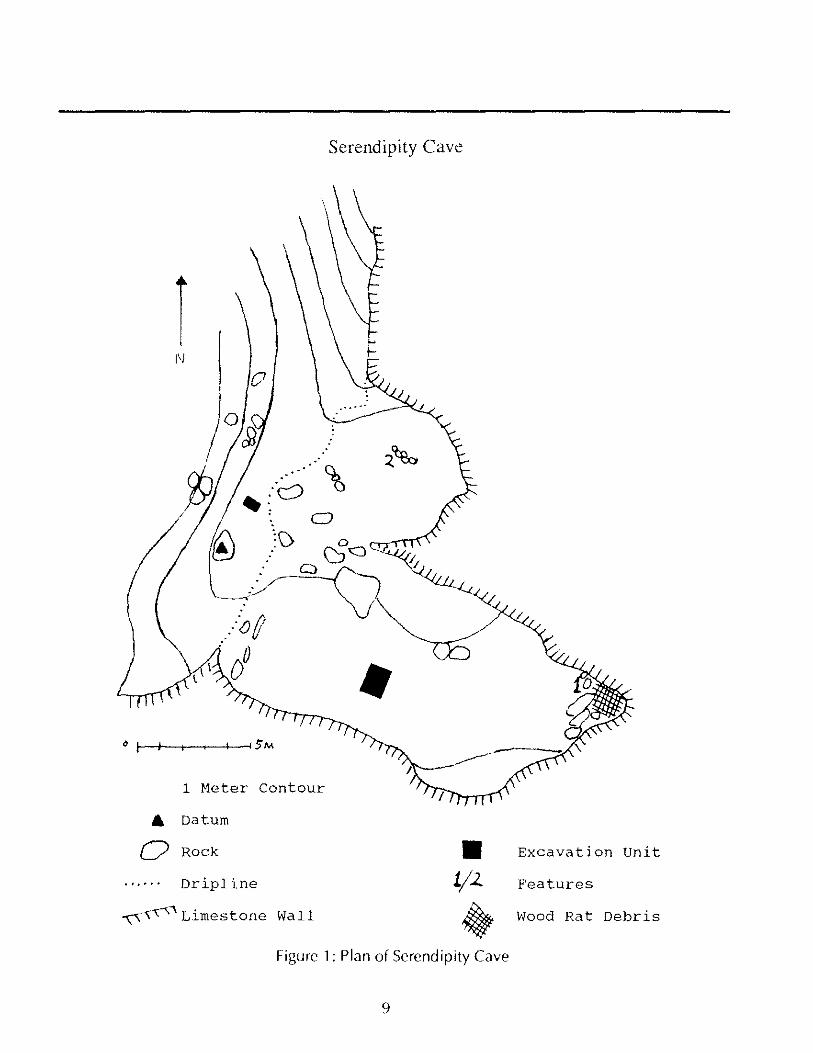
Serendipity Cave
1 Meter Contour
.. Datum
o Rock .. Excavation unit
...... Dripline 1/1. Features
~, . ~\' . Llmestone Wall ~ Wood Rat Debris
Figure 1: Plan of Serendipity Cave
9
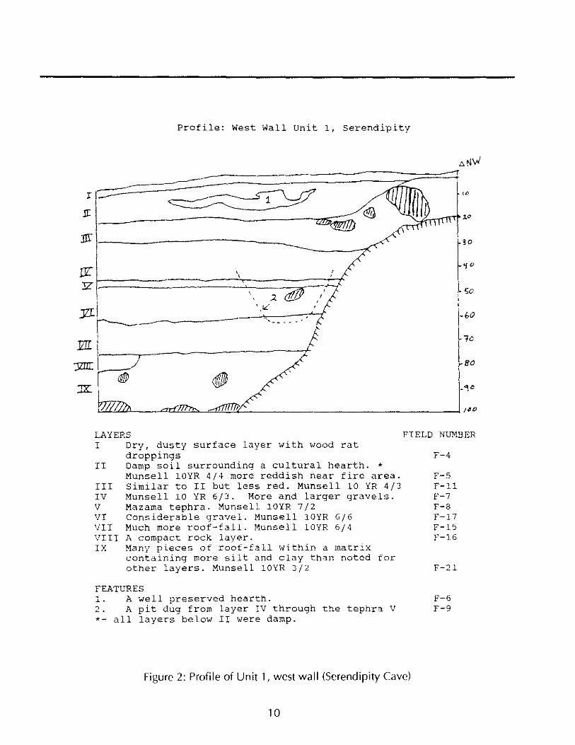
Profile: West Wall Unit 1, serendipity
, , :
30
50
-1.0
flO
LAYERS FIELD NUMBER I Dry, dusty surface layer with wood rat
droppings II Damp soil surrounding a cultural hearth. *
Munsell 10YR 4/4 more reddish near fire area. III Similar to II but less red. Munsell 10 YR 4/3
Munsell 10 YR 6/3. More and larger gravels. Mazama tephra. Munsell 10YR 7/2
IV V VI VIr
considerable gravel. Munsell 10YR 6/6 Much more roof-fall. Munsell 10YR 6/4
VIII A compact rock layer. IX Many pieces of roof-fall within a matrix
containing more silt and clay than noted for other layers. Munsell 10YR 3/2
FEATURES
F-4
F-5 F-ll F-7 F-8 F-17 F-15 F-16
F-21
1. A well preserved hearth. F-6 2. A pit dug from layer IV through the tephra V F-9 *- all layers below II were damp.
Figure 2: Profile of Unit 1, west wall (Serendipity Cave)
10
QUARTZ CRYSTAL FLAKES AND ARTIFACTS FROM WESTERN NEVADA
Donald R. Tuohy Nevada State Museum, Carson City, Nevada Nevada Archaeologist Volume 9 1991
A gift from Steve Wallmann to the Nevada State Museum during the 1990 Great Basin Conference triggered my thoughts about quartz crystal quarries and the need to study them thoroughly.
Quartz crystal flakes and artifacts are not all that common in the western Great Basin, where they are largely found in Washoe Indian territory and environs. I made no attempt to find references to quartz crystal flakes and artifacts in the grey literature (unpublished orobscurely published papers). Quartz crystals and flakes in the Nevada State Museum collections that have been made into tools are found in the Gladys Smith Collection from southern Washoe County, in the Derby Collection from the Humboldt Sink, and in collections from sites in the Carson Valley, Douglas County, and EsmeraldaCounty. I describe the Museum collections and Steve Wallmann'scollections here, after a word about the properties of quartz crystals.
THE PROPERTIES OF QUARTZ CRYSTALS
Crystalline quartz is widespread and important throughout the world; a large proportion of the earth's crust is made up of crystalline quartz and its relative material known as cryptocrystalline chalcedony. Quartz is a common mineral in many light-colored, igneous rocks and in sandstones (Field 1951 :8). Quartz is composed of silicon dioxide (Si02), and may occur as rock crystal, amethyst, rose quartz, mi Iky quartz, morion, smoky quartz, cairngorm, citrine, eat's eye quartz, tiger's eye, sagenite, and adventurine (Pearl 1946:211-212l.
On the Mohs standard scale of hardness, quartz is 7; only diamond, sapphire, and topaz are harder or more resistant to scratching. Crystalline quartz has a glassy appearance on the crystal faces, and the luster becomes greasy on fractured surfaces. It has true cleavage, but does not have conchoidal fracture.
11
THE WALlMANN COllECTION
(PERSHING COUNTY)
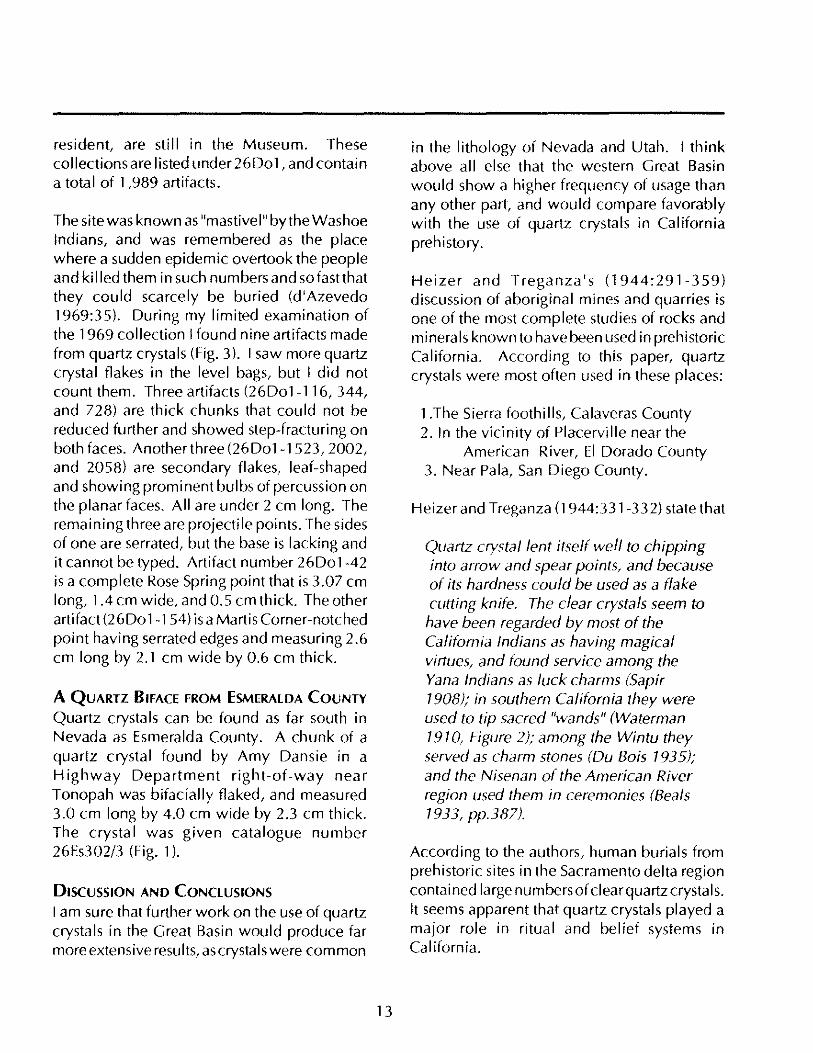
Steve Wall mann's gift consisted of 18 quartz flakes (possibly derived from a single quartz crystal) which were collected during several trips to a sand-dune site at Rye Patch, Nevada, between 1972 and 1976 (Fig. 1). The site is located on the east side of Rye Patch between the Sand Island site (26Pe450) reported in Rusco and Davis (1987:74), and the Pitt-Taylor Dam below Imlay, Nevada. According to Steve Wall mann:
At this writing, the dune is still intact in that it has the same basic size as when I first saw it in about 1967. The main part of the south side has blown out and become more bowlshaped with the passing years. This was a large core-reducing area. By large, I mean in comparison to other similar sites in this stretch of the Humboldt. There are, of course, bone scatters and some milling stones, but the primary things that one notices are the seemingly intact groups of flakes, mostly good-sized.
Eight flakes were of Class I type (Pippin and Hattori 1980), or primary (decortication) flakes having intact remnants of the original crystal faces. Fiveflakes showed secondary retouching for use as scrapers. Six flakes were Type II (core-reduction flakes)(Pippin and Hattori 1980), and three were Type IV (f1akefragmentsl. Two core-reduction flakes showed secondary retouch for use as scrapers, and one of them, a large piece, showed retouch along both edges.
THE GLADYS SMITH COlLECTION
(WASHOE COUNTY)
Washoe County has the largest number of quartz crystals per site of all Nevada's counties. These artifacts appear to be extremely numerous
around the western limits of Reno, westward to the California border. Gladys Smith was an amateur archeologist who surveyed this region (reported by Aikens [1972: 1 ~36j) and found quartz crystals and quartz~crystal flakes in 21 out of72 archeological sites recorded in a 14 by 10 mile area. Of course, noncultural quartz crystals also occur abundantly in western Nevada, and one place where they are gathered today is a well-known locality just north of Verdi (Scheid 1964:157).
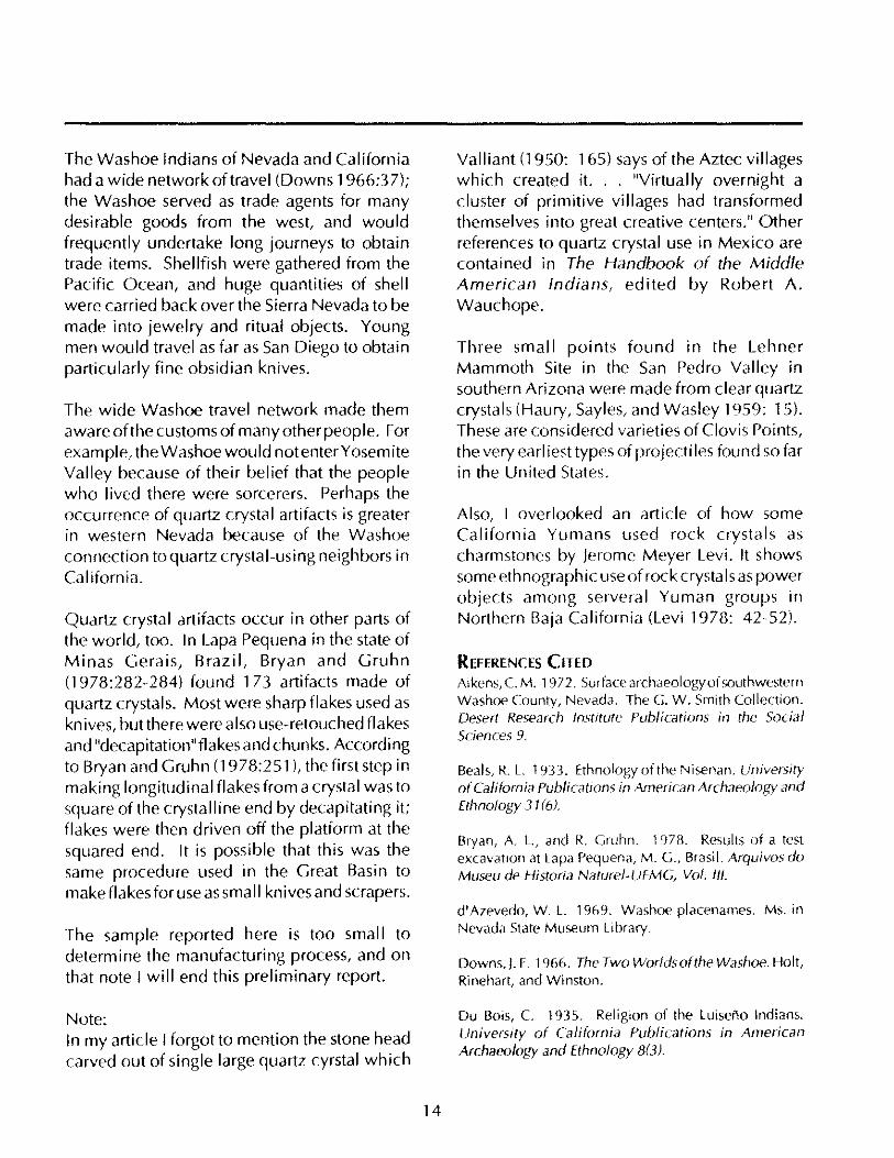
THE DERBY COllECTION
(HUMBOLDT SINK, CHURCHill COUNTY)
The Tom Derby Collection came from sites scattered over the Humboldt Sink; I think that Tom Derby concentrated most of his efforts on the east side of the sink near Lovelock Cave (NV-Ch-18) and at a nearby open site (NV-Pe~ 15)(Heizer and Clewlow 1968:59-88). He also collected at California site number NV-Pe-5 (reported in Elsasser 1958:26-51).
The collection includes three "roughouts," one graver, and one flake point (Fig. 2). My memory is that the collection contained more artifacts (including points) made out of quartz crystal, but these were the only objects I could find. The three roughouts are catalogued as 1403-G-161, 163, and 165. The largest (161) is 4.56 cm long, 2.3 cm wide, and 1.1 cm thick. It is oval and has secondary bifacial thinning on one end. The manufacturer could not control the thickness, and several attempts to thin it terminated by step-flaking in the center of one face. The artifact served as a scraper.
The other two rough outs are small ovate artifacts. One (1403~G-163) is 2 cm long, 1.37 cm wide, and 0.78 cm thick, and had been flaked on both faces. The other (1403~G-165) was made from a piece of smoky quartz, has one pointed end, and is 2.5 cm long, 1.3 cm wide, and 0.7 cm thick.
12
Of the other two quartz-crystal artifacts in the collection, number 1403-G-162 is a ''flake'' point retouched on two edges which converged to a point. It measures 2.82 cm long by 1.6 cm wide by 0.5 cm thick. The other, 1403~G~ 164, is a graver that had been retouched on both faces to create a sharp graving tip. It is tiny, measuring 2.13 cm long by 1.0 cm wide by 0.4 cm thick.
THE lEE COllECTION
(NEAR CARSON CITY, ORMSBY COUNTY)
Dr. Simeon Lemuel Lee, a Civil War veteran who settled in Carson City in 1870, amassed a collection of 7,500 Indian artifacts; upon his death in 1927 these were given to the State of Nevada by his widow Lola Montez Lee. What was left of the collection eventually wound up in the Nevada State Museum when Clark Guild founded that institution in 1941 (Tuohy 1974:8).
The Lee Collection of western Nevada points contains one made from a quartz crystal, measuring 3.4 cm long, 1.4 cm wide, and 0.8 cm thick. It has a leaf-shaped blade and side notches at the base, and would fit in with "Rose Spring" types (Jennings 1986:117)(Fig. 3). I have seen other points made of quartz crystals, but this is the only one I could find from the Carson City area for this report. Quartz crystal flakes are reported for the Wheeler Collection from Carson Hot Springs (Peterson 1984:205-248), but no points were mentioned.
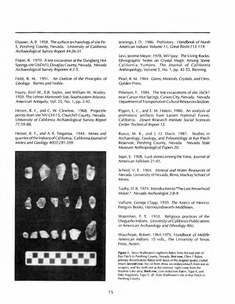
THE DANGBERG HOT SPRINGS COlLECTION
(26D01) (DOUGLAS COUNTY)
During the summer of 1969 the Nevada State Museum undertook test and salvage excavations at the Dangberg Hot Springs site in response to vandalism (Elston 1970). Collections from the excavation, together with materials from previous excavations by R. Shutler and a private collection given to the Museum by a nearby
resident, are still in the Museum. These collections are listed under 26001, and contain a total of 1,989 artifacts.
The site was known as "mastivel" by the Washoe Indians, and was remembered as the place where a sudden epidemic overtook the people and killed them in such numbers and sofastthat they could scarcely be buried (d'Azevedo 1969:35). During my limited examination of the 1969 collection I found nine artifacts made from quartz crystals (Fig. 3). I saw more quartz crystal flakes in the level bags, but I did not count them. Three artifacts (26001-116, 344, and 728) are thick chunks that could not be reduced further and showed step-fracturing on both faces. Anotherthree (26001-1523,2002, and 2058) are secondary flakes, leaf-shaped and showing prominent bulbs of percussion on the planar faces. All are under 2 cm long. The remaining three are projectile points. The sides of one are serrated, but the base is lacking and it cannot be typed. Artifact number 26001-42 is a complete Rose Spring point that is 3.07 cm long, 1.4 cm wide, and 0.5 cm thick. The other artifact (26001-154) is a Martis Corner-notched point having serrated edges and measuring 2.6 cm long by 2.1 cm wide by 0.6 cm thick.
A QUARTZ BIFACE FROM ESMERALDA COUNTY
Quartz crystals can be found as far south in Nevada as Esmeralda County. A chunk of a quartz crystal found by Amy Dansie in a Highway Department right-of-way near Tonopah was bifacially flaked, and measured 3.0 cm long by 4.0 cm wide by 2.3 cm thick. The crystal was given catalogue number 26Es302/3 (Fig. 1).
DISCUSSION AND CONCLUSIONS
I am sure that further work on the use of quartz crystals in the Great Basin would produce far more extensive results, ascrystals were common
13
in the lithology of Nevada and Utah. I think above all else that the western Great Basin would show a higher frequency of usage than any other part, and would compare favorably with the use of quartz crystals in California prehistory.
Heizer and Treganza's (1944:291-359) discussion of aboriginal mines and quarries is one of the most complete studies of rocks and minerals known to have been used in prehistofic California. According to this paper, quartz crystals were most often used in these places:
1.The Sierra foothills, Calaveras County 2. In the vicinity of Placerville near the
American River, EI Dorado County 3. Near Pala, San Diego County.
Heizer and Treganza (1944:331-332) state that
Quartz crystal lent itself weI! to chipping into arrow and spear points, and because of its hardness could be used as a flake cutting knife. The clear crystals seem to have been regarded by most of the Califomia Indians as having magical virtues, and found service among the Yana Indians as luck charms (Sapir 1908); in southern California they were used to tip sacred "wands" (Waterman 1910, Figure 2); among the Wintu they served as charm stones (Du Bois 1935); and the Nisenan of the American River region used them in ceremonies (Beals 1933, pp.387).
According to the authors, human burials from prehistoric sites in the Sacramento delta region contained large numbers of clear quartz crystals. It seems apparent that quartz crystals played a major role in ritual and belief systems in California.
The Washoe Indians of Nevada and California had a wide network of travel (Downs 1966:37); the Washoe served as trade agents for many desirable goods from the west, and would frequently undertake long journeys to obtain trade items. Shellfish were gathered from the Pacific Ocean, and huge quantities of shell were carried back over the Sierra Nevada to be made into jewelry and ritual objects. Young men would travel as far as San Diego to obtain particularly fine obsidian knives.
The wide Washoe travel network made them aware of the customs of many other people. For exam pie, the Washoe wou Id not enter Y osem ite Valley because of their belief that the people who I ived there were sorcerers. Perhaps the occurrence of quartz crystal artifacts is greater in western Nevada because of the Washoe connection to quartz crystal-using neighbors in California.
Quartz crystal artifacts occur in other parts of the world, too. In Lapa Pequena in the state of Minas Gerais, Brazil, Bryan and Gruhn (1978:282-284) found 173 artifacts made of quartz crystals. Most were sharp flakes used as knives, but there were also use-retouched flakes and "decapitation"flakesand chunks. According to Bryan and Gruhn (1978:251 ), the first step in making longitudinal flakes from a crystal was to square of the crystalline end by decapitating it; flakes were then driven off the platform at the squared end. It is possible that this was the same procedure used in the Great Basin to make flakes for use as small knives and scrapers.
The sample reported here is too small to determine the manufacturing process, and on that note I will end this preliminary report.
Note: In my article I forgot to mention the stone head carved out of single large quartz cyrstal which
14
Valliant (1950: 165) says of the Aztec villages which created it. .. "Virtually overnight a cluster of primitive villages had transformed themselves into great creative centers." Other references to quartz crystal use in Mexico are contained in The Handbook of the Middle American Indians, edited by Robert A. Wauchope.
Three small points found in the Lehner Mammoth Site in the San Pedro Valley in southern Arizona were made from clear quartz crystals (Haury, Sayles, and Wasley 1959: 15). These are considered varieties of Clovis Points, the very earliest types of projectiles found so far in the United States.
Also, I overlooked an article of how some California Yumans used rock crystals as charmstones by Jerome Meyer Levi. It shows some ethnographic useof rock crystals as power objects among serveral Yuman groups in Northern Baja California (Levi 1978: 42-52).
REFERENCES CITEO Aikens, C. M. 1 972. Surface archaeology of southwestern Washoe County, Nevada. The G. W. Smith Collection. Desert Research Institute Publications in the Social Sciences 9.
Beals, R. L. 1933. Ethnology of the Nisenan. University or California Publications in American Archaeology and Ethnology 31 (6).
Bryan, A. L., and R. Gruhn. 1978. Results of a test excavation at Lapa Pequena, M. G., Brasil. Arquivos do Museu de Historia Naturel·UFMG, Vol. III.
d' Azevedo, W. L. 1969. Washoe placenames. Ms. in Nevada State Museum Library.
Downs,). F. 1966. The Two Worlds of the Washoe. Holt, Rinehart, and Winston.
Du Bois, C. 1935. Religion of the Luiseno Indians. University of Califoroia Publications in American Archaeology and Ethnology 8(3).
Elsasser, A. B. 1958. The surface archaeology of site PeS, Pershing County, Nevada. University of Califomia Archaeologica l Survey Report 44:26-5 1.
Elston , R. 1970. A test excavation at the Dangberg Hot Springs site (26D01), Douglas County, Nevada. Nevada Archaeological Survey Reporter 4:3 -5.
Field, R. M. 1951. An Outline of the Principles of Geology. Barnes and Noble.
Haury, Emil W ., E.B. Sayles, and William W. W asley. 1959. The Lehner Mammoth Site, Southeastern Ari zona. American Antiquity, Vol. 25 , No. 1, pp. 2-42.
Heizer, R. F., and C. W , Clewlow, 1968. Projeo ile points from site NV-CH-15, Churchill County, Nevada, University of Califomia Archaeological Survey Report 71 :59-88,
Heizer, R. F" and A. E. Treganza. 1944. M ines and quarriesofthe IndiansofCa lifomia, CalifomiaJournal of Mines and Geology 40(3):291-359,
15
Jennings, J. D, 1986, Prehistory, Handbook of North American Indians Volume 11, Great Basin: 113-119,
Levi, Jerome Meyer. 1978. W ii'ipay: The Living RocksEthnographic Notes OIl Crystal Magic AmOllg Some California Yumans. The Journal of Califo rnia Anthropology, Vo lume 5, No.1 , pp, 42-52, Banning,
Pearl , R, M , 1964. Gems, Minerals, Crystals, and Ores, Golden Press,
Peterson, F, 1984. The test excavations of site 260r1 near CarSOfl Hot Springs, Carson Ci ty, Nevada. Nevada Department ofT ransportation Cu Itura I Resources Section,
Pippin, L c.. and E, M , Hattori. 1980 , An anal ysis of prehi sto ric arti facts from Lassen National Fo rest, Californi a, Desert Research Institute Social Sciences Center Technica l Report 15,
RuscO, M . K" and J. O. Davis, 19B7, Studies in Archaeo logy, Geo logy, and Paleonto logy at Rye Patch Reservoir, Pershing County, Nevada, Nevada State Museum Anthropologica l Papers 20,
Sapir, E, 190B, Luck stones among the Yana, Jo urnal of Ameri can Folklore 21 :42,
Scheid, V, E. 1964. M ineral and Water Resources of Nevada, University o f Nevada, Reno, M ackay School o f M ines.
Tuohy, D , R. 1974, Introduoion to "The Last Arrowhead M aker," Nevada Archeologist 2:8-9,
Valli ant, George Clapp. 1950. The Aztecs of Mexico. Pengui n Books, Harmoundsworth-Middlesex,
W aterman, T. T, 1910. Rel igious praOices o f the DiegueM Indians, University of Californ ia Publications in Arnerican Archaeology and Ethnology 8(6).
W auchope, Robert, 1964-1975, Handbook of Middle American Indians, 15 vols" The University o f Texas Press, Austin,
Figure 1. Sieve Wallmann' s eighteen flakes (rom the east side of Rye Patc h in Pershing County, Nevada; first row, Class 1 flakes, primary decortication flakes with (aces of the original quartz crystal intact; SoKond row, five of them show seconda ryretouc h (rom use as scrapers, and the sixth one al the extreme right came from the Washoe lake area; third row , core reduction fl akes, Type II , and flake fragment s, Type V. all from Wall mann's site in Rye Patch in PefShing County.
Figure 2. The Tom Derby collection from Humboldt Sink and two chunks of quartz crystals from Douglas County, and one from Esmeralda County; top two rows are from the Tom Derby collection; top row, a waste flake, and two incipient points; second row, a graver, and two bi facia lly fl aked roughouts; third row, the two pieces on the left are from Douglas County, and the piece on the right is from Esmeralda County.
16
Figure 3. The collection is from Dangberg Hot Springs, Douglas County, Nevada; the first two rows show waste fl akes and unfin ished point tips; the third row shows two poi nts from the Dangberg si te on the extreme left, and on the extreme right, one from the Carson River, near Carson City, and the Humboldt Concave point was collected in southern Washoe County.
ARCHAEOLOGY IN THE OllPATCH: A RESEARCH AND MANAGEMENT AGENDA FOR TRAP SPRING
Barry A. Price INFOTEC Research, Inc. Fresno, California Nevada Archaeologist Volume 9 1991
Thirty-seven years of commerc ial oil deve lopment have contributed substantially to our knowledge of eastern Nevada archeology. Hundreds of archeological surveys have been conducted in support of oil and gas exploration and the current international political si tuation serves to remind us that Nevada' s fledgling oil industry will likely grow.
The Trap Spring fi eld in northeastern Nye County is oneofthe most-explored of Nevada's oil regions. TrapSpring is located approximately 96.5 km (60 miles) south of Ely on the west side of north-central Railroad Valley. O il exploration began there afterthe first commercial discovery in Nevada at Blue Eagle Springs, 16 km (10 mil es) east of Trap Spring, in 1954 (Elliott 1973 ).
Commercial oil production at Trap Spring began in 1976 and more than 9 million barrels of crude oil have been drawn from 37 wells (Nevada Department of Minerals 1990). In 1975 the BLM began requiring systematic arch eo logica l survey in advance of oil explorat ion and development and more than 30 archeologica l su rvey reports covering portions of the oi I field have been fi led with the Battle Mountain District of the BLM (Tonopah Resource Area). The majority of these report on small -sca le surveys of well pads or linear seismic test lines.
The Trap Spring oi l fi eld covers portions of 12 adjacent sections. Several Nationa l Registereligible sites and site complexes are located within that area including the Railroad Va lley
FIGURE I
17
Gravel Bar site, 26-NY-1908, and the Trap Spring site complex, 26-NY-624.
The Gravel Bar Site is at the southem end of the Trap Spring oil field on an east-west-trending bar presumably formed by wave action of Pleistocene Lake Railroad (Elston, Davis, and Clerico 1979). Cultural features found along the 2.5-mile length of the bar contain artifacts spanning the entire known prehistory of the region. Late Pleistocene or early Holocene artifacts include Parman, Lake Mojave, and Haskett points, large lanceolate bifaces, crescents, and a variety of scrapers and flake tools typical of early Great Basin assemblages. Pinto, Elko, Rosegate, and Desert Series points represent the middle and late Holocene. A rock-ringed charcoal lens on the site was radiocarbon dated to 370 ± 40 B.P. (Elston, Davis, and Clerico 1979),
The extensive grouping of archeological sites and features focused around Trap Spring has been designated 26-NY -624. This site is a complex association of numerous settlement features, commonly including hearths and firealtered rock concentrations, very dense lithic tools and debitage (with flakedensities reaching several hundred pieces/m2 in some locations), milling stones, ceramics, faunal remains, charcoal, and other elements indicative of longterm use. These spatially distinct features are typically associated with individual dunes, and appear to be connected by a diffuse and discontinuous artifact and debris scatter.
Firstdiscovered in 1976 (McGonagle and Waski 1978), the Trap Spring site was originally recorded as approximately 45,000 m2 immediately south of the spring. Subsequent investigations of the area have revealed additional materials, and the site boundaries have been substantially expanded (d. Price 1989). Associated cultural materials cover
18
nearly two hundred acres, but are primarily restricted to the sand dunes wh ich follow the 1457 m (4780 ft) contour.
The common occurrence of Rosegate and Desert Series projecti Ie points along with Intermountain Brown Ware (and, rarely, Fremont) ceramics suggests most archeological features at Trap Spring date from Thomas's (1981, 1983) late prehistoric Underdown and Yankee Blade phases, ca. AD. 500-1859. McGonagle and Waski (1978) proposed the Blue Eagle and Clifford phases as equivalent units in Railroad Valley. Interestingly, the Desert Side-notched form, a common association with Shoshone ceramics in other regions, seems rare.
The archeological sites in and around the Trap Spring oil field offer opportunities to study a wide range of research issues deemed important in the Nevada Historic Preservation Plan (L yneis 1982) including the local cultural chronology and paleoclimatic sequence, Paleo-Indian and Archaic settlement and subsistence practices, ceramic and lithic technologies and tool manufacturing methods, and site formation processes. For this reason, several of these sites are considered eligible forthe National Register of Historic Places.
To date, site preservation has been accomplished primarily through avoidance of direct impacts to the cultural resources, in several cases necessitating redesign orrelocation of oil wells and access roads. Some drilling applications have been denied or withdrawn because of the archeological resources. Operators in and around Trap Spring have been generally cooperative, but impacts to sites have continued since development began. At the present time development pressure is intense, and site preservation through avoidance is rapidly becoming an unfeasible alternative.
The cumulative result of on-going oil development in the area has been continued degradation of the archeological resources, and continued restriction on development. It would benefit both developers and resource managers if a comprehensive research/ management plan for Trap Spring was produced. Managers would benefit from such a plan if it served to organize and interpret the numerous piecemeal surveys conducted in the area and included a research framework within which preservation and data recovery could be accomplished. Developers would benefit since such a plan could eliminate existing delays in development, and potentially eliminate the need for certain kinds of redundant studies as development continues. Currently, opportunities exist to work with major companies operating in the Trap Spring field to accomplish these objectives.
A MANAGEMENT AGENDA
Considering the quality of the cultural resources and the intensity of the on-going development, immediate attention should be given to preparation of a specific and detailed management plan for Trap Spring. Such a plan should include a statement of the BLM's management objectives for the area, as well as a listing of priority action items.
Toward the development of such a research/ management plan, the following recommendations are offered as a preliminary agenda to guide development and archeologica I studies in the Trap Spring oil field and surrounding area. As management needs are immediate concerns, these issues are addressed first. Without proper management, sites cannot be preserved nor can their research potential be realized.
Three basic management actions are needed immediately: 1) development of accurate and
19
detai led site maps on a scale appropriate for future management and research; 2) preparation of a research design and fieldwork plan covering inventory, site and feature testing, and data recovery; and 3) consistent site monitoring to gauge the cumulative impacts of continued development, and to ensure that existing proscriptions on development of certain parcels, and against unauthorized artifact collecting, are observed by oil-field personnel. Longer range management objectives might include consideration of a National Register District and development of uniform standards for determining whether sites and features contribute to the significance of the District. Once these are established, a Programmatic Memorandum of Agreement between the BLM and the Nevada SHPO regarding treatment of significant resources could substantially streamline the permitting process for project proponents trying to navigate through Section 106 of the National Historic Preservation Act.
From both a management and a research standpoint, accurate and detai led maps shOWing the full extent of these large and complex sites are a critical need. On the scale of 1 :500 (or even 1 :24,000), surface patterning would become more evident, horizontal stratigraphy might be definable, and the distribution of features and artifacts could be displayed. By showing existing roads and wells, surveyed parcels, and areas of higher and lower archeological sensitivity within the oil field, such maps would also be a distinct aid to land managers trying to protect sites from the cumulative impacts of oil exploration and development.
Existing contour mapping is not now readily available below the 1 :62,500 (15 minute) scale, which makes accurate mapping of individual wells and site features virtually impossible. If an appropriately scaled map of the area does
not currently exist, it should be constructed. Low-level aerial photogrammetry should be considered as an economical approach to producing such a base map. However, systematic on-the-ground reconnaissance will also be required to link togetherthe many small surveys conducted since 1975. Many surveys recorded only portions of sites, primarily individual artifact concentrations such as described above. These previously documented loci should be relocated, rerecorded to a common standard, and plotted precisely on the base maps. Unexplored areas between previously surveyed parcels should also be systematically exam ined for additional features, and to help tie features together and establish accurate site boundaries.
To aid future surveys, a set of permanent mapping baselines should beestablished. These can be emplaced by the engineers building the site base map, and should be marked with permanent and easi Iy found datum points at regular and convenient intervals. Clearly marked mapping points are particularly needed in the central part of the valley, where topographic rei ief is low and geographic landmarks few. (As an alternative to baselines, the existing oil wells could serve as excellent named landmarks for mapping in portions of the area, if they were accurately plotted on a readily available base map.)
Any research design for Trap Spring should contain adetailed discussion of relevant research domains and a clear statement of the linkages between the research questions and the available data classes. A preliminary listing of research domains that might be investigated using data from Trap Spring is presented below.
Field methods and analytic techniques will necessari Iy change with the questions under study, but a few methodological suggestions
20
are offered . To a id futu re surveyors, the research design should contain a statement regarding documentation standards for newly discovered features and for redocumenting known sites and features in the area. This is necessary to ensure comparability of the data collected by different consultants and researchers working in the area, to ensure that each location is plotted accurately on the site maps, and to ensure sufficient information is collected during initial documentation to characterize sites adequately for descriptive and evaluative purposes.
Archaeological investigators should be encouraged to make controlled surface collections and subsurface explorations. However, such surface collections, sondages, shovel probes, and similar small sampling units should only be permitted with the stipulation they are carried out according to a standard ized set of procedures, and all sampling locations and recovered materials be plotted on the site basemaps with respect to the established system of baselines and datum points. Under those conditions, a representative sample of artifacts would gradually become available for study, and meaningful specimens could be collected for radiocarbon dating, obsidian sourcing and hydration studies, ceramic analysis, and other ancillary studies.
A RESEARCH AGENDA
The research domains outlined below are similar to those developed by Lyneis (1982), covering the broad topics of chronology and culture history, paleoenvironment, land-use patterns, and settlement and subsistence dynamics. The list is not exhaustive and other researchers are encouraged to build on these suggestions. The needs of oil developers wi II continue to generate many small surveys, and it is hoped that these can be conducted within a broader research framework which addresses well-defined
questions beyond those immediately posed by the needs of cultural resources management.
CHRONOLOGY
Archeological studies in Railroad Valley have produced evidence of extensive use of the area throughout prehistory. Paleo-Indian settlement features have been found at the Gravel Bar Site (26-NY -1908) and other sites in the oil field (Elston, Davis, and Clerico 1979; Price 1989), as well as at the Duckwater/Bull Creek site complex 16 km north (Zancanella 1988) and other locations throughout Railroad Valley and the surrounding area (Price and Johnston 1988).
Paleo-Indian adaptations probably gave way to Archaic traditions between 10,000 and 8,000 years ago. Whi Ie the Archaic cultural sequence is well-defined in some parts of Nevada (cf. Elston 1982; Thomas 1983; Tuohy and Rendall 1979), the nature and timing of environmental and cultural changes in Railroad Valley are not precisely defined. Although projectile point types, milling tools, and ceramics indicate a sequence of cultural development and change which follows the general Great Basin pattern known from other areas, complete reconstructions of local chronology and paleoclimate await further research and collection of primary data.
Temporal control is a necessary precursor to most other forms of analysis and interpretation and a number of chronological questions about the archeology of the study area remain to be answered. A local sequence relating specific projectile points and other diagnostic materials to defined time periods has yet to be established. Such a sequence must be developed for the locality before functional and processual questions can be exp lored. Moreover, the antiquity, duration, and continuity of occupation atTrapSpring need to be addressed. When did
21
the first inhabitants arrive and settle the area? Was the area continuously occupied throughout prehistory, or are there gaps in the sequence?
Data classes available at Trap Spring that can be used to address chronological questions include cultural carbon and other organiC material for radiometric dating, hearths and fire-altered rock for thermoluminescence, and cultural and geomorphological stratigraphy. Projectile points, ceramics, and other tools useful for cross-dating are common. Although obsidian specimens are uncommon in the area hydration dating does have potential, yet i~ largely neglected in regional investigations.
PALEOENVIRONMENTS
Environmental change is often seen as a prime cause of culture change and patterns of culture expressed archaeologically are often examined as the consequences of environmental change. Reconstruction of local environments is therefore seen as a necessary precursor to archeological interpretation.
Specific questions regarding Railroad Valley paleoenVironments revolve around the hydrological history of Trap Spring and Lake Railroad, the geological history of the dune fields, gravel bars, and other pluvial and postpluvial landforms, and the history of the local botanical and animal communities. Did Lake Railroad support extensive marshes along its margins, and if so, when and for how long did they support human populations? Are shoreline fluctuations evident? Was Trap Spring always a reliable source of fresh water? When did the modern plant communities appear, and what communities did they replace? Is there a discernible succession of communities from Pleistocene to modern times?
The basis of paleoenvironmental reconstruction could come from studies of the local soil and
the pollen, seeds, phytol iths, and other constituents preserved in the sediments at Trap Spring and the nearby playa. Preserved rat middens from the nearby hills could also provide valuable information on local microclimates and paleoclimatic trends.
The Trap Spring field lies in the north-central part of the valley, where a series of alluvial lake plains descend toward a playa formed by pluvial Lake Railroad (Mifflin and Wheat 1979). The plains are separated by a strip of sand dunes, 100-200 meters wide, formed during and after recession of the lake. Wave-cut terraces and gravel bars formed by wave action and nearshore currents are also found in the vicinity (Kleinhampl and Ziony 1985). The geology of the dune fields is poorly understood at present-they could have formed through a variety of complex processes. For example, it is currently unclear whether they are eroding pre-Holocene formations or aggradi ng Holocene deposits (see Kleinhampl and Ziony 1985: 19-23 for a discussion of several possibilities).
It seems reasonable to suggest that the lateprehistoric occupations in the area took place afterthedunefield stabilized. However, earlier occupations are also indicated by the presence of Great Basin Stemmed, Elko, Gatecliff, and Humboldt series points. The discovery of earlier materials as lag in blown-out dunes may indicate occupation of the dune field priorto stabilization (King and Price 1990). Detailed geomorphological study will be necessary to determine the age, source, and history of these dunes. Previous studies of the geomorphology of the Gravel Bar Site (Elston, Davis, and Clerico 1979; Young and Clay 1989) should also be reviewed and can help form the basis of a specific research design for geomorphological studies.
22
SETIlEMENT AND SUBSISTENCE DYNAMICS
Many questions remain to be answered regarding the settlement and subsistence practices of the prehistoric inhabitants of Railroad Valley. What was the subsistence base for these people, and how did it change through time? What technology was employed to procure subsistence resources, and how was labor organized to produce and consume those resources? Did the different settlement features on these sites have different functions, and if so, how were they related. Do the preserved intraand inter-site spatial patterns havedemographic correlates? What was the relationship between Trap Spring and the ethnographic settlements at Blue Eagle Springs, Nyala, and Duckwater? Data bearing on these questions are available from a variety of sources in the Trap Spring district. Artifact density mapping i n and between major site loci will help delineate functional structure, and may reveal important spatial distributions and co-associations. Artifact analyses, along with special studies of subsistence-related features and cultural soils containing subsistence remains, bear directly on questions of seasonal ity, subsistence economics, labor, and technology.
LITHIC AND CERAMIC TECHNOlOGY
Research topics in this domain fall in two broad themes: technology as industry, and technology as production. In either case, the questions posed deal with the specifics of too I manufacture and use. Debitage and production stage analysis, use-wear analysis, tool replication, and otherfunctional studies are included in this domain. Since sites in the area appear to span all of prehistory, they may be particularly useful for examining diachronic patterns in resource acquisition and tool manufacture.
To date, the details of ceramic manufacturing technology in the Great Basin have been
largely ignored as a research issue in favor of typological and stylistic descriptions, classifications, and comparisons (Griset 1986; Sullivan 1988). Settlements such as 26-Ny-624, with its substantial numbers of ceramic artifacts, may contain features directly related to this industry, and may therefore provide the opportunity to open a completely new realm of regional inquiry.
CULTURE HISTORY AND CULTURE CONTACT
Steward (1938) reported an ethnographic population of 250 in Railroad Valley, with major settlements located at major spring complexes, primari lyon the east side of the valley. No settlement is reported at Trap Spring, and the temporal and cultural relationships between it and the ethnographic settlements are unclear. Perhaps Steward's sites represent contact and early post-contact period settlements, and the Trap Spring complex represents a late-prehistoric settlement predati ng Steward's sites.
There are two competing models of how and when the Shoshone first occupied thei r territory. One holds that they entered the area relatively recently, migrating from an eastern California homeland within the last 1 ,000 years (Bettinger and Baumhoff 1982; Lamb 1958), The other contends that the Shoshone are the descendants of earlier, local Archaic people, and developed in situ over several millennia (Aikens and Witherspoon 1986; Goss 1977). Both hypotheses are based primarily on linguistic evidence and must be tested archeologically, but recent studies of basketry (Adovasio 1986), ceramics (Madsen 1975), and obsidian (Hughes 1990) seem to support the "late arrival" hypothesis.
Models regarding Shoshone origins and history may be testable at the Trap Spring Site. If this site could be linked to the ethnographic
23
population of the region, then the directhistorical method could be used to trace the population back through time. Other linkages might identify particular artifact styles and technologies unique to the Shoshone and their predecessors.
SUMMARY AND CONCLUSIONS
As a result of increased oil exploration and production, development pressure on the Trap Spring site complex (26-NY-624), the Railroad Valley Gravel Bar site (26-NY-1908), and other cultural resources in the Trap Spring oil field has increased dramatically. These sites are large, complex, and significant settlements with a variety of features and data classes wh ich could provide important information on a wide range of issues crucial to an increased understanding of eastern Nevada prehistory. The sites are suffering cumulative degradation from a continuing succession of small-scale projects related to exploration and development in and around one of Nevada's most productive oil fields. As development proceeds, simple avoidance becomes increasingly ineffective as a management tool. A detailed plan for site management is needed to protect archeological values, and to guide future development in the area and study of the sites. Ideally, there should be a moratorium on further development until such a management plan is adopted. Opportunities to work with the oil industry to develop such a plan should be explored because of the inherent benefits to all parties.
REFERENCES CITED
Adovasio.J. M. 1986. Artifacts and Ethnicity: Basketry as an Indicator ofTerritoriality and Population Movements in the Prehistoric Great Basin. In Anthropology in Honor of Jesse D. Jennings (C.J. Condie and D.o. Fowler, eds.), pp. 43·88. University of Utah Anthropological Papers 110.
Aikens, C. M., and Y.T. Witherspoon. 1986. Great Basin Numic Prehistory: linguistics, Archeology, and
Environment. In Anthropology in Honor of Jesse D. Jennings (CJ. Condie and D.D. Fowler, edsJ, pp. 7·20. University of Utah Anthropological Papers 110.
Bettinger, R. L., and M.A. Baumhoff. 1982. The Numic Spread: Great Basin Cultures in Competition. American Antiquity 47: 485-503.
Elliott, R. R. 1973. History of Nevada. University of Nebraska Press, Lincoln.
Elston, R. 1982. Good Times, Hard Times: Prehistoric Culture Change in the Western Great Basin. In Man and Environment in the Great Basin (D.B. Madsen and J.F. O'Connell, eds.), pp. 186-206. Society for American Archaeology Papers No.2. D.C
Elston, R., J. Davis, and R. Cieri co. 1979. 26Ny1908: A Late Pleistocene Gravel Bar in Railroad Valley. Unpublished manuscript, Desert Research Institute, Reno.
Goss, J. A 1977. Linguistic Tools for the Great Basin Prehistorian. In Models in Great Basin Prehistory (D.D. Fowler, ed'), pp. 49-70. Desert Research Institute Publications in the Social Sciences and Humanities 12.
Griset, S.(editor). 1986. Pottery of the Great Basin and Adjacent Areas. University of Utah Anthropological Papers 111.
Hughes, R. A. 1990. Obsidian Source Use in Great Basin Alpine Environments. Paper presented at the Fifty·fifth Annual Meetingofthe Society for American Archaeology, Las Vegas.
King, R. F., and B. A Price. 1990. Archaeological Survey of Marathon Oil Company's Munson Ranch #11-24 Well Location in Rai I road Valley. BLMCultural Resources Report 6-1293(P) on fi Ie at the Tonopah Resource Area Office.
Kleinhampl, F. J., and J. I. Ziony. 1985. Geology of Northern Nye County, Nevada. Nevada Bureau of Mines and Geology Bulletin 99A.
Lamb, S. 1958. Linguistic Prehistory in the Great Basin. International Journal of American Linguistics24:95-1 00.
Lyneis, M. (editor). 1982. An Archaeological Element for the Nevada Historic Preservation Plan. Nevada Division of Historic Preservation and Archaeology, Carson City.
24
Madsen, D. B. 1975. DatingPaiute·Shoshoni Expansion in the Great Basin. American Antiquity 40:82-86.
McGonagle, R., and L. Waski. 1978. Archaeological Survey of Springs in the Tonopah Resource Area. Nevada BLM Technical Report 2.
Mifflin,M.D., andM.M. Wheat. 1979. Pluvial Lakes and Estimated Pluvial Climates of Nevada. Nevada Bureau of Mines and Geology Bulletin 94.
Nevada Department of Minerals. 1990. Nevada Oil Produdion. Cumulative bimonthly statistics through December, 1990. Nevada Department of Minerals, Carson City.
Price, B. A. 1989. Archaeological Survey ofTwelve Well Locations and Access Routes in the Munson Ranch and Duckwater Creek Unitsofthe Trap Spring Oilfield. BLM Cultural Resources Report #6·1245(P) on file at the Tonopah Resource Area Office.
Price, B. A, and S. E. Johnston. 1988. A Model of Late Pleistocene and Early Holocene Adaptation in Eastern Nevada. In Early Human Occupation in Far Western North America: the CloviS-Archaic Interface (j.A. Wi lIig, CM. Aikens, and I.L. Fagan, eds.), pp. 231-250. Nevada State Museum Anthropological Papers 21.
Steward, I. H. 1938. Basin-Plateau Aboriginal Sociopolitical Groups. Bureau of American Ethnology Bulletin 120.
Sullivan, A P. 1988. Prehistoric Southwestern Ceramic Manufacture: The Limitations of Current Evidence. American Antiquity 53(1): 23-35.
Thomas, D. H. 1981. How to Classify the Projedile Points from Monitor Valley, Nevada. Journal of California and Great Basin Anthropology 3(1): 7-43.
Thomas, D. H. 1983. The Archaeology of Monitor Valley, Volume 2: Gatecliff Shelter. American Museum of Natural History Anthropological Papers 59.
Tuohy, D. R., and D. L. Rendall (editors). 1979. The Archaeology of Smith Creek Canyon, Eastern Nevada. Nevada State Museum Anthropological Papers 17.
Young, B., and V. Clay. 1989. Determination of the Presence or Absence of Significant Contributing Elements to 26Ny190B in the Petrosource Project Area. BLM
Cultural Resources Re[X)rt 6-1300 on Ii Ie at the Tonopah Resource Area Office.
Zancanelia, J. K. 1988. Early Lowland Prehistory in Southcentral Nevada. In Early Human Occupation in Far Western North America: theClovis-Archaic Interface (j.A. Willig, CM. Aikens, and J.L. Fagan, edsJ, pp. 251-271. Nevada State Museum Anthropological Papers 21.
25
HISTORIC ABORIGINAL USE OF PAHUTE MESA
Ronald l. Reno University of Nevada, Reno Gregory H. Henton Desert Research I nstitute Nevada Archaeologist Volume 9 1991 Note: 'rhf-! is a revised version of a paper pre5N'1ted at the 21 st GrNt Basin Anthropological Conference, Pilfk City, Utah, 1988. The figures are at the !.'!1d.
ABSTRACT
Evidence has been rapidly accumulating concerning post-contact aboriginal use of Pahute Mesa on what is now the Nevada Test Site in south-central Nevada. Collections from the surface and excavations at open ethnohistoric sites and limb-structures at Drill Pads U19aq and U19au indicatethat traditional aboriginal lifeways continued well into the historic period in this remote region.
INTRODUCTION
The focus of this paper is on the nature of the interface of prehistoric and historic cultures based on two examples of recent archeological work on Pahute Mesa, Nye County, Nevada, where evidence of ethnohistoric use of the area has been rapidly accumulating. There are three main reasons for such remains being concentrated on Pahute Mesa. First the lack of public access to the area since the Second World War has helped ensure the preservation of such fragile archeological sites; second, this portion of Nevada has been the scene of little Euro-American historic activity; and third, plentiful pinyon and grass resources exist in this region, which are not available in most of the surrounding country.
A few trappers and explorers passed through south-central Nevada starting in 1827, but none found the region around Pahute Mesa attractive enough to tarry orto suggest that anyone else do so. Avoidance of this rugged and poorly watered area is well shown on an 1888 map of Nevada (Fig. 1). This map is particularly well suited to document the advance of Euro-American culture, since it shows the location of township surveys, a sensitive indicator of the territories occupied by a culture obsessed with land ownership. Southern Nevada is clearly less well developed than most of the rest of the state, but the largest area lacking any sign of development is centered on Pahute Mesa. If
26
one were to look for a place tofind a persistence of aboriginal lifeways into the post-contact period, this is an excellent place to start.
The 1908 map of Pahute Mesa and the surrounding area reflects the limited developments brought by the early 20th century mining boom that struck Nevada (Fig. 2). Few other changes occurred on Pahute Mesa and on most of the Nevada Test Site until the area was turned into a military gunnery range during the Second World War. The two study areas which provide the source of data for this paper are plotted on Fig. 2. Both of the locations, U 19aq and U19au, are 1 km squares surveyed to clear drill holes for proposed nuclear tests. Most of these areas were collected, and some sites were excavated. The data recovery at both project areas included remains of ethnohistoric activity.
The primary ethnographic source for Pahute Mesa is Steward (1938), This area was occupied by two main groups of Western Shoshone, one based in Oasis Valley, and approaching a Band level of organization at least during the winter, and the other with winter camps dispersed along the southern end of the Belted Range. Winter camps noted by Steward for both groups are plotted as circles on Fig. 2. Pahute Mesa is noted for pinyon and seed exploitation. Limited travel over the mesa is also noted, but use of the portion of Pahute Mesa in the study areas is not detailed in the literature.
Pippin (1984, 1986:92-96) noted a concentration of 1 2 historic aboriginal structures at the headwaters of Silent Canyon. The distribution of pinyon and juniper plotted on Fig. 2 helps explain the location of this cluster of remains. The project areas are in the closest extensive stand of pinyon to the aboriginal groups based in Oasis Valley. There is easy access to the project area from the pass between Timber Mountain and Pahute Mesa.
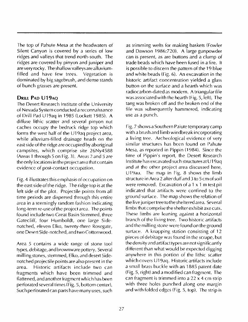
The top of Pahute Mesa at the headwaters of Silent Canyon is covered by a series of low ridges and valleys that trend north-south. The ridges are covered by pinyon and juniper and are very rocky. The shallowvalleysarealluviumfilled and have few trees. Vegetation is dominated by big sagebrush, and dense stands of bunch grasses are present.
DRILL PAD U19AQ The Desert Research Institute of the University of Nevada System conducted a reconnaissance of Drill Pad U 19aq in 1985 (Lockett 1985). A diffuse lithic scatter and several pinyon nut caches occupy the bedrock ridge top which forms the west half of the U19aq project area, while alluvium-filled drainage heads on the east side of the ridge are occupied by aboriginal campsites, which comprise site 26Ny4588 (Areas 1 through 5 on Fig. 3). Areas 2 and 5 are the only locations in the project area that contain evidence of post-contact occupation.
Fig. 4 illustrates this emphaSis of occupation on the east side of the ridge. The ridge top is at the left side of the plot. Projectile points from all time periods are dispersed through this entire area in a seemingly random fashion indicating long-term re-use ofthe project area. The points found include two Creat Basin Stemmed, three Catecliff, four Humboldt, one large Sidenotched, eleven Elko, twenty-three Rosegate, one Desert Side-notched, and two Cottonwood.
Area 5 contains a wide range of stone tool types, debitage, and brownware pottery. Several milling stones, stemmed, Elko, and desert Sidenotched projectile points are also present in the area. Historic artifacts include two can fragments which have been trimmed and flattened, and another fragment wh ich has been perforated several times (Fig. 5, bottom center). Such perforated can parts have many uses, such
27
as trimming wefts for making baskets (Fowler and Dawson 1986:720). A large gunpowder can is present, as are buttons and a clump of trade beads which have been fused in a fire. It is possible to discern the pattern of the 19 blue and white beads (Fig. 6). An excavation in the historic artifact concentration yielded a glass button on the surface and a hearth which was radiocarbon-dated as modern. A triangularfile was associated with the hearth (Fig. 5, left). The tang was broken off and the broken end of the file was subsequently hammered, indicating use as a punch.
Fig.7 shows a Southern Paiute temporary camp with a brush and I imb windbreak incorporating a living tree. Archeological evidence of very similar structures has been found on Pahute Mesa, as reported in Pippin (1984). Since the time of Pippin's report, the Desert Research Institute has excavated such structures at U 19aq and at the other project area discussed here, U19au. The map in Fig. 8 shows the limb structure in Area 2 after duff and 3 to 5 cm of soi I were removed. Excavation of a 1 x 1 m test pit indicated that artifacts were confined to the ground surface. The map shows the relation of the live junipertree tothe sheltered area. Several limbs that comprise the shelter exhibit axe cuts. These limbs are leaning against a horizontal branch of the living tree. Two historic artifacts and the milling stone were found on the ground surface. A knapping station consisting of 12 pieces of debitage was found in the scrape, but the density and artifact types are not Significantly different than what would be expected digging anywhere in this portion of the lithic scatter which covers U19aq. Historic artifacts include a small brass buckle with an 1885 patent date (Fig. 5, right) and a modified can fragment. The can fragment is trimmed into a 22 x 4 cm strip with three holes punched along one margin and with folded edges (Fig. 5, top). The strip is

bent into a 15 cm wide arc. Such strips are fairly common artifacts on the Nevada Test Site (Pippin 1986:96), A probable use may be for seed beaters. Wooden hoops attached to the leading edges of seed beaters are common both among Western Shoshone (Panamint) and the Southern Paiute. Both groups are known to have utilized metal strips to improve the efficiency of these tools (Fowler and Dawson 1986:715,718,725; P. J. Wilke 1988 personal communication). This is a highly significant type of artifact, for it allows monitoring seed harvesting on ethnohistoric sites.
DRILL PAD U19AU During 1983 the Desert Research Institute conducted a reconnaissance of Drill Pad U 19au (Henton 1983), located in a moderately sized north-south-trending alluvial-filled valley bordered on the west by a low ridge and on the east by low convoluted welded tuff cliffs. Numerous archeological sites included several camp sites which appeared to have habitation structures. Two types of structures were noted, one consisting of cleared rock circles and the other of living juniper trees which had been enhanced by building limb walls underneath the canopy of the tree. Priorto the construction of the drill pad, the Desert Research Institute was afforded the opportunity to investigate one of these juniper tree structure sites, 26Ny4040. This site is located at the base of a slope along the south side of a small valley formed by one of the convolutions in the welded tuff rim rock of the eastern side of the primary valley (Fig. 9). The site, which is located just within the tree line between the transition from sagebrush to pinyon-juniper, consists of three enhanced juniper tree structures enclosed in a larger scatter of artifacts including debitage, pottery, bifaces, projectile points, and milling stones. Excavations, limited to removing the duff and surface soil from all three of these structures, were conducted in 1986. Although the only
28
artifacts observed during the reconnaissance were common to prehistoric sites, excavation revealed that all of the structures also had historic artifact types in association.
The first structure, Feature 1, when discovered, was described as a I iving juniper tree with several branches underneath the canopy (Fig. 10). These branches appeared to be the remains of a wall of brush built into the tree to enhance its function as a shelter. One of the branches was forked and appeared to be anchored in a pi Ie of rocks and probably served as the support forthe far end of the wall. A well-used milling stone was observed just to the southwest of the feature, and some debitage was noted in the vicinity, but the types and number of these artifacts did not differ Significantly from the artifact scatter which occurred in the general site area.
Excavations at this feature involved removing and screening the duff accumulation from under the juniper, and then removing and screening the first 3 to 5 em of soil in the area of the feature. These excavations revealed three areas of charcoal-darkened or oxidized soil, which probably represent fire hearths. The excavations also revealed a scatter of artifacts consisting predominantly of debitage, but including a high proportion of stone tools, including a hammerstone, several cores, a chopping tool, two unifacially worked flakes and several bifaces. Additional artifacts found here included a Rose Spring corner-notched projectile point, a drill tip, and a white glass bead.
Feature 2 was originally described as several livingjunipers with branches underneath, again as an enhancement to make a better shelter. While not as obvious as the first shelter, one of the branches is forked and anchored by large stones. When originally recorded, only a single flake was observed with the shelter.
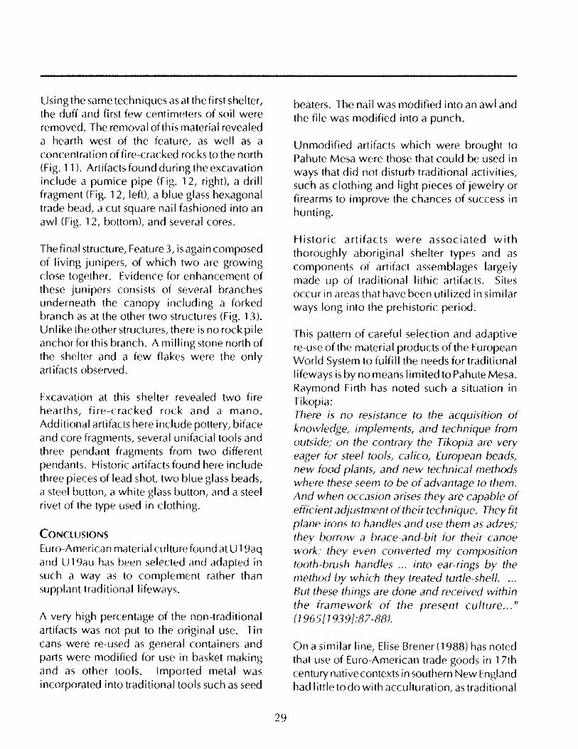
Using the same techniques as at the first shelter, the duff and first few centimeters of soil were removed. The removal of this material revealed a hearth west of the feature, as well as a concentration of fire-cracked rocks to the north (Fig. 11). Artifacts found during the excavation include a pumice pipe (Fig. 12, right), a drill fragment (Fig. 12, left), a blue glass hexagonal trade bead. a cut square nail fashioned into an awl (Fig. 12. bottom), and several cores.
Thefinal structure, Feature 3, isagain composed of living junipers, of which two are growing close together. Evidence for enhancement of these junipers consists of several branches underneath the canopy including a forked branch as at the other two structures (Fig. 13), Unl ike the other structures, there is no rock pile anchorforthis branch. A milling stone north of the shelter and a few flakes were the only artifacts observed.
Excavation at this shelter revealed two fire hearths, fire-cracked rock and a mana. Additional artifacts here include pottery, biface and core fragments, several unifacial tools and three pendant fragments from two different pendants. Historic artifacts found here include three pieces of lead shot, two blue glass beads, a steel button, a white glass button, and a steel rivet of the type used in clothing.
CONClUSIONS
Euro-American material culture found at U 19aq and U19au has been selected and adapted in such a way as to complement rather than supplant traditional lifeways.
A very high percentage of the non-traditional artifacts was not put to the original use. Tin cans were re-used as general containers and parts were modified for use in basket making and as other tools. Imported metal was incorporated into traditional tools such as seed
29
beaters. The nail was modified into an awl and the file was modified into a punch.
Unmodified artifacts which were brought to Pahute Mesa were those that could be used in ways that did not disturb traditional activities, such as clothing and light pieces of jewelry or firearms to improve the chances of success in hunting.
Historic artifacts were associated with thoroughly aboriginal shelter types and as components of artifact assemblages largely made up of traditional lithic artifacts. Sites occur in areas that have been util ized in similar ways long into the prehistoric period.
This pattern of careful selection and adaptive re-use of the material products of the European World System to fulfill the needs for traditional lifeways is by no means limited to Pahute Mesa. Raymond Firth has noted such a situation in Tikopia: There is no resistance to the acquisition of knowledge. implements, and technique from outside; on the contrary the Tikopia are very eager for steel tools, calico, European beads, new food plants, and new technical methods where these seem to be of advantage to them. And when occasion arises they are capable of efficient adjustment of their technique. They fit plane irons to handles and use them as adzes; they borrow a brace-and-bit for their canoe work; they even converted my composition tooth-brush handles ... into ear-rings by the method by which they treated turtle-shell. . .. But these things are done and received within the framework of the present culture ... " 17 965[1939J:87-88).
On a similar line, Elise Brener (1988) has noted that use of Euro-American trade goods in 17th century native contexts in southern New England had little to do with acculturation, as traditional
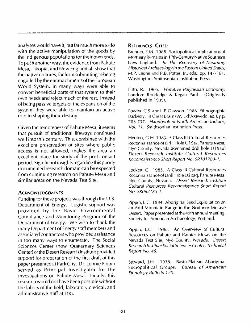
analyses would have it, but far much more to do with the active manipulation of the goods by the indigenous populations for their own ends. To put it another way, the evidence from Pahute Mesa, Tikopia, and New England all show that the native cultures, far from submitting to being engulfed by the encroach ments of the European World System, in many ways were able to convert beneficial parts of that system to their own needs and reject much of the rest. Instead of being passive targets of the expansion of the system, they were able to maintain an active role in shaping their destiny.
Given the remoteness of Pahute Mesa, it seems that pursuit of traditional lifeways continued well into this century. This, combined with the excellent preservation of sites where publ ic access is not allowed, makes the area an excellent place for study of the post-contact period. Significant insights regarding this poorly documented research domain can be expected from continuing research on Pahute Mesa and similar areas on the Nevada Test Site.
ACKNOWLEDGEMENTS
Funding for these projects was through the U.S. Department of Energy. Logistic support was provided by the Basic Environmental Compliance and Monitoring Program of the Department of Energy. We wish to thank the many Department of Energy staff members and associated contractors who provided assistance in too many ways to enumerate. The Social Sciences Center (now Quaternary Sciences Center) of the Desert Research Institute provided support for preparation of the first draft of this paper presented at Park City. Dr. Lonnie Pippin served as Principal Investigator for the investigations on Pahute Mesa. Finally, this research wou Id not have been possible without the labors of the field, laboratory,clerical, and administrative staff at DRI.
30
REFERENCES CITED Brenner, E.M. 1988. Sociopolitical Implications of Mortuary Remains in 17th-Century Native Southern New England. In The Recovery of Meaning: Historical Archaeology in the Eastern United States, M.P. Leone and P.B. Potter, Jr., eds., pp. 147-181. Washington: Smithsonian Institution Press.
Firth, R. 1965. Primitive PolyneSian Economy. London: Routledge & Kegan Paul. (Originally published in 1939).
Fowler, CS. and L.E. Dawson. 1986. Ethnographic Basketry. In Great Basin (W.L. d'Azevedo, ed'), pp. 705-737. Handbook of North American Indians, Vol. 11. Smithsonian Institution Press.
Henton, G.H. 1983. A Class III Cultural Resources Reconnaissance of Drill Hole U19as, Pahute Mesa, Nye County, Nevada.(Renamed drill hole U 19au) Desert Research Institute Cultural Resources Reconnaissance Short Report No. SR 1 0 1783- 1.
Lockett, C 1985. A Class III Cultural Resources Reconnaissance of Dri II Hole U20aq, Pahute Mesa, Nye County, Nevada. Desert Research Institute Cultural Resources Reconnaissance Short Report No. SR062185-1.
Pippin, L.C 1984. Aboriginal Seed Exploitation on an Arid Mountain Range in the Northern Mojave Desert. Paper presented atthe 49th annual meeting, Society for American Archaeology, Portland.
Pippin, L.C 1986. An Overview of Cultural Resources on Pahute and Rainier Mesas on the Nevada Test Site, Nye County, Nevada. Desert Research Institute Social Sciences Center, Technical Report No. 45.
Steward, J.H. 1938. Basin-Plateau Aboriginal Sociopolitical Groups. Bureau of American Ethnology Bulletin 120.

-'.' '' '- '
... _ , .... . .... ..;,.
l' " '.' . , k , . '-'~; . "1-~ .... _ .~ . D':.,; "-
.. _.,..h -.:
-" : :::·l ~~~; t~ -.~;. ----~-4. , 0._ .. ::1,
," ~'~"""
figure 1. Map of Nevada in 1888 showing su rveyed townships. [he arrow points to Pahute Mesa.
31

Figure 2. Pahute Mesa in 1908 (U.S.C.S. Kawich). The area depicted is 56 by 42 miles. Circles - Ethnographic campsites Squares - Drill pads Dotted lines - Pinyon/juniper
32
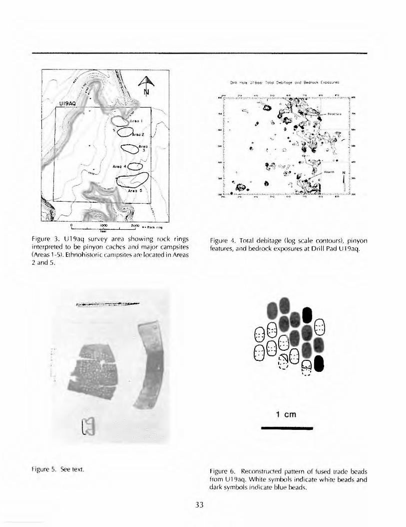
/' 0 .. /~ t ,
'.
~Ar~o . ~3
\.
~_~_ .. '''''''"" _~ __ :!:~ ··R...:t. ""t I .. ,
Figure 3. U19aq survey area showing rock rings interpreted to be pinyon caches and rnajor carnpsites (Areas 1-5). Ethnohistoric carnpsites are located in Areas 2 and 5.
Figure S. See text.
33
Figure 4. Total debitage (log sca le contours), pinyon features, and bedrock exposures at Dri ll Pad U19aq.
1 em
Figure 6. Reconstructed pattern of fused trade beads frorn U19aq. White syrnbols indicate white beads and dark syrnbols Indicate blue beads.
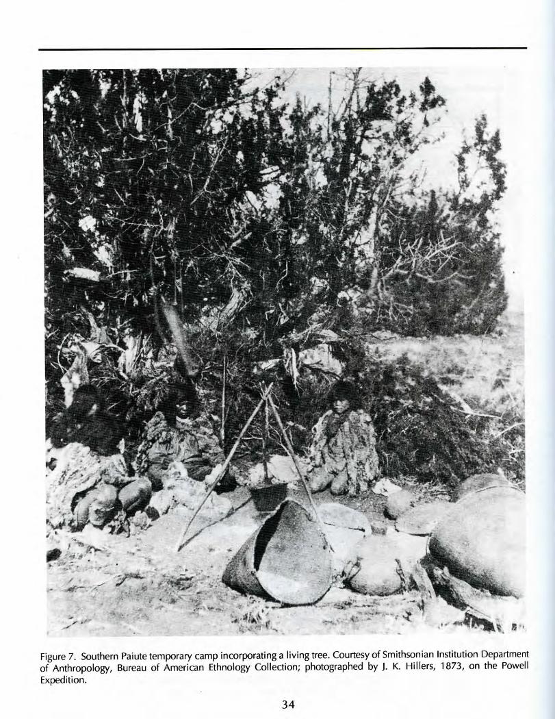
Figure 7. Southern Paiute temporary camp incorporating a living tree. Courtesy of Smithsonian Institution Departmentof Anthropology, Bureau of American Ethnology Collection; photographed by J. K. Millers, 1873, on the PowellExpedition.
34
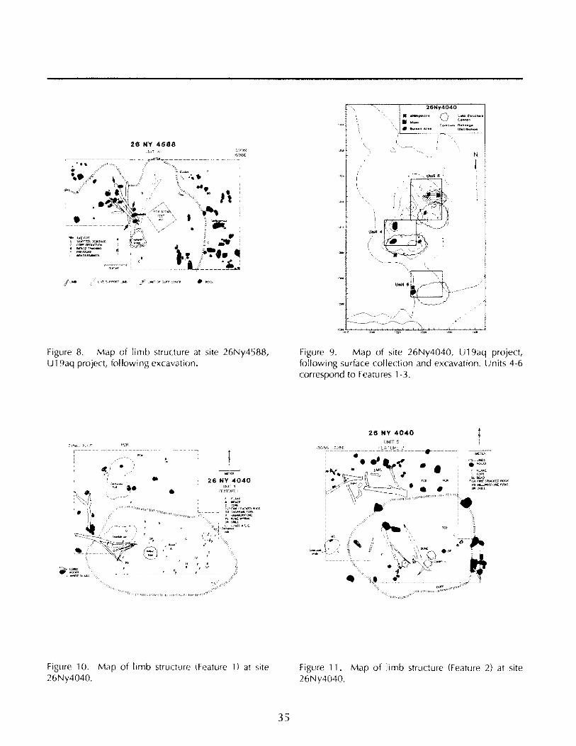
26 NY 4588
..... :'~f~;
....... ,,""
•
Figure 8. Map of limb structure at site 26Ny4588, U19aq project, following excavation.
r-----
, '
• •
-' ,~",'" ~~;
26 NY .(040 '<NI~ 4
flO;Ttli'E I
_____ , ___ ":.. _____ r. _____ _
Figure 10. Map of limb structure (Feature 1) at site 26Ny4040.
35
N
\
Figure 9. Map of site 26Ny4040, U19aq project, following surface collection and excavation. Units 4-6 correspond to Features 1-3.
, ~
~'"'-'" _t .- -1-~
28 NY 4040
"/"-
"""11"""",,
' ... =
, ''-'" ,~
.~ . r:;:~~~ --,
Figure 11. Map of limb structure (Feature 2) at site 26Ny4040.
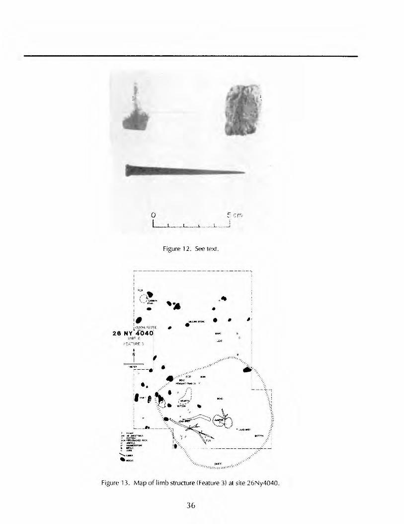
o I
•
u~.p 6
Figure 12. See text.
~-----------.-------,
• .--• •
" ,
Figure 13. Map of limb structure (Feature 3) at site 26Ny4040.
36
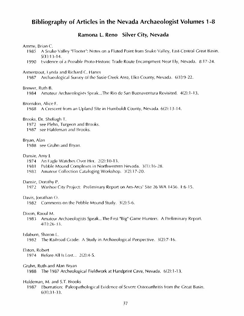
Bibliography of Articles in the Nevada Archaeologist Volumes 1-8
Ramona L Reno Silver City, Nevada
Amme, Brian C. 1985 A Snake Valley "Floater": Notes on a Fluted Point from Snake Valley, East-Central Great Basin.
5(1):13-14. 1990 Evidence of a possible Proto-Historic Trade Route Encampment Near Ely, Nevada. 8: 17 -24.
Armentrout, Lynda and Richard C. Hanes 1987 Archaeological Survey of the Susie Creek Area, Elko County, Nevada. 6(1 ):9-22.
Brewer, Ruth B. 1984 Amateur Archaeologists Speak ... The Rio de San Buenaventora Revisited. 4(2):1-13.
Bronsdon, Alice F. 1988 A Crescent from an Upland Site in Humboldt Coonty, Nevada. 6(2): 13-14.
Brooks, Dr. Sheliagh T. 1972 see Plehn, Turgeon and Brooks. 1987 see Haldeman and Brooks.
Bryan, Alan 1988 see Gruhn and Bryan.
Dansie, Amy J. 1974 An Eagle Watches Over Her. 2(2):10-13. 1981 Pehble Mound Complexes in Northwestern Nevada. 3(1): 16-28. 1982 Amateur Collection Cataloging Workshop. 3(2): 17 -20.
Dansie, Dorothy P. 1972 Washoe City Project: Preliminary Report on Am-Arcs' Site 26 WA 1436. 1 :6-15.
Davis, Jonathan O. 1982 Comments on the Pebble Moond Study. 3(2):5-6.
Dixon, Raoul M. 1983 Amateur Archaeologists Speak ... The First "Big" Game Honters: A Preliminary Report.
4(1 ):26-33.
Edaburn, Sharon L. 1982 The Railroad Grade: A Study in Archaeological Perspective. 3(2):7-16.
Elston, Robert 1974 Before Allis Lost. .. 2(2):4-5.
Gruhn, Ruth and Alan Bryan 1988 The 1987 Archeological Fieldwork at Handprint Cave, Nevada. 6(2):1-13.
Haldeman, M. and S.T. Brooks 1987 Eburnation: Paleopathological Evidence of Severe Osteoarthritis from the Great Basin.
6(1):31-33.
37
Hanes, Richard C. 1987 see Armentrout and Hanes.
Hanes, Richard C. and Peggy McGuckian 1987 Archaeological Survey Along the Quinn River, Black Rock Desert, Nevada. 6(1):1·9.
Hattori, Eugene M. 1987 see Thompson, Hattori, and Tuohy.
Hockett, Bryan Scott 1989 The Concept of "Carrying Range": A Method for Determining the Role Played by Wood rats in
Contributing Bones to Archaeological Sites. 7(1 ):28·35. 1990 Arachnid Taphonomy: Note on Scorpion Remains in Archeological Context. 8:7·10.
Hutchinson, Phil W. 1986 Archaeological Occurrence of a Large Mammal Horn Sheath from Pyramid Lake, Nevada.
5(2):28·30. 1988 A Bird·Shaped Stone Artifact. 6(2):26·27.
Klimowicz, Janis 1988 Incised Stones from the Great Basin: A Comparison of Sites. 6(2):28·39.
Lalich, Branislav 1974 Fire at Washoe. 2(1 ):24·25.
Leavitt, Christie P. 1974 The Physical Anthropology of an Aboriginal Burial From Goodsprings, Nevada. 2(2):19·22.
Lee, Dr. Simeon Lemuel 1974 The Last Arrowhead Maker. [Original publication date unknown! 2(2):9.
Lundy, Doris 1985 Minimum Recording Standards Proposed by the American Committee to Advance the Study of
Petroglyphs and Pictographs. 5(1 ):2·3.
Lyneis, Margaret M. 1990 Buff and Brown Wares at Lost City: A Fresh Look at Intrusives. 8:25·34.
Matthews, Barbara S. 1974 A Brief Summary of Rock Art Sites in Lincoln County, Nevada. 2(1):16·17.
Mawby, John E. 1986a An Unusual Proboscidean Skull from Fish Lake Valley, Nevada. 5(2):19·21. 1986b Collecting Fossils with the Plaster Jacket Technique. 5(2):24·28.
McGimsey, Charles R., III 1974 Praise the Laws and Pass the Legislation. 2(2):6·7.
McGuckian, Peggy 1987 see Hanes and McGuckian.
38
Morris, Rick 1988 The Life History of a Horseshoe Nail. 6(2}:15-25.
Myles, Jean 1972 A Trip to Tonopah. 1:19-22. 1974 Two Burials. 2(2):10.
Naphan, Ed 1972 Washoe City Soil and Site Description. 1: 16-18.
Plehn, Christie A., Suzanne Bredlau Turgeon, and Dr. Sheliagh T. Brooks 1972 Towards the Preservation of Nevada's Archaeology. 1 :23.
Rafferty, Kevin 1984 The Archaeology of a Desert Oasis: Red Rock Canyon and the Spring Mountains. 4(2):14-26. 1985 A Preliminary Report on the Las Vegas Valley Archaeological Research Project. 5(1):19-28. 1989 Archeological Research Along the Colorado River in Southern Nevada. 7(1 ):2-11. 1990 CRM Archeology and the Southern Great Basin. 8: 11 -17.
Raymond, Anan W. 1990 A Clovis Point from Labou Flat, Churchill County, Nevada. 8:2-6.
Reno, Ramona L. and Ronald L. Reno 1989 The Historic Cemetery at Silver City, Nevada: Recording Methods and Initial Findings.
7(1 ):14-28.
Reno, Ronald L. 1985 Clovis Projectile Points from Lahontan Reservoir and the Nevada Test Site, Nevada. 5(1):7-9. 1989 see Reno and Reno.
Rusco, Mary 1972 How Much is History Worth? 1 :4-5.
Ryan, Richard M. 1985 Clovis Point from Coal Valley Water Gap, Southeastern Nevada. 5(1 ):1 0-12. 1987 An Elephant by Any Other Name: Reply to Mawby. 6(1 ):1.
Santini,James D. 1974 A Preliminary Report on the Analysis of Incised Stones from Southern Nevada. 2(1 ):4-15.
Splat!, Norma and Herb Splatt 1981 Amateur Archaeologists Speak. 3(1 ):2-3. 1985 Amateur Archaeologists Speak ... Tiny Points from the Carson and Humboldt Sinks. 5(1 ):4-6.
Stevens, Jean 1982 Amateur Archaeologists Speak ... Surprise Fence, or the Fence That Wasn't There. 3(2):2-4.
Stout, Betty 1986 Discovery and C14 Dating of the Black Rock Desert Mammoth. 5(2):21-23.
Strawn, Mary B. 1989 see Tuohy and Strawn.
39
Sutton, Mark Q. 1987 Some Thoughts on the Possible Function of Some Cairn Complexes in the Southwestern
Great Basin. 6(1 ):23-30.
Thompson, Robert S., Eugene M. Hattori, and Donald R. Tuohy 1987 Paleoenvironmental and Archaeological Implications of Early Holocene - Late Pleistocene
Cave Deposits from Winnemucca Lake, Nevada. 6(1 ):34-38.
Ting, Peter C. 1983a Note on the Analysis of the Pyramid Lake Metal Pendant. [Nevada Archaeological Survey
Reporter, 3(1 ):7, 19691 4(1 ):20. 1983b A Copper Pendant from Pyramid Lake. [Nevada Archaeological Survey Reporter,
2(11,12):4-6, 19681 4(1 ):19-20. 1983c How the Amateur Can Contribute to the Prehistory of Nevada. [Chippings, 2(2):3-4, 19681
4(1):18. 1983d Pyramid Lake - Artifacts and Prehistory. [Address to NAA, March 21, 19771 4(1 ):22-25. 1983e Bone Points From Pyramid Lake. [Nevada Archaeological Survey Reporter, 2(3):4-13, 19681
4(1 ):9-17. 1983f A Decorated Fishing Sinker from Pyramid Lake. [Chippings, 3(2):1-3, 19691 4(1 ):20. 1983g Oldest Obsidian Point? [Chippings, 4(3,4):3-4, 19691 4(1 ):21. 1983h Publication Plans. [Nevada Archaeological Survey Reporter, 1 (4):8-9,19671 4(1 ):5. 1983i North American Indian Fishing Sinkers. [Western Collector, IV(10):8-9, 19661 4(1 ):2-4. 1983j A Pyramid Lake Surface Artifact Assemblage Located at or Near the 3800 Foot Elevation.
[Nevada Archaeological Survey Reporter, 1 (8):4-12, 19671 4(1 ):5-8.
Tuohy, Donald R. 1974a Introduction to "The Last Arrowhead Maker." 2(2):8. 1974b In the Path of Electrical Energy ... A Preliminary Report of Archaeological Salvage Work Along
Sierra Pacific Power Company's Power Corridors in Central Nevada. 2(1 ):18-23. 1981 A Brief History of the Discovery and Exploration of Pebble Mounds, Boulder Cairns, and Other
Rock Features at the Sad mat Site, Churchill County, Nevada. 3(1 ):4-15. 1983 Peter C. Ting, Sr. (1909-1980). 4(1 ):1. 1984 26Pel003: A Pinto Lithic Scatter on the Black Rock Desert, Nevada. 4(2):27-35. 1985 Notes on the Great Basin Distribution of Clovis Fluted and Folsom Projectile Points. 5(1 ):15-18. 1986a Errata and Additional Notes on the Great Basin Distribution of Clovis Fluted and Folsom
Projectile Points. 5(2):2-7. 1986b Nevada's Fossil Elephants. 5(2):8-19. 1987 see Thompson, Hattori, and Tuohy. 1989 Notes on a Clovis Point from the Black Rock Desert, Nevada. 7(1 ):11-13.
Tuohy, Donald R. and Mary B. Strawn 1989 Thin-Section Analysis of Mission Period Pottery from Baja California, Mexico. 7(1 ):36-48.
Turgeon, Suzanne Bredlau 1972 see Plehn, Turgeon and Brooks
Warren, Claude N. 1974 A Prehistoric Burial From Goodsprings, Nevada. 2(2):14-18.
40

r f , f t