ohio archaeologist - kb home
TRANSCRIPT
OHIO ARCHAEOLOGIST VOLUME 26 WINTER 1976 NO. 1
Published by
THE ARCHAEOLOGICAL SOCIETY OF OHIO
The Archaeological Society of Ohio
Officers
President—Dana L. Baker, 1976 West Taylor St., Mt. Victory, Ohio
Vice President—Jan Sorgenfrei, 1976 7625 Maxtown Rd , Westerville, Ohio
Executive Secretary—Frank W. Otto, 1976 1503 Hempwood Dr., Cols., Ohio
Treasurer—Don Bapst, 1976 2446 Chambers Ave., Columbus, Ohio
Recording Secretary—Dave Mielke, 1976 Box 389, Botkins, Ohio
Editor—Robert N. Converse, 1978 199 Converse Drive, Plain City, Ohio
Trustees
Ensil Chadwick, 119 Rose Avenue, Mt. Vernon, Ohio 43050 1978
Wayne A. Mortine, Scott Drive, Oxford Hgts., Newcomerstown, Ohio 1978
Charles H. Stout, 91 Redbank Drive, Fairborn, Ohio 1978
Alva McGraw, Route #11, Chillicothe, Ohio 1976 William C. Haney, 706 Buckhorn St.,
Ironton, Ohio 1976 Ernest G. Good, 16 Civic Drive, Grove City, Ohio 1976
Editorial Staff and Publishing Committee
Editor—Robert N. Converse, 199 Converse Drive, Plain City, Ohio 43064
Associate Editor-Martha P. Otto, The Ohio Historical Society, Columbus, Ohio 43211
Regional Collaborators-David W. Kuhns, 2642 Shawnee Road, Portsmouth,
Ohio Charles H. Stout, Sr, 91 Redbank Drive, Fairborn, Ohio Jeff Carskadden, 2686 Carol Drive, Zanesville, Ohio
Claude Britt, Jr., Many Farms, Arizona Ray Tanner, Behringer Crawford Museum, DeVou Park,
Covington, Kentucky William L.Jenkins, 3812 Laurel Lane, Anderson, Indiana Mark W. Long, Box 467, Wellston, Ohio Steven Kelley, Seaman, Ohio James Murphy, Dept. of Geology, Case Western Re
serve Univ. Cleveland, Ohio
Editorial Office and Business Office
199 Converse Drive, Plain City, Ohio 43064
Membership and Dues
Annual dues to the Archaeological Society of Ohio are payable on the first of January as follows: Regular membership $7.50; Husband and wife (one copy of publication) $8.50; Contributing $25.00 Funds are used for publishing the Ohio Archaeologist. The Archaeological Society of Ohio is an incorporated non-profit organization and has no paid officers or employees.
The Ohio Archaeologist is published quarterly and subscription is included in the membership dues.
Back Issues
Back issues of the Ohio Archaeologist may be purchased at the following prices:
Ohio Flint Types—$4.00 per copy Ohio Stone Tools—$3.00 per copy Ohio Slate Types—$5.00 per copy Back issues 1964 to 1974—$2.00 per copy Back issues prior to 1964 if still in print—$5.00 per
copy Write for prices on out of print issues Make all checks or money orders payable to the Ar
chaeological Society of Ohio and send to 199 Converse Drive, Plain City, Ohio 43064.
STANDING COMMITTEES
PROGRAM COMMITTEE Martha P. Otto, Chairman Ed. R. Hughes Richard Stambaugh Frank Otto John Winsch Robert Converse
MEMBERSHIP COMMITTEE Richard Stanbaugh, Chairman Ed. Gall Summers Redick Don Casto Carroll Welling Steve Parker Robert Harter Tom Stropki John Vargo David Scott David Kuhns Douglas Hooks Steve Kelley
FRAUDULENT ARTIFACTS COMMITTEE Robert Converse, Chairman Ernest Good Jack Hooks Steve Fuller Philip Foley Don Bapst Jan Sorgenfrei David Scott
LEGISLATIVE COMMITTEE Alva McGraw, Chairman Dwight Shipley Gilbert Dilley Norman Wright David Kuhns Robert Converse
EDUCATION AND PUBLICITY Dave Mielke, Chairman Charles Stout, Sr. Marilyn Harness Wayne Mortine James Murphy Ed R. Hughes
NOMINATING COMMITTEE Jan Sorgenfrei, Chairman Robert Converse Jack Hooks Ensil Chadwick
AUDITING COMMITTEE Donn Buck, Chairman Mike Kish Ensil Chadwick
EXHIBITS COMMITTEE Frank Otto, Chairman John Winsch Myers Campbell Steve Fuller Kenneth Black Jim Ritchie
Editor's Page The recent legislative action in Ohio con
cerning our prehistoric Indian remains brings into focus other problems in Ohio archaeology. I'm sure that all of our members are concerned with preserving and protecting important sites and earthworks and indeed that is one of the foundation stones of our Society. But preservation does not in itself bring about understanding and enl ightenment, goals which should be the ultimate aim of archaeological efforts by both professional and non-professional archaeologists.
Ohio is fortunate in that it was the center of two large mound building groups in the eastern United States. Within the boundaries of our state are more Indian remains than in any comparable area in North America. But it is unfortunate that our knowledge of these and other Ohio cultures has expanded very little in the last fifty years. There has not, for example, been a major Hopewell report in Ohio in half a century. Strangely enough, the large Hopewell geometric earthworks are almost all obliterated and no attempt has been made to preserve or restore even one example of these strange monuments peculiar to Ohio. Despite the plethora of Adena mounds in Ohio not a single excavation has revealed even a portion of what was found at the Cresap mound in West Virginia by Dragoo. Recent literature on Adena is little more than a summary of what has been excavated over the last century and makes no serious effort to define the cultural dynamics of one of our most important prehistoric groups. Information on Ohio Glacial Kame is nonexistent except for the work done by Wilbur Cunningham of Michigan nearly thirty years ago. We have birdstones, sandal sole gorgets, slate artifacts, and other Glacial Kame material and yet there has never been an excavation of a Glacial Kame site under any sort of controlled circumstances. Even more mysterious and unknown is the so-called Intrusive Mound Culture which has either descendants or antecedents in the northeastern United States. It has been fifty years since a tiny smattering of material was written on this little known group which came into Ohio with their strange burial customs and artifacts sometime after the demise of Hopewell. Even Fort Ancient has been ignored for the most part and many important sites have been destroyed by the bulldozers, quarry operators, and highway builders. Some effort has been made in northern Ohio in trying to unravel the late prehistoric and historic picture, but there
O H I O ARCHAEOLOGIST
TABLE OF CONTENTS
Crofoot Shoveller Duck Pipe 4
Beads 6
Test Excavations at the Seibert Site 7
What Culture Ohio "Birdpoints"? 11
The Tally Notched Birdstone 18
The Kenneth Black Collection 21
An Upper Ohio Valley Archaic Site 22
A Late Prehistoric Hilltop Site 24
Mevser Slate in the Hart Collection 28
Archaeology of a Well 29
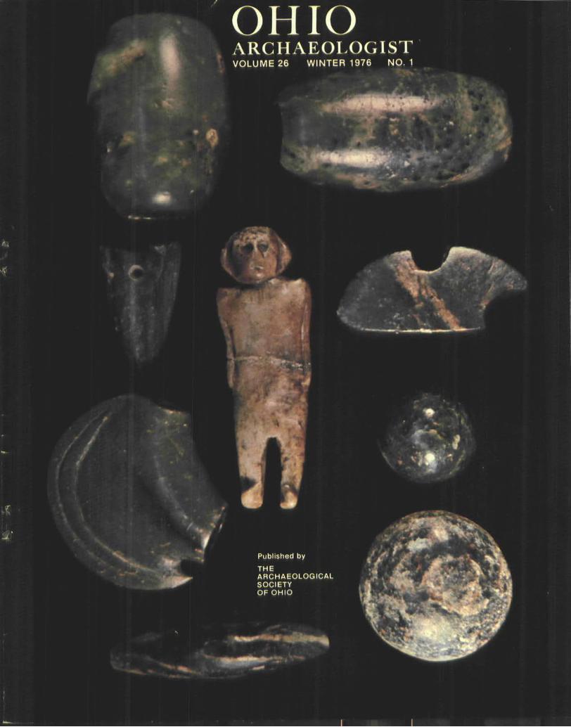
FRONT COVER Chlorite is probably the rarest stone from which Ohio Indian artifacts were fashioned. Its lustrous colors range from emerald green, through olive yellow, to almost black. In some of it there are red or rust colored inclusions or flashes of silver. Two tubular bannerstones are in the upper part of the picture, one of which is engraved. The small effigy- two cones, and the salvaged gorget are of a bright green with red and silvery inclusions. The pipe is of olive green chlorite and the bar weight is nearly black with silver inclusions. The human effigy is unique and is from the Hopewell farm, Ross County, Ohio.
too, a number of large sites are now completely gone.
Almost without except ion, any serious student trying to reconstruct the cultural sequences in Ohio must go back to literature written fifty or more years ago—literature which was written with little or no reference background or scienti f ic foundat ion. The ideas advanced by these early archaeologists are still being clung to by many present day archaeologists despite the abundance of empirical evidence to the contrary.
We now have a prehistoric site preservation bill—or soon will have—and it behooves the professional archaeologists in our state to make use of this law. Old ideas must be discarded and new interpretations must be made of what is under our feet. The preservation law should be used as a way to an end—not as an end in itself.
Robert N. Converse
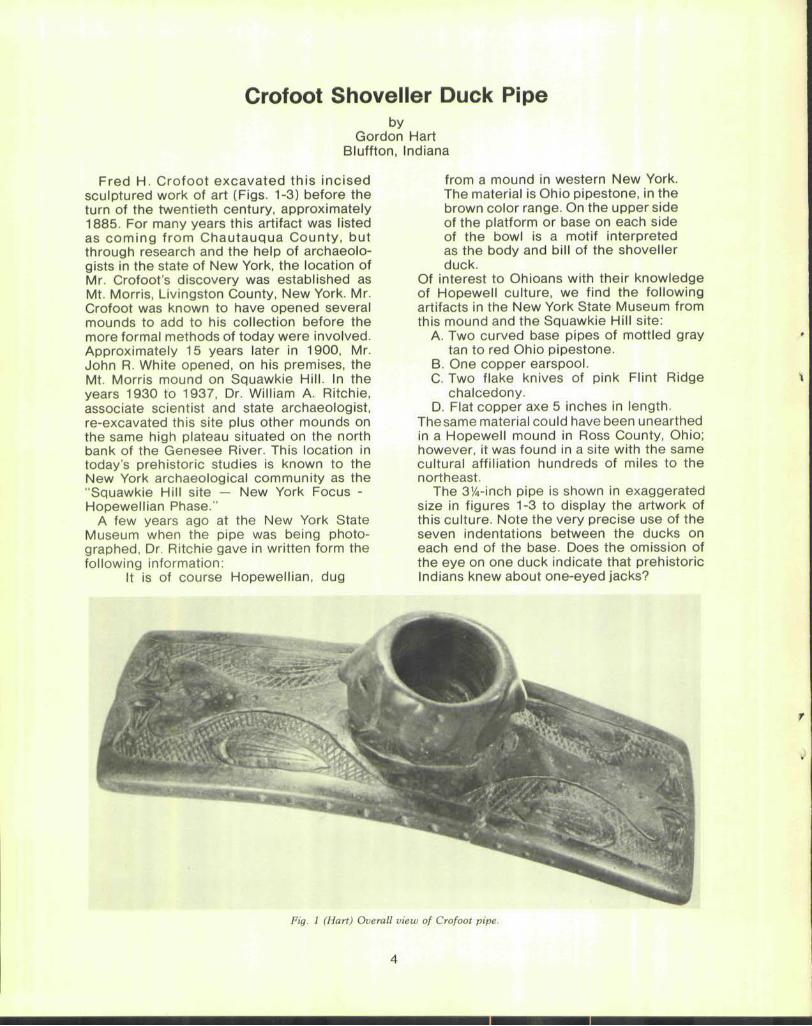
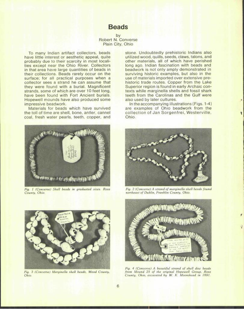
Crofoot Shoveller Duck Pipe by
Gordon Hart Bluffton, Indiana
Fred H. Crofoot excavated this incised sculptured work of art (Figs. 1-3) before the turn of the twentieth century, approximately 1885. For many years this artifact was listed as coming from Chautauqua County, but through research and the help of archaeologists in the state of New York, the location of Mr. Crofoot's discovery was established as Mt. Morris, Livingston County, New York. Mr. Crofoot was known to have opened several mounds to add to his collection before the more formal methods of today were involved. Approximately 15 years later in 1900, Mr. John R. White opened, on his premises, the Mt. Morris mound on Squawkie Hill. In the years 1930 to 1937, Dr. William A. Ritchie, associate scientist and state archaeologist, re-excavated this site plus other mounds on the same high plateau situated on the north bank of the Genesee River. This location in today's prehistoric studies is known to the New York archaeological community as the "Squawkie Hill site — New York Focus -Hopewellian Phase."
A few years ago at the New York State Museum when the pipe was being photographed, Dr. Ritchie gave in written form the following information:
It is of course Hopewellian, dug
from a mound in western New York. The material is Ohio pipestone, in the brown color range. On the upper side of the platform or base on each side of the bowl is a motif interpreted as the body and bill of the shoveller duck.
Of interest to Ohioans with their knowledge of Hopewell culture, we find the following artifacts in the New York State Museum from this mound and the Squawkie Hill site:
A. Two curved base pipes of mottled gray tan to red Ohio pipestone.
B. One copper earspool. C. Two flake knives of pink Flint Ridge
chalcedony. D. Flat copper axe 5 inches in length.
The same material could have been unearthed in a Hopewell mound in Ross County, Ohio; however, it was found in a site with the same cultural affiliation hundreds of miles to the northeast.
The 3%-inch pipe is shown in exaggerated size in figures 1-3 to display the artwork of this culture. Note the very precise use of the seven indentations between the ducks on each end of the base. Does the omission of the eye on one duck indicate that prehistoric Indians knew about one-eyed jacks?
Fig. 1 (Hart) Overall view of Crofoot pipe.
A
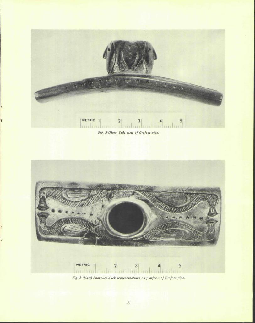
Fig. 2 (Hart) Side view of Crofoot pipe.
METHIC |
I I I I I
Fig. 3 (Hart) Shoveller duck representations on platform of Crofoot pipe.
5
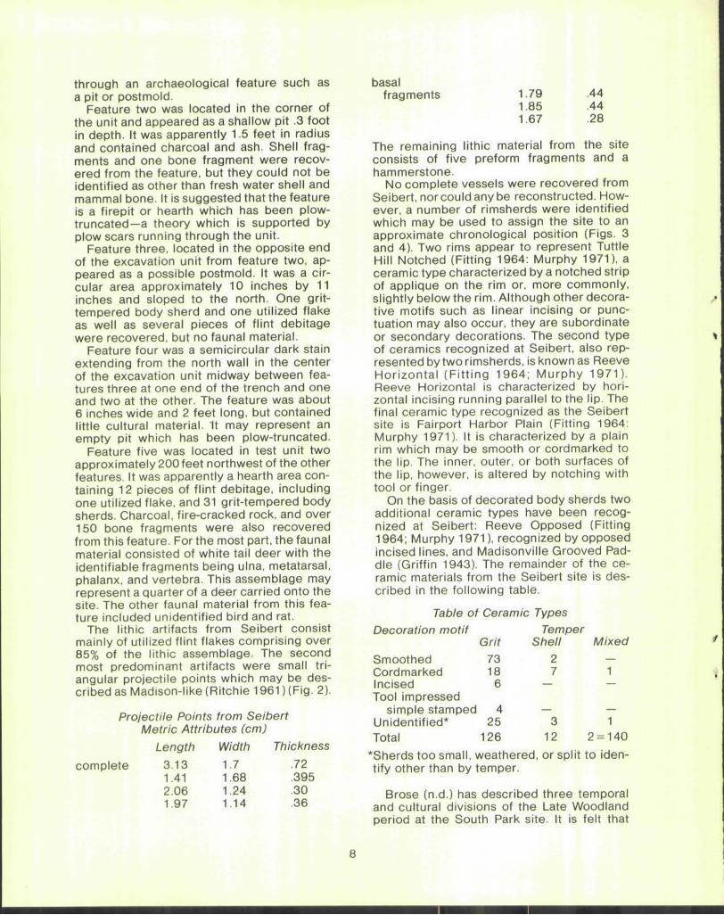
Beads by
Robert N. Converse Plain City, Ohio
To many Indian artifact collectors, beads have little interest or aesthetic appeal, quite probably due to their scarcity in most localities except near the Ohio River. Collectors in that area have large quantities of beads in their collections. Beads rarely occur on the surface; for all practical purposes when a collector sees a strand he can assume that they were found with a burial. Magnificent strands, some of which are over 10 feet long, have been found with Fort Ancient burials. Hopewell mounds have also produced some impressive beadwork.
Materials for beads which have survived the toll of time are shell, bone, antler, cannel coal, fresh water pearls, teeth, copper, and
Fig. 1 (Converse) Shell beads in graduated sizes. Ross County, Ohio.
Fig. 3 (Converse) Marginella shell beads, Wood County, Ohio.
stone. Undoubtedly prehistoric Indians also utilized wood, quills, seeds, claws, talons, and other materials, all of which have perished long ago. Indian fascination with beads and beadwork is not only amply demonstrated in surviving historic examples, but also in the use of materials imported over extensive prehistoric trade routes. Copper from the Lake Superior region is found in early Archaic contexts while marginella shells and fossil shark teeth from the Carolinas and the Gulf were also used by later cultures.
In the accompanying illustrations (Figs. 1-4) are examples of Ohio beadwork from the col lect ion of Jan Sorgenfrei , Westervi l le, Ohio.
Fig. 2 (Converse) A strand of marginella shell beads found northeast of Dublin, Franklin County, Ohio.
Fig. 4 (Converse) A beautiful strand of shell disc beads from Mound 25 of the original Hopewell Group, Ross County, Ohio, excavated by W. K. Moorehead in 1891.
Test Excavations at the Seibert Site: A Late Prehistoric Village in the Cuyahoga Valley
by G. Michael Pratt and David S. Brose
Dept. of Anthropology Case Western Reserve University
Cleveland, Ohio
The Seibert site was tested by the Anthropology Department at Case Western Reserve University in conjunction with an archaeological survey of northeastern Ohio during the summer of 1971. This study was a portion of a larger research plan funded by the National Science Foundation (GS-28985). The excavation was carried out under the direction of Dr. David S. Brose, Nancy Wilson, Clifford Watson, and Gala Baker; the material was analyzed at CWRU in 1974 by G. Michael Pratt.
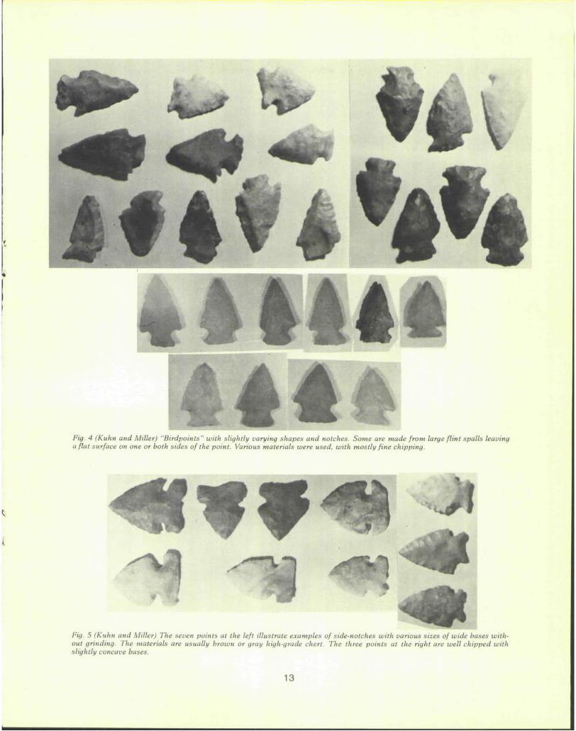
The Seibert site is located on a bluff overlooking the east bank of the Cuyahoga River some 100 feet above the present river level and roughly 25 miles from Lake Erie (Fig. 1). Its location on the Universal Transverse Mer-cator grid is approximately Zone 17, Easting Peninsula quad; 1963). The site lies in an 451740, Northing 4558550 (USGS 7.5' series, open field surrounded on three sides by woods. The excavation was concentrated in an area approximately 175 feet by 275 feet with test pits outside this rectangle showing less concentrated cultural material.
The natural vegetation of the site locale has been described as a mixed Mesophytic forest characterized by a predominance of beech; sugar, red and black maple; tulip; magnolia; chestnut; oaks; and ash. In lesser frequency white and black walnut, hickory, and elm also occur (Gordon 1969:50). Within a mile east or west of the site, areas of mixed oak forest predominate, although within a 15 mile radius nearly every type of vegetation could be found naturally in Ohio at the time of its settlement by Europeans (Gordon 1966: map). Thus, the area provides a potential for the utilization of nearly every type of collectable plant product found in the state, as well as the characteristic fauna of the river valley and upland forest environments.
At the time of excavation, the site was owned by Mr. Darrel Seibert of Cuyahoga Falls, Ohio. Although it was not under cultivation at the time of excavation, plow scars were observed intruding into the deposit indicating farming in recent times. When the presence of the site was first determined, it
was found that the land was for sale and negotiations were being carried on with the city of Akron to preserve the site area in a park.
Testing began in early July 1971 with 18 5-by-5-foot test pits, two of which were expanded due to the presence of features or the concentration of cultural material. All excavation was carried out by hand shoveling and troweling, with the overburden being sieved through 1/4 inch hardware cloth. Since it was felt that the site was to be preserved, the excavation was terminated after the area was proven to be an occupation site and sufficient data were recovered to roughly estimate the chronological position of that occupation.
In July it was learned that the site area had been sold to a developer and that construction had already begun on an apartment complex. Fieldworkers returned to find that grading and ditching had already begun for streets and underground power and water lines. Cultural material exposed by the construction prompted a surface collection and two more test pits were excavated at this time. By the end of August 1971, the site had been completely obliterated by modern construction.
Five features were recognized during the testing at the Seibert site, four of them from the same excavation unit (Unit 12). This unit was a 5-by-15-foot trench oriented with the long axis east-west. The fifth feature was recognized in a 10 foot by 10 foot square. Both of these units were located in the center of the test area, the area which had reflected the heaviest concentration of cultural material on the surface. The other test units contained cultural material, but no recognizable features.
Feature one appeared as a dark circular stain approximately 12 inches in diameter. Five pieces of flint debitage, including one utilized flake, ceramic material including five grit-tempered and two shell-tempered body sherds, and ten bone fragments, some of them burned, were recovered from the feature. The bone fragments, however, were too minute to be identified other than as mammal. The feature was felt to be a rodent burrow by those in the field, but may also be a burrow
7
through an archaeological feature such as a pit or postmold.
Feature two was located in the corner of the unit and appeared as a shallow pit .3 foot in depth. It was apparently 1.5 feet in radius and contained charcoal and ash. Shell fragments and one bone fragment were recovered from the feature, but they could not be identified as other than fresh water shell and mammal bone. It is suggested that the feature is a firepit or hearth which has been plow-truncated—a theory which is supported by plow scars running through the unit.
Feature three, located in the opposite end of the excavation unit from feature two, appeared as a possible postmold. It was a circular area approximately 10 inches by 11 inches and sloped to the north. One grit-tempered body sherd and one utilized flake as well as several pieces of flint debitage were recovered, but no faunal material.
Feature four was a semicircular dark stain extending from the north wall in the center of the excavation unit midway between features three at one end of the trench and one and two at the other. The feature was about 6 inches wide and 2 feet long, but contained little cultural material. It may represent an empty pit which has been plow-truncated.
Feature five was located in test unit two approximately 200 feet northwest of the other features. It was apparently a hearth area containing 12 pieces of flint debitage, including one utilized flake, and 31 grit-tempered body sherds. Charcoal, fire-cracked rock, and over 150 bone fragments were also recovered from this feature. For the most part, the faunal material consisted of white tail deer with the identifiable fragments being ulna, metatarsal, phalanx, and vertebra. This assemblage may represent a quarter of a deer carried onto the site. The other faunal material from this feature included unidentified bird and rat.
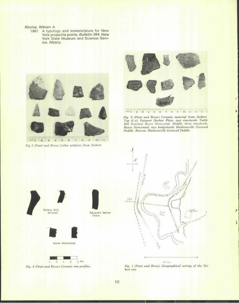
The lithic artifacts from Seibert consist mainly of utilized flint flakes comprising over 85% of the lithic assemblage. The second most predominant artifacts were small triangular projectile points which may be described as Madison-like (Ritchie 1961) (Fig. 2).
Projectile Points from Seibert Metric Attributes (cm)
Length Width Thickness
complete 3.13 1.7 .72 1.41 1.68 .395 2.06 1.24 .30 1.97 1.14 .36
basal fragments 1.79
1.85 1.67
.44
.44
.28
The remaining lithic material from the site consists of five preform fragments and a hammerstone.
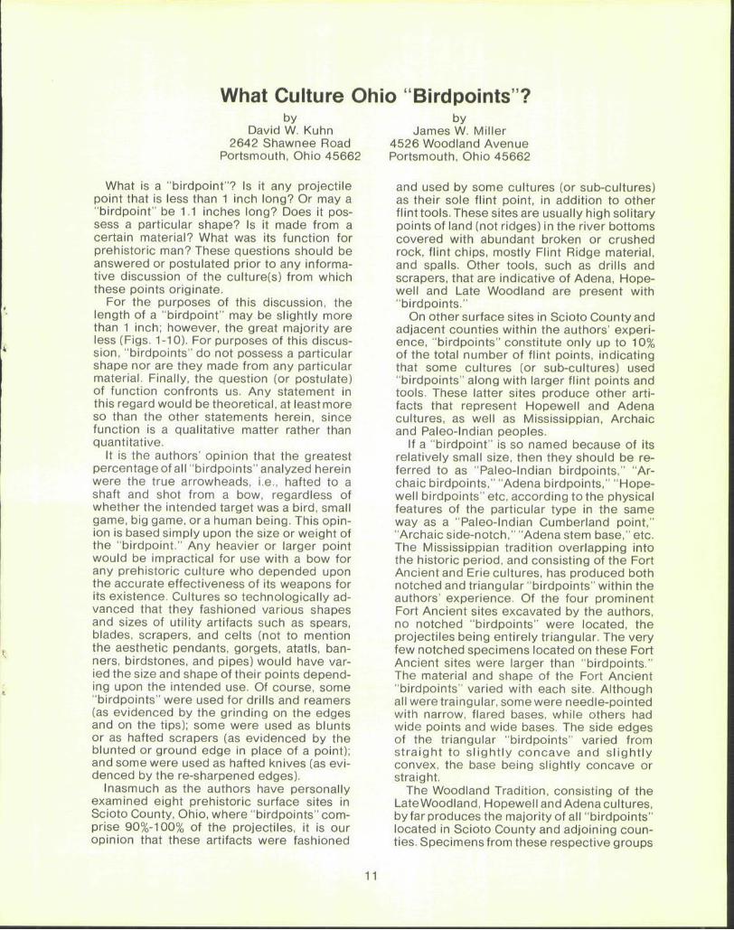
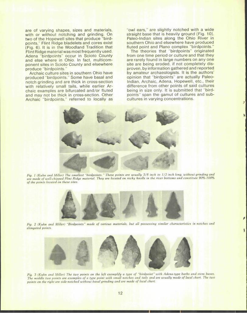
No complete vessels were recovered from Seibert, nor could any be reconstructed. However, a number of rimsherds were identified which may be used to assign the site to an approximate chronological position (Figs. 3 and 4). Two rims appear to represent Tuttle Hill Notched (Fitting 1964: Murphy 1971), a ceramic type characterized by a notched strip of applique on the rim or, more commonly, slightly below the rim. Although other decorative motifs such as linear incising or punctuation may also occur, they are subordinate or secondary decorations. The second type of ceramics recognized at Seibert, also represented by two rimsherds, is known as Reeve Horizontal (Fitt ing 1964; Murphy 1971). Reeve Horizontal is characterized by horizontal incising running parallel to the lip. The final ceramic type recognized as the Seibert site is Fairport Harbor Plain (Fitting 1964: Murphy 1971). It is characterized by a plain rim which may be smooth or cordmarked to the lip. The inner, outer, or both surfaces of the lip, however, is altered by notching with tool or finger.
On the basis of decorated body sherds two additional ceramic types have been recognized at Seibert: Reeve Opposed (Fitting 1964; Murphy 1971), recognized by opposed incised lines, and Madisonville Grooved Paddle (Griffin 1943). The remainder of the ceramic materials from the Seibert site is described in the following table.
Table of Ceramic Types Decoration motif Temper
Grit Shell Mixed Smoothed 73 2 — Cordmarked 18 7 1 Incised 6 — — Tool impressed
simple stamped 4 — — Unidentified* 25 3 1 Total 126 12 2 = 140
*Sherds too small, weathered, or split to identify other than by temper.
Brose (n.d.) has described three temporal and cultural divisions of the Late Woodland period at the South Park site. It is felt that
8

Seibert falls into the middle period, or approximately A.D. 1250-1450. This period represents a shift to greater reliance on agriculture than was previously seen in the area, with a resultant reduction in seasonal movement. The settlement pattern for this period is characterized by the establishment of agricultural villages in the late spring both on the coastal plain and in the interior uplands. These villages were occupied until after the autumn harvest and appear to have been surrounded by small special purpose camps for both hunting and collecting. After abandonment of the summer villages, the population moved to lake side villages for the utilization of fish and water fowl until spring. In addition, short-term camps were established in the upriver area by winter hunting parties from the coastal settlements. Based on the material recovered from the second occupation at South Park, the structures which may be expected from this time period appear as sub-rectangular postmold patterns 30-35 feet by 15-17 feet. The structures were characterized by multiple interior hearths and scattered interior and exterior round-bottomed and bell-shaped pits.
The ceramic material from this time period is quite varied, with no clear predominance of a single type. Fairport Filleted (Murphy 1971) and Tuttle Hill Notched (Fitting 1964) are the most common types, representing 20% and 16% respectively. A number of Fort Ancient ceramic types from the Anderson, Baum, and Madison foci (Griffin 1943) were recognized at South Park as well as other types of Whittlesey ware (c.f. Brose n.d.). However, none of those types present at South Park represented more than 10% of the ceramic identified.
The lithic material is rather unspectacular, indicating a high frequency of utilized debitage—73% of all chipped stone artifacts. The projectile points from this period are predominantly Madison-like (60%) with Levanna-like (23%) and Jack's Reef Corner-removed (17%) also recognized. Scrapers and drills are rare.
Bone artifacts consist of fish hooks, antler drifts, elk bone beamers, and turkey metatarsal awls, but the most common bone artifacts were cut bird bone beads.
As a result of the material recovered from the test excavations at Seibert, some tentative conclusions may be drawn concerning the chronological and cultural position of the site. It appears to be an agricultural village dating from approximately A.D. 1250-1450. The absence of faunal remains at the site
seems to indicate a lack of reliance on game, at least at those seasons during which the site was occupied. The presence of apparently empty features may represent storage pits which have been opened, or in which the agricultural remains were not preserved. The absence of significant differences in soil acidity or calcium carbonate content suggests the former interpretation is correct. The faunal remains which were recovered represented only a partial skeleton of white-tail deer, possibly a single quarter which may have been transported onto the site from a nearby hunting and butchering station.
Although the site may date to a later period of time, it is probably not earlier. In the earlier period, A.D. 900-1300, the ceramic materials show an affinity with the Younge tradition (Fitting 1965), while the later phases described by Brose (n.d.) reflect relations with the Fort Ancient Aspect (Griffin 1943) to the south.
Acknowledgements:Theauthors are indebted to Mr. Darrel Seibert for permission to excavate, the National Science Foundation for funding (GS-28985), and Ms. Helga Blue-stone of Case Western University for the analysis of the faunal material.
Brose, David S. (n.d.) An initial summary of the Late Prehis
toric period in northwestern Ohio. In The Late Prehistory of the Lake Erie drainage basin: a symposium D. Brose (ed.), Scientific Papers of the Cleveland Museum of Natural History. In Press.
Fitting, James E. 1964 Ceramic relationships of four Late Wood
land sites in northern Ohio. The Wisconsin Archaeologist 45(4): 160-75.
1965 Late Woodland culture of southeastern Michigan. Anthropological Papers #24, Museum of Anthropology, University of Michigan, Ann Arbor.
Gordon, Robert B. 1966 Natural vegetation of Ohio at the time
of the earliest land surveys. Map, Ohio Biological Survey, Ohio State University, Columbus.
1969 The natural vegetation of Ohio in pioneer days. Bulletin of the Ohio Biological Survey 3 (2), Ohio State University, Columbus, Ohio.
Griffin, James B. 1943 The Fort Ancient aspect: its cultural and
chronological position in Mississippi Valley archaeology, University of Michigan, Ann Arbor.
Murphy, James 1971 Some Whittlesey pottery types. Ohio
Archaeologist 21(1) 298-305.
Ritchie, William A. 1961 A typology and nomenclature for New
York projectile points. Bulletin 384, New York State Museum and Science Service, Albany.
" 1 2i :« * 5 B 7 * « M> J 1
Fig 2 (Pratt and Brose) Lithic artifacts from Seibert.
I Tuttle a i l
Notched
I Fairport Harbor
Plain
• I Reeve Horizontal
Fig. 3 (Pratt and Brose) Ceramic material from Seibert. Top (L-r): Fairport Harbor Plain; two rimsherds Tuttle Hill Notched: Reeve Horizontal. Middle: three rimsherds Reeve Horizontal: two bodysherds Madisonville Grooved Paddle. Bottom: Madisonville Grooved Paddle.
1 0 1 2 3 m'
Fig. 4 (Pratt and Brose) Ceramic rim profiles. Fig. 1 (Pratt and Brose) Geographical setting of the Seibert site.
10
What Culture Ohio "Birdpoints"? by
David W. Kuhn 2642 Shawnee Road
Portsmouth, Ohio 45662
What is a "birdpoint"? Is it any projectile point that is less than 1 inch long? Or may a "birdpoint" be 1.1 inches long? Does it possess a particular shape? Is it made from a certain material? What was its function for prehistoric man? These questions should be answered or postulated prior to any informative discussion of the culture(s) from which these points originate.
For the purposes of this discussion, the length of a "birdpoint" may be slightly more than 1 inch; however, the great majority are less (Figs. 1-10). For purposes of this discussion, "birdpoints" do not possess a particular shape nor are they made from any particular material. Finally, the question (or postulate) of function confronts us. Any statement in this regard would be theoretical, at leastmore so than the other statements herein, since function is a qualitative matter rather than quantitative.
It is the authors' opinion that the greatest percentage of all "birdpoints" analyzed herein were the true arrowheads, i.e., hafted to a shaft and shot from a bow, regardless of whether the intended target was a bird, small game, big game, or a human being. This opinion is based simply upon the size or weight of the "birdpoint." Any heavier or larger point would be impractical for use with a bow for any prehistoric culture who depended upon the accurate effectiveness of its weapons for its existence. Cultures so technologically advanced that they fashioned various shapes and sizes of utility artifacts such as spears, blades, scrapers, and celts (not to mention the aesthetic pendants, gorgets, atatls, banners, birdstones, and pipes) would have varied the size and shape of their points depending upon the intended use. Of course, some "birdpoints" were used for drills and reamers (as evidenced by the grinding on the edges and on the tips); some were used as blunts or as hafted scrapers (as evidenced by the blunted or ground edge in place of a point); and some were used as hafted knives (as evidenced by the re-sharpened edges).
Inasmuch as the authors have personally examined eight prehistoric surface sites in Scioto County, Ohio, where "birdpoints" comprise 90%-100% of the projectiles, it is our opinion that these artifacts were fashioned
by James W. Miller
4526 Woodland Avenue Portsmouth, Ohio 45662
and used by some cultures (or sub-cultures) as their sole flint point, in addition to other flinttools. These sites are usually high solitary points of land (not ridges) in the river bottoms covered with abundant broken or crushed rock, flint chips, mostly Flint Ridge material, and spalls. Other tools, such as drills and scrapers, that are indicative of Adena, Hopewell and Late Woodland are present with "birdpoints."
On other surface sites in Scioto County and adjacent counties within the authors' experience, "birdpoints" constitute only up to 10% of the total number of flint points, indicating that some cultures (or sub-cultures) used "birdpoints" along with larger flint points and tools. These latter sites produce other artifacts that represent Hopewell and Adena cultures, as well as Mississippian, Archaic and Paleo-lndian peoples.
If a "birdpoint" is so named because of its relatively small size, then they should be referred to as "Paleo-lndian birdpoints," "Archaic birdpoints," "Adena birdpoints," "Hopewell birdpoints" etc, according to the physical features of the particular type in the same way as a "Paleo-lndian Cumberland point," "Archaic side-notch," "Adena stem base," etc. The Mississippian tradition overlapping into the historic period, and consisting of the Fort Ancient and Erie cultures, has produced both notched and triangular "birdpoints" within the authors' experience. Of the four prominent Fort Ancient sites excavated by the authors, no notched "birdpoints" were located, the projectiles being entirely triangular. The very few notched specimens located on these Fort Ancient sites were larger than "birdpoints." The material and shape of the Fort Ancient "birdpoints" varied with each site. Although all were traingular, some were needle-pointed with narrow, flared bases, while others had wide points and wide bases. The side edges of the triangular "birdpoints" varied from straight to sl ightly concave and sl ightly convex, the base being slightly concave or straight.
The Woodland Tradition, consisting of the Late Woodland, Hopewell and Adena cultures, by far produces the majority of all "birdpoints" located in Scioto County and adjoining counties. Specimens from these respective groups
are of varying shapes, sizes and materials, with or without notching and grinding. On two of the Hopewell sites that produce "bird-points," Flint Ridge bladelets and cores exist (Fig. 6). It is in the Woodland Tradition that Flint Ridge material was most frequently used. Adena "birdpoints" occur in Scioto County and else where in Ohio. In fact, multicom-ponent sites in Scioto County and elsewhere produce "birdpoints."
Archaic culture sites in southern Ohio have produced "birdpoints." Some have basal and notch grinding and are thick in cross-section with relatively small tails, while earlier Archaic examples are bifurcated and/or fluted and may not be thick in cross-section. Other Archaic "birdpoints," referred to locally as
"owl ears," are slightly notched with a wide straight base that is heavily ground (Fig. 10). Paleo-lndian sites along the Ohio River in southern Ohio and elsewhere have produced fluted point and Piano complex "birdpoints."
The theories that "birdpoints" originated from one time period or culture and that they are rarely found in large numbers on any one site are being eroded, if not completely disproves by information gathered and reported by amateur archaeologists. It is the authors' opinion that "birdpoints" are actually Paleo-lndian, Archaic, Adena, Hopewell, etc., their difference from other points of said cultures being in size only. It is submitted that "bird-points" span the gamut of cultures and subcultures in varying concentrations.
,
Si 3̂ , V
^fefl ̂ f l£ Fig. 1 (Kuhn and Miller) The smallest "birdpoints." These points are usually 3/8 inch to 1/2 inch long, without grinding and are made of well-chipped Flint Ridge material. They are located on rocky knolls in the river bottoms and constitute 90%-100% of the points located on these sites.
Fig. 2 (Kuhn and Miller) "Birdpoints" made of various materials, but all possessing similar characteristics in notches and elongated points.
• i >
Fig. 3 (Kuhn and Miller) The two points on the left exemplify a type of "birdpoint" with Adena-type barbs and stem bases. The middle two points are examples of a type point with small notches and tails and are usually made of local chert. The two points on the right are side-notched without basal grinding and are made of local chert.
12
mr w ^w
Fig. 4 (Kuhn and Miller) "Birdpoints" with slightly varying shapes and notches. Some are made from large flint spalls leaving a flat surface on one or both sides of the point. Various materials were used, with mostly fine chipping.
Fig. 5 (Kuhn and Miller) The seven points at the left illustrate examples of side-notches with various sizes of wide bases without grinding. The materials are usually brown or gray high-grade chert. The three points at the right are well chipped with slightly concave bases.
13
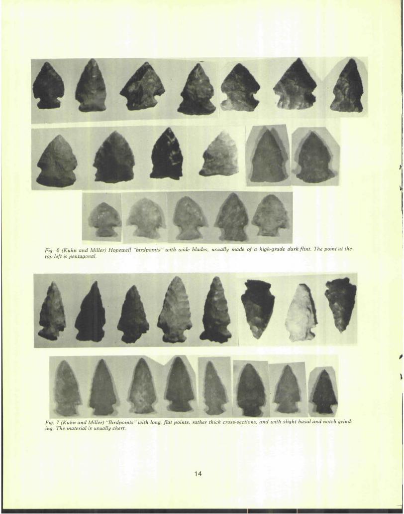
Fig. 6 (Kuhn and Miller) Hopewell "birdpoints" with wide blades, usually made of a high-grade dark flint. The point at the top left is pentagonal.
^H ^H ^M ^^f &̂ ^fl ^^^w ^w ' »
14441* Fig. 7 (Kuhn and Miller) "Birdpoints" with long, flat points, rather thick cross-sections, and with slight basal and notch grinding. The material is usually chert.
14
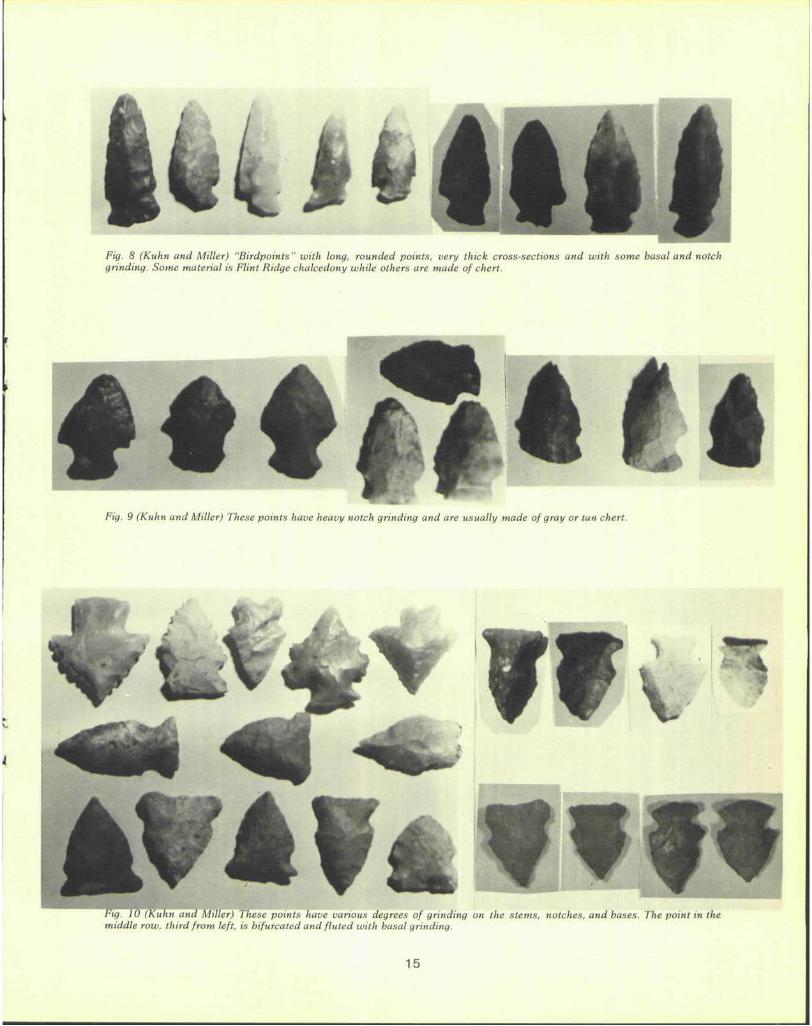
Fig. 8 (Kuhn and Miller) "Birdpoints" with long, rounded points, very thick cross-sections and with some basal and notch grinding. Some material is Flint Ridge chalcedony while others are made of chert.
Fig. 9 (Kuhn and Miller) These points have heavy notch grinding and are usually made of gray or tan chert.
i
Fig. 10 (Kuhn and Miller) These points have various degrees of grinding on the stems, notches, and bases. The point in the middle row, third from left, is bifurcated and fluted with basal grinding.
15
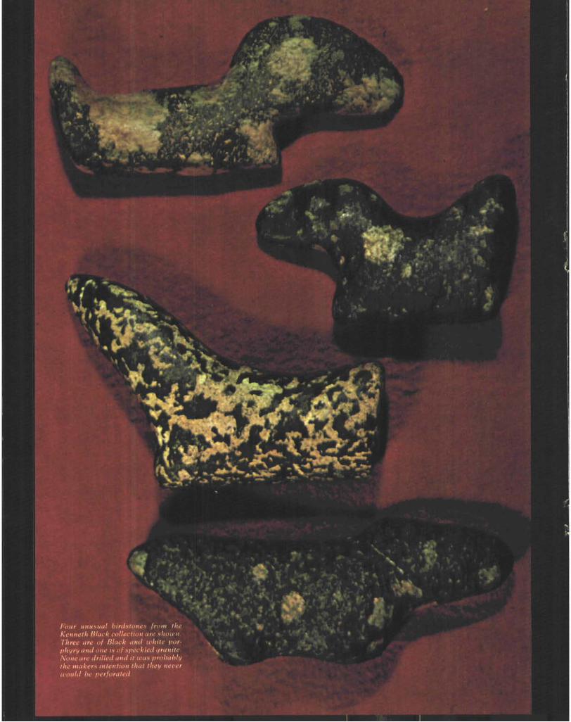
Four unusual birdstones from i Kenneth Black collection are show) Three are ol Mack and white porphyry and one is a) speckled granite None are drilled and it was probably the makers intention thai they never would be perforated
KVM
' » # •
N
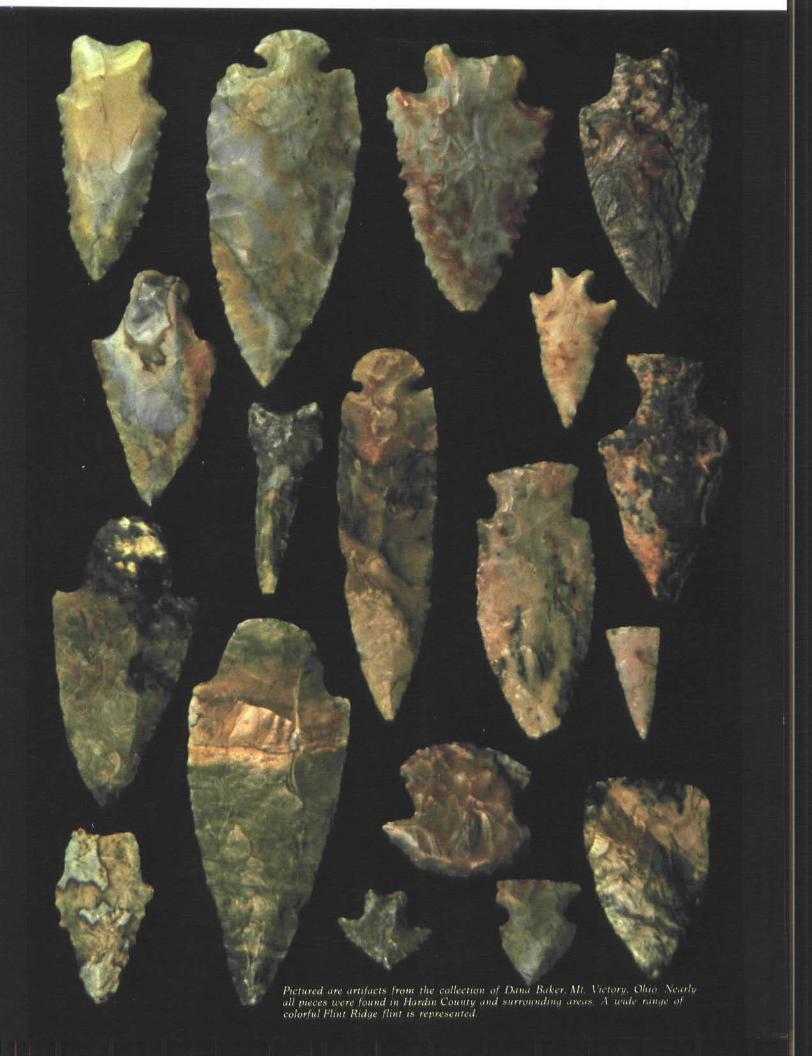
Pictured art artifact* hom the coli all pieces were found in Hardin Co. colorful Flint Ridge " " " it reprete
Daua Bakar, Mi. V; .1 wide ran,
rfvwffwivffffffffWffTi I V I I I I I I FBI a i f i i i • > ! • • • • •
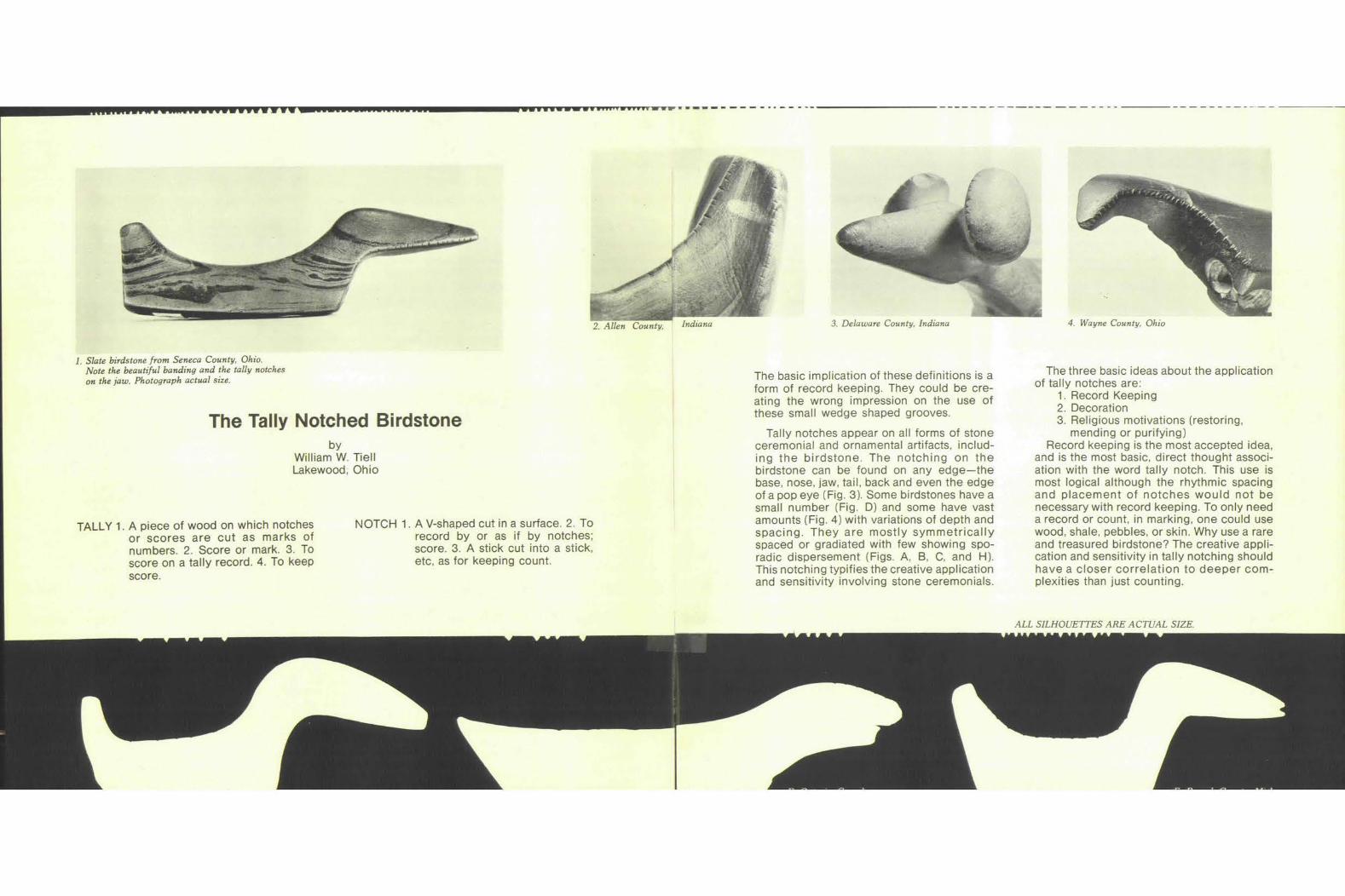
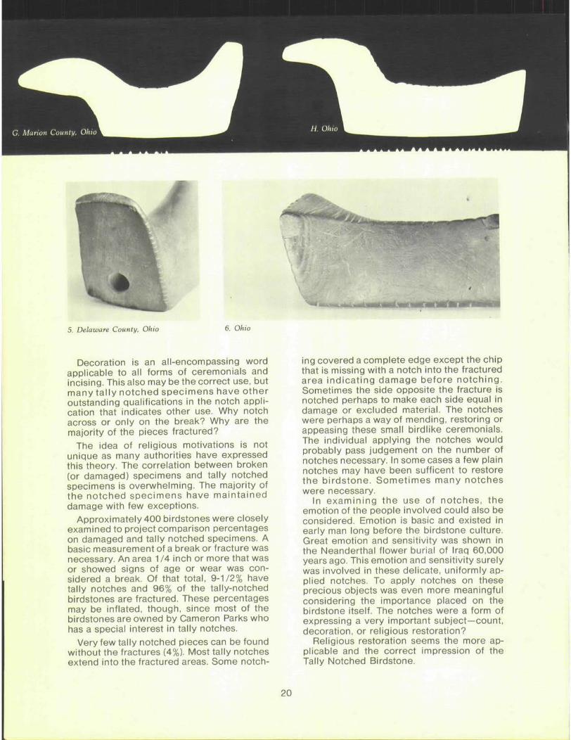
2. Allen County,
1. Slate birdstone from Seneca County, Ohio. Note the beautiful banding and the tally notches on the jaw. Photograph actual size.
The Tally Notched Birdstone by
William W. Tiell Lakewood, Ohio
TALLY 1. A piece of wood on which notches or scores are cut as marks of numbers. 2. Score or mark. 3. To score on a tally record. 4. To keep score.
NOTCH 1. A V-shaped cut in a surface. 2. To record by or as if by notches; score. 3. A stick cut into a stick, etc, as for keeping count.
3. Delaware County, Indiana 4. Wayne County, Ohio
The basic implication of these definitions is a form of record keeping. They could be creating the wrong impression on the use of these small wedge shaped grooves.
Tally notches appear on all forms of stone ceremonial and ornamental artifacts, including the birdstone. The notching on the birdstone can be found on any edge—the base, nose, jaw, tail, back and even the edge of a pop eye (Fig. 3). Some birdstones have a small number (Fig. D) and some have vast amounts (Fig. 4) with variations of depth and spacing. They are mostly symmetrically spaced or gradiated with few showing sporadic dispersement (Figs. A, B, C, and H). This notching typifies the creative application and sensitivity involving stone ceremonials.
The three basic ideas about the application of tally notches are:
1. Record Keeping 2. Decoration 3. Religious motivations (restoring,
mending or purifying) Record keeping is the most accepted idea,
and is the most basic, direct thought association with the word tally notch. This use is most logical although the rhythmic spacing and placement of notches would not be necessary with record keeping. To only need a record or count, in marking, one could use wood, shale, pebbles, or skin. Why use a rare and treasured birdstone? The creative application and sensitivity in tally notching should have a closer correlation to deeper complexities than just counting.
ALL SILHOUETTES ARE ACTUAL SIZE.
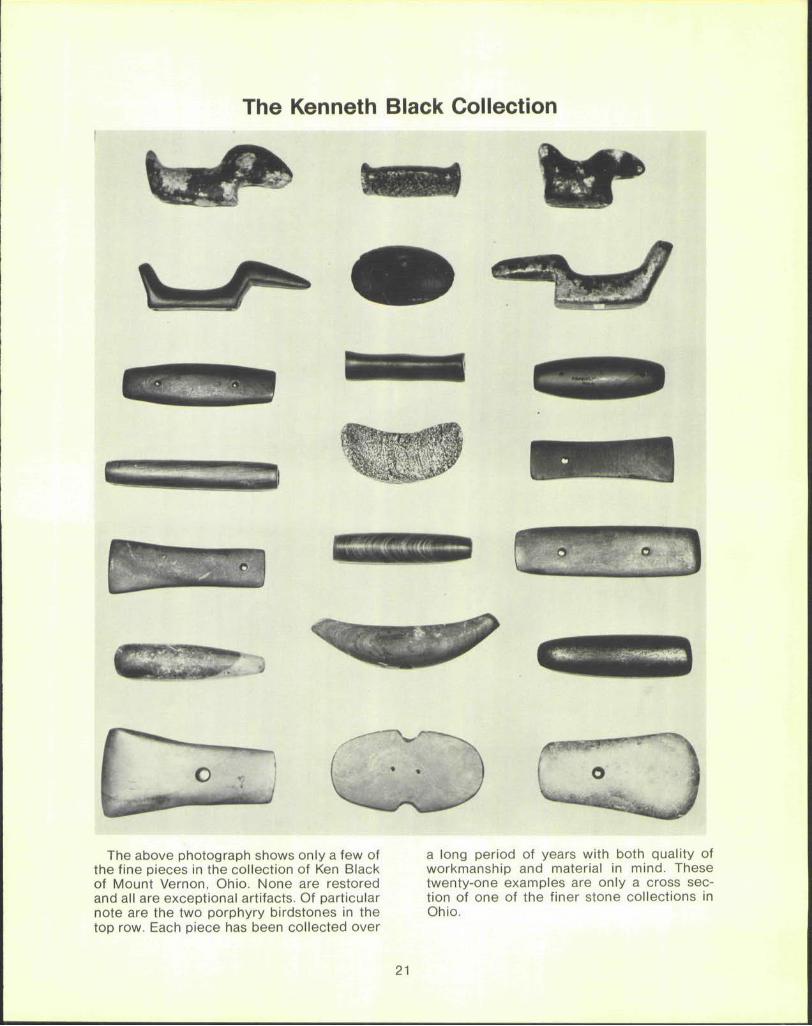
5. Delaware County, Ohio 6. Ohio
Decoration is an all-encompassing word applicable to all forms of ceremonials and incising. This also may be the correct use, but many tally notched specimens have other outstanding qualifications in the notch application that indicates other use. Why notch across or only on the break? Why are the majority of the pieces fractured?
The idea of religious motivations is not unique as many authorities have expressed this theory. The correlation between broken (or damaged) specimens and tally notched specimens is overwhelming. The majority of the notched specimens have maintained damage with few exceptions.
Approximately 400 birdstones were closely examined to project comparison percentages on damaged and tally notched specimens. A basic measurement of a break or fracture was necessary. An area 11A inch or more that was or showed signs of age or wear was considered a break. Of that total, 9-1/2% have tally notches and 96% of the tally-notched birdstones are fractured. These percentages may be inflated, though, since most of the birdstones are owned by Cameron Parks who has a special interest in tally notches.
Very few tally notched pieces can be found without the fractures (4%). Most tally notches extend into the fractured areas. Some notch
ing covered a complete edge except the chip that is missing with a notch into the fractured area indicating damage before notching. Sometimes the side opposite the fracture is notched perhaps to make each side equal in damage or excluded material. The notches were perhaps a way of mending, restoring or appeasing these small birdlike ceremonials. The individual applying the notches would probably pass judgement on the number of notches necessary. In some cases a few plain notches may have been sufficent to restore the birdstone. Sometimes many notches were necessary.
In examining the use of notches, the emotion of the people involved could also be considered. Emotion is basic and existed in early man long before the birdstone culture. Great emotion and sensitivity was shown in the Neanderthal flower burial of Iraq 60,000 years ago. This emotion and sensitivity surely was involved in these delicate, uniformly applied notches. To apply notches on these precious objects was even more meaningful considering the importance placed on the birdstone itself. The notches were a form of expressing a very important subject—count, decoration, or religious restoration?
Religious restoration seems the more applicable and the correct impression of the Tally Notched Birdstone.
20
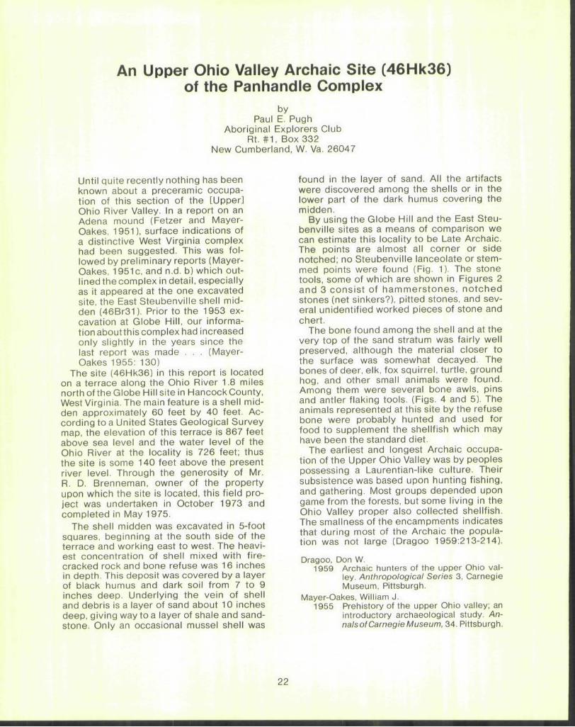
The Kenneth Black Collection
The above photograph shows only a few of a long period of years with both quality of the fine pieces in the collection of Ken Black workmanship and material in mind. These of Mount Vernon, Ohio. None are restored twenty-one examples are only a cross sec-and all are exceptional artifacts. Of particular tion of one of the finer stone collections in note are the two porphyry birdstones in the Ohio, top row. Each piece has been collected over
21
An Upper Ohio Valley Archaic Site (46Hk36) of the Panhandle Complex
by Paul E. Pugh
Aboriginal Explorers Club Rt. #1 , Box 332
New Cumberland, W. Va. 26047
Until quite recently nothing has been known about a preceramic occupation of this section of the [Upper] Ohio River Valley. In a report on an Adena mound (Fetzer and Mayer-Oakes, 1951), surface indications of a distinctive West Virginia complex had been suggested. This was followed by preliminary reports (Mayer-Oakes, 1951c, and n.d. b) which outlined the complex in detail, especially as it appeared at the one excavated site, the East Steubenville shell midden (46Br31). Prior to the 1953 excavation at Globe Hill, our information aboutthis complex had increased only slightly in the years since the last report was made . . . (Mayer-Oakes 1955: 130)
The site (46Hk36) in this report is located on a terrace along the Ohio River 1.8 miles north of the Globe Hill site in Hancock County, West Virginia. The main feature is a shell midden approximately 60 feet by 40 feet. According to a United States Geological Survey map, the elevation of this terrace is 867 feet above sea level and the water level of the Ohio River at the locality is 726 feet; thus the site is some 140 feet above the present river level. Through the generosity of Mr. R. D. Brenneman, owner of the property upon which the site is located, this field project was undertaken in October 1973 and completed in May 1975.
The shell midden was excavated in 5-foot squares, beginning at the south side of the terrace and working east to west. The heaviest concentration of shell mixed with fire-cracked rock and bone refuse was 16 inches in depth. This deposit was covered by a layer of black humus and dark soil from 7 to 9 inches deep. Underlying the vein of shell and debris is a layer of sand about 10 inches deep, giving way to a layer of shale and sandstone. Only an occasional mussel shell was
found in the layer of sand. All the artifacts were discovered among the shells or in the lower part of the dark humus covering the midden.
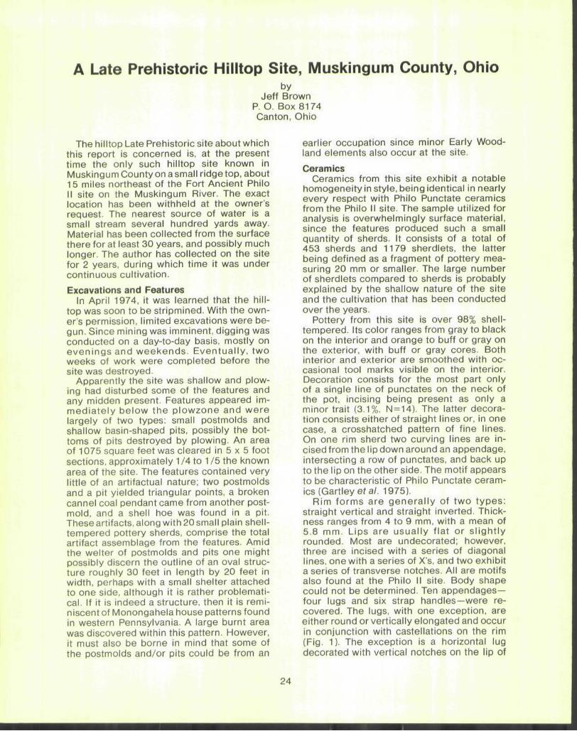
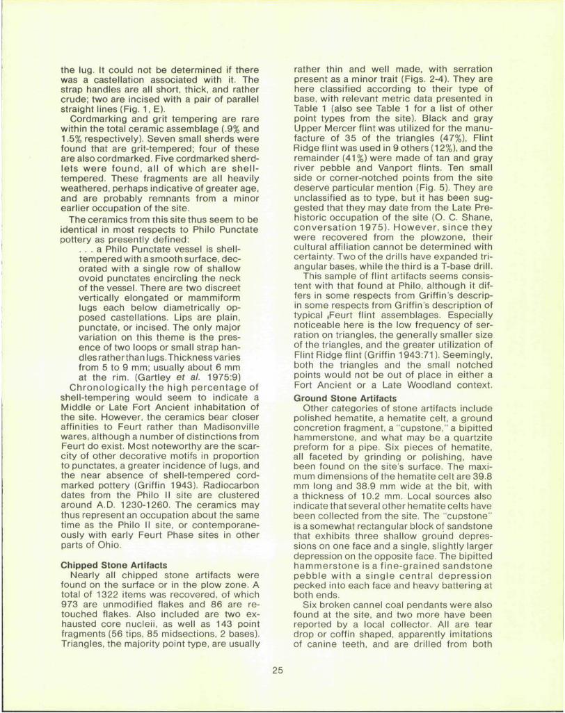
By using the Globe Hill and the East Steubenville sites as a means of comparison we can estimate this locality to be Late Archaic. The points are almost all corner or side notched; no Steubenville lanceolate or stemmed points were found (Fig. 1). The stone tools, some of which are shown in Figures 2 and 3 consist of hammerstones, notched stones (net sinkers?), pitted stones, and several unidentified worked pieces of stone and chert.
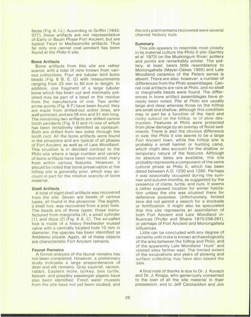
The bone found among the shell and at the very top of the sand stratum was fairly well preserved, although the material closer to the surface was somewhat decayed. The bones of deer, elk, fox squirrel, turtle, ground hog, and other small animals were found. Among them were several bone awls, pins and antler flaking tools. (Figs. 4 and 5). The animals represented at this site by the refuse bone were probably hunted and used for food to supplement the shellfish which may have been the standard diet.
The earliest and longest Archaic occupation of the Upper Ohio Valley was by peoples possessing a Laurentian-like culture. Their subsistence was based upon hunting fishing, and gathering. Most groups depended upon game from the forests, but some living in the Ohio Valley proper also collected shellfish. The smallness of the encampments indicates that during most of the Archaic the population was not large (Dragoo 1959:213-214).
Dragoo, Don W. 1959 Archaic hunters of the upper Ohio val
ley. Anthropological Series 3, Carnegie Museum, Pittsburgh.
Mayer-Oakes, William J. 1955 Prehistory of the upper Ohio valley; an
introductory archaeological study. An-nalsof Carnegie Museum, 34. Pittsburgh.
22
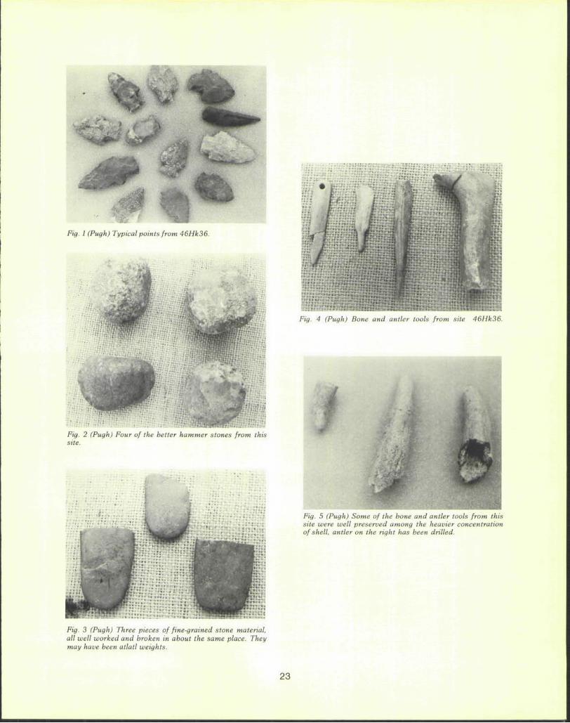
Fig. 1 (Pugh) Typical points from 46Hk36.
w
|
• • ' , ' : • • ' -
y
Fig. 4 (Pugh) Bone and antler tools from site 46Hk36.
• ^
l i*>
• • • . . . : •
Fig. 2 (Pugh) Four of the better hammer stones from this site.
Fig. 3 (Pugh) Three pieces of fine-grained stone material, all well worked and broken in about the same place. They may have been atlatl weights.
Fig. 5 (Pugh) Some of the bone and antler tools from this site were well preserved among the heavier concentration of shell, antler on the right has been drilled.
23
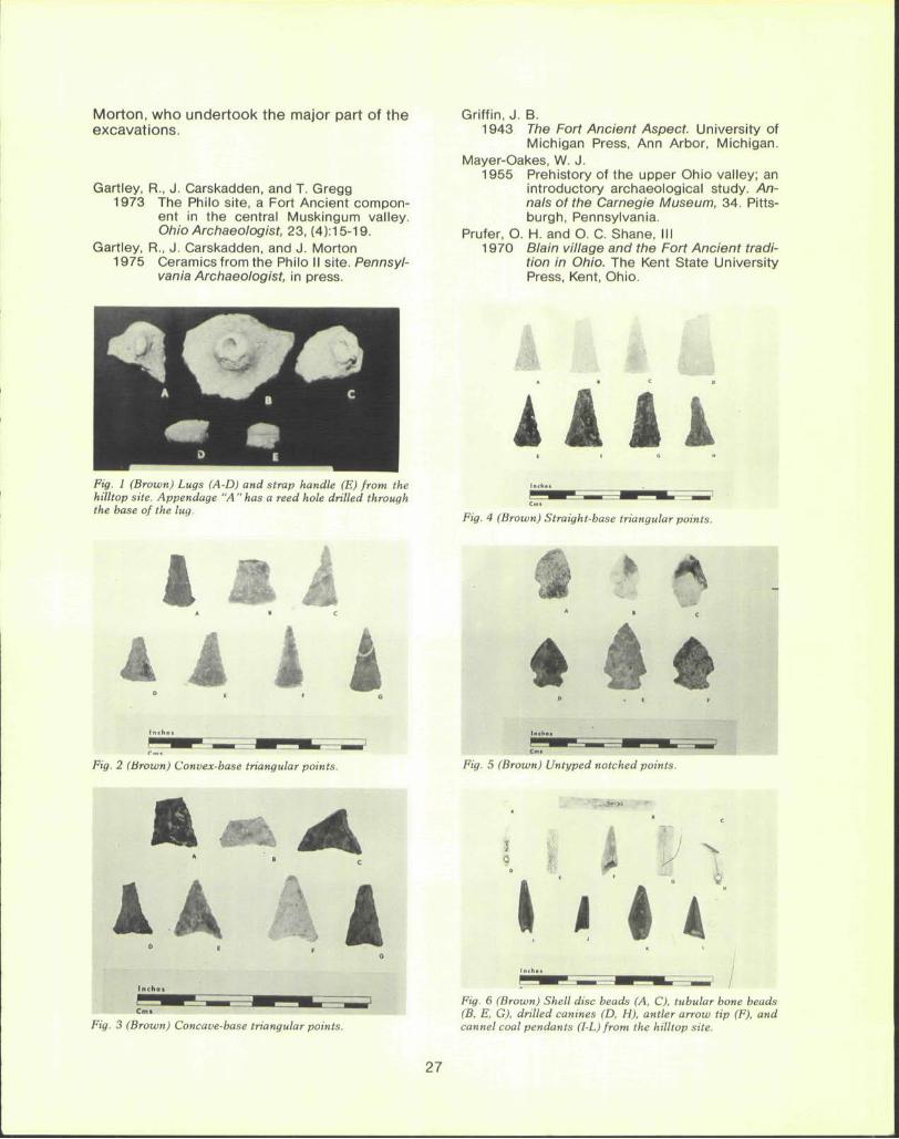
A Late Prehistoric Hilltop Site, Muskingum County, Ohio by
Jeff Brown P. O. Box 8174 Canton, Ohio
The hilltop Late Prehistoric site about which this report is concerned is, at the present time the only such hilltop site known in Muskingum County on a small ridge top, about 15 miles northeast of the Fort Ancient Philo II site on the Muskingum River. The exact location has been withheld at the owner's request. The nearest source of water is a small stream several hundred yards away. Material has been collected from the surface there for at least 30 years, and possibly much longer. The author has collected on the site for 2 years, during which time it was under continuous cultivation.
Excavations and Features In April 1974, it was learned that the hill
top was soon to be stripmined. With the owner's permission, limited excavations were begun. Since mining was imminent, digging was conducted on a day-to-day basis, mostly on evenings and weekends. Eventually, two weeks of work were completed before the site was destroyed.
Apparently the site was shallow and plowing had disturbed some of the features and any midden present. Features appeared immediately below the plowzone and were largely of two types: small postmolds and shallow basin-shaped pits, possibly the bottoms of pits destroyed by plowing. An area of 1075 square feet was cleared in 5 x 5 foot sections, approximately 11A to 1 /5 the known area of the site. The features contained very little of an artifactual nature; two postmolds and a pit yielded triangular points, a broken cannel coal pendant came from another post-mold, and a shell hoe was found in a pit. These artifacts, along with 20 small plain shell-tempered pottery sherds, comprise the total artifact assemblage from the features. Amid the welter of postmolds and pits one might possibly discern the outline of an oval structure roughly 30 feet in length by 20 feet in width, perhaps with a small shelter attached to one side, although it is rather problematical. If it is indeed a structure, then it is reminiscent of Monongahela house patterns found in western Pennsylvania. A large burnt area was discovered within this pattern. However, it must also be borne in mind that some of the postmolds and/or pits could be from an
earlier occupation since minor Early Woodland elements also occur at the site.
Ceramics Ceramics from this site exhibit a notable
homogeneity in style, being identical in nearly every respect with Philo Punctate ceramics from the Philo II site. The sample utilized for analysis is overwhelmingly surface material, since the features produced such a small quantity of sherds. It consists of a total of 453 sherds and 1179 sherdlets, the latter being defined as a fragment of pottery measuring 20 mm or smaller. The large number of sherdlets compared to sherds is probably explained by the shallow nature of the site and the cultivation that has been conducted over the years.
Pottery from this site is over 98% shell-tempered. Its color ranges from gray to black on the interior and orange to buff or gray on the exterior, with buff or gray cores. Both interior and exterior are smoothed with occasional tool marks visible on the interior. Decoration consists for the most part only of a single line of punctates on the neck of the pot, incising being present as only a minor trait (3.1%, N = 14). The latter decoration consists either of straight lines or, in one case, a crosshatched pattern of fine lines. On one rim sherd two curving lines are incised from the lip down around an appendage, intersecting a row of punctates, and back up to the lip on the other side. The motif appears to be characteristic of Philo Punctate ceramics (Gartley era/. 1975).
Rim forms are general ly of two types: straight vertical and straight inverted. Thickness ranges from 4 to 9 mm, with a mean of 5.8 mm. Lips are usually flat or sl ightly rounded. Most are undecorated; however, three are incised with a series of diagonal lines, one with a series of X's, and two exhibit a series of transverse notches. All are motifs also found at the Philo II site. Body shape could not be determined. Ten appendages-four lugs and six strap handles—were recovered. The lugs, with one exception, are either round or vertically elongated and occur in conjunction with castellations on the rim (Fig. 1). The exception is a horizontal lug decorated with vertical notches on the lip of
24
the lug. It could not be determined if there was a castellation associated with it. The strap handles are all short, thick, and rather crude; two are incised with a pair of parallel straight lines (Fig. 1, E).
Cordmarking and grit tempering are rare within the total ceramic assemblage (.9% and 1.5% respectively). Seven small sherds were found that are grit-tempered; four of these are also cordmarked. Five cordmarked sherdlets were found, all of which are shel l-tempered. These fragments are all heavily weathered, perhaps indicative of greater age, and are probably remnants from a minor earlier occupation of the site.
The ceramics from this site thus seem to be identical in most respects to Philo Punctate pottery as presently defined:
. . . a Philo Punctate vessel is shell-tempered with a smooth surface, decorated with a single row of shallow ovoid punctates encircling the neck of the vessel. There are two discreet vertically elongated or mammiform lugs each below diametrically opposed castellations. Lips are plain, punctate, or incised. The only major variation on this theme is the presence of two loops or small strap handles ratherthan lugs.Thickness varies from 5 to 9 mm; usually about 6 mm at the rim. (Gartley et a/. 1975:9)
Chronological ly the high percentage of shell-tempering would seem to indicate a Middle or Late Fort Ancient inhabitation of the site. However, the ceramics bear closer affinities to Feurt rather than Madisonville wares, although a number of distinctions from Feurt do exist. Most noteworthy are the scarcity of other decorative motifs in proportion to punctates, a greater incidence of lugs, and the near absence of shell-tempered cordmarked pottery (Griffin 1943). Radiocarbon dates from the Philo II site are clustered around A.D. 1230-1260. The ceramics may thus represent an occupation about the same time as the Philo II site, or contemporaneously with early Feurt Phase sites in other parts of Ohio.
Chipped Stone Artifacts Nearly all chipped stone artifacts were
found on the surface or in the plow zone. A total of 1322 items was recovered, of which 973 are unmodified flakes and 86 are retouched flakes. Also included are two exhausted core nucleii, as well as 143 point fragments (56 tips, 85 midsections, 2 bases). Triangles, the majority point type, are usually
rather thin and well made, with serration present as a minor trait (Figs. 2-4). They are here classified according to their type of base, with relevant metric data presented in Table 1 (also see Table 1 for a list of other point types from the site). Black and gray Upper Mercer flint was utilized for the manufacture of 35 of the triangles (47%), Flint Ridge flint was used in 9 others (12%), and the remainder (41%) were made of tan and gray river pebble and Vanport flints. Ten small side or corner-notched points from the site deserve particular mention (Fig. 5). They are unclassified as to type, but it has been suggested that they may date from the Late Prehistoric occupation of the site (O. C. Shane, conversation 1975). However, since they were recovered from the plowzone, their cultural affiliation cannot be determined with certainty. Two of the drills have expanded triangular bases, while the third is a T-base drill.
This sample of flint artifacts seems consistent with that found at Philo, although it differs in some respects from Griffin's descrip-in some respects from Griffin's description of typical iFeurt flint assemblages. Especially noticeable here is the low frequency of serration on triangles, the generally smaller size of the triangles, and the greater utilization of Flint Ridge flint (Griffin 1943:71). Seemingly, both the triangles and the small notched points would not be out of place in either a Fort Ancient or a Late Woodland context.
Ground Stone Artifacts Other categories of stone artifacts include
polished hematite, a hematite celt, a ground concretion fragment, a "cupstone," a bipitted hammerstone, and what may be a quartzite preform for a pipe. Six pieces of hematite, all faceted by grinding or polishing, have been found on the site's surface. The maximum dimensions of the hematite celt are 39.8 mm long and 38.9 mm wide at the bit, with a thickness of 10.2 mm. Local sources also indicate that several other hematite celts have been collected from the site. The "cupstone" is a somewhat rectangular block of sandstone that exhibits three shallow ground depressions on one face and a single, slightly larger depression on the opposite face. The bipitted hammerstone is a f ine-grained sandstone pebble with a single central depression pecked into each face and heavy battering at both ends.
Six broken cannel coal pendants were also found at the site, and two more have been reported by a local collector. All are tear drop or coffin shaped, apparently imitations of canine teeth, and are drilled from both
faces (Fig. 6, l-L). According to Griffin (1943: 377), these artifacts are not representative of Early or Baum Phase Fort Ancient, but are typical Feurt or Madisonville artifacts. Thus far only one cannel coal pendant has been found at the Philo II site.
Bone Artifacts Bone artifacts from this site are rather
scarce, with a total of nine known from various collections. Four are tubular bird bone beads (Fig. 6 B, E, G) with measurements ranging from 23 mm to 50 mm in length. In addition, one fragment of a large tubular bone which has been cut and minimally polished may be part of a bead or the residue from the manufacture of one. Two antler arrow points (Fig. 6 F) have been found; they are made from drilled-out antler tines, are well polished, and are 28 mm and 31 mm long. The remaining two artifacts are drilled canine tooth pendants (Fig. 6 D and H) one of which has been tentatively identified as opossum. Both are drilled from two sides through the tooth root. All the bone artifacts were found in the plowzone and are typical of all phases of Fort Ancient, as well as of Late Woodland. This situation is in decided contrast to the Philo site where a large number and variety of bone artifacts have been recovered, many from within various features. However, it should be noted that bone preservation at the hilltop site is generally poor, which may account in part for the relative scarcity of bone material.
Shell Artifacts A total of eight shell artifacts was recovered
from the site. Seven are beads of various types, all found in the plowzone. The eighth, a shell hoe, was recovered from a post hole. The beads are of three types: those manufactured from marginella (4), a small cylinder (1), and discs (2) (Fig. 6 A, C). The so-called hoe is made of a heavy freshwater mussel valve with a centrally located hole 10 mm in diameter; the species has been identified as Amblema plicata. Again, all of these objects are characteristic Fort Ancient remains.
Faunal Remains A formal analysis of the faunal remains has
not been completed. However, a preliminary study indicates a large preponderance of deer and elk remains. Gray squirrel, racoon, rabbit, Eastern mole, turkey, box turt le, beaver, and possibly passenger pigeon have also been identified. Fresh water mussels from the site have not yet been studied, and
theonly plant remains recovered were several charred hickory nuts.
Summary This site appears to resemble most closely
in its material culture the Philo II site (Gartley etal. 1973) on the Muskingum River; pottery and points are remarkably similar. The pottery, at least, bears little resemblance to Monongahela (Mayer-Oakes 1955) and Late Woodland ceramics of the Peters series is absent. There are also, however, a number of differences from the Philo assemblages. Can-nal coal artifacts are rare at Philo, and no shell or marginella beads were found. The differences in bone artifact assemblages have already been noted. Pits at Philo are usually large and deep whereas those on the hilltop are small and shallow, although this condition may in part be a function of the hard and rocky subsoil on the hilltop, or of plow destruction. Features at Philo were protected from plow damage by an overlay of flood sediments. There is also the obvious difference in size; the Philo II site seems to be a large Fort Ancient town, while the hilltop site is probably a small hamlet or hunting camp, which might also account for the shallow or temporary nature of the features. Although no absolute dates are available, this site probably represents a component of the same cultural phase as Philo II, which has been dated between A.D. 1230 and 1260. Perhaps it was seasonally occupied during the summer and autumn months, as suggested by the presence of clams, turtle, and nuts. It seems a rather exposed location for winter habitation unless the site was situated there for defensive purposes. Unfortunately, limited time did not permit a search for a stockade or fortification. It might also be speculated that this site represents an assimilation of both Fort Ancient and Late Woodland influences (Prufer and Shane 1970:258-261), or perhaps of Fort Ancient and Monongahela influences.
Little can be concluded with any degree of certainty until more is known archaeologically of the area between the hilltop and Philo, and of the apparently Late Woodland "Hunt" and related sites farther east. The limited extent of the excavations and years of plowing and surface collecting may have also biased the data.
A final note of thanks is due to Dr. J. Kovach and Dr. J. Knapp, who generously consented to the loan of all the site material in their possession, and to Jeff Carskadden and Jim
26
Morton, who undertook the major part of the excavations.
Gartley, R., J. Carskadden, and T. Gregg 1973 The Philo site, a Fort Ancient compon
ent in the central Muskingum valley. Ohio Archaeologist, 23, (4):15-19.
Gartley, R., J. Carskadden, and J. Morton 1975 Ceramics from the Philo II site. Pennsyl
vania Archaeologist, in press.
Griffin, J. B. 1943 The Fort Ancient Aspect. University of
Michigan Press, Ann Arbor, Michigan. Mayer-Oakes, W. J.
1955 Prehistory of the upper Ohio valley; an introductory archaeological study. Annals of the Carnegie Museum, 34. Pittsburgh, Pennsylvania. H. and O. C. Shane, III Blain village and the Fort Ancient tradition in Ohio. The Kent State University Press, Kent, Ohio.
Prufer, O 1970
• c
kkkk G H
Fig. 1 (Brown) Lugs (A-D) and strap handle (E) from the hilltop site. Appendage "A " has a reed hole drilled through the base of the lug.
^^^^F ^^^B^^^^ OT9P9 A • C
A l k k Fig. 2 (Brown) Convex-base triangular points.
Fig. 4 (Brown) Straight-base triangular points.
Fig. 5 (Brown) Untyped notched points.
u J \
Fig. 3 (Brown) Concave-base triangular points.
I i «4 Fig. 6 (Brown) Shell disc beads (A, C), tubular bone beads (B, E, G), drilled canines (D, H), antler arrow tip (F), and cannel coal pendants (I-L) from the hilltop site.
27
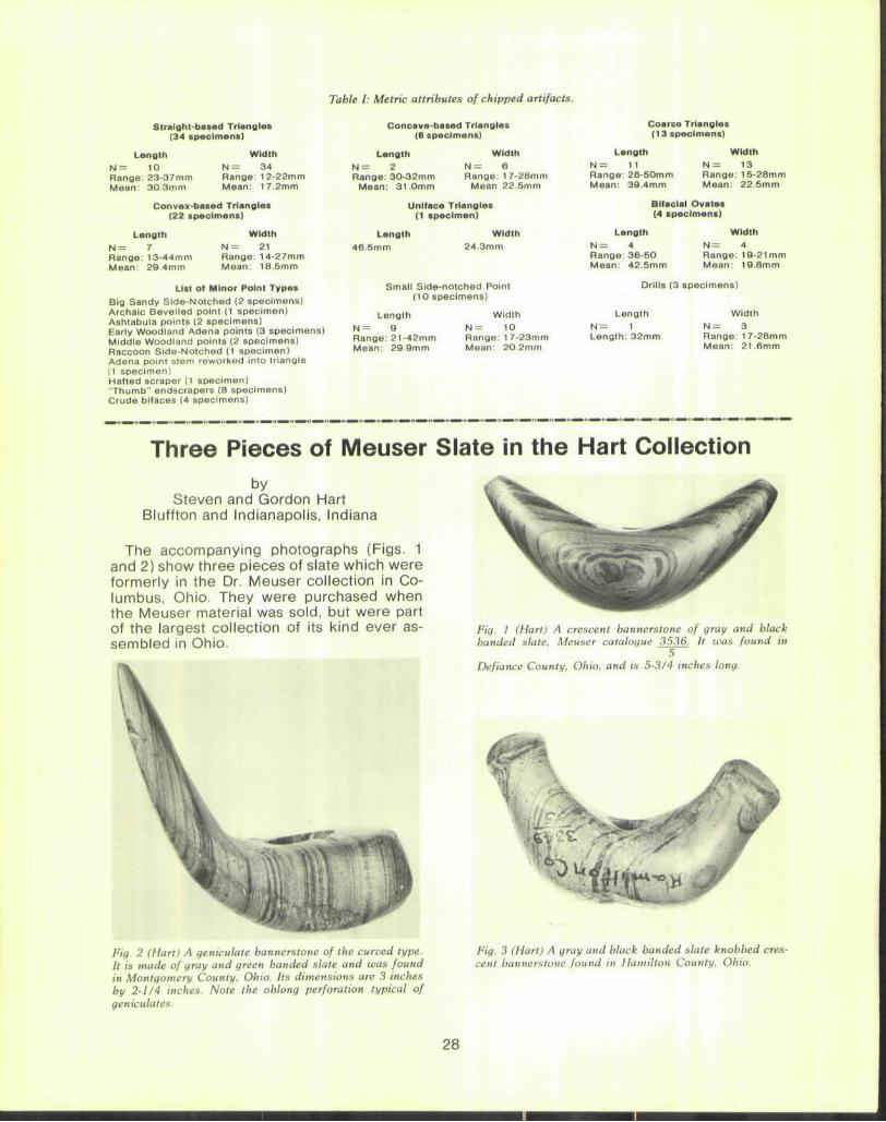
Table I: Metric attributes of chipped artifacts.
Straight-based Triangles (34 tpscimans)
Length N = 10 Range: 23-37mm Mean: 30 3mm
Width N = 34 Range: 12-22mm Mean: 17.2mm
Convex-bated Triangles (22 specimens)
Length N = 7 Range: 13-44mm Mean: 29.4mm
Width
N = 21 Range: 14-27mm Mean: 18.5mm
List of Minor Point Types
Big Sandy Side-Notched (2 specimens) Archaic Bevelled point (1 specimen) Ashtabula points (2 specimens) Early Woodland Adena points (3 specimens) Middle Woodland points (2 specimens) Raccoon Side-Notched (1 specimen) Adena point stem reworked into triangle (1 specimen) Hafted scraper (1 specimen) "Thumb" endscrapers (8 specimens) Crude bifaces (4 specimens)
Concave-based Triangles (6 specimens)
Length N = 2 Range: 30-32mm
Mean: 31.0mm
Width N = 6 Range: 1 7-28mrr
Mean 22.5mm
Uniface Triangles (1 specimen)
Length 46.5mm
Width 24.3mm
Small Side-notched Point (10 specimens)
Length N = 9 Range: 21-42mm Mean: 29.9mm
Width N = 10 Range: 17-23mm Mean: 20.2mm
Coarse Triangles (13 specimens)
Length
N = 11 Range: 28-50mm Mean: 39.4mm
Width N = 13 Range: 15-28mm Mean: 22.5mm
Bifacial Ovates (4 specimens)
Length
N = 4 Range: 36 -50 Mean: 42.5mm
Width N = 4 Range: 19-21 mm Mean: 19.8mm
Drills (3 specimens)
Length N = 1 Length: 32mm
Width N = 3 Range: 1 7-28mm Mean: 21.6mm
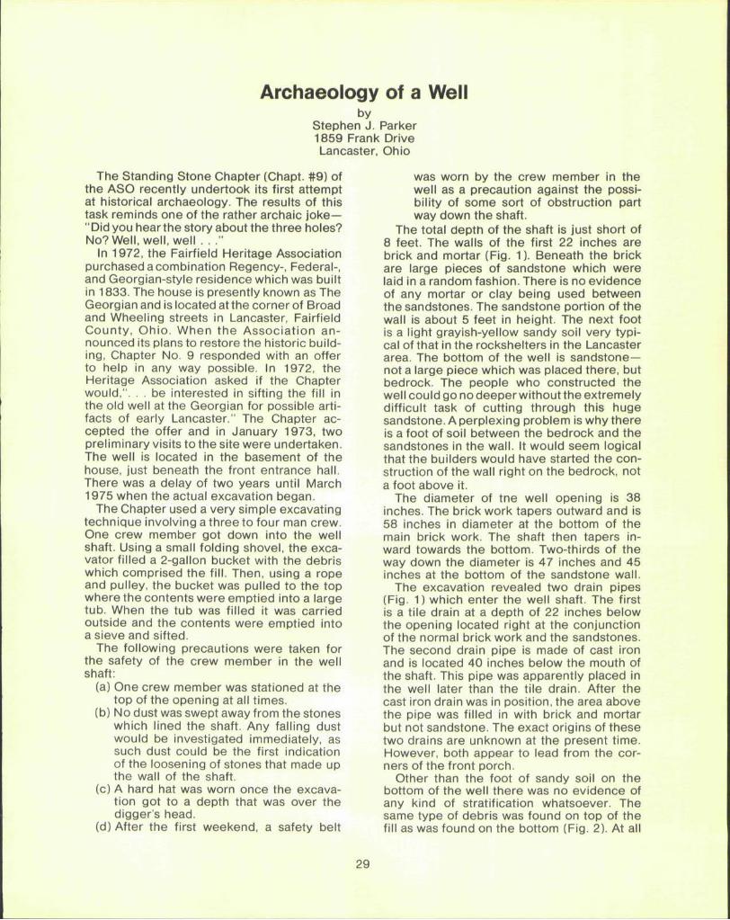
Three Pieces of Meuser Slate in the Hart Collection by
Steven and Gordon Hart Bluffton and Indianapolis, Indiana
The accompanying photographs (Figs. 1 and 2) show three pieces of slate which were formerly in the Dr. Meuser collection in Columbus, Ohio. They were purchased when the Meuser material was sold, but were part of the largest collection of its kind ever assembled in Ohio.
Fig. 2 (Hart) A geniculate bannerstone of the curved type. It is made of gray and green banded slate and was found in Montgomery County, Ohio. Its dimensions are 3 inches by 2-1/4 inches. Note the oblong perforation typical of geniculates.
Fig. 1 (Hart) A crescent bannerstone of gray and black banded slate, Meuser catalogue 3536. It was found in
5 Defiance County, Ohio, and is 5-3/4 inches long.
Fig. 3 (Hart) A gray and black banded slate knobbed crescent bannerstone found in Hamilton County. Ohio.
28
Archaeology of a Well by
Stephen J. Parker 1859 Frank Drive Lancaster, Ohio
The Standing Stone Chapter (Chapt. #9) of the ASO recently undertook its first attempt at historical archaeology. The results of this task reminds one of the rather archaic joke— "Did you hear the story about the three holes? No? Well, well, well . . ."
In 1972, the Fairfield Heritage Association purchased a combination Regency-, Federal-, and Georgian-style residence which was built in 1833. The house is presently known as The Georgian and is located atthe corner of Broad and Wheeling streets in Lancaster, Fairfield County, Ohio. When the Association announced its plans to restore the historic building, Chapter No. 9 responded with an offer to help in any way possible. In 1972, the Heritage Association asked if the Chapter would,". . . be interested in sifting the fill in the old well at the Georgian for possible artifacts of early Lancaster." The Chapter accepted the offer and in January 1973, two preliminary visits to the site were undertaken. The well is located in the basement of the house, just beneath the front entrance hall. There was a delay of two years until March 1975 when the actual excavation began.
The Chapter used a very simple excavating technique involving a three to four man crew. One crew member got down into the well shaft. Using a small folding shovel, the excavator filled a 2-gallon bucket with the debris which comprised the fill. Then, using a rope and pulley, the bucket was pulled to the top where the contents were emptied into a large tub. When the tub was filled it was carried outside and the contents were emptied into a sieve and sifted.
The following precautions were taken for the safety of the crew member in the well shaft:
(a) One crew member was stationed at the top of the opening at all times.
(b) No dust was swept away from the stones which lined the shaft. Any falling dust would be investigated immediately, as such dust could be the first indication of the loosening of stones that made up the wall of the shaft.
(c) A hard hat was worn once the excavation got to a depth that was over the digger's head.
(d) After the first weekend, a safety belt
was worn by the crew member in the well as a precaution against the possibility of some sort of obstruction part way down the shaft.
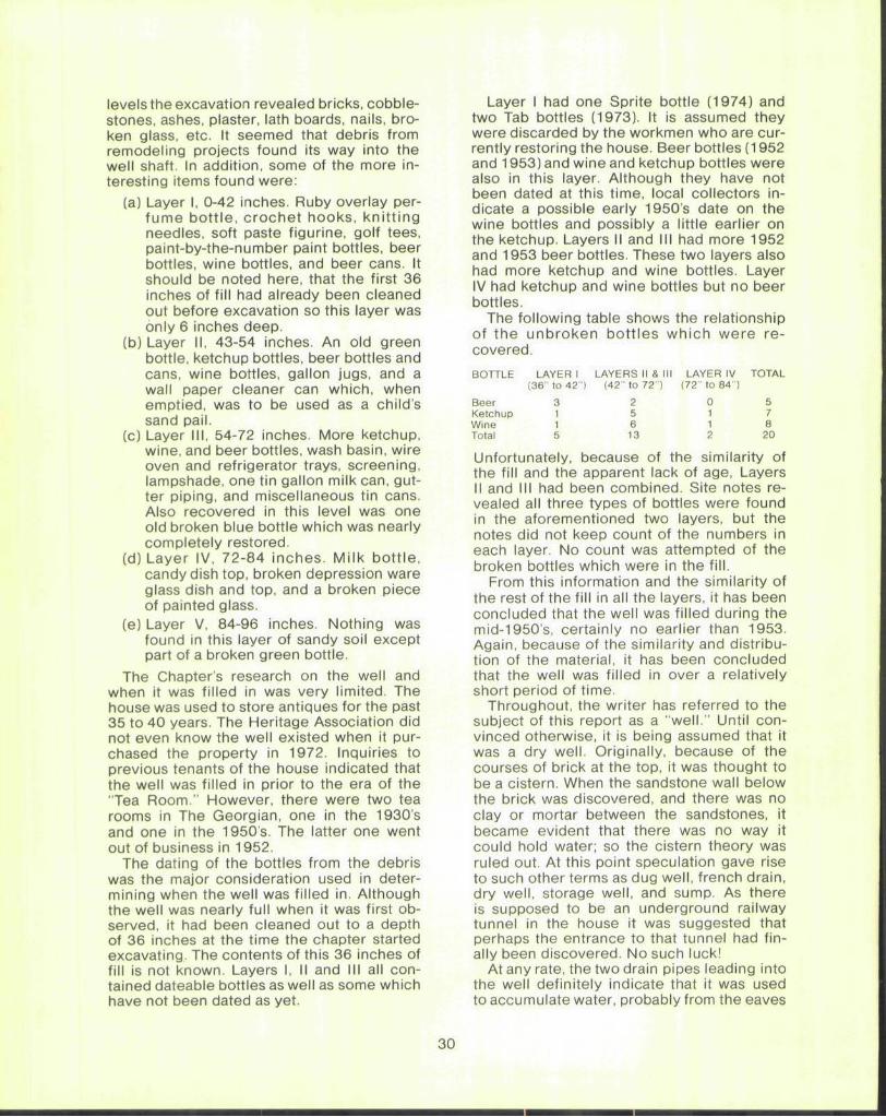
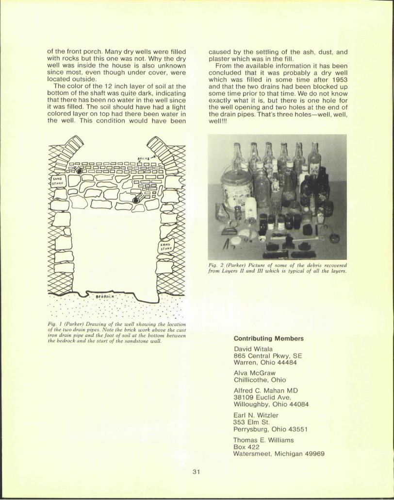
The total depth of the shaft is just short of 8 feet. The walls of the first 22 inches are brick and mortar (Fig. 1). Beneath the brick are large pieces of sandstone which were laid in a random fashion. There is no evidence of any mortar or clay being used between the sandstones. The sandstone portion of the wall is about 5 feet in height. The next foot is a light grayish-yellow sandy soil very typical of that in the rockshelters in the Lancaster area. The bottom of the well is sandstone— not a large piece which was placed there, but bedrock. The people who constructed the well could go no deeper without the extremely difficult task of cutting through this huge sandstone. A perplexing problem is why there is a foot of soil between the bedrock and the sandstones in the wall. It would seem logical that the builders would have started the construction of the wall right on the bedrock, not a foot above it.
The diameter of tne well opening is 38 inches. The brickwork tapers outward and is 58 inches in diameter at the bottom of the main brick work. The shaft then tapers inward towards the bottom. Two-thirds of the way down the diameter is 47 inches and 45 inches at the bottom of the sandstone wall.
The excavation revealed two drain pipes (Fig. 1) which enter the well shaft. The first is a tile drain at a depth of 22 inches below the opening located right at the conjunction of the normal brick work and the sandstones. The second drain pipe is made of cast iron and is located 40 inches below the mouth of the shaft. This pipe was apparently placed in the well later than the tile drain. After the cast iron drain was in position, the area above the pipe was filled in with brick and mortar but not sandstone. The exact origins of these two drains are unknown at the present time. However, both appear to lead from the corners of the front porch.
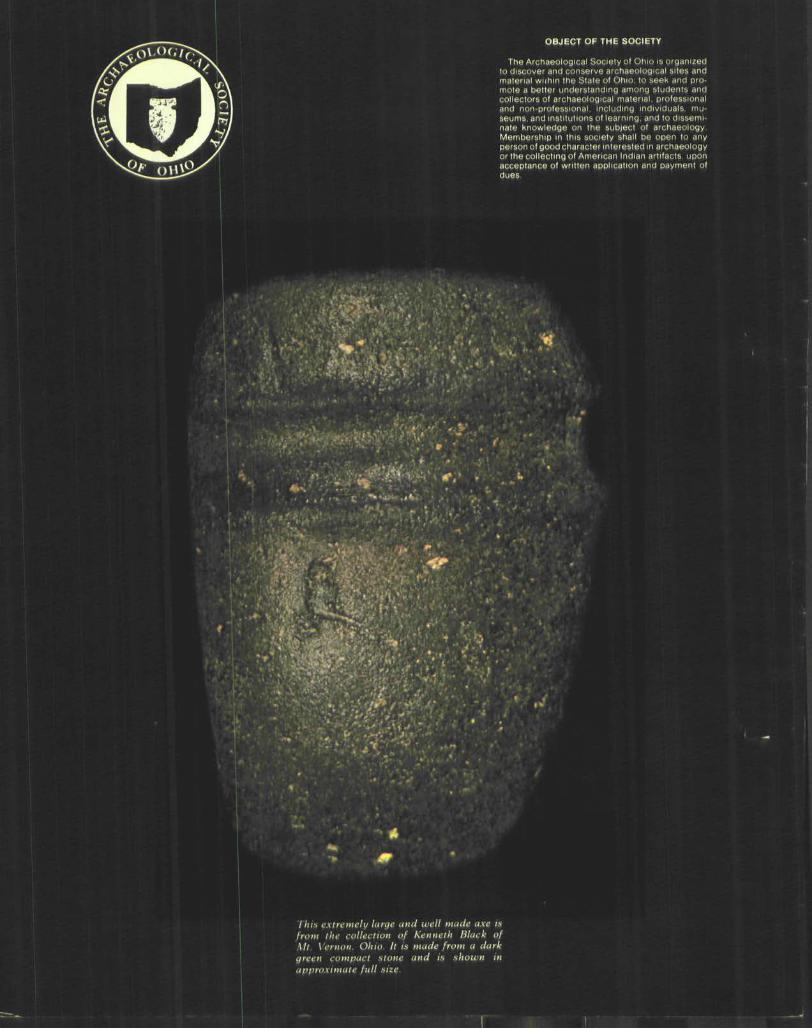
Other than the foot of sandy soil on the bottom of the well there was no evidence of any kind of stratification whatsoever. The same type of debris was found on top of the fill as was found on the bottom (Fig. 2). At all
29
levels the excavation revealed bricks, cobblestones, ashes, plaster, lath boards, nails, broken glass, etc. It seemed that debris from remodeling projects found its way into the well shaft. In addition, some of the more interesting items found were:
(a) Layer I, 0-42 inches. Ruby overlay perfume bott le, crochet hooks, knit t ing needles, soft paste figurine, golf tees, paint-by-the-number paint bottles, beer bottles, wine bottles, and beer cans. It should be noted here, that the first 36 inches of fill had already been cleaned out before excavation so this layer was only 6 inches deep.
(b) Layer II, 43-54 inches. An old green bottle, ketchup bottles, beer bottles and cans, wine bottles, gallon jugs, and a wall paper cleaner can which, when emptied, was to be used as a child's sand pail.
(c) Layer III, 54-72 inches. More ketchup, wine, and beer bottles, wash basin, wire oven and refrigerator trays, screening, lampshade, one tin gallon milk can, gutter piping, and miscellaneous tin cans. Also recovered in this level was one old broken blue bottle which was nearly completely restored.
(d) Layer IV, 72-84 inches. Milk bott le, candy dish top, broken depression ware glass dish and top, and a broken piece of painted glass.
(e) Layer V, 84-96 inches. Nothing was found in this layer of sandy soil except part of a broken green bottle.
The Chapter's research on the well and when it was filled in was very limited. The house was used to store antiques for the past 35 to 40 years. The Heritage Association did not even know the well existed when it purchased the property in 1972. Inquiries to previous tenants of the house indicated that the well was filled in prior to the era of the "Tea Room." However, there were two tea rooms in The Georgian, one in the 1930s and one in the 1950's. The latter one went out of business in 1952.
The dating of the bottles from the debris was the major consideration used in determining when the well was filled in. Although the well was nearly full when it was first observed, it had been cleaned out to a depth of 36 inches at the time the chapter started excavating. The contents of this 36 inches of fill is not known. Layers I, II and III all contained dateable bottles as well as some which have not been dated as yet.
Layer I had one Sprite bottle (1974) and two Tab bottles (1973). It is assumed they were discarded by the workmen who are currently restoring the house. Beer bottles (1952 and 1953) and wine and ketchup bottles were also in this layer. Although they have not been dated at this time, local collectors indicate a possible early 1950s date on the wine bottles and possibly a little earlier on the ketchup. Layers II and III had more 1952 and 1953 beer bottles. These two layers also had more ketchup and wine bottles. Layer IV had ketchup and wine bottles but no beer bottles.
The following table shows the relationship of the unbroken bottles which were recovered.
BOTTLE LAYER I LAYERS II & III LAYER IV TOTAL (36" to 42") (42" to 72") (72" to 84")
Beer 3 2 0 5 Ketchup 1 5 1 7 Wine 1 6 1 8 Total 5 13 2 20
Unfortunately, because of the similarity of the fill and the apparent lack of age, Layers II and III had been combined. Site notes revealed all three types of bottles were found in the aforementioned two layers, but the notes did not keep count of the numbers in each layer. No count was attempted of the broken bottles which were in the fill.
From this information and the similarity of the rest of the fill in all the layers, it has been concluded that the well was filled during the mid-1950s, certainly no earlier than 1953. Again, because of the similarity and distribution of the material, it has been concluded that the well was filled in over a relatively short period of time.
Throughout, the writer has referred to the subject of this report as a "well." Until convinced otherwise, it is being assumed that it was a dry well. Originally, because of the courses of brick at the top, it was thought to be a cistern. When the sandstone wall below the brick was discovered, and there was no clay or mortar between the sandstones, it became evident that there was no way it could hold water; so the cistern theory was ruled out. At this point speculation gave rise to such other terms as dug well, french drain, dry well, storage well, and sump. As there is supposed to be an underground railway tunnel in the house it was suggested that perhaps the entrance to that tunnel had finally been discovered. No such luck!
At any rate, the two drain pipes leading into the well definitely indicate that it was used to accumulate water, probably from the eaves
of the front porch. Many dry wells were filled with rocks but this one was not. Why the dry well was inside the house is also unknown since most, even though under cover, were located outside.
The color of the 12 inch layer of soil at the bottom of the shaft was quite dark, indicating that there has been no water in the well since it was filled. The soil should have had a light colored layer on top had there been water in the well. This condition would have been
Fig. 1 (Parker) Drawing of the well showing the location of the two drain pipes. Note the brick work above the cast iron drain pipe and the foot of soil at the bottom between the bedrock and the start of the sandstone wall.
caused by the settling of the ash, dust, and plaster which was in the fill.
From the available information it has been concluded that it was probably a dry well which was filled in some time after 1953 and that the two drains had been blocked up some time prior to that time. We do not know exactly what it is, but there is one hole for the well opening and two holes at the end of the drain pipes. That's three holes—well, well, well!!!
Fig. 2 (Parker) Picture of some of the debris recovered from Layers II and III which is typical of all the layers.
Contributing Members
David Witala 865 Central Pkwy, SE Warren, Ohio 44484
Alva McGraw Chillicothe, Ohio
Alfred C. Mahan MD 38109 Euclid Ave. Willoughby, Ohio 44084
Earl N. Witzler 353 Elm St. Perrysburg, Ohio 43551
Thomas E. Williams Box 422 Watersmeet, Michigan 49969
OBJECT OF THE SOCIETY
The Archaeological Society of Ohio is organized to discover and conserve archaeological sites and material wiihin the Stale of Ohio, to seek and promote a better understanding among students and collectors of archaeological material, professional and non-professional, including individuals, museums, and institutions of learning, and to disseminate knowledge on the subject of archaeology Membership in this society shall be open to any " " ' = " " " ' " o o d character interested in archaeology
cl ing of American Indian artifacts, upon acceptance of written application and payment of dues
THit extremely large and well made axe is from the collection of Kenneth Black of Ml. Vernon, Ohio It is made from a dark green compact stone and is shown in approximate full size.