nature-based solutions in the
TRANSCRIPT
Nature-based Solutions in the Ganges Brahmaputra Meghna (GBM) river basin
Case studies and lessons learned
Building River Dialogue and Governance (BRIDGE)
Editors: Vishwa Ranjan Sinha, Kathryn Bimson

i
Nature-based Solutions in the Ganges Brahmaputra Meghna (GBM) River Basin
Management Case studies and lessons learned
Editors: Vishwa Ranjan Sinha, Kathryn Bimson

ii
The designation of geographical entities in this report, and the presentation of the material, do not imply
the expression of any opinion whatsoever on the part of IUCN or Oxfam, TROSA partners and the
Government of Sweden concerning the legal status of any country, territory, or area, or of its authorities, or
concerning the delimitation of its frontiers or boundaries.
The views expressed in this publication do not necessarily reflect those of IUCN, Oxfam, TROSA partners,
or the Government of Sweden.
The research to produce this report was carried out as a part of the Transboundary Rivers of South Asia
(TROSA) programme. TROSA is a regional water governance programme supported by the Government
of Sweden and implemented by Oxfam and partners in Bangladesh, India, Myanmar and Nepal.
Published by: IUCN Asia Regional Office (ARO), Bangkok, Thailand
Copyright: © 2021 IUCN, International Union for Conservation of Nature and Natural
Resources
Reproduction of this publication for educational or other non-commercial purposes
is authorised without prior written permission from the copyright holder provided the
source is fully acknowledged.
Reproduction of this publication for resale or other commercial purposes is
prohibited without prior written permission of the copyright holder.
Citation: Sinha VR, Bimson K (eds.) (2021) Nature-based Solutions in the Ganges
Brahmaputra Meghna (GBM) river basin: Case studies and lessons learned.
Bangkok, Thailand: IUCN ARO.viii + 69pp.
Cover photo: Left to Right (1) Women farmers planting broom © IUCN; (2) Nadi Borthak at
Borobondho, Jakigong, Bangladesh © GUK Bokhtiar Hossain; (3) Erosion at
Padamati Char © MAUSAM; (4) Farmers engaged in wetlands and plant protection
activities © Manjunanth Lakshmikanthan
Back Cover photo: Jinjiram river © Oxfam Enamul Mazid Khan
Layout by: Vanessa Carriedo (Regional Communications Officer, IUCN Asia)
Available from: IUCN (International Union for Conservation of Nature)
Asia Regional Office
BRIDGE Programme
63 Sukhumvit Soi 39
Klongtan – Nua, Wattana
10110 Bangkok, Thailand
Tel +66 2 662 4029
Fax +66 2 662 4387
Email address: [email protected]
www.iucn.org/resources/publications

iii
Table of contents
Executive summary …………………………………………………………………………………iv Acknowledgements …………………………………………………………………………………vii Glossary ………………………………………………………………………………………………ix Acronyms……………………………………………………………………………………………...xi List of figures ………………………………………………………………………………………..xii 1. Increasing global recognition of nature’s role in addressing societal challenges ………...01 1.1. NbS in global and national discourse ………………………………………………01
1.2. Need for a global standard for NbS ………………………………………………...03 1.3. GBM river basin and NbS ……………………………………………………………04
2. About the report and methodology ……………………………………………………………..06 2.1. The GBM CSO Network………………………………………………………………06 2.2. Report aim and methodology..……………………………………………………….06
3. Case studies: Nature-based solutions for the management of the GBM river basin
Introduction to the case studies..………………………………………………………….09 3.1. Case study 1. Securing community land rights and restoring wetlands to enhance biodiversity and ecosystem services in Hail Haor, Bangladesh…………10 3.2. Case study 2. Improving water security and farmer’s incomes through integrated watershed management in the Datia Watershed (Madhya Pradesh, India) ……………………………………………………………........15 3.3. Case study 3. Demonstrating climate smart agriculture to enhance the resilience of large cardamom farmers in the Kangchenjunga transboundary landscape (Nepal) ……………………………………………………...,,21 3.4. Case study 4. ITC-IUCN collaboration in reviving traditional irrigation systems (ahar-pyne) and enhancing ecosystem services in Asarganj Agriscape ………………………………………………………………….........27 3.5. Case study 5. Reducing Landslide Disasters and Creating Livelihood Opportunities Through Eco-safe Roads in Nepal ………………………………………33 3.6. Case study 6. Engaging communities to design and implement landslide and erosion control strategies in the Teesta River Basin (West Bengal, India) ……………………………………………………………………....39 3.7. Case study 7. Community experiences with the development of bamboo-grass-based embankment to control river bank erosion (Bangladesh and Nepal) …………………………………………………………………..44
4. Lessons learned from documentation process ………………………………………………50 5. Conclusions and final recommendations …………………………………………………...57 Annex 1: Main contributors…………………………………………………………………………59 Annex 2: Bibliography………………………………………………………………….. ………….66 Annex 2: Criteria and template for case study documentation ………………………..……….68

iv
Executive summary
This report explores the scope and application of Nature-based Solutions (NbS) in addressing
water and river basin management issues. NbS are actions to protect, sustainably manage,
and restore natural or modified ecosystems to simultaneously providing human well-being and
biodiversity benefits. NbS is an umbrella term that encompasses several nature-based
approaches like Ecosystem-based Adaptation (EbA), Forest Landscape Restoration (FLR)
and Ecosystem based Disaster Risk Reduction (Eco-DRR).
Globally NbS is finding resonance with government policies, and is increasingly seen as a
strategy to address the most pressing societal challenges such as climate change and food
security. At least 66% of Paris Agreement signatories included NbS in some form to help
achieve their climate change mitigation and/or adaptation goals. Speaking of the countries
sharing the Ganges-Brahmaputra-Meghna River Basin, India aims to increase its carbon sink
from 2.5 to 3 billion tonnes CO2 equivalent by increasing forest cover, whereas, Nepal aims to
enhance forest carbon stock by at least 5% by 2025 compared to 2015 level.
Also, a large number of Civil Society Organizations in countries sharing the GBM basin are
applying nature based and traditional strategies to address community water security and
reduce community vulnerability to floods and riverbank erosion.
As NbS enters into policy and is adopted by projects on the ground, there is a need for greater
clarity on what the concept entails and what is required for it to be deployed successfully and
avoid green washing. To address this, IUCN launched the Global Standard for NbS in July
2020, after a two year long consultation process, which engaged more than 10,000 people
from across the globe, The Global Standard consists of eight criteria and 28 indicators, which
address the pillars of sustainable development (biodiversity, economy and society) and
resilient project management. These criteria respond directly to existing gaps including scale,
policy and complementarity to other interventions.
This report presents seven case studies based on initiatives led by Civil Society Organisations
(CSO) and IUCN partners in the GBM river basin, in Bangladesh, India and Nepal. These case
studies are analysed to highlight NbS strategies that could be harnessed by natural resource
managers and CSOs to address community challenges linked to food security, poverty and
water related disasters (floods and riverbank erosion).
Since 2017, IUCN has worked with the BRIDGE GBM CSO Network, a network of more than
25 CSOs from the five GBM countries, on the cooperative governance of shared water
resources in the GBM river basin. Discussions between IUCN and members of the GBM CSO
Network have revealed that a large number of CSO, government and private sector led
initiatives are applying NbS, although the results of these interventions are often not
adequately documented or widely shared – thus limiting their potential of being replicated or
in triggering a transformative change.
In 2018, IUCN initiated a series of regional capacity building workshops, CSO interviews, and
webinars on NbS. These activities were designed to simultaneously build the capacity of the
GBM CSO Network on NbS and also engage them in the documentation of case studies based
on their own work. All the members of the GBM CSO Network and some IUCN partners
(ICIMOD, ITC Limited) were requested to provide documentation of at least one case in a

v
suggested format (Annex 1). These activities were funded by Swedish International
Development Cooperation Agency (SIDA) through the Oxfam TROSA Programme.
Seven NbS case studies were selected for inclusion in this report and are discussed in detail
in Chapter 4. These case studies were selected as they applied nature based strategies and
had a very strong community engagement component. One of the most important criteria for
selection of these case studies was their application in the management of river basins and
focus on solving problems of the most vulnerable groups of societies, such as poor farmers
and fishermen or communities living along the river bank and severely impacting by erosion.
In terms of addressing societal challenges, more than 50% of the interventions discussed in
this report (Case Studies 1 to 4) simultaneously targeted water and food security issues as
their primary motivation for the application of Nature-based Solutions. These strategies
included: improving the availability of water for irrigation and household use through
restoration of wetlands and watersheds and the introduction of efficient irrigation management
strategies. The interventions discussed in Case Studies 5, 6 and 7 focused on the application
of NbS in disaster risk reduction, and demonstrated the effectiveness of ecological engineering
approaches in controlling landslides and river bank erosion.
Among the seven cases studies discussed, four studies integrate landscape approaches in
project design (Hail Haor, Datia Watershed, Asarganj Agriscape and Teplejung District). Other
three interventions are site specific, aiming to address local challenges faced by communities,
such as control of landslides along hill roads (eco-safe roads in Nepal) and river bank erosion
(Jinjiram and Teesta river basin).
Chapter 5 presents learnings from the seven case studies. The learnings are associated with
the eight criteria identified in the IUCN Global Standard for NbS. The analysis provides a basis
for revising and strengthening the case studies. Each case study clearly identified the societal
challenge to be addressed and the activities were designed to benefit the most vulnerable
communities, such as poor fishermen and farmers. To improve the economic feasibility of the
intervention, in most cases, activities were designed to create additional income generating
opportunities for local communities, through concepts like spice garden tourism, and trainings
for women’s self-help groups in organic farming and enterprise development. In some cases,
a watershed development fund was established, as a revolving fund to provide micro-credit
services to the local communities to support the diversification of their income.
In every case study, efforts were made to create an institutional mechanism for the
engagement of local communities in the design of activities and their implementation,
however, it is not clear how external stakeholders were engaged in the decision-making
processes. Also, there is little to no documentation of the strategies used to reconcile different
views of stakeholders during the design of the intervention. In most cases there is
documentation of who received the benefits, but there seem to be no discussion about any
negative impact on particular stakeholder group. A monitoring and evaluation framework was
developed in most cases, although it is more focused on human benefits. The biodiversity
outcomes are not integrated in regular monitoring of the project, with the exception of fisheries
and water provisioning services.
vi
Based on the analysis of case studies, Chapter 6 provides the following recommendations to
better align these initiatives with the IUCN Global Standard on NbS and facilitate their
replication and upscaling:
- Strengthen documentation of biodiversity gains: A well-founded understanding of the
current state of the ecosystems will help strengthen future interventions. The baseline
assessment needs to be broad enough to characterise the ecological state, drivers of
ecosystem degradation and options for net improvements, making use of both local
knowledge and scientific understanding;
- Improve mapping of the roles and influences of external stakeholders: There is a need to
document the rights and responsibilities of different stakeholder groups with reference to
the proposed NbS. This will ensure that the responsibilities of different stakeholder groups
are acknowledged and respected and do not jeopardize the NbS intervention.
- Promote private sector and youth engagement: In most case studies, the youth and private
sector engagement is weak, and needs to be strengthened. Engaging the private sector
will help in building its capacity in NbS and support for upscaling the learnings from
demonstration projects. Since, NbS requires working across generations, and moving
away from a site-based to a systems-based approach, youth engagement is necessary for
the sustainability of any NbS intervention.
- Strengthen project adaptive management: A monitoring and evaluation framework was
developed in most of the projects discussed in this paper, however, they tend to analyse
human benefits from a donor reporting perspective. None of the case studies clearly
demonstrate how the learnings from the project were used in adaptive management, to
limit risks and unexpected impacts of the activities on stakeholders. Strengthening the
documentation of both the positive and negative impacts of a particular NbS intervention,
as well as the trade-offs necessary for the sustainability of NbS, will support the designing
of a robust adaptive management process.
vii
Acknowledgements
The editors wish to express their sincere thanks to everyone who contributed, directly or
indirectly, to the development of this report. This report is a result of a collaborative process
and contributions received from the Members of the GBM CSO Network and IUCN partners,
International Centre for Integrated Mountain Development (ICIMOD) and ITC Limited, who
work on using nature to addressing societal challenges in the Ganges-Brahmaputra-Meghna
(GBM) river basin.
Special thanks to the members of the GBM CSO Network for contributing case studies for this
report, particularly Mr. M. Mokhlesur Rahman from Center for Natural Resource Studies
(CNRS) Bangladesh for the case study on Restoring wetlands to enhance biodiversity and
ecosystem services in Hail Haor; Ms. Gitika Goswami, Ms. Satabdi Mohapatra and Ms. Kavya
Arora from Development Alternatives (DA) India for the case study on Improving water security
and farmer’s income through integrated watershed management in the Datia watershed; Mr.
Soumya Dutta from Movement for Advancing Understanding of Sustainability & Mutuality
(MAUSAM) India and Mr. Arnab Bhattacharya from North Eastern Society for Protection Of
Nature (NESPON) India for the case study on Engaging community to design and implement
land-slide and erosion control strategies in the Teesta River Basin in India; Ms. Nuzhat Nueary
from Oxfam Bangladesh, Mr. Bokhtiar Hossain from Gana Unnayan Kendra (GUK)
Bangladesh and Mr. Kishan Khadka from National Environment and Equity Development
Society (NEEDS) Nepal for the case study on Community experiences with the development
of bamboo-grass based embankment to control river bank erosion on bamboo-grass
embankment.
Thanks to Mr. Surendra Raj Joshi, Mr. Sanjeev Bhuchar; Mr. Min Bahadur Gurung, Ms. Anu
Joshi Shrestha from the ICIMOD and Mr. Harish Chilwal from the Environment Conservation
and Development Forum (ECDF), Taplejung, Nepal for contributing the case study on
Enhancing resilience of large cardamom farmers through the adoption of climate smart
agriculture practices in Kanchenjunga Landscape.
Thanks to Dr. Pem Narayan Kandel, Secretary, Nepal Government and Dr. Sanjaya Devkota,
independent consultant and ecological engineering expert, for contributing the case study on
Reducing landslide disasters and creating livelihood opportunities through eco-safe roads in
Nepal.
Thanks to ITC Limited, for partnering with IUCN to test the application of NbS in agriculture
dominated landscapes in Asarganj, Bihar, India and Mr. Manjunath Lakshmikanthan from ITC
Limited for his contribution to the case study on ITC IUCN collaboration in reviving traditional
irrigation system (ahar & pyne) and enhancing ecosystem services in Asarganj agriscape.
Case studies and technical inputs were also provided by IUCN Secretariat staff working at the
IUCN Asia Regional Office, and IUCN country offices in Bangladesh, India and Nepal. Thanks
to Mr. Raphael Glemet, Senior Programme Officer, Water and wetlands, IUCN Asia for
providing support with the conceptualization and peer review of this paper, and Ms. Anu
Adhikari, Ms. Archana Chatterjjee and Mr. Aditya Petwal (now with Columbia Global Centers)
for contributing case studies based on the work of IUCN and partners.

viii
Thanks to TROSA Project Management Unit, for their consistent support for the IUCN
engagement with the GBM CSO Network on NbS capacity building and documentation, and
Mr. Avinash Singh, PQ and Learning Specialist– TROSA, Oxfam for valuable feedback on the
draft report.
Thanks to Swedish International Development Cooperation Agency (SIDA), for providing
financial support, through the Oxfam TROSA programme, which made this report possible.
Please see annex 1 for contact details of case study contributors.
Any errors or oversights in the report are the responsibility of the editors alone.

ix
Glossary
Ahar pynes system. Traditional practice of irrigation and flood management in South Bihar.
Under the system a network of water channels (pyne) are dug into the soil and connected to
small retention ponds. This network of channels helps to transfer river water to nearby
agricultural fields to irrigate kharif (mostly paddy) and rabi (wheat or gram) in winter season.
The ponds (ahar) help reduce the impacts of floods during the monsoon by absorbing extra
water, and provide opportunities for additional income generation through provisions of
fisheries.
Ecosystem-based Adaptation (EbA). The use of biodiversity and ecosystem services as
part of an overall adaptation strategy to help people to adapt to the adverse effects of climate
change (CBD, 2009). Examples of EbA applications include the renaturation of rivers or canals
to attenuate flooding, or the replanting of forests with more future climate-tolerant species to
adapt to climate change (Doswald & Osti, 2011).
Ecosystem-based disaster risk reduction (Eco-DRR). The sustainable management,
conservation and restoration of ecosystems to provide services that reduce disaster risk by
mitigating hazards and by increasing livelihood resilience (Pedrr 2010).
Ecosystem benefits. Ecosystems provide benefits to communities that have economic value,
including protection, food security, shelter and income.
Ecological engineering. Management of systems of human and environmental self-design
or light management that joins human design and environmental self-design, so that they are
mutually symbiotic (Odum, 1996).
Ecosystem function. The process through which the constituent living and non-living
elements of ecosystems change and interact (ForestERA, 2005).
Ecosystem restoration. Recovery of the structure, function and processes of the original
ecosystem.
Environmental valuation. Estimate about the magnitude or quality of the natural environment
(air, water, soil) or investigation about the effects that a certain function or activity has on
another function or activity.
Erosion. The wearing away of the land surface by natural forces, such as water, ice or wind
(Crofts et al., 2020).
Haor. Wetlands of considerable areal extent located in the Surma-Kushiyara River Basin in
north-eastern Bangladesh. During monsoon season, haors receive surface water from rivers
and canals and become vast stretches of water body spreading over hundreds of hectares,
whereas, in dry season, the water is restricted to deeper pockets called the beels. More than
350 Haors of varying sizes have been recorded in Bangladesh, including Tanguar Haor, a
Ramsar site.
Indigenous Peoples. “The existing descendants of the peoples who inhabited the present
territory of a country wholly or partially at the time when persons of a different culture or ethnic
origin arrived there from other parts of the world, overcame them and, by conquest, settlement,
or other means reduced them to a non-dominant or colonial situation; who today live more in
conformity with their particular social, economic and cultural customs and traditions than with
x
the institutions of the country of which they now form a part, under State structure which
incorporates mainly the national, social and cultural characteristics of other segments of the
population which are predominant.” (Working definition adopted by the UN Working Group on
Indigenous Peoples).
Indirect-use value. The benefits derives from the goods and services provided by an
ecosystem that are used indirectly by an economic agent. For example, the purification of
drinking water filtered by soils.
Kharif crop. Agriculture crops that are cultivated in Monsoon and harvested before the winter
(June to November) in India, Pakistan and Bangladesh. Examples of kharif corps include, rice,
maize, sorghum, pearl millet/bajra, finger millet/ragi (cereals), arhar (pulses), soyabean,
groundnut (oilseeds) and cotton.
Institutions. Institutions can refer, narrowly, to specific organizations – or, more broadly, to
the policies, rules, incentives, customs and practices that govern social relations.
Integral management. Management activities involving biological, social, economic and
cultural aspects linked to wildlife and its habitat.
Nature-based Solutions (NbS). Actions to protect manage and restore natural or modified
ecosystems, which address societal challenges, effectively and adaptively, providing human
wellbeing and biodiversity benefits (IUCN 2016).
Nature-based tourism. Forms of tourism that use natural resources in a wild or undeveloped
form. Nature-based tourism is travel for the purpose of enjoying undeveloped natural areas or
wildlife (Leung et al., 2018).
Rabi crops or rabi harvest. Agricultural crops that are sown in winter season and harvested
in the spring (November to April) in India, Pakistan and Bangladesh. Some of the important
rabi crops are wheat, barley, peas, gram and mustard.
Resilience (of ecosystems). Their ability to function and provide critical ecosystem services
under changing conditions.
Ridge to valley approach. Approach to restore degraded watersheds commonly practiced in
India and promoted by the National government policies. In this approach the treatment of
watershed starts at the ridge and progresses downwards into valley. It generally involves
planting of tree and development of water absorption trenches on the ridge and water storage
structures in the valley. This strategy reduces flow velocity, minimize soil erosion and increase
ground water recharge capacity of the water shed. By reduced soil erosion in ridge, there is
less silting in water conservation structures downstream.
Rhizotron. Various techniques for measurement of root system parameters, such as growth
rate, soil penetration as well as interaction of roots with the soil flora and fauna using non-
destructive and repeated observations. The technique is used for monitoring the survival rate
of newly established plantation during implementation of NbS for erosion control and habitat
restoration.
xi
Acronyms
BRIDGE BMU
Building River Dialogue and Governance Federal Ministry for the Environment, Nature Conservation and Nuclear Safety
CDKN Climate and Development Knowledge Network CRA Climate Resilient Agriculture CNRS Center for Natural Resource Studies CSO Civil Society Organisation DA Development Alternatives EbA Eco- DRR
Ecosystem-based Adaptation Ecosystem-based Disaster Risk Reduction
EPIC Ecosystems Protecting Infrastructure and Communities EPCO Environment Planning and Coordination Organisation FMCG GCF
Fast-moving consumer goods Green Climate Fund
GUK GIS
Gana Unnayan Kendra Geographic Information System
Himalica Rural Livelihoods and Climate Change Adaptation in the Himalayas ICIMOD International Centre for Integrated Mountain Development IUCN IKI
International Union for Conservation of Nature International Climate Initiative
KHAI Kangchenjunga Himalica Agriculture Industry LGCs Local Government Committees LULC Land Use Land Cover MAUSAM Movement for Advancing Understanding of Sustainability & Mutuality MACH Management of Aquatic Ecosystems through Community Husbandry MoL Ministry of Land MNREGA Mahatma Gandhi Employment Guarantee Act NEEDS National Environment and Equity Development Society NESPON North Eastern Society for Protection Of Nature NbS Nature-based Solutions RMOs Resource Management Organisation SIDA Swedish International Development Cooperation Agency SABAH SAARC Association for Home-based Workers SHGs Self-Help Groups TROSA UIL
Transboundary Rivers of South Asia University of Lausanne
WUGs Water User Groups

xii
List of Figures
Figure 1: NbS approach and components
Figure 2: Major societal challenges addressed by NbS
Figure 3: Nature-based Solutions Criteria from the Global Standard
Figure 4: Participants of the First NbS Training Workshop for GBM CSOs Network (June,
2018) © IUCN
Figure 5: Participants of the 2nd NbS training of GBM CSO Network surveying the Baikka Beel
Sanctuary © IUCN
Figure 6: Members of Baragangina RMO during their interaction with the members of the
GBM-CSO Network © IUCN
Figure 7: View of a traditional farmstead Datia District, India © Development Alternatives
Figure 8: Farmers Club Meeting in Datia Watershed © Development Alternatives
Figure 9: Women-farmers and the beneficiaries of the training on climate smart agriculture
practices tending their crop in Datia Watershed, India © Development Alternatives
Figure 10: A farm benefitting from improved irrigation and livelihoods diversification strategy
in Datia Watershed, India © Development Alternatives
Figure 11: Water storage pond in a farmstead to harvest and channelize rainwater, Datia
Watershed, India © Development Alternatives
Figure 12: View of a conventional farm of large cardamom in Nepal © ICIMOD
Figure 13: Training of women entrepreneur on product diversification and value addition using
different parts of large cardamom © ICIMOD
Figure 14: Integrated large cardamom farm after the adoption of package climate smart
measures by local farmers in Taplejung District, Nepal © ICIMOD
Figure 15: Agriscape in Chorgaon, Asarganj Munger, Bihar, India © ManjunathL
Figure 16: Farmers meeting on the side of traditional Ahar (pond), Asarganj, Munger, Bihar,
India © ManjunathL
Figure 17: Farmers engaged in restoration of ahar-pyne and plant protection activities,
Munger, Bihar, India © ManjunathL
Figure 18: Farmers harvesting fish from restored ahar (pond), Chargaon, Munger Bihar © Mr.
Manjunath
Figure 19: Villagers preparing site for the demonstration of eco-safe roads in Gharelu Village,
Nepal © Sanjaya Devkota
Figure 20: Rhizotron plot at the Gharelu Village, Nepal © SanjayaDevkota

xiii
Figure 21: A women farmer planting broom grass along the roadside close to her agricultural
field, Tilahar village, Nepal © IUCN
Figure 22: Eco-safe roads after two years of project intervention with lush green grass growth
along the sides © ESR Nepal
Figure 23: (Left) Vetiver nursery in Karmat village (Right) Vetiver plantation along the Teesta
river bank downstream of Teesta barrage © MAUSAM
Figure 24: Bamboo-grass based embankments increase sedimentation and reduce river bank
erosion on Jinjiram ©Bokhtiar Hossain
Figure 25: Nodi Boithak or meetings with community affected by riverbank erosion in
Borobondho, Jakigonj-1 village, Bangladesh © Bokhtiar Hossain
Figure 26: Riverbank stabilisation activities applying bamboos and grass plantation in
Chaudhar River, Nepal © Kishan Khadka
Figure 27: Bank of the Jinjiram river in Namapara Village, one year of year after the riverbank
stablisation activities, with significant reduction in riverbank erosion, Bangladesh © Oxfam
Bangladesh
Figure 28: River bank stablised with the lush green growth of grass, Chaudhar River, Nepal ©
Kishan Khadka

1
1 Increasing global recognition of nature’s role in addressing societal
challenges
1.1 NbS in global and national discourse
For most of the 20th century, decision-makers treated the conservation of nature as peripheral
to national and global agendas. At best, it was considered a worthy interest, at worst, an
obstacle to development. However, growing scientific consensus indicates that such views
were misplaced and that “nature is essential for human existence and good quality of life.”
Failure to recognise this fact not only results in a model of economic growth that significantly
contributes to the loss of biodiversity, it also misses the opportunity to effectively deploy nature
in helping resolve major societal challenges such as climate change, food security and
disaster risk reduction. For decades, conservation oriented organisations, including IUCN, as
well as a number of CSOs and Indigenous communities have carried out both traditional and
innovative conservation initiatives, which have simultaneously helped protect, manage and
restore the environment, while delivering tangible and sustainable benefits for people.
From 2001 to 2005, the Millennium Ecosystem Assessment analysed the work of more than
1,360 experts worldwide, to assess the consequences of ecosystem change for human well-
being. Its findings provided a state-of-the-art scientific appraisal of the condition and trends in
the world’s ecosystems and the services they provide, as well as the scientific basis for action
to conserve and use them sustainably. The assessment defines ecosystem services as the
benefits people obtain from ecosystems. These include provisioning services such as food
and water; regulating services such as flood and disease control; cultural services such as
spiritual, recreational, and cultural benefits; and supporting services, such as nutrient cycling,
which maintain the conditions for life on Earth.
Figure 1. NbS approach and components

2
It also represents a milestone in the evolution and understanding of ecosystem services,
reinforcing the idea that the conservation approach doesn’t only benefit biodiversity, rather it
is a long-term strategy to secure critical benefits (e.g. food and water security, disaster risks
reduction, human health) for human societies at scale.
In 2010, at the UN CBD COP 10 (Nagoya-Aichi, Japan), members adopted the Strategic Plan
for Biodiversity (2011-2020) which also includes a 2050 Vision for biodiversity conservation
with the tag line, “Living in Harmony with Nature,” where “By 2050, biodiversity is valued,
conserved, restored and wisely used, maintaining ecosystem services, sustaining a healthy
planet and delivering benefits essential for all people.” In 2018, the Sharm El-Sheikh to Beijing
Action Agenda for Nature and People was launched jointly by the UN CBD Secretariat and
the Chinese Government to support the implementation of the 2050 Vision. In 2020, the UN
Leader’s Summit on Biodiversity in New York voiced strong support for Nature-based
Solutions.
In 2016, during the World Conservation Congress in Hawaii, USA, IUCN Members adopted a
resolution (WCC-2016-Res-069) on defining Nature-based Solutions. The resolution adopted
a framework on NbS, including the first official definition as “actions to protect, sustainably
manage, and restore natural or modified ecosystems that address societal challenges
effectively and adaptively, simultaneously providing human well-being and biodiversity
benefits.” This definition has been commonly used since then by IUCN members, including a
large number of governments and within the UN system.
Figure 2. Major societal challenges addressed by NbS (Source: IUCN Global Standards for NbS)
Research highlights that NbS could provide around 30% of the cost-effective mitigation
needed by 20301 to stabilise warming to below 2°C. They can also provide a powerful defence
against the impacts and long-term hazards of climate change, which is the biggest threat to
biodiversity. Finding ways to work with ecosystems, rather than relying solely on conventional
engineered solutions, can help communities adapt to climate change impacts. Using nature to
green cities can also result in significant energy savings and health benefits.
More than two-thirds of the governments supporting the Paris Climate Agreement included
Nature-based Solutions (NbS) in some form to help achieve their climate change mitigation
and/or adaptation goals. At the same time, scientists agree that to get on track to limit global
1 Nature-based Solutions in Nationally Determined Contributions @2019 IUCN and University of Oxford

3
temperature rise to 1.5°C, emissions must drop rapidly to 25 gigatons (Gt) by 20302 from
current level of 33 Gt in 2019. This is only possible with large-scale ecosystem restoration
efforts.
1.2 Need for a global standard for NbS
As NbS enters into policy and is adopted by projects on the ground, there is a pressing need
for greater clarity and precision of what the concept entails and what is required for it to be
deployed successfully. Without this, the application of NbS could result in inconsistent and
ungrounded applications.
To address this, IUCN launched the Global Standard for NbS in July 2020, after a two-year
consultation process, which engaged more than 10,000 people from across the globe. The
Standard consists of eight criteria (Figure 3) and their associated indicators, which address
the pillars of sustainable development (biodiversity, economy and society) and resilient project
management. These criteria respond directly to existing gaps including scale, policy and
complementarity to other interventions.
The standard aims to equip users with a robust framework for designing and verifying NbS
that yield the desired outcomes, by solving one or several societal challenges. Based on the
feedback of actual and potential NbS users, it has been developed as a facilitative Standard,
purposefully avoiding a rigid normative framing with fixed, definitive thresholds of what NbS
ought to achieve. Rather, the Standard is designed to support users to apply, learn and
continuously strengthen and improve the effectiveness, sustainability and adaptability of their
2 UNEP Emissions Gap Report 2019
Figure 3. Nature-based solutions criteria from the global standard

4
NbS interventions. It also serves as a mechanism for developing a consistent approach to
designing and verifying concrete solutions-orientated outcomes.
The application of the standard allows project implementers to systematically deploy NbS,
accounting for the intervention’s design and execution and enabling the results to be tracked
and linked to global goals and research narratives. For individual interventions on the ground,
applying the standard gives tangible added value. First, the results can give credibility to the
intervention when speaking to investors, donors and other stakeholders. Second, the use of
the standard provides individual interventions with recommendations for improvement, using
the results as a way to identify gaps and solutions. Finally, the standard can be used as a
means of engagement and communication across sectors, starting conversations and
providing a common framework and language to discuss trade-offs.
The standard provides an opportunity to create a global user community that helps to guide
implementation on the ground, accelerate policy development, and create conservation
science on NbS. Through the Standard, NbS will be based on a common understanding and
a shared vision for a just and sustainable world.
1.3 GBM river basin and NbS
The Ganges-Brahmaputra-Meghna (GBM) river basin is shared by Bangladesh, Bhutan,
China, India and Nepal. More than 630 million people live in the basin, making it one of the
largest and most populated river basins in the world.
The GBM river basin is also one of the world’s most biologically diverse river basins, after the
Amazon and the Congo. For example, the stretch of the Ganges between Narora and Brijghat
was declared a Ramsar Site or “wetland of international importance” in 2005. This 85-kilometre
stretch provides habitat for several species of turtles and game fish like the Mahseer (Tor tor),
as well as a number of other threatened species, including the Gangetic river dolphin
(Platanista gangetica) and the gharial (Gavialis gangeticus). Similarly, the floodplains of
Brahmaputra basin is home to many endangered and threatened species of mammals such
as the great one-horned rhinoceros (Rhinoceros unicornis), wild water buffalo (Bubalus
arnee), royal Bengal tiger (Panthera tigris tigris), and Indian elephant (Elephas maximus
indicus). The Meghna basin can be defined as a “biogeographical gateway,” as it is located in
the transition zone between the Indian, Indo-Malayan and Indo-Chinese biogeographical
regions. The basin is rich in biodiversity, indicated by the presence of internationally
Criteria overview:
1. NbS effectively address societal challenges
2. Design of NbS is informed by scale
3. NbS result in net gain to biodiversity and ecosystem integrity
4. NbS are economically viable
5. NbS are based on inclusive, transparent and empowering governance processes
6. NbS equitably balances trade-offs between achievement of their primary goal(s) and the
continued provision of multiple benefits
7. NbS are managed adaptively, based on evidence
8. NbS are sustainable and mainstreamed within an appropriate jurisdictional context
5
recognised wetlands, such as Tanguar Haor, and many hilsa (Tenualosa ilisha) fish
conservation sanctuaries that protect the breeding sites of the most economically important
fish in the region.
Numerous infrastructure projects threaten the unique and fragile balance of the GBM’s
ecosystems by changing the structure and natural flow of water bodies, impacting their
capacity to hold water and intensifying water scarcity. Deforestation and unregulated mining
are changing the basin morphology by increasing erosion and landslides and impacting the
delta development processes in the Bay of Bengal. Exacerbated by increasing pollution, these
anthropogenic impacts degrade the GBM’s ecosystem services, leading to impoverishment,
migration, social unrest, and decreased resilience.
Climate change is further compounding these pressures within the GBM river basin. The basin
has been identified as one of the most vulnerable regions in the world to the impacts of climate
change. Within the first few weeks of the monsoon in 2020, hundreds died and many more
individuals were displaced due to flooding. In Nepal, landslides killed more than 120 people in
first six months of 2020.
In the GBM countries, government policies demonstrate a recognition of the role of Nature-
based Solutions in supporting climate adaptation and mitigation targets as well as
conservation of economically important fish species. . In Nepal, the policies on watershed
management and climate change include Ecosystem-based Adaptation (EbA) as an important
strategy. India’s nationally determined contribution to the 2015 Paris Climate Agreement
commits to achieving an additional cumulative carbon sink of 2.5–3 gigatonnes of carbon
dioxide equivalent (GtCO2e) by 2030 (UNFCCC 2015), and its National Mission for Green
India aims to restore forests and enhance tree cover over 10 million hectares. In Bangladesh,
the government has been promoting area-based conservation strategies for the protection of
the hilsa fish breeding sites and the use of bandals (bamboo fencing) as a river bank erosion
control strategy.

6
2 About the report and methodology
2.1 The GBM CSO Network
Since 2017, IUCN has been working with the BRIDGE GBM CSO Network, group of more
than 25 CSOs from the five GBM countries, on capacity building and the documentation of
Nature-based Solutions. The network was created to strengthen the role of CSOs in promoting
cooperative governance of the shared water resources in the GBM river basin.
Through regional dialogues and consensus building activities, the network has developed a
joint vision3 for the cooperative management of the GBM basin. The vision identifies 21 cross-
cutting action points under five themes: capacity-building; transboundary cooperation;
communication, outreach, and advocacy; research and knowledge; and policy and legislation.
The crosscutting actions promote the mainstreaming of NbS in current river management
planning and practices, through:
1) Application of ecosystem-based approaches to scientifically assess current ecological
conditions and their linkages with water and land-use regulations and the adequacy of
current conservation and management frameworks (Action 5).
2) Developing regional guidelines based on the best practices in ecosystem services
conservation, management, natural-resource use, disaster risk reduction, and climate
change to integrate into policies. Using the guidelines to improve existing legal frameworks
and policies at all levels to build the resilience and adaptive capacity of local communities
(Action 12);
3) Promoting ecologically and culturally sustainable activities that benefit local
communities and support the conservation of riverine ecosystems (Action 13);
Dialogues with the network has indicated that a lot of ongoing initiatives implemented by CSOs
on water resource management apply Nature-based Solutions. However, these are poorly
documented and the framework for NbS is often misunderstood. This limits the capacity of
CSOs to systematically promote and upscale NbS, and to use the results to influence
governance dialogues on shared basin management. The documentation of NbS initiatives
and strategies from the GBM basin was identified by the Network as one of the priority areas
of work in 2018.
2.2 Report aim and methodology
This report explores application of Nature-based Solutions to address water and river basin
management issues. To do this, the report analyses seven case studies from CSO-led
initiatives in the GBM river basin in Bangladesh, India and Nepal. Based on these analysis,
the report provides an overview on NbS strategies that can be implemented by natural
resource managers, private sector companies, and CSOs working for the wellbeing of local
communities.
This report is the result of a consultation process (June 2018 to August 2020) involving a
series of regional capacity building workshops, CSO interviews, and webinars on NbS
3 GBM CSO Vision

7
facilitated by the BRIDGE GBM Project, and funded by Swedish International Development
Cooperation Agency (SIDA) through Oxfam TROSA Programme.
The first CSO capacity building workshop on NbS and its application in river basin
management (June 2018, Kathmandu)4 initiated a dialogue on the definition of NbS, its scope
and potential application in the management of shared river basins. One of the
recommendations of the workshop was to document the implementation of Nature-based
Solutions from the GBM region.
After the 2018 workshop, criteria for inclusion in the report, along with the format for
documenting NbS were developed by IUCN and shared with the GBM CSO Network (Annex
1). The criteria included:
1. Reduce social and environmental vulnerabilities;
2. Generate multiple social benefits;
3. Maintain, restore or improve ecosystem health;
4. Is supported by policies at multiple levels;
5. Supports equitable governance and enhances capacities;
In addition to above criteria, additional guidance to support case study selection included the
following:
6. Solutions strongly linked to water and basin issues (vs. broader NbS in the basin but with
no real connection to the river/basin theme);
7. Solutions with a potential for replication;
8. Solutions presenting evidence of results (quantitative and qualitative) and references;
It is important to note that at this time (2018-2019), the IUCN Global Standard for NbS was
under development. The criteria and guidance provided above were inspired by preliminary
versions of the Standard and are similar to the eight criteria in the final version of the NbS
Global Standard launched in July 2020.
From October-December 2018, IUCN facilitated several online meetings with the members of
GBM CSO Network to explain the criteria and support the documentation process. In March
2019, IUCN facilitated a second training workshop of the GBM CSO Network on NbS in
Sreemangal, Bangladesh. The members learned how to present their project interventions
and findings through case studies and also joined a field visit to Baikka Beel, a wetland
sanctuary extending over 100 ha, located in Hail Haor region, in northeastern Bangladesh.
The Center for Natural Resource Studies (CNRS), one of the members of the GBM CSO
Network in Bangladesh, has been working in the area for 30 years on community engagement
in natural resource management.
Following the workshop, CSO members finalized NbS stories and shared them with IUCN for
review and compilation. More than 15 members shared stories of NbS based on their past and
current work. The stories included a range of issues, including the role of NbS in resolving
conflicts between stakeholders, reducing water related disasters and improving food and
water security.
4 NbS and its application in river basin management in the GBM Basin
8
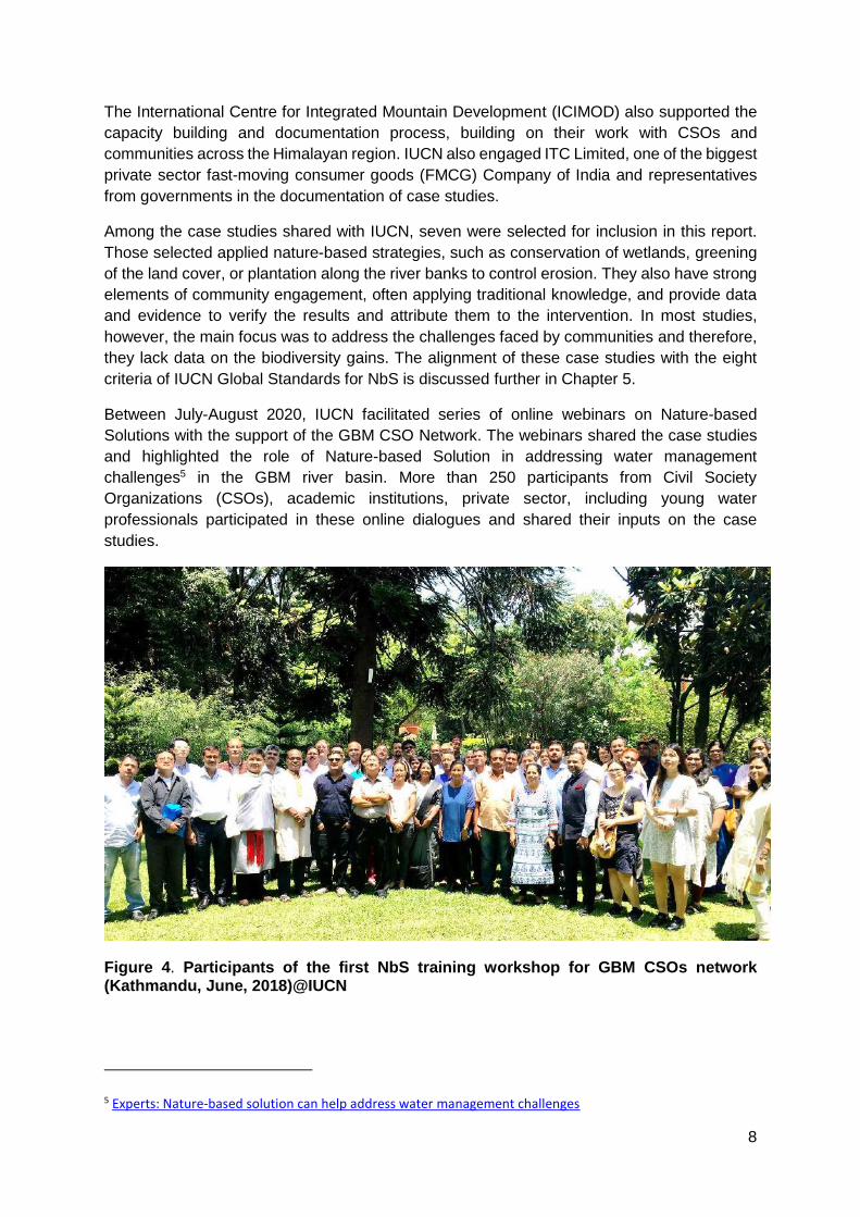
The International Centre for Integrated Mountain Development (ICIMOD) also supported the
capacity building and documentation process, building on their work with CSOs and
communities across the Himalayan region. IUCN also engaged ITC Limited, one of the biggest
private sector fast-moving consumer goods (FMCG) Company of India and representatives
from governments in the documentation of case studies.
Among the case studies shared with IUCN, seven were selected for inclusion in this report.
Those selected applied nature-based strategies, such as conservation of wetlands, greening
of the land cover, or plantation along the river banks to control erosion. They also have strong
elements of community engagement, often applying traditional knowledge, and provide data
and evidence to verify the results and attribute them to the intervention. In most studies,
however, the main focus was to address the challenges faced by communities and therefore,
they lack data on the biodiversity gains. The alignment of these case studies with the eight
criteria of IUCN Global Standards for NbS is discussed further in Chapter 5.
Between July-August 2020, IUCN facilitated series of online webinars on Nature-based
Solutions with the support of the GBM CSO Network. The webinars shared the case studies
and highlighted the role of Nature-based Solution in addressing water management
challenges5 in the GBM river basin. More than 250 participants from Civil Society
Organizations (CSOs), academic institutions, private sector, including young water
professionals participated in these online dialogues and shared their inputs on the case
studies.
Figure 4. Participants of the first NbS training workshop for GBM CSOs network (Kathmandu, June, 2018)@IUCN
5 Experts: Nature-based solution can help address water management challenges
9
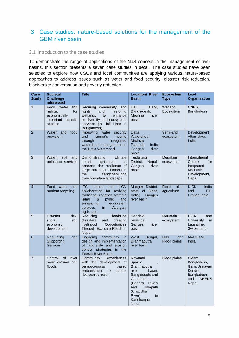
3 Case studies: nature-based solutions for the management of the
GBM river basin
3.1 Introduction to the case studies
To demonstrate the range of applications of the NbS concept in the management of river
basins, this section presents a seven case studies in detail. The case studies have been
selected to explore how CSOs and local communities are applying various nature-based
approaches to address issues such as water and food security, disaster risk reduction,
biodiversity conversation and poverty reduction.
Case Study
Societal Challenge addressed
Title Location/ River Basin
Ecosystem Type
Lead Organisation
1 Food, water and habitat for economically important aquatic species
Securing community land rights and restoring wetlands to enhance biodiversity and ecosystem services (in Hail Haor in Bangladesh)
Hail Haor, Bangladesh; Meghna river basin
Wetland Ecosystem
CNRS, Bangladesh
2 Water and food provision
Improving water security and farmer’s income through integrated watershed management in the Datia Watershed
Datia Watershed; Madhya Pradesh; India Ganges river basin
Semi-arid ecosystem
Development Alternative, India
3 Water, soil and pollination services
Demonstrating climate smart agriculture to enhance the resilience of large cardamom farmers in the Kangchenjunga transboundary landscape
Teplejung District, Nepal; Ganges river basin
Mountain ecosystem
International Centre for Integrated Mountain Development, Nepal
4 Food, water, and nutrient recycling
ITC Limited and IUCN collaboration for reviving traditional irrigation systems (ahar & pyne) and enhancing ecosystem services in Asarganj agriscape
Munger District, state of Bihar, India; Ganges river basin
Flood plain agriculture
IUCN India and ITC Limited India
5 Disaster risk, social and economic development
Reducing landslide disasters and creating livelihood Opportunities Through Eco-safe Roads in Nepal
Gandaki province; Ganges river basin
Mountain ecosystem
IUCN and University in Lausanne, Switzerland
6 Regulating and Supporting Services
Engaging community in design and implementation of land-slide and erosion control strategies in the Teesta River Basin
West Bengal, Brahmaputra river basin
Hills and Flood plains
MAUSAM, India
7 Control of river bank erosion and floods
Community experiences with the development of bamboo-grass based embankment to control riverbank erosion
Rowmari upazila, , Brahmaputra river basin, Bangladesh; and Chandapur (Banara River) and Bibapatti (Chaudhar River) in Kanchanpur, Nepal
Flood plains Oxfam Bangladesh, Gana Unnayan Kendra, Bangladesh and NEEDS Nepal

10
Hail Haor6 is a wetland ecosystem located in northeast Bangladesh, in the Meghna river basin.
It is surrounded by hills in the north and east. Hail Haor includes a variety of land use types,
including wetlands, swamp forest, marshes, agriculture fields and rivers.
6Marshy wetland ecosystem in the north eastern part of Bangladesh covering the districts of Sunamganj, Moulovibazar, Sylhet, Kishorganj and Netrokona
CASE STUDY 1
Securing community land rights and restoring wetlands to enhance biodiversity and ecosystem services in Hail Haor, Bangladesh
Center for Natural Resource
Studies (CNRS), Dhaka,
Bangladesh, M. Mokhlesur
Rahman
Societal Challenges:
Ecosystem services:
Financial Support: USAID,
Management of Aquatic Ecosystems
through Community Husbandry
(MACH) Project
Timeline: 1999 to 2006
Background
Food
Water

11
For 7-8 months of the year, most of the area of Hail Haor is flooded, extending to over 13,000
ha in the peak of monsoon. In dry season, the water is restricted to deeper pockets, locally
called “beels” (wetlands), of different sizes, ranging from 2 ha (Jethua Beel) to more than 100
Ha (Baikka Beel) and covering a total area of 3,000 ha. The Hail Haor provides habitat for
more than 70 indigenous fish species and also wintering ground for rare and endangered
migratory bird species such as Teal (Anas crecca).
The ecosystem services of the Hail Haor support the livelihoods of more than 170,000 people
living in 60 villages around the haor. The majority of people in these villages depend on
agriculture and fisheries as their main source of livelihoods. The beels provide water for
irrigation for the boro (winter) rice and also act as breeding sites for economically important
fish and aquatic biota.
The ecosystem services at the Hail Haor were declining. A variety of factors contributed to this
decline, including overexploitation of water resources, the land-use changes promoting
conversion of perennial beels for agriculture and aquaculture activity and increasing rates of
sedimentation of beels (due to forest degradation and intensive agriculture practices on the
hill slopes). These changes have also severed the connectivity of the beels with the Manu
River and affected the inundation pattern and local fish migration.
The problems are further accentuated by a lack of community engagement in wetland
management. Government land use policies fail to support community rights for fisheries in
beels. There are also ambiguities and conflict around the institutional roles and
responsibilities. The Ministry of Land (MoL) is responsible for leasing the beels for fisheries,
whereas, the Department of Fisheries (DOF) is responsible for the implementation of the Fish
Act, Bangladesh (1950), which aims to promote conservation and sustainable utilisation of
fishery resources in country. These ambiguities also precipitate conflict at the community level.
In the dry season, farmers cultivate water intensive winter rice (boro rice). The increase in the
rice cultivation area over the years and over-extraction of water from beels is a source of
conflict between farmers and fishermen.
During the project inception phase, intensive consultations with local communities (farmers
and fishermen) was facilitated to identify main challenges and solutions. The lack of
community rights to use the beels, habitat degradation and over-extraction of natural
resources were identified as the main reasons for the decline in ecosystem services. The
fishermen requested the project to secure community rights on beels, design interventions to
improve the management of wetlands and reduce water abstractions for irrigation in the dry
season.
Activities

12
To establish a baseline, the project initiated research and community surveys and estimated
the economic value of the ecosystem services provided by Hail Haor. The value of fisheries,
non-fish aquatic products and agriculture benefits from Hail Haor was estimated at US$ 8
million annually in 2000.
In 2000, the project secured a 10-year lease for the communities to manage the beels. The
leased area was divided into eight village clusters and a Resource Management Organisation
(RMO), led by local communities, was created for each cluster. The RMOs included user
communities of all socio-economic groups, including fishermen, and were linked to
government-led processes, such as the Local Government Committees (LGCs), headed by
the Chief Executive Officer of the sub-district.
To strengthen the capacity of RMOs on wetland management, the project facilitated trainings
and learning visits on wetland restoration and management. Micro-credit schemes were also
initiated to diversify livelihoods and decrease the dependence of the local community on
agriculture and fisheries.
Figure 5: Participants of the 2nd NbS training of GBM CSO Network surveying the
Baikka Beel Sanctuary, Hail Haor, Bangladesh© IUCN
13
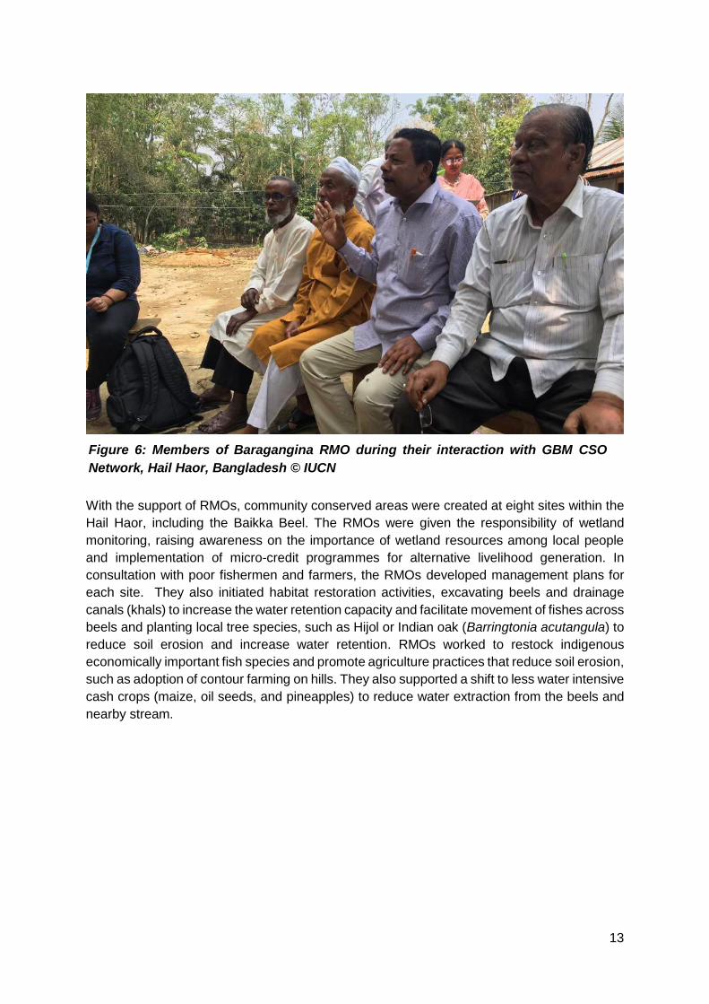
With the support of RMOs, community conserved areas were created at eight sites within the
Hail Haor, including the Baikka Beel. The RMOs were given the responsibility of wetland
monitoring, raising awareness on the importance of wetland resources among local people
and implementation of micro-credit programmes for alternative livelihood generation. In
consultation with poor fishermen and farmers, the RMOs developed management plans for
each site. They also initiated habitat restoration activities, excavating beels and drainage
canals (khals) to increase the water retention capacity and facilitate movement of fishes across
beels and planting local tree species, such as Hijol or Indian oak (Barringtonia acutangula) to
reduce soil erosion and increase water retention. RMOs worked to restock indigenous
economically important fish species and promote agriculture practices that reduce soil erosion,
such as adoption of contour farming on hills. They also supported a shift to less water intensive
cash crops (maize, oil seeds, and pineapples) to reduce water extraction from the beels and
nearby stream.
Figure 6: Members of Baragangina RMO during their interaction with GBM CSO
Network, Hail Haor, Bangladesh © IUCN

14
The restoration of the wetland habitat increased the total economic value of Hail Haor by
approximately 25%, from USD 8 million in 1999 to USD 10.9 million/year in 20067 due to
improved management of resources compared to baseline situation (1999).
The diversity of water birds visiting the Baikka Beel more than doubled, from 18 species in
2003, to 39 species in 2019. A 33% increase in fish consumption was recorded among the
households living within catchment the Hail Haor from 2000 to 2004, particularly benefiting the
landless and marginal farmers.
In July 2003, the Ministry of Land designated Baikka Beel as a permanent sanctuary, giving
up an annual lease income of about US$1,500, and recognised the Baragangina Resource
Management Organization (RMO), led by the communities, as the custodians of the beel.
Thus, RMOs responsibility to protect the sanctuary and educate the wider community on the
need for its conservation and sustainable use was officially recognised.
The recognition of community based institutional mechanisms and the creation of Baikka Beel
Wildlife Sanctuary by the Ministry of Land was an important factor in the sustainability of the
activities initiated by the project. Among the eight RMOs established in the Hail Haor area,
only Baikka Beel RMO is still functional. The benefits from the creation of Baikka Beel
sanctuary are felt at the landscape level. The sanctuary has increased fish populations in the
nearby beels, which is reflected in the increase in the household fish consumption. The
increase in bird population in the area provides opportunities to generate additional income
through tourism.
7 Economic Value of Bangladesh Wetlands MACH (Technical Paper 6), Paul Thompson and Luke Colavito
Results
Lessons Learned

15
The Datia watershed is located in Datia block, in the Bundelkhand region of Madhya Pradesh,
India. The 5,527 ha watershed is drained by small seasonal rivers including, Sindh, Pahuj, the
Mahuar and the Betwa, and supports a population of more than one hundred thousand people.
Development Alternatives, Gitika
Goswami; Satabdi Mohapatra;
and Kavya Arora
Societal Challenges:
Ecosystem services:
Financial Support: Department
of Science and Technology,
Government of India, Climate and
Development Knowledge Network
(CDKN)
Timeline: 2014-2018
Background
CASE STUDY 2
Improving water
security and
farmer’s incomes
through integrated
watershed
management in the
Datia watershed
(Madhya Pradesh,
India)
Food
Water
16
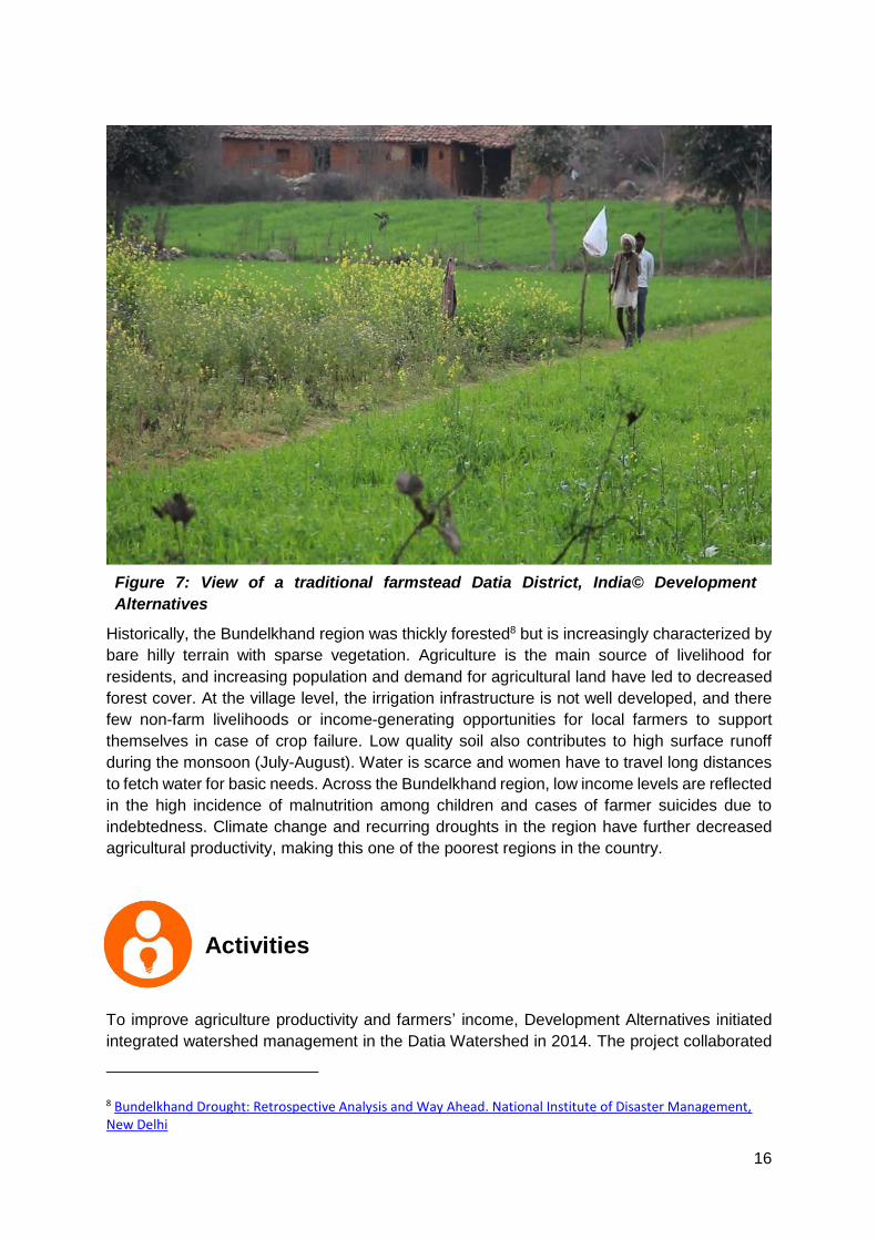
Historically, the Bundelkhand region was thickly forested8 but is increasingly characterized by
bare hilly terrain with sparse vegetation. Agriculture is the main source of livelihood for
residents, and increasing population and demand for agricultural land have led to decreased
forest cover. At the village level, the irrigation infrastructure is not well developed, and there
few non-farm livelihoods or income-generating opportunities for local farmers to support
themselves in case of crop failure. Low quality soil also contributes to high surface runoff
during the monsoon (July-August). Water is scarce and women have to travel long distances
to fetch water for basic needs. Across the Bundelkhand region, low income levels are reflected
in the high incidence of malnutrition among children and cases of farmer suicides due to
indebtedness. Climate change and recurring droughts in the region have further decreased
agricultural productivity, making this one of the poorest regions in the country.
To improve agriculture productivity and farmers’ income, Development Alternatives initiated
integrated watershed management in the Datia Watershed in 2014. The project collaborated
8 Bundelkhand Drought: Retrospective Analysis and Way Ahead. National Institute of Disaster Management, New Delhi
Activities
Figure 7: View of a traditional farmstead Datia District, India© Development
Alternatives

17
with academic institutions to conduct GIS mapping of the watershed and identify degraded
areas for restoration. During both the planning and implementation phases, multiple
consultations were done with academic partners, such as Environment Planning and
Coordination Organisation (EPCO), National Institute of Disaster Management (India),
Institute of Development Studies (University of Sussex) and Kings College, London to ensure
comprehensive project design.
The project applied a ridge to valley9 approach to identify sites for the creation of water
conservation structures, such as increasing vegetation, developing check dams and
deepening water channels. At higher elevations, the project initiated tree plantation to increase
green cover and also constructed ponds and check dams to maximise water retention and
reduce surface run-off. The approach was modified in flat lands around agricultural fields,
where the reopening of water channels and planting of trees/grasses around the fields was
completed to improve soil moisture. The ridge to valley approach is promoted by the
governments to provide a holistic approach to watershed management and has been tested
by Development Alternatives in other parts of the Bundelkhand region since the 1990s.
A Watershed Committee (WC) was formed with representatives from local government
(Panchayat/Gram Sabha), as well as farmers, women and other marginalised groups. The
major role of the WCs was to monitor execution of water and soil conservation measures
initiated by the project.
9 Ridge to Valley - A Holistic Watershed Perspective (WOTR India)
Figure 8: Farmers Club Meeting on the Integrated Watershed Management
Strategies, Datia Watershed ©Development Alternatives

18
The WCs were trained on watershed management strategies and designing of soil and water
retention structures, such as check dams and ponds, to improve rain water availability at the
landscape level. Under the WC’s supervision, tree species such as Amaltas (Cassia fistula),
Gamharm (Gmelina arborea), Saguan and Khair (Acacia catechu) were planted in the
degraded areas.
The project also facilitated targeted capacity building workshops for the local farmers,
particularly targeting women self-help groups on climate resilient agriculture practices, such
as the wadi model10 (agro-forestry system) and agriculture diversification strategies (crop-
livestock integrated farming), to reduce farmers vulnerabilities to crop failures and associated
economic loss. Farmers were motivated to plant fruiting trees such as guava, papaya, mango,
lime and pomegranate to meet their household needs, as well as woody species such as
Subabul (Leucaena leucocephala) to provide firewood decreasing dependence on the nearby
forest area. The project also supported the local forest department in the restoration of
degraded forest areas in the watershed.
To improve the farm income, farmer clubs and women’s self-help groups were developed and
members were trained on integrated farming practices such as agri-horticulture or vegetable
cultivation, promotion of organic farming and the use of varmi-composting. A Watershed
Development Fund was established, as a revolving fund to provide micro-credit services for
10 Wadi: A model for sustainable tribal livelihood
Figure 9: Women-farmers and beneficiaries of the training workshops on climate
smart agriculture practices, tending their crop, Datia Watershed, India ©
Development Alternatives
19
initiating businesses. The WC’s were given the responsibility to manage the funds and ensure
their proper utilisation.
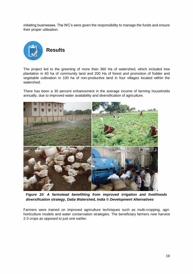
The project led to the greening of more than 360 Ha of watershed, which included tree
plantation in 60 ha of community land and 200 Ha of forest and promotion of fodder and
vegetable cultivation in 100 ha of non-productive land in four villages located within the
watershed.
There has been a 30 percent enhancement in the average income of farming households
annually, due to improved water availability and diversification of agriculture.
Farmers were trained on improved agriculture techniques such as multi-cropping, agri-
horticulture models and water conservation strategies. The beneficiary farmers now harvest
2-3 crops as opposed to just one earlier.
Results
Figure 10: A farmstead benefitting from improved irrigation and livelihoods
diversification strategy, Datia Watershed, India © Development Alternatives

20
In the eight project villages, a total of 71,000 cubic meters of rainwater harvesting potential
was created through the development of ponds, check dams, and an overall increase in the
green cover in the watershed. An average increase in the groundwater level of 0.48 meters
was recorded in 78 wells in the seven villages monitored during April 2014-June 2017.
The case highlights that the success of integrated watershed management depends on a clear
understanding of the different land use types, and the engagement of different stakeholders
including, farmers, local government and technical experts in the design and implementation
of restoration initiatives. This example also highlights the potential for hybrid solutions
(including NbS and non-NbS components) to tackle water scarcity and irrigation challenges in
the semi-arid agriculture systems.
Lessons Learned
Figure 11: Water storage pond in a farmstead to harvest and channelize rainwater,
Datia Watershed, India © Development Alternatives

21
The Kanchenjunga Landscape (KL) is a high altitude transboundary landscape spreading
across Nepal, India and Bhutan. Large cardamom (Amomum subulatum) is one of the niche
products of this landscape and also the main cash crop grown by small farmers. Due to the
ability of large cardamom to provide a high return per unit of land, it is considered ‘black gold’
by the local farmers.
International Centre for Integrated
Mountain Development,
Kathmandu, Nepal, Surendra Raj
Joshi; Sanjeev Bhuchar; Min
Bahadur Gurung; Anu Joshi
Shrestha; Harish Chilwal
Societal Challenge:
Ecosystem service:
Financial Support: European
Union (EU)
Timeline: 2012-2018
Background
CASE STUDY 3
Demonstrating
climate smart
agriculture to
enhance the
resilience of large
cardamom farmers
in the
Kangchenjunga
transboundary
landscape (Nepal)
Food
Water
Nutrient Cycling
22
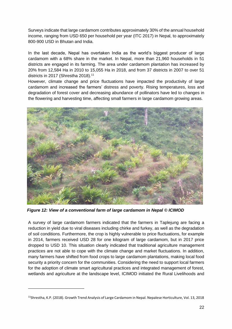
Surveys indicate that large cardamom contributes approximately 30% of the annual household
income, ranging from USD 650 per household per year (ITC 2017) in Nepal, to approximately
800-900 USD in Bhutan and India.
In the last decade, Nepal has overtaken India as the world’s biggest producer of large
cardamom with a 68% share in the market. In Nepal, more than 21,960 households in 51
districts are engaged in its farming. The area under cardamom plantation has increased by
20% from 12,584 Ha in 2010 to 15,055 Ha in 2018, and from 37 districts in 2007 to over 51
districts in 2017 (Shrestha 2018).11
However, climate change and price fluctuations have impacted the productivity of large
cardamom and increased the farmers’ distress and poverty. Rising temperatures, loss and
degradation of forest cover and decreasing abundance of pollinators have led to changes in
the flowering and harvesting time, affecting small farmers in large cardamom growing areas.
A survey of large cardamom farmers indicated that the farmers in Taplejung are facing a
reduction in yield due to viral diseases including chirke and furkey, as well as the degradation
of soil conditions. Furthermore, the crop is highly vulnerable to price fluctuations, for example
in 2014, farmers received USD 28 for one kilogram of large cardamom, but in 2017 price
dropped to USD 10. This situation clearly indicated that traditional agriculture management
practices are not able to cope with the climate change and market fluctuations. In addition,
many farmers have shifted from food crops to large cardamom plantations, making local food
security a priority concern for the communities. Considering the need to support local farmers
for the adoption of climate smart agricultural practices and integrated management of forest,
wetlands and agriculture at the landscape level, ICIMOD initiated the Rural Livelihoods and
11Shrestha, K.P. (2018). Growth Trend Analysis of Large Cardamom in Nepal. Nepalese Horticulture, Vol. 13, 2018
Figure 12: View of a conventional farm of large cardamom in Nepal © ICIMOD
23
Climate Change Adaptation in the Himalayas (Himalica) Project12 initiated a demonstration of
Climate Resilient Agriculture (CRA) practises in the Taplejung district of Nepal.
To implement the project, a partnership was established between key government agencies
(industry, agriculture and environment), the Environment Conservation and Development
Forum (ECDF), Nepal; SAARC Business Association of Home based Workers (SABAH),
Nepal; and the District Chamber of Commerce.
The project completed ecosystem assessments of large cardamom-based farming systems to
gain insight into ecosystem health and trends in climate change impacts.13 The study found,
from 1996 to 2015 land under forest cover, which includes government managed forests and
community managed forests, decreased slightly. But there was a significant increase in the
area under agro-forestry enterprises, such as large cardamom plantation and crop farming
terraces. During the household surveys, participants indicted a decline in both freshwater
availabilities impacting the productivity of large cardamom farms. Based on the household
survey, 12 large cardamom farms (from 296 households) were selected in the Taplejung
District for the demonstration of climate smart agriculture practices at the landscape level.
The project facilitated training of farmers on a package of practices (POP) focusing on climate
smart measures with the technical support from ECDF. These included, a) promotion of local
varieties that are resilient to extreme weather conditions; b) promotion of organic agriculture,
including the development and use of Jholmal – a homemade bio-pesticide and bio-fertilizer
made from green manure and cow urine; c) mulching and inter-cropping to maintain soil
health/organic matter; and d) use of mobile technology to disseminate information on soil
types, disease and pest management, timing for the planting of the crops, and information on
the prevailing price and demand-supply status of large cardamom. Measures to improve water
use efficiency were introduced, such as drip and sprinkle irrigation. Soil moisture was
conserved through mulching, planting of local shade tree species and rainwater harvesting. In
addition, small pits (0.5–1 ft deep and 1 ft diameter) were dug between every 3-4 cardamom
clumps to collect water and increase soil moisture.
Raw cardamom pods contain 80% water at the time of harvesting. Therefore, before selling
them in the market, the farmers dry the pods using traditional dryers, which depend on
fuelwood sourced from nearby forest areas. The project collaborated with Nepal Commercial
Agriculture Research Programme and developed energy efficient dryers, which were about
twice as fuel-efficient as the local dryers (bhattis), and these were distributed to the farmers in
the demonstration area.
12 ICIMOD Himalica Initiative 13 A Multi-Dimensional Assessment of Ecosystems and Ecosystem Services in Taplejung, Nepal
Activities

24
To further increase the farmers’ incomes, the project promoted processing of the raw
cardamom to develop market-ready products, such as cardamom tea mix and cardamom
spice powder (biryani masala). In partnership with SABAH, the project developed the
CARDAMONIA market strategy - which included, a) development of cardamom mix soft drinks
and cardamom-based products and their promotion by chain of village café and restaurant
chains managed by SABAH; and b) series of trainings workshops focusing mainly to women
entrepreneurs were organised to develop value added products with the brand name
‘Himalica- Green Products from the Mountains.’
A Spice Garden Tourism concept was developed in partnership with Nepal Tourism Board;
the Trekking Agencies' Association of Nepal; Wolfmatrix pvt. Ltd, Nepal; and the Environment
Conservation and Development Forum. Local youth and communities received training on
homestay tourism, hospitality management and guiding trekking. A community enterprise,
Kangchenjunga Himalica Agriculture Industry (KHAI), was registered with 13 members (10
women) and established an office in Kathmandu. Farmers were also trained in bee keeping
for both income generation and pollination services.
Overall, there was a 50% increase in the productivity of large cardamom yields, from 112
kg/Ha to 163 kg/Ha, contributing to an increase in annual household income from 600 to 770
USD.
Results
Figure 13: Training of women entrepreneur on product diversification and value
addition using different parts of large cardamom© ICIMOD
25
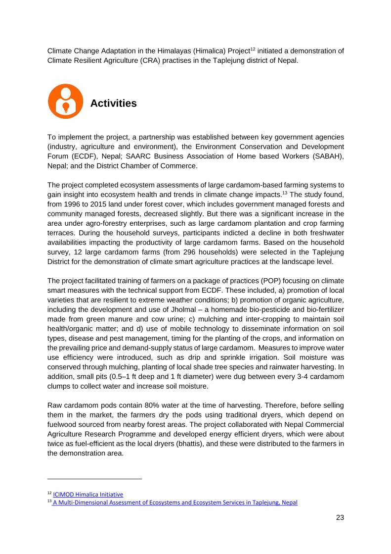
Five community irrigation schemes were developed, and two natural ponds, Lalitar Pokhari
and Pathiverafedi Kalipokhari, were rehabilitated, through the removal of silt and garbage,
planting of multi-purpose indigenous tree species to create a natural fencing of the ponds, and
the cleaning of water channels that bring water into the pond from nearby hills.
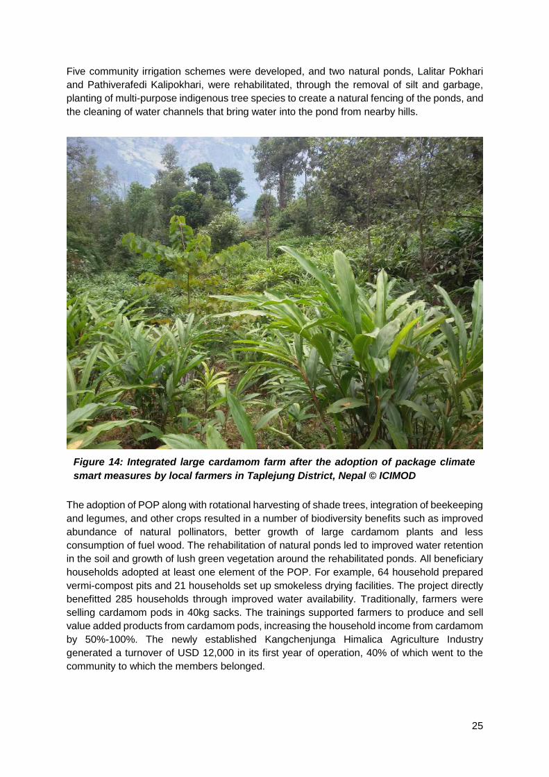
The adoption of POP along with rotational harvesting of shade trees, integration of beekeeping
and legumes, and other crops resulted in a number of biodiversity benefits such as improved
abundance of natural pollinators, better growth of large cardamom plants and less
consumption of fuel wood. The rehabilitation of natural ponds led to improved water retention
in the soil and growth of lush green vegetation around the rehabilitated ponds. All beneficiary
households adopted at least one element of the POP. For example, 64 household prepared
vermi-compost pits and 21 households set up smokeless drying facilities. The project directly
benefitted 285 households through improved water availability. Traditionally, farmers were
selling cardamom pods in 40kg sacks. The trainings supported farmers to produce and sell
value added products from cardamom pods, increasing the household income from cardamom
by 50%-100%. The newly established Kangchenjunga Himalica Agriculture Industry
generated a turnover of USD 12,000 in its first year of operation, 40% of which went to the
community to which the members belonged.
Figure 14: Integrated large cardamom farm after the adoption of package climate
smart measures by local farmers in Taplejung District, Nepal © ICIMOD

26
At the request of local municipal government, the project supported the formulation of a five-
year Strategic Action Plan and Vision for Agriculture Development in 2018 for the Taplejung
municipality. The plan is aligned with Nepal’s Agriculture Development Strategy (2015- 2035),
and integrates the learnings from the project demonstration sites.
Improved water use efficiency at the farms, coupled with the diversification of livelihoods, such
as, processing of raw large cardamom to create value added products made the beneficiary
families more resilient to price fluctuations compared to the control group. The productivity of
large cardamom plantations can be enhanced with climate smart agricultural practices, and
without any use of chemical fertilizers. This requires promoting a package green agriculture
practices - plantation of local fruit trees to provide shade to the large cardamom crops and
reduce soil erosion, and restoring two natural ponds to improve soil moisture.
Lessons Learned
27
South Bihar in India is located in the flood plains of the Ganges river basin. The region is
characterised by the presence of numerous wetlands interspersed with agriculture fields. The
farmers traditionally practice the ahar-pyne system for irrigation and flood management.14
Under this system, a network of water channels (pyne) are dug into the soil and connected to
small retention ponds.
14 Ahar pynes: Traditional flood harvesting systems of South Bihar
ITC Limited, Manjunath
Lakshmikanthan; Columbia
Global Centers, Aditya Petwal;
International Union for
Conservation of Nature and
Natural Resources, Archana
Chatterjee
Societal Challenge:
Ecosystem service:
Financial Support: ITC Limited
Timeline: 2016-2019
Background
CASE STUDY 4
ITC-IUCN
collaboration in
reviving traditional
irrigation systems
(ahar-pyne) and
enhancing
ecosystem services
in Asarganj
agriscape
Food
Water
Nutrient Cycling

28
This network of channels helps to transfer river and rain water to nearby agricultural fields to
irrigate kharif (mostly paddy) and rabi (wheat or gram) in winter season. The ponds (ahar) and
channels (pyne) also help reduce the impacts of floods during the monsoon by channelizing
excess water into ahar’s. Additionally, the ponds provide opportunities for income generation
for farmers, through provisions of fisheries and other flood based agricultural crops, such as
water chestnut.
However, the practice of ahar pyne is under decline and several of these traditional ponds
have been encroached upon or suffered from siltation. During 1930 to 1997, areas under ahar
pyne agriculture system declined15 from 0.94 million ha to 0.53 million ha. This has increased
the vulnerability of local farmers to floods, which are becoming more pronounced due to
climate change and the absence of an integrated land use management strategy.
Overall, the productivity of agriculture in the Munger district is also declining. Research16 by
ICAR shows that limited livelihood options, a lack of integrated farming system models and
small and fragmented land holdings are the main challenges contributing to the
underdevelopment of the region. The research also identifies multiple economic benefits of
farming models that promote multiple uses of ponds and wetlands, thorough integrated fish,
agriculture, horticulture and aquatic crops.
IUCN and ITC Limited, a diversified Indian conglomerate, initiated a collaborative study in
2016, which reaffirmed the need to revive the ahar-pyne system to improve the productivity
agriscapes. A pilot initiative was taken up to revive the ahar-pyne system and demonstrate
the role of landscape management strategies in enhancing ecosystem services (provision of
water and pollinators) for optimum agriculture yields.
15 Traditional water management systems - An overview of Ahar-pyne system in South Bihar plains of India and need for its revival 16 Livelihood Improvement of Underprivileged Farming Community : Some Experiences from Vaishali, Samastipur, Darbhanga and Munger Districts of Bihar
Figure 15: Agriscape in Chorgaon, Asarganj Munger, Bihar, India ©ManjunathL
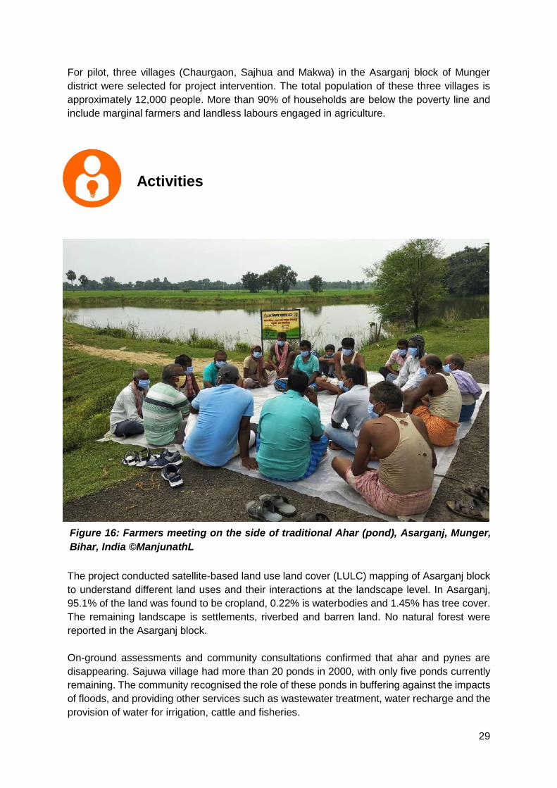
29
For pilot, three villages (Chaurgaon, Sajhua and Makwa) in the Asarganj block of Munger
district were selected for project intervention. The total population of these three villages is
approximately 12,000 people. More than 90% of households are below the poverty line and
include marginal farmers and landless labours engaged in agriculture.
The project conducted satellite-based land use land cover (LULC) mapping of Asarganj block
to understand different land uses and their interactions at the landscape level. In Asarganj,
95.1% of the land was found to be cropland, 0.22% is waterbodies and 1.45% has tree cover.
The remaining landscape is settlements, riverbed and barren land. No natural forest were
reported in the Asarganj block.
On-ground assessments and community consultations confirmed that ahar and pynes are
disappearing. Sajuwa village had more than 20 ponds in 2000, with only five ponds currently
remaining. The community recognised the role of these ponds in buffering against the impacts
of floods, and providing other services such as wastewater treatment, water recharge and the
provision of water for irrigation, cattle and fisheries.
Activities
Figure 16: Farmers meeting on the side of traditional Ahar (pond), Asarganj, Munger,
Bihar, India ©ManjunathL

30
Consultations with farmers and key respondent interviews also indicated a decline in the
abundance of pollinators across the Asharganj block. Farmers also reported a decline in the
population of earthworms and termites, blaming the overuse of pesticide for poor soil health.
The LULC mapping indicated that Asharganj block has long stretches of agriculture fields
without much green cover, a potential reason for the decline in the population of pollinators
such as bees. Therefore, the project initiated tree plantation to create habitat for birds and
pollinators and reduce soil erosion and the siltation of wetlands. Nearly 9000 tree species,
such as Sesbania grandis, Dalbergia sisson, Syzygium cumini, Ziziphus mauritiana,
Artocarpus heterophyllus and Moringa oliefera, were planted in the three pilot villages, on the
field bunds and around wetlands. One of the important consideration in the selection of tree
species was its utility for local farming community, for example Sesbania is a leguminous tree
and thus helps improve the nitrogen in the soil, provides fuel wood, and the flowers and leaves
are commonly eaten in South Asia, Moringa fruits and leaves are used as vegitables and
revered for its medicinal values (treating asthma, diabetes, obesity, blood pressure) and
Syzgium is favoured for its fruit, timber, and ornamental value.
The project supported capacity building of farmers through workshops and on-farm
demonstrations on water use efficient Climate Smart Agricultural practices, pest and disease
management, and integrated farming strategies in floodplain agriculture systems to help
enhance the income of the farmers.
Two ponds (ahar) were selected for restoration and their connectivity with other pond systems
was enhanced through digging new channels (pynes). To increase the depth of the ponds, the
community was engaged in desilting of ponds and planting of Napier grass (Cenchrus
purpureus) and multi-purpose tree species around the ponds. To make these ponds ready for
integrated fish and agriculture farming, they were treated with Mahua (Madhuca sp.) oil cake,
Figure 17: Farmers engaged in restoration of ahar-pyne and plant protection activities,
Munger, Bihar, India ©ManjunathL

31
lime and cow dung slurry. Community-led pilots were initiated at these sites, to demonstrate
the potential of integrated water chestnut-fisheries farming models in improving farmers’
incomes. Both ponds were stocked with fish fry and a protocol for monitoring the ponds was
developed in consultation with the farmers participating in the pilot demonstration.
The project made a business case for conservation of the ahar-pyne system. The water user
groups who participated in the demonstration were able to generate a profit of 6000 to 8000
Indian Rupees (100 USD) from water chestnuts (Trapa natans) grown in 10% of the ahar; and
70,000 to 80,000 (1,000 USD) with fish cultivation. The ahar-pyne system also provided critical
irrigation post-monsoon and enhanced rabi wheat cultivation by 74% in the area.
The project created awareness among the local farming communities on the advantages of
conserving traditional ahar-pyne systems as well as the importance of local stewardship for
the maintenance and conservation of wetlands.
The lessons learned from the project were consolidated to develop a toolkit on sustainable
agri-scape development. The plan was submitted to the state government, and a formal
Results
Figure 18: Farmers harvesting fish from restored ahar (pond), Chargaon, Munger Bihar ©Mr
ManjunathL
32
collaboration with District Rural, Development Agency (DRDA), Rural Development Dept. was
established in March 2021, to restore the entire ahar-pyne system in Munger through
MGNREGS (Mahatma Gandhi National Rural Employment Guarantee Scheme). During
phase II, ITC Limited supporting the development of plans for replicating agriscape
management concept in other locations, such as, in Ghod river basin, Maharastra, and
Bhavani river basin in the state of Tamil Nadu.
It is critical that assessment of the problem is done with a landscape approach (agriscape).
There is a need to address challenges using approaches that not only strengthen ecosystem
services, but also have a positive economic impact on most vulnerable groups. For example,
consultations with local communities indicated that the loss of ahar-pyne system and dearth
of pollinators were main reasons for low agriculture productivity. This led to the design of a
targeted intervention around the revival of ahar-pyne system and improving the green cover
at the landscape level to enhance ecosystem services.
Lessons Learned
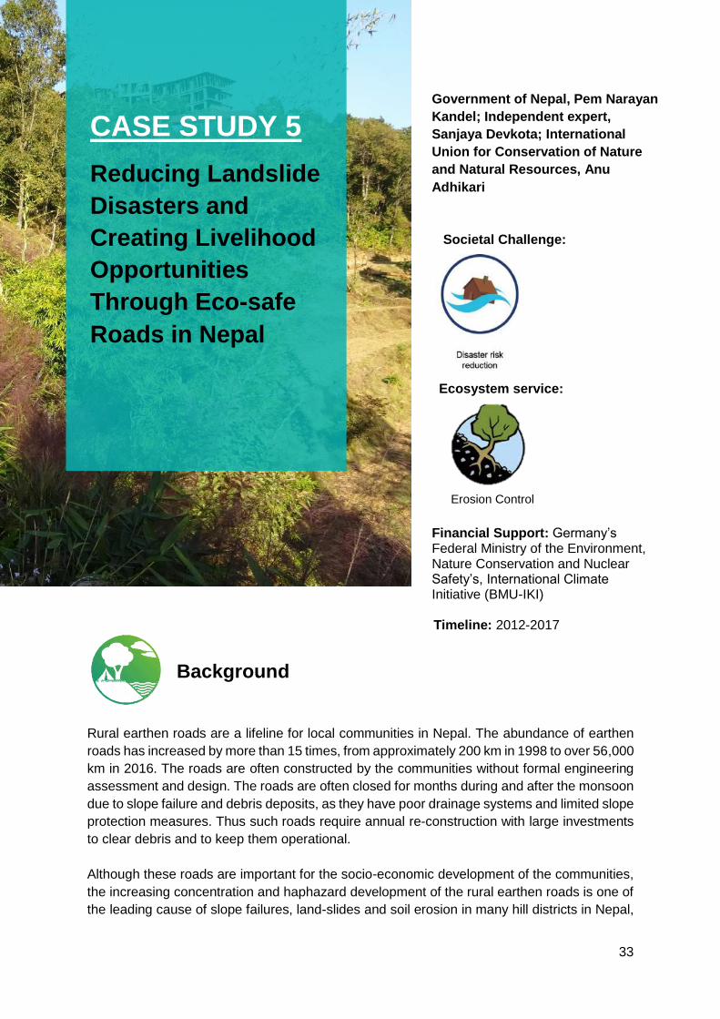
33
Case Study 5
Rural earthen roads are a lifeline for local communities in Nepal. The abundance of earthen
roads has increased by more than 15 times, from approximately 200 km in 1998 to over 56,000
km in 2016. The roads are often constructed by the communities without formal engineering
assessment and design. The roads are often closed for months during and after the monsoon
due to slope failure and debris deposits, as they have poor drainage systems and limited slope
protection measures. Thus such roads require annual re-construction with large investments
to clear debris and to keep them operational.
Although these roads are important for the socio-economic development of the communities,
the increasing concentration and haphazard development of the rural earthen roads is one of
the leading cause of slope failures, land-slides and soil erosion in many hill districts in Nepal,
Government of Nepal, Pem Narayan
Kandel; Independent expert,
Sanjaya Devkota; International
Union for Conservation of Nature
and Natural Resources, Anu
Adhikari
Societal Challenge:
Ecosystem service:
Financial Support: Germany’s Federal Ministry of the Environment, Nature Conservation and Nuclear Safety’s, International Climate Initiative (BMU-IKI)
Timeline: 2012-2017
Background
CASE STUDY 5
Reducing Landslide
Disasters and
Creating Livelihood
Opportunities
Through Eco-safe
Roads in Nepal
Erosion Control

34
including the Gandaki Province.17 The Nepal government recorded 115 deaths from landslides
in hilly districts, from April-July 2020 (MoHA, Nepal 2020).
The Ecosystems Protecting Infrastructure and Communities (EPIC) project (2012-2017), led
by IUCN and partners, initiated pilots to reduce the landslide vulnerabilities of the local
communities in three hill districts, in the Gandaki, Syangja, Kaski, and Parbat. The pilots
demonstrated value of ecological engineering18 approaches in simultaneously reducing the
risk of landslides by creating ‘eco-safe roads’ and generating additional income for local
communities.
To develop baseline information, the project established a partnership with local and
international universities for Geographic Information System (GIS) mapping, land use changes
and identification of erosion and landslide hotspots in the three selected districts. The baseline
studies conducted by University of Lausanne (UIL), Switzerland observed that the rate of soil
erosion in the Tilahar Village (Parabat District) was approximately 30 cubic meters during the
17 Haphazard construction of rural roads causing landslides 18 Ecological Engineering: A New Paradigm for Engineers and Ecologists
Activities
Figure 19: Villagers preparing site for the demonstration of eco-safe roads in Gharelu Village,
Nepal ©Sanjaya Devkota

35
monsoon season in 2014. In the watershed of Phewa Lake (Kaski District), the research
documented an increase in the road network from 23 km in 1979 to 305 km at the end of
August 2016, identifying 174 landslides hazard zones in the area.
Based on the vulnerability of the community to landslides, three sites were selected in pilot
districts to demonstrate eco-engineering solutions for landslides and soil erosion control. After
the identification of pilot sites, IUCN supported local partners in establishing pilot
demonstration sites through engaging local communities and sharing information on site-
specific vulnerabilities.
Each demonstration site applied a range of slope stabilization measures, including the
construction of low cost drainage canals along the roads and drystone protection wall, live
fence palisades and live check dams. At each pilot site, fruit bearing trees were planted along
the road to stabilize the soil and provide additional income for the local community. Additional
soil stabilization was provided by the plantation of local grass species. Seven species were
selected by the local communities including, broom grass or Amriso (Thysanalaena maxima),
Urlo Khar (Cymbopogon microtheca), Napier (Penniseluim purpurreum), Salim Khar
(Chiysopogon gryllus), Babiyo (Eulaliopsis binate), Kush (Cannabis indica) and Kans
(Saccharum spontaneum). An additional species, Vetiver (Chrysopogon zizanioide) was
chosen based on expert advice. Research indicates that a single broom grass plant can bind
an average 3.8 cubic meter of soil and thus can stabilize the slopes along the roadsides,
significantly decreasing the soil erosion and vulnerability to landslides. In addition, a
Rhizotron19 was installed to study the soil characteristics and its interactions with plant roots.
19 techniques for measurement of root system parameters, such as growth rate, soil penetration as well as interaction of roots with the soil flora and fauna using non-destructive and repeated observations.
Figure 20: Rhizotron plot at the Gharelu Village, Nepal ©SanjayaDevkota

36
At the three sites, total 50,000 grass seedlings were planted along the road, and low-cost civil
engineering structures, including walls made from local stone, were erected where immediate
support was needed. Other measures to stabilize the slopes included use of bamboo poles to
construct fascines.20 In dry and fragile soil slopes, jute netting was installed to allow the
species to grow and prevent further soil erosion.
To create additional livelihood opportunities for the communities, the project facilitated
capacity building workshops on the development of marketable products, such as brooms,
from the broom grass species. In Parabat District, the project developed a women’s self-help
group and linked it to the District Micro-Entrepreneurs’ Group Association, opening up
additional avenues for income generation. Three nurseries, with a total annual capacity of
more than 100,000 seedlings, were established with support from the District Soil
Conservation Office. In Tilahar, a nursery with an annual capacity of 50,000 seedlings was
established and is managed by communities.
The project facilitated four national workshops to ensure wider dissemination of the lessons
learned and integration into policy. The national workshops involved more than 300 national
and local government officials. At least 52 people from sectors not directly involved in the
project visited the demonstration sites to gain first-hand experience of the practical application
of eco-engineering in reducing community vulnerability to landslides and soil erosion.
Monitoring of the demonstration sites indicated that the eco-engineering measures
considerably reduced soil erosion rate. In Tilahar village, the project calculated losses of 30
cubic meters of soil during the monsoon season in 2014. In 2015, the slopes were stabilised
by planting trees and grass species on slopes along the road and low concrete wall (toe wall)
was developed in the steeper parts to prevent slippage or spreading of the soil. Results from
2016 demonstrate that soil loss was reduced to 1.5 cubic meters after the 2015 monsoon. The
results demonstrate ecological engineering is very effective in reducing the extent of slope
failure and soil erosion.
The project demonstrated additional benefits for communities from eco-safe roads, through
the generation of extra income from selling of grasses and shrubs for fodder, sale of brooms
from Amriso (Thysanalaena maxima) and fruits from the trees planted along the road to control
soil erosion.
20 Bundles of live woody stems that, when planted in trenches, grow into clumps of erosion-fighting vegetation.
Results

37
The project published Community-based Bio-engineering for Eco-safe Roadsides in Nepal,21
a training manual based on the lessons learned from implementation. The manual provides
guidance to communities and local government agencies on the occurrence, assessment and
mitigation of road construction-induced landslides and erosion. Throughout the project, more
than 66 community members were trained in the technical aspects of eco-engineering.
The learnings from EPIC programme were replicated at other sites through IUCN’s Up-scaling
Mountain Ecosystem-based Adaptation (EbA)22 project in 2017. A Green Climate Fund (GCF)
proposal titled, Improving Climate Resilience of Vulnerable Communities and Ecosystems in
the Gandaki River Basin, Nepal was developed in 2016 to upscale the project learning at the
basin level. The Gandaki basin project was approved in 202023 and will run for 7 years. It aims
to reduce the impacts of landslides and floods on local communities through implementing
EbA across the Gandaki basin in Nepal. The project will be executed by Government of Nepal
- Ministry of Forests and Environment.
21 Community-based Bio-engineering for eco-safe roadsides in Nepal 22 Scaling-up Mountain EbA (Using Nature-based Solutions to adapt to Climate Change) 23 Improving Climate Resilience of Vulnerable Communities and Ecosystems in the Gandaki River Basin, Nepal
Figure 21: A women farmer planting broom grass along the roadside close to her agricultural
field, Tilahar village, Nepal@IUCN

38
Economic valuation is an important tool in promoting nature-based solutions. Studies on the
cost effectiveness of eco-safe roads versus the conventional bulldozed roads, or grey roads,
suggested that during “normal monsoons” (based on historical rainfall records) the eco-safe
roads become more cost-effective after 12 years compared to grey roads,24 as the costs for
repair and maintenance are significantly lower. Though the initial costs of eco-safe roads is
higher, they can withstand the monsoon rains, provide access to the community through
reduced travel costs and can generate additional income for local communities.
24 Dr. M. Vicarelli, (Department of Economics, University of Massachusetts, Amherst, USA)
Lessons Learned
Figure 21: Eco-safe roads after two years of project intervention with lush green grass growth
along the sides ©ESR Nepal
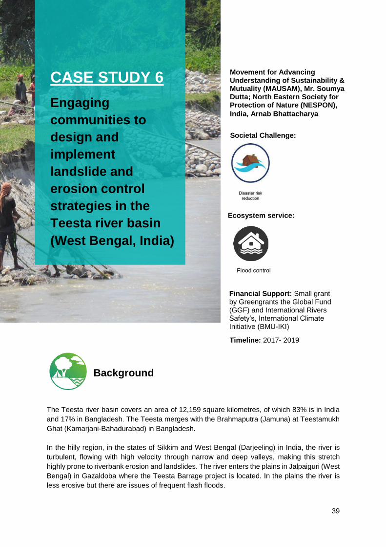
39
The Teesta river basin covers an area of 12,159 square kilometres, of which 83% is in India
and 17% in Bangladesh. The Teesta merges with the Brahmaputra (Jamuna) at Teestamukh
Ghat (Kamarjani-Bahadurabad) in Bangladesh.
In the hilly region, in the states of Sikkim and West Bengal (Darjeeling) in India, the river is
turbulent, flowing with high velocity through narrow and deep valleys, making this stretch
highly prone to riverbank erosion and landslides. The river enters the plains in Jalpaiguri (West
Bengal) in Gazaldoba where the Teesta Barrage project is located. In the plains the river is
less erosive but there are issues of frequent flash floods.
Movement for Advancing Understanding of Sustainability & Mutuality (MAUSAM), Mr. Soumya Dutta; North Eastern Society for Protection of Nature (NESPON),
India, Arnab Bhattacharya
Societal Challenge:
Ecosystem service:
Financial Support: Small grant by Greengrants the Global Fund (GGF) and International Rivers Safety’s, International Climate Initiative (BMU-IKI)
Timeline: 2017- 2019
Background
CASE STUDY 6
Engaging
communities to
design and
implement
landslide and
erosion control
strategies in the
Teesta river basin
(West Bengal, India)
Flood control

40
There are a number of cascade hydropower projects on the Teesta river in Sikkim, including
Teesta-V commissioned in 2008. The construction of hydropower dams have increased both
the frequency of landslides and earthquake vulnerability across the hilly region of basin. An
assessment of the Teesta-V project using the Hydropower Sustainability Assessment
Protocol25, indicates several gaps, such as, a lack of a systematic approach to
communications and consultations with the stakeholders, and shortfalls in the biodiversity
assessment relating to impacts on fishes and their hatcheries.
In West Bengal, the Teesta Barrage Project (TBP) is considered among the largest irrigation
projects of eastern India. When phase II of the project will be completed, it is expected to
irrigate an area of 922,000 hectares in six districts of north Bengal and will produce 67.50
megawatts of hydropower. Concerns have been raised regarding the impacts of barrage
operations on the communities26 and also availability water downstream. Communities living
close to the barrage rely on sub-canals for irrigation and have complained about reduction in
flow since the project has begun. Villagers in Jalpaiguri District have linked the erratic
operation of barrage gates and the sudden release of large quantities of water with increased
frequency of flash floods and riverbank erosion. Erosion is particularly concerning for the
villagers, as thousands have lost their farmlands and houses.
To support the communities in addressing these challenges, MAUSAM initiated consultations
in the affected communities in selected villages to support them in coping with these impacts.
25 Teesta-V Power Station - Hydropower Sustainability Assessment Report (NHPC, 2019) 26 Political Economy Analysis of the Teesta River Basin
Figure 22: Local villagers sharing the problem related to river bank erosion in Padamati
Char, Teesta River, India ©MAUSAM
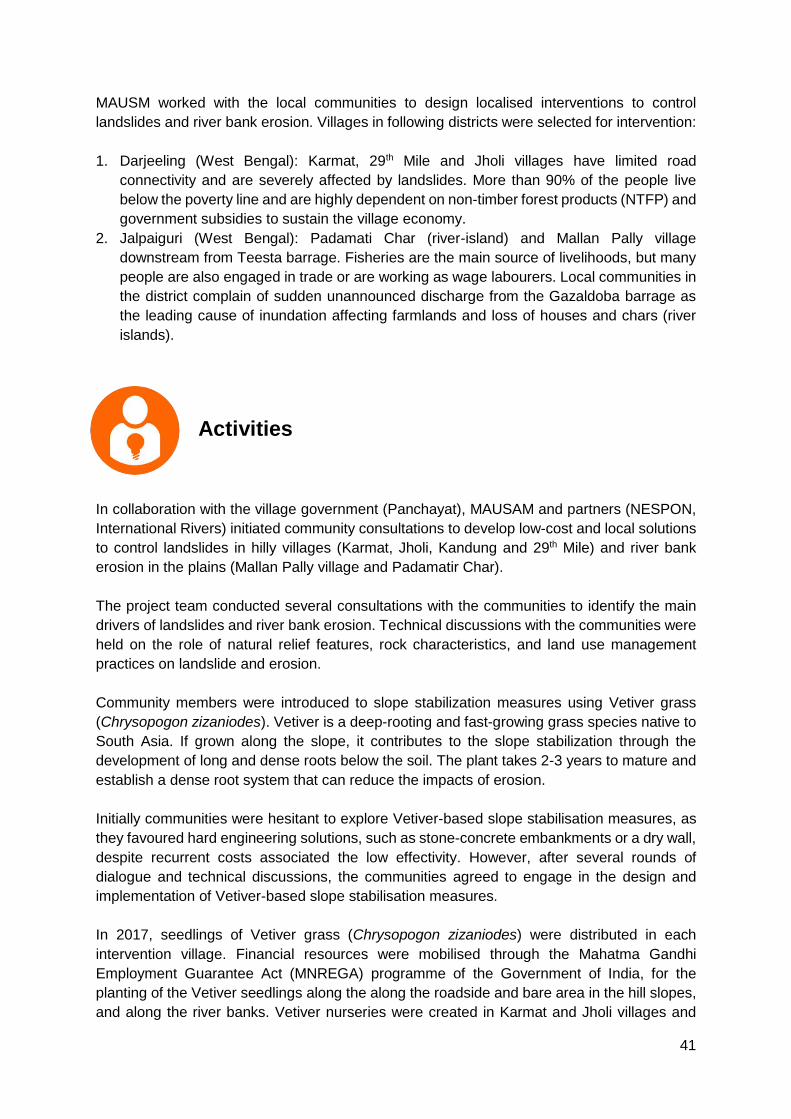
41
MAUSM worked with the local communities to design localised interventions to control
landslides and river bank erosion. Villages in following districts were selected for intervention:
1. Darjeeling (West Bengal): Karmat, 29th Mile and Jholi villages have limited road
connectivity and are severely affected by landslides. More than 90% of the people live
below the poverty line and are highly dependent on non-timber forest products (NTFP) and
government subsidies to sustain the village economy.
2. Jalpaiguri (West Bengal): Padamati Char (river-island) and Mallan Pally village
downstream from Teesta barrage. Fisheries are the main source of livelihoods, but many
people are also engaged in trade or are working as wage labourers. Local communities in
the district complain of sudden unannounced discharge from the Gazaldoba barrage as
the leading cause of inundation affecting farmlands and loss of houses and chars (river
islands).
In collaboration with the village government (Panchayat), MAUSAM and partners (NESPON,
International Rivers) initiated community consultations to develop low-cost and local solutions
to control landslides in hilly villages (Karmat, Jholi, Kandung and 29th Mile) and river bank
erosion in the plains (Mallan Pally village and Padamatir Char).
The project team conducted several consultations with the communities to identify the main
drivers of landslides and river bank erosion. Technical discussions with the communities were
held on the role of natural relief features, rock characteristics, and land use management
practices on landslide and erosion.
Community members were introduced to slope stabilization measures using Vetiver grass
(Chrysopogon zizaniodes). Vetiver is a deep-rooting and fast-growing grass species native to
South Asia. If grown along the slope, it contributes to the slope stabilization through the
development of long and dense roots below the soil. The plant takes 2-3 years to mature and
establish a dense root system that can reduce the impacts of erosion.
Initially communities were hesitant to explore Vetiver-based slope stabilisation measures, as
they favoured hard engineering solutions, such as stone-concrete embankments or a dry wall,
despite recurrent costs associated the low effectivity. However, after several rounds of
dialogue and technical discussions, the communities agreed to engage in the design and
implementation of Vetiver-based slope stabilisation measures.
In 2017, seedlings of Vetiver grass (Chrysopogon zizaniodes) were distributed in each
intervention village. Financial resources were mobilised through the Mahatma Gandhi
Employment Guarantee Act (MNREGA) programme of the Government of India, for the
planting of the Vetiver seedlings along the along the roadside and bare area in the hill slopes,
and along the river banks. Vetiver nurseries were created in Karmat and Jholi villages and
Activities
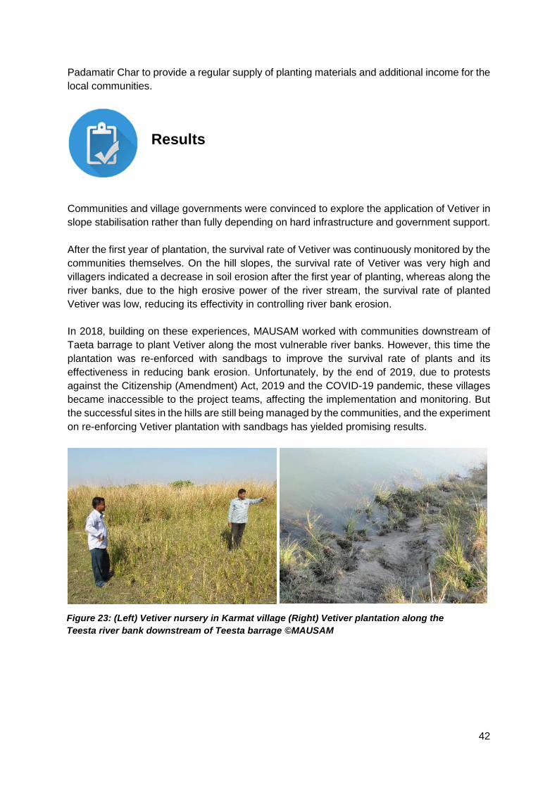
42
Padamatir Char to provide a regular supply of planting materials and additional income for the
local communities.
Communities and village governments were convinced to explore the application of Vetiver in
slope stabilisation rather than fully depending on hard infrastructure and government support.
After the first year of plantation, the survival rate of Vetiver was continuously monitored by the
communities themselves. On the hill slopes, the survival rate of Vetiver was very high and
villagers indicated a decrease in soil erosion after the first year of planting, whereas along the
river banks, due to the high erosive power of the river stream, the survival rate of planted
Vetiver was low, reducing its effectivity in controlling river bank erosion.
In 2018, building on these experiences, MAUSAM worked with communities downstream of
Taeta barrage to plant Vetiver along the most vulnerable river banks. However, this time the
plantation was re-enforced with sandbags to improve the survival rate of plants and its
effectiveness in reducing bank erosion. Unfortunately, by the end of 2019, due to protests
against the Citizenship (Amendment) Act, 2019 and the COVID-19 pandemic, these villages
became inaccessible to the project teams, affecting the implementation and monitoring. But
the successful sites in the hills are still being managed by the communities, and the experiment
on re-enforcing Vetiver plantation with sandbags has yielded promising results.
Results
Figure 23: (Left) Vetiver nursery in Karmat village (Right) Vetiver plantation along the
Teesta river bank downstream of Teesta barrage ©MAUSAM
43
Long-term engagement with the community is an important factor in building trust. MAUSAM
has been working in the intervention area for more than a decade to support the communities
in adapting to the impacts of climate change. On the other hand, North Eastern Society for the
Preservation of Nature and Wildlife (NESPON) is working on the community forest rights
issues for more than 20 years. Due to long-term relationship, these two organisations had a
good rapport with the communities. This helped trigger discussions on green infrastructure
solutions despite community preference and belief in grey solutions, such as construction of
concrete embankments. Dialogues on the technical issues such as relief features, as well as
factors that contribute to increased vulnerability to erosion helped in convincing the
communities to try green infrastructure solutions as an erosion control strategy.
The activities also demonstrated that Vetiver plantation alone is not effective in controlling
erosion at sites with high flow velocity or steep slopes. In 2018, MAUSAM worked with one of
the villages downstream of Taeta barrage, to plant Vetiver, however, this time the plantation
was reinforced with sandbags which improved the survival rate and effectiveness in controlling
erosion.
Lessons Learned
44
River bank erosion is a pressing issue across the Ganges-Brahmaputra-Meghna (GBM) basin.
In 2019, erosion destroyed the homes of at least 8,000 people in Bangladesh’s northern
districts during heavy July floods and displaced at least 300,000 people27 across the country.
The situation is similar in Nepal, with thousands of people losing their agricultural land and
house to erosion and flooding. This has created problems of outmigration from the villages
and a negative notion among communities about the river – many communities consider rivers
as a threat to their lives and livelihoods.
27 Bangladesh’s disappearing river lands (The New Humanitarian)
Oxfam Bangladesh, Nuzhat Nueary; Gana Unnayan Kendra (GUK) Bokhtiar Hossain; National Environment and Equity Development Society (NEEDS) Nepal, Kishan Khadka
Societal Challenge:
Ecosystem service:
Financial Support: SIDA (Oxfam Bangladesh) and UKAID (NEEDS Nepal)
Timeline: 2018 – ongoing
(Banglades) and 2015-2020
(Nepal)
Background
CASE STUDY 7
Community
experiences with
the development of
bamboo-grass-
based embankment
to control river
bank erosion
(Bangladesh and
Nepal)
Erosion Control
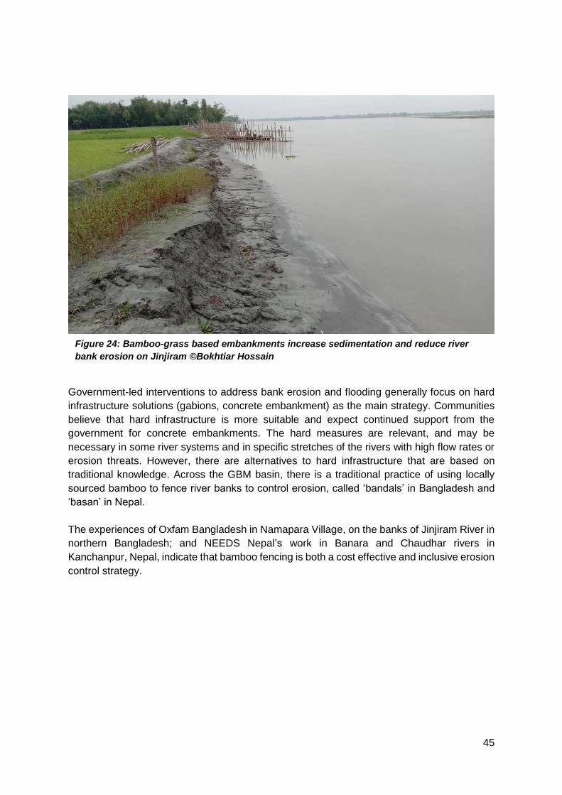
45
Government-led interventions to address bank erosion and flooding generally focus on hard
infrastructure solutions (gabions, concrete embankment) as the main strategy. Communities
believe that hard infrastructure is more suitable and expect continued support from the
government for concrete embankments. The hard measures are relevant, and may be
necessary in some river systems and in specific stretches of the rivers with high flow rates or
erosion threats. However, there are alternatives to hard infrastructure that are based on
traditional knowledge. Across the GBM basin, there is a traditional practice of using locally
sourced bamboo to fence river banks to control erosion, called ‘bandals’ in Bangladesh and
‘basan’ in Nepal.
The experiences of Oxfam Bangladesh in Namapara Village, on the banks of Jinjiram River in
northern Bangladesh; and NEEDS Nepal’s work in Banara and Chaudhar rivers in
Kanchanpur, Nepal, indicate that bamboo fencing is both a cost effective and inclusive erosion
control strategy.
Figure 24: Bamboo-grass based embankments increase sedimentation and reduce river
bank erosion on Jinjiram ©Bokhtiar Hossain

46
Oxfam Bangladesh (Jinjiram River)
One of the bandal sites is located at Namapara village, Rowmari Upazilla, Kurigram District.
The village is home to approximately 220 families and their main livelihoods are farming and
fishing. The village is affected by river bank erosion in the monsoon season (July-September),
which is more pronounced when the floodwaters are receding.
Oxfam Bangladesh and partners facilitated a series of community consultations (Nadi
Baithoks or River Camps) in Namapara village in 2018. These consultations discussed local
water governance challenges and ways to address them at the community level. During these
consultations, communities identified the loss of fertile agricultural land as the main threat to
their livelihoods and agreed to experiment with hybrid bamboo-grass based embankments as
a solution to control riverbank erosion. The Women’s Self-Help Group (SHG) in the village
agreed take the lead in the design and implementation of bamboo fencing.
The Women’s SHG organized meetings with officials of Upazilla Parishod (local government)
and received their support and funding for the initiative. Gana Unnayan Kendra (GUK) and
Activities
Figure 25: Nodi Boithak or meetings with community affected by riverbank erosion in
Borobondho, Jakigonj-1 village, Bangladesh ©Bokhtiar Hossain
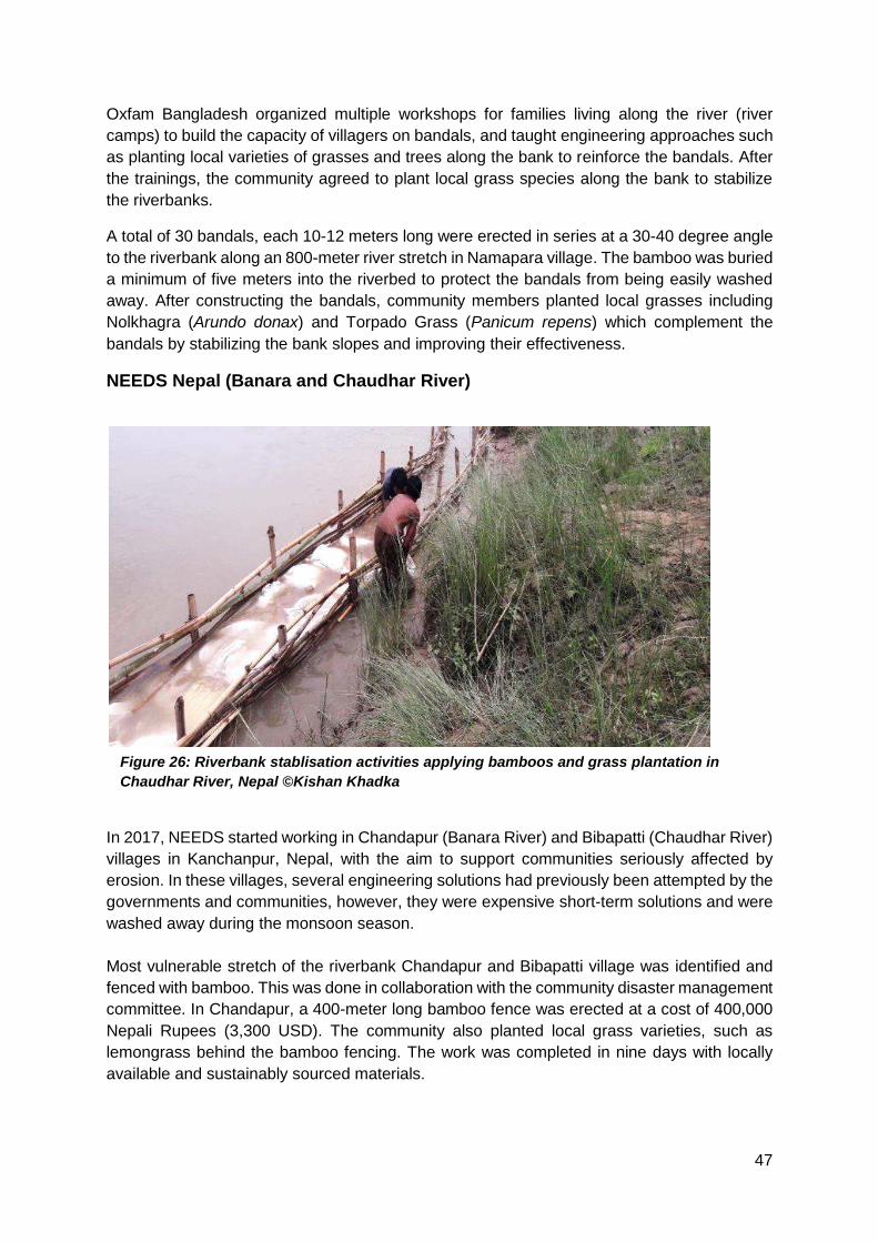
47
Oxfam Bangladesh organized multiple workshops for families living along the river (river
camps) to build the capacity of villagers on bandals, and taught engineering approaches such
as planting local varieties of grasses and trees along the bank to reinforce the bandals. After
the trainings, the community agreed to plant local grass species along the bank to stabilize
the riverbanks.
A total of 30 bandals, each 10-12 meters long were erected in series at a 30-40 degree angle
to the riverbank along an 800-meter river stretch in Namapara village. The bamboo was buried
a minimum of five meters into the riverbed to protect the bandals from being easily washed
away. After constructing the bandals, community members planted local grasses including
Nolkhagra (Arundo donax) and Torpado Grass (Panicum repens) which complement the
bandals by stabilizing the bank slopes and improving their effectiveness.
NEEDS Nepal (Banara and Chaudhar River)
In 2017, NEEDS started working in Chandapur (Banara River) and Bibapatti (Chaudhar River)
villages in Kanchanpur, Nepal, with the aim to support communities seriously affected by
erosion. In these villages, several engineering solutions had previously been attempted by the
governments and communities, however, they were expensive short-term solutions and were
washed away during the monsoon season.
Most vulnerable stretch of the riverbank Chandapur and Bibapatti village was identified and
fenced with bamboo. This was done in collaboration with the community disaster management
committee. In Chandapur, a 400-meter long bamboo fence was erected at a cost of 400,000
Nepali Rupees (3,300 USD). The community also planted local grass varieties, such as
lemongrass behind the bamboo fencing. The work was completed in nine days with locally
available and sustainably sourced materials.
Figure 26: Riverbank stablisation activities applying bamboos and grass plantation in
Chaudhar River, Nepal ©Kishan Khadka

48
The bamboo fencing was effective in reducing riverbank erosion at every site. Over time, due
to natural silt capture and deposition behind the bamboo fences, the riverbank was extended.
In Chandapur Nepal, within two years of the intervention, the land near the restored bank was
utilized by the local women’s group to plant cash crops, such as citronella, contributing to extra
income of 15,000-20,000 Nepali Rupees annually (200 USD).
The local community reported an increased abundance of fish and crustacean species along
the restored banks. In Namapara, Bangladesh, villagers reported that the sites along the
restored river banks, between the bandals and grass plantation, were preferred by local catfish
species (Seperata sp.) for nesting, as these were less disturbed by human interventions.
Results
Figure 27: Bank of the Jinjiram river in Namapara Village, one year of year after the
riverbank stablisation activities, with significant reduction in riverbank erosion,
Bangladesh ©Oxfam Bangladesh
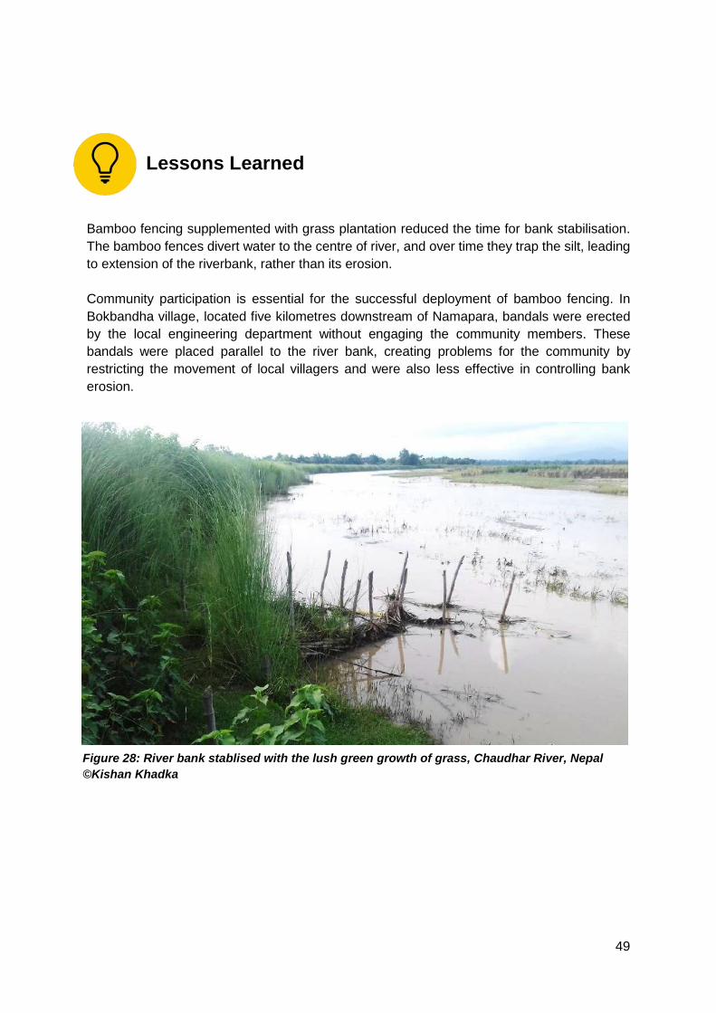
49
Bamboo fencing supplemented with grass plantation reduced the time for bank stabilisation.
The bamboo fences divert water to the centre of river, and over time they trap the silt, leading
to extension of the riverbank, rather than its erosion.
Community participation is essential for the successful deployment of bamboo fencing. In
Bokbandha village, located five kilometres downstream of Namapara, bandals were erected
by the local engineering department without engaging the community members. These
bandals were placed parallel to the river bank, creating problems for the community by
restricting the movement of local villagers and were also less effective in controlling bank
erosion.
Lessons Learned
Figure 28: River bank stablised with the lush green growth of grass, Chaudhar River, Nepal
©Kishan Khadka

50
4 Lessons learned from documentation process
This chapter analyses the case studies through the eight criteria’s identified by IUCN Global
Standards for NbS. The case studies discussed in this paper were all designed and
implemented before the launch of IUCN Global Standards on NbS – therefore, it is not fair to
expect full alignment of these interventions with the Global Standards. This analysis can serve
as the basis for revising and/or strengthening the case studies presented previously and
helped identified key recommendations presented in section 6.
Criterion 1 - NbS effectively address societal challenges
This Criterion aims to ensure that the NbS is designed in response to a societal challenge(s)
that has been identified as a priority by those who are or will be directly affected by the
challenge(s). It requires that all the stakeholders, especially rights holders and beneficiaries
of the NbS are involved in the decision-making process used for identifying the priority
challenge(s) (Criterion 5).
In all case studies presented, the societal challenges identified emerged mostly from previous
baseline studies. Community consultations were held to discuss and validate the societal
challenges.
Case Studies 1-4 simultaneously targeted water and food security issues as the primary
motivation for the application of Nature-based Solutions. Case Studies 5-7, focused on the
application of NbS in reducing disasters risks, such as landslides and river bank erosion.
In most cases, the decision-making process used to identify the societal challenges is unclear.
There is a need to strengthen the documentation of the strategies used to reconcile varying
stakeholder views during the design of the intervention, which was lacking in these projects.
In most of the case studies, the implementing agency had a long-term presence in the project
area, and past learnings and exchanges with communities provided a baseline for identifying
the key societal challenges to be addressed. For example, Development Alternatives (DA) has
been working in the semi-arid zones of Bundelkhand (India) since the early 1990’s, particularly
targeting integrated land and water management issues. Datia Watershed is located in this
region, and therefore the designing of the intervention built on prior learnings and stakeholders
relations.
Tangible benefits to human well-being from the intervention were recorded in all case studies.
However, there seems to be a gap in the benchmarking and periodic assessment of the human
well-being outcomes. In addition, in most cases, it is not clear how the implementers used
results from the project to inform the adaptive planning process (Criterion 7), or why a
particular solution was prioritized.
Criterion 2 - Design of NbS is informed by scale
This Criterion aims to encourage the recognition of the complexity and uncertainty that occur
in land/seascapes. The scale applies not only to the biophysical or geographic perspective but
also to the influence of economic systems, policy frameworks and the importance of cultural
perspectives. Therefore, a “systems framing’’ of the NbS can help better acknowledge these
interactions as well as risks.

51
Among the seven case studies discussed in this paper, the first four integrated landscape
approaches to varying degrees (Hail Haor, Datia Watershed, Asarganj Agriscape and
Teplejung District). In these case studies, the intersectoral synergies and conflict are well
documented. In other cases, the intervention was site-specific, aiming to address localized
challenges faced by communities, such as control of landslides along the hill roads (eco-safe
roads) or river bank erosion (Jinjiram and Teesta River).
There is limited documentation of the synergies of the proposed interventions amongst
different sectors. For example, the Hail Haor (Case study 1) and Asarjang initiatives (Case
study 4) documented conflicts between the fisheries and agricultural sectors, therefore
activities were designed to minimize this conflict. In the Teesta and Jinjiram basins, the
projects facilitated community dialogues to discuss various social and physical factors
contributing to landslides and river bank erosion. Because the community in the Teesta basin
favoured grey infrastructure solutions for disaster risk reduction, initial dialogues with the
communities were designed to explain the technical aspects and values of ecological
engineering in stabilizing river banks and landslide hazard zones.
In the majority of cases, there is a lack of articulation of the positive and negative impacts of
a specific project beyond the intervention site. In both the Hail Haor and Asarganj cases, the
project identified the loss of connectivity of wetlands with the main river channel as a threat to
local fish biodiversity and decreased landscape resilience to flooding. However, these
linkages were either not considered under the scope of project intervention or the results were
not captured fully. In Hail Haor, the declaration of Baikka Beel as reserve area increased the
number of migratory birds visiting the site and also improved the availability of water and fish
in the areas located around the beel. However, these benefits beyond the intervention site
were not captured in qualitative manner leading to difficulty in articulating the benefits outside
the intervention area.
Criterion 3 - NbS result in net gain to biodiversity and ecosystem integrity
NbS are derived as goods and services from ecosystems, therefore strongly depend on the
health of an ecosystem. Biodiversity loss and ecosystem change can have significant impacts
on the functioning and integrity of the system. Therefore, NbS design and implementation
must avoid undermining the integrity of the system and instead, proactively seek to enhance
the functionality and connectivity of the ecosystem. Doing so can also ensure the long-term
resilience and durability of the NbS.
The case studies have limited documentation of the status of ecosystem services, except for
fisheries and water provisioning services. Biodiversity characteristics such as species
composition, or trends in the total number of species was generally not documented.
In Hail Haor (Case study 1) , the MACH project conducted technical studies and estimated the
economic value of different ecosystem services including fisheries and agriculture. The drivers
of wetland degradation were also documented in consultation with local communities. The
baseline economic values were compared to showcase an increase in the ecosystem services
in monetary terms due to project intervention. In another approach, the Himalica project
facilitated a baseline assessment of ecosystem health, trends, and climate change impacts in
Teplejung district of Nepal to identify pilot villages however, the focus was on documenting

52
increase in agriculture productivity and climate resilience of agri-system, rather than
biodiversity gains. The project promoted eco-friendly approach to large cardamom farming
leading to improvement in soil health, however, there is no documentation of the
improvement’s in the abundance of beneficial soil micro-fauna or any wild species of plants or
animals.
A review of the solutions suggests gaps in documentation of biodiversity and ecosystem
benefits in project monitoring. Targets for enhancing key biodiversity values need to be better
established. In most cases, the interventions contributed to the enhancement of the ecosystem
services, due to variety of factors such as a net gain in green cover, improvement in soil
moisture or conservation of wetlands. These factors also contribute to the improved presence
and abundance of local biodiversity, but these gains were not captured. In most cases, a
review of documents does not indicate if periodic assessments were completed to document
the adverse consequences of the project activities on the functioning of ecosystem. Since
ecosystems are complex, with interdependent components and processes, there will always
be a level of uncertainty of how activities planned to address a societal challenge will impact
or influence the system. However, capturing these in future NbS design and monitoring will
help minimize unanticipated impacts on the functioning of the ecosystems.
Utilizing NbS can provide an opportunity to enhance biodiversity conservation and ecosystem
management efforts. As discussed under Criterion 2, Case study 1, 2, 3 and 4 were
implemented with the landscape perspective and the project designs explicitly integrated
activities to improve the ecosystem’s integrity and connectivity, such as the conservation and
revival of wetlands and planting of trees to increase the overall green cover at the landscape
level.
The analysis of results from the case studies suggest that the project activities led to an
increase in green cover, however, there is no documentation of any increase in the
biodiversity and/or abundance of species as a result of improved green cover. Furthermore,
only in Hail Haor (Case study 1), did the project design explicitly include biodiversity
enhancement as one of the project objectives, and activities such as conservation of natural
wetlands and reintroduction of lost or vulnerable fish species were included and monitored.
Criterion 4 - NbS are economically viable
The return on investment, effectiveness of the intervention, equitable distribution of benefits
and costs are key determinants of success for an NbS in the long run. Therefore, this Criterion
requires that sufficient consideration is given to the economic viability of the intervention, both
at the design stage and its implementation. If the economic feasibility is not adequately
addressed, NbS run the risk of being short-term projects, where, after closing, the solution and
benefits provided cease to exist, potentially leaving the landscape and communities worse off
than before.
A review of the results and learnings from the case studies indicates that implementers were
conscious of the need for documenting the cost-effectiveness of the proposed solutions. In
some cases, the lead organization collaborated with a university or engaged technical experts
to undertake the analysis. However, in most cases cost-effectiveness was done at the end of
the project, and not as tool for selecting a particular NbS. The cost-effectiveness of NbS is
strongly articulated in the MACH (Case study 1) and EPIC projects (Case study 5). The MACH

53
project facilitated studies at the beginning and end of the project to document economic value
of the different ecosystem services (fisheries, agriculture and flood regulation). The restoration
of the wetland habitat increased the total annual economic value of Hail Haor by 25%, from 8
million USD in 2000 to 10.9 million USD in 2006. The EPIC project in Nepal documented that
within a span of 12 years, the eco-safe roads became more cost effective than traditional
earthen roads, and generates additional livelihood benefits for the local communities.
Most of the interventions discussed in this paper were funded by a single donor. However,
during the implementation of some projects, efforts were made to mobilize additional
resources. In the Jinjiram river basin, community work was funded through money received
from the local government plans. In the Himalica project, efforts were made to diversify the
income of farmers through innovative concepts such as Spice Garden Tourism, and the
development of a community enterprise – Kanchanjunga Himalica Agriculture Industry (KHAI).
The project in Datia watershed established farmer’s clubs and Women’s Self-Help Groups and
trained them in integrated and organic farming. A Watershed Development Fund was also
established, providing revolving funds as micro-credits.
Criterion 5 - NbS are based on inclusive, transparent and empowering governance
processes
This criterion requires that NbS acknowledge, involve and respond to the concerns of a variety
of stakeholders, especially rights holders. Also, NbS must adhere to and align with the
prevailing legal and regulatory provisions, being clear on where legal responsibilities and
liabilities lie. This is important and not only reduces intervention’s sustainability risks, but also
to enhance its social ‘license to operate’.
It is unclear whether community feedback and grievance mechanisms were put in place as
part of the design, implementation and monitoring of the solutions. In most cases, reports
indicate holding consultations and dialogues with communities, which likely enabled a space
for communities and stakeholders to express possible complaints or worries, however it does
not appear to be a well-established mechanism. Equality and gender inclusion was one the
main criteria used for the selection of case studies discussed in this paper. In most cases, the
project design included the promotion of participation of the most vulnerable communities in
the governance of natural resources. In some cases, women’s Self-Help Groups (SHGs) were
engaged in leading the implementation of activities, for example in Datia watershed (Case
study 2) and Teplejung District (case study 3), women’s SHGs were trained on integrated
farming practices such as agro-horticulture, vegetable cultivation and organic farming. In
Jinjiram basin (Case study 7), Nodi Baithaks (River Consultations) facilitated by the Oxfam
and local partners in Namapara village provided a platform for the women’s SHG to discuss
the design of bamboo fencing for the control of river bank erosion and the benefits of planting
of multi-purpose deep rooting grass along the river banks to reinforce the bamboo fencing.
However, the engagement of youth seems absent in most of the cases.
Each intervention applied different strategies to engage and institutionalize community
engagement during the project implementation. The most common strategies included the
formation of Water User Groups (WUGs), Resource Management Organizations (RMOs)
and/or women’s Self-Help Groups (SHGs). However, there is no documentation of the
community consultations in the project designing stage. It is important that communities are
consulted in the beginning on identifying problems and developing solutions. Noting which
54
stakeholders were involved in the decision-making and the role they played in the identification
possible solutions is particularly important where extreme inequality persists. This is important
to ensure that processes can be adapted to encourage meaningful participation of the most
vulnerable groups of the societies.
Every case study discussed in this paper focused on a single country and implementation was
mostly restricted to districts or provinces of the country. In the Jinjiram Basin case, the project
team acknowledged that comprehensive basin-wide NbS is required to solve the problem of
erosion, and for this there is a need for transboundary cooperation, as the basin is also shared
by Bangladesh and India.
Criterion 6 - NbS equitably balances trade-offs between achievement of their primary
goal(s) and the continued provision of multiple benefits
Ecosystems provide a wealth of different benefits and not everyone values each of them in
the same way. Therefore, tradeoffs between stakeholders and sectors is inevitable and needs
to be managed effectively and equitably. This Criterion requires that NbS proponents
acknowledge these tradeoffs and follow a fair, transparent and inclusive process to balance
and manage them over both time and geographic space.
As discussed under Criterion 1, the identification of societal challenges was based on previous
studies and the prior engagement of stakeholders in the intervention areas. There is not
sufficient documentation of the potential negative impacts of the intervention, or discussion on
the trade-offs required for the long-term sustainability of the projects. In some cases, trade-
offs are implicit in the cost-benefit analyses conducted.
The legal and customary rights to access, use and management over land and natural
resources is generally recognized by every case study. However, there is scope for the better
documentation of rights and responsibilities of the different stakeholder groups with reference
to the proposed NbS. This documentation will ensure the responsibilities and benefits to
different stakeholder groups are acknowledged and respected and do not jeopardize the entire
NbS process.
“Where risk is unavoidable, safeguards must be in place and be periodically reviewed to
anticipate and avoid adverse consequences of interventions, especially considering that
inequity in trade-offs may change over time and that not all stakeholders may be equally
affected. Therefore, NbS design and strategy needs to be explicit about whose benefits and
whose costs will be addressed, including when and how this will be reviewed (IUCN NbS
Standards 2020).”
Criterion 7 - NbS are managed adaptively, based on evidence
Ecosystems have complex, dynamic and self-organising nature. This also means that
ecosystems have greater resilience which confers a wider range of options to respond to
unanticipated social, economic or climate events. This Criterion therefore, aims to exploit this
attribute of ecosystems through designing of adaptive management strategy for the proposed
NbS.
The foundation of adaptive management is the evidence-base provided by regular monitoring
and evaluation, drawing on scientific understanding as well as indigenous, traditional and local
55
knowledge. By proactively adopting an adaptive management approach, the NbS can
continue to be relevant through the lifecycle of the intervention and the risk of redundancy and
stranded investments are minimised.
Most of the initiatives are implementing NbS strategies but don’t explicitly present an initial
theory of change, or formal NbS strategy, including the reasoning behind the NbS, articulation
of the intended outcomes and clear understanding of the ways to achieve them.
Monitoring and evaluation plans, when they exist, focus mostly on human-benefits, and
overlook the biodiversity benefits. They are also not directly articulated with a mechanism that
enables adaptive management. The design and monitoring of these solutions rarely includes
an assessment of potential negative impacts or trade-offs, which forms an important
component of a monitoring assessment, enabling adaptation and changes in the way the
solution was initially designed.
Adaptive management is mentioned in some cases, based on key results and dialogues with
communities. In Case Study 6, which learned that Vetiver plantation alone will not be effective
in controlling erosion in sites where flow velocity is high, one of the villages downstream of
Taeta barrage reinforced the Vetiver plantation with sandbags to improve the survival rate and
effectiveness of the solution in reducing river bank erosion.
Criterion 8 - NbS are sustainable and mainstreamed within an appropriate jurisdictional
context
This Criterion requires that NbS are designed and managed with a view to long-term
sustainability and are aligned with sectoral, national and other policy frameworks. There are
various approaches to mainstreaming NbS; however, all rely on strategic communications and
outreach with audience from different sectors, including individuals (e.g. the public,
academics), institutions (e.g. national government, start-ups, businesses, and organisations)
and global networks (e.g. Sustainable Development Goals, Paris Agreement).
Activities were designed with an understanding of the opportunities and limitations posed by
local policies and regulations, however the case studies do not communicate the policy
framework for their interventions, or how they could trigger policy changes. In the Hail Haor
case, the local community had no access over the wetlands, and the rights to fisheries were
auctioned to highest bidder alienating communities form wetland governance and use,
therefore, the MACH project secured 10 year lease for selected wetlands from the Ministry of
Land, and created a Resource Management Organisation (RMOs) including the the Baikka
Beel RMO, which still exists and is connected to the Local Government Committees (LGCs),
headed by the Chief Executive Officer of the sub-district.
Different strategies were used by the projects to share their learnings. In most cases, the
projects facilitated regular meetings and site visits to share the results of the project with local
line agencies. For example, the EPIC project organized dissemination and training workshops
for government officials, and also developed a guidance tool for the implementation of
ecological engineering strategies. In the Himalica project, the learnings from the project were
used to develop a Strategic Action Plan and Vision for Agriculture Development of Taplejung
district at the request of local government. In the Asarganj project in India, the lessons learned
were consolidated to develop a toolkit on agriscape management, and agriscape plans were

56
developed for replication at an additional two sites located in the Ghod and Bhavani river
basins in southern India.
In the EPIC, Himalica and MACH projects, documents including policy briefs, technical and
mid-term appraisal reports are available online and freely accessible to individuals and
stakeholders interested in researching and replicating the process. However, in most other
case studies, it was difficult to find project appraisals or technical reports online.

57
5 Conclusions and final recommendations
The seven case studies presented in this report are of critical importance to shape the
discourse on the implementation of NbS at scale in the GBM region. They each identify
strategies of working with local communities in addressing societal challenges, and use the
restoration or management of ecosystems as an entry point. Despite a number of gaps, as
identified by the screening through IUCN Global Standard, these initiatives are pioneering a
new way of thinking, while demonstrating tangible benefits.
Moving forward, IUCN will continue to work with CSOs and other relevant stakeholders to
develop a practical understanding of NbS and will support the design of innovative and locally
relevant NbS interventions, along with their mainstreaming in CSO programmes and
government polices at the local, national and regional levels.
The section below highlights key recommendations to strengthen and improve the solutions
presented, allowing them to be further refined.
1. Strengthen documentation of biodiversity gains: Biodiversity net gain is a defining
criteria for any NbS intervention, therefore, it is important that these gains are captured
and documented. The baseline assessment needs to be broad enough to characterise the
ecological state, drivers of ecosystem degradation and options for net improvements,
making use of both local knowledge and scientific understanding. The net gain in
biodiversity includes both the increase in total number of species, and also abundance of
the species in a particular ecological system. For example, organic agriculture practices
contribute to enhancement in soil health and increases the abundance of beneficial soil
organisms, but these gains were not documented. The documentation of these aspects
will help in building evidence on the contributions of these local interventions to global
biodiversity conservation and enhance the probability of replication and upscaling of
successful strategies, and their mainstreaming in government policies and plans.
2. Improve mapping of the roles and influences of external stakeholders: There is a
need to strengthen the documentation of the rights and responsibilities of different
stakeholder groups with reference to the proposed NbS. A key function of NbS safeguards
is to ensure that intervention don’t impact the most disadvantaged members of society in
anyway or that they have access to the intervention’s benefits. Therefore, a clear
understanding and documentation of costs and benefits to different stakeholder groups is
suggested as it will help avoid any conflict between the stakeholder groups and support
the consensus building process among stakeholders and sectors on identification of trade-
offs needed for the optimise the use of natural resources for its sustainable and equitable
development.
3. Strengthen project adaptive management: A monitoring and evaluation framework was
developed in most of the initiatives discussed in this paper, however, generally they tend
to focus on monitoring human benefits. None of the case studies clearly demonstrate how
the learnings from the project were used in adaptive management to limit risks and
unexpected impacts of the activities on any stakeholder group. Monitoring mechanisms
should take into account all aspects of the NbS, including human and biodiversity benefits,
involving local stakeholders and governance platforms in the implementation and review,
and helping them to design adaptive management. Strengthening the documentation of

58
the positive and negative impacts of a particular NbS intervention will support the design
of a robust adaptive management process.
4. Promote private sector and youth engagement: In most case studies, the youth and
private sector engagement is weak, and needs to be strengthened. Since, NbS requires
working across generations, and moving away from a site-based to a systems-based
approach, youth engagement is necessary for the sustainability of any NbS intervention.
Engaging the private sector will help in building its capacity in NbS and support for
upscaling the learnings from demonstration projects. A stronger mapping and inclusion of
market based mechanisms is suggested in future programming. For example, case study
2 highlights strategies for establishing market linkages for the products developed by
Women Entrepreneurs (CARDIMONIA strategy of Himalica), whereas case study 4,
demonstrate the value of working closely with private sector, learning’s from the Asarganj
agriscape was replicated in Ghod and Bhavani River Basin with the support of ITC Limited.
The other strategies to engage private sector to mobilise the resources may include grants,
incentives, low interest loans for low carbon and environmentally friendly enterprise and
public-private partnership projects.
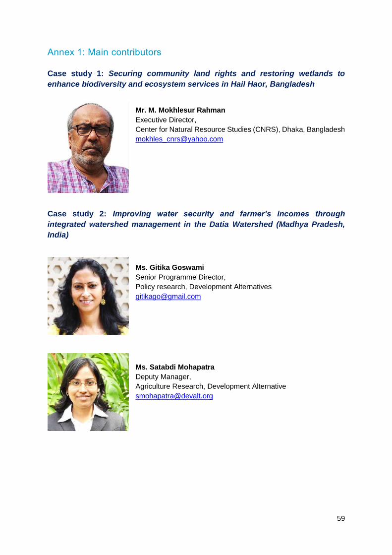
59
Annex 1: Main contributors
Case study 1: Securing community land rights and restoring wetlands to
enhance biodiversity and ecosystem services in Hail Haor, Bangladesh
Mr. M. Mokhlesur Rahman
Executive Director,
Center for Natural Resource Studies (CNRS), Dhaka, Bangladesh
Case study 2: Improving water security and farmer’s incomes through
integrated watershed management in the Datia Watershed (Madhya Pradesh,
India)
Ms. Gitika Goswami
Senior Programme Director,
Policy research, Development Alternatives
Ms. Satabdi Mohapatra
Deputy Manager,
Agriculture Research, Development Alternative

60
Ms. Kavya Arora
Manager - Policy and Planning,
Development Alternatives
Case Study 3: Demonstrating climate smart agriculture to enhance the
resilience of large cardamom farmers in the Kangchenjunga transboundary
landscape (Nepal)
Mr. Surendra Raj Joshi
Senior Resilient Livelihoods Specialist
ICIMOD, Kathmandu, Nepal
Mr. Sanjeev Bhuchar
Senior Watershed Management Specialist
ICIMOD, Kathmandu, Nepal

61
Ms. Anu Joshi Shrestha
Rural Enterprise and Value Chain Specialist
ICIMOD, Kathmandu, Nepal
Mr. Min Bahadur Gurung
Gender and Social Inclusion Analyst
ICIMOD, Kathmandu, Nepal
Mr. Harish Chilwal
Local Coordinator, Himalica Pilot Project
Environment Conservation and Development Forum,
Taplejung, Nepal

62
Case Study 4: ITC-IUCN collaboration in reviving traditional irrigation systems
(ahar-pyne) and enhancing ecosystem services in Asarganj Agriscape
Mr. Manjunath Lakshmikanthan
Regional Manager - Eastern India
ITC Limited, India
Mr. Aditya Petwal
Senior Program Officer,
Columbia Global Centers, Mumbai
Ms. Archana Chatterjee
Programme Manager, India Programme Coordination
IUCN India Office

63
Case Study 5: Reducing Landslide Disasters and Creating Livelihood
Opportunities Through Eco-safe Roads in Nepal
Dr. Pem Narayan Kandel
Secretary, Ministry of Industry, Tourism, Forest and
Environment, Province 2 of Janakpur
Government of Nepal
Mr. Sanjaya Devkota
Bio-engineering expert and independent consultant
Nepal
Ms. Anu Adhikari
Senior Program Officer
Climate Change, Gender & Social Inclusion
IUCN Nepal Programme Coordination
64
Case Study 6: Engaging communities to design and implement landslide and
erosion control strategies in the Teesta River Basin (West Bengal, India)
Mr. Soumya Dutta
Trustee - Movement for Advancing Understanding of
Sustainability & Mutuality (MAUSAM)
Advisory Board Member - UN Climate Technology Centre and
Network
Mr. Arnab Bhattacharya
Member
North Eastern Society for Protection of Nature (NESPON),
Siliguri, India
Case Study 7: Community experiences with the development of bamboo-grass-
based embankment to control river bank erosion (Bangladesh and Nepal)
Ms. Nuzhat Nueary
Project Officer
Transboundary Rivers of South Asia,
Oxfam Bangladesh
65
Mr. Kishan Khadka
Project Officer
National Environment and Equity Development Society
(NEEDS), Nepal
Mr. Bokhtiar Hossain
Project Officer
Transboundary Rivers of South Asia, GUK, Bangladesh

66
Annex 2: Bibliography
Anas AZM (2019). Bangladesh’s disappearing river lands. The New Humanitarian.
https://www.thenewhumanitarian.org/Bangladesh-river-erosion-engulfs-homes-climate-
change-migration (Accessed: 15 August 2020)
Cohen-Shacham, E., Walters, G., Janzen, C. and Maginnis, S. (eds.) (2016). Nature-based
Solutions to address global societal challenges. Gland, Switzerland: IUCN. xiii + 97pp.
http://indiatogether.org/sustainable-tribal-livelihood-via-wadi-agriculture
Devkota, S., Sudmeier-Rieux, K., Penna, I., Eberle, S., Jaboyedoff, M., Adhikari, A. and R.
Khanal (2014) Community-based bio-engineering for eco-safe roadsides in Nepal. Lausanne:
University of Lausanne, International Union for Conservation of Nature, Nepal and Department
of Soil Conservation and Watershed Management, Government of Nepal.
https://www.iucn.org/sites/dev/files/content/documents/bioengineering_brochure_hr.pdf
Gupta, A. K., Nair, S.S., Ghosh, O., Singh, A. and Dey, S. (2014). Bundelkhand Drought:
Retrospective Analysis and Way Ahead. National Institute of Disaster Management, New
Delhi, Page 148. https://nidm.gov.in/PDF/pubs/Bundelkhand Drought 2014.pdf
International Centre for Integrated Mountain Development (ICIMOD) (2018). Multi-
Dimensional Assessment of Ecosystems and Ecosystem Services in Taplejung, Nepal;
ICIMOD Working Paper 2018/6.
https://lib.icimod.org/record/33890/files/WP_2018-6_Taplejung.pdf
International Union for Conservation of Nature (IUCN) (2020). Global Standard for Nature-
based Solutions. A user-friendly framework for the verification, design and scaling up of NbS.
First edition. Gland, Switzerland: IUCN.
https://portals.iucn.org/library/sites/library/files/documents/2020-020-En.pdf
Koul Divy Ninad, Singh Swati, Neelam Ganesh & Shukla Gopal (2009); Traditional water
management systems - An overview of Ahar-pyne system in South Bihar plains of India and
need for its revival. Collectives for Integrated Livelihood Initiatives, Indian Council of
Agricultural Research (ICAR), Ranchi (Jharkhand)
https://www.researchgate.net/publication/263168629_Traditional_water_management_syste
ms_-_An_overview_of_Ahar-
pyne_system_in_South_Bihar_plains_of_India_and_need_for_its_revival
Thompson Paul and Colavito Luke (2007). Economic Value of Bangladesh Wetlands MACH
(Technical Paper 6)
http://nishorgo.org/wp-content/uploads/2017/02/3-6-Economic-Value-of-Bangladesh-
Wetlands.pdf
Mitsch William J. (1996) Click Ecological Engineering: A New Paradigm for Engineers and
Ecologists. https://www.nap.edu/read/4919/chapter/9 (Accessed: 15 August 2020)
67
IUCN BRIDGE GBM, 2018. Nature-based solutions and their application in river basin
management: BRIDGE GBM CSO dialogue report. Bangkok, Thailand: IUCN. 20pp.
https://www.iucn.org/sites/dev/files/content/documents/nbs_workshop-bridge_gbm_report_3-
june2018.pdf
Indian Council of Agricultural Research (ICAR) 2014. Livelihood Improvement of
Underprivileged Farming Community: Some Experiences from Vaishali, Samastipur,
Darbhanga and Munger Districts of Bihar. Technical Bulletin No. R-40/PAT-26
https://www.researchgate.net/publication/322630889_Livelihood_Improvement_of_Underpriv
ileged_Farming_Community_Some_Experiences_from_Vaishali_Samastipur_Darbhanga_a
nd_Munger_Districts_of_Bihar
Mohanty Abhijit, Clarkson Rosie, and Robson Kieran (2015). Wadi: A model for sustainable
tribal livelihood.
http://indiatogether.org/sustainable-tribal-livelihood-via-wadi-agriculture
National Hydroelectric Power Corporation (NHPC) (2019). Official Assessment Teesta-V
Power Station - Hydropower Sustainability Assessment Report
https://static1.squarespace.com/static/5c1978d3ee1759dc44fbd8ba/t/5d8c752237aac41d40
9a4923/1569486263861/Teesta-V+Assessment+Report_Sept+19+2019_final.pdf
Seddon, N., Sengupta, S., García-Espinosa, M., Hauler, I., Herr, D. and Rizvi, A.R. (2019).
Nature-based Solutions in Nationally Determined Contributions: Synthesis and
recommendations for enhancing climate ambition and action by 2020. Gland, Switzerland and
Oxford, UK: IUCN and University of Oxford.
https://portals.iucn.org/library/sites/library/files/documents/2019-030-En.pdf
The Asia Foundation (2013). Political economy analysis of the Teesta River Basin.
https://asiafoundation.org/resources/pdfs/1-
TheAsiaFoundation.PoliticalEconomyAnalysisoftheTeestaRiverBasin.March20131.pdf
Watershed Organisation Trust, India (2019). Ridge to Valley - A Holistic Watershed
Perspective https://www.youtube.com/watch?v=YnBGommXHXg&t=407s (Accessed: 13
March 2020)
Vyas K G (2020). Ahar pynes: Traditional flood harvesting systems of South Bihar.
https://www.indiawaterportal.org/articles/ahar-pynes-traditional-flood-harvesting-systems-
south-bihar (Accessed: 15 December 2020)

68
Annex 3: Criteria and template for case study documentation
Criteria
The IUCN Secretariat, in close coordination with the GBM CSO network and private sector
partners will receive and analyse proposals for the NBS case solutions and decide which ones
to follow up on. Please apply these criteria when you are selecting the case for analysis:
1. Solutions with an evidence of integrated strategy (vs. single activities), looking at solution
which work in parallel on i) reducing social and environmental vulnerabilities and generate
social benefits ii) restore and maintain ecosystem health iii) supported by (or enhancing
existing) policies at multiple levels iv) supporting equitable governance and enhance
capacities;
2. solutions strongly linked to water and basin issues (vs. broader NBS simply happening in
the basin but with no real connection to the river/basin theme);
3. solutions with a potential for replication;
4. solutions presenting evidence of results (quantitative and qualitative) and references;
Solution template
Name of Country(ies) - Title of your solution
author(s), organisation(s), email(s)
Pictures
2 to 3 pictures illustrating the context of your solution and the activities (JPG format, hi-res).
Background (200 words)
Kindly provide an introduction to the topic and a summary of your solution. In 200 words,
introduce briefly the context you are working on, including ecosystems and livelihoods, issues
and stakeholders involved, and provide objectives and elements of your solution.
Main activities (500 words)
A NBS is usually a complex series of activities and approaches. As such, kindly start by stating
the technical objective of the solution (e.g “in order to limit the flooding on xxx communities,
and enhance livelihoods through fisheries a management plan for the xxx wetlands was
implemented”) then move on to describing of the technical activities by categories.
Examples of activity categories of activities can be the following:
ecosystem restoration/management;
education on natural resources use, management, good practices;
revising policies to integrate NbS;
knowledge mobilisation;
governance work;
Others
Please also state how gender empowerment and social inclusion are taken into account in the
design of these activities.

69
Results (250 words)
It is very important to be able to qualify and, when possible, quantify the results. You may use
some of the categories below and try to be specific (e.g. avoid results like “this solution
improved the livelihoods of communities” but instead “income from fisheries increased by xx%
in the 4 communities concerned in the 2 years following the project” with references).
Potential results categories include:
environmental/conservation benefits
livelihood and income-generation benefits
disaster risk management benefit of adaptation
policy change or influence on government planning or up scaling of your solution
Please also specify how this solution benefitted gender empowerment and social inclusion.
Challenges (150 words)
Present briefly the key challenges in designing/implementing your solution.
institutional
conflicts
funding
lack of capacity
Other
Key lessons learned (200 words)
It is important to summarise lessons learned (from success and challenges). The lessons
learned can be centred on the following categories:
need for science/data
importance of partnership and collaboration
importance of local leaderships, champions
importance of policy integration
importance of economic integration of the solution
importance of demonstration activities
Inspiring Story (200 words) – optional
Know of any one or any group who benefited from the solutions and there’s an inspiring story
that could come out of it? If you do, give us a little bit more information and the IUCN Asia
Communications team can follow up with you and help you draft the story.
Acknowledgements

INTERNATIONAL UNION FOR CONSERVATION OF NATURE
ASIA REGIONAL OFFICE 63 Sukhumvit Soi 39 Klongtan - Nua, Wattana 10110 Bangkok, Thailand Tel +66 (2) 662 4029 Fax +66 (2) 662 4387
www.iucn.org/asia